great yarmouth (pdf - 8mb)
TRANSCRIPT
Norfolk County Council at your service
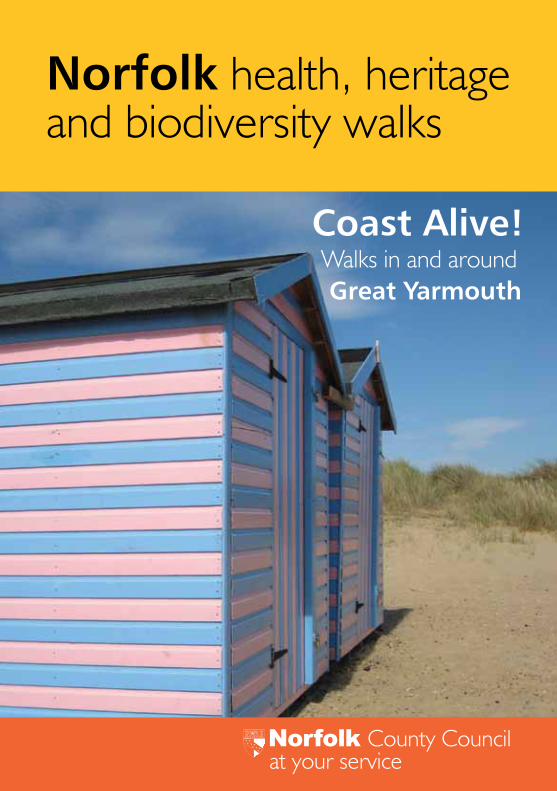
Coast Alive! Walks in and around Great Yarmouth
Norfolk health, heritage and biodiversity walks
1
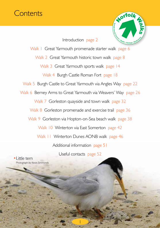
Contents
Introduction page 2
Walk 1 Great Yarmouth promenade starter walk page 6
Walk 2 Great Yarmouth historic town walk page 8
Walk 3 Great Yarmouth sports walk page 14
Walk 4 Burgh Castle Roman Fort page 18
Walk 5 Burgh Castle to Great Yarmouth via Angles Way page 22
Walk 6 Berney Arms to Great Yarmouth via Weavers’ Way page 26
Walk 7 Gorleston quayside and town walk page 32
Walk 8 Gorleston promenade and exercise trail page 36
Walk 9 Gorleston via Hopton-on-Sea beach walk page 38
Walk 10 Winterton via East Somerton page 42
Walk 11 Winterton Dunes AONB walk page 46
Additional information page 51
Useful contacts page 52• Little tern
Photograph by Kevin Simmonds
No
rfolk
Co
un
ty Council – Health • Heritage • Biodivers
ity
N
orfolk Walk
s
3
Introduction
Coast Alive aims to bring the benefits of two long distance international trails to our local community by helping to stimulate
activities along the coast to improve the health and happiness of local communities.
The first is the North Sea Cycle Route which was opened in 2001. At 6,000km it is the worlds longest cycle trail and passes through 7 countries around the North Sea. The second is the North Sea Trail, a walking route around the same coastline using existing footpaths as well as creating and regenerating footpaths. Both projects were developed by international partnerships and partly funded through the European Commission’s Interreg IIIB North sea Programme. For more information visit their websites at: www.northsea-cycle.com and www.northseatrail.org or visit the Coast Alive website at: www.coast-alive.eu.
The long distance trails are fantastic for visitors, but what about locals? Great for some, but not everyone has the time, money or ability to enjoy long distance trails. By creating a series of short circular coastal walks and encouraging people to fit regular local walks into daily life with friends and family, adults and children alike can take part conveniently with little or no cost and get a flavour of the charms and challenges of the North Sea route. A repeated local walk for an hour or so followed by a cup of tea shared with friends is worth so much more than it appears; free exercise, great social benefits, supporting local business year round, minimal travel and a feeling of ownership of ‘your’ walk; simply keeping the Coast Alive!
Great YarmouthGreat Yarmouth is a highly individual place, not just in Norfolk but in England. Not only did it evolve one of the most remarkable town plans in medieval Europe, but its very site was an unusual gift of nature. In Roman times a vast estuary stretched from Acle to the coast discharging freshwater from three major rivers into the sea. Later, a long thin island of sand and shingle began to emerge at the mouth of the estuary dividing it into northern and southern channels. The northern channel near Caister became blocked and the island grew southwards into a long narrow spit of land.
As the sand spit grew and dried out it was seasonally occupied by local fishermen when herring shoaled in the autumn. Once this first settlement established permanently in the Yare-mouth it developed at a rapid pace. Great Yarmouth became a prosperous medieval fishing, boat building and trading town which hugged the river side of the sand bank with long streets facing the river and its back to the sea. The main streets roughly followed the course of the river and were connected by around 150 narrow lanes and alleys called ‘rows’.
When bathing in sea water became fashionable, Yarmouth began to develop as a seaside resort. The coming of the railways in 1844 changed the town almost overnight; a new industry of providing for day trippers evolved with many of the early tourist attractions still surviving such as the wooden scenic railway, the two piers and boating lake.
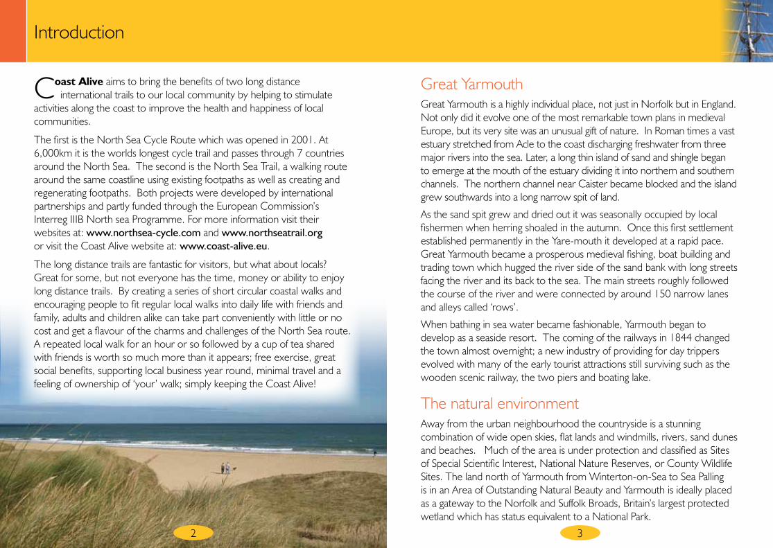
The natural environmentAway from the urban neighbourhood the countryside is a stunning combination of wide open skies, flat lands and windmills, rivers, sand dunes and beaches. Much of the area is under protection and classified as Sites of Special Scientific Interest, National Nature Reserves, or County Wildlife Sites. The land north of Yarmouth from Winterton-on-Sea to Sea Palling is in an Area of Outstanding Natural Beauty and Yarmouth is ideally placed as a gateway to the Norfolk and Suffolk Broads, Britain’s largest protected wetland which has status equivalent to a National Park.
2
54
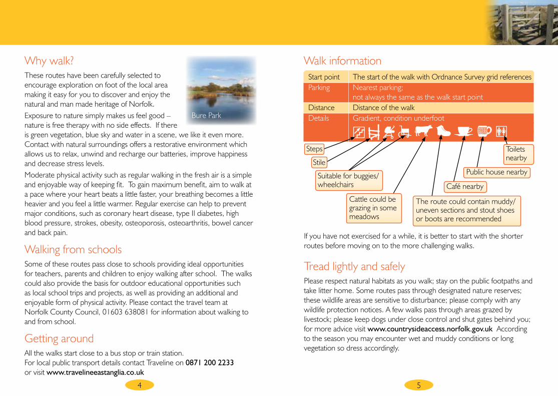
Start point The start of the walk with Ordnance Survey grid references Parking Nearest parking; not always the same as the walk start point Distance Distance of the walk Details Gradient, condition underfoot
Steps
Cattle could be grazing in some meadows
The route could contain muddy/uneven sections and stout shoes or boots are recommended
Café nearby
Public house nearby
Toilets nearby
Suitable for buggies/wheelchairs
Stile
Walk informationWhy walk?These routes have been carefully selected to encourage exploration on foot of the local area making it easy for you to discover and enjoy the natural and man made heritage of Norfolk. Exposure to nature simply makes us feel good –nature is free therapy with no side effects. If there is green vegetation, blue sky and water in a scene, we like it even more. Contact with natural surroundings offers a restorative environment which allows us to relax, unwind and recharge our batteries, improve happiness and decrease stress levels.Moderate physical activity such as regular walking in the fresh air is a simple and enjoyable way of keeping fit. To gain maximum benefit, aim to walk at a pace where your heart beats a little faster, your breathing becomes a little heavier and you feel a little warmer. Regular exercise can help to prevent major conditions, such as coronary heart disease, type II diabetes, high blood pressure, strokes, obesity, osteoporosis, osteoarthritis, bowel cancer and back pain.
Walking from schoolsSome of these routes pass close to schools providing ideal opportunities for teachers, parents and children to enjoy walking after school. The walks could also provide the basis for outdoor educational opportunities such as local school trips and projects, as well as providing an additional and enjoyable form of physical activity. Please contact the travel team at Norfolk County Council, 01603 638081 for information about walking to and from school.
Getting aroundAll the walks start close to a bus stop or train station. For local public transport details contact Traveline on 0871 200 2233 or visit www.travelineeastanglia.co.uk
If you have not exercised for a while, it is better to start with the shorter routes before moving on to the more challenging walks.
Tread lightly and safelyPlease respect natural habitats as you walk; stay on the public footpaths and take litter home. Some routes pass through designated nature reserves; these wildlife areas are sensitive to disturbance; please comply with any wildlife protection notices. A few walks pass through areas grazed by livestock; please keep dogs under close control and shut gates behind you; for more advice visit www.countrysideaccess.norfolk.gov.uk According to the season you may encounter wet and muddy conditions or long vegetation so dress accordingly.
Bure Park
7
Walk
1Great Yarmouth promenade starter walk
Start point North Drive; start of promenade opposite Salisbury Road, North Denes • Grid reference TG531090 Parking North Drive (seasonal charge) Distance Up to 4 miles Details Minor gradient, 100% firm surface
Walk instructionsStart with an easy promenade walk in Great Yarmouth before tackling more adventurous routes.
It is two miles to walk the entire length of the promenade in Great Yarmouth, starting from the boating lake at the north end and finishing at the south end just beyond the scenic roller coaster. Of course you then have to walk another two miles back again, although you could cheat and have a ride in the road train one way and walk back!
It is recommended we should walk for at least 30 minutes per day on at least 5 days per week and take 10,000 steps per day. A gentle 1.3 mile walk between Britannia Pier and Wellington Pier and back again takes approximately 30 minutes, with an average of 2700 steps. To walk the entire length of the promenade and back again takes approximately 8,000 steps; a daily sea front walk will help reach that 10,000 steps goal.
● It is fascinating to note the change of character from one end of the promenade to the other; from the natural sand dunes at North Denes, passing the visitor entertainments of the Golden Mile to the industrial southern end towards the new harbour.
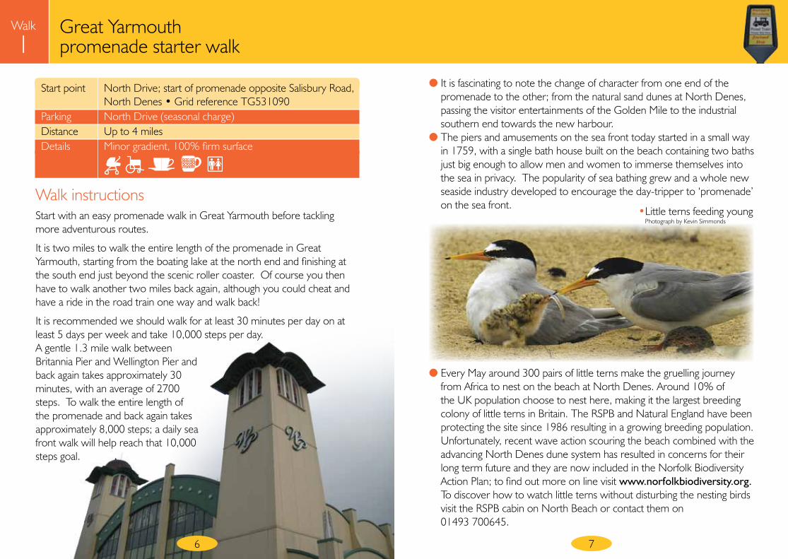
● The piers and amusements on the sea front today started in a small way in 1759, with a single bath house built on the beach containing two baths just big enough to allow men and women to immerse themselves into the sea in privacy. The popularity of sea bathing grew and a whole new seaside industry developed to encourage the day-tripper to ‘promenade’ on the sea front. • Little terns feeding young
Photograph by Kevin Simmonds
6
● Every May around 300 pairs of little terns make the gruelling journey from Africa to nest on the beach at North Denes. Around 10% of the UK population choose to nest here, making it the largest breeding colony of little terns in Britain. The RSPB and Natural England have been protecting the site since 1986 resulting in a growing breeding population. Unfortunately, recent wave action scouring the beach combined with the advancing North Denes dune system has resulted in concerns for their long term future and they are now included in the Norfolk Biodiversity Action Plan; to find out more on line visit www.norfolkbiodiversity.org. To discover how to watch little terns without disturbing the nesting birds visit the RSPB cabin on North Beach or contact them on 01493 700645.
Walk
2Great Yarmouth historic town walk
98
Start point Hall Quay, Great Yarmouth Grid reference TG521075 Parking Stonecutters Quay car park (pay and display) Distance 1.9 miles Details Minor gradient, 100% firm surface
Walk instructionsStart in Hall Quay beside Haven Bridge and walk along the Historic South Quay, keeping the river on your right.
Shortly after passing the town hall, leave the river wall and keep left of the metal railings. Turn left into Yarmouth Way at the pedestrian crossing point.
Walk up Yarmouth Way, pass St Georges Theatre at the top and continue ahead over the junctions to walk through St Georges Park beside Trafalgar Road.
Turn right at the end of Trafalgar Road onto Marine Parade.
At the Sea Life Centre and just before the Winter Gardens, turn right onto the path between the Hotel White Feather and a grass area on the left, following the signs to the Historic South Quay and Time and Tide Museum. This path becomes a tree lined street crossed by Wellington Road; note the twin arches either side.
Turn right at the T-junction into Nelson Road South and cross immediately. As the road bears sharp right continue ahead into Malakoff Road, a cobbled street.
Cross at the end into the opposite road (Garden Gate) and then turn right at the end onto Blackfriars Road. Pause to have a close look at the town wall; it is worth a short diversion to the left to see two of the remaining towers. When finished, walk towards the church passing the Time and Tide Museum.
Turn left at the T-junction in front of the church into St Peter’s Road. At the next T-junction turn right into King Street, then immediately left into Nottingham Way.
At the end turn right onto the South Quay and cross at the pedestrian lights. There is a raised viewing platform on South Quay with an information panel explaining the view across the river. Keeping the river on your left, return along the historic quay to the start point at the Haven Bridge.
● Silver Darlings (herring) were very important to the development of Great Yarmouth. In the autumn millions of herring swimming in huge shoals migrated southwards from the east coast of Scotland on their way to their shallow winter spawning grounds off Brittany. Herring rise to the surface to feed off plankton in the latter part of the day. They can lay 10,000 eggs or more and live to around ten years.
Malakoff Road
MSouth Q
uay
Haven Bridge
Start
10
Walk
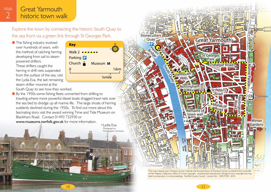
2Explore the town by connecting the historic South Quay to the sea front via a green link through St Georges Park.
Great YarmouthP
11
This map is based upon Ordnance Survey material with the permission of Ordnance Survey on behalf of the Controller of Her Majesty’s Stationery Office © Crown copyright. Unauthorised reproduction infringes Crown copyright and may lead to prosecution or civil proceedings. Norfolk County Council. Licence No: 100019340. 2010.
Great Yarmouth historic town walk
Yarmouth Way
St Georges Park
Trafalgar Road King Street
St Peter’s Road
Nottingham Way
Winter Gardens
Remains of town wall
Wellington Road
Marine Parade
Stonecutters Quay
Walk 2ParkingChurch
Key
0 ½km
¼mile
PMMuseum
● The fishing industry evolved over hundreds of years, with the method of catching herring developing from sail to steam powered drifters. These drifters caught the herring in drift nets suspended from the surface of the sea; visit the Lydia Eva, the last remaining steam drifter moored at the South Quay to see how they worked.
● By the 1950s some fishing fleets converted from drifting to trawling,where more powerful diesel boats dragged trawl nets over the sea bed to dredge up all marine life. The large shoals of herring suddenly declined during the 1950s. To find out more about this fascinating story visit the award winning Time and Tide Museum on Blackfriars Road. Contact 01493 732930 or www.museums.norfolk.gov.uk for more information.
• Lydia EvaPhotograph by Photographic memories
Walk
2Great Yarmouth historic town walk
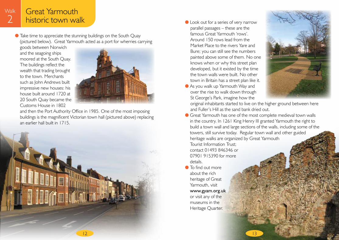
● Take time to appreciate the stunning buildings on the South Quay (pictured below). Great Yarmouth acted as a port for wherries carrying goods between Norwich and the seagoing ships moored at the South Quay. The buildings reflect the wealth that trading brought to the town. Merchants such as John Andrews built impressive new houses: his house built around 1720 at 20 South Quay became the Customs House in 1802 and then the Port Authority Office in 1985. One of the most imposing buildings is the magnificent Victorian town hall (pictured above) replacing an earlier hall built in 1715.
● Look out for a series of very narrow parallel passages – these are the famous Great Yarmouth ‘rows’. Around 150 rows lead from the Market Place to the rivers Yare and Bure; you can still see the numbers painted above some of them. No one knows when or why this street plan developed, but it existed by the time the town walls were built. No other town in Britain has a street plan like it.
● As you walk up Yarmouth Way and over the rise to walk down through St George’s Park, imagine how the original inhabitants started to live on the higher ground between here and Fuller’s Hill as the sand bank dried out.
● Great Yarmouth has one of the most complete medieval town walls in the country. In 1261 King Henry III granted Yarmouth the right to build a town wall and large sections of the walls, including some of the towers, still survive today. Regular town wall and other guided heritage walks are organized by Great Yarmouth Tourist Information Trust; contact 01493 846346 or 07901 915390 for more details.
● To find out more about the rich heritage of Great Yarmouth, visit www.gyam.org.uk or visit any of the museums in the Heritage Quarter.
12 13
Walk
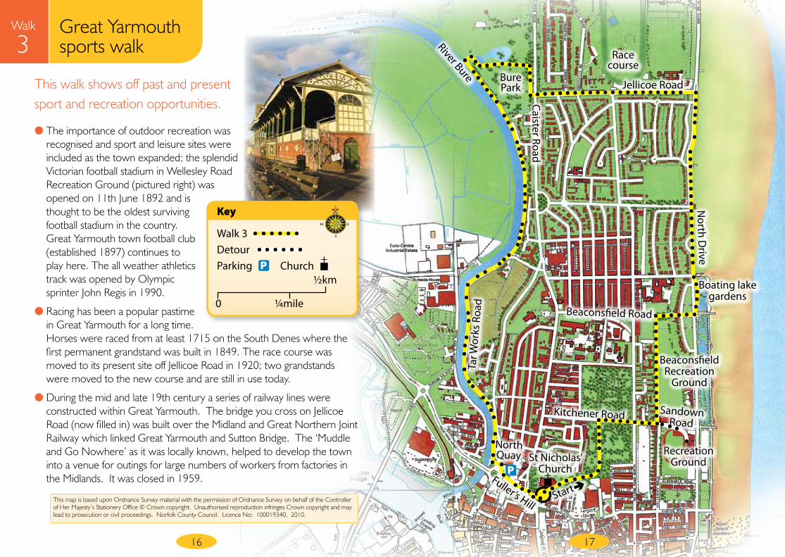
3Great Yarmouth sports walk
14
Start point St Nicholas’ Church, Great Yarmouth Grid reference TG524080 Parking Any town car park Distance 3.9 miles Details Minor gradient, 90% firm surface
Walk instructionsWalk around the back of the church and follow the main path through the cemetery. Turn right onto Kitchener Road and cross at the end onto Sandown Road opposite.
Turn right at the start of Wellesley Road to have a quick look in the recreation ground to see the Victorian grandstand – one of just two surviving wooden grandstands in England. Return to Sandown Road and cross into Beaconsfield Recreation Ground almost opposite.
At the end, turn right onto Beaconsfield Road.
Turn left the T-junction into North Drive. Cross the road to walk through the boating lake gardens adjacent to the road. Continue ahead at the end of the boating lake, keeping the sea on your right.
Turn left onto Jellicoe Road; walk on the right hand side for good views of the Great Yarmouth race course.
At the T-junction, cross Caister Road and enter Bure Park. Walk over the footbridge and turn right. Bear left after a short distance to walk across the park; pass the lake on your right and exit via the concrete steps (a little to the right of the lake). Turn left at the River Bure.
Follow the River Bure for 1.2 miles back to Great Yarmouth keeping the river on your right, passing the old yacht station. The riverside path eventually becomes Tar Works Road; follow this almost to the end, bearing right on the path beside Yarmouth Yacht Station which leads to North Quay.
Just before the bridge, turn left to walk through the North Quay underpass.
Turn right at the end and follow the path towards the town centre, pass the car park and cross at the pedestrian lights to return to the church.
● The town cemetery is one of 1,300 County Wildlife Sites in Norfolk and is an oasis for wildlife in the town. It has areas of grassland that are relicts of sand dune communities with grass species unusual to churchyards such as field rush wood, red fescue and sand sedge along with the more colourful ox-eye daisy and bird’s foot trefoil. The churchyard away from the main path provides a valuable relatively undisturbed habitat for many bird and butterfly species. Great Yarmouth cemetery is very popular with bird watchers, as it often attracts rare migrants looking for shelter as they reach land from the North Sea. St Nicholas’ Church is claimed to be the largest parish church in England.
15
Tar W
orks
Roa
d
North Quay
Boating lake gardens
Sandown Road
St Nicholas’ Church
Start
P
This walk shows off past and present sport and recreation opportunities.
Walk
3
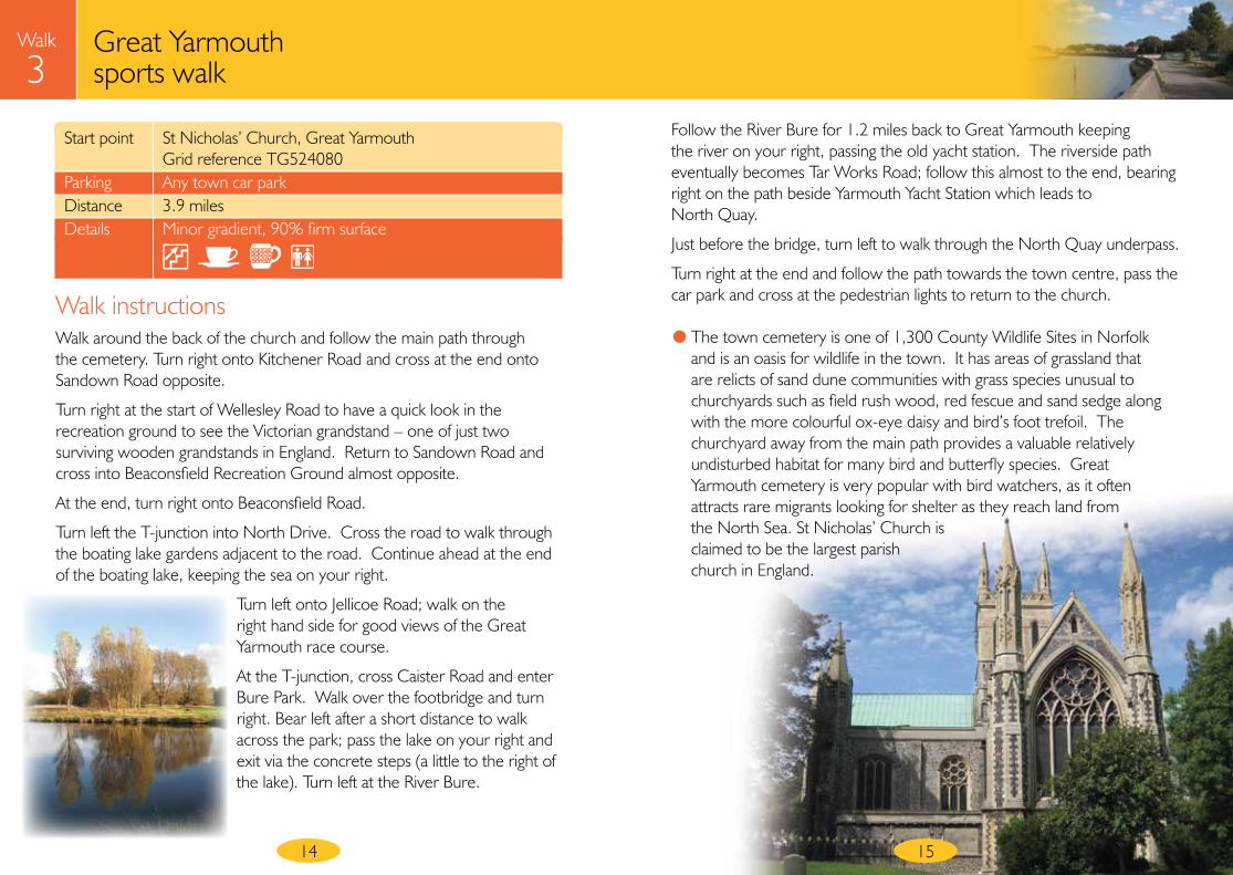
● The importance of outdoor recreation was recognised and sport and leisure sites were included as the town expanded; the splendid Victorian football stadium in Wellesley Road Recreation Ground (pictured right) was opened on 11th June 1892 and is thought to be the oldest surviving football stadium in the country. Great Yarmouth town football club (established 1897) continues to play here. The all weather athletics track was opened by Olympic sprinter John Regis in 1990.
● Racing has been a popular pastime in Great Yarmouth for a long time. Horses were raced from at least 1715 on the South Denes where the first permanent grandstand was built in 1849. The race course was moved to its present site off Jellicoe Road in 1920; two grandstands were moved to the new course and are still in use today.
● During the mid and late 19th century a series of railway lines were constructed within Great Yarmouth. The bridge you cross on Jellicoe Road (now filled in) was built over the Midland and Great Northern Joint Railway which linked Great Yarmouth and Sutton Bridge. The ‘Muddle and Go Nowhere’ as it was locally known, helped to develop the town into a venue for outings for large numbers of workers from factories in the Midlands. It was closed in 1959.
16 17
Jellicoe Road
Race course
Bure Park
River Bure
Caister Road
North D
rive
Beaconsfield Road
Recreation Ground
Beaconsfield Recreation
Ground
Kitchener Road
Fuller’s HillThis map is based upon Ordnance Survey material with the permission of Ordnance Survey on behalf of the Controller of Her Majesty’s Stationery Office © Crown copyright. Unauthorised reproduction infringes Crown copyright and may lead to prosecution or civil proceedings. Norfolk County Council. Licence No: 100019340. 2010.
Great Yarmouth sports walk
Walk 3DetourParking
Key
P
0 ¼mile
½kmChurch
Walk
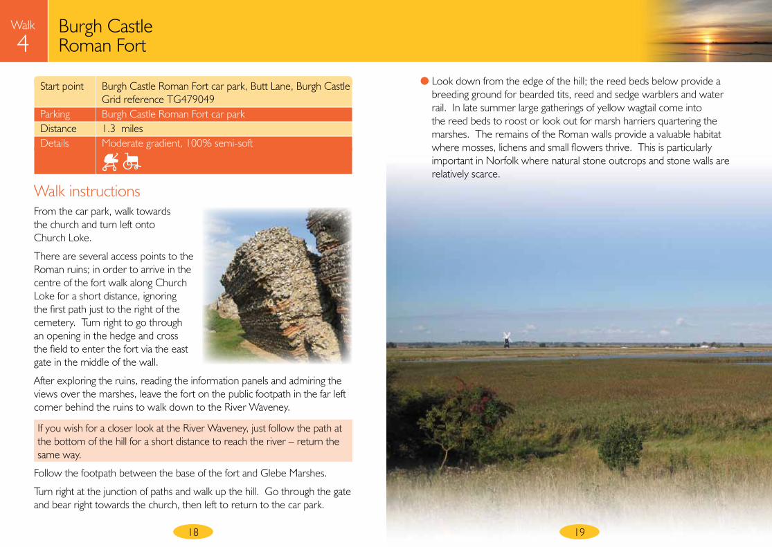
4Burgh Castle Roman Fort
● Look down from the edge of the hill; the reed beds below provide a breeding ground for bearded tits, reed and sedge warblers and water rail. In late summer large gatherings of yellow wagtail come into the reed beds to roost or look out for marsh harriers quartering the marshes. The remains of the Roman walls provide a valuable habitat where mosses, lichens and small flowers thrive. This is particularly important in Norfolk where natural stone outcrops and stone walls are relatively scarce.
Walk instructionsFrom the car park, walk towards the church and turn left onto Church Loke.
There are several access points to the Roman ruins; in order to arrive in the centre of the fort walk along Church Loke for a short distance, ignoring the first path just to the right of the cemetery. Turn right to go through an opening in the hedge and cross the field to enter the fort via the east gate in the middle of the wall.
After exploring the ruins, reading the information panels and admiring the views over the marshes, leave the fort on the public footpath in the far left corner behind the ruins to walk down to the River Waveney.
If you wish for a closer look at the River Waveney, just follow the path at the bottom of the hill for a short distance to reach the river – return the same way.
Follow the footpath between the base of the fort and Glebe Marshes.
Turn right at the junction of paths and walk up the hill. Go through the gate and bear right towards the church, then left to return to the car park.
1918
Start point Burgh Castle Roman Fort car park, Butt Lane, Burgh Castle Grid reference TG479049 Parking Burgh Castle Roman Fort car park Distance 1.3 miles Details Moderate gradient, 100% semi-soft
Start
Walk
4
This map is based upon Ordnance Survey material with the permission of Ordnance Survey on behalf of the Controller of Her Majesty’s Stationery Office © Crown copyright. Unauthorised reproduction infringes Crown copyright and may lead to prosecution or civil proceedings. Norfolk County Council. Licence No: 100019340. 2010.
Burgh Castle Roman Fort
20 21
Fascinating Roman ruins walk with panoramic views over a landscape of marsh and mills.
Walk 4DetourParking
Key
P
0 ¼mile
½kmChurch
PChurch Loke
Church Road
Butt LaneRiver Waveney
Burgh CastleRoman Fort
Glebe Marshes
● The Roman fort at Burgh Castle is a survivor of a network of similar forts, known as the Saxon Shore Forts, built in the late 3rd century to protect the coast against Saxon invasion. In Roman times two forts stood on either side of a great estuary open to the sea, with its mouth where Great Yarmouth now stands. To find out more about this superb Norfolk Archaeological Trust site read the information panels, or call in at Burgh Castle Post Office to buy the booklet ‘Outposts of the Roman Empire’ to help guide you or visit www.norfarchtrust.org.uk. The other fort is at Caister-on-Sea and has been partly excavated; you can walk through the foundations of various rooms of a Roman building (both sites are free).
● The Burgh Castle Roman site continued to be used by successive generations. It was a cemetery in Middle Saxon times and possibly was also the location of a monastery founded by St Fursey in the early 7th century. A Norman motte and bailey castle was constructed within
the fort, the motte being demolished in the mid 19th century. The only clue remaining is a large gap cut through the
south wall for a Norman ditch to run through it, and a barely visible low mound. In more recent times scallops were cut out of the cliff over the marsh when materials were dug out for a neighbouring brick works; many Yarmouth
buildings are built with bricks stamped ‘Burgh Castle’.• Sedge warbler
Photograph by Terry Leonard
23
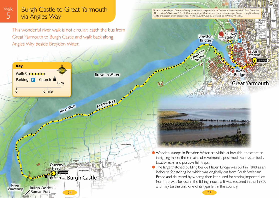
Walk
5Burgh Castle to Great Yarmouth via Angles Way
22
Start point Queens Head bus stop, High Road, Burgh Castle Grid reference TG481051 Please note this is not a circular walk You need to catch a bus from Market Gates in Gt Yarmouth to the Queens Head bus stop in Burgh Castle, First Service number 7 bus from stand D – for times check with Traveline 0871 200 2233 Parking Any town car park Distance 4.8 miles Details Minor gradients, 90% soft surface
Walk instructionsFrom the bus stop at the Queens Head and with the pub on your right, walk along Church Road.
To visit the Roman fort (adding approximately 1 mile to the walk), turn left through the gate beside the church and then bear right to cross the field to the ruins. After having a good look at the wall, walk down any of the paths or steps and turn right onto the public footpath at the base of the hill; you are now on Angles Way. Bear left at the junction of paths, go through the kissing gate onto the path on the river bank.
If not visiting the Roman town, go through the gate to the right of the church and walk down to the river.
With Breydon Water on your left, walk along Angles Way on the river bank for 4.2 miles to Great Yarmouth.
Continue along the river bank at Cobholm Island, ignoring all the paths leading off to the right. Walk under the Breydon Bridge. When the tarmac path finishes bear right, then left, turning next left again towards the back of the terraced houses.
Continue ahead on reaching Crittens Road. At Lady Haven Road, keep left on the footway beside the car park and then turn left at the end onto Steam Mill Lane. Turn left at the end and cross Haven Bridge.
There is a choice of routes to end the walk; to return to the bus station, cross South Quay Road, turn right then first left into Regent Street and walk up to the bus station.
Or if you wish to find the end of Angles Way beside the railway station; turn left after crossing Haven Bridge and walk along North Quay, turning left to cross the footbridge to the rail station. There is a great sculpture and information panel marking the Three Ways Crossing Point and the Gateway to the Broads – Britain’s largest protected wetland; this marks the start or end of Angles Way, Weavers’ Way and Wherryman’s Way.
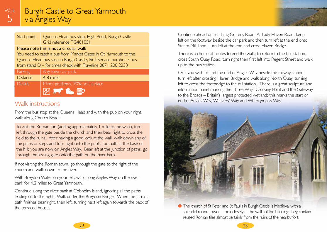
● The church of St Peter and St Paul’s in Burgh Castle is Medieval with a splendid round tower. Look closely at the walls of the building; they contain reused Roman tiles almost certainly from the ruins of the nearby fort.
Railway station
Start
Queens Head
Breydon Water
River Waveney
River Yare Angles Way
Breydon Bridge
Haven Bridge
Bus station
Cobholm
Island
Walk
5This wonderful river walk is not circular; catch the bus from Great Yarmouth to Burgh Castle and walk back along Angles Way beside Breydon Water.
2524
Burgh Castle
Walk 5Parking
Key
P
0 ½mile
1kmChurch
This map is based upon Ordnance Survey material with the permission of Ordnance Survey on behalf of the Controller of Her Majesty’s Stationery Office © Crown copyright. Unauthorised reproduction infringes Crown copyright and may lead to prosecution or civil proceedings. Norfolk County Council. Licence No: 100019340. 2010.
Burgh Castle to Great Yarmouth via Angles Way
Great Yarmouth
● Wooden stumps in Breydon Water are visible at low tide; these are an intriguing mix of the remains of revetments, post medieval oyster beds, boat wrecks and possible fish traps.
● The large thatched building beside Haven Bridge was built in 1840 as an icehouse for storing ice which was originally cut from South Walsham Broad and delivered by wherry, then later used for storing imported ice from Norway for use in the fishing industry. It was restored in the 1980s and may be the only one of its type left in the country.
P
Burgh Castle Roman Fort
26 27
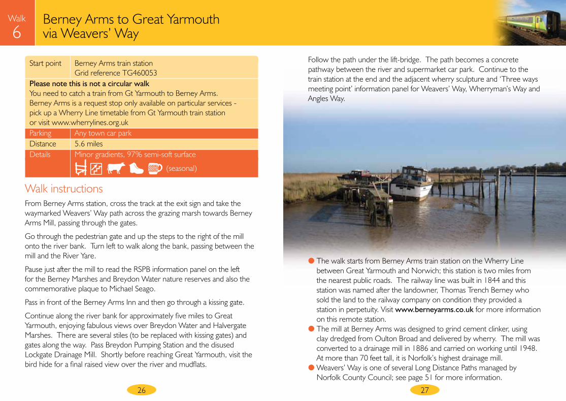
Walk instructionsFrom Berney Arms station, cross the track at the exit sign and take the waymarked Weavers’ Way path across the grazing marsh towards Berney Arms Mill, passing through the gates.
Go through the pedestrian gate and up the steps to the right of the mill onto the river bank. Turn left to walk along the bank, passing between the mill and the River Yare.
Pause just after the mill to read the RSPB information panel on the left for the Berney Marshes and Breydon Water nature reserves and also the commemorative plaque to Michael Seago.
Pass in front of the Berney Arms Inn and then go through a kissing gate.
Continue along the river bank for approximately five miles to Great Yarmouth, enjoying fabulous views over Breydon Water and Halvergate Marshes. There are several stiles (to be replaced with kissing gates) and gates along the way. Pass Breydon Pumping Station and the disused Lockgate Drainage Mill. Shortly before reaching Great Yarmouth, visit the bird hide for a final raised view over the river and mudflats.
Follow the path under the lift-bridge. The path becomes a concrete pathway between the river and supermarket car park. Continue to the train station at the end and the adjacent wherry sculpture and ‘Three ways meeting point’ information panel for Weavers’ Way, Wherryman’s Way and Angles Way.
Walk
6Berney Arms to Great Yarmouth via Weavers’ Way
● The walk starts from Berney Arms train station on the Wherry Line between Great Yarmouth and Norwich; this station is two miles from the nearest public roads. The railway line was built in 1844 and this station was named after the landowner, Thomas Trench Berney who sold the land to the railway company on condition they provided a station in perpetuity. Visit www.berneyarms.co.uk for more information on this remote station.
● The mill at Berney Arms was designed to grind cement clinker, using clay dredged from Oulton Broad and delivered by wherry. The mill was converted to a drainage mill in 1886 and carried on working until 1948. At more than 70 feet tall, it is Norfolk’s highest drainage mill.
● Weavers’ Way is one of several Long Distance Paths managed by Norfolk County Council; see page 51 for more information.
Start point Berney Arms train station Grid reference TG460053 Please note this is not a circular walk You need to catch a train from Gt Yarmouth to Berney Arms. Berney Arms is a request stop only available on particular services - pick up a Wherry Line timetable from Gt Yarmouth train station or visit www.wherrylines.org.uk Parking Any town car park Distance 5.6 miles Details Minor gradients, 97% semi-soft surface
(seasonal)
Railway station
Berney Arms station
Berney RSPB Reserve
River YareBerney Arms Mill
Breydon Water
Weavers’ Way
Lockgate Drainage Mill (disused)
Beighton Marshes
Acle Marshes
Halvergate
Marshes
A47
Railway
2928
Walk
6Another superb river walk, again this is not circular. Catch the train to Berney Arms to walk to Great Yarmouth along Weavers’ Way.
Start
P
This map is based upon Ordnance Survey material with the permission of Ordnance Survey on behalf of the Controller of Her Majesty’s Stationery Office © Crown copyright. Unauthorised reproduction infringes Crown copyright and may lead to prosecution or civil proceedings. Norfolk County Council. Licence No: 100019340. 2010.
Berney Arms to Great Yarmouth via Weavers’ Way
Breydon Bridge
Great Yarmouth
Walk 6Parking
Key
P
0 ½mile
1kmMill
30
Walk
6Walk
5Walk
4Breydon Water and Halvergate Marshes
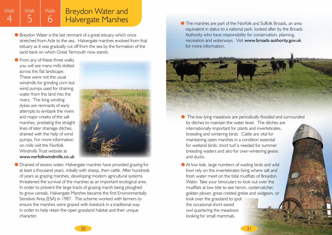
● Breydon Water is the last remnant of a great estuary which once stretched from Acle to the sea. Halvergate marshes evolved from that estuary as it was gradually cut off from the sea by the formation of the sand bank on which Great Yarmouth now stands.
● From any of these three walks you will see many mills dotted across this flat landscape. These were not the usual windmills for grinding corn but wind pumps used for draining water from the land into the rivers. The long winding dykes are remnants of early attempts to embank the rivers and major creeks of the salt marshes, predating the straight lines of later drainage ditches, drained with the help of wind pumps. For more information on mills visit the Norfolk Windmills Trust website at www.norfolkwindmills.co.uk
● Drained of excess water, Halvergate marshes have provided grazing for at least a thousand years, initially with sheep, then cattle. After hundreds of years as grazing marshes, developing modern agricultural systems threatened the survival of the marshes as an important ecological area. In order to prevent the large tracts of grazing marsh being ploughed to grow cereals, Halvergate Marshes became the first Environmentally Sensitive Area (ESA) in 1987. This scheme worked with farmers to ensure the marshes were grazed with livestock in a traditional way in order to help retain the open grassland habitat and their unique character.
● The marshes are part of the Norfolk and Suffolk Broads, an area equivalent in status to a national park, looked after by the Broads Authority who have responsibility for conservation, planning, recreation and waterways. Visit www.broads-authority.gov.uk for more information.
31
● The low lying meadows are periodically flooded and surrounded by ditches to maintain the water level. The ditches are internationally important for plants and invertebrates, breeding and wintering birds. Cattle are vital for maintaining open marshes in a condition essential for wetland birds; short turf is needed for summer breeding waders and also for over-wintering geese and ducks.
● At low tide, large numbers of wading birds and wild fowl rely on the invertebrates living where salt and fresh water meet on the tidal mudflats of Breydon Water. Take your binoculars to look out over the mudflats at low tide to see heron, oystercatcher, golden plover, great crested grebe and widgeon, or look over the grassland to spot the occasional short-eared owl quartering the meadows looking for small mammals.
32
Walk
7Gorleston quayside and town walk
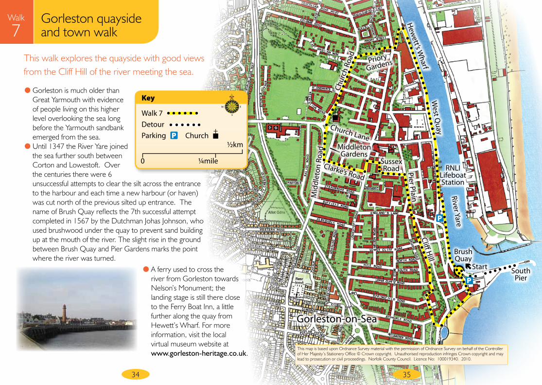
Start point Brush Quay, Quay Road, Gorleston Grid reference TG530039 Parking Quay Road car park Distance 2.2 miles Details Moderate gradient, 100% firm surface
33
Walk instructionsStart by walking along Brush Quay as far as possible on the South Pier for a good view of the River Yare meeting the sea. Then turn round and walk back along Brush Quay keeping the river on your right. Continue alongside the river; there are several sets of steps over flood defence walls.
Pass Great Yarmouth and Gorleston RNLI Lifeboat Station and the old Gorleston Volunteer Lifeboat House. Go up the steps to walk along the short section of historic waterfront, pausing to read the information panel for the timber ‘dolphins’. The remains of these wooden piers, which provided access to the deeper water of the main channel in the River Yare, are visible at low tide.
Continue along West Quay and Hewett’s Wharf. There is another information panel on a raised viewing platform shortly before the Great Yarmouth Port Authority Pilots building.
Leave the quayside by turning left at Pilots building to walk up the narrow road (Ice House Hill, not signposted); there is a sign for The Short Blue public house near the bottom of this road.
Cross the road at the top of the hill into Priory Gardens almost opposite and walk through the gardens. Leave the gardens through the gate at the end and turn left to walk towards St Andrew’s Church. Pass the church on your left and cross Church Lane.
To enter Middleton Gardens, keep right along Middleton Road for a short distance, the entrance is on the left. Turn right and walk through the park, leaving via the steps on left just before the end.
Cross the road into Clarke’s Road opposite and follow this to the end.
Turn left at the T-junction, cross almost immediately and take the first right turn into Sussex Road. Follow this as it bears right and continue round to the end.
Turn right at the T-junction onto Pier Plain. On reaching the junction on the corner, cross the road and take the right fork into Cliff Hill – a one way street signposted ‘cliffs’.
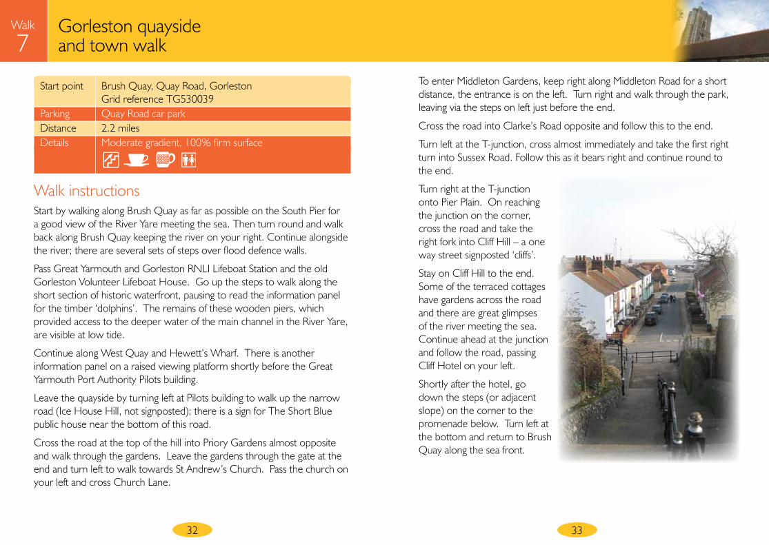
Stay on Cliff Hill to the end. Some of the terraced cottages have gardens across the road and there are great glimpses of the river meeting the sea. Continue ahead at the junction and follow the road, passing Cliff Hotel on your left.
Shortly after the hotel, go down the steps (or adjacent slope) on the corner to the promenade below. Turn left at the bottom and return to Brush Quay along the sea front.
P
Sussex Road Pier Plain
Cliff Hill
Clarke’s Road
Chur
ch R
oad
Church Lane
Mid
dlet
on R
oad
West Q
uay
Hew
ett’s Wharf
Brush Quay
RNLI Lifeboat Station
Priory
Gardens
River Yare
South Pier
Walk 7DetourParking
Key
P
0 ¼mile
½kmChurch
Walk
7This walk explores the quayside with good views from the Cliff Hill of the river meeting the sea.
34 35
Gorleston-on-Sea
This map is based upon Ordnance Survey material with the permission of Ordnance Survey on behalf of the Controller of Her Majesty’s Stationery Office © Crown copyright. Unauthorised reproduction infringes Crown copyright and may lead to prosecution or civil proceedings. Norfolk County Council. Licence No: 100019340. 2010.
Gorleston quayside and town walk
P
Middleton Gardens
Start
● Gorleston is much older than Great Yarmouth with evidence of people living on this higher level overlooking the sea long before the Yarmouth sandbank emerged from the sea.
● Until 1347 the River Yare joined the sea further south between Corton and Lowestoft. Over the centuries there were 6 unsuccessful attempts to clear the silt across the entrance to the harbour and each time a new harbour (or haven) was cut north of the previous silted up entrance. The name of Brush Quay reflects the 7th successful attempt completed in 1567 by the Dutchman Johas Johnson, who used brushwood under the quay to prevent sand building up at the mouth of the river. The slight rise in the ground between Brush Quay and Pier Gardens marks the point where the river was turned.
● A ferry used to cross the river from Gorleston towards Nelson’s Monument; the landing stage is still there close to the Ferry Boat Inn, a little further along the quay from Hewett’s Wharf. For more information, visit the local virtual museum website at www.gorleston-heritage.co.uk.
37
Walk
8Gorleston promenade and exercise trail
Start point Promenade beside Pier Hotel, Gorleston Grid reference TG530039 Parking Quay Road car park Distance 2.1 miles Details Moderate gradient, 100% firm surface
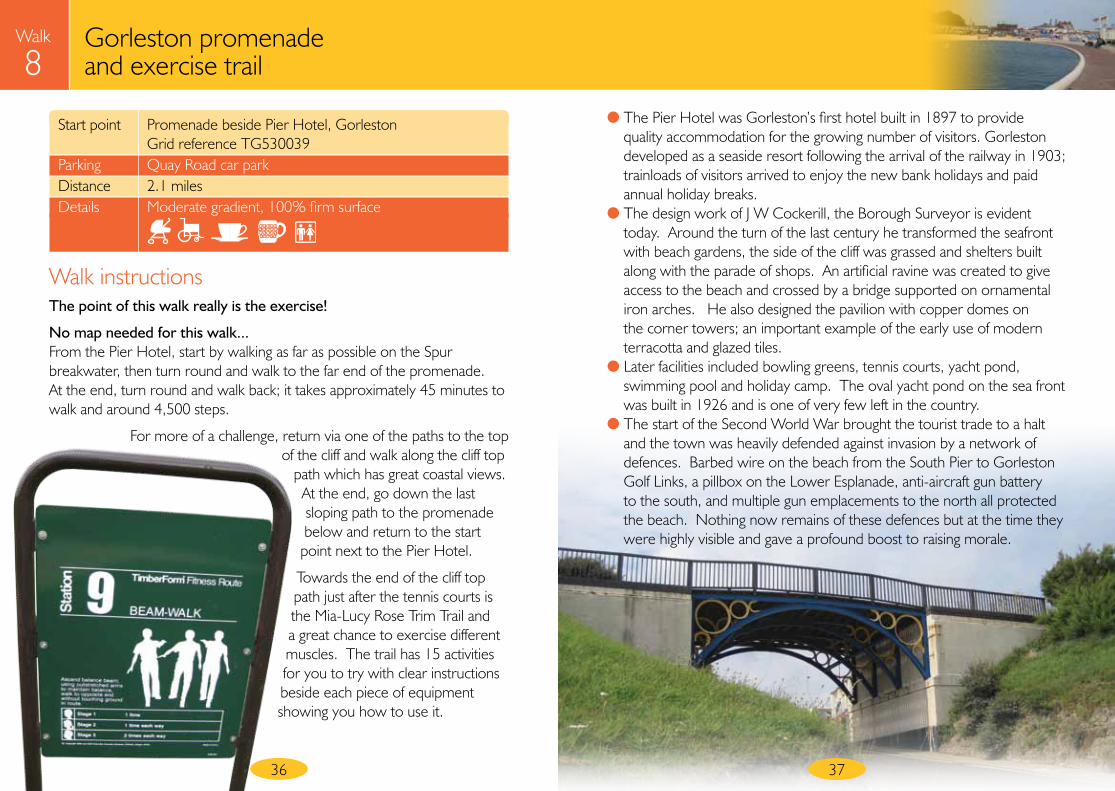
● The Pier Hotel was Gorleston’s first hotel built in 1897 to provide quality accommodation for the growing number of visitors. Gorleston developed as a seaside resort following the arrival of the railway in 1903; trainloads of visitors arrived to enjoy the new bank holidays and paid annual holiday breaks.
● The design work of J W Cockerill, the Borough Surveyor is evident today. Around the turn of the last century he transformed the seafront with beach gardens, the side of the cliff was grassed and shelters built along with the parade of shops. An artificial ravine was created to give access to the beach and crossed by a bridge supported on ornamental iron arches. He also designed the pavilion with copper domes on the corner towers; an important example of the early use of modern terracotta and glazed tiles.
● Later facilities included bowling greens, tennis courts, yacht pond, swimming pool and holiday camp. The oval yacht pond on the sea front was built in 1926 and is one of very few left in the country.
● The start of the Second World War brought the tourist trade to a halt and the town was heavily defended against invasion by a network of defences. Barbed wire on the beach from the South Pier to Gorleston Golf Links, a pillbox on the Lower Esplanade, anti-aircraft gun battery to the south, and multiple gun emplacements to the north all protected the beach. Nothing now remains of these defences but at the time they were highly visible and gave a profound boost to raising morale.
Walk instructionsThe point of this walk really is the exercise!
No map needed for this walk...From the Pier Hotel, start by walking as far as possible on the Spur breakwater, then turn round and walk to the far end of the promenade. At the end, turn round and walk back; it takes approximately 45 minutes to walk and around 4,500 steps.
For more of a challenge, return via one of the paths to the top of the cliff and walk along the cliff top
path which has great coastal views. At the end, go down the last sloping path to the promenade below and return to the start point next to the Pier Hotel.
Towards the end of the cliff top path just after the tennis courts is the Mia-Lucy Rose Trim Trail and a great chance to exercise different muscles. The trail has 15 activities for you to try with clear instructions beside each piece of equipment showing you how to use it.
36
38
Walk
9Gorleston via Hopton-on-Sea beach walk
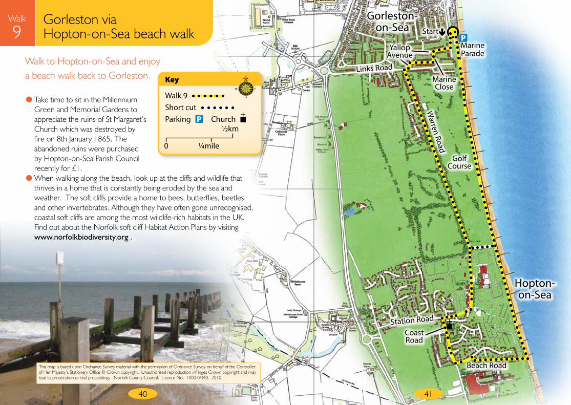
Start point Marine Parade, Gorleston Grid reference TG530021 Parking Car park at end of Marine Parade Distance 3.8 miles Details Moderate gradient, 80% soft surface
Walk instructionsPlan ahead and check the tide times before walking along the beach to avoid walking at high tide. The tide details are published daily in the Eastern Daily Press or look on line on www.bbc.co.uk/weather/coast.
With the sea behind you, turn left into Marine Parade and follow the road round to the right as it becomes Yallop Avenue. Turn first left into Marine Close. Continue on the pathway at the end, turning left to rejoin Yallop Avenue.
Turn second left into Warren Road. After the tarmac road finishes, continue along the green link path between Gorleston and Hopton-on-Sea. Please keep to the path and ignore any cross paths for the adjacent golf course.
Walk straight across at the roundabout and continue to the end, ignoring all entrances to the holiday village. Turn left at the T-junction into the Coast Road.
Pass the Millennium Green and Memorial Gardens and the remains of St Margaret’s Church. After Hopton Primary School turn third left into Beach Road.
Bear right after a short distance to follow Beach Road down to the sea.
On reaching the beach turn left and keeping the sea on your right walk along the beach for 1.4 miles to Gorleston.
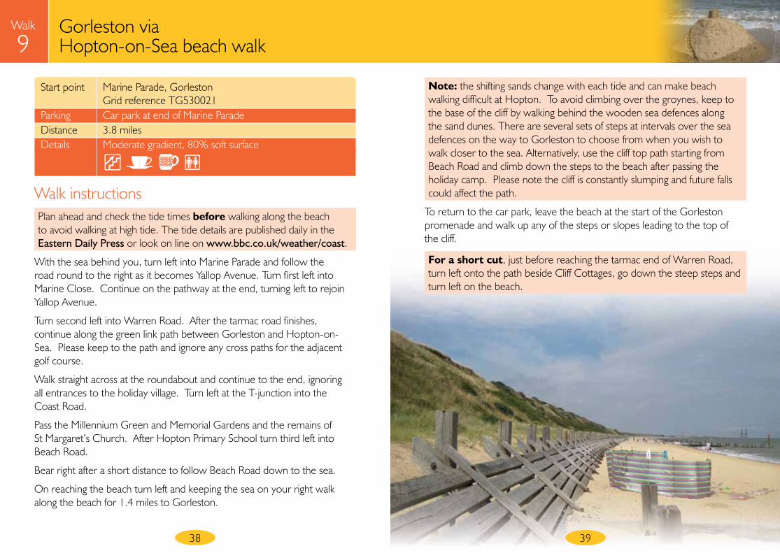
Note: the shifting sands change with each tide and can make beach walking difficult at Hopton. To avoid climbing over the groynes, keep to the base of the cliff by walking behind the wooden sea defences along the sand dunes. There are several sets of steps at intervals over the sea defences on the way to Gorleston to choose from when you wish to walk closer to the sea. Alternatively, use the cliff top path starting from Beach Road and climb down the steps to the beach after passing the holiday camp. Please note the cliff is constantly slumping and future falls could affect the path.
To return to the car park, leave the beach at the start of the Gorleston promenade and walk up any of the steps or slopes leading to the top of the cliff.
For a short cut, just before reaching the tarmac end of Warren Road, turn left onto the path beside Cliff Cottages, go down the steep steps and turn left on the beach.
39
Beach Road
Marine Parade
Walk
9Walk to Hopton-on-Sea and enjoy a beach walk back to Gorleston.
40 41
Start P
This map is based upon Ordnance Survey material with the permission of Ordnance Survey on behalf of the Controller of Her Majesty’s Stationery Office © Crown copyright. Unauthorised reproduction infringes Crown copyright and may lead to prosecution or civil proceedings. Norfolk County Council. Licence No: 100019340. 2010.
Gorleston via Hopton-on-Sea beach walk
Gorleston-on-Sea
Hopton-on-Sea
Walk 9Short cutParking
Key
P
0 ¼mile
½kmChurch
Yallop Avenue
Coast Road
Marine Close
Golf Course
Links Road
Warren Road
Station Road
● Take time to sit in the Millennium Green and Memorial Gardens to appreciate the ruins of St Margaret’s Church which was destroyed by fire on 8th January 1865. The abandoned ruins were purchased by Hopton-on-Sea Parish Council recently for £1.
● When walking along the beach, look up at the cliffs and wildlife that thrives in a home that is constantly being eroded by the sea and weather. The soft cliffs provide a home to bees, butterflies, beetles and other invertebrates. Although they have often gone unrecognised, coastal soft cliffs are among the most wildlife-rich habitats in the UK. Find out about the Norfolk soft cliff Habitat Action Plans by visiting www.norfolkbiodiversity.org .
42
Walk
10Winterton via East Somerton
Start point Beach Road car park, Winterton Grid reference TG498197 Parking Beach Road car park, Winterton (seasonal charge) Distance 3.3 miles Details Moderate gradient, 30% soft
Walk instructionsFrom the car park, walk to the village on the path beside Beach Road.
Turn second left onto The Loke and then right at the T-junction onto King Street, which shortly becomes The Craft.
Continue along The Craft to the end, ignoring all side roads.
Turn left at the T-junction onto Hemsby Road. Walk along this short busy section of Hemsby Road for approximately 150 metres, then turn first right onto the public footpath beside Mill Farm.
After passing the buildings, continue in the same direction on the farm track over the hill. Follow the track as it bears right to walk between High Barn Farm and Somerton Wind Farm, continuing ahead as it becomes a tarmac track.
Cross Winterton Road onto Manor Farm Road almost opposite.
Follow the road around to the right as it becomes Low Road. Shortly after passing the white house on the left, continue ahead onto the public bridleway at the point where the road bears sharp right.
Cross North Market Road at the end onto the opposite track, between the houses.
Bear slightly right at the Winterton-Horsey Dunes Site of Special Scientific Interest sign, then left to follow the vehicle track through the dunes to the wooden boat sheds beside the car park.
43
seasonal café
● Clement Scott, the Victorian writer who promoted the Cromer area as ’Poppyland’, recorded his thoughts on windmills over 110 years ago “I wonder if these old-fashioned windmills, dotted all over England, could ever be utilized for the collection and storage of one of the forces that are in time to supersede steam”. His question has been answered by the 10 wind turbines at West Somerton Wind Farm towering over the landscape which produce renewable energy for about 1,400 houses.
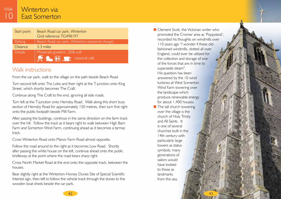
● The tall church towering over the village is the church of Holy Trinity and All Saints. It is one of several churches built in the 14th century with particularly large towers as status symbols; many generations of sailors would have looked to these as landmarks from the sea.
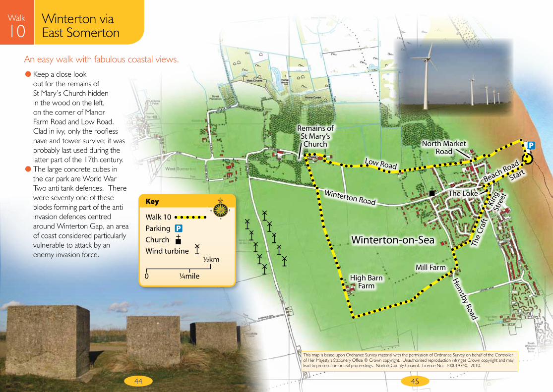
Mill FarmHigh Barn
Farm
Remains of St Mary’s Church
Winterton Road
Low Road
The Loke
North Market Road
Beach Road
King
St
reet
The
Craf
t
Hemsby Road
An easy walk with fabulous coastal views.
44 45
Start
P
Winterton-on-Sea
This map is based upon Ordnance Survey material with the permission of Ordnance Survey on behalf of the Controller of Her Majesty’s Stationery Office © Crown copyright. Unauthorised reproduction infringes Crown copyright and may lead to prosecution or civil proceedings. Norfolk County Council. Licence No: 100019340. 2010.
Walk
10Winterton via East Somerton
● Keep a close look out for the remains of St Mary’s Church hidden in the wood on the left, on the corner of Manor Farm Road and Low Road. Clad in ivy, only the roofless nave and tower survive; it was probably last used during the latter part of the 17th century.
● The large concrete cubes in the car park are World War Two anti tank defences. There were seventy one of these blocks forming part of the anti invasion defences centred around Winterton Gap, an area of coast considered particularly vulnerable to attack by an enemy invasion force.
Walk 10ParkingChurchWind turbine
Key
P
0 ¼mile
½km
46
Walk
11Winterton Dunes AONB walk
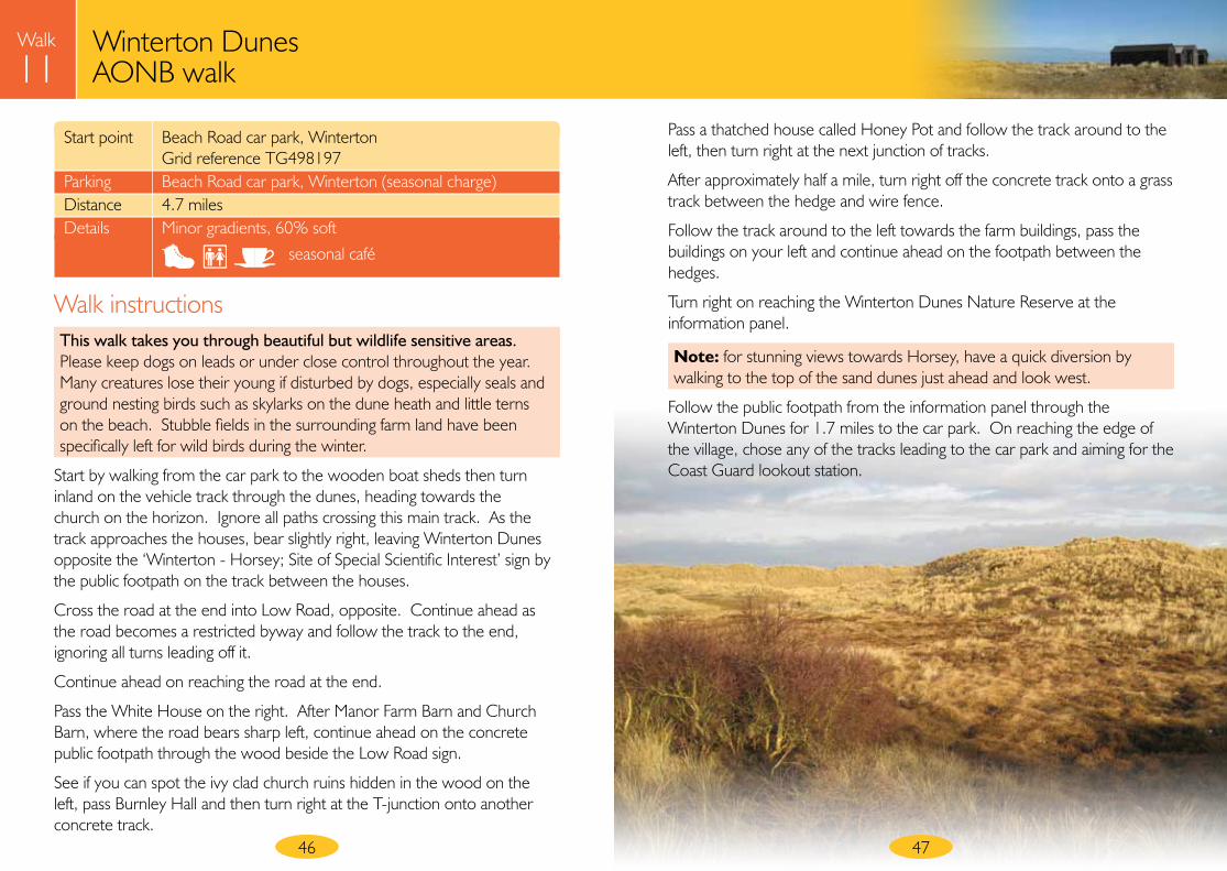
Start point Beach Road car park, Winterton Grid reference TG498197 Parking Beach Road car park, Winterton (seasonal charge) Distance 4.7 miles Details Minor gradients, 60% soft
Walk instructionsThis walk takes you through beautiful but wildlife sensitive areas. Please keep dogs on leads or under close control throughout the year. Many creatures lose their young if disturbed by dogs, especially seals and ground nesting birds such as skylarks on the dune heath and little terns on the beach. Stubble fields in the surrounding farm land have been specifically left for wild birds during the winter.
Start by walking from the car park to the wooden boat sheds then turn inland on the vehicle track through the dunes, heading towards the church on the horizon. Ignore all paths crossing this main track. As the track approaches the houses, bear slightly right, leaving Winterton Dunes opposite the ‘Winterton - Horsey; Site of Special Scientific Interest’ sign by the public footpath on the track between the houses.
Cross the road at the end into Low Road, opposite. Continue ahead as the road becomes a restricted byway and follow the track to the end, ignoring all turns leading off it.
Continue ahead on reaching the road at the end.
Pass the White House on the right. After Manor Farm Barn and Church Barn, where the road bears sharp left, continue ahead on the concrete public footpath through the wood beside the Low Road sign.
See if you can spot the ivy clad church ruins hidden in the wood on the left, pass Burnley Hall and then turn right at the T-junction onto another concrete track.
Pass a thatched house called Honey Pot and follow the track around to the left, then turn right at the next junction of tracks.
After approximately half a mile, turn right off the concrete track onto a grass track between the hedge and wire fence.
Follow the track around to the left towards the farm buildings, pass the buildings on your left and continue ahead on the footpath between the hedges.
Turn right on reaching the Winterton Dunes Nature Reserve at the information panel.
Note: for stunning views towards Horsey, have a quick diversion by walking to the top of the sand dunes just ahead and look west.
Follow the public footpath from the information panel through the Winterton Dunes for 1.7 miles to the car park. On reaching the edge of the village, chose any of the tracks leading to the car park and aiming for the Coast Guard lookout station.
seasonal café
47
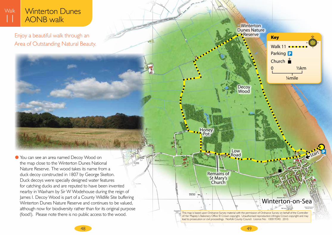
Low Road
Honey Pot
Winterton Dunes Nature
Reserve
Decoy Wood
Walk
11Enjoy a beautiful walk through an Area of Outstanding Natural Beauty.
48 49
Start
Walk 11Parking
Church
Key
0 ½km
¼mile
P
P
This map is based upon Ordnance Survey material with the permission of Ordnance Survey on behalf of the Controller of Her Majesty’s Stationery Office © Crown copyright. Unauthorised reproduction infringes Crown copyright and may lead to prosecution or civil proceedings. Norfolk County Council. Licence No: 100019340. 2010.
Winterton Dunes AONB walk
● You can see an area named Decoy Wood on the map close to the Winterton Dunes National Nature Reserve. The wood takes its name from a duck decoy constructed in 1807 by George Skelton. Duck decoys were specially designed water features for catching ducks and are reputed to have been invented nearby in Waxham by Sir W Wodehouse during the reign of James I. Decoy Wood is part of a County Wildlife Site buffering Winterton Dunes Nature Reserve and continues to be valued, although now for biodiversity rather than for its original purpose (food!). Please note there is no public access to the wood.
Winterton-on-Sea
Remains of St Mary’s Church
50 51
Walk
11Winterton Dunes AONB walk
● The dunes at Winterton are classified as a Site of Special Scientific Interest and are part of the Area of Outstanding Natural Beauty which stretches from Winterton to Sea Palling.
● These naturally forming dunes are unusual in that they show greater ecological similarities to the dune systems of the Baltic - which support acidic plant communities - rather than the dunes on the North Norfolk Coast - where the sand is calcareous. It is one of just a few sites in Norfolk to have a stable breeding population of Natterjack toads, Europe’s loudest amphibian. The toads burrow in the dunes and breed in the shallow pools behind the main ridge, which also supports adders, smooth and great crested newts. A number of dragonfly species use the pools including the Norfolk and common hawker. This special interest is protected under powerful European legislation and the site is also a National Nature Reserve managed by Natural England, for more information visit www.naturalengland.org.uk.
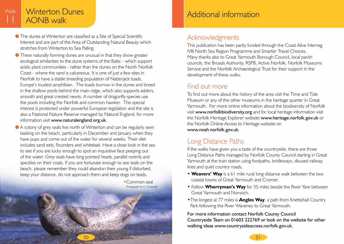
● A colony of grey seals live north of Winterton and can be regularly seen basking on the beach, particularly in December and January when they have pups and come out of the water for several weeks. Their diet includes sand eels, flounders and whitebait. Have a close look in the sea to see if you are lucky enough to spot an inquisitive face peeping out of the water. Grey seals have long pointed heads, parallel nostrils and speckles on their coats. If you are fortunate enough to see seals on the beach, please remember they could abandon their young if disturbed, keep your distance, do not approach them and keep dogs on leads.
• Common seal Photograph by G. Cresswell
Additional information
AcknowledgmentsThis publication has been partly funded through the Coast Alive Interreg IVB North Sea Region Programme and Smarter Travel Choices. Many thanks also to Great Yarmouth Borough Council, local parish councils, the Broads Authority, RSPB, Active Norfolk, Norfolk Museums Service and the Norfolk Archaeological Trust for their support in the development of these walks.
Find out moreTo find out more about the history of the area visit the Time and Tide Museum or any of the other museums in the heritage quarter in Great Yarmouth. For more online information about the biodiversity of Norfolk visit www.norfolkbiodiversity.org and for local heritage information visit the Norfolk Heritage Explorer website www.heritage.norfolk.gov.uk or the Norfolk Online Access to Heritage website on www.noah.norfolk.gov.uk.
Long Distance PathsIf the walks have given you a taste of the countryside, there are three Long Distance Paths managed by Norfolk County Council starting in Great Yarmouth at the train station using footpaths, bridleways, disused railway lines and quiet country roads. • Weavers’ Way is a 61 mile rural long distance walk between the two
coastal towns of Great Yarmouth and Cromer. • Follow Wherryman’s Way for 35 miles beside the River Yare between
Great Yarmouth and Norwich. • The longest at 77 miles is Angles Way, a path from Knettishall Country
Park following the River Waveney to Great Yarmouth.
For more information contact Norfolk County Council Countryside Team on 01603 222769 or look on the website for other walking ideas www.countrysideaccess.norfolk.gov.uk.
52
Norfolk County Councilwww.norfolk.gov.uk
Norfolk Heritage Explorerwww.heritage.norfolk.gov.uk
Norfolk Online Access to Heritagewww.noah.norfolk.gov.uk
Norfolk Biodiversity Partnershipwww.norfolkbiodiversity.org
Great Yarmouth Borough Councilwww.great-yarmouth.gov.uk
Active Norfolkwww.activenorfolk.org
Other walking ideas:Norfolk County Council Countryside Accesswww.countrysideaccess.norfolk.gov.uk
Days Out in Norfolk www.norfolk.gov.uk/daysoutbybusandtrain
Led walks in the area:Walking the way to healthwww.whi.org.uk
Heritage guided walksGreat Yarmouth Tourist Information Trust01493 846346
Public transport:Traveline 0871 200 2233www.travelineeastanglia.co.uk
Wherry Line train service to Berney Armswww.wherrylines.org.uk
Other:Norfolk Museums & Archaeology Service 01493 743930www.museums.norfolk.gov.uk
Great Yarmouth Archaeological Mapwww.gyam.org.uk
Norfolk Archaeological Trustwww.norfarchtrust.org.uk
Gorleston heritagewww.gorleston-heritage.co.uk
Berney Armswww.berneyarms.co.uk
Norfolk Windmills Trustwww.norfolkwindmills.co.uk
Broads Authoritywww.broads-authority.gov.uk
RSBPwww.rspb.org.uk
Area of Outstanding Natural Beautywww.norfolkcoastaonb.org.uk
Natural Englandwww.naturalengland.org.uk
Useful contacts
Contact us...If you have any comments regarding these walks, whether good or not so good – tell us what you think!
Write to: Norfolk County Council, County Hall, Martineau Lane, Norwich, Norfolk NR1 2SGEmail: [email protected]: 01603 222769
• All information correct at time of going to press (February 2010)• Printed on recycled paper using vegetable based inks
at your serviceNorfolk County Council
G23623 2/10 CB
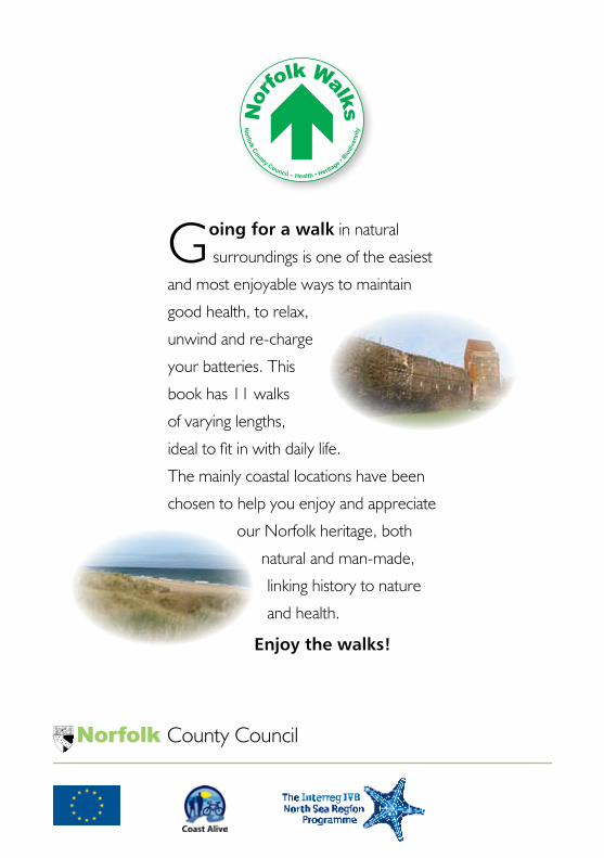
Going for a walk in natural
surroundings is one of the easiest
and most enjoyable ways to maintain
good health, to relax,
unwind and re-charge
your batteries. This
book has 11 walks
of varying lengths,
ideal to fit in with daily life.
The mainly coastal locations have been
chosen to help you enjoy and appreciate
our Norfolk heritage, both
natural and man-made,
linking history to nature
and health.
Enjoy the walks!
Norfolk County Council
No
rfolk C
ounty Council – Health • Heritage •
Biodi
vers
ity
Nor
folk Walks