glastonburv and rocky hill - national park service or town glastonburv and rocky hill ... 121, 131,...
TRANSCRIPT
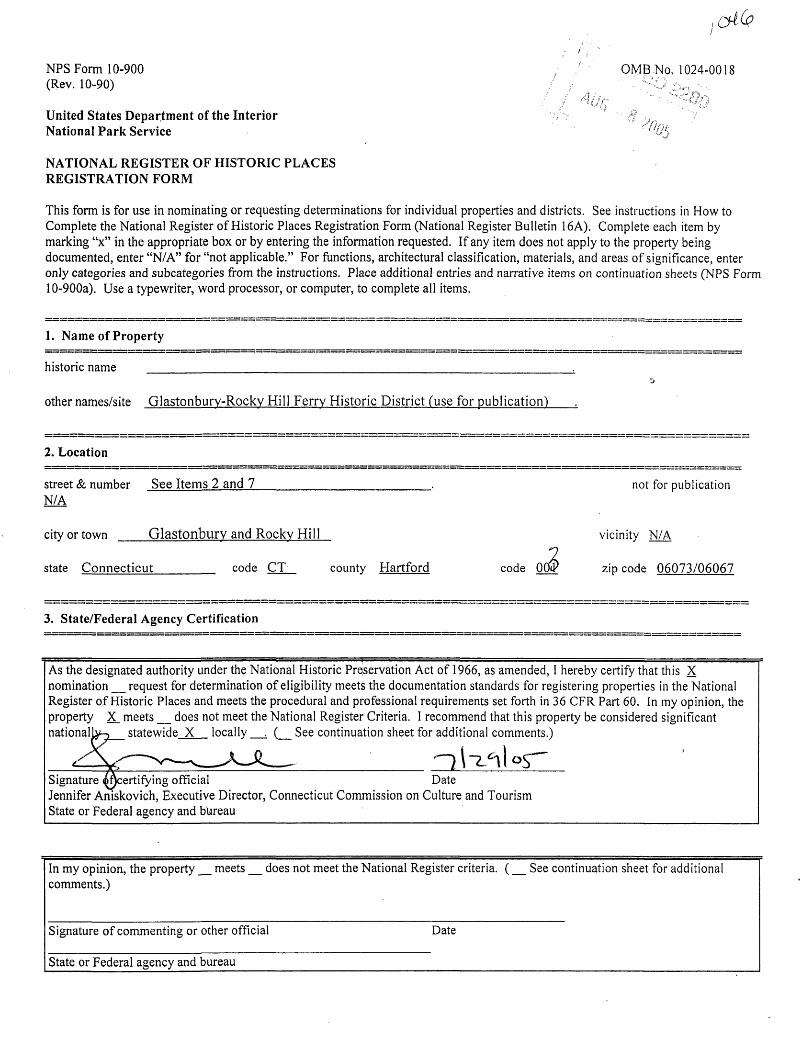
NFS Form 10-900 . 0MB No, 1024-0018 (Rev. 10-90) / , -\.^i"
United States Department of the Interior / <f v National Park Service ' IJU^
NATIONAL REGISTER OF HISTORIC PLACES REGISTRATION FORM
This form is for use in nominating or requesting determinations for individual properties and districts. See instructions in How to Complete the National Register of Historic Places Registration Form (National Register Bulletin 16A). Complete each item by marking "x" in the appropriate box or by entering the information requested. If any item does not apply to the property being documented, enter "N/A" for "not applicable." For functions, architectural classification, materials, and areas of significance, enter only categories and subcategories from the instructions. Place additional entries and narrative items on continuation sheets (NPS Form 10-900a). Use a typewriter, word processor, or computer, to complete all items.
1. Name of Property
historic name
other names/site Glastonburv-Rockv Hill Ferry Historic District (use for publication)
2. Location
street & number See Items 2 and 7N/A
not for publication
city or town Glastonburv and Rocky Hill
state Connecticut code CT county Hartford code 0
vicinity N/A
zip code 06073/06067
3. State/Federal Agency Certification
As the designated authority under the National Historic Preservation Act of 1966, as amended, I hereby certify that this X nomination _ request for determination of eligibility meets the documentation standards for registering properties in the National Register of Historic Places and meets the procedural and professional requirements set forth in 36 CFR Part 60. In my opinion, the property X_ meets _ does not meet the National Register Criteria. I recommend that this property be considered significant nationally.-, statewide X locally _. (_ See continuation sheet for additional comments.)
Signature (^certifying official DateJennifer Aniskovich, Executive Director, Connecticut Commission on Culture and TourismState or Federal agency and bureau
In my opinion, the property _ meets _ does not meet the National Register criteria. (_ See continuation sheet for additional comments.)
Signature of commenting or other official Date
State or Federal agency and bureau
NFS Form 10-900a OMB Approval No. 1024-0018 (8-86)
United States Department of the Interior National Park Service
NATIONAL REGISTER OF HISTORIC PLACES CONTINUATION SHEET
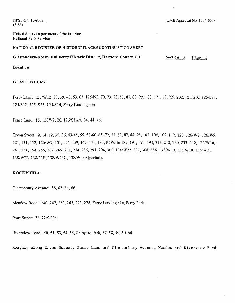
Glastonbury-Rocky Hill Ferry Historic District, Hartford County, CT Section 2 Page 1
Location
GLASTONBURY
Ferry Lane: 125/W12, 23, 39, 43, 53, 63, 125/N2, 70, 73, 78, 83, 87, 88, 99, 108, 171, 125/89,202, 125/S10, 125/S11,
125/S12. 125, S13, 125/S14, Ferry Landing site.
Pease Lane: 15, 126W2, 26, 126/S1AA, 34, 44, 46.
Tryon Street: 9, 14, 19, 35, 36, 43-45, 55, 58-60, 65, 72, 77, 80, 87, 88, 95, 103, 104, 109, 112, 120, 126/W8, 126/W9,
121, 131, 132, 126/W7, 151, 156, 159, 167, 171, 183, ROW to 187, 191, 193, 194,213,218,230,233,240, 125/W16,
241, 251, 254, 255, 262, 265, 271, 274, 286, 291, 294, 300, 138/W22, 302, 308, 386, 138/W19, 138/W20, 138/W21,
138/W22, 138/23B, 138/W23C, 138/W23A(partial).
ROCKY HILL
Glastonbury Avenue: 58, 62, 64, 66.
Meadow Road: 240, 247, 262, 263, 273, 276, Ferry Landing site, Ferry Park.
Pratt Street: 72, 22/5/004.
Riverview Road: 50, 51, 53, 54, 55, Shipyard Park, 57, 58, 59, 60, 64.
Roughly along Tryon Street, Ferry Lane and Glastonbury Avenue, Meadow and Riverview Roads
Glastonbury-Rocky Hill Ferry Historic DistrictName of Property
Hartford, CTCounty and State
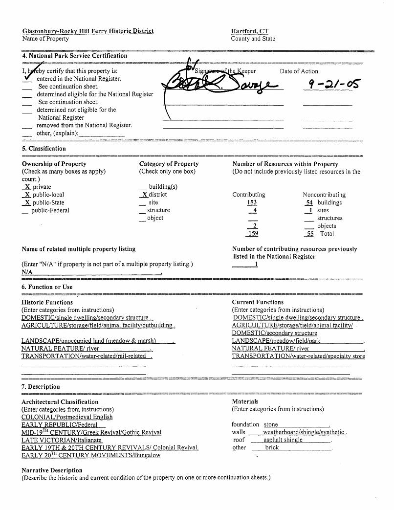
4. National Park Service Certification
I, hereby certify that this property is: entered in the National Register.See continuation sheet.
determined eligible for the National RegisterSee continuation sheet,
determined not eligible for theNational Registerremoved from the National Register.other, (explain):_________
Date of Action
5. Classification
Ownership of Property(Check as many boxes as apply) count.)
X privateX public-localX public-State
_ public-Federal
Category of Property(Check only one box)
_ building(s)X district
__ site _ structure _ object
Number of Resources within Property(Do not include previously listed resources in the
Contributing 153
159
Noncontributing54 buildings
_!_ sites __ structures _ objects
55 Total
Name of related multiple property listing
(Enter "N/A" if property is not part of a multiple property listing.)N/A___ ________________.
Number of contributing resources previously listed in the National Register
1
6. Function or Use
Historic Functions(Enter categories from instructions) DQMESTIC/single dwelling/secondary structure . AGRICULTURE/storase/field/animal facility/outbuilding.
LANDSCAPE/unoccupied land (meadow & marsh)___._ NATURAL FEATURE/ river__________._ TRANSPORTATION/water-related/rail-related .
Current Functions(Enter categories from instructions) DQMESTIC/single dwelling/secondary structure . AGRICULTURE/storage/field/animal facility/ . DQMESTIC/secondary structure LANDSCAPE/meadow/field/park________. NATURAL FEATURE/ river___________& TRANSPORTATION/water-related/specialtv store
1, Description
Architectural Classification(Enter categories from instructions)COLONIAL/Postmedieval EnglishEARLY REPUBLIC/FederalMID-19 CENTURY/Greek Revival/Gothic RevivalLATE VICTORIAN/ItalianateEARLY 19TH & 2QTH CENTURY REVIVALS/ Colonial Revival.EARLY 20 CENTURY MOVEMENTS/Bungalow
Materials(Enter categories from instructions)
foundation stone__________,.walls weatherboard/shingle/syntheticroof asphalt shingle_____.other brick
Narrative Description(Describe the historic and current condition of the property on one or more continuation sheets.)
NFS Form 10-900a 0MB Approval No. 1024-0018 (8-86)
United States Department of the Interior National Park Service
NATIONAL REGISTER OF HISTORIC PLACES CONTINUATION SHEET
Glastonbury-Rocky Hill Ferry Historic District, Hartford County, CT Section 7 Page 1
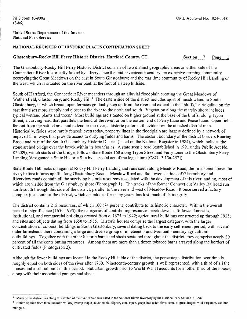
The Glastonbury-Rocky Hill Ferry Historic District consists of two distinct geographic areas on either side of the Connecticut River historically linked by a ferry since the mid-seventeenth century: an extensive farming community occupying the Great Meadows on the east in South Glastonbury; and the maritime community of Rocky Hill Landing on the west, which is situated on the river bank at the foot of a steep hillside.
South of Hartford, the Connecticut River meanders through an alluvial floodplain creating the Great Meadows of Wethersfield, Glastonbury, and Rocky Hill. 1 The eastern side of the district includes most of meadowland in South Glastonbury, in which broad, open terraces gradually step up from the river and extend to the "bluffs," a ridgeline on the east that rises more steeply and closer to the river to the north and south. Vegetation along the marshy shore includes typical wetland plants and trees.2 Most buildings are situated on higher ground at the base of the bluffs, along Tryon Street, a curving road that parallels the bend of the river, or on the eastern end of Ferry Lane and Pease Lane. Open fields fan out from the settled area and extend to the river, a historic pattern still evident on the attached district map. Historically, fields were rarely fenced; even today, property lines in the floodplain are largely defined by a network of unpaved farm ways that provide access to outlying fields and barns. The eastern boundary of the district borders Roaring Brook and part of the South Glastonbury Historic District (listed on the National Register in 1984), which includes the stone arched bridge over the brook within its boundaries. A state scenic road (established in 1991 under Public Act No. 87-289), which starts at the bridge, follows State Route 160 along Tryon Street and Ferry Lane to the Glastonbury Ferry Landing (designated a State Historic Site by a special act of the legislature [CSG 13 13a-252]).
State Route 160 picks up again at Rocky Hill Ferry Landing and runs south along Meadow Road, the first street above the river, before it turns uphill along Glastonbury Road. Meadow Road and the lower sections of Glastonbury and Riverview roads contain all the surviving historic resources associated with the development of this river landing, most of which are visible from the Glastonbury shore (Photograph 1). The tracks of the former Connecticut Valley Railroad run north-south through this side of the district, parallel to the river and west of Meadow Road. It once served a factory complex just south of the district, which abandoned for many years, has lost much of its integrity.
The district contains 215 resources, of which 160 (74 percent) contribute to its historic character. Within the overall period of significance (1650-1995), the categories of contributing resources break down as follows: domestic, institutional, and commercial buildings erected from c. 1675 to 1942; agricultural buildings constructed up through 1955; and sites and objects dating from 1650 to 1955. Historic houses comprise the largest category, with the larger concentration of colonial buildings in South Glastonbury, several dating back to the early settlement period, with several older farmsteads there containing a large and diverse group of nineteenth- and twentieth- century agricultural outbuildings. Together with the other historic barns and sheds scattered throughout the district, they comprise nearly 30 percent of all the contributing resources. Among them are more than a dozen tobacco barns arrayed along the borders of cultivated fields (Photograph 2).
Although far fewer buildings are located in the Rocky Hill side of the district, the percentage distribution over time is roughly equal on both sides of the river after 1760. Nineteenth-century growth is well represented, with a third of all the houses and a school built in this period. Suburban growth prior to World War II accounts for another third of the houses, along with their associated garages and sheds.
1 Much of the district lies along this stretch of the river, which was listed in the National Rivers Inventory by the National Park Service in 1998.2 Native riparian flora there includes willow, swamp maple, silver maple, slippery elm, aspen, grape, box elder, ferns, cattails, greendragon, wild bergamot, and bur
marigold.
NFS Form 10-900a 0MB Approval No. 1024-0018 (8-86)
United States Department of the Interior National Park Service
NATIONAL REGISTER OF HISTORIC PLACES CONTINUATION SHEET
Glastonbury-Rocky Hill Ferry Historic District, Hartford County, CT Section 7 Page 2
Contributing historic sites in the district include the ferry landings on both sides of the river, a private cemetery, and a park. The ferry vessels, the barge Hollister III, (58' x 15'), and the towboat Cumberland, which are tied up to pilings at the Rocky Hill landing during the off-season (November through April), were placed in service in 1955 and are considered contributing (moveable) objects (Inventory #s 190, 191; Photograph 4).
Various domestic colonial types and forms are represented in the district. All organized around a center-chimney plan, they include saltboxes and one-story cottages, as well as the more standard five-bay, two-story Colonial. Two of the oldest examples are saltboxes with integral rear ells which were built by the Hollister family (Inventory #s 52, 70; Photographs 4, 5). The c. 1690 John Hollister House (listed on the National Register in 1974) is located above Roaring Brook at the eastern entrance to the district. 3 It features a hewn fa9ade overhang with partially exposed carved corbels and framed double overhangs in the gable ends, also elaborated with corbelling.4 The leanto was raised to two stories at the northwest rear corner about 1840 and there is a one-story ell addition at the northeast rear. Until recently a flared door hood, a type more common in the New Haven Colony, distinguished the Amos Hollister saltbox, which, although now clad in artificial siding, has retained its essential form and fenestration pattern. The only other saitbox in the district, located across the river on Riverview Road, has retained the ell, but displays a totally remodeled facade (Inventory #200).
The c. 1700 Thomas Treat House, a one-story cottage with a gambrel-roofed attic, is set well back from the southeast side of Tryon Street (Inventory #145; Photograph 6). 5 Although substantially intact, alterations to the house include replacement of the lower slope of the rear roof at a more shallow angle and the addition of windows to the original three- bay fa9ade. Gambrel-roofed Capes, a type of cottage introduced later in the century, are found in Rocky Hill, including one in the district, which probably was moved up from the landing to its present site at the foot of Glastonbury Road sometime after 1870 (Inventory #179).
Many two-story, gable-roofed, Colonial-style houses were built in the district from about 1740 to 1790. Characteristically plain dwellings with center chimneys and five-bay facades, the oldest is the Joseph Hollister III House, set back and slightly above the west side of Tryon Street (Inventory #105, Photograph 7). Like many Colonials in the district, it has a multi-paned transom over the door. Both the Jonathan Miller and James Kellam houses, built about 1760, have been restored (Inventory #s 150, 40; Photograph 8, 9). The addition of a wing and a new doorway were included in the restoration of the Kellam House; the splayed door surround, possibly a replica of the original, is fairly common in the area. There is no district precedent, however, for the pedimented doorway on the Kellam House, a recent replacement for a Greek Revival entrance dating from the 1840s. Because the house is located in the flood plain at the end of Ferry Lane, the stone foundation was rebuilt well above grade. Another Hollister Colonial built just prior to the Revolution exhibits slight double overhangs, purely a cosmetic interpretation of the pronounced overhang featured on the old Hollister saltbox (Inventory #117; Photograph 10). Its open facade porch was added in the late 1800s. Recent residing partially obscures the ear-molded architrave at the front door of the 1765 Treat House, but its narrow transom and sidelights remain (Inventory #154; Photograph 11).
Among the several Colonials in the Rocky Hill side of the district are the Jacob Williams House on Pratt Street and the Goodrich House that overlooks the river from the west side of Riverview Road (Inventory #s 193, 213; Photograph 12). It is evident that the Lewis Whitmore House, now oriented with its east gable end towards Meadow Road, was built as a
3 The nomination repeats the tradition that this saltbox was originally erected on the bank of the Connecticut River and moved to this location in the early 1700s. However, family history and interior construction methods strongly indicate that it was built on this site. When an earlier Hollister House at the riverside was abandoned because of repeated flooding, it was dismantled and some of the timbers and boards were used to construct outbuildings on the Hollister farm at the present site.4 A second layer of clapboard installed over lath sometime before 1900 has all but obscured the corbels and reduced the depth of the overhangs by about two inches.s Although gambrel roofs are unusual at this early date, they were used on several other houses built in South Glastonbury around the turn of century.
NFS Form 10-900a OMB Approval No. 1024-0018 (8-86)
United States Department of the InteriorNational Park ServiceNATIONAL REGISTER OF HISTORIC PLACES CONTINUATION SHEET
Glastonbury-Rocky Hill Ferry Historic District, Hartford County, CT Section 7 Page 3
three-bay Colonial with a southern fapade (Inventory #188; Photograph 13). Some of its alterations and additions over time may be related to its use as a sail loft around 1800. Before the right-of-way for the railroad changed its location, Riverview Road passed directly in front of this house and several others west of the tracks (Inventory #s 205, 207, and possibly #198). A much larger, two-story house with gambrel roof is located on the riverfront across Meadow Road, is one of two double houses of this type built in the port (Inventory #187; Photograph 14). 6 There are now four doors on the west elevation and a two-story, one-bay addition on the east hides the original river fa9ade.
That the Colonial form and style persisted in the district after the Revolution is demonstrated by the John Caswell House on Tryon Street (Inventory # 132; Photograph 15). Caswell was a cabinetmaker with a shop nearby and may have built his house. Its splayed doorway surround is hidden from public view by foundation hedging. The Cape Cod style of Tryon House on Ferry Lane also originated in the colonial period (Inventory #16; Photograph 16). Typically, this c.1800 example is framed with taller posts, with paired facade windows well below the roof plate, a construction method commonly employed by the late eighteenth century. The transitional Samuel Hollister House, a four-bay Colonial built about 1790, is embellished with a Federal doorway and paneled pilasters (Inventory #139; Photograph 17). Older Colonials were updated with Federal style features in this period as well, for example, the cove ceiling portico added about 1818 to the c. 1760 Treat-Horton House, probably by the second owner (Inventory #122; Photograph 18).
The gable-to-street orientation of later houses in the district was ushered in by the Greek Revival style in the 1840s. With its wide corner pilasters and trabeated recessed doorway, the Martin Hollister House on Tryon Street near the eastern entrance to the district fully expresses the pedimented temple form of this style (Inventory #64; Photograph 19). A later nineteenth-century facade porch does not hide the similar classic lines of the James L. Kellam House, another Greek Revival on Ferry Lane (Inventory #31).
The Greek Revival influence also is seen on some vernacular houses in the district. Among them is the Hubbard House at the west end of Ferry Lane that has three-pane attic windows under the eaves on the side elevations, a characteristic feature on cottages of this style (Inventory # 1; Photograph 20). Several vernacular farmhouses display the rectangular window in the gable peak derived from this style: one with a two-bay fa9ade on Pease Lane (Inventory #47); and a c. 1870 four-bay example on Tryon Street (Inventory #102, Photograph 21). The latter house has an overhang along both side elevations, an unusual feature for a house of this age, which may indicate that it was raised to two stories.
Across the river, the Greek Revival temple form is transmuted into the Italianate style in the Jason Augustus Robbins House by a round-arched window in the pediment and an arched door hood supported by brackets (Inventory #198; Photograph 22). His father's house across Riverview Road is the only high-style, Italianate in the district (Inventory #202). Unfortunately, mature shade trees hide many of its style features, which include elaborately bracketed overhanging eaves and a cupola. The only other nineteenth-century house in the district to even approach this level of style is the Tyler House, a Gothic Revival sited high above Tyron Street (Inventory #84; Photograph 23). Characteristic features include paired gable windows, exposed rafter ends, steeply pitched roofs, and scroll-sawn brackets on the turned porch posts. Members of the Tyler family are interred in the private cemetery at the rear of 103 Tryon Street, which is generally hidden from public view but visible from the house (Inventory #94). Most of the rest of the nineteenth-century houses in the district are simply vernacular in character and often embellished with Victorian porches like several examples on Ferry Lane (Inventory #s 3, 29; Photograph 24), or the 1885 Lewis Hollister on Tryon Street
6 It resembles the Oliver Pomeroy House that was moved to Massachusetts in the 1970s. Built in two sections between 1740 and 1771, it once stood nearby at the corner of Pratt Street and Glastonbury Road.
NFS Form 10-900a 0MB Approval No. 1024-0018 (8-86)
United States Department of the InteriorNational Park ServiceNATIONAL REGISTER OF HISTORIC PLACES CONTINUATION SHEET
Glastonbury-Rocky Hill Ferry Historic District, Hartford County, CT Section 7 Page 4
(Inventory #110; Photograph 25). Also in this group are the vernacular cottages along the Rocky Hill riverfront that often doubled as stores, of which only two survive (Inventory #s 183, 186; Photograph 26).
When agricultural land was subdivided for residential development in the early 1900s, some new houses in the district echoed the form and detailing of earlier Colonials, and others utilized the new suburban Bungalow style, as shown by a representative streetscape on the south side of Ferry Lane, which includes the oldest Bungalow (1903) in the district (Inventory #s 6, 8, 10; Photograph 26). The earliest Colonial Revival in the district was erected on Tryon Street in 1922. A typical example, it features a cove ceiling front porch with a shallow pediment (Inventory #142; Photograph 27). The characteristic front porches of Bungalows, usually sheltered by an extension of the main roof, often displays a broad roof dormer, as shown by just one of the four built on Tryon Street between 1919 and 1935 (Inventory #169; Photograph 28). As is the case here, older barns still stand behind these newer houses and their backyards often border fields or pasture.
Between c. 1850 and 1955, a number of agricultural outbuildings were erected on most of historic farmsteads. One of the larger clusters of farm buildings is associated with the Treat-Horton House on Tryon Street, the focus of a 32-acre working farmstead that runs almost to the river (Photograph 29). The largest building there, a c.l 850 gabled English barn, has broad doors with a multi-light transom in the long elevation and a cupola (Inventory #124); all of the rest of the later Horton barns have entrances in the gable ends, including the outlying tobacco barns built in 1939 and 1955 along the property boundaries (Inventory #s 126, 127). A c. 1850 brick smokehouse in the property is the only known survivor of its kind in Glastonbury (Inventory #128). Another large group of outbuildings at the John Hollister House (Inventory #52) includes a carriage or wagon house, poultry houses, and corn cribs, as well as a tobacco barn in the field to the north. On the Amos Hollister property, now an active horse farm (Inventory #70), the older agricultural buildings were retained when a new stable was added in 1992. Paddock fencing on this 23-acre farm and at the James Lyman Kellam place on Ferry Lane (Inventory #31) are the only current structural boundaries in the district meadows. Some secondary structures predate the house; for instance, the c. 1870 barn and c. 1920 tobacco barn (Inventory #s 83, 84) now associated with a 1922 Four-Square on Tryon Street (Inventory #79). Several tobacco barns share the sites of modern houses on Tryon Street (Inventory #s 86, 165, 173; Photograph 2).
Three buildings converted to new uses complete the district. The Nayaug School became a residence in the 1920s, a historic rehabilitation fully in keeping with the Colonial Revival spirit of the time (Inventory #120; Photograph 30). The only brick building in the district, it was raised to two stories with a gambrel roof, and has a fanlight in the fa9ade peak. A building that once served as a bake house for a grist mill on Roaring Brook and latter as an office of a feldspar mill (east of the brook) was restored for the second time in 2002 (Inventory #51; Photograph 31). The interior was first remodeled about 1940 to plans drawn by restoration architect Norris F. Prentice. More recently, new commercial uses have been found for the railroad buildings across the river (Inventory #s 185, 188; Photograph 32).
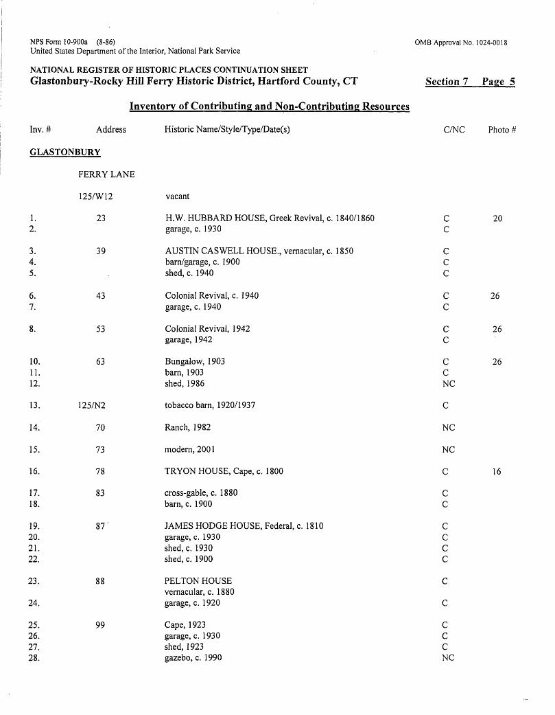
A complete inventory list of all the contributing and non-contributing resources, organized in alphanumeric order first by town, and then by street address follows. Inventory numbers are used to identify resources in the text and on the district map. Land parcels in the district are identified by map and lot numbers but not included in the inventory count unless they include a building. Also not included are small buildings that may be relocated, such as temporary field sheds for horses or pre-fabricated garden sheds, or the several metal buildings now associated with the ferry operation at Rocky Hill Landing. Several sources cited in the bibliography were consulted for the historic names and construction dates, including the historic architectural survey of South Glastonbury, local histories, historic maps, federal censuses, and in Rocky Hill, research notes provided by a resident historian. When the original owner is not known, the name of a later owner may be used. Properties identified by more than one name usually acknowledge the historic importance of a second or later owner. Wherever possible, dates of construction from the above sources were verified by field observation and/or land and tax assessor's records. Dates preceded by "c." for circa, are estimates of the probable year of construction, plus or minus ten years.
NFS Form 10-900a (8-86)United States Department of the Interior, National Park Service
NATIONAL REGISTER OF HISTORIC PLACES CONTINUATION SHEETGlastonbury-Rocky Hill Ferry Historic District, Hartford County, CT
OMB Approval No. 1024-0018
Section 7 Page 5
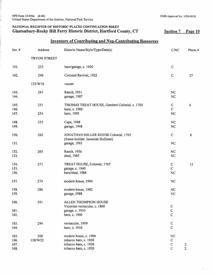
Inv. # Address
GLASTONBURY
Inventory of Contributing and Non-Contributing Resources
Historic Name/Style/Type/Date(s) C/NC
1.2.
3.4.5.
6.7.
8.
10.11.12.
13.
14.
15.
16.
17.18.
19.20.21.22.
23.
24.
25.26.27.28.
FERRY LANE
125/W12
23
39
43
53
63
125/N2
70
73
78
83
87'
88
99
vacant
H.W. HUBBARD HOUSE, Greek Revival, c. 1840/1860garage, c. 1930
AUSTIN CASWELL HOUSE., vernacular, c. 1850barn/garage, c. 1900shed, c. 1940
Colonial Revival, c. 1940garage, c. 1940
Colonial Revival, 1942garage, 1942
Bungalow, 1903barn, 1903shed, 1986
tobacco barn, 1920/1937
Ranch, 1982
modern, 2001
TRYON HOUSE, Cape, c. 1800
cross-gable, c. 1880barn, c. 1900
JAMES HODGE HOUSE, Federal, c. 1810garage, c. 1930shed, c. 1930shed, c. 1900
PELTON HOUSEvernacular, c. 1880garage, c. 1920
Cape, 1923garage, c. 1930shed, 1923gazebo, c. 1990
CC
CCC
CC
CC
CCNC
C
NC
NC
C
Cc
cccc
c
c
cccNC
Photo #
20
26
26
26
16
NFS Form 10-900a (8-86)United States Department of the Interior, National Park Service
0MB Approval No. 1024-0018
NATIONAL REGISTER OF HISTORIC PLACES CONTINUATION SHEETGlastonbury-Rocky Hill Ferry Historic District, Hartford County, CT
Inventory of Contributing and Non-Contributing Resources
Inv.#
29.30.
31.32.33.34.35.36.37.38.
39.
40.41.
42.
43.44.
45.46.
47.
48.
49.50.
Address
FERRY LANE
108
171
125/S9
202
125/S10. Sll,S12, S13, S14
PEASE LANE
15
126/W2
26
126/S1AA
34
44
46
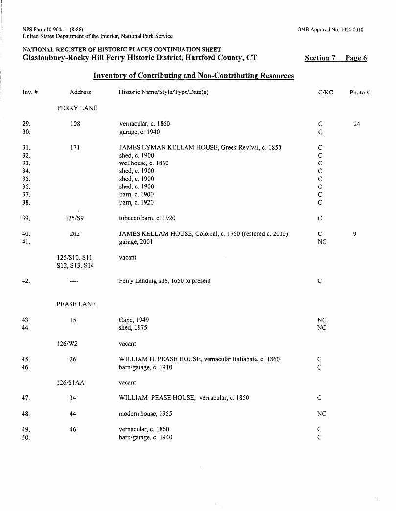
Historic Name/Style/Type/Date(s)
vernacular, c. 1 860garage, c. 1940
JAMES LYMAN KELLAM HOUSE, Greek Revival, c. 1850shed, c. 1900wellhouse, c. 1860shed, c. 1900shed, c. 1900shed, c. 1900barn, c. 1900barn, c. 1920
tobacco bam, c. 1920
JAMES KELLAM HOUSE, Colonial, c. 1760 (restored c. 2000)garage, 2001
vacant
Ferry Landing site, 1650 to present
Cape, 1949shed, 1975
vacant
WILLIAM H. PEASE HOUSE, vernacular Italianate, c. 1860barn/garage, c. 1910
vacant
WILLIAM PEASE HOUSE, vernacular, c. 1850
modern house, 1955
vernacular, c. 1860barn/garage, c. 1940
Cft
Cc
cccccccc
c
cNC
c
NCNC
CC
c
NC
Cc
Section 7 Page 6
Photo #
24
NFS Form 10-900a (8-86)United States Department of the Interior, National Park Service
NATIONAL REGISTER OF HISTORIC PLACES CONTINUATION SHEETGlastonbury-Rocky Hill Ferry Historic District, Hartford County, CT
Inventory of Contributing and Non-Contributing Resources
Inv. # Address Historic Name/Style/Type/Date(s)
TRYON STREET
51. 9 BAKE HOUSE, c. 1780; restored as house, c. 1940,(restoration architect: Norris F. Prentice); restored 2002
JOHN HOLLISTER HOUSE, Colonial saltbox, c. 1690barn, 1954barn, c. 1900shed, c. 1900shed. c. 1920tobacco barn, c. 1900poultry house, c. 1900poultry house, c. 1900corn crib, c. 1900
vernacular, c. 1860 shed, c. 1900
modern house, 1998
MARTIN HOLLISTER HOUSE, Greek Revival, 1849 barn/shed, c. 1930 garage, c. 1930
modern house, 1997
modern house, 1994 garage, 1999
AMOS HOLLISTER HOUSE, Colonial saltbox, c. 1690horse barn, 1992barn, c. 1900shed, c. 1900shed, c. 1950shed, c. 1950shed, c, 1950
modern house, 1994
modern house, 1994
Four-Square, 1922 barn. c. 1870 tobacco barn, c.1900
OMB Approval No. 1024-0018
Section 7 Page 7
52.53.54.55.56.57.58.59.60.
61.62.
63.
64.65.66.
67
68.69.
70.
72.73.74.75.76.
77.
78.
79.80.81.
14
19
35
36
43-45
55
58-60
65
72
77
C/NC
C
c c c c c c c c c
c c
NC
c c c
NC
NCNC
CNCCCc c c
NC
NC
Cc c
Photo #
31
19
NFS Form 10-900a (8-86)United States Department of the Interior, National Park Service
0MB Approval No. 1024-0018
NATIONAL REGISTER OF HISTORIC PLACES CONTINUATION SHEETGlastonbury-Rocky Hill Ferry Historic District, Hartford County, CT
Inventory of Contributing and Non-Contributing Resources
Inv.#
82.83.
84.
85.
86.87.88.89.90.
91.92.
93.94.
95.96.
97.98.
99.100.101.
102.103.
104.
105.106.107.
108.
109.
Address
TRYON STREET
80
87
88
95
103
104
109
112
120
126/W8&9
121
131
132
126/W7
151
Historic Name/Style/Type/Date(s)
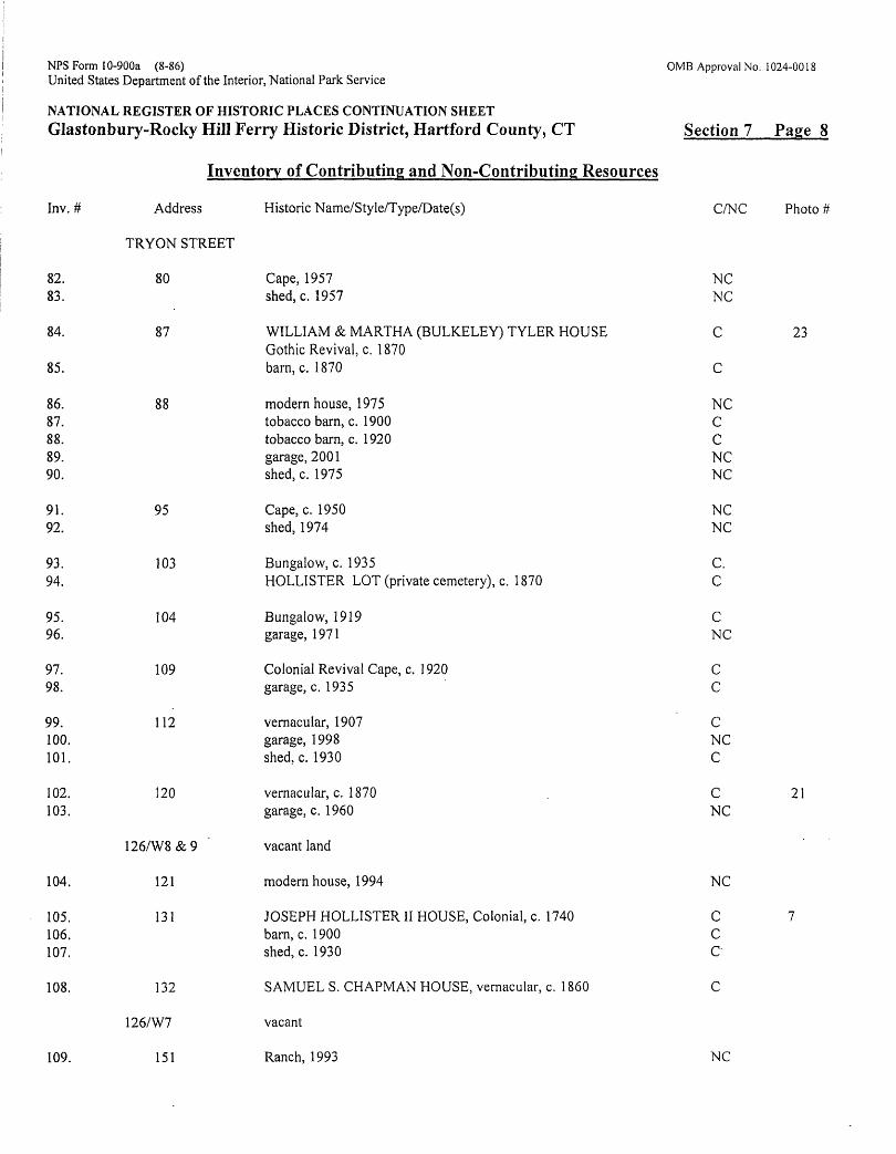
Cape, 1957shed, c. 1957
WILLIAM & MARTHA (BULKELEY) TYLER HOUSEGothic Revival, c. 1870barn, c. 1 870
modern house, 1975tobacco barn, c. 1900tobacco barn, c. 1920garage, 2001shed, c. 1975
Cape, c. 1950shed, 1974
Bungalow, c. 1935HOLLISTER LOT (private cemetery), c. 1870
Bungalow, 1919garage, 1971
Colonial Revival Cape, c. 1920garage, c. 1935
vernacular, 1907garage, 1998shed, c. 1930
vernacular, c. 1870garage, c. 1960
vacant land
modern house, 1994
JOSEPH HOLLISTER II HOUSE, Colonial, c. 1740barn, c. 1900shed, c. 1930
SAMUEL S. CHAPMAN HOUSE, vernacular, c. 1860
vacant
Ranch, 1993
C/b
NCNC
C
C
NCCCNCNC
NCNC
C.C
cNC
Cc
cNCC
CNC
NC
CCc
c
NC
Section 7 Page 8
Photo #
23
21
NFS Form 10-900a (8-86)United States Department of the Interior, National Park Service
NATIONAL REGISTER OF HISTORIC PLACES CONTINUATION SHEETGlastonbury-Rocky Hill Ferry Historic District, Hartford County, CT
Inventory of Contributing and Non-Contributing Resources
Inv.#
110.111.112.
113.
114115.
116.
117.118.
119.
120.
121.
122.123.124.125.126.127.128.129.130.131.
132.133.134.
135.136.
137.138.
139.140.
Address
TRYON STREET
156
159
167
171
183
ROW (to 187)
191
193
194
213
218
230
233
Historic Name/Sty le/Type/Date(s)
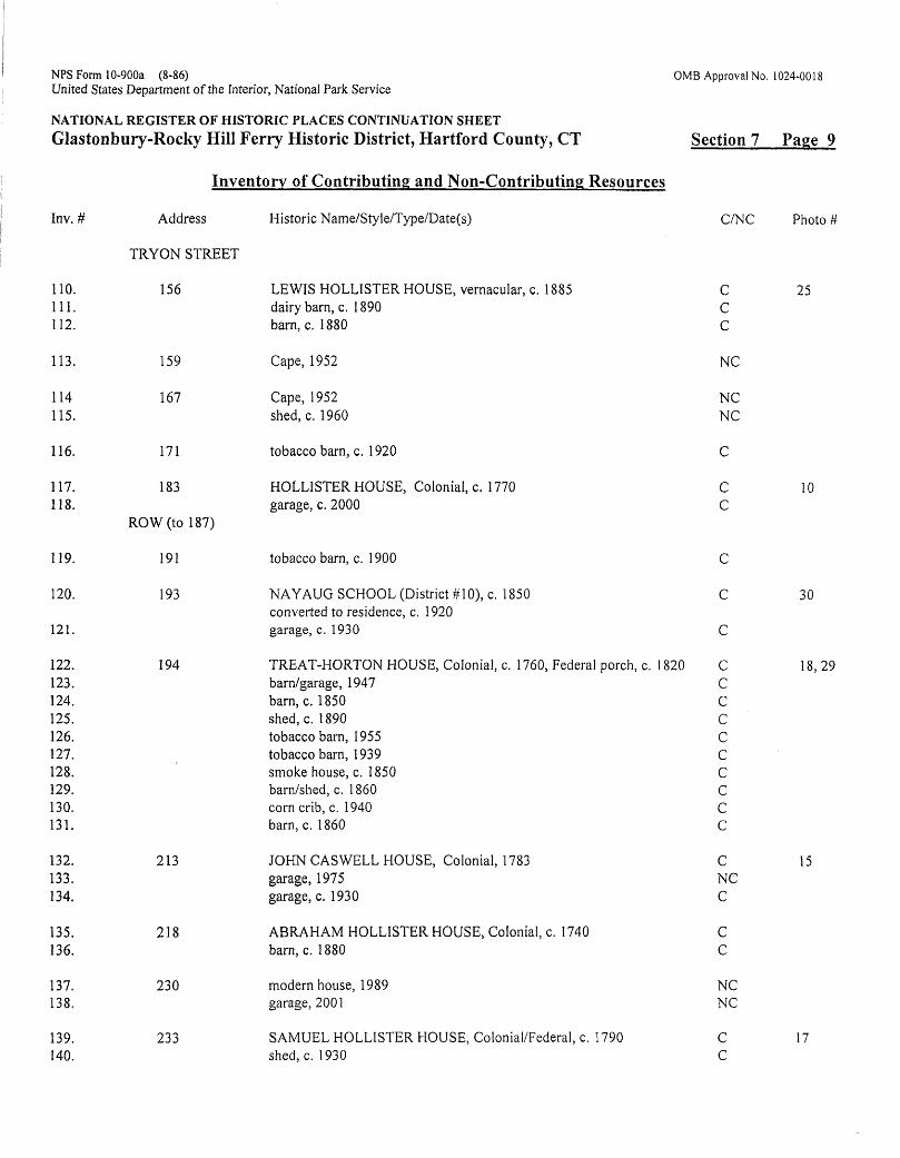
LEWIS HOLLISTER HOUSE, vernacular, c. 1885dairy barn, c. 1890barn, c. 1880
Cape, 1952
Cape, 1952shed, c. 1960
tobacco barn, c. 1920
HOLLISTER HOUSE, Colonial, c. 1770garage, c. 2000
tobacco barn, c. 1 900
NAYAUG SCHOOL (District #10), c. 1850converted to residence, c. 1920garage, c. 1930
TREAT-HORTON HOUSE, Colonial, c. 1760, Federal porch, c. 1820barn/garage, 1947barn, c. 1850shed, c. 1890tobacco barn, 1955tobacco barn, 1939smoke house, c. 1850barn/shed, c. 1 860corn crib, c. 1940barn, c. 1860
JOHN CASWELL HOUSE, Colonial, 1783garage, 1975garage, c. 1930
ABRAHAM HOLLISTER HOUSE, Colonial, c. 1740barn, c. 1880
modern house, 1989garage, 2001
SAMUEL HOLLISTER HOUSE, Colonial/Federal, c. 1790shed, c. 1930
C/>
CCC
NC
NCNC
C
Cc
c
c
c
cccccccccc
cNCc
cc
NCNC
Cc
OMB Approval No. 1024-0018
Section 7 Page 9
Photo #
25
10
30
18,29
15
17
NFS Form 10-900a (8-86)United States Department of the Interior, National Park Service
NATIONAL REGISTER OF HISTORIC PLACES CONTINUATION SHEETGlastonbury-Rocky Hill Ferry Historic District, Hartford County, CT
Inventory of Contributing and Non-Contributing Resources
Inv. # Address Historic Name/Style/Type/Date(s)
TRYON STREET
OMB Approval No. 1024-0018
Section 7 Page 10
C/NC Photo #
141.
142.
143.144.
145.146.147.
148.149.
150.
151.
152.153.
154.155.156.
157.
158.159.
160.
161.162.
163.164.
165.166.167.168.
233
240
125/W16
241
251
254
255
262
265
271
274
286
291
294
300138/W22
barn/garage, c. 1920
Colonial Revival, 1922
vacant
Ranch, 1951garage, 1987
THOMAS TREAT HOUSE, Gambrel Colonial, c. 1700barn, c. 1900barn, 1995
Cape, 1948garage, 1948
JONATHAN MILLER HOUSE Colonial, 1765(frame builder: Jeremiah Hollister)garage, 1993
Ranch, 1956shed, 1965
TREAT HOUSE, Colonial, 1765garage, c. 1940barn/shed, 1988
modern house, 1994
modern house, 1982garage, 1988
ALLEN THOMPSON HOUSEVictorian vernacular, c. 1 860garage, c. 1930barn, c. 1900
vernacular, 1909barn, c. 1910
modern house, c. 1900tobacco barn, c. 1920tobacco barn, c. 1920tobacco barn, c. 1920
C
C
NCNC
CCNC
NCNC
C
NC
NCNC
CCNC
NC
NCNC
CCc
cc
NCCC 2C 2
27
11
NFS Form 10-900a (8-86)United States Department of the Interior, National Park Service
NATIONAL REGISTER OF HISTORIC PLACES CONTINUATION SHEETGlastonbury-Rocky Hill Ferry Historic District, Hartford County, CT
Inventory of Contributing and Non-Contributing Resources
Inv. #
169. 170. 171.
172.
173. 174.
175 176.
Address
TRYON STREET
302
308
386
138/W19, W20,W21, W22. W23B, W23C
138/W23A (partial)
Historic Name/Sty!e/Type/Date(s)
Bungalow, c. 1920 garage^arn, c. 1920 shed, c. 1920
Bungalow, c. 1930
modern house, c. 2000 tobacco barn, c. 1920
vacant
tobacco barn, c. 1920 machinery shed, 1998
C^
Cc c
c
NC C
cNC
OMB Approval No. 1024-0018
Section 7 Page 11
Photo #
28
ROCKY HILL
177178.
179.
180.
181.
182.
183.184.
185.
186.
187.
188.
GLASTONBURY AVENUE
58
62
64
66
MEADOW ROAD
240
247
262
263
273
276
vernacular, c. 1900 garage/shed, c. 1900
Gambrel Cape, c. 1780 (moved to this site after 1870)
Bungalow, 1927
Bungalow, 1928 (altered)
Railroad depot, c. 1875
ABU AH COLLINS HOUSE, vernacular, c. 1850 garage, 1965
Railroad warehouse, 1905
GRIMES-MORION HOUSE & STORE, vernacular, c. 1800
GEORGE WHITE HOUSE, Gambrel Colonial, c. 1770
LEWIS WHITMORE (SAIL LOFT) HOUSE, Colonial, c. 1780
C
NC
CNC
C
C
c
c
32
26
26
14
13
NFS Form 10-900a (8-86)United States Department of the Interior, National Park Service
NATIONAL REGISTER OF HISTORIC PLACES CONTINUATION SHEETGlastonbury-Rocky Hill Ferry Historic District, Hartford County, CT
OMB Approval No. 1024-0018
Section 7 Page 12
Inv.#
189.190.191.
192.
193194.195.196.
197.
198.199.
200.201.
202.203.204.
205.
206.
207.208.209.
210.
211.
212.
213.214.
Inventory of Contributing and Non-Contributing Resources
Address Historic Name/Style/Type/Date(s)
MEADOW ROAD
Ferry Landing site, c. 1650 to present Hollisterlll, barge, 1955 Cumberland, towboat, 1955
PRATT STREET
72
22/5/004
RIVERVIEW ROAD
50
51
53
54.
55
57
58
59
60
Ferry Park, c. 1990
JACOB WILLIAMS HOUSE, Colonial, c. 1780 barn, c. 1880 barn, c. 1900 shed, c. 1940
vacant
WILLIAM R. BULKELEY HOUSE, vernacular, c.1840
JASON AUGUSTUS ROBBINS HOUSE, Italianate, c. 1865 barn/guest house, c. 1890
ISAAC BELDEN HOUSE, Colonial, c. 1775 (facade altered) barn, c. 1870
WILLIAM HUBBARD ROBBINS HOUSE, Italianate, c. 1860 garage/shed, c. 1930 shed, c. 1920
vernacular, c. 1880
WATERSIDE PARK, 1871/SHIPYARD PARK, 1954
vernacular, c. 1900 garage, c. 1920 barn, c. 1920
Tudor Revival, c. 1945
vernacular, c. 1900
vernacular, c. 1900
HUGH GOODRICH HOUSE, Colonial, c. 1770 garage, c. 1950
C/NC
C Cc
NC
Cc
NC C
CCc
c
c
c c c
NC
C
C
CNC
Photo #
12
22
215. 64 Ranch, 1970 NC
Glastonbury-Rocky Hill Ferry Historic DistrictName of Property
Hartford, CTCounty and State
8. Statement of Significance
Applicable National Register Criteria(Mark "x" in one or more boxes for the criteria qualifying the property for National Register listing)
X A Property is associated with events that have madea significant contribution to the broad patterns ofour history.
_B Property is associated with the lives of persons significant in our past.
X _C Property embodies the distinctive characteristics of a type, period, or method of construction or represents the work of a master, or possesses high artistic values, or represents a significant and distinguishable entity whose components lack individual distinction.
___ D Property has yielded, or is likely to yieldinformation important in prehistory or history.
Criteria Considerations(Mark "X" in all the boxes that apply.) Property is:___ A owned by a religious institution or used for
religious purposes.
B removed from its original location.
C a birthplace or grave.
_ __ D a cemetery.___ E a reconstructed building, object, or structure.___ F a commemorative property.___G Less than 50 years of age or achieved significance within the past 50
Narrative Statement of Significance(Explain the significance of the property on one or more continuation sheets.)
Areas of Significance(Enter categories from instructions)
AGRICULTURE_________ ARCHITECTURE________ COMMERCE/TRADE______ TRANSPORTATION
Period of Significance 1650- 1955_____
Significant DatesN/A
Significant Person(Complete if Criterion B is marked above)N/A_____________________
Cultural AffiliationN/A
Architect/Builder See section 7 (text and inventory list)
years.
Bibliography (Cite the books, articles, and other sources used in preparing Previous documentation on file (NFS):_____preliminary determination of individual listing
_(36 CFR 67) has been requested.X previously listed in the National Register
previously determined eligible by the National Register designated a National Historic Landmark recorded by Historic American Buildings Survey # recorded by Historic American Engineering Record #___
; this form on one or more continuation sheets.) Primary Location of Additional Data:
X State Historic Preservation Office ___ Other State agency ___ Federal agency _____ Local government ___ University
OtherX
Name of repository: Glastonbury Historical Society; Cora Belden Library, Rocky Hill
NFS Form 10-900a OMB Approval No. 1024-0018 (8-86)
United States Department of the Interior National Park Service
NATIONAL REGISTER OF HISTORIC PLACES CONTINUATION SHEET
Glastonbury-Rocky Hill Ferry Historic District, Hartford County, CT Section 8 Page 1
Statement of SignificanceThe Glastonbury-Rocky Hill Ferry Historic District encompasses a significant and well-preserved historic vernacular landscape on the banks of the Connecticut River. Shaped and differentiated by a unique natural and cultural history, the farmers of Nayaug in South Glastonbury and the merchants at the Rocky Hill Landing exploited the natural resources of their riverine communities and remained linked together by the oldest continuously operating ferry in the United States. Although little remains of a distinguished shipbuilding tradition that once prevailed on both sides of the river, much of this historic legacy is preserved in the homes of district shipbuilders. The historic maritime focus of Rocky Hill Landing is expressed in the surviving nearby homes and stores of merchant traders, which include several examples of the Colonial and Italianate styles. Of particular architectural significance are the well-preserved farmscapes of the Great Meadows in South Glastonbury that still display historic land-use patterns that date back to the seventeenth century. Broad expanses of cultivated fields and pastures radiating out to the river's edge provide an authentic historic setting for a fine collection of Colonial and Greek Revival farmhouses, which are enhanced by an impressive array of associated outbuildings.
Historical Background and SignificanceThe Connecticut River towns, Wethersfield, Windsor, and Hartford, were the first English settlements in Connecticut. Glastonbury and Rocky Hill are daughter towns of Wethersfield, which was settled by families from Watertown, Massachusetts, and England, between 1634 and 1636. Land was purchased from Sowheag (aka Sequin), sachem of the Wongunks, one of the larger Native American groups occupying the Connecticut Valley Lowlands. The original 54- square mile tract, which extended from the Middletown bounds north to Hartford, ran from six miles west of the river to three miles into the wilderness on the east, an area traditionally occupied by the Nayaugs, a related sub-group. Like most River Indians, they were agriculturists, accustomed to camping in the Great Meadows during the growing season, and retreating to the hills of East Glastonbury where they hunted during the winter months. Whether they were consulted about the sale is not known, but European settlement in the Great Meadows of South Glastonbury effectively ended this traditional way of life. Later in the century, colonists who had purchased land from Native Americans prior to 1662 (the year a royal charter for the Connecticut Colony was finally obtained by John Winthrop, Jr.) became concerned about the legitimacy of these transactions. By 1671, however, when Wethersfield proprietors reaffirmed their ownership of the land by executing a new deed with Sowheag's descendants, most of remaining Wongunks and Nayaugs were living on a reservation in Portland Meadows.6
Glastonbury became a separate town in 1693 but Rocky Hill remained part of Wethersfield until incorporation in 1843. Despite these political divisions, family ties were maintained by descendants of Wethersfield proprietors who lived on both sides of the river. Rocky Hill, once known as the "lower community," became the third church society of Wethersfield in 1722 and was known as Stepney Parish after 1723. The institutional centers of both these communities developed outside the district; in Rocky Hill around the junction of Old Main and Church streets to the west; and along South Glastonbury's Main Street to the east.
The Great RiverLike the Native Americans who came before them, the settlers of Wethersfield recognized and exploited the full potential of the great tidal river that directed their lives and those of their descendants. A dynamic force of nature both beneficent and unpredictable, the Connecticut River reshaped their physical environment, renewed their alluvial fields with nutrient laden soil, and served as a highway to the major markets of the Atlantic and the Caribbean. Brooks and streams that rose in the uplands and emptied into the Connecticut provided power for colonial grist- and sawmills and later industry. Salmon and shad returning annually to these streams to spawn were seined in great quantities for food and fertilizer. The
6 In 1664 300 acres was set aside in by the colony for the few Native Americans still living in the Connecticut Valley.. Some had moved westward to join other displaced groups, but many succumbed to smallpox and other diseases brought to the New World by the settlers. Jn 1756 the reservation was sold off for building lots.
NFS Form 10-900a 0MB Approval No. 1024-0018 (8-86)
United States Department of the Interior National Park Service
NATIONAL REGISTER OF HISTORIC PLACES CONTINUATION SHEET
Glastonbury-Rocky Hill Ferry Historic District, Hartford County, CT Section 8 Page 2
shortnose river sturgeon, a lesser known anadromous fish seined for its roe for caviar, returned every year to Roaring Brook, once known as Sturgeon Brook.7
It is the nature of an alluvial river like the Connecticut to change its course over time; the gradual lateral shift of the river as it meandered through the floodplain of this glacial rift valley continued well into historic period, only stabilizing by the middle of the nineteenth-century. With this eastward drift new soil was added to the Great Meadows of Rocky Hill, which eventually extended east to subsume Wright's Island in the middle of the river, and scoured out the Glastonbury shore on the north side of the district, the site of a shipyard by the mid-1700s. Just the opposite action occurred as the river reversed course to the south, depositing more silt on the alluvial floodplain in South Glastonbury and carving out a deeper channel for a harbor at Rocky Hill Landing.
While the fertile soil of the floodplain sustained many generations of settler families on both sides of the river, historic land use policies in the Great Meadows differed markedly. In Rocky Hill, the meadows were common land, historically managed by a proprietors committee and are still owned by the town; in Glastonbury, the area was surveyed and divided up for private ownership. Largely due to these policies, the area encompassed by the district in South Glastonbury contains the largest concentration of historic buildings in all of the Great Meadows, while in Rocky Hill, meadowland has remained uninhabited to the present day. 8
Although farmers everywhere are subject to the vagaries of the weather and the seasonal agricultural cycle, for those in the district, annual seasonal floods dictated the time of planting and even the location of their farmsteads. Only a few South Glastonbury farmers built houses in the floodplain. The rest clustered together above and along the 30-foot contour line, designated today as the 100-year flood line.9 An earth berm along the north side of Ferry Lane as it joins Tryon Street is the only obvious example of recontouring land for flood protection. Historic flood levels are not well documented but in the record floods of 1936 and 1938, both these streets were inundated. Receding flood waters which drastically eroded topsoil, also revealed evidence of human occupation in the South Glastonbury Meadows dating back 10,000 years. Major 500-year floods could drastically change the course of the river and have long-term economic impacts. Such was the case in the great flood of 1700, which wiped out Wethersfield's natural harbor and established Rocky Hill Landing as the principal center for the town's mercantile and shipbuilding trades.
Navigating the Great River challenged district sailing masters and their crews for 250 years Although the tide was of little consequence this far up river, downstream, strong tidal currents were hazardous and ships often had to drop anchor and wait for a favorable tide to cross the bar at Saybrook. Larger vessels bound for the open sea often left port half loaded and topped off their cargoes at New London. There were few navigational aids; no buoys marked the shoals and the first lighthouse on Long Island Sound was not erected until the 1820s. Kerosene beacons were placed along the river later in the century; in South Glastonbury, these beacons ringed the shore of the meadows and were tended by Walter Kellam, a blind lamplighter who lived nearby (Inventory #31). Beating back upriver against the current, even with favorable winds, was equally arduous and time consuming, especially after 1790, when ships carrying foreign goods had to clear customs at Middletown, then the major riverport on the Connecticut.
The caviar was such major export commodity by the early 1800s, the river sturgeon was almost harvested to extinction.
8 Today dirt roads run through this quasi-public area, which is still cultivated by sod and vegetable farmers who lease land from the town.9 A somewhat misleading term, since floods of this level have a one percent chance of occurring every year. There have been seven 100-year floods just in last
century, and 500-year floods in 1955 and 1989.
NFS Form 10-900a OMB Approval No. 1024-0018 (8-86)
United States Department of the Interior National Park Service
NATIONAL REGISTER OF HISTORIC PLACES CONTINUATION SHEET
Glastonbury-Rocky Hill Ferry Historic District, Hartford County, CT Section 8 Page 3
SettlementIn 1639, the year the river towns adopted the Fundamental Orders and elected a governor of the Connecticut Colony, Wethersfield proprietors laid formal claim to the east side of the river. Organized as proprietory (joint stock) company with rights to grant or sell commonly held land assets, they began with a survey of Naubuc (now Glastonbury), said to be the first in the colony. Surveyors laid out three-mile strips of land running east from the river's edge from the present border of East Hartford south to the mouth of Roaring Brook. Although all types of land as well as fishing rights were included, the width of these strips varied widely, so each proprietor received a land grant proportional to his investment in the company. Subsequent divisions followed a similar pattern, with the last made in the early 1700s. The long-lot division of Nayaug crossed today's Main Street in South Glastonbury but apparently stopped at an arbitrary line running north south from the mouth of Roaring Brook. In the "ungiven land" 10 west of the line, the district meadows, parcels were surveyed to accommodate to the bend in the river.
Some of the largest land grants were awarded to Richard Treat (1584-1669), John Hollister (1612-1665), and Gentleman John Robbins (d. 1660), later arrivals in Wethersfield who came directly from England in the 1640s. Although unable to inherit land in England, these sons of English gentry were not poor. Unlike the yeomen and tradesman who made up most of the colony population, these proprietors were men of means and their investment in the Wethersfield proprietorship paid off handsomely. Amassing land wealth unheard of in the Old World, they established a political power base in the Connecticut colony which, as the history of district reveals, was inherent in many succeeding generations. For instance, Robert Treat (1624-1710), son of Richard the settler, was governor of the colony from 1683 to 1698, and also founder of Milford and New Milford.
Intermarriage was common between the families of the "Standing Order," as the colonial leadership came to be called. In 1642, the year Hollister arrived from Bristol, England, he married Richard Treat's daughter, which assured his political future. A leader in town and church affairs, Hollister was reelected many times to General Court (the early name of the General Assembly). In a similar fashion, the marriage of John Robbins to the sister of Thomas Welles, the second colonial governor, was equally advantageous for him and his family line. Robbins descendants settled all of Wethersfield's daughter towns, including two who lived in the district in Rocky Hill (Inventory #s 198, 202). Although both Richard Treat and John Hollister had extensive holdings in Nayaug in the 1640s and elsewhere in Glastonbury, they never lived in the district. Richard Treat, Jr., who inherited all of his father's 900 acres in Glastonbury, was a graduate of Harvard College and an itinerant missionary to the Indians. He may have built a house in the uplands before his death in 1659 during the French and Indian War, but the only surviving family dwelling in the district belonged to his son, Thomas (Inventory #154). Although John Hollister apparently built two houses, one about 1650 for his tenant farmer, the existing house he left to his son John (1644-1711) was not his permanent home (Inventory #52).
Even though proprietors made use of their land on the east side of the river, the general reluctance to permanently settle in such a relatively isolated wilderness was understandable. Fresh in their memories was the 1637 massacre of nine Wethersfield settlers, the major proximate cause of the retaliatory Pequot War. Even though they grazed their cattle in the meadows and grew hill corn in the Native-American manner in the fields there, most farmers crossed the river every day to look after their farms. A few hired cattle herders, who lived in temporary quarters, or like John Hollister, employed someone to take care of their property. Settlement was delayed further by another period of unrest later in the century that culminated in King Phillip's War (1665-1667), a last ditch effort to drive Europeans out of New England, in which
10 Apparent a reference to the fact that the meadows were not included in the original land sold by the Wongunks, but were a separate tract purchased later from
Tarramungus, Sowheag's son.
NFS Form 10-900a OMB Approval No. 1024-0018 (8-86)
United States Department of the Interior National Park Service
NATIONAL REGISTER OF HISTORIC PLACES CONTINUATION SHEET
Glastonbury-Rocky Hill Ferry Historic District, Hartford County, CT Section 8 Page 4
towns were burned and their inhabitants massacred. 11 Although the Connecticut colony took precautions and directed John Hollister II to "secure" 12 his house and corn and fortify one of the hills overlooking the valley, Wethersfield was spared. The pace of settlement picked up after war ended in 1675, and by 1693, the year the petition for a separate township was granted, there were 34 householders in Glastonbury, including several members of Treat family, as well as John and Amos Hollister; the latter man built his saltbox in the district about 1690 (Inventory #147).
Glastonbury-Rocky Hill FerryA ferry linked the two communities soon after 1649, when Wethersfield voted to lay out roads on both sides of the river (present-day Glastonbury Road on the west and Ferry Lane on the east) and established a public landing in Rocky Hill. Joseph Smith, holder of one of the early land grants there, or Richard Smith, were the first ferrymen, and the privilege was passed down in their extended family. In 1724 the General Assembly affirmed the Smith's continued hegemony by formally granting the ferry right to Jonathan, Joseph's son, and set the toll rate: four pence for each man, horse, and load, with persons on horseback at half rate, double on Sundays or during high water. Rafts and later boats were propelled by oars, sweeps, poles or sails depending on conditions. When the river was in flood, ferrymen had to skid their boats across inundated marshes and make for Glastonbury docks north or south of the regular landing. Equipment remained relatively primitive until 1846, when an ingenious ferryman installed a horse-powered treadmill on the deck of his flatboat.
While the ferry privilege had remained exclusively in the hands of Rocky hill residents for the first hundred years, during the last half of the nineteenth century, ferrymen lived on both sides of the river. Among them were William R. Bulkeley, who lived at Rocky Hill Landing (Inventory #200) and Anson Tryon and Robert Hollister of Glastonbury (Inventory #s 119, 112). Since other ferries that served nearby towns in the Central Valley were no longer operating, for these men, farmers all, the ferry privilege was a lucrative sideline. 13 It became even more valuable after the Connecticut Valley Railroad came through Rocky Hill Landing in 1871, making the district ferry a vital link in a much wider inland transportation network. Since railroads continued to bypass the east side of the river, it was much appreciated by Glastonbury's mill owners, who ferried woolen goods and ground feldspar across the river to be shipped by rail well into the twentieth century.
Perhaps in anticipation of the increased custom generated by the railroad, in 1866 Rocky Hill and Glastonbury paid Lyman Williams a $1000 bonus to put a steam ferryboat in operation. When his lease was renewed in 1876, his partner was Martin F. Hollister, the son of Judge Martin Hollister of South Glastonbury (Inventory #64). Centennial, their new steam ferryboat, remained in service until spring of 1888, when young Hollister, now the sole owner of the privilege, built a new vessel, The Hollister. Following a legal challenge to his ownership, however, in which the State Supreme Court ruled that the towns owned the ferry, Hollister "threw up" his right in 1893. Rocky Hill and Glastonbury jointly ran the ferry until it was taken over by the state in 1915. A steam-powered side winder, the Nayaug, provided service from 1903 to 1921.
The present steel barge, Hollister III, with a three-car capacity, is towed by the Cumberland, powered by a modern marine diesel engine (Inventory #s 193, 194). They were designed by Walter Mclnnis (1893-1976), a naval architect and founder of the design and brokerage firm of Eldredge-Mclnnis of Boston in 1926. Although perhaps best known for his 1930 design of the 52-foot Marlin, which later became President John F. Kennedy's family yacht, Mclnnis designed numerous other motor sailers yachts, schooners and cruisers including the 83-foot Lion's Whelp, a tender in
11 Simsbury, than a frontier town, was burned to the ground, but raids on colonial settlements mostly were confined to the northern Connecticut Valley.12 "Securing," or stockading a house, was a fairly common practice in Glastonbury into the early 1700s.13 By 1849 ferries that once crossed the river to the north and south were out of business; only Colt's ferry at East Hartford for his Willowbrook employees was still
running, and it was disbanded in 1864.
NFS Form 10-900a 0MB Approval No. 1024-0018 (8-86)
United States Department of the Interior National Park Service
NATIONAL REGISTER OF HISTORIC PLACES CONTINUATION SHEET
Glastonbury-Rocky Hill Ferry Historic District, Hartford County, CT Section 8 Page 5
America's Cup races. Although the majority of commercial fishing vessels designed by Mclnnis were built in Nova Scotia yards, many of the his custom-designed pleasure craft were constructed at George Lawry & Son of Neponset, Massachusetts, Mclnnis' first employer and the premier yacht builders of New England. 14
AgricultureAlonzo Chapin, a nineteenth-century Glastonbury minister and town historian, compiled a record of agricultural production in 1845. Although his list covered all of Glastonbury, some of the farm produce was grown in the district. The major crop was hay, a valuable commodity in the growing cities of the state and as far way as New York City. It was valued at $47,000, representing 38 percent of the total farm production ($125,510). Corn, rye, and potatoes together accounted for 28 percent, butter, wood and charcoal, each at seven percent; leather (mainly pigskin) was valued at $14,500. Tobacco, later to become a major farm commodity, was then still a minor cash crop worth only $1500.
Tobacco became a major Connecticut River Valley industry in more recent times, signaled in the district by the appearance of the first tobacco barns around 1900. By 1920, many more barns of this type were constructed there, often on land leased to the consolidated tobacco associations or syndicates formed in this period, including one in Glastonbury. Although production reached a peak in 1952, with 17,000 acres under cultivation throughout the Central Valley, overproduction by the syndicates in the 1920s had so depressed the tobacco market that some farmers in the district, turned to dairying or egg production, as evidenced by dairy barns or poultry houses then associated with district houses (Inventory #s 52, 110, 122). By 1982 less than 4000 acres in the valley were still used for tobacco. With a recent resurgence in tobacco cultivation brought about a renewed demand for cigar leaf, working farms in South Glastonbury are once again devoted to this crop, including the Treat-Horton property on Tryon Street (Inventory #122), one of the few growers to build a new tobacco barn after World War II (Inventory #126). Although tobacco is no longer cured on site, in the district, historic drying sheds still provide storage, and growers still lease land. In another agricultural revival, one that dates back to the era of the West Indies trade, some of the historic hay and livestock barns in the district are part of modern horse farms (Inventory #s 31, 70).
Shipbuilding and the Maritime TradeIn the seventeenth century Wethersfield's natural harbor, then right on the Connecticut River, was the town's major port. Although shipbuilding had begun four miles downriver at Rocky Hill Landing, it became the town's principal maritime facility only after the Great Flood of 1700. When the flood waters receded, Wethersfield's harbor was gone; the river bed had shifted to the east leaving a shallow, partially enclosed cove, today's Wethersfield Cove. New sand bars deposited just south of the cove were a barrier to most river traffic; Rocky Hill's Stepney Landing as it was then known, now favorably situated at the head of navigation, became a regional center for the maritime trade. Timothy Dwight, Yale college president and peripatetic observer of the New England scene, who visited there around 1800, confirmed that Stepney was still flourishing as "the seat of most commerce and trade for all of Wethersfield," a position it held until about 1825. 15 Shipping declined when Jefferson's Embargo and War of 1812 disrupted trade, and most river ports never fully recovered. At Rocky Hill however, commercial prospects improved after the railroad arrived in 1871. The large steam-powered passenger vessels that plied the river made regular stops at Stepney's steamboat wharf just south of the district. Goods still brought to the landing by ferry, by steam packet, or on the traditional river workboats (built here until the late 1800s) could then be transshipped by rail to new inland markets.
14 Mclnnis compiled the records of the Lawry company, which included over 2000 working drawings and half models, which he donated to M.I.T in 1965.15 Travels in New England and New York, Vol. I, Letter XIX, p. 162.
NFS Form 10-900a OMB Approval No. 1024-0018 (8-86)
United States Department of the Interior National Park Service
NATIONAL REGISTER OF HISTORIC PLACES CONTINUATION SHEET
Glastonbury-Rocky Hill Ferry Historic District, Hartford County, CT Section 8 Page 6
Five acres at Rocky Hill was reserved for a public shipyard and landing in 1672. An additional five acres granted to Thomas Williams for a private shipyard eventually covered more than 52 acres at the north end of the Landing (now Ferry Park) and ran uphill to Riverview Road. In 1871 five of these acres were donated to the town for Waterside Park, rededicated as Shipyard Park in 1954 (Inventory #206). Other shipyards operated south of the district after the Revolution were run by John Williams and the Belden families, the former represented at the landing by the colonial period house of Jacob Williams, the only known Rocky Hill manner to live near the river (Inventory #193). More than 100 schooners and sloops were built here between 1750 and 1825 for local owners and Wethersfield and Hartford merchants, who participated in the West Indian and Triangle trade. The Stepney yards also built some of the river workboats. Regional produce shipped from the port included hay, grain crops, and lumber, and livestock including horses, which were transported on specially constructed flatboats called "horse jockeys," There was some direct trade with the Caribbean, but most farm produce was traded through New York. That this maritime community was essential to the famed onion trade of Wethersfield is demonstrated by the colonial account book of merchant Ephraim Williams. For almost 20 years, he was actively engaged in shipping onyons [sic] from Stepney Landing to New York, where it was traded for molasses, rum, and other West Indies products.
A number of trades supported the shipbuilding industry, including a sail loft owned by Elisha Cal lender, Jr., in or near the Whitmore House in the early 1800s (Inventory #188), and a 600-foot rope walk, which ran uphill by present-day 53 and 55 Riverview Road (Inventory #s 200, 205). Although masts were fashioned elsewhere in town, by 1808 pulley blocks and wagons were manufactured in the district, the latter business started by William Neff in a shed on the Jacob Williams property and later moved across the road (Inventory #193).
Merchants at the landing included Justus Robbins, who married Captain Williams' daughter and had a store in his father- in-law's house (Inventory #193). It was later run by Edmund Bulkeley, a descendant of the Reverand Gershom Bulkeley, an early Wethesfield minister, whose relatives lived in the district on both sides of the river (Inventory #s 50, 85). Jason Augustus Robbins and his father, William, who built stylish houses overlooking the port in the 1860s (Inventory #s 198, 202), declared themselves as farmers in the decadal censuses, but the evident wealth of this well-connected family suggests that they too were involved in commerce. Among the other nineteenth-century merchants and storekeepers were Roderick Grimes who lived in the Justus Robbins House by mid-century and had a store on the water side of Meadow Road, and Abijah Collins, whose store was located in his house (Inventory #s 186, 183). George White ran a saloon in his house next to the Landing (Inventory #187).
Several shipyards owned by the Welles family were operating on the east side of the river by the mid 1700s. In this period dressed lumber was Glastonbury's chief export. Although heavily taxed by the colony and the Crown, the lumber trade still flourished because of the demand; town sawmills supplied timbers and planking for ships and buildings in New York and the southern colonies. The shipyard in the district was owned by Thomas Welles, a direct descendant of the governor, and run by members of his family for nearly 50 years. 16 The yard was located at "Log Landing" 17 at the foot of Pease Lane and his sawmill, which he owned with Thomas Hollister (John II's grandson), was on the east side of Roaring Brook at the site later occupied by "Great Gristmill at Nayaug"(Inventory #51). Since ships built here for Hartford and Glastonbury merchants traded directly with the West Indies, it is likely that his sawmill also turned out red oak barrel hoops and staves for export. The barrels were put together in the island ports and used for shipping various products. When sea trade was banned during the Revolution, many mariners and ship owners turned to privateering as an alternate
16 The Naubuc shipyard to the north, owned by Samuel Welles, owner of the Welles Tavern, is now underwater.17 So called because logs were floated down river to be collected in a boom there.
NFS Form 10-900a (8-86)
United States Department of the Interior National Park Service
NATIONAL REGISTER OF HISTORIC PLACES CONTINUATION SHEET
Glastonbury-Rocky Hill Ferry Historic District, Hartford County, CT
OMB Approval No. 1024-0018
Section 8 Page 7
source of income. Although the Welleses invested in three armed privateers built at their yard, 18 the value of the few prize cargoes they captured did not make up for the loss of income from shipbuilding. John Welles, Jr, went bankrupt in 1784 and lost the yard, as well as the family home in Glastonbury, known today as the Wells-Shipman-Ward House.
The Hollister shipyard, the successor to Welles, which began operating about 1795, was run and supported by district residents. Roswell Hollister, the owner, lived in his ancestral home, the John Hollister saltbox (Inventory #52). Local tradition holds that several shipwrights resided in the district, including Thomas Tryon, master carpenter for the sloop Mary, built here in 1808 (Inventory #16). The brig Nestor, built here in 1830 for Captain Elijah Hollister, Roswell's son, went down with all hands off the Carolinas. Two other captains who sailed for Hollister were members of the Horton family, which came to South Glastonbury about 1800: Horace, the master of the schooner McDonough built here in 1818; and Sampson, master and owner of the brig Sampson (Inventory #150); their descendants still live in the district, proprietors of an extensive working farm (Inventory #122). The last sailing vessel turned out by this yard was a brig built for Martin Hollister about 1870 (Inventory #64). The crew may have included his son, Arthur, as well as the six other young men in the district who still listed "sailor" as their principal occupation in the federal census that year. Among them were Arthur Hodge, son of James Hodge on Ferry Lane (Inventory #19), and James and William Pease, living in different households on the lane named for the family (Inventory #s 45, 47). Twin sons of Samuel Chapman and their much older brother also preferred the sea to farming; they all resided in the family house on Tyron Street (Inventory #108).
Architectural SignificanceMuch of the architectural significance of the district resides on the east side of river in the Great Meadows atNayaug. Illustrating the sequential adaption of English immigrants to a discrete and specialized New World environment, the well- preserved and unique rural landscape that developed there over 300 years, still bears the indelible imprint of colonial land policies and agricultural practices laid down in the settlement period. Accommodating to the reality of living so near an unpredictable river, most farmers chose to build on the high ground, creating a historic setting that evokes an English manorial village: an arc of clustered buildings with long, narrow fields on the periphery. Most evident during the growing season, this spatial organization is further defined by the internal network of unpaved roads that often run along property boundaries. The integrity and cohesiveness of this setting was largely preserved as succeeding generations continued to reinforce this pattern, in the orientation of their farmhouses and the arrangement of their farmyards, and especially, the maintenance of their fields. Without this generational stewardship, ancient field patterns would have disappeared and much of the significance of this area would be lost. The Treat-Horton Farmstead, one of the more notable of the several farms that remained in the same family for much of the historic period, is centrally located at the intersection of the two major roads (Photograph 29). With its neat ordered arrangement of buildings, nearly surrounded by cultivated fields, this property demonstrates a consistent pattern of land use, preserved and maintained for more than two centuries. Even the more recent suburban houses have failed to erase the essential elements of this historic pattern. Agricultural fields still stretch out to the river behind the small residential lots carved out of historic farmsteads in the 1900s, which together with an exceptional number and variety of well-preserved outbuildings, adds to the rural ambience of the district.
The continuity and cohesiveness of this timeless historic pattern is enhanced by the collective presence of quite similar Colonial farmhouses. Substantial two-story dwellings that speak to the success of their owners, they are typical of the Connecticut Plain style. For more than a century, these "girt dwellings" as they were known locally, were erected with little variation in scale or form. The persistence of this pattern language well into the Federal period speaks to the essential conservatism of these Yankee farmers, as does the level of style. Although interior spaces were often
Hunter, their largest ship with 18 guns and a crew of 100, captured an English brig and brought her into New London to claim the prize cargo.
NFS Form 10-900a 0MB Approval No. 1024-0018 (8-86)
United States Department of the Interior National Park Service
NATIONAL REGISTER OF HISTORIC PLACES CONTINUATION SHEET
Glastonbury-Rocky Hill Ferry Historic District, Hartford County, CT Section 8 Page 8
embellished, there is little outward display of wealth. Despite their involvement overtime in the shipping trade and industry, which exposed their owners to sophisticated urban architecture, and closer to home, the more stylish Colonials that line the Glastonbury's Main Street, the modest architectural enhancement of these Colonials is largely confined to doorways.
Among the several individually significant houses in the district is the John Hollister saltbox, a subject of great interest to architectural historians in the Colonial Revival period. Norman Isham and Albert J. Brown featured this house in their book first published in 1900, in support of their theory that the hewn overhang was an indigenous colonial modification of the traditional framed English or Jacobean jetty. According to the authors, the Hollister House then was one of only two survivors with this type of overhang; the other was the c. 1680 Patterson House in Berlin, in which the leanto is a latter addition. By 1924, when J. Frederick Kelly published his book on Connecticut architecture, this theory was so generally accepted that hewn type of overhang was considered the hallmark of Second Period Colonials (1675-1725). The rare double curve form of the carved corbels, which Kelly called unique, was illustrated in both books: in Isham and Brown by a sketch of the original design; and in Kelly, with a photograph as it appears today, with the corbel partially hidden by the second layer of clapboard. Although valued for its great age and historical associations with this important family, the removal of this outer sheathing would add to the building's architectural importance.
Several later nineteenth-century houses are especially significant for their level of style, as well as their fine condition. The exceptionally well-preserved Greek Revival built by Judge Martin Hollister not only represents the epitome of this style in the district, it makes an architectural statement about the owner (Inventory #64). Although the Greek Revival was quite common in both rural and urban settings from 1840 to 1860, this house is only fully developed example in the district. With its degree of sophisticated detailing and temple form, deliberately sited facing the road, it was a status symbol for a member of a more modern generation of Hollisters. No longer simply farmers, they were civic leaders as well as successful industrialists. Antebellum wealth is also represented across the river in the two Robbins family houses on Riverview Road (Inventory #s 198, 202). The one built for Jason Augustus Robbins is a particularly notable and unusual example of transitional styling, in which a Greek Revival temple form is dominated by relatively bold Italianate features, especially the doorway with it large, arched and bracketed hood.
ConclusionAs this evaluation of the historical and architectural significance has demonstrated, the Glastonbury-Rocky Hill Ferry Historic District fully meets the National Register's eligibility criteria for significant historic cultural landscapes. 20 The district clearly demonstrates the evolutionary adaption to specific riverine environments, within the wider historic context of the Connecticut River Valley Lowlands. The Connecticut River, the overarching theme and central force in the district's ecosystem, which determined the location and patterns of settlement and the use of land, dominated the lives of settlers and their descendants for nearly three hundred years. Shipbuilding and trade on both sides of the river took full advantage of this major transportation artery. Along this stretch of the river, the successful adaption to two quite different physiographic environments created the historically significant maritime community at Rocky Hill Landing and the prosperous and architecturally significant agrarian community in the South Glastonbury Meadows, in which the integrity of the spatial organization laid down in the 1600s has been preserved by an exceptional and well-documented continuity in the use and ownership of the land. From an early period, the Glastonbury-Rocky Hill Ferry maintained social as well as economic ties between these communities, and by the late nineteenth century it became a vital link in a wider transportation network. Today, the Glastonbury-Rocky Hill Ferry District remains as one of the few tangible expressions of the patterns of development that characterized the first English settlements in Connecticut.
See National Register Bulletin: Guidelines for Evaluating and Documenting Rural Historic Landscapes, National Park Service, 1989, revised 1999.
NFS Form 10-900a OMB Approval No. 1024-0018
(8-86)
United States Department of the Interior National Park Service
NATIONAL REGISTER OF HISTORIC PLACES CONTINUATION SHEET
Glastonbury-Rocky Hill Ferry Historic District, Hartford County, CT Section 9 Page 1
9. Major Bibliographic References
Atlas of Hartford City and County, Hartford: Baker & Tilden, 1869.Adams, Sherman W. and Henry R. Stiles. The History of Ancient Wethersfield, comprising the present towns of Wethersfield,
Rocky Hill, and Newington, and Glastonbury prior to its incorporation in 1693, from date of earliest settlement until the present time. 2. vols. New York: Grafton Press, 1904.
Andrews, Gregory and David Ransom. Historic Resources Inventory: Phase I (Main Street and South Glastonbury). The Historical Society of Glastonbury and the Connecticut Historical Commission, 1989.
Buel, Richard, Jr., and J. Bard McNulty, eds. Connecticut Observed: Three Centuries of Visitor's Impressions 1676-1940.The Acorn Club and the Connecticut Humanities Council, 1999.Chapin, Alonzo B. D.D. Glastenbury [sic] for Two Hundred Years: A Centennial Discourse, May 18lh, A.D. 1853. Reprint
edition. South Glastonbury: Chapin Book Fund, 1976."Connecticut Houses," Hartford: Connecticut Society Colonial Dames of America, 1942.Cooke, June. Personal communications, 2004 (Selected Research: Rocky Hill Historic Houses).Cunningham, Janice P. Historic Preservation in Connecticut: Volume 111, Central Valley: Historical and Architectural
Overview and Management Guide. Connecticut Historical Commission, 1995.Delaney, Edmund. The Connecticut River: New England's Historic Waterway. Boston: Bulfmch Press, Little Brown &
Company, 1989.Dwight, Timothy (Barbara Miller Solomon ed.). Travels in New England and New York, Vol. 1. Cambridge, Massachusetts:
Belknap Press, Harvard University Press, 1969Federal Census, MS. 1850-1870.Fox, Frances Wells & Jared Butler Standish et al. Wethersfield and her Daughters, from 1634 to J 934. Hartford: The Case
Lockwood & Brainard Co., 1934.(The) Great Meadows of the Connecticut River. Amherst, Massachusetts: Dept. of Landscape Architecture and Planning,
University of Massachusetts, 2001.Hedden, Daniel T. The Glastonbury Express: A Photographic History of a New England Town Over the Last Century.
Glastonbury: The Historical Society of Glastonbury, 2nd printing, 1990."(An) Historic District for Rocky Hill, Connecticut: Report of the Historic District Study Committee, January 1, 1973."Isham Norman M. & Albert Brown. Early Connecticut Houses. New York: Dover Publications, 1965.Keegan, Kristen Noble and William F Keegan, eds. The archaeology of Connecticut: the human era, 11,000 years ago to the
present. Storrs, Connecticut: Bibliopola Press; Hanover New Hampshire: University Press of New England (distributors), 1999.Kelly, J. Frederick. Early Domestic Architecture of Connecticut. New York: Dover Publications, 1952.Looking Back at Rocky Hill, Connecticut, Incorporated 1843. Rocky Hill: The Sesquicentennial Book Committee for the
Rocky Hill Historical Society, 1992.Likely Tales: Stepney Parish, 1776. Rocky Hill: The Bicentennial Committee, 1976.McNulty, Marjorie Grant. Glastonbury: From Settlement to Suburb. Glastonbury: The Historical Society of Glastonbury,
1975.Revill, Peter J. A Short History of Rocky Hill, Connecticut: A Connecticut River Town. Rocky Hill: The Rocky Hill
Historical Society, n.d.Survey of Glastonbury, Connecticut, particularly the Changes and Developments in Glastonbury since January 1923.
Glastonbury: The Service Club of Glastonbury, Connecticut, 1930.Trumbull, J. Hammond, ed. The Memorial History of Hartford County, Connecticut, 1633-1884. 2 Vols. Boston: Edward J.
Osgood Publishers, 1886.Woodford, E.M. Map of Hartford County, Connecticut. H. & C.T. Smith, 1855.
Glastonburv-Rockv Hill Ferry Historic DistrictName of Property
Harford, CTCounty and State
10. Geographical Data
Acreage of Property 230
UTM References(Place additional UTM references on a continuation sheet)1
Zone Easting Northing2
Verbal Boundary Description(Describe the boundaries of the property on a continuation sheet.)
Boundary Justification(Explain why the boundaries were selected on a continuation sheet.)
4Zone Easting Northing
X See continuation sheet.
11. Form Prepared By:
name/title
organization
Reviewed by John Herzan, National Register Coordinator
Jan Cunningham, National Register Consultant
Cunningham Preservation Associates. LLC
street & number 37 Orange Road______________
city or town
date 12/30/05
.telephone (860) 347 4072
Middletown state CT zip code 06457
Property Owner
(Complete this item at the request of the SHPO or FPO.)
name_____ street & number city or town _
telephonestate zip code
Paperwork Reduction Act Statement: This information is being collected for applications to the National Register of Historic Places to nominate properties for listing or determine eligibility for listing, to list properties, and to amend existing listings. Response to this request is required to obtain a benefit in accordance with the National Historic Preservation Act, as amended (16 U.S.C. 470 et seq.).
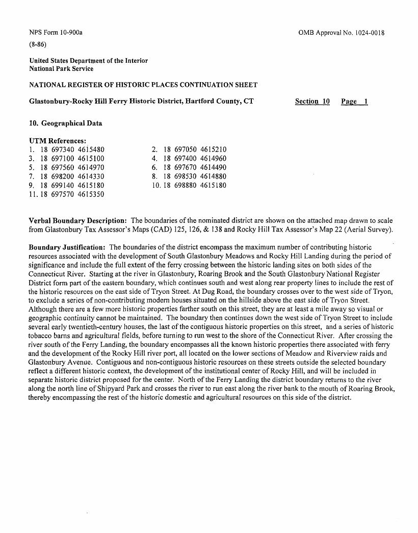
NFS Form 10-900a 0MB Approval No. 1024-0018
(8-86)
United States Department of the Interior National Park Service
NATIONAL REGISTER OF HISTORIC PLACES CONTINUATION SHEET
Glastonbury-Rocky Hill Ferry Historic District, Hartford County, CT Section 10 Page 1
10. Geographical Data
UTM References:I. 18 697340 46J5480 2. 18 697050 46152103. 18 697100 4615100 4. 18 697400 46149605. 18 697560 4614970 6. 18 697670 46144907. 18 698200 4614330 8. 18 698530 46148809. 18 699140 4615180 10.18 698880 4615180II.18 697570 4615350
Verbal Boundary Description: The boundaries of the nominated district are shown on the attached map drawn to scale from Glastonbury Tax Assessor's Maps (CAD) 125, 126, & 138 and Rocky Hill Tax Assessor's Map 22 (Aerial Survey).
Boundary Justification: The boundaries of the district encompass the maximum number of contributing historic resources associated with the development of South Glastonbury Meadows and Rocky Hill Landing during the period of significance and include the full extent of the ferry crossing between the historic landing sites on both sides of the Connecticut River. Starting at the river in Glastonbury, Roaring Brook and the South Glastonbury National Register District form part of the eastern boundary, which continues south and west along rear property lines to include the rest of the historic resources on the east side of Tryon Street. At Dug Road, the boundary crosses over to the west side of Tryon, to exclude a series of non-contributing modern houses situated on the hillside above the east side of Tryon Street. Although there are a few more historic properties farther south on this street, they are at least a mile away so visual or geographic continuity cannot be maintained. The boundary then continues down the west side of Tryon Street to include several early twentieth-century houses, the last of the contiguous historic properties on this street, and a series of historic tobacco barns and agricultural fields, before turning to run west to the shore of the Connecticut River. After crossing the river south of the Ferry Landing, the boundary encompasses all the known historic properties there associated with ferry and the development of the Rocky Hill river port, all located on the lower sections of Meadow and Riverview raids and Glastonbury Avenue. Contiguous and non-contiguous historic resources on these streets outside the selected boundary reflect a different historic context, the development of the institutional center of Rocky Hill, and will be included in separate historic district proposed for the center. North of the Ferry Landing the district boundary returns to the river along the north line of Shipyard Park and crosses the river to run east along the river bank to the mouth of Roaring Brook, thereby encompassing the rest of the historic domestic and agricultural resources on this side of the district.
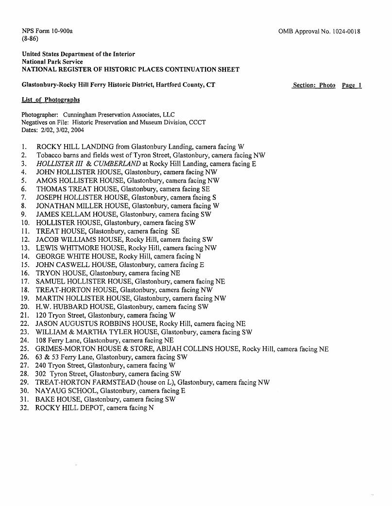
NFS Form 10-900a OMB Approval No. 1024-0018 (8-86)
United States Department of the InteriorNational Park ServiceNATIONAL REGISTER OF HISTORIC PLACES CONTINUATION SHEET
Glastonbury-Rocky Hill Ferry Historic District, Hartford County, CT Section: Photo Page 1
List of Photographs
Photographer: Cunningham Preservation Associates, LLC Negatives on File: Historic Preservation and Museum Division, CCCT Dates: 2/02, 3/02,2004
1. ROCKY HILL LANDING from Glastonbury Landing, camera facing W2. Tobacco barns and fields west of Tyron Street, Glastonbury, camera facing NW3. HOLLISTER III & CUMBERLAND at Rocky Hill Landing, camera facing E4. JOHN HOLLISTER HOUSE, Glastonbury, camera facing NW5. AMOS HOLLISTER HOUSE, Glastonbury, camera facing NW6. THOMAS TREAT HOUSE, Glastonbury, camera facing SE7. JOSEPH HOLLISTER HOUSE, Glastonbury, camera facing S8. JONATHAN MILLER HOUSE, Glastonbury, camera facing W9. JAMES KELLAM HOUSE, Glastonbury, camera facing SW10. HOLLISTER HOUSE, Glastonbury, camera facing SW11. TREAT HOUSE, Glastonbury, camera facing SE12. JACOB WILLIAMS HOUSE, Rocky Hill, camera facing SW13. LEWIS WHITMORE HOUSE, Rocky Hill, camera facing NW14. GEORGE WHITE HOUSE, Rocky Hill, camera facing N15. JOHN C AS WELL HOUSE, Glastonbury, camera facing E16. TRYON HOUSE, Glastonbury, camera facing NE17. SAMUEL HOLLISTER HOUSE, Glastonbury, camera facing NE18. TREAT-HORTON HOUSE, Glastonbury, camera facing NW19. MARTIN HOLLISTER HOUSE, Glastonbury, camera facing NW20. H.W. HUBBARD HOUSE, Glastonbury, camera facing SW21. 120 Tryon Street, Glastonbury, camera facing W22. JASON AUGUSTUS ROBBINS HOUSE, Rocky Hill, camera facing NE23. WILLIAM & MARTHA TYLER HOUSE, Glastonbury, camera facing S W24. 108 Ferry Lane, Glastonbury, camera facing NE25. GRIMES-MORTON HOUSE & STORE, ABIJAH COLLINS HOUSE, Rocky Hill, camera facing NE26. 63 & 53 Ferry Lane, Glastonbury, camera facing SW27. 240 Tryon Street, Glastonbury, camera facing W28. 302 Tyron Street, Glastonbury, camera facing SW29. TREAT-HORTON FARMSTEAD (house on L), Glastonbury, camera facing NW30. NAYAUG SCHOOL, Glastonbury, camera facing E31. BAKE HOUSE, Glastonbury, camera facing S W32. ROCKY HILL DEPOT, camera facing N