glacial heritage area - dnr.wi.gov · deansville state wildlife area ... dave walz dana white-quam...
TRANSCRIPT
Glacial Heritage Area Plan
Conceptual Plan for: Conservation Parks
COLD SPRING CONSERVATION PARK
DOROTHY CARNES CONSERVATION PARK
DR. J.S. GARMAN NATURE PRESERVE
KORTH CONSERVATION PARK
LAKE RIPLEY MANAGEMENT DISTRICT PRESERVE
CUSHMAN MILL CONSERVATION PARK
HOLZHUETER FARM CONSERVATION PARK
HOPE LAKE CONSERVATION PARK
NORTH SHORE MORAINE CONSERVATION PARK
OAKLAND HIGHLANDS CONSERVATION PARK
RED CEDAR LAKE CONSERVATION PARK
SCUPPERNONG VALLEY CONSERVATION PARK
Linking Trails
River-based Conservation Areas ALLEN CREEK CONSERVATION AREA
LOWER BARK RIVER CONSERVATION AREA
LOWER KOSHKONONG CREEK CONSERVATION AREA
Master Plan for: State Wildlife Areas
DEANSVILLE STATE WILDLIFE AREA GOOSE LAKE STATE WILDLIFE AREA JEFFERSON MARSH STATE WILDLIFE AREA & STATE
NATURAL AREA KOSHKONONG STATE WILDLIFE AREA LAKE MILLS STATE WILDLIFE AREA LIMA MARSH – STORR’S LAKE STATE WILDLIFE AREA PRINCE’S POINT STATE WILDLIFE AREA ROME POND STATE WILDLIFE AREA WATERLOO – MUD LAKE STATE WILDLIFE AREA
CRAWFISH PRAIRIE STATE HABITAT AREA RURAL LANDSCAPE PROTECTION AREAS
State Natural Area RED CEDAR LAKE STATE NATURAL AREA

51
12
18
51
12
18
14
106
138
184
109
134
106
16
26
73
20
89
26
16
59
67
89
60
73
67
19
99
59
89
60
151
94
90
94
43
94
Existing Land Ownership
Municipal
County
State(Non-DNR)
Federal
Non-profitConservation Organization
Dept of NaturalResources
State Natural Area
GLACIAL HERITAGE AREA
Linking Trails
Existing
Planned
Planned Protection Areas
DNR Wildlife,Park or NaturalArea
ConservationPark
RiverCorridor
Rural LandscapeProtection Area
Crawfish PrairieHabitat Area
WM-GHA-OVERVIEW acr
WISCONSIN DEPARTMENTOF NATURAL RESOURCESBureau of Facilities and Lands
Rock R.
Wild
Goo s
e Stat
e Tr ai
l
HOLZHUETERFARM PARK
GARMANPRESERVE
NORTHSHORE
MORAINEPARK
KORTHPARK
HOPE LAKE PARK
LAKE RIPLEYPRESERVE
LOWERKOSHKONONG
CREEK
OAKLANDHIGHLANDS
PARK
DOROTHYCARNES
PARK
COLDSPRING
PARK
CUSHMANMILL PARK
SCUPPERNONGVALLEY PARK
ALLEN CREEK
LOWER BARK RIVER
Waterloo-Mud Lake
WildlifeArea
DeansvilleWildlife Area
Goose LakeWildlife Area
LakeMills
WildlifeArea
Jefferson Marsh
Wildlife Area
Rome PondWildlife Area
Princes PointWildlife Area
KoshkonongWildlife Area
Storrs Lake- Lima Marsh Wildlife Area
Kettle MoraineState Forest--Southern Unit
Waterloo
Marshall Watertown
JohnsonCreek
Deerfield
Jefferson
Edgerton
Fort Atkinson
Sullivan
Lake Mills
Palmyra
Whitewater
Milton
Maunesha R.
Craw fish R.
Crawfish
R.
Beav
er D
am R
.
Lowell
Reeseville
Rock
R.
Kosh konong Ck.
LakeKoshkonong
Bark R.
RockLake
Rock R.
Rock
R.
Cambridge
Glacial Drumlin State Trail
Riley-DeppePark
Cam-Rock Park
Silverwood Park
BicentennialPark
Carlin WeldPark
Glacial
River T
rail
LangerFamilyPark
AztalanStatePark
Crawfish PrairieHabitat Area
DANE CO. JEFFERSON CO. WAUKESHA CO.
WALWORTH CO.ROCK CO.
DODGE CO.
RedCedar Lake
Map Updated: March 2011
0 2.5 5 Miles
Glacial Heritage AreaProject Area
Glacial Heritage Area Plan Approved by the Natural Resources Board
October 21, 2009
Department of Natural Resources
Executive Staff
Matt Frank, Secretary
Pat Henderson, Deputy Secretary
Mary Ellen Vollbrecht, Executive Assistant
Division Administrators
Laurie Osterndorf, Land
Todd Ambs, Water
Al Shea, Air & Waste
Vance Rayburn, Customer and Employee Services
Vacant, Enforcement and Science
Paul DeLong, Forestry
Regional Directors
Lloyd Eagan, South Central
Gloria McCutcheon, Southeast
Ron Kazmierczak, Northeast
John Gozdzialski, Northern
Scott Humrickhouse, West Central
Natural Resources Board Christine L. Thomas, Chair Stevens Point Jonathan P. Ela, Vice-Chair Madison John W. Welter, Secretary Eau Claire David Clausen Amery Preston D. Cole Milwaukee Gary E. Rohde River Falls Jane Wiley Wausau
The Wisconsin Department of Natural Resources provides equal opportunity in its employment, programs, services, and functions under an Affirmative Action Plan. If you have any questions, please write to Equal Opportunity Office, Department of Interior, Washington, D.C. 20240 This publication is available in alternative format (large print, Braille, audio tape, etc.) upon request. Please call (608)266-0823 for more information.
DNR Publication Number: LF – 050 – 2011
This document is available at: http://dnr.wi.gov/master_planning/
ACKNOWLEDGEMENTS
Many of the area’s citizens and their elected representatives provided invaluable ideas, perspectives, and input throughout the planning process, for which the Department is genuinely thankful. In particular, the DNR wishes to acknowledge the extraordinary efforts of the GHA External Advisory Team. Their exceptional guidance and counsel, matched with an unyielding optimism and commitment throughout a long planning process, exceeded all expectations and the Department looks forward to continued collaboration with them and others as the project is implemented.
Margaret Burlingham
Ken Carpenter
Greg David
John David
Jeff Gaska
Steve Grabow
Mo Hansen
Chris James
Gail Towers MacAskill
John McKenzie
Paul Moderacki
John Molinaro
David Musolf
Steve Nass
Joe Nehmer
John Raub
Jessica Schmiedicke
Kitty Welch
Jim Welsh
Dustin Wolff
DEPARTMENT OF NATURAL RESOURCES PLANNING TEAMS
Sponsors Steve Miller Mark Aquino
Guidance and Acceptance Team
Steve Miller Mark Aquino Tom Hauge Ken Johnson
Rebecca Schroeder Dan Schuller Barb Zellmer
Plan Coordination Team
John Pohlman Russ Anderson Peter Biermeier
Paul Cunningham Joanne Farnsworth
Doug Fendry Tim Galvin Eric Lobner
Todd Peterson
Plan Development Team Cathy Bleser Sarah Carter Jim Congdon Tom Davies Mike Foy Jake Fries
Mike Halsted Brenda Hill
Ruth Johnson Sue Josheff
Charlie Kilian Mark Martin
Greg Matthews Jeff Prey
Dave Walz Dana White-Quam Mary Zickermann
Wildlife Area Master Plan Team
Doug Fendry Jake Fries
Tom Watkins
TABLE OF CONTENTS
Executive Summary ................................................................................................................................................................ 1
CHAPTER I. Land acquisition and protection & real estate issues ............................................................ 7
A. INTRODUCTION ...........................................................................................................................................................7
Summary of authorized acquisition
B. ACQUISITION AUTHORITY, PROPERTY DESIGNATIONS, AND LAND MANAGEMENT
CLASSIFICATIONS. ................................................................................................................................................8
C. REAL ESTATE MANAGEMENT POLICIES. .........................................................................................................9
D. METHODS TO ACQUIRE LAND OR LAND RIGHTS IN THE GHA. ..........................................................11
E. METHODS TO MAINTAIN LANDS IN AN UNDEVELOPED STATE IN THE GHA. ..............................12
F. PUBLIC ACCESS ON LANDS ACQUIRED OR EASED. ......................................................................................14
G. CRITERIA TO GUIDE ACQUISITION OF LAND WITHIN THE PROJECT BOUNDARIES. ...................16
CHAPTER II. Land management and recreational use in the GHA network ....................................20
A. CONCEPTUAL PLAN FOR THE CONSERVATION PARKS ............................................................................21
1. Existing conservation parks (a) Parks where no changes are planned
(b) Parks where expansions are planned COLD SPRING CONSERVATION PARK ............................................................................. 23
DOROTHY CARNES CONSERVATION PARK.................................................................... 24
DR. J.S. GARMAN NATURE PRESERVE ........................................................................... 25
KORTH CONSERVATION PARK ......................................................................................... 26
LAKE RIPLEY MANAGEMENT DISTRICT PRESERVE .................................................... 27
2. New conservation parks to be established CUSHMAN MILL CONSERVATION PARK ......................................................................... 29
HOLZHUETER FARM CONSERVATION PARK ................................................................ 30
HOPE LAKE CONSERVATION PARK................................................................................. 31
NORTH SHORE MORAINE CONSERVATION PARK ....................................................... 32
OAKLAND HIGHLANDS CONSERVATION PARK............................................................. 33
RED CEDAR LAKE CONSERVATION PARK...................................................................... 34
SCUPPERNONG VALLEY CONSERVATION PARK............................................................ 35
B. CONCEPTUAL PLAN FOR THE LINKING TRAILS......................................................................................... 36
1. Existing linking trails
2. New linking trails
C. CONCEPTUAL PLAN FOR THE RIVER-BASED CONSERVATION AREAS ............................................. 45
1. Small-scale recreation sites along paddleable rivers and creeks.
2. High quality habitat blocks in riparian zones. ALLEN CREEK CONSERVATION AREA ............................................................................ 47
LOWER BARK RIVER CONSERVATION AREA ................................................................. 47
LOWER KOSHKONONG CREEK CONSERVATION AREA ............................................... 47
3. Narrow bands of permanent habitat along river, creeks, and major tributaries.
Glacial Heritage Area Plan
Glacial Heritage Area Plan
D. MASTER PLAN FOR THE STATE WILDLIFE & NATURAL AREAS .......................................................... 49
1. State Wildlife Areas ...................................................................................................................... 49 CRAWFISH PRAIRIE STATE HABITAT AREA ................................................................... 50
RURAL LANDSCAPE PROTECTION AREAS ...................................................................... 51
2. State Natural Areas ....................................................................................................................... 52 (a) New designated State Natural Areas.
(b) Expansions of State Natural Areas.
(c) State Natural Areas where no changes are planned.
3. Elements that apply to all lands within the State Wildlife Areas & Red Cedar Lake State Natural Area ..................................................................................... 54 (a) Land Management.
(b) Recreation Management and Use.
4. Elements that apply to specific wildlife and natural area properties..................................68
DEANSVILLE STATE WILDLIFE AREA ............................................................................. 69 GOOSE LAKE STATE WILDLIFE AREA............................................................................. 70 JEFFERSON MARSH STATE WILDLIFE AREA & STATE NATURAL AREA ................. 72 KOSHKONONG STATE WILDLIFE AREA.......................................................................... 74 LAKE MILLS STATE WILDLIFE AREA .............................................................................. 75 LIMA MARSH – STORR’S LAKE STATE WILDLIFE AREA .............................................. 78 PRINCE’S POINT STATE WILDLIFE AREA ...................................................................... 80 ROME POND STATE WILDLIFE AREA ............................................................................. 82 WATERLOO – MUD LAKE STATE WILDLIFE AREA....................................................... 84 RED CEDAR LAKE STATE NATURAL AREA .................................................................... 89
CHAPTER III. Implementation........................................................................................................................................91
A. HOW THE GHA PLAN WILL AFFECT EXISTING OPERATIONS................................................................91
B. THE COLLABORATIVE APPROACH TO ACQUISITION AND MANAGEMENT OF PROPERTIES. ....91
Developing management agreements and implementation plans.
C. GOALS AND ROLES IN ACQUIRING LAND OR LAND RIGHTS IN THE GHA. .................................... 93
D. GOALS AND ROLES IN MANAGING HABITAT AND VEGETATION IN THE GHA. ............................ 96
E. GOALS AND ROLES IN DEVELOPING FACILITIES TO PROVIDE RECREATION
OPPORTUNITIES IN THE GHA. ......................................................................................................................... 97
F. GOALS AND ROLES IN MAINTAINING AND OPERATING FACILITIES TO PROVIDE
RECREATION OPPORTUNITIES IN THE GHA. ............................................................................................ 98
CHAPTER IV. Maps of the properties and components in the GHA network...................................99
APPENDICES
A. Analysis of Region and Study Area. B. Descriptions of natural communities and Species of Greatest Conservation Need in the
Southeastern Glacial Plain.
Executive Summary. The Glacial Heritage Area project will be a coordinated series of parks, preserves, wildlife and natural areas, and other conservation lands that are linked together and to nearby cities and villages with different types of trails. This network of “strings and pearls” will provide readily accessible opportunities for residents and visitors to get outdoors to hike, bike, watch wildlife, fish, paddle, hunt, camp, cross country ski, ride horses, and participate in other nature-based activities. Equally important, the project will protect and restore native grassland, savanna, woodland, and wetland habitats, and improve water quality in lakes, wetlands, and rivers. In addition, the project incorporates the area's significant cultural and historical elements. The Glacial Heritage Area is the result of a cooperative planning effort by a diverse group of people representing local community interests, elected officials, conservation and recreation organizations, and the Department of Natural Resources.
Summary of facility development goals.
Conservation parks. 9 new or expanded “central focal points” (e.g., parking lot, picnic area,
water (hand pump), vault toilet, interpretive signs, shelters, and informational kiosks).
40 miles of primitive to moderately-developed hiking trails (including some trails that are ADA-accessible).
20 miles of lightly to moderately-developed equestrian trails.
15 miles of moderately to fully-developed recreational biking trails.
10 miles of lightly to moderately-developed mountain biking trails.
3 rustic campgrounds (2 car campgrounds, 1 horse group campground).
Linking trails. 102 miles of moderately to fully-developed trails suitable for biking and
walking.
30 miles of lightly to moderately-developed equestrian trails adjacent to the biking/walking trails.
River-based Conservation Areas.
10 small access sites (5 to 10 acres) located along major rivers and streams that provide canoe, kayak, or motorboat access, parking, picnic tables, toilets, and/or drinking water.
2 larger parks (100 to 300 acres) that provide shore fishing, primitive or lightly-developed trails, picnic areas, and camping facilities accessible only from the water for paddlers.
Wildlife Areas.
All wildlife areas will have parking areas with informational signs and larger parking areas will have kiosks. Zeloski (London) Marsh Unit of the Lake Mills Wildlife Area:
o 2 wildlife observation platforms, decks, or towers. o 2.5 miles of moderately-developed biking and hiking trail along the
east side of the marsh. o 2 miles of moderately-developed hiking trail. o 0.25 mile of ADA Accessible trail from the parking lot on London
Road to an observation deck. o Interpretive displays and or kiosks.
Rome Pond Wildlife Area: o A carry-in canoe access site from the parking lot on the eastern side
of the property. o 3 miles of primitive hiking trails.
Goose Lake Wildlife Area: o 3 wildlife observation areas that enable an improved viewing
experience. o 4 miles of primitive hiking trails. o Interpretive displays and or kiosks.
Prince’s Point Wildlife Area: o 6 miles of primitive hiking trails. o A wildlife observation area that enables an improved viewing
experience.
The Department and partners’ will create the Glacial Heritage Area to facilitate the protection and management of four types of landscape resources, while increasing economic development and prosperity of nearby cities and villages. The four types of lands that comprise the network are:
Conservation parks. The primary purpose of the conservation parks is, collectively, to provide high quality opportunities for residents and visitors alike to engage in a range of outdoor activities, particularly trail-based activities including hiking, biking, horseback riding, and cross-country skiing. Most of the existing parks as well as the new parks have, or are planned to have, an assortment of improve-ments including picnic areas, drinking water, and toilets. Some will also include shelters, play equipment for children, or observation decks and blinds designed to provide enhanced wildlife-watching opportunities. When an adequate land base can be acquired, limited rustic camping will be possible at some parks. The various conservation parks will provide a range in outdoor experiences. Some parks will incorporate developed facilities while others will be managed to provide a rustic experience with limited improvements. Similarly, the parks will provide mixes of different recreation activities based on each park’s attributes, size, and location. Deer and turkey hunting will be incorporated at times of the year and in portions of the new parks that do not conflict with, the parks’ primary
Glacial Heritage Area Plan 1
purposes and users. That is, deer and turkey hunting are secondary, supplemental activities that will be incorporated where they will not displace people from participating in the parks’ primary activities. A total of thirteen, small to modestly-sized parks and preserves currently exist in the GHA project area. The GHA plan calls for the expansion of five of these and establishes seven new parks. Most of the conservation parks will eventually range in size from 200 to 700 acres.
Linking trails. Approximately 100 miles of linking trails are planned to meander through the countryside and connect conservation and recreation destinations to the dozen cities and villages in the area. A coordinated network of biking, horseback riding, cross-country skiing, and hiking opportunities will be served by the trails. The linking trails will be relatively flat, either off-road or separated from vehicle traffic, and suitable for people with a range of abilities, including children and seniors. Most trails will be within narrow corridors (typically 30’ to 100’) with surfaces of packed gravel, asphalt, grass, or soil. Some will have different “treads” for different trail users (e.g., one for bicycles, and an adjacent one for horses).
A primary factor in locating these trails will be to ensure they have minimal impact on surrounding land use. They will be located based on land-owner preferences, which might include along the edges of fields or woodlots, along the edges of road right-of-ways, on farm roads, or in other areas where existing land uses will not be significantly affected. Initial segments of the linking trails will be located on appropriate, lightly-traveled, rural roads as needed.
Summary of acquisition goals
Conservation parks (acquisition goal = 3,801 acres)
Expand 5 existing conservation parks or areas. Acquisition goal = 901 acres.
Establish 7 new conservation parks. Acquisition goal = 2,900 acres.
Work with agricultural agencies and organizations to maintain and protect adjacent lands in farming, conservation, or other open space uses.
Linking Trails (acquisition goal = 1,344 acres) Establish 102 miles of new corridors between the conservation parks and
cities & villages; construct off-road trails with hardened surfaces suitable for recreational biking and natural surface treads for hiking, horseback riding, and mountain biking. Acquisition goal = 1,344 acres.
River-based Conservation Areas (acquisition goal = 2,475 acres) Establish up to 10 small (5 to 10 acres) access sites along major rivers and
streams in the area that provide canoe, kayak, or motorboat access, parking, picnic tables, toilets, and/or drinking water. Acquisition goal = 75 acres.
Establish one or two larger access areas (100 to 300 acres) that provide shore fishing, primitive or lightly developed trails, picnic areas, and camping facilities. Acquisition goal = 400 acres.
Protect three very high quality habitat blocks in riparian zones. Acquisition goal = 1,500 acres.
Protect and manage narrow bands of permanent riparian habitat along the Rock, Crawfish, Bark, and Maunesha Rivers and Koshkonong, Whitewater, and Allen Creeks and their major tributaries. Acquisition goal = 500 acres.
Work with agricultural agencies and organizations to maintain and protect adjacent lands in farming, conservation, or other open space uses.
Wildlife & Natural Areas (acquisition goal = 27,425 acres)
Expand eleven State Wildlife Areas and two State Natural Areas. Acquisition goal = 21,925 acres.
Establish the Crawfish Prairie Habitat Area. Acquisition goal = 2,500 acres.
Protect land adjacent to the Wildlife Areas in undeveloped, open space uses including row crops, pasture, and native grassland, wetland and savanna habitats. Acquisition goal = 3,000 acres.
Work with agricultural agencies and organizations to maintain and protect adjacent lands in farming, conservation, or other open space uses.
Total acquisition goal = 35,045 acres
River corridors. Two types of lands along rivers and creeks will be components of the GHA. First, is a series of small sites (5 to 10 acre), and one or two larger sites, that provide recreational access for boaters, paddlers, and shore anglers. These areas are planned to include parking, launches, picnic areas, pit toilets, and other simple facilities. The larger sites are planned to provide a limited number of simple, rustic campsites accessible only from the water.
The second type of river corridor protection will focus on natural resources. High quality open wetlands and floodplain forests along the Lower Bark River, Lower Koshkonong Creek, and Allen Creek will be protected. These landscape features harbor diverse native communities and popula-tions of several rare plant and animal species. In addition, the GHA project will protect narrow bands of permanent riparian vegetation along rivers and streams to improve water quality.
Wildlife & Natural Areas.
Eleven State Wildlife Areas and twelve State Natural Areas are present within the GHA and together encompass over 25,000 acres. Like many
Glacial Heritage Area Plan 2
wildlife properties elsewhere in the state, several of the Wildlife Areas were originally established in the 1940s to 1960s as Public Hunting Grounds and were managed for different game animals. Over the ensuing decades, recognition of their value as habitat for many non-game species (including many rare plants and animals) has increased. Similarly, the recreation uses of many of these areas have expanded beyond hunting, trapping, and fishing and now include activities such as rustic hiking, snowshoeing, and wildlife watching. In recognition of their multi-purpose functions, these areas were re-named “State Wildlife Areas.”
The GHA plan expands the eleven State Wildlife Areas to protect and restore additional native habitats, improve public use and access to the properties by having easily recognizable boundaries, enhance the efficiency of land management actions, increase public hunting and trapping opportunities, and provide additional opportunities for minimally developed nature-based recreation. In addition, the plan designates five new State Natural Areas on existing DNR lands and expands the Red Cedar Lake and Allen Creek State Natural Areas. Most of these expansions relocate existing project boundaries out to the nearest roadway.
In addition, the GHA plan establishes one new property, the Crawfish Prairie Habitat Area, which will provide critically needed habitat for grassland birds and other related species. This area is designed to contain one large core area of grassland surrounded by a mix of cropland, pastures, and restored prairies. Finally, the GHA plan establishes Rural Landscape Protection Areas to buffer many of the Wildlife Areas. These landscapes will be large undeveloped areas of protected farmlands interspersed with some small scattered conservation lands.
The lands the GHA project encompasses. Some of the lands within the GHA network are already protected as state, county, and local parks, state wildlife areas, natural areas, and other properties owned by non-profit groups. These properties, such as the Glacial Drumlin Trail, Goose Lake Wildlife Area, and Dorothy Carnes Park, are some of the most popular and scenic sites in the area. Other parts of the network, in particular the linking trails between the parks and the villages and cities, require additional acquisitions by the DNR or other partner groups. The long-term acquisition goals are outlined below.
Acres in the GHA currently owned by
the DNR, counties, non-profit conservation groups, or other entity.
626 acres
Acres to be acquired by the DNR, counties, non-profit conservation
groups, or other similar entity as part of the GHA.
Conservation Parks 3,801 acres Linking Trails 300 acres 1,344 acres River Corridors 400 acres 2,475 acres Wildlife & Natural Areas 29,476 acres 27,425 acres
Total 30,802 acres 35,045 acres
Acquiring and managing lands and funding sources. The GHA project is a joint effort of many partner groups. Some of these groups have the ability to purchase and manage lands while others have expertise and capacity in other areas including education, outreach, construction and operation of various facilities and trails, and habitat restoration. The funding for DNR land acquisitions will come primarily from the state Stewardship program. The Stewardship program also provides matching funds to non-profit organizations and local governments to partner with those entities to purchase lands. County and local governments have acquired several key parcels in the area through donation and purchase in recent years, as have local conservation groups.
Glacial Heritage Area Plan 3
The development and management of facilities to support different types of outdoor recreation in the GHA network will also be a cooperative effort among many partners. In particular, for lands it acquires for the conservation parks and linking trails, the DNR will engage county and local governments as well as conservation and recreation groups to develop and operate different recreation facilities such as biking, hiking, and horseback riding trails, picnic areas, observation platforms, and other features.
Lands for the GHA project will only be acquired from landowners who wish to sell or donate land or land rights.
Vision, goals, objectives of Glacial Heritage Area.
The following vision, goals, and objectives for the Glacial Heritage Area were developed by DNR staff and the GHA External Advisory Team. Vision. Create a coordinated network of places and corridors that: enables and encourages a variety of compatible and sustainable outdoor recreation uses; preserves, restores, and protects significant habitats; benefits and integrates with local economic growth and farmland protection efforts; enhances the quality of life by maintaining and improving the land and water resources that underpin the economy; and helps residents and visitors maintain a strong connection to the natural world.
GOAL 1: Create exceptional outdoor recreation opportunities for residents and visitors — work with willing landowners to protect and link conservation lands in a network that collectively provides a wide variety of readily accessible, nature-based recreation opportunities that are compatible with and foster natural resource sustainability.
OBJECTIVE 1A: Complete already approved conservation and recreation projects and establish new publicly-accessible areas to address outdoor, nature-based recreation needs in the region.
OBJECTIVE 1B: Establish corridors and buffers that link public properties and increase recreation opportunities and maintain traditional uses.
OBJECTIVE 1C: Establish connections between nearby cities and villages and the Glacial Heritage Area's network of properties.
OBJECTIVE 1D: Provide facilities that encourage participation in a wide variety of compatible land-and water-based, non-motorized recreation activities.
OBJECTIVE 1E: Incorporate educational opportunities, including environmental, cultural, and historical components, into outdoor recreational activities.
OBJECTIVE 1F: Provide opportunities for people with diverse interests and abilities to engage in outdoor recreation activities that will facilitate their appreciation for, and connection to, the environment.
GOAL 2: Preserve wildlife and water resources — work with willing landowners to create a network of conservation lands and habitat corridors that help preserve and improve the quality and viability of wildlife and water resources.
OBJECTIVE 2A: Protect, restore, and manage critical native prairie, savanna, woodland, and wetland habitats and other sensitive and unique areas and the wildlife that inhabit them.
OBJECTIVE 2B: Help improve and preserve water quality and quantity in lakes, wetlands, rivers, and groundwater through various means, including protecting and restoring blocks of undeveloped shoreline habitat and groundwater recharge areas, and encouraging urban and rural landowners to utilize various conservation practices.
Glacial Heritage Area Plan 4
GOAL 3: Complement the voluntary protection of working farms — assist in maintaining the area's agricultural economy and rural character by coordinating with farmers on compatible land uses and work with local, state, and federal initiatives that seek to voluntarily preserve working farmlands.
OBJECTIVE 3A: Encourage and help facilitate the protection of farms throughout the Glacial Heritage Area to maintain the area's open and rural landscape.
OBJECTIVE 3B: Emphasize through educational materials the importance of farming to the quality of life in the Glacial Heritage Area and as an integral component of the "strings and pearls" network.
OBJECTIVE 3C: Minimize conflicts to farm operations from adjacent land uses by helping to protect lands that buffer key farmlands.
GOAL 4: Combine ecology and economics to improve resident's quality of life — using existing protected lands as its foundation, create and integrate the Glacial Heritage Area with growth planning of local communities to maximize land use efficiency as well as provide financial, recreation, and conservation "returns."
OBJECTIVE 4A: Coordinate and integrate the network of conservation and recreation lands with growth planning in the area, including local parks planning, to maintain and enhance the quality of life for future generations.
OBJECTIVE 4B: Leverage the Glacial Heritage Area to help promote, expand, and diversify local economic development goals.
GOAL 5: Work collaboratively across jurisdictions — with input from a broad range of interests, create a coordinated project across political boundaries that turns the vision of the future of the Glacial Heritage Area into reality for future generations.
OBJECTIVE 5A: Bring together rural and urban residents, landowners, local units of government, conservation groups, recreation users, businesses, elected officials, agencies, and others to develop and implement the Glacial Heritage Area project.
OBJECTIVE 5B: Encourage and support local communities and organizations to collaboratively and collectively embrace a significant role in planning and implementing the Glacial Heritage Area.
OBJECTIVE 5C: Develop one recognizable identity where the entire network of areas and corridors, regardless of ownership, is viewed by the public as one unified, seamless project.
Glacial Heritage Area Plan 5

Glacial Heritage Area Plan 6
CHAPTER I. Land acquisition and protection & real estate issues. A. INTRODUCTION.
The Department and partner groups will use different approaches to land protection and acquisition based on landowner wishes, protection goals, funding availability, and other factors. This chapter describes the methods to be used both to acquire land and land rights and to maintain farming and open space uses within the project boundaries established in the GHA. Given the range of recreation and conservation goals the GHA project addresses, the Department and partner groups will use a range of land protection “tools” in different places to achieve different objectives. For example, it will likely be most appropriate to acquire in fee title those areas planned to provide significant recreation opportunities. That is, given the nature of different outdoor activities it is not appropriate to expect private landowners to provide substantial amounts of recreation opportunity for the general public. Other areas intended to provide only limited or focused recreation opportunities (e.g., a horseback riding trail) or simply to be maintained in their current farming or open space use can be appropriately protected through the acquisition of limited rights (e.g., an easement). The Department and the partners will need to pursue the land protection tools that are most suitable to the protection need and the best fit for the landowner’s wishes.
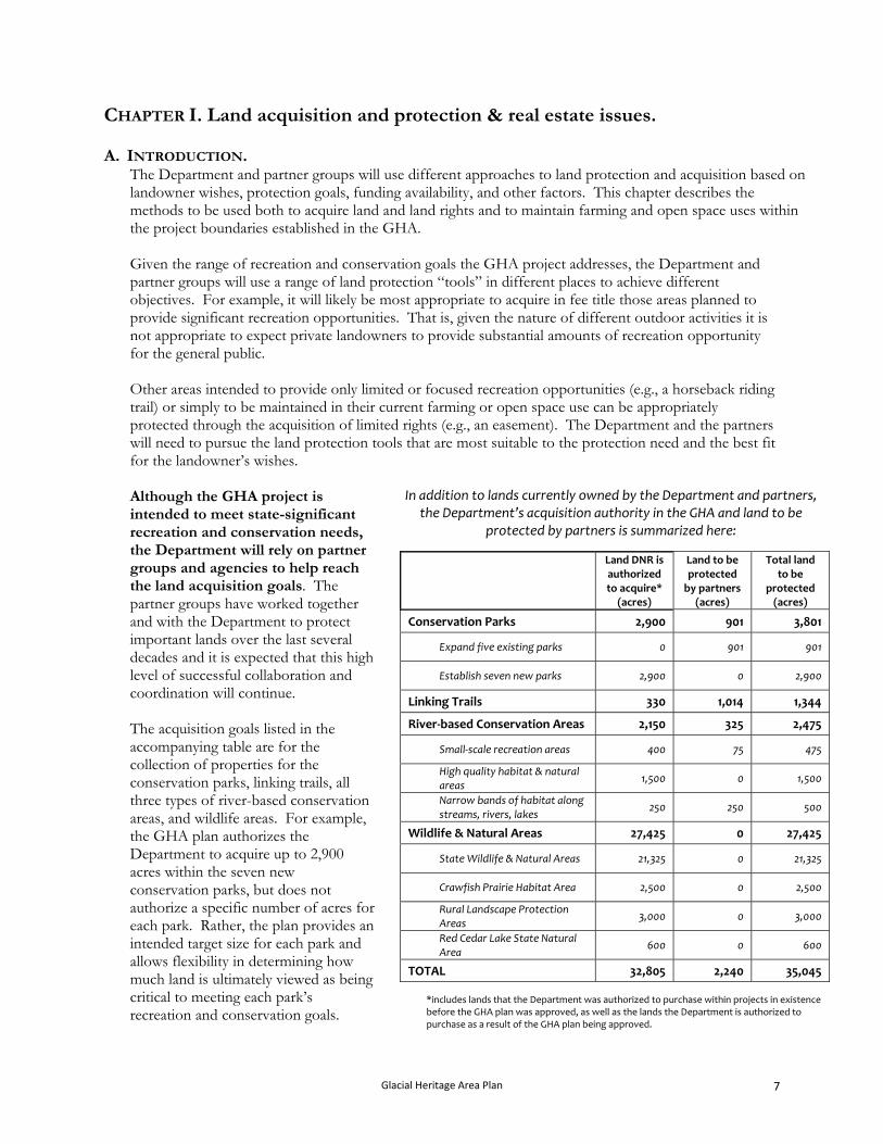
In addition to lands currently owned by the Department and partners, the Department’s acquisition authority in the GHA and land to be
protected by partners is summarized here:
Although the GHA project is intended to meet state-significant recreation and conservation needs, the Department will rely on partner groups and agencies to help reach the land acquisition goals. The partner groups have worked together and with the Department to protect important lands over the last several decades and it is expected that this high level of successful collaboration and coordination will continue.
Land DNR is authorized to acquire*
(acres)
Land to be protected by partners
(acres)
Total land to be
protected (acres)
Conservation Parks 2,900 901 3,801
Expand five existing parks 0 901 901
Establish seven new parks 2,900 0 2,900
Linking Trails 330 1,014 1,344
River‐based Conservation Areas 2,150
325 2,475 The acquisition goals listed in the accompanying table are for the collection of properties for the conservation parks, linking trails, all three types of river-based conservation areas, and wildlife areas. For example, the GHA plan authorizes the Department to acquire up to 2,900 acres within the seven new conservation parks, but does not authorize a specific number of acres for each park. Rather, the plan provides an intended target size for each park and allows flexibility in determining how much land is ultimately viewed as being critical to meeting each park’s recreation and conservation goals.
Small‐scale recreation areas 400 75 475
High quality habitat & natural areas
1,500 0 1,500
Narrow bands of habitat along streams, rivers, lakes
250 250 500
Wildlife & Natural Areas 27,425 0 27,425
State Wildlife & Natural Areas 21,325 0 21,325
Crawfish Prairie Habitat Area 2,500 0 2,500
Rural Landscape Protection Areas
3,000 0 3,000
Red Cedar Lake State Natural Area
600 0 600
TOTAL 32,805 2,240 35,045
*includes lands that the Department was authorized to purchase within projects in existence before the GHA plan was approved, as well as the lands the Department is authorized to purchase as a result of the GHA plan being approved.
Glacial Heritage Area Plan 7
Similarly, the Department is authorized to acquire up to 21,325 acres within the project boundaries of the State Wildlife Areas as a collection. A project boundary has been drawn around each of the new or expanded conservation parks, wildlife and natural areas, and the high quality river-based conservation area sites. The project boundaries delineate zones within which these protected areas are to be located. For nearly all of the conservation parks, high quality river-based conservation areas, and wildlife areas, the project boundaries encompass significantly more land than the acquisition goals. The Department’s and partners’ hope is that some of the landowners within these project boundaries will be interested in selling or donating portions of their property to enable the establishment or expansion of the protected areas. In most cases, the project boundaries for these conservation areas follow roads. This is done simply to make it easier to portray where these boundaries are located and to ensure that adequate access is available for lands that may be acquired in the future. However, a consequence of this approach is that many homes, farmsteads, and other improvements are located within the project boundaries. The Department and partners do not seek to purchase improvements or small lots as part of the GHA project. In most situations where buildings are purchased as part of a larger land holding, the buildings will be split from the larger parcel and sold according to and consistent with local ordinances. Several programs available to assist landowners interested in maintaining farmland and conservation lands are described in Chapter IV. Local and county governments, who together control local land use issues, will continue to play the pivotal role in determining the setting within which the conservation parks, trails, river-based conservation areas and wildlife areas sit.
B. ACQUISITION AUTHORITY, PROPERTY DESIGNATIONS, AND LAND MANAGEMENT
CLASSIFICATIONS. The Department will acquire land for the Glacial Heritage Area using the following authorities:
State Wildlife Areas under the authority of State Statute 23.09(2)(d) 3 and 15. Crawfish Prairie State Habitat Area under the authority of State Statute 23.09(2)(d) 14. Rural Landscape Protection Areas under the authority of State Statute 23.09(2)(d) 14. Red Cedar Lake State Natural Area under the authority of State Statute 23.09(2)(d) 8. Conservation Parks under the authority of State Statute 23.09(2)(d) 2 and Stats. 27.01. Linking Trails under the authority of State Statute 23.09(2)(d) 12. River-based Conservation Areas under the authority of State Statute 23.09(2)(d) 7 and 14.
The Department will acquire less than fee rights in the Glacial Heritage Area under the authority of State Statute 23.09(10). Partners will acquire lands under their respective operating authorities. The different property designations are described in Sec 23.09, Sec. 23.091, Sec 23.175, Sec. 23.27, and Sec 27.01 State Stats. The lands within the GHA project that the Department acquires will be designated as follows:
The 2,900 acres for the seven new conservation parks will be designated as “state parks.” The 330 acres for the new or expanded linking trails will be designated as “state trails.” The 400 acres for the river access sites will be designated as “recreation areas.” The 1,500 acres for the high quality habitat blocks in riparian zones will be designated as “habitat
areas” or “state natural areas.” The 250 acres for the narrow bands of permanent habitat along river, creeks, and major tributaries
will be designated as “recreation areas” or as “habitat areas.”
Glacial Heritage Area Plan 8
The 21,325 acres for the expansions of the wildlife areas will be designated as “state wildlife areas.” The 2,500 acres for the new Crawfish Prairie State Habitat Area will be designated as “habitat
areas.” The 3,000 acres for the new Rural Landscape Protection Areas will be designated as “habitat
areas.” The 600 acres for the Red Cedar Lake State Natural Area will be designated as “state natural area.”
When the Department establishes a property (e.g., a new state park or state forest), it also assigns the property, or portions of the property, land management classifications that describe the general management objectives. The land management classifications for the different types of properties that the Department acquires in the GHA will be:
Conservation Parks The Conservation Parks will be classified as “recreation management areas” as defined in Administrative Code NR 44.06. In addition to their designation as “recreation management areas,” these properties will also be assigned a “recreational use setting sub-classification” of Type 3 or 4. Linking Trails The Linking Trails will be classified as “recreation management areas” as defined in Administrative Code NR 44.06. The sub-classifications will be Type 4. River-based Conservation Areas The one or two planned larger river access sites designed to provide shore fishing opportunities and water-access-only camping sites will be classified as “recreation management areas” with a sub-classification of Type 3 or 4. Lands protected within the larger blocks of habitat planned at Allen Creek, Lower Bark River, and Lower Koshkonong Creek Woods, will be classified as either “habitat management areas” or “native community management areas” where appropriate, based on ecological features. The narrow bands of permanent habitat along river, creeks, and major tributaries will be classified as “recreation management areas” with sub-classifications of Type 3 or 4 or “habitat management areas.” Wildlife & Natural Areas The State Wildlife Areas will be classified primarily as “habitat management areas” with some areas of high ecological quality classified as “native community management areas” where appropriate. The State Natural Areas will be classified as “native community management areas.”
C. REAL ESTATE MANAGEMENT POLICIES.
1. Acquisition Policies. It is the policy of the Natural Resources Board and the DNR to acquire lands only from willing sellers. As required by state and federal laws, the Department pays just compensation for property, which is the estimated market value based on an appraisal. At times, it is in the interest of the Department and the landowner for the Department to acquire only part of the rights to a property, or an easement. The Department has a number of easement options available to address these situations. Landowners within the property boundary will be contacted periodically by Department staff to explain the Department’s land acquisition program and to see if they have an interest in selling their property. Acquisition priorities for the properties vary from year to year and are based on a number of factors, such as resource management or recreation needs and available funding.
Glacial Heritage Area Plan 9
In almost all cases the DNR can only purchase property for its appraised fair market value, as determined by an independent appraisal. This insures that landowners are offered a fair and competitive price and that taxpayers (as the ultimate buyers) pay only what a property is worth.
2. Project boundaries and acquisition goals. For most state parks, wildlife areas, forests, and other Department properties, the agency is only authorized to purchase land within approved “project boundaries.” For the GHA, project boundaries have been drawn for the conservation parks, the habitat areas of the river-based conservation areas, the expansions of the wildlife areas, the Crawfish Prairie Habitat Area, and the Rural Landscape Protection Areas. In most cases, the project boundaries for these conservation and recreation areas follow roads. This is done simply to make it easier to portray where these boundaries are located and to ensure that adequate access is available for lands that may be acquired in the future. However, a consequence of this approach is that many homes, farmsteads, and other improvements are located within the project boundaries. The Department and partners do not seek to purchase improvements or small lots as part of the GHA project. In most situations where buildings are purchased as part of a larger land holding, the buildings will be split from the larger parcel and sold according to and consistent with local ordinances. It is the Department’s and partners’ hope that lands within the project boundaries that do not become part of the protected areas will be maintained in agricultural or other open space use. In all cases, the project boundaries encompass significantly more land than is planned to be acquired. As an example, the project boundary for the North Shore Moraine Park encompasses 2,050 acres; the park itself —planned to be located somewhere within this boundary—is intended to be formed through the acquisition of up to 300 acres from willing sellers. The linking trails do not have project boundaries due to the fact that for the most part they can be successfully located in a broad swath between two destinations. As such, their ultimate locations are considerably flexible and not “place-dependent.” Instead of project boundaries, the linking trails are portrayed as general routes between cities and protected areas.
3. Future Boundary Adjustment Process. From time to time adjustments in property boundaries are needed. In some cases parcels of land are removed from the boundary to allow alternative, necessary public uses by local governments. In other cases it may be desirable to add small parcels adjacent to the property so they can be purchased for resource protection or to meet expanding recreational needs. Property boundary changes of 40 acres or more require approval by the Natural Resources Board. Wisconsin Administrative Code Ch. NR 44 provides a plan amendment process that may be used to make adjustments in the property boundary.
4. Property Taxes and Payments in Lieu of Taxes (PILT).
Since 1992, the Department of Natural Resources pays aids in lieu of taxes on lands it acquires equal to property taxes that would have been paid had the land remained in private ownership. According to the new law (State Statute 70.11 (1)), property acquired by DNR comes off the tax roll and in place of the loss of tax base, each taxing jurisdiction receives an aid payment equivalent to property taxes. The law requires one difference between how DNR lands and private properties are assessed. To avoid the need for local assessors to continually assess DNR property and for the DNR to review and possibly appeal assessments, the law states that initial assessed value is set at the DNR purchase price of the property. Subsequently, this value is adjusted to reflect the change in the assessed value
Glacial Heritage Area Plan 10
of land in the taxation district. For example, if the assessed value of land in a Township increases by 5%, then the assessed value of DNR land in the Township is automatically increased 5% and the payment in lieu of taxes also increases 5%. All other aspects of the way DNR makes its payment in lieu of tax under this new program are the same as those for a local taxpayer.
Prior to 1992, the state made payments to local governments where the Department owned land based on a rather complicated formula. Due to the confusion surrounding these payments, the Legislature created a new law in 1992 that simplified the payment process.
D. METHODS TO ACQUIRE LAND OR LAND RIGHTS IN THE GHA. The Department is authorized to acquire land or specific land rights in the GHA through a variety of ways described below. The appropriate acquisition approach will depend on the intent of the future use of the land and the wishes of the land owner. The different land acquisition tools that the Department (and other organizations as applicable) may use in the GHA are as follows: 1. Options to acquire full interests in property.
(a) Fee title (simple) purchase. Fee title acquisition is the outright purchase of land including the transfer of title to the property and all the rights associated with ownership (i.e. the entire bundle of rights). The Department and partner groups applying for state funds are required to offer the land’s fair market value as determined by an independent appraisal.
(b) Fee title purchase with life-estate.
In some cases, a landowner may wish to sell their land but continue living on the property. The Department and partner groups can delay public control of all or a portion of the land by negotiating a life estate or a lease-back arrangement. With a life estate, the buyer pays the landowner fair market value for the land minus the value of the landowner’s use during his or her lifetime, which depends on the projected life span of the landowner. The landowner receives payment during his or her lifetime and continues to live on the land.
(c) Fee title transfer with a donation, partial donation, or bargain purchase.
In a bargain sale of land, the land is sold for less that its fair market value. This makes the land more affordable for the Department or partner groups and also offers the landowner, several potential benefits. A bargain sale provides cash to the land owner, may reduce capital gains taxes, and entitles the landowner to a charitable income tax deduction based on the difference between the land's fair market value and its sales price.
(d) Fee title sale or donation and then resale.
Some properties have critical open space values, help meet key public access needs, or have other attributes that make their preservation in an undeveloped state important to the success of the GHA project. In some of these situations, the DNR or partner groups may seek to acquire a property and retain the development rights and/or public access rights, but then re-sell the lands for farming or other open space uses.
2. Options to acquire partial interests in property.
(a) Easements. Easements are used by landowners to sell or donate specific rights to another person, organization, or agency. Easements go by different names, typically according to the resource of interest: historic preservation easements, agricultural easements, access easements, conservation easements, and
Glacial Heritage Area Plan 11
others. Easements are recorded on the title so that all future owners of the land are bound by the original agreement. In most cases, particularly for conservation and access purposes, easements involve the permanent transfer of rights. Not surprisingly, easements are popular with many landowners because they enable them to sell or donate particular rights (often some of the most financially valuable ones) while retaining ownership of the property. Because they allow limited financial resources to be focused on specific needs, easements are also popular with private and public conservation and recreation groups. The most common types of easements that may be acquired in the GHA project are conservation, agricultural, scenic or public access easements.
3. Options for acquiring segments of the linking trails. The Department has experience with establishing trails, most notably the Ice Age Trail, that do not have access to pre-existing corridors such as rail beds or utility corridors. Establishing these “cross-country” trails is made difficult by the number of landowners and the diversity of their perspectives and needs. One method to help ensure that the trail is acquired most efficiently is to negotiate long-term options to purchase a trail corridor with all landowners within a particular section before actually purchasing the strips of land. That is, the Department or partner groups may wait to purchase pieces of a trail corridor until an adequate number have been lined up to be able to build a useable trail.
E. METHODS TO MAINTAIN LANDS IN AN UNDEVELOPED STATE IN THE GHA.
As stated previously, the conservation parks, river-based conservation areas, and wildlife areas will benefit very much from being surrounding by undeveloped land that is farmed or in some form of conservation or open space use. Some of the options for landowners to maintain their property in an undeveloped state include the following:
1. Purchase or donation of development rights (PDR).
In some cases, there is a desire to permanently protect rural landscapes to maintain them for agriculture, forestry, or other open space uses. One way that landowners, organizations, and agencies can accomplish this goal is to supplement existing land use plans with the donation or purchase of a property’s development rights. By acquiring the development rights and then placing a conservation, forestry or agricultural easement on the land, PDR programs can maintain the rural character of land. PDR programs are being used increasingly by local units of government in Wisconsin and elsewhere.
2. Federal Farm Bill programs.
The Farm Bill was reauthorized in May 2008 and USDA agencies are revising how the new law will be implemented. Below are descriptions of the major conservation-focused programs within the earlier version of the Farm Bill. It is expected that the reauthorized programs will retain most of these attributes, although some changes may occur.
(a) Conservation Reserve Program (CRP) The Conservation Reserve Program is a voluntary program for agricultural landowners to receive annual rental payments (based on the agriculture rental value of the land) and cost-share assistance to establish long-term, resource conserving covers on eligible farmland. Acreage enrolled is planted to permanent grassland or forest covers making the program a major contributor to increased wildlife populations and protects millions of acres of topsoil from erosion. Landowners enroll in CRP contracts for 10 to 15 years.
(b) Conservation Reserve Enhancement Program (CREP) The Conservation Reserve Enhancement Program is a voluntary land retirement program that helps agricultural producers protect environmentally sensitive land, decrease erosion, restore wildlife habitat, and safeguard ground and surface water. The program is a partnership among
Glacial Heritage Area Plan 12
producers; tribal, state, and federal governments; and, in some cases, private groups. CREP is an offshoot of the Conservation Reserve Program. Like CRP, CREP is administered by USDA's Farm Service Agency (FSA). By combining CRP resources with state, tribal, and private programs, CREP provides farmers and ranchers with a sound financial package for conserving and enhancing the natural resources of farms. CREP addresses high-priority conservation issues of both local and national significance, such as impacts to water supplies, loss of critical habitat for threatened and endangered wildlife species, soil erosion, and reduced habitat for fish populations such as salmon. CREP is a community-based, results-oriented effort centered around local participation and leadership.
(c) Wetland Reserve Program (WRP) The Wetland Reserve Program (WRP) is a voluntary program that provides technical and financial assistance to eligible landowners to address wetland, wildlife habitat, soil, water, and related natural resource concerns on private lands in an environmentally beneficial and cost-effective manner. The program provides an opportunity for landowners to receive financial incentives to restore, protect, and enhance wetlands in exchange for retiring farmed wetlands from agriculture.
(d) Environmental Quality Incentives Program (EQIP) The Environmental Quality Incentives Program is a voluntary program that provides assistance to farmers and ranchers who face threats to soil, water, air, and related natural resources on their land. Through EQIP, the Natural Resources Conservation Service (NRCS) provides assistance to agricultural producers in a manner that will promote agricultural production and environmental quality as compatible goals, optimize environmental benefits, and help farmers and ranchers meet Federal, State, Tribal, and local environmental requirements.
3. Other federal programs.
(a) Wildlife Habitat Improvement Program (WHIP) The Wildlife Habitat Incentive Program (WHIP) provides cost-share assistance to private landowners to help them enhance wildlife habitat areas on their lands. WHIP complements other cost share/incentive programs and provides a mechanism capable of overcoming two major obstacles to increasing wildlife habitat area. First, WHIP compensates landowners for the lack of market incentive to invest in public goods, such as watershed and wildlife protection. Second, it encourages landowners to make long term investments in maintaining the natural resource base (particularly land management practices capable of improving habitat areas). WHIP is administered by the NRCS.
(b) North American Wetlands Conservation Act (NAWCA) NAWCA provides matching grants to organizations and individuals who have developed partnerships to carry out wetland conservation projects. The Act was passed, in part, to support activities under the North American Waterfowl Management Plan, an international agreement that provides a strategy for the long-term protection of wetlands and associated upland habitats needed by waterfowl and other migratory birds. In December 2002, Congress expanded its scope to include the conservation of all habitats and birds associated with wetland ecosystems.
4. State landowner assistance programs.
(a) Managed Forest Law (MFL) The purpose of Wisconsin's forest tax laws is to encourage sustainable forestry on private lands by providing property tax incentives to landowners. This is accomplished with a binding agreement between the state Department of Natural Resources and private landowners. Under the Managed Forest Law, the landowner agrees to a management plan for a period of 25 or 50 years that includes
Glacial Heritage Area Plan 13
mandatory and recommended practices. The reward for following the plan is that MFL property taxes average 80% less than regular property taxes.
(b) Wisconsin Forest Landowner Grant Program (WFLGP) The Wisconsin Forest Landowner Grant Program was created to encourage private forest landowners to manage their lands in a manner that benefits the forest resources and the people of the State. WFLGP assists private landowners to protect and enhance their forested lands, prairies, and waters. The program allows qualified landowners to be reimbursed up to 50% of the eligible cost of eligible practices. Private landowners in Wisconsin are eligible for WFLGP funding if they own at least 10 contiguous acres of non-industrial private forest but not more than 500 acres within Wisconsin.
(c) Wisconsin Department of Agriculture, Trade, and Consumer Protection’s Purchase of Agricultural Conservation Easements (PACE) program The DATCP’s Working Lands Program has established a new program to provide up to 50% of the cost of purchasing agricultural conservation easements, including transaction costs. Through the PACE program, the state will provide funding to cooperating local governments or non-profit organizations to purchase easements from willing landowners. Land with an agricultural conservation easement cannot be developed for any purpose that would prevent its use for agriculture.
F. PUBLIC ACCESS ON LANDS ACQUIRED OR EASED.
In accordance with recent legislation and unless otherwise exempted, lands acquired using Stewardship funds under the authority of wildlife, fisheries, habitat, or recreation areas are required to be open for the five nature-based outdoor recreation activities as defined by the State Stewardship Law (Sec. 23.0916, Wis. Stats.) Lands acquired for State Parks and Trails are not subject to this requirement. These five activities are: cross-country skiing, fishing, hiking, hunting, and trapping. Although lands acquired using Stewardship are to be open for these activities, there is no requirement that designated or maintained hiking or skiing trails be provided. Lands acquired with Stewardship funds may be closed to one or more of these activities in order to: (a) protect public safety, (b) protect a unique animal or plant community, or (c) to accommodate a usership pattern. Administrative Code NR 52 describes the factors to be addressed and process for restricting or prohibiting one or more of these activities.
The following section describes the situations where it may be appropriate to restrict or prohibit one or more of these five activities on land or land rights within the GHA project boundaries that are acquired by the Department or partners. Any restrictions or prohibitions will need to meet the conditions of NR 52.
1. Lands acquired in fee.
At the present time, no areas are known to harbor potential public safety issues or exceptionally sensitive resources that would necessitate prohibiting all public access. There are some sites within the GHA project that harbor high-quality occurrences of rare species and native communities where, if acquired, it may be appropriate to limit access to only trails, to particular times of the year when disturbance will be less of a concern, to the types of recreation allowed, or limit uses in other ways. Lands acquired in fee for the wildlife and natural areas and the larger blocks of land for the river-based conservation areas will be open to cross-country skiing, fishing, hiking, hunting, and trapping, in addition to some other activities that are described later in this chapter. The GHA plan calls for the acquisition of 22,875 acres to expand and create wildlife, habitat, and natural area properties (to go with the approximately 32,000 acres of public land in the area that are currently open for cross-country skiing, fishing, hiking, hunting, and trapping).
Glacial Heritage Area Plan 14
The State Stewardship Law requirement regarding lands acquired with Stewardship funds be open to these five nature-based activities does not apply to lands acquired under the authority of state parks (which includes state trails). Park properties are intended and designed to provide a range of recreational uses, including many higher intensity uses, some of which may need to be separated to ensure that participants enjoy high quality experiences and minimize impacts to resources. By statute, the conservation parks and linking trails are required to be closed to hunting (unless otherwise opened) and closed to trapping. For further explanation of how the Department intends to incorporate hunting in portions of the planned seven new conservation parks, see page 29.
2. Lands acquired in fee with subsequent sale of specific use rights (e.g., farming) There may be some instances where it is appropriate for the Department or partners to acquire lands in fee then subsequently to sell certain rights in the property. For example, the Department has used this approach successfully in some limited situations to purchase properties that contain both important conservation values and high quality farmland. The right to farm the prime fields can be re-sold to local farmers. Depending on the circumstances unique to a property, public access may not be appropriate or the Department can retain public access rights for different hunting or trapping seasons.
3. Land rights acquired through easement There may be some instances where it is appropriate for the Department or partners to acquire easements conveying partial rights in a property. For example, the Crawfish Prairie Habitat Area (CPHA) and the Rural Landscape Protection Areas (RLPA) are both intended to protect pockets of conservation lands within a mosaic of open, undeveloped land (primarily farmland). Some of these lands could be protected through conservation easements. Similarly, some of the undeveloped lands within the CPHA and RLPA could be protected through agricultural easements. In some cases, landowners are willing to sell or donate easements on properties with high conservation value but are unwilling to include some or all forms of public access in the easement. Although current State Stewardship Law does not require public access on lands protected through an easement, the Department and the partners strong preference is to secure at least some forms of public access for nature-based recreation (e.g., cross-country skiing, fishing, hiking, hunting, and trapping) on easements. As stated earlier, at the present time no areas within the GHA project boundaries are known to harbor potential public safety issues or exceptionally sensitive resources that would necessitate prohibiting all public access. However, in some very limited cases it may be appropriate for the Department or partners to acquire easements without or with only limited public access. These situations could include the following: (a) Acquisition of scenic easements.
The Department, or partners using Stewardship grants, may purchase or accept as donations scenic easements with limited or without public access within the project boundaries established in the GHA that meet one of the following criteria:
Parcels that provide critical visual buffers as seen from protected lands within parks, natural areas, wildlife areas or other conservation areas where acquisition in fee is not feasible or practical.
Parcels that have high scenic value and are too small (10 acres or less), or otherwise limited, to provide meaningful recreational use.
Glacial Heritage Area Plan 15
(b) Acquisition of agricultural easements. The GHA plan encourages the protection of farmlands buffering the parks, natural areas, wildlife areas and other conservation areas and there is strong interest from many partners in developing a farmland protection program throughout the entire area. Agricultural easements could include limited public access (e.g., hunting after crops have been harvested or in the spring prior to planting), but public access is not necessarily required to meet the goals of protecting farmland and its buffering benefits. The Department, or partners using Stewardship grants, may purchase or accept as donations agricultural easements with limited or without public access within the project boundaries established in the GHA that provide critical buffering to maintain an existing protected area’s conservation or recreation values. If additional federal, state, or local funding becomes available to purchase agricultural easements, the Department will work with partners in their efforts to acquire agricultural easements in the GHA project area and may also seek to purchase some forms of public access on these lands as appropriate.
(c) Acquisition of conservation easements. The Department or partners may purchase or accept as donations conservation easements with limited or without public access in the project boundaries established in the GHA that meet one of the following criteria:
Parcels that harbor particularly sensitive resources where some forms of nature-based recreational use would conflict with the conservation goals of the easement. For example, the easement may restrict access during critical parts of the year, for example during the breeding season of rare grassland birds.
Parcels too small or inaccessible to provide meaningful recreational use (e.g., a 10-acre isolated wetland parcel).
Parcels that harbor unique or high-quality resources that the Department concludes could be harmed by general public access (e.g., sensitive archaeological sites).
Parcels that provide critical habitat connections or linkages between protected lands. For lands protected using easements, it is the Department’s and partners’ intent to also acquire a right-of-first-refusal. This will allow the Department to have the flexibility to provide a full range of recreation activities suitable for the parcel.
G. CRITERIA TO GUIDE ACQUISITION OF LAND WITHIN THE PROJECT BOUNDARIES. The implementation of the GHA project is designed to provide flexibility for the Department and its partners as well as for landowners. Because the project boundaries for various components of the network are larger than the acquisition goals, in some cases considerably larger, there is a need to evaluate the relative strengths of different parcels and properties within project boundaries. If landowners are interested in selling property, the following criteria will be used by the Department and partners to assess properties for potential acquisition. As stated earlier, it is the Department’s and partners’ hope that lands within these project boundaries that do not become part of the conservation parks, river-based conservation areas, and wildlife area remain in farming, conservation or other open space uses through a combination of landowner initiatives, farmland protection programs, purchase of development rights, and other tools.
Glacial Heritage Area Plan 16
1. Conservation Parks. The project boundaries of the conservation parks encompass 13,000 acres and are considerably larger than the acquisition goals (3,801 acres). In assessing which lands to seek to acquire within these project boundaries, the Department and partners will follow these criteria:
Lands whose owners are interested in selling or are willing to consider selling all or portions of their property.
Lands that possess characteristics such as water features, topography, vegetation, historical features, and scenic views that will enable particularly satisfying recreational opportunities.
Lands that harbor high quality native habitats or significant ecological features or lands that can be restored relatively easily to high ecological quality.
Lands that harbor habitat that supports Species of Greatest Conservation Need or lands that can be restored to support significant populations of SGCN.
Lands adjacent to existing park lands or other protected lands. Lands that are in larger ownership blocks. Lands with no or low-value improvements. Lands that do not have significant amounts of prime farmland or that will not significantly
impact working farms in the area.
2. River-based Conservation Areas. The project boundaries for the high-quality habitat areas of the river-based conservation areas encompass nearly 6,000 acres and are considerably larger than the acquisition goals (1,500 acres). In assessing which lands to seek to acquire within these project boundaries, the Department and partners will follow these criteria:
Lands whose owners are interested in selling or are willing to consider selling all or portions of their property.
Lands that harbor high quality native habitats or significant ecological features or lands that can be restored relatively easily to high ecological quality.
Lands that harbor habitat that supports Species of Greatest Conservation Need or lands that can be restored to support significant populations of SGCN.
Lands adjacent to existing park lands or other protected lands. Lands that are in larger ownership blocks. Lands with no or low-value improvements. Lands that do not have significant amounts of prime farmland or that will not significantly
impact working farms in the area. Lands that currently affect the hydrology of important conservation lands. Lands that will be affected by the restoration of other nearby protected wetland areas (i.e.,
restoration efforts are impeded by potential impacts to surrounding lands). No project boundaries have been established for the small-scale recreation sites (primarily access sites). In assessing which lands to seek to acquire along “paddleable” rivers and streams, the Department and partners will follow these criteria:
Lands whose owners are interested in selling or are willing to consider selling all or portions of their property.
Small sites that can provide improved access and are spaced at approximately 3-5 mile intervals. Lands with no or low-value improvements. Lands that do not have significant amounts of prime farmland or that will not significantly
impact working farms in the area. One or two larger sites that can provide a small, rustic water-access only campground.
Glacial Heritage Area Plan 17

No project boundaries have been established for the narrow bands of permanent vegetation along major rivers and streams. In assessing which lands to seek to acquire along rivers and streams, the Department and partners will follow these criteria:
Lands whose owners are interested in selling or are willing to consider selling fee or easement rights.
Lands on which the restoration of permanent vegetation will have a substantive impact on water quality.
Lands adjacent to or near existing blocks of native habitat where a band of permanent vegetation can provide important travel corridors.
Lands along rivers and streams that can provide good quality shore fishing opportunities. Lands with no or low-value improvements. Lands that do not have significant amounts of prime farmland or that will not significantly
impact working farms in the area. 3. Linking Trails.
No project boundaries have been established for the linking trails due to the flexibility in their ultimate location. In assessing which narrow strips of land to seek to acquire, the Department and partners will follow these criteria:
Lands whose owners are interested in selling or are willing to consider selling all or portions of their property.
Lands that build on existing trail segments and sections or protected lands that can support trails. Lands that do not significantly interfere with the existing land uses and operations. Lands that possess characteristics that will enable particularly satisfying recreational
opportunities. Lands that can support sustainable trails.
4. Wildlife & Natural Areas.
The project boundaries for the existing Wildlife Areas encompass 56,268 acres of which 26,883 acres are currently owned by the Department. Of the other 29,385 acres in the project boundaries, the Department has authorization to purchase 21,325 acres boundaries of the Wildlife Areas. In addition, the Red Cedar Lake Natural Area is planned to be expanded by 600 acres within a total project boundary of approximately 1,500 acres. In assessing which lands within these project boundaries for the expansions to the existing Wildlife Areas to seek to acquire, the Department and partners will follow these criteria:
Lands whose owners are interested in selling or are willing to consider selling all or portions of their property.
Lands that harbor native habitats or significant ecological features. Lands adjacent to existing Wildlife Area lands or other protected lands. Lands that are in larger ownership blocks. Lands with no or low-value improvements. Lands that do not have significant amounts of prime farmland or that will not significantly
impact working farms in the area. Lands that can provide high-quality hunting, trapping, and fishing experiences as well as
opportunities for other compatible nature-based outdoor activities. Lands that currently affect the hydrology of important conservation lands. Lands that will be affected by the restoration of other nearby protected wetland areas (i.e.,
restoration efforts are impeded by potential impacts to surrounding lands).
Glacial Heritage Area Plan 18
The Rural Landscape Protection Areas are designed to be a mosaic of working farms interspersed with a limited amount of conservation lands. The Department is authorized to purchase up to 3,000 acres scattered through these broad areas to provide wildlife habitat. In assessing which lands to seek to acquire within these project boundaries for the Rural Landscape Protection Areas, the Department and partners will follow these criteria:
Lands whose owners are interested in selling or are willing to consider selling all or portions of their property.
Lands that harbor native habitats or significant ecological features. Lands with no or low-value improvements. Lands that do not have significant amounts of prime farmland or that will not significantly
impact working farms in the area. Lands that can provide high-quality hunting, trapping, and fishing experiences as well as
opportunities for other nature-based outdoor activities. Lands that currently affect the hydrology of important conservation lands. Lands that will be affected by the restoration of other nearby protected wetland areas (i.e.,
restoration efforts are impeded by potential impacts to surrounding lands). The Crawfish Prairie Habitat Area is designed to follow the land protection model used at other grassland conservation projects elsewhere in the state and region. This approach seeks to protect a small number of larger core habitat areas surrounded by a landscape of farmlands and smaller, scattered conservation lands. The Department is authorized to purchase up to 2,500 acres here. The intent is to protect lands in one or two large core blocks and in scattered areas through the project boundary. In assessing which lands to seek to acquire within the project boundary for the Crawfish Prairie Habitat Area, the Department and partners will follow these criteria:
Lands whose owners are interested in selling or are willing to consider selling all or portions of their property.
Lands that harbor native habitats or significant scenic or ecological features. Lands that are in larger ownership blocks or that assist in creating a larger, core area. Lands with no or low-value improvements. Lands that do not have significant amounts of prime farmland or that will not significantly
impact working farms in the area. Lands that can provide high-quality hunting, trapping, and fishing experiences as well as
opportunities for other nature-based outdoor activities. Lands that can be restored relatively easily to high ecological quality. Lands that harbor habitat that supports Species of Greatest Conservation Need or lands that can
be restored to support significant populations of SGCN. Lands that currently affect the hydrology of important conservation lands. Lands that will be affected by the restoration of other nearby protected wetland areas (i.e.,
restoration efforts are impeded by potential impacts to surrounding lands).
Throughout the areas identified for the Wildlife Areas, the Department will work with partner groups (e.g., such as Ducks Unlimited, Pheasants Forever, local rod and gun clubs, and other conservation organizations) to protect and restore lands. Also, the Department will encourage efforts by the counties or DATCP to protect and maintain farmlands in these areas through purchase of agricultural conservation easements or development rights, particularly in areas harboring larger blocks of prime farm soils.
Glacial Heritage Area Plan 19

CHAPTER II. Land management and recreational use in the GHA network. The management and use of the different components that comprise the Glacial Heritage Area –conservation parks, linking trails, river-based conservation areas, and wildlife & natural areas– are described in detail here. For the properties which are planned but yet to be acquired, or are owned and managed by partner groups, a conceptual plan for management and use is presented. For the wildlife and natural area properties owned by the Department, a master plan for management and use is described. For properties already in state ownership (e.g., the existing Wildlife Areas), the descriptions provided are specific and detailed. For properties already in some other form of protective ownership (e.g., county park or trail, municipal park, non-profit conservation preserve) the descriptions presented here are more general and follow the existing plans developed by the controlling party. The management goals and actions presented here for these properties are intended to be consistent with those existing plans and will also apply to expansion areas. For the planned new conservation parks and river-based conservation areas in the network that are not currently controlled or owned by the Department or its partners, only conceptual plans are described here. As land is acquired for these properties over time, then more comprehensive and detailed plans, referred to as “implementation plans” for these properties will be developed later describing:
what recreation facilities, including trails, are planned, where these facilities will be located, what outdoor recreation activities will be accommodated (either throughout a property or in specific
portions), which habitats will be managed where, and which habitat management techniques will be used.
This more in-depth planning will be needed because at the current time the specific properties that may be acquired within the project boundaries for the new conservation parks and river-based conservation areas are unknown. That is, because the project boundaries are significantly larger than the acquisition goals for each of the properties, the future development of facilities and trails as well as habitat management objectives will be a function of which lands within the project boundary are actually acquired. The implementation plans will include property-specific assessments to ensure the best recreational “fits” for the lands as well as the protection and enhancement of any sensitive resources that may be present (e.g., archaeological features, high quality habitats, and species of greatest conservation need). The primary manager or operator of each of the new conservation parks, linking trails, and river access sites (planned to be the Jefferson County Parks Department) will lead the development of these implementation plans as land is acquired, with the Department’s assistance. As additional land holdings are acquired and a broader range of activities is possible at a property, then the implementation plan will need to be amended to describe additional facility developments, designated use areas, and management activities. Public involvement in the planning process commensurate with the complexity of the planned uses will be needed. All implementation plans and amendments will need to meet state planning standards and be approved by the Department Secretary prior to any facility development or management actions on Department-owned property. See Chapter IV for further discussion on the development of implementation plans.
Glacial Heritage Area Plan 20
A. CONCEPTUAL PLAN FOR THE CONSERVATION PARKS. The primary purpose of the conservation parks in the GHA is to provide high quality opportunities for residents and visitors to engage in a variety of nature-based trail activities and other associated activities, particularly wildlife watching. Some of the parks will have water access and provide high quality fishing opportunities. The larger, existing parks have areas that are predominantly native vegetation such as restored prairies, savannas, forests, and wetlands of varying ecological quality. The new parks and the existing parks that will be enlarged as part of the GHA project are also intended to provide areas of predominantly native vegetation. Five existing parks will be expanded by the partners that currently own land at the property (Jefferson County Parks Department or the Lake Ripley Management District). Seven new conservation parks will be created, with lands acquired by the Department and managed by Jefferson County. Lands that the Department acquires for the conservation parks will be acquired under state parks authority, designated as “state parks” as defined in Sec. 27.01 State Stats. and classified for land management purposes as Type 3 or 4 “recreation management areas” as defined in Administrative Code NR 44.07. This GHA plan authorizes the Department to acquire up to 2,900 acres for the new conservation parks and establishes a target of 901 acres for the partners to protect in the expanded parks. Most of the existing and new parks have or are envisioned to incorporate facilities including hiking, cross-country skiing, biking, and/or equestrian trails, parking, picnic areas, drinking water, and toilets. Some may also include a shelter, limited play equipment for young children, or observation decks designed to provide high quality wildlife watching opportunities. If an adequate land base is acquired, some limited rustic camping will be possible. Another important component of the conservation parks is to educate the public not only about the habitats they see as they hike, bike, ride or ski through the park, but also broader natural resource issues and opportunities. This will be accommodated through changing exhibits at kiosks, interpretive signs, development of different brochures, and other means. In most instances the project boundaries for the existing and new conservation parks are substantially larger than the acquisition targets. As a result, identifying future recreation uses that are “good fits” for the property will depend on its size, physical and ecological characteristics, location, and other factors. The following descriptions of each of the parks present the range of activities that appear well suited given the overall features present in each project area. The specific recreation activities that will be accommodated, habitat management goals and strategies, locations of use areas and facilities, and other issues will be described and mapped during the development of the implementation plans.
Glacial Heritage Area Plan 21
1. Existing conservation parks. (a) Parks where no changes are planned.
No changes to the size, use or management of the following state, county, or local parks are part of the Glacial Heritage Area project:
Aztalan Park Bicentennial (Dog) Park Cam-Rock Park Carlin-Weld Park Langer Family Park Mush-Ko-Se-Day Park Riley-Deppe Park Silverwood Park
In addition, no changes to any other municipal parks are part of the GHA project.
(b) Conceptual plan for management and use of parks where expansions are planned. The following existing parks and preserves are to be expanded to provide additional resource protection and recreation opportunities:
Cold Spring Park Dorothy Carnes Park Dr. J.S. Garman Nature Preserve Korth Park Lake Ripley Management District Preserve
The partner groups will take the lead in expanding these parks. The expansions to these five parks and preserves are described in the following pages. As noted previously, the acquisition goal listed for each park is smaller than the project boundary. That is, each park is intended to be located somewhere within its project boundary, depending on landowner interests and other factors. An acquisition goal is provided for each park, although the ultimate size of a park may be greater or smaller depending on landowner interest, availability of funding, recreation demand, and other aspects. The following pages describe the conceptual plans for how these expanded properties will be managed and used.
Glacial Heritage Area Plan 22
COLD SPRING CONSERVATION PARK Currently, this 1-acre park is simply a small wayside with a shelter and limited picnicking facilities. The park is midway between Whitewater and Fort Atkinson. When expanded, the park will provide a number of recreation opportunities that will likely draw visitors from both communities. Jefferson County will take the lead on establishing a second “unit” of the park to include the adjacent pair of small, steep drumlins. Shrubby and woody species have overgrown large portions of the drumlins, but some native prairie and savanna remnants are believed to remain. Although there will be limited opportunities to provide a wide range of activities given the park’s planned small size, there are great views from the top of the drumlins. Depending upon which lands are acquired, the plan for Cold Spring Park includes the following:
Maintain and restore prairie and savanna communities through a combination of brush
and tree cutting, mowing, prescribed burns, and herbicide treatment as needed. Establish a small day use area that takes advantage of the views of the countryside from
the drumlins and provides opportunities for hiking, picnicking, nature education, and wildlife watching.
Establish up to 2 miles of primitive to lightly-developed hiking trails. Construct park facilities to facilitate day use including features such as picnic tables,
water, and restrooms. Project area = 90 acres Partner acquisition target = 80 acres
Glacial Heritage Area Plan 23
DOROTHY CARNES CONSERVATION PARK Dorothy Carnes Park is centered around a very high quality, deep water marsh (often referred to as Rose “Lake”) that attracts enormous flocks of waterfowl during the spring migration. The existing 394-acre park is currently used for hiking, cross country skiing, nature study, bird watching, and picnicking. Park lands currently include about 2/3rd of the lake shoreline. Due to some of the site’s high ecological quality, much of the existing park is designated the Rose Lake State Natural Area. Jefferson County Parks Department’s intent is to keep much of the park in a natural setting with relatively light recreational use and is currently developing a management plan for the property. The County will take the lead on expanding the existing park to not only protect the remaining shoreline, but also to enable a wider range of recreation activities, including rustic camping and a segment of a broader horseback riding trail between Fort Atkinson and Oakland Highlands Park (and possibly on to Cambridge/Rockdale). If land surrounding the lake is protected, an approximately 4 to 6-mile trail around the lake is planned. If adequate land is protected, a biking trail around the lake is also planned. Given some restrictions on the authorized uses of land that has already been protected (a function of some of the funding) and the wet soils in some sections, a biking trail will likely need to be further away from the shore in portions and thus longer than 6 miles. From downtown Fort Atkinson, a roundtrip bike ride around the lake will likely be 8 to 10 miles. The park lies along the planned linking trail from Fort Atkinson to Cambridge. The expansion of Carnes Park could include this trail. Depending upon which lands are acquired, the plan for Dorothy Carnes Park includes the following:
Protect and restore wetland, prairie, and oak savanna communities using a variety of actions including cutting brush and trees, prescribed burning, mowing, and herbicide treatments.
Expand the existing trail network to add up to 10 miles of primitive to moderately-developed hiking trails, including a trail encircling the lake.
Construct a moderately to fully-developed biking trail around the lake. Construct a moderately to fully-developed biking and/or horseback riding trail through
or along the edge of the park as part of the trail linking Fort Atkinson to Rockdale/Cambridge.
Provide high quality wildlife watching opportunities with observation decks or blinds at several locations around the lake.
Construct additional park facilities to facilitate day use, including additional picnic tables, water, and educational interpretive signs.
If an adequate amount of land is purchased to provide enough space and separation from other park activities, establish a small rustic “car camping” site.
Interestingly, a portion of the marsh was platted as a lake (with the lake bed owned by the state) and a portion was platted as private land (some of which is now owned by Jefferson County as part of the park). Project area = 1700 acres Partner acquisition target = 1000 acres (394 acres currently owned by Jefferson County Parks)
Glacial Heritage Area Plan 24
DR. J.S. GARMAN NATURE PRESERVE Located just south of Waterloo, this 40-acre preserve was donated to Jefferson County by the Garman family. Steep topography on the west side of the park levels out at the top of the drumlin where 22 Indian Mounds are found. The woods include oak, hickory, maple, and cherry species and some pines and spruce were planted at one time within the woods and along the north edge. The preserve has a short hiking trail with additional primitive to lightly-developed trails planned for the future. The County’s goal, at the request of the Garman family, is that the preserve remains a minimally-developed property recognizing the site’s sensitive resources. Jefferson County will take the lead on a small expansion of the preserve, which will enable some additional hiking and day use opportunities and partially buffer the site from surrounding development. The park is planned to be extended primarily to the west down the large drumlin to STH 19. A small expansion is planned to the south out to Waterloo Road, which will provide an additional access point to the park. The total acquisition goal is an additional 40 acres within a 100-acre project area. A small portion of the planned expanded park area is wooded; if the woods are acquired they will continue to be managed as forest or restored to savanna. Open lands that are acquired will be restored to savanna and prairie. As additional land is purchased, the existing trail network will be expanded to add a small amount of primitive to lightly-developed hiking trails. Some limited facilities overlooking the Maunesha River (e.g., picnic area, toilet, interpretive signs) are also planned. No biking or equestrian trails are planned. Depending upon which lands are acquired, the plan for Garman Preserve includes the following:
Maintain existing park acreage as a minimally-developed day use park with primitive trails. Manage and restore native communities in the expansion area including prairies, savanna,
and oak woodland using a variety of actions including cutting brush and trees, prescribed burning, mowing, and herbicide treatments.
In the expansion area, provide opportunities for picnicking, nature and cultural education. In the expansion area, create up to 2 miles of additional primitive to lightly-developed trails
for hiking. In the expansion area, construct additional park facilities including picnic tables, water, and
interpretive signs.
Project area = 120 acres Partner acquisition target = 80 acres (40 acres currently owned by Jefferson County Parks)
Glacial Heritage Area Plan 25
KORTH CONSERVATION PARK Korth Park sits atop a high drumlin and provides spectacular views over Rock Lake. A three-season shelter with kitchen facilities and restrooms was just completed at the top of the drumlin overlooking the lake. The 90-acre park has several hiking trails and a section of paved bike trail that is part of a loop around Rock Lake. At the south end of the park are picnic tables, a shelter, grills, and restrooms. With its views of Rock Lake, connection to the Glacial Drumlin Trail, the newly constructed shelter, and other existing facilities, Korth Park is one of the County’s most visited properties. The Jefferson County Parks Department will take the lead on expanding the park, both to be able to provide a broader range of recreation activities and experiences as well as to adjoin the Glacial Drumlin Trail and the Lake Mills Wildlife Area. The expansion will allow for expanded hiking and biking opportunities and maintain the views from the top of the drumlin. Lands acquired will be restored to wetlands and prairies, and possibly some savanna. Trails constructed in the expansion area will be a range of primitive to fully-developed trails for hiking or recreational biking. No equestrian or mountain biking trails are planned. If a visitor center for the GHA is eventually constructed, Korth may be an excellent site. The expansion will be critical for providing an adequate land base both to buffer surrounding residential developments, to maintain the open space between the existing park and the Glacial Drumlin Trail, and to provide an adequate amount of trails to draw people to the park.
Depending upon which lands are acquired, the plan for Korth Park includes the following:
Manage and restore native communities including wetlands, prairies, and savanna using a variety of actions including cutting brush and trees, prescribed burning, mowing, and herbicide treatments.
Expand the park to take advantage of the views of Rock Lake and provide additional opportunities for hiking and biking, picnicking, nature education, and wildlife watching.
Expand the existing trail network to add 2 or more miles of primitive to fully-developed trails.
Construct additional park features to facilitate day use, including additional picnic tables, water, and interpretive signs.
Project area = 285 acres Partner acquisition target = 200 acres (90 acres currently owned by Jefferson County Parks)
Glacial Heritage Area Plan 26
LAKE RIPLEY MANAGEMENT DISTRICT PRESERVE
The Lake District’s Preserve is a 100-acre, public nature conservancy located on former farmland at the inlet to Lake Ripley. It was acquired in 1997 using a combination of state grants and private donations and has since been restored back to its original wetlands and native prairie, and functions to protect the quality of water flowing into Lake Ripley. An interpretive trail offers hikers and nature enthusiasts the opportunity to explore the diverse flora and fauna that inhabit the Preserve. The Preserve is open to hunting. The Lake Ripley Management District will take the lead on a small expansion to the preserve. Just to the southwest of the preserve is a 40-acre DNR property. Protecting the land between these two parcels will create a larger block of habitat. Also small sections of land added to the north and east of the existing preserve will help ensure the quality of the water flowing through the inlet creek that drains into Lake Ripley.
Depending upon which lands are acquired, the plan for the Lake Ripley Preserve includes the following:
Maintain existing park acreage as a minimally-developed day use park with primitive to lightly-developed trails.
Manage and restore native communities in the expansion area including wetlands, prairies, savanna, and oak woodland using a variety of actions including cutting brush and trees, prescribed burning, mowing, and herbicide treatments.
In the expansion area, create additional primitive to lightly-developed trails for hiking.
Project area = 185 acres Partner acquisition target = 166 acres (101 acres currently owned by the Lake Management District)
Glacial Heritage Area Plan 27
2. New conservation parks to be established.
The Department will take the lead on establishing the following new parks to provide recreation opportunities and resource protection: Cushman Mill Park, Holzhueter Farm Park, Hope Lake Park, North Shore Moraine Park, Oakland Highlands Park, Red Cedar Lake Park, and Scuppernong Valley Park. An acquisition target is provided for each park, although the ultimate size of a park may be greater or smaller depending on landowner interest, availability of funding, recreation demand, and other aspects. This GHA plan provides one collective acquisition goal (2,900 acres) for the Department’s acquisitions within the seven new parks. The conceptual plan for the management and use of these seven new parks is described in more detail in the following pages.
Hunting in the new conservation parks
The new parks’ primary purposes are to provide high quality trail activities (hiking, recreational and mountain biking, horseback riding, cross country skiing) and associated activities such as picnicking, wildlife watching, nature study, and nature photography. Other activities may be provided at the conservation parks if they supplement but do not conflict with or displace the primary purposes. The Department hopes and expects that it will be able to acquire large enough tracks of park land that portions away from areas being used extensively for various activities could provide high quality deer and spring turkey hunting seasons without unduly conflicting with the primary purposes and users of the parks. Hunting is prohibited in properties that the Department’s acquires under its state park authority unless opened by a change to administrative rule (NR 10). The Natural Resources Board approved such a rule change in May, 2010 as part of the spring conservation hearings. Consistent with hunting policies in other state park lands, the rule change enables the Department to open some or all of the properties acquired for the seven new parks to the following hunting seasons as described in the “implementation plans” (see page 92) developed for each park property:
Deer hunting during the November gun season.
Deer hunting during the 11-day muzzleloader season (following the November gun season).
Deer hunting during the late archery season (following the November gun season until the close of the season in January).
Turkey hunting during the first three time periods of the statewide spring turkey season (the first time period begins the Wednesday nearest April 13th).
The Department and the operator of the parks (the county) will work together, along with park user groups and local interests, to identify opportunities to provide high quality experiences for all visitors, including managed hunting opportunities, in the development of the implementation plans. It is the Department’s intent that where these new parks can provide hunting, that they provide superior, uncrowded experiences for hunters similar to the managed hunts provided at Dane County Parks. As such, the Department will work with the operator and the hunting community to design high quality hunting experiences through the issuance of a managed, permit-based system. The Department will enable this system through the use of land use agreements that lease land to Jefferson County or other means. Depending on the success of these hunting opportunities, use levels of different activities, size of the park, habitat management needs, and other factors, other managed hunting seasons or periods may be incorporated as well. It is also the Department’s intent that the new parks not become refuges for white-tailed deer or other species of management concern. Although the seven parks are to be modest in size (average size is about 400 acres), it is possible that they may harbor populations of animals that are large enough to cause damage to native vegetation or other important features at the parks or may conflict with the Department’s species management goals. As such, it may be necessary to open an entire park to some limited hunting seasons to address management needs. Finally, it is possible that in some instances there will be a period between when the Department acquires lands for these seven new parks and when facilities and trails are constructed and used. During this interim period, it is the Department’s intent that lands without facilities or use by hikers, bikers, horseback riders, skiers or other uses will be open for deer and spring turkey hunting seasons on a permit basis to provide high quality hunting experiences. Once the trails and other facilities (e.g., picnic areas, corrals, and wildlife watching platforms) are constructed and use levels rise, some of the hunting seasons that were instituted may eventually conflict or displace the primary purposes or users of the parks. If this occurs, certain areas within the parks, or potentially the whole park, will be closed to hunting seasons as needed to minimize conflicts.
Glacial Heritage Area Plan 28
CUSHMAN MILL CONSERVATION PARK The Cushman family built one of the first dams and lumber mills in Jefferson County on the Bark River here in the early 1840s, forming the mill pond. The site is located between two terminal moraines and the river winds through and around a drumlin field, resulting in dramatic topography where the drumlins rise steeply from the banks of the river. The high hills provide striking views of the surrounding countryside. The dike and dam forming the mill pond were washed out during the floods in June 2008. One of the oldest surviving buildings in the region, a hotel built in 1843 which served travelers between Milwaukee and Madison, sits on the banks of the Bark River within the project area and is currently a personal residence.
This park will be located along the banks of the Bark River and include the surrounding drumlins and hilly moraines. The river - with a rocky bottom, relatively clear water, and swift currents - is a popular paddling and fishing destination. The park will be midway between the planned Scuppernong Valley Park, the Jefferson Marsh, Rome Pond, and Prince’s Point Wildlife Areas, and the Glacial Drumlin Trail. As such, this park will be a central connecting point for regional linking trails to these properties. Establishing a large park here will take advantage of the scenic features of the Bark River and provide a broad range of land and water based recreation activities, including a biking and/or horseback riding loop trail around and through the property. The park will also provide visitors with cultural and historical education opportunities. Depending upon which lands are acquired, the plan for Cushman Mill Park includes the following:
Manage and restore larger areas of prairie, savanna, forest, wetland, and riparian communities using a variety of actions including cutting brush and trees, prescribed burning, mowing, and herbicide treatments.
Establish a day use park that takes advantage of the Bark River and provides substantial opportunities for hiking, picnicking, nature education, cultural and historical education, paddling, fishing, and wildlife watching.
Provide 5 or more miles of primitive to moderately-developed hiking trails. Provide facilities for paddlers and anglers including put-in/take-out sites and shore fishing
opportunities. Construct a moderately to fully-developed biking trail around and through the park and
connect as feasible to the Glacial Drumlin Trail or Scuppernong Valley Park. Construct equestrian trails around and through the park and connect to a larger regional
network. Provide parking, a corral, hitching posts and other features to accommodate equestrian use.
Construct park facilities to accommodate day use, such as picnic tables, water, interpretive signs, shelters, and restrooms.
If an adequate amount of land is purchased to provide enough space and separation from other park activities, establish a small rustic “car camping” site.
In areas of the park with few trails and facilities or with limited use by the primary users of the park during certain times of the year, provide high quality managed deer and spring turkey hunting experiences through the use of a permit system.
Project area = 1,355 acres DNR acquisition target = 700 acres
Glacial Heritage Area Plan 29
HOLZHUETER FARM CONSERVATION PARK Located about 4 miles east of Waterloo, this area contains a large hill (from which Holy Hill, thirty miles to the east, can be seen), woodlot, and farm fields. Waterloo Wildlife Area lies to the north, as well as the rail line connecting Waterloo to Watertown. A linking trail between the two cities is planned adjacent to the rail line. Given the rugged terrain and network of farm roads and trails on the property, the day use park will be used for hiking, cross-country skiing, and mountain biking as well as associated activities such as picnicking, wildlife watching, and nature photography. Lands will be restored to native communities, particularly oak savannas and prairies on the uplands and sedge meadows and wet prairies in the lowlands and designed to complement habitats at the adjacent Waterloo Wildlife Area.
Depending upon which lands are acquired, the plan for Holzheter Farm Park includes the following:
Manage and restore native communities, particularly oak savannas and prairies on the uplands and sedge meadows and wet prairies in the lowlands using a variety of actions including cutting brush and trees, prescribed burning, mowing, and herbicide treatments.
Establish a day use park that takes advantage of the hilly topography and provides opportunities for hiking, mountain biking, picnicking, nature education, cross country skiing, and wildlife watching.
Construct park facilities to accommodate day use, such as picnic tables, water, interpretive signs, shelters, and restrooms.
Construct up to 8 miles of mountain biking trails that cover a range of abilities and technical skills. Some of these trails could also be used for cross country skiing.
Provide 2 or more miles of primitive to moderately-developed hiking trails. Some of these trails could also be used for cross country skiing.
In areas of the park with few trails and facilities or with limited use by the primary users of the park during certain times of the year, provide high quality managed deer and spring turkey hunting experiences through the use of a permit system.
Project area = 700 acres DNR acquisition target = 300 acres
Glacial Heritage Area Plan 30
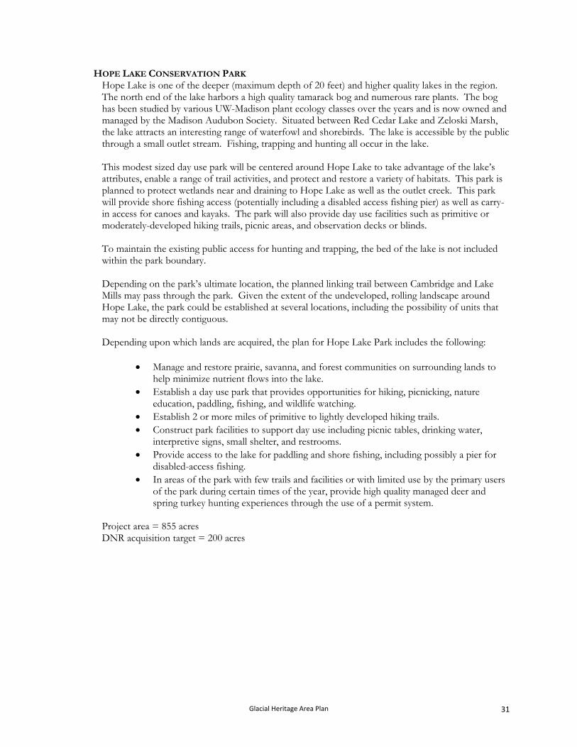
HOPE LAKE CONSERVATION PARK Hope Lake is one of the deeper (maximum depth of 20 feet) and higher quality lakes in the region. The north end of the lake harbors a high quality tamarack bog and numerous rare plants. The bog has been studied by various UW-Madison plant ecology classes over the years and is now owned and managed by the Madison Audubon Society. Situated between Red Cedar Lake and Zeloski Marsh, the lake attracts an interesting range of waterfowl and shorebirds. The lake is accessible by the public through a small outlet stream. Fishing, trapping and hunting all occur in the lake. This modest sized day use park will be centered around Hope Lake to take advantage of the lake’s attributes, enable a range of trail activities, and protect and restore a variety of habitats. This park is planned to protect wetlands near and draining to Hope Lake as well as the outlet creek. This park will provide shore fishing access (potentially including a disabled access fishing pier) as well as carry-in access for canoes and kayaks. The park will also provide day use facilities such as primitive or moderately-developed hiking trails, picnic areas, and observation decks or blinds. To maintain the existing public access for hunting and trapping, the bed of the lake is not included within the park boundary. Depending on the park’s ultimate location, the planned linking trail between Cambridge and Lake Mills may pass through the park. Given the extent of the undeveloped, rolling landscape around Hope Lake, the park could be established at several locations, including the possibility of units that may not be directly contiguous.
Depending upon which lands are acquired, the plan for Hope Lake Park includes the following:
Manage and restore prairie, savanna, and forest communities on surrounding lands to
help minimize nutrient flows into the lake. Establish a day use park that provides opportunities for hiking, picnicking, nature
education, paddling, fishing, and wildlife watching. Establish 2 or more miles of primitive to lightly developed hiking trails. Construct park facilities to support day use including picnic tables, drinking water,
interpretive signs, small shelter, and restrooms. Provide access to the lake for paddling and shore fishing, including possibly a pier for
disabled-access fishing. In areas of the park with few trails and facilities or with limited use by the primary users
of the park during certain times of the year, provide high quality managed deer and spring turkey hunting experiences through the use of a permit system.
Project area = 855 acres DNR acquisition target = 200 acres
Glacial Heritage Area Plan 31
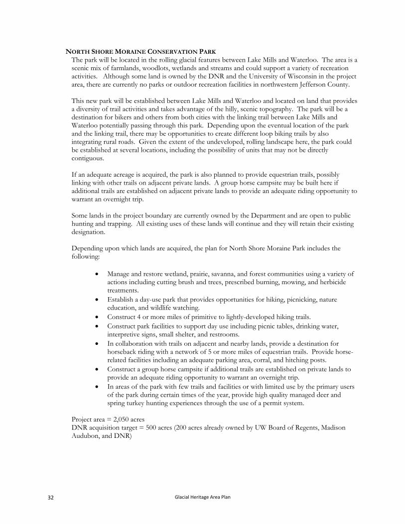
NORTH SHORE MORAINE CONSERVATION PARK The park will be located in the rolling glacial features between Lake Mills and Waterloo. The area is a scenic mix of farmlands, woodlots, wetlands and streams and could support a variety of recreation activities. Although some land is owned by the DNR and the University of Wisconsin in the project area, there are currently no parks or outdoor recreation facilities in northwestern Jefferson County. This new park will be established between Lake Mills and Waterloo and located on land that provides a diversity of trail activities and takes advantage of the hilly, scenic topography. The park will be a destination for bikers and others from both cities with the linking trail between Lake Mills and Waterloo potentially passing through this park. Depending upon the eventual location of the park and the linking trail, there may be opportunities to create different loop biking trails by also integrating rural roads. Given the extent of the undeveloped, rolling landscape here, the park could be established at several locations, including the possibility of units that may not be directly contiguous. If an adequate acreage is acquired, the park is also planned to provide equestrian trails, possibly linking with other trails on adjacent private lands. A group horse campsite may be built here if additional trails are established on adjacent private lands to provide an adequate riding opportunity to warrant an overnight trip. Some lands in the project boundary are currently owned by the Department and are open to public hunting and trapping. All existing uses of these lands will continue and they will retain their existing designation. Depending upon which lands are acquired, the plan for North Shore Moraine Park includes the following:
Manage and restore wetland, prairie, savanna, and forest communities using a variety of actions including cutting brush and trees, prescribed burning, mowing, and herbicide treatments.
Establish a day-use park that provides opportunities for hiking, picnicking, nature education, and wildlife watching.
Construct 4 or more miles of primitive to lightly-developed hiking trails. Construct park facilities to support day use including picnic tables, drinking water,
interpretive signs, small shelter, and restrooms. In collaboration with trails on adjacent and nearby lands, provide a destination for
horseback riding with a network of 5 or more miles of equestrian trails. Provide horse-related facilities including an adequate parking area, corral, and hitching posts.
Construct a group horse campsite if additional trails are established on private lands to provide an adequate riding opportunity to warrant an overnight trip.
In areas of the park with few trails and facilities or with limited use by the primary users of the park during certain times of the year, provide high quality managed deer and spring turkey hunting experiences through the use of a permit system.
Project area = 2,050 acres DNR acquisition target = 500 acres (200 acres already owned by UW Board of Regents, Madison Audubon, and DNR)
Glacial Heritage Area Plan 32
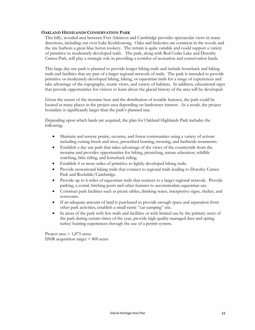
OAKLAND HIGHLANDS CONSERVATION PARK This hilly, wooded area between Fort Atkinson and Cambridge provides spectacular views in many directions, including out over Lake Koshkonong. Oaks and hickories are common in the woods and the site harbors a great blue heron rookery. The terrain is quite variable and could support a variety of primitive to moderately-developed trails. The park, along with Red Cedar Lake and Dorothy Carnes Park, will play a strategic role in providing a corridor of recreation and conservation lands. This large day-use park is planned to provide longer hiking trails and include horseback and biking trails and facilities that are part of a larger regional network of trails. The park is intended to provide primitive or moderately-developed hiking, biking, or equestrian trails for a range of experiences and take advantage of the topography, scenic views, and variety of habitats. In addition, educational signs that provide opportunities for visitors to learn about the glacial history of the area will be developed. Given the extent of the moraine here and the distribution of notable features, the park could be located at many places in the project area depending on landowner interest. As a result, the project boundary is significantly larger than the park’s planned size. Depending upon which lands are acquired, the plan for Oakland Highlands Park includes the following:
Maintain and restore prairie, savanna, and forest communities using a variety of actions including cutting brush and trees, prescribed burning, mowing, and herbicide treatments.
Establish a day use park that takes advantage of the views of the countryside from the moraine and provides opportunities for hiking, picnicking, nature education, wildlife watching, bike riding, and horseback riding.
Establish 4 or more miles of primitive to lightly-developed hiking trails. Provide recreational biking trails that connect to regional trails leading to Dorothy Carnes
Park and Rockdale/Cambridge. Provide up to 6 miles of equestrian trails that connect to a larger regional network. Provide
parking, a corral, hitching posts and other features to accommodate equestrian use. Construct park facilities such as picnic tables, drinking water, interpretive signs, shelter, and
restrooms. If an adequate amount of land is purchased to provide enough space and separation from
other park activities, establish a small rustic “car camping” site. In areas of the park with few trails and facilities or with limited use by the primary users of
the park during certain times of the year, provide high quality managed deer and spring turkey hunting experiences through the use of a permit system.
Project area = 1,875 acres DNR acquisition target = 800 acres
Glacial Heritage Area Plan 33
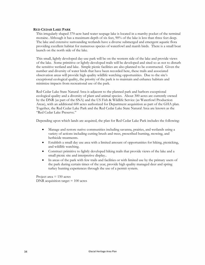
RED CEDAR LAKE PARK
This irregularly shaped 370-acre hard water seepage lake is located in a marshy pocket of the terminal moraine. Although it has a maximum depth of six feet, 90% of the lake is less than three feet deep. The lake and extensive surrounding wetlands have a diverse submerged and emergent aquatic flora providing excellent habitat for numerous species of waterfowl and marsh birds. There is a small boat launch on the north side of the lake. This small, lightly developed day-use park will be on the western side of the lake and provide views of the lake. Some primitive or lightly-developed trails will be developed and sited so as not to disturb the sensitive wetland and lake. Simple picnic facilities are also planned to be constructed. Given the number and diversity of water birds that have been recorded here, these trails and associated observation areas will provide high quality wildlife watching opportunities. Due to the site’s exceptional ecological quality, the priority of the park is to maintain and enhance habitats and minimize impacts from recreational use of the park. Red Cedar Lake State Natural Area is adjacent to the planned park and harbors exceptional ecological quality and a diversity of plant and animal species. About 300 acres are currently owned by the DNR (as part of the SNA) and the US Fish & Wildlife Service (as Waterfowl Production Areas), with an additional 600 acres authorized for Department acquisition as part of the GHA plan. Together, the Red Cedar Lake Park and the Red Cedar Lake State Natural Area are known as the “Red Cedar Lake Preserve.” Depending upon which lands are acquired, the plan for Red Cedar Lake Park includes the following:
Manage and restore native communities including savanna, prairies, and wetlands using a variety of actions including cutting brush and trees, prescribed burning, mowing, and herbicide treatments.
Establish a small day use area with a limited amount of opportunities for hiking, picnicking, and wildlife watching.
Construct primitive to lightly developed hiking trails that provide views of the lake and a small picnic site and interpretive display..
In areas of the park with few trails and facilities or with limited use by the primary users of the park during certain times of the year, provide high quality managed deer and spring turkey hunting experiences through the use of a permit system.
Project area = 150 acres DNR acquisition target = 100 acres
Glacial Heritage Area Plan 34
SCUPPERNONG VALLEY CONSERVATION PARK This park will be centered on the scenic valley northwest of Palmyra drained by the Scuppernong River and Mud Creek. The area hosts some small woodlots, and several remnant prairies. Much of the lowland area is currently farmed, although a variety of high quality wetlands exist. The upland area is planned to support a variety of facilities and trails, including horseback riding. Due to the number of horses stabled in the general area, it may be possible to establish additional equestrian trails on private property outside the park as well, based on landowner interest. Lying between Rome Pond and Prince’s Point Wildlife Areas, the park will provide important connecting habitat depending on landowner interest and restoration efforts. This day-use park is planned to protect and restore sizeable prairie and wetland communities and be large enough to support a variety of trail activities. Of particular interest is providing equestrian and biking trails that link with regional trails connecting to the Kettle Moraine State Forest.
Depending upon which lands are acquired, the plan for Scuppernong Valley Park includes the following:
Manage and restore prairies, savannas, and wetland communities using a variety of actions including cutting brush and trees, prescribed burning, mowing, and herbicide treatments.
Establish a day use park that takes advantage of the views of the large valley and provides opportunities for hiking, picnicking, nature education, and wildlife watching.
Construct a network of 3 or more miles of primitive or lightly-developed hiking trails. Construct park facilities such as picnic tables, water, interpretive signs, shelters, and
restrooms. Construct a linking biking and/or horseback riding trail that is part of a linking trail from
Cushman Mill Park to the Kettle Moraine Forest. Provide high quality wildlife watching opportunities including observation decks or blinds. In areas of the park with few trails and facilities or with limited use by the primary users of
the park during certain times of the year, provide high quality managed deer and spring turkey hunting experiences through the use of a permit system.
Project area = 1,550 acres DNR acquisition target = 500 acres
Glacial Heritage Area Plan 35
B. CONCEPTUAL PLAN FOR THE LINKING TRAILS. The primary purpose of the linking trails in the GHA is to provide recreational biking, horseback riding, and cross-country skiing opportunities for residents and visitors. As such, these trails are envisioned to be within corridors that are relatively flat, either off-road or separated from vehicle traffic, and suitable for a wide range of abilities, including children. Most of these trails will have surfaces of packed gravel, asphalt, or grass and generally be 6 to 8 feet wide. Depending on which trail uses are planned for different segments of the trail network, there may be separate treads within a corridor (e.g., one path for bikes and an adjacent one for horses). These trails are intended to have minimal impact on the use of surrounding lands. As such, they are intended to be located on a mix of places such as: farm roads, along the edges of fields or woodlots, along the edges of road right-of-ways, or in other areas where existing land uses will not be significantly affected. Initially, segments of these trails may need to be located on lightly traveled rural roads. The ultimate locations of these linking trails will depend on landowner wishes and interest. For linking trails designed for biking and/or horseback riding use, the intent is to create trail loops ranging from 10 to 40 miles so that riders can choose experiences based on their available time and physical ability. These trails are envisioned to pass through various parks and conservation areas as they link the area’s communities. Another goal of the network is to incorporate places for trail users to stop and see wildlife at observation decks, learn about habitat management, plant and animal ecology, and environmental issues at interpretive signs, rest at benches, and to the degree possible, visit various attractions. These attractions could include restaurants, ice cream or coffee shops, historic sites, scenic vistas, farm stands, and other places of interest. It is anticipated that picnic shelters, water, toilets, and other facilities will be available at local and county parks along the trails. Creating these new off-road linking trails will only be possible if enough landowners within the planned corridors support the concept. Landowners throughout the area will have different needs and perspectives regarding trails on or adjacent to their properties. Some may be interested in allowing a trail corridor along their property, others may be interested in entering into short term arrangements, others may be interested in permanent agreements, and still others may not be interested in the trail at all. Some may be interested in selling narrow trail access rights; others may only be interested in selling (in fee) larger blocks of land. And, of course, many may not be interested in selling any portion of their property. The intent of the GHA project is to purchase a minimal width of corridor, typically 100’ or less. This is consistent with the approach used to create other off-road trails elsewhere in the state and nation. Even using a very flexible approach to acquiring a trail corridor, it will likely be difficult and time consuming to develop the planned network. This GHA plan provides one collective acquisition goal (330 acres) for the Department’s new acquisitions for the linking trails and establishes an acquisition target of 1,044 acres for the partners acquisitions in the new linking trails. Lands that the Department acquires for the Linking Trails will be acquired under the state trails authority, be designated as “state trails” as defined in Sec. 23.09(2)(d) 12. and Sec. 23.175 State Stats. and classified as Type 4 “recreation management areas” as defined in Administrative Code NR 44.07.
Glacial Heritage Area Plan 36
1. Existing linking trails. GLACIAL DRUMLIN TRAIL. Running between Madison and Milwaukee, this heavily used trail stretches for 52 miles through farmlands and glacial topography. The trail bisects the Area and passes through or near Deerfield, Lake Mills and Jefferson. The trail is on a former rail corridor, except for a 1.5-mile section northeast of Jefferson, between State Highway 26 and County Highway Y, which uses public roads as the trail route. The trail is surfaced with crushed limestone packed to a smooth surface and is open to bicyclists and walkers for much of the year. During winter, the trail is open for snowmobiles. Although the trail is also open to cross-country skiing and snowshoeing, the trail is not groomed and skiers and snowshoers must share the trail with snowmobiles. All-terrain vehicles (ATVs), motorized vehicles (except snowmobiles), horses, and hunting are prohibited on the trail. Camping is available at the Sandhill Station campground about one mile south of the trail at Lake Mills. Currently, a short spur trail leads to Korth Park on the west side of Rock Lake. No changes of the use and management of the trail property are planned, nor to the existing acreage goal for the trail. However, the following changes affecting the Glacial Drumlin Trail are planned:
Establish a short spur trail to Aztalan Park. Expand the Glacial River Trail northward to the Wild Goose Trail (cross the Glacial
Drumlin Trail near Bicentennial (Dog) Park). Construct a wildlife observation platform or tower along the Glacial Drumlin trail at the
Zeloski (London) Marsh Unit of the Lake Mills Wildlife Area. In addition, a bike trail along the eastern side of the Zeloski Marsh (on the existing service road) will be established to link the parking lot on London Road to the Glacial Drumlin Trail. Since the Zeloski Marsh Unit of the Wildlife Area was in existence before this linking bike trail will be established, the Wildlife Area will receive preference in resolving any management or user recreation conflict that may arise.
The Glacial Drumlin Trail is temporarily re-routed through the Zeloski Marsh Unit of the Wildlife Area as a result of a failing bridge. Until the bridge can be repaired or rebuilt, the Wildlife Area will receive preference in resolving any management or user recreation conflicts that may arise due to this temporary re-routing.
GLACIAL RIVER TRAIL. Located mostly on a former railroad bed, the seven mile Glacial River Trail goes from downtown Fort Atkinson southwest to the Rock County line. The section in Fort Atkinson is paved and heavily used by walkers, bikers, in-line skaters, and parents pushing strollers. The remainder of the trail is surfaced with packed crushed limestone. Near the Rock County line, the trail passes through a small covered bridge over a creek that drains to the Rock River. In Fort Atkinson the trail passes along Bicentennial Riverwalk Park where playground equipment, picnic tables, gazebo, drinking water and restrooms are available. The trail is planned to be extended north to the Wild Goose Trail at Clyman and south to Milton. Running the entire length of the Area, this long linking trail will create a major north-south route from which other connecting trails can originate. The trail and connections from it to other parks will likely be heavily used. In combination with the Glacial Drumlin Trail, the extended Glacial River Trail will form the overall backbone of the GHA project.
Glacial Heritage Area Plan 37
Through the collaborative efforts of local elected officials and the Department of Transportation, significant portions of the extension of the Glacial River Trail will be established as part of the reconstruction of STH 26. The trail in these sections will be a combination of new, paved trail separated from vehicle traffic, widened road shoulders with bike lanes, and low-volume frontage roads. The railroad bed that the existing Glacial River Trail is located on is still in use north of Fort Atkinson. For those gaps in the trail from Fort Atkinson to the Wild Goose Trail where the trail will not be constructed as part of the STH 26 work, the linking trail is planned to be located in the right-of-way or, if sections are no longer needed by railroads and the lines are abandoned, then the trail could be located on the rail bed. In Rock County, the rail line that is used for the Glacial River Trail has been abandoned and removed. The Department of Transportation plans to incorporate a bike path into the STH 26 reconstruction project from the county line south to Storr’s Lake Road, just east of Milton. The extension of the Glacial River Trail will be a moderately to fully developed trail designed for recreational biking, cross-country skiing, and walking. The trail will be surfaced with packed crushed limestone or paved, depending on use levels. In total, approximately 13 miles of new trail are to be constructed as part of the extension. In addition to extending the Glacial River Trail, the GHA project plans to establish spur trails to:
Mush-Ko-Se-Day Park (approximately 1 mile). Bicentennial (Dog) Park (between Jefferson and Johnson Creek) (approximately 1 mile). Hahn’s Lake (approximately 1 mile).
Glacial Heritage Area Plan 38
2. New linking trails.
All of the following corridors are planned to include moderately to fully-developed trails designed for recreational biking, cross-country skiing, and walking. Several of these corridors are planned to also have equestrian trails alongside.
The following linking trails are planned:
WATERLOO TO LAKE MILLS.
AZTALAN PARK TO GLACIAL DRUMLIN TRAIL.
FORT ATKINSON TO ROCKDALE AND CAMBRIDGE.
CAMBRIDGE TO GLACIAL DRUMLIN TRAIL.
WHITEWATER TO FORT ATKINSON.
WATERTOWN TO WATERLOO.
WATERLOO TO MARSHALL.
CUSHMAN MILL PARK TO GLACIAL DRUMLIN TRAIL.
WATERTOWN TO OCONOMOWOC.
PALMYRA AND KETTLE MORAINE STATE FOREST TO CUSHMAN MILL PARK.
Glacial Heritage Area Plan 39
WATERLOO TO LAKE MILLS. With a mix of drumlins, end and ground moraine, forested and open wetlands, and productive farmland, this rural corridor is exceptionally scenic. The significant amount of wetlands here, ranging from tiny ephemeral sites to large mosaics of nearly 1,000 acres, make finding opportunities for off-road trails very difficult in some stretches. Another obstacle for this connection is Interstate 94, which can likely only be crossed at existing over- or under-passes at one of three locations. Yet, this connection between Waterloo and Lake Mills will likely be one of the most heavily used trails in the GHA with commuters, tourists, and residents looking for a recreational ride. Two linking trails are planned between these two cities. One is designed to provide greater exposure to off-road, “cross country” experiences and wind through several protected properties. This trail will offer opportunities to see a variety of different attractions and resources. The other trail is designed to be primarily on wide road shoulders or otherwise within the road corridors and to provide a more direct connection between the cities.
CRAWFISH VALLEY TRAIL This off-road trail is planned to run along the west side of the Crawfish River valley taking in the spectacular views, especially to the east. Given the large floodplain and associated wetlands along the Crawfish River, establishing a trail near the river will not be practical. Developing the trail along the higher ground east of STH 89 and CTH G, possibly in or adjacent to their right-of-ways for much of the route, may be the most practical alternative for this option. This option will connect to a linking trail between Waterloo and Watertown near the planned Holzhueter Farm Park.
Miles: approximately 10. Places to integrate into the route: Faville Prairie, Holzhueter Farm Park and North
Shore Moraine Park, Waterloo Wildlife Area. Potential temporary road routes: Rock Lake, North Shore, Springer, Woodland, Island
Church, Blue Joint, Island.
STONEY BROOK TRAIL This trail is planned to run along the corridor of end moraine through which much of Stoney Brook flows. This corridor provides an interesting mix of habitats (woodlands, wetlands, prairies, and rolling farmlands) and topography. As such, the trail will provide a variety of experiences. The trail in this option is planned to be placed primarily on road shoulders, within the road or utility right-of-ways, or some combination. This trail could also continue south to Korth Park, the Glacial Drumlin Trail, and Cambridge.
Miles: approximately 10. Places to integrate into the route: Garman Preserve, horticultural fields owned by
McKay Nursery, Korth Park, Rock Lake, Glacial Drumlin Trail. Potential temporary road routes: Cemetery, Newville, CTH O, Airport, CTH S,
Shorewood Hills, TCH B, Kroghville.
AZTALAN PARK TO GLACIAL DRUMLIN TRAIL This trail will establish a connection between the Glacial Drumlin Trail and Aztalan State Park and will provide an easily accessible destination site for the many users of the Glacial Drumlin Trail. The existing Master Plan for Aztalan Park calls for a Visitor and Interpretive Center to be constructed on the west side of the Crawfish River. Once at the property, trail users could visit the center, walk the trails, picnic, walk and bike ride on park roads. This area is characterized by rolling upland that could be restored to prairie that provides views south and east.
Glacial Heritage Area Plan 40
Miles: approximately 0.5. Places to integrate into the route: Aztalan Park. Potential temporary road routes: CTH Q.
FORT ATKINSON TO ROCKDALE AND CAMBRIDGE
Several linkages between communities in part of the Area already exist, have been approved, or are in final planning stages. The Glacial Drumlin Trail connects Deerfield to Lake Mills to a point midway between Johnson Creek and Jefferson. An extension of the Glacial River Trail is planned as part of the STH 26 road improvement project within the highway right-of-way from Jefferson to Fort Atkinson. Another trail is being planned by multiple partners from Cambridge to the Glacial Drumlin Trail. With “three sides” of a potential 30 to 40-mile loop completed or in planning, the final segment is the connection between Fort Atkinson and the Cambridge/Rockdale area. If this segment is completed, the resulting loop combined with the existence of several lightly traveled rural roads crossing the loop, will allow bike riders to go on a wide variety of different trips and will likely be very popular with residents and visitors. In addition, this linking trail is planned as an equestrian trail corridor. The large number of horse owners in this area provides the opportunity to develop a network of equestrian trails that use a public trail as a “backbone” from which other trails on private property emanate. The entire area is a mix of flatter areas and hilly moraine features. This trail will provide recreational biking, horseback riding, and hiking and run northwest out of Fort Atkinson, pass along Dorothy Carnes Park, run through the hilly moraine area, head west between Red Cedar Lake and Lake Ripley, then to Cam-Rock Park. One alternative to the last stretch would be to continue heading northwest and connect to the trail running between Cambridge to Lake Mills (possibly near Hope Lake Park).
Miles: approximately 8. Places to integrate into the route: Dorothy Carnes Park, Lake Ripley Management
District Preserve, Red Cedar Lake, Cam-Rock Park, Hope Lake Park. Potential temporary road routes: Banker, Keisling, CTH J, CTH G, Dell, Scheppert,
Perry, Oakland, Marsh, South and West Cedar, Punsel, Rucks, Airport, Rockdale, Bigelow, Hope Lake.
As part of this linking trail, an off-road recreational spur trail for biking, horseback riding, and hiking is planned to Oakland Highlands Park and Dorothy Carnes Park.
Miles: approximately 3. Places to integrate into the route: Dorothy Carnes Park, planned Oakland Highlands
Park. Potential temporary road routes: CTH J, Kunz, CTH C, Hoard, Radloff.
CAMBRIDGE TO GLACIAL DRUMLIN TRAIL
This short segment will enable users of the Glacial Drumlin Trail easy access to Cambridge, and with the existing trail in Cam-Rock Park, south to Rockdale. The Village of Cambridge is currently developing options for building an off-road trail from Cam-Rock Park to the north end of the village. This connection continuing north to the Glacial Drumlin Trail, part of the potential loop described above, will likely be very popular with residents in Lake Mills, Cambridge, and Rockdale.
Glacial Heritage Area Plan 41
Two linking trails are planned between Cambridge and the Glacial Drumlin Trail that, together, will create loop trails for residents of both Cambridge and Lake Mills (approximately 12 and 15 miles, respectively).
HOPE LAKE TRAIL This off-road recreational biking and hiking trail is planned to run northeast out of Cambridge, along the planned Hope Lake Park, then north through the Zeloski Marsh unit of the Lake Mills Wildlife Area on the existing service road to the Glacial Drumlin Trail.
Miles: approximately 3. Places to integrate into the route: planned Hope Lake Park, Zeloski Marsh unit of the
Lake Mills Wildlife Area. Potential temporary road routes: Park, Church, Ripley, Hope Lake, Britzke, London.
NORTHWEST CAMBRIDGE TRAIL This off-road recreational biking and hiking trail will run north from Cambridge along Koshkonong Creek to the old wastewater treatment plant lagoons, which the Village is planning to convert into an environmental education center. From there, the trail is planned to go west to land owned by the Cambridge Foundation (which is slated to become a park) and then north in the right-of-ways of State Farm Road and Prairie Drive to connect to the Glacial Drumlin Trail about 1.5 miles west of London.
Miles: approximately 2.5. Places to integrate into the route: Koshkonong Creek, both a potential day-use park and
a potential environmental education center. Potential temporary road routes: Prairie Dr, State Farm Rd.
WHITEWATER TO FORT ATKINSON.
As two of the largest communities in the area, this linking trail will likely not only attract many recreational users but also commuters. USH 12 connects the two cities and is heavily used leaving many of the nearby rural roads relatively lightly traveled. The presence of the Bark River and Whitewater and Allen Creeks, all good to excellent quality waters with scenic corridors, provides opportunities to combine the creation of a recreational trail with resource conservation. This off-road recreational biking and hiking trail will run north out of Whitewater, along the Whitewater Creek valley to the planned expansion of Cold Spring Park, north to the Bark River and then west to Fort Atkinson. Nearly the entire route is flat with considerable lowlands which will likely make siting the trail difficult in places.
Miles: approximately 10. Places to integrate into the route: planned expansion of Cold Spring Park, Bark River,
Whitewater Creek. Potential temporary road routes: Fremont, Findlay, CTH N, CTH M, Bark River.
WATERTOWN TO WATERLOO
These two cities are linked both by STH 19 and an active railroad line. The rail line is planned for conversion to a high speed rail connection between Madison and Milwaukee (which is part of a larger regional connection between Chicago and the Twin Cities). Approximately midway between these cities is the Crawfish River and the hamlet of Hubbleton. A 400’ bridge over the river about a mile south of Hubbleton is planned to accommodate snowmobilers, recreational bikers, and hikers.
Glacial Heritage Area Plan 42
Although this entire corridor between Waterloo and Watertown is flat and is not as visually interesting as other portions of the GHA, this connection will enable longer bike rides that connect to the Glacial River Trail, Glacial Drumlin Trail, Wild Goose Trail, and the planned connecting trail between Waterloo and Lake Mills. This off-road biking, cross-country skiing, and hiking trail is planned run adjacent to the existing railroad line, STH 19, or a combination of both, linking the two cities. A small resting area with picnic facilities and toilets at the Crawfish River crossing will add to the value of the trail.
Miles: approximately 12. Places to integrate into the route: Crawfish River. Potential temporary road routes: STH 89, Island, Peschel, Hubbleton, Reamer, Middle,
CTH QQ, Berry, West, CTH G, STH 19, CTH Q, CTH T.
WATERLOO TO MARSHALL These two cities are linked by the Maunesha River and STH 19. In addition, the rail line under consideration for use in a planned high speed rail connection between Madison and Milwaukee (which is part of a larger regional connection between Chicago and the Twin Cities) passes through Waterloo and just north of Marshall. Dane County Parks has acquired a parcel of land (through the donation of a life estate) midway between Waterloo and Marshall along the Maunesha River. The property will be used for a future park and planning for the use and management of the property is in the preliminary stages. Given the numerous drumlins between these two cities, if adequate acreage is acquired, the area could support a series of interesting mountain biking trails. This off-road recreational biking, hiking, and cross-country skiing trail is planned to pass through the new Dane County Park and run adjacent to the existing railroad line, STH 19, the Maunesha River, or a combination of all three.
Miles: approximately 3 to 4. Places to integrate into the route: future Dane County Park, Maunesha River, Garman
Preserve. Potential temporary road routes: STH 19, Canal, W. Waterloo, Cherry Lane.
CUSHMAN MILL PARK TO GLACIAL DRUMLIN TRAIL
If the planned Cushman Mill Park is established, this short connection will likely draw many recreational bikers from the Glacial Drumlin Trail to the park and vice versa. Duck Creek, a very scenic stream originating from Goose Lake near Concord and meandering south to Cushman Pond, flows through part of the corridor. Several small drumlins rise above the wetlands in this corridor and provide a possible corridor route. The small hamlet of Rome could also be included in this connection. The Rome Pond Wildlife Area lies immediately to the east. This off-road recreational biking, hiking, and cross-country skiing trail will run between the planned Cushman Mill Park and the Glacial Drumlin Trail.
Miles: approximately 3. Places to integrate into the route: Duck Creek, Rome Pond Wildlife Area. Potential temporary road routes: Hagedorn, Cushman, CTH D, Duck Creek, Markert,
Betschler, Staude, CTH P, Rome.
Glacial Heritage Area Plan 43
WATERTOWN TO OCONOMOWOC Although only partially within the Area of the GHA project, this linking trail will provide a connection to cities and villages to the east and combine with additional and potential state and local trails in Waukesha and Milwaukee Counties. This corridor has a unique history. From 1908 to 1940, electric trolley cars ran between Milwaukee and Watertown. Known as the Interurban Railway, the train made stops at Oconomowoc, Waukesha, and several other villages on the trip. The corridor still exists (the tracks and bridges have been removed) and now contains an electric power line and a service road. This corridor has long been identified as a possible “rail-trail” and will likely serve many users. Kanow Park lies a couple miles to the north. This off-road recreational biking, hiking, and cross-country skiing trail is planned to run between Watertown and Oconomowoc on the former Interurban Railway.
Miles: approximately 11. Places to integrate into the route: Lac Le Belle, Kanow Park.
PALMYRA AND KETTLE MORAINE STATE FOREST TO CUSHMAN MILL PARK
This planned connection will form the eastern end of the overall GHA project. This corridor is an interesting mix of rolling ground moraine close to Palmyra, a large flat valley to the north, and then a series of steep drumlins near the planned Cushman Mill Park. This off-road recreational biking, horseback riding, hiking, and cross-country skiing trail is planned to pass through the Scuppernong Valley Park. There are a significant number of horses stabled in the general area of this corridor. Combined with the horse campground in the Kettle Moraine State Forest, this corridor will likely get considerable use by horseback riders.
Miles: approximately 9. Places to integrate into the route: Scuppernong Valley Park. Potential temporary road routes: Hanson, Mehring, Thayer, Fromander, Island, CTH CI, CTH F, CTH E, Zion, Hooper
Glacial Heritage Area Plan 44
C. CONCEPTUAL PLAN FOR THE RIVER-BASED CONSERVATION AREAS.
The primary purposes of the river-based conservation areas in the GHA are to help improve water quality, provide travel routes for wildlife, maintain and restore riparian habitat, and provide recreation opportunities. People are drawn to open water as recreation destinations, even if not engaging in activities on the water. Relatively small sites as put-in and take-out locations (potentially with picnic areas and toilets) are needed at periodic locations along the rivers and streams that are suitable for paddling. In addition, establishing one or two larger blocks of land along major rivers will provide opportunities for rustic, water-access only camping and significant shore fishing. Some stretches along the major rivers and streams in the project area contain high quality riparian habitat worthy of protection. These natural areas often extend well beyond the immediate riparian zone and include areas several hundred acres in size. Some of these habitats, often a mix of open wetlands and floodplain forests, harbor significant populations of rare species. Corridors of native vegetation along rivers and streams benefit wildlife both by providing travel routes between larger protected areas as well as providing some relatively narrow strips of habitat. Protecting and restoring riparian habitat can also provide paddlers with improved opportunities to view a diversity of wildlife. A final purpose for protecting lands along the major rivers and streams in the GHA is for their contribution to improving water quality. The GHA contains over 200 miles of rivers and streams of varying quality and all these waters suffer from impacts (to some degree) to their overall quality. Resolving the entire range of water quality issues associated with the area’s waterbodies is beyond the scope of the GHA project. However, protecting and establishing bands of permanent vegetation along the major rivers and streams in the area will provide modest improvements to water quality. Research indicates that buffers of permanent vegetation 30’ to 100’ in width along shorelines can prevent significant amounts of sediment and nutrients from entering waters. Protecting and restoring wetlands along rivers and creeks can also retain and absorb run-off thereby reducing the magnitude of flooding further downstream.
The following lands along river corridors are planned for protection: Recreation access sites along “paddle-able” rivers and creeks.
Lands that the Department acquires for these sites will be acquired under the recreation area authority, designated as “recreation areas” as defined by Sec. 23.091 State Stats. and classified as “recreation management areas” as defined in Administrative Code NR 44.06 with a sub-classification of Type 3 or 4.
High quality habitat blocks in riparian zones in the Area. Lands that the Department acquires for these riparian habitat blocks will be acquired under the
habitat area authority, designated as “habitat areas” as defined by Sec. 23.092 State Stats. or “natural areas” as defined by Sec. 23.28 State Stats. and classified as “habitat management areas” or “native community management areas” as defined in Administrative Code NR 44.06.
Narrow bands of permanent habitat along rivers and major tributaries in the Area. Lands that the Department acquires for this purpose will be acquired under the authority of stream
bank protection, designated as “recreation areas” as defined by Sec. 23.091 State Stats. or as “habitat areas” as defined by Sec. 29.092 State Stats., and classified as “recreation management areas” (with a sub-classification of Type 3 or 4) or “habitat management areas” as defined in Administrative Code NR 44.06.
Glacial Heritage Area Plan 45
An acquisition goal is provided for each of these three types of river-based conservation areas. As with the conservation parks and the linking trails, the GHA plan establishes one acquisition goal of 2,150 for the Department and establishes an acquisition target of 325 acres for the partners for the three types of river-based conservation areas. As stated previously, the ultimate size of a property may be greater or smaller depending on landowner interest, availability of funding, recreation demand, and other aspects. A conceptual plan for the river-based conservation areas is as follows:
1. Small-scale recreation sites along “paddle-able” rivers and creeks.
The existing put-in/take-out sites provide some access to these paddle-able waters, but many lack adequate facilities (most notably parking) or have poor quality access to the water (e.g., they are in muddy, rocky, or steep areas). In many cases, the only available parking is on road shoulders or in the parking lots of area businesses. The planned access sites will provide facilities ranging from simply parking and good access to the water, to more improved sites with picnic tables, drinking water, and toilets. In addition, one or two larger blocks are to be acquired to provide more opportunities for shore fishing and one or two rustic, water-access-only camping sites. Together, these sites will create a range of “water trails” of varying lengths and experiences.
Depending upon which lands are acquired, the plan for these small-scale recreation sites includes the following:
The partner groups will take the lead on establishing up to ten small-scale (5 to 10 acres) access sites along rivers and streams in the Area to provide canoe, kayak, or motorboat access and could also provide picnic tables, toilets, and/or drinking water. In several instances, some publicly-owned land is already available with the potential to support access facilities, in other cases small tracts of land at bridge crossings or other access opportunities will need to be acquired. The highest priorities for establishing or improving access include the following:
An access site with parking and limited facilities on the Rock River between Watertown and Johnson Creek, potentially in the Hahn’s Lake area.
An access site with parking and limited facilities on the Crawfish River between Hubbleton and Milford, potentially in the Crawfish Prairie area.
An access site with parking and limited facilities on the Crawfish River between Aztalan and Jefferson.
An access site with parking and limited facilities downstream of the dams in Watertown. An access site with parking and limited facilities on the Rock River between Jefferson
and Fort Atkinson, potentially on the west side of the river. An access site with parking and limited facilities at the mouth of the Rock River.
The Department will take the lead on establishing one or two larger recreation sites (100 to 300 acres) to provide shore fishing, primitive or lightly developed trails, picnic areas, and rustic, water-access only camping sites.
On lands not used in providing river access and recreation opportunities, protect and restore wetland, prairie, and oak savanna communities as appropriate using a variety of actions including cutting brush and trees, prescribed burning, mowing, and herbicide treatments.
Project areas = 5,000 acres (200 miles of river and creek x 100’ width each side) DNR acquisition target = 400 acres. Partner acquisition target = 75 acres.
Glacial Heritage Area Plan 46
2. High quality habitat blocks in riparian zones.
The Department will take the lead on purchasing and managing blocks of high quality riparian habitat in the following three areas. These areas provide large blocks of marsh and floodplain forest habitat for resident and migratory species. Given their exceptional ecological quality, the two areas not already designated as State Natural Areas will be considered for such status if acquired. Given their lowland nature, they are not well suited to provide opportunities for many types of recreation.
The primary purpose of protecting these high quality habitats areas is to maintain their ecological values. Recreational uses are secondary and will be limited to low-impacts uses such as hunting, trapping, fishing, hiking, and cross-country skiing and few, if any, primitive supporting facilities.
(a) Allen Creek Conservation Area – Allen Creek Wetlands State Natural Area.
Depending upon which lands are acquired, the plan for Allen Creek Wetlands State Natural Area includes the following:
Protect and restore fen, lowland prairie, and associated communities as appropriate using a variety of actions including cutting brush and trees, prescribed burning, mowing, and herbicide treatments.
No facilities or improvements are planned. Project area = 2,015 acres DNR acquisition target = 500 acres (through the State Natural Areas program)
(b) Lower Bark River Conservation Area.
Depending upon which lands are acquired, the plan for the Lower Bark River includes the following:
Protect and restore wetlands, floodplain forests, lowland prairie, and associated communities as appropriate using a variety of actions including cutting brush and trees, prescribed burning, mowing, and herbicide treatments.
Some small areas along this corridor could support some minor improvements that could provide shore fishing and places where boaters can picnic or stretch their legs.
Project area = 2,095 acres DNR acquisition target = 500 acres
(c) Lower Koshkonong Creek Conservation Area.
Depending upon which lands are acquired, the plan for the Lower Koshkonong Creek includes the following:
Protect and restore wetlands, floodplain forests, lowland prairie, and associated communities as appropriate using a variety of actions including cutting brush and trees, prescribed burning, mowing, and herbicide treatments.
No facilities or improvements are planned.
Project area = 1,870 acres DNR acquisition target = 500 acres
Glacial Heritage Area Plan 47
3. Narrow bands of permanent habitat along river, creeks, and major tributaries. The Department and partner groups will each take the lead on protecting and managing permanent riparian habitat along the Rock, Crawfish, Bark, and Maunesha Rivers and Koshkonong, Whitewater, and Allen Creeks and their major tributaries to help:
improve water quality by filtering out nutrients and sediments, restore riparian habitat including wetlands, and create wildlife travel corridors.
Although some land may be appropriate to attempt to purchase, for much of this area the goal will be to encourage landowners along rivers and creeks in the Area to enroll their lands into federal and state programs that provide some financial assistance for restoring or managing permanent vegetation along waterbodies. An important component of protecting riparian lands is their contribution to minimizing the adverse impacts of flooding. Large swaths of the lowlands, particularly along the Rock, Crawfish, Bark, and Maunesha Rivers, were heavily flooded during the spring and early summer of 2008. Restoring floodplain wetlands in these areas will not only minimize future economic hardships but will also help to mitigate downstream flooding.
Depending upon which lands are acquired, the plan for the narrow bands of habitat includes the following:
Protect and restore wetlands, grasslands, savannas, and associated communities as appropriate using a variety of actions including cutting brush and trees, prescribed burning, mowing, and herbicide treatments.
Manage vegetation to improve water quality and provide habitat for wildlife.
No facilities or improvements are planned. Recreational uses are secondary and will be limited to low-impacts uses such as hunting, trapping, fishing, hiking, wildlife watching and similar uses.
Project area = 5,000 acres (200 miles of river and creek x 100’ width each side) DNR acquisition target = 250 acres. Partner acquisition target = 250 acres
Glacial Heritage Area Plan 48
D. MASTER PLAN FOR THE STATE WILDLIFE & NATURAL AREAS. The following pages describe the master plan for the Department owned State Wildlife Areas and State Natural Areas within the GHA project. 1. State Wildlife Areas.
The primary purpose of the State Wildlife Areas in the GHA is to provide high quality native habitats that support healthy populations of game and non-game species and to provide places where any citizen may hunt, trap, or fish. The existing eleven properties encompass approximately 25,000 acres and support a range of habitats ranging from large open marshes to prairies to oak woodlands. The Wildlife Areas are managed to provide rustic experiences with few, if any, facilities. Typically, these properties have a few parking lots, some service roads that enable DNR staff to get vehicles and equipment into the property, and hunter access trails. The Wildlife Areas are used by local residents as well as visitors from throughout the region. Although the properties are primarily managed for hunting and trapping, other uses including fishing, hiking, wildlife watching, dog walking, snow shoeing and cross-country skiing (although not on any groomed trails) occur at the properties, too. In developing the management plan for the Wildlife and Natural Areas, the Department analyzed many attributes including land use patterns and trends, habitat distribution and quality, life history requirements of species of greatest conservation need, recreation needs and trends, factors that provide for high quality outdoor experiences, and public input. The resulting plan calls for maintaining much of the existing approach to overall management and use, but includes some important changes. Most notably, the plan calls for a significant expansion to the Wildlife Areas as well as the establishment of the Crawfish Prairie Habitat Area and the Rural Landscape Protection Areas to help meet conservation and recreation goals. Section 23.09 (2) (d) 3., State Stats., provides legislative authority and direction for the acquisition and management of state wildlife areas. The primary purpose of state wildlife areas as stated in this statute is to provide "areas in which any citizen may hunt, trap or fish". Section 23.11 (1), Stats., provides for the general care, protection and supervision of state lands. Section 23.30, Stats., deals with the provisions of the outdoor recreation program. Lands that the Department acquires for the Wildlife Areas will be acquired under the Department’s authority to purchase lands for state wildlife areas, designated as “state wildlife areas” or “state habitat areas” as stated in Sec. 23.09 State Stats. and classified for land management purposes as “habitat management areas” or “native community management area” as defined in Administrative Code NR 44.06. The management and uses of state wildlife areas are further defined in NR 1.51. WI Admin Code. While hunting and trapping are the primary public uses of the wildlife areas in the Glacial Heritage Area, other uses such as walking, nature study, berry picking, and other low-impact recreational activities are also allowed. Other compatible open-space uses may be allowed under the property’s master plan when they do not detract from the primary purpose of the property; however, they may be limited in time and location to avoid interference with wildlife production or survival and public hunting and trapping. This GHA plan has one collective authorized goal (21,325 acres) for the Department’s additional acquisitions within the State Wildlife Areas properties. This figure combines the remaining authority that existed prior to the GHA plan being approved (6,325 acres) and the new
Glacial Heritage Area Plan 49
authorization (15,000 acres). The project boundaries of two pairs of wildlife properties are combined into larger projects. Their new property names are: Lima Marsh – Storr’s Lake State Wildlife Area and Waterloo – Mud Lake State Wildlife Area. The nine State Wildlife Areas in the GHA are:
Deansville State Wildlife Area Goose Lake State Wildlife Area Jefferson Marsh State Wildlife and Natural Area Koshkonong State Wildlife Area Lake Mills State Wildlife Area Lima Marsh-Storr’s Lake State Wildlife Area Prince’s Point State Wildlife Area Rome Pond State Wildlife Area Waterloo-Mud Lake State Wildlife Area
In addition, the GHA plan also creates two new protection areas: Crawfish Prairie State Habitat Area and the Rural Landscape Protection Areas. This GHA plan authorizes acreage goals of 2,500 and 3,000 acres, respectively, for these two new projects. They are described here:
(a) CRAWFISH PRAIRIE STATE HABITAT AREA.
The goals of this property are to restore and maintain an ecologically functional habitat area for grassland and wetland bird and wildlife species, to allow for the reintroduction of prairie grouse, and to provide unique wildlife related recreational opportunities. The Crawfish Prairie State Habitat Area is designed to be a mosaic of restored blocks of native grassland and wetland habitats set within a landscape of working farmlands. To be an ecologically functional, which means to be capable of long-term sustainability of grassland bird and wildlife populations, larger blocks (1,000 acres or more) of contiguous grassland/savanna habitat must be present. However, additional, smaller satellite areas of grassland and wetlands are valuable as well. This GHA plan authorizes the Department to acquire up to 2,500 acres within a larger 6,455 acre project boundary. The Crawfish Prairie State Habitat Area is located along the west bank of the Crawfish River, bounded roughly on the north by Hubbleton, on the south by Faville Prairie State Natural Area, and on the western flank by Waterloo State Wildlife Area. This project area is an area of former low prairie in the floodplain of the Crawfish River. The Land Legacy Report identified the Crawfish Prairie area as providing a rare opportunity within the south-eastern glacial plains for grassland restoration on a landscape scale. Grassland and wetland restoration efforts on this scale will benefit many endangered and threatened grassland bird species and other species of special concern. It may also meet the habitat needs of prairie grouse, which were last recorded in this area in 1957. Within the project area are prairie remnants on Faville Prairie and Snapper Prairie State Natural Areas, the former being additionally significant as it was a research site of Aldo Leopold and his graduate students. The exact amount of grassland and wetland habitat needed to sustain many grassland birds species is not known, and likely varies geographically. It is generally assumed that value of grassland habitat increases as the size of the grassland area increases. Within the Crawfish Prairie Focus Area, a core area of approximately 1,000 acres of permanent, contiguous grassland will be established. Additionally, a mosaic of scattered, satellite grasslands, each being at least 40 acres, will be established on sites surrounding the core area. The goal is to restore a total of 1,500 acres of additional, smaller blocks of permanent grassland habitat. Department management will follow the appropriate objectives for the non-forested habitat types.
Glacial Heritage Area Plan 50
It is unrealistic at this time to delineate specific lands or area in which the core area will be established due to the inherent difficulty of predicting which lands will become available for purchase. However, it will be most desirable to for the Department to focus its acquisition efforts near the existing permanently protected grassland restorations and remnants in the vicinity of Prairie Lane. Many of these sites are owned or are being managed and restored by the Madison Audubon Society.
(b) RURAL LANDSCAPE PROTECTION AREAS.
The Rural Landscape Protection Areas (RLPA) encompass lands that provide an important open-space buffer adjacent to the wildlife areas. Sustaining an abundance of open space uses, such as agriculture, grasslands, woodlots, or natural wetlands adjacent to the wildlife areas is important for perpetuating the long-range values and uses of these properties. The Rural Landscape Protection Areas are envisioned to be maintained as areas dominated by working farms and scattered conservation lands. Primarily voluntary, non-acquisition tools will be used to encourage continuation of these uses here. The RLPA in total encompass approximately 25,000 acres. Options for maintaining and protecting lands within the RLPA include:
Voluntary Farmland and Land Conservation Programs Partner groups will take the lead in working with farmers and other landowners within the RLPA to keep these lands in working farms (particularly land with prime agricultural soils) or other compatible open space uses through various federal and state farmland protection or land conservation programs. The programs that are available today are shown below and described in more detail in the next chapter.
Farm and Ranch Lands Protection Program (FRPP) Wetlands Reserve Program (WRP) Environmental Quality Incentives Program (EQIP) Conservation Reserve Enhancement Program (CREP) Conservation Reserve Program (CRP) Grassland Reserve Program (GRP) Wildlife Habitat Incentives Program (WHIP) Wisconsin Farmland Preservation Program
Fee Title Purchase With this GHA plan, the Department is authorized to purchase up to 3,000 acres of land within the RLPA. These lands will have high conservation value or significantly contribute to or protect the conservation values of the State Wildlife Areas. For the high conservation value lands, particular emphasis will be placed on parcels over 40 acres in size that meet critical habitat needs or can be restored to support Species of Greatest Conservation Need or represent Natural Community Types that are identified as rare within the Southeast Glacial Plains Ecological Landscape. Some lands may be purchased to buffer critical areas from incompatible land uses. In these cases an emphasis will be placed on retaining the development rights and selling the lands for agricultural or other open space uses.
Glacial Heritage Area Plan 51
2. State Natural Areas. The primary purpose of the State Natural Areas in the GHA is to protect outstanding examples of Wisconsin's native landscape of natural communities, significant geological formations and archeological sites.
State Natural Areas are valuable for research and educational use, the preservation of genetic and biological diversity, and for providing benchmarks for determining the impact of use on managed lands. They also provide some of the last refuges for rare plants and animals. Sections 23.27--23.29 State Stats., provides legislative authority and direction for the acquisition, designation, dedication, and management of State Natural Areas. Section 23.27 (1) defines natural areas as "reserves for native biotic communities...habitat[s] for endangered, threatened, or critical species...or areas with highly significant geological or archaeological features". Section 23.28(1) provides authority to designate natural areas as State Natural Areas and Section 23.29 provides authority to legally dedicate and protect State Natural Areas in perpetuity. Lands that the Department acquires for the Natural Areas will be acquired under the Department’s authority to purchase lands for state natural areas, designated as “state natural areas” as stated in Sec. 23.09 State Stats. and classified for land management purposes as “native community management area” as defined in Administrative Code NR 44.06. The State Natural Areas located within the GHA overall project boundary and changes, expansions or modifications are as follows:
(a) New designated State Natural Areas:
The GHA plan creates five new designated State Natural Areas on lands owned by the Department. These are:
Chub Lake Oak Savanna (within Waterloo-Mud Lake State Wildlife Area) Chub/Mud Lake Riverine Marsh (within Waterloo-Mud Lake State Wildlife Area) Mud Lake Fen and Wet Prairie (within Lake Mills State Wildlife Area) Texas Island Woods (within Rome Pond State Wildlife Area) Waterloo Quartzite Outcrops (within Waterloo-Mud Lake State Wildlife Area)
These five are described in detail later in the document.
(b) Expansions of State Natural Areas: The GHA plan authorizes the Department to acquire:
Allen Creek Wetlands (formerly known as Star School Fen) – 500 acres Red Cedar Lake – an additional 600 acres
(c) State Natural Areas where no changes are planned:
Other State Natural Areas occurring within the GHA overall boundary where no changes are planned as a result of the approval of the GHA plan include:
Ancient Aztalan Village (within Aztalan State Park) Bean Lake (within Lake Mills State Wildlife Area) Deansville Fen (within Deansville State Wildlife Area) Fair Meadows & Koshkonong Corners (privately owned) Faville Prairie (owned by the UW-Madison) Goose Lake Drumlins (within Goose Lake State Wildlife Area) Jefferson Tamarack Swamp (within Jefferson Marsh State Wildlife & Natural Area)
Glacial Heritage Area Plan 52

Lima Bog (within Lima Marsh-Storr’s Lake State Wildlife Area) Rose Lake (within Dorothy Carnes County Park) Snapper Prairie (owned by the Madison Audubon Society) Waterloo Prairie (within Waterloo-Mud Lake State Wildlife Area)
Glacial Heritage Area Plan 53
3. Elements of the Master Plan that apply to all lands owned by the Department within the State Wildlife Areas and State Natural Areas.
(a) Land Management.
(i) Introduction. 1. Land Management Classifications.
All lands within the GHA State Wildlife Areas are classified as Habitat Management Areas, except for several smaller Native Community Management Areas (all but one of these are also designated as State Natural Areas). The land use classifications for each property are shown on individual property maps in Section 2. The Red Cedar Lake State Natural Area is classified as a Native Community Management Area.
2. Management Goals for the State Wildlife Areas.
Provide a wide range of quality wildlife habitats and native communities – including wetlands, grasslands, savannas, oak woodlots, and upland forests.
Provide opportunities for public hunting, trapping, wildlife observation, and other types of compatible nature-based outdoor recreation.
3. Resource Management, Development and Protection.
The following general management objectives and prescriptions apply, as appropriate to the site, to all the properties covered under this plan. Additional management objectives and prescriptions for specific habitats and management areas on individual properties are included within this plan as well. General Management Objectives for State Wildlife Areas
Manage wetlands on lands classified as habitat management areas to maximize wildlife benefits; particularly, habitat for waterfowl nesting, brood rearing, and migratory stopover and grassland birds and shorebirds.
Maintain and enhance the quality and extent of wetlands, with particular emphasis placed on wet and wet-mesic prairie, sedge meadow, calcareous fen, emergent marsh, and southern tamarack swamp.
Provide the largest practicable blocks of grassland and forest habitats. Protect and enhance populations of threatened and endangered species and
species of greatest conservation need. Protect archeological features from disturbance and degradation and manage
according to Department standards. General Management Prescriptions for State Wildlife Areas
Where small non-forested areas occur within or adjacent to larger blocks of forested habitat, convert these open areas to a forest type appropriate for the site.
Strive to connect adjacent blocks of grassland habitat by removing small intervening patches of trees and brush wherever possible.
Where feasible, identify and eradicate populations of invasive species by burning, cutting, pulling, and/or herbicide treatment. Invasive species of particular concern currently include common and glossy buckthorn, exotic bush honeysuckles, garlic mustard and wild parsnip.
Prevent physical disturbance of archaeological features, including mounds. Control woody species invading archaeologically significant areas following the DNR’s guidelines outlined in "Burials, Earthworks and Mounds Preservation Policy and Plan."
Glacial Heritage Area Plan 54
The Value of Larger Blocks of Habitat
Gone are the extensive prairies, savannas, wetlands, and larger patches of forest that dotted this landscape prior to European settlement. Today, all types of remaining native habitats, but especially grasslands/prairies and upland forests, are severely fragmented, having been broken in small patches by agriculture, highways, and urban and rural development. In general, the wildlife benefits of a particular habitat type increase as patch size increases. Although it is not well known what the minimum area required for maintaining viable populations of many species of grassland nesting birds, it is largely accepted that the larger a contiguous grassland is, the more benefits it provides to these species. Similarly, larger blocks of forested habitat provide higher quality habitat for interior bird species. In addition to the wildlife habitat benefits associated with large blocks of habitat, the ease and efficiency of management increases as patch size increases.
(ii) Resource Management Objectives and Prescriptions – by habitat type. 1. Wetland habitats (non-forested).
Sedge Meadow, Wet Prairie, and Wet-mesic Prairie Sedge meadow, wet prairie, and wet-mesic prairie habitats support many rare species. Today, these open wetlands are much less abundant in this landscape then they once were. Historically, fire played a key role in maintaining the grasslands in southern Wisconsin. The lack of fire in the present landscape has allowed the encroachment of woody species. Many of these grasslands have been lost or severely degraded by drainage, flooding, lack of fire, or invasive species. Degraded sedge meadow/wet prairies can be described as dominated by reed canary grass as a result of grazing and/or ditching, or as areas are being invaded by woody vegetation due to the lack of disturbance (e.g. fire on the site). Especially in the case of reed canary grass dominated sedge meadows, restoration can be a monumental task given the tools currently at hand. Continuing research on cost-effective, environmentally safe methods for removing canary grass from sedge meadows may provide future tools to accomplish these restorations.
Management Objective: Whenever possible, maintain and restore the extent and quality of the sedge
meadow/wet prairie and wet-mesic prairie community types on all sites where it occurs.
Management Prescriptions:
In areas that are undergoing conversion from open sedge meadow/wet prairie to shrubs and brush use prescribed fire, mowing, and herbicide to remove the woody vegetation.
On sites that are dominated by monotypic stands of reed canary grass, where practicable use prescribed fire, mowing, and herbicide treatment to reduce competition to the native vegetation.
Where possible and compatible with other primary objectives, restore the original hydrology of the site.
Calcareous Fen Fens have much in common with sedge meadow, wet prairie, and wet-mesic prairie communities and often they are associated. However, fens have attributes which set
Glacial Heritage Area Plan 55
them apart – they harbor unique plant species which are supported by special hydrological conditions. The primary threats to calcareous fens are disruption of hydrology and invasion of woody species and canary grass. Ditching, diking, dredging, tiling, pumping, and quarrying can all affect the quantity and quality of groundwater needed by fens to persist. Invasive species can be serious threats to calcareous fens, with glossy buckthorn, narrow-leaved cattail, giant reed grass, and purple loosestrife among the potential offenders. Grazing, vehicular traffic, and overuse by hikers or other recreationists can physically damage the surface and destroy sensitive vegetation. Historically, fire played a key role in maintaining many of the fens in southern Wisconsin. The lack of fire in the present landscape has contributed to the encroachment of woody species on open fen habitat, with the consequent suppression or loss of some of the more light-demanding herbs.
Management Objective: Maintain and restore the fen community type on all sites where it occurs.
Management Prescriptions:
Manage the surrounding lands, as well as groundwater resources, to preserve the fen’s hydrologic function.
Keep the shrub and tree component along with invasive species in check. Short-statured woody vegetation maintained by fire is acceptable. Due to the sensitivity of fens soils, the removal of encroaching woody material should usually be by hand methods and prescribed fire, or by vehicles on frozen ground.
Where possible, manage in complexes of marsh, wet meadow, low prairie, shrub-carr, and southern tamarack swamp.
Emergent Marsh Emergent marshes are areas with persistent to permanent water typically with low flow. The habitat type is dominated by both emergent and submergent vegetation. Some of the common species present often include cattail (Typha spp.), bulrush (Scirpus spp.), and waterlilies (Nymphaea spp). These deep water marshes can be permanent wetlands or maintained through the use of a combination of berms, dams, or other water control structures for the flexibility to artificially manipulate seasonal water levels.
Management Objective: Maintain the extent and quality of deep water emergent marsh habitat.
Management Prescriptions:
Remove invasive and woody species through the use of mowing, cutting, burning, herbicide, or a combination there of.
Maintain or restore original hydrology of wetland where applicable. Maintain health of vegetative community through the use of prescribed fire
where possible. On wetlands where water level management is possible, seasonally
manipulate water levels to improve and enhance waterfowl use, to improve shorebird habitat, to benefit wetland floral and faunal communities, and to facilitate vegetative management practices. In particular, as needed, conduct periodic partial and/or complete drawdowns to promote the
Glacial Heritage Area Plan 56
Planting wetland vegetative species is not normally necessary due to the existing seed bank but should be done if needed to enhance the wetland (e.g., wild rice or millets).
Shrub-carr Shrub-carr wetlands provide important wildlife habitat, especially as winter cover for ring-necked pheasants and white-tailed deer. Typical shrub-carr wetlands are habitat types that are in a state of succession due to a lack of fire. Historically, shrub-carr rarely formed in the presence of periodic fire events. In the absence of this natural disturbance, maintenance of this habitat type requires periodic management treatments to maintain this type.
Management Objective: Maintain existing shrub-carr wetland in areas that do not have high
potential for management as sedge meadow, wet prairie, or wet mesic prairie.
Management Prescriptions:
Use prescribed fire, tree cutting, herbicide treatments, and mowing to maintain shrub-carr habitat.
2. Grasslands, Prairies, and Oak Opening (savanna) habitats.
Once common, grasslands and oak openings are now rare communities within the GHA. Native remnant mesic prairies are virtually non-existent on the GHA State Wildlife Areas. While prairie restorations provide only a portion of the biodiversity present in a native prairie, they provide important habitat for many wildlife species. Oak openings are one of the most rare habitat types in the GHA.
Management Objectives: Wherever feasible, maintain and enhance prairie restorations and other
grasslands with an emphasis on excluding non-native and invasive species. Wherever feasible, restore or enhance oak openings (savanna).
Management Prescriptions: Land management in areas of prairie restorations and oak openings (oak savanna) primarily focuses on simulating the natural disturbances (primarily fire) that historically functioned to maintain structure and diversity in these communities.
Management approaches used on individual parcels will vary based on the management potential and opportunities for the site, which in turn are derived from site-based factors such as soils, topography, hydrology, and cover type, parcel size and surrounding land uses.
The following management practices are to be applied on grassland, prairie restoration, and oak opening restoration sites:
Where possible, use prescribed fire to invigorate native grasses and forbs to suppress the encroachment of woody species, and in some cases to control non-native invasive plants.
Use cutting, mowing, brushing, and herbiciding (when necessary) to remove invading trees and shrubs.
Glacial Heritage Area Plan 57
On prairie and savanna restoration sites, plant a diversity of native prairie grassland species.
On sites to be targeted for cool-season grass habitat, plan a variety of cool-season grasses or legumes.
Wherever possible, remove hedgerows, fence lines, small conifer plantations, and small low quality forest patches to increase the size of unbroken grassland/prairie area. Retain oak that may be present at the appropriate density for savanna. (While these activities may have minimal effects on increasing grassland acreage on the landscape, they will effectively improve the size and functional quality of the habitat.)
Oak may be planted to increase or establish oak on oak opening restoration sites.
3. Agriculture Crops and Food Plots.
There are agricultural lands found on wildlife areas. In some situations, these are newly acquired lands that are farmed for several years in order to develop the proper soil conditions and cover crops to better allow the site to be restored to prairie. In other situations, the Department continues to farm the land to meet management objectives for the site.
Management Objectives: Enhance opportunities for pheasant hunting Provide opportunities for mourning dove hunting Provide a winter food source for wildlife Provide brush control by farming land before converting to grasslands,
prairies or oak opening. Management Prescriptions:
Plant food plots or leave agricultural crops (share crop acreage) standing to provide winter food for various game species.
Plant approximately 100 to 150 acres (in scattered plots of five to ten acres) of sunflowers or other agricultural crops and manipulate them to attract doves. When sunflowers are mature, mow portions of the fields to disperse the seeds on the ground and create open areas in where doves prefer to forage.
4. Forested Habitats.
All forest management activities, except for southern tamarack swamp, follow the guidelines in the DNR Silvicultural and Forest Aesthetic Handbook. The prescriptions listed below are for the primary forest types found on the GHA properties. The prescriptions include a overview of the general management methods and guidance from the Silvicultural Handbook as well as some additional considerations to be applied to this group of properties. Consult the Silvicultural Handbook for additional details and management considerations.
General Management Prescriptions for all types of Forest Stands:
Retain snags and course woody habitat whenever their retention does not conflict with other management objectives.
Leave long-lived reserve trees as individuals or in groups to provide timber, wildlife, and aesthetic value whenever their retention does not conflict with regeneration and other forest management objectives.
Glacial Heritage Area Plan 58
Salvage trees damaged by wind, ice, fire, insects, and disease as long as the salvage meets the overall objectives for the area.
Where appropriate, the rotation age for some stands of oak and central/northern hardwoods may be extended in order to increase the abundance of older-age forest habitat, which is highly limited in this ecological landscape.
Intermediate forest treatments, such as release or crown thinning, may be used where appropriate to develop young stands and improve composition and timber quality.
Management Prescriptions for Specific Forest Types:
Central and Northern Hardwoods Central hardwood tree species, such as black cherry, American elm, black walnut, bitternut hickory, and shagbark hickory tend to grow in partial shade to full sun, whereas northern hardwood tree species, such as sugar maple and basswood, tolerate more shady conditions. This variation in shade tolerance means that either even-aged or uneven-aged regeneration systems may be used depending upon the tree species being favored. Even-aged silvicultural methods, such as overstory removal or shelterwood, tend to keep all the trees approximately the same age by harvesting the entire stand at 80-150 year intervals. Uneven-aged methods, such as single-tree or group selection, tend to create a stand with trees of three or more distinct age classes.
Management Objective: Maintain the health and vigor and diversity of central and northern
hardwood stands to provide wildlife habitat and aesthetic value, and secondarily, for forest products.
Management Prescriptions:
Consider the forest conditions on the surrounding landscape when planning stand level management prescriptions, as a variety of age classes and stand sizes across the landscape is beneficial for wildlife and aesthetics.
Assess the degree of succession to central or northern hardwoods prior to prescribing regeneration system for stand.
Natural regeneration systems of central hardwoods can utilize both even and uneven-aged methods, including overstory removal, shelterwood, group selection, single-tree selection, coppice, and clearcut. Follow the DNR Silviculture and Forest Aesthetics Handbook guidance on selecting the appropriate regeneration system based on stand composition, advanced regeneration, site, and other factors.
Use intermediate treatments, such as release or crown thinning, to develop young stands and improve composition and timber quality.
Artificial regeneration from seed or seedlings may be used to establish desirable trees where seed source and advanced regeneration is lacking.
Other management techniques that may be used to help regenerate stands include soil scarification, herbicide treatments, and prescribed fire where feasible and safe.
Glacial Heritage Area Plan 59

Oak Oak woodlands historically developed or regenerated following significant disturbance, such as the prairie and oak savanna fires that were once common to this area prior to European settlement. Oak is highly valuable for a wide variety of game and non-game wildlife species. Generally, site disturbance is required to regenerate existing stands and to maintain an oak component in mixed stands. Management will typically involve even-aged harvest practices of various types and sizes occurring at intervals of 100-150 years.
Management Objective: Maintain, enhance, and expand oak stands wherever practicable.
Management Prescriptions
Maintain oak stands through management techniques appropriate for the stand and site conditions. Natural regeneration systems of oak include even-age management techniques, clearcutting, and shelterwood harvesting techniques. Artificial regeneration from seed or seedlings may be used to establish oak reproduction prior to or after timber harvests when natural regeneration is not adequate. Other management techniques that may be used to help regenerate oak stands include soil scarification, herbicide treatments, and prescribed fire where feasible and safe. Use intermediate treatments, such as release or crown thinning, to develop young stands and improve composition and timber quality.
Assess the degree of succession to central hardwoods and advanced regeneration density prior to prescribing oak regeneration harvests. Natural conversion to these species may be prescribed if oak regeneration seems unlikely. If successful regeneration of an existing oak stand is questionable, retain the stand as long as possible and allow the stand to convert, as it may be more feasible to reestablish the stand on a new site through planting.
On non-forested sites that are naturally succeeding into oak, passively manage the site (use fire where appropriate) and allow it to convert to oak woodland or oak savanna. If a more rapid conversion is desired, additional oak seedlings may be planted. Oak acreage may also be expanded by planting suitable sites on current or former agricultural fields adjacent to forested uplands.
Research prescriptions are allowed and they may vary somewhat from the standard silvicultural practices.
Aspen Although a small forest component on these properties, aspen provides cover for wildlife, including woodcock which has had declining numbers in the U.S. This early successional forest type requires disturbance and abundant sunlight to regenerate. It is typically managed using complete even-aged harvests at intervals of 45-60 years.
Management Objective: Retain aspen stands and aspen as a component of other forest habitat
types whenever practicable, except where it negatively impacts sedge meadow or prairie habitats.
Management Prescriptions:
Glacial Heritage Area Plan 60
Achieve natural regeneration of aspen primarily through coppice (i.e., root sprouts).
Where the objective is to develop or maintain a stand of mixed tree species, retain individual longer-lived trees, such as oak. These trees can improve stand structure, wildlife habitat, aesthetic beauty, and increase the diversity of the stand.
Natural conversion to other forest types, such as central hardwoods, may be prescribed if adequate aspen regeneration is unlikely. Harvest aspen and other short-lived species, leaving the long-lived species to develop.
Conifer Plantations Red pine and other conifers were planted 25 to 50 years ago in various small plantations or shelter belts on a number of the wildlife areas. Conifers (except tamarack) are not native to this area.
Management Objective: Gradually phase out conifer plantations and other plantings over time.
Management Prescription:
Naturally or artificially convert pine plantations to another forest or other suitable habitat type. While these stands are retained, use even-aged management practices to maximize the stands health, vigor, and quality.
Bottomland Hardwoods and Swamp Hardwoods The bottomland hardwood and swamp hardwood forest types are associated with wet soils in flood plains, depressions, and stream/river bottoms. The major commercial tree bottomland hardwood species are eastern cottonwood, green ash, river birch, swamp white oak, and silver maple. The major components of the swamp hardwood type include black ash, American elm, and red maple.
Management Objective:
Maintain the extent and quality of bottomland hardwood and swamp hardwood stands.
Management Prescription: Bottomland hardwood forests are intricate and variable ecosystems due to species richness, flooding, ice movement, internal drainage patterns and the pattern of deposition and development of soils is complex. Given the almost infinite variability of bottomland hardwood site conditions, as well as the species mix and silvicultural characteristics, no single regeneration prescription will function adequately on most bottomland sites. This is true for swamp hardwood stands as well.
The selection of the most appropriate silvicultural system to use for these forest stands is very site-specific and must be determined based on the judgment and experience of the managing forester.
Southern Tamarack Swamp (Rich) Tamarack is found on moist organic soils, peats and mucks of swamps and muskegs, especially in the southern limits of its range. Because of its rarity in this landscape, this habit is highly valuable for many species.
Glacial Heritage Area Plan 61
Like the southwest Wisconsin pine relics, these are basically remnant northern forests that have persisted in the fire-prone southern Wisconsin landscape since the early post-glacial period when northern forests dominated the landscape. The wet nature of these areas have protected them from the fires that transformed this area from initial boreal forests that existed here in the immediate recession of the glaciers to the development of the prairies/savannas, yet it is likely that fire did occasionally reach these areas during drought years, possible setting back these generally fire-intolerant plant communities for decades, or perhaps longer. In addition, it is likely that in such a single-species dominated stand of trees, pests or wind-throw occasionally decimated stands. Whatever the case, given that this is a species that does not reproduce under its own shade, there had to be some naturally occurring events that set them back periodically – thus, providing an opportunity for these areas to regenerate. Therefore, it’s likely that the boundaries of these tamarack stands varied over time, sometimes expanding, sometimes contracting. As these stands are at the southern fringe of their range they will likely be highly susceptible to the effects of climate change. Successfully managing southern tamarack poses significant challenges. When hydrologic changes or other impacts occur, this community can quickly convert to shrub swamp. Unsustainable forest management and adjacent agricultural practices can result in soil compactions, soil erosion, water quality impacts, invasive species establishment, and regeneration problems. Invasive plants pose a serious threat. Finally, the reasons for the decline and the failure of southern tamarack stands to regenerate are not always clear. Management of relict southern tamarack swamp communities will require a thoughtful approach. Many of these stands seem to be dwindling at this point in time, possibly as a result of any of the above (or, lack-thereof) conditions, or the altered hydrology caused by ditching, and/or the deposition of upland sediment/nutrients from adjacent agricultural practices, and/or invasive species. Thus, while some management is necessary to insure the perpetuation of this forest type, there probably won’t be a consistent management approach within, or between, nearby sites.
Management Objective:
Maintain tamarack on sites where it exists whenever possible, except where it conflicts with the objectives of a larger, associated wetland community.
Management Prescriptions:
Where feasible, manage this forest type in conjunction with other complimentary forest and wetlands communities. Isolated sites should be buffered from land uses that can degrade them.
Assess the status of the stand to determine its condition and management issues. The assessment should include evaluation of the hydrology of the area, especially the impact of ditches, dikes, and run-off from adjacent uplands. It should also include an assessment of any impacts from activities on adjacent uplands, including invasive species encroachment, development/high capacity wells, and agricultural activities. Take management actions as appropriate to the site using the tools listed below.
Use management practices that limit soil damage, erosion, sedimentation, and hydrologic changes on these sites and adjacent lands. Convert adjacent upland crop land to grassland cover whenever possible.
Periodically monitor for and eradicate exotic plant species. Glossy buckthorn is a known problem, and other possible problem species
Glacial Heritage Area Plan 62
Salvage will generally not occur within the wetlands. In the case of a catastrophic natural disaster the best management response should be determined after consultation with managers from affected programs.
Use the following management activities or management tools as appropriate for the site: Ditch filling or dike removal Prescribed burning in fire-dependent plant communities such as the
sedge meadow and adjacent uplands, and if deemed appropriate, parts of the southern tamarack swamp for regeneration purposes
Converting adjacent upland agricultural lands to grassland cover to reduce erosion
Control invasive species using mowing, brushing, hand cutting, or herbicides. Bio-control methods may be used for purple loosestrife, or other species as deemed appropriate, safe, and effective.
(iii) General Authorized Management Activities and Tools.
All activities listed above in the management prescriptions and those listed below are authorized on habitat management areas at all the wildlife areas as may be appropriate, unless restricted by a general habitat type prescription or any property-specific management prescription.
Prescribed fire Chemical application Mechanical/mowing Grazing Hand cutting – chainsaw Bio-fuel harvest Timber harvest – even aged and uneven-aged silvicultural systems, including clear-cutting Tree and grassland planting Water level manipulation – in impounded wetland restoration sites Agriculture – crop rotations for food patches, hunting cover and brush and invasive
species control Placement of nest boxes, platforms or similar devices to enhance reproduction of
desired wildlife species Bio-control measures
(b) Recreation Management and Use.
(i) Introduction All lands of state wildlife areas and state natural areas, except for refuges that are closed to waterfowl or migratory bird hunting, are open to traditional outdoor recreational uses, including hunting, fishing, trapping, walking, nature study, and berry picking. A substantial percentage of these properties are wetlands that are not suitable for trails or other intensive human uses. Some of these properties or portions of them that have dry access routes provide good wildlife habitat, but due to their flat topography and brushy vegetation they are not particularly attractive for recreational pursuits other than hunting or trapping. Some other portions of the properties are useful for incidental hiking or bird
Glacial Heritage Area Plan 63
watching but still are not of a recreational quality that will attract high levels of users. However, a select number of sites have qualities that make them especially attractive for non-hunting recreational users. These are places that people heavily use and return to again and again now, or are likely to if facilities are provided. These locations were chosen as sites to feature and promote enhanced non-hunting recreational opportunities. Key criteria for selecting the feature sites are good public access, soil conditions for the use, scenic quality and/or exceptional wildlife watching opportunities.
1. Recreational Use Objectives:
Provide high quality hunting, trapping, and fishing opportunities; particularly for pheasant and waterfowl hunting.
Provide opportunities for high quality non-hunting related recreational activities, such as hiking, cross country skiing, wildlife viewing, and nature study, as is compatible with the property’s capabilities and the primary objective above.
To the degree practicable, accommodate compatible incidental open-space recreational uses; for example, canoeing, and berry picking. (Incidental uses are uses that are not specifically managed for on the property.)
2. Recreational Management Prescriptions:
Public motor vehicle access is limited to designated parking lots and their access roads. Department management roads may be gated or otherwise closed to public access at the discretion of the property manager.
ATV and horse use is prohibited on the properties. Snowmobile trails may be allowed at the discretion of the property manager.
Immediately prior to and during the pheasant hunting season stock pheasants on sites with suitable cover to supplement natural pheasant production and to provide increased opportunity for harvest. Seasonally maintain a network of mowed stocking lanes as a means to provide department vehicular access for pheasant stocking.
Specific recreation management and developments are detailed for each property in Section Two of this plan.
(ii) General Property Administration, and Management Policies or Provisions.
The following section describes general policies and provisions that are applied to all state managed lands of the GHA State Wildlife Areas. Funding Constraints Implementation of the master plan is dependent upon staffing and funding allocations that are set by a process outside of the master plan. Operational funding for the Department is established biannually by the state legislature. Development projects also follow an administrative funding and approval process outside of the master plan. Many of the initiatives in the plan are dependent upon additional funding and staffing support. Therefore, a number of legislative and administrative processes outside of the master plan will determine the rate this master plan will be implemented. Facility Management The property manager may relocate or temporarily close road and trail segments or other public use facilities as deemed necessary after appropriate authorization by normal Department approval processes. The new road and trail location and design must be consistent with the land classification requirements (NR 44) and the management objectives for the Area in which it is located.
Glacial Heritage Area Plan 64

Public Health and Safety and Emergency Action Plan All facilities will comply with federal, state, and local health and sanitation codes. The property manager has the authority to close trails and other facilities on the wildlife areas and state natural area when necessary due to health, safety, or environmental damage concerns. Within designated public use areas such as parking lots and designated trails, trees or other natural elements that are deemed public hazards will be removed. Safety inspections are done at least twice per year. Refuse Management Visitors are required to carry out any refuse they bring in because no designated refuse or recycling receptacles are available. Burying of refuse is not allowed anywhere on the property. Road Management Plan and Public Vehicle Access Policy The wildlife areas have a network of primitive, lightly and moderately developed, roads that are used for management purposes and public walking access. Except for roads that lead to public parking lots or boat access sites all roads are closed to public vehicle access. Closed roads are gated or signed. All Department maintained service roads that are not open to public vehicles will be maintained as primitive or lightly developed roads (NR 44.07(3). Primitive roads, such as old farm roads, are not routinely maintained. Ruts and downed trees may be encountered by the public and are corrected as needed. Public access roads managed by the Department shall be constructed and maintained as either lightly developed or moderately developed roads. The property manager may determine which of these road standards to apply on a case by case basis. The following management prescriptions apply to Department managed roads:
Maintain permanent service roads and public access roads within the wildlife areas in a sustainable condition according to the Wisconsin’s Forestry Best Management Practices for Water Quality.
Regularly inspect active roads (especially after heavy storm events). Clear debris as needed from the road surfaces, culverts and ditches to decrease unsafe conditions and prevent damage.
Maintain stable road surfaces to facilitate proper drainage and reduce degradation from traffic during wet or soft conditions.
Monitor soil disturbance and take measures to prevent excessive damage. Restore roads used in timber harvests to non-erosive conditions, in accordance with
Wisconsin's Forestry Best Management Practices for Water Quality. Snowmobile Trails There are extensive amounts of snowmobile trails throughout the GHA. These trails are allowed to cross wildlife areas when the wildlife areas provide the most feasible route to maintain a regional snowmobile trail system, do not degrade wildlife habitat and are not routed through important winter wildlife habitat, and are signed and maintained according to applicable state statutes and administrative codes. Bicycle and Horse Use Bicycle use is allowed only on trails designated for that use. Horses may be ridden on wildlife areas only on designated equestrian trails (there are no current designated equestrian trails on the state wildlife areas).
Glacial Heritage Area Plan 65
Disabled Accessibility All new construction and renovation of infrastructure will follow guidelines set forth within the Americans with Disabilities Act and also be done in a manner consistent with NR 44 standards of the land use classification of the site where the development is located. The property manager has the authority to make reasonable accommodations for people with disabilities, consistent with the requirements of the area’s land use classification. Endangered, Threatened and Species of Special Concern Protection Implementation of all management prescriptions in the master plan will be carried out with consideration of the needs of endangered, threatened, and species of special concern and the potential impacts to the species and their habitat. Management actions planned during plan implementation will be checked against a database of known occurrences of listed species to assure that no department actions results in the direct taking of any known endangered or threatened resource. Protection of Archaeological Features Property managers will prevent physical disturbance of the archeological features (e.g., mounds) on properties. This includes controlling woody species invading the mound. Managers will follow the DNR’s guidelines outlined in "Burials, Earthworks and Mounds Preservation Policy and Plan". Public Access on Service Roads, Fire Breaks and Dikes and Hunter Access Trails The public may use service roads, fire breaks and dikes to gain access on properties for wildlife watching, nature appreciation, etc. These are not designed or maintained as hiking trails, but people are free to walk anywhere on properties unless posted closed to the public. Hunter walking trails are primitive trails commonly used by hunters but non-hunters are welcome to use these trails as well. Hiking trails may also be used by hunters, trappers and anyone else wishing to use these trails on properties open to hunting. Best Management Practices for Water Quality All forest management activities will comply with the most recent version of the guidelines in the Wisconsin’s Forestry’s Best Management Practices for Water Quality (BMPs). Pest Control As stated in Wisconsin Statute 26.30, “It is the public policy of the state to control forest pests on or threatening forests of the state…” Any significant forest pest events will be evaluated with consideration given to the property management goals and the potential threat of the pest to other landowners. Infestations of the non-native gypsy moth caterpillar will be managed according to the Forest’s Gypsy Moth Management Plan. Responses to significant infestations from other forest pests may include timber salvage or pesticide treatments. Any response to a significant pest outbreak will be evaluated by an interdisciplinary team of scientists and communicated through press releases and notices to interested parties. Control of Invasive Species Invasive plants will be controlled using appropriate and effective methods, including but not limited to the use of herbicides, cutting, or hand removal. Control methods may be restricted in certain sensitive management areas.
Glacial Heritage Area Plan 66
Chemical Use Approved herbicides and pesticides may be used for various purposes on the wildlife areas, such as the control of invasive plants or to control plant competition in vegetation regeneration areas and insect control except as restricted in the management prescriptions in this master plan. All department procedures and herbicide and pesticides label requirements will be followed. Prescribed Fire Prescribed fire may be used as a management tool where feasible and safe except when restricted by management area prescription. It may be used to help regenerate forest cover types such as oak types. It may also be used to create and maintain grassland/prairie habitat, wildlife habitat, to reduce fuels to lessen fire hazard and to control undesirable vegetation. Fire Suppression As stated in Wisconsin Statutes 26.11, “The Department is vested with power, authority and jurisdiction in all matters relating to the prevention, detection and suppression of forest fires outside the limits of incorporated villages and cities in the state except as provided in sub (2), and to do all things necessary in the exercise of such power, authority and jurisdiction.” Wildland fire suppression actions will consider the property management goals and the threats of the fire to life and property. Appropriate techniques will be used in each event to provide effective fire suppression while minimizing resource damage. Authorized Response to Catastrophic Events Wildfires, tree diseases and insect infestations shall be controlled to the degree appropriate to protect the values of each management area. Necessary emergency actions may be taken to protect public health and safety. Appropriate management responses to catastrophic events are determined on a case-by-case basis, and action will be taken as appropriate. Non-Metallic Mining Policy The Department may use gravel, sand, fill dirt, or other fill material from department-owned lands for Department use. Under certain circumstances other government bodies or agencies may also have access to these materials. Section 23.20 of the Wisconsin Statutes states, “the department may permit any town, county, or state agency to obtain gravel, sand, fill dirt or other fill material needed for road purposes from any department-owned gravel pit or similar facility if this material is unavailable from private vendors within a reasonable distance of the worksite. The department shall charge a fee for this material commensurate with the fee charged by private vendors.” Any nonmetallic mining is regulated under the requirements of NR 135 Nonmetallic Mining Reclamation, Wis. Adm. Code, except for sites that do not exceed one acre in total for the life of the mining operation. Site reclamation under NR 135 is administered by the county. NR 135 requires mining sites to be located appropriately, operated in a sound environmental manner, and that all disturbed areas be reclaimed according to a reclamation plan. Department of Transportation (DOT) projects are exempt because DOT projects have their own reclamation requirements. New sites will not be considered where they will impact geological or ecological feature of significance identified below. Geological Features of Importance
surface quartzite deposits sites within any designated State Natural Area
Glacial Heritage Area Plan 67

4. Elements of the Master Plan that apply to specific wildlife area and natural area properties.
The following pages of the master plan for the wildlife areas and natural areas describe special management and development actions that are unique to each of the properties. The general management objectives and prescriptions described in the previous section apply to each property, except as may be limited by the property-specific prescriptions below.
Glacial Heritage Area Plan 68
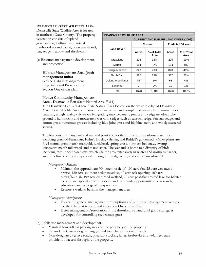
DEANSVILLE STATE WILDLIFE AREA. Deansville State Wildlife Area is located in northeast Dane County. The property vegetation consists of upland grassland/agricultural land, mixed hardwood upland forest, open marshland, fen, sedge meadow and shrub-carr.
(a) Resource management, development,
and protection.
Habitat Management Area (both management units) See the Habitat Management Objectives and Prescriptions in Section One of this plan. Native Community Management Area - Deansville Fen (State Natural Area #311)
DEANSVILLE WILDLIFE AREA
CURRENT AND FUTURE LAND COVER (2009)
Current Predicted 50 Year
Land Cover Acres % of Total
Area Acres % of Total
Area
Grassland 225 13% 225 13%
Marsh 154 9% 154 9%
Sedge Meadow 820 49% 820 49%
Shrub Carr 387 23% 387 23%
Upland Woodlands 87 5% 68 4%
Savanna 0 0% 19 1%
Total 1673 100% 1673 100%
The Deansville Fen, a 604 acre State Natural Area located on the western edge of Deansville Marsh State Wildlife Area, contains an extensive wetland complex of native plant communities featuring a high quality calcareous fen grading into wet-mesic prairie and sedge meadow. The ground is hummocky and moderately wet with sedges such as tussock sedge, fen star sedge, and cotton grass, numerous grasses including blue-joint grass and big blue-stem, and widely scattered shrubs. The fen contains many rare and unusual plant species that thrive in the carbonate rich soils including grass-of-Parnassus, Kalm's lobelia, valerian, and Riddell's goldenrod. Other plants are fowl manna-grass, marsh marigold, turtlehead, spring-cress, northern bedstraw, swamp lousewort, marsh milkweed, and marsh aster. The wetland is home to a diversity of birds including rare - short-eared owl, which use the area extensively in winter and northern harrier, and bobolink, common snipe, eastern kingbird, sedge wren, and eastern meadowlark.
Management Objective: Maintain the approximate 604 acre mosaic of: 100 acre fen, 25 acre wet-mesic
prairie, 120 acre southern sedge meadow, 40 acre oak opening, 100 acre cattail/bulrush, 199 acre disturbed wetland, 20 acre peat-fire created lake for habitat for rare and special concern species and to provide opportunities for research, education, and ecological interpretation.
Restore a wetland basin in the management area. Management Prescriptions:
Follow the general management prescriptions and authorized management actions for these habitat types found in Section One of this plan.
Defer management /restoration of the disturbed wetland until good strategy is developed for controlling reed canary grass.
(b) Public use management and development.
Maintain four 4-8 car parking areas on the periphery of the property. Expand the Class-2 dog training ground to include adjacent uplands. Non-designated service roads, pheasant stocking lanes, firebreaks and volunteer trails
provide foot access throughout the property.
Glacial Heritage Area Plan 69
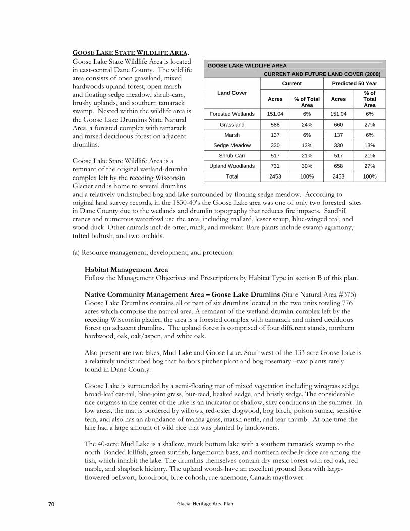
GOOSE LAKE STATE WILDLIFE AREA. Goose Lake State Wildlife Area is located in east-central Dane County. The wildlife area consists of open grassland, mixed hardwoods upland forest, open marsh and floating sedge meadow, shrub-carr, brushy uplands, and southern tamarack swamp. Nested within the wildlife area is the Goose Lake Drumlins State Natural Area, a forested complex with tamarack and mixed deciduous forest on adjacent drumlins. Goose Lake State Wildlife Area is a remnant of the original wetland-drumlin complex left by the receding Wisconsin Glacier and is home to several drumlins and a relatively undisturbed bog and lake surrounded by floating sedge meadow. According to original land survey records, in the 1830-40’s the Goose Lake area was one of only two forested sites in Dane County due to the wetlands and drumlin topography that reduces fire impacts. Sandhill cranes and numerous waterfowl use the area, including mallard, lesser scaup, blue-winged teal, and wood duck. Other animals include otter, mink, and muskrat. Rare plants include swamp agrimony, tufted bulrush, and two orchids.
GOOSE LAKE WILDLIFE AREA
CURRENT AND FUTURE LAND COVER (2009)
Current Predicted 50 Year
Land Cover Acres % of Total
Area Acres
% of Total Area
Forested Wetlands 151.04 6% 151.04 6%
Grassland 588 24% 660 27%
Marsh 137 6% 137 6%
Sedge Meadow 330 13% 330 13%
Shrub Carr 517 21% 517 21%
Upland Woodlands 731 30% 658 27%
Total 2453 100% 2453 100%
(a) Resource management, development, and protection.
Habitat Management Area Follow the Management Objectives and Prescriptions by Habitat Type in section B of this plan. Native Community Management Area – Goose Lake Drumlins (State Natural Area #375) Goose Lake Drumlins contains all or part of six drumlins located in the two units totaling 776 acres which comprise the natural area. A remnant of the wetland-drumlin complex left by the receding Wisconsin glacier, the area is a forested complex with tamarack and mixed deciduous forest on adjacent drumlins. The upland forest is comprised of four different stands, northern hardwood, oak, oak/aspen, and white oak. Also present are two lakes, Mud Lake and Goose Lake. Southwest of the 133-acre Goose Lake is a relatively undisturbed bog that harbors pitcher plant and bog rosemary –two plants rarely found in Dane County. Goose Lake is surrounded by a semi-floating mat of mixed vegetation including wiregrass sedge, broad-leaf cat-tail, blue-joint grass, bur-reed, beaked sedge, and bristly sedge. The considerable rice cutgrass in the center of the lake is an indicator of shallow, silty conditions in the summer. In low areas, the mat is bordered by willows, red-osier dogwood, bog birch, poison sumac, sensitive fern, and also has an abundance of manna grass, marsh nettle, and tear-thumb. At one time the lake had a large amount of wild rice that was planted by landowners. The 40-acre Mud Lake is a shallow, muck bottom lake with a southern tamarack swamp to the north. Banded killfish, green sunfish, largemouth bass, and northern redbelly dace are among the fish, which inhabit the lake. The drumlins themselves contain dry-mesic forest with red oak, red maple, and shagbark hickory. The upland woods have an excellent ground flora with large-flowered bellwort, bloodroot, blue cohosh, rue-anemone, Canada mayflower.
Glacial Heritage Area Plan 70
Management Objectives and Prescriptions - Non-upland forest communities: Maintain the southern tamarack swamp, cattail marsh, Mud and Goose Lakes, and
floating sedge mat for their ecological values and to provide opportunities for research, education, and ecological interpretation.
Follow the general management prescriptions and authorized management prescriptions for the southern tamarack swamp habitat type. Control invasive exotic species.
Management Objectives and Prescriptions - Upland Forest Communities Management objectives and prescriptions for each of the four upland forested sites are listed individually below. The location of each site is shown on the Goose Lake State Wildlife Area property map.
Site 1: Establish and maintain as an extended rotation central hardwood forest community. Manage by using periodic thinning, release, selection harvest (single tree, group or patch), and artificial regeneration in the form of hand planting, to develop ecological characteristics typical of old-growth forests while also managing for desired species and limited timber production. Management will favor established oak, hickory, and black cherry over other species and allow for artificial regeneration of these species. Follow the guidance in the old-growth forest handbook (2480.5) for retention and marking guidelines.
Sites 2 and 3: Maintain and enhance an older growth red oak woodland community. Manage by conducting a “shelterwood harvest” to promote establishment of oak regeneration, but conduct only a limited partial overstory removal harvest or no overstory removal harvest to retain some level of large diameter mature reserve oak trees throughout the stand and maintain oak regeneration that does become established. Prescribed burning may be used to further promote oak regeneration. A significant portion of site 3 will also be managed to regenerate and maintain existing aspen.
Site 4: Maintain and enhance the white oak woodland community. Manage by harvesting most all trees, except leave all white oak and some red oak, shagbark hickory and black cherry. Conduct slash reduction management. Follow-up with regular prescribed burns to maintain the community.
(b) Public use management and development.
The following applies to the property as described below:
Provide a designated 1.5 mile lightly developed hiking trail from the parking area at Krueger Road to an overlook of Goose Lake. Develop a wildlife observation area at the overlook of Goose Lake.
Provide a designated 50-75 yard lightly developed trail northeast from the parking area at Krueger road to the top of the drumlin and a scenic overlook of the Wildlife Area. Develop and maintain an informational display at the overlook.
Provide a designated primitive trail from the parking area at Raether Road to the former hunt club landing site on the east side of Goose Lake.
Maintain six 4-10 car parking areas on the periphery of the property. Develop and maintain a six car parking area off of CTH BB to provide access to the grasslands on the southeast corner of the property.
Many non-designated service roads, pheasant stocking lanes, firebreaks and volunteer trails provide foot access throughout the property.
Glacial Heritage Area Plan 71
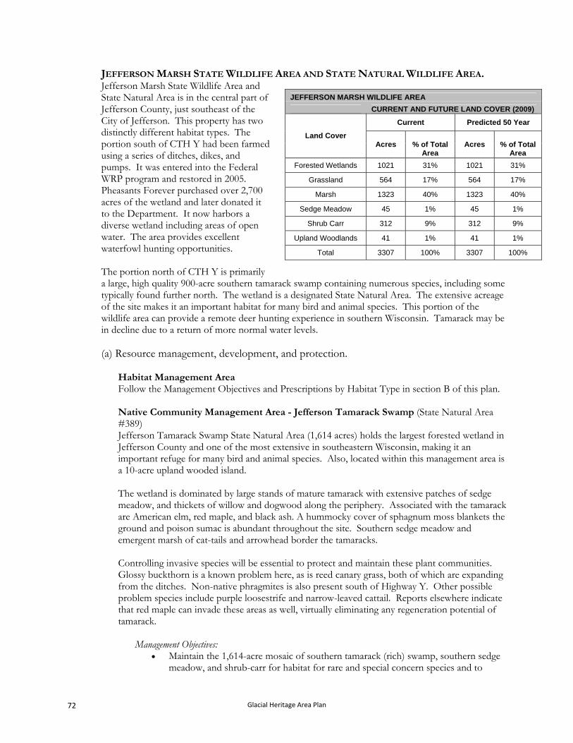
JEFFERSON MARSH STATE WILDLIFE AREA AND STATE NATURAL WILDLIFE AREA. Jefferson Marsh State Wildlife Area and State Natural Area is in the central part of Jefferson County, just southeast of the City of Jefferson. This property has two distinctly different habitat types. The portion south of CTH Y had been farmed using a series of ditches, dikes, and pumps. It was entered into the Federal WRP program and restored in 2005. Pheasants Forever purchased over 2,700 acres of the wetland and later donated it to the Department. It now harbors a diverse wetland including areas of open water. The area provides excellent waterfowl hunting opportunities. The portion north of CTH Y is primarily a large, high quality 900-acre southern tamarack swamp containing numerous species, including some typically found further north. The wetland is a designated State Natural Area. The extensive acreage of the site makes it an important habitat for many bird and animal species. This portion of the wildlife area can provide a remote deer hunting experience in southern Wisconsin. Tamarack may be in decline due to a return of more normal water levels.
JEFFERSON MARSH WILDLIFE AREA
CURRENT AND FUTURE LAND COVER (2009)
Current Predicted 50 Year
Land Cover Acres % of Total
Area Acres % of Total
Area
Forested Wetlands 1021 31% 1021 31%
Grassland 564 17% 564 17%
Marsh 1323 40% 1323 40%
Sedge Meadow 45 1% 45 1%
Shrub Carr 312 9% 312 9%
Upland Woodlands 41 1% 41 1%
Total 3307 100% 3307 100%
(a) Resource management, development, and protection.
Habitat Management Area Follow the Management Objectives and Prescriptions by Habitat Type in section B of this plan. Native Community Management Area - Jefferson Tamarack Swamp (State Natural Area #389) Jefferson Tamarack Swamp State Natural Area (1,614 acres) holds the largest forested wetland in Jefferson County and one of the most extensive in southeastern Wisconsin, making it an important refuge for many bird and animal species. Also, located within this management area is a 10-acre upland wooded island. The wetland is dominated by large stands of mature tamarack with extensive patches of sedge meadow, and thickets of willow and dogwood along the periphery. Associated with the tamarack are American elm, red maple, and black ash. A hummocky cover of sphagnum moss blankets the ground and poison sumac is abundant throughout the site. Southern sedge meadow and emergent marsh of cat-tails and arrowhead border the tamaracks. Controlling invasive species will be essential to protect and maintain these plant communities. Glossy buckthorn is a known problem here, as is reed canary grass, both of which are expanding from the ditches. Non-native phragmites is also present south of Highway Y. Other possible problem species include purple loosestrife and narrow-leaved cattail. Reports elsewhere indicate that red maple can invade these areas as well, virtually eliminating any regeneration potential of tamarack.
Management Objectives: Maintain the 1,614-acre mosaic of southern tamarack (rich) swamp, southern sedge
meadow, and shrub-carr for habitat for rare and special concern species and to
Glacial Heritage Area Plan 72
provide opportunities for research, education, and ecological interpretation. There may be a decline of tamarack as hydrology changes on this site due to wetland restoration efforts.
Management Prescriptions:
Follow the general management prescriptions for the Southern Tamarack Swamp (rich) habitat type found in Section One of this plan.
Develop a plan for managing the potential future loss of ash on this site due to the Emerald Ash Borer.
(b) Public use management and development.
Develop and maintain a vehicle accessible scenic overlook and wildlife observation site off of CTH Y with associated informational display.
Maintain six 4-10 car parking areas on the periphery of the property.
Many non-designated service roads and dike tops provide foot access throughout the property.
Glacial Heritage Area Plan 73
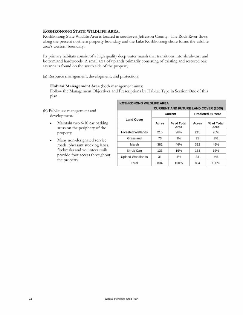
KOSHKONONG STATE WILDLIFE AREA. Koshkonong State Wildlife Area is located in southwest Jefferson County. The Rock River flows along the present northern property boundary and the Lake Koshkonong shore forms the wildlife area’s western boundary. Its primary habitats consist of a high quality deep water marsh that transitions into shrub-carr and bottomland hardwoods. A small area of uplands primarily consisting of existing and restored oak savanna is found on the south side of the property.
(a) Resource management, development, and protection.
Habitat Management Area (both management units) Follow the Management Objectives and Prescriptions by Habitat Type in Section One of this plan.
KOSHKONONG WILDLIFE AREA
CURRENT AND FUTURE LAND COVER (2009)
Current Predicted 50 Year
Land Cover Acres % of Total
Area Acres % of Total
Area
Forested Wetlands 215 26% 215 26%
Grassland 73 9% 73 9%
Marsh 382 46% 382 46%
Shrub Carr 133 16% 133 16%
Upland Woodlands 31 4% 31 4%
Total 834 100% 834 100%
(b) Public use management and
development.
Maintain two 6-10 car parking areas on the periphery of the property
Many non-designated service roads, pheasant stocking lanes, firebreaks and volunteer trails provide foot access throughout the property.
Glacial Heritage Area Plan 74
LAKE MILLS STATE WILDLIFE AREA. Lake Mills State Wildlife Area is located in west-central Jefferson County and is comprised of a diverse variety of habitat types currently.
The habitat types include open water marsh, large areas of wet prairie, lowland hardwoods with tamarack, and some oak savanna uplands. This wildlife area is divided into two separate units. The eastern unit, the Lake Mills Unit, is located immediately southwest of the City of Lake Mills. The western unit, the Zeloski Marsh Unit, lies about one mile further west. These units have distinctively different characters.
The Lake Mills Unit is primarily comprised of wetlands including parts of three lakes, extensive shrub-carr and southern tamarack swamp, and some uplands with oak savanna and other hardwoods. The Zeloski Marsh Unit, which is part of the former, larger London Marsh, is comprised of large restored wetlands with impoundments that provide opportunities to manage water levels for migrating and nesting waterfowl, shorebirds, and other wetland species. Large portions of the area have been planted with wet to mesic prairie species. The Zeloski Marsh Unit contains over 3.5 miles of dike-top access lanes maintained for management purposes which also provide excellent opportunities for walking, wildlife watching, and hunting. The Zeloski Unit was acquired by the Madison Audubon Society and donated to the Department in 2006. In addition, the Department of Transportation acquired and restored an adjacent 209 acre wetland (as a mitigation bank) that will be transferred to the Department.
LAKE MILLS WILDLIFE AREA
CURRENT AND FUTURE LAND COVER (2009)
Current Predicted 50 Year
Land Cover Acres
% of Total Area
Acres % of Total Area
Forested Wetlands 380 14% 380 14%
Grassland 700 26% 700 26%
Marsh 1134 42% 1134 42%
Savanna 161 6% 161 6%
Shrub Carr 117 4% 117 4%
Upland Woodlands 31 1% 31 1%
Sedge Meadow 155 6% 155 6%
Total 2678 100% 2678 100%
The Glacial Drumlin State Trail lies adjacent to the eastern unit all along the north boundary and bisects the western unit of the wildlife area. This trail provides bicycle and foot access for a very scenic spring, summer, or fall outing. The trail doubles as a snow mobile trail in the winter.
(a) Resource management, development, and protection.
Habitat Management Area (both management units) Follow the Management Objectives and Prescriptions by Habitat Type in Section One of this plan. Native Community Management Area - Bean Lake (State Natural Area #111) The Bean Lake management area, 195 acre State Natural Area, contains a 33-acre alkaline seepage lake surrounded by a shrub wetland and southern tamarack swamp. Maximum depth is 6 feet, and the bottom substrate is poorly decomposed brown and black peat. The water is usually turbid and supports algal blooms; yellow pond-lily is the most common macrophyte. Surrounding the lake is a narrow zone of swamp loosestrife with cat-tails, sedges, and soft stem bulrush on the northeast edge. Tamarack and shrub-carr of dogwood, bog birch, poison sumac, and willows surround the lake and encompass the entire area to the edge of Rock Lake. Along the northeast edge of the lake are two small upland islands forested with deciduous hardwoods.
Glacial Heritage Area Plan 75
Within the swamp surrounding the lake there are few characteristic bog species. Bird species nesting within the natural area include green-backed herons, wood duck, mallard, blue-winged teal, sandhill crane, great horned owl, and long-eared owl.
Management Objectives: Maintain the southern tamarack swamp (45 acres), and associated shrub-carr (58
acres), shallow - hard water seepage lake (33 acres), southern sedge meadow (17 acres), and southern dry-mesic (17 acres) forest for habitat for rare and special concern species and to provide opportunities for research, education, and ecological interpretation.
Remove aspen in northeast corner of area. Provide opportunities for research, education, and ecological interpretation.
Management Prescriptions For the southern tamarack swamp, shrub-carr, and southern sedge meadow habitat
types follow their respective general management prescriptions found in Section One of this plan.
Passively manage the southern dry-mesic forest, except for invasive species removal.
Native Community Management Area - Mud Lake Fen and Wet Prairie (State Natural Area #604) The 149-acre Mud Lake Fen and Wet Prairie is within the Lake Mills State Wildlife Area and is located south of Mud Lake. The area features a narrow band of fen habitat along the uplands that then grades into wet prairie. The calcareous fen contain a good variety of species including Riddell’s goldenrod, Ohio goldenrod (special concern), small yellow lady’s-slipper (special concern), small white lady’s-slipper (state-threatened), grass of parnassus, lousewort, and small fringed gentian (special concern). The wet prairie is dominated by bluejoint grass and closer to Mud Lake cattails are dominant. Problem species include one clone of non-native phragmites southwest of Mud Lake and scattered areas of canary grass. Woody species including willows, tamarack, and silky dogwood have increased due to the lack of fire, which historically, occurred in the area.
Management Objective:
Restore and enhance the quality of the fen and wet prairie. Management Prescriptions:
Remove invasive species including non-native phragmites and canary grass, Conduct prescribed burns to simulate natural processes to reduce the impact of
woody species including silky dogwood, tamarack, and willows. Follow the general management prescriptions for calcareous Fen and Wet Prairie
found in Section One of this plan.
(b) Public use management and development.
Lake Mills Unit Maintain the boardwalk from the boat landing to Mud Lake. Maintain the primitive trail/boardwalk from parking area at Bean Lake Road to Bean
Lake State Natural Area.
Glacial Heritage Area Plan 76
Maintain the 5 site Sandhill Station Campground cooperatively with the Glacial Drumlin State Trail.
Maintain the bike trail from Sandhill Station Campground to Mud Lake Road. This is designated as a lightly developed trail.
Maintain eight 6-10 car parking areas on the periphery of the property. Non-designated service roads, pheasant stocking lanes, firebreaks and volunteer trails
provide foot access throughout the property. Provide a Class-2 dog training ground.
Zeloski Marsh Unit Develop and maintain a moderately developed (ADA accessible) trail from the parking
area at London Road around southernmost impoundment. Provide an ADA accessible wildlife observation deck along the trail at the south end of this impoundment.
Maintain a bike trail, a lightly developed trail, on the existing Department service road linking the Jefferson County bike route on London Road to the Glacial Drumlin State Trail
Develop and maintain a wildlife observation tower or platform along the Glacial Drumlin State Trail.
Maintain two 8-12 car parking areas on the periphery of the property. Many non-designated service roads, dike tops, and firebreaks provide foot access
throughout the property.
Glacial Heritage Area Plan 77
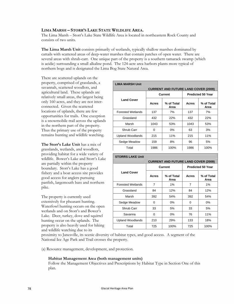
LIMA MARSH – STORR’S LAKE STATE WILDLIFE AREA. The Lima Marsh – Storr’s Lake State Wildlife Area is located in northeastern Rock County and consists of two units. The Lima Marsh Unit consists primarily of wetlands, typically shallow marshes dominated by cattails with scattered areas of deep-water marshes that contain patches of open water. There are several areas with shrub-carr. One unique part of the property is a southern tamarack swamp (which is acidic) surrounding a small alkaline pond. The 124-acre area harbors plants more typical of northern bogs and is designated the Lima Bog State Natural Area. There are scattered uplands on the property, comprised of grasslands, a savannah, scattered woodlots, and agricultural land. These uplands are relatively small areas, the largest being only 160 acres, and they are not inter-connected. Given the scattered locations of uplands, there are few opportunities for trails. One exception is a snowmobile trail across the uplands in the northern part of the property. Thus the primary use of the property remains hunting and wildlife watching. The Storr’s Lake Unit has a mix of grasslands, wetlands, and woodlots, providing habitat for a wide variety of wildlife. Bower’s Lake and Storr’s Lake are partially within the property boundary. Storr’s Lake has a good fishery and a boat access site provides good access for anglers pursuing panfish, largemouth bass and northern pike. The property is currently used extensively for pheasant hunting. Waterfowl hunting occurs on the open wetlands and on Storr’s and Bower’s Lake. Deer, turkey, dove and squirrel hunting occur on the uplands. The property is also heavily used for hiking and wildlife watching due to its proximity to Janesville, its scenic diversity of habitat types, and good access. A segment of the National Ice Age Park and Trail crosses the property.
(a) Resource management, development, and protection.
Habitat Management Area (both management units) Follow the Management Objectives and Prescriptions by Habitat Type in Section One of this plan.
STORRS LAKE Unit
CURRENT AND FUTURE LAND COVER (2009)
Current Predicted 50 Year
Land Cover Acres % of Total
Area Acres % of Total
Area
Forested Wetlands 7 1% 7 1%
Grassland 84 12% 84 12%
Marsh 392 54% 392 54%
Sedge Meadow 0 0% 0 0%
Shrub Carr 33 5% 33 5%
Savanna 0 0% 76 11%
Upland Woodlands 210 29% 133 18%
Total 725 100% 725 100%
LIMA MARSH Unit
CURRENT AND FUTURE LAND COVER (2009)
Current Predicted 50 Year
Land Cover Acres % of Total
Area Acres % of Total
Area
Forested Wetlands 137 7% 137 7%
Grassland 432 22% 432 22%
Marsh 1043 53% 1043 53%
Shrub Carr 0 0% 63 3%
Upland Woodlands 215 11% 215 11%
Sedge Meadow 159 8% 96 5%
Total 1986 100% 1986 100%
Glacial Heritage Area Plan 78

Native Community Management Area – Lima Bog (State Natural Area #219) One of the largest bogs in south central Wisconsin, Lima Bog, a 164 acre State Natural Area, contains a four-acre hard water bog lake surrounded by more than 100 acres of southern tamarack swamp, which has flora more typical of northern then southern bogs. A 5-acre dense mat of swamp loosestrife, cat-tail, sedges, and rushes encircles the open lake where pond-lily dominates the aquatic macrophyte flora. The forest contains many tamarack, whose reproduction is varied over space and time. Poison sumac is prevalent in the understory along with bog birch, red-osier dogwood, winterberry, and willows. Near the lake and within the denser areas of tamarack forest are hummocks carpeted with sphagnum moss and typical bog plants such as pitcher plant, sundew, small cranberry, and several species of orchids. To the east, set between the tamarack and the uplands, is an 11-acre sedge meadow dominated by sedges and blue-joint grass. The bird fauna is typical of southern Wisconsin wetlands but northern species such as black-throated green warbler and white-throated sparrow occasionally spend the summer here.
Management Objective:
Maintain the 164 acre mosaic of relict bog and forest (109 ac), and sedge meadow (11 ac) for habitat for rare and special concern species and to provide opportunities for research, education, and ecological interpretation.
Management Prescription:
Follow the general management prescriptions and authorized management actions for the Southern Tamarack Swamp (rich) and sedge meadow habitat types found in Section One of this plan.
(b) Public use management and development.
Lima Marsh Unit
Maintain seven 6-10 car parking areas on the periphery of the property. Maintain a Class-2 dog training ground along Willow Road. If and when the use of non-
toxic shot is required on wildlife areas, relocate the dog training ground to a site on Hartzell Road.
Non-designated service roads, pheasant stocking lanes, firebreaks and volunteer trails provide foot access throughout the property.
Storr’s Lake Unit
Maintain a boat ramp at Storr’s Lake Maintain a carry in canoe access to Bowers Lake Maintain the section of the National Scenic Ice Age Trail that runs from the parking area
at Storrs Lake to the parking area at North Bowers Lake Road. This trail is a primitive trail, except where it follows the service road it is a lightly developed trail.
Incorporate a horseback riding trail as part of a larger cooperative trail network in suitable portions of the property that do not significantly conflict with the property’s primary habitat and use. Upon request for the trail link, the Department will determine the siting of the trail and shared management responsibilities through the Department’s standard Master Plan variance process.
Maintain three 4-15 car parking areas on the periphery of the property. Non-designated service roads, pheasant stocking lanes, firebreaks and volunteer trails
provide foot access throughout the property.
Glacial Heritage Area Plan 79
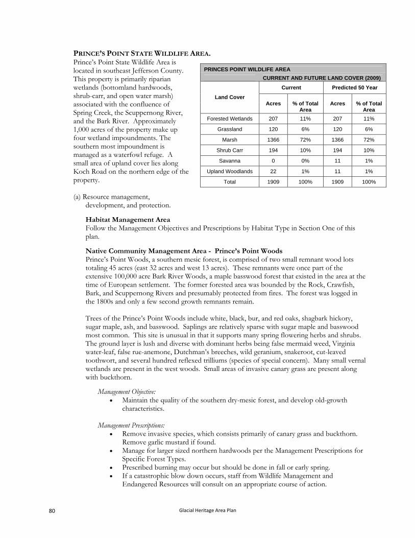
PRINCE’S POINT STATE WILDLIFE AREA. Prince’s Point State Wildlife Area is located in southeast Jefferson County. This property is primarily riparian wetlands (bottomland hardwoods, shrub-carr, and open water marsh) associated with the confluence of Spring Creek, the Scuppernong River, and the Bark River. Approximately 1,000 acres of the property make up four wetland impoundments. The southern most impoundment is managed as a waterfowl refuge. A small area of upland cover lies along Koch Road on the northern edge of the property.
PRINCES POINT WILDLIFE AREA
CURRENT AND FUTURE LAND COVER (2009)
Current Predicted 50 Year
Land Cover Acres % of Total
Area Acres % of Total
Area
Forested Wetlands 207 11% 207 11%
Grassland 120 6% 120 6%
Marsh 1366 72% 1366 72%
Shrub Carr 194 10% 194 10%
Savanna 0 0% 11 1%
Upland Woodlands 22 1% 11 1%
Total 1909 100% 1909 100%
(a) Resource management, development, and protection.
Habitat Management Area Follow the Management Objectives and Prescriptions by Habitat Type in Section One of this plan.
Native Community Management Area - Prince’s Point Woods Prince’s Point Woods, a southern mesic forest, is comprised of two small remnant wood lots totaling 45 acres (east 32 acres and west 13 acres). These remnants were once part of the extensive 100,000 acre Bark River Woods, a maple basswood forest that existed in the area at the time of European settlement. The former forested area was bounded by the Rock, Crawfish, Bark, and Scuppernong Rivers and presumably protected from fires. The forest was logged in the 1800s and only a few second growth remnants remain. Trees of the Prince’s Point Woods include white, black, bur, and red oaks, shagbark hickory, sugar maple, ash, and basswood. Saplings are relatively sparse with sugar maple and basswood most common. This site is unusual in that it supports many spring flowering herbs and shrubs. The ground layer is lush and diverse with dominant herbs being false mermaid weed, Virginia water-leaf, false rue-anemone, Dutchman’s breeches, wild geranium, snakeroot, cut-leaved toothwort, and several hundred reflexed trilliums (species of special concern). Many small vernal wetlands are present in the west woods. Small areas of invasive canary grass are present along with buckthorn.
Management Objective: Maintain the quality of the southern dry-mesic forest, and develop old-growth
characteristics. Management Prescriptions:
Remove invasive species, which consists primarily of canary grass and buckthorn. Remove garlic mustard if found.
Manage for larger sized northern hardwoods per the Management Prescriptions for Specific Forest Types.
Prescribed burning may occur but should be done in fall or early spring. If a catastrophic blow down occurs, staff from Wildlife Management and
Endangered Resources will consult on an appropriate course of action.
Glacial Heritage Area Plan 80

(b) Public use management and development.
Provide a primitive loop hiking trail from the Koch Road parking lot and circling the
wetland and impoundment. Provide a primitive loop hiking trail from the boat landing at CHT D and around refuge
impoundment. Maintain boat ramp on Bark River off of CTH D. Maintain five 4-10 car parking areas on the periphery of the property.
Glacial Heritage Area Plan 81
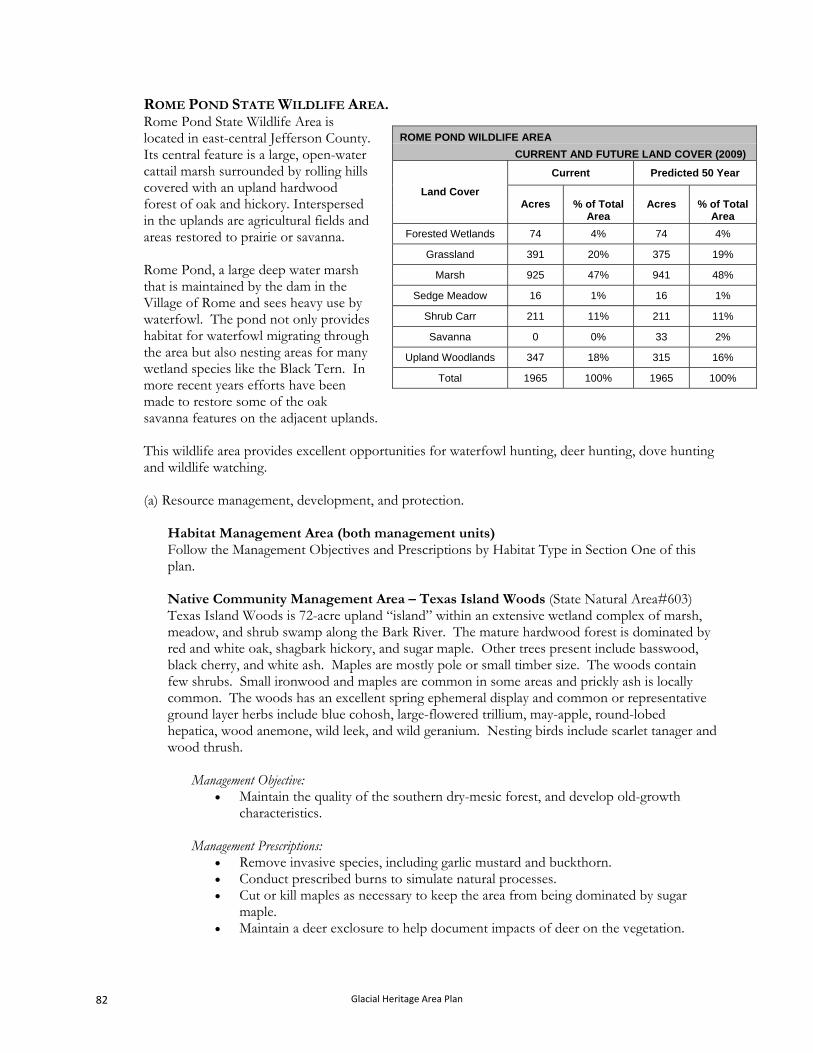
ROME POND STATE WILDLIFE AREA. Rome Pond State Wildlife Area is located in east-central Jefferson County. Its central feature is a large, open-water cattail marsh surrounded by rolling hills covered with an upland hardwood forest of oak and hickory. Interspersed in the uplands are agricultural fields and areas restored to prairie or savanna. Rome Pond, a large deep water marsh that is maintained by the dam in the Village of Rome and sees heavy use by waterfowl. The pond not only provides habitat for waterfowl migrating through the area but also nesting areas for many wetland species like the Black Tern. In more recent years efforts have been made to restore some of the oak savanna features on the adjacent uplands.
ROME POND WILDLIFE AREA
CURRENT AND FUTURE LAND COVER (2009)
Current Predicted 50 Year
Land Cover Acres Acres % of Total
Area % of Total
Area
Forested Wetlands 74 4% 74 4%
Grassland 391 20% 375 19%
Marsh 925 47% 941 48%
Sedge Meadow 16 1% 16 1%
Shrub Carr 211 11% 211 11%
Savanna 0 0% 33 2%
Upland Woodlands 347 18% 315 16%
Total 1965 100% 1965 100%
This wildlife area provides excellent opportunities for waterfowl hunting, deer hunting, dove hunting and wildlife watching.
(a) Resource management, development, and protection.
Habitat Management Area (both management units) Follow the Management Objectives and Prescriptions by Habitat Type in Section One of this plan. Native Community Management Area – Texas Island Woods (State Natural Area#603) Texas Island Woods is 72-acre upland “island” within an extensive wetland complex of marsh, meadow, and shrub swamp along the Bark River. The mature hardwood forest is dominated by red and white oak, shagbark hickory, and sugar maple. Other trees present include basswood, black cherry, and white ash. Maples are mostly pole or small timber size. The woods contain few shrubs. Small ironwood and maples are common in some areas and prickly ash is locally common. The woods has an excellent spring ephemeral display and common or representative ground layer herbs include blue cohosh, large-flowered trillium, may-apple, round-lobed hepatica, wood anemone, wild leek, and wild geranium. Nesting birds include scarlet tanager and wood thrush.
Management Objective:
Maintain the quality of the southern dry-mesic forest, and develop old-growth characteristics.
Management Prescriptions:
Remove invasive species, including garlic mustard and buckthorn. Conduct prescribed burns to simulate natural processes. Cut or kill maples as necessary to keep the area from being dominated by sugar
maple. Maintain a deer exclosure to help document impacts of deer on the vegetation.
Glacial Heritage Area Plan 82
If a catastrophic blow down occurs, staff from Wildlife Management and Endangered Resources will consult on an appropriate course of action.
(b) Public use management and development.
Develop and maintain a primitive loop hiking trail originating at Rome Pond County Park
and routed around the drumlin and along the edge of the marsh. Provide a carry-in canoe access from parking lot on CTH E to Bark River. Maintain fourteen 4-10 car parking areas on the periphery of the property. Non-designated service roads, pheasant stocking lanes, firebreaks and volunteer trails
provide foot access throughout the property.
Glacial Heritage Area Plan 83
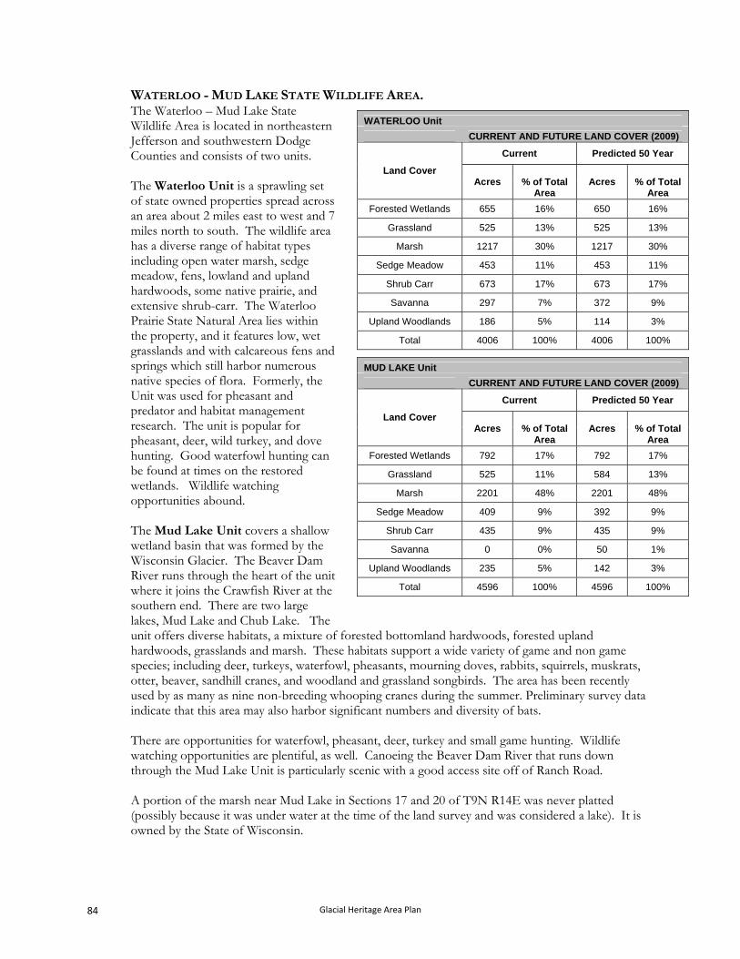
WATERLOO - MUD LAKE STATE WILDLIFE AREA. The Waterloo – Mud Lake State Wildlife Area is located in northeastern Jefferson and southwestern Dodge Counties and consists of two units.
WATERLOO Unit
CURRENT AND FUTURE LAND COVER (2009)
Current Predicted 50 Year
Land Cover Acres Acres % of Total
Area % of Total
Area The Waterloo Unit is a sprawling set of state owned properties spread across an area about 2 miles east to west and 7 miles north to south. The wildlife area has a diverse range of habitat types including open water marsh, sedge meadow, fens, lowland and upland hardwoods, some native prairie, and extensive shrub-carr. The Waterloo Prairie State Natural Area lies within the property, and it features low, wet grasslands and with calcareous fens and springs which still harbor numerous native species of flora. Formerly, the Unit was used for pheasant and predator and habitat management research. The unit is popular for pheasant, deer, wild turkey, and dove hunting. Good waterfowl hunting can be found at times on the restored wetlands. Wildlife watching opportunities abound.
Forested Wetlands 655 16% 650 16%
Grassland 525 13% 525 13%
Marsh 1217 30% 1217 30%
Sedge Meadow 453 11% 453 11%
Shrub Carr 673 17% 673 17%
Savanna 297 7% 372 9%
Upland Woodlands 186 5% 114 3%
Total 4006 100% 4006 100%
The Mud Lake Unit covers a shallow wetland basin that was formed by the Wisconsin Glacier. The Beaver Dam River runs through the heart of the unit where it joins the Crawfish River at the southern end. There are two large lakes, Mud Lake and Chub Lake. The unit offers diverse habitats, a mixture of forested bottomland hardwoods, forested upland hardwoods, grasslands and marsh. These habitats support a wide variety of game and non game species; including deer, turkeys, waterfowl, pheasants, mourning doves, rabbits, squirrels, muskrats, otter, beaver, sandhill cranes, and woodland and grassland songbirds. The area has been recently used by as many as nine non-breeding whooping cranes during the summer. Preliminary survey data indicate that this area may also harbor significant numbers and diversity of bats.
MUD LAKE Unit
CURRENT AND FUTURE LAND COVER (2009)
Current Predicted 50 Year
Land Cover Acres Acres % of Total
Area % of Total
Area
Forested Wetlands 792 17% 792 17%
Grassland 525 11% 584 13%
Marsh 2201 48% 2201 48%
Sedge Meadow 409 9% 392 9%
Shrub Carr 435 9% 435 9%
Savanna 0 0% 50 1%
Upland Woodlands 235 5% 142 3%
Total 4596 100% 4596 100%
There are opportunities for waterfowl, pheasant, deer, turkey and small game hunting. Wildlife watching opportunities are plentiful, as well. Canoeing the Beaver Dam River that runs down through the Mud Lake Unit is particularly scenic with a good access site off of Ranch Road.
A portion of the marsh near Mud Lake in Sections 17 and 20 of T9N R14E was never platted (possibly because it was under water at the time of the land survey and was considered a lake). It is owned by the State of Wisconsin.
Glacial Heritage Area Plan 84
(a) Resource management, development, and protection. Habitat Management Area (both management units) Follow the Management Objectives and Prescriptions by Habitat Type in Section One of this plan. Native Community Management Area - Waterloo Prairie (State Natural Area #111) Waterloo Prairie, a 235 acre state natural area, is comprised of two widely separated units of low, wet grasslands along Stoney Brook and its tributaries. The northern unit features a large, raised calcareous fen and spring complex with numerous wet seepage slopes while a more extensive wet prairie meadow lies within the southern unit. The hummocky black peaty fen soil supports a diversity of species including such grasses as big blue-stem, blue-joint grass, Indian grass, and sweet grass. Forbs include grass-of-Parnassus, valerian, Riddell's goldenrod, shooting-star, prairie blazing-star, wood-betony, swamp lousewort, prairie phlox, golden alexanders, pale-spiked lobelia, marsh pea, mountain mint, numerous asters, and common bog arrow-grass, a species of special status concern despite its name. Along the west edge of the fen are numerous springs with water parsnip and spring runs flowing into Stony Creek. If the nearby fen is acquired it will be added to the SNA and managed in like manner. The alkaline wet to wet-mesic prairie is dominated by blue-joint grass, prairie cord grass, and tussock sedge. Showy forbs include Michigan lily, marsh milkweed, marsh marigold, and cowbane. Common nesting birds include willow flycatcher, yellow warbler, marsh wren, sedge wren, swamp sparrow, and sandhill crane. Bobolink are frequently seen here.
Management Objectives:
Maintain the 235-acre mosaic of fen (27 ac), wet-mesic prairie (30 ac), wet prairie (60 ac), hard water spring (1 ac), southern sedge meadow (67 ac), oak woodland (3 ac), and disturbed wetland (20 ac) for habitat for rare and special concern species and to provide opportunities for research, education, and ecological interpretation.
Management Prescriptions:
Follow the general management prescriptions and authorized management actions for these habitat types found in Section One of this plan.
Defer management /restoration of the disturbed wetland until good strategy is developed for controlling reed canary grass.
Native Community Management Area - Waterloo Quartzite Outcrops (State Natural Area #605) This native community area consists of two sites and is primarily a geological feature. (A third, similar, site in the area is owned and managed by Madison Audubon Society, and it is being restored to savanna.) As shown on the map, one site is located on the Mud Lake Unit, the other on the Waterloo Unit. Dott and Attig in their Roadside Geology of Wisconsin (2004) explains the history of Waterloo quartzite “A window through the Pleistocene deposits reveals Precambrian red quartzite and Paleozoic conglomerate composed of boulders of quartzite. The rocks and their relationships to each other are the same as at the Baraboo Hills to the northwest though not as well exposed. The quartzite was deformed, metamorphosed, and eroded prior to the flooding of Wisconsin by seas in Cambrian and Ordovician time. Storm waves in the ancient sea pounded islands of quartzite, tumbling and rounding the boulders that would become conglomerate. At Waterloo,
Glacial Heritage Area Plan 85
the conglomerate appears to be of younger Ordovician age than at Baraboo but is otherwise similar. The quartzite is estimated at about 1.7 billion years old and is cut by a dike of granite about 1.5 billion years old.” A fourth outcrop, which has significant archeological features, will be added to the SNA if acquired.
Waterloo Unit Site This is a 24-acre wooded quartzite island (Stoney Island) in the Crawfish and Maunesha River floodplain. Rock is abundant on the surface. The elevation from the floodplain to the top of the island is 40 feet and 5-30% slopes are present. The island contains a variety of hardwoods with white and red oak, shagbark hickory, and hackberry being common. Some of the trees are open grown and some are over two-foot diameter. Other trees include bur oak, black cherry, ash, and basswood. Dominant species in the shrub or sapling layer are bitternut hickory, hackberry, and prickly ash, along with some gooseberry. The area has a rich carpet of spring plants. Pale corydalis grows on the rocks. Problem invasive species are present but not in large amounts, they include common buckthorn, honeysuckle, and garlic mustard. This site is listed in the State Historical Society Archaeological Site Inventory as having a Native American campsite or village. The island also contained a great blue heron rookery in the 1980’s and may be used by herons in the future. Access to the island is by water or a ¾ mile walk from the west.
Management objectives
Maintain the ecological value and function of the oak woods community with minimal site disturbance.
Protect the Archaeological resources on the site.
Management Prescriptions Remove invasive species, including garlic mustard, buckthorn, and honeysuckle, Conduct prescribed burns to simulate natural processes. Do not conduct timber
harvests. If a catastrophic blow down occurs, staff from Wildlife Management and
Endangered Resources will consult on an appropriate course of action.
Mud Lake Unit Site This site is a 27-acre “island” within a large wetland and consists of Pella silty clay loam and abundant outcrops of Waterloo quartzite. These outcrops are found throughout the site. Compared to the quartzite island on the Waterloo Unit, there is little change in elevation. The quartzite on this island contains "quartzite breccia", meaning broken, angular fragments of red or gray quartzite in a matrix of white quartz. The same rock occurs in at least four or five different localities in the Baraboo Hills. This rock is very interesting to geologists since there are other minerals in the breccia besides quartz, which are of great potential interest for isotopic dating of the breccia and/or for estimating the temperature of formation. The exact cause of the brecciation, or breakage, of the quartzite into the angular fragment is still controversial. The woods contain large white, bur, red oaks, shagbark hickory, ash, and basswood. Some of the oaks are “open grown”. Also present are silver maple, aspen, and swamp white oak. Saplings include ironwood, hackberry, yellow bud hickory, and hawthorn. Shrubs include a very little amount of honeysuckle, buckthorn, and gooseberry that is mostly found north of
Glacial Heritage Area Plan 86
the east/west fence on the north quarter of the island. The ground layer is dominated by wild leek. Pale corydalis grows on the outcrops. Disturbance has not occurred in the southern portion of the site for decades as evidenced by the lack of tree stumps and exotic invasive plants. Part of the island is within the high water mark of the floodplain.
Management objective:
Maintain the southern dry forest. Conduct fall or early spring prescribed burns.
Management prescriptions Remove buckthorn and honeysuckle. Remove the small wooden building and about 800 feet of fence. Manage to keep older oak and hickory as the major cover type. Conduct prescribed burns in fall or early spring
Native Community Management Area – Chub/Mud Lake Riverine Marsh (State Natural Area #606) This 1,987-acre riverine marsh and lakes is in the southern part of a 7,000-acre wetland impacted by “pulse-flooding” of the Beaver Dam and Crawfish Rivers that join near Mud and Chub Lakes. Water from about 688 square miles flows through the marsh. In years of very high water the upper half of this area is under 4-5 feet of water with deeper water in the lower half. Two to three times a year, aside from spring snowmelt flooding, the wetland is covered by 6-18 inches of water following a 2-3 inch storm event. Much of the year the marsh does not have any standing water, so drought also has a major influence on the wetland’s vegetation. The highly dynamic nature of this riverine wetland creates the special ecological conditions that warrant its addition to the state natural areas system. Due to the extremes in water levels the marsh is dominated by only a very few plants, primarily by river bulrush and phragmites (native genotype). Cattails, which had been a component, were killed by the extended high water in the June 2008 flood. Houghton muck soils dominate the marsh and while they can absorb water readily, they can also pass it freely. The wetland receives high use by wildlife including sandhill cranes, great egrets (state-threatened), great blue herons, tundra swans, and a wide variety of ducks and geese. The high quality vegetation and large acreage probably contribute to high use by foraging bat populations. A few muskrats also use the area. The State Natural Area includes state-owned land that was never platted under the wide stretch of the river.
Management objective: Conserve the dynamic riverine marsh ecosystem.
Management prescriptions
Remove the nonnative phragmites, if found. Conduct moist soil management if deemed necessary along the edge of the
uplands where canary grass is usually dominant. Bidens and smartweed are abundant in the seed bank. This management could include herbiciding canary grass and possibly prescribed burning.
Conduct prescribed burns on adjacent uplands.
Native Community Management Area - Chub Lake Oak Savanna (State Natural Area #607) This area is a restorable 21-acre oak savanna on the south side of Chub Lake. It contains over 25 large trees over two foot diameter. Dominant trees include bur, white, and red oak along with
Glacial Heritage Area Plan 87
shagbark hickory. There is abundant reproduction especially of bur and white oaks. It has now grown into a closed canopy stand. The shrub layer contains honeysuckle, prickly ash and gray dogwood. The closed canopy probably has eliminated many savanna forbs and grasses. A parking lot is present in the middle of the area and could lead to an observation tower overlooking Chub Lake. This savanna could become an excellent demonstration area since it contains large open grown specimens and has easy access.
Management objective:
Restore and maintain the oak savanna community. Management prescriptions
Remove black cherry, honeysuckle, gray dogwood, prickly ash, and many of the smaller oaks leaving replacement oak trees.
Use herbicides if necessary to control unwanted species. Conduct prescribe burns in fall followed by hand broadcasting of savanna forbs and
grasses to aid in restoration efforts. Conduct spring burns after the savanna ground layer is restored.
(b) Public use management and development.
Waterloo Unit Develop and maintain a carry-in canoe access from the Hwy 19 parking lot. Non-designated service roads, pheasant stocking lanes, firebreaks and volunteer trails
provide foot access throughout the property. Maintain fourteen 4-10 car parking areas on the periphery of the property.
Mud Lake Unit
Develop an observation area on a site off of CTH G, on the shore of Chub Lake, that provides a vehicle accessible scenic overlook and wildlife observation area with an associated informational display.
Clear invasive species that block key views of the marsh, for example at the corner of CTH Q.
Maintain two boat ramps on the Beaver Dam River, one at Ranch Road and one at S Garden Road, and develop and maintain one carry-in canoe access to the Crawfish River from parking area at CTH G.
Designate a canoe route on Beaver Dam and Crawfish Rivers Maintain twelve 4-10 car parking areas on the periphery of the property. Non-designated service roads, pheasant stocking lanes, firebreaks and volunteer trails
provide foot access throughout the property.
Glacial Heritage Area Plan 88
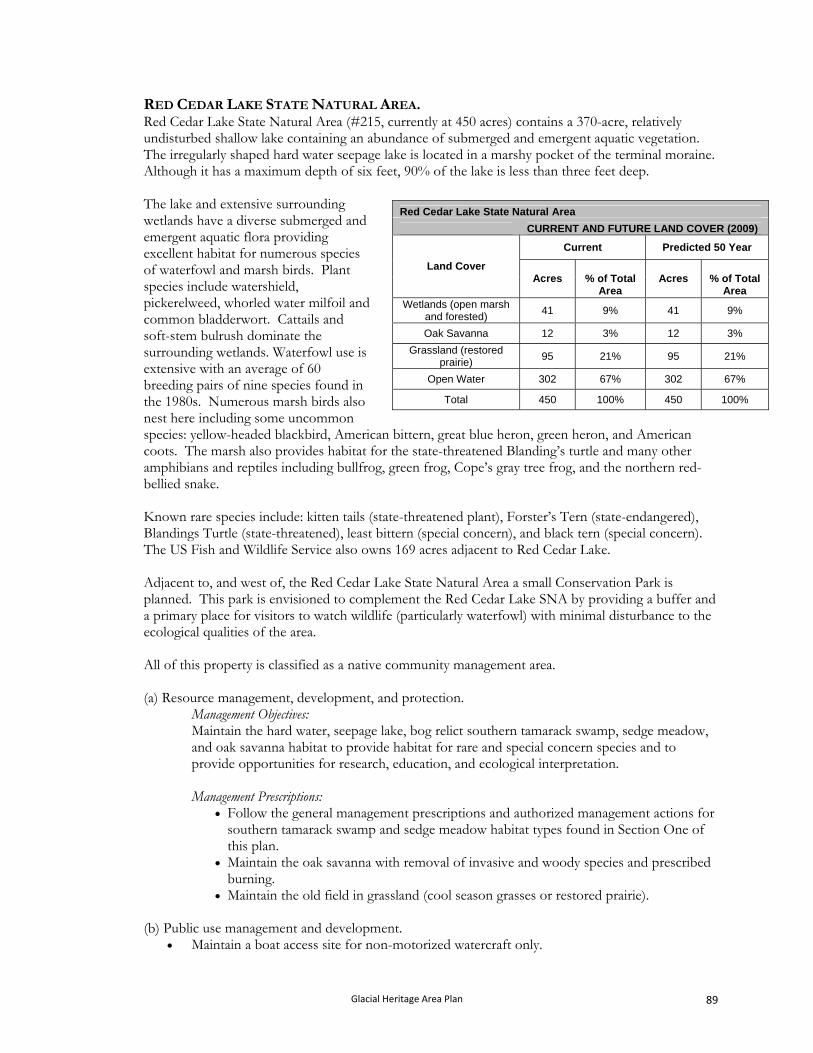
RED CEDAR LAKE STATE NATURAL AREA. Red Cedar Lake State Natural Area (#215, currently at 450 acres) contains a 370-acre, relatively undisturbed shallow lake containing an abundance of submerged and emergent aquatic vegetation. The irregularly shaped hard water seepage lake is located in a marshy pocket of the terminal moraine. Although it has a maximum depth of six feet, 90% of the lake is less than three feet deep. The lake and extensive surrounding wetlands have a diverse submerged and emergent aquatic flora providing excellent habitat for numerous species of waterfowl and marsh birds. Plant species include watershield, pickerelweed, whorled water milfoil and common bladderwort. Cattails and soft-stem bulrush dominate the surrounding wetlands. Waterfowl use is extensive with an average of 60 breeding pairs of nine species found in the 1980s. Numerous marsh birds also nest here including some uncommon species: yellow-headed blackbird, American bittern, great blue heron, green heron, and American coots. The marsh also provides habitat for the state-threatened Blanding’s turtle and many other amphibians and reptiles including bullfrog, green frog, Cope’s gray tree frog, and the northern red-bellied snake.
Red Cedar Lake State Natural Area
CURRENT AND FUTURE LAND COVER (2009)
Current Predicted 50 Year
Land Cover Acres Acres % of Total
Area % of Total
Area Wetlands (open marsh
and forested) 41 9% 41 9%
Oak Savanna 12 3% 12 3%
Grassland (restored prairie)
95 21% 95 21%
Open Water 302 67% 302 67%
Total 450 100% 450 100%
Known rare species include: kitten tails (state-threatened plant), Forster’s Tern (state-endangered), Blandings Turtle (state-threatened), least bittern (special concern), and black tern (special concern). The US Fish and Wildlife Service also owns 169 acres adjacent to Red Cedar Lake. Adjacent to, and west of, the Red Cedar Lake State Natural Area a small Conservation Park is planned. This park is envisioned to complement the Red Cedar Lake SNA by providing a buffer and a primary place for visitors to watch wildlife (particularly waterfowl) with minimal disturbance to the ecological qualities of the area. All of this property is classified as a native community management area.
(a) Resource management, development, and protection.
Management Objectives: Maintain the hard water, seepage lake, bog relict southern tamarack swamp, sedge meadow, and oak savanna habitat to provide habitat for rare and special concern species and to provide opportunities for research, education, and ecological interpretation.
Management Prescriptions:
Follow the general management prescriptions and authorized management actions for southern tamarack swamp and sedge meadow habitat types found in Section One of this plan.
Maintain the oak savanna with removal of invasive and woody species and prescribed burning.
Maintain the old field in grassland (cool season grasses or restored prairie).
(b) Public use management and development. Maintain a boat access site for non-motorized watercraft only.
Glacial Heritage Area Plan 89
Glacial Heritage Area Plan 90
CHAPTER III. Implementation.
Given the diversity of places to be protected, the range of recreation experiences to be provided and conservation objectives to be met, the mix of partners that currently own and operate lands and facilities to meet recreation and conservation needs in the area, and the diversity of funding sources that will be needed to fulfill the goals of the project, implementation of the GHA project will be complicated. What follows is an implementation plan that seeks to leverage the unique strengths of many different organizations and agencies, realizing that reaching the vision is well beyond the capacity of any single entity. Implementation of the project will need to be flexible and adapt to changing opportunities to create the GHA network. That is, landowner interest may create opportunities to establish high quality components of the GHA network that are not currently envisioned. All parties involved in creating the GHA plan currently have limited financial and staffing resources which are likely to continue in the foreseeable future. The Department, county governments, non-profit conservation groups, state and federal agencies, and other groups have collaborated in the past on many projects to meet the conservation and recreation needs of this region. It is anticipated that this level of cooperation and success will continue during implementation of the GHA project. The discussion of implementation is organized as follows: land acquisition, habitat (vegetation) restoration and management, facility construction and development, and facility management.
A. HOW THE GHA PLAN WILL AFFECT EXISTING OPERATIONS.
The plan incorporates a wide range of places and linking corridors designed, collectively, to provide a diversity of recreation experiences and address a range of conservation needs. Some of these places and connections are already in some form of formal protective ownership, others are not. In this plan some of the already protected places are to be expanded, while no change is planned at others. Each government agency or private conservation group that owns lands within the project area will, of course, use and manage their lands following their own guidelines and goals. This plan does not dictate to other agencies or groups how they should use or manage their lands, but rather seeks to integrate the management plans for those properties into the broader network. The Department’s expectation is that partner agencies, local governments, and private organizations that own and manage land within the project area will use this GHA plan as a primary tool in developing their respective land use, protection, and management plans. Implementation of the GHA project will involve many partners as well as many funding sources. Each partner will be influenced by their own operating constraints, have unique opportunities and needs, and react differently to changing circumstances. Implementation will be further complicated by a very wide range of external forces and conditions, most importantly the availability of funding and staffing. As such, each partner will need to remain flexible in approaching implementation and will need to continue working collaboratively with others in implementing the project. There is no expectation that any partner, including the Department, must commit financial, staffing, or other resources into the future to implement the project.
B. THE COLLABORATIVE APPROACH TO ACQUISITION AND MANAGEMENT OF PROPERTIES.
The GHA project is unique in many ways, but none more so than the depth and range of partnerships that have gone into its design and will need to continue in its implementation. One of the most notable manifestations of this partnership is that some of the lands in the network will be acquired and managed by the Department, some by the partners, and some will be acquired by the Department and managed and operated by a partner. The primary partner to manage these properties is the Jefferson County Parks
Glacial Heritage Area Plan 91
Department. It is possible that other partners may also wish to take on a range of roles in managing and operating properties in the future. As state, county, and local units of government address budgetary constraints, the development and strengthening of such partnerships – among all levels of government, non-profit groups, businesses, landowners, and others – becomes imperative. The specific components of the network that the Department plans to acquire and enter agreements with partners (primarily Jefferson County, but other partners may emerge in the future) to manage and operate are described in detail in the next sections and are summarized here:
2,900 acres for seven new conservation parks.
330 acres for linking trails.
400 acres for 1 or 2 large river sites for shore fishing and water-access-only camping sites.
Developing management agreements and implementation plans. The Department plans to enter into agreements regarding management of these properties in a stepwise process as follows:
First, the Department will enter into an overarching memorandum of understanding (MOU) with Jefferson County. This MOU will describe the goals and objectives of the partnership, respective general roles, process for resolving problems, and other issues as needed. The MOU will be signed by the Department Secretary and the Jefferson County Board, or designees.
Second, when the Department acquires land for
the new conservation parks, linking trails or river sites, then an “implementation plan” will be developed for the property. The implementation plan will describe in more detail and map the specific natural and cultural resources, existing land cover and vegetation characteristics, and other unique features present on the land that is acquired. Earlier portions of the GHA plan described each park, linking trail, and river site, their intent, general goals and objectives, and potential recreation activities that the properties are likely well suited to address, and planned facilities. Using these parameters, the implementation plan will also describe what recreation activities will occur in which parts of the property, what facilities will be developed, what habitats will be managed and restored, and what land management techniques will be used.
An example of an implementation plan Within a conservation park, one section may be identified for hiking, mountain biking, and cross-country skiing with a series of trails mapped out, another area might be identified for higher intensity uses and include facilities such as a picnic area, barbeque pits and a shelter, and a third section might be only minimally developed with a few horseback riding trails passing through. In developing the implementation plan, it could be determined, for example, that the trail area is likely to be only lightly used in the late fall and early winter. As such, the 9-day gun, the muzzle-loader, and the late bow season for deer could be compatible with the park’s primary users in this section. Similarly, depending on its size and the habitat present, the lightly developed area with the horse-back riding trails might be able to support these deer seasons in addition to spring turkey periods.
As additional land holdings are acquired and a broader range of activities is possible at a park or river site, then the implementation plan will need to be amended to describe additional facility developments, designated use areas, and management activities. Implementation plans for the linking trails will be developed as complete or meaningful segments between destination points are acquired by either the Department or partners.
The implementation plan will map the locations of parking lots, trails, shelters, corrals, and other facilities as well as different recreational use areas. In addition, the plan will delineate where different habitats exist or are planned and describe how these different areas will be managed.
Glacial Heritage Area Plan 92
The Department believes that since the use of the parks, linking trails, and large access sites along rivers (both by local residents and visitors from further away) will most directly affect local communities and that the Jefferson County Parks Department will be responsible for managing these properties, it is most appropriate for the County Parks Department to lead the planning for their future use and operation. Because these lands will be owned by the Department, the implementation plans will need to meet state planning standards using procedures described in the DNR Master Planning Handbook for “Tier III” plans. The Department will assist in the development of the implementation plans as needed.
It is the Department’s intent that future users of the property help design the implementation plan. The Department will assist the County in ensuring that public involvement in the planning process that is commensurate with the complexity of the planned uses for the subject property occurs. All implementation plans and amendments will need to be approved by the Department Secretary and the Jefferson County Parks Committee (or designees) prior to any facility development or management actions on Department-owned property.
Third, following completion and approval of an implementation plan, the Department will enter
into a 15-year land use agreement, or similar agreement, with Jefferson County for the subject property or group of properties. This agreement will describe the different specific roles that each party has in terms of carrying out the implementation plan (e.g., construction of trails, parking lots, picnic facilities, boat access sites, and habitat management actions), responsibility for enforcement actions, how revenues from sharecropping or timber harvest will be distributed, and other issues as necessary.
C. GOALS AND ROLES IN ACQUIRING LAND OR LAND RIGHTS IN THE GHA.
The Department will primarily use funds from the state Stewardship program to purchase land or land rights. It is expected that partner groups will use a combination of locally raised money as well as matching funds from the Stewardship program and other sources to the degree that acquisitions qualify for available funding. All planned acquisitions described here are contingent upon the availability of adequate staffing and funding. If resources are not available, there is no expectation that the GHA project can be implemented by the Department or the partner agencies, organizations, and groups. The roles for acquiring land are planned as follows:
Conservation Parks. The conservation parks are a combination of expansions of existing properties and new projects. In an effort to simplify management and operations at the conservation parks, it is planned that ownerships be unified as much as possible. That is, it is preferable for each of the conservation parks to have just one owner. To that end, the partners currently leading acquisition efforts at the existing parks and preserves will continue to do so. These five are: Cold Spring, Dorothy Carnes, Garman, and Korth Parks, and the Lake Ripley LMD Preserve and are planned to be expanded by a total of 901 acres.
The Department will take the lead on acquiring land to establish the new conservation parks. These seven parks are: Cushman Mill, Holzhueter, Hope Lake, North Shore Moraine, Oakland Highlands, Red Cedar Lake, and Scuppernong Valley. These conservation parks total a planned 2,900 acres.
Glacial Heritage Area Plan 93
The counties, local units of government and other partners will take the primary lead on contacting landowners, discussing potential acquisition options, arranging for appraisals and surveys, and other associated tasks in purchasing land for all the conservation parks, except for Red Cedar Lake for which the Department will take the lead. It is expected that this work will be completed as staffing and funding levels allow and will also be a function of the amount of landowner interest. Linking Trails. The counties and local units of government will take the primary lead in purchasing land for the linking trails, with assistance from the Department where trails are near or connect to Department-owned land. It is estimated that about 25% of the linking trails may be near or connect to Department lands. Thus, the Department will take the lead on acquiring up to 330 acres and the counties, local units of government, and other partner groups take the lead in acquiring 1,014 acres. The DNR’s 330 acres of new authority to acquire land for linking trails does not include the existing acreage authority for the Glacial Drumlin Trail. The counties, local units of government and other partners will take the primary lead on contacting landowners, discussing potential acquisition options, arranging for appraisals and surveys, and other associated tasks in purchasing land for the linking trails. It is expected that this work will be completed as staffing and funding levels allow and will also be a function of the amount of landowner interest. Establishing linking trails will be difficult due to the number of potential landowners and their respective interests in selling strips of land or in allowing a trail on their property. To ensure that acquisition efforts do not lead to only small pieces of a linking trail being purchased that do not enable the construction of a useable trail, it is planned that the acquisition of land or land rights to create linking trails use long-term options. That is, landowners will be asked to sign options of several years in length that allow counties, local units of government, the Department, or other partners adequate time to assemble enough willing landowners to create a useable linking trail. If enough landowners agree to sell strips of land, then the Department, counties, or others can exercise the options at the same time. This approach is used by other states and communities in creating longer distance rural trails. River-based Conservation Areas. Three different types of places are planned to be acquired for river-based conservation areas as follows: The counties, local units of government, and other partners will take the lead in
purchasing land for the small access sites (75 acres) and the Department will take the lead in acquiring the larger blocks of land along major rivers for one or two river-based sites for shore fishing and water-access-only camping sites (400 acres).
The Department will take the primary lead in purchasing land for the large, habitat-based areas at Allen Creek, the lower Bark River, and the lower Koshkonong Creek Woods (1,500 acres).
The Department and partners will jointly work to purchase and protect narrow bands of permanent land along major rivers and streams (250 acres by the Department, 250 acres by partner groups).
The counties, local units of government and other partners will take the primary lead on contacting landowners, negotiating potential acquisition options, arranging for appraisals and surveys, and other associated tasks in purchasing land for the small access sites. The Department and various partners will jointly take responsibility for this work in the large habitat-based areas and the narrow bands
Glacial Heritage Area Plan 94

along the major rivers and streams. It is expected that this work will be completed as staffing and funding allows and will also be a function of the level of landowner interest. Wildlife & Natural Areas. Three different types of places are planned to be acquired and protected for the wildlife areas as follows: Expansions to the existing Wildlife & Natural Areas. The Department will take the lead, in
collaboration with various partner groups, in acquiring 21,325 acres within the expansions to the existing Wildlife Areas and 600 acres within the Red Cedar Lake Natural Area. The project boundaries for these properties are expanded in total to approximately 56,000 acres.
Crawfish Prairie Habitat Area. This new project will be a mosaic of restored native habitats set within a landscape of working farmlands. The Department will take the lead, in collaboration with various partner groups, in acquiring 2,500 acres to protect or restore native habitats within the 6,455 acre project boundary at this new project.
The new Rural Landscape Protection Areas are to be undeveloped areas primarily dominated by working farms with some conservation lands scattered within the area. The Department will take the lead, in collaboration with various partner groups, in acquiring 3,000 acres scattered within the Rural Landscape Protection Areas to protect or restore native habitats. The project boundaries for these RLPA in total encompass approximately 25,000 acres.
Partner groups will take the lead in working with landowners on protecting additional land within the areas identified for Wildlife Areas and work with landowners to encourage enrollment in Farm Bill programs, sell or donate farming easements, restore native habitats, and other similar actions. Partner groups will also take responsibility for working with landowners to keep other lands in the project boundaries in working farms (particularly areas with prime agricultural soils) through various farmland protection programs.
The Department will take the lead on contacting landowner, negotiating potential acquisition options, conducting appraisals and surveys, and other associated tasks in purchasing land for the expansions of the existing wildlife areas, the new Crawfish Prairie Habitat Area, and the Rural Landscape Protection Areas. It is expected that this work will be completed as staffing and funding allows and will also be a function of the level of landowner interest.
In summary, the acquisition roles are as follows:
Category
TOTAL Planned new acquisition
(acres)
Planned DNR-led
acquisition (acres)
Planned Partner-led acquisition
(acres) Conservation Parks 3,801 2,900 901 Linking Trails 1,344 330 1,014 River-based Conservation Areas 2,475 2,150 325 Wildlife & Natural Areas 27,425 27,425 0
Total 35,045 32,805 2,240
Glacial Heritage Area Plan 95

D. GOALS AND ROLES IN MANAGING HABITAT AND VEGETATION IN THE GHA. The GHA plan calls for multiple entities to own lands that will make up the overall project. It is expected that initial restoration and ongoing habitat management costs for each of the entities involved will be covered by their respective operational funding or through other funding that they are able to tap. It is also hoped that a diversity of funding sources and partnerships will continue to be used in various restoration and management efforts. The Department’s intent is to simplify management coordination as much as possible by minimizing the number of groups responsible for management and operation at specific sites. To accomplish this goal, the following management roles are planned: Conservation Parks. Jefferson County and other partners will take the lead in acquiring lands for the expansion of the five existing conservation parks and the Department will take the lead in acquiring land for the seven new conservation parks. Lands acquired by the Department for conservation parks will be restored and managed by county or local governments or nonprofit conservation groups through memorandums of understanding, implementation plans, and land use agreements. The Department will assist with habitat restoration and management as feasible. County and local governments and nonprofit conservation groups will take the lead in restoring and managing lands for the conservation parks that they acquire. Linking Trails. Narrow strips of land will be acquired to develop the linking trails. As such, very little undeveloped land will need to be actively managed as part of the linking trails. One task that will likely be necessary is removing invasive species, particularly woody plants such as box elder that may occur along these corridors. The entity maintaining and operating the trail segment will also perform vegetation management along the corridor as needed. River-based Conservation Areas. Three types of lands along river corridors will be protected. The 75 acres to be acquired for the small-scale recreation sites will not have any appreciable land needing habitat management so are not included here. The lands acquired as river-based conservation areas are to be managed as follows:
High quality habitat areas. These three sites (Allen Creek, Lower Bark River, and Lower Koshkonong Creek) will be up to 500 acres apiece and primarily be focused on maintaining and restoring wetland and riparian habitats. Lands acquired by the Department will be restored and managed by Department staff. Local governments and nonprofit conservation groups will be responsible for restoring and managing lands they acquire with assistance from Department staff as feasible.
Larger river access sites. The GHA plan calls for the Department to acquire up to 400 acres for
one or two larger access sites along major rivers. These sites will provide shore fishing and campsites accessible only from the water. Lands acquired by the Department for the larger river access sites will be restored and managed by county or local governments or nonprofit conservation groups through memorandums of understanding, implementation plans, and land use agreements.
Narrow bands of permanent habitat. Only a very small percentage of these corridors will be
owned and managed by the Department, local governments, or nonprofit conservation groups. Lands acquired by each partner group will be restored and managed by that partner, or by another partner under some form of agreement.
Glacial Heritage Area Plan 96
State Wildlife & Natural Areas. All lands owned by the Department within the existing and expanded Wildlife and Natural Areas will be restored and managed by Department staff. Lands within Wildlife or Natural Area project boundaries that are owned by other government agencies or non-profit groups are to be managed by the owner. Department staff will assist with management actions as staffing allows.
E. GOALS AND ROLES IN DEVELOPING FACILITIES TO PROVIDE RECREATION OPPORTUNITIES IN
THE GHA. The GHA project calls for the development of a substantial amount and diversity of facilities at the conservation parks including trails, observation decks, picnic areas and shelters, parking areas, drinking water and toilets to accommodate a variety of different recreation activities. The plan also calls for establishing many longer-distance linking trails between communities and parks to create a network of trail opportunities. The number of facilities that are ultimately constructed will be contingent on the amount of money available to the Department and partners both to build and operate these facilities. It is expected that funding for construction will vary from year to year. Nearly each type of facility can have a range of “elaborateness.” That is, the design complexity, materials used, size, and degree of refinement of everything from parking lots to kiosks can vary depending on available funding and desired experience for the visitor. Facilities to provide recreation opportunities on lands owned by the Department are to be funded through a combination of:
State funds allocated through a competitive process via submission to the agency’s 6-year Capital Budget. Requests through the Capital Budget process for Stewardship funds require substantial lead time and compete with other facility and enhancement requests throughout the state.
Local funds, including those combined with qualifying grants such as those available through the Stewardship program.
If the recreation facilities on Department-owned lands are to be managed and operated by county park departments or other entities, a memorandum of understanding, agreement, contract or some other arrangement must be in place before construction occurs. Facilities on lands owned by local governments or nonprofit conservation groups are to be funded by these entities, most likely through a combination of local funds matched with qualifying grants from the Stewardship program and other sources. If agreeable to the respective owners of specific lands, partner groups will be encouraged to help develop facilities at project areas as funding and volunteer opportunities allow. As with the acquisition of lands, the Department and partner groups seek to work cooperatively to fulfill the goals for building and operating facilities to provide recreation opportunities.
Glacial Heritage Area Plan 97
F. GOALS AND ROLES IN MAINTAINING AND OPERATING FACILITIES TO PROVIDE RECREATION
OPPORTUNITIES IN THE GHA. The workload for managing and operating different facilities will be directly a function of the amount and type of facilities constructed. As with habitat management tasks, it is expected that facility operations costs for each of the entities involved will be covered by their respective operational funding. Given that the establishment of new facilities and trails will occur over a long time period, it is likely that the funding needed to manage and operate facilities will increase modestly but consistently over time. It is also expected that a diversity of funding sources and partnerships will be applied to the management and operation of many recreation facilities. The Department and partners will need to remain flexible in determining what groups are best suited to manage different facilities and as a result the roles presented here may need to shift over time. It is planned that local and county governments or nonprofit conservation groups take the lead in performing ongoing maintenance and operations of facilities and trails on conservation parks (including those where the Department owns the land), linking trails, and the access sites that are part of the river-based conservation areas. Construction, management, and operation of these facilities on Department-owned land will occur through memoranda of understanding, implementation plans, and land use agreements with partner groups. The Department will use the memorandum of understanding describing the development and operation of the State Trails Network as a model for these agreements. The Department will take the lead on maintaining and operating facilities and trails on all the existing and expanded State Wildlife and Natural Areas, the Crawfish Prairie State Habitat Area, and the lands acquired in the Rural Landscape Protection Areas.
Glacial Heritage Area Plan 98
CHAPTER IV. Maps of the properties and components in the GHA network. A base map showing project boundaries is included for the following properties:
Cold Spring Conservation Park Cushman Mill Conservation Park Dorothy Carnes Conservation Park Dr. J.S. Garman Nature Preserve Holzhueter Farm Conservation Park Hope Lake Conservation Park Korth Conservation Park Lake Ripley Management District Preserve North Shore Moraine Conservation Park Oakland Hills Conservation Park Red Cedar Lake Conservation Park Scuppernong Valley Conservation Park Allen Creek Conservation Area Lower Bark River Conservation Area Lower Koshkonong River Conservation Area
The following maps are included for the following properties:
Map 1: DNR property and project boundaries Map 2: Public land ownership Map 3: Land cover of DNR-owned land Map 4: Land management classifications and recreation facilities
Deansville State Wildlife Area Goose Lake State Wildlife Area Jefferson Marsh State Wildlife Area & State Natural Area Koshkonong State Wildlife Area Lake Mills State Wildlife Area Prince’s Point State Wildlife Area Rome Pond State Wildlife Area Storr’s Lake-Lima Marsh State Wildlife Area Waterloo-Mud Lake State Wildlife Area Crawfish Prairie State Habitat Area Red Cedar Lake State Natural Area
Glacial Heritage Area Plan 99
Glacial Heritage Area Plan 100

51
12
18
51
12
18
14
106
138
184
109
134
106
16
26
73
20
89
26
16
59
67
89
60
73
67
19
99
59
89
60
151
94
90
94
43
94
Existing Land Ownership
Municipal
County
State(Non-DNR)
Federal
Non-profitConservation Organization
Dept of NaturalResources
State Natural Area
GLACIAL HERITAGE AREA
Linking Trails
Existing
Planned
Planned Protection Areas
DNR Wildlife,Park or NaturalArea
ConservationPark
RiverCorridor
Rural LandscapeProtection Area
Crawfish PrairieHabitat Area
WM-GHA-OVERVIEW acr
WISCONSIN DEPARTMENTOF NATURAL RESOURCESBureau of Facilities and Lands
Rock R.
Wild
Goo s
e Stat
e Tr ai
l
HOLZHUETERFARM PARK
GARMANPRESERVE
NORTHSHORE
MORAINEPARK
KORTHPARK
HOPE LAKE PARK
LAKE RIPLEYPRESERVE
LOWERKOSHKONONG
CREEK
OAKLANDHIGHLANDS
PARK
DOROTHYCARNES
PARK
COLDSPRING
PARK
CUSHMANMILL PARK
SCUPPERNONGVALLEY PARK
ALLEN CREEK
LOWER BARK RIVER
Waterloo-Mud Lake
WildlifeArea
DeansvilleWildlife Area
Goose LakeWildlife Area
LakeMills
WildlifeArea
Jefferson Marsh
Wildlife Area
Rome PondWildlife Area
Princes PointWildlife Area
KoshkonongWildlife Area
Storrs Lake- Lima Marsh Wildlife Area
Kettle MoraineState Forest--Southern Unit
Waterloo
Marshall Watertown
JohnsonCreek
Deerfield
Jefferson
Edgerton
Fort Atkinson
Sullivan
Lake Mills
Palmyra
Whitewater
Milton
Maunesha R.
Craw fish R.
Crawfish
R.
Beav
er D
am R
.
Lowell
Reeseville
Rock
R.
Kosh konong Ck.
LakeKoshkonong
Bark R.
RockLake
Rock R.
Rock
R.
Cambridge
Glacial Drumlin State Trail
Riley-DeppePark
Cam-Rock Park
Silverwood Park
BicentennialPark
Carlin WeldPark
Glacial
River T
rail
LangerFamilyPark
AztalanStatePark
Crawfish PrairieHabitat Area
DANE CO. JEFFERSON CO. WAUKESHA CO.
WALWORTH CO.ROCK CO.
DODGE CO.
RedCedar Lake
Map Updated: March 2011
0 2.5 5 Miles
Glacial Heritage AreaProject Area

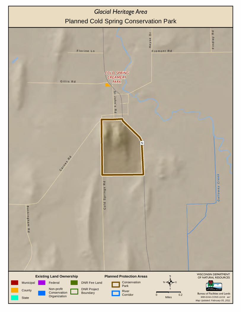
COLD SPRINGCREAMERY
PARK
Gal
low
ay Cr
eek
N
F l o r i n e L n
St
Jo
hn
's R
d
G i l l i s R d
Ca
r ne
s R
d
F r e m o n t R d
Fin
dla
y R
d
He
ys
e D
r
Bu
ck
ing
ha
m R
d
Co
ld S
pri
ng
s R
d
WISCONSIN DEPARTMENTOF NATURAL RESOURCES
Bureau of Facilities and Lands
Existing Land OwnershipMunicipal
County
State
Federal
Non-profitConservationOrganization
DNR Fee Land
DNR ProjectBoundary
Glacial Heritage Area
Planned Protection AreasConservationPark
RiverCorridor 0 0.2
Miles
Planned Cold Spring Conservation Park
Map Updated: February 05, 2011WM-GHA-CONS-11/16 acr
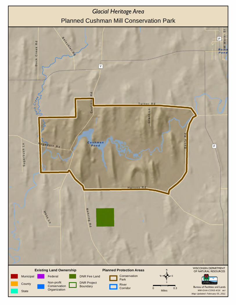
Duck
C re e
k
C u s h m a nP o n d
R o m eP o n d
F
P
Y
Me
hr i n
g R
d
Su
ga
rb
us
h L
n
W W
ate
r S
t
T u r n e r R d
H a n s o n R d
Cu
sh
ma
n R
d
Du
ck
Cre
ek
Rd
Be
t sc
hl e
r R
d
Be
nt e
Rd
Gr a
nt
Ln
H a g e d o r n R d
He
ss
Ln
WISCONSIN DEPARTMENTOF NATURAL RESOURCES
Bureau of Facilities and Lands
Existing Land OwnershipMunicipal
County
State
Federal
Non-profitConservationOrganization
DNR Fee Land
DNR ProjectBoundary
Glacial Heritage Area
Planned Protection AreasConservationPark
RiverCorridor 0 0.3
Miles
Planned Cushman Mill Conservation Park
Map Updated: February 05, 2011WM-GHA-CONS-4/16 acr
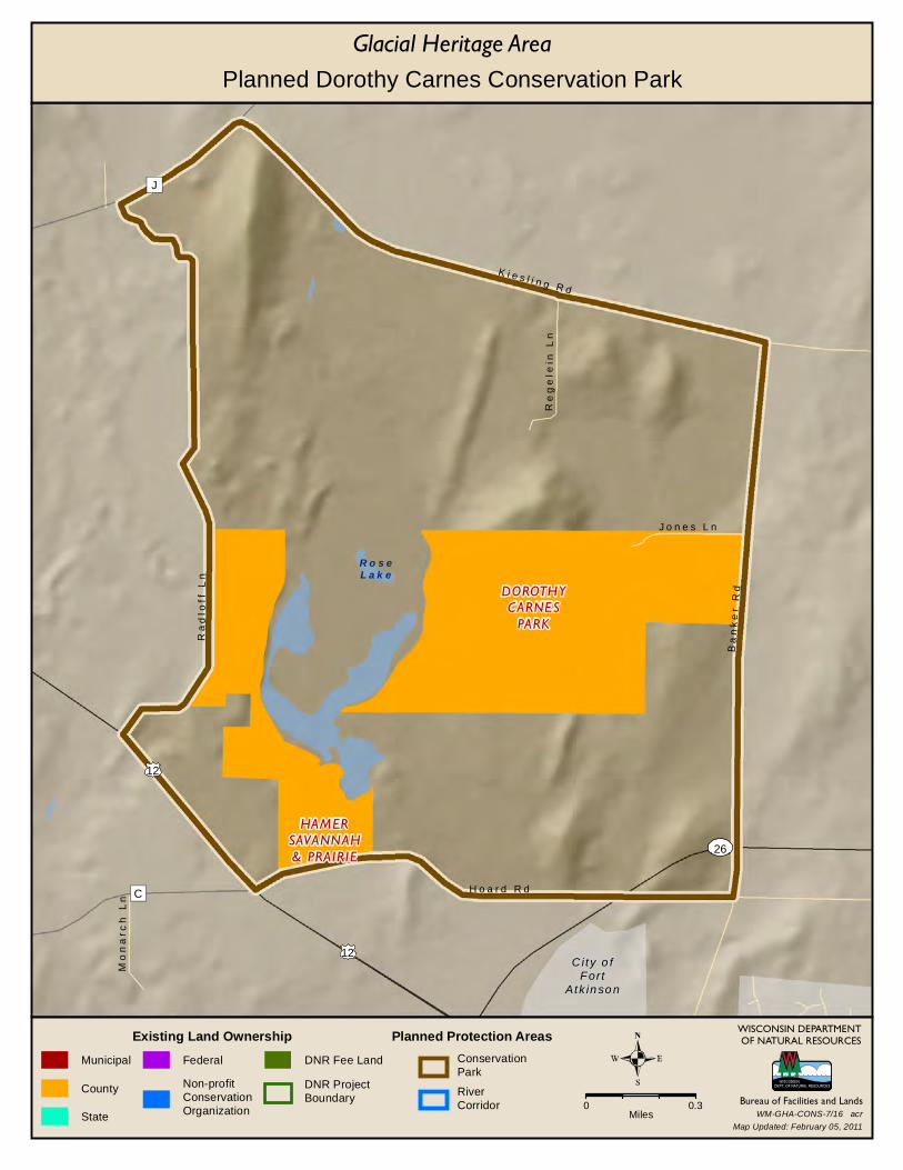
DOROTHYCARNES
PARK
HAMERSAVANNAH& PRAIRIE
12
12
City o fFor t
Atk in so n
26
R o s eL a k e
C
J
J o n e s L n
K i e s l i n g R d
Ba
nk
er
Rd
H o a r d R d
Mo
na
r ch
Ln
Re
ge
lein
Ln
Ra
dlo
ff L
n
WISCONSIN DEPARTMENTOF NATURAL RESOURCES
Bureau of Facilities and Lands
Existing Land OwnershipMunicipal
County
State
Federal
Non-profitConservationOrganization
DNR Fee Land
DNR ProjectBoundary
Glacial Heritage Area
Planned Protection AreasConservationPark
RiverCorridor 0 0.3
Miles
Planned Dorothy Carnes Conservation Park
Map Updated: February 05, 2011WM-GHA-CONS-7/16 acr
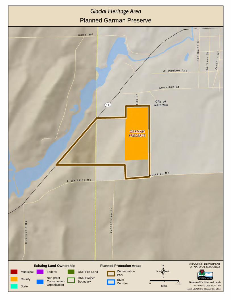
GARMANPRESERVE
City o fWa te r lo o19
C a n a l R d
K n o w l t o n S t
Va
n B
ure
n S
t
M i l w a u k e e A v e Ha
rris
on
St
Ja
ck
so
n S
t
Fo
x L
n
W a t e r l o o R d
Do
sc
ha
dis
Rd
E W a t e r l o o R d
Su
ns
et
Vi e
w L
n
WISCONSIN DEPARTMENTOF NATURAL RESOURCES
Bureau of Facilities and Lands
Existing Land OwnershipMunicipal
County
State
Federal
Non-profitConservationOrganization
DNR Fee Land
DNR ProjectBoundary
Glacial Heritage Area
Planned Protection AreasConservationPark
RiverCorridor 0 0.2
Miles
Planned Garman Preserve
Map Updated: February 05, 2011WM-GHA-CONS-8/16 acr
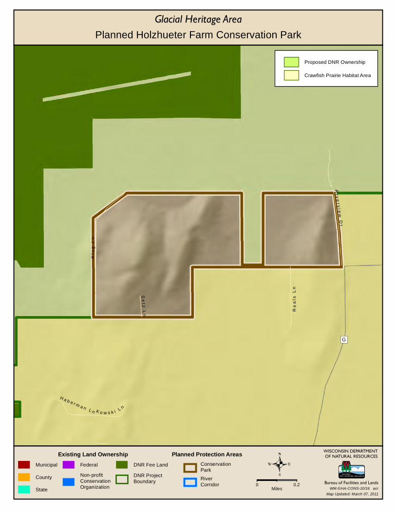
G
Re
als
Ln
Se
t z L
n
K o w s k i L n
H a b e r m a n L n
Riv
er v
i ew
Dr
Klu
g L
n
WISCONSIN DEPARTMENTOF NATURAL RESOURCES
Bureau of Facilities and Lands
Existing Land OwnershipMunicipal
County
State
Federal
Non-profitConservationOrganization
DNR Fee Land
DNR ProjectBoundary
Glacial Heritage Area
Planned Protection AreasConservationPark
RiverCorridor 0 0.2
Miles
Proposed DNR Ownership
Crawfish Prairie Habitat Area
Planned Holzhueter Farm Conservation Park
Map Updated: March 07, 2011WM-GHA-CONS-10/16 acr
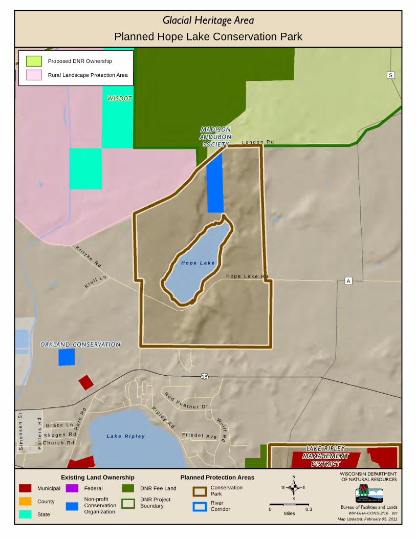
LAKE RIPLEYMANAGEMENT
DISTRICT
MADISONAUDUBONSOCIETY
OAKLAND CONSERVATION
WISDOT
18
H o p e L a k e
L a k e R i p l e y
S
A
G r a c e L n
Ri p l e y
Rd
W
olf f
Rd
Re d
F e a t h e r D r
L o n d o n R d
Pa
r k R
d
Sim
on
se
n S
t
S k o g e n R d F r i e d e l A v e
Po
tte
rs
Rd
H o p e L a k e R d
B r i t z k e R
d
C h u r c h R d
K r ul l L n
WISCONSIN DEPARTMENTOF NATURAL RESOURCES
Bureau of Facilities and Lands
Existing Land OwnershipMunicipal
County
State
Federal
Non-profitConservationOrganization
DNR Fee Land
DNR ProjectBoundary
Glacial Heritage Area
Planned Protection AreasConservationPark
RiverCorridor 0 0.3
Miles
Proposed DNR Ownership
Rural Landscape Protection Area
Planned Hope Lake Conservation Park
Map Updated: February 05, 2011WM-GHA-CONS-2/16 acr
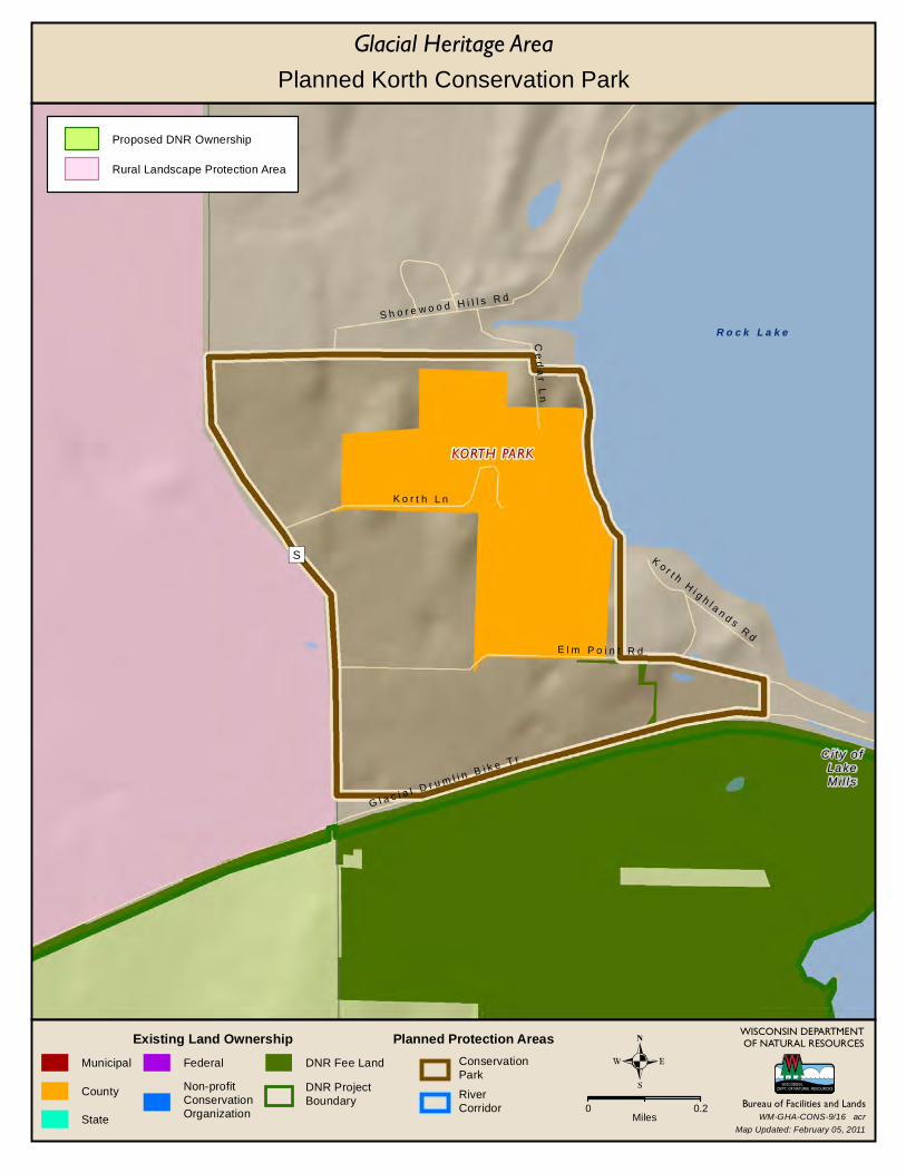
KORTH PARK
City o fLa keMi l ls
R o c k L a k e
S
E l m P o i n t R d
K o r t h H
i g h l a n d s R
d
S h o r e w o o d H i l l s R d
Ce
da
r L
n
K o r t h L n
G l a c i a l D r u m l i n B i k e T r
WISCONSIN DEPARTMENTOF NATURAL RESOURCES
Bureau of Facilities and Lands
Existing Land OwnershipMunicipal
County
State
Federal
Non-profitConservationOrganization
DNR Fee Land
DNR ProjectBoundary
Glacial Heritage Area
Planned Protection AreasConservationPark
RiverCorridor 0 0.2
Miles
Proposed DNR Ownership
Rural Landscape Protection Area
Planned Korth Conservation Park
Map Updated: February 05, 2011WM-GHA-CONS-9/16 acr

OAKLANDCONSERVATION
LAKE RIPLEYMANAGEMENT
DISTRICT
18
L a k eR i p l e y
A
Wo
lff
Rd
Ri p
l ey
Rd
Po
pl a
r A
ve
N O
ak
lan
d R
d
P e r r y R d
WISCONSIN DEPARTMENTOF NATURAL RESOURCES
Bureau of Facilities and Lands
Existing Land OwnershipMunicipal
County
State
Federal
Non-profitConservationOrganization
DNR Fee Land
DNR ProjectBoundary
Glacial Heritage Area
Planned Protection AreasConservationPark
RiverCorridor 0 0.2
Miles
Planned Lake Ripley Preserve
Map Updated: February 05, 2011WM-GHA-CONS-12/16 acr
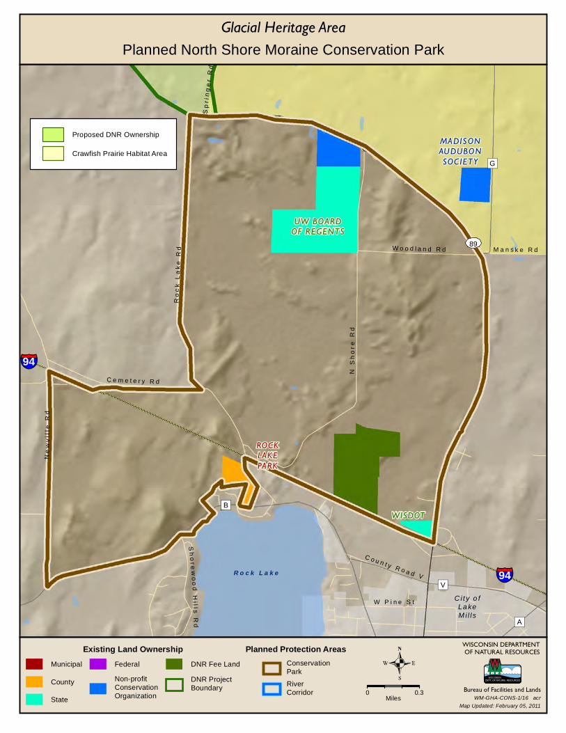
WISDOT
ROCKLAKEPARK
MADISONAUDUBONSOCIETY
UW BOARDOF REGENTS
City o fLa keMi l ls
89
R o c k L a k e
94
94
A
B
V
G
Sh
ore
wo
od
Hi ll s
Rd
W P i n e S t
Ro
ck
La
ke
Rd
C o u n t y R o a d V
Ne
wv
ille
Rd
N S
ho
re
Rd
C e m e t e r y R d
Sp
rin
ge
r R
d
M a n s k e R dW o o d l a n d R d
WISCONSIN DEPARTMENTOF NATURAL RESOURCES
Bureau of Facilities and Lands
Existing Land OwnershipMunicipal
County
State
Federal
Non-profitConservationOrganization
DNR Fee Land
DNR ProjectBoundary
Glacial Heritage Area
Planned Protection AreasConservationPark
RiverCorridor 0 0.3
Miles
Proposed DNR Ownership
Crawfish Prairie Habitat Area
Planned North Shore Moraine Conservation Park
Map Updated: February 05, 2011WM-GHA-CONS-1/16 acr
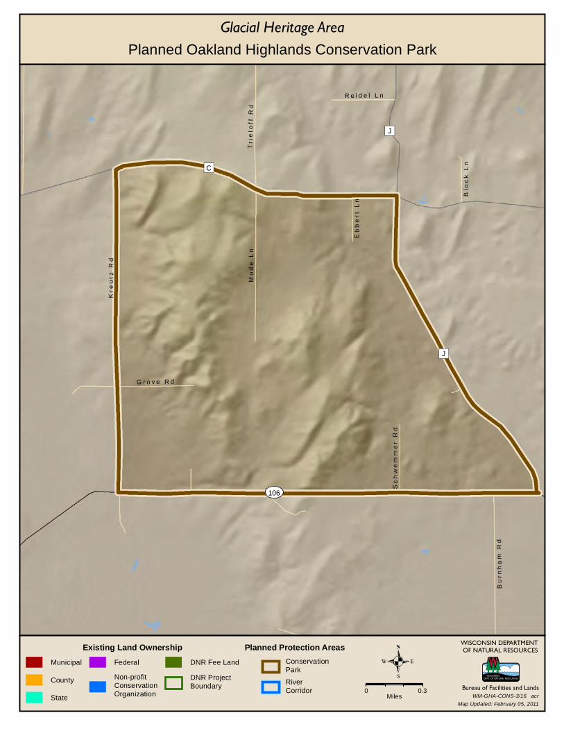
106
J
J
C
Blo
ck
Ln
Bu
rnh
am
Rd
Eb
be
rt
Ln
R e i d e l L n
Sc
hw
em
me
r R
d
G r o v e R d
Tr
ielo
f f R
dM
od
e L
n
Kr
eu
tz R
d
WISCONSIN DEPARTMENTOF NATURAL RESOURCES
Bureau of Facilities and Lands
Existing Land OwnershipMunicipal
County
State
Federal
Non-profitConservationOrganization
DNR Fee Land
DNR ProjectBoundary
Glacial Heritage Area
Planned Protection AreasConservationPark
RiverCorridor 0 0.3
Miles
Planned Oakland Highlands Conservation Park
Map Updated: February 05, 2011WM-GHA-CONS-3/16 acr
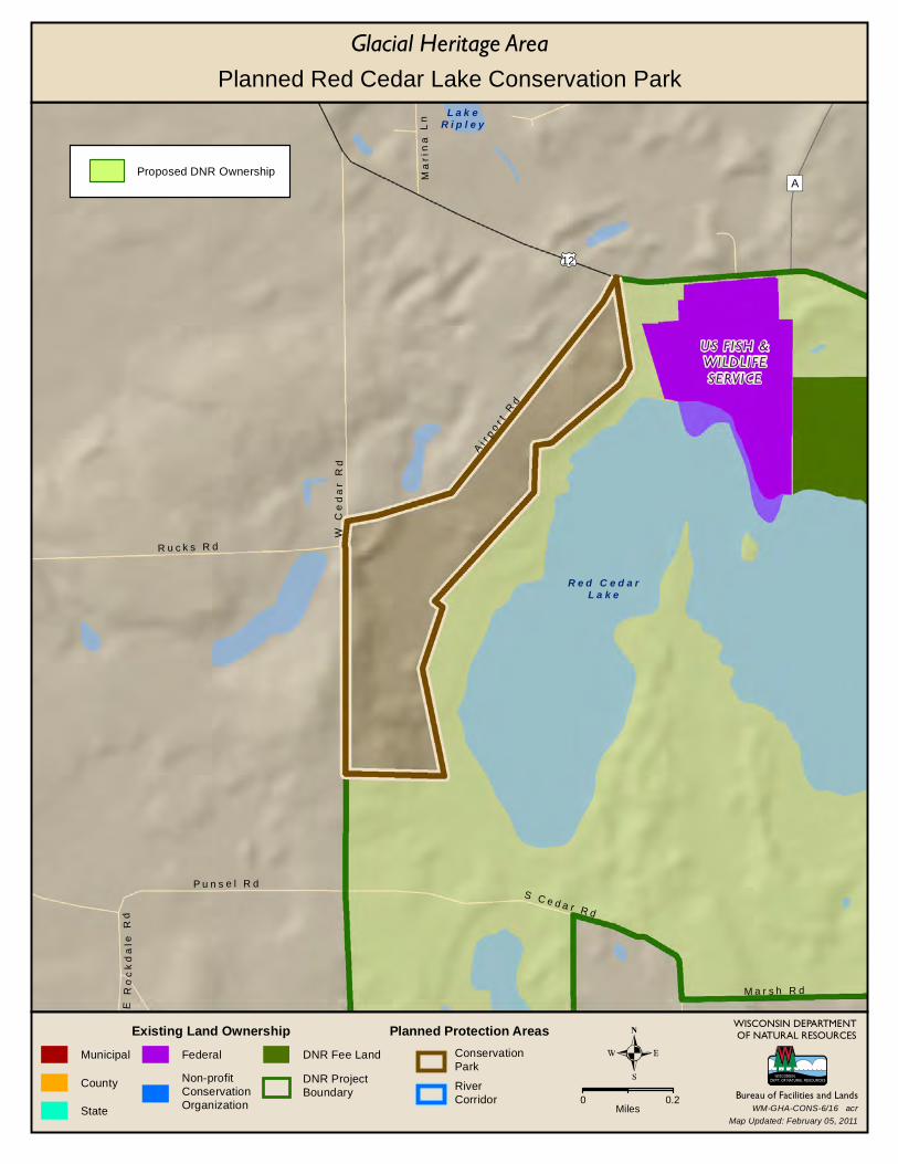
US FISH &WILDLIFESERVICE
12
R e d C e d a rL a k e
L a k eR i p l e y
A
E R
oc
kd
ale
Rd
S C e d a r R d
W C
ed
ar
Rd
R u c k s R d
Ma
rin
a L
n
M a r s h R d
P u n s e l R d
Ai r
po
r t R
d
WISCONSIN DEPARTMENTOF NATURAL RESOURCES
Bureau of Facilities and Lands
Existing Land OwnershipMunicipal
County
State
Federal
Non-profitConservationOrganization
DNR Fee Land
DNR ProjectBoundary
Glacial Heritage Area
Planned Protection AreasConservationPark
RiverCorridor 0 0.2
Miles
Proposed DNR Ownership
Planned Red Cedar Lake Conservation Park
Map Updated: February 05, 2011WM-GHA-CONS-6/16 acr
CI
CI
E
E
R o m e O a k H i l l R d
Cla
r ic
e D
r
Ro
ge
r R
d
H o o p e r R d
Bl u
e b i rd
Ri d
g e
Sa
wm
ill
Rd
S c h u y l e r R d
WISCONSIN DEPARTMENTOF NATURAL RESOURCES
Bureau of Facilities and Lands
Existing Land OwnershipMunicipal
County
State
Federal
Non-profitConservationOrganization
DNR Fee Land
DNR ProjectBoundary
Glacial Heritage Area
Planned Protection AreasConservationPark
RiverCorridor 0 0.3
Miles
Planned Scuppernong Valley Conservation Park
Map Updated: March 07, 2011
Rural Landscape Protection Area
WM-GHA-CONS-5/16 acr
MUSH-KO-SE-
DAY PARK
12
City o fFor t
Atk in so n
26
Allen C
r e e k
M
S M
ain
St
Gl a
ci a
l R
i ve
r B
i ke
Tr l
P o e p p e l R d
C r e a m e r y R d
Wo
od
l aw
n D
r
Ri g
ge
r t R
dSu
mm
i t D r
R o e L n
H a c k b a r t h R d Ma
ple
St
Sh
ari
Ln
S t a r S c h o o l R d
P o n d R d
Gr o
el e
r R
d
WISCONSIN DEPARTMENTOF NATURAL RESOURCES
Bureau of Facilities and Lands
Existing Land OwnershipMunicipal
County
State
Federal
Non-profitConservationOrganization
DNR Fee Land
DNR ProjectBoundary
Glacial Heritage Area
Planned Protection AreasConservationPark
RiverCorridor 0 0.3
Miles
Planned Allen Creek Conservation Area
Map Updated: February 05, 2011WM-GHA-CONS-15/16 acr
BURNTVILLAGE
PARK
COLD SPRINGCREAMERY
PARK
MUSH-KO-SE-DAYPARK
12
12
106
106
City o fFor t
Atk in so n
8926
Deer
Cr e
e k
N
M
Ed
g e wa t e
r R
d
Ro c k
R i ve r R d
S M
ain
St
R o g e r s S t
M i l w a u k e e A v e E
Ea
st
St
F l o r i n e L n
H a c k b a r t h R d
E l m S t
Mc
Mi l l e
n S
t
Ku
tz R
d
R i g ge
r t R
d
G i l l i s R d
E C r a m e r S t
M a c k L n
B a r k R i v e r R dBlu
ff S
t
S h a n e r L n
Oa
k S
t
Ca
r ne s
Rd
F o x H i l l R d
Cu
rtis
Mi l
l R
d
Be
rg R
d
WISCONSIN DEPARTMENTOF NATURAL RESOURCES
Bureau of Facilities and Lands
Existing Land OwnershipMunicipal
County
State
Federal
Non-profitConservationOrganization
DNR Fee Land
DNR ProjectBoundary
Glacial Heritage Area
Planned Protection AreasConservationPark
RiverCorridor 0 0.3
Miles
Planned Lower Bark River Conservation Area
Map Updated: February 05, 2011WM-GHA-CONS-14/16 acr
BUSSEYVILLEPARK
SILVERWOODPARK
106
L a k eK o s h k o n o n g
A
O l s o n R d
Jo
yc
e R
d
A a r b a c k R d
Ro
ck
da
le R
d
L o g a R d E L
ak
e D
r
D a n i e l s o n R d
L a k e D r
Wh
ite
Cro
w R
d
La
ke
Rd
Dr
av
es
Rd
C r a i g R d
Bin
gh
am
Rd
K u m l e i n R d
Ca
rc
ajo
u R
d
K l e me n t
Rd
WISCONSIN DEPARTMENTOF NATURAL RESOURCES
Bureau of Facilities and Lands
Existing Land OwnershipMunicipal
County
State
Federal
Non-profitConservationOrganization
DNR Fee Land
DNR ProjectBoundary
Glacial Heritage Area
Planned Protection AreasConservationPark
RiverCorridor 0 0.3
Miles
Planned Lower Koshkonong Creek Conservation Area
Map Updated: February 05, 2011WM-GHA-CONS-13/16 acr

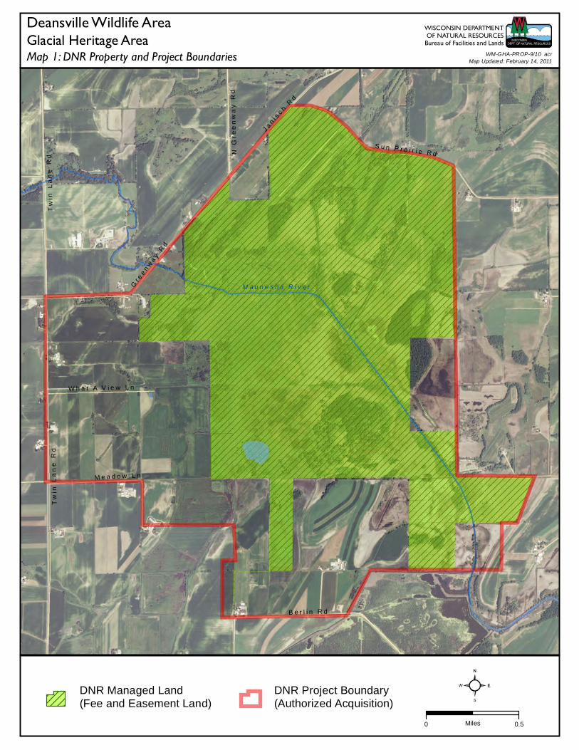
M a u n e s h a R i v e r
Tw
in L
an
e R
d
N G
re
en
wa
y R
d
B e r l i n R d
S u n P r a i r i e R d
J an
i sc h
Rd
Tw
in L
an
e R
d
W h a t A V i e w L n
Gr e
en
wa
y R
d
M e a d o w L n
0 0.5Miles
Map 1: DNR Property and Project BoundariesGlacial Heritage Area
WISCONSIN DEPARTMENTOF NATURAL RESOURCES
Bureau of Facilities and Lands
DNR Managed Land(Fee and Easement Land)
DNR Project Boundary(Authorized Acquisition)
Deansville Wildlife Area
Map Updated: February 14, 2011WM-GHA-PROP-9/10 acr
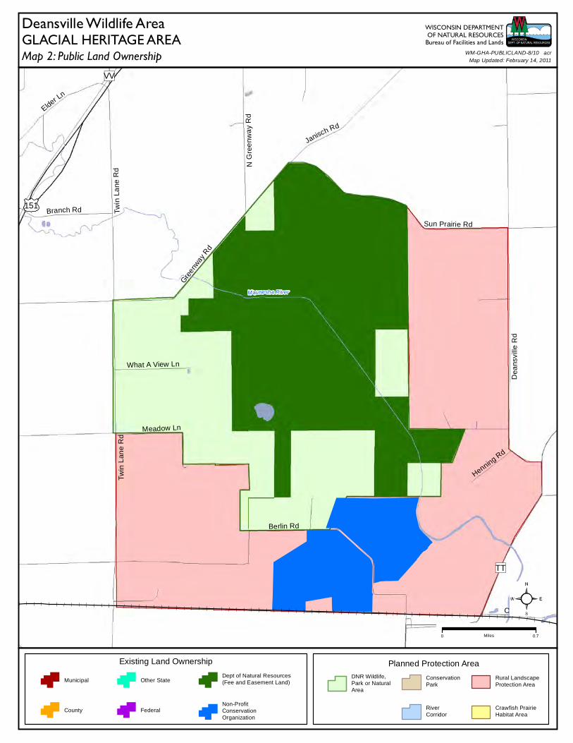
151
Maunesha River
VV
TT
Berlin Rd
Sun Prairie Rd
Branch Rd Twin
Lane
Rd
Dea
nsvi
lle R
d
N G
ree
nwa
y R
d
Canal Rd
Elder Ln
Janisch Rd
Henning Rd
Twin
Lan
e R
d
What A View Ln
Gre
enway
Rd
Meadow Ln
Map 2: Public Land OwnershipGLACIAL HERITAGE AREA
Planned Protection Area
DNR Wildlife,Park or NaturalArea
ConservationPark
RiverCorridor
Rural LandscapeProtection Area
Crawfish PrairieHabitat Area
Existing Land Ownership
Municipal
County
Other State
Federal
Dept of Natural Resources(Fee and Easement Land)
Non-ProfitConservationOrganization
WISCONSIN DEPARTMENTOF NATURAL RESOURCES
Bureau of Facilities and LandsWM-GHA-PUBLICLAND-8/10 acr
Map Updated: February 14, 2011
Deansville Wildlife Area
0 0.7Miles
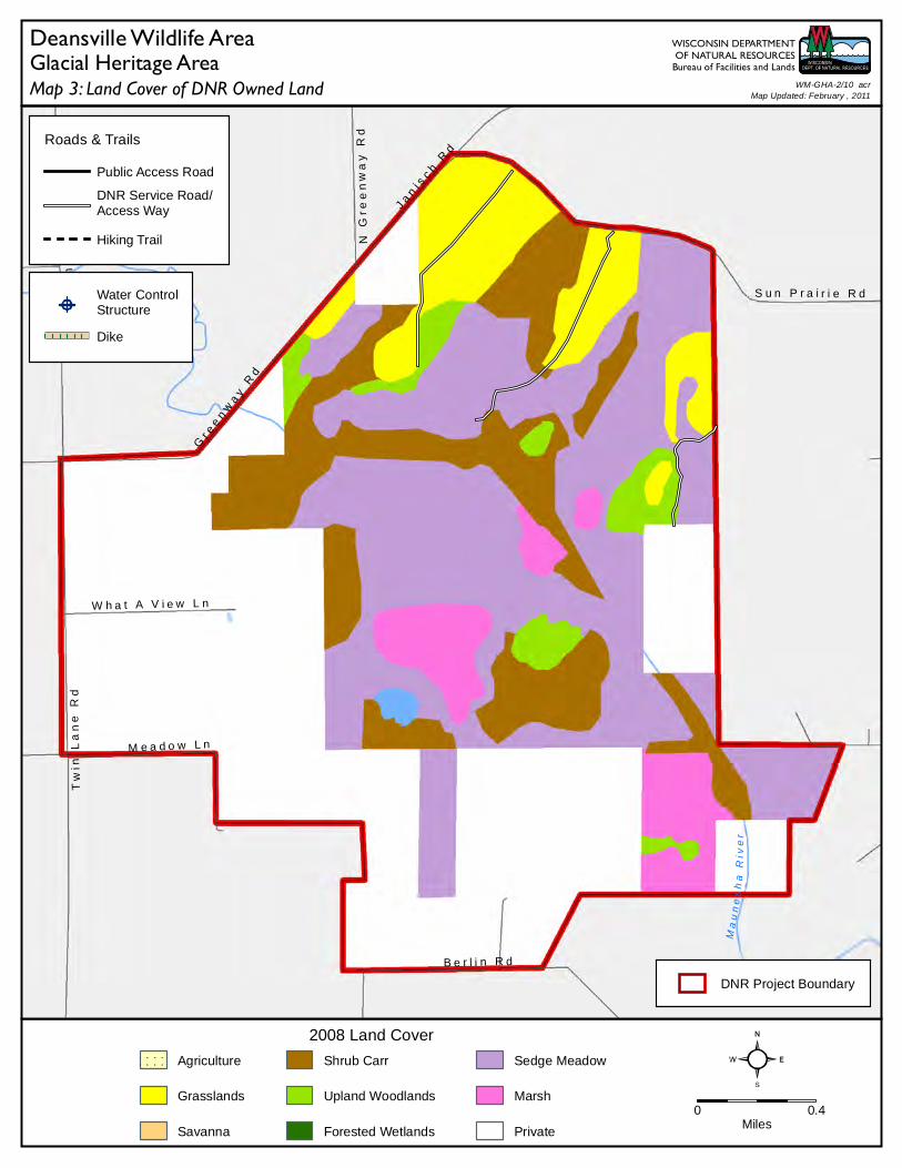
Ma u
n es h
a R
iver
N G
ree
nw
ay
Rd
Tw
in L
an
e R
d
B e r l i n R d
S u n P r a i r i e R d
J an
i sc h
Rd
Tw
in L
an
e R
d
W h a t A V i e w L n
Gr e
en
wa
y R
d
M e a d o w L n
DNR Project Boundary
0 0.4Miles
2008 Land Cover
Agriculture
Grasslands
Savanna
Shrub Carr
Upland Woodlands
Forested Wetlands
Sedge Meadow
Marsh
Private
Water ControlStructure
Dike
Roads & Trails
Public Access Road
DNR Service Road/Access Way
Hiking Trail
Map 3: Land Cover of DNR Owned LandGlacial Heritage Area
WISCONSIN DEPARTMENTOF NATURAL RESOURCES
Bureau of Facilities and Lands
Deansville Wildlife AreaMap Updated: February , 2011
WM-GHA-2/10 acr
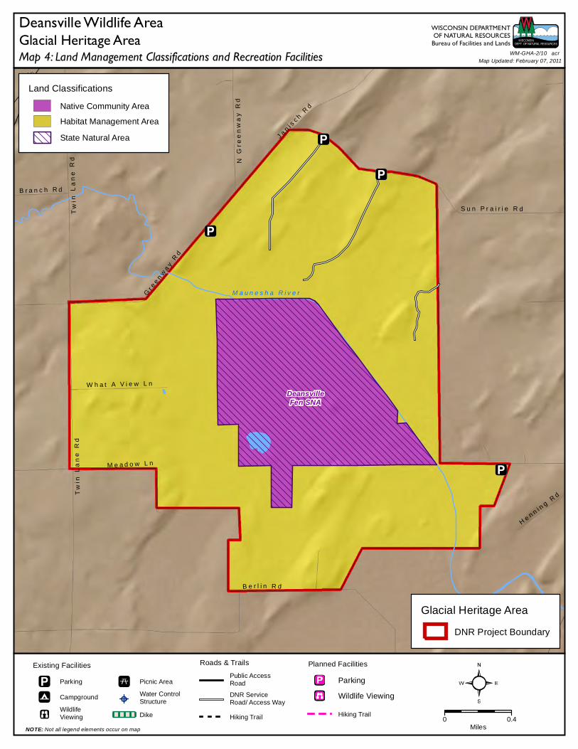
151
DeansvilleFen SNA
M a u n e s h a R i v e r
TT
S u n P r a i r i e R dTw
in L
an
e R
d
B e r l i n R d
N G
ree
nw
ay
Rd
B r a n c h R d
He n n i n
g R
dTw
in L
an
e R
d
W h a t A V i e w L n
Gr e
en
wa
y R
d
J an i s
c h
Rd
M e a d o w L n
Land Classifications
Native Community Area
Habitat Management Area
State Natural Area
Roads & Trails
Public AccessRoad
DNR ServiceRoad/ Access Way
Hiking Trail 0 0.4Miles
Planned Facilities
Parking
Wildlife Viewing
Hiking Trail
Existing Facilities
Parking
Campground
WildlifeViewing
Picnic Area
Water ControlStructure
Dike
NOTE: Not all legend elements occur on map
Map 4: Land Management Classifications and Recreation FacilitiesGlacial Heritage Area
WISCONSIN DEPARTMENTOF NATURAL RESOURCES
Bureau of Facilities and Lands
Glacial Heritage Area
DNR Project Boundary
Deansville Wildlife AreaWM-GHA-2/10 acr
Map Updated: February 07, 2011
73
73
Ston
y Br
ook
K o s h k o n o n g C r e e k
Spr i
n g Cr
eek
M u dL a k e
G o o s eL a k e
94
BB
B
O
He im
an
Ln
D a h l R d
Ba
nn
on
Rd
Mi d
wa
y L
n
E M e d i n a R d
Z a n d e r L
n
Tow
er
Li n
e R
d
Mi s
so
ur
i R
d
Ja
co
bs
Rd
0 0.5Miles
Map 1: DNR Property and Project BoundariesGlacial Heritage Area
WISCONSIN DEPARTMENTOF NATURAL RESOURCES
Bureau of Facilities and Lands
DNR Managed Land(Fee and Easement Land)
DNR Project Boundary(Authorized Acquisition)
Goose Lake Wildlife Area
Map Updated: March 07, 2011WM-GHA-PROP-8/10 acr
73
73 94
Koshkonong Creek
Sto n
y Broo
k
Sprin
g Cr ee
k
MudLake
GooseLake
OBBB
I-94
He
iman Ln
Dahl Rd
E Medina Rd
Ba
nnon
Rd
Midw
ay Ln
Graffin Rd
Pa
vlak
Rd
Missouri R
d
I-94
Zander Ln
Inla
nd L
n
Kru
ege
r R
d
Tow
er Li
ne R
d
Rae
ther
Rd
Cre
stvi
ew R
d
Feenstra R
d
Jaco
bs R
d
Map 2: Public Land OwnershipGLACIAL HERITAGE AREA
Planned Protection Area
DNR Wildlife,Park or NaturalArea
ConservationPark
RiverCorridor
Rural LandscapeProtection Area
Crawfish PrairieHabitat Area
Existing Land Ownership
Municipal
County
Other State
Federal
Dept of Natural Resources(Fee and Easement Land)
Non-ProfitConservationOrganization
WISCONSIN DEPARTMENTOF NATURAL RESOURCES
Bureau of Facilities and LandsWM-GHA-PUBLICLAND-7/10 acr
Map Updated: February 14, 2011
Goose Lake Wildlife Area
0 0.75Miles
K o s h k o n o n g C r e e k
Ston
y Br
ook
S pr i
ng C
ree k
73
73
G o o s eL a k e
94
BB
O
B
H e i m
an
LnD
a h l R
d
Ba
nn
on
Rd
Mi d
wa
y L
n
E M e d i n a R d
Z a n d e r
Ln
Mis
so
ur i
Rd
To
we
r L
i ne
Rd
Ja
co
bs
Rd
DNR Project Boundary
0 0.5Miles
2008 Land Cover
Agriculture
Grasslands
Savanna
Shrub Carr
Upland Woodlands
Forested Wetlands
Sedge Meadow
Marsh
Private
Roads & Trails
Public Access Road
DNR Service Road/Access Way
Hiking Trail
Map 3: Land Cover of DNR Owned LandGlacial Heritage Area
WISCONSIN DEPARTMENTOF NATURAL RESOURCES
Bureau of Facilities and Lands
Goose Lake Wildlife AreaMap Updated: March , 2011
WM-GHA-3/10 acr
Vi l la ge ofDee r f ie l d
73
73
Goose LakeDrumlins
SNA
Goose LakeDrumlins
SNASite#2
Site#1
Site#4
Site#3
9494
Sto n
y Br
ook
K o s h k o n o n g C re e k
M u d C r e e k
Spr i
n g C
ree k
BB
M u dL a k e
O
B
H e i m
an
Ln
D a h l R d
Ba
nn
on
Rd
E M e d i n a R d
Mi d
wa
y L
n
Z a n d e r
Ln
To
we
r L
i ne
Rd
Bo
xe
l de
r R
d
Mi s
so
ur i
Rd
Ja
co
bs
Rd
Land Classifications
Native Community Area
Habitat Management Area
State Natural Area
Roads & Trails
Public AccessRoad
DNR ServiceRoad/ Access Way
Hiking Trail 0 0.6Miles
Planned Facilities
Parking
Wildlife Viewing
Hiking Trail
Existing Facilities
Parking
Campground
WildlifeViewing
Picnic Area
Water ControlStructure
Dike
NOTE: Not all legend elements occur on map
Map 4: Land Management Classifications and Recreation FacilitiesGlacial Heritage Area
WISCONSIN DEPARTMENTOF NATURAL RESOURCES
Bureau of Facilities and Lands
Glacial Heritage Area
DNR Project Boundary
Goose Lake Wildlife AreaWM-GHA-3/10 acr
Map Updated: March 07, 2011
18
City o fJe f ferso n
Deer
Cree
k
N
B
Wil
lin
g R
d
Ja
ec
ke
l R
d
S o u t h S t
Sc
hm
idt
Rd
H a g e d o r n R d
Wil
l R
d
S H
ele
nv
ille
Rd
Pa
ra
dis
e R
d
Be
ar
Ho
le R
d
Ba
ue
r L
n
V o g e l R d
W a l t h e r R d
Sc
he
el
L n
S S c hope
n R
d
0 0.75Miles
Map 1: DNR Property and Project BoundariesGlacial Heritage Area
WISCONSIN DEPARTMENTOF NATURAL RESOURCES
Bureau of Facilities and Lands
DNR Managed Land(Fee and Easement Land)
DNR Project Boundary(Authorized Acquisition)
Jefferson Marsh Wildlife Area
Map Updated: February 14, 2011WM-GHA-PROP-10/10 acr
City o fJe f fe rso n
18
Deer
Cree
k
D
N
B
Will
ing
Rd
Jaeckel Rd
S D
ew
ey A
ve
Gei
ssle
r R
d
N D
ewey
Ave
N H
ele
nvi
lle R
d
Chr
istb
erg
Rd
Sch
mid
t R
d
Hagedorn Rd
South St
Will
Rd
Pa
rad
ise
Rd
Haas
Rd
Be
ar H
ole
Rd
Ba
uer
Ln
Vogel Rd
S H
ele
nvi
lle R
d
Walther Rd
Markert Rd
Map 2: Public Land OwnershipGLACIAL HERITAGE AREA
Planned Protection Area
DNR Wildlife,Park or NaturalArea
ConservationPark
RiverCorridor
Rural LandscapeProtection Area
Crawfish PrairieHabitat Area
Existing Land Ownership
Municipal
County
Other State
Federal
Dept of Natural Resources(Fee and Easement Land)
Non-ProfitConservationOrganization
WISCONSIN DEPARTMENTOF NATURAL RESOURCES
Bureau of Facilities and LandsWM-GHA-PUBLICLAND-9/10 acr
Map Updated: February 14, 2011
Jefferson Marsh Wildlife Area
0 1Miles
City o fJe ffe rson
18
18
D e e r C r ee k
N
B
Wil
lin
g R
d
Ja
ec
ke
l R
dS
ch
mid
t R
dH a g e d o r n R d
S o u t h S t
Wil
l R
d
Pa
ra
dis
e R
d
S H
ele
nv
ille
Rd
Be
ar
Ho
le R
d
Ba
ue
r L
n
V o g e l R d
W a l t h e r R d
Sc
he
el
L n
S S c h op
en
Rd
DNR Project Boundary
0 0.6Miles
2008 Land Cover
Agriculture
Grasslands
Savanna
Shrub Carr
Upland Woodlands
Forested Wetlands
Sedge Meadow
Marsh
Private
Water ControlStructure
Dike
Roads & Trails
Public Access Road
DNR Service Road/Access Way
Hiking Trail
Map 3: Land Cover of DNR Owned LandGlacial Heritage Area
WISCONSIN DEPARTMENTOF NATURAL RESOURCES
Bureau of Facilities and Lands
Jefferson Marsh Wildlife AreaMap Updated: February , 2011
WM-GHA-6/10 acr
City o fJe f ferso n
18
106
JeffersonTamarack
Swamp
Deer
Cree
k
N
B
Wil
lin
g R
d
Ja
ec
ke
l R
d
C u r t i s M i l l R d
Ge
iss
ler
Rd
N D
ew
ey
Av
e
Sc
hm
idt
Rd
H a g e d o r n R d
S o u t h S t
Wil
l R
d
Pa
rad
ise
Rd
Ku
tz R
dH
aa
s R
d
Be
ar
Ho
le R
d
Ba
ue
r L
n
V o g e l R d
S H
ele
nv
ille
Rd
Sc
he
el
L n
Ma r k e r t
Rd
S Sc hop
en
Rd
Land Classifications
Native Community Area
Habitat Management Area
State Natural Area
Roads & Trails
Public AccessRoad
DNR ServiceRoad/ Access Way
Hiking Trail 0 0.7Miles
Planned Facilities
Parking
Wildlife Viewing
Hiking Trail
Existing Facilities
Parking
Campground
WildlifeViewing
Picnic Area
Water ControlStructure
Dike
NOTE: Not all legend elements occur on map
Map 4: Land Management Classifications and Recreation FacilitiesGlacial Heritage Area
WISCONSIN DEPARTMENTOF NATURAL RESOURCES
Bureau of Facilities and Lands
Glacial Heritage Area
DNR Project Boundary
Jefferson Marsh Wildlife AreaWM-GHA-6/10 acr
Map Updated: February 07, 2011
106
City o fFor t
Atk in so n
26L a k eK o s h k o n o n g
M u d L a k e
K o s h k o n o n g M o u n d s R d
N o r t h S h o r e R d
O l d H w y 1 0 6
Bu
rn
ha
m R
d
Gr o
el e
r R
d
Gl a
c i al
Ri v
er
Bi k
e T
r l
Ga
rv
er
t L
n
Ol d
2 6 R d
L a mp
Rd
Sc
hw
em
me
r L
n
Vi n
ni e
Ha
ha
Rd
0 0.5Miles
Map 1: DNR Property and Project BoundariesGlacial Heritage Area
WISCONSIN DEPARTMENTOF NATURAL RESOURCES
Bureau of Facilities and Lands
DNR Managed Land(Fee and Easement Land)
DNR Project Boundary(Authorized Acquisition)
Koshkonong Wildlife Area
Map Updated: February 14, 2011WM-GHA-PROP-7/10 acr

City o fFor t
Atk in so n
106
26
Allen Cre ek
LakeKoshkonong
Mud Lake
Blackhawk Island Rd
Bus
Stat
e H
wy
26
North Shore Rd
Falk
Rd
Bur
nha
m R
d
Groeler
Rd
Deer P
ath R
d
Gla
cial R
iver Bike
Trl
Ga
rv er t L n
Old 26 Rd
Lamp
Rd
Schw
emm
er Ln
Vin
n ie
Hah
a R
d
Map 2: Public Land OwnershipGLACIAL HERITAGE AREA
Planned Protection Area
DNR Wildlife,Park or NaturalArea
ConservationPark
RiverCorridor
Rural LandscapeProtection Area
Crawfish PrairieHabitat Area
Existing Land Ownership
Municipal
County
Other State
Federal
Dept of Natural Resources(Fee and Easement Land)
Non-ProfitConservationOrganization
WISCONSIN DEPARTMENTOF NATURAL RESOURCES
Bureau of Facilities and LandsWM-GHA-PUBLICLAND-6/10 acr
Map Updated: February 14, 2011
Koshkonong Wildlife Area
0 0.5Miles
City o fFor t
At k inson
106
26
L a k eK o s h k o n o n g
M u d L a k e
K o s h k o n o n g M o u n d s R d
N o r t h S h o r e R d
Ol d
H w y 1 0 6
Bu
rnh
am
Rd
Gr o
el e
r R
d
Gl a
c i al
Ri v
er
Bi k
e T
r l
Ga
r ve
r t L
n
Ol d
2 6 R
d
L a mp
Rd
Sc
hw
em
me
r L
n
Vi n
ni e
Ha
ha
Rd
DNR Project Boundary
0 0.4Miles
2008 Land Cover
Agriculture
Grasslands
Savanna
Shrub Carr
Upland Woodlands
Forested Wetlands
Sedge Meadow
Marsh
Private
Water ControlStructure
Dike
Roads & Trails
Public Access Road
DNR Service Road/Access Way
Hiking Trail
Map 3: Land Cover of DNR Owned LandGlacial Heritage Area
WISCONSIN DEPARTMENTOF NATURAL RESOURCES
Bureau of Facilities and Lands
Koshkonong Wildlife AreaMap Updated: February , 2011
WM-GHA-7/10 acr
City o fFor t
Atk in so n
106
26
A l l e n C r e e k
L a k eK o s h k o n o n g
M u d L a k e
K o s h k o n o n g M o u n d s R d
H i g h R i d g e R d
N o r t h S h o r e R d
Ol d
H w y 1 0 6
Fa
l k R
d
Bu
rn
ha
m R
d
Ga
r ve
rt
Ln
Ol d
2 6 R d
L a mp
Rd
Sc
hw
em
me
r L
n
Gl a
c i al
Ri v
er
Bi k
e T
r l
Gr o
el e
r R
d
Land Classifications
Native Community Area
Habitat Management Area
State Natural Area
Roads & Trails
Public AccessRoad
DNR ServiceRoad/ Access Way
Hiking Trail 0 0.5Miles
Planned Facilities
Parking
Wildlife Viewing
Hiking Trail
Existing Facilities
Parking
Campground
WildlifeViewing
Picnic Area
Water ControlStructure
Dike
NOTE: Not all legend elements occur on map
Map 4: Land Management Classifications and Recreation FacilitiesGlacial Heritage Area
WISCONSIN DEPARTMENTOF NATURAL RESOURCES
Bureau of Facilities and Lands
Glacial Heritage Area
DNR Project Boundary
Koshkonong Wildlife AreaWM-GHA-7/10 acr
Map Updated: March 07, 2011
18
City o fLa keMi l ls
89
R o c k C r e e k
H o p eL a k e
R o c kL a k e
B e a nL a k e
M u dL a k e
B
AB
A
S
E l m P o i n t R d
Sh o r e w
o o d H
i l ls
Rd
Lo
nd
o n
Rd
G l a c i a l D r u m l i n B i k e T r
H o p e L a k e R d
S a n d y B e a c h R d
Big
elo
w R
d
S F
err
y D
r
Kr o
gh
vi l
l e R
d
Co n s e r v a t i o
n R d
Mu
d L
ak
e R
d
P i n n a c l e D r
Cr
os
sm
an
Rd
K o r t h L n
A l l e y R d
0 0.75Miles
Map 1: DNR Property and Project BoundariesGlacial Heritage Area
WISCONSIN DEPARTMENTOF NATURAL RESOURCES
Bureau of Facilities and Lands
DNR Managed Land(Fee and Easement Land)
DNR Project Boundary(Authorized Acquisition)
Lake Mills Wildlife Area
Map Updated: February 14, 2011WM-GHA-PROP-5/10 acr
City o fLa keMi l ls
Vi l la ge ofCamb r id ge
18
134
89
Sto ny Br ook
Rock Creek
Rock Creek
Rock Lake
LakeRipley
MudLake
BeanLake
B
A
V
O
A
S
Ripley Rd
Shorewood
Hill
s R
d
London Rd
Par
k R
d
Glacial Drumlin Bike Tr
Sandy Beach Rd
Munson Rd
I-94
Depot Rd
New
vil le
Rd
Fair Oak Rd
Big
elo
w R
d
S F
err y
Dr
Ho
p e L
ake
Rd
Kuhl Rd
Sto
ney
Cre
ek R
d
Britzke Rd
Conservation Rd
Mu
d L
ak e R
d
Pinnacle Dr
Hope Lake Rd
Cro
ssm
an
Rd
Lagoon Rd
Kro
ghvi
lle R
d
Alley Rd
Map 2: Public Land OwnershipGLACIAL HERITAGE AREA
Planned Protection Area
DNR Wildlife,Park or NaturalArea
ConservationPark
RiverCorridor
Rural LandscapeProtection Area
Crawfish PrairieHabitat Area
Existing Land Ownership
Municipal
County
Other State
Federal
Dept of Natural Resources(Fee and Easement Land)
Non-ProfitConservationOrganization
WISCONSIN DEPARTMENTOF NATURAL RESOURCES
Bureau of Facilities and LandsWM-GHA-PUBLICLAND-5/10 acr
Map Updated: February 14, 2011
Lake Mills Wildlife Area
0 1Miles
City o fLakeMi l ls
Vi l lag e ofCambr idge
18
134
S to n
y B r o o k
R o ck C re ek
89
H o p eL a k e
R o c k L a k e
M u d L a k e
94
BB
B
A
V
O
A
E l m P o i n t R d
S h o r e wo o d
Hi l
l s R
d
L o n d o n R d
G l a c i a l D r u m l i n B i k e T r
Ne
wv
ill e
Rd
Big
elo
w R
d
H o p e L a k e R d
K u h l R d
Br i t z k e
R d
Mu
d L
ak
e R
d
P i n n a c l e D r
Sto
ne
y C
ree
k R
d
Cro
ss
ma
n R
d
Kr o
gh
vi l
l e R
d
A l l e y R d
DNR Project Boundary
0 0.8Miles
2008 Land Cover
Agriculture
Grasslands
Savanna
Shrub Carr
Upland Woodlands
Forested Wetlands
Sedge Meadow
Marsh
Private
Water ControlStructure
Dike
Roads & Trails
Public Access Road
DNR Service Road/Access Way
Hiking Trail
Map 3: Land Cover of DNR Owned LandGlacial Heritage Area
WISCONSIN DEPARTMENTOF NATURAL RESOURCES
Bureau of Facilities and Lands
Lake Mills Wildlife AreaMap Updated: February , 2011
WM-GHA-4/10 acr
City o fLa keMi l ls
Vi l la ge ofCamb r id ge
18
12
134
Mud LakeFen and WetPrairie SNA
BeanLake SNA
89
Site#4
S t o n y B r o o k
R o c k C r e e k
94
94
BB
H o p eL a k e
R o c k L a k e
L a k eR i p l e y
M u dL a k e
A
B
V
O
A
S
PR OPO
SED BIKE
TRA I
L
Ri p l e y
Rd
E l m P o i n t R d
S h o r e wo o d
Hi l
l s R
d
L o n d o n R d
H o p e L a k e R dC
P A
ve
Pa
r k R
d
G l a c i a l D r u m l i n B i k e T r
Ow
e n S t
D e p o t R d
Ne
wv
ille
Rd
Big
elo
w R
d
Fa
vil
l e R
d
F a i r O a k R d
M u n s o n R d
Kr
og
hv
i l le R
d
K u h l R d
Br i t z k e
R d
Mu
d L
ak
e R
d
P i n n a c l e D r
Cro
ss
ma
n R
d
A l l e y R d
Sto
ne
y C
re
ek
Rd
N S h o r e
R d
Land Classifications
Native Community Area
Habitat Management Area
State Natural Area
Roads & Trails
Public AccessRoad
DNR ServiceRoad/ Access Way
Hiking Trail 0 0.9Miles
Planned Facilities
Parking
Wildlife Viewing
Hiking Trail
Existing Facilities
Parking
Campground
WildlifeViewing
Picnic Area
Water ControlStructure
Dike
NOTE: Not all legend elements occur on map
Map 4: Land Management Classifications and Recreation FacilitiesGlacial Heritage Area
WISCONSIN DEPARTMENTOF NATURAL RESOURCES
Bureau of Facilities and Lands
Glacial Heritage Area
DNR Project Boundary
Lake Mills Wildlife AreaWM-GHA-4/10 acr
Map Updated: February 07, 2011
106
59
Stee
l Br
ook
M u d C r e e k
Scu p
p e
r n o n g R i v e r
Spri
ng C
reek
G r e e nI s l e
L a k e
D
T h a y e r R d
Ho
wa
rd R
d
M a r s h a l l R d
Me
hr
ing
Rd
Lo
we
r H
eb
r on
Rd
P i p e r R d
K o c h R d
Pe
ch
ou
s R
d
E h l e r t R d
M a r s h R d
H o f f m a n R d
Fro
mm
ad
er
Rd
Kin
ca
id L
n
0 0.75Miles
Map 1: DNR Property and Project BoundariesGlacial Heritage Area
WISCONSIN DEPARTMENTOF NATURAL RESOURCES
Bureau of Facilities and Lands
DNR Managed Land(Fee and Easement Land)
DNR Project Boundary(Authorized Acquisition)
Princes Point Wildlife Area
Map Updated: February 14, 2011WM-GHA-PROP-3/10 acr
City o fWhi te wate r
Vi l lag e ofPal myra
106
59
Stee
l Broo
k
Spring Creek
Mud Creek
Scuppernong River
Scuppernong River
BlueSpringLake
SpringLake
CI
EF
D
E
Thayer Rd
S 4
th S
t
Taf t
St
N 1st St
Wo
jtku
nsk
i R
d
Rome Oak Hill Rd
Lowland Dr
Ha
as
Rd
Hooper Rd
Green
Isle Dr
Ho
wa
rd R
d
Hanson Rd
S 3rd
St
Paul Dr
Low
er
He
bro
n R
d
Me
hri
ng
Rd
Zio
n R
d
Cu
shm
an
Rd
Piper Rd
Myr
a L
n
Hess Ln
Hw
y
Koch Rd
Pe
cho
us
Rd
Be
ten
z L
n
Marsh Rd
Ca
lki ns
Rd
Ehlert RdHoffman Rd
Tam
ara
ck R
d
Fro
mm
ad
er
Rd
Wo
od
wa
rd R
d
Kin
caid
Ln
South Shore Dr
Is land Rd
Map 2: Public Land OwnershipGLACIAL HERITAGE AREA
Planned Protection Area
DNR Wildlife,Park or NaturalArea
ConservationPark
RiverCorridor
Rural LandscapeProtection Area
Crawfish PrairieHabitat Area
Existing Land Ownership
Municipal
County
Other State
Federal
Dept of Natural Resources(Fee and Easement Land)
Non-ProfitConservationOrganization
WISCONSIN DEPARTMENTOF NATURAL RESOURCES
Bureau of Facilities and LandsWM-GHA-PUBLICLAND-3/10 acr
Map Updated: March 07, 2011
Princes Point Wildlife Area
0 1Miles
106
106
M u d C r e e k
Spr in g C
re e k
Stee
l Br
ook
59
G r e e nI s l e
L a k e
D
T h a y e r R d
Ho
wa
rd R
d
M a r s h a l l R d
Me
hri
ng
Rd
Lo
we
r H
eb
r on
Rd
P i p e r R d
K o c h R d
Pe
ch
ou
s R
d
E h l e r t R d
M a r s h R d
H o f f m a n R d Fro
mm
ad
er
Rd
Ki n
ca
id L
n
DNR Project Boundary
0 0.6Miles
2008 Land Cover
Agriculture
Grasslands
Savanna
Shrub Carr
Upland Woodlands
Forested Wetlands
Sedge Meadow
Marsh
Private
Water ControlStructure
Dike
Roads & Trails
Public Access Road
DNR Service Road/Access Way
Hiking Trail
Map 3: Land Cover of DNR Owned LandGlacial Heritage Area
WISCONSIN DEPARTMENTOF NATURAL RESOURCES
Bureau of Facilities and Lands
Princes Point Wildlife AreaMap Updated: February , 2011
WM-GHA-9/10 acr
106
59
Spri
ng C
reek
S cu p pe r n o n g R i v e r
Mud
Cre
ek
Stee
l Br
ook
CI
G r e e nI s l e
L a k e
U
F
D
T h a y e r R d
Ho
wa
rd
Rd
M a r s h R d
Lo
we
r H
eb
r on
Rd
Me
hri
ng
Rd
M a r s h a l l R d
P i p e r R d
L o w l a n d D r
K o c h R d
Sa
wm
ill
Rd
Pe
ch
ou
s R
d
Ca
lkin
s R
d
E h l e r t R dH o f f m a n R d Fro
mm
ad
er
Rd
Jo
hn
so
n R
d
Kin
ca
id L
n
Land Classifications
Native Community Area
Habitat Management Area
State Natural Area
Roads & Trails
Public AccessRoad
DNR ServiceRoad/ Access Way
Hiking Trail 0 0.7Miles
Planned Facilities
Parking
Wildlife Viewing
Hiking Trail
Existing Facilities
Parking
Campground
WildlifeViewing
Picnic Area
Water ControlStructure
Dike
NOTE: Not all legend elements occur on map
Map 4: Land Management Classifications and Recreation FacilitiesGlacial Heritage Area
WISCONSIN DEPARTMENTOF NATURAL RESOURCES
Bureau of Facilities and Lands
Glacial Heritage Area
DNR Project Boundary
Princes Point Wildlife AreaWM-GHA-9/10 acr
Map Updated: February 14, 2011
B ark
R iv e
r
R o m eP o n d
F
E
F r o e l i c h R d
N o r t h e y R
d
Ro
me
Oa
k H
ill
Rd
He
r r R
d
Pio
ne
er
Dr
H u n t e r s L n
B e n t e R d
Lu n
dt
Rd
0 0.5Miles
Map 1: DNR Property and Project BoundariesGlacial Heritage Area
WISCONSIN DEPARTMENTOF NATURAL RESOURCES
Bureau of Facilities and Lands
DNR Managed Land(Fee and Easement Land)
DNR Project Boundary(Authorized Acquisition)
Rome Pond Wildlife Area
Map Updated: February 14, 2011WM-GHA-PROP-2/10 acr
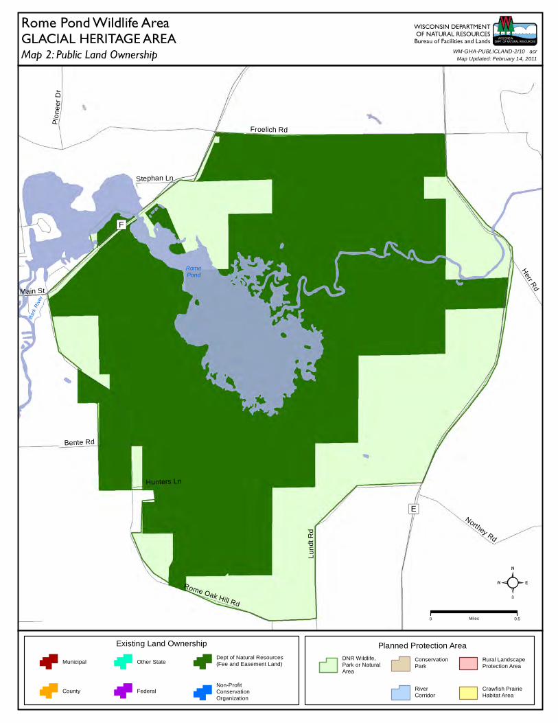
Bark
River
RomePond
F
E
Froelich Rd
Main St
Northey Rd
Rome Oak Hill Rd
Stephan Ln
Herr R
d
Hunters Ln
Bente Rd
Pio
neer
Dr
Lun
dt R
d
Map 2: Public Land OwnershipGLACIAL HERITAGE AREA
Planned Protection Area
DNR Wildlife,Park or NaturalArea
ConservationPark
RiverCorridor
Rural LandscapeProtection Area
Crawfish PrairieHabitat Area
Existing Land Ownership
Municipal
County
Other State
Federal
Dept of Natural Resources(Fee and Easement Land)
Non-ProfitConservationOrganization
WISCONSIN DEPARTMENTOF NATURAL RESOURCES
Bureau of Facilities and LandsWM-GHA-PUBLICLAND-2/10 acr
Map Updated: February 14, 2011
Rome Pond Wildlife Area
0 0.5Miles
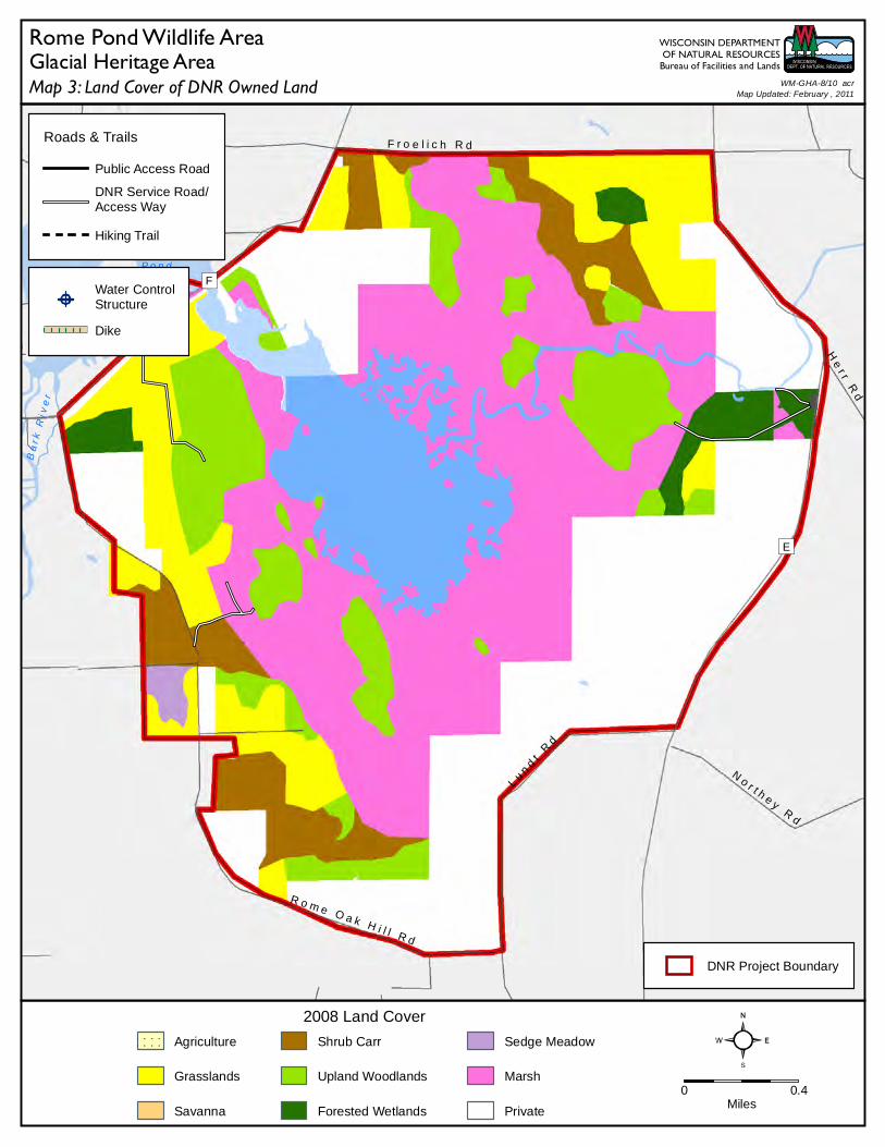
B ark
R iv e
r
R o m eP o n d
F
E
F r o e l i c h R d
No r t h e y
Rd
R o m e O a k H i l l R d
He
r r R
d
Lu n
dt
Rd
DNR Project Boundary
0 0.4Miles
2008 Land Cover
Agriculture
Grasslands
Savanna
Shrub Carr
Upland Woodlands
Forested Wetlands
Sedge Meadow
Marsh
Private
Water ControlStructure
Dike
Roads & Trails
Public Access Road
DNR Service Road/Access Way
Hiking Trail
Map 3: Land Cover of DNR Owned LandGlacial Heritage Area
WISCONSIN DEPARTMENTOF NATURAL RESOURCES
Bureau of Facilities and Lands
Rome Pond Wildlife AreaMap Updated: February , 2011
WM-GHA-8/10 acr
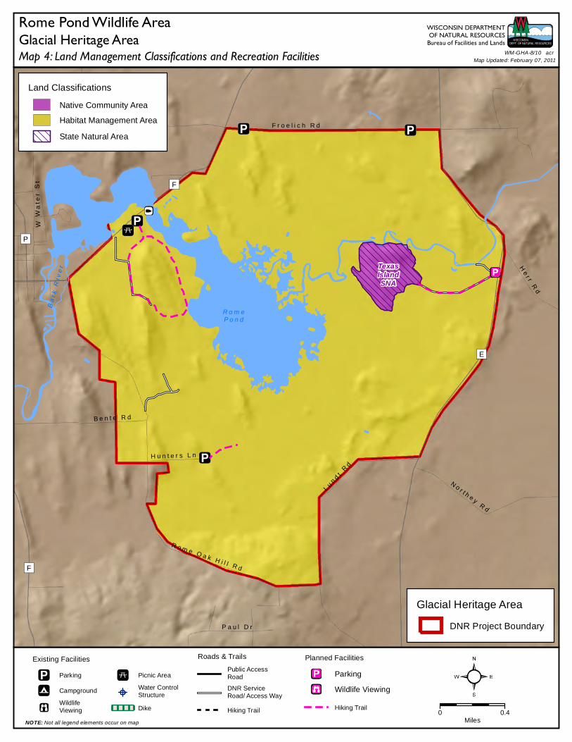
TexasIslandSNA
B ar k
Ri v
e r
R o m eP o n d
F
P
F
E
F r o e l i c h R d
W W
ate
r S
t
P a u l D r
He
r r R
d
N o r t h e y R d
R o m e O a k H i l l R d
H u n t e r s L n
B e n t e R d
Pio
ne
er
Dr
Lu
n dt
Rd
Land Classifications
Native Community Area
Habitat Management Area
State Natural Area
Roads & Trails
Public AccessRoad
DNR ServiceRoad/ Access Way
Hiking Trail 0 0.4Miles
Planned Facilities
Parking
Wildlife Viewing
Hiking Trail
Existing Facilities
Parking
Campground
WildlifeViewing
Picnic Area
Water ControlStructure
Dike
NOTE: Not all legend elements occur on map
Map 4: Land Management Classifications and Recreation FacilitiesGlacial Heritage Area
WISCONSIN DEPARTMENTOF NATURAL RESOURCES
Bureau of Facilities and Lands
Glacial Heritage Area
DNR Project Boundary
Rome Pond Wildlife AreaWM-GHA-8/10 acr
Map Updated: February 07, 2011
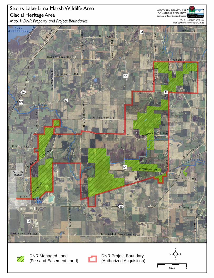
City o fM i l t on
26
59
O t t e r C r e e k
S p r i n g B r o o kAl
len
Cr e
e k
L a k eK o s h k o n o n g
S t o r r sL a k e
NN
KK
KK
N
M
M
N
N L
ima
Ce
nte
r R
d
C o u n t y L i n e R d
E S a l i s
b u r y R
d
N V
ick
erm
an
Rd
N K
lug
Rd
N S
turt
ev
an
t R
d
M - H T o w n l i n e R d
E S c h m i d t R d
Po
ep
pe
l R
d
N V
ick
er
ma
n R
d
E G o d f r e y R d
G r o g a n R d
Mc
Mil
len
Rd
E P i o n e e r R d
E L a n d J T o w n l i n e R d
T r i C o u n t y R o a d
E S t o r r s L a
k e R
d
E W i l l o w D r
Ol d
26
Rd
E B e r g R d
Vic
ke
r ma
n R
d
E K l u g R d
N B
ry
an
t R
d
Ha
i gh
t R
d
N H
ob
bs
Rd
H o g e R d
E B o w e r s L a k e R d
N B
o we r s
L a k e R d
0 1Miles
Map 1: DNR Property and Project BoundariesGlacial Heritage Area
WISCONSIN DEPARTMENTOF NATURAL RESOURCES
Bureau of Facilities and Lands
DNR Managed Land(Fee and Easement Land)
DNR Project Boundary(Authorized Acquisition)
Storrs Lake-Lima Marsh Wildilfe Area
Map Updated: February 14, 2011WM-GHA-PROP-4/10 acr
12
59
59
26
Otter Creek
Otter Creek
Spring Brook
Allen
Cree
k
LakeKoshkonong
StorrsLake
NN
KK
M
M
N
N
KKN
Lim
a C
en
ter
Rd
E R
y a n Rd
Mc
Mill
en
Rd
E Salis
bury Rd
N Ja
ne
svi
lle S
t
Tw
inkl
ing
Sta
r R
d
N V
ick
erm
an
Rd
M-H Townline Rd
N K
lug
Rd
E Schmidt Rd
Chicago
St
N S
cha
rin
e R
d
Po
ep
pe
l R
dE Godfrey Rd
Grogan Rd
E L and J Townline Rd
E Storrs Lake Rd
E Pioneer Rd
E Willow Dr
Gla
cial
Riv
er Bik
e Tr
l
N M
cM
illin
Rd
N S
turt
eva
nt
Rd
N M
cCo
rd R
d
E Berg Rd
N H
en
ke
Rd
N D
em
ps e
y D
r
Vic k
erm
an
Rd
E Klug Rd
N B
rya
nt
Rd
Haight Rd
N L
ima
Ce
nte
r R
d
N M
ilto
n-S
ho
pie
re R
d
N T
arr
an
t R
d
N E
me
r ald
Gro
v e R
d
N H
ob
bs
Rd
Hoge Rd
E Bowers Lake Rd
N Bow
ers
La
ke R
d
Map 2: Public Land OwnershipGLACIAL HERITAGE AREA
Planned Protection Area
DNR Wildlife,Park or NaturalArea
ConservationPark
RiverCorridor
Rural LandscapeProtection Area
Crawfish PrairieHabitat Area
Existing Land Ownership
Municipal
County
Other State
Federal
Dept of Natural Resources(Fee and Easement Land)
Non-ProfitConservationOrganization
WISCONSIN DEPARTMENTOF NATURAL RESOURCES
Bureau of Facilities and LandsWM-GHA-PUBLICLAND-4/10 acr
Map Updated: February 14, 2011
Storrs Lake-Lima Marsh Wildlife Area
0 1Miles
City o fMi l ton
12
G a l l o w a y C r e e k
S p r i n g B r o o k
O t t e r C r e e k
Alle
n C r
e ek
59
26
L a k eK o s h k o n o n g
S t o r r sL a k e
NN
KK
KK
N
M
M
N
N L
ima
Ce
nte
r R
d
C o u n t y L i n e R d
E S a l i s
b u r y R
d
C r e a m e r y R d
T r i C o u n t y R o a d
Ol d
Hw
y 2
6
N V
ick
er
ma
n R
d
N K
l ug
Rd
E S c h m i d t R d
M - H T o w n l i n e R d
Po
ep
pe
l R
d
E G o d f r e y R d
G r o g a n R d
Mc
Mil
len
Rd
E L a n d J T o w n l i n e R d
E P i o n e e r R d
Ol d
26
Rd
N M
cM
illi
n R
d
N S
t ur t e
v a n t R d
N M
cC
or
d R
d
E B e r g R d
Vic
ke
rma
n R
d
E K l u g R d
N B
ry
an
t R
d
Ha
i gh
t R
d
H o g e R d
DNR Project Boundary
0 1Miles
2008 Land Cover
Agriculture
Grasslands
Savanna
Shrub Carr
Upland Woodlands
Forested Wetlands
Sedge Meadow
Marsh
Private
Water ControlStructure
Dike
Roads & Trails
Public Access Road
DNR Service Road/Access Way
Hiking Trail
Map 3: Land Cover of DNR Owned LandGlacial Heritage Area
WISCONSIN DEPARTMENTOF NATURAL RESOURCES
Bureau of Facilities and Lands
Storrs Lake-Lima Marsh Wildlife AreaMap Updated: February , 2011
WM-GHA-10/10 acr
City o fM i l t on
12
Lima BogState
Natural Area
59
59
26
FairMeadows
SNA
O t t e r Cr e ek
G a ll o w a y C r e e k
S p r i n g B r o o k
Alle
n C
reek
NN
KK
KK
L a k e K o s h k o n o n g
S t o r r sL a k e
M
N
N
Ice
Age
Tra
il
N L
i ma
Ce n t e
r R d
C o u n t y L i n e R d
P o n d R d
Ol d
26
Rd
E S
a l is b u r y
Rd
M e s k e R dC r e a m e r y R d
N C
ou
nt y
Lin
e R
d
N V
ick
er
ma
n R
d
N K
lug
Rd
E S c h m i d t R d
E B o w e r s L a k e R d
M - H T o w n l i n e R d
E G o d f r e y R d
G r o g a n R d Bu
ck
i ng
ha
m R
d
Mc
Mil le
n R
dT r i C o u n t y R o a d
E L a n d J To w n l i n e R d
Po
ep
pe
l R
d
N M
cM
illi
n R
d
E P i o n e e r R d
N M
cC
or
d R
d
E B e r g R d
N H
en
ke
Rd
N S
t u
r te v a n t
R d
Vic
ke
rm
an
Rd
E K l u g R d
N B
r ya
nt
Rd
N T
arr
an
t R
d
Ha
igh
t
R d
H o g e R d
N V
og
el
Rd
Land Classifications
Native Community Area
Habitat Management Area
State Natural Area
Roads & Trails
Public AccessRoad
DNR ServiceRoad/ Access Way
Hiking Trail 0 1.1Miles
Planned Facilities
Parking
Wildlife Viewing
Hiking Trail
Existing Facilities
Parking
Campground
WildlifeViewing
Picnic Area
Water ControlStructure
Dike
NOTE: Not all legend elements occur on map
Map 4: Land Management Classifications and Recreation FacilitiesGlacial Heritage Area
WISCONSIN DEPARTMENTOF NATURAL RESOURCES
Bureau of Facilities and Lands
Glacial Heritage Area
DNR Project Boundary
Storrs Lake-Lima Marsh Wildlife AreaWM-GHA-10/10 acr
Map Updated: February 07, 2011
Vi l l age o fRee sev i l l e
Ci ty o fWate r loo
19
89
S t o n y B r o o k
N o l an
C r ee k
M a u n e s h a R i v e r
L a u C r e e k
M ud C r e
e k
C h u bL a k e
M u dL a k e
H a h n sL a k e
BB
GI
II
I
N
A
G
Q
I
T
T
K
O
G
Co
un
t y R
oa
d K
T o r p y R d
B o b o l i n k R d
B u r r O a k R d
Pe
sc
he
l R
d
Ye
rg
es
Rd
N e w v i l l e R d
Ba
ke
r R
d
Da
l ma
n R
d
N K
oh
n R
d
M i d d l e R d
S t o n e y B r o o k R d
C o u n t y R o a d G G
P o r t R d
To w n H a l l R d
Wa
lto
n R
d
H u b b l e t o n R d
Hu
gh
es
Rd
St a
r k R
d
Co
un
t y R
oa
d B
B
A u s t i n R d
Su
l l i va
n R
d
Ho
rs
es
ho
e R
d
Riv
er
Rd
Ba
rr
y R
d
P i t R
d
N a v a n R d
We
st
Rd
B l u e J o i n t R dW
oo
d R
d
G i e s e R d
F r e n c h R d
O l s o n R d
S p r i n g e r R d
E H
ub
b
l e t o n R d
To
pp
e R
d
Mil
e R
d
L o n g R d
P r a i r i e L n
S o l d n e r R d
Wi l lo
w R
d
Yo
uk
er
Rd
Ve
l R
d
S K
oh
n R
d
Co
un
ty R
oa
d
C l a r k s o n R d
S c h m i d t R d
Se
t z R
d
P e r g a n d e R d
Do
ep
ke
Rd
Jo
rd
an
Rd
Ric
h R
d
R
an
ch
Rd
0 2Miles
Map 1: DNR Property and Project BoundariesGlacial Heritage Area
WISCONSIN DEPARTMENTOF NATURAL RESOURCES
Bureau of Facilities and Lands
DNR Managed Land(Fee and Easement Land)
DNR Project Boundary(Authorized Acquisition)
Waterloo-Mud Lake Wildilfe Area
Map Updated: March 07, 2011WM-GHA-PROP-1/10 acr
Ci ty o fCo l um bus
Vi l l age o fRee sev i l l e
Ci ty o fWate r loo
89
19
Cold Spring Creek
Casp
er Creek
Ston
y Broo k
Nolan CreekLa
u Cree
kMud Cree
k
Pratt
Cree
k
94
ChubLake
MudLake
HahnsLake
J
KW
TT
TV
I
G
BB
Q
GI
GG
N
I
Y
II
T
K
T
OW
els
h R
d
Emera ld Dr
Glory Rd
Torpy Rd
Sk
al its
ky
Ln
Fra
nk
Rd
Riv
er
Rd
Wilson Rd
Canal Rd
W Tamrack Rd
Bobolink Rd
Burr Oak Rd
Pe
sch
el
Rd
Ye
rge
s R
d
Provimi Rd
Boxelder R
d
Ba
ke
r R
d
Navan Rd
New
vi ll e R
d
E Medina Rd
Da l
man
Rd
N K
oh
n R
d
Middle Rd
Seven Hi ll Rd
Stoney Brook Rd
Port Rd
Town Hall Rd
Pe
t i g R
d
Ma
ide
n L
an
e R
d
Hug
hes R
dR
oc
k L
ake
Rd
Wa
lto
n R
d
Hubbleton Rd
Fa
vil
le R
d
Sta
r k R
d
Vandre Rd
Austin Rd
Ho
rse
sh
oe
Rd
Riv
er
Rd
Ba
rry
Rd
Mud Lake R
d
Pit Rd
We
st
Rd
Gy
ps
y R
d
B lue Joint Rd
Veith Rd
Isla
nd
Ch
urc
h R
d
Sul livan Rd
E H
ors
es
ho
e R
d
Buss Ln
Wo
od
Rd
Giese Rd
Loa
m Rd
Ja
hn
ke
Rd
Is land Rd
F rench Rd
I-94
Olson Rd
Manske Rd
Sp
ring
er Rd
E Hubbleton Rd
Johnson Rd
To
pp
e R
d
Mil
e R
d
Mu ller Rd
Hil
l to
p R
d
Long Rd
W Clymet Rd
Prai rie Ln
N Wollin Rd
Soldner Rd
W
illow R
d
Yo
uk
er
Rd
Ve
l R
d
We
lsh
Rd
S K
oh
n R
d
C larkson Rd
Schmidt Rd
Klu
g L
n
Pergande Rd
Ju
ng
le R
d
R ichart Ln
Quarry Rd
Sydo Rd
Airport Rd
Garden Rd
Setz
Rd
Do
ep
ke
Rd
J ord
an
Rd
Du ffy
Rd
Riv
er
Oa
ks R
d
Ric
h R
d
Ranch
Rd
Map 2: Public Land OwnershipGLACIAL HERITAGE AREA
Planned Protection Area
DNR Wildlife,Park or NaturalArea
ConservationPark
RiverCorridor
Rura l LandscapeProtection Area
Crawfish PrairieHabitat Area
Existing Land Ownership
Municipa l
County
Other State
Federa l
Dept of Natural Resources(Fee and Easement Land)
Non-ProfitConservationOrganization
WISCONSIN DEPARTMENTOF NATURAL RESOURCES
Bureau of Facilities and LandsWM-GHA-PUBLICLAND-1/10 acr
Map Updated: March 07, 2011
Waterloo-Mud Lake Wildlife Area
0 2.5Miles
Cit y ofColu m bu s
Vil l a g e o fRee s e v il l e
C it y ofWat e rt own
C it y ofWat e r l oo
Sto n
y Br
o ok
N o l an
C r ee k
M a u n e s h a R i v e r
L a u C r e e k
Cas p
e r C r e
e kM u d
C r ee k
89
19
D a n v i l l eM i l l p o n d
H a h n sL a k e
94
QQTV
KW
TT
BB
II
J
I
G
Q
N
I
A
T
Y
K
O
G
T
Co
un
ty R
oa
d K
We
lsh
Rd
G l o r y R d
T o r p y R d
W i l s o n R d
C a n a l R d
W T a m r a c k R d
B o b o l i n k R d
Ne
wv
i l l e R
d
B u r r O a k R d
M a n s k e R d
Ye
rg
es
Rd
P r o v i m i R d
F i v e M i l e R d
N S
ho
re
Rd
Riv
er
Rd
Bo
xe
lde
r R
d
Ba
ke
r R
d
N a v a n R d
A
i r po
r t R
d
C o u n t y R o a d T T
Da
lma
n R
d
N K
oh
n R
d
M i d d l e R d
S e v e n H i l l R d
S t o n e y B r o o k R d
C o u n t y R o a d G G
P o r t R d
Pe
t i g R
d
Ma
ide
n L
an
e R
d
Hu
gh
es
Rd
Wa
lto
n R
d
Hu
bb
let o
n R
d
St a
r k R
d
V a n d r e R d
A u s t i n R d
Ho
rse
sh
oe
Rd
Riv
er
Rd
Ba
rr
y R
d
Tr
i-C
ou
nty
Rd
We
st
Rd
Gy
ps
y R
d
V e i t h R d
W e s t S t
Su
l l i va
n R
d
E H
or s
es
ho
e R
d
S p r u c e D rRo
ck
La
ke
Rd
Fr
an
k R
d
Co
un
ty R
oa
d B
B
Wo
od
Rd
G i e s e R d
F r e n c h R d
O l s o n R d
S p r i n g e r
Rd
To
pp
e R
d
Mil
e R
d
E m e r a l d D r
Hil
lto
p R
d
L o n g R d
W C l y m e t R d
P r a i r i e L n
N W o l l i n R d
S o l d n e r R d
Wil l o
w R
d
Yo
uk
er
Rd
Ve
l R
d
We
lsh
Rd
S K
oh
n R
d
C l a r k s o n R d
S c h m i d t R d
P e r g a n d e R d
Se
t z R
d
Jo
rda
n R
d
Du
f fy
Rd
Ric
h R
d
DNR Project Boundary
0 1.9Miles
2008 Land Cover
Agriculture
Grasslands
Savanna
Shrub Carr
Upland Woodlands
Forested Wetlands
Sedge Meadow
Marsh
Private
Water ControlStructure
Dike
Roads & Trails
Public Access Road
DNR Service Road/Access Way
Hiking Trail
Map 3: Land Cover of DNR Owned LandGlacial Heritage Area
WISCONSIN DEPARTMENTOF NATURAL RESOURCES
Bureau of Facilities and Lands
Waterloo-Mud Lake Wildlife AreaMap Updated: March , 2011
WM-GHA-1/10 acr
City o fLa keMi l ls
Vi l lag e ofLowe l l
V i l la ge ofRee sev i l l e
C i ty o fWa te r town
Vi l lag e ofJo hn so n
Cree k
C i ty o fWa te r lo o
Vi l lag e ofC lyman
WaterlooQuartzite Oak Woods
& Savanna--South SNA
Chub LakeSavanna SNA
FavillePrairie SNA
WaterlooPrairieSNA Snapper
PrairieSNA
19
89
26
73
16
16
19
26
89
Goose LakeDrumlins
SNA
RiverineMarsh SNA
Site#4
Site #3
R o c k C r e
e k
S t o n y B r oo k
N o l a n C r e e k
M a u n e s h a R i v e r
Silv
er C
ree k
L a u C r e e k
C ol d
S pr i
n g Cr
eek
C a s p e r C r e e k
Pra t
t Cr e
e k
Cly m
a n C r
e ek
M u d C r e e k
94
TT
KW
BB
TV
GI
GG
II
R o c kL a k e
M i l lP o n d
D a n v i l l eM i l l p o n d
H a h n sL a k e
J
A
Q
I
K
B
G
Q
I
N
T
K
Y
T
O
Co
un
ty R
oa
d K
E m e r a l d D r
G l o r y R d
W e s t S t
To r p y R d
Fr
an
k R
d
W i l s o n R d
C a n a l R d
Ro
ck
La
ke
Rd
B u r r O a k R d
Ne
wv
i l l e R
d
Ye
rge
s R
d
P r o v i m i R d
N S
ho
re R
d
B o x e l d er
Rd
Ba
ke
r R
d
N a v a n R d
A i r p o r t R d
C
o u n t y R o a d T T
E M e d i n a R d
N K
oh
n R
d
M i d d l e R d
S e v e n H i l l R d
Ch
er
ry L
n
Ma
i de
n L
an
e R
d
Hu g
he
s R
d
Wa
lto
n R
d
Fa
vil
l e R
d
St a
r k R
d
F i n d e r R d
Va n d r e R d
A u s t i n R d
Riv
er
Rd
Sw
itz
ke
Rd
Ai r
po
rt
Rd
Ba
rry
Rd
Tri
-C
ou
nty
Rd
We
st
Rd
Gy
ps
y R
d
V e i t h R d
K u h l R d
Su
l l i va
n R
d
Co
un
t y R
oa
d B
B
G i e s e R d
Hig
h R
d
F r e n c h R d
R i v e r D r
Hil
lto
p R
d
L o n g R d
Ma
ns
ke
Rd
Wi l l o
w R
d
Ve
l R
d
We
lsh
Rd
M u l l e r R d
Ch
ur c h
Dr
Co
un
t y R
oa
d Q
Q
C l a r k s o n R d
Se t z
Rd
S y d o R d
Du f f
y R
d
Ric
h R
d
Land Classifications
Native Community Area
Habitat Management Area
State Natural Area
Roads & Trails
Public AccessRoad
DNR ServiceRoad/ Access Way
Hiking Trail 0 2.2Miles
Planned Facilities
Parking
Wildlife Viewing
Hiking Trail
Existing Facilities
Parking
Campground
WildlifeViewing
Picnic Area
Water ControlStructure
Dike
NOTE: Not all legend elements occur on map
Map 4: Land Management Classifications and Recreation FacilitiesGlacial Heritage Area
WISCONSIN DEPARTMENTOF NATURAL RESOURCES
Bureau of Facilities and Lands
Glacial Heritage Area
DNR Project Boundary
Waterloo-Mud Lake Wildlife AreaWM-GHA-1/10 acr
Map Updated: March 07, 2011
89
G
S c h m i d t R d
Re
als
Ln
N S
ho
re
Rd
E H u b b l e t o n R d
R u b i d e l l R
d
Va
nd
re
Rd
B l u e J o i n t R d
M a n s k e R d
O l s o n R d
Sp
r in
ge
r R
d
P r a i r i e L n
Pra
irie
Rd
R e a m e r R d
Riv
er
vi e
w D
r
Klu
g L
n
W o o d l a n d R d
Riv
er
Rd
Ro
ck
La
ke
Rd
0 0.75Miles
Map 1: DNR Property and Project BoundariesGlacial Heritage Area
WISCONSIN DEPARTMENTOF NATURAL RESOURCESBureau of Facilities and Lands
DNR Managed Land(Fee and Easement Land)
DNR Project Boundary(Authorized Acquisition)
Crawfish Prairie Habitat Area
Map Updated: March 09, 2011WM-GHA-PROP-11/11 acr
Waterloo QuartziteOak Woods &
Savanna--South SNA
FavillePrairieSNA
WaterlooPrairieSNA
SnapperPrairieSNA
89
G
W e s t R d
N S
ho
re
Rd
Fa
vil
le R
d
Ro
ck
La
ke
Rd
R u b i d el l
Rd
N W o l l i n R d
M a n s k e R d V a n d r e R d
Ri v
er
Rd
N a v a n R d
E H u b b l e t o n R d
B l u e J o i n t R d
O l s o n R d
Sp
r in
ge
r R
d
S c h m i d t R d
Wo
lff
Rd
P r a i r i e L n Pr
air
ie R
d
R e a m e r R dRiv
er
vi e
w D
r
Klu
g L
n
W o o d l a n d R d
Land Classifications
Native Community Area
Habitat Management Area
State Natural Area
Roads & Trails
Public AccessRoad
DNR ServiceRoad/ Access Way
Hiking Trail 0 0.7Miles
Planned Facilities
Parking
Wildlife Viewing
Hiking Trail
Existing Facilities
Parking
Campground
WildlifeViewing
Picnic Area
Water ControlStructure
Dike
NOTE: Not all legend elements occur on map
Map 4: Land Management Classifications and Recreation FacilitiesGlacial Heritage Area
WISCONSIN DEPARTMENTOF NATURAL RESOURCESBureau of Facilities and Lands
Glacial Heritage Area
DNR Project Boundary
Crawfish Prairie Habitat AreaWM-GHA-LANDMGT-4/11 acr
Map Updated: March 09, 2011
12
R e d C e d a rL a k e
A
A
W C
ed
ar
Rd
S C e d a r R d
M a r s h R d
Ai r
po
r t R
d
0 0.25Miles
Map 1: DNR Property and Project BoundariesGlacial Heritage Area
WISCONSIN DEPARTMENTOF NATURAL RESOURCES
Bureau of Facilities and Lands
DNR Managed Land(Fee and Easement Land)
DNR Project Boundary(Authorized Acquisition)
Red Cedar Lake Natural Area
Map Updated: February 14, 2011WM-GHA-PROP-6/10 acr
12
Red CedarLake
A
A
W C
eda
r R
d
S Cedar Rd
Rucks Rd
Marsh Rd
Punsel Rd
Is
land
Ln
Asje R
d
Airport Rd
Map 2: Public Land OwnershipGLACIAL HERITAGE AREA
Planned Protection Area
DNR Wildlife,Park or NaturalArea
ConservationPark
RiverCorridor
Rural LandscapeProtection Area
Crawfish PrairieHabitat Area
Existing Land Ownership
Municipal
County
Other State
Federal
Dept of Natural Resources(Fee and Easement Land)
Non-ProfitConservationOrganization
WISCONSIN DEPARTMENTOF NATURAL RESOURCES
Bureau of Facilities and LandsWM-GHA-PUBLICLAND-10/10 acr
Map Updated: February 14, 2011
Red Cedar Lake Natural Area
0 0.4Miles
12
R e d C e d a rL a k e
A
A
W C
ed
ar
Rd
S C e d a r R d
M a r s h R d
Ai r
po
r t R
d
DNR Project Boundary
0 0.2Miles
2008 Land Cover
Agriculture
Grasslands
Savanna
Shrub Carr
Upland Woodlands
Forested Wetlands
Sedge Meadow
Marsh
Private
Water ControlStructure
Dike
Roads & Trails
Public Access Road
DNR Service Road/Access Way
Hiking Trail
Map 3: Land Cover of DNR Owned LandGlacial Heritage Area
WISCONSIN DEPARTMENTOF NATURAL RESOURCES
Bureau of Facilities and Lands
Red Cedar Lake Natural AreaMap Updated: February , 2011
WM-GHA-5/10 acr
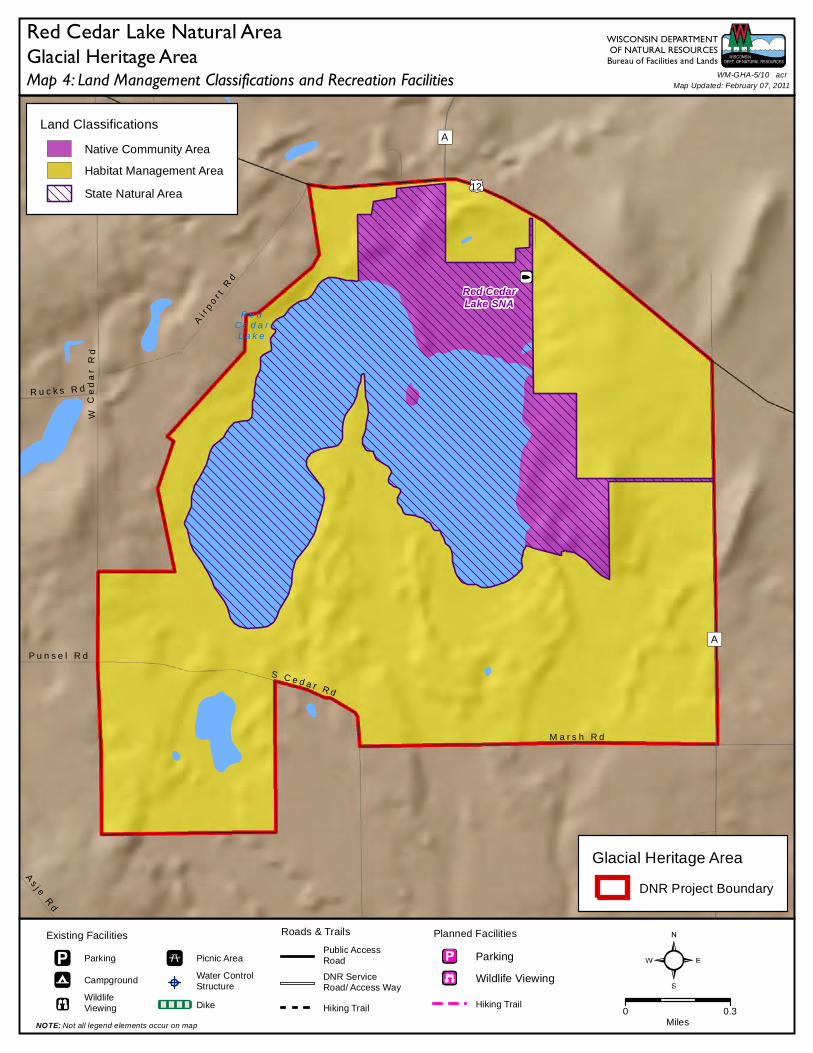
12
Red CedarLake SNA
R e dC e d a rL a k e
A
A
W C
ed
ar
Rd
S C e d a r R d
R u c k s R d
As
j e R
d
M a r s h R d
P u n s e l R d
Ai r
po
r t R
d
Land Classifications
Native Community Area
Habitat Management Area
State Natural Area
Roads & Trails
Public AccessRoad
DNR ServiceRoad/ Access Way
Hiking Trail 0 0.3Miles
Planned Facilities
Parking
Wildlife Viewing
Hiking Trail
Existing Facilities
Parking
Campground
WildlifeViewing
Picnic Area
Water ControlStructure
Dike
NOTE: Not all legend elements occur on map
Map 4: Land Management Classifications and Recreation FacilitiesGlacial Heritage Area
WISCONSIN DEPARTMENTOF NATURAL RESOURCES
Bureau of Facilities and Lands
Glacial Heritage Area
DNR Project Boundary
Red Cedar Lake Natural AreaWM-GHA-5/10 acr
Map Updated: February 07, 2011


51
12
18
51
12
18
14
106
138
184
109
134
106
16
26
73
20
89
26
16
59
67
89
60
73
67
19
99
59
89
60
151
94
90
94
43
94
Existing Land Ownership
Municipal
County
State(Non-DNR)
Federal
Non-profitConservation Organization
Dept of NaturalResources
State Natural Area
GLACIAL HERITAGE AREA
Linking Trails
Existing
Planned
Planned Protection Areas
DNR Wildlife,Park or NaturalArea
ConservationPark
RiverCorridor
Rural LandscapeProtection Area
Crawfish PrairieHabitat Area
WM-GHA-OVERVIEW acr
WISCONSIN DEPARTMENTOF NATURAL RESOURCESBureau of Facilities and Lands
Rock R.
Wild
Goo s
e Stat
e Tr ai
l
HOLZHUETERFARM PARK
GARMANPRESERVE
NORTHSHORE
MORAINEPARK
KORTHPARK
HOPE LAKE PARK
LAKE RIPLEYPRESERVE
LOWERKOSHKONONG
CREEK
OAKLANDHIGHLANDS
PARK
DOROTHYCARNES
PARK
COLDSPRING
PARK
CUSHMANMILL PARK
SCUPPERNONGVALLEY PARK
ALLEN CREEK
LOWER BARK RIVER
Waterloo-Mud Lake
WildlifeArea
DeansvilleWildlife Area
Goose LakeWildlife Area
LakeMills
WildlifeArea
Jefferson Marsh
Wildlife Area
Rome PondWildlife Area
Princes PointWildlife Area
KoshkonongWildlife Area
Storrs Lake- Lima Marsh Wildlife Area
Kettle MoraineState Forest--Southern Unit
Waterloo
Marshall Watertown
JohnsonCreek
Deerfield
Jefferson
Edgerton
Fort Atkinson
Sullivan
Lake Mills
Palmyra
Whitewater
Milton
Maunesha R.
Craw fish R.
Crawfish
R.
Beav
er D
am R
.
Lowell
Reeseville
Rock
R.
Kosh konong Ck.
LakeKoshkonong
Bark R.
RockLake
Rock R.
Rock
R.
Cambridge
Glacial Drumlin State Trail
Riley-DeppePark
Cam-Rock Park
Silverwood Park
BicentennialPark
Carlin WeldPark
Glacial
River T
rail
LangerFamilyPark
AztalanStatePark
Crawfish PrairieHabitat Area
DANE CO. JEFFERSON CO. WAUKESHA CO.
WALWORTH CO.ROCK CO.
DODGE CO.
RedCedar Lake
Map Updated: March 2011
0 2.5 5 Miles
Glacial Heritage AreaProject Area