gis solutions for surveying - · pdf filegis solutions for surveying building new...
TRANSCRIPT
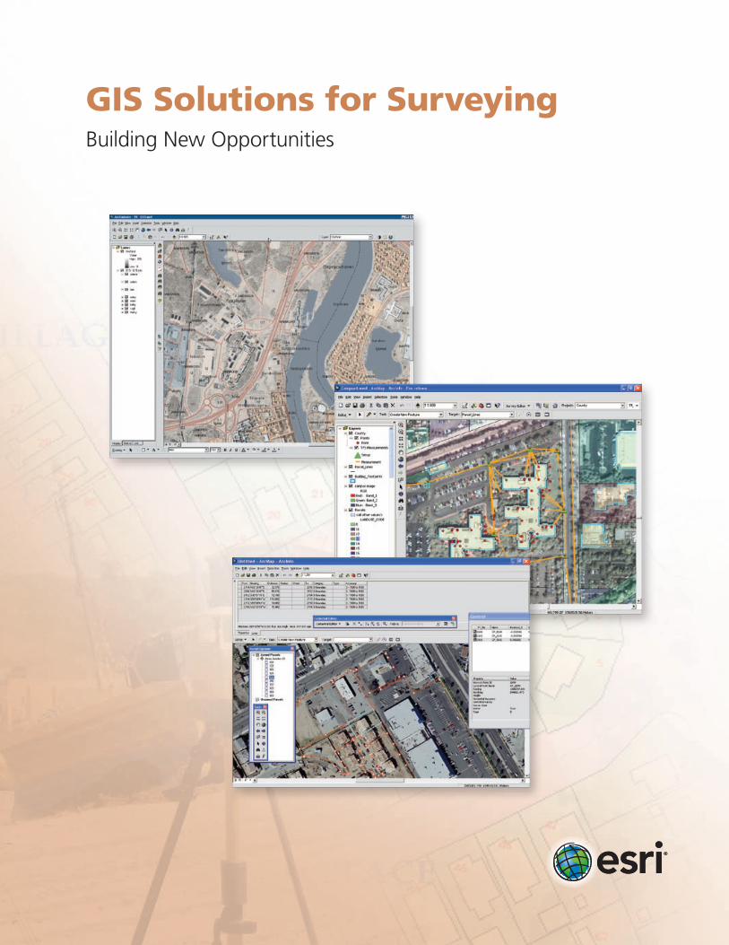
GIS Solutions for SurveyingBuilding New Opportunities

GIS Solutions for SurveyingBuilding New Opportunities
Surveyors depend on a variety of software and technology to gather existing information, collect new information, analyze data, produce plans, manage projects, and deliver accurate data. Geographic information system (GIS) technology brings this functionality and more to one place, providing a central location to conduct spatial analysis, overlay data, and integrate other solutions and systems. GIS is built on a database rather than individual project files, enabling surveyors to easily manage, reuse, share, and analyze data, saving them time.
Surveyors play a central role in a range of government agencies and private organizations, from planning and construction to engineering and land boundary determination. Esri® GIS software solutions are interoperable with the many data formats used in the field and office, allowing surveyors to provide data to various agencies in the required format while maintaining the data’s core integrity.
The ArcGIS® suite of software helps surveyors manage critical data by bringing their technologies together including everything from automated data collection with traditional instruments to the most modern GPS.
www.esri.com/surveying

Developing InfrastructureSurveying is a vital part of infrastructure development, from building roads and communication systems to establishing transportation networks and pipelines. A centralized information system based on Esri GIS software provides the framework for maintaining and deploying critical data and applications across every aspect of the infrastructure project including data collection, planning, construction, and operations management.
With Esri GIS, you can • Securelystoreandmanagevastamountsofspatial
information.
• Propagatedatachangesamongmultipledatasources.
• Ensuredataintegrity,consistency,andcredibility.
• Integratereal-timetrackingoffeaturesandevents.
• TieGISdatatonon-GISapplications.
• AllowthosewithoutGISknowledgetotakeadvantageofgeographic data.
This architecture provides the tools to assemble intelligent GIS applications and improve a project process by giving engineers, construction contractors, surveyors, and analysts a single data source from which to work. Centrally hosting applications and data makes it easy to manage, organize, and integrate geographic data, including CAD data, from existing databases to visualize, analyze, and make decisions. The system helps combat data communication errors, eliminating the need for multiple, flat files in disparate systems.
Data Collection Speci�c functions to collect precise site data used for predesign analysis, design, and calculations including �eld survey, topography, soils, subsurface geology, traf�c, lidar, photogrammetry, and other site-speci�c design-grade data.
Predesign Analysis Analysis to support design including hydrology analysis, volume calculations, soil load analysis, traf�c capacity, environmental impact, slope stability, materials consumption, runoff, erosion control, and air emissions.
DesignCreation of new infrastructure data for new civil works including grading, contouring, speci�cations, cross sections, design calculations, mass haul plans, environmental mitigation plans, and equipment staging.
Construction The mechanics and management for building new infrastructure including takeoffs; machine control; earth movement; intermediate construction, volume and material, and payment calculations; materials tracking; logistics; and traf�c management.
Data Collection As-Built Surveying Speci�c functions to collect precise site data used for payment and documenting existing conditions. Data collected in GIS formats can be seamlessly integrated into the operational GIS infrastructure without conversion.
Operations/Maintenance Including applications such as AM/FM; work order, outage, and asset management; vehicle routing; dispatch; maintenance; inventory tracking; SCADA; and logistics.
PlanningHigh-level planning functions for site location including environmental impact mitigation, economic analysis, regulatory permitting, alternative siting analysis, distance to utilities, and bene�t/cost alternatives analysis.
InfrastructureLife Cycle
GIS
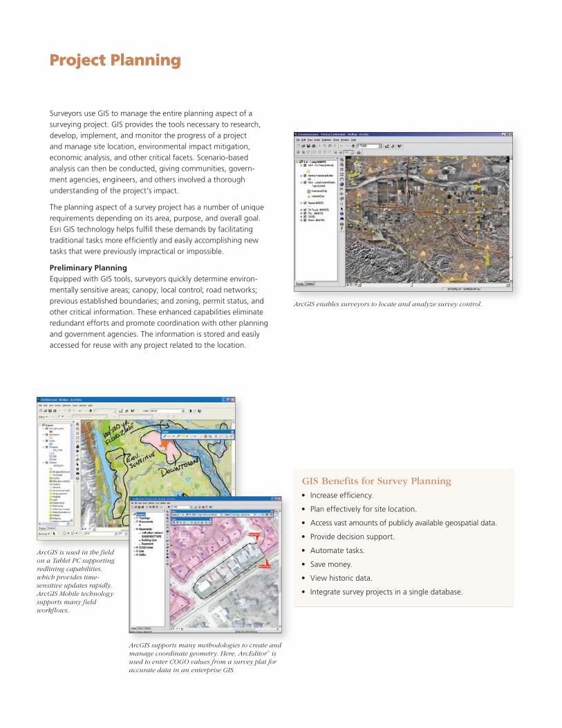
Surveyors use GIS to manage the entire planning aspect of a surveying project. GIS provides the tools necessary to research, develop, implement, and monitor the progress of a project and manage site location, environmental impact mitiga tion, economic analysis, and other critical facets. Scenariobased analysis can then be conducted, giving communities, government agencies, engineers, and others involved a thorough understanding of the project’s impact.
The planning aspect of a survey project has a number of unique requirements depending on its area, purpose, and overall goal. Esri GIS technology helps fulfill these demands by facilitating traditional tasks more efficiently and easily accomplishing new tasks that were previously impractical or impossible.
Preliminary PlanningEquipped with GIS tools, surveyors quickly determine environmentally sensitive areas; canopy; local control; road networks; previous established boundaries; and zoning, permit status, and other critical information. These enhanced capabili ties eliminate redundant efforts and promote coordination with other planning and government agencies. The information is stored and easily accessed for reuse with any project related to the location.
GIS Benefits for Survey Planning• Increaseefficiency.
• Planeffectivelyforsitelocation.
• Accessvastamountsofpubliclyavailablegeospatialdata.
• Providedecisionsupport.
• Automatetasks.
• Savemoney.
• Viewhistoricdata.
• Integratesurveyprojectsinasingledatabase.
ArcGIS supports many methodologies to create and manage coordinate geometry. Here, ArcEditor™ is used to enter COGO values from a survey plat for accurate data in an enterprise GIS.
ArcGIS is used in the field on a Tablet PC supporting redlining capabilities, which provides time-sensitive updates rapidly. ArcGIS Mobile technology supports many field workflows.
Project Planning
ArcGIS enables surveyors to locate and analyze survey control.
GIS Benefits for Survey Planning• Increaseefficiency.
• Planeffectivelyforsitelocation.
• Accessvastamountsofpubliclyavailablegeospatialdata.
• Providedecisionsupport.
• Automatetasks.
• Savemoney.
• Viewhistoricdata.
• Integratesurveyprojectsinasingledatabase.
Project Planning
Esri’s GIS software adds intelligence to spatial data, whether the data is generated in the field with GPS or remotely with lidar and photogrammetry. Surveyors enter raw data, measurements, and field sketches directly into the GIS, enabling them to efficiently manage their data in a central repository (personal geodatabase) with other spatial information, streamlining workflows and improving productivity.
Surveyors use GIS software and technology for collecting, importing, converting, and storing spatial measurement and computational fabrics for agencies and private businesses of any size. They integrate computations (COGO, traverse least squares, etc.) and preexisting networks as well as import spatial data feature classes and relationships.
Field Measurement Surveyors rely on a range of data collection devices in the field, from total station angle measurements to highresolution 3D lidar point clouds. With Esri’s ArcGIS software, surveyors not only bring data straight from the field into a geodatabase in a seamless workflow, but they also take GIS data back into the field via a Windows® CE device, data collector, or laptop computer. The software is customized to best meet the company’s or surveyor’s needs by optimizing functionality needed to complete a job or by developing custom field solutions.
Using ArcGIS for data collection enables surveyors to• View,edit,andanalyzesurveydata.
• Storedatainacentralizedenvironment.
• Useproject-collecteddatatobuildaninformationsystem.
• Collectandtransfer/transmitfeaturedatadirectlyfromthe field into the geodatabase.
• Improveefficiencybycompletingmoreworkflowstepsinside the GIS.
• ComputeLSA,GPSdifferentialcorrections,andCOGOcorrections.
• Createandstoreimportantdetaileddescriptioncodesinthe geodatabase.
• Customizeworkflowsand/ordatacollectionprocessestosuit individual needs and requirements.
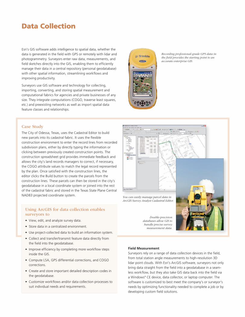
Recording professional-grade GPS data in the field provides the starting point to an accurate enterprise GIS.
Double-precision databases allow GIS to handle precise survey
measurement data.
Data Collection
You can easily manage parcel data in ArcGIS Survey Analyst Cadastral Editor.
Case StudyThe City of Odessa, Texas, uses the Cadastral Editor to build new parcels into its cadastral fabric. It uses the flexible construction environment to enter the record lines from recorded subdivision plans, either by directly typing the information or clicking between previously created construction points. The construction spreadsheet grid provides immediate feedback and allows the city's land records managers to correct, if necessary, the COGO attribute values to match the legal record represented by the plan. Once satisfied with the construction lines, the editor clicks the Build button to create the parcels from the construction lines. These parcels can then be stored in the city’s geodatabase in a local coordinate system or joined into the rest of the cadastral fabric and stored in the Texas State Plane Central NAD83 projected coordinate system.
Using ArcGIS for data collection enables surveyors to• View,edit,andanalyzesurveydata.
• Storedatainacentralizedenvironment.
• Useproject-collecteddatatobuildaninformationsystem.
• Collectandtransfer/transmitfeaturedatadirectlyfromthe field into the geodatabase.
• Improveefficiencybycompletingmoreworkflowstepsinside the GIS.
• ComputeLSA,GPSdifferentialcorrections,andCOGOcorrections.
• Createandstoreimportantdetaileddescriptioncodesinthe geodatabase.
• Customizeworkflowsand/ordatacollectionprocessestosuit individual needs and requirements.
Data Collection
Site investigation is critical to planning new projects. Surface and subsurface conditions influence survey methods, which affect project cost and scheduling. Surveyors rely on the ArcGIS geodatabase to store, input, and query descriptive soil and geotechnical data and relate it to other predesign engineering information.Usingsearchbyeliminationconcepts,ArcGIShelpsdevelop a heuristic approach to model the process of decision making and generate the potential sites for temporary facilities. The software’s tools help solve construction layout problems and open a new way of thinking for managing spatial information. ArcGIS takes data that originates from many different sources and file formats and integrates it into a single application platform to support unique civil engineering workflows. Data can be created easily, intuitively, and correctly the first time in both 2D and 3D environments.
Civil engineers use GIS to keep track of multiple urban and regional indicators, forecast future community needs, and plan accordingly to guarantee quality of life for everyone in livable communities. Federal, regional, state, county, and local planning agencies have realized the power of enterprise GIS to identify problems, respond to them efficiently, and share the results with the public. Esri GIS solutions provide tools to help them reach their agency missions while doing more and spending less.
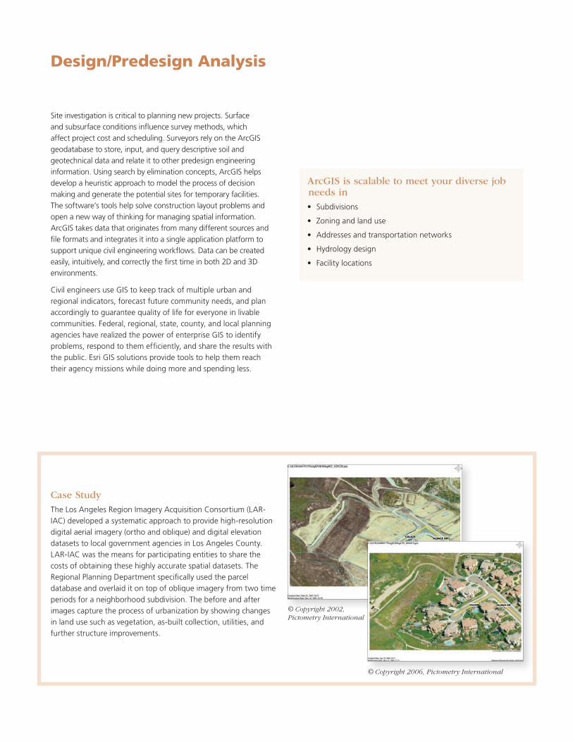
Case StudyTheLosAngelesRegionImageryAcquisitionConsortium(LAR-IAC) developed a systematic approach to provide highresolution digital aerial imagery (ortho and oblique) and digital elevation datasetstolocalgovernmentagenciesinLosAngelesCounty.LAR-IACwasthemeansforparticipatingentitiestosharethecosts of obtaining these highly accurate spatial datasets. The RegionalPlanningDepartmentspecificallyusedtheparceldatabase and overlaid it on top of oblique imagery from two time periods for a neighborhood subdivision. The before and after images capture the process of urbanization by showing changes in land use such as vegetation, asbuilt collection, utilities, and further structure improvements.
Design/Predesign Analysis
ArcGIS is scalable to meet your diverse job needs in • Subdivisions
• Zoningandlanduse
• Addressesandtransportationnetworks
• Hydrologydesign
• Facilitylocations
© Copyright 2002, Pictometry International
© Copyright 2006, Pictometry International
Construction projects involve complex plans; environmental permits; and critical data that details layout, specifications, and other key design information. For a project to be successful, several aspects must be analyzed and considered including environmental impact, scheduling conflicts, takeoffs, budgeting, site safety, and logistics. GIS technology improves the mechanics and management for building new infrastructure by integrating design and site data, interfacing with machine control, and providing the framework for asbuilt data collection. All those involved in a project, such as engineers, owners, contractors, and the public, rely on the technology to open communication.
As-Built SurveyingA completed construction project rarely reflects its original plan exactly; instead, variations occur, requiring a revised design plan. GIS technology provides the tools to collect precise site data and document existing conditions. With asbuilt surveying infrastructure data, operators use defined operational industrystandard data models. Asbuilt surveying with GIS technology permits the surveyor to deliver data into operational GIS, eliminating costly data conversion and reducing errors.
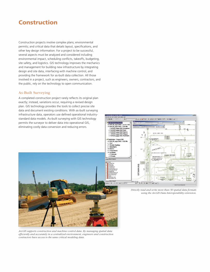
ArcGIS supports construction and machine control data. By managing spatial data efficiently and accurately in a centralized environment, engineers and construction contractors have access to the same critical modeling data.
Construction
Directly read and write more than 50 spatial data formats using the ArcGIS Data Interoperability extension.
Landdevelopmentinvolvesseveralareastoconsiderincludingsite geometrics, roadways, drainage systems, utilities, property boundaries, and building sites. Esri GIS software gives surveyors the tools to capture and create new data with advanced mobile capabilities that vastly improve field data collection, inventories, and integration with GPS measurements. Access to fast, accurate field data is critical, as a cadastre loses its value if registers and maps are not constantly updated. GIS solutions store data in a central location, giving surveyors the capability to quickly and easily make any necessary changes.
Land AnalysisArcGIS software products greatly enhance the optimum use of land, functional efficiency of a proposed design and its marketability, and overall costeffectiveness of a project. GIS can be used for terrain, hydrological, landuse suitability, and visibility analyses. It can also be used to assess environmental impacts for determining the consequences of various regulatory requirements.
Specialized MappingArcGIS software, coupled with specialized applications designed specifically for land developers, is used to perform
• Cadastralmapping
• Surveying
• Contouring
• Traverseadjustments
• Stakeout
• Roaddesign
• Earthwork
• Sitedesign
• Drafting
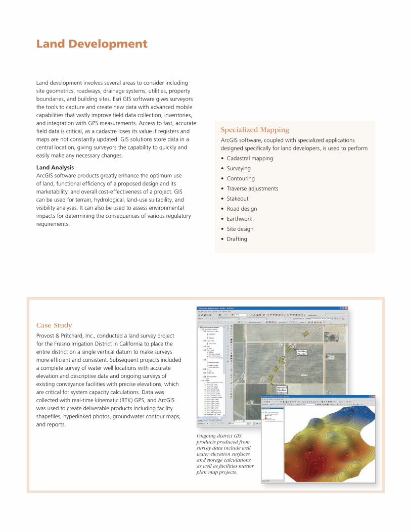
Case StudyProvost & Pritchard, Inc., conducted a land survey project for the Fresno Irrigation District in California to place the entire district on a single vertical datum to make surveys more efficient and consistent. Subsequent projects included a complete survey of water well locations with accurate elevation and descriptive data and ongoing surveys of existing conveyance facilities with precise elevations, which are critical for system capacity calculations. Data was collectedwithreal-timekinematic(RTK)GPS,andArcGISwas used to create deliverable products including facility shapefiles, hyperlinked photos, groundwater contour maps, and reports.
Land Development
Ongoing district GIS products produced from survey data include well water elevation surfaces and storage calculations as well as facilities master plan map projects.

The credibility of a surveyor’s data is one of the most critical aspects of any survey. ArcGIS facilitates a seamless flow of information among planners, CAD designers, engineering modelers, and project managers and extends project data and applications to operations and facility managers, field technicians, consultants, and the public. All ArcGIS products support key data interchange formats and Web services standards for ensuring relevant GIS and information technology (IT) interoperability between systems over wired and wireless networks. An interoperable information system with tightly integrated data management and an unparalleled collaborative environment continues to distinguish the ArcGIS software family from other software. Project managers can deploy this functionality and business logic wherever it is needed—desktops, servers, custom applications, Web services, or mobile devices.
Surveyors using GIS to manage and store individual projects will build a survey information system with time. Instead of storing surveys in isolated, individual files, GIS allows surveyors to store all survey data in one database, providing easy access to past work that can be efficiently reused and overlaid with new data.
Computer-Aided DesignCAD interoperability is an important part of Esri’s software solutions. Existing datasets on state GIS Web sites and flat CAD files are integrated and managed from a central location, eliminating duplicate datasets and providing the platform for all spatial data functionality.
Esri provides two solutions for CAD interoperability. CAD direct read involves accessing CAD data without any conversion. This workflow is similar to accessing a geodatabase or shapefile. Bidirectional translation involves the conversion of CAD data to a GIS data format and vice versa. This enables organizations to incorporate CAD data into an existing GIS and deliver spatial information in a CAD format. Both of these CAD interoperability tools are available through ArcGIS.
Case StudyTheCityofRoseville,California,maintainsmorethan130layersin an enterprise ArcSDE® geodatabase and manages the data in ArcGIS. City staff developed and implemented a custom ArcGIS application that combines CAD integration, data maintenance, and validation and imports GIS data into the enterprise ArcSDE database. The application simplifies the processes for parcel and street data conversion and maintenance, enables better data workflow management, and improves CADGIS interoperability. The results are immediate, and longterm benefits include staff time and cost savings, streamlined workflow, improved data quality, and quicker data availability for the city’s public safety departments.
Survey Data Management
A surveyor’s information system based on Esri’s ArcGIS Server improves efficiency and productivity to improve communication. The system uses GIS to connect all divisions in an organization’s departments from surveying and mapping to accounting, which streamlines workflows, asset management, operations, and planning.
UsingGISthroughouttheorganizationallowsallsectionstoshare and easily access geographic data. This information system promotes data integrity and facilitates better communication and decision making throughout the enterprise.
A surveyor’s information system supports• Decisionmaking
• Businesssystems
• Returnoninvestment
• Internalandexternaldatabaseintegrationincluding CAD data
• Dataaccuracy,accessibility,andintegrity
• Efficientuseofpastprojectdata
• Accumulatingsurveydatainadatabase
Facility Management
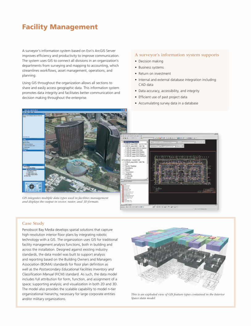
GIS integrates multiple data types used in facilities management and displays the output in vector, raster, and 3D formats.
This is an exploded view of GIS feature types contained in the Interior Space data model.
Case StudyPenobscot Bay Media develops spatial solutions that capture highresolution interior floor plans by integrating robotic technology with a GIS. The organization uses GIS for traditional facility management analysis functions, both in building and across the installation. Designed against existing industry standards, the data model was built to support analysis and reporting based on the Building Owners and Managers Association (BOMA) standards for floor plan definition as well as the Postsecondary Educational Facilities Inventory and Classification Manual (FICM) standard. As such, the data model includes full attribution for form, function, and assignment of a space; supporting analysis; and visualization in both 2D and 3D. The model also provides the scalable capability to model ntier organizational hierarchy, necessary for large corporate entities and/ormilitaryorganizations.
Every day, surveyors depend on an array of technology to meet their dynamic needs from data collection to business management. GIS provides the tools to link all components of a project together, providing a foundation to share with the agencies and departments that rely on survey data to complete their own tasks. The unique capabilities of the software create the flexible, analytic environment necessary to turn geographic data into spatial information that drives development and ensures an enhanced understanding of the world around us.
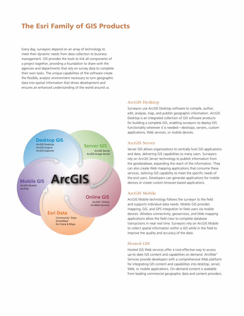
The Esri Family of GIS Products
ArcGIS DesktopSurveyors use ArcGIS Desktop software to compile, author, edit, analyze, map, and publish geographic information. ArcGIS Desktop is an integrated collection of GIS software products for building a complete GIS, enabling surveyors to deploy GIS functionality wherever it is needed—desktops, servers, custom applications, Web services, or mobile devices.
ArcGIS Server Server GIS allows organizations to centrally host GIS applications and data, delivering GIS capabilities to many users. Surveyors rely on ArcGIS Server technology to publish information from the geodatabase, expanding the reach of the information. They can also create Web mapping applications that consume these services, tailoring GIS capability to meet the specific needs of the end users. Developers can generate applications for mobile devices or create custom browserbased applications.
ArcGIS MobileArcGIS Mobile technology follows the surveyor to the field and supports individual data needs. Mobile GIS provides mapping, GIS, and GPS integration to field users via mobile devices. Wireless connectivity, geoservices, and Web mapping applications allow the field crew to complete database transactions in near real time. Surveyors rely on ArcGIS Mobile to collect spatial information within a GIS while in the field to improve the quality and accuracy of the data.
Hosted GIS HostedGISWebservicesofferacost-effectivewaytoaccessuptodate GIS content and capabilities on demand. ArcWeb SM Services provide developers with a comprehensive Web platform for integrating GIS content and capabilities into desktop, server, Web, or mobile applications. Ondemand content is available from leading commercial geographic data and content providers.
ArcGIS
Desktop GISServer GIS
Online GIS
Esri Data
Mobile GIS
ArcGIS ServerArcGIS Image Server
ArcGISSM OnlineArcWeb Services
CommunityTM DataStreetMapTM
Esri Data & Maps
ArcGIS MobileArcPad®
ArcGIS DesktopArcGIS EngineArcGIS Explorer

PrintedinUSA
About Esri
Since1969,Esrihasbeenhelping
organizations map and model our
world. Esri’s GIS software tools
and methodologies enable these
organizations to effectively analyze
and manage their geographic
information and make better
decisions. They are supported by our
experienced and knowledgeable staff
and extensive network of business
partners and international distributors.
A fullservice GIS company, Esri
supports the implementation of GIS
technology on desktops, servers,
online services, and mobile devices.
These GIS solutions are flexible,
customizable, and easy to use.
Our Focus
Esri software is used by hundreds
of thousands of organizations that
apply GIS to solve problems and
make our world a better place to
live. We pay close attention to our
users to ensure they have the best
tools possible to accomplish their
missions. A comprehensive suite of
training options offered worldwide
helps our users fully leverage their
GIS applications.
Esri is a socially conscious business,
actively supporting organizations
involved in education, conservation,
sustainable development, and
humanitarian affairs.
Contact Esri
1-800-GIS-XPRT(1-800-447-9778)
Phone:909-793-2853
Fax:909-793-5953
www.esri.com
Offices worldwide
www.esri.com/locations
Copyright©2007,2009,2010Esri.Allrightsreserved.Esri,theEsriglobelogo,ArcGIS,ArcWeb,ArcMap,ArcInfo,ArcEditor,ArcView,ArcScene,Community,StreetMap,ArcPad,ArcToolbox,3DAnalyst,ArcSDE,@esri.com,andwww.esri.comaretrademarks,registeredtrademarks,orservicemarksofEsriintheUnitedStates,theEuropeanCommunity,orcertainother jurisdictions. Other companies and products mentioned herein may be trademarks or registered trademarks of their respective trademark owners.
103127DUAL1M8/10dh/sp
380NewYorkStreet
Redlands,CA92373-8100USA