gis och positionering - högskolan...
TRANSCRIPT
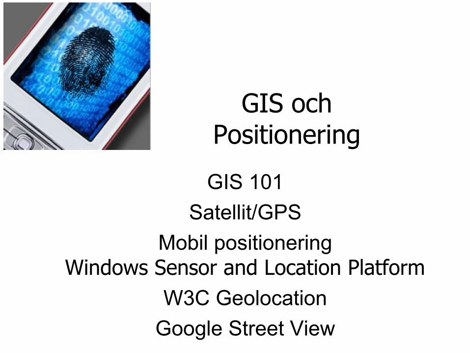
GIS ochPositionering
GIS 101
Satellit/GPS
Mobil positioneringWindows Sensor and Location Platform
W3C Geolocation
Google Street View
General GIS Concepts 1• What is GIS?
– Geographic Information System offer a dynamic digital environment for visualizing and analyzing geographic information
– A GIS is constituted by the interaction between tabular and spatial data, where the tables contain information related to map features
– For this reason, one often speak of Relational Databases when discussing GIS
• When to use it?– To find spatial data
– To analyze data using geospatial methods
– To map information
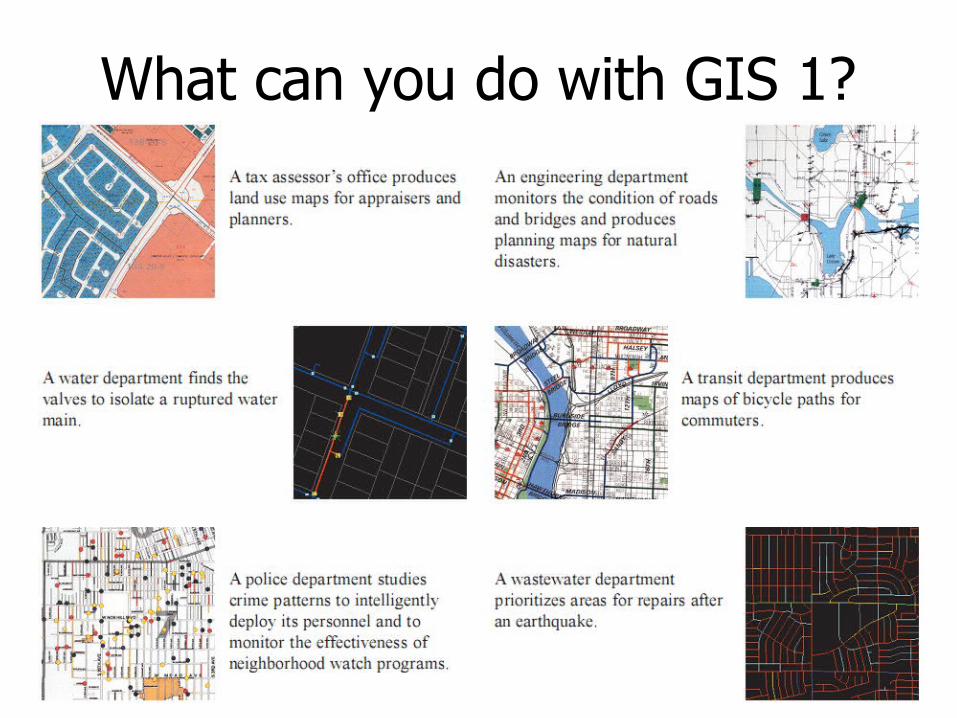
What can you do with GIS 1?
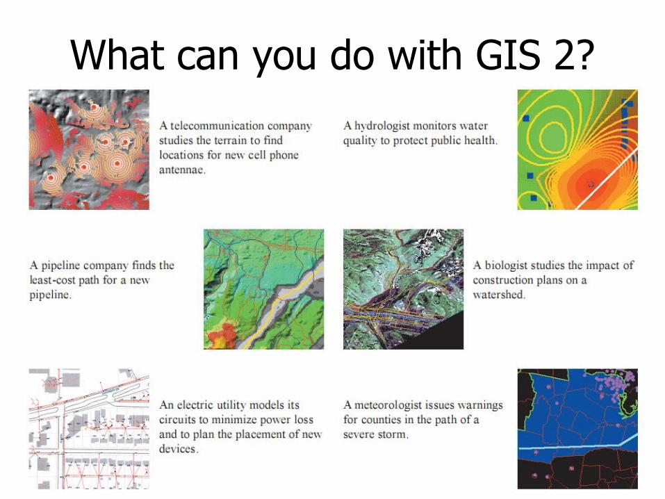
What can you do with GIS 2?
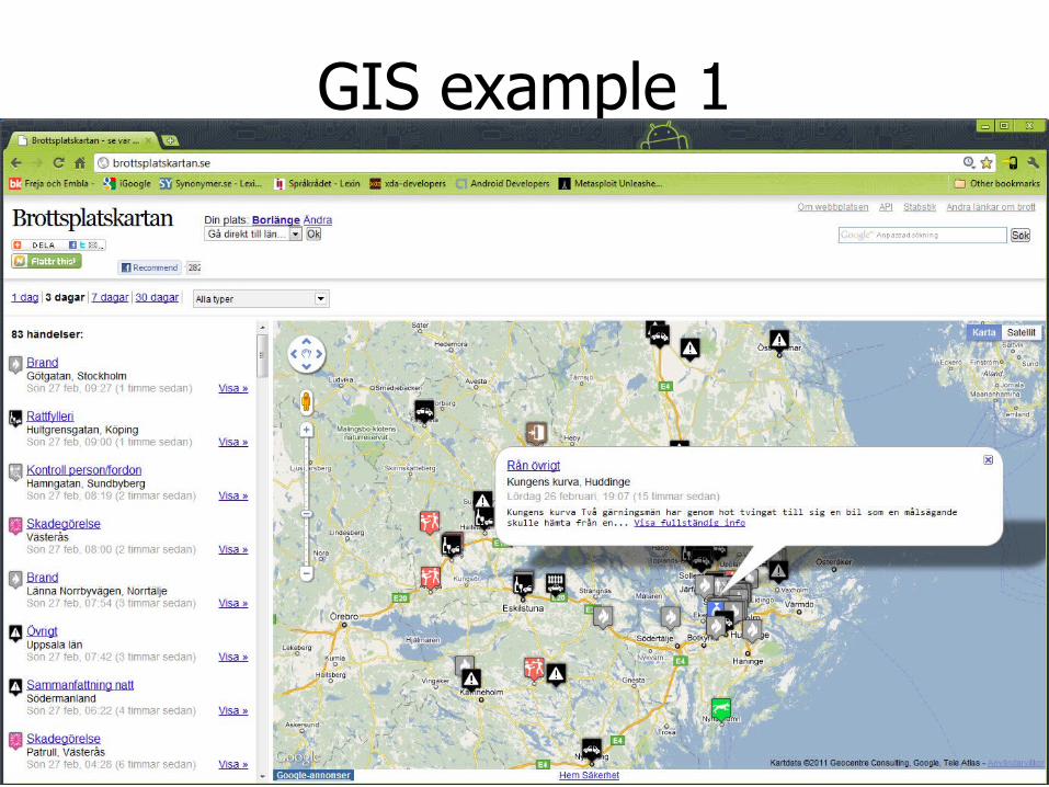
GIS example 1
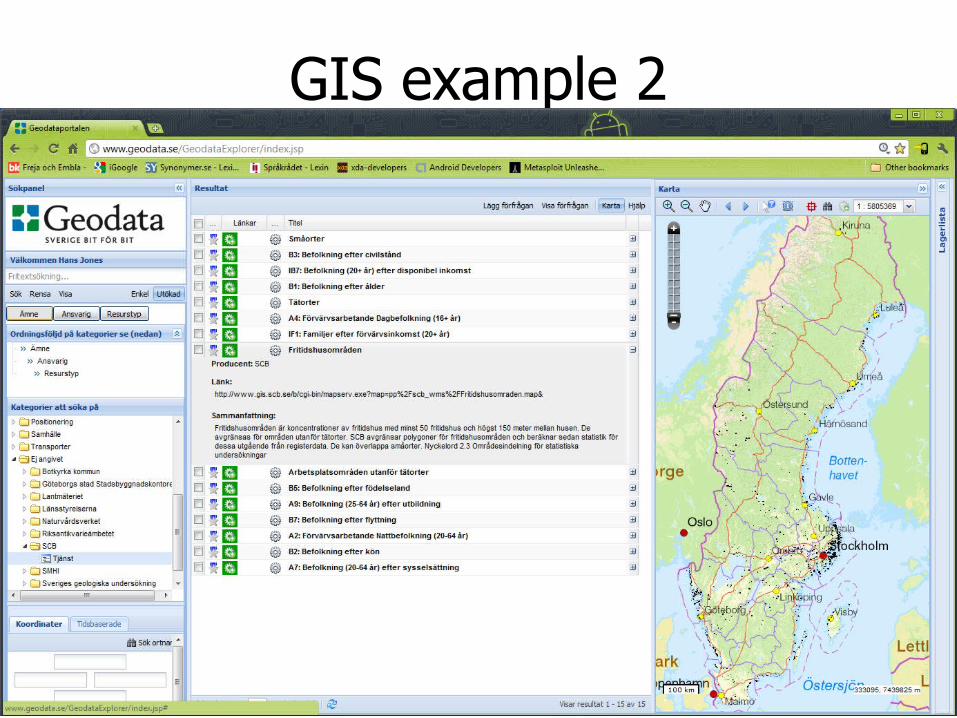
GIS example 2
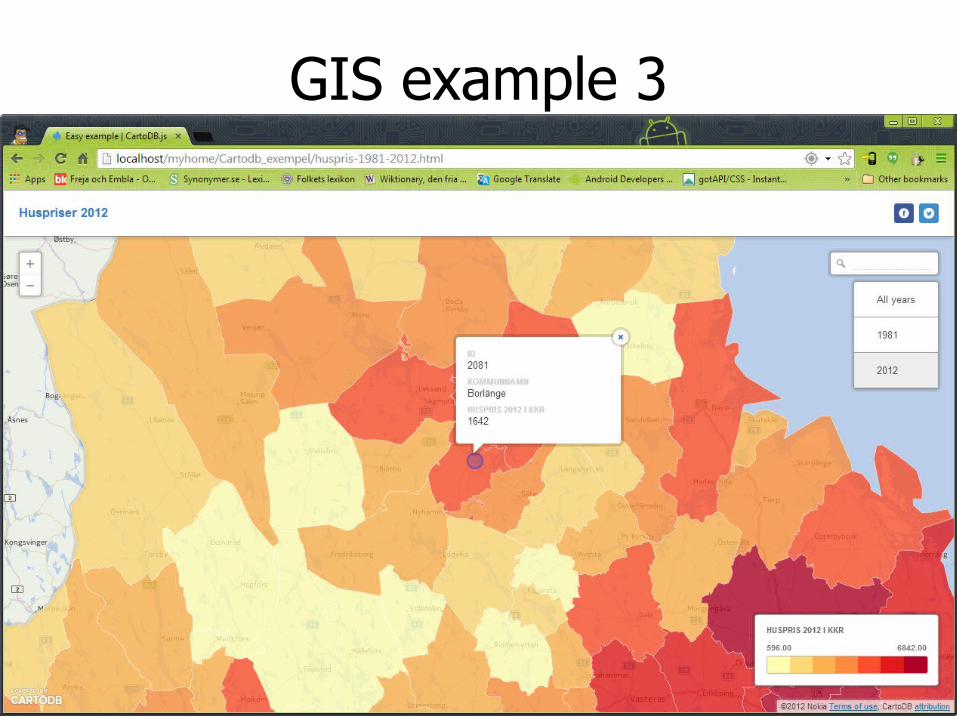
GIS example 3
General GIS Concepts 2• Tabular Data
– Tabular data consists of attribute tables that define the parameters of the map features
– There is really no limit to what the tables can contain, whether boolean values, text, or numeric data
• A text entry may have the city's name, or some other description etc.
• A numeric entry could have population figures, lat/long coordinates or date time
– The advantage of the relational database system is that the different columns can be sorted and selected according to the user's need
• These selections then appear highlighted on the map
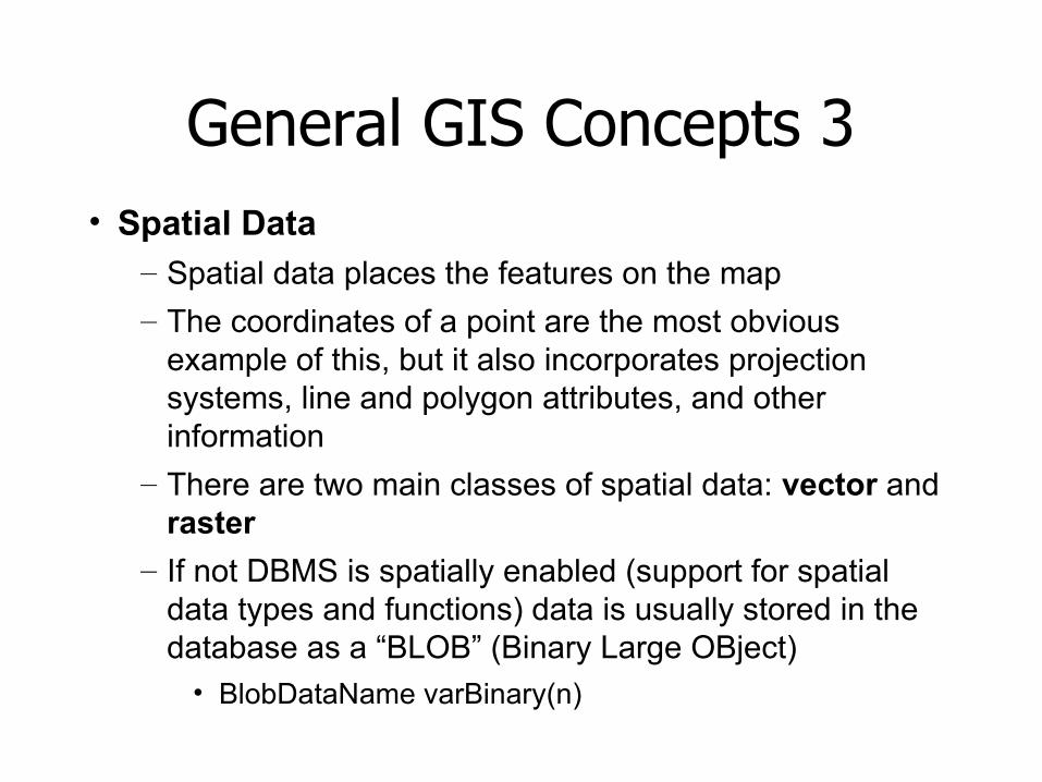
General GIS Concepts 3• Spatial Data
– Spatial data places the features on the map
– The coordinates of a point are the most obvious example of this, but it also incorporates projection systems, line and polygon attributes, and other information
– There are two main classes of spatial data: vector and raster
– If not DBMS is spatially enabled (support for spatial data types and functions) data is usually stored in the database as a “BLOB” (Binary Large OBject)
• BlobDataName varBinary(n)
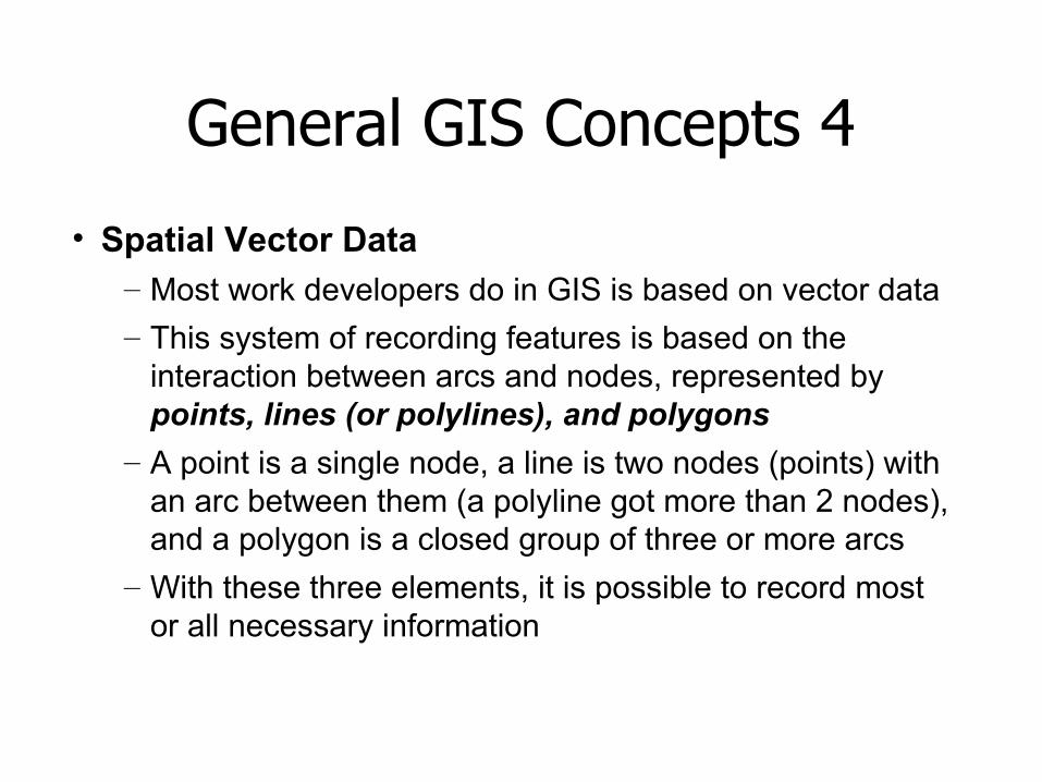
General GIS Concepts 4
• Spatial Vector Data – Most work developers do in GIS is based on vector data
– This system of recording features is based on the interaction between arcs and nodes, represented by points, lines (or polylines), and polygons
– A point is a single node, a line is two nodes (points) with an arc between them (a polyline got more than 2 nodes), and a polygon is a closed group of three or more arcs
– With these three elements, it is possible to record most or all necessary information
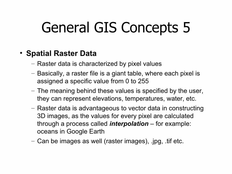
General GIS Concepts 5
• Spatial Raster Data – Raster data is characterized by pixel values
– Basically, a raster file is a giant table, where each pixel is assigned a specific value from 0 to 255
– The meaning behind these values is specified by the user, they can represent elevations, temperatures, water, etc.
– Raster data is advantageous to vector data in constructing 3D images, as the values for every pixel are calculated through a process called interpolation – for example: oceans in Google Earth
– Can be images as well (raster images), .jpg, .tif etc.
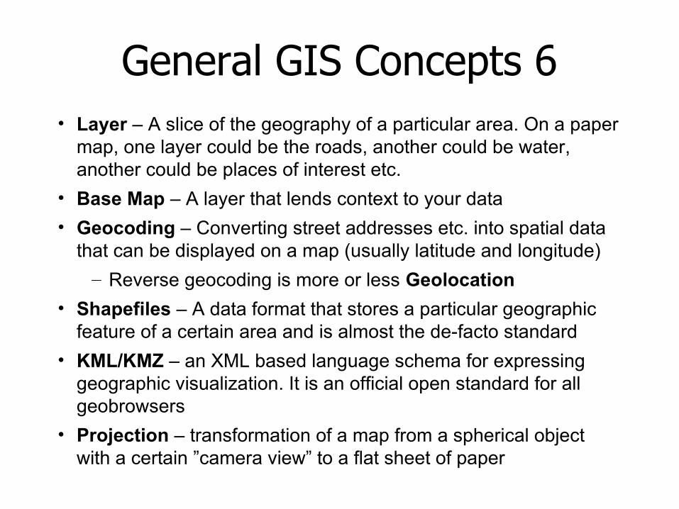
General GIS Concepts 6• Layer – A slice of the geography of a particular area. On a paper
map, one layer could be the roads, another could be water, another could be places of interest etc.
• Base Map – A layer that lends context to your data
• Geocoding – Converting street addresses etc. into spatial data that can be displayed on a map (usually latitude and longitude)
– Reverse geocoding is more or less Geolocation
• Shapefiles – A data format that stores a particular geographic feature of a certain area and is almost the de-facto standard
• KML/KMZ – an XML based language schema for expressing geographic visualization. It is an official open standard for all geobrowsers
• Projection – transformation of a map from a spherical object with a certain ”camera view” to a flat sheet of paper
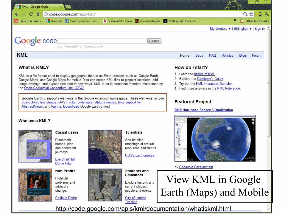
View KML in Google Earth (Maps) and Mobile
http://code.google.com/apis/kml/documentation/whatiskml.html
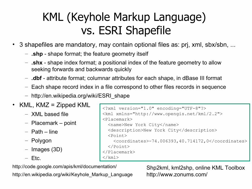
KML (Keyhole Markup Language) vs. ESRI Shapefile
• 3 shapefiles are mandatory, may contain optional files as: prj, xml, sbx/sbn, ...– .shp - shape format; the feature geometry itself
– .shx - shape index format; a positional index of the feature geometry to allow seeking forwards and backwards quickly
– .dbf - attribute format; columnar attributes for each shape, in dBase III format
– Each shape record index in a file correspond to other files records in sequence
– http://en.wikipedia.org/wiki/ESRI_shape
• KML, KMZ = Zipped KML– XML based file
– Placemark – point
– Path – line
– Polygon
– Images (3D)
– Etc.
http://code.google.com/apis/kml/documentation/
http://en.wikipedia.org/wiki/Keyhole_Markup_Language
<?xml version="1.0" encoding="UTF-8"?><kml xmlns="http://www.opengis.net/kml/2.2"><Placemark> <name>New York City</name> <description>New York City</description> <Point> <coordinates>-74.006393,40.714172,0</coordinates> </Point></Placemark></kml>
Shp2kml, kml2shp, online KML Toolboxhttp://www.zonums.com/
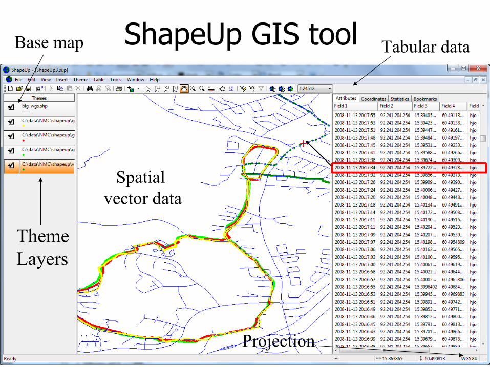
ShapeUp GIS tool
ThemeLayers
Tabular data
Spatial vector data
Projection
Base map
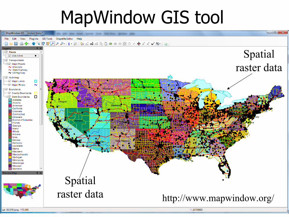
MapWindow GIS tool
Spatialraster data http://www.mapwindow.org/
Spatialraster data
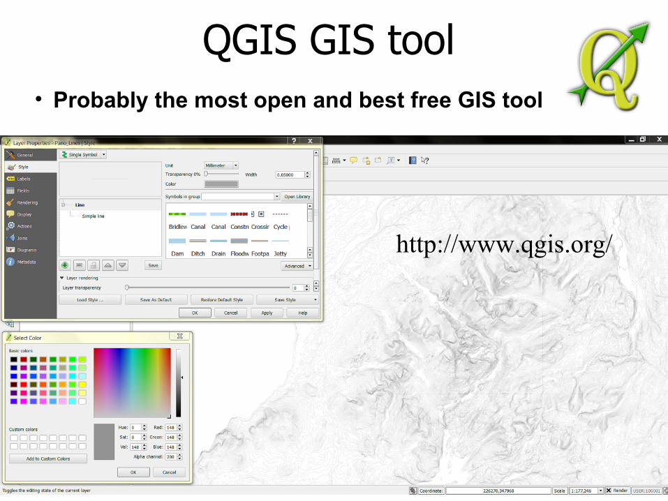
QGIS GIS tool
http://www.qgis.org/
• Probably the most open and best free GIS tool
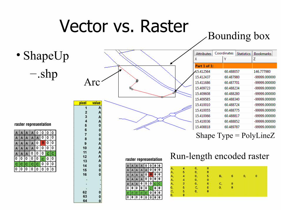
Vector vs. Raster
Run-length encoded raster
Arc
Bounding box
Shape Type = PolyLineZ
• ShapeUp
–.shp
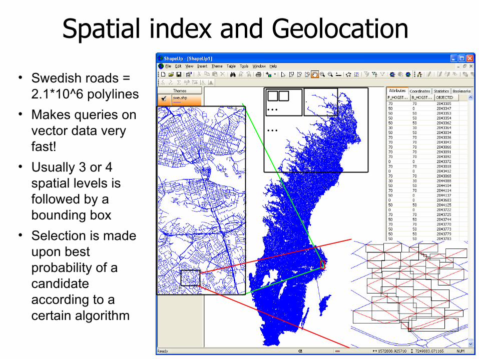
Spatial index and Geolocation
...
...
• Swedish roads = 2.1*10^6 polylines
• Makes queries on vector data very fast!
• Usually 3 or 4 spatial levels is followed by a bounding box
• Selection is made upon best probability of a candidate according to a certain algorithm
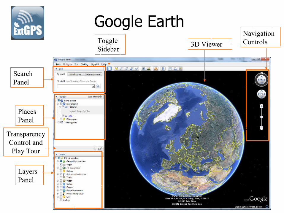
Navigation Controls3D Viewer
Search Panel
Layers Panel
PlacesPanel
Toggle Sidebar
Google Earth
Transparency Control andPlay Tour
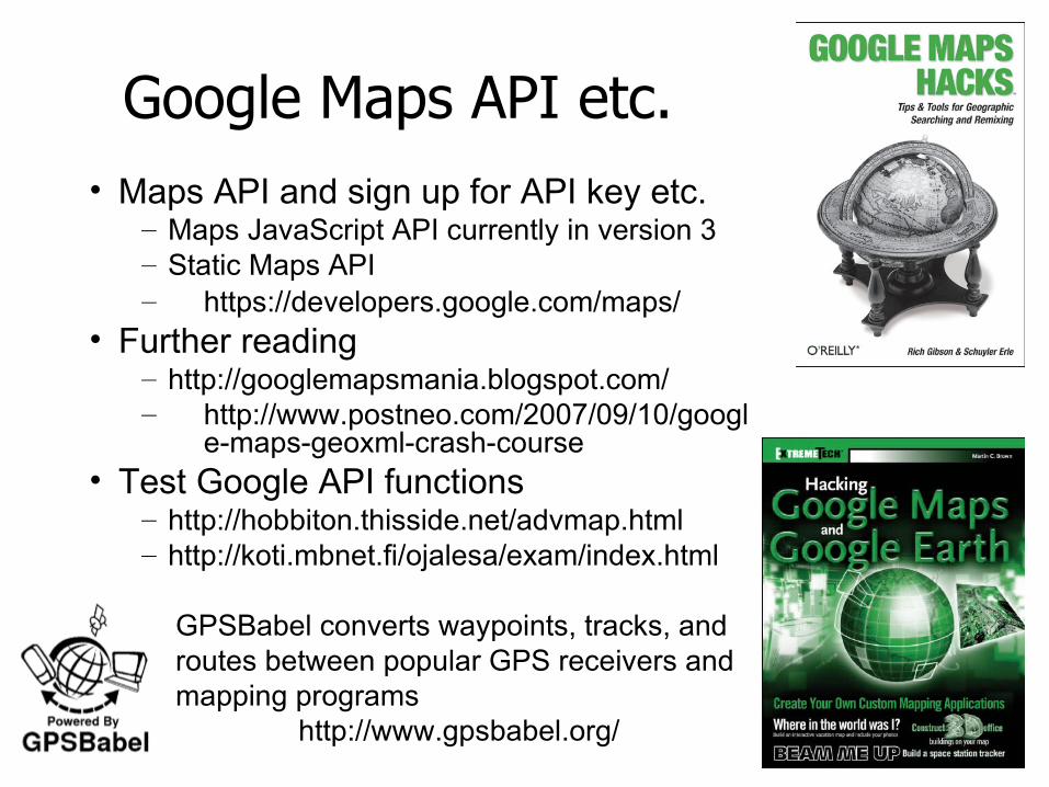
Google Maps API etc.• Maps API and sign up for API key etc.
– Maps JavaScript API currently in version 3– Static Maps API– https://developers.google.com/maps/
• Further reading– http://googlemapsmania.blogspot.com/– http://www.postneo.com/2007/09/10/googl
e-maps-geoxml-crash-course• Test Google API functions
– http://hobbiton.thisside.net/advmap.html– http://koti.mbnet.fi/ojalesa/exam/index.html
GPSBabel converts waypoints, tracks, and routes between popular GPS receivers and mapping programs
http://www.gpsbabel.org/
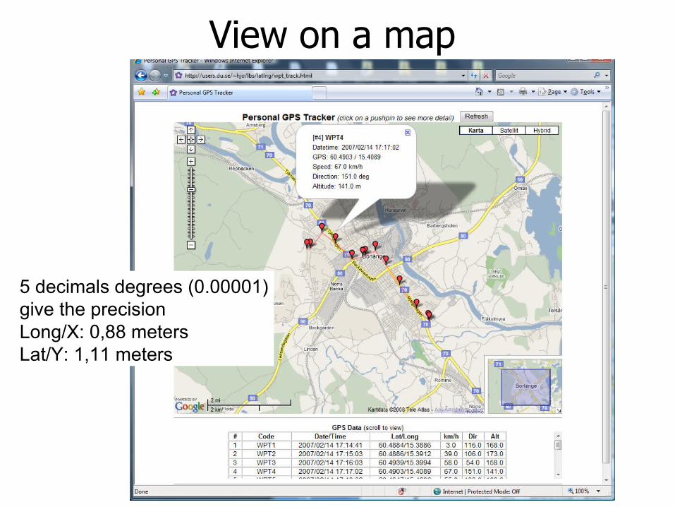
View on a map
5 decimals degrees (0.00001) give the precisionLong/X: 0,88 metersLat/Y: 1,11 meters
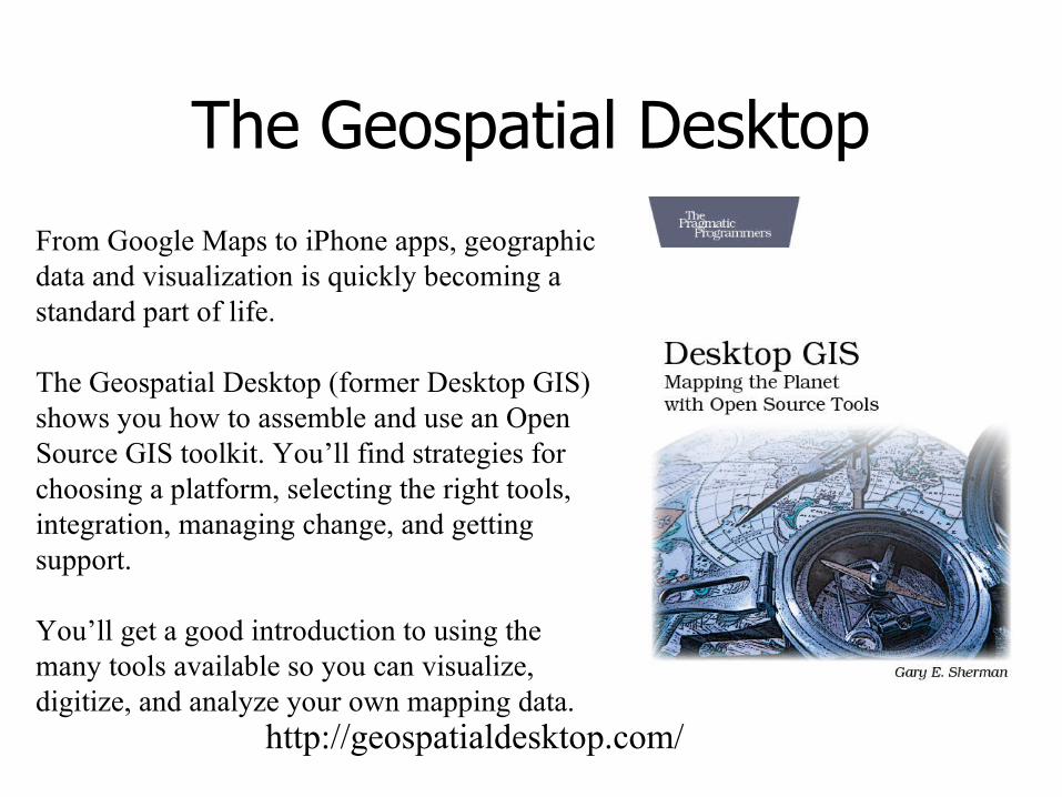
The Geospatial Desktop
From Google Maps to iPhone apps, geographic data and visualization is quickly becoming a standard part of life.
The Geospatial Desktop (former Desktop GIS) shows you how to assemble and use an Open Source GIS toolkit. You’ll find strategies for choosing a platform, selecting the right tools, integration, managing change, and getting support.
You’ll get a good introduction to using the many tools available so you can visualize, digitize, and analyze your own mapping data.
http://geospatialdesktop.com/
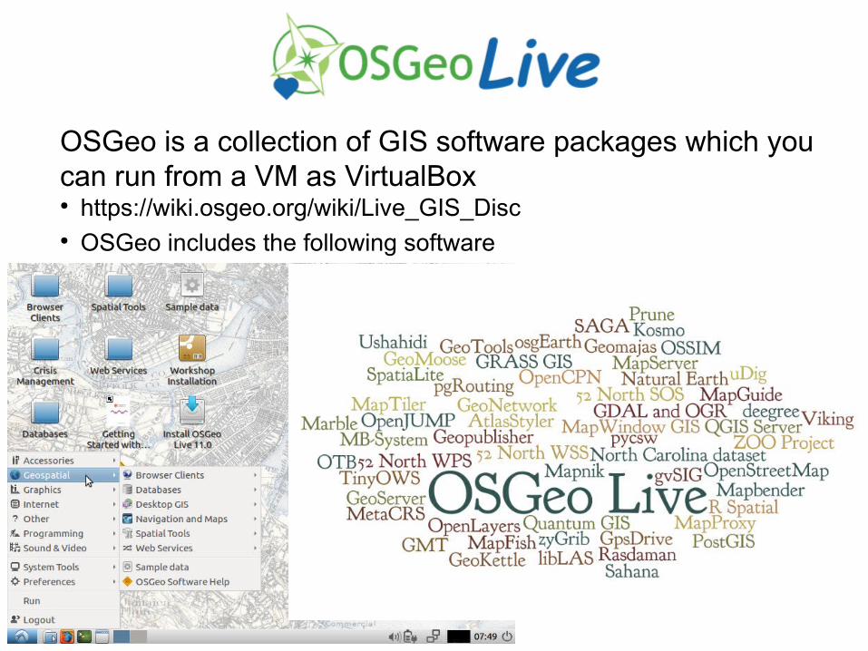
OSGeo is a collection of GIS software packages which you can run from a VM as VirtualBox● https://wiki.osgeo.org/wiki/Live_GIS_Disc● OSGeo includes the following software
- MapServer
- OpenLayers
- uDig
- OpenJUMP PIROL
- PostgreSQL
- PostGIS
- Grass
- ...
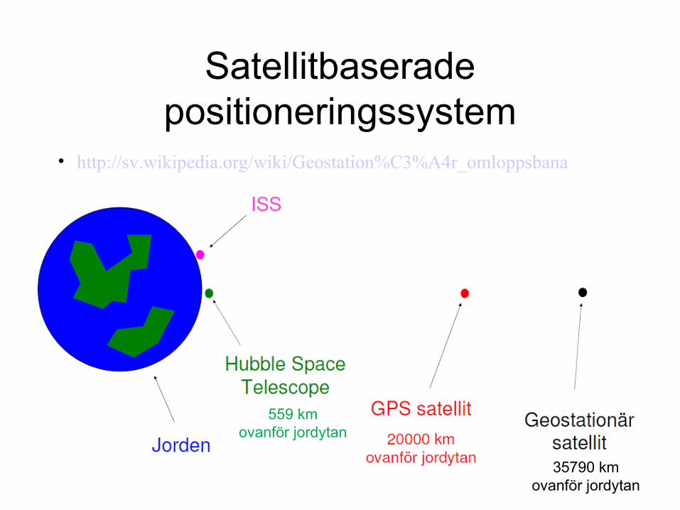
Satellitbaserade positioneringssystem
• http://sv.wikipedia.org/wiki/Geostation%C3%A4r_omloppsbana
559 kmovanför jordytan
35790 kmovanför jordytan
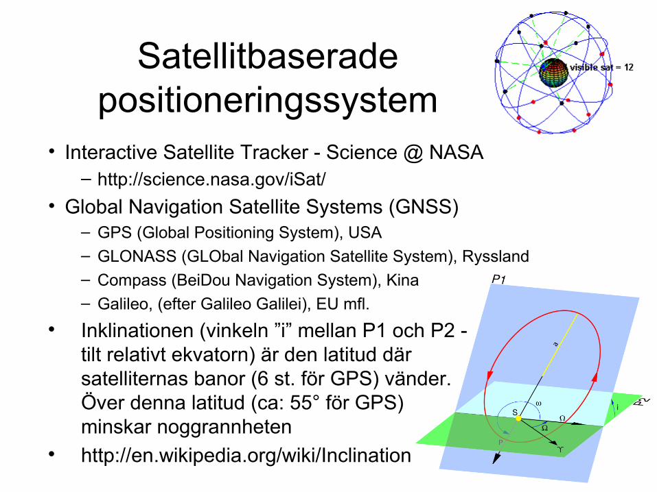
Satellitbaserade positioneringssystem
• Interactive Satellite Tracker - Science @ NASA– http://science.nasa.gov/iSat/
• Global Navigation Satellite Systems (GNSS)– GPS (Global Positioning System), USA– GLONASS (GLObal Navigation Satellite System), Ryssland– Compass (BeiDou Navigation System), Kina– Galileo, (efter Galileo Galilei), EU mfl.
Inklinationen (vinkeln ”i” mellan P1 och P2 - tilt relativt ekvatorn) är den latitud där satelliternas banor (6 st. för GPS) vänder. Över denna latitud (ca: 55° för GPS) minskar noggrannheten
http://en.wikipedia.org/wiki/Inclination
GPS
• Tänkt som ett militärt system från början, störnings signal borta 2000
• Första satelliten skickades upp 1978• 1994 hade alla 24 satelliter samt tre
reservsatelliter skickats upp• För närvarande (dec 2012) 32 satelliter• En ny per år har sänts upp 2010 - 2013• Noggrannheten är ca: 2 - 8 m (stand alone)• Inklination, 55 grader• http://en.wikipedia.org/wiki/Global_Positioning_System
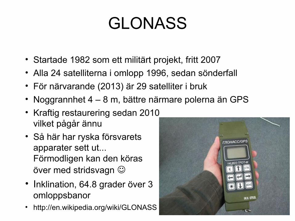
GLONASS
• Startade 1982 som ett militärt projekt, fritt 2007
• Alla 24 satelliterna i omlopp 1996, sedan sönderfall
• För närvarande (2013) är 29 satelliter i bruk
• Noggrannhet 4 – 8 m, bättre närmare polerna än GPS
• Kraftig restaurering sedan 2010vilket pågår ännu
• Så här har ryska försvarets apparater sett ut... Förmodligen kan den köras över med stridsvagn
• Inklination, 64.8 grader över 3omloppsbanor
• http://en.wikipedia.org/wiki/GLONASS
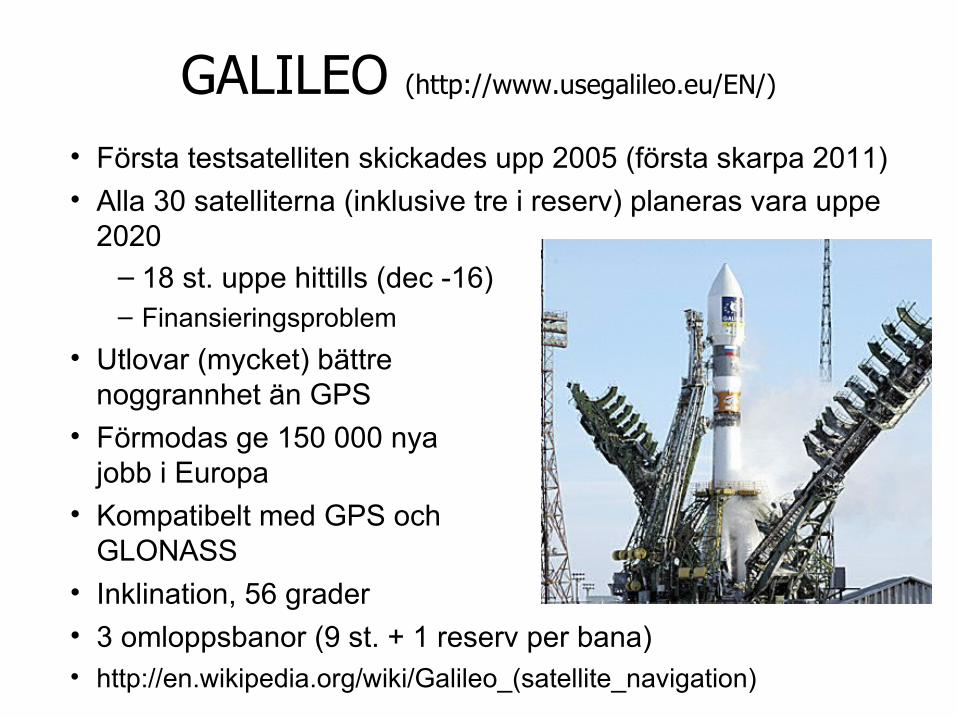
GALILEO (http://www.usegalileo.eu/EN/)
• Första testsatelliten skickades upp 2005 (första skarpa 2011)
• Alla 30 satelliterna (inklusive tre i reserv) planeras vara uppe 2020
– 18 st. uppe hittills (dec -16)– Finansieringsproblem
• Utlovar (mycket) bättre noggrannhet än GPS
• Förmodas ge 150 000 nya jobb i Europa
• Kompatibelt med GPS och GLONASS
• Inklination, 56 grader
• 3 omloppsbanor (9 st. + 1 reserv per bana)• http://en.wikipedia.org/wiki/Galileo_(satellite_navigation)
BeiDou Navigation Satellite System
• BeiDou 1– Tänkt som ett militärt system från början men är öppet från
2008 ->
– Första satelliten skickades upp 2000
– 2007 hade 5 satelliter skickats upp
– Satelliterna befinner sig i geostationär bana ca: 35000 km över jordytan
– Noggrannheten är ca: 10 m
• BeiDou 2– Globalt system med 35 satelliter, 10 st. uppe 2011
– Fungerar i asien sedan dec 2012, ska vara klart 2020
• http://en.wikipedia.org/wiki/Beidou_Navigation_Satellite_System
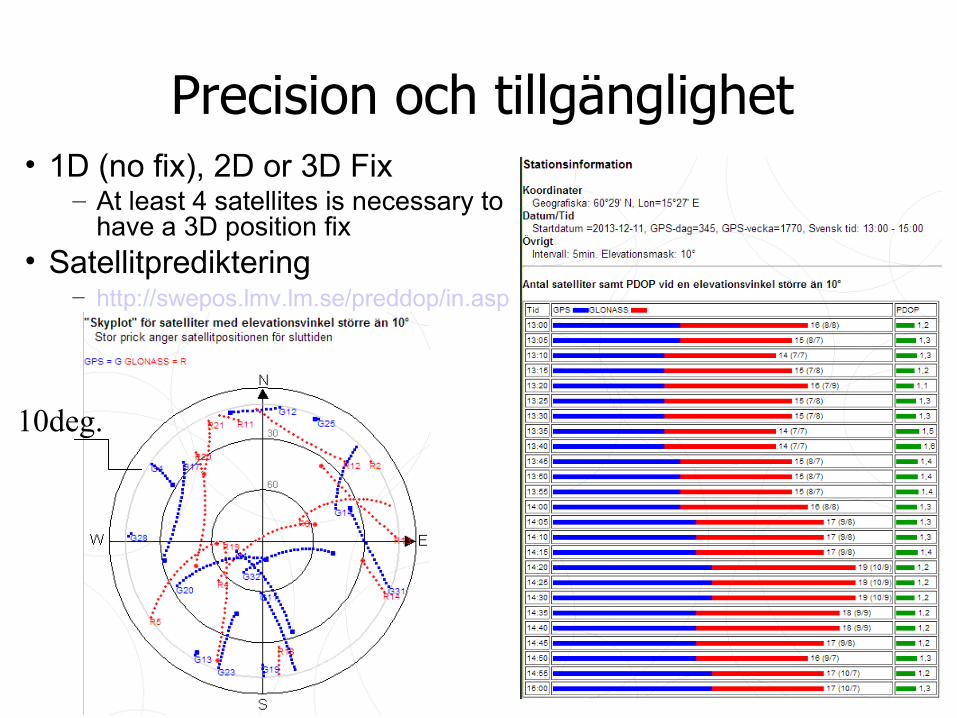
Precision och tillgänglighet• 1D (no fix), 2D or 3D Fix
– At least 4 satellites is necessary to have a 3D position fix
• Satellitprediktering– http://swepos.lmv.lm.se/preddop/in.asp
10deg.
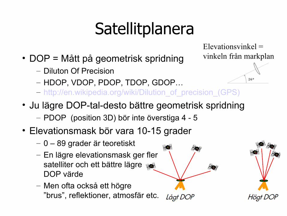
Satellitplanera
• DOP = Mått på geometrisk spridning– Diluton Of Precision– HDOP, VDOP, PDOP, TDOP, GDOP…– http://en.wikipedia.org/wiki/Dilution_of_precision_(GPS)
• Ju lägre DOP-tal-desto bättre geometrisk spridning– PDOP (position 3D) bör inte överstiga 4 - 5
• Elevationsmask bör vara 10-15 grader– 0 – 89 grader är teoretiskt– En lägre elevationsmask ger fler
satelliter och ett bättre lägre DOP värde
– Men ofta också ett högre ”brus”, reflektioner, atmosfär etc.
Elevationsvinkel = vinkeln från markplan
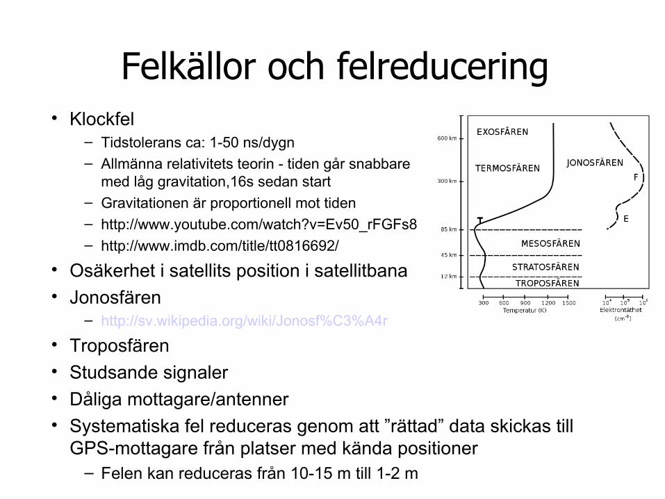
Felkällor och felreducering• Klockfel
– Tidstolerans ca: 1-50 ns/dygn– Allmänna relativitets teorin - tiden går snabbare
med låg gravitation,16s sedan start– Gravitationen är proportionell mot tiden– http://www.youtube.com/watch?v=Ev50_rFGFs8– http://www.imdb.com/title/tt0816692/
• Osäkerhet i satellits position i satellitbana• Jonosfären
– http://sv.wikipedia.org/wiki/Jonosf%C3%A4r
• Troposfären• Studsande signaler• Dåliga mottagare/antenner• Systematiska fel reduceras genom att ”rättad” data skickas till
GPS-mottagare från platser med kända positioner – Felen kan reduceras från 10-15 m till 1-2 m
Augmentation• Systemlösningen kontrollerar integritetsgränser och
beräknar korrektionsfaktorer för att slutligen sända rättad positionsdata till GPS-mottagaren (på samma frekvens) endera via markstationer (GBAS) eller via satellitstationer (SBAS)
• GBAS (Ground Based Augmentation System)– SWEPOS (LMV) och EPOS (Teracoms dGPS tjänst) – Förbättrar precisionen ner mot centimetern– http://swepos.lmv.lm.se/
• SBAS (Satellite Based Augmentation System), geostationära
– WAAS (Wide Area Augmentation System, USA)– MSAS (Multi-functional Satellite Augmentation System, Asien)– EGNOS (European Geostationary Navigation Overlay Service)
• Förbättrar precisionen – inte bättre än 2 meter fel• EGNOS är påslaget sedan 2005 men kan ha problem i
norrland
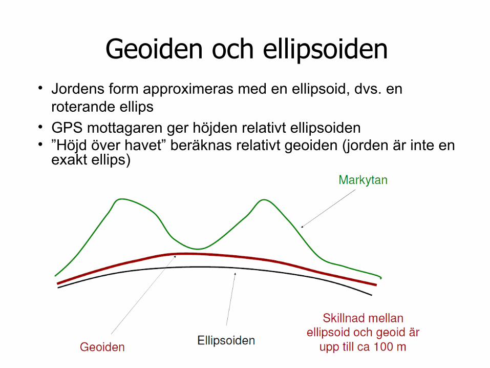
Geoiden och ellipsoiden• Jordens form approximeras med en ellipsoid, dvs. en
roterande ellips• GPS mottagaren ger höjden relativt ellipsoiden• ”Höjd över havet” beräknas relativt geoiden (jorden är inte en
exakt ellips)
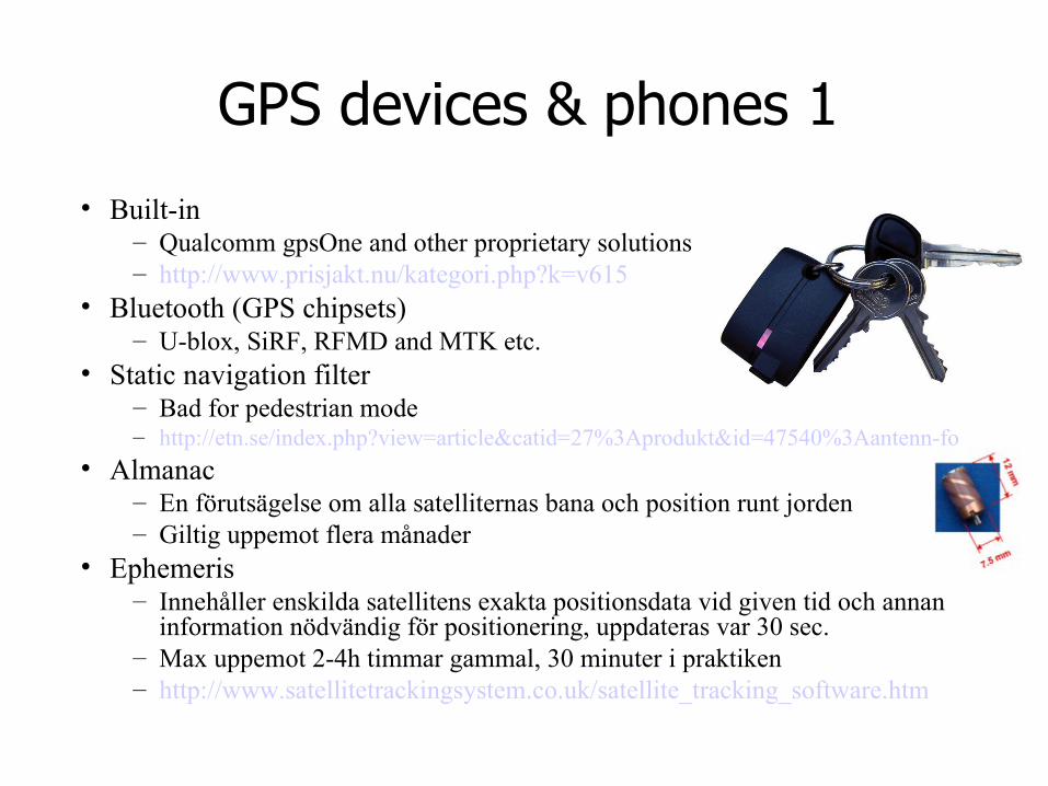
GPS devices & phones 1
• Built-in– Qualcomm gpsOne and other proprietary solutions– http://www.prisjakt.nu/kategori.php?k=v615
• Bluetooth (GPS chipsets)– U-blox, SiRF, RFMD and MTK etc.
• Static navigation filter– Bad for pedestrian mode– http://etn.se/index.php?view=article&catid=27%3Aprodukt&id=47540%3Aantenn-fo
• Almanac– En förutsägelse om alla satelliternas bana och position runt jorden– Giltig uppemot flera månader
• Ephemeris – Innehåller enskilda satellitens exakta positionsdata vid given tid och annan
information nödvändig för positionering, uppdateras var 30 sec.– Max uppemot 2-4h timmar gammal, 30 minuter i praktiken– http://www.satellitetrackingsystem.co.uk/satellite_tracking_software.htm
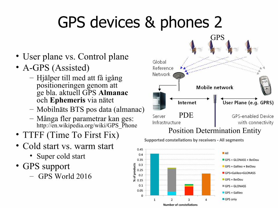
GPS devices & phones 2
• User plane vs. Control plane• A-GPS (Assisted)
– Hjälper till med att få igång positioneringen genom att ge bla. aktuell GPS Almanac och Ephemeris via nätet
– Mobilnäts BTS pos data (almanac)– Många fler parametrar kan ges:
http://en.wikipedia.org/wiki/GPS_Phone
• TTFF (Time To First Fix)• Cold start vs. warm start
• Super cold start• GPS support
– GPS World 2016
PDE
GPS
Position Determination Entity
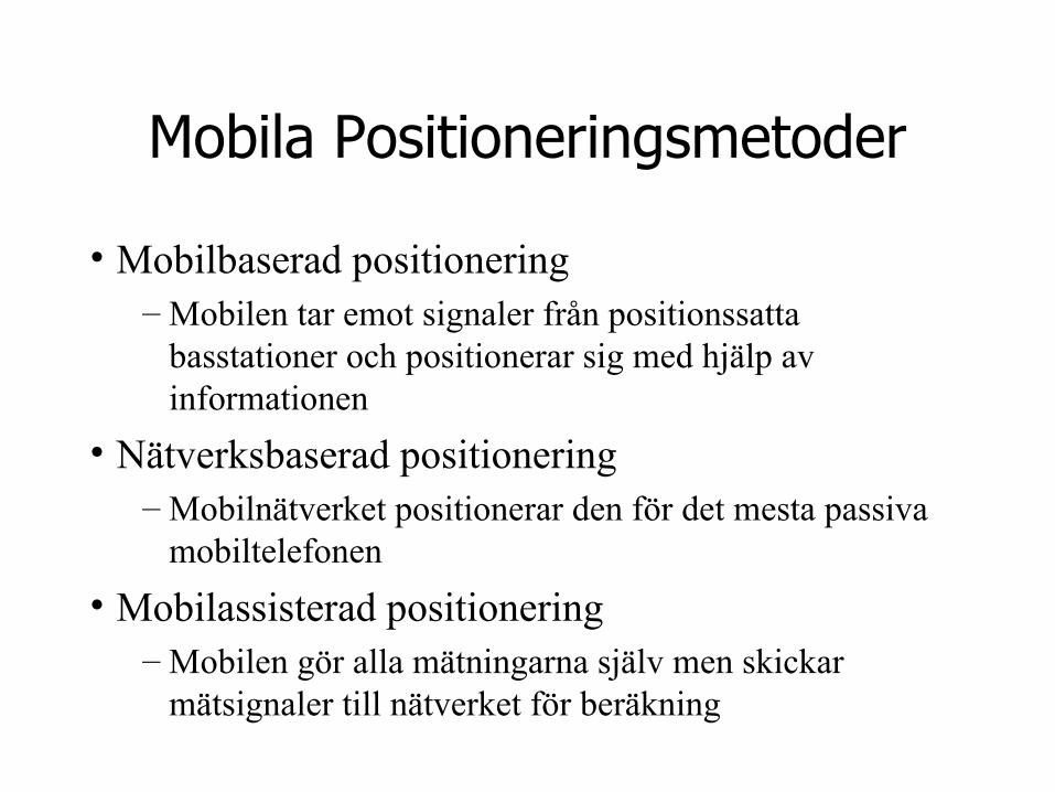
Mobila Positioneringsmetoder
• Mobilbaserad positionering– Mobilen tar emot signaler från positionssatta
basstationer och positionerar sig med hjälp av informationen
• Nätverksbaserad positionering– Mobilnätverket positionerar den för det mesta passiva
mobiltelefonen
• Mobilassisterad positionering– Mobilen gör alla mätningarna själv men skickar
mätsignaler till nätverket för beräkning
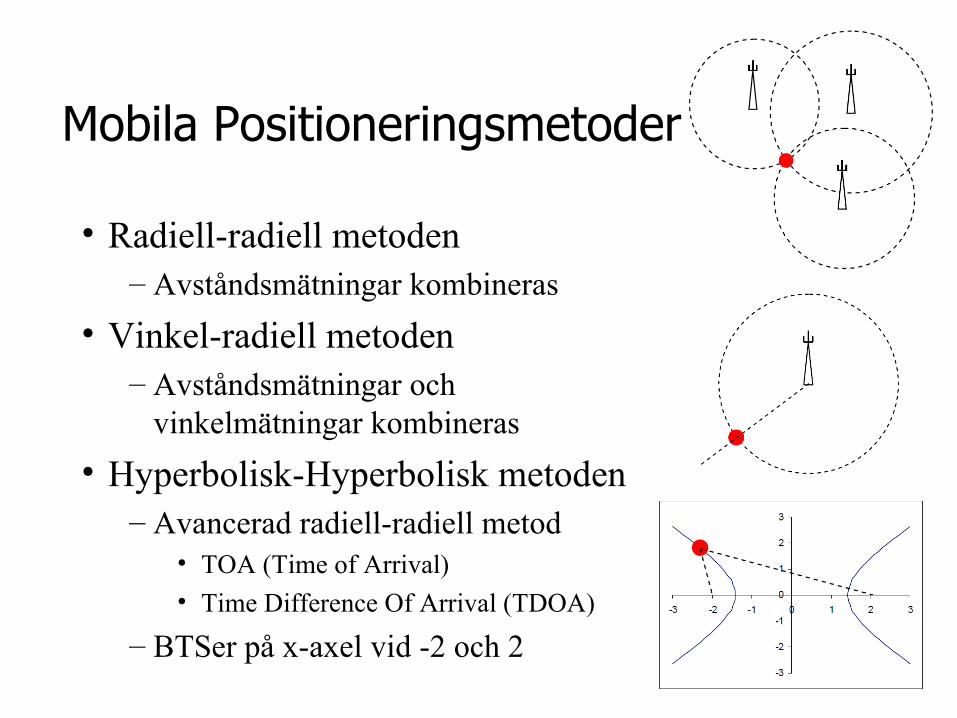
Mobila Positioneringsmetoder
• Radiell-radiell metoden– Avståndsmätningar kombineras
• Vinkel-radiell metoden– Avståndsmätningar och
vinkelmätningar kombineras
• Hyperbolisk-Hyperbolisk metoden– Avancerad radiell-radiell metod
• TOA (Time of Arrival)
• Time Difference Of Arrival (TDOA)
– BTSer på x-axel vid -2 och 2
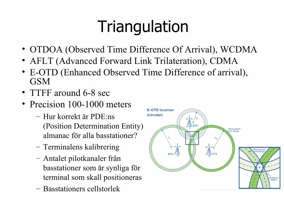
Triangulation• OTDOA (Observed Time Difference Of Arrival), WCDMA • AFLT (Advanced Forward Link Trilateration), CDMA• E-OTD (Enhanced Observed Time Difference of arrival),
GSM• TTFF around 6-8 sec• Precision 100-1000 meters
– Hur korrekt är PDE:ns (Position Determination Entity) almanac för alla basstationer?
– Terminalens kalibrering
– Antalet pilotkanaler från basstationer som är synliga för terminal som skall positioneras
– Basstationers cellstorlek
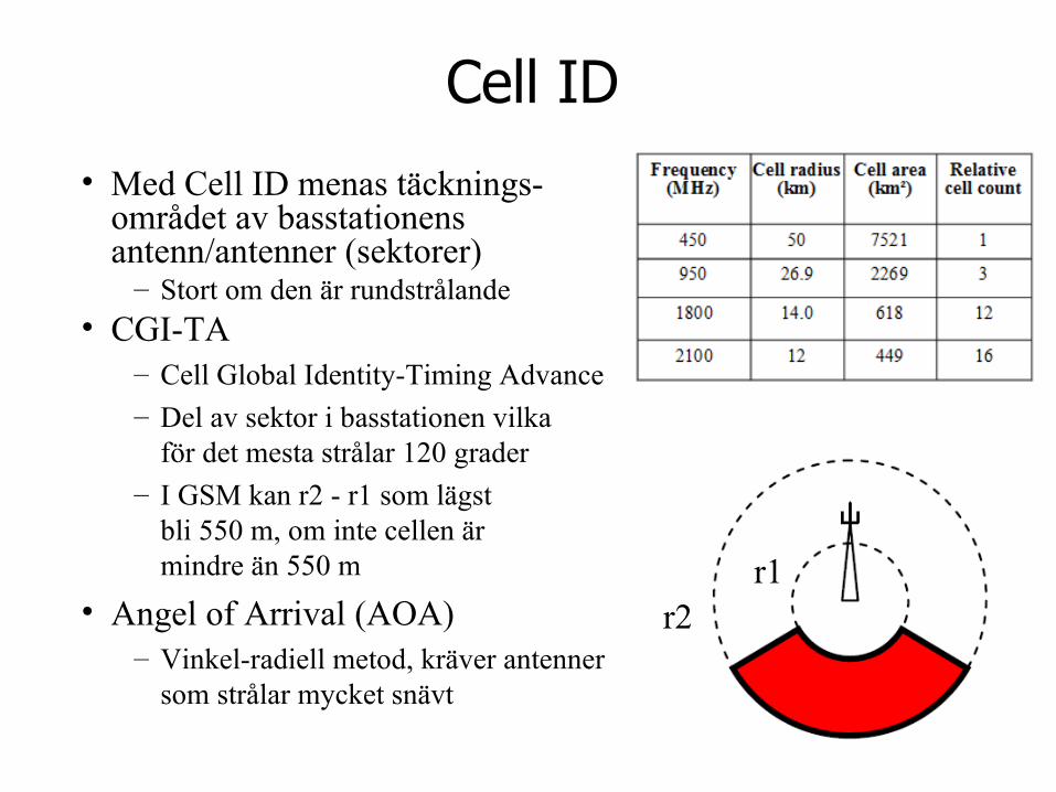
Cell ID
• Med Cell ID menas täcknings-området av basstationens antenn/antenner (sektorer)
– Stort om den är rundstrålande• CGI-TA
– Cell Global Identity-Timing Advance
– Del av sektor i basstationen vilkaför det mesta strålar 120 grader
– I GSM kan r2 - r1 som lägstbli 550 m, om inte cellen är mindre än 550 m
• Angel of Arrival (AOA)– Vinkel-radiell metod, kräver antenner
som strålar mycket snävt
r2r1
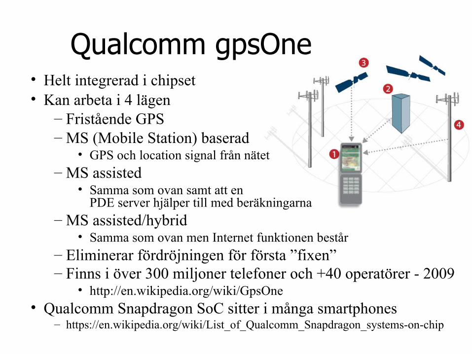
Qualcomm gpsOne• Helt integrerad i chipset• Kan arbeta i 4 lägen
– Fristående GPS– MS (Mobile Station) baserad
• GPS och location signal från nätet – MS assisted
• Samma som ovan samt att en PDE server hjälper till med beräkningarna
– MS assisted/hybrid• Samma som ovan men Internet funktionen består
– Eliminerar fördröjningen för första ”fixen”– Finns i över 300 miljoner telefoner och +40 operatörer - 2009
• http://en.wikipedia.org/wiki/GpsOne• Qualcomm Snapdragon SoC sitter i många smartphones
– https://en.wikipedia.org/wiki/List_of_Qualcomm_Snapdragon_systems-on-chip
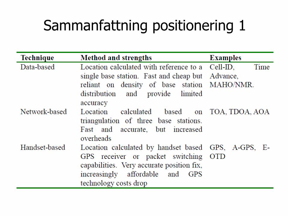
Sammanfattning positionering 1
• e
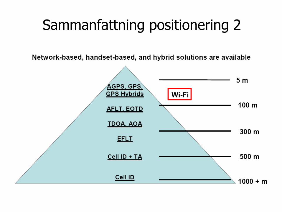
Sammanfattning positionering 2
Wi-Fi
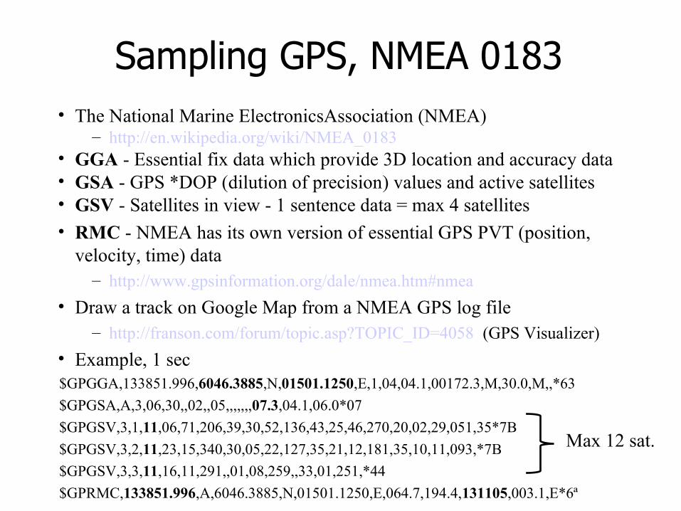
Sampling GPS, NMEA 0183• The National Marine ElectronicsAssociation (NMEA)
– http://en.wikipedia.org/wiki/NMEA_0183 • GGA - Essential fix data which provide 3D location and accuracy data• GSA - GPS *DOP (dilution of precision) values and active satellites• GSV - Satellites in view - 1 sentence data = max 4 satellites
• RMC - NMEA has its own version of essential GPS PVT (position, velocity, time) data
– http://www.gpsinformation.org/dale/nmea.htm#nmea
• Draw a track on Google Map from a NMEA GPS log file – http://franson.com/forum/topic.asp?TOPIC_ID=4058 (GPS Visualizer)
• Example, 1 sec$GPGGA,133851.996,6046.3885,N,01501.1250,E,1,04,04.1,00172.3,M,30.0,M,,*63
$GPGSA,A,3,06,30,,02,,05,,,,,,,07.3,04.1,06.0*07
$GPGSV,3,1,11,06,71,206,39,30,52,136,43,25,46,270,20,02,29,051,35*7B
$GPGSV,3,2,11,23,15,340,30,05,22,127,35,21,12,181,35,10,11,093,*7B
$GPGSV,3,3,11,16,11,291,,01,08,259,,33,01,251,*44
$GPRMC,133851.996,A,6046.3885,N,01501.1250,E,064.7,194.4,131105,003.1,E*6ª
Max 12 sat.
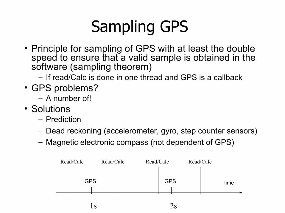
Sampling GPS• Principle for sampling of GPS with at least the double
speed to ensure that a valid sample is obtained in the software (sampling theorem)
– If read/Calc is done in one thread and GPS is a callback• GPS problems?
– A number of!• Solutions
– Prediction– Dead reckoning (accelerometer, gyro, step counter sensors)– Magnetic electronic compass (not dependent of GPS)
Time
Read/Calc
GPS GPS
Read/Calc Read/Calc Read/Calc
1s 2s
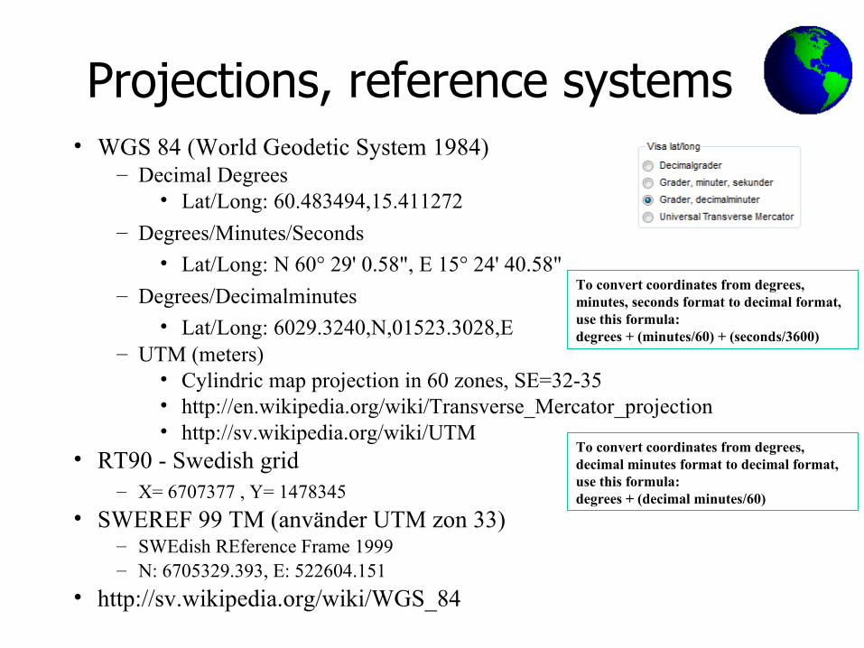
Projections, reference systems• WGS 84 (World Geodetic System 1984)
– Decimal Degrees• Lat/Long: 60.483494,15.411272
– Degrees/Minutes/Seconds• Lat/Long: N 60° 29' 0.58", E 15° 24' 40.58"
– Degrees/Decimalminutes
• Lat/Long: 6029.3240,N,01523.3028,E– UTM (meters)
• Cylindric map projection in 60 zones, SE=32-35• http://en.wikipedia.org/wiki/Transverse_Mercator_projection• http://sv.wikipedia.org/wiki/UTM
• RT90 - Swedish grid– X= 6707377 , Y= 1478345
• SWEREF 99 TM (använder UTM zon 33)– SWEdish REference Frame 1999– N: 6705329.393, E: 522604.151
• http://sv.wikipedia.org/wiki/WGS_84
To convert coordinates from degrees, decimal minutes format to decimal format, use this formula:degrees + (decimal minutes/60)
To convert coordinates from degrees, minutes, seconds format to decimal format, use this formula:degrees + (minutes/60) + (seconds/3600)
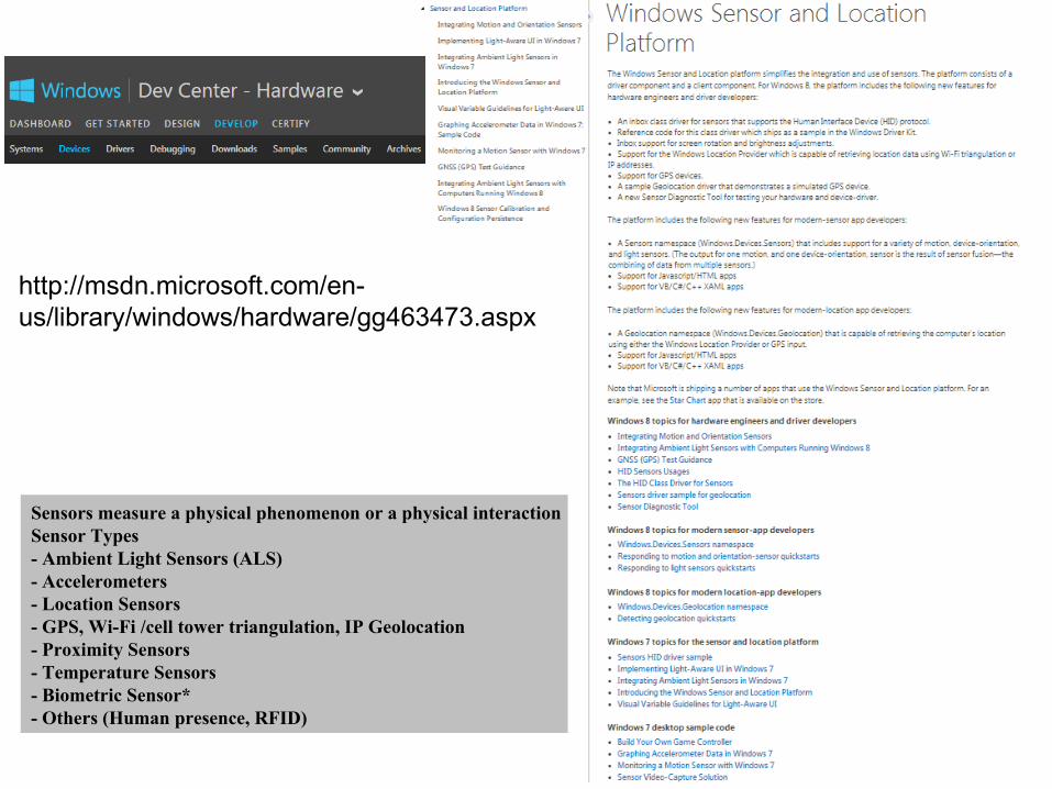
Sensors measure a physical phenomenon or a physical interactionSensor Types- Ambient Light Sensors (ALS)- Accelerometers- Location Sensors- GPS, Wi-Fi /cell tower triangulation, IP Geolocation- Proximity Sensors- Temperature Sensors- Biometric Sensor*- Others (Human presence, RFID)
http://msdn.microsoft.com/en-us/library/windows/hardware/gg463473.aspx
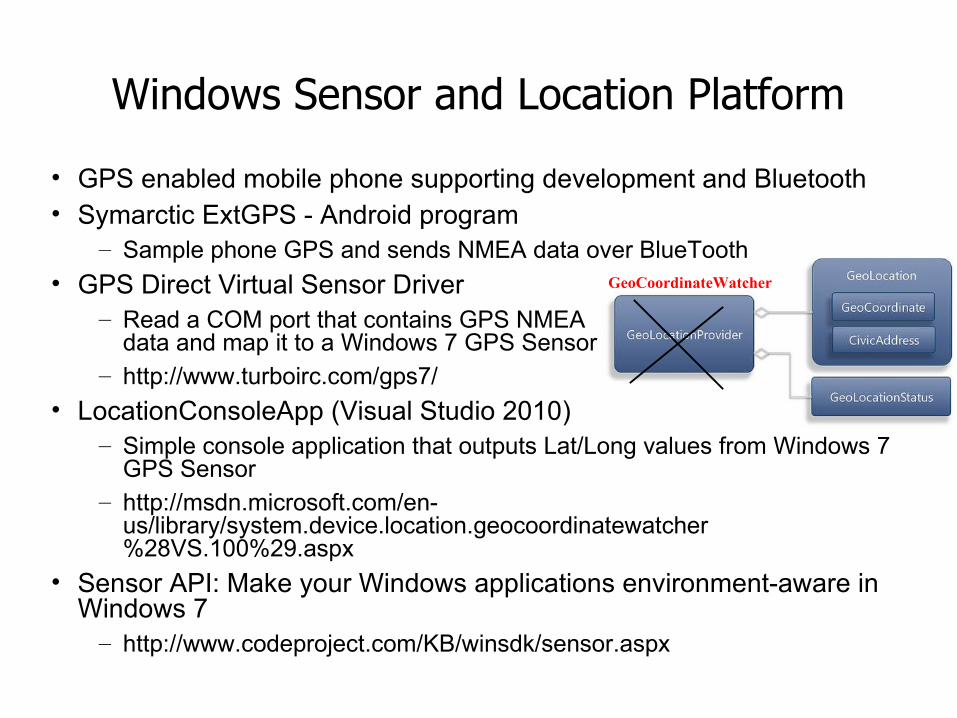
Windows Sensor and Location Platform
• GPS enabled mobile phone supporting development and Bluetooth• Symarctic ExtGPS - Android program
– Sample phone GPS and sends NMEA data over BlueTooth
• GPS Direct Virtual Sensor Driver– Read a COM port that contains GPS NMEA
data and map it to a Windows 7 GPS Sensor– http://www.turboirc.com/gps7/
• LocationConsoleApp (Visual Studio 2010)– Simple console application that outputs Lat/Long values from Windows 7
GPS Sensor– http://msdn.microsoft.com/en-
us/library/system.device.location.geocoordinatewatcher%28VS.100%29.aspx
• Sensor API: Make your Windows applications environment-aware in Windows 7
– http://www.codeproject.com/KB/winsdk/sensor.aspx
GeoCoordinateWatcher
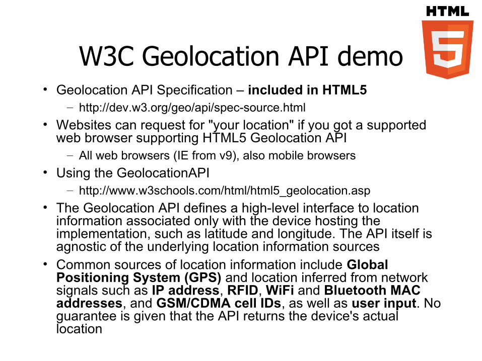
W3C Geolocation API demo• Geolocation API Specification – included in HTML5
– http://dev.w3.org/geo/api/spec-source.html
• Websites can request for "your location" if you got a supported web browser supporting HTML5 Geolocation API
– All web browsers (IE from v9), also mobile browsers
• Using the GeolocationAPI– http://www.w3schools.com/html/html5_geolocation.asp
• The Geolocation API defines a high-level interface to location information associated only with the device hosting the implementation, such as latitude and longitude. The API itself is agnostic of the underlying location information sources
• Common sources of location information include Global Positioning System (GPS) and location inferred from network signals such as IP address, RFID, WiFi and Bluetooth MAC addresses, and GSM/CDMA cell IDs, as well as user input. No guarantee is given that the API returns the device's actual location
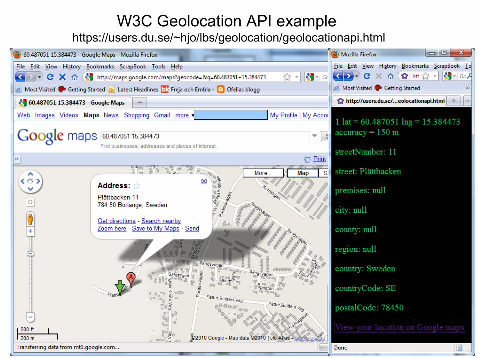
W3C Geolocation API example https://users.du.se/~hjo/lbs/geolocation/geolocationapi.html
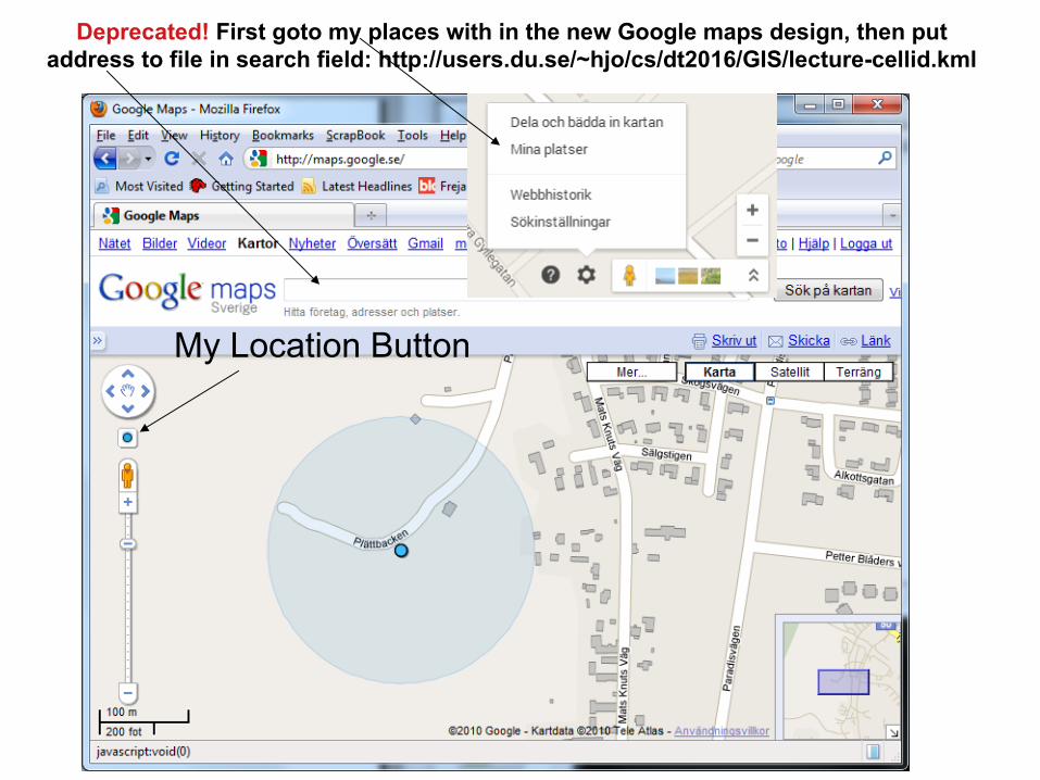
My Location Button
Deprecated! First goto my places with in the new Google maps design, then putaddress to file in search field: http://users.du.se/~hjo/cs/dt2016/GIS/lecture-cellid.kml
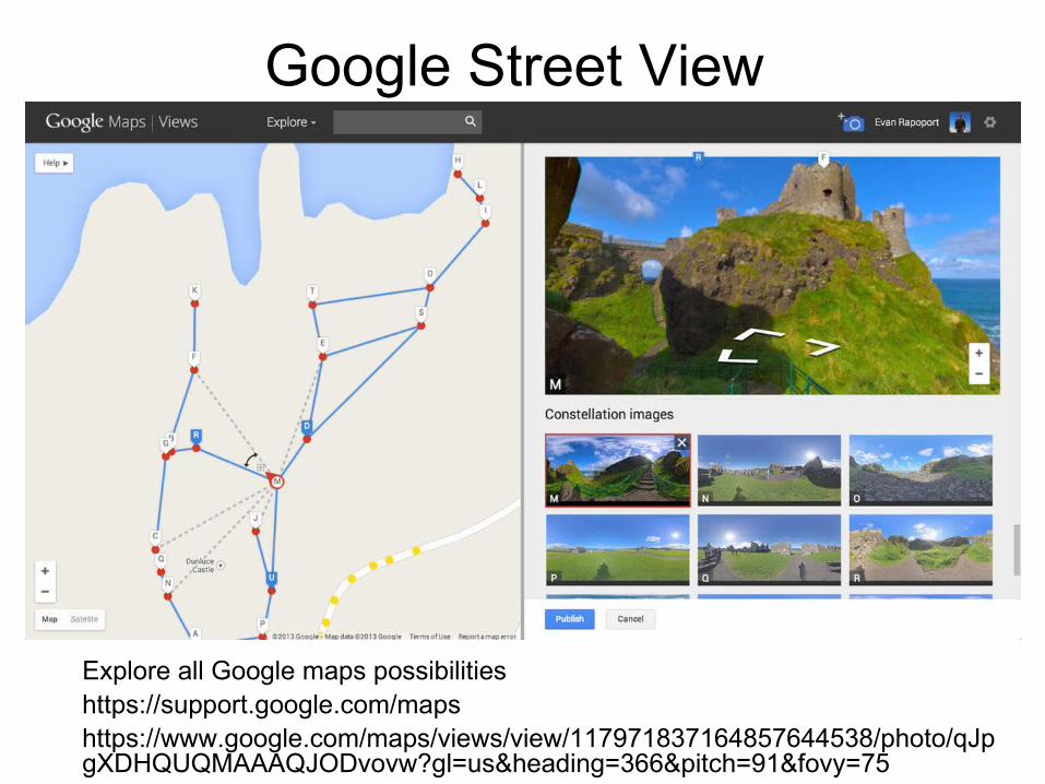
Google Street View
Explore all Google maps possibilitieshttps://support.google.com/mapshttps://www.google.com/maps/views/view/117971837164857644538/photo/qJpgXDHQUQMAAAQJODvovw?gl=us&heading=366&pitch=91&fovy=75

GIS, kartor och GPS länkar• Rapport öppna karttjänster
– http://users.du.se/~hjo/cs/dt2011/GIS/Rapport%20Kartl%c3%a4ggning%20av%20%c3%b6ppna%20karttj%c3%a4nster.pdf
• GIS self learning tool– http://www.geogra.uah.es/patxi/gisweb/menu.html
• http://libraries.mit.edu/gis/
• http://www.lantmateriet.se/
• http://www.utsidan.se
• http://www.gpspassion.com
• http://www.nvdb.se/