gi2016 final programm & proceedings of abstracts & summaries
TRANSCRIPT
GI2016 – GI/GIS/GDI – Forum
Open Data & OpenGOV im grenzüberschreitenden Europa der Regionen 16. Grenzüberschreitendes Sächsisches GI/GIS/GDI - Forum in Dresden: 04. Oktober 2016
NNR-Special-Edition-2016 PROCEEDINGS – “GI2016 Cross-border GI / GIS / GDI - FORUM” – DRESDEN ISSN 1801-6480
1
GGII22001166 (( 1166.. SSääcchhssiisscchheess GGII//GGIISS//GGDDII –– WWOORRKKSSHHOOPP –– FFOORRUUMM ))
FINAL PROGRAMME PROCEEDINGS OF ABSTRACTS & SUMMARIES
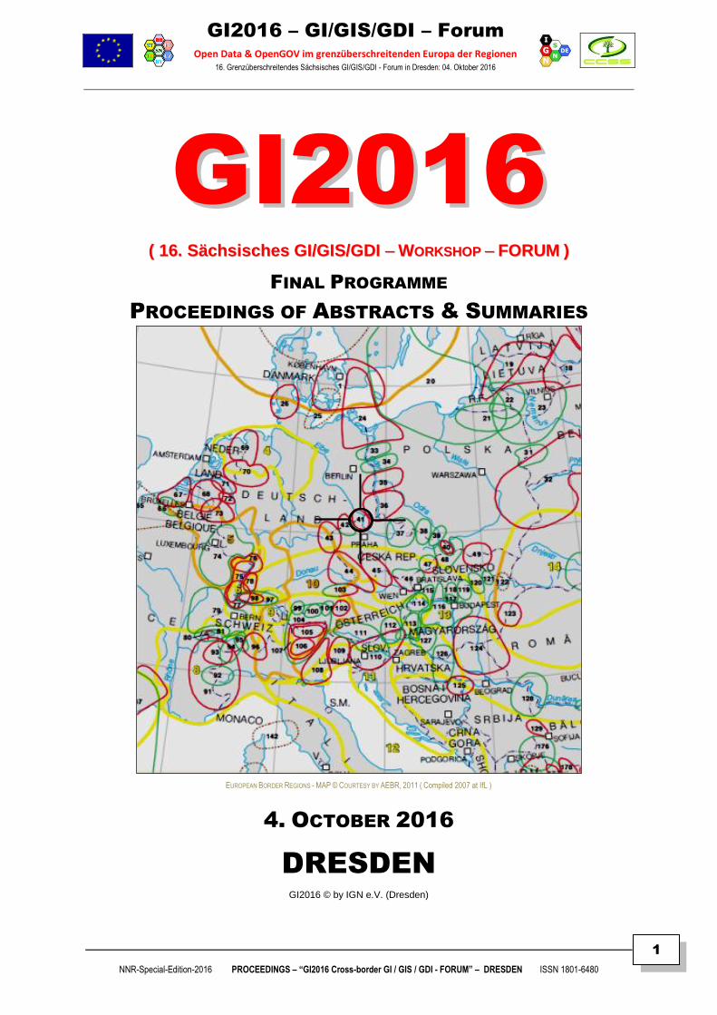
EUROPEAN BORDER REGIONS - MAP © COURTESY BY AEBR, 2011 ( Compiled 2007 at IfL )
4. OCTOBER 2016
DRESDEN GI2016 © by IGN e.V. (Dresden)
GI2016 – GI/GIS/GDI – Forum
Open Data & OpenGOV im grenzüberschreitenden Europa der Regionen 16. Grenzüberschreitendes Sächsisches GI/GIS/GDI - Forum in Dresden: 04. Oktober 2016
NNR-Special-Edition-2016 PROCEEDINGS – “GI2016 Cross-border GI / GIS / GDI - FORUM” – DRESDEN ISSN 1801-6480
2
SUSTAINABILITY OF INTER-REGIONAL COLLABORATION
EU Support Programme for “Inter-Regional and Cross-border Collaboration” – Free State of Saxony
GI2016 – INTERREGIONAL PROGRAMME – COMMITTEE
SCIENTIFIC PROGRAMME & ORGANIZATION MEMBERS: Chairs: Doz. Dr. F. HOFFMANN (IGN/DE), Dr. K. Charvat (CCSS/CZ) & CEO W.MAYER (PROGIS/AT) Org-Members: Dr. G. HOFFMANN (IGN-SN), Prof. S. KLOSS (IGN-SN), Dr. K.-D. MICHAEL (IGN-SN).
ORGANIZER’S INFORMATION & INTERNET REFERENCE URL’S
GI2016-Contact-Address [ [email protected] | [email protected] ]
IGN-Dresden [ http://GDI-SN.blogspot.com ]
CCSS-Praha [ http://www.CCSS.cz ]
PROGIS-Villach [ http://www.PROGIS.com ]
IMPRESSUM:
Herausgegeben von / Published by ( Founding Members of IGN e.V. )
Doz. Dr. Frank HOFFMANN, CSc IGN – Vorstandsvorsitzender, Dresden IGN (INNOVATION. Grenzüberschreitendes Netzwerk e.V.)
Dr. Karel CHARVAT, EU-Project Manager Past President of CCSS, Praha CCSS (Czech Center for Science and Society e.V.)
Dipl.Ing. Walter H. MAYER, CEO Geschäftsführer / Director of PROGIS GmbH, Villach (AT)
PROGIS GmbH
INNOVATION. Grenzüberschreitendes Netzwerk
( Gemeinnütziger e.V. / Non-profit Organization )
IGN-Vorstand, c/o Martin-Andersen-Nexö-Str. 4
D – 01217 DRESDEN / Saxony / Germany
EMAIL: [ [email protected] | [email protected] ]
SKYPE: [ fh_ign ]
INTERNET: [ http://www.IGN-SN.de ]
WEBLOG: [ http://GDI-SN.blogspot.com ]
TEL/FAX: [ +49-351-403.2729 # FAX: +49-351-401.4260 ]
Copyright © 2016 by IGN-Dresden & CCSS-Praha & PROGIS-Villach – All rights reserved.
GI2016 – GI/GIS/GDI – Forum
Open Data & OpenGOV im grenzüberschreitenden Europa der Regionen 16. Grenzüberschreitendes Sächsisches GI/GIS/GDI - Forum in Dresden: 04. Oktober 2016
NNR-Special-Edition-2016 PROCEEDINGS – “GI2016 Cross-border GI / GIS / GDI - FORUM” – DRESDEN ISSN 1801-6480
3
GGII22001166 -- OOppeenn DDAATTAA uunndd OOppeennGGOOVV iimm ggrreennzzüübbeerrsscchhrreeiitteennddeenn EEUURROOPPAA ddeerr RREEGGIIOONNEENN 04. Oktober 2016 / 9-17 Uhr – 01069 Dresden, Konrad-ZUSE-Haus, Liebigstraße 3
GI2016 < WORKSHOP > PROGRAMM AAKKTTUUEELLLLEESS PPRROOGGRRAAMMMM <<>> FFIINNAALL PPRROOGGRRAAMMMMEE
Zeit Thema Bem.
09:00
|
„Konrad-ZUSE-Haus“ – Liebigstr. 3, 01069 Dresden
Anmeldung <> Registration
09:45
|
SCHILLER ( GI2016 Welcome Address by Host Company @ ZUSE-Villa ) & Introduction
Big Data Search Solution - Dynamische Bauprofessor-Suche in NEXTBAUTM
10:15
|
HOFFMANN ( GI2016 Welcome Address by IGN e.V. ) & Workshop Introduction
From GI2000 - The Tradition of "Saxonian GI/GIS/GDI" Workshops & Symposia - to GI2016
10:45
|
BÖHM
Hinterhermsdorf & Weltgeschichte - Deutschland erstmals seit 1871 größer geworden?
11:15 Kaffeepause <> Break for Coffee
11:30
|
BÖHM
Die Entstehung der Böhm-Wanderkarten & DLR-Kultur-Interview (Audio)
12:00
|
SCHILLER
Big BIM Data - Bauwerksmodell & modellbasiertes Arbeiten mit DBD-Kostenkalkül 4.0
12:30
|
|
Mittagespause <> Break for Lunch
13:30
|
MAYER
Big COPERNICUS Data - SENTINEL 2 - Ein Bild alleine ist zuwenig
14:00 BÖHM
VIMAGE - Big Terrain Data - Verarbeitung kartographischer Reliefdarstellungen
14:30
|
CHARVAT & Team
SENSLOG API as Tools for Collection of Big VGI Data
15:00 Kaffeepause <> Break for Coffee
15:15
|
SHI
Automatic Interaction and seamless Integration of Big Data Hubs on Internet (via Skype)
15:45
|
SHI
Big Data Analytics on Internet & Cartographical Visualization for Communicating (via Skype)
16:15
|
CHARVAT
GEOSS Workshop (Brussel: 21./22.09.2016) & INSPIRE Conference (Barcelona: 26.-30.09.2016)
16:45
|
Abschlußdiskussion <> Final Discussion
Summarizing up
17:00 "Get together"
Status: as per 25. September 2016 ( PPT Presentations include 30% time for Q&A, including discussion )
GI2016 – GI/GIS/GDI – Forum
Open Data & OpenGOV im grenzüberschreitenden Europa der Regionen 16. Grenzüberschreitendes Sächsisches GI/GIS/GDI - Forum in Dresden: 04. Oktober 2016
NNR-Special-Edition-2016 PROCEEDINGS – “GI2016 Cross-border GI / GIS / GDI - FORUM” – DRESDEN ISSN 1801-6480
4
GGII22001166 -- OOppeenn DDAATTAA uunndd OOppeennGGOOVV iimm ggrreennzzüübbeerrsscchhrreeiitteennddeenn EEUURROOPPAA ddeerr RREEGGIIOONNEENN 04. Oktober 2016 / 9-17 Uhr – 01069 Dresden, Konrad-ZUSE-Haus, Liebigstraße 3
GI2016 < INHALT / CONTENT > WORKSHOP
AALLPPHHAABBEETTIISSCCHHEE AAUUTTOORREENNLLIISSTTEE <<>> AALLPPHHAABBEETTIICCAALL AAUUTTHHOORRSS LLIISSTT
AUTOREN / THEMEN <> AUTHORS / THEMES
Seite / Page
GI2016 - PROGRAMM ................................................................................................................................................3
AUTORENLISTE .........................................................................................................................................................4
SCHILLER: GI2016 - Welcome Address to “Konrad-ZUSE-Haus”…………………………..........................................5
HOFFMANN: GI2016 - Welcome by IGN e.V. & Workshop Introduction GI2000 <> GI2016 ......................................7
GI2016 - PROCEEDINGS of ABSTRACTS & SUMMARIES ...................................................................................10
BÖHM: Hinterhermsdorf & Weltgeschichte - Deutschland erstmals seit 1871 größer geworden? ...........................11
BÖHM: Die Entstehung der Böhm-Wanderkarten - Von der Seele unserer Wege ...................................................15
BÖHM: DLR-Kultur-Interview (Stadt, Land, Karten Zeichnen - von Hand) ................................................................20
BÖHM: VIMAGE - BigData - Verarbeitung kartographischer Reliefdarstellungen .....................................................25
Charvat & Team: SENSLOG API as Tools for Collection of Big VGI Data ................................................................28
MAYER: Big COPERNICUS Data - SENTINEL 2 - Ein Bild alleine ist zuwenig ....................................................... 30
SCHILLER: Big Data Search Solution - Dynamische Bauprofessor-Suche in NEXTBAUTM ........................................36
SCHILLER: Big BIM Data - Bauwerksmodell & modellbasiertes Arbeiten mit DBD-Kostenkalkül 4.0 ......................39
SHI: Automatic Interaction and Seamless Integration of Big Data Hubs on Internet..................................................41
SHI: Big Data Analytics on the Internet .....................................................................................................................42
SHI: Standardization enabling Geodata Exchange and Flow on the Internet ............................................................43
SHI: Cartographical Visualization for Communicating geoscientific findings - a modern approach ...........................44
INFORMATIONEN: About IGN & CCSS # COPERNICUS Berlin 2017 # BIM WORLD Munich 2016 ....................48
INFORMATIONEN: INTERGEO2016 # VDV-OpenData # AdV-GeobasisDaten.......................................................50
IMPRIMATUR: 3300..0099..22001166
GI2016 – GI/GIS/GDI – Forum
Open Data & OpenGOV im grenzüberschreitenden Europa der Regionen 16. Grenzüberschreitendes Sächsisches GI/GIS/GDI - Forum in Dresden: 04. Oktober 2016
NNR-Special-Edition-2016 PROCEEDINGS – “GI2016 Cross-border GI / GIS / GDI - FORUM” – DRESDEN ISSN 1801-6480
5
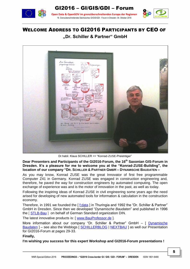
WELCOME ADDRESS TO GI2016 PARTICIPANTS BY CEO OF
„Dr. Schiller & Partner“ GmbH
Dr.habil. Klaus SCHILLER <> “Konrad-ZUSE-Preisträger”
Dear Presenters and Participants of the GI2016-Forum, the 16th Saxonian GIS-Forum in Dresden. It’s a pleasure for me to welcome you at the “Konrad-ZUSE-Building”, the location of our company “DR. SCHILLER & PARTNER GMBH – DYNAMISCHE BAUDATEN –
As you may know, Konrad ZUSE was the great Innovator of first free programmable Computer Z41 in Germany. Konrad ZUSE was engaged in construction engineering and, therefore, he paved the way for construction engineers by automated computing. The open exchange of experience was and is the motor of innovation in the past, as well as today.
Following the inspiring ideas of Konrad ZUSE in civil engineering some years ago the need arised for developing of new automated tools for information & calculation in the construction economy.
Therefore, in 1991 we founded the [ f:data ] in Thuringia and 1992 the “Dr. Schiller & Partner” GmbH in Dresden. Since then we developed “Dynamische Baudaten” and published in 1996 the [ STLB-Bau ] on behalf of German Standard organization DIN.
The latest innovative products is: [ www.BauProfessor.de ].
More information about our company “Dr. Schiller & Partner” GmbH – [ Dynamische Baudaten ] – see also the Weblogs [ SCHILLERBLOG | NEXTBAU ] as well our Presentation for GI2016-Forum at pages 29-33.
Finally,
I'm wishing you success for this expert Workshop and GI2016-Forum presentations !
GI2016 – GI/GIS/GDI – Forum
Open Data & OpenGOV im grenzüberschreitenden Europa der Regionen 16. Grenzüberschreitendes Sächsisches GI/GIS/GDI - Forum in Dresden: 04. Oktober 2016
NNR-Special-Edition-2016 PROCEEDINGS – “GI2016 Cross-border GI / GIS / GDI - FORUM” – DRESDEN ISSN 1801-6480
6
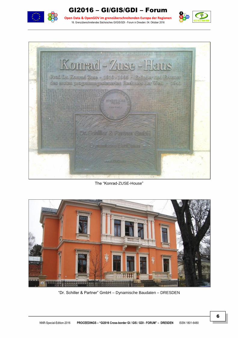
The “Konrad-ZUSE-House”
“Dr. Schiller & Partner” GmbH – Dynamische Baudaten – DRESDEN
GI2016 – GI/GIS/GDI – Forum
Open Data & OpenGOV im grenzüberschreitenden Europa der Regionen 16. Grenzüberschreitendes Sächsisches GI/GIS/GDI - Forum in Dresden: 04. Oktober 2016
NNR-Special-Edition-2016 PROCEEDINGS – “GI2016 Cross-border GI / GIS / GDI - FORUM” – DRESDEN ISSN 1801-6480
7
GI2016 – GI/GIS/GDI – WORKSHOP
Doz. Dr. Frank HOFFMANN, CSc – Vorstandsvorsitzender IGN e.V. Academician of International Eurasian Academy of Sciences (IEAS)
GI2016 – WELCOME by IGN & INTRODUCTION to GI2016
GI2016 – MOTIVATION, CONCEPTION & WORKSHOP INTRODUCTION FROM GI2000 – THE HISTORY OF "SAXONIAN GI/GIS/GDI WORKSHOPS & SYMPOSIA – TO GI2016
ABSTRACT & SUMMARY
The European Commission has positioned itself as an innovative player in the field of multi-purpose use of
OPEN GEO DATA (OGD) and PUBLIC SECTOR INFORMATION (PSI). The goal is to develop an open, dynamic
Media industry that refine public data into valuable information and knowledge not only for ICT experts and
Public Administrations, but also allowing transparency and participation for User communities and Citizens.
With the EU DIRECTIVES PSI (2003/98/EC / updated 2013/XX/EC), INSPIRE (2007/02/EC) legal requirements
were provided enabling new developments and opportunities for funding of projects until 2013 and beyond
2014 – 2020 in EUROPE OF REGIONS. However, there is a need for more & better knowledge about new EU
policies and strategies like "DIGITAL EUROPE & HORIZON 2020". Therefore, these awareness needs require
more and comprehensive information and knowledge as well creative, innovative actions for postgradual
education and training. The European Commission presented in 2011 the „Strategy of Open Data in Europe“
to push the growth of EU economy to nearly 40 Billions Euro per year, e.g. "turning Data into Gold":
[ http://europa.eu/rapid/pressReleasesAction.do?reference=IP/11/1524&format=HTML&aged=0&language=EN&guiLanguage=en ]
Therefore, sustainable decision making requires greater Awareness of intellectual property rights (IPR)
and Knowledge exchange of OpenDATA and creative commons bylaws for economic, ecological and social
applications in Europe of Regions, as well as OpenGOV for better governance, tourism, civil protection and
security-related infrastructures. Finally, there is still yet a need for comprehensive information, education and
training actions, particularly at local, regional, cross-border and inter-regional levels.
However, the most problematic field is the CROSS-BORDER ADAPTATION and SEMANTIC INTEROPERATION of Copyrights,
Licensing and really OPEN Data, Services and Applications for an effective governance, transparency and user participation
developing and supporting the creation of OPEN APPS for sustainable growth of infrastructure and environment !
Therefore, the GI2016 Workshop Forum is intenting to inter-regional exchange of experience and information
for integration of OpenPSI, Open GEO & Sentinel Data at local, regional and, especially, cross-border levels.
Proposals for presentation & poster (title+abstract, max. 250-300 words in German or English or Russian) had
to be submitted by 31.05.2016 to allow composing of the actual programme framework draft, while extented
Summary texts were due until 15.09.2016 using the DOC templates (available for downloading from Weblog at
IGN's [ http://GDI-SN.blogspot.de ] website) !
GI2016 – Contacts & Logistics
GI2016 Contact [ [email protected] | [email protected] | [email protected] ] GI2016 Participation is FFRREEEE OOFF CCHHAARRGGEE ( ! ) as supported by EU Cross-border-Collaboration Programme
Registration deadline setup at: 25.09.2016 !
The FINAL PROGRAMME&PROCEEDINGS is accessible later on via IGN’s weblog: [ GDI-SN.blogspot.com ]
FFuurrtthheerr llooggiissttiiccss iinnffoorrmmaattiioonn aanndd uuppddaatteess ppuubblliisshheedd aatt WWeebblloogg [[ hhttttpp::////GGDDII--SSNN..bbllooggssppoott..ccoomm ]] !!
GI2016 – GI/GIS/GDI – Forum
Open Data & OpenGOV im grenzüberschreitenden Europa der Regionen 16. Grenzüberschreitendes Sächsisches GI/GIS/GDI - Forum in Dresden: 04. Oktober 2016
NNR-Special-Edition-2016 PROCEEDINGS – “GI2016 Cross-border GI / GIS / GDI - FORUM” – DRESDEN ISSN 1801-6480
8
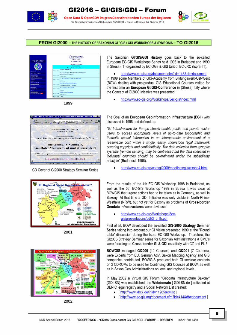
FROM GI2000 – THE HISTORY OF "SAXONIAN GI / GIS / GDI WORKSHOPS & SYMPOSIA – TO GI2016
11999999
The Saxonian GI/GIS/GDI History goes back to the so-called European EC-GIS Workshops Series held 1998 in Budapest and 1999 in Stresa (IT) organized by EC-DG3 & GIS Unit of EC-JRC (Ispra, IT).
http://www.ec-gis.org/document.cfm?id=146&db=document In 1999 some Members of GIS-Academy from Bildungswerk-Ost-West (BOW) dealing with postgradual GIS Educational Courses visited for the first time an European GI/GIS-Conference in (Stresa) Italy where the Concept of GI2000 Initiative was presented:
http://www.ec-gis.org/Workshops/5ec-gis/index.html
CCDD CCoovveerr ooff GGII22000000 SSttrraatteeggyy SSeemmiinnaarr SSeerriieess
The Goal of an European GeoInformation Infrastructure (EGII) was discussed in 1998 and defined as:
"GI Infrastructure for Europe should enable public and private sector users to access appropriate levels of up-to-date topographic and thematic spatial information in an interoperable environment at a reasonable cost within a single, easily understood legal framework covering copyright and confidentiality. The data collected from synoptic systems (remote sensing) may be centralised but the data collected in individual countries should be co-ordinated under the subsidiarity principle" (Budapest, 1998).
http://www.ec-gis.org/copygi2000/meetings/giswrkshp4.html
22000011
From the results of the 4th EC GIS Workshop 1998 in Budapest, as well as the 5th EC-GIS Workshop 1999 in Stresa it was clear at BOWGIS that urgent actions had to be taken as in Germany, as well in Saxony. At that time a GDI Initiative was only visible in North-Rhine-Westfalia (NRW), but not yet for Saxony as problems of Cross-border Geodata Infrastructures were obviouse!
http://www.ec-gis.org/Workshops/8ec-gis/presentations/pdf/3_p_fh.pdf
First of all, BOW developed the so-called GIS-2000 Strategy Seminar Series taking into account our GI Vision presented 1999 at the "Round table" discussion during the Ispra EC-GIS Workshop. Therefore, the GI2000-Strategy Seminar series for Saxonian Administrations & SME's were focusing on Cross-border GI & GDI espatially with CZ and PL !
22000022
BOWGIS managed GI2000 (10 Courses) and GI2001 (7 Courses), were Experts from EU, German AdV, Saxon Mapping Agency and GIS companies contributed. BOWGIS produced both GI seminar contents on 2 CDROMs to be used for Continuing GIS Courses at BOW, as well as in Saxon Geo Administrations on local and regional levels.
IInn MMaayy 22000022 aa VViirrttuuaall GGIISS FFoorruumm ""GGeeooddaattaa IInnffrraassttrruuccttuurree SSaaxxoonnyy""
((GGDDII--SSNN)) wwaass eessttaabblliisshheedd,, tthhee WWeebbddoommaaiinn [[ GGDDII--SSNN..ddee ]] aaccttiivvaatteedd aatt
DDEENNIICC lleeggaall rreeggiissttrryy aanndd aa SSoocciiaall NNeettwwoorrkk LLiisstt ccrreeaatteedd::
[ http://www.kbx7.de/?lid=11265&c=list ].
[ http://www.ec-gis.org/document.cfm?id=414&db=document ]
BBuutt,, tthhee ssuummmmeerr 22000022 wwaass aann iimmppoorrttaanntt sstteepp tt
GI2016 – GI/GIS/GDI – Forum
Open Data & OpenGOV im grenzüberschreitenden Europa der Regionen 16. Grenzüberschreitendes Sächsisches GI/GIS/GDI - Forum in Dresden: 04. Oktober 2016
NNR-Special-Edition-2016 PROCEEDINGS – “GI2016 Cross-border GI / GIS / GDI - FORUM” – DRESDEN ISSN 1801-6480
9
Further, the summer 2002 was a breakpoint for BOWGIS to strengthen its GI&GIS activities after the European EC-GIS conference in Dublin with the revival of former GI2000 Project, and now under the new headline of INSPIRE initiative for a European Geo Information Infrastructure [ http://inspire-forum.jrc.ec.europa.eu/ ]. See also the INSPIRE-History website at [ http://inspire.ec.europa.eu/index.cfm/pageid/4 ]
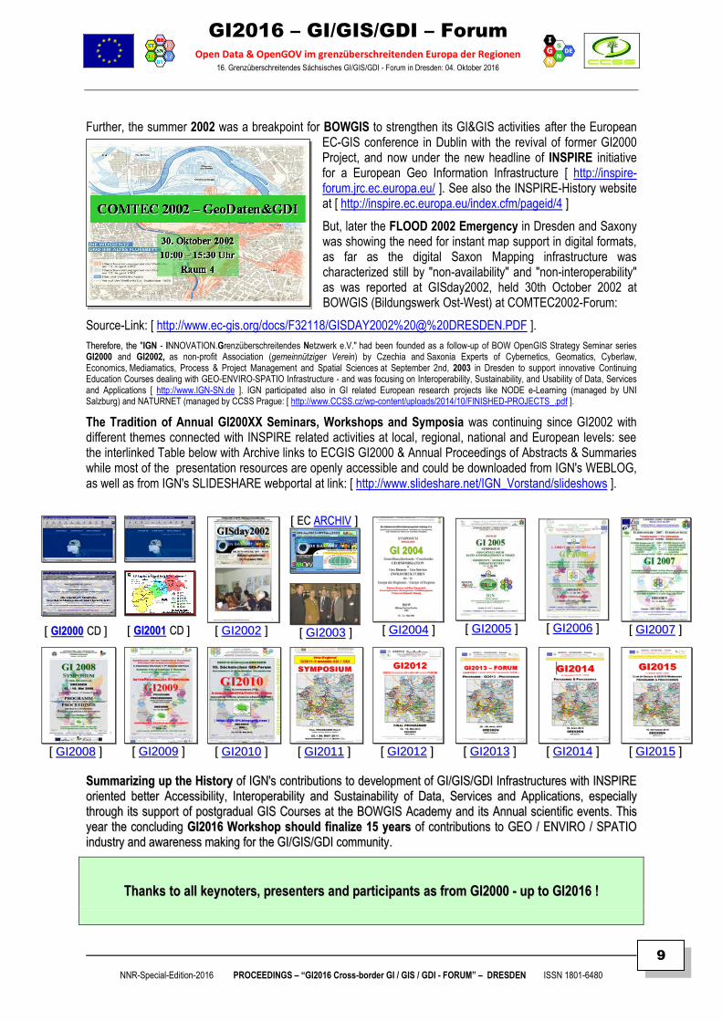
But, later the FLOOD 2002 Emergency in Dresden and Saxony was showing the need for instant map support in digital formats, as far as the digital Saxon Mapping infrastructure was characterized still by "non-availability" and "non-interoperability" as was reported at GISday2002, held 30th October 2002 at BOWGIS (Bildungswerk Ost-West) at COMTEC2002-Forum:
Source-Link: [ http://www.ec-gis.org/docs/F32118/GISDAY2002%20@%20DRESDEN.PDF ].
TThheerreeffoorree,, tthhee "IGN - INNOVATION.Grenzüberschreitendes Netzwerk e.V." had been founded as a follow-up of BOW OpenGIS Strategy Seminar series GI2000 and GI2002, as non-profit Association (gemeinnütziger Verein) by Czechia and Saxonia Experts of Cybernetics, Geomatics, Cyberlaw, Economics, Mediamatics, Process & Project Management and Spatial Sciences at September 2nd, 2003 in Dresden to support innovative Continuing Education Courses dealing with GEO-ENVIRO-SPATIO Infrastructure - and was focusing on Interoperability, Sustainability, and Usability of Data, Services and Applications [ http://www.IGN-SN.de ]. IGN participated also in GI related European research projects like NODE e-Learning (managed by UNI Salzburg) and NATURNET (managed by CCSS Prague: [ http://www.CCSS.cz/wp-content/uploads/2014/10/FINISHED-PROJECTS_.pdf ].
The Tradition of Annual GI200XX Seminars, Workshops and Symposia was continuing since GI2002 with different themes connected with INSPIRE related activities at local, regional, national and European levels: see the interlinked Table below with Archive links to ECGIS GI2000 & Annual Proceedings of Abstracts & Summaries while most of the presentation resources are openly accessible and could be downloaded from IGN's WEBLOG, as well as from IGN's SLIDESHARE webportal at link: [ http://www.slideshare.net/IGN_Vorstand/slideshows ].
[[ GGII22000000 CCDD ]]
[[ GGII22000011 CCDD ]] [[ GGII22000022 ]]
[[ EECC AARRCCHHIIVV ]]
[[ GGII22000033 ]] [[ GGII22000044 ]] [[ GGII22000055 ]] [[ GGII22000066 ]] [[ GGII22000077 ]]
[[ GGII22000088 ]] [[ GGII22000099 ]] [[ GGII22001100 ]] [[ GGII22001111 ]] [[ GGII22001122 ]] [[ GGII22001133 ]] [[ GGII22001144 ]] [[ GGII22001155 ]]
SSuummmmaarriizziinngg uupp tthhee HHiissttoorryy ooff IIGGNN''ss ccoonnttrriibbuuttiioonnss ttoo ddeevveellooppmmeenntt ooff GGII//GGIISS//GGDDII IInnffrraassttrruuccttuurreess wwiitthh IINNSSPPIIRREE
oorriieenntteedd bbeetttteerr AAcccceessssiibbiilliittyy,, IInntteerrooppeerraabbiilliittyy aanndd SSuussttaaiinnaabbiilliittyy ooff DDaattaa,, SSeerrvviicceess aanndd AApppplliiccaattiioonnss,, eessppeecciiaallllyy
tthhrroouugghh iittss ssuuppppoorrtt ooff ppoossttggrraadduuaall GGIISS CCoouurrsseess aatt tthhee BBOOWWGGIISS AAccaaddeemmyy aanndd iittss AAnnnnuuaall sscciieennttiiffiicc eevveennttss.. TThhiiss
yyeeaarr tthhee ccoonncclluuddiinngg GGII22001166 WWoorrkksshhoopp sshhoouulldd ffiinnaalliizzee 1155 yyeeaarrss ooff ccoonnttrriibbuuttiioonnss ttoo GGEEOO // EENNVVIIRROO // SSPPAATTIIOO
iinndduussttrryy aanndd aawwaarreenneessss mmaakkiinngg ffoorr tthhee GGII//GGIISS//GGDDII ccoommmmuunniittyy..
TThhaannkkss ttoo aallll kkeeyynnootteerrss,, pprreesseenntteerrss aanndd ppaarrttiicciippaannttss aass ffrroomm GGII22000000 -- uupp ttoo GGII22001166 !!
GI2016 – GI/GIS/GDI – Forum
Open Data & OpenGOV im grenzüberschreitenden Europa der Regionen 16. Grenzüberschreitendes Sächsisches GI/GIS/GDI - Forum in Dresden: 04. Oktober 2016
NNR-Special-Edition-2016 PROCEEDINGS – “GI2016 Cross-border GI / GIS / GDI - FORUM” – DRESDEN ISSN 1801-6480
10
GGII22001166
PPRROOCCEEEEDDIINNGGSS Abstracts & Summaries
DRESDEN
4. Oktober 2016
Edited by IGN e.V.
Doz. Dr. Frank HOFFMANN, CSc – IGN
Dr. Klaus-Dieter MICHAEL – VSBI
Dr. Gudrun HOFFMANN – IGN
Prof. Dr. Siegmar KLOSS – IGN
IMPRIMATUR TO PRINT
30. September 2016
Copyright © 2016 – CCSS-Praha & IGN-Dresden – All rights reserved.
GI2016 – GI/GIS/GDI – Forum
Open Data & OpenGOV im grenzüberschreitenden Europa der Regionen 16. Grenzüberschreitendes Sächsisches GI/GIS/GDI - Forum in Dresden: 04. Oktober 2016
NNR-Special-Edition-2016 PROCEEDINGS – “GI2016 Cross-border GI / GIS / GDI - FORUM” – DRESDEN ISSN 1801-6480
11
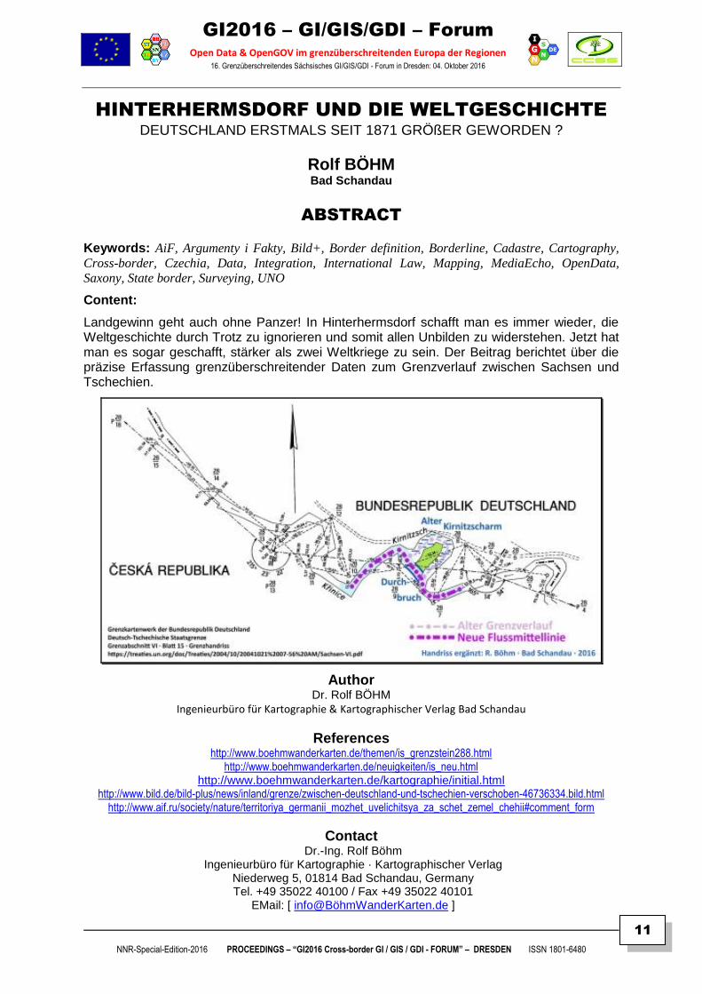
HINTERHERMSDORF UND DIE WELTGESCHICHTE DEUTSCHLAND ERSTMALS SEIT 1871 GRÖßER GEWORDEN ?
Rolf BÖHM Bad Schandau
ABSTRACT
Keywords: AiF, Argumenty i Fakty, Bild+, Border definition, Borderline, Cadastre, Cartography,
Cross-border, Czechia, Data, Integration, International Law, Mapping, MediaEcho, OpenData,
Saxony, State border, Surveying, UNO
Content:
Landgewinn geht auch ohne Panzer! In Hinterhermsdorf schafft man es immer wieder, die Weltgeschichte durch Trotz zu ignorieren und somit allen Unbilden zu widerstehen. Jetzt hat man es sogar geschafft, stärker als zwei Weltkriege zu sein. Der Beitrag berichtet über die präzise Erfassung grenzüberschreitender Daten zum Grenzverlauf zwischen Sachsen und Tschechien.
Author Dr. Rolf BÖHM
Ingenieurbüro für Kartographie & Kartographischer Verlag Bad Schandau
References http://www.boehmwanderkarten.de/themen/is_grenzstein288.html
http://www.boehmwanderkarten.de/neuigkeiten/is_neu.html http://www.boehmwanderkarten.de/kartographie/initial.html
http://www.bild.de/bild-plus/news/inland/grenze/zwischen-deutschland-und-tschechien-verschoben-46736334.bild.html http://www.aif.ru/society/nature/territoriya_germanii_mozhet_uvelichitsya_za_schet_zemel_chehii#comment_form
Contact Dr.-Ing. Rolf Böhm
Ingenieurbüro für Kartographie · Kartographischer Verlag Niederweg 5, 01814 Bad Schandau, Germany Tel. +49 35022 40100 / Fax +49 35022 40101
EMail: [ info@BöhmWanderKarten.de ]
GI2016 – GI/GIS/GDI – Forum
Open Data & OpenGOV im grenzüberschreitenden Europa der Regionen 16. Grenzüberschreitendes Sächsisches GI/GIS/GDI - Forum in Dresden: 04. Oktober 2016
NNR-Special-Edition-2016 PROCEEDINGS – “GI2016 Cross-border GI / GIS / GDI - FORUM” – DRESDEN ISSN 1801-6480
12
SUMMARY
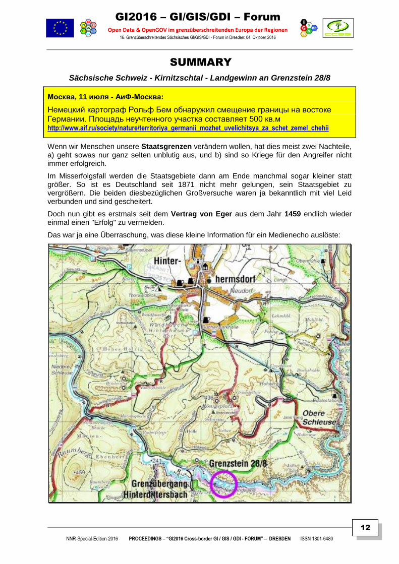
Sächsische Schweiz - Kirnitzschtal - Landgewinn an Grenzstein 28/8
Москва, 11 июля - АиФ-Москва:
Немецкий картограф Рольф Бем обнаружил смещение границы на востоке Германии. Площадь неучтенного участка составляет 500 кв.м http://www.aif.ru/society/nature/territoriya_germanii_mozhet_uvelichitsya_za_schet_zemel_chehii
Wenn wir Menschen unsere Staatsgrenzen verändern wollen, hat dies meist zwei Nachteile, a) geht sowas nur ganz selten unblutig aus, und b) sind so Kriege für den Angreifer nicht immer erfolgreich.
Im Misserfolgsfall werden die Staatsgebiete dann am Ende manchmal sogar kleiner statt größer. So ist es Deutschland seit 1871 nicht mehr gelungen, sein Staatsgebiet zu vergrößern. Die beiden diesbezüglichen Großversuche waren ja bekanntlich mit viel Leid verbunden und sind gescheitert.
Doch nun gibt es erstmals seit dem Vertrag von Eger aus dem Jahr 1459 endlich wieder einmal einen "Erfolg" zu vermelden.
Das war ja eine Überraschung, was diese kleine Information für ein Medienecho auslöste:
GI2016 – GI/GIS/GDI – Forum
Open Data & OpenGOV im grenzüberschreitenden Europa der Regionen 16. Grenzüberschreitendes Sächsisches GI/GIS/GDI - Forum in Dresden: 04. Oktober 2016
NNR-Special-Edition-2016 PROCEEDINGS – “GI2016 Cross-border GI / GIS / GDI - FORUM” – DRESDEN ISSN 1801-6480
13
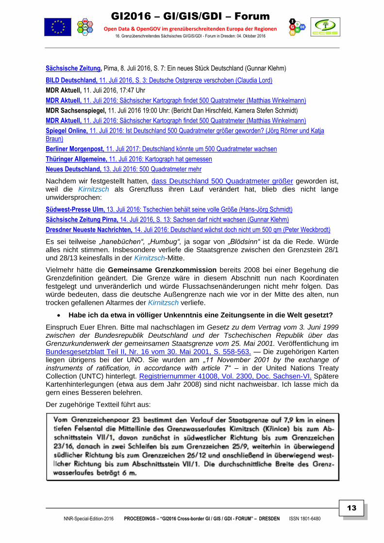
Sächsische Zeitung, Pirna, 8. Juli 2016, S. 7: Ein neues Stück Deutschland (Gunnar Klehm)
BILD Deutschland, 11. Juli 2016, S. 3: Deutsche Ostgrenze verschoben (Claudia Lord)
MDR Aktuell, 11. Juli 2016, 17:47 Uhr
MDR Aktuell, 11. Juli 2016: Sächsischer Kartograph findet 500 Quatratmeter (Matthias Winkelmann)
MDR Sachsenspiegel, 11. Juli 2016 19:00 Uhr: (Bericht Dan Hirschfeld, Kamera Stefen Schmidt)
MDR Aktuell, 11. Juli 2016: Sächsischer Kartograph findet 500 Quatratmeter (Matthias Winkelmann)
Spiegel Online, 11. Juli 2016: Ist Deutschland 500 Quadratmeter größer geworden? (Jörg Römer und Katja Braun)
Berliner Morgenpost, 11. Juli 2017: Deutschland könnte um 500 Quadratmeter wachsen
Thüringer Allgemeine, 11. Juli 2016: Kartograph hat gemessen
Neues Deutschland, 13. Juli 2016: 500 Quadratmeter mehr
Nachdem wir festgestellt hatten, dass Deutschland 500 Quadratmeter größer geworden ist, weil die Kirnitzsch als Grenzfluss ihren Lauf verändert hat, blieb dies nicht lange unwidersprochen:
Südwest-Presse Ulm, 13. Juli 2016: Tschechien behält seine volle Größe (Hans-Jörg Schmidt)
Sächsische Zeitung Pirna, 14. Juli 2016, S. 13: Sachsen darf nicht wachsen (Gunnar Klehm)
Dresdner Neueste Nachrichten, 14. Juli 2016: Deutschland wächst doch nicht um 500 qm (Peter Weckbrodt)
Es sei teilweise „hanebüchen“, „Humbug“, ja sogar von „Blödsinn“ ist da die Rede. Würde alles nicht stimmen. Insbesondere verliefe die Staatsgrenze zwischen den Grenzstein 28/1 und 28/13 keinesfalls in der Kirnitzsch-Mitte.
Vielmehr hätte die Gemeinsame Grenzkommission bereits 2008 bei einer Begehung die Grenzdefinition geändert. Die Grenze wäre in diesem Abschnitt nun nach Koordinaten festgelegt und unveränderlich und würde Flussachsenänderungen nicht mehr folgen. Das würde bedeuten, dass die deutsche Außengrenze nach wie vor in der Mitte des alten, nun trocken gefallenen Altarmes der Kirnitzsch verliefe.
Habe ich da etwa in völliger Unkenntnis eine Zeitungsente in die Welt gesetzt?
Einspruch Euer Ehren. Bitte mal nachschlagen im Gesetz zu dem Vertrag vom 3. Juni 1999 zwischen der Bundesrepublik Deutschland und der Tschechischen Republik über das Grenzurkundenwerk der gemeinsamen Staatsgrenze vom 25. Mai 2001. Veröffentlichung im Bundesgesetzblatt Teil II, Nr. 16 vom 30. Mai 2001, S. 558-563. — Die zugehörigen Karten liegen übrigens bei der UNO. Sie wurden am „11 November 2001 by the exchange of instruments of ratification, in accordance with article 7“ – in der United Nations Treaty Collection (UNTC) hinterlegt. Registriernummer 41008, Vol. 2300, Doc. Sachsen-VI. Spätere Kartenhinterlegungen (etwa aus dem Jahr 2008) sind nicht nachweisbar. Ich lasse mich da gern eines Besseren belehren.
Der zugehörige Textteil führt aus:
GI2016 – GI/GIS/GDI – Forum
Open Data & OpenGOV im grenzüberschreitenden Europa der Regionen 16. Grenzüberschreitendes Sächsisches GI/GIS/GDI - Forum in Dresden: 04. Oktober 2016
NNR-Special-Edition-2016 PROCEEDINGS – “GI2016 Cross-border GI / GIS / GDI - FORUM” – DRESDEN ISSN 1801-6480
14
„Mittellinie des Grenzwasserlaufes“ – das ist doch eigentlich recht eindeutig formuliert.
Als treues sächsisches Landeskind und Verehrer Jaroslav Hašeks liegt es mir natürlich fern, anderslautende Darstellungen irgendwie in Zweifel zu ziehen. Gewiss hat alles eine gewisse Richtigkeit. Unzweifelhaft mag da die Grenzfestlegung durch die Grenzkommission 2008 irgendwie geändert worden sein.
Um Rechtswirksamkeit zu entfalten, müsste der Vorgang aber erst noch einige Formalia durchlaufen: Innenministerium, Auswärtiges Amt, Diplomatie, Staatsvertrag, Bundestag, UNO. Solang dies nicht geschehen ist – und damit letztendlich eine Völkerrechtsänderung bewirkt ist – haben wir hier lediglich einen interner Arbeitsstand vorliegen und solange gilt die alte Grenzdefinition von 2001 (genau genommen sogar von 1459) unverändert fort.
Halt! Moment mal! Diese Darstellungen nun auch mal mit der Brille des Staats- und Völkerrechtlers lesen. Was gilt? Was ist die Anspruchsgrundlage?
Da hat also der Freistaat Sachsen eine durch Fluss-Achsenänderung ermöglichte Gebietserweiterung großmütig ausgeschlagen. Wir dürfen gewiss Einvernehmen von Bund und Ländern unterstellen. Folglich liegt hier eine Inbesitznahme des Gebietes durch die Bundesrepublik Deutschland nicht vor.
Gleichsam gilt freilich das internationale Völkerrecht fort, demzufolge die „Mittellinie des Grenzwasserlaufes“ die Grenzlinie bildet. Ohne Zweifel hat sich diese verändert, was zur Folge hat, dass das Gebiet nun aus dem Territorium der Tschechischen Republik ausgeschieden ist. Somit ist der besagte Landstrich also herrenlos geworden.
Schließlich wird auf Nachfragen durch Gunnar KLEHM in einem Bericht der "Sächsischen Zeitung" vom 14. Juli 2016 die Situation aus behördlicher Sicht u.a. wie folgt erklärt:
Sachsen darf nicht wachsen - Die Kirnitzsch brachte Landgewinn. Aber der
Grenzfluss ist seiner Aufgabe enthoben. Wegen Unzuverlässigkeit...
Quelle: http://www.sz-online.de/nachrichten/sachsen-darf-nicht-wachsen-3442477.html
"... Nach strenger Lesart des Grenzvertrags zwischen Deutschland und Tschechien hätte die Ständige Grenzkommission beider Staaten nun die Entscheidung treffen müssen, dass sich Deutschland vergrößert. Bei „nassen Grenzen“ ändert sich mit dem Flusslauf auch der Grenzverlauf. Doch das jährlich zusammenkommende Gremium hat eine andere Entscheidung getroffen. „Wir haben gemeinsam festgelegt, den Grenzverlauf zwischen Grenzstein 28/1 und 28/13 als trockene Grenze zu betrachten“, erklärt Werner Haupt, der Geschäftsführer des Staatsbetriebs Geobasisinformation und Vermessung Sachsen, dem früheren Landesvermessungsamt...
Karten bei der UNO hinterlegt...
"In den Jahren 2007 und 2008 wurde der Verlauf der Kirnitzsch noch mal völlig neu vermessen. Aufgrund dieser Daten hat die Gemeinsame Grenzkommission schließlich neue Karten zum linearen Grenzverlauf bestätigt, die auch bei den Vereinten Nationen hinterlegt sind."
Das erfolgt aber nur der Form halber. Eine dritte Stelle war zur Klärung von Grenzentscheidungen in den vergangenen 25 Jahren nicht notwendig.
„Bisher haben wir immer eine Lösung gefunden“, sagt Werner Haupt.
Auch vom tschechischen Innenministerium wurde ein möglicher "Grenzkonflikt" entlang der Kirnitzsch als „Humbug“ bezeichnet...
GI2016 – GI/GIS/GDI – Forum
Open Data & OpenGOV im grenzüberschreitenden Europa der Regionen 16. Grenzüberschreitendes Sächsisches GI/GIS/GDI - Forum in Dresden: 04. Oktober 2016
NNR-Special-Edition-2016 PROCEEDINGS – “GI2016 Cross-border GI / GIS / GDI - FORUM” – DRESDEN ISSN 1801-6480
15
DIE ENTSTEHUNG DER BÖHM-WANDERKARTEN VON DER SEELE UNSERER WEGE
Rolf BÖHM
Ingenieurbüro für Kartographie & Kartographischer Verlag - Bad Schandau (DE)
ABSTRACT
Keywords: 3D, Base map, BigData, Compilation, Cross-border, Landscape, Map Design,
Map Projections, Mapping, OpenData, OpenStreetMap, Relief, Road Network, SRTM, Tourist
Maps
Content:
Gerade im GIS- und OpenStreetMap-Zeitalter werden immer mehr allmögliche Objekte kartiert. Wege gibt es nicht nur seit ein paar hundert Jahren. Es darf vermutet werden, dass Wege-Hauptachsen, die heute nach wie vor in Nutzungen sind, wie z.B. die B6 von Dresden nach Bautzen 1000 Jahre und noch älter sind. Die ältesten Wegspuren in Mitteleuropa sind nahezu 6000 Jahre alt.
Der Landschaftsraum, der einmal wesentlich von Wegen konstituiert wurde, ist mehr und mehr ein Sammelsurium von Autobahnen, Eisenbahn-Ausbaustrecken, Gewerbegebieten, Solarparks, Deponien, nicht zuletzt Braunkohlen-Tagebauen oder Windparks.
Die Kontinuität der topographischen Fläche zerfällt und wird fraktal und fragmentiert. Bei alledem bleibt das eigentliche Rückgrat der ursprünglichen Kulturlandschaft eigenartig unbeachtet: Der Weg.
Der Beitrag erläutert zunächst am Beispiel der Sächsischen Schweiz die Entwicklung des Wegenetzes und demonstriert dessen kartographisches Design und Fertigung der Böhm-Wanderkartenserie.
Danach wird am Beispiel des Computereinsatzes zur kartographischen Relief-Bearbeitung die Verarbeitung von Massendaten (BigData) für verschiedene kartographische Erzeugnisse demonstriert.
Author Dr.Ing. Rolf BÖHM
References
http://www.boehmwanderkarten.de/kv/is_kv_main.html http://www.boehmwanderkarten.de/werkstatt/is_schrammsteinwege_main.html
http://www.boehmwanderkarten.de/werkstatt/is_khaatal_main.html http://www.boehmwanderkarten.de/werkstatt/is_khaatal_topographie.html http://www.boehmwanderkarten.de/werkstatt/is_khaatal_kartographie.html http://www.boehmwanderkarten.de/werkstatt/is_khaatal_lithographie.html
Contact Dr.-Ing. Rolf Böhm
Ingenieurbüro für Kartographie & Kartographischer Verlag Niederweg 5, 01814 Bad Schandau, Germany Tel. +49 35022 40100 / Fax +49 35022 40101
EMail: [ info@BöhmWanderKarten.de ]
GI2016 – GI/GIS/GDI – Forum
Open Data & OpenGOV im grenzüberschreitenden Europa der Regionen 16. Grenzüberschreitendes Sächsisches GI/GIS/GDI - Forum in Dresden: 04. Oktober 2016
NNR-Special-Edition-2016 PROCEEDINGS – “GI2016 Cross-border GI / GIS / GDI - FORUM” – DRESDEN ISSN 1801-6480
16
SUMMARY
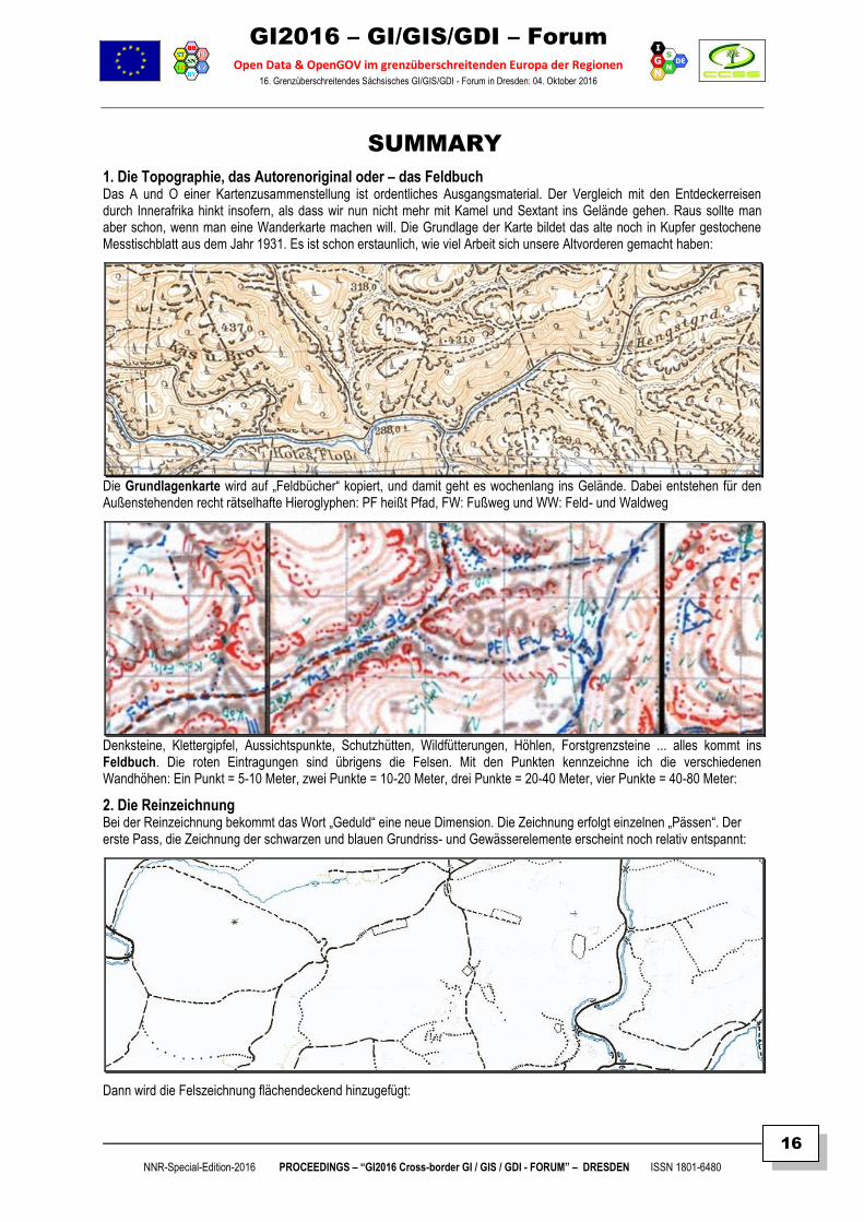
1. Die Topographie, das Autorenoriginal oder – das Feldbuch Das A und O einer Kartenzusammenstellung ist ordentliches Ausgangsmaterial. Der Vergleich mit den Entdeckerreisen durch Innerafrika hinkt insofern, als dass wir nun nicht mehr mit Kamel und Sextant ins Gelände gehen. Raus sollte man aber schon, wenn man eine Wanderkarte machen will. Die Grundlage der Karte bildet das alte noch in Kupfer gestochene Messtischblatt aus dem Jahr 1931. Es ist schon erstaunlich, wie viel Arbeit sich unsere Altvorderen gemacht haben:
Die Grundlagenkarte wird auf „Feldbücher“ kopiert, und damit geht es wochenlang ins Gelände. Dabei entstehen für den Außenstehenden recht rätselhafte Hieroglyphen: PF heißt Pfad, FW: Fußweg und WW: Feld- und Waldweg
Denksteine, Klettergipfel, Aussichtspunkte, Schutzhütten, Wildfütterungen, Höhlen, Forstgrenzsteine ... alles kommt ins Feldbuch. Die roten Eintragungen sind übrigens die Felsen. Mit den Punkten kennzeichne ich die verschiedenen Wandhöhen: Ein Punkt = 5-10 Meter, zwei Punkte = 10-20 Meter, drei Punkte = 20-40 Meter, vier Punkte = 40-80 Meter:
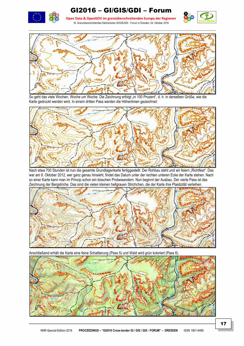
2. Die Reinzeichnung Bei der Reinzeichnung bekommt das Wort „Geduld“ eine neue Dimension. Die Zeichnung erfolgt einzelnen „Pässen“. Der erste Pass, die Zeichnung der schwarzen und blauen Grundriss- und Gewässerelemente erscheint noch relativ entspannt:
Dann wird die Felszeichnung flächendeckend hinzugefügt:
GI2016 – GI/GIS/GDI – Forum
Open Data & OpenGOV im grenzüberschreitenden Europa der Regionen 16. Grenzüberschreitendes Sächsisches GI/GIS/GDI - Forum in Dresden: 04. Oktober 2016
NNR-Special-Edition-2016 PROCEEDINGS – “GI2016 Cross-border GI / GIS / GDI - FORUM” – DRESDEN ISSN 1801-6480
17
So geht das viele Wochen, Woche um Woche. Die Zeichnung erfolgt „in 100 Prozent“, d. h. in derselben Größe, wie die Karte gedruckt werden wird. In einem dritten Pass werden die Höhenlinien gezeichnet:
Nach etwa 700 Stunden ist nun die gesamte Grundlagenkarte fertiggestellt. Der Rohbau steht und wir feiern „Richtfest“. Das war am 9. Oktober 2012, wer ganz genau hinsieht, findet das Datum unter der rechten unteren Ecke der Karte stehen. Nach so einer Karte kann man im Prinzip schon ein bisschen Probewandern. Nun beginnt der Ausbau. Der vierte Pass ist das Zeichnung der Bergstriche. Das sind die vielen kleinen hellgrauen Strichchen, die der Karte ihre Plastizität verleihen.
Anschließend erhält die Karte eine feine Schattierung (Pass 5) und Wald wird grün koloriert (Pass 6).
GI2016 – GI/GIS/GDI – Forum
Open Data & OpenGOV im grenzüberschreitenden Europa der Regionen 16. Grenzüberschreitendes Sächsisches GI/GIS/GDI - Forum in Dresden: 04. Oktober 2016
NNR-Special-Edition-2016 PROCEEDINGS – “GI2016 Cross-border GI / GIS / GDI - FORUM” – DRESDEN ISSN 1801-6480
18
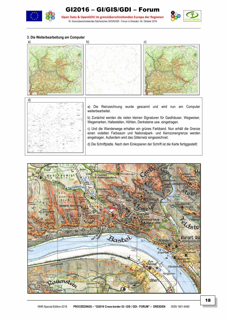
3. Die Weiterbearbeitung am Computer a) b) c)
d)
a) Die Reinzeichnung wurde gescannt und wird nun am Computer weiterbearbeitet.
b) Zunächst werden die vielen kleinen Signaturen für Gasthäuser, Wegweiser, Wegemarken, Haltestellen, Höhlen, Denksteine usw. eingetragen.
c) Und die Wanderwege erhalten ein grünes Farbband. Nun erhält die Grenze einen violetten Farbsaum und Nationalpark- und Kernzonengrenze werden eingetragen. Außerdem wird das Gitternetz eingezeichnet:
d) Die Schriftplatte. Nach dem Einkopieren der Schrift ist die Karte fertiggestellt:
GI2016 – GI/GIS/GDI – Forum
Open Data & OpenGOV im grenzüberschreitenden Europa der Regionen 16. Grenzüberschreitendes Sächsisches GI/GIS/GDI - Forum in Dresden: 04. Oktober 2016
NNR-Special-Edition-2016 PROCEEDINGS – “GI2016 Cross-border GI / GIS / GDI - FORUM” – DRESDEN ISSN 1801-6480
19
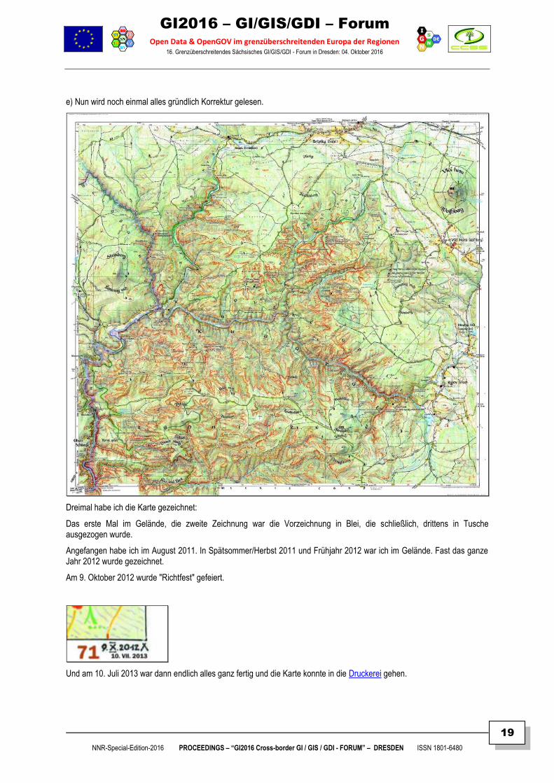
e) Nun wird noch einmal alles gründlich Korrektur gelesen.
Dreimal habe ich die Karte gezeichnet:
Das erste Mal im Gelände, die zweite Zeichnung war die Vorzeichnung in Blei, die schließlich, drittens in Tusche ausgezogen wurde.
Angefangen habe ich im August 2011. In Spätsommer/Herbst 2011 und Frühjahr 2012 war ich im Gelände. Fast das ganze Jahr 2012 wurde gezeichnet.
Am 9. Oktober 2012 wurde "Richtfest" gefeiert.
Und am 10. Juli 2013 war dann endlich alles ganz fertig und die Karte konnte in die Druckerei gehen.
GI2016 – GI/GIS/GDI – Forum
Open Data & OpenGOV im grenzüberschreitenden Europa der Regionen 16. Grenzüberschreitendes Sächsisches GI/GIS/GDI - Forum in Dresden: 04. Oktober 2016
NNR-Special-Edition-2016 PROCEEDINGS – “GI2016 Cross-border GI / GIS / GDI - FORUM” – DRESDEN ISSN 1801-6480
20
DLR KULTUR - INTERVIEW
DR. ROLF BÖHM STADT, LAND, KARTEN ZEICHNEN - VON HAND!
DLR | Studio 9 | Reprint zum Beitrag vom 23.08.2016 (c) by Bastian Brandau
ABSTRACT
Keywords: Computerkartographie, Elbsandsteingebirge, Gelände, Informationsspeicher, Karte, Kartensymbole,
Kartenwerkstatt, Landkarte, Leidenschaft, Map design, Navigation, Orientierung, Visualization, Wanderkarten
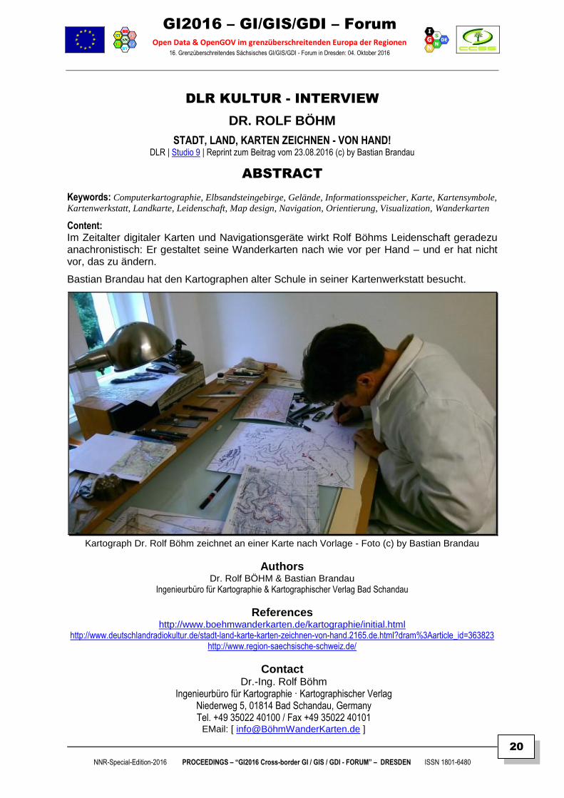
Content: Im Zeitalter digitaler Karten und Navigationsgeräte wirkt Rolf Böhms Leidenschaft geradezu anachronistisch: Er gestaltet seine Wanderkarten nach wie vor per Hand – und er hat nicht vor, das zu ändern.
Bastian Brandau hat den Kartographen alter Schule in seiner Kartenwerkstatt besucht.
Kartograph Dr. Rolf Böhm zeichnet an einer Karte nach Vorlage - Foto (c) by Bastian Brandau
Authors Dr. Rolf BÖHM & Bastian Brandau
Ingenieurbüro für Kartographie & Kartographischer Verlag Bad Schandau
References http://www.boehmwanderkarten.de/kartographie/initial.html
http://www.deutschlandradiokultur.de/stadt-land-karte-karten-zeichnen-von-hand.2165.de.html?dram%3Aarticle_id=363823 http://www.region-saechsische-schweiz.de/
Contact Dr.-Ing. Rolf Böhm
Ingenieurbüro für Kartographie · Kartographischer Verlag Niederweg 5, 01814 Bad Schandau, Germany Tel. +49 35022 40100 / Fax +49 35022 40101
EMail: [ info@BöhmWanderKarten.de ]
GI2016 – GI/GIS/GDI – Forum
Open Data & OpenGOV im grenzüberschreitenden Europa der Regionen 16. Grenzüberschreitendes Sächsisches GI/GIS/GDI - Forum in Dresden: 04. Oktober 2016
NNR-Special-Edition-2016 PROCEEDINGS – “GI2016 Cross-border GI / GIS / GDI - FORUM” – DRESDEN ISSN 1801-6480
21
INTERVIEW < AUDIO > SUMMARY
Im Zeitalter digitaler Karten und Navigationsgeräte wirkt Rolf Böhms Leidenschaft geradezu anachronistisch: Er gestaltet seine Wanderkarten nach wie vor per Hand – und er hat nicht vor, das zu ändern.
Bastian Brandau hat den Kartographen alter Schule in seiner Kartenwerkstatt besucht.
"So, den können wir schon nehmen, 0,25, das sind die dünnen Höhenlinien. Linienstärken…"
An seinem Schreibtisch sucht Rolf Böhm unter seinen Tuschestiften den mit der richtigen Stärke. Braun, 0,25 Millimeter. Böhm, leicht verwuscheltes Haar und runde Brille, überträgt Höhenlinien auf eine entstehende Landkarte per Hand.
Rolf Böhm: "So, na, wird langsam ein Bild draus. Da muss man sehen, wenn die zu dünn werden, zu
weit auseinanderlaufen, die Höhenlinien, da kommt noch was anderes rein. Also, es muss ein Bild
geben. Hier sieht man die Felsen, das ist so ein oberer Horizont. Hier geht eine Treppe runter, hier
geht so ein Pfad."
Feine, einzelne Striche, angeordnet in ungleichmäßig verlaufenden Formen: Es sind die zerklüfteten Felsen des Elbsandsteingebirges aus der Vogelperspektive. Gewässer, Täler, Hügel und Siedlungen: In Handarbeit entsteht hier im Maßstab 1 zu 2000 eine Wanderkarte eines Gebietes der böhmischen Schweiz, das bei Google Earth nur eine grüne Masse mit ein paar Wegen ist.
Böhm: "Das ist ein Kartentitel, an dem ich gerade zeichne, Na Tokáni, Balzhütte. Aber da sitze ich
noch ein Jahr dran, das dauert eine Weile."
Bierhumpen als Symbol für Gaststätten
Sorgfalt, Ruhe und Ausdauer, ohne diese Eigenschaften läuft nichts bei Rolf Böhm. Seine handgestalteten Wanderkarten für die Sächsische Schweiz sind überregional bekannt, 24 davon hat er im Angebot. Böhm wandert die Strecken vorher ab und gestaltet die Karten dann im Atelier in seinem Haus in Bad Schandau: Wo ist ein neuer Weg entstanden, wo ein alter verschwunden? Welches Café hat vielleicht einen anderen Namen?
Es sind die Details, die Böhms Karten besonders machen: Der Bierhumpen als Symbol für eine Gaststätte, die handschriftlichen Namen von Bächen, Orten oder Sehenswürdigkeiten. Und das Männchen, das auf fast jeder Karte versteckt ist, als Gruß an seine inzwischen erwachsenen Kinder.
Wer dem studierten Kartographen in seiner Werkstatt über die Schulter geschaut hat, erkennt auf den fertigen Karten die tausenden feinen handgezeichneten Striche, die dort Felsen und Höhenzüge ergeben.
Böhm: "Ich bin ein etwas Über-das-übliche-Maß-hinaus-Gestalter. Und in meinen Vorstellungen im
Kopf ist fertig, wie eine Karte ist. Ich habe immer noch auf die supergute Kartografie-Software
gewartet. Das geht ja jetzt schon seit 30 Jahren so, dass man sagt, Karten macht man mit dem
Computer. Und am Anfang habe ich mir das angeguckt und gesagt, nee, das bringst du eigentlich
besser mit der Hand. Dann wurden die Programme ein bisschen besser und mir waren sie aber immer
noch nicht gut genug. Und dann kam irgendwie eine Phase, da habe ich dann gemerkt, nach dem
händischen Stil ist durchaus noch eine Nachfrage."
Und die ist Rolf Böhm durchaus bereit, weiter zu befriedigen. Er, der schon als Kind die Welt kartographierte, und der einen besonderen geographischen Orientierungssinn zu haben scheint. Und es ist ja nicht so, dass er was gegen Computer hätte. Jahrelang hat er als Programmierer gearbeitet, betreibt eine Website und kann einschlägige Programme durchaus bedienen.
GI2016 – GI/GIS/GDI – Forum
Open Data & OpenGOV im grenzüberschreitenden Europa der Regionen 16. Grenzüberschreitendes Sächsisches GI/GIS/GDI - Forum in Dresden: 04. Oktober 2016
NNR-Special-Edition-2016 PROCEEDINGS – “GI2016 Cross-border GI / GIS / GDI - FORUM” – DRESDEN ISSN 1801-6480
22
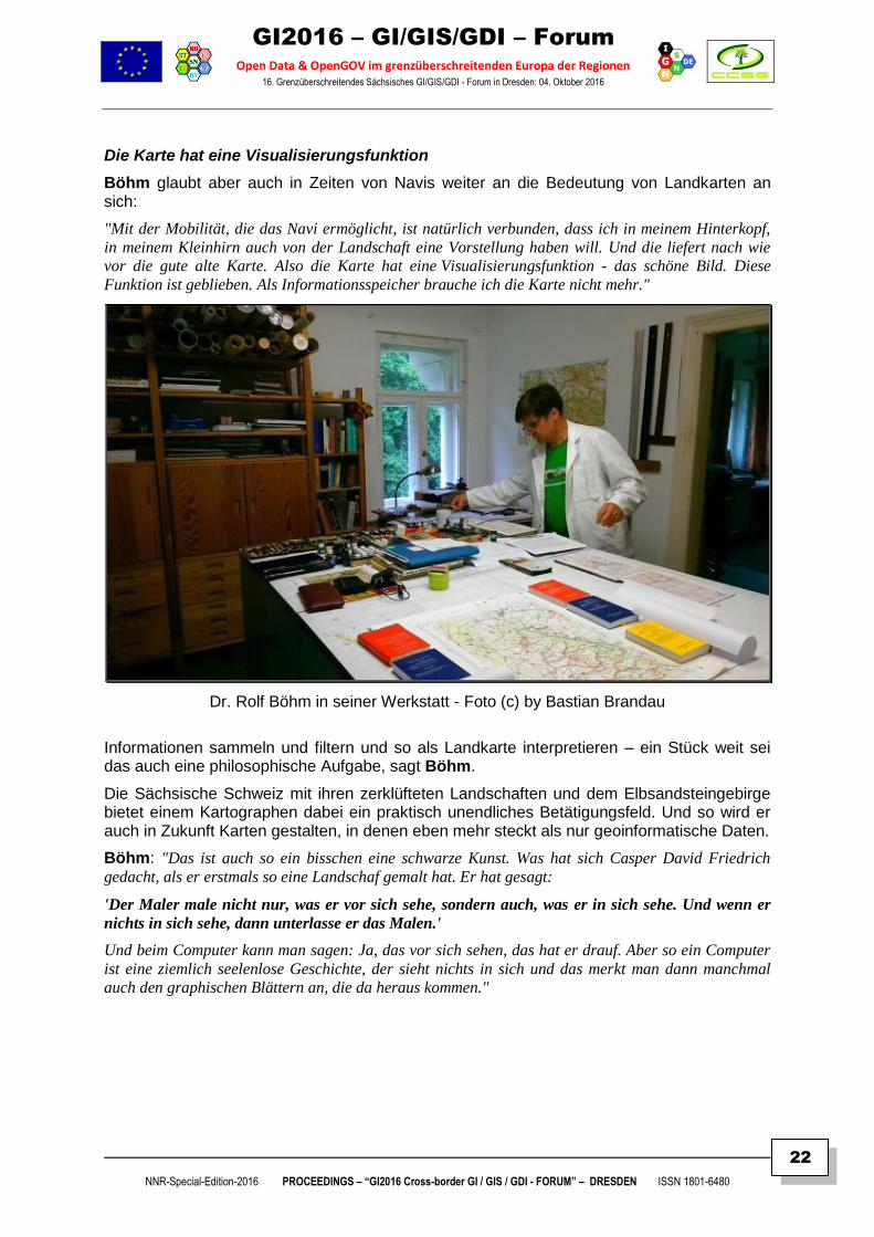
Die Karte hat eine Visualisierungsfunktion
Böhm glaubt aber auch in Zeiten von Navis weiter an die Bedeutung von Landkarten an sich:
"Mit der Mobilität, die das Navi ermöglicht, ist natürlich verbunden, dass ich in meinem Hinterkopf,
in meinem Kleinhirn auch von der Landschaft eine Vorstellung haben will. Und die liefert nach wie
vor die gute alte Karte. Also die Karte hat eine Visualisierungsfunktion - das schöne Bild. Diese
Funktion ist geblieben. Als Informationsspeicher brauche ich die Karte nicht mehr."
Dr. Rolf Böhm in seiner Werkstatt - Foto (c) by Bastian Brandau
Informationen sammeln und filtern und so als Landkarte interpretieren – ein Stück weit sei das auch eine philosophische Aufgabe, sagt Böhm.
Die Sächsische Schweiz mit ihren zerklüfteten Landschaften und dem Elbsandsteingebirge bietet einem Kartographen dabei ein praktisch unendliches Betätigungsfeld. Und so wird er auch in Zukunft Karten gestalten, in denen eben mehr steckt als nur geoinformatische Daten.
Böhm: "Das ist auch so ein bisschen eine schwarze Kunst. Was hat sich Casper David Friedrich
gedacht, als er erstmals so eine Landschaf gemalt hat. Er hat gesagt:
'Der Maler male nicht nur, was er vor sich sehe, sondern auch, was er in sich sehe. Und wenn er
nichts in sich sehe, dann unterlasse er das Malen.'
Und beim Computer kann man sagen: Ja, das vor sich sehen, das hat er drauf. Aber so ein Computer
ist eine ziemlich seelenlose Geschichte, der sieht nichts in sich und das merkt man dann manchmal
auch den graphischen Blättern an, die da heraus kommen."
GI2016 – GI/GIS/GDI – Forum
Open Data & OpenGOV im grenzüberschreitenden Europa der Regionen 16. Grenzüberschreitendes Sächsisches GI/GIS/GDI - Forum in Dresden: 04. Oktober 2016
NNR-Special-Edition-2016 PROCEEDINGS – “GI2016 Cross-border GI / GIS / GDI - FORUM” – DRESDEN ISSN 1801-6480
23
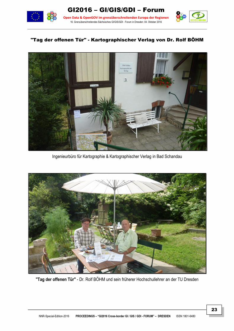
"Tag der offenen Tür" - Kartographischer Verlag von Dr. Rolf BÖHM
Ingenieurbüro für Kartographie & Kartographischer Verlag in Bad Schandau
"Tag der offenen Tür" - Dr. Rolf BÖHM und sein früherer Hochschullehrer an der TU Dresden
GI2016 – GI/GIS/GDI – Forum
Open Data & OpenGOV im grenzüberschreitenden Europa der Regionen 16. Grenzüberschreitendes Sächsisches GI/GIS/GDI - Forum in Dresden: 04. Oktober 2016
NNR-Special-Edition-2016 PROCEEDINGS – “GI2016 Cross-border GI / GIS / GDI - FORUM” – DRESDEN ISSN 1801-6480
24
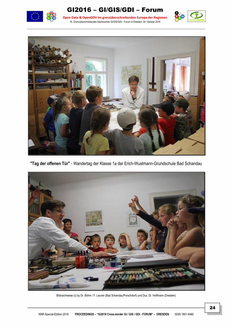
"Tag der offenen Tür" - Wandertag der Klasse 1a der Erich-Wustmann-Grundschule Bad Schandau
Bildnachweise (c) by Dr. Böhm / F. Leuner (Bad Schandau/Porschdorf) und Doz. Dr. Hoffmann (Dresden)
GI2016 – GI/GIS/GDI – Forum
Open Data & OpenGOV im grenzüberschreitenden Europa der Regionen 16. Grenzüberschreitendes Sächsisches GI/GIS/GDI - Forum in Dresden: 04. Oktober 2016
NNR-Special-Edition-2016 PROCEEDINGS – “GI2016 Cross-border GI / GIS / GDI - FORUM” – DRESDEN ISSN 1801-6480
25
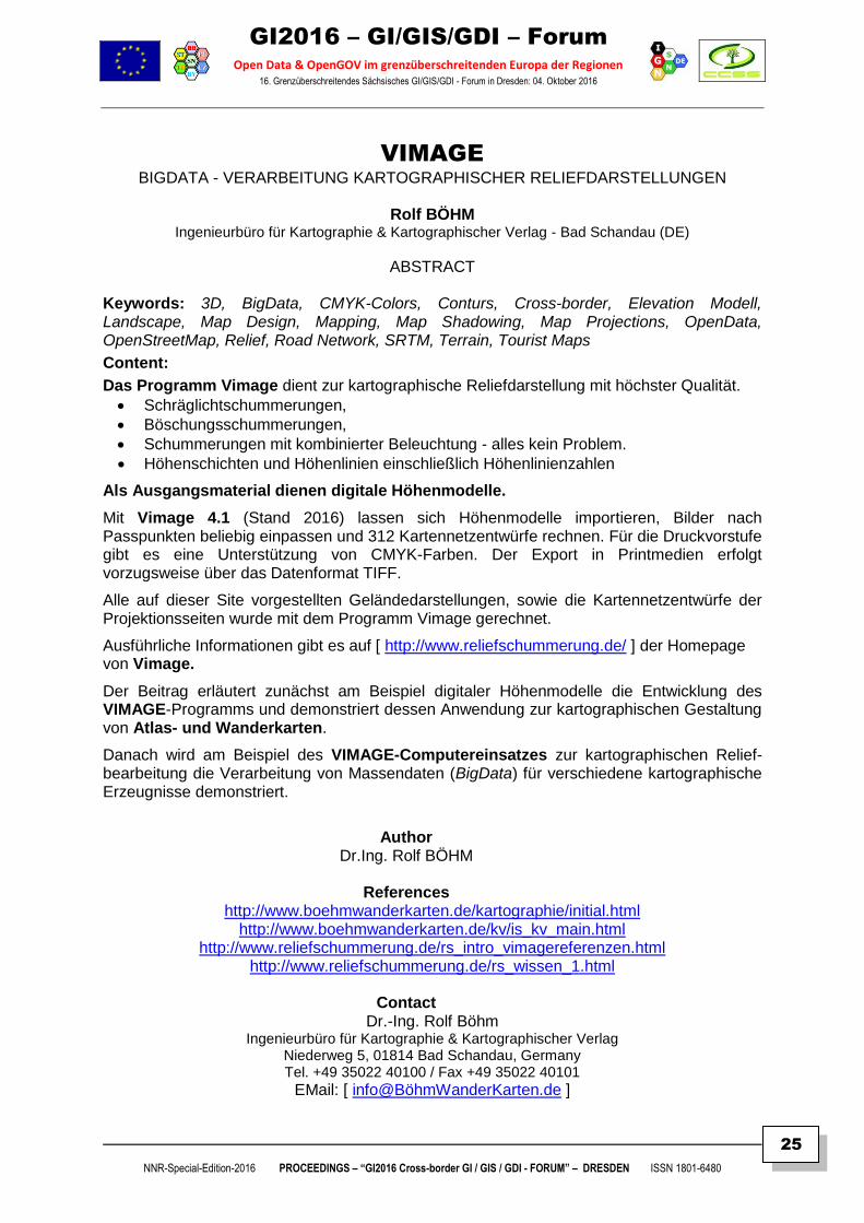
VIMAGE BIGDATA - VERARBEITUNG KARTOGRAPHISCHER RELIEFDARSTELLUNGEN
Rolf BÖHM
Ingenieurbüro für Kartographie & Kartographischer Verlag - Bad Schandau (DE)
ABSTRACT
Keywords: 3D, BigData, CMYK-Colors, Conturs, Cross-border, Elevation Modell, Landscape, Map Design, Mapping, Map Shadowing, Map Projections, OpenData, OpenStreetMap, Relief, Road Network, SRTM, Terrain, Tourist Maps
Content:
Das Programm Vimage dient zur kartographische Reliefdarstellung mit höchster Qualität.
Schräglichtschummerungen,
Böschungsschummerungen,
Schummerungen mit kombinierter Beleuchtung - alles kein Problem.
Höhenschichten und Höhenlinien einschließlich Höhenlinienzahlen
Als Ausgangsmaterial dienen digitale Höhenmodelle.
Mit Vimage 4.1 (Stand 2016) lassen sich Höhenmodelle importieren, Bilder nach Passpunkten beliebig einpassen und 312 Kartennetzentwürfe rechnen. Für die Druckvorstufe gibt es eine Unterstützung von CMYK-Farben. Der Export in Printmedien erfolgt vorzugsweise über das Datenformat TIFF.
Alle auf dieser Site vorgestellten Geländedarstellungen, sowie die Kartennetzentwürfe der Projektionsseiten wurde mit dem Programm Vimage gerechnet.
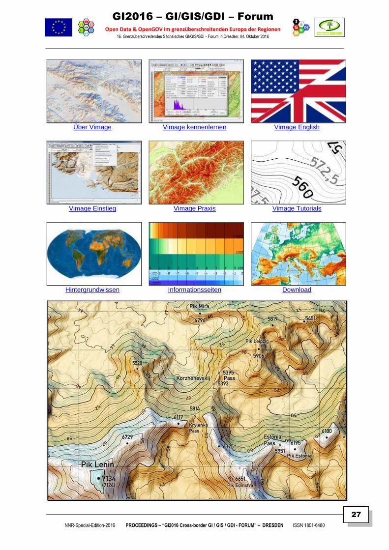
Ausführliche Informationen gibt es auf [ http://www.reliefschummerung.de/ ] der Homepage von Vimage.
Der Beitrag erläutert zunächst am Beispiel digitaler Höhenmodelle die Entwicklung des VIMAGE-Programms und demonstriert dessen Anwendung zur kartographischen Gestaltung von Atlas- und Wanderkarten.
Danach wird am Beispiel des VIMAGE-Computereinsatzes zur kartographischen Relief-bearbeitung die Verarbeitung von Massendaten (BigData) für verschiedene kartographische Erzeugnisse demonstriert.
Author
Dr.Ing. Rolf BÖHM
References http://www.boehmwanderkarten.de/kartographie/initial.html
http://www.boehmwanderkarten.de/kv/is_kv_main.html http://www.reliefschummerung.de/rs_intro_vimagereferenzen.html
http://www.reliefschummerung.de/rs_wissen_1.html
Contact Dr.-Ing. Rolf Böhm
Ingenieurbüro für Kartographie & Kartographischer Verlag Niederweg 5, 01814 Bad Schandau, Germany Tel. +49 35022 40100 / Fax +49 35022 40101
EMail: [ info@BöhmWanderKarten.de ]
GI2016 – GI/GIS/GDI – Forum
Open Data & OpenGOV im grenzüberschreitenden Europa der Regionen 16. Grenzüberschreitendes Sächsisches GI/GIS/GDI - Forum in Dresden: 04. Oktober 2016
NNR-Special-Edition-2016 PROCEEDINGS – “GI2016 Cross-border GI / GIS / GDI - FORUM” – DRESDEN ISSN 1801-6480
26
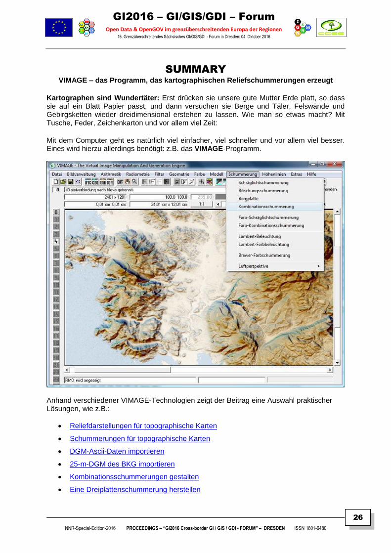
SUMMARY VIMAGE – das Programm, das kartographischen Reliefschummerungen erzeugt
Kartographen sind Wundertäter: Erst drücken sie unsere gute Mutter Erde platt, so dass sie auf ein Blatt Papier passt, und dann versuchen sie Berge und Täler, Felswände und Gebirgsketten wieder dreidimensional erstehen zu lassen. Wie man so etwas macht? Mit Tusche, Feder, Zeichenkarton und vor allem viel Zeit:
Mit dem Computer geht es natürlich viel einfacher, viel schneller und vor allem viel besser. Eines wird hierzu allerdings benötigt: z.B. das VIMAGE-Programm.
Anhand verschiedener VIMAGE-Technologien zeigt der Beitrag eine Auswahl praktischer Lösungen, wie z.B.:
Reliefdarstellungen für topographische Karten
Schummerungen für topographische Karten
DGM-Ascii-Daten importieren
25-m-DGM des BKG importieren
Kombinationsschummerungen gestalten
Eine Dreiplattenschummerung herstellen
GI2016 – GI/GIS/GDI – Forum
Open Data & OpenGOV im grenzüberschreitenden Europa der Regionen 16. Grenzüberschreitendes Sächsisches GI/GIS/GDI - Forum in Dresden: 04. Oktober 2016
NNR-Special-Edition-2016 PROCEEDINGS – “GI2016 Cross-border GI / GIS / GDI - FORUM” – DRESDEN ISSN 1801-6480
27
Über Vimage Vimage kennenlernen Vimage English
Vimage Einstieg Vimage Praxis Vimage Tutorials
Hintergrundwissen Informationsseiten Download
GI2016 – GI/GIS/GDI – Forum
Open Data & OpenGOV im grenzüberschreitenden Europa der Regionen 16. Grenzüberschreitendes Sächsisches GI/GIS/GDI - Forum in Dresden: 04. Oktober 2016
NNR-Special-Edition-2016 PROCEEDINGS – “GI2016 Cross-border GI / GIS / GDI - FORUM” – DRESDEN ISSN 1801-6480
28
SENSLOG API AS TOOLS FOR COLLECTION BIG VGI DATA
Karel Charvat & Team Michal Kepka, Simon Leitgeb, Dmitrij Kozuch, Raitis Berzins
ABSTRACT
Keywords: Approach, BigData, bottom-up, Citizens, Cloud, Cordova, Data collection, Data exchange, Data infrastructures, GEOSS, GIS, COPERNICUS, Google maps, INSPIRE, Local knowledge, Model, OGC, OSM, realtime, Standardization, SDI4Apps platform, Spatial,
top-down, Volunteered geographic information (VGI), WikiMapia. Content:
There are different voluntary or bottom-up initiatives supporting SDI building. More and more localized information and data is collected by citizens.
“Human observations” can become a part of the future real-time SDI's and serve as an input for spatial decision-making processes.
Currently, data collection by citizens is higher than collection of data by public bodies.
Local and community activities capture local knowledge in multimedia forms including videos, photos or oral histories. The collected information can contribute to up-to-date data.
Volunteered geographic information (VGI) is the harnessing of tools to create, assemble, and disseminate geographic data provided voluntarily by individuals.
Some examples of this phenomenon are WikiMapia, OpenStreetMap, and Google Map Maker. VGI can also be seen as an extension of critical and participatory approaches to geographic information systems and as a specific concern within online or web credibility.
Authors
Dr. Karel Charvat (CCSS & WirelessInfo Team / Praha, CZ) Michal Kepka, Simon Leitgeb, Dmitrij Kozuch, Raitis Berzins
Reference
http://www.CCSS.cz/ http://sdi4apps.eu/project-information/
https://github.com/mkepka/senslog/watchers
Contact Karel Charvat, Czech Centre for Science and Society,
Radlicka 28, 150 00 Praha 5, Czech Republic Mobile: +420-605033596
EMail: [ mailto:[email protected] ]
GI2016 – GI/GIS/GDI – Forum
Open Data & OpenGOV im grenzüberschreitenden Europa der Regionen 16. Grenzüberschreitendes Sächsisches GI/GIS/GDI - Forum in Dresden: 04. Oktober 2016
NNR-Special-Edition-2016 PROCEEDINGS – “GI2016 Cross-border GI / GIS / GDI - FORUM” – DRESDEN ISSN 1801-6480
29
SUMMARY Currently, there are two divided worlds:
top-down managed world of INSPIRE, GMES, GEOSS and similar initiatives represented by SDI experts, and
bottom-up mobile world of smartphones, tablets, world of citizens and also world of thousands micro SMEs developing applications.
The question is, if we are able to find a bridge between these two worlds?
When decomposing this question further subtopics for investigation can be identified:
IS it possible to standardize VGI Can ordinary people profit from INSPIRE? Can INSPIRE profit from different voluntary initiatives? Is it possible on the basis of INSPIRE to build a successful business for thousands of
European SMEs? Are we able to find a WIN–WIN strategy for public sector, private sector and citizens?
See http://sdi4apps.eu/project-information/
We are now offering as one potential way SensLog.
https://github.com/mkepka/senslog/watchers.
SensLog is an integrated solution for sensor networks.
SensLog consists of data model and server-side application which is capable to store, analyses and publish data in various ways. SensLog receives measured data from nodes or gateways, stores data properly in the database, pre-processes for easier queries if desired and then publishes data through the system of web-services.
SensLog is suitable for sensor networks with static sensors (e.g. meteorological stations) as well as for mobile sensors (e.g. tracking of vehicles, human-as-sensor).
The Database model was based on standardized data model for observations from OGC Observations&Measurements. But the model was extended to provide more functionality, especially in the field of users hierarchy, alerts and tracking of mobile sensors. Important improvements of SensLog application were made in last period.
New version of Database model is utilized now. The Database model was improved using table partitioning for largest tables.
But improvements seen by users can be found in SensLog API.
http://sdi4apps.eu/2016/04/opensensorsnetwork-pilot-senslog-api-version-1-0-is-open/.
Effectively, we have the means to collect sensor data without any additional investment. Relying on the hybrid mobile application framework Cordova (aka PhoneGap),
s4a.js http://sdi4apps.eu/2016/04/s4a-js-1-0-simple-solutions-to-well-known-problems/
implements SensLog as a programmable object in JavaScript making it easy both to insert and retrieve observations from sensors with single lines of code. Before calling these methods, the units and sensors should be registered using the SensLog administration tool.
Now, we have both the sensors and the means to store and retrieve the sensor data — all accessible from simple JavaScript using the Cloud infrastructure of the SDI4Apps platform.
GI2016 – GI/GIS/GDI – Forum
Open Data & OpenGOV im grenzüberschreitenden Europa der Regionen 16. Grenzüberschreitendes Sächsisches GI/GIS/GDI - Forum in Dresden: 04. Oktober 2016
NNR-Special-Edition-2016 PROCEEDINGS – “GI2016 Cross-border GI / GIS / GDI - FORUM” – DRESDEN ISSN 1801-6480
30
BIG COPERNICUS DATA SENTINEL II - EIN BILD ALLEINE IST ZU WENIG
Walter H. MAYER
CEO PROGIS GmbH / Treasurer of Club of Ossiach
ABSTRACT
Keywords: Access, Agriculture, Automation, Bandwide, BigData, Color, Cross-border,
Digitalization, GIS, INVEKOS, Layer definition, LPIS, Open Data, Pattern recognition,
Sentinel2, WinGIS.
Content:
Seit Ende 2015 ist der EC Satellit Sentinel-2 im All und liefert hochauflösende Bilder für die
Landwirtschaft, für das Management von Naturgefahren, für die Versicherungswirtschaft und für
Sicherheitsservices. Der Satellit trägt einen multispektralen Scanner mit einer Bandbreite von 290 km,
13 Spektralbänder vom sichtbaren bis zum nahen infrarot und Kurzwellen-infrarot, 4 von den
Spektralbändern liefern eine Auflösung von 10m, 6 Bänder 20m und 3 Bänder 60 m Auflösung.
Für die Landwirtschaft liefert der Satellit 10m und 20m aufgelöste Bilder mit einer Wiederholfrequenz
von 5 bis 10 Tagen, eine globale Abdeckung und es werden als zusätzliches Service NDVI Indizes
(Wachstumsindizes) ausgewertet welche entsprechend einer Farbskala von -1 zu +1 Auskunft darüber
geben wie sich das Chlorophyll-Wachstum auf einem Acker/Wiese entwickelt.
Als zusätzliches Service wird die Sentinel Technologie in unser WinGIS Geoinformationssystem eingebettet und nach Import der LPIS Daten (Land Parcel Information-System oder im deutschen Sprachraum auch INVEKOS Daten (Feldstücks- oder Schlagpolygone) und der Anwender automatisch informiert wenn ein neues Bild verfügbar ist. Im nächsten Release werden die Bilder auch in einen Film zusammengestellt werden und man kann das Wachstum auf der Zeitachse verfolgen.
Ein zusätzlich knapp vor Fertigstellung befindliches Muster-Erkennungs-System wird es ermöglichen
Muster und Farben von Bildern automatisiert zu erkennen und die Ergebnisse nach Gruppen getrennt in
das GIS einzubinden und dort automatisiert zu digitalisieren. Die Antwort kann sein (1) wieviel ha Acker,
Wiese, Weide, Almen, Steine etc. oder (2) wo sind die Schadpflanzen etc.; Anwendungen unendlich
viele, auch außerhalb der Land- und Forstwirtschaft.
Author
Dipl.Ing. Walter H. MAYER CEO PROGIS GmbH Treasurer CoO
References
[ http://www.PROGIS.com | http://www.ClubOfOssiach.org ]
Contact Dipl.Ing. Walter H. MAYER, Postgasse 6, A-9500 Villach/Austria
E-mail: [ mailto:[email protected] ], Skype: [ walter.h.mayer ]
Tel: +43/4242/26332
GI2016 – GI/GIS/GDI – Forum
Open Data & OpenGOV im grenzüberschreitenden Europa der Regionen 16. Grenzüberschreitendes Sächsisches GI/GIS/GDI - Forum in Dresden: 04. Oktober 2016
NNR-Special-Edition-2016 PROCEEDINGS – “GI2016 Cross-border GI / GIS / GDI - FORUM” – DRESDEN ISSN 1801-6480
31
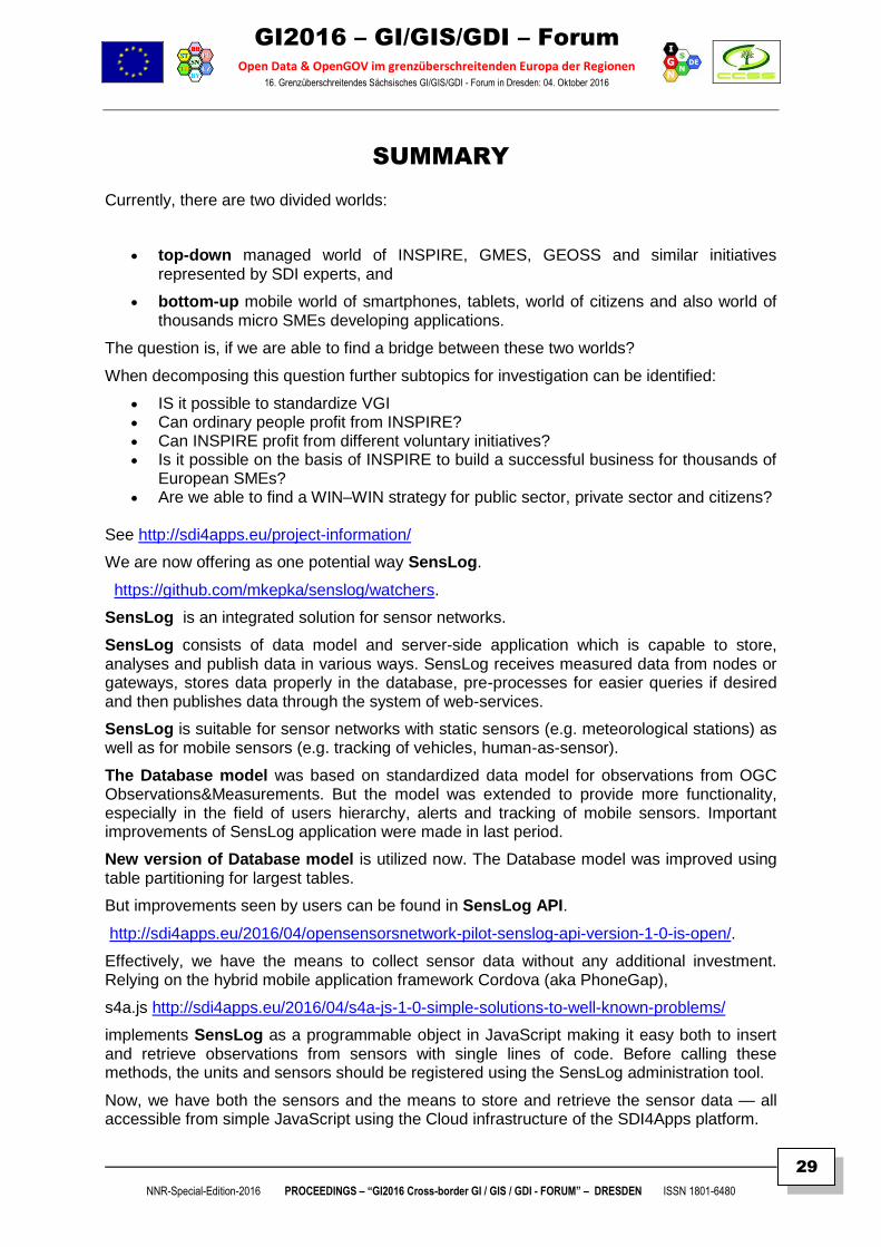
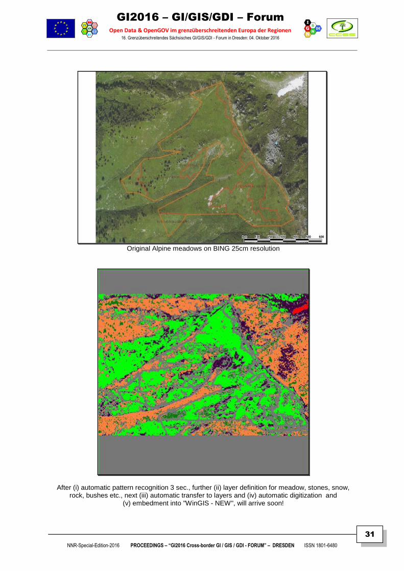
Original Alpine meadows on BING 25cm resolution
After (i) automatic pattern recognition 3 sec., further (ii) layer definition for meadow, stones, snow, rock, bushes etc., next (iii) automatic transfer to layers and (iv) automatic digitization and
(v) embedment into "WinGIS - NEW", will arrive soon!
GI2016 – GI/GIS/GDI – Forum
Open Data & OpenGOV im grenzüberschreitenden Europa der Regionen 16. Grenzüberschreitendes Sächsisches GI/GIS/GDI - Forum in Dresden: 04. Oktober 2016
NNR-Special-Edition-2016 PROCEEDINGS – “GI2016 Cross-border GI / GIS / GDI - FORUM” – DRESDEN ISSN 1801-6480
32
SUMMARY
SENTINEL–2 Images
All 5 days new growth status of your fields - part of WinGIS® – DokuPLANT® & mobGIS®
Walter H. MAYER, CEO PROGIS GmbH
Zivilingenieur - Mitglied der Bundesingenieurkammer und zertifizierter Dipl.Ing.
Since end of 2015, the EC Sentinel 2 satellite is active and delivers high-resolution optical images for agriculture, land monitoring, emergency response and security services. The satellite carries a multispectral imager with a swath of 290 km, a set of 13 spectral bands from visible and near infrared to shortwave infrared, featuring 4 spectral bands at 10 m, six bands at 20m and three bands at 60 m spatial resolution.
For agriculture, the satellite provides outstanding 10 and 20m spatial resolution with a 5 days revisit frequency, a global coverage and provides total new opportunities for local, regional and global monitoring of crop conditions, soil properties and mapping tillage activities. It helps to assess land use, predict harvest, monitor seasonal change and assist in implementing policies for sustainable development. It is used to monitor changes of agricultural production and productivity of pastures caused by drought and to monitor the decline of land productivity and soil degradation due to excessive cultivation and pasturage and improper irrigation. The images will support efforts to ensure food security in vulnerable areas.
PROGIS will not only deliver different images available within WinGIS, DokuPlant, ForestOffice or mobGIS/Logistics, but will also give access automatically to an NDVI index (=Normalized Difference Vegetation Index) image. The calculation, based on the difference of the reflection of visible and near infrared images, called vegetation index, allows the identification of vegetated areas and their “condition” or used to quantify the photosynthetic capacity of plant canopies.
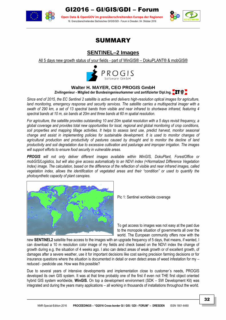
Pic 1: Sentinel worldwide coverage
To get access to images was not easy at the past due to the monopole situation of governments all over the world. The European community offers now with the
new SENTINEL2 satellite free access to the images with an upgrade frequency of 5 days, that means, if wanted, I can download a 10 m resolution color image of my fields and check based on the NDVI index the change of growth during e.g. the situation of 4 weeks ago. I also can detect areas of weak growth or of excellent growth, of damages after a severe weather, use it for important decisions like cost saving precision farming decisions or for insurance questions where the situation is documented in detail or even detect areas of weed infestation for my – reduced - pesticide use. How was this possible?
Due to several years of intensive developments and implementation close to customer´s needs, PROGIS developed its own GIS system. It was at that time probably one of the first if even not THE first object oriented hybrid GIS system worldwide, WinGIS. On top a development environment (SDK – SW Development Kit) was integrated and during the years many applications – all working in thousands of installations throughout the world.
GI2016 – GI/GIS/GDI – Forum
Open Data & OpenGOV im grenzüberschreitenden Europa der Regionen 16. Grenzüberschreitendes Sächsisches GI/GIS/GDI - Forum in Dresden: 04. Oktober 2016
NNR-Special-Edition-2016 PROCEEDINGS – “GI2016 Cross-border GI / GIS / GDI - FORUM” – DRESDEN ISSN 1801-6480
33
The most important beside WinGIS® are
DokuPlant® (= Farm-management),
ForestOffice® (= Forest management),
Logistics and mobGIS® (=logistics for fleets of agricultural machines based on stakeholder cooperation models),
Precision Farming Tools,
Land consolidation (for the Lower Austrian government) and last but not least
EnvirOffice: Environment- and natural-risk-management tools & applications.
All these tools have the capability to run with vector data and/or raster data and have unlimited size capabilities. After first having implemented local images, mainly orthoimages, we linked later BING maps, Google - or Yandex maps as offline - and online use to the system and now can offer Sentinel-data as part of all applications.
As we in parallel during the last years not only have developed technology and ICT based applications, we have focused also on technology integration. The questions had been to be solved: How to integrate weather-stations, tractor-data, laboratory information of soil- or manure data to setup a circular flow management model at farms and how to integrate into our so called expert models (machinery, fertilizer, carbon, pesticides, seeds, methods etc.) the so important and needed know how of local experts. A well-done cooperation on worldwide basis helps to setup this model in the meantime.
Beside several technologies and their integration and the cooperation with local experts, we developed an organization- and business model that allows to support entire countries and the entire chain. That is in agriculture or in forestry rather complex and has to integrate the several common based public interests as well as the private interests of the different chain partners. In any case, better information will help to manage our nature better, more profitable and more sustainable. All concepts have been driven to support the farmer as THE integrative factor that has to manage agriculture and/or forestry land, has in future to be responsible for the management of the “commons” and must be supported in several cases by (local/international) experts. The challenge is big but with the help of these new SENTINEL images, we are a huge step forward in offering entire country covering solutions.
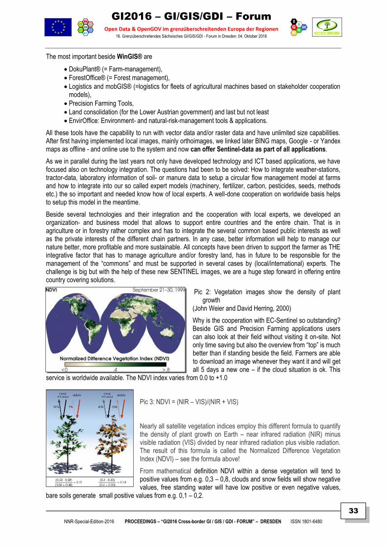
Pic 2: Vegetation images show the density of plant growth
(John Weier and David Herring, 2000)
Why is the cooperation with EC-Sentinel so outstanding? Beside GIS and Precision Farming applications users can also look at their field without visiting it on-site. Not only time saving but also the overview from “top” is much better than if standing beside the field. Farmers are able to download an image whenever they want it and will get all 5 days a new one – if the cloud situation is ok. This
service is worldwide available. The NDVI index varies from 0.0 to +1.0
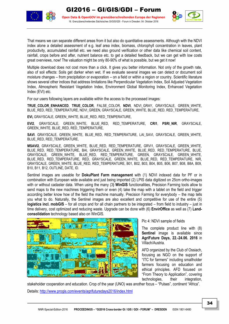
Pic 3: NDVI = (NIR – VIS)/(NIR + VIS)
Nearly all satellite vegetation indices employ this different formula to quantify the density of plant growth on Earth – near infrared radiation (NIR) minus visible radiation (VIS) divided by near infrared radiation plus visible radiation. The result of this formula is called the Normalized Difference Vegetation Index (NDVI) – see the formula above!
From mathematical definition NDVI within a dense vegetation will tend to positive values from e.g. 0,3 – 0,8, clouds and snow fields will show negative values, free standing water will have low positive or even negative values,
bare soils generate small positive values from e.g. 0,1 – 0,2.
GI2016 – GI/GIS/GDI – Forum
Open Data & OpenGOV im grenzüberschreitenden Europa der Regionen 16. Grenzüberschreitendes Sächsisches GI/GIS/GDI - Forum in Dresden: 04. Oktober 2016
NNR-Special-Edition-2016 PROCEEDINGS – “GI2016 Cross-border GI / GIS / GDI - FORUM” – DRESDEN ISSN 1801-6480
34
That means we can separate different areas from it but also do quantitative assessments. Although with the NDVI index alone a detailed assessment of e.g. leaf area index, biomass, chlorophyll concentration in leaves, plant productivity, accumulated rainfall etc. we need also ground verification or other data like chemical soil content, rainfall, crops before and after, nutrient balance etc. to get a detailed feedback, but we can get with low costs great overviews, now! The valuation might be only 80-90% of what is possible, but we get it now!
Multiple download does not cost more than a click. It gives you better information. Not only of the growth rate, also of soil effects: Soils get darker when wet. If we evaluate several images we can detect or document soil moisture changes – from precipitation or evaporation – on a field or within a region or country. Scientific literature shows several other indices that address limitations like Perpendicular Vegetation Index, Soil Adjusted Vegetation Index, Atmospheric Resistant Vegetation Index, Environment Global Monitoring Index, Enhanced Vegetation Index (EVI) etc.
For our users following layers are available within the access to the processed images:
TRUE_COLOR_ENHANCED, TRUE_COLOR, FALSE_COLOR, NDVI, NDVI_GRAY, GRAYSCALE, GREEN_WHITE, BLUE_RED, RED_TEMPERATURE, NDVI_GREEN, GRAYSCALE, GREEN_WHITE, BLUE_RED, RED_TEMPERATURE,
EVI, GRAYSCALE, GREEN_WHITE, BLUE_RED, RED_TEMPERATURE,
EVI2, GRAYSCALE, GREEN_WHITE, BLUE_RED, RED_TEMPERATURE, CRI1, PSRI_NIR, GRAYSCALE, GREEN_WHITE, BLUE_RED, RED_TEMPERATURE,
SAVI. GRAYSCALE, GREEN_WHITE, BLUE_RED, RED_TEMPERATURE, LAI_SAVI, GRAYSCALE, GREEN_WHITE, BLUE_RED, RED_TEMPERATURE,
MSAVI2, GRAYSCALE, GREEN_WHITE, BLUE_RED, RED_TEMPERATURE, GRVI1, GRAYSCALE, GREEN_WHITE, BLUE_RED, RED_TEMPERATURE, BAI, GRAYSCALE, GREEN_WHITE, BLUE_RED, RED_TEMPERATURE, BLUE, GRAYSCALE, GREEN_WHITE, BLUE_RED, RED_TEMPERATURE, GREEN, GRAYSCALE, GREEN_WHITE, BLUE_RED, RED_TEMPERATURE, RED, GRAYSCALE, GREEN_WHITE, BLUE_RED, RED_TEMPERATURE, NIR, GRAYSCALE, GREEN_WHITE, BLUE_RED, RED_TEMPERATURE, B01, B02, B03, B04, B05, B06, B07, B08, B8A, B09, B10, B11, B12, OUTLINE, DATE, ID.
Sentinel images are useable for DokuPlant Farm management with (1) NDVI indexed data for PF or in combination with European wide available and just being imported (2) LPIS data digitized on 25cm ortho-images with or without cadaster data. When using the many (3) WinGIS functionalities, Precision Farming tools allow to send maps to the new machines triggering them or even (4) take the map with a tablet on the field and trigger according better know how of the field the machine manually. Precision Farming for everybody – the map tells you what to do. Naturally, the Sentinel images are also excellent and competitive for use of the entire (5) logistics incl. mobGIS – for all crops and for all chain partners to be integrated – from field to industry – just in time delivery, cost optimized and reducing waste. Upgrade can be done with (6) EnvirOffice as well as (7) Land-consolidation technology based also on WinGIS.
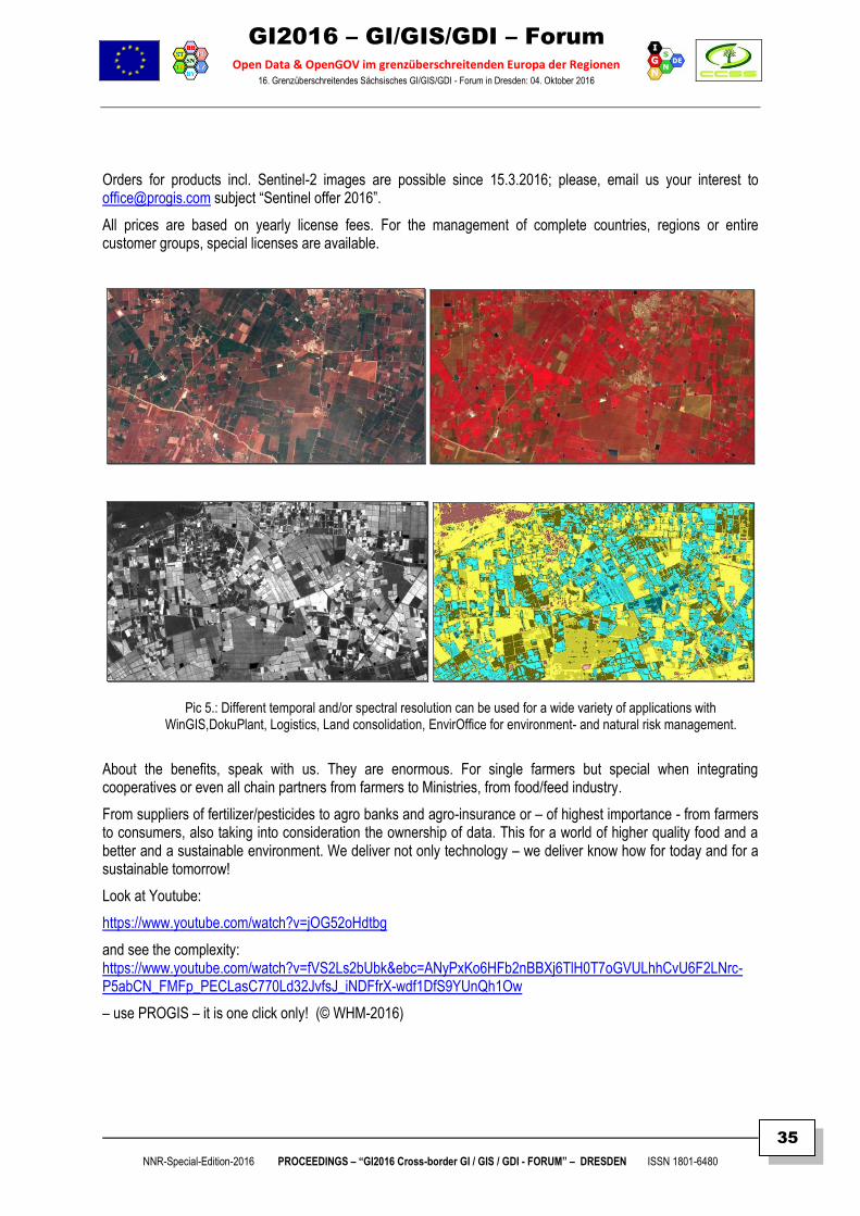
Pic 4: NDVI sample of fields
The complete product line with (8) Sentinel image is available since AgriFuture Days, 22.-24.06. 2016 in Villach/Austria.
AFD organized by the Club of Ossiach, focusing as NGO on the support of “ITC for farmers” including smallholder farmers focusing on education and ethical principles. AFD focused on “From Theory to Application”, covering technologies, their integration,
stakeholder cooperation and education. Crop of the year (UNO) was another focus – “Pulses”, continent “Africa”.
Details: http://www.progis.com/events/agrifuturedays2016/index.html
GI2016 – GI/GIS/GDI – Forum
Open Data & OpenGOV im grenzüberschreitenden Europa der Regionen 16. Grenzüberschreitendes Sächsisches GI/GIS/GDI - Forum in Dresden: 04. Oktober 2016
NNR-Special-Edition-2016 PROCEEDINGS – “GI2016 Cross-border GI / GIS / GDI - FORUM” – DRESDEN ISSN 1801-6480
35
Orders for products incl. Sentinel-2 images are possible since 15.3.2016; please, email us your interest to [email protected] subject “Sentinel offer 2016”.
All prices are based on yearly license fees. For the management of complete countries, regions or entire customer groups, special licenses are available.
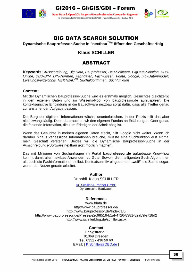
Pic 5.: Different temporal and/or spectral resolution can be used for a wide variety of applications with WinGIS,DokuPlant, Logistics, Land consolidation, EnvirOffice for environment- and natural risk management.
About the benefits, speak with us. They are enormous. For single farmers but special when integrating cooperatives or even all chain partners from farmers to Ministries, from food/feed industry.
From suppliers of fertilizer/pesticides to agro banks and agro-insurance or – of highest importance - from farmers to consumers, also taking into consideration the ownership of data. This for a world of higher quality food and a better and a sustainable environment. We deliver not only technology – we deliver know how for today and for a sustainable tomorrow!
Look at Youtube:
https://www.youtube.com/watch?v=jOG52oHdtbg
and see the complexity: https://www.youtube.com/watch?v=fVS2Ls2bUbk&ebc=ANyPxKo6HFb2nBBXj6TlH0T7oGVULhhCvU6F2LNrc-P5abCN_FMFp_PECLasC770Ld32JvfsJ_iNDFfrX-wdf1DfS9YUnQh1Ow
– use PROGIS – it is one click only! (© WHM-2016)
GI2016 – GI/GIS/GDI – Forum
Open Data & OpenGOV im grenzüberschreitenden Europa der Regionen 16. Grenzüberschreitendes Sächsisches GI/GIS/GDI - Forum in Dresden: 04. Oktober 2016
NNR-Special-Edition-2016 PROCEEDINGS – “GI2016 Cross-border GI / GIS / GDI - FORUM” – DRESDEN ISSN 1801-6480
36
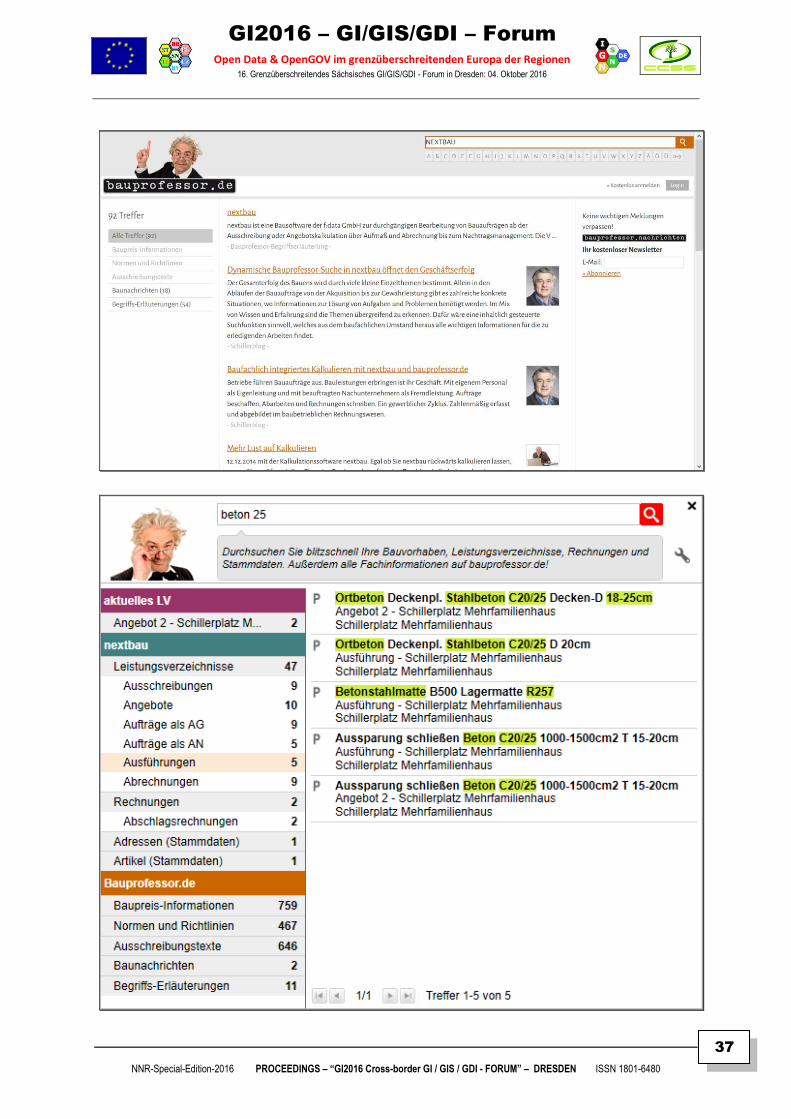
BIG DATA SEARCH SOLUTION Dynamische Bauprofessor-Suche in "nextbauTM" öffnet den Geschäftserfolg
Klaus SCHILLER
ABSTRACT
Keywords: Ausschreibung, Big Data, Bauprofessor, Bau-Software, BigData-Solution, DBD-
Online, DBD-BIM, DIN-Normen, Fachdaten, Fachwissen, Fdata, Google, IFC-Datenmodell, Leistungsverzeichnis, NEXTBAUTM, Suchalgorithmen, Suchfunktion
Content:
Mit der Dynamischen Bauprofessor-Suche wird es erstmals möglich, Gesuchtes gleichzeitig in den eigenen Daten und im Wissens-Pool von bauprofessor.de aufzuspüren. Die kontextsensitive Einbindung in die Bausoftware nextbau sorgt dafür, dass alle Treffer genau zur anstehenden Aufgabe passen. Der Berg der digitalen Informationen wächst ununterbrochen. In der Praxis hilft das aber nicht zwangsläufig. Denn da brauchen wir den eigenen Fundus an Erfahrungen. Oder genau die fehlende Information, die zum Erledigen der Arbeit nötig ist. Wenn das Gesuchte in meinen eigenen Daten steckt, hilft Google nicht weiter. Wenn ich darüber hinaus verlässliche Informationen brauche, müsste eine Suchfunktion erst einmal mein Geschäft verstehen. Beides will die Dynamische Bauprofessor-Suche in der Ausschreibungs-Software nextbau jetzt möglich machen. Das mit Millionen von Suchanfragen im Portal bauprofessor.de aufgebaute Know-how kommt damit allen nextbau-Anwendern zu Gute: Sowohl die intelligenten Such-Algorithmen als auch die Fachinformationen selbst. Kontextsensitiv eingebunden „weiß“ die Suche sogar, woran der Nutzer gerade arbeitet.
Author
Dr.habil. Klaus SCHILLER
Dr. Schiller & Partner GmbH -Dynamische BauDaten-
References www.fdata.de
http://www.bauprofessor.de/ http://www.bauprofessor.de/Index/a/0
http://www.bauprofessor.de/Presse/e2c98516-b1af-4720-8381-82ab9fe718d2 http://www.schillerblog.de/schiller.aspx
Contact Liebigstraße 3 01069 Dresden
Tel. 0351 / 436 59 60 EMail: [ [email protected] ]
GI2016 – GI/GIS/GDI – Forum
Open Data & OpenGOV im grenzüberschreitenden Europa der Regionen 16. Grenzüberschreitendes Sächsisches GI/GIS/GDI - Forum in Dresden: 04. Oktober 2016
NNR-Special-Edition-2016 PROCEEDINGS – “GI2016 Cross-border GI / GIS / GDI - FORUM” – DRESDEN ISSN 1801-6480
37
GI2016 – GI/GIS/GDI – Forum
Open Data & OpenGOV im grenzüberschreitenden Europa der Regionen 16. Grenzüberschreitendes Sächsisches GI/GIS/GDI - Forum in Dresden: 04. Oktober 2016
NNR-Special-Edition-2016 PROCEEDINGS – “GI2016 Cross-border GI / GIS / GDI - FORUM” – DRESDEN ISSN 1801-6480
38
SUMMARY Dynamische Bauprofessor-Suche in NEXTBAU
TM öffnet den Geschäftserfolg
Der Gesamterfolg des Bauens wird durch viele kleine Einzelthemen bestimmt. Allein in den Abläufen der Bauaufträge von der Akquisition bis zur Gewährleistung gibt es zahlreiche konkrete Situationen, wo Informationen zur Lösung von Aufgaben und Problemen benötigt werden. Im Mix von Wissen und Erfahrung sind die Themen übergreifend zu erkennen. Dafür wäre eine inhaltlich gesteuerte Suchfunktion sinnvoll, welches aus dem baufachlichen Umstand heraus alle wichtigen Informationen für die zu erledigenden Arbeiten findet.
Mit der dynamischen Bauprofessor-Suche hat "nextbau" ab der Version 2016.1 solch ein Informationsfenster, wodurch eine vernetzte Suche online im Internet und offline in den Dateisystemen von "nextbau" verknüpft ist. So lässt der Anwender im Arbeitsprozess den Bauprofessor suchen, indem er einfach das Gesuchte eintippt und über eine verteilte Suche wird das Gefundene mit einem Klick sortiert und übersichtlich bereitgestellt. Strukturierte und unstrukturierte Daten werden entflochten und Beziehungen zwischen den Daten sichtbar. So bietet "nextbau" seinen Kunden eine individuelle „Big-Data Lösung“.
Das komplexe Suchen und die klar strukturierten Suchergebnisse verursachen bei allen Geschäftsvorgängen einen erkenntnisgewinnenden Prozess. Aus der beziehungsreichen Realität von Bauvorhaben wird damit eine situative Ordnung in den Daten entfaltet, die eine Orientierungshilfe und eine Gewissheit schafft. Man sieht, wo das Gesuchte steckt. Sei es in der Leistungsbeschreibung und Kalkulation, in den Leistungsverzeichnissen, Rechnungen, Adressen, Artikelsortimenten oder aber im Fachwissen von [ http://www.bauprofessor.de ] vernetzt mit den Standardisierungs-Regeln der Technik von DIN und VDI.
Ein Mausklick genügt und man springt direkt zur gefundenen Stelle und bewahrt den Überblick.
Nicht alle Daten sind gleich. Im konkreten Geschäftsprozess erhalten sie ihre pragmatische Bedeutung. Dabei entsteht ein spezifisches Beziehungsgeflecht faktischer Inhalte, wo auch zusätzliches Fachwissen per Bauprofessor aktiviert und nach Kategorien angezeigt wird.
Dies können verständlich erklärte Fachbegriffe, 200 Musterbriefe zum Bauvertrag, die erwähnte VOB/C oder miteinander vernetzte Auszüge aus DIN-Normen oder VDI-Richtlinien sein. All dies vereint die Bauprofessor-Suche mit der Gliederung von "nextbau" und seiner gesamten Datenwelt.
Folglich können im aktuellen "nextbau" 2016.1 selbst anwendertypische Kategorien angelegt werden, die somit automatisch in die Bauprofessor-Suche integriert sind. Dadurch steuert der Nutzer seine eigene Daten-Infrastruktur. Inhalte von tausenden Leistungsverzeichnissen (LV) sind im Verbund mit Fach- und Anwenderinformationen treffsicher und übersichtlich aufspürbar.
Sogar im CSV-Format importierte Artikelstammdaten werden in die Ergebnissuche eingeordnet. In einer als chaotisch empfundenen Bauwelt hilft die Bauprofessor-Suche dem Anwender beim Sichten und Verstehen von analogen Regelmäßigkeiten zur Orientierung und Entscheidungsfindung.
Die dynamische Bauprofessor-Suche basiert auf den realen Erfahrungen mit Millionen von Suchanfragen z.B. in [ bauprofessor.de ] und einer langjährigen KI-Forschung. Derzeit erfolgt eine Fusion mit DBD-BIM und dem IFC-Datenmodell.
Aus den Applikationen mit DBD-BIM kann die Bauprofessor-Suche so individuelle Bauwerksmodelle nach IFC mit Bauteil- und Raumeigenschaften, Leistungen, Kosten und Regeln der Technik vernetzen und auswerten.
GI2016 – GI/GIS/GDI – Forum
Open Data & OpenGOV im grenzüberschreitenden Europa der Regionen 16. Grenzüberschreitendes Sächsisches GI/GIS/GDI - Forum in Dresden: 04. Oktober 2016
NNR-Special-Edition-2016 PROCEEDINGS – “GI2016 Cross-border GI / GIS / GDI - FORUM” – DRESDEN ISSN 1801-6480
39
BIG BIM DATA Bauwerksmodell und modellbasiertes Arbeiten mit DBD-Kostenkalkül 4.0
Klaus SCHILLER
ABSTRACT
Keywords: AVA, Bauleistungen, Bauwerksmodell, BigBimData, BIM-LeistungsVerzeichnis-
Container, Building InformationModelling, CAD, Datenaustausch, DBD-Kostenkalkül, DBD-Online, DIN, DIN-Normen, DIN SPEC 91350, DVA, IFC-Modell, GAEB, GAEB-DA-XML, Leistungsmodell, Leistungsverzeichnis, Prozessmodellierung, Standardisierung, STLB-Bau, VDI, VOB. Content:
Modellbasierte Daten, wie z.B. Dynamische BauDaten (DBD) sind die Voraussetzung für Building und Information Modelling (BIM). Das Leitmotiv von BIM ist der Prozess des Modelling als fachübergreifendes geistiges Arbeiten am Bauwerksmodell. Die neue Generation von DBD-KostenKalkül 4.0 fokussiert demzufolge 2016 auf die BIM-Orientierung, welches dem zünftigen Prozessdenken und Datenaustausch von BIM entspricht. Modellbasiert werden die Kosten und Leistungen ermittelt, indem das graphische Modell
der Räume mit dem alphanumerischen Modellieren der Bauteile kombiniert wird. Dabei lässt
sich das Bauwerksmodell aus 2D-Plänen/Bilddateien erstellen oder neutral über ein digitales
IFC-Modell importieren. In DBD-KostenKalkül 4.0 sind fast alle in IFC4 definierten
Bauteilklassen benutzbar. Der IFC-Import für Räume und Bauteile ist mit einem
pragmatischen Konverter für IFC-Dateien ausgestattet, wobei projektübergreifende
Modellsynchronisationen (Model-Merging) und Projektaktualisierungen bei versionierten IFC-
Dateien den BIM-Prozess unterstützen. Gekoppelt mit einem sauberen IFC-Export wird
dadurch eine Kommunikation des Bauwerksmodells mit BIM-Anwendungen wie CAD- oder
AVA-Software ermöglicht.
Author Dr.habil. Klaus SCHILLER
Dr. Schiller & Partner GmbH -Dynamische BauDaten-
References http://www.bauprofessor.de/
http://www.schillerblog.de/schiller.aspx http://www.dbd.de/Pages/default.aspx
http://www.dbd.de/dbd-kostenkalkuel/Pages/default.aspx http://www.dbd.de/dbd-produkte/Pages/default.aspx
http://www.dbd.de/gut_zu_wissen/Pages/default.aspx
Contact Liebigstraße 3 01069 Dresden
Tel. 0351 / 436 59 60 EMail: [ [email protected] ]

GI2016 – GI/GIS/GDI – Forum
Open Data & OpenGOV im grenzüberschreitenden Europa der Regionen 16. Grenzüberschreitendes Sächsisches GI/GIS/GDI - Forum in Dresden: 04. Oktober 2016
NNR-Special-Edition-2016 PROCEEDINGS – “GI2016 Cross-border GI / GIS / GDI - FORUM” – DRESDEN ISSN 1801-6480
40
SUMMARY
Dynamische BauDaten (DBD) sind die Voraussetzung für Building und Information Modelling
(BIM). Das Leitmotiv von BIM ist der Prozess des Modelling als fachübergreifendes geistiges
Arbeiten am Bauwerksmodell. Die neue Generation von DBD-KostenKalkül 4.0 fokussiert
demzufolge 2016 auf die BIM-Orientierung, welches dem zünftigen Prozessdenken und
Datenaustausch von BIM entspricht.
Mit Informationen wird modelliert und aus dem Modellierten werden denkbare Informationen
abgeleitet, die in weitere Fachanwendungen und deren Fachmodelle fließen. Im Konkreten
von DBD-KostenKalkül sind das die Kosten- und Leistungsmodelle entsprechend den
Standardisierungsregeln der Technik nach DIN-Normen oder VDI-Richtlinien. Ändern sich
dabei die Eigenschaften des Bauwerksmodells, so verändern sich daraus schlussfolgernd
die Bauleistungen und Kosten.
Modellbasiert werden die Kosten und Leistungen ermittelt, indem das graphische Modell
der Räume mit dem alphanumerischen Modellieren der Bauteile kombiniert wird. Dabei lässt
sich das Bauwerksmodell aus 2D-Plänen/Bilddateien erstellen oder neutral über ein digitales
IFC-Modell importieren. In DBD-KostenKalkül 4.0 sind fast alle in IFC4 definierten
Bauteilklassen benutzbar. Der IFC-Import für Räume und Bauteile ist mit einem
pragmatischen Konverter für IFC-Dateien ausgestattet, wobei projektübergreifende
Modellsynchronisationen (Model-Merging) und Projektaktualisierungen bei versionierten IFC-
Dateien den BIM-Prozess unterstützen. Gekoppelt mit einem sauberen IFC-Export wird
dadurch eine Kommunikation des Bauwerksmodells mit BIM-Anwendungen wie CAD- oder
AVA-Software ermöglicht.
Zudem werden die abgeleiteten Leistungsverzeichnisse mit oder ohne Baupreise nach
GAEB-DA XML für die Ausschreibung und Kalkulation exportiert. Standardisiert erfolgt dies
mit STLB-Bau. Zusätzlich ist auch ein GAEB-Stammdaten-Import für Leistungspositionen
möglich, damit man die Leistungsbeschreibung auch mit eigenen Texten ergänzen kann. Die
Kosten werden nach Formulartechniken wie der DIN 276 oder EFB 223 sowie als Mengen-
Wert-Gerüste nach Bauteilen oder Gewerken ausgewiesen. Ansonsten ist auch ein Excel-
und Raumbuch-Export ausführbar.
Der Anwender kann im BIM-orientierten DBD-KostenKalkül 4.0 eigene Projektvorlagen mit
unterschiedlichen Qualitätstypen erstellen und diese Favoriten farblich über Projektteile
differenzieren, wodurch die visuelle Transparenz eines Bürostandards in der Grafik und in
den Bauteillisten sichtbar wird. Für die modellbasierte Kalkulation ist auch die
Plausibilitätsprüfung wichtig, wobei das Projekt automatisch auf fehlende oder nicht
eindeutige Zuordnungen gecheckt wird.
In DBD-KostenKalkül 4.0 wurde die Ursache-Wirkungs-Kette vom räumlichen Bauteilgefüge
als IFC-Modell bis zu den Kosten- und Leistungsmodellen in Analogie zu den Forderungen
der praktischen Anwendung umgesetzt. Damit wurde auch klar, dass der Knalleffekt des
digitalen Bauens im interdisziplinären Netzwerk der Fachmodelle mit dem BIM-Modell liegt.
Auf diese Weise erfolgen weitere Innovationen in Form zusätzlicher BIM-Module. Geplant ist
der bauteilorientierte Einstieg in STLB-Bau, eine DIN-BIM-Bibliothek sowie die Vernetzung
inklusive Ausbau der DBD-BIM-Cloud. Aber auch BIM-LV-Container und innovative DBD-
IFC-Modeller stehen an.
GI2016 – GI/GIS/GDI – Forum
Open Data & OpenGOV im grenzüberschreitenden Europa der Regionen 16. Grenzüberschreitendes Sächsisches GI/GIS/GDI - Forum in Dresden: 04. Oktober 2016
NNR-Special-Edition-2016 PROCEEDINGS – “GI2016 Cross-border GI / GIS / GDI - FORUM” – DRESDEN ISSN 1801-6480
41
AUTOMATIC INTERACTION AND SEAMLESS
INTEGRATION OF BIG DATA HUBS ON INTERNET
Shaozhong SHI
ABSTRACT
Keywords: Big Data Hubs, Automatic Interaction, Seamless Integration, Open Data, Standards Development, Application
Content: The world has seen creation of a great number of data hubs globally. However, at present, the most of such data hubs are functioning as if they were “isolated islands” of data and information. The data hubs are deployed with different technologies at geographically dispersed locations.
Critical barriers of server-to-serve communication and data exchange needs to be overcome. Automatic interaction and seamless integration of Big Data hubs have been found feasible to allow fast response time of communication and geodata transfer for future development of interoperable services. Critically important to seamless integration of big data hubs are interoperable communication protocols. High performance processors in live distributed computing systems can be developed for finding new solutions for ensuring prompt Internet services.
With the development of new initiatives in Open data and Open Standards, a showcase is presented to illustrate how geodata hubs can interact and communicate with each other automatically for timely data exchange. Showcased are the design and development of an Internet-based geodata processing service demonstrator system and the operation of critical data bridges between geodata services with the use of Open Geographical Consortium (OGC)’s specifications. The important roles of the development of standards are discussed. Application examples of geo-data standards are presented.
Author Dr. Shaozhong SHI
References S. Shi and N. Walford: Web-based Spatio-temporal Interpolator for Census Area Statistics (Grant reference: RES-348-25-0012) http://www.researchcatalogue.esrc.ac.uk/grants/RES-348-25-0012/outputs/read/bde08626-a6bb-411f-9f14-6705d71b9a2e S. Shi and N. Walford: AN AUTOMATED INTERNET GEOINFORMATION SERVICE FOR INTEGRATING ONLINE GEOINFORMATION SERVICES AND GENERATING QUASI-REALISTIC SPATIAL POPULATION GIS MAPS http://www.isprs.org/proceedings/XXXVIII/part2/Papers/134_Paper.pdf https://s3-eu-west-1.amazonaws.com/esrc-files/outputs/JobgvbumH0GfFGcF1xuaLg/VDLSdadh4k28mtUQmWIOsA.pdf S. Shi, 2015: Design and Development of an Online Geoinformation Service Delivery of Geospatial Models in the United Kingdom. Environmental Earth Sciences. Springer: Volume 74, Issue 10, Pages 7069-7080. DOI:10.1007/s12665-015-4243-8. http://link.springer.com/article/10.1007%2Fs12665-015-4243-8
Contact 4 Haythrop Close, Downhead Park, Milton Keynes, Buckinghamshire, United Kingdom, MK15 9DD
Mobile: +44-7909844462 EMail: [ drshishaozhong (at) gmail.com ]
GI2016 – GI/GIS/GDI – Forum
Open Data & OpenGOV im grenzüberschreitenden Europa der Regionen 16. Grenzüberschreitendes Sächsisches GI/GIS/GDI - Forum in Dresden: 04. Oktober 2016
NNR-Special-Edition-2016 PROCEEDINGS – “GI2016 Cross-border GI / GIS / GDI - FORUM” – DRESDEN ISSN 1801-6480
42
BIG DATA ANALYTICS ON THE INTERNET
Shaozhong SHI
ABSTRACT
Keywords: Big Data, Cross-international-border Access and Use, Open Data, Automation, Generation of Analytical Output
Content:
A showcase of internationally remote access to and use of open data and application over the Internet is presented. It shows how automation in big data analytics can be achieved on the Internet.
It shows the importance of standardisation and accessibility of data. It illustrates, with a live example, how Open Source tools can be utilised for advancing big data analytics.
It shows the design of a new application with use of Open Source tools such as Pandas, Numpy and Metplotlib. It explains how full automation in sourcing and processing data and generating analytical output can be achieved. It shows the importance of the standardisation of data and the role of geographical identifiers in automated data processing.
It illustrates key solutions which are critically important in developing intergrated solutions with Open Source tools. Automatic statistical aggregation from counties to states and dis-aggregation from state level statistics into counties are presented.
Author
Dr. Shaozhong SHI
References https://www.nass.usda.gov/Quick_Stats/
https://www.python.org/downloads/ https://www.scipy.org/scipylib/download.html
http://matplotlib.org/downloads.html https://pypi.python.org/pypi/pylab
Contact 4 Haythrop Close, Downhead Park, Milton Keynes, Buckinghamshire, United Kingdom, MK15 9DD
Mobile: +44-7909844462 EMail: [ drshishaozhong (at) gmail.com ]
GI2016 – GI/GIS/GDI – Forum
Open Data & OpenGOV im grenzüberschreitenden Europa der Regionen 16. Grenzüberschreitendes Sächsisches GI/GIS/GDI - Forum in Dresden: 04. Oktober 2016
NNR-Special-Edition-2016 PROCEEDINGS – “GI2016 Cross-border GI / GIS / GDI - FORUM” – DRESDEN ISSN 1801-6480
43
STANDARDISATION ENABLING GEODATA
EXCHANGE AND FLOW ON THE INTERNET
Shaozhong SHI
ABSTRACT
Keywords: Standardisation, Automation, Big Data, Cloud, hierarchical identifier code system; consistency, pattern of codes; Geographical Information System (GIS); Data management and processing Content: In the age of big data and Cloud computing, data coding systems and consistency in applications are important for the service chain of data preservation, processing and dissemination. Data standardisation is as important as information communication protocols. Structured data management lays a good foundation for automation in data processing. This showcase illustrates the role of standardised geographical identifier coding system in efficient management, retrieval and processing of geographical data. It also shows its pivotal role in enabling fully automated geodata exchange and flow over the Internet. An examplar case is presented with area-based geographical datasets. Area-based data products are one important type of data products. Area-based statistics have been an important and useful source of secondary data for research and teaching. The case shows the important role of a data coding system for enabling a concerted service chain of web services and data processing service. It illustrates, by example, how Cloud-based applications can be created for user-friendly services at real-time. It explains how obtaining of area-based statistics can be made as easy as clicking buttons. The application of the coding system made possible on-demand provision of data for any area of interest at all available levels of geographical areas.
Author Dr. Shaozhong SHI
References https://www.nass.usda.gov/Quick_Stats/
https://www.python.org/downloads/ https://www.scipy.org/scipylib/download.html
http://matplotlib.org/downloads.html https://pypi.python.org/pypi/pylab
Contact 4 Haythrop Close, Downhead Park, Milton Keynes, Buckinghamshire, United Kingdom, MK15 9DD
Mobile: +44-7909844462 EMail: [ drshishaozhong (at) gmail.com ]
GI2016 – GI/GIS/GDI – Forum
Open Data & OpenGOV im grenzüberschreitenden Europa der Regionen 16. Grenzüberschreitendes Sächsisches GI/GIS/GDI - Forum in Dresden: 04. Oktober 2016
NNR-Special-Edition-2016 PROCEEDINGS – “GI2016 Cross-border GI / GIS / GDI - FORUM” – DRESDEN ISSN 1801-6480
44
CARTOGRAPHICAL COMPILATION AND MANAGEMENT OF
INTERPRETED DATA RESULTING FROM DIFFERENT
REMOTE SENSING TECHNIQUES
A MODERN COMPUTATIONAL APPROACH
Shaozhong Shi
ABSTRACT
Keywords: Approach, Cartography, Communication, computational, ESIN-D-15-00123, Geology, Geoscience, Illustrative Interpretation, Maps, Research, Systematic Mapping Content:
Cartographical visualisation is very important in communicating geoscientific findings. It allows depiction of a wide range of interrelated natural features and processes operating within the Earth system. Cartography allows visualising and communicating research findings in a more accessible manner. Aesthetically produced cartographical illustrations can be overwhelmingly attractive and create visual impact. Visually appealing cartographical illustrations can effectively communicate research findings and technological advances. Production of cartographical illustrations is an important means for visualising geoscientific phenomena. It allows amalgamating mapping efforts and compilation of geoscientific results. Computerised cartography allows generation and management of visual products efficiently and effectively. Well designed cartographical maps and illustrations can be easily understood by a wide range of people. Thus, research findings can be communicated effectively to a diverse range of audiences including policy makers and the general public. Particularly, it can be used for producing interpretative illustrations for unveiling the fascinating and much less known correlated geological events over the space.
Author Shaozhong SHI
References https://www.facebook.com/shaozhong.shi
http://link.springer.com/article/10.1007%2Fs12145-015-0245-z https://www.semanticscholar.org/author/Shaozhong-Shi/3406195
Contact 4 Haythrop Close, Downhead Park, Milton Keynes, Buckinghamshire, United Kingdom, MK15 9DD
Mobile: +44-7909844462 EMail: [ drshishaozhong (at) gmail.com ]
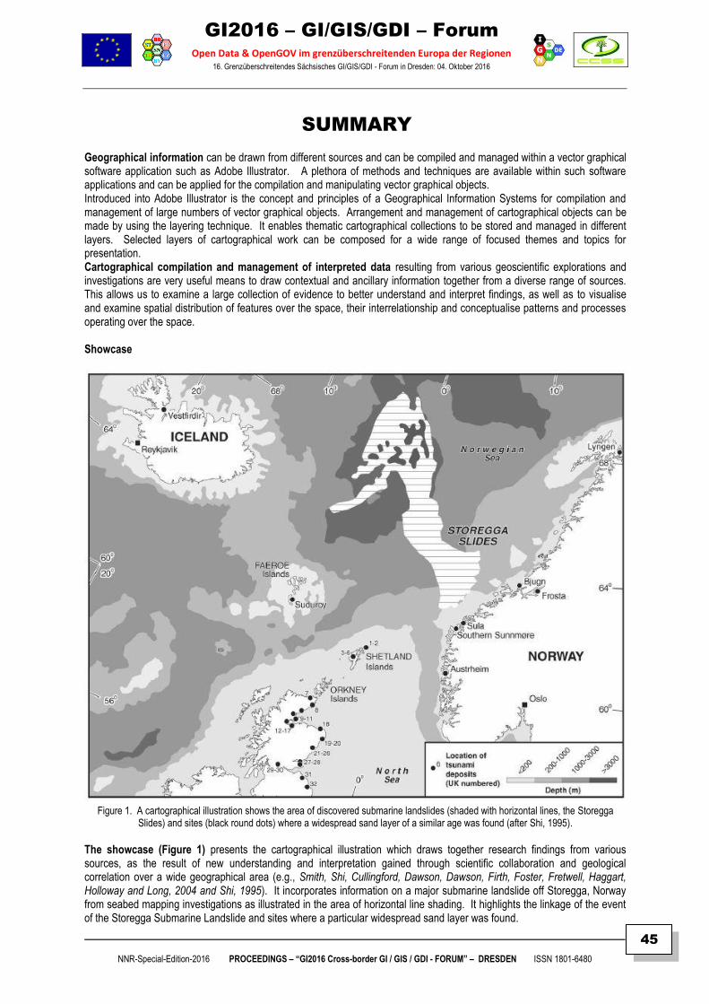
GI2016 – GI/GIS/GDI – Forum
Open Data & OpenGOV im grenzüberschreitenden Europa der Regionen 16. Grenzüberschreitendes Sächsisches GI/GIS/GDI - Forum in Dresden: 04. Oktober 2016
NNR-Special-Edition-2016 PROCEEDINGS – “GI2016 Cross-border GI / GIS / GDI - FORUM” – DRESDEN ISSN 1801-6480
45
SUMMARY Geographical information can be drawn from different sources and can be compiled and managed within a vector graphical software application such as Adobe Illustrator. A plethora of methods and techniques are available within such software applications and can be applied for the compilation and manipulating vector graphical objects. Introduced into Adobe Illustrator is the concept and principles of a Geographical Information Systems for compilation and management of large numbers of vector graphical objects. Arrangement and management of cartographical objects can be made by using the layering technique. It enables thematic cartographical collections to be stored and managed in different layers. Selected layers of cartographical work can be composed for a wide range of focused themes and topics for presentation. Cartographical compilation and management of interpreted data resulting from various geoscientific explorations and investigations are very useful means to draw contextual and ancillary information together from a diverse range of sources. This allows us to examine a large collection of evidence to better understand and interpret findings, as well as to visualise and examine spatial distribution of features over the space, their interrelationship and conceptualise patterns and processes operating over the space. Showcase
Figure 1. A cartographical illustration shows the area of discovered submarine landslides (shaded with horizontal lines, the Storegga
Slides) and sites (black round dots) where a widespread sand layer of a similar age was found (after Shi, 1995).
The showcase (Figure 1) presents the cartographical illustration which draws together research findings from various sources, as the result of new understanding and interpretation gained through scientific collaboration and geological correlation over a wide geographical area (e.g., Smith, Shi, Cullingford, Dawson, Dawson, Firth, Foster, Fretwell, Haggart, Holloway and Long, 2004 and Shi, 1995). It incorporates information on a major submarine landslide off Storegga, Norway from seabed mapping investigations as illustrated in the area of horizontal line shading. It highlights the linkage of the event of the Storegga Submarine Landslide and sites where a particular widespread sand layer was found.
GI2016 – GI/GIS/GDI – Forum
Open Data & OpenGOV im grenzüberschreitenden Europa der Regionen 16. Grenzüberschreitendes Sächsisches GI/GIS/GDI - Forum in Dresden: 04. Oktober 2016
NNR-Special-Edition-2016 PROCEEDINGS – “GI2016 Cross-border GI / GIS / GDI - FORUM” – DRESDEN ISSN 1801-6480
46
This particular sand layer is believed to be deposited by a tsunami along the coastline of the Scotland. The geological correlation was not obvious to independently conducted site investigations to experts and novice readers. Cartographical illustration and linking such features have been found to play an important role in communicating scientific interpretation and linkage of features and events can be highlighted and emphasised with additional drawings and annotation. Particularly, special attention needs to be drawn to readers, when inherent relationship and linkage of features and events are present, but not easily seen by inexperienced novice readers. The cartographical representation of the submarine landslide area was derived from the output of various remote sensing and modeling projects on the seafloor mapping. The remote sensing of the seafloor of the area was investigated with a range of methods and techniques including the use of seismic profiling techniques (specifically, the British Geological Society (BGS) Deep-Tow Boomer (DTB)). The DTB was able to collect profiles with a vertical resolution of 1 metre, with a penetration of up to 200 metres in water depths of up to 1500 metres (Evans, 1995). Since the discovery of the Storegga Slide and its widespread impact, further seafloor mapping of the North Sea has occurred and a range of data including high resolution swath bathymetry and sidescan sonar data (Long and Holmes, 2001) were collected Procedure of workflow: The technical approach and procedure described here focus on compiling vector graphical objects into integrated vector map data files. It allows vector graphical objects to be put together with contextual and ancillary data sets for producing final maps and illustrations. The procedure of the workflow of this approach is as follows:
1. Gathering vector data sets as the output of interpreted features 2. Converting the data sets and importing these into a vector graphical software application such as Adobe Illustrator;
alternatively, on-screen digitising can be made in the graphical software package. 3. Organise data sets into different topic layers and group vector graphical objects appropriately, in conjunction with
contextual and ancillary map data sets 4. Carry out quality check and edit graphical objects 5. Apply appropriate styles of legend, symbols, signs, lines and filling patterns in accordance with widely accepted
conventions and standards 6. Select appropriate data layers and objects to compose topic specific maps and illustrations 7. Carry out editing tasks and create the final output of maps and illustrations for visualisation
Legends, symbols, signs, annotation and typology The power of computational tools in vector graphical software applications permits boundless possibilities for creating appropriate legends and symbols for reflecting typology of geoscientific features (Figure 1). It allows a flexible way to adopt existing conventions and standards for legends, symbols, signs and annotation. It also permits addition of new ones to encompass advancement and new scientific findings. This is very important in the production chain from output of field work to reach the final map and cartographical illustration products. Figure 1 gives a glimpse of what can be done. Horizontally shaded area in the North Sea denotes the extent of the Storrega Slides, off the west coast of Norway. The area of the seafloor was investigated with remote sensing and modeling techniques (e.g., Evens, 1995; Haflidasona, H., Sejrupa, H. P., Nygard, A. Mienert, J., Bryn, P., Lien, R., Forsberg, C. F., Berg, K. and Masson, D., 2004). The brightness of the shading of the sea denotes the depth of the surface of the seafloor. The round dots denote the sites where a particular deposit was found. The deposit was believed to have been laid down by a mega-tsunami generated by the landslide. Various sized and styled Helvetica fonts were used throughout the illustration. Further advances can be made from existing classification schemes and examples of symbolisation. For example, there are symbolisation schemes for geomorphological features (e.g., Demek 1972; Gardiner and Dackombe 1979; Ollier 1977, Gel-lert,1988) can be adapted. Types of cartographic visualisation Cartographical visualisation has been a revolving field. It is a vibrant field for multi-disciplinary exploration and offers a rich ground for further scientific discovery and technological renaissance. Cartographical visualisation has not been limited to conventional cartography. Cartographical visualisation has been explored in a wide range of forms including 2D, 2.5D, 3D models and animation models. Sources and availability of data arising from mapping have been growing. Undoubtedly, geoscientific mapping has important applications in research, resource exploitation and management. Cartographical visualisation will assist effective communication on the latest happening and technological renaissance in geoscientific mapping. There is an ample scope for explorative development and uses of innovative visualisation techniques in mapping by following the cartographical concept and principles.
GI2016 – GI/GIS/GDI – Forum
Open Data & OpenGOV im grenzüberschreitenden Europa der Regionen 16. Grenzüberschreitendes Sächsisches GI/GIS/GDI - Forum in Dresden: 04. Oktober 2016
NNR-Special-Edition-2016 PROCEEDINGS – “GI2016 Cross-border GI / GIS / GDI - FORUM” – DRESDEN ISSN 1801-6480
47
Discussions One of the key goals of geoscientific investigations is to generate re-usable map products. Though remote sensing techniques can extend our capability to discover features beyond the reach of human eyes and perception, there is a need to make output of interpretation accessible to general novice users. Particularly, false colour images can only be understood by trained specialists and are inaccessible to novices. Professional cartographical production has become an established practice at the stage of reaching the final map production in the process of information processing, interpretation and product generation. The approach offers a distinctive advantage for compilation of all data together and generates professionally produced map and illustration products. It offers an important approach for creating comprehensive and informative products. It is an approach of harnessing and integrating scientific interpretations, in combination with other contextual and ancillary information for a variety of visualisation and communication projects to reach a general audience.
The technological approach described here has been found to be very useful to harness and compile large volumes of interpreted results arising from the output of geoscientific interpretations.
It is important to note that this approach has been found to be very useful in producing high quality cartographical work. This is particularly due to the fact that vector graphical software applications are much suited and versatile for editing graphical objects contained in maps. These applications permit drawing and manipulation by hand with ease and have useful functions and tools to allow traditional cartographical artwork to be produced. Stylish end products can be produced. For instance, text annotations can be place in any directions and styles and can also render along the natural flow of channels and around the boarders of natural features. It allows us to turn output of investigations into high quality products depicting natural features more realistically. Scalable vector graphics can be re-used and edited to provide emphasis on new findings. New scientific finding and technological advances resulting from the output of geoscientific investigations can be emphasised with appropriate settings and contextual information together. Thus, visual communication can be effective..
Conclusions Well designed cartographical drawings find their own legs into emerging publications as others quote and reuse the information in neat appealing visual forms. It is believed that cartographical illustrations are particularly useful in presenting interpreted results. It can assist in removing the major communication barrier between deciphering expertise and general novice viewers. By putting together information, interesting new findings may be revealed when interrelations of phenomena in the system of the Earth are examined. It will assist interpretation and communicating findings on the previously uncharted part of the world. For instance, new insightful knowledge can be gained of the linkage of off-shore and on-shore natural phenomena, patterns and processes operating in coastal areas. The advantage of application of cartography is its visualisation and communicative power. It is a well known fact that appealing visual content drives engagement and can generate a wide impact. Suitable software applications can allow managing and presenting and communicating findings. These allow map products to be developed to reach niche market areas based on data collections. It is envisaged that geoscientific mapping will undergo further scientific, technological and cartographical renaissance in the future. A rich collection of geospatial datasets, map and cartographical illustration products will further develop. A rich digital collection of legends, symbols and signs reflecting the evolving descriptive typology of the environment will be accumulated for the depiction of the natural phenomena. Cartographical compilation of a diverse range of interpreted output will contribute to the process of harnessing and integrating an ever-growing number of geographical feature objects and management of big vector-based graphical data sets.
References Demek J (ed), 1972, Manual of detailed geomorphological mapping. Academia (for the International Geographical Union, Commission on Geomorphological Survey and Mapping), Prague, 344p. Evans, D., 1995, The BGS deep-tow boomer meets the Storegga Slide. The Edingurgh Geologist Issue No. 28. http://www.edinburghgeolsoc.org/edingeologist/z_28_04.html. Gardiner V, Dackombe RV, 1979, Geomorphological field manual. Allen & Unwin, London, 254p. Gellert JF, 1988, Applied geomorphological survey and mapping on coasts. Zeitschrift fur Geomorphologie, N.F., Supplement Band 68, 223p. Robinson, A. H., 1952. The Look of Maps. Madison, WI: the University of Wisconsin Press. Shi, S., 1995. Observational and Theoretical Aspects of Tsunami Sedimentation. Ph.D Thesis. Coventry University. Smith, D.E., Shi, S., Cullingford, R.A., Dawson, A.G., Dawson, S., Firth, C.R., Foster, I.D.L., Fretwell, P.T., Haggart, B.A., Holloway, L.K. and Long, D. 2004. The Holocene Storegga Slide tsunami in the United Kingdom. Quaternary Science Reviews 23, 2291-2321. Smith, D. E., Dawson, A. G., Hickey, K. R., Firth, C. R., Brooks, C. L., Dawson, S. and Shi, S., 1993: Final report on work undertaken by Coventry University (The Co-ordinator) - The Geological record: impacts of sea level change in Europe. Climate Change, Sea Level Rise and Associated Impacts in Europe - The report for the Commission of the European Communities under contract EPOC-CT90-0015.
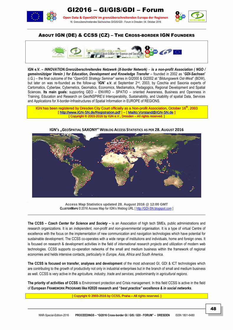
GI2016 – GI/GIS/GDI – Forum
Open Data & OpenGOV im grenzüberschreitenden Europa der Regionen 16. Grenzüberschreitendes Sächsisches GI/GIS/GDI - Forum in Dresden: 04. Oktober 2016
NNR-Special-Edition-2016 PROCEEDINGS – “GI2016 Cross-border GI / GIS / GDI - FORUM” – DRESDEN ISSN 1801-6480
48
ABOUT IGN (DE) & CCSS (CZ) – THE CROSS-BORDER IGN FOUNDERS
IGN e.V. – INNOVATION.Grenzüberschreitendes Netzwerk (X-border Network) – is a non-profit Association ( NGO / gemeinnütziger Verein ) for Education, Development and Knowledge Transfer – founded in 2002 as “GDI-Sachsen” (i.G.) – the final outcome of the “OpenGIS Strategy Seminar” series in GI2000 & GI2002 at “Bildungswerk Ost-West” (BOW), but later on was re-founded as the follow-up “IGN” e.V. at September 2nd, 2003, by Czechia and Saxonia experts of Cartomatics, Cyberlaw, Cybernetics, Geomatics, Economics, Mediamatics, Pedagogics, Regional Development and Spatial Sciences. Its main goals: supporting GEO – ENVIRO – SPATIO – oriented Awareness, Business and Openness in Training, Education and Research on GeoINSPIRE’d Interoperability, Sustainability, and Usability of spatial Data, Services and Applications for X-border-Infrastructures of Spatial Information in EUROPE of REGIONS.
IIGGNN hhaass bbeeeenn rreeggiisstteerreedd bbyy DDrreessddeenn CCiittyy CCoouurrtt ooffffiicciiaallllyy aass aa NNoonn--pprrooffiitt AAssssoocciiaattiioonn,, OOccttoobbeerr 1166tthh
,, 22000033
[[ hhttttpp::////wwwwww..IIGGNN--SSNN..ddee//RReeggiissttrraattiioonn..ppddff ]] –– [[ MMaaiillttoo::VVoorrssttaanndd@@IIGGNN--SSNN..ddee ]] [[ CCooppyyrriigghhtt ©© 22000033--22001166 bbyy IIGGNN ee..VV..,, DDrreessddeenn –– AAllll rriigghhttss rreesseerrvveedd.. ]]
IGN’s „GEOSPATIAL SAXONY“ WEBLOG ACCESS STATISTICS AS PER 28. AUGUST 2016
Access Map Statistics updated 28. August 2016 @ 12:00 GMT CLUSTERMAPS © 2016 Access Map for IGN’s Weblog URL [ http://GDI-SN.blogspot.com ]
The CCSS – Czech Center for Science and Society – is an Association of high tech SMEs, public administrations and
research organizations. It is an independent, non-profit and non-governmental organisation. It is a type of virtual Centre of
excellence with the focus on the implementation of new communication and navigation technologies which have potential for
sustainable development. The CCSS co-operates with a wide range of institutions and individuals, home and foreign ones. It
is focused on research & development activities in the field of international research projects and utilization of modern web
technologies. CCSS supports co-operation networks of the small and medium business within the framework of regional
economies and helds intensive contacts, particularly in Europe, Asia, Africa and South America.
The CCSS is focused on transfer, analyses and development of the most advanced GI, GDI & ICT technologies which
are contributing to the growth of productivity not only in industrial enterprises but in the branch of small and medium business
as well. CCSS is very active in the agriculture, industry, trade and services, predominantly in agricultural regions.
The priority of activities of CCSS is Environment protection and Crisis management. In this field CCSS is active in the field
of European FRAMEWORK PROGRAMS like H2020 research and “best practice” excellence & in social networks.
[[ CCooppyyrriigghhtt ©© 22000033--22001166 bbyy CCCCSSSS,, PPrraahhaa –– AAllll rriigghhttss rreesseerrvveedd.. ]]
GI2016 – GI/GIS/GDI – Forum
Open Data & OpenGOV im grenzüberschreitenden Europa der Regionen 16. Grenzüberschreitendes Sächsisches GI/GIS/GDI - Forum in Dresden: 04. Oktober 2016
NNR-Special-Edition-2016 PROCEEDINGS – “GI2016 Cross-border GI / GIS / GDI - FORUM” – DRESDEN ISSN 1801-6480
49
INFORMATIONEN
Nationales Forum für Fernerkundung und Copernicus 2017
"Copernicus@work" Das Nationale Forum für Fernerkundung und Copernicus 2017 findet vom 14. bis 16. März 2017 im BMVI in Berlin statt. Mit dem diesjährigen Titel „Copernicus@work“ wird zum Ausdruck gebracht, dass Copernicus jetzt arbeitsfähig ist und unseren Arbeitsalltag nachhaltig beeinflussen wird. Durch Copernicus wird eine wertvolle digitale Informationsbasis für eine effiziente öffentliche Verwaltung, innovative privatwirtschaftliche Dienstleistungen und für die Wissenschaft geschaffen. Diese umfangreiche Informationsfülle gilt es zukünftig innovativ und intelligent zu nutzen. Wo und wie Copernicus in die Arbeitsprozesse implementiert werden kann bzw. diese neu definieren kann, wollen wir im Rahmen des Forums mit Ihnen diskutieren.
Ziele sind u.a. Fortführung des regelmäßigen Dialogs zwischen den verschiedenen Akteuren im Bereich
Fernerkundung/Copernicus
Diskussionen zum aktuellen Stand von Copernicus (national und europäisch)
Weiterentwicklung der nationalen Nutzeranforderungen
Präsentation von Zugangswegen zu den Copernicus-Daten und Prozessierungsmöglichkeiten für große Datenmengen (Big Data Analytics), z.B. an Hand der "Copernicus Data and Exploitation Platform-Deutschland" (CODE-DE)
Präsentation operationeller Copernicus Anwendungen
Vermittlung wissenschaftlicher Grundlagen zur Stärkung der Nutzung von Fernerkundungsmethoden, -produkten und In-Situ Daten, insbesondere in der öffentlichen Verwaltung.
Termine
Bis 25.Oktober 2016: Einreichung der Themenvorschläge für eine Fachsession
Bis 15. November 2016: Anmeldung für einen Informationsstand bzw. einen digitalen Posterbeitrag
Ab 25.November 2016: Veröffentlichung des Programmentwurfs und Beginn des Anmeldeverfahrens
Veranstalter Bundesregierung | Deutsches Zentrum für Luft- und Raumfahrt e.V. (DLR)
Source © by: http://www.d-copernicus.de/nationales-forum-fuer-fernerkundung-und-copernicus-2017-copernicuswork
BIM WORLD MUNICH 2016 Bim World Munich 2016 29.+30. November Postpalast – Munich
The BIM Roadmap for the construction industry – For the first time in Germany, BIM World will
present for two days the new structures around digital construction and planning.
The BIM World MUNICH will be THE platform in Germany and the German speaking countries for
all engaged sector players. The two day conference with exhibition area will demonstrate the benefits
and implementation of the digital processes, present essential software, technologies and best practices
in BIM and outline the upcoming challenges for working with BIM.
Contact: NAVISPACE AG, Keramikstraße 4, D-82211 Herrsching [ [email protected] ]
Source © by: http://www.bim-world.de/
GI2016 – GI/GIS/GDI – Forum
Open Data & OpenGOV im grenzüberschreitenden Europa der Regionen 16. Grenzüberschreitendes Sächsisches GI/GIS/GDI - Forum in Dresden: 04. Oktober 2016
NNR-Special-Edition-2016 PROCEEDINGS – “GI2016 Cross-border GI / GIS / GDI - FORUM” – DRESDEN ISSN 1801-6480
50
INTERGEO - Hamburg: 11.-13. Oktober 2016
GeoBIM, Smart City, Big Data, BIM oder Geospatial 4.0: Es gibt eine Reihe von Begriffen, die in der Geoinformationswirtschaft derzeit in Mode sind. Für manchen werden alleine diese Buzzwords Grund genug sein, die INTERGEO in Hamburg zu besuchen. Andere schauen genauer auf die vielen Innovationen, die sich hinter diesen Begriffen verstecken.
Auf konkreter Produktebene sind auf der INTERGEO 2016, die vom 11. bis 13. Oktober in Hamburg stattfindet, nämlich eine große Anzahl von Neuerungen zu sehen, die der bunten Anwenderschaft der Geoinformatik einen konkreten praktischen Nutzen bringen. Mit 522 Ausstellern zählt die Messe in etwa so viele wie in den letzten Jahren.
Alles in allem zeigt die INTERGEO also auch den Megatrend der Digitalisierung. Marktanalysten schätzen, dass es im Jahr 2017 mehr vernetzte Geräte geben wird als Menschen. Und gerade in den Haupt-Zielgruppen der INTERGEO (also beim Bauen, Versorgen und Verwalten) erwartet man eine weitere Welle der Digitalisierung. Wenn nicht jeder bei Geospatial 4.0 oder GeoBIM einen konkreten Sinn entdecken mag, ein Körnchen Wahrheit ist sicher vorhanden. Wer offenen Auges die INTERGEO besucht, wird an jeder Ecke interessante Facetten der Digitalisierung finden.
Source © by: http://www.intergeo.de
INTERGEO Positionspapier des VDV zu „Open Geo-Data“ 29. September 2016
Der Verband Deutscher Vermessungsingenieure (VDV) e.V., Berufsverband für Geodäsie und Geoinformatik, ruft im Positionspapier „Open Geo-Data“ die Bundesländer und Kommunen auf, amtliche Geodaten im Sinne von Open Data kostenfrei und mit freien Lizenzen bereitzustellen.
Der Verbreitung und Nutzung von amtlichen Geobasis- und Geofachdaten stünden komplizierte, unterschiedliche und zu hohe Gebührenregelungen entgegen. Weiter argumentiert der VDV, dass der Wert der mit enormem Aufwand erstellten Daten vom Liegenschaftskataster über topografische Daten über Angaben zur Landnutzung oder der zahlreichen kommunalen Geodatenbestände nur dann gehoben werden könne, wenn er offen zur Verfügung gestellt würde. Der VDV stützt sich in seiner Argumentation auf die Vorbildfunktion des Bundes sowie der Länder Hamburg und Berlin... Nur so könne aus der Daseinsberechtigung der Verwaltungen eine echte Dienstleistungsversorgung für die Bürger werden...
Der VDV verweist zudem auf die positiven Aspekte von offenen Geodaten für die Wirtschaft... Im Positionspapier weist der Verband außerdem darauf hin, dass Deutschland bei Open Data hinter einem Großteil der Industrienationen zurückliege und unter anderem aufgrund mangelnder Transparenz zu Landeigentumsdaten im Open Data Index der Open Knowledge Foundation nur noch den 26. Platz belegt. Unter dem Motto „Transparenz schaffen und stärken“ rät der VDV deshalb zu einem sinnvollen Verhältnis zwischen Datenschutz und Transparenz... und verweist auf die Open Data Charta, bei der sich alle acht G8 Staaten zu einer breiten Veröffentlichung von Verwaltungsdaten im Sinne von „Open Data“ bekannt haben – allerdings seien daraufhin nur einzelne zaghafte Entwicklungen erfolgt.
Schließlich betont der VDV die Wichtigkeit des Raumbezugs offener Daten. Nur durch Raumbezug seien die Daten einfach zu finden, zugänglich, schnell zu evaluieren und leicht zu teilen, was eine breitere Nutzung von existierenden Geodaten und Geodateninfrastrukturen (GDI) ermögliche.
Source © by: www.VDV-online.de
GI2016 – GI/GIS/GDI – Forum
Open Data & OpenGOV im grenzüberschreitenden Europa der Regionen 16. Grenzüberschreitendes Sächsisches GI/GIS/GDI - Forum in Dresden: 04. Oktober 2016
NNR-Special-Edition-2016 PROCEEDINGS – “GI2016 Cross-border GI / GIS / GDI - FORUM” – DRESDEN ISSN 1801-6480
51
INTERGEO
Amtliche Geobasisdaten als Grundlage für Entscheidungsträger 29. September 2016
Am INTERGEO-Stand der AdV (Arbeitsgemeinschaft der Vermessungsverwaltungen der Länder der Bundesrepublik Deutschland informieren die Länder Hamburg, Schleswig-Holstein und Mecklenburg-Vorpommern über Neuigkeiten aus der Welt der amtlichen Geobasisdaten. Hamburg präsentiert sein Masterportal zur komfortablen Erstellung von Web-Anwendungen für Geodaten sowie sein Metadatenportal MetaVer (MetadatenVerbund), das als Internet-Suchmaschine für Geoinformationen als gemeinsames Projekt der Länder Brandenburg, Bremen, Hamburg, Mecklenburg-Vorpommern und Sachsen-Anhalt betrieben wird. Darüber hinaus wird die Langzeitspeicherung von Geodaten thematisiert.
Mecklenburg-Vorpommern informiert über die Welt von 3D-Geobasisdaten. Die 3D-Gebäudemodelle M-V liegen in den Detailstufen LoD1 und LoD2 flächendeckend vor und werden über das Geoportal M-V bereitgestellt. Bildbasierte Oberflächenmodelle (bDOM) entstehen automatisiert als 3D-Punktwolken aus Pixelpaaren orientierter Luftbildpaare. bDOM Datensätze verfügen über eine hohe geometrische 3D-Auflösung mit Texturinformationen aus den originären Luftbildern und sind für Visualisierungen geeignet. Laut AdV liegt für M-V zudem ein flächendeckender Datenbestand mit einer geometrischen Auflösung der Erdoberfläche von 0,1 bis 0,4 Metern vor. Reduziert auf die Ebene können aus den bDOM-Daten True Orthophotos generiert werden.
Schleswig-Holstein zeigt den DigitalenAtlasNord als zentrale Präsentationskomponete verschiedener digitaler Geodaten mit der auch die Auswertung von Geodaten möglich ist. Außerdem werden die Vorteile von 3D-Punktwolken in der Flurbereinigungsvermessung thematisiert: Hierbei soll der Einsatz von Laserscans in der Flurbereinigungsvermessung eine Effektivitätssteigerung bei der Auswertung von sichtbaren Grenzen ermöglichen.
Zudem informieren die drei zentralen Stellen der AdV, Zentrale Stelle SAPOS, Zentrale Stelle Geotopographie und Zentrale Stelle Hauskoordinaten und Hausumringe, über „Geobasisdaten aus einer Hand“, und erklären Einzelheiten zu dem neuen Höhenbezug in Deutschland sowie zu der automatisierten Generalisierung von ATKIS-Daten... AdV, Halle A2, Stand C2.071
Source © by: http://www.business-geomatics.com/bgx/
DDiiee GGII22001166 OOrrggaanniissaattoorreenn –– IIGGNN (( DDrreessddeenn )) && CCCCSSSS (( PPrraahhaa )) && PPRROOGGIISS ((VViillllaacchh)) –– ddaannkkeenn......
dem Support-Programme der EU zur “Inter-regionalen Zusammenarbeit” in Sachsen (2014-2017)
den Autoren aus AT (Villach), CZ (Prag), DE (Bad Schandau & Dresden) und UK (Buckinghamshire)
dem Ingenieurbüro für Kartographie und Kartenverlag Dr. Böhm (Bad Schandau)
dem Verlag sig Media GmbH (Köln)
sowie der Firma DR. SCHILLER & PARTNER GmbH (Dresden)
...für deren aktive Mitwirkung, Materialbereitstellung und fachliche Unterstützung,
...... wweellcchhee zzuumm EErrffoollgg ddeess GGII22001166 –– IInntteerrrreeggiioonnaalleenn GGII // GGIISS // GGDDII –– FFoorruummss bbeeiiggeettrraaggeenn hhaabbeenn !!