geospatial platform/data.gov metadata … · include terms found in published in iso metadata,...
TRANSCRIPT
Geospatial Metadata Guide for catalog.data.gov 8/2/13 Page 1
Geospatial Platform/data.gov Metadata Recommendations to Support Data Discovery and Use
Metadata collection has been ongoing for many years now in the geospatial field. With the publication of the initial Content Standard for Digital Geospatial Metadata (CSDGM) in 1994 and its Version 2 in 1998, and globally with the international metadata standard ISO 19115 in 2003, and its XML form, ISO TS19139, in 2007. The primary objective of these standards is to provide contextual documentation of geospatial resources – data, services, documents, and applications that enable fitness-for-use evaluations, and facilitate direct online access to the described resources. The Geospatial One-Stop and the Geospatial Platform successor catalog, executed in partnership with data.gov, have as a priority the documentation of online accessible data and information products, specifically the location of data sets and applications for download and Web service URLs for real-time visualization and data access or processing. This document identifies best practices of geospatial metadata creation and publishing that will lead to more successful propagation of metadata and ease of resource discovery and access through cataloguing systems like data.gov and the Geospatial Platform. Separate guidance exists in github for the preparation of non-spatial metadata for the federal Open Data Project. Associated with this metadata document are examples of a validated metadata record
in both CSDGM and ISO format (XML) that illustrates most of these recommendations.
Provide direct URL to online resources in metadata. Resources (data, services,
applications) that are described in either CSDGM or ISO metadata must include URLs that take a user to the online resource. This is a baseline expectation of the data.gov environment and one we must follow in the shared catalog. Links should provide direct access to the resource wherever possible. Metadata records that only include references to websites or HTML pages where one must re-initiate search are not user-friendly and preclude automated clients from accessing the data. As both metadata standards allow for multiple resource links to be placed in metadata, this should be encouraged to allow users to directly access multiple facets of the data: web service, download, documentation, browse graphic.
Use the appropriate metadata structure to describe the download or access URL. In
CSDGM metadata, links to resources should be in the Distribution section of the standard using the following XML substructure (CSDGM V 2.0 1998), where Format Name (formname) should describe the specific format being made available in this group. The paired online URL is in the CSDGM Network Resource (networkr) element. Multiple access methods may be described in a metadata document for links to different formats. Online Linkage (onlink) is sometimes used to store actionable URLs, but is not recommended for encoding the distribution linkage.

Geospatial Metadata Guide for catalog.data.gov 8/2/13 Page 2
<digform>
<digtinfo>
<formname>shapefile</formname>
</digtinfo>
<digtopt>
<onlinopt>
<computer>
<networka>
<networkr>http://someagency.gov/data/prod_234.zip
</networkr>
</networka>
</computer>
</onlinopt>
</digtopt>
</digform>
In ISO 19115, the following constructs can be used in the Distribution Section describing the downloadable data resource and its access, format, and function. Where a resource is available through a WMS or WFS, it is more helpful to include two linkages in the distribution section – one (download) link for the WMS “GetMap” or WFS “GetFeature” request URL, and the other (information) link for the WMS “GetCapabilities” URL. This enables catalog clients to find and bind to exactly the resource being described among many possible layers or feature types in a service. Multiple instances of distribution information should be included in one metadata record, where available. //gmd:distributionInfo/gmd:MD_Distribution/gmd:distributionFormat/ <gmd:MD_Format>
<gmd:name>
<gco:CharacterString>GeoTIFF</gco:CharacterString>
</gmd:name>
<gmd:version gco:nilReason="unknown"/>
</gmd:MD_Format>
//gmd:distributionInfo/gmd:MD_Distribution/ <gmd:transferOptions>
<gmd:MD_DigitalTransferOptions>
<gmd:onLine>
<gmd:CI_OnlineResource>
<gmd:linkage>
<gmd:URL>http://server.gov/tiffs/bouguer_ok.tif</gmd:URL>
</gmd:linkage>
<gmd:function>
<gmd:CI_OnLineFunctionCode
codeList="http://www.isotc211.org/2005/resources/Codelist/gmxCodelists.xml#CI_OnLineFunctionCode" codeListValue="download"> download </gmd:CI_OnLineFunctionCode>
</gmd:function>
</gmd:CI_OnlineResource>
</gmd:onLine>
</gmd:MD_DigitalTransferOptions>
</gmd:transferOptions>
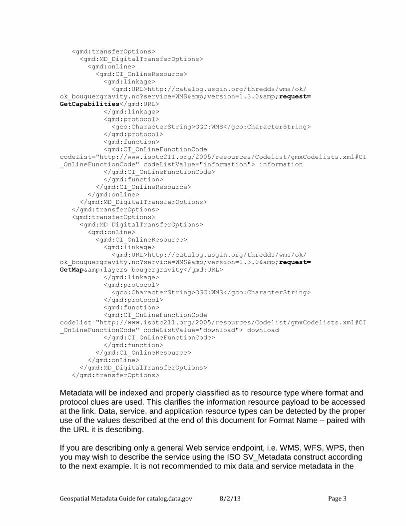
Geospatial Metadata Guide for catalog.data.gov 8/2/13 Page 3
<gmd:transferOptions>
<gmd:MD_DigitalTransferOptions>
<gmd:onLine>
<gmd:CI_OnlineResource>
<gmd:linkage>
<gmd:URL>http://catalog.usgin.org/thredds/wms/ok/
ok_bouguergravity.nc?service=WMS&version=1.3.0&request=
GetCapabilities</gmd:URL>
</gmd:linkage>
<gmd:protocol>
<gco:CharacterString>OGC:WMS</gco:CharacterString>
</gmd:protocol>
<gmd:function>
<gmd:CI_OnLineFunctionCode
codeList="http://www.isotc211.org/2005/resources/Codelist/gmxCodelists.xml#CI
_OnLineFunctionCode" codeListValue="information"> information
</gmd:CI_OnLineFunctionCode>
</gmd:function>
</gmd:CI_OnlineResource>
</gmd:onLine>
</gmd:MD_DigitalTransferOptions>
</gmd:transferOptions>
<gmd:transferOptions>
<gmd:MD_DigitalTransferOptions>
<gmd:onLine>
<gmd:CI_OnlineResource>
<gmd:linkage>
<gmd:URL>http://catalog.usgin.org/thredds/wms/ok/
ok_bouguergravity.nc?service=WMS&version=1.3.0&request=
GetMap&layers=bougergravity</gmd:URL>
</gmd:linkage>
<gmd:protocol>
<gco:CharacterString>OGC:WMS</gco:CharacterString>
</gmd:protocol>
<gmd:function>
<gmd:CI_OnLineFunctionCode
codeList="http://www.isotc211.org/2005/resources/Codelist/gmxCodelists.xml#CI
_OnLineFunctionCode" codeListValue="download"> download
</gmd:CI_OnLineFunctionCode>
</gmd:function>
</gmd:CI_OnlineResource>
</gmd:onLine>
</gmd:MD_DigitalTransferOptions>
</gmd:transferOptions>
Metadata will be indexed and properly classified as to resource type where format and protocol clues are used. This clarifies the information resource payload to be accessed at the link. Data, service, and application resource types can be detected by the proper use of the values described at the end of this document for Format Name – paired with the URL it is describing. If you are describing only a general Web service endpoint, i.e. WMS, WFS, WPS, then you may wish to describe the service using the ISO SV_Metadata construct according to the next example. It is not recommended to mix data and service metadata in the

Geospatial Metadata Guide for catalog.data.gov 8/2/13 Page 4
same record as they typically are at different levels of granularity – data set “layers” versus a service that serves combinations of data sets, coordinate reference systems, and output formats. <gmd:MD_Metadata>
<gmd:identificationInfo>
<srv:SV_ServiceIdentification>
<gmd:citation/>
<gmd:abstract/>
<srv:serviceType>
<gco:LocalName>ogc:wms</gco:LocalName>
</srv:serviceType>
<srv:serviceTypeVersion>
<gco:CharacterString>1.3.0</gco:CharacterString>
</srv:serviceTypeVersion>
<srv:couplingType/>
<srv:containsOperations>
<srv:SV_OperationMetadata>
<srv:operationName>
<gco:CharacterString>getCapabilities
</gco:CharacterString>
</srv:operationName>
<srv:DCP>
<srv:DCPList
codeList="http://www.fgdc.gov/nap/metadata/register/codelists.html#IC_112"
codeListValue="WebServices">WebServices</srv:DCPList>
</srv:DCP>
<srv:connectPoint>
<gmd:CI_OnlineResource>
<gmd:linkage>
<gmd:URL>http://someagency.org/svc/maps.cgi</gmd:URL>
</gmd:linkage>
</gmd:CI_OnlineResource>
</srv:connectPoint>
</srv:SV_OperationMetadata>
</srv:containsOperations>
</srv:SV_ServiceIdentification>
</gmd:identificationInfo>
Include terms found in published taxonomies in your metadata. In ISO Metadata,
there is a structure allowing for the identification of one or more Topic Categories that best characterize your data or application domain. These are very high-level thematic bins, but are excellent for providing a quick triage of available data when indexed in the data.gov catalog. In CSDGM: <keywords>
<theme>
<themekt>ISO 19115 Topic Category</themekt>
<themekey>biota</themekey>
<themekey>environment</themekey>
</theme>
</keywords>
Geospatial Metadata Guide for catalog.data.gov 8/2/13 Page 5
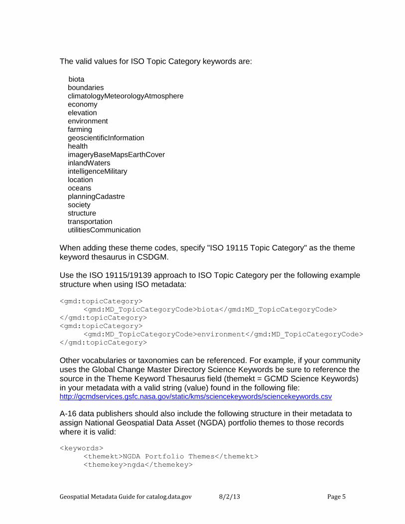
The valid values for ISO Topic Category keywords are: biota boundaries climatologyMeteorologyAtmosphere economy elevation environment farming geoscientificInformation health imageryBaseMapsEarthCover inlandWaters intelligenceMilitary location oceans planningCadastre society structure transportation utilitiesCommunication
When adding these theme codes, specify "ISO 19115 Topic Category" as the theme keyword thesaurus in CSDGM. Use the ISO 19115/19139 approach to ISO Topic Category per the following example structure when using ISO metadata:
<gmd:topicCategory>
<gmd:MD_TopicCategoryCode>biota</gmd:MD_TopicCategoryCode>
</gmd:topicCategory>
<gmd:topicCategory>
<gmd:MD_TopicCategoryCode>environment</gmd:MD_TopicCategoryCode>
</gmd:topicCategory>
Other vocabularies or taxonomies can be referenced. For example, if your community uses the Global Change Master Directory Science Keywords be sure to reference the source in the Theme Keyword Thesaurus field (themekt = GCMD Science Keywords) in your metadata with a valid string (value) found in the following file: http://gcmdservices.gsfc.nasa.gov/static/kms/sciencekeywords/sciencekeywords.csv
A-16 data publishers should also include the following structure in their metadata to assign National Geospatial Data Asset (NGDA) portfolio themes to those records where it is valid: <keywords>
<themekt>NGDA Portfolio Themes</themekt>
<themekey>ngda</themekey>
Geospatial Metadata Guide for catalog.data.gov 8/2/13 Page 6
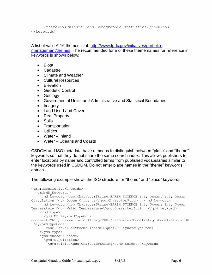
<themekey>Cultural and Demographic Statistics</themkey>
</keywords>
A list of valid A-16 themes is at: http://www.fgdc.gov/initiatives/portfolio-management/themes. The recommended form of these theme names for reference in keywords is shown below:
Biota
Cadastre
Climate and Weather
Cultural Resources
Elevation
Geodetic Control
Geology
Governmental Units, and Administrative and Statistical Boundaries
Imagery
Land Use-Land Cover
Real Property
Soils
Transportation
Utilities
Water – Inland
Water – Oceans and Coasts CSDGM and ISO metadata have a means to distinguish between “place” and “theme” keywords so that they do not share the same search index. This allows publishers to enter locations by name and controlled terms from published vocabularies similar to the keywords used in CSDGM. Do not enter place names in the “theme” keywords entries. The following example shows the ISO structure for “theme” and “place” keywords: <gmd:descriptiveKeywords>
<gmd:MD_Keywords>
<gmd:keyword><gco:CharacterString>EARTH SCIENCE > Oceans > Ocean
Circulation > Ocean Currents</gco:CharacterString></gmd:keyword>
<gmd:keyword><gco:CharacterString>EARTH SCIENCE > Oceans > Ocean
Temperature > Water Temperature</gco:CharacterString></gmd:keyword>
<gmd:type>
<gmd:MD_KeywordTypeCode
codeList="http://www.isotc211.org/2005/resources/Codelist/gmxCodelists.xml#MD
_KeywordTypeCode"
codeListValue="theme">theme</gmd:MD_KeywordTypeCode>
</gmd:type>
<gmd:thesaurusName>
<gmd:CI_Citation>
<gmd:title><gco:CharacterString>GCMD Science Keywords
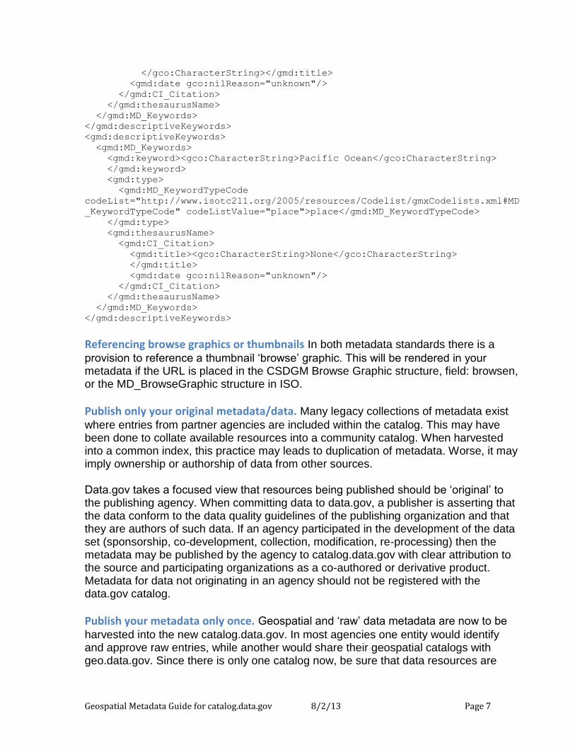
Geospatial Metadata Guide for catalog.data.gov 8/2/13 Page 7
</gco:CharacterString></gmd:title>
<gmd:date gco:nilReason="unknown"/>
</gmd:CI_Citation>
</gmd:thesaurusName>
</gmd:MD_Keywords>
</gmd:descriptiveKeywords>
<gmd:descriptiveKeywords>
<gmd:MD_Keywords>
<gmd:keyword><gco:CharacterString>Pacific Ocean</gco:CharacterString>
</gmd:keyword>
<gmd:type>
<gmd:MD_KeywordTypeCode
codeList="http://www.isotc211.org/2005/resources/Codelist/gmxCodelists.xml#MD
_KeywordTypeCode" codeListValue="place">place</gmd:MD_KeywordTypeCode>
</gmd:type>
<gmd:thesaurusName>
<gmd:CI_Citation>
<gmd:title><gco:CharacterString>None</gco:CharacterString>
</gmd:title>
<gmd:date gco:nilReason="unknown"/>
</gmd:CI_Citation>
</gmd:thesaurusName>
</gmd:MD_Keywords>
</gmd:descriptiveKeywords>
Referencing browse graphics or thumbnails In both metadata standards there is a
provision to reference a thumbnail ‘browse’ graphic. This will be rendered in your metadata if the URL is placed in the CSDGM Browse Graphic structure, field: browsen, or the MD_BrowseGraphic structure in ISO.
Publish only your original metadata/data. Many legacy collections of metadata exist
where entries from partner agencies are included within the catalog. This may have been done to collate available resources into a community catalog. When harvested into a common index, this practice may leads to duplication of metadata. Worse, it may imply ownership or authorship of data from other sources. Data.gov takes a focused view that resources being published should be ‘original’ to the publishing agency. When committing data to data.gov, a publisher is asserting that the data conform to the data quality guidelines of the publishing organization and that they are authors of such data. If an agency participated in the development of the data set (sponsorship, co-development, collection, modification, re-processing) then the metadata may be published by the agency to catalog.data.gov with clear attribution to the source and participating organizations as a co-authored or derivative product. Metadata for data not originating in an agency should not be registered with the data.gov catalog.
Publish your metadata only once. Geospatial and ‘raw’ data metadata are now to be
harvested into the new catalog.data.gov. In most agencies one entity would identify and approve raw entries, while another would share their geospatial catalogs with geo.data.gov. Since there is only one catalog now, be sure that data resources are
Geospatial Metadata Guide for catalog.data.gov 8/2/13 Page 8
published to the catalog – if tabular through the ‘raw’ data metadata feed, if geospatial through the catalog WAF or CSW. It is recommended that you coordinate your publication efforts within the agency to provide a consistent view of agency metadata holdings.
Write descriptive titles and abstracts. Following good library and publications practice,
titles of metadata documents should be declarative so that when reviewed, the user has a good sense of the information context being promoted. Titles must also be unique – having a dozen results with the identical title is not very helpful to the end user and there are features within the results that should be elevated to the title to distinguish them. Good titles will include the topic, and where relevant, the range of dates and geography associated with the data product being documented – What? Where? When? Where resources have local, regional, national, or global coverage, it should be apparent in the title. If the metadata describes a modification of data from another source, that also should be noted in the title. Never use a filename as the title of a metadata record! Although titles should not try to replace an Abstract or more lengthy description, they should not be terse. You may also wish to review the titles of your metadata records relative to those already in the catalog to assure distinction between the various entries. A rich abstract provides additional information and enables users to better assess the data resource’s fitness for use. The abstract should include:
a general description of the data resource content and features
form of the data resource, e.g. GIS, imagery, database, service, application, etc.
relevant place names and references
the time period of the data resource content
information about special data characteristics or limitations, e.g. data access limitations, excluded geographies or content, etc
Collections or series of homogeneous data need collection-level and member-level metadata records. Homogeneous series data are all of the same content, share most
of the same metadata values, and might only vary in terms of content date and geographic extent. Examples include satellite imagery repositories, or data product series individually available for download. This type of collection management is not applicable to most heterogeneous collections where every record should be indexed and is unique relative to its peers within the collection. To support homogeneous collections, the new catalog.data.gov solution supports the ability to distinguish a ‘parent’ metadata record that contains the basic information common to the full series. The first resource description link (under the distribution section) should be a URL to the Web Accessible Folder or CSW GetRecords URL containing the series metadata records. These ‘child’ records are separately indexed and made discoverable to the user after finding the parent record in general search. The parent record should not be located with the children in the folder or its subfolders.
Geospatial Metadata Guide for catalog.data.gov 8/2/13 Page 9
Specify content dates. Both CSDGM and ISO metadata include metadata fields to
store dates related to the metadata and the information content itself. In CSDGM, the Source Time Period of Content structure carries single date or the beginning and ending date of the data, expressed using ISO 8601 Dates in the form of YYYYMMDD or YYYY-MM-DD. The word ‘present’ may also be used in lieu of an end-date for continuously collected data. In ISO metadata, the following structure should be used, by example, using the same date format: <gmd:temporalElement>
<gmd:EX_TemporalExtent>
<gmd:extent>
<gml:TimePeriod gml:id="boundingTemporalExtent">
<gml:description>ground condition</gml:description>
<gml:beginPosition>1999-11-03</gml:beginPosition>
<gml:endPosition>2012-12-30</gml:endPosition>
</gml:TimePeriod>
</gmd:extent>
</gmd:EX_TemporalExtent>
</gmd:temporalElement>
The indeterminatePosition attribute can be used in time positions. This attribute is often used to document unknown and present dates. The valid values for indeterminatePosition are “unknown”, “after”, “before”, and “now”. The following example shows how an unknown date is represented in ISO: <gmd:temporalElement>
<gmd:EX_TemporalExtent>
<gmd:extent>
<gml:TimePeriod gml:id="boundingTemporalExtent">
<gml:description>ground condition</gml:description>
<gml:beginPosition>2012-08-15T20:00:00</gml:beginPosition>
<gml:endPosition indeterminatePosition="unknown"/>
</gml:TimePeriod>
</gmd:extent>
</gmd:EX_TemporalExtent>
</gmd:temporalElement>
The use of “now” is equivalent to the use of “present” in CSDGM: <gml:endPosition indeterminatePosition="now"/>
Publication date can also be encoded in the ISO Identification Section as a useful date for search on information products, as per the following example: <gmd:date>
<gmd:CI_Date>
<gmd:date>

Geospatial Metadata Guide for catalog.data.gov 8/2/13 Page 10
<gco:Date>2010-06-04</gco:Date>
</gmd:date>
<gmd:dateType>
<gmd:CI_DateTypeCode
codeList="http://www.isotc211.org/2005/resources/Codelist/gmxCodelists
.xml#CI_DateTypeCode"
codeListValue="publication"
codeSpace="002">publication</gmd:CI_DateTypeCode>
</gmd:dateType>
</gmd:CI_Date>
</gmd:date>
Geospatial Metadata Guide for catalog.data.gov 8/2/13 Page 11
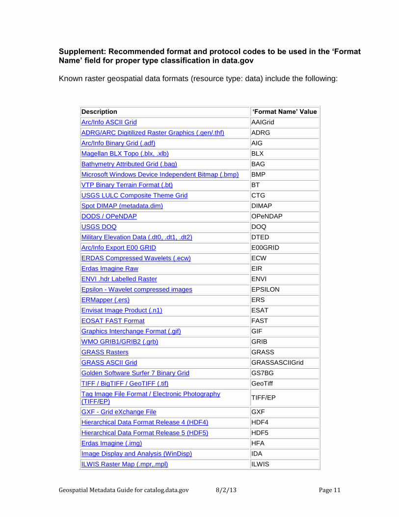
Supplement: Recommended format and protocol codes to be used in the ‘Format Name’ field for proper type classification in data.gov Known raster geospatial data formats (resource type: data) include the following:
Description ‘Format Name’ Value
Arc/Info ASCII Grid AAIGrid
ADRG/ARC Digitilized Raster Graphics (.gen/.thf) ADRG
Arc/Info Binary Grid (.adf) AIG
Magellan BLX Topo (.blx, .xlb) BLX
Bathymetry Attributed Grid (.bag) BAG
Microsoft Windows Device Independent Bitmap (.bmp) BMP
VTP Binary Terrain Format (.bt) BT
USGS LULC Composite Theme Grid CTG
Spot DIMAP (metadata.dim) DIMAP
DODS / OPeNDAP OPeNDAP
USGS DOQ DOQ
Military Elevation Data (.dt0, .dt1, .dt2) DTED
Arc/Info Export E00 GRID E00GRID
ERDAS Compressed Wavelets (.ecw) ECW
Erdas Imagine Raw EIR
ENVI .hdr Labelled Raster ENVI
Epsilon - Wavelet compressed images EPSILON
ERMapper (.ers) ERS
Envisat Image Product (.n1) ESAT
EOSAT FAST Format FAST
Graphics Interchange Format (.gif) GIF
WMO GRIB1/GRIB2 (.grb) GRIB
GRASS Rasters GRASS
GRASS ASCII Grid GRASSASCIIGrid
Golden Software Surfer 7 Binary Grid GS7BG
TIFF / BigTIFF / GeoTIFF (.tif) GeoTiff
Tag Image File Format / Electronic Photography (TIFF/EP)
TIFF/EP
GXF - Grid eXchange File GXF
Hierarchical Data Format Release 4 (HDF4) HDF4
Hierarchical Data Format Release 5 (HDF5) HDF5
Erdas Imagine (.img) HFA
Image Display and Analysis (WinDisp) IDA
ILWIS Raster Map (.mpr,.mpl) ILWIS
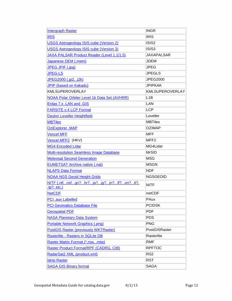
Geospatial Metadata Guide for catalog.data.gov 8/2/13 Page 12
Intergraph Raster INGR
IRIS IRIS
USGS Astrogeology ISIS cube (Version 2) ISIS2
USGS Astrogeology ISIS cube (Version 3) ISIS3
JAXA PALSAR Product Reader (Level 1.1/1.5) JAXAPALSAR
Japanese DEM (.mem) JDEM
JPEG JFIF (.jpg) JPEG
JPEG-LS JPEGLS
JPEG2000 (.jp2, .j2k) JPEG2000
JPIP (based on Kakadu) JPIPKAK
KMLSUPEROVERLAY KMLSUPEROVERLAY
NOAA Polar Orbiter Level 1b Data Set (AVHRR) L1B
Erdas 7.x .LAN and .GIS LAN
FARSITE v.4 LCP Format LCP
Daylon Leveller Heightfield Leveller
MBTiles MBTiles
OziExplorer .MAP OZIMAP
Vexcel MFF MFF
Vexcel MFF2 (HKV) MFF2
MG4 Encoded Lidar MG4Lidar
Multi-resolution Seamless Image Database MrSID
Meteosat Second Generation MSG
EUMETSAT Archive native (.nat) MSGN
NLAPS Data Format NDF
NOAA NGS Geoid Height Grids NGSGEOID
NITF (.ntf, .nsf, .gn?, .hr?, .ja?, .jg?, .jn?, .lf?, .on?, .tl?, .tp?, etc.)
NITF
NetCDF netCDF
PCI .aux Labelled PAux
PCI Geomatics Database File PCIDSK
Geospatial PDF PDF
NASA Planetary Data System PDS
Portable Network Graphics (.png) PNG
PostGIS Raster (previously WKTRaster) PostGISRaster
Rasterlite - Rasters in SQLite DB Rasterlite
Raster Matrix Format (*.rsw, .mtw) RMF
Raster Product Format/RPF (CADRG, CIB) RPFTOC
RadarSat2 XML (product.xml) RS2
Idrisi Raster RST
SAGA GIS Binary format SAGA
Geospatial Metadata Guide for catalog.data.gov 8/2/13 Page 13
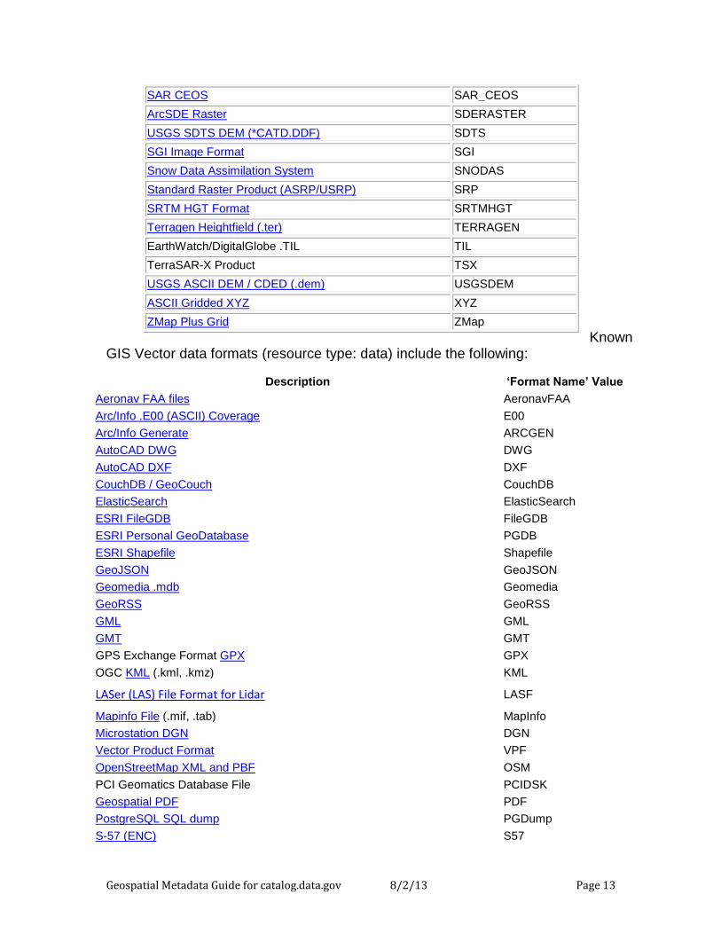
Known GIS Vector data formats (resource type: data) include the following:
SAR CEOS SAR_CEOS
ArcSDE Raster SDERASTER
USGS SDTS DEM (*CATD.DDF) SDTS
SGI Image Format SGI
Snow Data Assimilation System SNODAS
Standard Raster Product (ASRP/USRP) SRP
SRTM HGT Format SRTMHGT
Terragen Heightfield (.ter) TERRAGEN
EarthWatch/DigitalGlobe .TIL TIL
TerraSAR-X Product TSX
USGS ASCII DEM / CDED (.dem) USGSDEM
ASCII Gridded XYZ XYZ
ZMap Plus Grid ZMap
Description ‘Format Name’ Value
Aeronav FAA files AeronavFAA
Arc/Info .E00 (ASCII) Coverage E00
Arc/Info Generate ARCGEN
AutoCAD DWG DWG
AutoCAD DXF DXF
CouchDB / GeoCouch CouchDB
ElasticSearch ElasticSearch
ESRI FileGDB FileGDB
ESRI Personal GeoDatabase PGDB
ESRI Shapefile Shapefile
GeoJSON GeoJSON
Geomedia .mdb Geomedia
GeoRSS GeoRSS
GML GML
GMT GMT
GPS Exchange Format GPX GPX
OGC KML (.kml, .kmz) KML
LASer (LAS) File Format for Lidar LASF
Mapinfo File (.mif, .tab) MapInfo
Microstation DGN DGN
Vector Product Format VPF
OpenStreetMap XML and PBF OSM
PCI Geomatics Database File PCIDSK
Geospatial PDF PDF
PostgreSQL SQL dump PGDump
S-57 (ENC) S57
Geospatial Metadata Guide for catalog.data.gov 8/2/13 Page 14
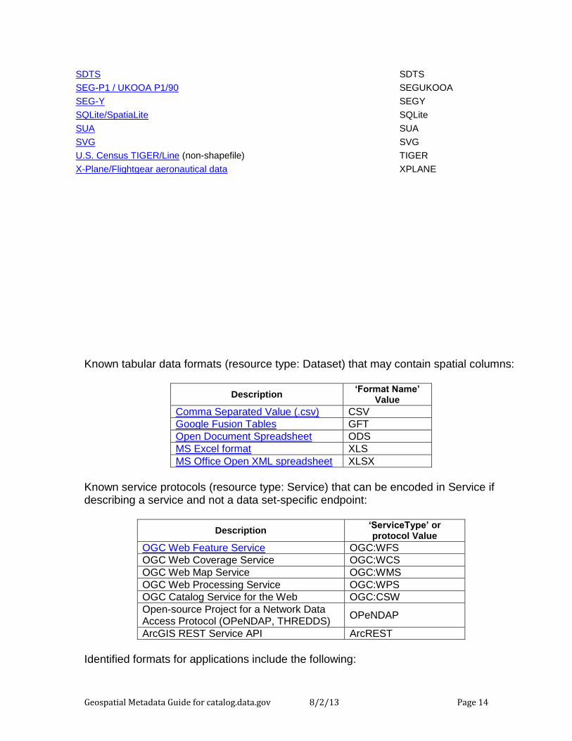
Known tabular data formats (resource type: Dataset) that may contain spatial columns:
Description ‘Format Name’
Value
Comma Separated Value (.csv) CSV
Google Fusion Tables GFT
Open Document Spreadsheet ODS
MS Excel format XLS
MS Office Open XML spreadsheet XLSX
Known service protocols (resource type: Service) that can be encoded in Service if describing a service and not a data set-specific endpoint:
Description ‘ServiceType’ or protocol Value
OGC Web Feature Service OGC:WFS
OGC Web Coverage Service OGC:WCS
OGC Web Map Service OGC:WMS
OGC Web Processing Service OGC:WPS
OGC Catalog Service for the Web OGC:CSW
Open-source Project for a Network Data Access Protocol (OPeNDAP, THREDDS)
OPeNDAP
ArcGIS REST Service API ArcREST
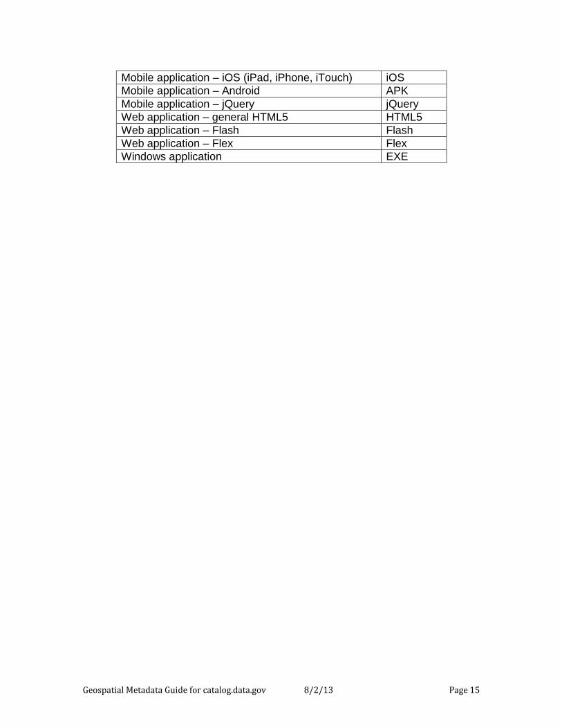
Identified formats for applications include the following:
SDTS SDTS
SEG-P1 / UKOOA P1/90 SEGUKOOA
SEG-Y SEGY
SQLite/SpatiaLite SQLite
SUA SUA
SVG SVG
U.S. Census TIGER/Line (non-shapefile) TIGER
X-Plane/Flightgear aeronautical data XPLANE
Geospatial Metadata Guide for catalog.data.gov 8/2/13 Page 15
Mobile application – iOS (iPad, iPhone, iTouch) iOS
Mobile application – Android APK
Mobile application – jQuery jQuery
Web application – general HTML5 HTML5
Web application – Flash Flash
Web application – Flex Flex
Windows application EXE