geoserv: a distributed urban sensing platform jong hoon ahnn (ucla, presenter) uichin lee (kaist)...
TRANSCRIPT
GeoServ: A Distributed Urban Sensing Platform
Jong Hoon Ahnn (UCLA, presenter)
Uichin Lee (KAIST)
Hyun Jin Moon (NEC Lab America)

Mobile Computing Trends in US Desktop, laptop, netbook:
Now, 1billion users In 2015, 2 billion users
Mobile phones Now, 4.3 billion users In 2013, 5.8 billion users
Smartphones Now, 150 million users In 2020, billions of users??? Urban Sensing Enablers
GeoServ@CCGRID 2011 2
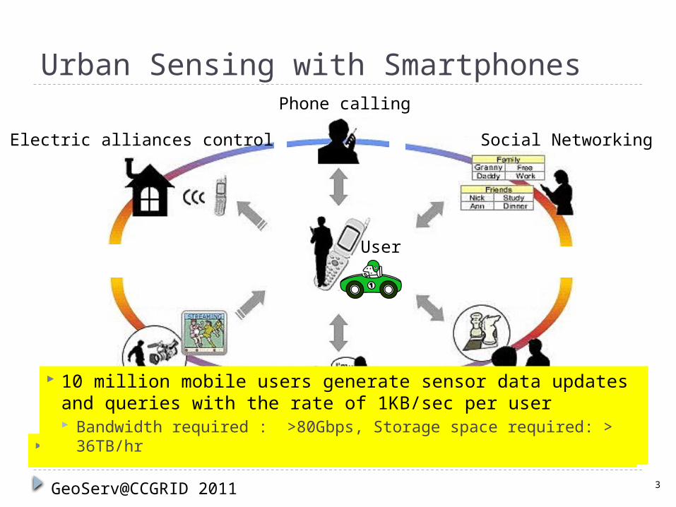
Urban Sensing with Smartphones
Electric alliances control
Live Streaming Gaming
Social Networking
Therefore, scalable sensor networking systems are needed.Chatting
Phone calling
User
10 million mobile users generate sensor data updates and queries with the rate of 1KB/sec per user Bandwidth required : >80Gbps, Storage space required: >
36TB/hr
GeoServ@CCGRID 2011 3
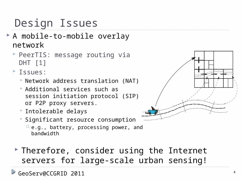
Design Issues A mobile-to-mobile overlay
network PeerTIS: message routing via DHT
[1] Issues:
Network address translation (NAT) Additional services such as session
initiation protocol (SIP) or P2P proxy servers.
Intolerable delays Significant resource consumption
e.g., battery, processing power, and bandwidth
4GeoServ@CCGRID 2011
Therefore, consider using the Internet servers for large-scale urban sensing!
Design Issues (cont.) Existing Approach (in using Internet servers)
Centralized multi-tier architecture Provide scalable services by provisioning more servers
and bandwidth at the datacenters. Semi-hierarchical architecture
Each organization maintains database servers for its own “stationary sensors.”
Appropriate for participatory sensing by sharing users’ computing resources.
5GeoServ@CCGRID 2011
Still, need a scalable architecture to support billions of mobile users!
Consider a two-tier sensor networking architecture for large-scale participatory sensing.
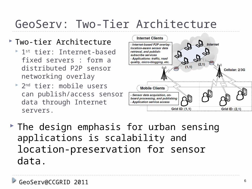
GeoServ: Two-Tier Architecture
The design emphasis for urban sensing applications is scalability and location-preservation for sensor data.
Two-tier Architecture 1st tier: Internet-based
fixed servers : form a distributed P2P sensor networking overlay
2nd tier: mobile users can publish/access sensor data through Internet servers.
6GeoServ@CCGRID 2011

Two Services using GeoServ1. Location-aware sensor data retrieval service2. Location-aware publish-subscribe service
7GeoServ@CCGRID 2011
Applications Street-level traffic flow information service Vehicular safety warning service Ride quality monitoring service
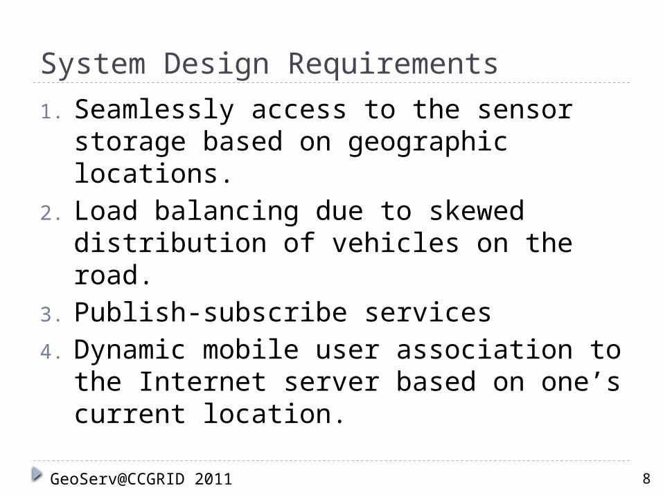
System Design Requirements
1. Seamlessly access to the sensor storage based on geographic locations.
2. Load balancing due to skewed distribution of vehicles on the road.
3. Publish-subscribe services4. Dynamic mobile user association to
the Internet server based on one’s current location.
8GeoServ@CCGRID 2011
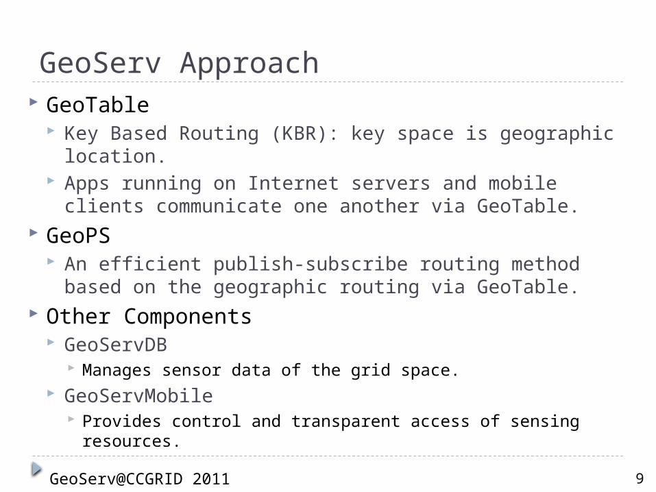
GeoServ Approach GeoTable
Key Based Routing (KBR): key space is geographic location.
Apps running on Internet servers and mobile clients communicate one another via GeoTable.
GeoPS An efficient publish-subscribe routing method based on
the geographic routing via GeoTable. Other Components
GeoServDB Manages sensor data of the grid space.
GeoServMobile Provides control and transparent access of sensing resources.
9GeoServ@CCGRID 2011
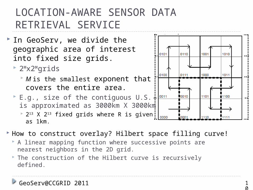
LOCATION-AWARE SENSOR DATA RETRIEVAL SERVICE
In GeoServ, we divide the geographic area of interest into fixed size grids. 2Mx2M
grids M is the smallest exponent that
covers the entire area. E.g., size of the contiguous U.S. is
approximated as 3000km X 3000km 213 X 213 fixed grids where R is given as
1km.
10
GeoServ@CCGRID 2011
How to construct overlay? Hilbert space filling curve! A linear mapping function where successive points are
nearest neighbors in the 2D grid. The construction of the Hilbert curve is recursively defined.

LOCATION-AWARE SENSOR DATA RETRIEVAL SERVICE (cont.)
Routing Semantics Geocasting to a single grid point
11
GeoServ@CCGRID 2011
Concurrent Geocasting (for GeoPS) Due to overhead of sequential search,
we utilize how the Hilbert curve is constructed.
Geocasting to multiple grid points Simple rectangular area based
addressing as {(x1; y1); (x2; y2)}.
{(1;0);(2;1)}
3
2
1
0
[X] 0 1 2 3
[Y]
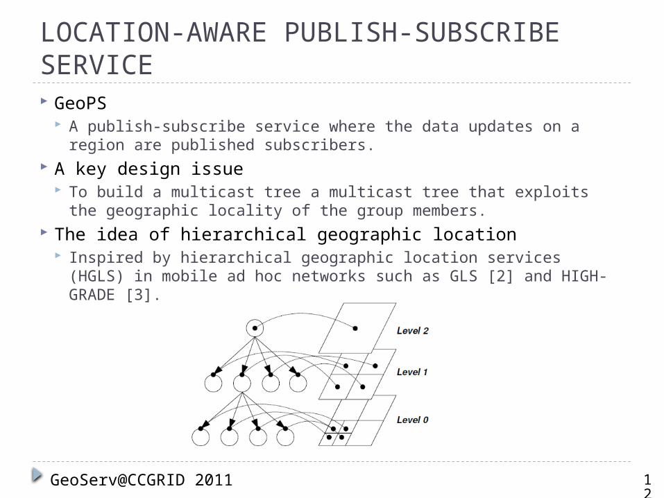
LOCATION-AWARE PUBLISH-SUBSCRIBE SERVICE GeoPS
A publish-subscribe service where the data updates on a region are published subscribers.
A key design issue To build a multicast tree a multicast tree that exploits the
geographic locality of the group members. The idea of hierarchical geographic location
Inspired by hierarchical geographic location services (HGLS) in mobile ad hoc networks such as GLS [2] and HIGH-GRADE [3].
12
GeoServ@CCGRID 2011
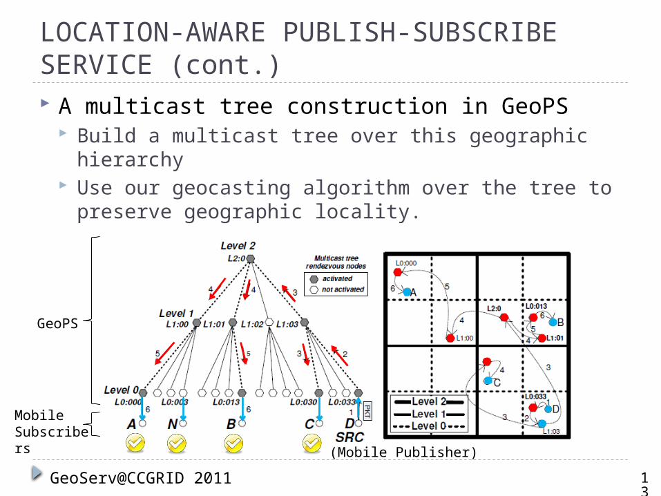
LOCATION-AWARE PUBLISH-SUBSCRIBE SERVICE (cont.) A multicast tree construction in GeoPS
Build a multicast tree over this geographic hierarchy Use our geocasting algorithm over the tree to
preserve geographic locality.
13
GeoServ@CCGRID 2011
GeoPS
Mobile Subscribers (Mobile Publisher)
LOCATION-AWARE PUBLISH-SUBSCRIBE SERVICE (cont.)
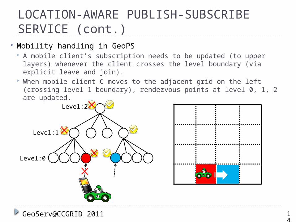
Mobility handling in GeoPS A mobile client’s subscription needs to be updated (to upper layers)
whenever the client crosses the level boundary (via explicit leave and join).
When mobile client C moves to the adjacent grid on the left (crossing level 1 boundary), rendezvous points at level 0, 1, 2 are updated.
14
GeoServ@CCGRID 2011
Level:0
Level:1
Level:2
LOCATION-AWARE PUBLISH-SUBSCRIBE SERVICE (cont.)
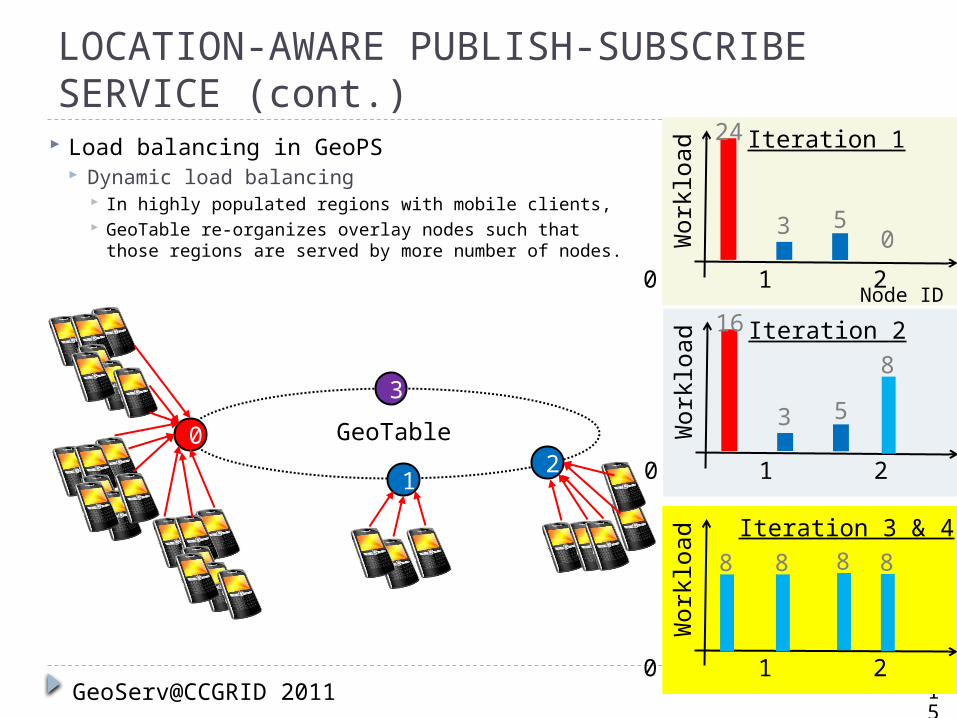
Load balancing in GeoPS Dynamic load balancing
In highly populated regions with mobile clients, GeoTable re-organizes overlay nodes such that
those regions are served by more number of nodes.
GeoServ@CCGRID 2011
12
3
GeoTable0
24
0 1 2 3Node ID
Work
load
3 50
Iteration 1
16
0 1 2 3
Work
load
3 5
Iteration 28
15
0 1 2 3W
ork
load Iteration 3 & 4
888 8

Evaluation List
1. Location-aware data retrieval2. Impact of query region sizes and
concurrent geocasting3. Load balancing4. Location-aware publish-subscribe
service
16
GeoServ@CCGRID 2011
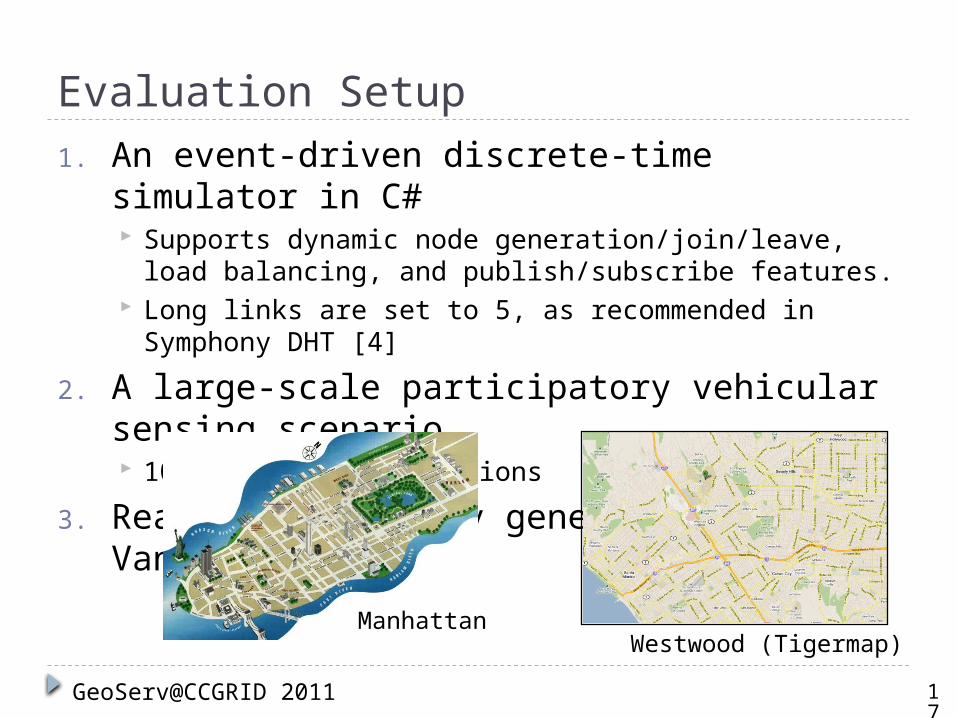
Evaluation Setup1. An event-driven discrete-time simulator in
C# Supports dynamic node generation/join/leave, load
balancing, and publish/subscribe features. Long links are set to 5, as recommended in Symphony
DHT [4]
2. A large-scale participatory vehicular sensing scenario 100 different simulations
3. Realistic mobility generation: VanetMobiSim
17
GeoServ@CCGRID 2011
Westwood (Tigermap)Manhattan
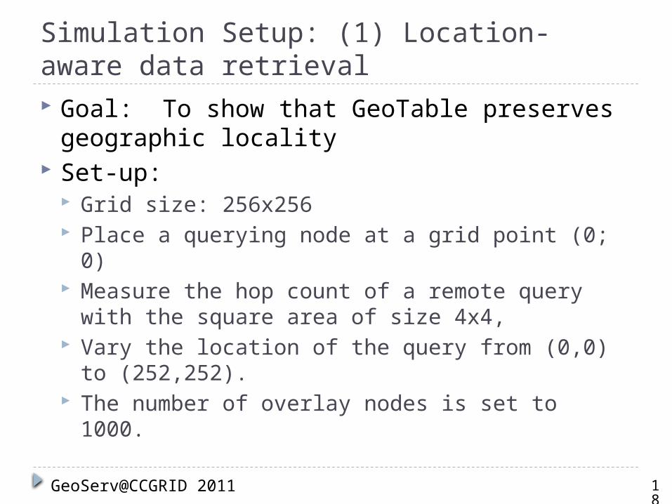
Simulation Setup: (1) Location-aware data retrieval Goal: To show that GeoTable preserves
geographic locality Set-up:
Grid size: 256x256 Place a querying node at a grid point (0; 0) Measure the hop count of a remote query with the
square area of size 4x4, Vary the location of the query from (0,0) to
(252,252). The number of overlay nodes is set to 1000.
18
GeoServ@CCGRID 2011
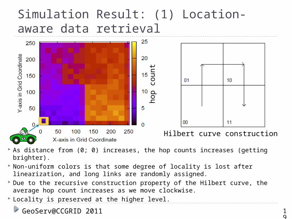
Simulation Result: (1) Location-aware data retrieval
As distance from (0; 0) increases, the hop counts increases (getting brighter). Non-uniform colors is that some degree of locality is lost after linearization,
and long links are randomly assigned. Due to the recursive construction property of the Hilbert curve, the average
hop count increases as we move clockwise. Locality is preserved at the higher level.
19
GeoServ@CCGRID 2011
hop c
ount
Hilbert curve construction
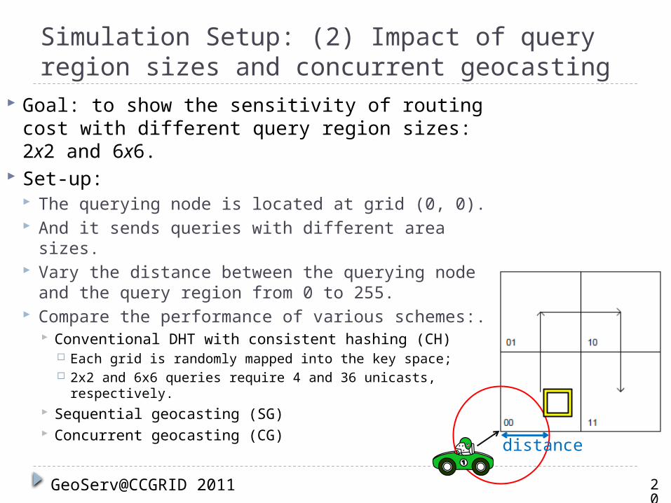
Simulation Setup: (2) Impact of query region sizes and concurrent geocasting
20
GeoServ@CCGRID 2011
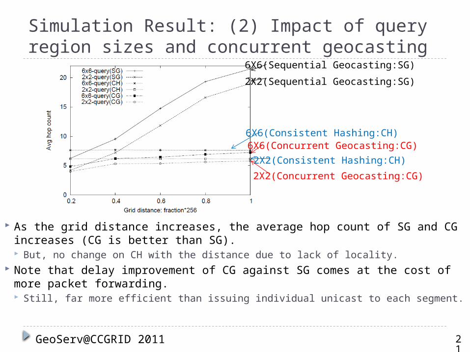
Goal: to show the sensitivity of routing cost with different query region sizes: 2x2 and 6x6.
Set-up: The querying node is located at grid (0, 0). And it sends queries with different area sizes. Vary the distance between the querying node
and the query region from 0 to 255. Compare the performance of various schemes:.
Conventional DHT with consistent hashing (CH) Each grid is randomly mapped into the key space; 2x2 and 6x6 queries require 4 and 36 unicasts,
respectively. Sequential geocasting (SG) Concurrent geocasting (CG) distance
Simulation Result: (2) Impact of query region sizes and concurrent geocasting
As the grid distance increases, the average hop count of SG and CG increases (CG is better than SG). But, no change on CH with the distance due to lack of locality.
Note that delay improvement of CG against SG comes at the cost of more packet forwarding. Still, far more efficient than issuing individual unicast to each segment.
21
GeoServ@CCGRID 2011
6X6(Sequential Geocasting:SG)
6X6(Consistent Hashing:CH)6X6(Concurrent Geocasting:CG)
2X2(Sequential Geocasting:SG)
2X2(Consistent Hashing:CH)
2X2(Concurrent Geocasting:CG)
Simulation Setup: (3) Load balancing Goal: to show how heterogeneous distribution of mobile
clients influences the overall load imbalance Set-up
Mobile clients publish sensor data to the overlay nodes. Road topology information from Tiger Los Angeles map.
The area size is 12,800m X 12,800m, centered at the UCLA campus. The grid size of 50m X 50m, composed of 256x256 grids.
Mobile Clients The different numbers of mobile clients from 1000 to 5000 with a gap of
1000 nodes. Data generation with the rate of 128 Bytes/sec.
Overlay nodes The number of overlay nodes is fixed to 1000 nodes.
Measurement: the total published data size per node to see how per-node workload is unbalanced.
22
GeoServ@CCGRID 2011
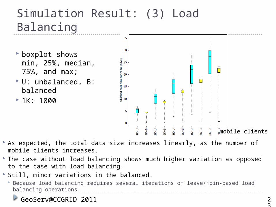
Simulation Result: (3) Load Balancing
As expected, the total data size increases linearly, as the number of mobile clients increases.
The case without load balancing shows much higher variation as opposed to the case with load balancing.
Still, minor variations in the balanced. Because load balancing requires several iterations of leave/join-based load balancing
operations.
23
GeoServ@CCGRID 2011
boxplot shows min, 25%, median, 75%, and max;
U: unbalanced, B: balanced
1K: 1000
mobile clients
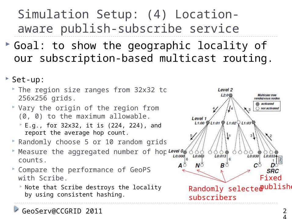
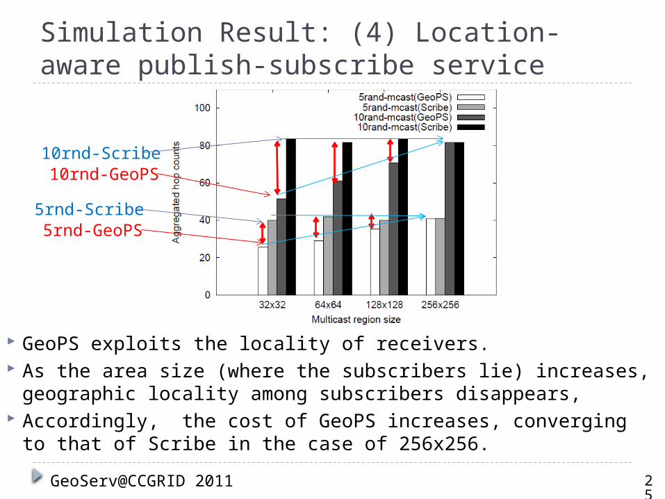
Simulation Setup: (4) Location-aware publish-subscribe service
Set-up: The region size ranges from 32x32 to
256x256 grids. Vary the origin of the region from (0, 0)
to the maximum allowable. E.g., for 32x32, it is (224, 224), and report
the average hop count. Randomly choose 5 or 10 random grids Measure the aggregated number of hop
counts. Compare the performance of GeoPS
with Scribe. Note that Scribe destroys the locality by
using consistent hashing.
24
GeoServ@CCGRID 2011
Goal: to show the geographic locality of our subscription-based multicast routing.
Randomly selectedsubscribers
Fixedpublisher
Simulation Result: (4) Location-aware publish-subscribe service
GeoPS exploits the locality of receivers. As the area size (where the subscribers lie) increases,
geographic locality among subscribers disappears, Accordingly, the cost of GeoPS increases, converging to that of
Scribe in the case of 256x256.
25
GeoServ@CCGRID 2011
5rnd-GeoPS5rnd-Scribe
10rnd-GeoPS10rnd-Scribe
Concluding Remarks A scalable sensor networking system design
To enable location-relevant sensor data sharing among mobile users with smartphones.
A two-tier sensor networking system: GeoServ Exploits the Internet infrastructure. Mobile users publish/access sensor information
through the Internet-based distributed sensor storage.
Mathematical Proofs in the paper We proved that GeoServ protocols preserve
geographic locality and validated their performance via extensive simulations.
26
GeoServ@CCGRID 2011
References[1] J. Rybicki, B. Scheuermann, M. Koegel, and M. Mauve. PeerTIS: a Peer-to-Peer Traffic Information System. In VANET, 2009.
[2] J. Li, J. Jannotti, D. S. J. D. Couto, D. R. Karger, and R. Morris. A Scalable Location Service for Geographic Ad Hoc Routing. In MobiCom, 2000.
[3] Y. Yu, G.-H. Lu, and Z.-L. Zhang. Enhancing Location Service Scalability with HIGH-GRADE. In MASS, 2004.
[4] G. S. Manku, M. Bawa, and P. Raghavan. Symphony: Distributed Hashing in a Small World. In USITS, 2003.[5] USA to Add 80 Million New Smartphone Users by 2011. http://twittown.com/mobile/mobile-blog/ usa-add-80-million-new-smartphone-users-2011.
27
GeoServ@CCGRID 2011

Thank you.