geography learner
DESCRIPTION
platesTRANSCRIPT
2014 LOWER SECONDARY
GEOGRAPHY
Teaching Syllabuses
EXPRESS COURSE
NORMAL (ACADEMIC) COURSE
CURRICULUM PLANNING & DEVELOPMENT DIVISION MINISTRY OF EDUCATION, SINGAPORE

© Copyright 2014. Curriculum Planning and Development Division. This publication is not for sale. All rights reserved. No part of this publication may be reproduced without the prior permission of the Ministry of Education, Singapore. Year of Implementation: 2014 in Secondary One and 2015 in Secondary Two. ISBN: 978-981-07-7464-6 (PDF); ISBN: 978-981-07-7463-9 (Paperback)
Ministry of Education SINGAPORE
CONTENTS
Page
1. INTRODUCTION
Desired Outcomes of Education and the Study of Geography in
Singapore
1
Value of Geography Education in Singapore 2
Key Geographical Concepts 3
2. THINKING BEHIND THE SYLLABUSES & IMPLEMENTATION
Design of the Lower Secondary Geography Syllabuses 6
Syllabus Aims and Learning Outcomes 6
Syllabus Framework and Content Overviews 7
Implementation 14
o Annex A: Deployment of Allied Educators (Teaching and Learning)
AED (T&L) to Support Humanities Department
o Annex B: Suggested Vignette of AED (T&L) In Support of
Humanities Department
19
21
3. RECOMMENDED PEDAGOGY
Geographical Inquiry 26
4. 21st CENTURY COMPETENCIES
21st Century Competencies in Geography Education 28
Competency Domains, Components and their Definitions 30
o Annex C: Mapping of Lower Secondary Geography Syllabuses to
21st Century Competencies and Benchmarks (Secondary)
32
5. SCOPE AND SEQUENCE CHART FOR LOWER SECONDARY
GEOGRAPHY SYLLABUSES
40
6. ASSESSMENT
Purpose of Assessment 68
Assessment Objectives 68
Modes of Assessment 69
Assessment Specification Grid 70
7. TABLES OF SPECIFICATIONS, SPECIMEN QUESTIONS & MARKING
SCHEMES
o Annex D: Response to a Geographical Issue 75
o Annex E: Table of Specifications for Test for Secondary One and
Two Express Course
79
o Annex F: Table of Specifications for Test for Secondary One and
Two Normal (Academic) Course
80
o Annex G: Table of Specifications for Examination for Secondary
One and Two Express Course
81
o Annex H: Table of Specifications for Examination for Secondary
One and Two Normal (Academic) Course
82
o Annex I: Rubric for Assessment of Geographical Investigation 83
o Annex J: Specimen Short Answer Questions for Secondary
One and Two Express and Normal (Academic) Courses
85
o Annex K: Specimen Structured Questions for Secondary One
and Two Express Course
87
o Annex L: Specimen Structured Questions: For Secondary One
and Two Normal Academic Course
89
o Annex M: Specimen Marking Schemes for Short Answer
Questions for Secondary One and Two Express and Normal
(Academic) Courses
92
o Annex N: Specimen Marking Schemes for Specimen Structured
Questions for Secondary One & Two Express Course
92
o Annex O: Specimen Marking Schemes for Specimen Structured
Questions for Express and Normal (Academic) Courses
93
8. AMPLIFICATION OF SYLLABUSES 95
9. RECOMMENDED READINGS 121

0
SECTION 1: INTRODUCTION
1
INTRODUCTION
DESIRED OUTCOMES OF EDUCATION AND THE STUDY OF GEOGRAPHY IN SINGAPORE The Desired Outcomes of Education (DOE) are attributes that educators aspire for our
learners. These outcomes establish a common purpose for geography teachers, and serve
as a compass to steer the teaching and learning process. The DOE for our learners are:
a confident person who has a strong sense of right and wrong, is adaptable and resilient,
knows himself, is discerning in judgment, thinks independently and critically, and
communicates effectively;
a self-directed learner who questions, reflects, perseveres and takes responsibility for his
own learning;
an active contributor who is able to work effectively in teams, is innovative, exercises
initiative, takes calculated risks and strives for excellence; and
a concerned citizen who is rooted to Singapore, has a strong civic responsibility, is
informed about Singapore and the world, and takes an active part in bettering the lives of
others around him.
The Lower Secondary Geography syllabuses will enable students to acquire a wide range of
knowledge and skills to understand and explain physical and human phenomena; and other
contemporary environmental and social issues that occur in different places and cultures.
Equipped with the skills of gathering and analysing information, and an inquiring mind to
seek answers to issues affecting our lives and the world we live in, geography students will
be prepared for their roles as informed citizens in the 21st century. The subject also imbibes
in students an awareness of appropriate attitudes and values that promotes a positive
geographical future; one that ensures the sustainability of our resources, people, country,
and planet. These attributes would place students in good stead to attain the DOE. An
illustration of how Geography contributes towards the DOE in the Singapore education
system is shown in Figure 1.
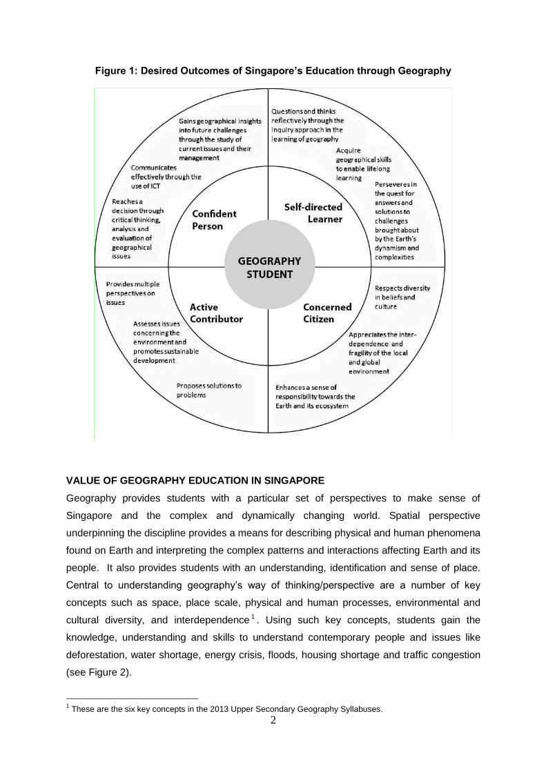
2
Figure 1: Desired Outcomes of Singapore’s Education through Geography
VALUE OF GEOGRAPHY EDUCATION IN SINGAPORE
Geography provides students with a particular set of perspectives to make sense of
Singapore and the complex and dynamically changing world. Spatial perspective
underpinning the discipline provides a means for describing physical and human phenomena
found on Earth and interpreting the complex patterns and interactions affecting Earth and its
people. It also provides students with an understanding, identification and sense of place.
Central to understanding geography’s way of thinking/perspective are a number of key
concepts such as space, place scale, physical and human processes, environmental and
cultural diversity, and interdependence 1 . Using such key concepts, students gain the
knowledge, understanding and skills to understand contemporary people and issues like
deforestation, water shortage, energy crisis, floods, housing shortage and traffic congestion
(see Figure 2).
1 These are the six key concepts in the 2013 Upper Secondary Geography Syllabuses.
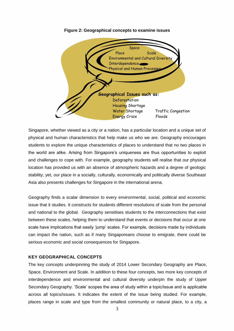
3
Figure 2: Geographical concepts to examine issues
Singapore, whether viewed as a city or a nation, has a particular location and a unique set of
physical and human characteristics that help make us who we are. Geography encourages
students to explore the unique characteristics of places to understand that no two places in
the world are alike. Arising from Singapore’s uniqueness are thus opportunities to exploit
and challenges to cope with. For example, geography students will realise that our physical
location has provided us with an absence of atmospheric hazards and a degree of geologic
stability; yet, our place in a socially, culturally, economically and politically diverse Southeast
Asia also presents challenges for Singapore in the international arena.
Geography finds a scalar dimension to every environmental, social, political and economic
issue that it studies. It constructs for students different resolutions of scale from the personal
and national to the global. Geography sensitises students to the interconnections that exist
between these scales, helping them to understand that events or decisions that occur at one
scale have implications that easily ‘jump’ scales. For example, decisions made by individuals
can impact the nation, such as if many Singaporeans choose to emigrate, there could be
serious economic and social consequences for Singapore.
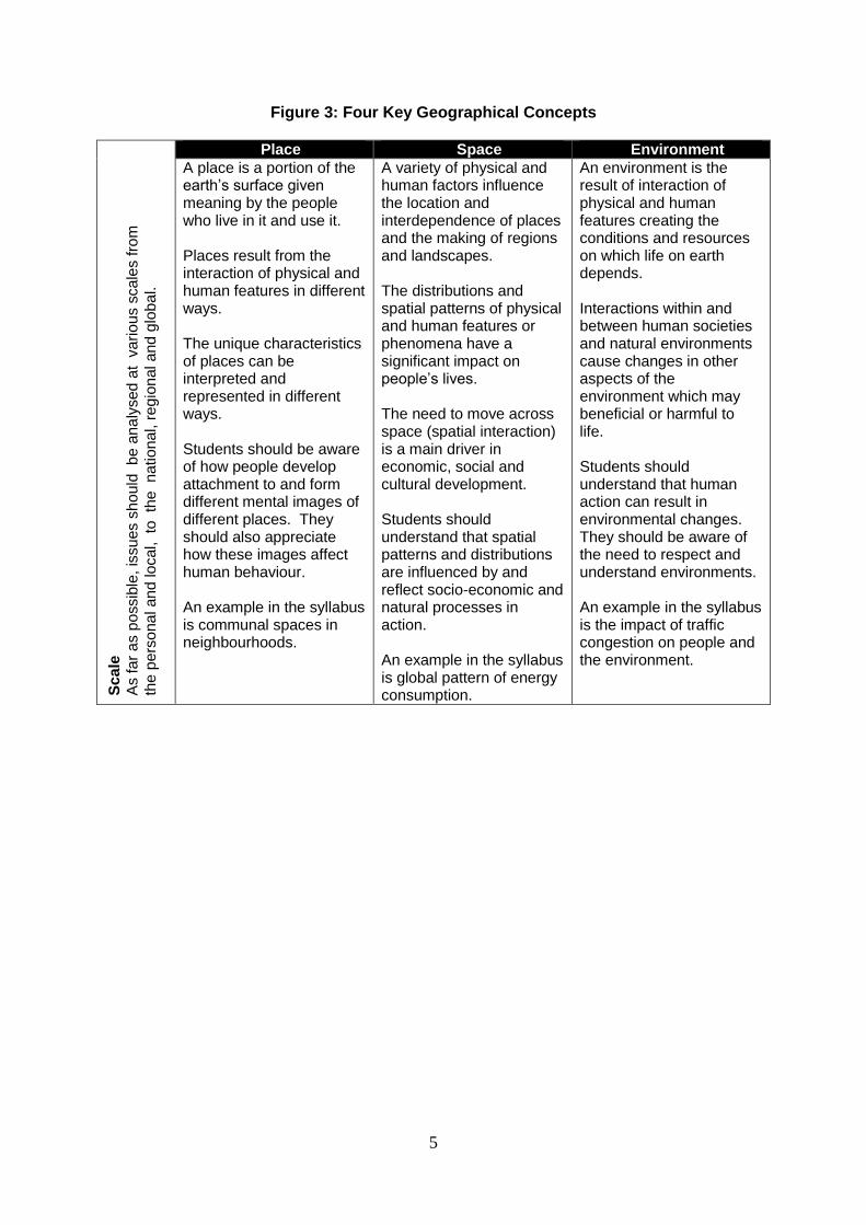
KEY GEOGRAPHICAL CONCEPTS
The key concepts underpinning the study of 2014 Lower Secondary Geography are Place,
Space, Environment and Scale. In addition to these four concepts, two more key concepts of
interdependence and environmental and cultural diversity underpin the study of Upper
Secondary Geography. ‘Scale’ scopes the area of study within a topic/issue and is applicable
across all topics/issues. It indicates the extent of the issue being studied. For example,
places range in scale and type from the smallest community or natural place, to a city, a
Geographical Issues such as: Deforestation
Housing Shortage
Water Shortage Traffic Congestion
Energy Crisis Floods
Space
Place Scale
Environmental and Cultural Diversity
Interdependence
Physical and Human Processes
4
country or a region. ‘Places’ are parts of the Earth’s surface that are identified and given
meaning by people. They can be natural (shaped by the environment) or built (constructed
by human beings). Just as a place with its associated climate, landscapes and resources
influences the way people live, people also influence places through the actions they take. A
big place such as a city is organised into different spaces such as for housing, industry,
businesses and recreation. Each ‘Space’ thus has its own purpose or use and is
characterised by its location (where it is located on the Earth’s surface), spatial distribution
(pattern resulting from its arrangement on the Earth’s surface) and spatial organisation (how
and why it is arranged on the Earth’s surface). Likewise physical and human processes are
embedded within ‘Environment’. Some environments are natural (physical) such as ice caps
and deserts while other environments are known as built (human) environments. The latter
have been altered by humans and examples include cities, towns and farmlands.
The key concepts provide valuable insights into the nature of Geography because of their
breadth of application to the content studied and the extent to which they are linked to other
significant ideas within the subject. The key concepts may be used individually or in
combination. They help to anchor the subject by giving it a greater coherence. For example,
the use of place helps students understand why people originally settled along the banks of
Singapore River and how Singapore has developed and changed over time. The concept of
environment helps students to analyse the changes humans make to natural environments
and better appreciate their impact so that the changes can be managed more wisely. As
students learn Geography, they will develop their understanding of these concepts. Growing
familiarity with these key concepts will help students to put on the geographical lens; that is
to think geographically. Details and examples of the four key concepts are shown in Figure 3.
5
Figure 3: Four Key Geographical Concepts
Sc
ale
A
s fa
r a
s p
ossib
le, is
su
es s
ho
uld
b
e a
na
lysed
at v
ario
us s
ca
les fro
m
the
pe
rso
na
l an
d lo
cal, to
th
e n
atio
nal, r
eg
ion
al a
nd
glo
ba
l.
Place Space Environment
A place is a portion of the earth’s surface given meaning by the people who live in it and use it. Places result from the interaction of physical and human features in different ways. The unique characteristics of places can be interpreted and represented in different ways. Students should be aware of how people develop attachment to and form different mental images of different places. They should also appreciate how these images affect human behaviour. An example in the syllabus is communal spaces in neighbourhoods.
A variety of physical and human factors influence the location and interdependence of places and the making of regions and landscapes. The distributions and spatial patterns of physical and human features or phenomena have a significant impact on people’s lives. The need to move across space (spatial interaction) is a main driver in economic, social and cultural development. Students should understand that spatial patterns and distributions are influenced by and reflect socio-economic and natural processes in action. An example in the syllabus is global pattern of energy consumption.
An environment is the result of interaction of physical and human features creating the conditions and resources on which life on earth depends. Interactions within and between human societies and natural environments cause changes in other aspects of the environment which may beneficial or harmful to life. Students should understand that human action can result in environmental changes. They should be aware of the need to respect and understand environments. An example in the syllabus is the impact of traffic congestion on people and the environment.
0
SECTION 2: THINKING BEHIND THE SYLLABUSES & IMPLEMENTATION
6
THINKING BEHIND THE SYLLABUSES & IMPLEMENTATION
DESIGN OF THE LOWER SECONDARY GEOGRAPHY SYLLABUSES
The following principles are considered in the design of the syllabus:
To update knowledge, skills and values so that the syllabuses address
contemporary issues of global importance while ensuring relevance and connection
to the students in Singapore;
To provide opportunities for students to examine current issues through global and
local perspectives as informed, concerned and participative citizens;
To ensure coherence, continuity and progression in syllabus framework, content
and skills from secondary to pre-university level; and
To align the syllabus with the Desired Outcomes of Education, 21 st Century
Competencies and Outcomes, and IT Masterplan 3 recommendations.
SYLLABUS AIMS AND LEARNING OUTCOMES
Aims
The syllabus aims to enable students to:
develop an interest in geography;
acquire geographical knowledge and develop a basic understanding of geography as a
discipline/subject;
gain global awareness of current geographical issues and future challenges;
learn the process of geographical inquiry and to use it to make sense of new knowledge;
develop skills in acquiring, communicating and applying geographical knowledge; and
develop a concern for the environment and make informed judgments about human
action/behaviour.
Learning Outcomes
Knowledge and Understanding
The syllabus intends for students to develop knowledge of:
geographical concepts, terms and facts;
components of physical and human environments;
diverse spatial patterns of physical and human phenomena/features;
relationships and interactions between and within physical and human phenomena at local,
regional and global scales; and
different approaches through which challenges faced can be managed by local, regional
and global communities.
7
Skills
The syllabus intends for students to develop the skills to:
work effectively in teams to observe, collect and record geographical data obtained from
both primary and secondary sources;
derive knowledge and understanding from field experiences of places and natural
environments;
interpret maps, atlases, tables, graphs, photographs and fieldwork data;
recognise patterns in geographical data and suggest relationships; and
organise and present geographic information in a coherent way.
Values
Through their geographical training, students should develop:
an interest in, and valuing of, the ways that the environment supports life;
a sense of appreciation, care and responsibility for the quality of the environment; and
sensitivity towards the attitudes, beliefs and values of people of different cultures.
SYLLABUS FRAMEWORK AND CONTENT OVERVIEWS
Issue-based Framework
The Lower Secondary Geography syllabuses adopt an issue-based framework whereby
students would acquire an understanding of Geography through the study of significant
environmental and human issues confronting Singapore and the world. Using such an
approach, the syllabus content is scoped to provide sufficient breadth and depth for students
to understand each issue. Each issue is unpacked systematically through a set of five guiding
questions, namely: What is the issue? Which part(s) of the world is/are affected by the issue?
Why is the issue located there? How does the issue affect human society and natural
environments? How should it be managed? These questions are aligned to the geographical
inquiry approach and collectively, they represent the way geographers work when
investigating an issue or problem. The questions are also age-appropriate expressions of the
four key geographical concepts of place, space, environment, and scale underpinning the new
syllabuses.
\
8
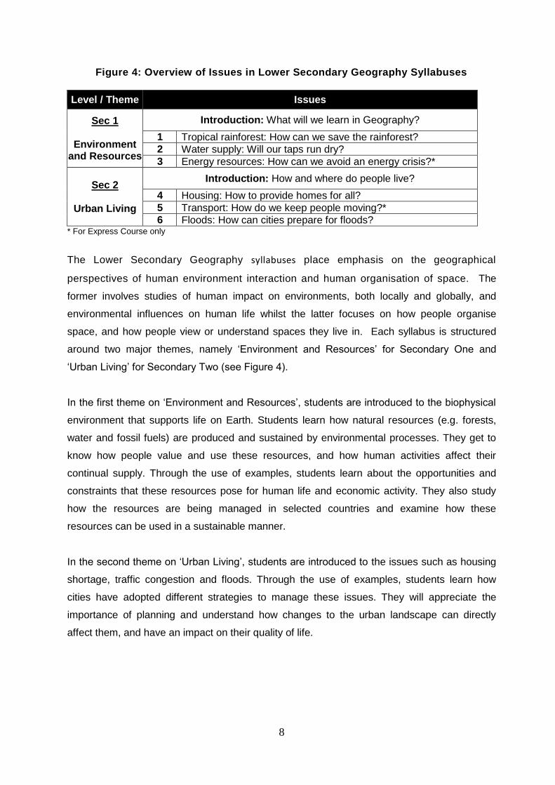
Figure 4: Overview of Issues in Lower Secondary Geography Syllabuses
Level / Theme Issues
Sec 1
Environment and Resources
Introduction: What will we learn in Geography?
1 Tropical rainforest: How can we save the rainforest?
2 Water supply: Will our taps run dry?
3 Energy resources: How can we avoid an energy crisis?*
Sec 2
Urban Living
Introduction: How and where do people live?
4 Housing: How to provide homes for all?
5 Transport: How do we keep people moving?*
6 Floods: How can cities prepare for floods? * For Express Course only
The Lower Secondary Geography syllabuses place emphasis on the geographical
perspectives of human environment interaction and human organisation of space. The
former involves studies of human impact on environments, both locally and globally, and
environmental influences on human life whilst the latter focuses on how people organise
space, and how people view or understand spaces they live in. Each syllabus is structured
around two major themes, namely ‘Environment and Resources’ for Secondary One and
‘Urban Living’ for Secondary Two (see Figure 4).
In the first theme on ‘Environment and Resources’, students are introduced to the biophysical
environment that supports life on Earth. Students learn how natural resources (e.g. forests,
water and fossil fuels) are produced and sustained by environmental processes. They get to
know how people value and use these resources, and how human activities affect their
continual supply. Through the use of examples, students learn about the opportunities and
constraints that these resources pose for human life and economic activity. They also study
how the resources are being managed in selected countries and examine how these
resources can be used in a sustainable manner.
In the second theme on ‘Urban Living’, students are introduced to the issues such as housing
shortage, traffic congestion and floods. Through the use of examples, students learn how
cities have adopted different strategies to manage these issues. They will appreciate the
importance of planning and understand how changes to the urban landscape can directly
affect them, and have an impact on their quality of life.
9
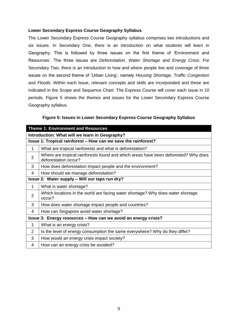
Lower Secondary Express Course Geography Syllabus
The Lower Secondary Express Course Geography syllabus comprises two introductions and
six issues. In Secondary One, there is an introduction on what students will learn in
Geography. This is followed by three issues on the first theme of ‘Environment and
Resources’. The three issues are Deforestation, Water Shortage and Energy Crisis. For
Secondary Two, there is an introduction to how and where people live and coverage of three
issues on the second theme of ‘Urban Living’, namely Housing Shortage, Traffic Congestion
and Floods. Within each issue, relevant concepts and skills are incorporated and these are
indicated in the Scope and Sequence Chart. The Express Course will cover each issue in 10
periods. Figure 5 shows the themes and issues for the Lower Secondary Express Course
Geography syllabus.
Figure 5: Issues in Lower Secondary Express Course Geography Syllabus
Theme 1: Environment and Resources
Introduction: What will we learn in Geography?
Issue 1: Tropical rainforest – How can we save the rainforest?
1 What are tropical rainforests and what is deforestation?
2 Where are tropical rainforests found and which areas have been deforested? Why does deforestation occur?
3 How does deforestation impact people and the environment?
4 How should we manage deforestation?
Issue 2: Water supply – Will our taps run dry?
1 What is water shortage?
2 Which locations in the world are facing water shortage? Why does water shortage occur?
3 How does water shortage impact people and countries?
4 How can Singapore avoid water shortage?
Issue 3: Energy resources – How can we avoid an energy crisis?
1 What is an energy crisis?
2 Is the level of energy consumption the same everywhere? Why do they differ?
3 How would an energy crisis impact society?
4 How can an energy crisis be avoided?
10
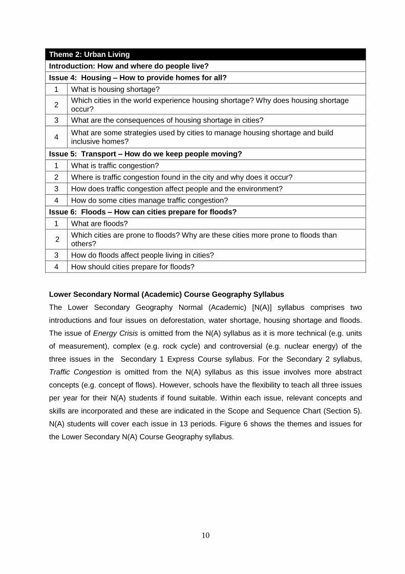
Theme 2: Urban Living
Introduction: How and where do people live?
Issue 4: Housing – How to provide homes for all?
1 What is housing shortage?
2 Which cities in the world experience housing shortage? Why does housing shortage occur?
3 What are the consequences of housing shortage in cities?
4 What are some strategies used by cities to manage housing shortage and build inclusive homes?
Issue 5: Transport – How do we keep people moving?
1 What is traffic congestion?
2 Where is traffic congestion found in the city and why does it occur?
3 How does traffic congestion affect people and the environment?
4 How do some cities manage traffic congestion?
Issue 6: Floods – How can cities prepare for floods?
1 What are floods?
2 Which cities are prone to floods? Why are these cities more prone to floods than others?
3 How do floods affect people living in cities?
4 How should cities prepare for floods?
Lower Secondary Normal (Academic) Course Geography Syllabus
The Lower Secondary Geography Normal (Academic) [N(A)] syllabus comprises two
introductions and four issues on deforestation, water shortage, housing shortage and floods.
The issue of Energy Crisis is omitted from the N(A) syllabus as it is more technical (e.g. units
of measurement), complex (e.g. rock cycle) and controversial (e.g. nuclear energy) of the
three issues in the Secondary 1 Express Course syllabus. For the Secondary 2 syllabus,
Traffic Congestion is omitted from the N(A) syllabus as this issue involves more abstract
concepts (e.g. concept of flows). However, schools have the flexibility to teach all three issues
per year for their N(A) students if found suitable. Within each issue, relevant concepts and
skills are incorporated and these are indicated in the Scope and Sequence Chart (Section 5).
N(A) students will cover each issue in 13 periods. Figure 6 shows the themes and issues for
the Lower Secondary N(A) Course Geography syllabus.
11
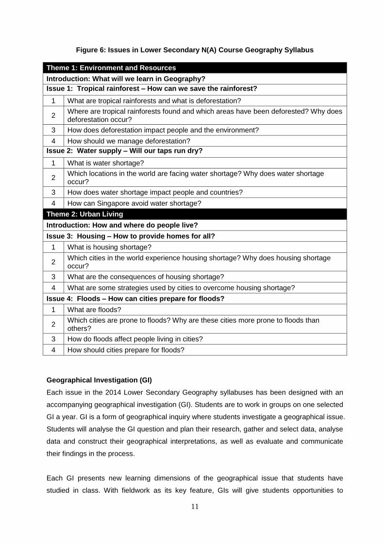
Figure 6: Issues in Lower Secondary N(A) Course Geography Syllabus
Theme 1: Environment and Resources
Introduction: What will we learn in Geography?
Issue 1: Tropical rainforest – How can we save the rainforest?
1 What are tropical rainforests and what is deforestation?
2 Where are tropical rainforests found and which areas have been deforested? Why does deforestation occur?
3 How does deforestation impact people and the environment?
4 How should we manage deforestation?
Issue 2: Water supply – Will our taps run dry?
1 What is water shortage?
2 Which locations in the world are facing water shortage? Why does water shortage occur?
3 How does water shortage impact people and countries?
4 How can Singapore avoid water shortage?
Theme 2: Urban Living
Introduction: How and where do people live?
Issue 3: Housing – How to provide homes for all?
1 What is housing shortage?
2 Which cities in the world experience housing shortage? Why does housing shortage occur?
3 What are the consequences of housing shortage?
4 What are some strategies used by cities to overcome housing shortage?
Issue 4: Floods – How can cities prepare for floods?
1 What are floods?
2 Which cities are prone to floods? Why are these cities more prone to floods than others?
3 How do floods affect people living in cities?
4 How should cities prepare for floods?
Geographical Investigation (GI)
Each issue in the 2014 Lower Secondary Geography syllabuses has been designed with an
accompanying geographical investigation (GI). Students are to work in groups on one selected
GI a year. GI is a form of geographical inquiry where students investigate a geographical issue.
Students will analyse the GI question and plan their research, gather and select data, analyse
data and construct their geographical interpretations, as well as evaluate and communicate
their findings in the process.
Each GI presents new learning dimensions of the geographical issue that students have
studied in class. With fieldwork as its key feature, GIs will give students opportunities to
12
appreciate the real-world application of geographical knowledge and skills as well as help
them to acquire 21st Century Competencies. Given that lower secondary students are new to
the study of Geography, students will follow a guided inquiry approach. Teachers will provide
guidance to enable students to learn about the inquiry process and be familiar with the
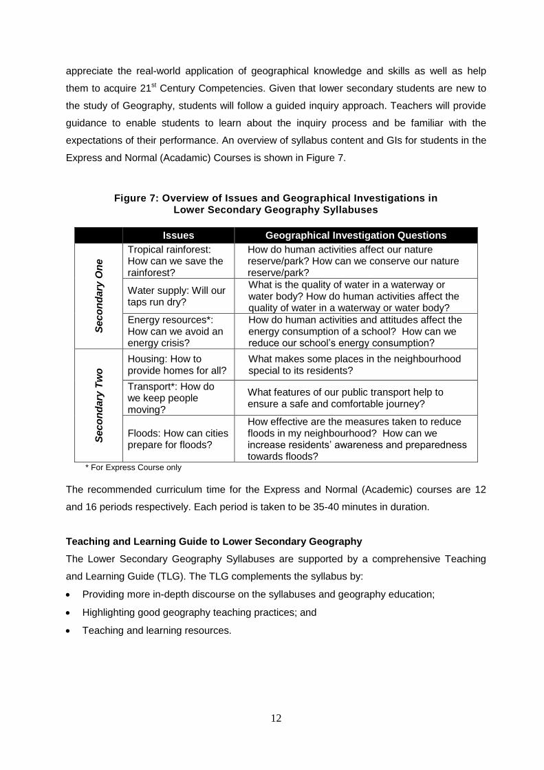
expectations of their performance. An overview of syllabus content and GIs for students in the
Express and Normal (Acadamic) Courses is shown in Figure 7.
Figure 7: Overview of Issues and Geographical Investigations in Lower Secondary Geography Syllabuses
Issues Geographical Investigation Questions
Se
co
nd
ary
On
e
Tropical rainforest: How can we save the rainforest?
How do human activities affect our nature reserve/park? How can we conserve our nature reserve/park?
Water supply: Will our taps run dry?
What is the quality of water in a waterway or water body? How do human activities affect the quality of water in a waterway or water body?
Energy resources*: How can we avoid an energy crisis?
How do human activities and attitudes affect the energy consumption of a school? How can we reduce our school’s energy consumption?
Se
co
nd
ary
Tw
o
Housing: How to provide homes for all?
What makes some places in the neighbourhood special to its residents?
Transport*: How do we keep people moving?
What features of our public transport help to ensure a safe and comfortable journey?
Floods: How can cities prepare for floods?
How effective are the measures taken to reduce floods in my neighbourhood? How can we increase residents’ awareness and preparedness towards floods?
* For Express Course only
The recommended curriculum time for the Express and Normal (Academic) courses are 12
and 16 periods respectively. Each period is taken to be 35-40 minutes in duration.
Teaching and Learning Guide to Lower Secondary Geography
The Lower Secondary Geography Syllabuses are supported by a comprehensive Teaching
and Learning Guide (TLG). The TLG complements the syllabus by:
Providing more in-depth discourse on the syllabuses and geography education;
Highlighting good geography teaching practices; and
Teaching and learning resources.
13
Scope and Sequence Chart
A Scope and Sequence Chart has been developed based on the Lower Secondary
Geography Syllabuses in Section 5 of this Teaching Syllabus. This chart outlines the guiding
questions together with the associated learning outcomes, knowledge/skills, key geographical
concepts and content concepts as well as MOE initiatives for all issues in the syllabuses. In
the Scope and Sequence Chart, the skills component for each issue consists of specific
topographical map reading skills, geographical data and techniques as well as geographical
investigations. This Scope and Sequence Chart is a useful reference to guide teachers to plan
for their scheme of work. It will also enable teachers to develop lesson plans that will deliver
specific learning outcomes incrementally.
Assessment
Details of the assessment format for the two syllabuses are provided in Section 6. For more
details on Assessment, refer to Section 3 in the TLG of Lower Secondary Geography.
14
IMPLEMENTATION
IMPLEMENTATION OF THE NEW LOWER SECONDARY GEOGRAPHY SYLLABUSES
The Lower Secondary Geography syllabuses are scheduled for implementation at Secondary
One in 2014 and Secondary Two in 2015. The following are suggested practices that schools
can adopt with regard to various aspects of the curriculum.
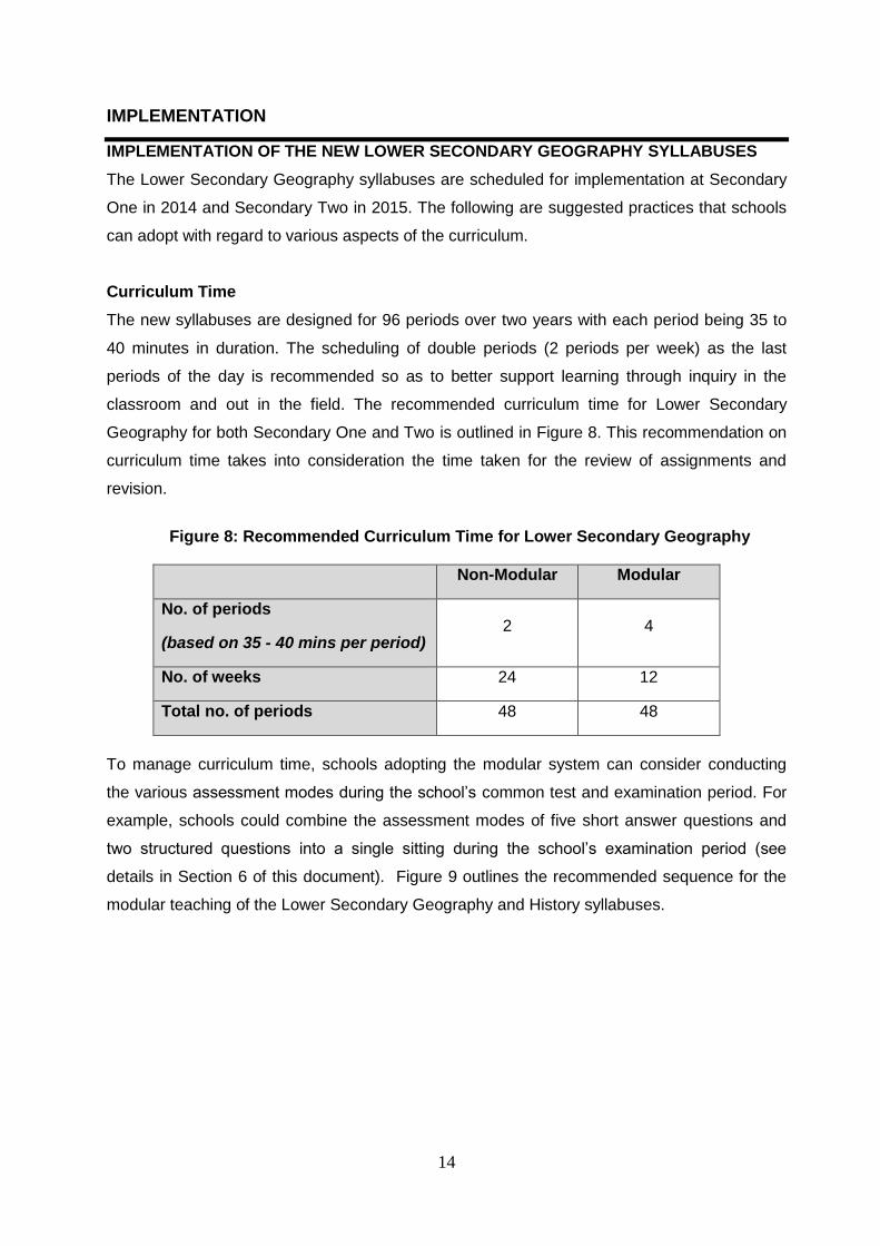
Curriculum Time
The new syllabuses are designed for 96 periods over two years with each period being 35 to
40 minutes in duration. The scheduling of double periods (2 periods per week) as the last
periods of the day is recommended so as to better support learning through inquiry in the
classroom and out in the field. The recommended curriculum time for Lower Secondary
Geography for both Secondary One and Two is outlined in Figure 8. This recommendation on
curriculum time takes into consideration the time taken for the review of assignments and
revision.
Figure 8: Recommended Curriculum Time for Lower Secondary Geography
Non-Modular Modular
No. of periods
(based on 35 - 40 mins per period) 2 4
No. of weeks 24 12
Total no. of periods 48 48
To manage curriculum time, schools adopting the modular system can consider conducting
the various assessment modes during the school’s common test and examination period. For
example, schools could combine the assessment modes of five short answer questions and
two structured questions into a single sitting during the school’s examination period (see
details in Section 6 of this document). Figure 9 outlines the recommended sequence for the
modular teaching of the Lower Secondary Geography and History syllabuses.
15
Figure 9: Recommended Sequence for the Modular Teaching of Geography and History Syllabuses
Semester 1 Semester 2
Secondary One Geography History
Secondary Two History Geography
The suggested sequence keeps in view the difference in curriculum time between the
semesters, ensuring an equal number of periods for the two subjects across two years. It is
proposed that the Geography syllabuses be taught in Semester 1 in Secondary One and in
Semester 2 in Secondary Two. However, within the time block, the issues in the New Lower
Secondary Geography syllabuses can be taught in any order. Figures 10 and 11 provide
details on the recommended allocation of periods across two years for the non-modular and
modular systems respectively.
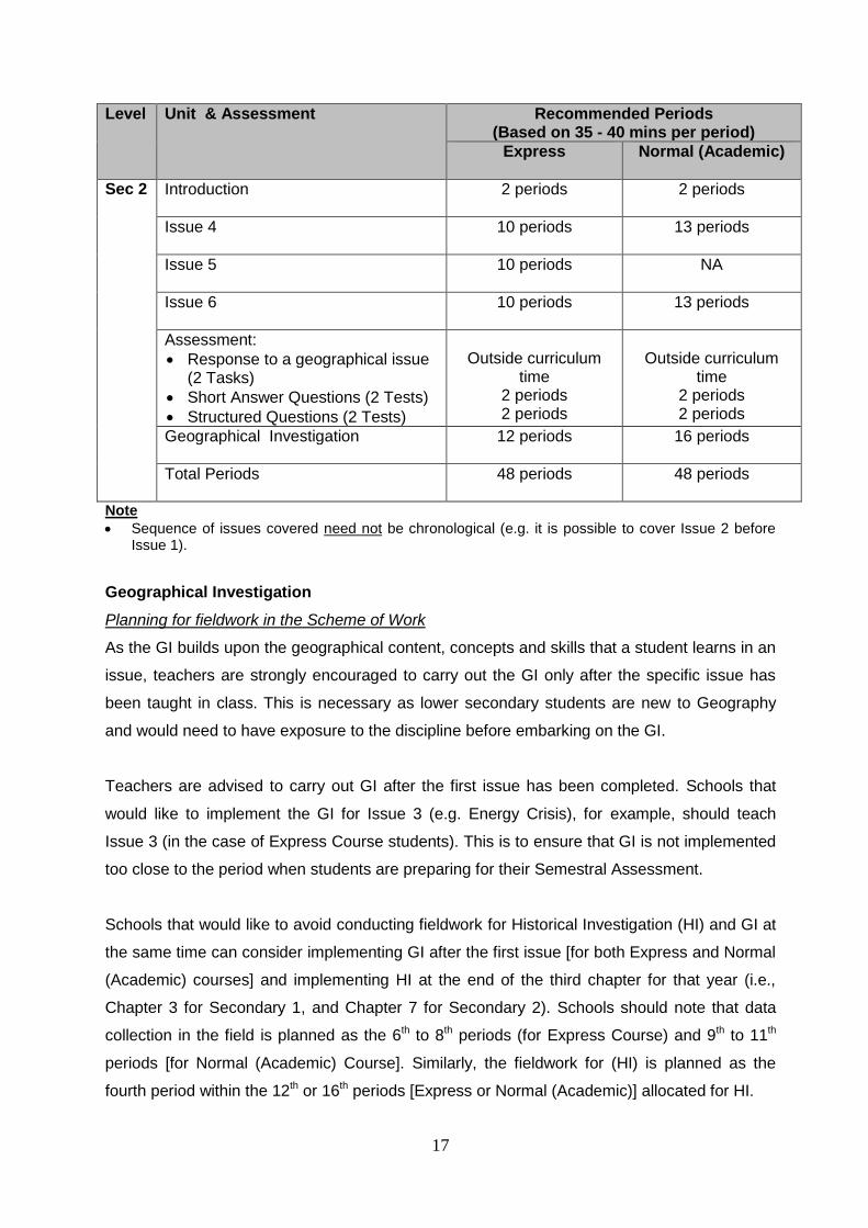
Figure 10: Recommended periods across the year for the non-modular system
Level Unit & Assessment Recommended Periods
(Based on 35 - 40 mins per period)
Express Normal (Academic)
Sec 1
Introduction 2 periods 2 periods
Issue 1 10 periods 13 periods
Issue 2 10 periods 13 periods
Issue 3 10 periods NA
Assessment:
Response to a Geographical Issue (2 Tasks)
Short Answer Questions (2 Tests)
Structured Questions (2 Tests)
Outside curriculum
time 2 periods 2 periods
Outside curriculum
time 2 periods 2 periods
Geographical Investigation
12 periods 16 periods
Total Periods 48 periods 48 periods
16
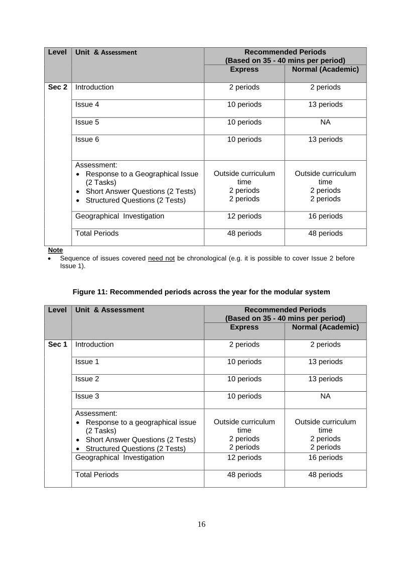
Level Unit & Assessment Recommended Periods (Based on 35 - 40 mins per period)
Express Normal (Academic)
Sec 2
Introduction 2 periods 2 periods
Issue 4 10 periods 13 periods
Issue 5 10 periods NA
Issue 6 10 periods 13 periods
Assessment:
Response to a Geographical Issue (2 Tasks)
Short Answer Questions (2 Tests)
Structured Questions (2 Tests)
Outside curriculum
time 2 periods 2 periods
Outside curriculum
time 2 periods 2 periods
Geographical Investigation
12 periods 16 periods
Total Periods
48 periods 48 periods
Note
Sequence of issues covered need not be chronological (e.g. it is possible to cover Issue 2 before Issue 1).
Figure 11: Recommended periods across the year for the modular system Level Unit & Assessment Recommended Periods
(Based on 35 - 40 mins per period)
Express Normal (Academic)
Sec 1
Introduction 2 periods 2 periods
Issue 1 10 periods 13 periods
Issue 2 10 periods 13 periods
Issue 3 10 periods NA
Assessment:
Response to a geographical issue (2 Tasks)
Short Answer Questions (2 Tests)
Structured Questions (2 Tests)
Outside curriculum
time 2 periods 2 periods
Outside curriculum
time 2 periods 2 periods
Geographical Investigation
12 periods 16 periods
Total Periods 48 periods 48 periods
17
Level Unit & Assessment Recommended Periods (Based on 35 - 40 mins per period)
Express Normal (Academic)
Sec 2
Introduction 2 periods 2 periods
Issue 4 10 periods 13 periods
Issue 5 10 periods NA
Issue 6 10 periods 13 periods
Assessment:
Response to a geographical issue (2 Tasks)
Short Answer Questions (2 Tests)
Structured Questions (2 Tests)
Outside curriculum
time 2 periods 2 periods
Outside curriculum
time 2 periods 2 periods
Geographical Investigation
12 periods 16 periods
Total Periods
48 periods 48 periods
Note
Sequence of issues covered need not be chronological (e.g. it is possible to cover Issue 2 before Issue 1).
Geographical Investigation
Planning for fieldwork in the Scheme of Work
As the GI builds upon the geographical content, concepts and skills that a student learns in an
issue, teachers are strongly encouraged to carry out the GI only after the specific issue has
been taught in class. This is necessary as lower secondary students are new to Geography
and would need to have exposure to the discipline before embarking on the GI.
Teachers are advised to carry out GI after the first issue has been completed. Schools that
would like to implement the GI for Issue 3 (e.g. Energy Crisis), for example, should teach
Issue 3 (in the case of Express Course students). This is to ensure that GI is not implemented
too close to the period when students are preparing for their Semestral Assessment.
Schools that would like to avoid conducting fieldwork for Historical Investigation (HI) and GI at
the same time can consider implementing GI after the first issue [for both Express and Normal
(Academic) courses] and implementing HI at the end of the third chapter for that year (i.e.,
Chapter 3 for Secondary 1, and Chapter 7 for Secondary 2). Schools should note that data
collection in the field is planned as the 6th to 8th periods (for Express Course) and 9th to 11th
periods [for Normal (Academic) Course]. Similarly, the fieldwork for (HI) is planned as the
fourth period within the 12th or 16th periods [Express or Normal (Academic)] allocated for HI.
18
Time-tabling To further support the carrying out of fieldwork, it would be good practice for schools to
schedule two Geography periods as the last periods of the day. Teachers will then be able to
extend the duration of the periods and conduct fieldwork at sites farther away from the school.
Manpower support
Teachers could engage the help of other members of their department as chaperones for the
fieldtrips. Good scaffolding can be designed to support students’ learning. However, it is
recommended that at least one Geography teacher be present to address students’ questions
during the GI.
When planning for data collection in the field, schools can consider leveraging on existing
fieldtrips, such as Learning Journeys, or organising inter-disciplinary fieldtrips. However, it is
crucial that schools keep sight of the design of GI and maintain the integrity of the GI learning
experience in undertaking such initiatives. Students need to develop an understanding of the
discipline, gain conceptual understanding and be immersed in the inquiry process. For
example, students should be given the opportunity to perform their GI tasks separately from
the National Education task while on site during the Learning Journey. The fieldtrip will also
need to be planned very carefully to ensure that it is held at an appropriate time during the
inquiry process.
Schools can also involve parents and alumni as chaperones, together with teachers. This
strategy has the added advantage of building a stronger school community through fostering
relationships between stakeholders, and deepening stakeholders’ engagement with the school.
Manpower Deployment
Schools are encouraged to deploy at least two teachers for each level in the teaching of Lower
Secondary Geography, to create peer support and enable professional sharing. Schools can
also consider arranging for beginning teachers to co-teach with more experienced teachers to
enhance mentoring and to share responsibilities in developing resources.
Schools are encouraged to deploy at least one AED (T&L) to support teachers in the conduct
of Geographical Investigation. AED (T&L) can also support the Humanities Department
through providing remediation support for students. Refer to Annex A for a possible
deployment guide and Annex B for a pen-picture of an AED (T&L) deployed to support the
Humanities Department.

19
Annex A
Deployment of Allied Educators (Teaching and Learning) AED (T&L) to Support
Humanities Department
The points below outline the possible deployment of an AED (T&L) to support the Humanities
Department in teaching and learning as well as school activities.
Teaching and Learning:
a) Support in teaching: Reinforce/Support learning through specific and differentiated
learning and remediation support for individual students or groups of students as directed
by and with guidance from the subject teacher (who remains primarily responsible for the
quality of teaching and learning). Among the various subjects that are under the purview
of the Humanities Department, it is recommended that the AED (T&L) assisting
Humanities teachers be deployed for Geography, History or Social Studies so as to
alleviate the workload issues faced by these subject teachers.
b) Classroom management: Assist teachers in managing and monitoring of students’
behaviours during lessons. He/she can help to implement positive behavioural
management strategies as planned by the teachers.
c) Resource Development: Assist in resource development under the guidance of a teacher
by building and maintaining the pool of teaching and learning resources for specified
subjects within the AED’s job scope, or if possible, the department in general.
d) Monitor students’ performance: Track submission of students’ assignments and monitor
their performance under the guidance of the teacher.
e) Appointment as Assistant Form Teacher: Be appointed as an assistant form teacher.
However, form teachers would have the primary responsibility to look into the holistic
development of each child and they should be the first line of contact with parents.
f) Support in the implementation of the Geographical and the Historical Investigations:
Assist teachers in the various stages of the Geographical and Historical Investigations in
terms of resource development support, guiding individual students, facilitating group
discussions, monitoring of students’ performance.
20
g) Professional Learning Circle: Participate in the Humanities Department’s PLC to suggest
improvements to learning support and enrichment programmes for pupils / the school.
School Activities: As part of the school community, AEDs can be involved in the planning and execution of
school events and activities which are associated with or usually assigned to the Humanities
Department. Some examples include Humanities Week, National Education celebrations, local
and overseas fieldtrips. Notwithstanding this, the AED (T&L) assisting Humanities teachers
should not be given the responsibility of being in charge of these events or activities. The
rationale for having the AED (T&L) assisting the Humanities teachers actively involved in
school-wide activities is to:
a) cultivate a sense of belonging and ownership in the school; b) obtain a big picture of the school vision, mission, and values; and
c) familiarise AEDs with members of the school community beyond the Humanities
Department
21
Annex B
Vignette of AED (T&L) Supporting the Humanities Department
Designation : Allied Educator (Teaching & Learning) in support of the Humanities Department
Substantive Grade : AED 13B YKC is an AED(T&L) deployed to assist the Humanities Department of BME Secondary
School. His main responsibility is to support the Department in both academic subjects and
non-academic areas so as to help students with different learning needs learn better. He
also works with teachers to provide support in pastoral care and CCAs as part of the holistic
development of students.
YKC has been tasked to support Mrs Lim, who is the form teacher and History teacher of
1N1. He has also been tasked to assist in the conduct of the Lower Secondary Geographical
and Historical Investigations. As part of his professional development, YKC attends the
Humanities department’s professional learning circle. He is also closely mentored by Mrs
Lim as well as a Geography teacher, so that he is better able to carry out his tasks in
supporting the Humanities department.
The following vignette illustrates some of the Humanities-related work performed by YKC.
In the Classroom
In the initial period, YKC followed Mrs Lim to 1N1 for History lessons as an observer. Mrs
Lim took time to explain the syllabus objectives, main pedagogical approach and the
department’s SOW for the subject to YKC. Prior to a lesson, she would provide YKC with her
lesson plan to explain the lesson objectives and the desired students’ learning experiences
for her lesson. She would also inform YKC of any particular students needing his monitoring
and support, for example, the low progress leaners and those with behavioural problems.
YKC gradually played a more active role in supporting Mrs Lim with lesson preparation. He
approached Mrs Lim for the lesson plans for forthcoming topics. He read through the
relevant chapters in the course book, and carried out additional research following the IT
links provided in the course book and the references given in the TLG to develop his content
mastery. YKC also clarified the lesson objectives with Mrs Lim and how he could provide
assistance to the weaker students.
22
When Mrs Lim was conducting lessons, YKC would sit at the back of the classroom to
observe students’ responses and listen for the key emphases of the lesson. If he saw
students dozing off or groups making too much noise, he would walk up to the students to
correct their behaviour. When the students worked in groups on analysing sources, YKC
would approach the low progress learners to address their questions. For the rest of the
students, YKC would provide guiding questions to scaffold their interpretation of the sources.
When there were a few students who could not understand the concept that was taught
during the lesson, YKC would explain the concept again using an approach that was easier
for the students to understand. He would arrange to meet the students for a consultation
after school should they still have further questions.
At the end of the school day, YKC would record what he had done during the lesson and the
consultation session in a log book. He would also pen down the questions that the students
had asked and his responses as well as his own queries about the topic and source-based
skills. The next morning, YKC would pass the log book to Mrs Lim for her reference and
feedback. The log would later be used to guide the preparation of remediation material that
had to be approved by Mrs Lim before YKC taught the remedial group.
As YKC settled into his role and got to know the students, he started to support Mrs Lim in
monitoring students’ results and their academic development. YKC monitored the
submission of assignments by the students and would follow up on the late submissions.
After each marked assignment and test, YKC would record the marks and check the
students’ progress. He took note of which students constantly failed their assignments and
or regressed in their scores. He alerted Mrs Lim to these students to enable her to follow-up.
In addition to classroom support, YKC provided additional help to Mrs Lim when she wanted
to infuse ICT in the teaching. Mrs Lim intended to use a digital tool such as Popplet to
promote students’ collaborative learning. As students were unfamiliar with the tool, Mrs Lim
asked YKC to assist her in conducting a sharing cum hands-on activity session for the
students. During this session, Mrs Lim and YKC modelled the collaborative use of the tool
for the students and provided one-to-one support for those who encountered difficulty. After
the session, YKC further assisted Mrs Lim in ensuring that students uploaded their work to
the school’s Humanities website.
23
Conduct of the Geographical and Historical Investigations
YKC was tasked to support the department in the conduct of the Geographical and Historical
Investigations. In fact, the Geographical and Historical Investigations are part of a wider
departmental project. All the Humanities teachers, as well as YKC, were briefed on the
Geographical and the Historical Investigations, and were to assist at various stages of
conducting the Geographical and the Historical Investigations. YKC had read through the
students’ activity materials and lesson plan for a better idea of how the Investigations were
to be carried out.
After discussion with the Geography teacher-in-charge, Ms Selvi, YKC was tasked with the
logistics arrangements. He filled up a draft of the RAMS which was later discussed with and
finalised by Ms Selvi. A list of student’s names and emergency numbers was compiled. He
made the necessary transportation arrangements for the fieldwork. He also assisted in
giving out and collecting the parent consent forms. Furthermore, he assisted Ms Selvi by
booking the computer laboratory for student research. During the lesson, when the students
were conducting the research, he guided them in looking for relevant data online and in
recording as well as keeping their data. At the end of the research phase, it was YKC’s
responsibility to ensure and follow up on students completing and submitting their individual
research findings.
In preparation for the fieldwork, YKC helped print the GI logs for distribution to the students.
He organised the students into their groups and assigned them their respective roles. During
the first GI lesson, he facilitated the group’s analyses of the GI question by asking probing
questions. At the end of the lesson, he ensured that all groups completed and submitted
their guiding questions for grading.
Prior to the fieldwork, he checked all the fieldwork equipment (i.e. water test kits) for proper
working condition. On the actual day while Ms Selvi was the main facilitator for the class,
YKC supervised student groups to ensure safety and that their tasks were on track. He
helped to distribute fieldwork equipment, reminding students to handle the equipment with
care. For safety reasons, YKC assisted student groups with the collection of water samples.
At the end of the fieldtrip, YKC assisted Ms Selvi in the collection and checking of the
fieldwork equipment. Back in school, YKC facilitated a group analysis of the data. He guided
the students in constructing responses to the GI question and ensured that they submitted
the group end product as well as their personal reflections for grading. In consultation with
Ms Selvi, he also looked into logistical arrangements to support the presentation of the
24
group product. At the end of the entire GI process, YKC updated the school’s Humanities
website with pictures and the students’ work.
As for the Historical Investigation, YKC was to assist Mrs Lim with the resource development
as well as the actual conduct of the Investigation. YKC discussed with Mrs Lim the additional
resources that would be required. As students would be carrying out online research and
oral history interviews for their Investigation, Mrs Lim and YKC thought that additional
material from online resources, and tips on conducting oral history interviews would be
helpful for the students. YKC thus helped Mrs Lim and the department in gathering and
curating these resources, and shared them on the school’s intranet. At one of the
Professional Learning Circles, he also explained to teachers how they could use these
resources.
In the actual conduct of the Historical Investigation, YKC assisted Mrs Lim in facilitating
group discussions during class time. He asked probing questions to help students generate
ideas about how they could go about their research. When students were carrying out online
research, he helped to ensure that students were on task and using sound search strategies.
For the oral history interviews, YKC assisted Mrs Lim in instructing students how to carry out
the interviews, and in helping students identify possible interviewees. He also assisted Mrs
Lim in tracking students’ submission of their work as well as recording their performance.
This facilitated Mrs Lim’s follow-up on students who were lagging in their Investigations.
YKC also helped to ensure that all the students uploaded their work onto their online
learning portal for peer evaluation and sharing of learning.
School Activities – (National Education Committee) Commemoration of Total Defence
Day
YKC was a member of the school’s National Education Committee and part of the team for
the Total Defence Day (TDD) commemoration. For the year’s TDD activities, the NE
Committee decided to have the students relive a day in the lives of the people in Singapore
during the Japanese Occupation. The Committee decided to focus on certain features of the
Japanese Occupation such as the blackouts and meagre food supply to highlight the
hardships that people underwent during that time. After discussion with the teachers in the
TDD team, YKC was tasked to liaise with the canteen vendors and school’s operation
manager to coordinate the sale of certain types of food for the day, and the blackout
schedule. In addition, YKC sourced for pictures and stories from the Japanese Occupation
for the static display boards so as to inform students about the importance of TDD. The NE
Committee also decided to invite the Singapore Civil Defence Force to give a speech and

25
demonstration during the week’s assembly period to highlight the importance and value of
civil defence to the community. Under the instruction of the teacher-in-charge, YKC
contacted the SCDF and made the logistics arrangements for the presentation. On the day
of the TDD commemoration, YKC and a teacher from the NE Committee received the SCDF
personnel and ensured that the presentation was able to proceed smoothly. YKC also saw
that the blackout procedure and sale of food at the canteen was adhered to.
0
SECTION 3: RECOMMENDED PEDAGOGY
26
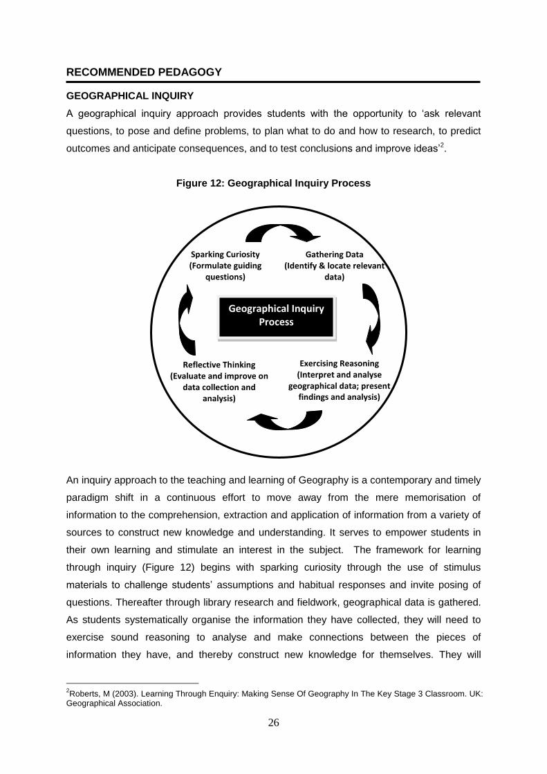
RECOMMENDED PEDAGOGY GEOGRAPHICAL INQUIRY
A geographical inquiry approach provides students with the opportunity to ‘ask relevant
questions, to pose and define problems, to plan what to do and how to research, to predict
outcomes and anticipate consequences, and to test conclusions and improve ideas’2.
Figure 12: Geographical Inquiry Process
An inquiry approach to the teaching and learning of Geography is a contemporary and timely
paradigm shift in a continuous effort to move away from the mere memorisation of
information to the comprehension, extraction and application of information from a variety of
sources to construct new knowledge and understanding. It serves to empower students in
their own learning and stimulate an interest in the subject. The framework for learning
through inquiry (Figure 12) begins with sparking curiosity through the use of stimulus
materials to challenge students’ assumptions and habitual responses and invite posing of
questions. Thereafter through library research and fieldwork, geographical data is gathered.
As students systematically organise the information they have collected, they will need to
exercise sound reasoning to analyse and make connections between the pieces of
information they have, and thereby construct new knowledge for themselves. They will
2Roberts, M (2003). Learning Through Enquiry: Making Sense Of Geography In The Key Stage 3 Classroom. UK:
Geographical Association.
Diagram 2.2.5: Historical Inquiry Process
Sparking Curiosity (Formulate guiding
questions)
Gathering Data (Identify & locate relevant
data)
Exercising Reasoning (Interpret and analyse
geographical data; present findings and analysis)
Reflective Thinking (Evaluate and improve on
data collection and analysis)
Geographical Inquiry Process

27
analyse the information in the light of the question posed so as to arrive at a conclusion to
the question before reflecting on their learning based on the inquiry process or conclusion
drawn. Through the inquiry process, students will be challenged to examine their own
thinking, feeling and doing and become self-reflective thinkers. These four aspects of
sparking curiosity, gathering data, exercising reasoning and reflective thinking serve as the
basic thinking processes that students will go through in a geographical inquiry.
0
SECTION 4:
21 ST
CENTURY COMPETENCIES
28
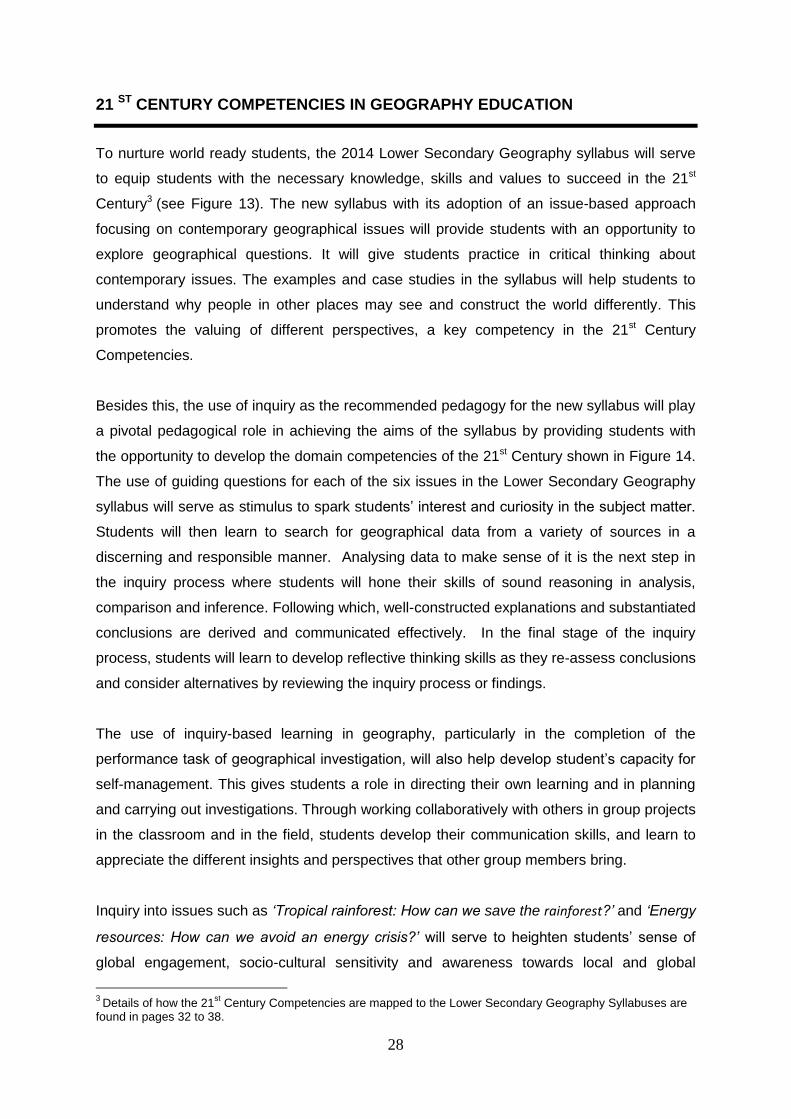
21 ST CENTURY COMPETENCIES IN GEOGRAPHY EDUCATION
To nurture world ready students, the 2014 Lower Secondary Geography syllabus will serve
to equip students with the necessary knowledge, skills and values to succeed in the 21st
Century3 (see Figure 13). The new syllabus with its adoption of an issue-based approach
focusing on contemporary geographical issues will provide students with an opportunity to
explore geographical questions. It will give students practice in critical thinking about
contemporary issues. The examples and case studies in the syllabus will help students to
understand why people in other places may see and construct the world differently. This
promotes the valuing of different perspectives, a key competency in the 21st Century
Competencies.
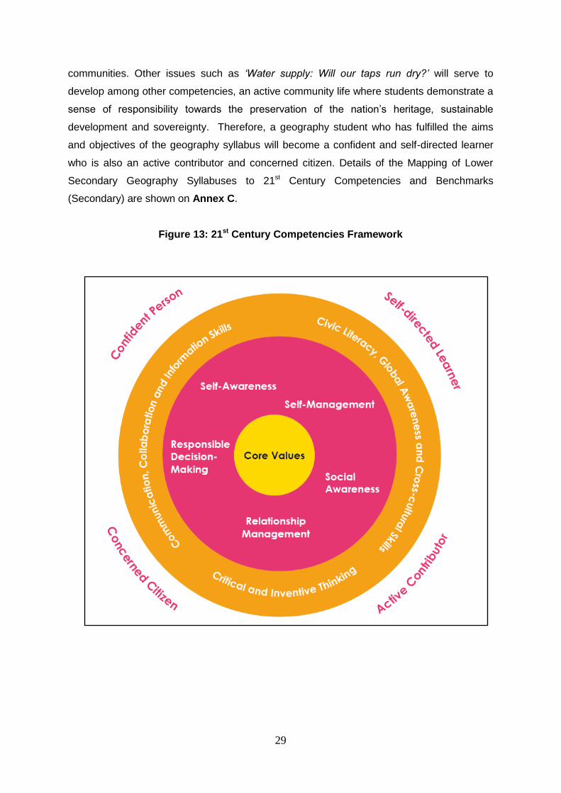
Besides this, the use of inquiry as the recommended pedagogy for the new syllabus will play
a pivotal pedagogical role in achieving the aims of the syllabus by providing students with
the opportunity to develop the domain competencies of the 21st Century shown in Figure 14.
The use of guiding questions for each of the six issues in the Lower Secondary Geography
syllabus will serve as stimulus to spark students’ interest and curiosity in the subject matter.
Students will then learn to search for geographical data from a variety of sources in a
discerning and responsible manner. Analysing data to make sense of it is the next step in
the inquiry process where students will hone their skills of sound reasoning in analysis,
comparison and inference. Following which, well-constructed explanations and substantiated
conclusions are derived and communicated effectively. In the final stage of the inquiry
process, students will learn to develop reflective thinking skills as they re-assess conclusions
and consider alternatives by reviewing the inquiry process or findings.
The use of inquiry-based learning in geography, particularly in the completion of the
performance task of geographical investigation, will also help develop student’s capacity for
self-management. This gives students a role in directing their own learning and in planning
and carrying out investigations. Through working collaboratively with others in group projects
in the classroom and in the field, students develop their communication skills, and learn to
appreciate the different insights and perspectives that other group members bring.
Inquiry into issues such as ‘Tropical rainforest: How can we save the rainforest?’ and ‘Energy
resources: How can we avoid an energy crisis?’ will serve to heighten students’ sense of
global engagement, socio-cultural sensitivity and awareness towards local and global
3
Details of how the 21st Century Competencies are mapped to the Lower Secondary Geography Syllabuses are
found in pages 32 to 38.
29
communities. Other issues such as ‘Water supply: Will our taps run dry?’ will serve to
develop among other competencies, an active community life where students demonstrate a
sense of responsibility towards the preservation of the nation’s heritage, sustainable
development and sovereignty. Therefore, a geography student who has fulfilled the aims
and objectives of the geography syllabus will become a confident and self-directed learner
who is also an active contributor and concerned citizen. Details of the Mapping of Lower
Secondary Geography Syllabuses to 21st Century Competencies and Benchmarks
(Secondary) are shown on Annex C.
Figure 13: 21st Century Competencies Framework
30
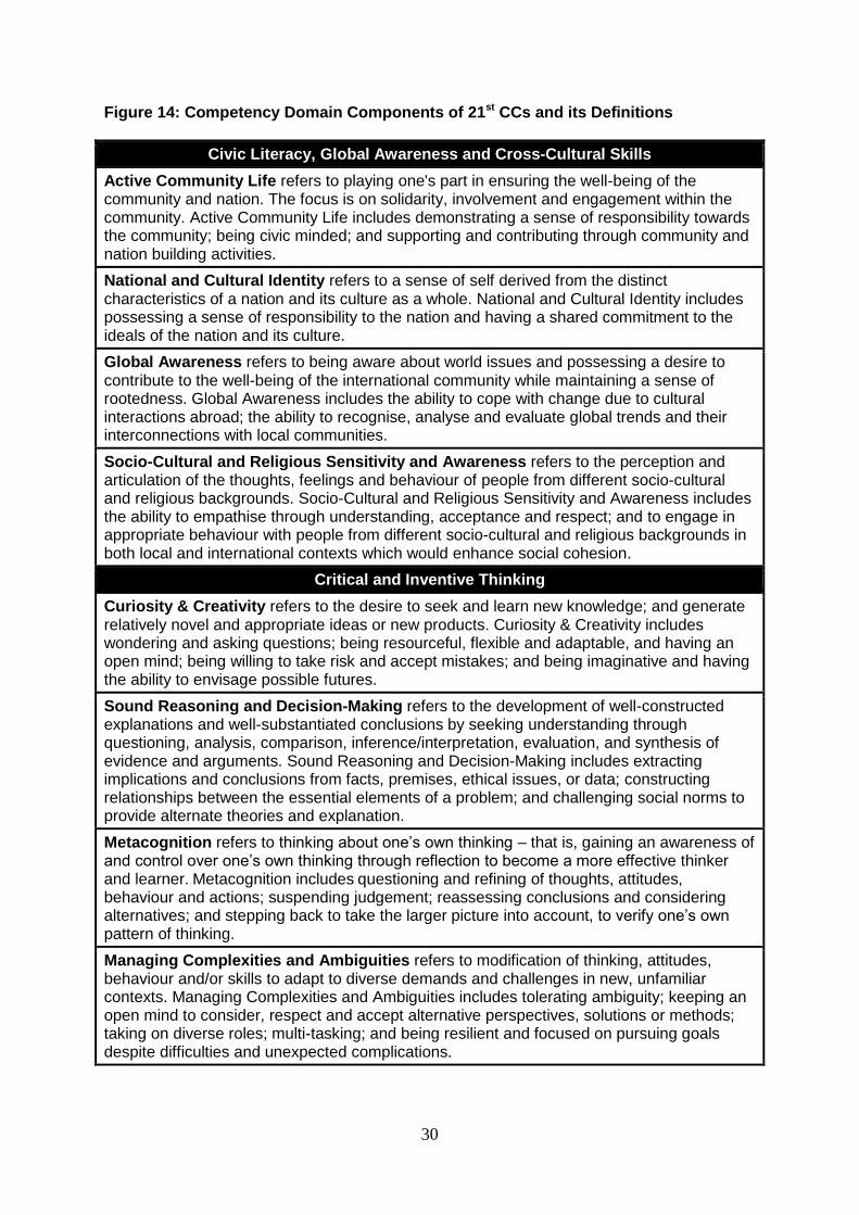
Figure 14: Competency Domain Components of 21st CCs and its Definitions
Civic Literacy, Global Awareness and Cross-Cultural Skills
Active Community Life refers to playing one's part in ensuring the well-being of the community and nation. The focus is on solidarity, involvement and engagement within the community. Active Community Life includes demonstrating a sense of responsibility towards the community; being civic minded; and supporting and contributing through community and nation building activities.
National and Cultural Identity refers to a sense of self derived from the distinct characteristics of a nation and its culture as a whole. National and Cultural Identity includes possessing a sense of responsibility to the nation and having a shared commitment to the ideals of the nation and its culture.
Global Awareness refers to being aware about world issues and possessing a desire to contribute to the well-being of the international community while maintaining a sense of rootedness. Global Awareness includes the ability to cope with change due to cultural interactions abroad; the ability to recognise, analyse and evaluate global trends and their interconnections with local communities.
Socio-Cultural and Religious Sensitivity and Awareness refers to the perception and articulation of the thoughts, feelings and behaviour of people from different socio-cultural and religious backgrounds. Socio-Cultural and Religious Sensitivity and Awareness includes the ability to empathise through understanding, acceptance and respect; and to engage in appropriate behaviour with people from different socio-cultural and religious backgrounds in both local and international contexts which would enhance social cohesion.
Critical and Inventive Thinking
Curiosity & Creativity refers to the desire to seek and learn new knowledge; and generate relatively novel and appropriate ideas or new products. Curiosity & Creativity includes wondering and asking questions; being resourceful, flexible and adaptable, and having an open mind; being willing to take risk and accept mistakes; and being imaginative and having the ability to envisage possible futures.
Sound Reasoning and Decision-Making refers to the development of well-constructed explanations and well-substantiated conclusions by seeking understanding through questioning, analysis, comparison, inference/interpretation, evaluation, and synthesis of evidence and arguments. Sound Reasoning and Decision-Making includes extracting implications and conclusions from facts, premises, ethical issues, or data; constructing relationships between the essential elements of a problem; and challenging social norms to provide alternate theories and explanation.
Metacognition refers to thinking about one’s own thinking – that is, gaining an awareness of and control over one’s own thinking through reflection to become a more effective thinker and learner. Metacognition includes questioning and refining of thoughts, attitudes, behaviour and actions; suspending judgement; reassessing conclusions and considering alternatives; and stepping back to take the larger picture into account, to verify one’s own pattern of thinking.
Managing Complexities and Ambiguities refers to modification of thinking, attitudes, behaviour and/or skills to adapt to diverse demands and challenges in new, unfamiliar contexts. Managing Complexities and Ambiguities includes tolerating ambiguity; keeping an open mind to consider, respect and accept alternative perspectives, solutions or methods; taking on diverse roles; multi-tasking; and being resilient and focused on pursuing goals despite difficulties and unexpected complications.
31
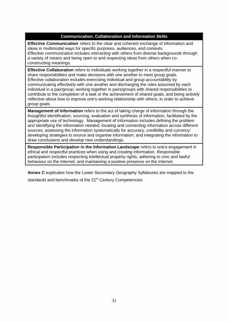
Communication, Collaboration and Information Skills
Effective Communication refers to the clear and coherent exchange of information and ideas in multimodal ways for specific purposes, audiences, and contexts. Effective communication includes interacting with others from diverse backgrounds through a variety of means and being open to and respecting ideas from others when co-constructing meanings.
Effective Collaboration refers to individuals working together in a respectful manner to share responsibilities and make decisions with one another to meet group goals. Effective collaboration includes exercising individual and group accountability by communicating effectively with one another and discharging the roles assumed by each individual in a pair/group; working together in pairs/groups with shared responsibilities to contribute to the completion of a task or the achievement of shared goals; and being actively reflective about how to improve one's working relationship with others, in order to achieve group goals.
Management of Information refers to the act of taking charge of information through the thoughtful identification, sourcing, evaluation and synthesis of information, facilitated by the appropriate use of technology. Management of Information includes defining the problem and identifying the information needed; locating and connecting information across different sources; assessing the information systematically for accuracy, credibility and currency; developing strategies to source and organise information; and integrating the information to draw conclusions and develop new understandings.
Responsible Participation in the Information Landscape refers to one’s engagement in ethical and respectful practices when using and creating information. Responsible participation includes respecting intellectual property rights; adhering to civic and lawful behaviour on the Internet; and maintaining a positive presence on the Internet.
Annex C explicates how the Lower Secondary Geography Syllabuses are mapped to the
standards and benchmarks of the 21st Century Competencies.
32
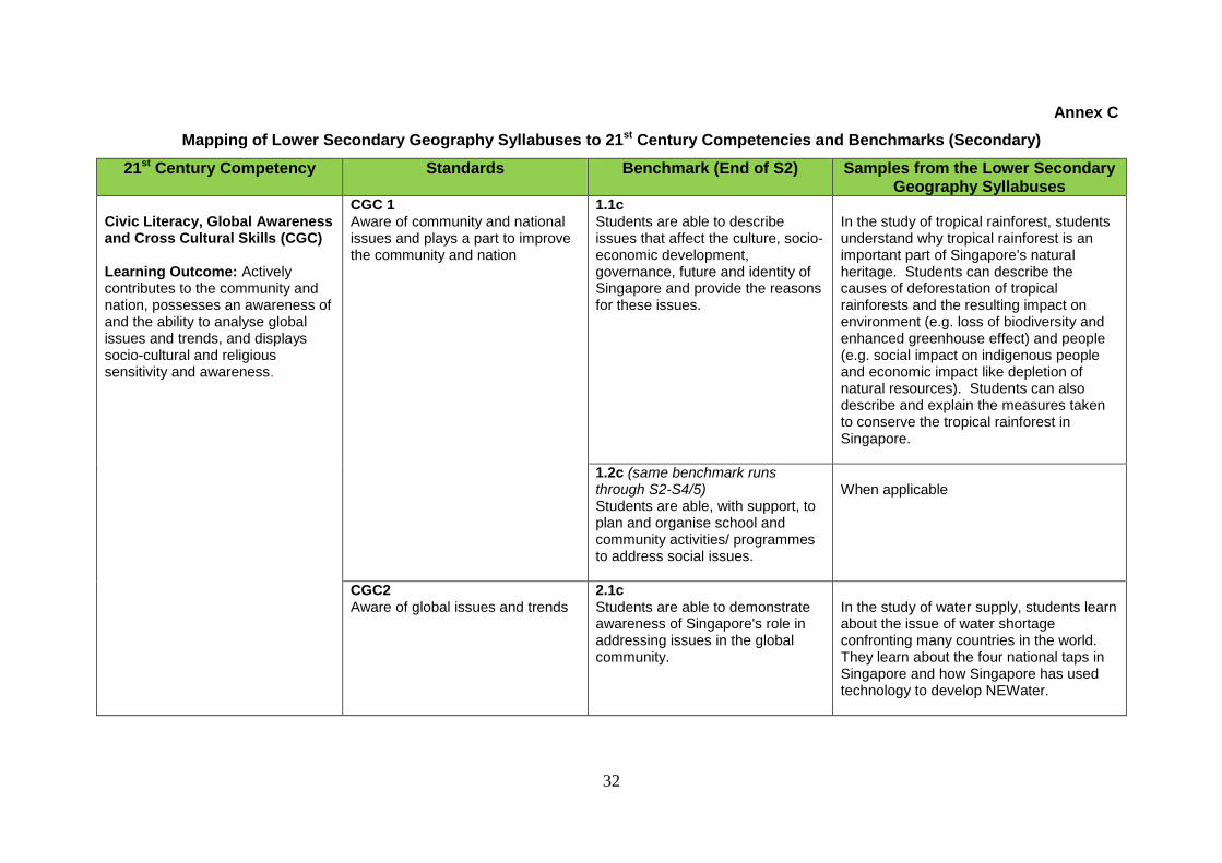
Annex C
Mapping of Lower Secondary Geography Syllabuses to 21st Century Competencies and Benchmarks (Secondary)
21st Century Competency Standards Benchmark (End of S2) Samples from the Lower Secondary Geography Syllabuses
Civic Literacy, Global Awareness and Cross Cultural Skills (CGC) Learning Outcome: Actively contributes to the community and nation, possesses an awareness of and the ability to analyse global issues and trends, and displays socio-cultural and religious sensitivity and awareness.
CGC 1 Aware of community and national issues and plays a part to improve the community and nation
1.1c Students are able to describe issues that affect the culture, socio-economic development, governance, future and identity of Singapore and provide the reasons for these issues.
In the study of tropical rainforest, students understand why tropical rainforest is an important part of Singapore's natural heritage. Students can describe the causes of deforestation of tropical rainforests and the resulting impact on environment (e.g. loss of biodiversity and enhanced greenhouse effect) and people (e.g. social impact on indigenous people and economic impact like depletion of natural resources). Students can also describe and explain the measures taken to conserve the tropical rainforest in Singapore.
1.2c (same benchmark runs through S2-S4/5) Students are able, with support, to plan and organise school and community activities/ programmes to address social issues.
When applicable
CGC2 Aware of global issues and trends
2.1c Students are able to demonstrate awareness of Singapore's role in addressing issues in the global community.
In the study of water supply, students learn about the issue of water shortage confronting many countries in the world. They learn about the four national taps in Singapore and how Singapore has used technology to develop NEWater.
33
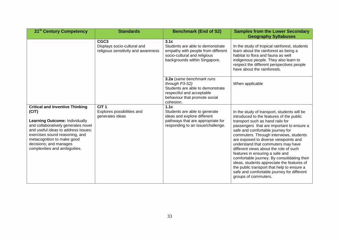
21st Century Competency Standards Benchmark (End of S2) Samples from the Lower Secondary Geography Syllabuses
CGC3 Displays socio-cultural and religious sensitivity and awareness
3.1c Students are able to demonstrate empathy with people from different socio-cultural and religious backgrounds within Singapore.
In the study of tropical rainforest, students learn about the rainforest as being a habitat to flora and fauna as well indigenous people. They also learn to respect the different perspectives people have about the rainforests.
3.2a (same benchmark runs through P3-S2) Students are able to demonstrate respectful and acceptable behaviour that promote social cohesion.
When applicable
Critical and Inventive Thinking (CIT) Learning Outcome: Individually and collaboratively generates novel and useful ideas to address issues; exercises sound reasoning, and metacognition to make good decisions; and manages complexities and ambiguities.
CIT 1 Explores possibilities and generates ideas
1.1c Students are able to generate ideas and explore different pathways that are appropriate for responding to an issue/challenge.
In the study of transport, students will be introduced to the features of the public transport such as hand rails for passengers that are important to ensure a safe and comfortable journey for commuters. Through interviews, students are exposed to diverse viewpoints and understand that commuters may have different views about the role of such features in ensuring a safe and comfortable journey. By consolidating their ideas, students appreciate the features of the public transport that help to ensure a safe and comfortable journey for different groups of commuters.
34
21st Century Competency Standards Benchmark (End of S2) Samples from the Lower Secondary Geography Syllabuses
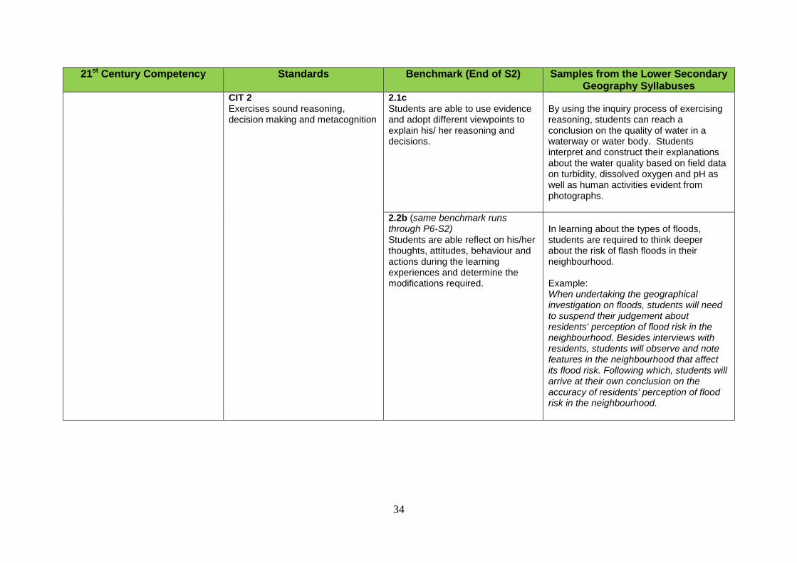
CIT 2 Exercises sound reasoning, decision making and metacognition
2.1c Students are able to use evidence and adopt different viewpoints to explain his/ her reasoning and decisions.
By using the inquiry process of exercising reasoning, students can reach a conclusion on the quality of water in a waterway or water body. Students interpret and construct their explanations about the water quality based on field data on turbidity, dissolved oxygen and pH as well as human activities evident from photographs.
2.2b (same benchmark runs through P6-S2) Students are able reflect on his/her thoughts, attitudes, behaviour and actions during the learning experiences and determine the modifications required.
In learning about the types of floods, students are required to think deeper about the risk of flash floods in their neighbourhood. Example: When undertaking the geographical investigation on floods, students will need to suspend their judgement about residents' perception of flood risk in the neighbourhood. Besides interviews with residents, students will observe and note features in the neighbourhood that affect its flood risk. Following which, students will arrive at their own conclusion on the accuracy of residents' perception of flood risk in the neighbourhood.
35
21st Century Competency Standards Benchmark (End of S2) Samples from the Lower Secondary Geography Syllabuses
CIT 3 Manages complexities and ambiguities
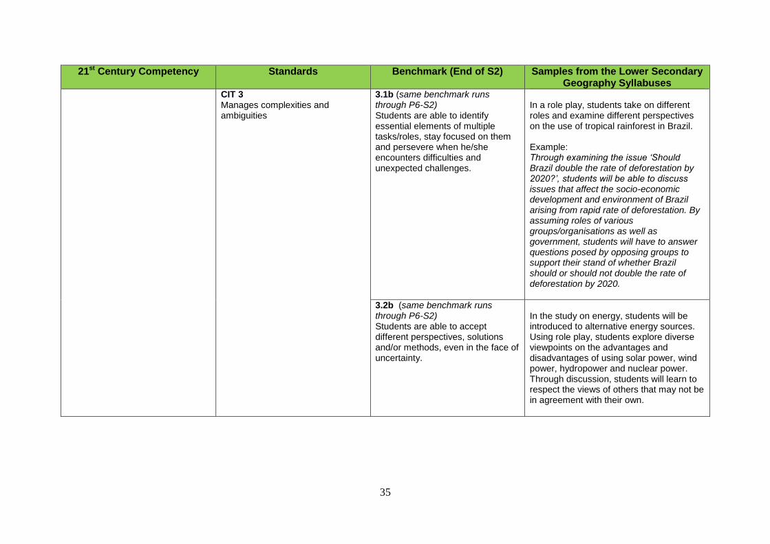
3.1b (same benchmark runs through P6-S2) Students are able to identify essential elements of multiple tasks/roles, stay focused on them and persevere when he/she encounters difficulties and unexpected challenges.
In a role play, students take on different roles and examine different perspectives on the use of tropical rainforest in Brazil. Example: Through examining the issue ‘Should Brazil double the rate of deforestation by 2020?’, students will be able to discuss issues that affect the socio-economic development and environment of Brazil arising from rapid rate of deforestation. By assuming roles of various groups/organisations as well as government, students will have to answer questions posed by opposing groups to support their stand of whether Brazil should or should not double the rate of deforestation by 2020.
3.2b (same benchmark runs through P6-S2) Students are able to accept different perspectives, solutions and/or methods, even in the face of uncertainty.
In the study on energy, students will be introduced to alternative energy sources. Using role play, students explore diverse viewpoints on the advantages and disadvantages of using solar power, wind power, hydropower and nuclear power. Through discussion, students will learn to respect the views of others that may not be in agreement with their own.
36
21st Century Competency Standards Benchmark (End of S2) Samples from the Lower Secondary Geography Syllabuses
Communication, Collaboration and Information Skills (CCI) Learning Outcome: Communicates information and ideas clearly and collaborates effectively; manages, creates and shares information thoughtfully, ethically and responsibly.
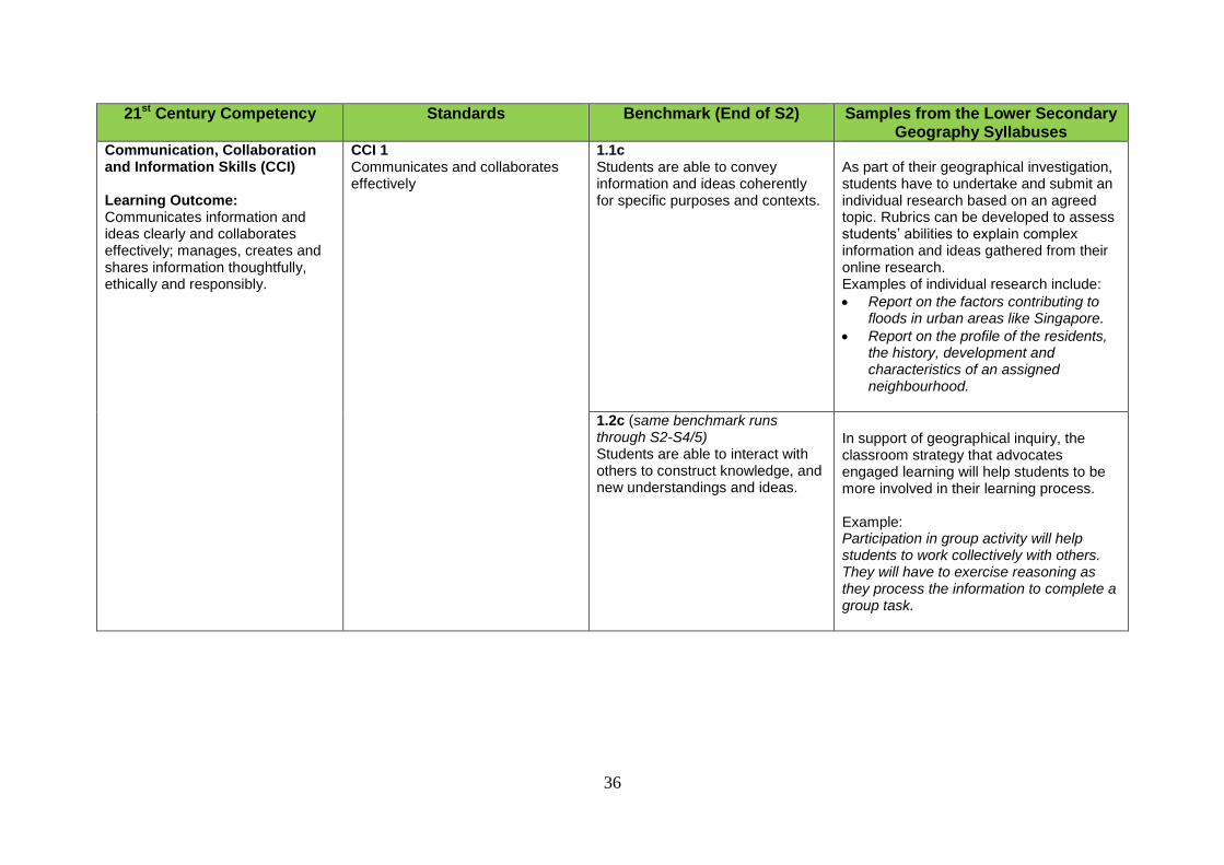
CCI 1 Communicates and collaborates effectively
1.1c Students are able to convey information and ideas coherently for specific purposes and contexts.
As part of their geographical investigation, students have to undertake and submit an individual research based on an agreed topic. Rubrics can be developed to assess students’ abilities to explain complex information and ideas gathered from their online research. Examples of individual research include:
Report on the factors contributing to floods in urban areas like Singapore.
Report on the profile of the residents, the history, development and characteristics of an assigned neighbourhood.
1.2c (same benchmark runs through S2-S4/5) Students are able to interact with others to construct knowledge, and new understandings and ideas.
In support of geographical inquiry, the classroom strategy that advocates engaged learning will help students to be more involved in their learning process. Example: Participation in group activity will help students to work collectively with others. They will have to exercise reasoning as they process the information to complete a group task.
37
21st Century Competency Standards Benchmark (End of S2) Samples from the Lower Secondary Geography Syllabuses
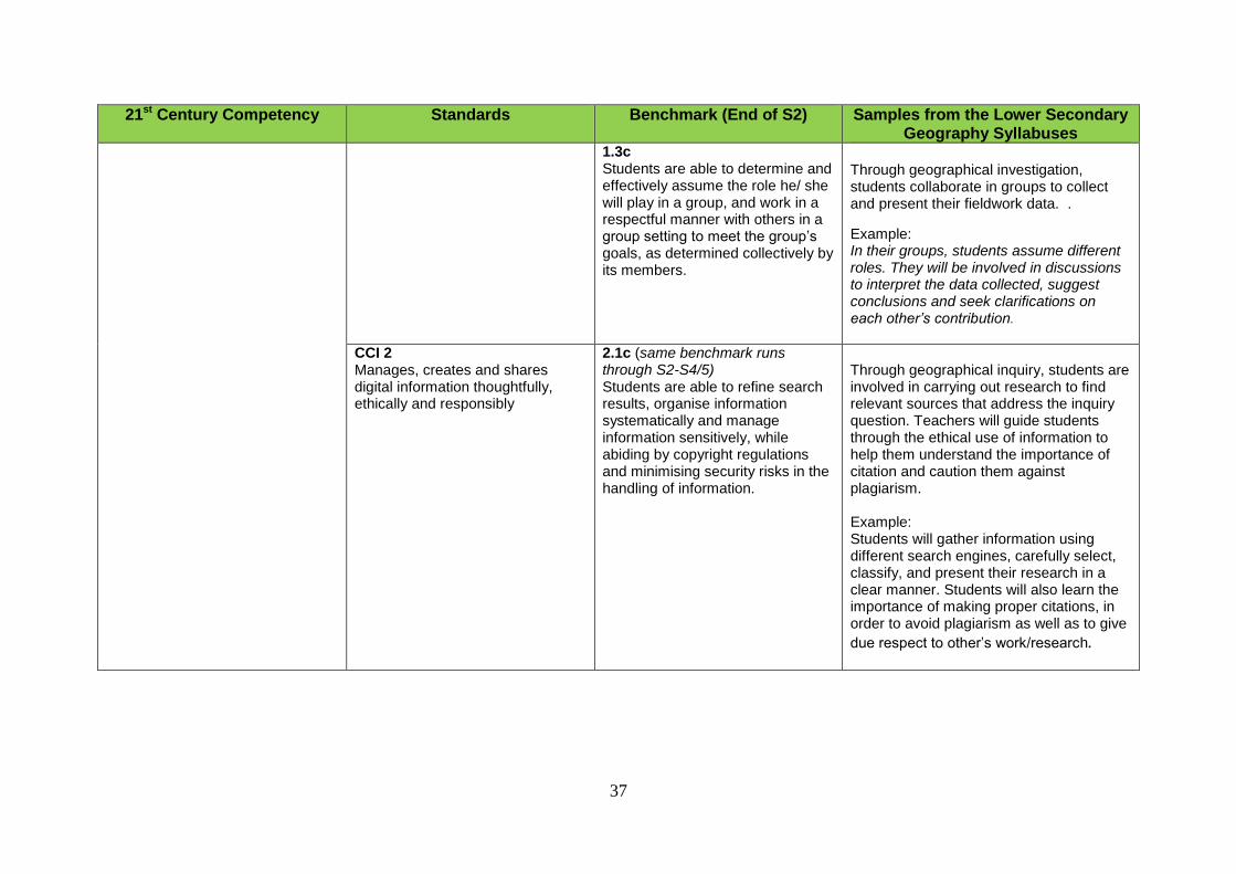
1.3c Students are able to determine and effectively assume the role he/ she will play in a group, and work in a respectful manner with others in a group setting to meet the group’s goals, as determined collectively by its members.
Through geographical investigation, students collaborate in groups to collect and present their fieldwork data. .
Example: In their groups, students assume different roles. They will be involved in discussions to interpret the data collected, suggest conclusions and seek clarifications on each other’s contribution.
CCI 2 Manages, creates and shares digital information thoughtfully, ethically and responsibly
2.1c (same benchmark runs through S2-S4/5) Students are able to refine search results, organise information systematically and manage information sensitively, while abiding by copyright regulations and minimising security risks in the handling of information.
Through geographical inquiry, students are involved in carrying out research to find relevant sources that address the inquiry question. Teachers will guide students through the ethical use of information to help them understand the importance of citation and caution them against plagiarism. Example: Students will gather information using different search engines, carefully select, classify, and present their research in a clear manner. Students will also learn the importance of making proper citations, in order to avoid plagiarism as well as to give
due respect to other’s work/research.
38
21st Century Competency Standards Benchmark (End of S2) Samples from the Lower Secondary Geography Syllabuses
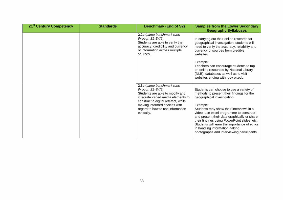
2.2c (same benchmark runs through S2-S4/5) Students are able to verify the accuracy, credibility and currency of information across multiple sources.
In carrying out their online research for geographical investigation, students will need to verify the accuracy, reliability and currency of sources from credible websites. Example: Teachers can encourage students to tap on online resources by National Library (NLB), databases as well as to visit websites ending with .gov or.edu.
2.3c (same benchmark runs through S2-S4/5) Students are able to modify and integrate varied media elements to construct a digital artefact, while making informed choices with regard to how to use information ethically.
Students can choose to use a variety of methods to present their findings for the geographical investigation. Example: Students may show their interviews in a video, use excel programme to construct and present their data graphically or share their findings using PowerPoint slides, etc. Students will learn the importance of ethics in handling information, taking photographs and interviewing participants.
39
21st Century Competency Standards Benchmark (End of S2) Samples from the Lower Secondary Geography Syllabuses
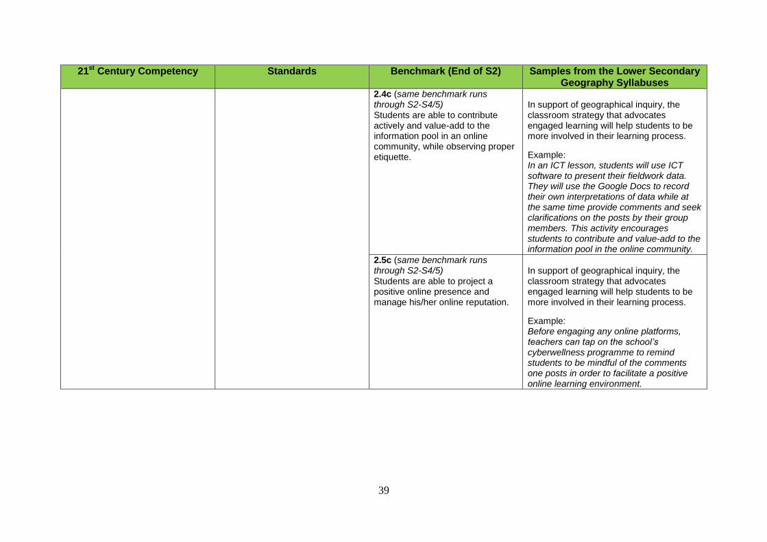
2.4c (same benchmark runs through S2-S4/5) Students are able to contribute actively and value-add to the information pool in an online community, while observing proper etiquette.
In support of geographical inquiry, the classroom strategy that advocates engaged learning will help students to be more involved in their learning process.
Example: In an ICT lesson, students will use ICT software to present their fieldwork data. They will use the Google Docs to record their own interpretations of data while at the same time provide comments and seek clarifications on the posts by their group members. This activity encourages students to contribute and value-add to the information pool in the online community.
2.5c (same benchmark runs through S2-S4/5) Students are able to project a positive online presence and manage his/her online reputation.
In support of geographical inquiry, the classroom strategy that advocates engaged learning will help students to be more involved in their learning process.
Example: Before engaging any online platforms, teachers can tap on the school’s cyberwellness programme to remind students to be mindful of the comments one posts in order to facilitate a positive online learning environment.
0
SECTION 5:
SCOPE AND SEQUENCE CHART FOR LOWER SECONDARY GEOGRAPHY SYLLABUSES
40
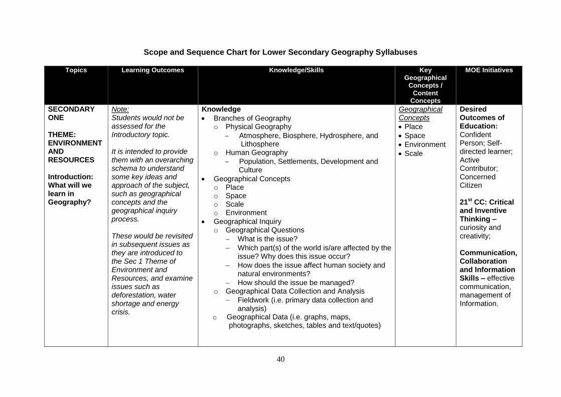
Scope and Sequence Chart for Lower Secondary Geography Syllabuses
Topics Learning Outcomes Knowledge/Skills Key Geographical
Concepts / Content
Concepts
MOE Initiatives
SECONDARY ONE THEME: ENVIRONMENT AND RESOURCES Introduction: What will we learn in Geography?
Note: Students would not be assessed for the Introductory topic. It is intended to provide them with an overarching schema to understand some key ideas and approach of the subject, such as geographical concepts and the geographical inquiry process. These would be revisited in subsequent issues as they are introduced to the Sec 1 Theme of Environment and Resources, and examine issues such as deforestation, water shortage and energy crisis.
Knowledge
Branches of Geography o Physical Geography
Atmosphere, Biosphere, Hydrosphere, and Lithosphere
o Human Geography
Population, Settlements, Development and Culture
Geographical Concepts o Place o Space o Scale o Environment
Geographical Inquiry o Geographical Questions
What is the issue?
Which part(s) of the world is/are affected by the issue? Why does this issue occur?
How does the issue affect human society and natural environments?
How should the issue be managed? o Geographical Data Collection and Analysis
Fieldwork (i.e. primary data collection and analysis)
o Geographical Data (i.e. graphs, maps, photographs, sketches, tables and text/quotes)
Geographical Concepts
Place
Space
Environment
Scale
Desired Outcomes of Education: Confident Person; Self-directed learner; Active Contributor; Concerned Citizen 21st CC: Critical and Inventive Thinking –curiosity and creativity; Communication, Collaboration and Information Skills – effective communication, management of Information.
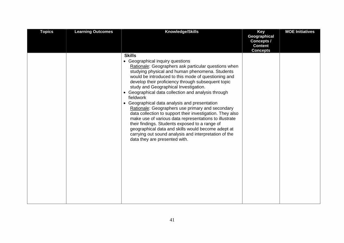
41
Topics Learning Outcomes Knowledge/Skills Key Geographical
Concepts / Content
Concepts
MOE Initiatives
Skills
Geographical inquiry questions Rationale: Geographers ask particular questions when studying physical and human phenomena. Students would be introduced to this mode of questioning and develop their proficiency through subsequent topic study and Geographical Investigation.
Geographical data collection and analysis through fieldwork
Geographical data analysis and presentation Rationale: Geographers use primary and secondary data collection to support their investigation. They also make use of various data representations to illustrate their findings. Students exposed to a range of geographical data and skills would become adept at carrying out sound analysis and interpretation of the data they are presented with.
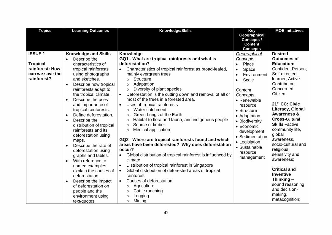
42
Topics Learning Outcomes Knowledge/Skills Key Geographical
Concepts / Content
Concepts
MOE Initiatives
ISSUE 1 Tropical rainforest: How can we save the rainforest?
Knowledge and Skills
Describe the characteristics of tropical rainforests using photographs and sketches.
Describe how tropical rainforests adapt to the tropical climate.
Describe the uses and importance of tropical rainforests.
Define deforestation.
Describe the distribution of tropical rainforests and its deforestation using maps.
Describe the rate of deforestation using graphs and tables.
With reference to named examples, explain the causes of deforestation.
Describe the impact of deforestation on people and the environment using text/quotes.
Knowledge GQ1 - What are tropical rainforests and what is deforestation?
Characteristics of tropical rainforest as broad-leafed, mainly evergreen trees o Structure o Adaptation o Diversity of plant species
Deforestation is the cutting down and removal of all or most of the trees in a forested area.
Uses of tropical rainforests o Water catchment o Green Lungs of the Earth o Habitat to flora and fauna, and indigenous people o Source of timber o Medical application
GQ2 - Where are tropical rainforests found and which areas have been deforested? Why does deforestation occur?
Global distribution of tropical rainforest is influenced by climate
Distribution of tropical rainforest in Singapore
Global distribution of deforested areas of tropical rainforest
Causes of deforestation o Agriculture o Cattle ranching o Logging o Mining
Geographical Concepts
Place
Space
Environment
Scale Content Concepts
Renewable resource
Structure
Adaptation
Biodiversity
Economic development
Sedimentation
Legislation
Sustainable resource management
Desired Outcomes of Education: Confident Person; Self-directed learner; Active Contributor; Concerned Citizen 21st CC: Civic Literacy, Global Awareness & Cross-Cultural Skills –active community life, global awareness, socio-cultural and religious sensitivity and awareness; Critical and Inventive Thinking – sound reasoning and decision-making, metacognition;
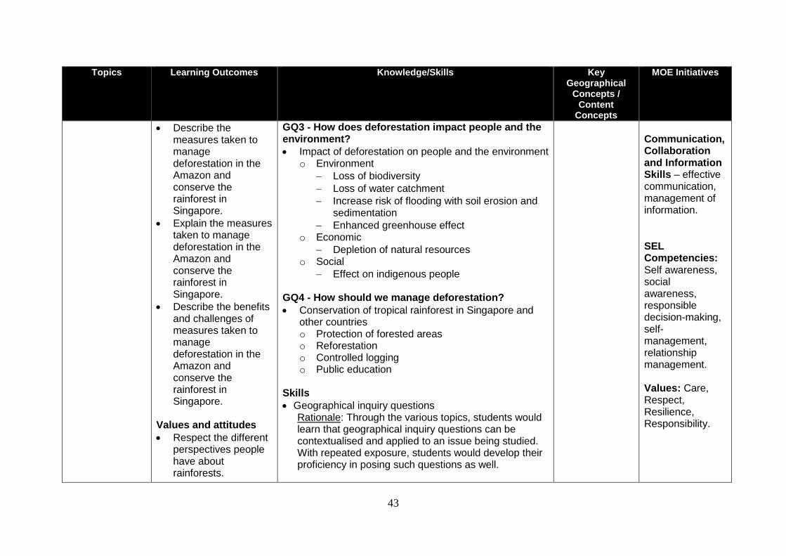
43
Topics Learning Outcomes Knowledge/Skills Key Geographical
Concepts / Content
Concepts
MOE Initiatives
Describe the measures taken to manage deforestation in the Amazon and conserve the rainforest in Singapore.
Explain the measures taken to manage deforestation in the Amazon and conserve the rainforest in Singapore.
Describe the benefits and challenges of measures taken to manage deforestation in the Amazon and conserve the rainforest in Singapore.
Values and attitudes
Respect the different perspectives people have about rainforests.
GQ3 - How does deforestation impact people and the environment?
Impact of deforestation on people and the environment o Environment
Loss of biodiversity
Loss of water catchment
Increase risk of flooding with soil erosion and sedimentation
Enhanced greenhouse effect o Economic
Depletion of natural resources o Social
Effect on indigenous people
GQ4 - How should we manage deforestation?
Conservation of tropical rainforest in Singapore and other countries o Protection of forested areas o Reforestation o Controlled logging o Public education
Skills
Geographical inquiry questions Rationale: Through the various topics, students would learn that geographical inquiry questions can be contextualised and applied to an issue being studied. With repeated exposure, students would develop their proficiency in posing such questions as well.
Communication, Collaboration and Information Skills – effective communication, management of information. SEL Competencies: Self awareness, social awareness, responsible decision-making, self- management, relationship management. Values: Care, Respect, Resilience, Responsibility.
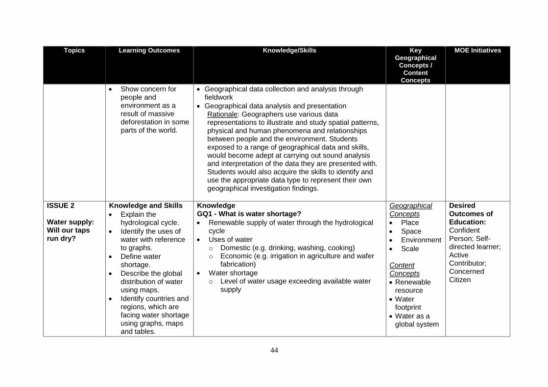
44
Topics Learning Outcomes Knowledge/Skills Key Geographical
Concepts / Content
Concepts
MOE Initiatives
Show concern for people and environment as a result of massive deforestation in some parts of the world.
Geographical data collection and analysis through fieldwork
Geographical data analysis and presentation Rationale: Geographers use various data representations to illustrate and study spatial patterns, physical and human phenomena and relationships between people and the environment. Students exposed to a range of geographical data and skills, would become adept at carrying out sound analysis and interpretation of the data they are presented with. Students would also acquire the skills to identify and use the appropriate data type to represent their own geographical investigation findings.
ISSUE 2 Water supply: Will our taps run dry?
Knowledge and Skills
Explain the hydrological cycle.
Identify the uses of water with reference to graphs.
Define water shortage.
Describe the global distribution of water using maps.
Identify countries and regions, which are facing water shortage using graphs, maps and tables.
Knowledge GQ1 - What is water shortage? Renewable supply of water through the hydrological
cycle
Uses of water o Domestic (e.g. drinking, washing, cooking) o Economic (e.g. irrigation in agriculture and wafer
fabrication)
Water shortage o Level of water usage exceeding available water
supply
Geographical Concepts
Place
Space
Environment
Scale Content Concepts
Renewable resource
Water footprint
Water as a global system
Desired Outcomes of Education: Confident Person; Self-directed learner; Active Contributor; Concerned Citizen
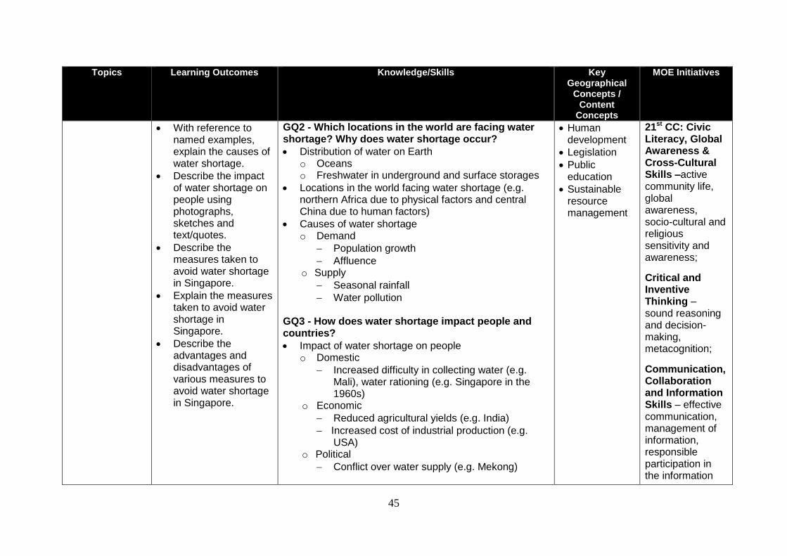
45
Topics Learning Outcomes Knowledge/Skills Key Geographical
Concepts / Content
Concepts
MOE Initiatives
With reference to named examples, explain the causes of water shortage.
Describe the impact of water shortage on people using photographs, sketches and text/quotes.
Describe the measures taken to avoid water shortage in Singapore.
Explain the measures taken to avoid water shortage in Singapore.
Describe the advantages and disadvantages of various measures to avoid water shortage in Singapore.
GQ2 - Which locations in the world are facing water shortage? Why does water shortage occur?
Distribution of water on Earth o Oceans o Freshwater in underground and surface storages
Locations in the world facing water shortage (e.g. northern Africa due to physical factors and central China due to human factors)
Causes of water shortage o Demand
Population growth
Affluence o Supply
Seasonal rainfall
Water pollution
GQ3 - How does water shortage impact people and countries?
Impact of water shortage on people o Domestic
Increased difficulty in collecting water (e.g. Mali), water rationing (e.g. Singapore in the 1960s)
o Economic
Reduced agricultural yields (e.g. India)
Increased cost of industrial production (e.g. USA)
o Political
Conflict over water supply (e.g. Mekong)
Human development
Legislation
Public education
Sustainable resource management
21st CC: Civic Literacy, Global Awareness & Cross-Cultural Skills –active community life, global awareness, socio-cultural and religious sensitivity and awareness;
Critical and Inventive Thinking – sound reasoning and decision-making, metacognition;
Communication, Collaboration and Information Skills – effective communication, management of information, responsible participation in the information
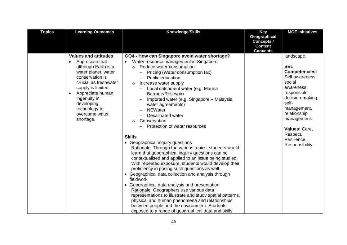
46
Topics Learning Outcomes Knowledge/Skills Key Geographical
Concepts / Content
Concepts
MOE Initiatives
Values and attitudes
Appreciate that although Earth is a water planet, water conservation is crucial as freshwater supply is limited.
Appreciate human ingenuity in developing technology to overcome water shortage.
GQ4 - How can Singapore avoid water shortage?
Water resource management in Singapore o Reduce water consumption
Pricing (Water consumption tax)
Public education o Increase water supply
Local catchment water (e.g. Marina Barrage/Resevoir)
Imported water (e.g. Singapore – Malaysia water agreements)
NEWater
Desalinated water o Conservation
Protection of water resources Skills
Geographical inquiry questions Rationale: Through the various topics, students would learn that geographical inquiry questions can be contextualised and applied to an issue being studied. With repeated exposure, students would develop their proficiency in posing such questions as well.
Geographical data collection and analysis through fieldwork
Geographical data analysis and presentation Rationale: Geographers use various data representations to illustrate and study spatial patterns, physical and human phenomena and relationships between people and the environment. Students exposed to a range of geographical data and skills
landscape. SEL Competencies: Self awareness, social awareness, responsible decision-making, self- management, relationship management. Values: Care, Respect, Resilience, Responsibility.
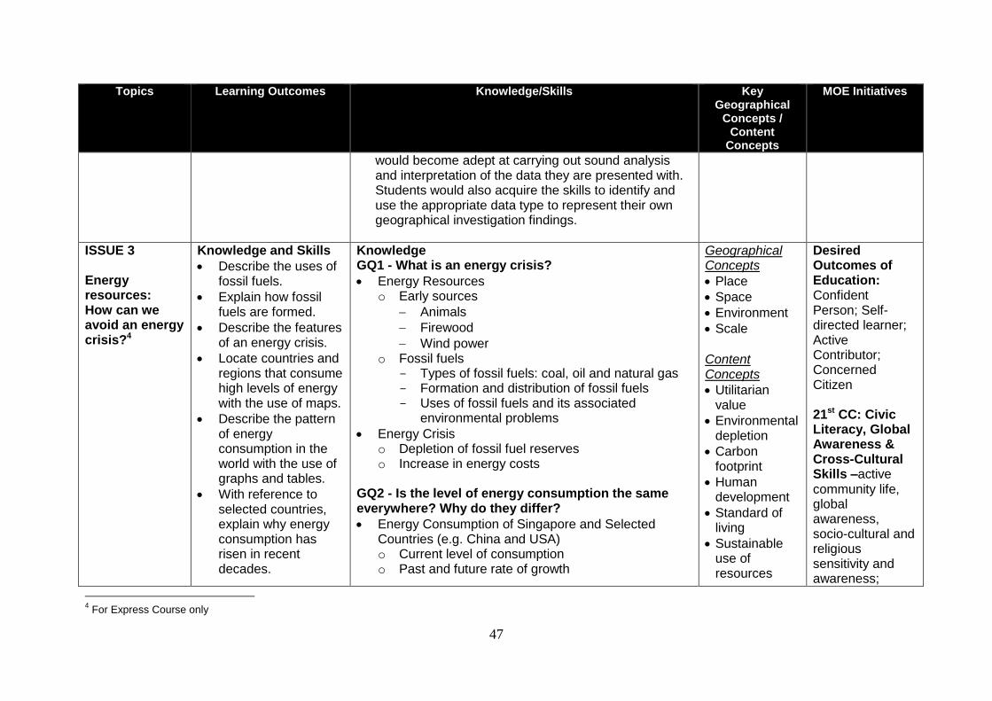
47
Topics Learning Outcomes Knowledge/Skills Key Geographical
Concepts / Content
Concepts
MOE Initiatives
would become adept at carrying out sound analysis and interpretation of the data they are presented with. Students would also acquire the skills to identify and use the appropriate data type to represent their own geographical investigation findings.
ISSUE 3 Energy resources: How can we avoid an energy crisis?4
Knowledge and Skills
Describe the uses of fossil fuels.
Explain how fossil fuels are formed.
Describe the features of an energy crisis.
Locate countries and regions that consume high levels of energy with the use of maps.
Describe the pattern of energy consumption in the world with the use of graphs and tables.
With reference to selected countries, explain why energy consumption has risen in recent decades.
Knowledge GQ1 - What is an energy crisis?
Energy Resources o Early sources
Animals
Firewood
Wind power o Fossil fuels
- Types of fossil fuels: coal, oil and natural gas - Formation and distribution of fossil fuels - Uses of fossil fuels and its associated
environmental problems
Energy Crisis o Depletion of fossil fuel reserves o Increase in energy costs
GQ2 - Is the level of energy consumption the same everywhere? Why do they differ?
Energy Consumption of Singapore and Selected Countries (e.g. China and USA) o Current level of consumption o Past and future rate of growth
Geographical Concepts
Place
Space
Environment
Scale Content Concepts Utilitarian
value
Environmental depletion
Carbon footprint
Human development
Standard of living
Sustainable use of resources
Desired Outcomes of Education: Confident Person; Self-directed learner; Active Contributor; Concerned Citizen 21st CC: Civic Literacy, Global Awareness & Cross-Cultural Skills –active community life, global awareness, socio-cultural and religious sensitivity and awareness;
4 For Express Course only
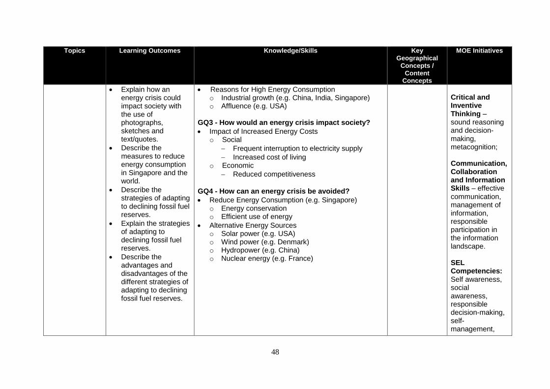
48
Topics Learning Outcomes Knowledge/Skills Key Geographical
Concepts / Content
Concepts
MOE Initiatives
Explain how an energy crisis could impact society with the use of photographs, sketches and text/quotes.
Describe the measures to reduce energy consumption in Singapore and the world.
Describe the strategies of adapting to declining fossil fuel reserves.
Explain the strategies of adapting to declining fossil fuel reserves.
Describe the advantages and disadvantages of the different strategies of adapting to declining fossil fuel reserves.
Reasons for High Energy Consumption o Industrial growth (e.g. China, India, Singapore) o Affluence (e.g. USA)
GQ3 - How would an energy crisis impact society?
Impact of Increased Energy Costs o Social
Frequent interruption to electricity supply
Increased cost of living o Economic
Reduced competitiveness
GQ4 - How can an energy crisis be avoided?
Reduce Energy Consumption (e.g. Singapore) o Energy conservation o Efficient use of energy
Alternative Energy Sources o Solar power (e.g. USA) o Wind power (e.g. Denmark) o Hydropower (e.g. China) o Nuclear energy (e.g. France)
Critical and Inventive Thinking – sound reasoning and decision-making, metacognition; Communication, Collaboration and Information Skills – effective communication, management of information, responsible participation in the information landscape. SEL Competencies: Self awareness, social awareness, responsible decision-making, self- management,
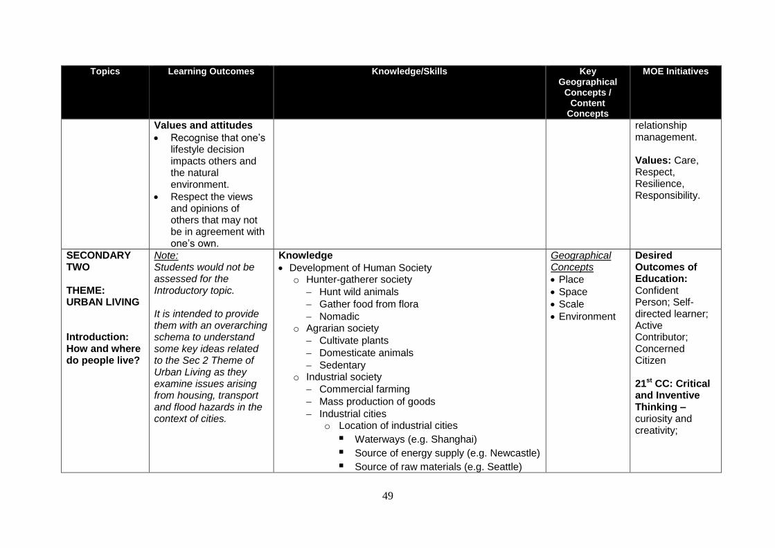
49
Topics Learning Outcomes Knowledge/Skills Key Geographical
Concepts / Content
Concepts
MOE Initiatives
Values and attitudes
Recognise that one’s lifestyle decision impacts others and the natural environment.
Respect the views and opinions of others that may not be in agreement with one’s own.
relationship management. Values: Care, Respect, Resilience, Responsibility.
SECONDARY TWO THEME: URBAN LIVING Introduction: How and where do people live?
Note: Students would not be assessed for the Introductory topic. It is intended to provide them with an overarching schema to understand some key ideas related to the Sec 2 Theme of Urban Living as they examine issues arising from housing, transport and flood hazards in the context of cities.
Knowledge
Development of Human Society o Hunter-gatherer society
Hunt wild animals
Gather food from flora
Nomadic o Agrarian society
Cultivate plants
Domesticate animals
Sedentary o Industrial society
Commercial farming
Mass production of goods
Industrial cities o Location of industrial cities
Waterways (e.g. Shanghai)
Source of energy supply (e.g. Newcastle)
Source of raw materials (e.g. Seattle)
Geographical Concepts
Place
Space
Scale
Environment
Desired Outcomes of Education: Confident Person; Self-directed learner; Active Contributor; Concerned Citizen 21st CC: Critical and Inventive Thinking –curiosity and creativity;
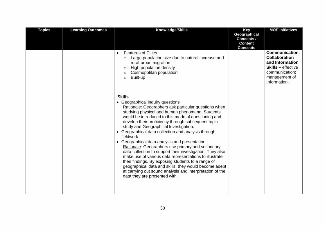
50
Topics Learning Outcomes Knowledge/Skills Key Geographical
Concepts / Content
Concepts
MOE Initiatives
Features of Cities o Large population size due to natural increase and
rural-urban migration o High population density o Cosmopolitan population o Built-up
Skills
Geographical inquiry questions Rationale: Geographers ask particular questions when studying physical and human phenomena. Students would be introduced to this mode of questioning and develop their proficiency through subsequent topic study and Geographical Investigation.
Geographical data collection and analysis through fieldwork
Geographical data analysis and presentation Rationale: Geographers use primary and secondary data collection to support their investigation. They also make use of various data representations to illustrate their findings. By exposing students to a range of geographical data and skills, they would become adept at carrying out sound analysis and interpretation of the data they are presented with.
Communication, Collaboration and Information Skills – effective communication; management of Information.
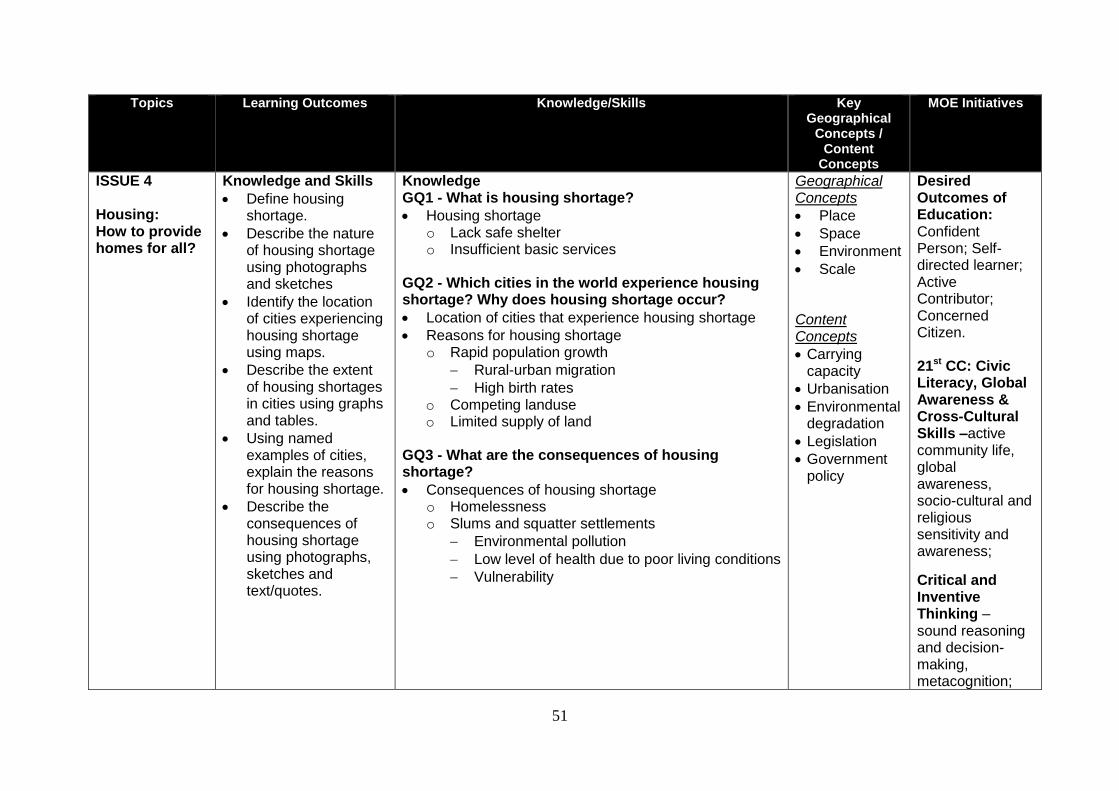
51
Topics Learning Outcomes Knowledge/Skills Key Geographical
Concepts / Content
Concepts
MOE Initiatives
ISSUE 4 Housing: How to provide homes for all?
Knowledge and Skills
Define housing shortage.
Describe the nature of housing shortage using photographs and sketches
Identify the location of cities experiencing housing shortage using maps.
Describe the extent of housing shortages in cities using graphs and tables.
Using named examples of cities, explain the reasons for housing shortage.
Describe the consequences of housing shortage using photographs, sketches and text/quotes.
Knowledge GQ1 - What is housing shortage?
Housing shortage o Lack safe shelter o Insufficient basic services
GQ2 - Which cities in the world experience housing shortage? Why does housing shortage occur?
Location of cities that experience housing shortage
Reasons for housing shortage o Rapid population growth
Rural-urban migration
High birth rates o Competing landuse o Limited supply of land
GQ3 - What are the consequences of housing shortage?
Consequences of housing shortage o Homelessness o Slums and squatter settlements
Environmental pollution
Low level of health due to poor living conditions
Vulnerability
Geographical Concepts
Place
Space
Environment
Scale
Content Concepts
Carrying capacity
Urbanisation
Environmental degradation
Legislation
Government policy
Desired Outcomes of Education: Confident Person; Self-directed learner; Active Contributor; Concerned Citizen. 21st CC: Civic Literacy, Global Awareness & Cross-Cultural Skills –active community life, global awareness, socio-cultural and religious sensitivity and awareness;
Critical and Inventive Thinking – sound reasoning and decision-making, metacognition;
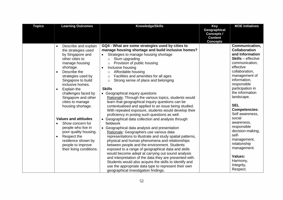
52
Topics Learning Outcomes Knowledge/Skills Key Geographical
Concepts / Content
Concepts
MOE Initiatives
Describe and explain the strategies used by Singapore and other cities to manage housing shortage.
Describe the strategies used by Singapore to build inclusive homes.
Explain the challenges faced by Singapore and other cities to manage housing shortage.
Values and attitudes
Show concern for people who live in poor quality housing.
Respect the resilience shown by people to improve their living conditions.
GQ4 - What are some strategies used by cities to manage housing shortage and build inclusive homes?
Strategies to manage housing shortage o Slum upgrading o Provision of public housing
Inclusive housing o Affordable housing o Facilities and amenities for all ages o Strong sense of place and belonging
Skills
Geographical inquiry questions Rationale: Through the various topics, students would learn that geographical inquiry questions can be contextualised and applied to an issue being studied. With repeated exposure, students would develop their proficiency in posing such questions as well.
Geographical data collection and analysis through fieldwork
Geographical data analysis and presentation Rationale: Geographers use various data representations to illustrate and study spatial patterns, physical and human phenomena and relationships between people and the environment. Students exposed to a range of geographical data and skills would become adept at carrying out sound analysis and interpretation of the data they are presented with. Students would also acquire the skills to identify and use the appropriate data type to represent their own geographical investigation findings.
Communication, Collaboration and Information Skills – effective communication, effective collaboration, management of information, responsible participation in the information landscape. SEL Competencies: Self awareness, social awareness, responsible decision-making, self- management, relationship management. Values: Harmony, Integrity, Respect.

53
Topics Learning Outcomes Knowledge/Skills Key Geographical
Concepts / Content
Concepts
MOE Initiatives
ISSUE 5 Transport: How do we keep people moving?5
Knowledge and skills
Describe the characteristics of urban transport using photographs and sketches.
Define traffic congestion.
Describe the distribution of traffic congestion in the city using maps.
With reference to Singapore and named examples, explain the causes of traffic congestion in the city.
Describe the impact of traffic congestion on people and the environment using graphs, tables and text/quotes.
Knowledge GQ1 - What is traffic congestion?
Characteristics of urban transport: o Variety of transport modes o Density of transport network o Quality of transport infrastructure
Traffic congestion o A situation where there are more vehicles than
the road can handle o Characterised by slower speeds, longer trip times,
and increased vehicular queue
Q2 - Where is traffic congestion found in the city and why does it occur?
Concentration of traffic congestion in the city
Causes of traffic congestion in Singapore and other cities o Separation of work and residential areas o Movement from one part of the city to another to
obtain or provide goods and services. o Inadequate transport infrastructure and poor
provision of transport services
Geographical Concepts
Place
Space
Environment
Scale Content Concepts
Carrying capacity
Urbanisation
Landuse planning
Connectivity
Accessibility
Environmental degradation
Quality of Life
Legislation
Government policy
Desired Outcomes of Education: Confident Person; Self-directed learner; Active Contributor; Concerned Citizen. 21st CC: Civic Literacy, Global Awareness & Cross-Cultural Skills –active community life, global awareness, socio-cultural and religious sensitivity and awareness; Critical and Inventive Thinking – sound reasoning and decision-
5 For Express Course only
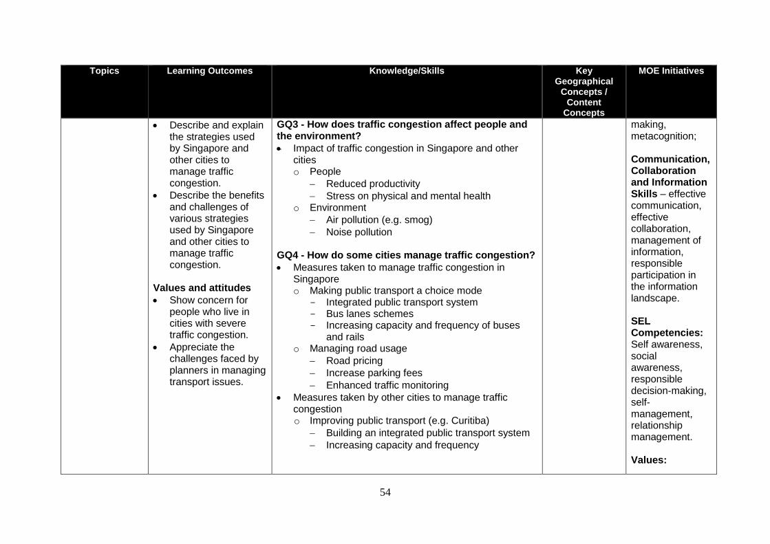
54
Topics Learning Outcomes Knowledge/Skills Key Geographical
Concepts / Content
Concepts
MOE Initiatives
Describe and explain the strategies used by Singapore and other cities to manage traffic congestion.
Describe the benefits and challenges of various strategies used by Singapore and other cities to manage traffic congestion.
Values and attitudes
Show concern for people who live in cities with severe traffic congestion.
Appreciate the challenges faced by planners in managing transport issues.
GQ3 - How does traffic congestion affect people and the environment?
Impact of traffic congestion in Singapore and other cities o People
Reduced productivity
Stress on physical and mental health o Environment
Air pollution (e.g. smog)
Noise pollution
GQ4 - How do some cities manage traffic congestion?
Measures taken to manage traffic congestion in Singapore o Making public transport a choice mode
- Integrated public transport system - Bus lanes schemes - Increasing capacity and frequency of buses
and rails o Managing road usage
Road pricing
Increase parking fees
Enhanced traffic monitoring
Measures taken by other cities to manage traffic congestion o Improving public transport (e.g. Curitiba)
Building an integrated public transport system
Increasing capacity and frequency
making, metacognition; Communication, Collaboration and Information Skills – effective communication, effective collaboration, management of information, responsible participation in the information landscape. SEL Competencies: Self awareness, social awareness, responsible decision-making, self- management, relationship management. Values:
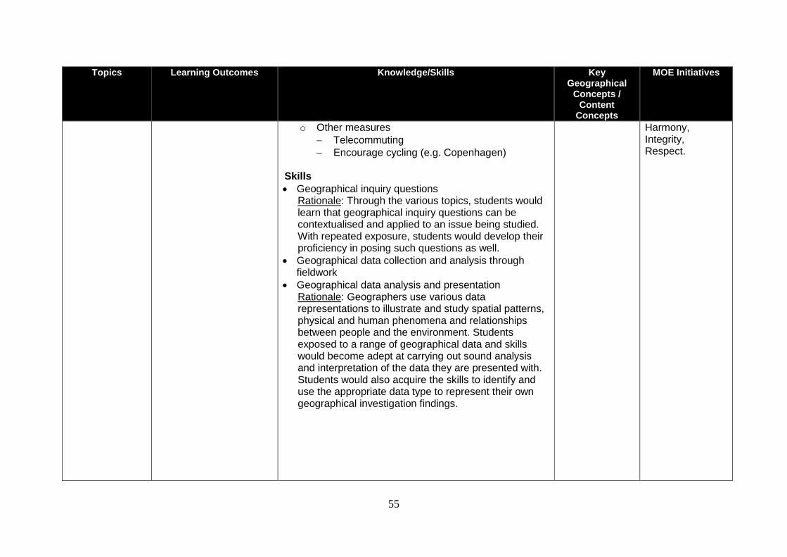
55
Topics Learning Outcomes Knowledge/Skills Key Geographical
Concepts / Content
Concepts
MOE Initiatives
o Other measures
Telecommuting
Encourage cycling (e.g. Copenhagen) Skills
Geographical inquiry questions Rationale: Through the various topics, students would learn that geographical inquiry questions can be contextualised and applied to an issue being studied. With repeated exposure, students would develop their proficiency in posing such questions as well.
Geographical data collection and analysis through fieldwork
Geographical data analysis and presentation Rationale: Geographers use various data representations to illustrate and study spatial patterns, physical and human phenomena and relationships between people and the environment. Students exposed to a range of geographical data and skills would become adept at carrying out sound analysis and interpretation of the data they are presented with. Students would also acquire the skills to identify and use the appropriate data type to represent their own geographical investigation findings.
Harmony, Integrity, Respect.
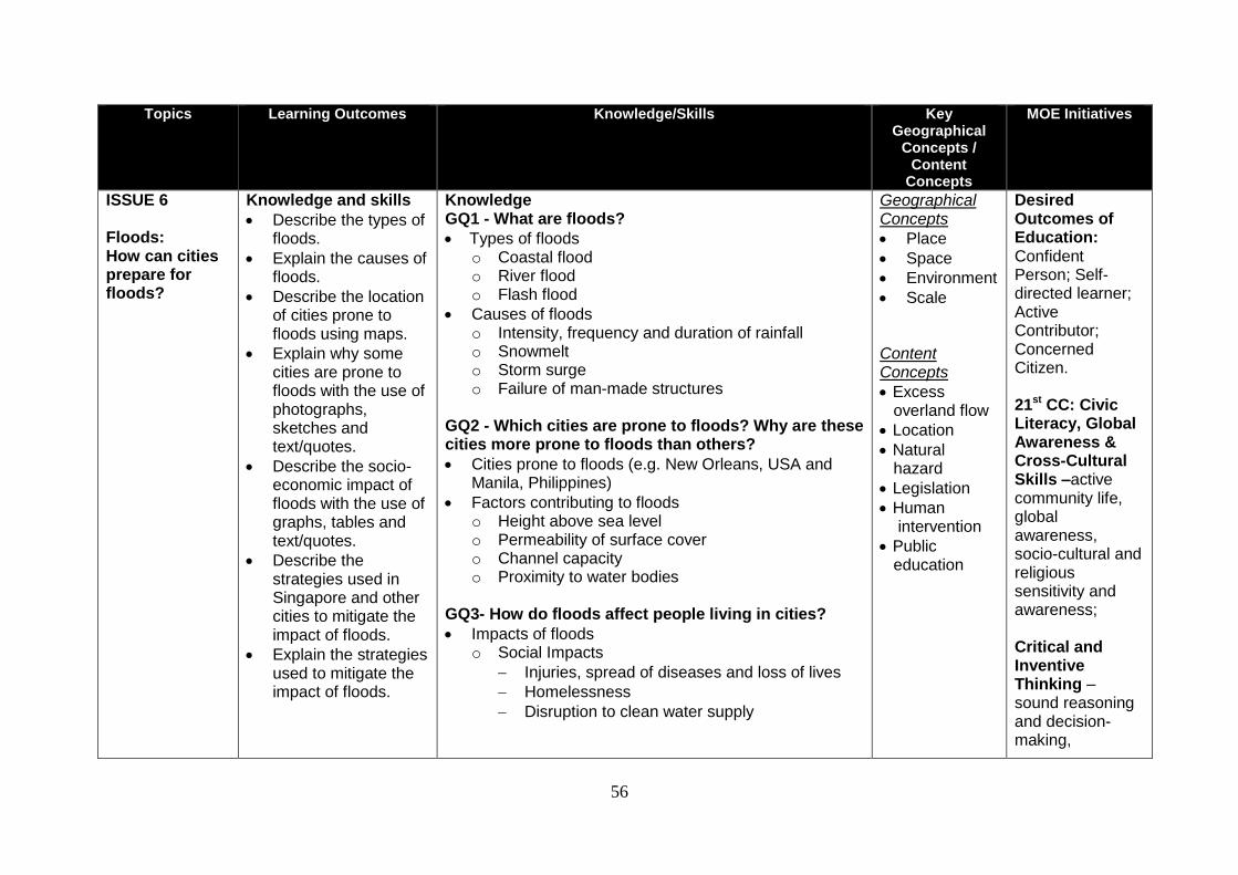
56
Topics Learning Outcomes Knowledge/Skills Key Geographical
Concepts / Content
Concepts
MOE Initiatives
ISSUE 6 Floods: How can cities prepare for floods?
Knowledge and skills
Describe the types of floods.
Explain the causes of floods.
Describe the location of cities prone to floods using maps.
Explain why some cities are prone to floods with the use of photographs, sketches and text/quotes.
Describe the socio-economic impact of floods with the use of graphs, tables and text/quotes.
Describe the strategies used in Singapore and other cities to mitigate the impact of floods.
Explain the strategies used to mitigate the impact of floods.
Knowledge GQ1 - What are floods?
Types of floods o Coastal flood o River flood o Flash flood
Causes of floods o Intensity, frequency and duration of rainfall o Snowmelt o Storm surge o Failure of man-made structures
GQ2 - Which cities are prone to floods? Why are these cities more prone to floods than others?
Cities prone to floods (e.g. New Orleans, USA and Manila, Philippines)
Factors contributing to floods o Height above sea level o Permeability of surface cover o Channel capacity o Proximity to water bodies
GQ3- How do floods affect people living in cities?
Impacts of floods o Social Impacts
Injuries, spread of diseases and loss of lives
Homelessness
Disruption to clean water supply
Geographical Concepts
Place
Space
Environment
Scale
Content Concepts
Excess overland flow
Location
Natural hazard
Legislation
Human intervention
Public education
Desired Outcomes of Education: Confident Person; Self-directed learner; Active Contributor; Concerned Citizen. 21st CC: Civic Literacy, Global Awareness & Cross-Cultural Skills –active community life, global awareness, socio-cultural and religious sensitivity and awareness; Critical and Inventive Thinking – sound reasoning and decision-making,
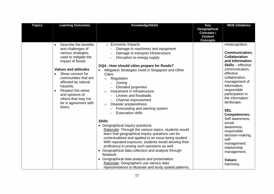
57
Topics Learning Outcomes Knowledge/Skills Key Geographical
Concepts / Content
Concepts
MOE Initiatives
Describe the benefits and challenges of various strategies used to mitigate the impact of floods.
Values and attitudes
Show concern for communities that are affected by natural hazards.
Respect the views and opinions of others that may not be in agreement with theirs.
o Economic Impacts
Damage to machinery and equipment
Damage to transport infrastructure
Disruption to energy supply GQ4 - How should cities prepare for floods?
Mitigation Strategies Used in Singapore and Other Cities o Regulation
Zoning
Elevated properties o Investment in Infrastructure
Levees and floodwalls
Channel improvement o Disaster preparedness
Forecasting and warning system
Evacuation drills Skills
Geographical inquiry questions Rationale: Through the various topics, students would learn that geographical inquiry questions can be contextualised and applied to an issue being studied. With repeated exposure, students would develop their proficiency in posing such questions as well.
Geographical data collection and analysis through fieldwork
Geographical data analysis and presentation Rationale: Geographers use various data representations to illustrate and study spatial patterns,
metacognition; Communication, Collaboration and Information Skills – effective communication, effective collaboration, management of information, responsible participation in the information landscape. SEL Competencies: Self awareness, social awareness, responsible decision-making, self- management, relationship management. Values: Harmony,
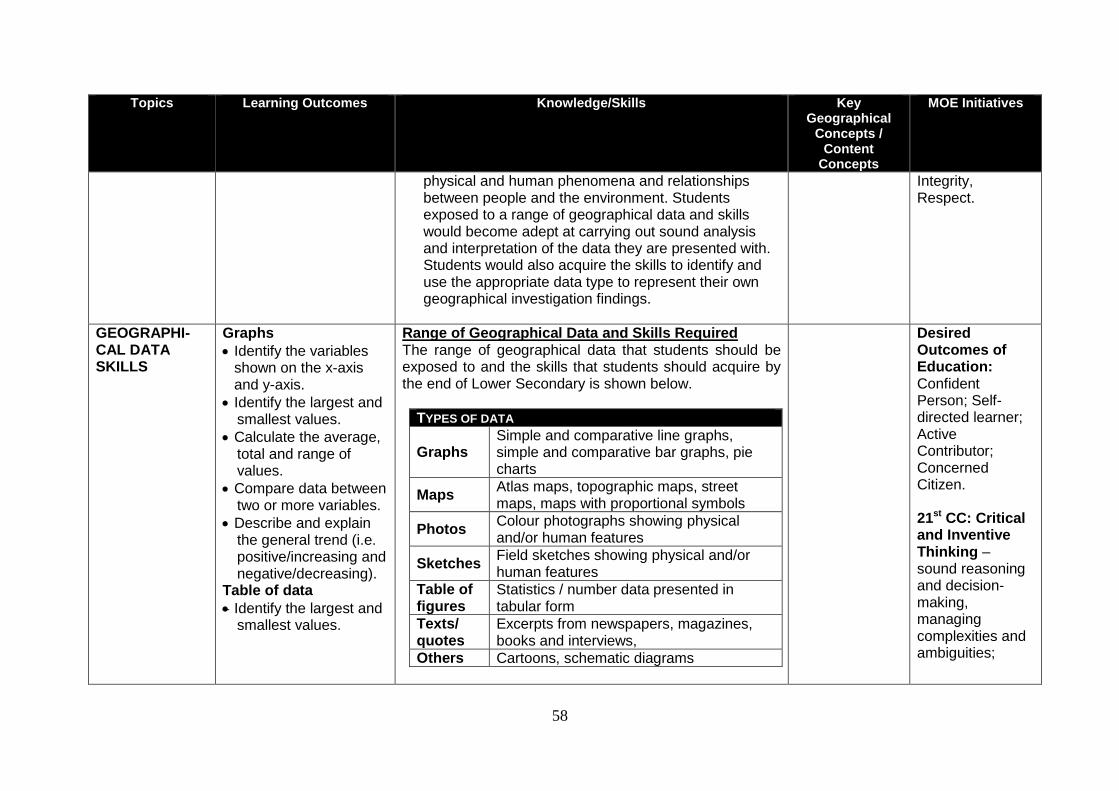
58
Topics Learning Outcomes Knowledge/Skills Key Geographical
Concepts / Content
Concepts
MOE Initiatives
physical and human phenomena and relationships between people and the environment. Students exposed to a range of geographical data and skills would become adept at carrying out sound analysis and interpretation of the data they are presented with. Students would also acquire the skills to identify and use the appropriate data type to represent their own geographical investigation findings.
Integrity, Respect.
GEOGRAPHI-CAL DATA SKILLS
Graphs
Identify the variables shown on the x-axis and y-axis.
Identify the largest and smallest values.
Calculate the average, total and range of values.
Compare data between two or more variables.
Describe and explain the general trend (i.e. positive/increasing and negative/decreasing).
Table of data
Identify the largest and smallest values.
Range of Geographical Data and Skills Required The range of geographical data that students should be exposed to and the skills that students should acquire by the end of Lower Secondary is shown below.
TYPES OF DATA
Graphs Simple and comparative line graphs, simple and comparative bar graphs, pie charts
Maps Atlas maps, topographic maps, street maps, maps with proportional symbols
Photos Colour photographs showing physical and/or human features
Sketches Field sketches showing physical and/or human features
Table of figures
Statistics / number data presented in tabular form
Texts/ quotes
Excerpts from newspapers, magazines, books and interviews,
Others Cartoons, schematic diagrams
Desired Outcomes of Education: Confident Person; Self-directed learner; Active Contributor; Concerned Citizen. 21st CC: Critical and Inventive Thinking – sound reasoning and decision-making, managing complexities and ambiguities;
59
Topics Learning Outcomes Knowledge/Skills Key Geographical
Concepts / Content
Concepts
MOE Initiatives
Calculate the average, total and range of values.
Describe and explain the general trend (i.e. positive/increasing and negative/decreasing).
Maps
Locate places (such as continents, oceans, countries and cities) and physical features (such as regions of tropical rainforest).
Use o latitude and
longitude, o cardinal points (i.e.
North, South, East, West),
o compass bearings, o four-digit and six-
digit grid references, and
o symbols in a legend to locate and describe features on maps.
Providing Iterative Learning Experiences It is expected that learning experiences be provided for students to develop the necessary geographical data skills throughout all topics in the proposed syllabuses in an iterative manner. This means that for example, opportunities to practice the identification of the continents on a world map should be provided repeatedly in more than one topic, where it is relevant and appropriate. Skills
Geographical data analysis and presentation Rationale: Geographers use various data representations to illustrate and study spatial patterns, physical and human phenomena and relationships between people and the environment. Students exposed to a range of geographical data and skills would become adept at carrying out sound analysis and interpretation of the data they are presented with. Students would also acquire the skills to identify and use the appropriate data type to represent their own geographical investigation findings.
Communication, Collaboration and Information Skills – effective collaboration, management of information, responsible participation in the information landscape.
60
Topics Learning Outcomes Knowledge/Skills Key Geographical
Concepts / Content
Concepts
MOE Initiatives
Measure straight-line distance using a scale (i.e. line/linear and statement).
Interpret information presented in maps.
Photographs and Sketches
Identify and describe the feature(s) shown, using the terms foreground, middleground and background.
Label or annotate the features shown.
Text/Quotes
Describe and explain the issue being presented in the text or quote.
61
Topics Learning Outcomes Knowledge/Skills Key Geographical
Concepts / Content
Concepts
MOE Initiatives
GEOGRAPHI-CAL INVESTIGA-TIONS
Knowledge
Explain how human activities (e.g. by individuals, non-governmental organisations and government agencies) can affect a nature reserve/park.
Describe the ways we (e.g. individuals, non-governmental organisations and government agencies) can conserve a nature reserve/park.
Geographical Investigation 1: How do human activities affect our nature reserve/park? How can we conserve our nature reserve/park? The aims of this geographical investigation are to: 1. explain how human activities (e.g. by individuals,
non-governmental organisations and government agencies) can affect a nature reserve/park; and
2. suggest ways we (e.g. individuals, non-governmental organisations and government agencies) can conserve a nature reserve/park.
Geographical Concepts
Place
Space
Environment
Scale
Desired Outcomes of Education:
Confident Person; Self-directed learner; Active Contributor; Concerned Citizen. 21
st CC: Civic
Literacy, Global Awareness & Cross-Cultural Skills –active community life, global awareness, socio-cultural and religious asensitivity and awareness; Critical and Inventive Thinking – sound reasoning and decision-making, metacognition; Communication, Collaboration and Information Skills – effective communication, effective collaboration, management of information, responsible participation in the information landscape.
SEL Competencies: Self awareness, social awareness, responsible
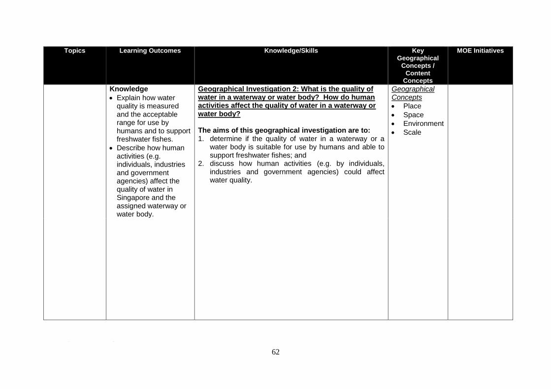
62
Topics Learning Outcomes Knowledge/Skills Key Geographical
Concepts / Content
Concepts
MOE Initiatives
Knowledge
Explain how water quality is measured and the acceptable range for use by humans and to support freshwater fishes.
Describe how human activities (e.g. individuals, industries and government agencies) affect the quality of water in Singapore and the assigned waterway or water body.
Geographical Investigation 2: What is the quality of water in a waterway or water body? How do human activities affect the quality of water in a waterway or water body? The aims of this geographical investigation are to: 1. determine if the quality of water in a waterway or a
water body is suitable for use by humans and able to support freshwater fishes; and
2. discuss how human activities (e.g. by individuals, industries and government agencies) could affect water quality.
Geographical Concepts
Place
Space
Environment
Scale
Knowledge Describe how human activities and attitudes (e.g. values/ awareness of students, teaching staff and non-teaching staff) affect the energy consumption of a school.
Geographical Investigation 3: How do human activities and attitudes affect the energy consumption of a school? How can we reduce our school’s energy consumption?6
The aims of this geographical investigation are to: 1. determine the areas of high/low energy consumption
in a school; and
2. discuss how human activities and attitudes affect a school’s energy consumption and suggest ideas to reduce it.
Geographical Concepts
Place
Space
Environment
Scale
6 For Express Course only
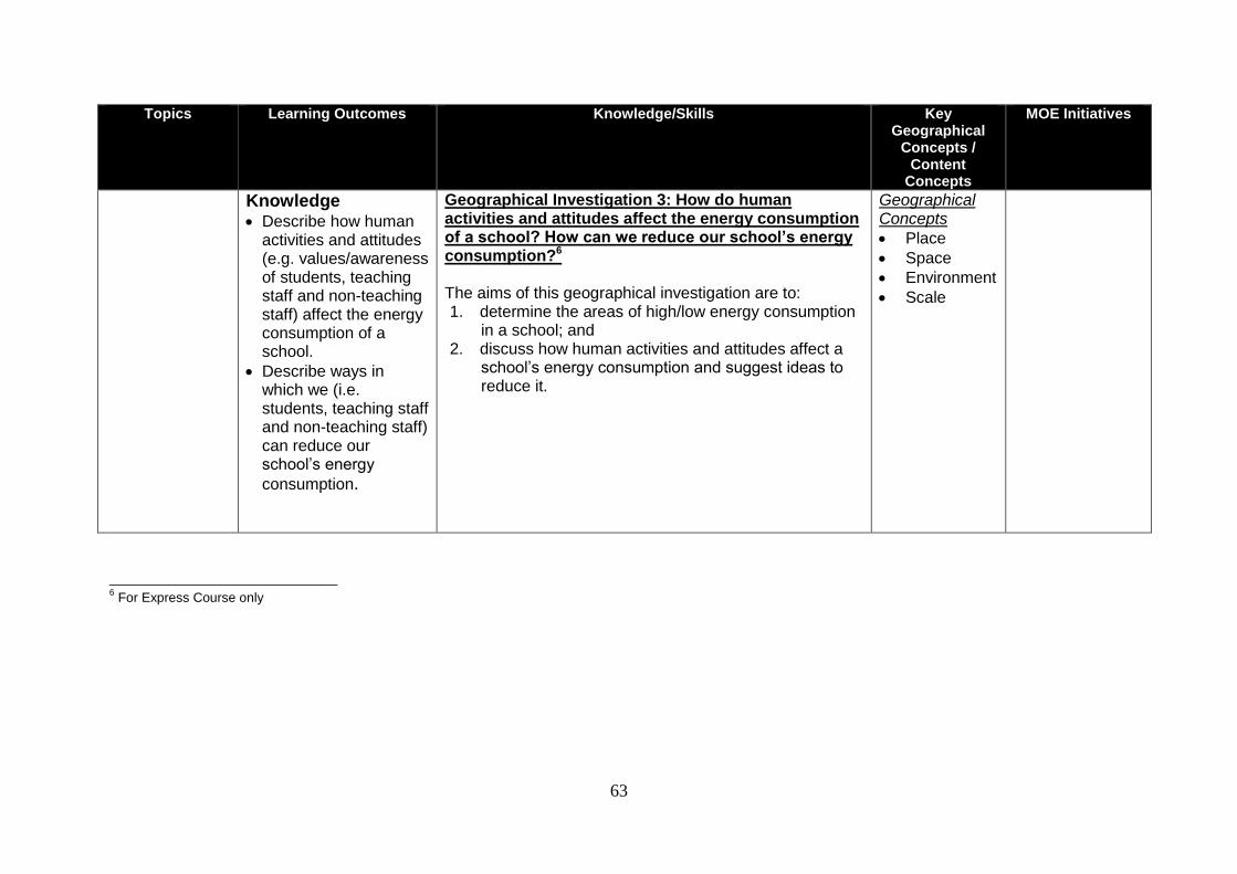
63
Topics Learning Outcomes Knowledge/Skills Key Geographical
Concepts / Content
Concepts
MOE Initiatives
Knowledge Describe how human
activities and attitudes (e.g. values/awareness of students, teaching staff and non-teaching staff) affect the energy consumption of a school.
Describe ways in which we (i.e. students, teaching staff and non-teaching staff) can reduce our school’s energy
consumption.
Geographical Investigation 3: How do human activities and attitudes affect the energy consumption of a school? How can we reduce our school’s energy consumption?6
The aims of this geographical investigation are to: 1. determine the areas of high/low energy consumption
in a school; and 2. discuss how human activities and attitudes affect a
school’s energy consumption and suggest ideas to reduce it.
Geographical Concepts
Place
Space
Environment
Scale
_______________________________ 6 For Express Course only
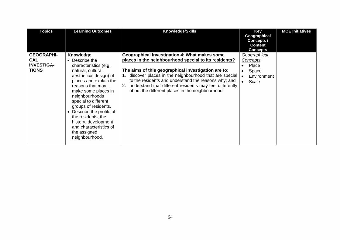
64
Topics Learning Outcomes Knowledge/Skills Key Geographical
Concepts / Content
Concepts
MOE Initiatives
GEOGRAPHI-CAL INVESTIGA-TIONS
Knowledge
Describe the characteristics (e.g. natural, cultural, aesthetical design) of places and explain the reasons that may make some places in neighbourhoods special to different groups of residents.
Describe the profile of the residents, the history, development and characteristics of the assigned neighbourhood.
Geographical Investigation 4: What makes some places in the neighbourhood special to its residents? The aims of this geographical investigation are to: 1. discover places in the neighbourhood that are special
to the residents and understand the reasons why; and 2. understand that different residents may feel differently
about the different places in the neighbourhood.
Geographical Concepts
Place
Space
Environment
Scale
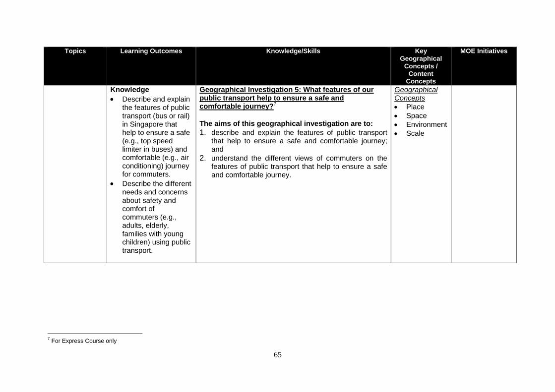
65
Topics Learning Outcomes Knowledge/Skills Key Geographical
Concepts / Content
Concepts
MOE Initiatives
Knowledge
Describe and explain the features of public transport (bus or rail) in Singapore that help to ensure a safe (e.g., top speed limiter in buses) and comfortable (e.g., air conditioning) journey for commuters.
Describe the different needs and concerns about safety and comfort of commuters (e.g., adults, elderly, families with young children) using public transport.
Geographical Investigation 5: What features of our public transport help to ensure a safe and comfortable journey?7
The aims of this geographical investigation are to: 1. describe and explain the features of public transport
that help to ensure a safe and comfortable journey; and
2. understand the different views of commuters on the features of public transport that help to ensure a safe and comfortable journey.
Geographical Concepts
Place
Space
Environment
Scale
7 For Express Course only
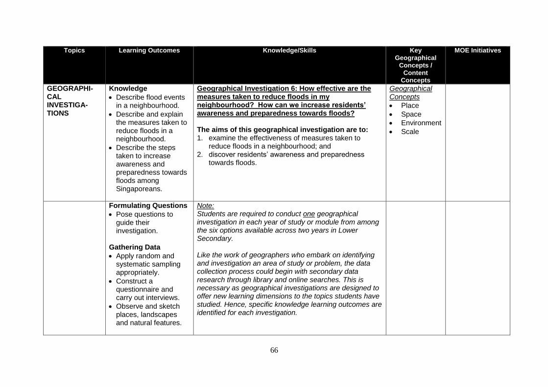
66
Topics Learning Outcomes Knowledge/Skills Key Geographical
Concepts / Content
Concepts
MOE Initiatives
GEOGRAPHI-CAL INVESTIGA-TIONS
Knowledge
Describe flood events in a neighbourhood.
Describe and explain the measures taken to reduce floods in a neighbourhood.
Describe the steps taken to increase awareness and preparedness towards floods among Singaporeans.
Geographical Investigation 6: How effective are the measures taken to reduce floods in my neighbourhood? How can we increase residents’ awareness and preparedness towards floods? The aims of this geographical investigation are to: 1. examine the effectiveness of measures taken to
reduce floods in a neighbourhood; and 2. discover residents’ awareness and preparedness
towards floods.
Geographical Concepts
Place
Space
Environment
Scale
Formulating Questions
Pose questions to guide their investigation.
Gathering Data
Apply random and systematic sampling appropriately.
Construct a questionnaire and carry out interviews.
Observe and sketch places, landscapes and natural features.
Note: Students are required to conduct one geographical investigation in each year of study or module from among the six options available across two years in Lower Secondary. Like the work of geographers who embark on identifying and investigation an area of study or problem, the data collection process could begin with secondary data research through library and online searches. This is necessary as geographical investigations are designed to offer new learning dimensions to the topics students have studied. Hence, specific knowledge learning outcomes are identified for each investigation.
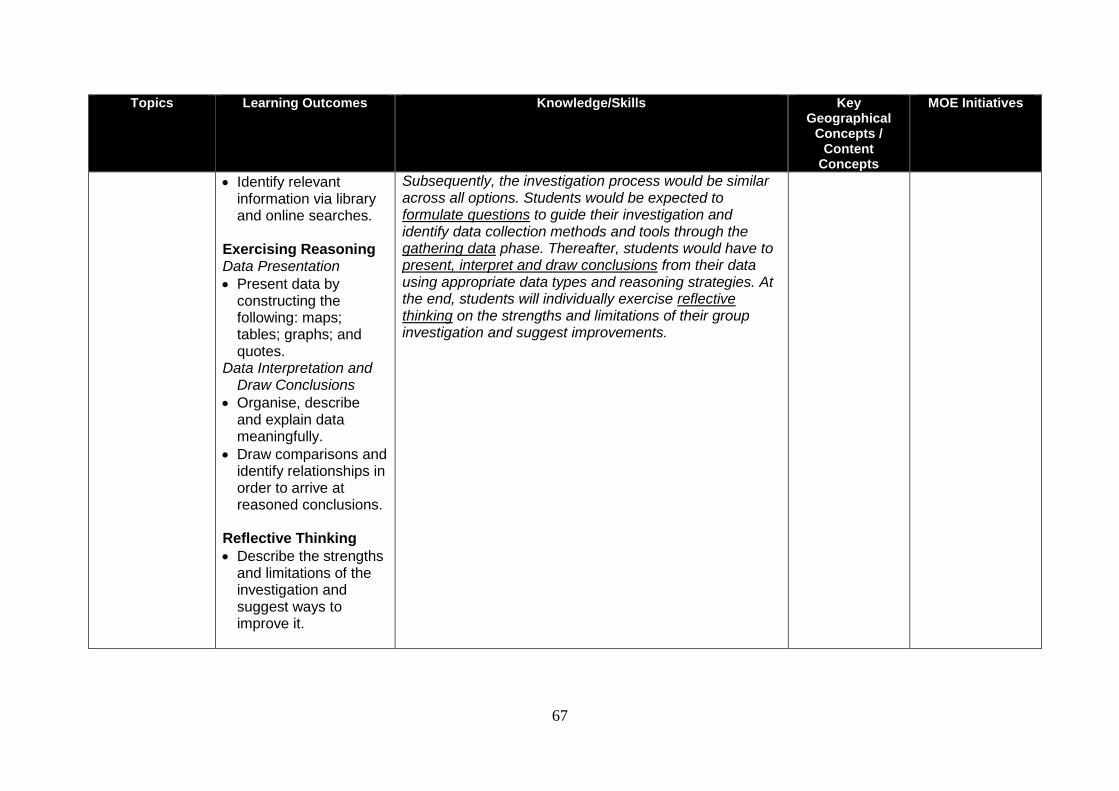
67
Topics Learning Outcomes Knowledge/Skills Key Geographical
Concepts / Content
Concepts
MOE Initiatives
Identify relevant information via library and online searches.
Exercising Reasoning Data Presentation
Present data by constructing the following: maps; tables; graphs; and quotes.
Data Interpretation and Draw Conclusions
Organise, describe and explain data meaningfully.
Draw comparisons and identify relationships in order to arrive at reasoned conclusions.
Reflective Thinking
Describe the strengths and limitations of the investigation and suggest ways to improve it.
Subsequently, the investigation process would be similar across all options. Students would be expected to formulate questions to guide their investigation and identify data collection methods and tools through the gathering data phase. Thereafter, students would have to present, interpret and draw conclusions from their data using appropriate data types and reasoning strategies. At the end, students will individually exercise reflective thinking on the strengths and limitations of their group investigation and suggest improvements.
0
SECTION 6: ASSESSMENT
68
ASSESSMENT
PURPOSE OF ASSESSMENT
Assessment for the new Lower Secondary Geography Syllabus will include Assessment for
Learning and Assessment of Learning. These forms of assessment play an integral role
in the teaching and learning of Geography. The purpose of assessment must be understood
beyond the context of examinations. Assessment for learning takes place during teaching
and aims to help students improve their learning. It provides teachers with information on
students’ progress and valuable feedback on the effectiveness of their lessons. Teachers
can use the information gained to scaffold students’ learning to ensure progression.
Assessment for learning can also help students to develop positive habits of reflection and
independent learning through peer and self-assessment.
In contrast, Assessment of learning typically takes place at the end of a unit or term. It plays
a critical role in assessing students’ knowledge and understanding of the subject. It yields
information on mastery and attainment and provides a means to determine the ability of
students to progress to the next level. Both Assessments for and of Learning aim to facilitate
meaningful learning in Geography where the learning process is developmentally
appropriate and caters to students’ varied needs and helps them acquire 21st Century
Competencies. Beyond this, assessment should also reflect the experiences we want
students to have in the study of Geography that mirrors real life scenarios. This will enable
students to appreciate the relevance of what they have learnt (content, skills and
geographical understanding) and be able to apply these in their daily lives now and in the
future.
ASSESSMENT OBJECTIVES
In the Lower Secondary Geography syllabuses, the geographical knowledge and skills to be
assessed are defined in the Assessment Objectives (AOs). These AOs are as follows:
AO1: Knowledge
Students should be able to:
demonstrate relevant factual knowledge – geographical facts, concepts, processes,
interactions and trends;
demonstrate knowledge of geographical inquiry process (formulating questions,
gathering data, exercising reasoning and reflective thinking).
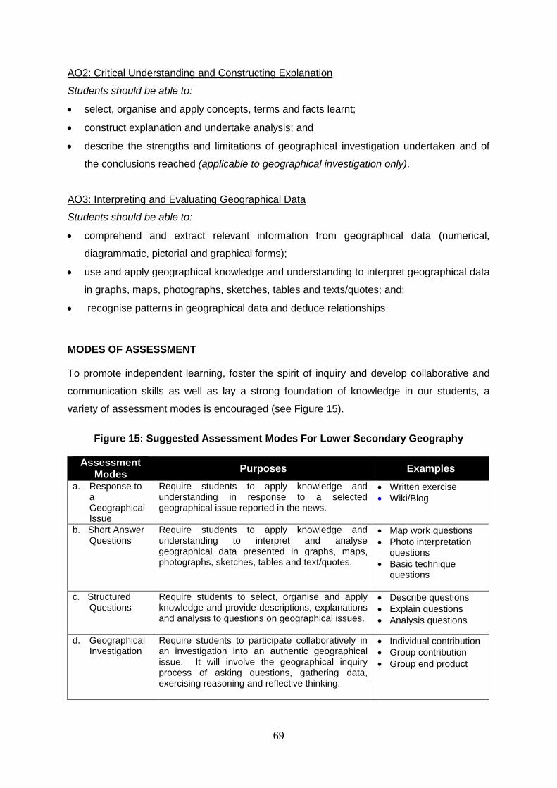
69
AO2: Critical Understanding and Constructing Explanation
Students should be able to:
select, organise and apply concepts, terms and facts learnt;
construct explanation and undertake analysis; and
describe the strengths and limitations of geographical investigation undertaken and of
the conclusions reached (applicable to geographical investigation only).
AO3: Interpreting and Evaluating Geographical Data
Students should be able to:
comprehend and extract relevant information from geographical data (numerical,
diagrammatic, pictorial and graphical forms);
use and apply geographical knowledge and understanding to interpret geographical data
in graphs, maps, photographs, sketches, tables and texts/quotes; and:
recognise patterns in geographical data and deduce relationships
MODES OF ASSESSMENT To promote independent learning, foster the spirit of inquiry and develop collaborative and
communication skills as well as lay a strong foundation of knowledge in our students, a
variety of assessment modes is encouraged (see Figure 15).
Figure 15: Suggested Assessment Modes For Lower Secondary Geography
Assessment Modes
Purposes Examples
a. Response to a Geographical Issue
Require students to apply knowledge and understanding in response to a selected geographical issue reported in the news.
Written exercise
Wiki/Blog
b. Short Answer Questions
Require students to apply knowledge and understanding to interpret and analyse geographical data presented in graphs, maps, photographs, sketches, tables and text/quotes.
Map work questions
Photo interpretation questions
Basic technique questions
c. Structured Questions
Require students to select, organise and apply knowledge and provide descriptions, explanations and analysis to questions on geographical issues.
Describe questions
Explain questions
Analysis questions
d. Geographical Investigation
Require students to participate collaboratively in an investigation into an authentic geographical issue. It will involve the geographical inquiry process of asking questions, gathering data, exercising reasoning and reflective thinking.
Individual contribution
Group contribution
Group end product
70
ASSESSMENT SPECIFICATION GRID
The assessment specification grid for the 2014 Lower Secondary Geography syllabuses
consists of Response to a Geographical Issue, Short Answer Questions, Structured
Questions and the Geographical Investigation (GI) task. All these assessment modes are
assessed regularly over a period of time. Students are therefore assessed at regular
junctures of their learning process rather than only at the end. These assessment modes
contribute to form the overall results for each module or academic year.
The assessment consists of two Response to a Geographical Issue tasks (2 x 10 marks),
two End-of-Issue Tests (2 x 25 marks) and a Geographical Investigation which will be
explained later. The Response to a Geographical Issue task will enable students to apply
what they have learned in their geography lessons to support their personal opinion about a
geographical issue with reasons and examples. Annex D shows an example of a Response
to a Geographical Issue task and the associated rubric. The End-of-Issue Test of 50 minutes
duration, will consist of 10 Short Answer Questions (10 marks) and one Structured Question
(15 marks). The Short Answer Questions will test knowledge and skills of map work, map
reading, photograph interpretation and basic techniques. Students would need to use the
resources provided to answer the Short Answer Questions. In contrast, the structured
question will focus on description and explanation and to some extent analysis of
geographical issues. There is no differentiation between Express and Normal (Academic)
Courses in the Short Answer Questions. However, differentiation between the two courses is
present in the structured questions. For the Express Course, each structured question has
no more than 4 parts and the highest mark for one part is 5 marks. In contrast, each
structured question in the Normal (Academic) Course has no more than 5 parts and the
highest mark for one part is 4 marks. Details of the suggested assessment specification grid
without examination are shown in Figure 16 while the Table of Specifications for Express
Course and Normal (Academic) Course are shown in Annexes E and F respectively.
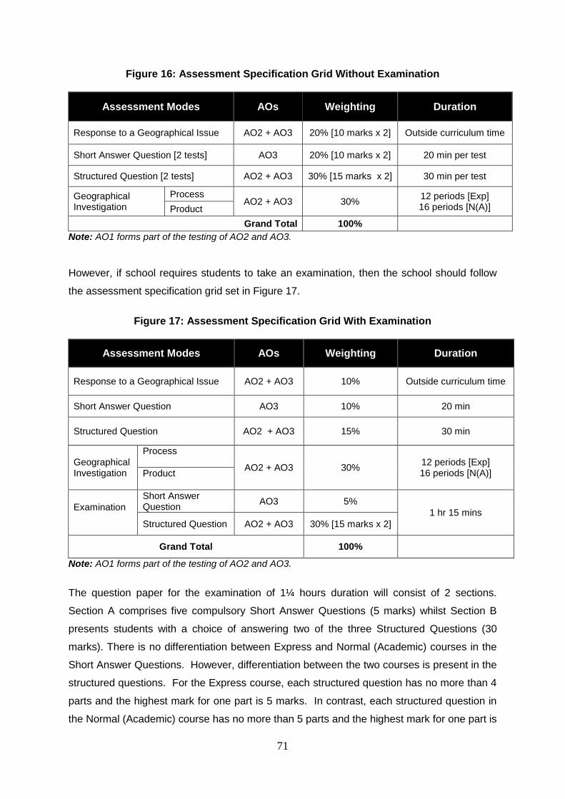
71
Figure 16: Assessment Specification Grid Without Examination
Assessment Modes AOs Weighting Duration
Response to a Geographical Issue AO2 + AO3 20% [10 marks x 2] Outside curriculum time
Short Answer Question [2 tests] AO3 20% [10 marks x 2] 20 min per test
Structured Question [2 tests] AO2 + AO3 30% [15 marks x 2] 30 min per test
Geographical Investigation
Process AO2 + AO3 30%
12 periods [Exp] 16 periods [N(A)] Product
Grand Total 100%
Note: AO1 forms part of the testing of AO2 and AO3.
However, if school requires students to take an examination, then the school should follow
the assessment specification grid set in Figure 17.
Figure 17: Assessment Specification Grid With Examination
Assessment Modes AOs Weighting Duration
Response to a Geographical Issue AO2 + AO3 10% Outside curriculum time
Short Answer Question AO3 10% 20 min
Structured Question AO2 + AO3 15% 30 min
Geographical Investigation
Process
AO2 + AO3 30% 12 periods [Exp] 16 periods [N(A)] Product
Examination
Short Answer Question
AO3 5%
1 hr 15 mins
Structured Question AO2 + AO3 30% [15 marks x 2]
Grand Total 100%
Note: AO1 forms part of the testing of AO2 and AO3.
The question paper for the examination of 1¼ hours duration will consist of 2 sections.
Section A comprises five compulsory Short Answer Questions (5 marks) whilst Section B
presents students with a choice of answering two of the three Structured Questions (30
marks). There is no differentiation between Express and Normal (Academic) courses in the
Short Answer Questions. However, differentiation between the two courses is present in the
structured questions. For the Express course, each structured question has no more than 4
parts and the highest mark for one part is 5 marks. In contrast, each structured question in
the Normal (Academic) course has no more than 5 parts and the highest mark for one part is
72
4 marks. For details of the different assessment components in the examination, please
refer to the Table of Specifications for Express and Normal (Academic) courses in Annexes
E and F respectively.
Additional Information on Response to a Geographical Issue
Each exercise on Response to a Geographical Issue (see Annex D) will involve a response
to a current issue in the news based on any topic in the syllabus. Such an exercise
comprises an article of 150-200 words focusing on a geographical issue from a newspaper.
It will give students an opportunity to further develop 21st Century Competencies whilst
helping them to appreciate the relevance of Geography in the real world. After reading the
article, students have to write a summary of 75-100 words. To ensure that the summary has
a geographical slant, students have to use a question frame in geography (e.g. Core
Questions in Geography) to pose questions. With the aid of these questions, students will
gather and select the necessary content to produce a summary. Besides the summary,
students have to demonstrate knowledge of places through mapwork. With the aid of atlases
or Google maps, students have to locate 1-2 places/continents mentioned in the article.
Finally, students will write a personal response of 50-80 words on the geographical issue.
They will apply what they have learned about the issue in their geography lessons and
support their opinion with reasons and examples. In writing their personal response,
students will be provided with a few pointers to consider.
Assessment of Geographical Investigation
The GI is worth 30% in the overall results for the year. It is completed over a period of time
and includes assessment of both process and product. Each GI presents new learning
dimensions of the issue. It provides scope to assess a wider range of geographical skills as
students are provided with the opportunity to develop 21st Century Competencies in working
as a group in primary and secondary data collection and analysis. There are individual as
well as group components to be submitted for grading and the group end product serves to
consolidate learning. Finally, there is also the individual reflection which students have to
complete which draws heavily from the insights they gained from the analysis of class data.
Details of the suggested assessment format for GI are shown in Figure 18.
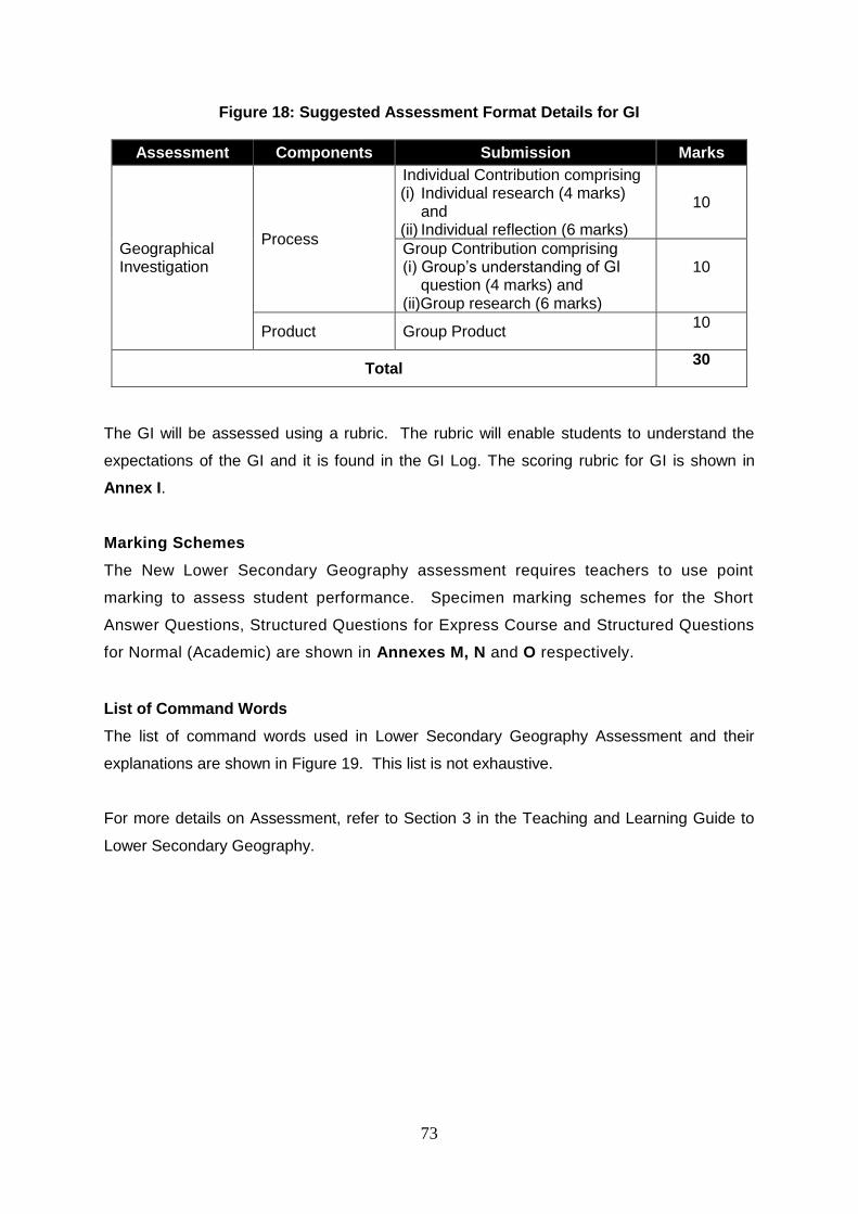
73
Figure 18: Suggested Assessment Format Details for GI
Assessment Components Submission Marks
Geographical Investigation
Process
Individual Contribution comprising (i) Individual research (4 marks)
and (ii) Individual reflection (6 marks)
10
Group Contribution comprising (i) Group’s understanding of GI question (4 marks) and (ii)Group research (6 marks)
10
Product Group Product 10
Total 30
The GI will be assessed using a rubric. The rubric will enable students to understand the
expectations of the GI and it is found in the GI Log. The scoring rubric for GI is shown in
Annex I.
Marking Schemes
The New Lower Secondary Geography assessment requires teachers to use point
marking to assess student performance. Specimen marking schemes for the Short
Answer Questions, Structured Questions for Express Course and Structured Questions
for Normal (Academic) are shown in Annexes M, N and O respectively.
List of Command Words
The list of command words used in Lower Secondary Geography Assessment and their
explanations are shown in Figure 19. This list is not exhaustive.
For more details on Assessment, refer to Section 3 in the Teaching and Learning Guide to
Lower Secondary Geography.
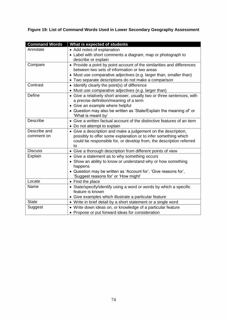
74
Figure 19: List of Command Words Used in Lower Secondary Geography Assessment
Command Words What is expected of students
Annotate Add notes of explanation
Label with short comments a diagram, map or photograph to describe or explain
Compare Provide a point by point account of the similarities and differences between two sets of information or two areas
Must use comparative adjectives (e.g. larger than, smaller than)
Two separate descriptions do not make a comparison
Contrast Identify clearly the point(s) of difference
Must use comparative adjectives (e.g. larger than)
Define Give a relatively short answer, usually two or three sentences, with a precise definition/meaning of a term
Give an example where helpful
Question may also be written as ‘State/Explain the meaning of’ or ‘What is meant by’
Describe Give a written factual account of the distinctive features of an item
Do not attempt to explain
Describe and comment on
Give a description and make a judgement on the description, possibly to offer some explanation or to infer something which could be responsible for, or develop from, the description referred to
Discuss Give a thorough description from different points of view
Explain Give a statement as to why something occurs
Show an ability to know or understand why or how something happens
Question may be written as ‘Account for’, ‘Give reasons for’, ‘Suggest reasons for’ or ‘How might’
Locate Find the place
Name State/specify/identify using a word or words by which a specific feature is known
Give examples which illustrate a particular feature
State Write in brief detail by a short statement or a single word
Suggest Write down ideas on, or knowledge of a particular feature
Propose or put forward ideas for consideration
0
SECTION 7: TABLES OF SPECIFICATIONS, SPECIMEN QUESTIONS & MARKING SCHEMES
75
Annex D
Response to a Geographical Issue
Imagine that you are a writer working on a school publication and are required to write a response to a geographical issue that had recently taken place. The issue is reported in the news article below.
Creating Ecological Links for Enhanced Biodiversity
Today, the Bukit Timah Expressway divides the Bukit Timah Nature Reserve and the Central Catchment Nature Reserve, preventing a healthy exchange of wildlife between the two reserves. The movement of plant and animal species is necessary for the long-term sustainability of biodiversity in the nature reserves, in particular the smaller Bukit Timah Nature Reserve. NParks has been studying various ways to bridge the two reserves and provide an ecological connection between them. We explored the options of building overhead or underground ecological links between the two reserves, as well as the possibilities of re-routing the BKE as a flyover or underpass. I am pleased to announce that NParks will be developing an Eco-Link across the BKE, in the form of an overhead bridge, to connect the Bukit Timah and Central Catchment Nature Reserves. With a width of 50-metres at its narrowest point, this hourglass-shaped bridge will be densely planted with vegetation to encourage animal crossings between the two nature reserves. Not only will the Eco-Link benefit the wildlife, people will also be able to enjoy extended hikes between the two nature reserves via trails on the new link. The first of its kind in Southeast Asia, this overhead Eco-Link affirms the Government's commitment to the long-term conservation of Singapore's biodiversity.
Adapted from a speech by Mr Mah Bow Tan, Minister for National Development at the opening of Dairy Farm Nature Park (5 Sep 2009).
In preparation for your work, you will need to do the following: a) Summary (3 marks) b) Mapwork (2 marks) c) Personal response(5 marks)
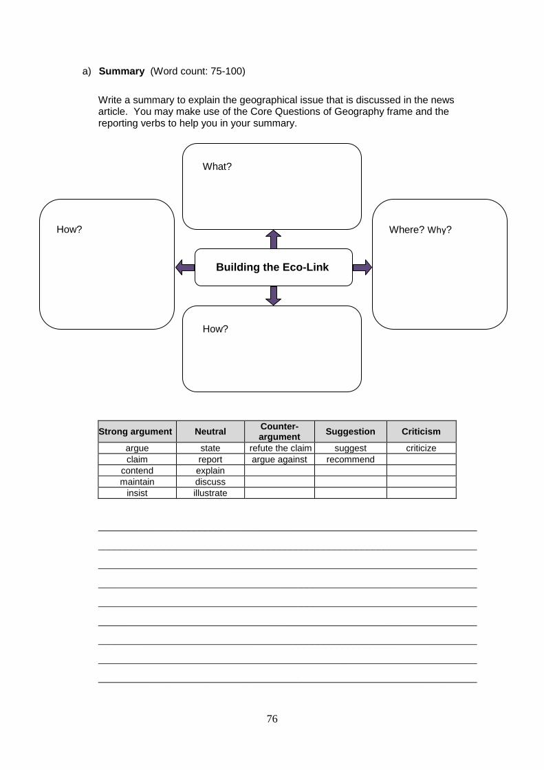
76
a) Summary (Word count: 75-100)
Write a summary to explain the geographical issue that is discussed in the news article. You may make use of the Core Questions of Geography frame and the reporting verbs to help you in your summary.
Strong argument Neutral Counter-argument
Suggestion Criticism
argue state refute the claim suggest criticize
claim report argue against recommend
contend explain
maintain discuss
insist illustrate
_____________________________________________________________________
_____________________________________________________________________
_____________________________________________________________________
_____________________________________________________________________
_____________________________________________________________________
_____________________________________________________________________
_____________________________________________________________________
_____________________________________________________________________
_____________________________________________________________________
What?
Where? Why?
How?
How?
Building the Eco-Link
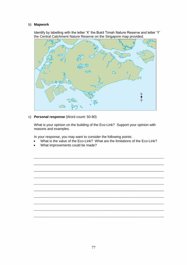
77
b) Mapwork Identify by labelling with the letter ‘X’ the Bukit Timah Nature Reserve and letter ‘Y’ the Central Catchment Nature Reserve on the Singapore map provided.
c) Personal response (Word count: 50-80) What is your opinion on the building of the Eco-Link? Support your opinion with reasons and examples.
In your response, you may want to consider the following points:
What is the value of the Eco-Link? What are the limitations of the Eco-Link?
What improvements could be made?
_____________________________________________________________________
_____________________________________________________________________
_____________________________________________________________________
_____________________________________________________________________
_____________________________________________________________________
_____________________________________________________________________
_____________________________________________________________________
_____________________________________________________________________
_____________________________________________________________________
_____________________________________________________________________
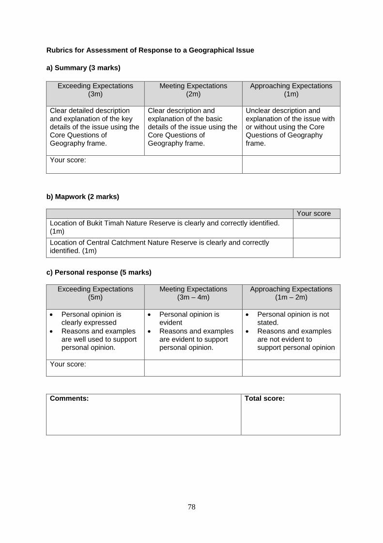
78
Rubrics for Assessment of Response to a Geographical Issue
a) Summary (3 marks)
Exceeding Expectations (3m)
Meeting Expectations (2m)
Approaching Expectations (1m)
Clear detailed description and explanation of the key details of the issue using the Core Questions of Geography frame.
Clear description and explanation of the basic details of the issue using the Core Questions of Geography frame.
Unclear description and explanation of the issue with or without using the Core Questions of Geography frame.
Your score:
b) Mapwork (2 marks)
Your score
Location of Bukit Timah Nature Reserve is clearly and correctly identified. (1m)
Location of Central Catchment Nature Reserve is clearly and correctly identified. (1m)
c) Personal response (5 marks)
Exceeding Expectations (5m)
Meeting Expectations (3m – 4m)
Approaching Expectations (1m – 2m)
Personal opinion is clearly expressed
Reasons and examples are well used to support personal opinion.
Personal opinion is evident
Reasons and examples are evident to support personal opinion.
Personal opinion is not stated.
Reasons and examples are not evident to support personal opinion
Your score:
Comments:
Total score:

79
Annex E
Table of Specifications for Test for Secondary One & Two Express Course
(Duration: 50 minutes)
Issue Short Answer Questions AO1+2 AO1+3
Se
cti
on
A (
10
ma
rks
)
Ten short answer questions on an issue.
Q1 (a) 1
Q1 (b) 1
Q1 (c) 1
Q2 (a) 1
Q2 (b) 1
Q2 (c) 1
Q3 (a) 1
Q3 (b) 1
Q3 (c) 1
Q3 (d) 1
Section A Total 10
Issue Structured Question with no more than 4 parts
AO1+2 AO1+3
Se
cti
on
B
(15
ma
rks
)
One structured question with no more than 4 parts is set based on an issue. The highest mark for one part is 5 marks.
Q4 (a) 3
Q4 (b) 3
Q4 (c) 4
Q4 (d) 5
Section B Total 12 3
Grand Total 12
13
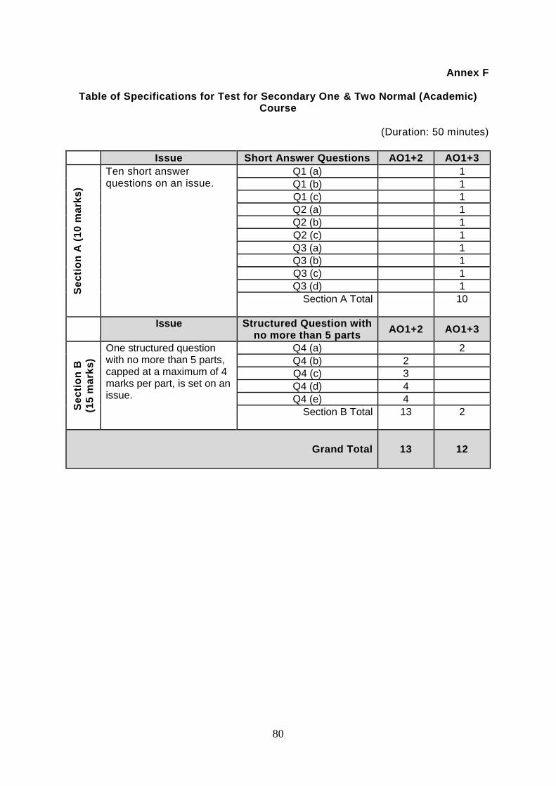
80
Annex F
Table of Specifications for Test for Secondary One & Two Normal (Academic) Course
(Duration: 50 minutes)
Issue Short Answer Questions AO1+2 AO1+3
Se
cti
on
A (
10
ma
rks
)
Ten short answer questions on an issue.
Q1 (a) 1
Q1 (b) 1
Q1 (c) 1
Q2 (a) 1
Q2 (b) 1
Q2 (c) 1
Q3 (a) 1
Q3 (b) 1
Q3 (c) 1
Q3 (d) 1
Section A Total
10
Issue Structured Question with no more than 5 parts
AO1+2 AO1+3
Se
cti
on
B
(15
ma
rks
)
One structured question with no more than 5 parts, capped at a maximum of 4 marks per part, is set on an issue.
Q4 (a) 2
Q4 (b) 2
Q4 (c) 3
Q4 (d) 4
Q4 (e) 4
Section B Total 13 2
Grand Total 13
12
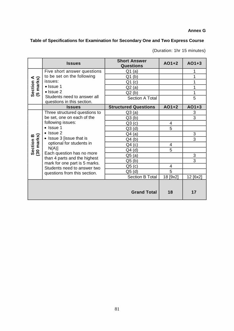
81
Annex G
Table of Specifications for Examination for Secondary One and Two Express Course
(Duration: 1hr 15 minutes)
Issues
Short Answer Questions
AO1+2 AO1+3
Se
cti
on
A
(5 m
ark
s)
Five short answer questions to be set on the following issues:
Issue 1
Issue 2 Students need to answer all questions in this section.
Q1 (a) 1
Q1 (b) 1
Q1 (c) 1
Q2 (a) 1
Q2 (b) 1
Section A Total 5
Issues Structured Questions AO1+2 AO1+3
Se
cti
on
B
(30
ma
rks
)
Three structured questions to be set, one on each of the following issues:
Issue 1
Issue 2
Issue 3 [issue that is optional for students in N(A)]
Each question has no more than 4 parts and the highest mark for one part is 5 marks. Students need to answer two questions from this section.
Q3 (a) 3
Q3 (b) 3
Q3 (c) 4
Q3 (d) 5
Q4 (a) 3
Q4 (b) 3
Q4 (c) 4
Q4 (d) 5
Q5 (a) 3
Q5 (b) 3
Q5 (c) 4
Q5 (d) 5
Section B Total 18 [9x2] 12 [6x2]
Grand Total
18
17
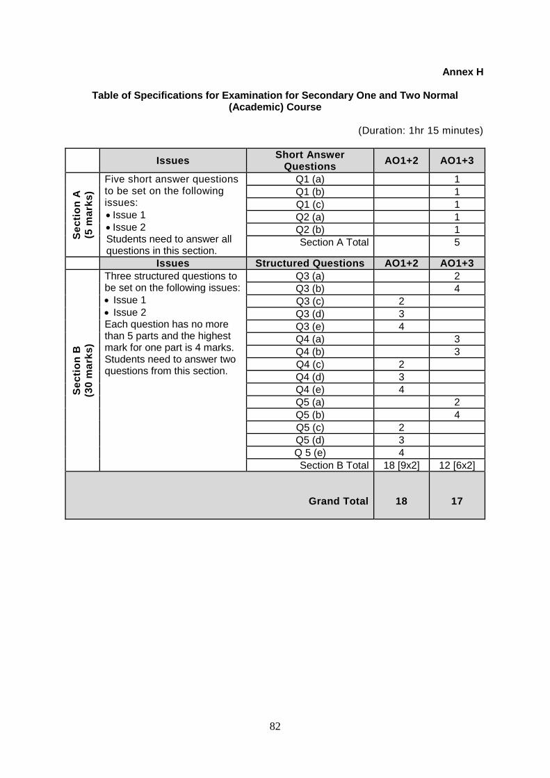
82
Annex H
Table of Specifications for Examination for Secondary One and Two Normal (Academic) Course
(Duration: 1hr 15 minutes)
Issues
Short Answer Questions
AO1+2 AO1+3
Se
cti
on
A
(5 m
ark
s)
Five short answer questions to be set on the following issues:
Issue 1
Issue 2 Students need to answer all questions in this section.
Q1 (a) 1
Q1 (b) 1
Q1 (c) 1
Q2 (a) 1
Q2 (b) 1
Section A Total 5
Issues Structured Questions AO1+2 AO1+3
Se
cti
on
B
(30
ma
rks
)
Three structured questions to be set on the following issues:
Issue 1
Issue 2 Each question has no more than 5 parts and the highest mark for one part is 4 marks. Students need to answer two questions from this section.
Q3 (a) 2
Q3 (b) 4
Q3 (c) 2
Q3 (d) 3
Q3 (e) 4
Q4 (a) 3
Q4 (b) 3
Q4 (c) 2
Q4 (d) 3
Q4 (e) 4
Q5 (a) 2
Q5 (b) 4
Q5 (c) 2
Q5 (d) 3
Q 5 (e) 4
Section B Total 18 [9x2] 12 [6x2]
Grand Total
18
17
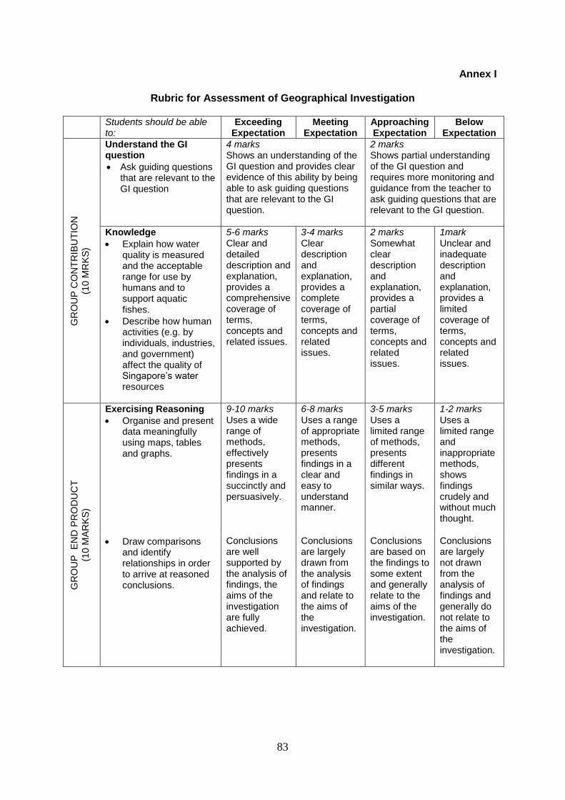
83
Annex I
Rubric for Assessment of Geographical Investigation
Students should be able to:
Exceeding Expectation
Meeting Expectation
Approaching Expectation
Below Expectation
GR
OU
P C
ON
TR
IBU
TIO
N
(10 M
RK
S)
Understand the GI question
Ask guiding questions that are relevant to the GI question
4 marks Shows an understanding of the GI question and provides clear evidence of this ability by being able to ask guiding questions that are relevant to the GI question.
2 marks Shows partial understanding of the GI question and requires more monitoring and guidance from the teacher to ask guiding questions that are relevant to the GI question.
Knowledge
Explain how water quality is measured and the acceptable range for use by humans and to support aquatic fishes.
Describe how human activities (e.g. by individuals, industries, and government) affect the quality of Singapore’s water resources
5-6 marks Clear and detailed description and explanation, provides a comprehensive coverage of terms, concepts and related issues.
3-4 marks Clear description and explanation, provides a complete coverage of terms, concepts and related issues.
2 marks Somewhat clear description and explanation, provides a partial coverage of terms, concepts and related issues.
1mark Unclear and inadequate description and explanation, provides a limited coverage of terms, concepts and related issues.
GR
OU
P
EN
D P
RO
DU
CT
(10 M
AR
KS
)
Exercising Reasoning
Organise and present data meaningfully using maps, tables and graphs.
9-10 marks
Uses a wide range of methods, effectively presents findings in a succinctly and persuasively.
6-8 marks
Uses a range of appropriate methods, presents findings in a clear and easy to understand manner.
3-5 marks
Uses a limited range of methods, presents different findings in similar ways.
1-2 marks
Uses a limited range and inappropriate methods, shows findings crudely and without much thought.
Draw comparisons and identify relationships in order to arrive at reasoned conclusions.
Conclusions are well supported by the analysis of findings, the aims of the investigation are fully achieved.
Conclusions are largely drawn from the analysis of findings and relate to the aims of the investigation.
Conclusions are based on the findings to some extent and generally relate to the aims of the investigation.
Conclusions are largely not drawn from the analysis of findings and generally do not relate to the aims of the investigation.
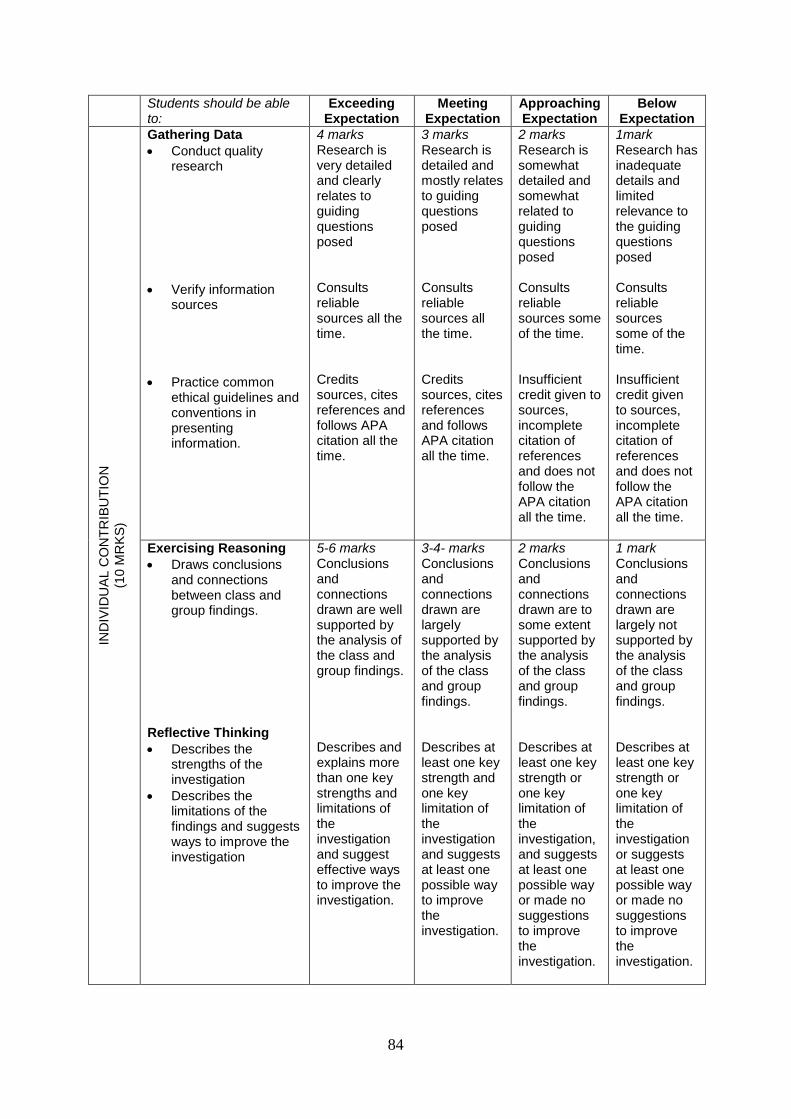
84
Students should be able to:
Exceeding Expectation
Meeting Expectation
Approaching Expectation
Below Expectation
IND
IVID
UA
L C
ON
TR
IBU
TIO
N
(10 M
RK
S)
Gathering Data
Conduct quality research
Verify information sources
Practice common ethical guidelines and conventions in presenting information.
4 marks Research is very detailed and clearly relates to guiding questions posed Consults reliable sources all the time. Credits sources, cites references and follows APA citation all the time.
3 marks Research is detailed and mostly relates to guiding questions posed Consults reliable sources all the time. Credits sources, cites references and follows APA citation all the time.
2 marks Research is somewhat detailed and somewhat related to guiding questions posed Consults reliable sources some of the time. Insufficient credit given to sources, incomplete citation of references and does not follow the APA citation all the time.
1mark Research has inadequate details and limited relevance to the guiding questions posed Consults reliable sources some of the time. Insufficient credit given to sources, incomplete citation of references and does not follow the APA citation all the time.
Exercising Reasoning
Draws conclusions and connections between class and group findings.
Reflective Thinking
Describes the strengths of the investigation
Describes the limitations of the findings and suggests ways to improve the investigation
5-6 marks Conclusions and connections drawn are well supported by the analysis of the class and group findings. Describes and explains more than one key strengths and limitations of the investigation and suggest effective ways to improve the investigation.
3-4- marks Conclusions and connections drawn are largely supported by the analysis of the class and group findings. Describes at least one key strength and one key limitation of the investigation and suggests at least one possible way to improve the investigation.
2 marks Conclusions and connections drawn are to some extent supported by the analysis of the class and group findings. Describes at least one key strength or one key limitation of the investigation, and suggests at least one possible way or made no suggestions to improve the investigation.
1 mark Conclusions and connections drawn are largely not supported by the analysis of the class and group findings. Describes at least one key strength or one key limitation of the investigation or suggests at least one possible way or made no suggestions to improve the investigation.
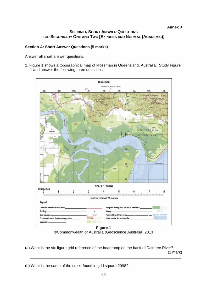
85
Annex J
SPECIMEN SHORT ANSWER QUESTIONS FOR SECONDARY ONE AND TWO [EXPRESS AND NORMAL (ACADEMIC)]
Section A: Short Answer Questions (5 marks)
Answer all short answer questions. 1. Figure 1 shows a topographical map of Mossman in Queensland, Australia. Study Figure 1 and answer the following three questions.
Figure 1
©Commonwealth of Australia (Geoscience Australia) 2013
(a) What is the six-figure grid reference of the boat ramp on the bank of Daintree River?
(1 mark) _______________________________________________________________________ (b) What is the name of the creek found in grid square 2998?
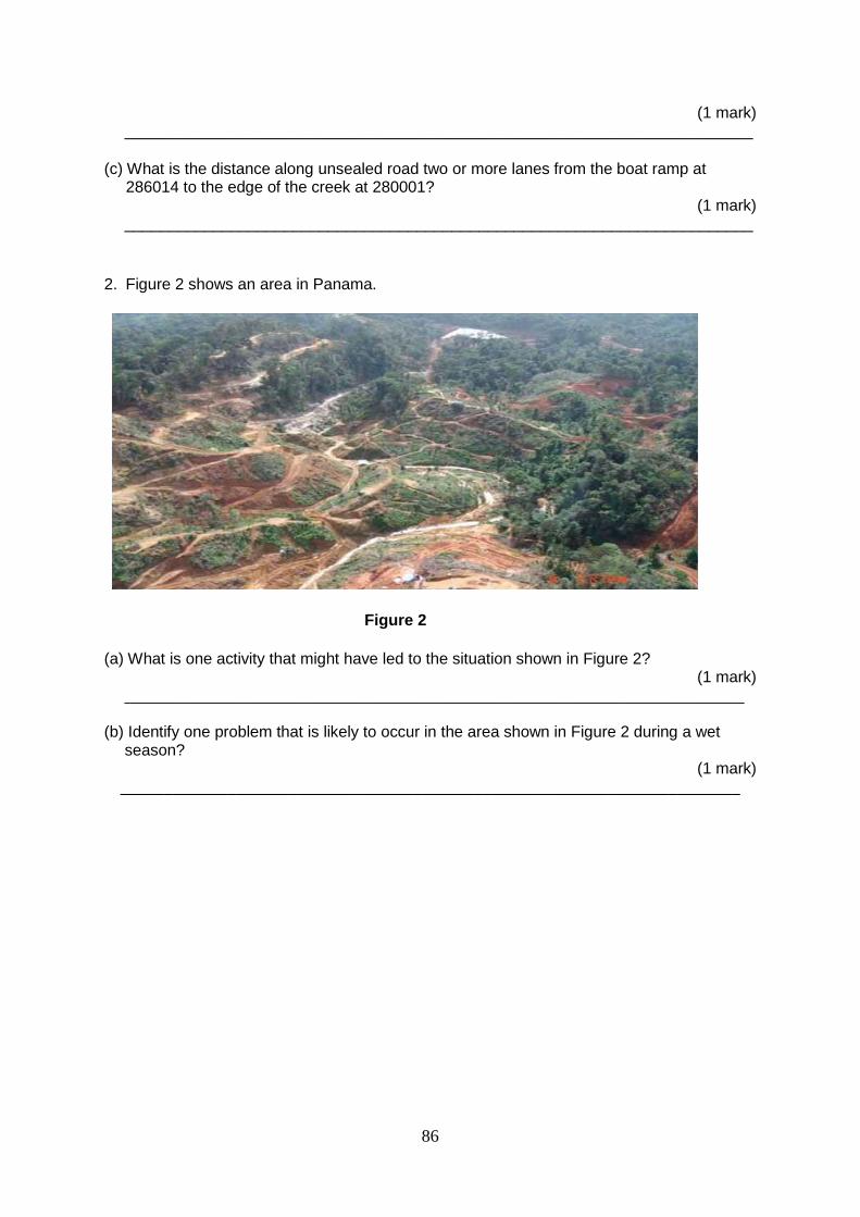
86
(1 mark) _______________________________________________________________________
(c) What is the distance along unsealed road two or more lanes from the boat ramp at 286014 to the edge of the creek at 280001?
(1 mark) _______________________________________________________________________
2. Figure 2 shows an area in Panama.
Figure 2
(a) What is one activity that might have led to the situation shown in Figure 2? (1 mark)
______________________________________________________________________ (b) Identify one problem that is likely to occur in the area shown in Figure 2 during a wet
season? (1 mark)
______________________________________________________________________
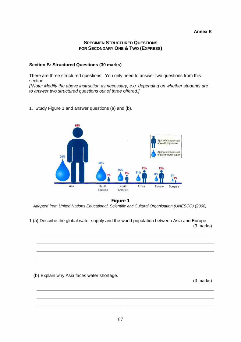
87
Annex K
SPECIMEN STRUCTURED QUESTIONS
FOR SECONDARY ONE & TWO (EXPRESS)
Section B: Structured Questions (30 marks)
There are three structured questions. You only need to answer two questions from this section. [*Note: Modify the above instruction as necessary, e.g. depending on whether students are to answer two structured questions out of three offered.]
1. Study Figure 1 and answer questions (a) and (b).
Figure 1 Adapted from United Nations Educational, Scientific and Cultural Organisation (UNESCO) (2008).
1 (a) Describe the global water supply and the world population between Asia and Europe. (3 marks)
(b) Explain why Asia faces water shortage.
(3 marks)
88
(c) ’Water, water, everywhere, but not a drop to drink.’ Explain how this statement is true. (4 marks)
(d) Discuss the impacts of water shortage on people. (5 marks)
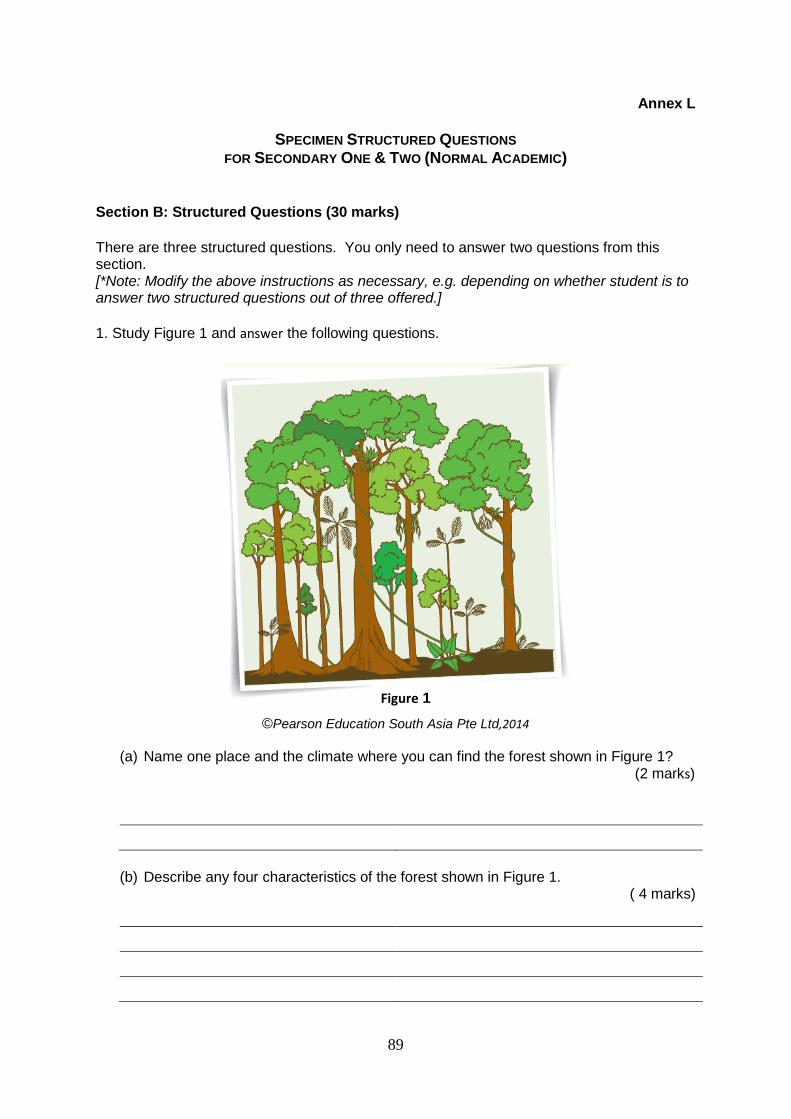
89
Annex L
SPECIMEN STRUCTURED QUESTIONS
FOR SECONDARY ONE & TWO (NORMAL ACADEMIC)
Section B: Structured Questions (30 marks)
There are three structured questions. You only need to answer two questions from this section. [*Note: Modify the above instructions as necessary, e.g. depending on whether student is to answer two structured questions out of three offered.]
1. Study Figure 1 and answer the following questions.
©Pearson Education South Asia Pte Ltd,2014
(a) Name one place and the climate where you can find the forest shown in Figure 1? (2 marks)
(b) Describe any four characteristics of the forest shown in Figure 1. ( 4 marks)
Figure 1
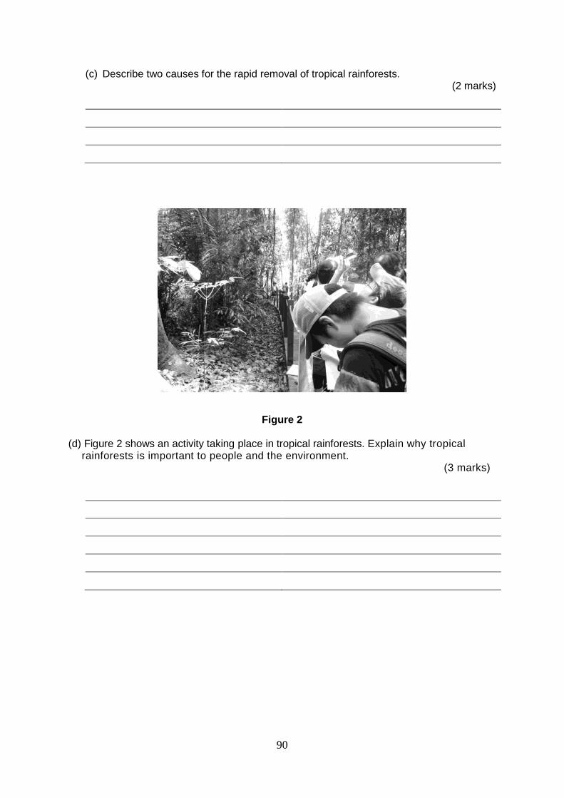
90
(c) Describe two causes for the rapid removal of tropical rainforests. (2 marks)
Figure 2 (d) Figure 2 shows an activity taking place in tropical rainforests. Explain why tropical
rainforests is important to people and the environment. (3 marks)
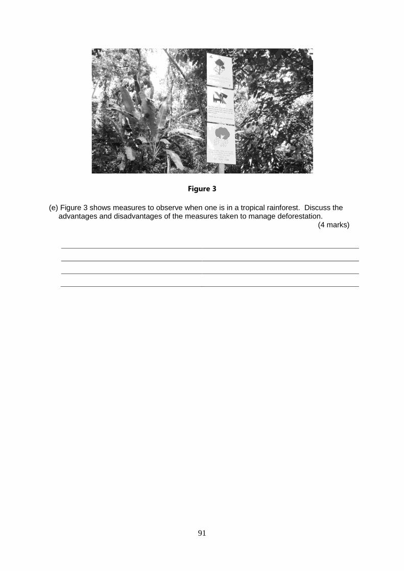
91
Figure 3
(e) Figure 3 shows measures to observe when one is in a tropical rainforest. Discuss the advantages and disadvantages of the measures taken to manage deforestation.
(4 marks)
92
Annex M
SPECIMEN MARKING SCHEMES FOR SHORT ANSWER QUESTIONS (SECONDARY ONE AND TWO EXPRESS AND NORMAL (ACADEMIC))
Section A: Short Answer Questions
Question Indicative Content
1a 312021
1b Crocodile Creek
1c 1.6 km
2a Deforestation
2b Soil erosion
Annex N
SPECIMEN MARKING SCHEMES FOR SPECIMEN STRUCTURED QUESTIONS
(SECONDARY ONE & TWO EXPRESS)
Section B: Structured Questions
Question Indicative Content
1a Describe the global water supply and the world population between Asia and Europe. [4]
Asia has around 60 % of world population
Asia has 36% of global water supply
Europe has around 13% of world population
Europe has 11% of global water supply. Any 1 @ 1 mark
1b Explain why Asia faces water shortage. [2]
Although Asia has the highest percentage of global water supply, it also has the highest percentage of world population.
In fact, its percentage of world population is almost double / very much more than its percentage share of global water supply.
1c ’Water, water, everywhere, but not a drop to drink.’ Explain how this statement is true. [4]
Although the earth is mostly made up of water, 97% is salt water which cannot be drank.
Only 3% of the earth's water supply consists of freshwater.
However, within this 3%, less than 1% is readily available in lakes and rivers.
The others are stored in glaciers and ice sheets.
1d Discuss the impacts of water shortage on people. [5]
Water rationing may be implemented and people will not have access to water at all times.
93
Question Indicative Content
In some countries, people may have to travel long distances to water sources to collect water.
Agricultural yields will be reduced as water is heavily used in the growing of crops.
Cost of industrial production will increase because water is used in many industrial processes.
Conflict may arise between countries over water especially when there is more than one user of the water resource.
Annex O
SPECIMEN MARKING SCHEMES FOR SPECIMEN STRUCTURED QUESTIONS
(SECONDARY ONE & TWO NORMAL (ACADEMIC))
Section B: Structured Questions
Question Indicative Content
1a Name one place and the climate where you can find the forest shown in Figure 1? [1]
One place: Amazon Basin, Congo Basin, parts of SE Asia e.g. Malaysia, Indonesia, etc
Climate: Equatorial climate
1b Describe any four characteristics of the forest shown in Figure 2. [4]
Many species including large vines and epiphytic ferns
Tall trees with straight trunks
Tall trees with buttress roots
Trees in the canopy layer spread to form a continuous layer
Few plants in the undergrowth layer Any 4 @ 1 mark
1c Describe two causes for the rapid removal of tropical rainforests. [2]
Forests are cleared for agricultural activities.
Forests are cleared to create areas for cattle to graze.
Forests are cleared to create areas for buildings/settlements
Trees are cut down for timber. The timber is used to make products such as furniture, etc.
Precious metals and gemstones are found beneath many tropical rainforests. Such forests are thus cleared before mining of metals and gemstones can occur.
Any 2 @ 1 mark
1d Figure 5 shows an activity taking place in tropical rainforests. Explain why tropical rainforests is important to people and the environment. [3]
Tropical rainforests are a source of timber. Timber is used to make furniture and other wood products.
94
Question Indicative Content
Tropical rainforests are a habitat for flora and fauna. Each hectare may contain up to 300 species of trees. They are also a habitat for indigenous people such as hunters and shifting cultivators.
Tropical rainforests are the 'green lungs of the earth' because they absorb the carbon dioxide from the atmosphere and release oxygen through photosynthesis.
Tropical rainforests are water catchment areas.
Tropical rainforests are a source of medicine as many plants found in the rainforests have medicinal value.
Any 3 @ 1 mark
1e Figure 2 shows measures to observe when one is in a tropical rainforest. Discuss the advantages and disadvantages of two measures taken to manage deforestation. [4]
Reforestation improves soil fertility and reduces soil erosion during the wet season. However, reforestation projects are time consuming and expensive.
Public education increases people awareness of the importance of conserving the rainforests. However, many people are dependent on the forests for a living and they have few alternative sources of income. It is also difficult to turn environmental awareness into action.
Protected forests bar people from falling trees. They help to protect indigenous lands. However, protected areas still face the threats of illegal logging and mining because the rainforest covers a large area, making it difficult to track illegal loggers.
Controlled logging leads to a better control of illegal logging and a decrease in deforestation. However, the threat from illegal logging is still present because the rainforest covers a large area, making it difficult to track illegal loggers.
Any 3 @ 1 mark
0
SECTION 8: AMPLIFICATION OF SYLLABUSES
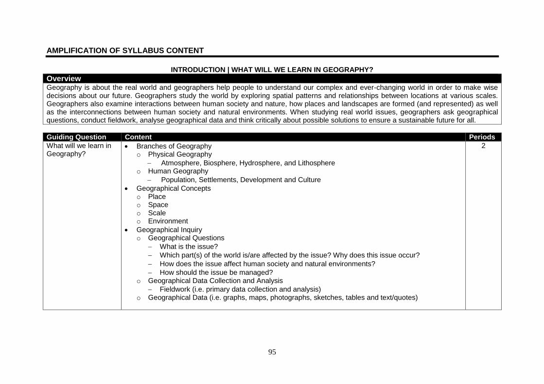
95
AMPLIFICATION OF SYLLABUS CONTENT
INTRODUCTION | WHAT WILL WE LEARN IN GEOGRAPHY?
Overview
Geography is about the real world and geographers help people to understand our complex and ever-changing world in order to make wise decisions about our future. Geographers study the world by exploring spatial patterns and relationships between locations at various scales. Geographers also examine interactions between human society and nature, how places and landscapes are formed (and represented) as well as the interconnections between human society and natural environments. When studying real world issues, geographers ask geographical questions, conduct fieldwork, analyse geographical data and think critically about possible solutions to ensure a sustainable future for all.
Guiding Question Content Periods
What will we learn in Geography?
Branches of Geography o Physical Geography
Atmosphere, Biosphere, Hydrosphere, and Lithosphere o Human Geography
Population, Settlements, Development and Culture
Geographical Concepts o Place o Space o Scale o Environment
Geographical Inquiry o Geographical Questions
What is the issue?
Which part(s) of the world is/are affected by the issue? Why does this issue occur?
How does the issue affect human society and natural environments?
How should the issue be managed? o Geographical Data Collection and Analysis
Fieldwork (i.e. primary data collection and analysis) o Geographical Data (i.e. graphs, maps, photographs, sketches, tables and text/quotes)
2
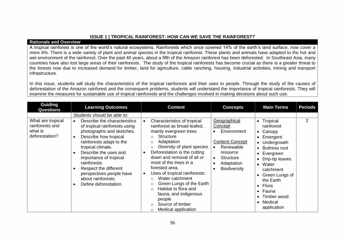
96
ISSUE 1 | TROPICAL RAINFOREST: HOW CAN WE SAVE THE RAINFOREST?
Rationale and Overview
A tropical rainforest is one of the world’s natural ecosystems. Rainforests which once covered 14% of the earth’s land surface, now cover a mere 6%. There is a wide variety of plant and animal species in the tropical rainforest. These plants and animals have adapted to the hot and wet environment of the rainforest. Over the past 40 years, about a fifth of the Amazon rainforest has been deforested. In Southeast Asia, many countries have also lost large areas of their rainforests. The study of the tropical rainforests has become crucial as there is a greater threat to the forests now due to increased demand for timber, land for agriculture, cattle ranching, housing, industrial activities, mining and transport infrastructure. In this issue, students will study the characteristics of the tropical rainforests and their uses to people. Through the study of the causes of deforestation of the Amazon rainforest and the consequent problems, students will understand the importance of tropical rainforests. They will examine the measures for sustainable use of tropical rainforests and the challenges involved in making decisions about such use.
Guiding Questions
Learning Outcomes Content Concepts Main Terms Periods
Students should be able to:
What are tropical rainforests and what is deforestation?
Describe the characteristics of tropical rainforests using photographs and sketches.
Describe how tropical rainforests adapt to the tropical climate.
Describe the uses and importance of tropical rainforests.
Respect the different perspectives people have about rainforests.
Define deforestation.
Characteristics of tropical rainforest as broad-leafed, mainly evergreen trees o Structure o Adaptation o Diversity of plant species
Deforestation is the cutting down and removal of all or most of the trees in a forested area.
Uses of tropical rainforests: o Water catchment o Green Lungs of the Earth o Habitat to flora and
fauna, and indigenous people
o Source of timber o Medical application
Geographical Concept
Environment Content Concept
Renewable resource
Structure
Adaptation
Biodiversity
Tropical rainforest
Canopy
Emergent
Undergrowth
Buttress root
Evergreen
Drip-tip leaves
Water catchment
Green Lungs of the Earth
Flora
Fauna
Timber wood
Medical application
2
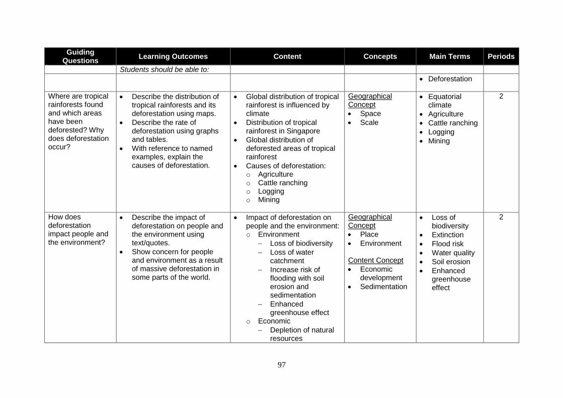
97
Guiding Questions
Learning Outcomes Content Concepts Main Terms Periods
Students should be able to:
Deforestation
Where are tropical rainforests found and which areas have been deforested? Why does deforestation occur?
Describe the distribution of tropical rainforests and its deforestation using maps.
Describe the rate of deforestation using graphs and tables.
With reference to named examples, explain the causes of deforestation.
Global distribution of tropical rainforest is influenced by climate
Distribution of tropical rainforest in Singapore
Global distribution of deforested areas of tropical rainforest
Causes of deforestation: o Agriculture o Cattle ranching o Logging o Mining
Geographical Concept
Space
Scale
Equatorial climate
Agriculture
Cattle ranching
Logging
Mining
2
How does deforestation impact people and the environment?
Describe the impact of deforestation on people and the environment using text/quotes.
Show concern for people and environment as a result of massive deforestation in some parts of the world.
Impact of deforestation on people and the environment: o Environment
Loss of biodiversity
Loss of water catchment
Increase risk of flooding with soil erosion and sedimentation
Enhanced greenhouse effect
o Economic
Depletion of natural resources
Geographical Concept
Place
Environment Content Concept
Economic development
Sedimentation
Loss of biodiversity
Extinction
Flood risk
Water quality
Soil erosion
Enhanced greenhouse effect
2
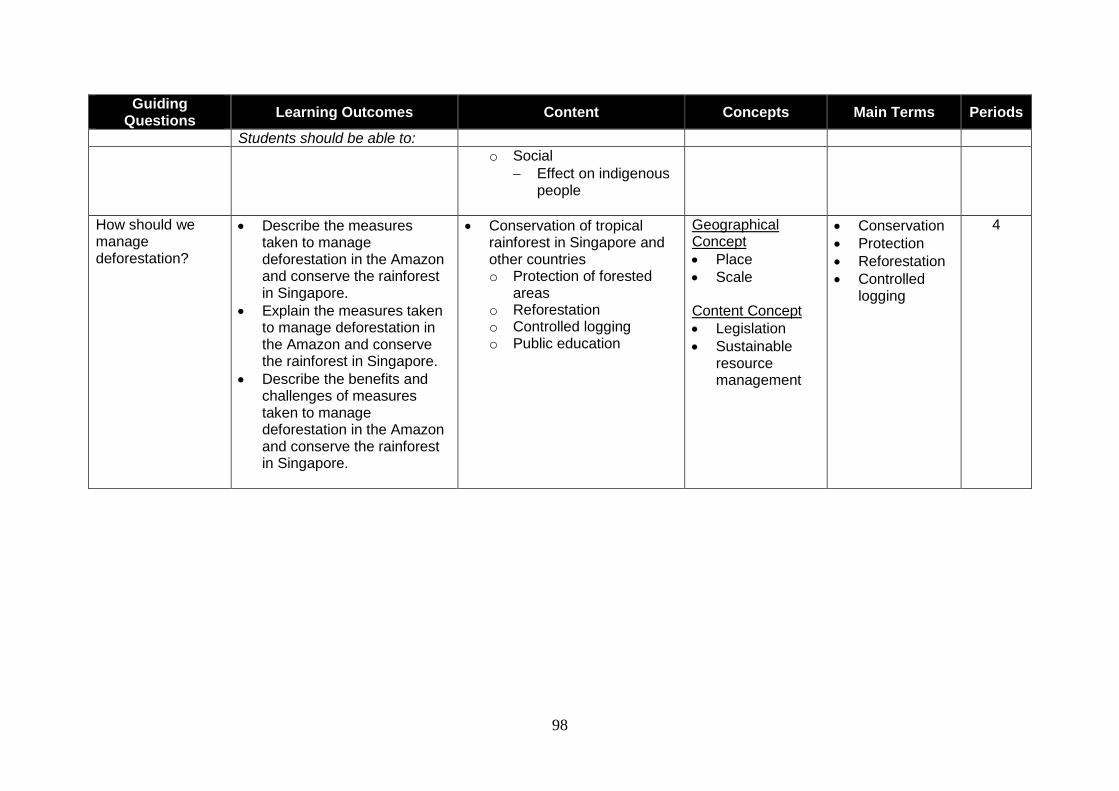
98
Guiding Questions
Learning Outcomes Content Concepts Main Terms Periods
Students should be able to:
o Social
Effect on indigenous people
How should we manage deforestation?
Describe the measures taken to manage deforestation in the Amazon and conserve the rainforest in Singapore.
Explain the measures taken to manage deforestation in the Amazon and conserve the rainforest in Singapore.
Describe the benefits and challenges of measures taken to manage deforestation in the Amazon and conserve the rainforest in Singapore.
Conservation of tropical rainforest in Singapore and other countries o Protection of forested
areas o Reforestation o Controlled logging o Public education
Geographical Concept
Place
Scale Content Concept
Legislation
Sustainable resource management
Conservation
Protection
Reforestation
Controlled logging
4
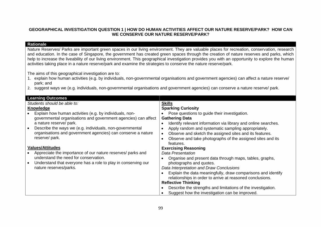
99
GEOGRAPHICAL INVESTIGATION QUESTION 1 | HOW DO HUMAN ACTIVITIES AFFECT OUR NATURE RESERVE/PARK? HOW CAN WE CONSERVE OUR NATURE RESERVE/PARK?
Rationale
Nature Reserves/ Parks are important green spaces in our living environment. They are valuable places for recreation, conservation, research and education. In the case of Singapore, the government has created green spaces through the creation of nature reserves and parks, which help to increase the liveability of our living environment. This geographical investigation provides you with an opportunity to explore the human activities taking place in a nature reserve/park and examine the strategies to conserve the nature reserve/park. The aims of this geographical investigation are to: 1. explain how human activities (e.g. by individuals, non-governmental organisations and government agencies) can affect a nature reserve/
park; and 2. suggest ways we (e.g. individuals, non-governmental organisations and government agencies) can conserve a nature reserve/ park.
Learning Outcomes
Students should be able to: Knowledge
Explain how human activities (e.g. by individuals, non-governmental organisations and government agencies) can affect a nature reserve/ park.
Describe the ways we (e.g. individuals, non-governmental organisations and government agencies) can conserve a nature reserve/ park.
Values/Attitudes
Appreciate the importance of our nature reserves/ parks and understand the need for conservation.
Understand that everyone has a role to play in conserving our nature reserves/parks.
Skills Sparking Curiosity
Pose questions to guide their investigation. Gathering Data
Identify relevant information via library and online searches.
Apply random and systematic sampling appropriately.
Observe and sketch the assigned sites and its features.
Observe and take photographs of the assigned sites and its features.
Exercising Reasoning Data Presentation
Organise and present data through maps, tables, graphs, photographs and quotes.
Data Interpretation and Draw Conclusions
Explain the data meaningfully, draw comparisons and identify relationships in order to arrive at reasoned conclusions.
Reflective Thinking
Describe the strengths and limitations of the investigation.
Suggest how the investigation can be improved.
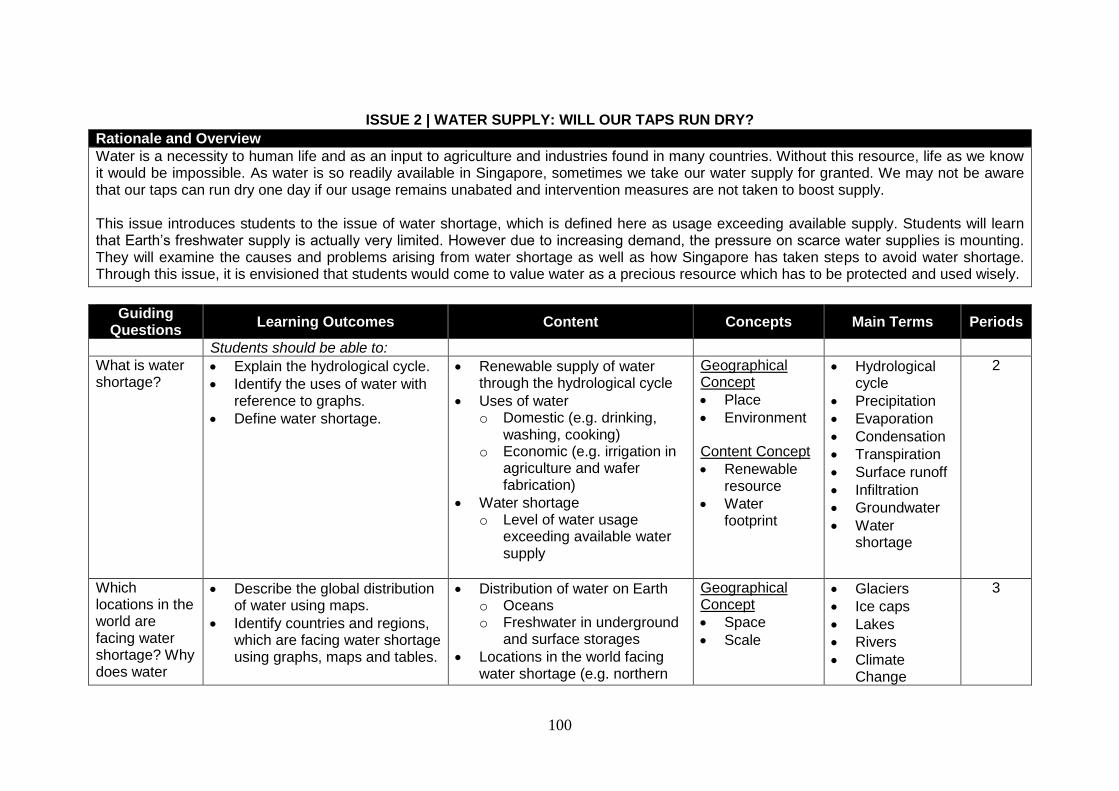
100
ISSUE 2 | WATER SUPPLY: WILL OUR TAPS RUN DRY?
Rationale and Overview
Water is a necessity to human life and as an input to agriculture and industries found in many countries. Without this resource, life as we know it would be impossible. As water is so readily available in Singapore, sometimes we take our water supply for granted. We may not be aware that our taps can run dry one day if our usage remains unabated and intervention measures are not taken to boost supply. This issue introduces students to the issue of water shortage, which is defined here as usage exceeding available supply. Students will learn that Earth’s freshwater supply is actually very limited. However due to increasing demand, the pressure on scarce water supplies is mounting. They will examine the causes and problems arising from water shortage as well as how Singapore has taken steps to avoid water shortage. Through this issue, it is envisioned that students would come to value water as a precious resource which has to be protected and used wisely.
Guiding Questions
Learning Outcomes Content Concepts Main Terms Periods
Students should be able to:
What is water shortage?
Explain the hydrological cycle.
Identify the uses of water with reference to graphs.
Define water shortage.
Renewable supply of water through the hydrological cycle
Uses of water o Domestic (e.g. drinking,
washing, cooking) o Economic (e.g. irrigation in
agriculture and wafer fabrication)
Water shortage o Level of water usage
exceeding available water supply
Geographical Concept
Place
Environment Content Concept
Renewable resource
Water footprint
Hydrological cycle
Precipitation
Evaporation
Condensation
Transpiration
Surface runoff
Infiltration
Groundwater
Water shortage
2
Which locations in the world are facing water shortage? Why does water
Describe the global distribution of water using maps.
Identify countries and regions, which are facing water shortage using graphs, maps and tables.
Distribution of water on Earth o Oceans o Freshwater in underground
and surface storages
Locations in the world facing water shortage (e.g. northern
Geographical Concept
Space
Scale
Glaciers
Ice caps
Lakes
Rivers
Climate Change
3
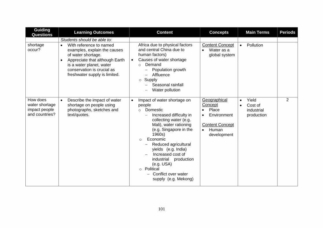
101
Guiding Questions
Learning Outcomes Content Concepts Main Terms Periods
Students should be able to:
shortage occur?
With reference to named examples, explain the causes of water shortage.
Appreciate that although Earth is a water planet, water conservation is crucial as freshwater supply is limited.
Africa due to physical factors and central China due to human factors)
Causes of water shortage o Demand
Population growth
Affluence o Supply
Seasonal rainfall
Water pollution
Content Concept
Water as a global system
Pollution
How does water shortage impact people and countries?
Describe the impact of water shortage on people using photographs, sketches and text/quotes.
Impact of water shortage on people o Domestic
Increased difficulty in collecting water (e.g. Mali), water rationing (e.g. Singapore in the 1960s)
o Economic
Reduced agricultural yields (e.g. India)
Increased cost of industrial production (e.g. USA)
o Political
Conflict over water supply (e.g. Mekong)
Geographical Concept
Place
Environment Content Concept
Human development
Yield
Cost of industrial production
2
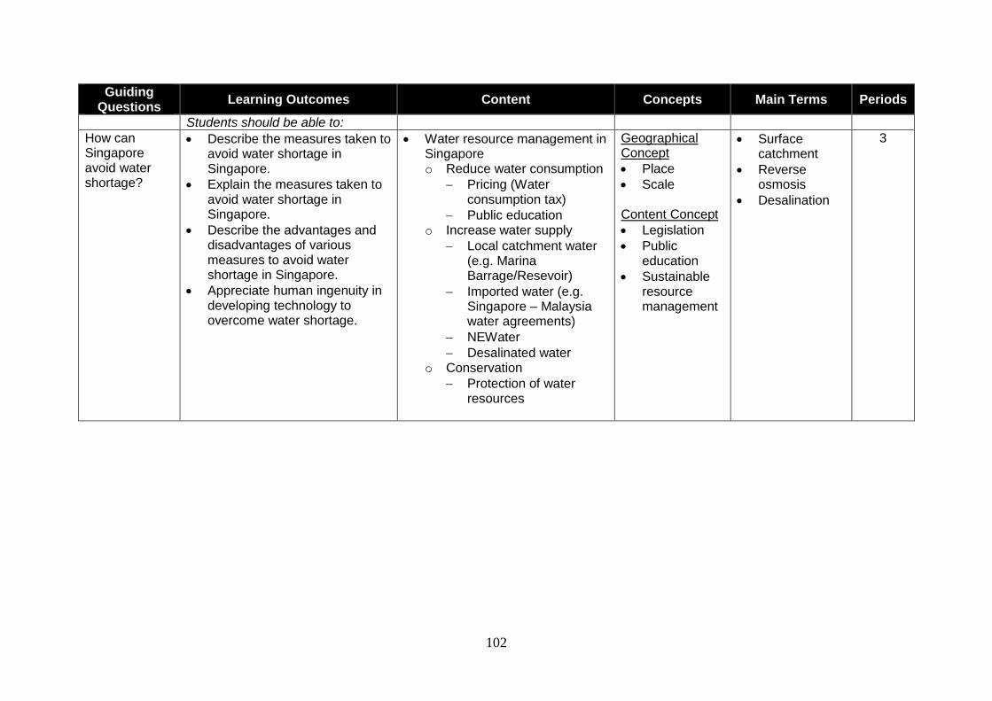
102
Guiding Questions
Learning Outcomes Content Concepts Main Terms Periods
Students should be able to:
How can Singapore avoid water shortage?
Describe the measures taken to avoid water shortage in Singapore.
Explain the measures taken to avoid water shortage in Singapore.
Describe the advantages and disadvantages of various measures to avoid water shortage in Singapore.
Appreciate human ingenuity in developing technology to overcome water shortage.
Water resource management in Singapore o Reduce water consumption
Pricing (Water consumption tax)
Public education o Increase water supply
Local catchment water (e.g. Marina Barrage/Resevoir)
Imported water (e.g. Singapore – Malaysia water agreements)
NEWater
Desalinated water o Conservation
Protection of water resources
Geographical Concept
Place
Scale Content Concept
Legislation
Public education
Sustainable resource management
Surface catchment
Reverse osmosis
Desalination
3
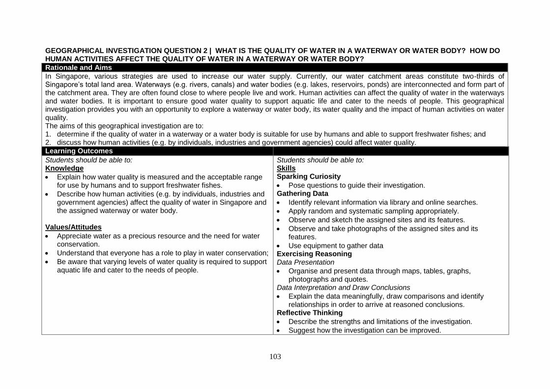
103
GEOGRAPHICAL INVESTIGATION QUESTION 2 | WHAT IS THE QUALITY OF WATER IN A WATERWAY OR WATER BODY? HOW DO HUMAN ACTIVITIES AFFECT THE QUALITY OF WATER IN A WATERWAY OR WATER BODY?
Rationale and Aims
In Singapore, various strategies are used to increase our water supply. Currently, our water catchment areas constitute two-thirds of Singapore’s total land area. Waterways (e.g. rivers, canals) and water bodies (e.g. lakes, reservoirs, ponds) are interconnected and form part of the catchment area. They are often found close to where people live and work. Human activities can affect the quality of water in the waterways and water bodies. It is important to ensure good water quality to support aquatic life and cater to the needs of people. This geographical investigation provides you with an opportunity to explore a waterway or water body, its water quality and the impact of human activities on water quality. The aims of this geographical investigation are to: 1. determine if the quality of water in a waterway or a water body is suitable for use by humans and able to support freshwater fishes; and 2. discuss how human activities (e.g. by individuals, industries and government agencies) could affect water quality.
Learning Outcomes
Students should be able to: Knowledge
Explain how water quality is measured and the acceptable range for use by humans and to support freshwater fishes.
Describe how human activities (e.g. by individuals, industries and government agencies) affect the quality of water in Singapore and the assigned waterway or water body.
Values/Attitudes
Appreciate water as a precious resource and the need for water conservation.
Understand that everyone has a role to play in water conservation;
Be aware that varying levels of water quality is required to support aquatic life and cater to the needs of people.
Students should be able to: Skills Sparking Curiosity
Pose questions to guide their investigation. Gathering Data
Identify relevant information via library and online searches.
Apply random and systematic sampling appropriately.
Observe and sketch the assigned sites and its features.
Observe and take photographs of the assigned sites and its features.
Use equipment to gather data Exercising Reasoning Data Presentation
Organise and present data through maps, tables, graphs, photographs and quotes.
Data Interpretation and Draw Conclusions
Explain the data meaningfully, draw comparisons and identify relationships in order to arrive at reasoned conclusions.
Reflective Thinking
Describe the strengths and limitations of the investigation.
Suggest how the investigation can be improved.
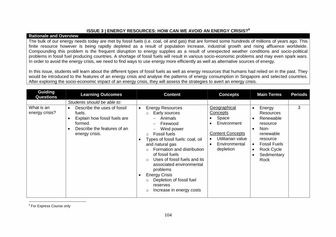
104
ISSUE 3 | ENERGY RESOURCES: HOW CAN WE AVOID AN ENERGY CRISIS?8
Rationale and Overview
The bulk of our energy needs today are met by fossil fuels (i.e. coal, oil and gas) that are formed some hundreds of millions of years ago. This finite resource however is being rapidly depleted as a result of population increase, industrial growth and rising affluence worldwide. Compounding this problem is the frequent disruption to energy supplies as a result of unexpected weather conditions and socio-political problems in fossil fuel producing countries. A shortage of fossil fuels will result in various socio-economic problems and may even spark wars. In order to avoid the energy crisis, we need to find ways to use energy more efficiently as well as alternative sources of energy. In this issue, students will learn about the different types of fossil fuels as well as energy resources that humans had relied on in the past. They would be introduced to the features of an energy crisis and analyse the patterns of energy consumption in Singapore and selected countries. After exploring the socio-economic impact of an energy crisis, they will assess the strategies to avert an energy crisis.
Guiding Questions
Learning Outcomes Content Concepts Main Terms Periods
Students should be able to:
What is an energy crisis?
Describe the uses of fossil fuels.
Explain how fossil fuels are formed.
Describe the features of an energy crisis.
Energy Resources o Early sources
Animals
Firewood
Wind power o Fossil fuels
Types of fossil fuels: coal, oil and natural gas o Formation and distribution
of fossil fuels o Uses of fossil fuels and its
associated environmental problems
Energy Crisis o Depletion of fossil fuel
reserves o Increase in energy costs
Geographical Concepts
Space
Environment Content Concepts
Utilitarian value
Environmental depletion
Energy Resources
Renewable resource
Non-renewable resource
Fossil Fuels
Rock Cycle
Sedimentary Rock
3
8 For Express Course only
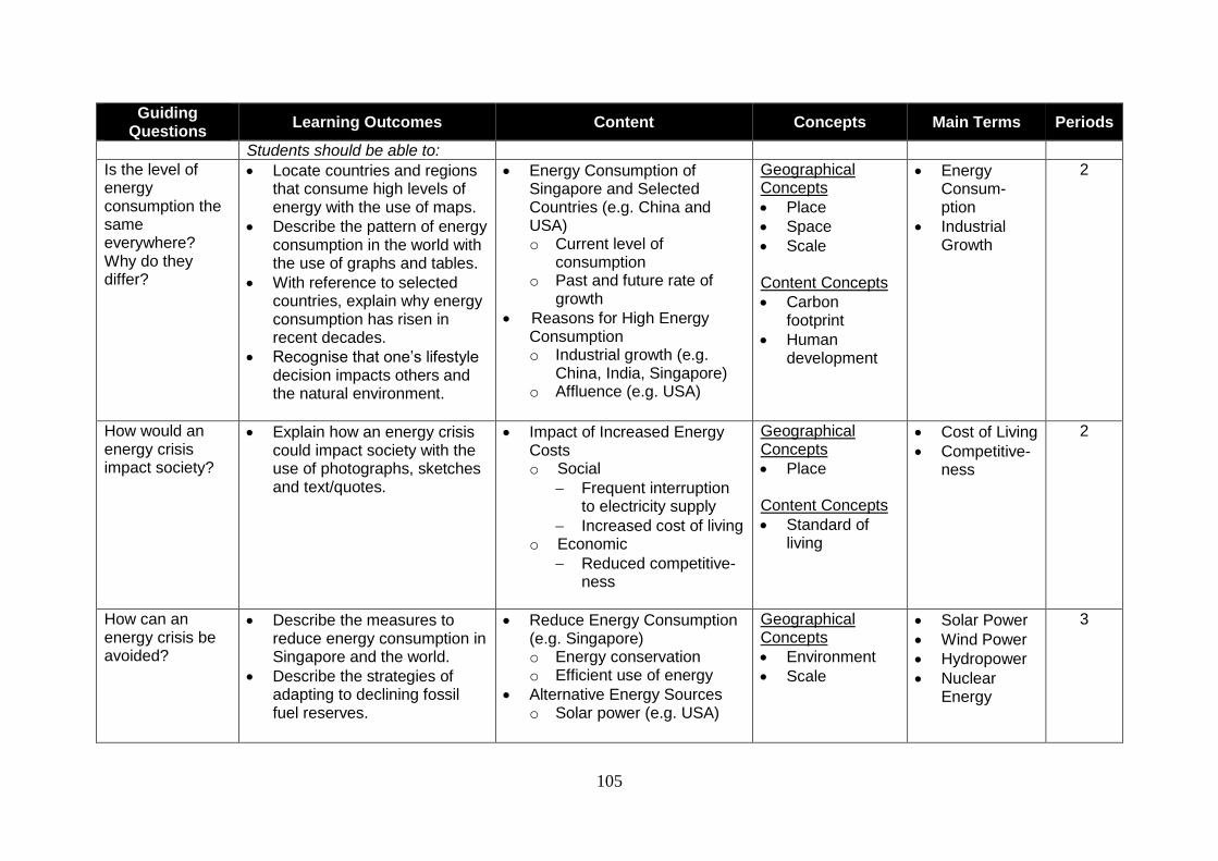
105
Guiding Questions
Learning Outcomes Content Concepts Main Terms Periods
Students should be able to:
Is the level of energy consumption the same everywhere? Why do they differ?
Locate countries and regions that consume high levels of energy with the use of maps.
Describe the pattern of energy consumption in the world with the use of graphs and tables.
With reference to selected countries, explain why energy consumption has risen in recent decades.
Recognise that one’s lifestyle decision impacts others and the natural environment.
Energy Consumption of Singapore and Selected Countries (e.g. China and USA) o Current level of
consumption o Past and future rate of
growth
Reasons for High Energy Consumption o Industrial growth (e.g.
China, India, Singapore) o Affluence (e.g. USA)
Geographical Concepts
Place
Space
Scale Content Concepts
Carbon footprint
Human development
Energy Consum-ption
Industrial Growth
2
How would an energy crisis impact society?
Explain how an energy crisis could impact society with the use of photographs, sketches and text/quotes.
Impact of Increased Energy Costs o Social
Frequent interruption to electricity supply
Increased cost of living o Economic
Reduced competitive-ness
Geographical Concepts
Place Content Concepts
Standard of living
Cost of Living
Competitive-ness
2
How can an energy crisis be avoided?
Describe the measures to reduce energy consumption in Singapore and the world.
Describe the strategies of adapting to declining fossil fuel reserves.
Reduce Energy Consumption (e.g. Singapore) o Energy conservation o Efficient use of energy
Alternative Energy Sources o Solar power (e.g. USA)
Geographical Concepts
Environment
Scale
Solar Power
Wind Power
Hydropower
Nuclear Energy
3
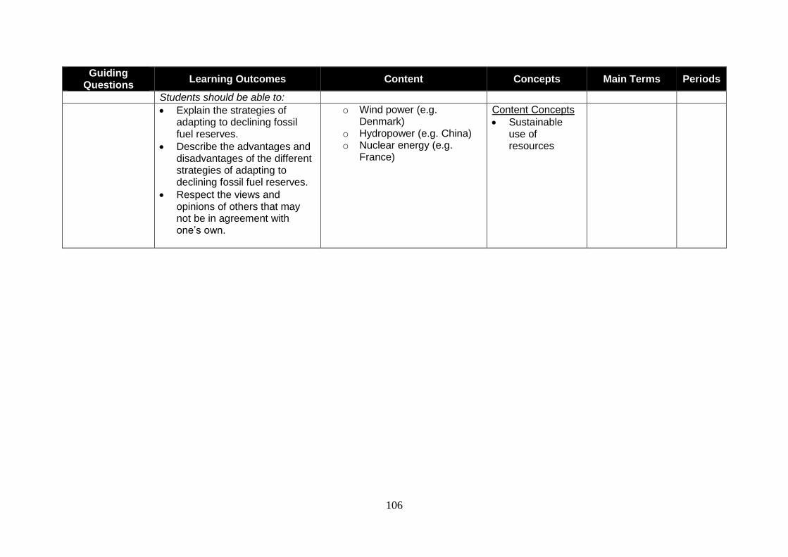
106
Guiding Questions
Learning Outcomes Content Concepts Main Terms Periods
Students should be able to:
Explain the strategies of adapting to declining fossil fuel reserves.
Describe the advantages and disadvantages of the different strategies of adapting to declining fossil fuel reserves.
Respect the views and opinions of others that may not be in agreement with one’s own.
o Wind power (e.g. Denmark)
o Hydropower (e.g. China) o Nuclear energy (e.g.
France)
Content Concepts
Sustainable use of resources
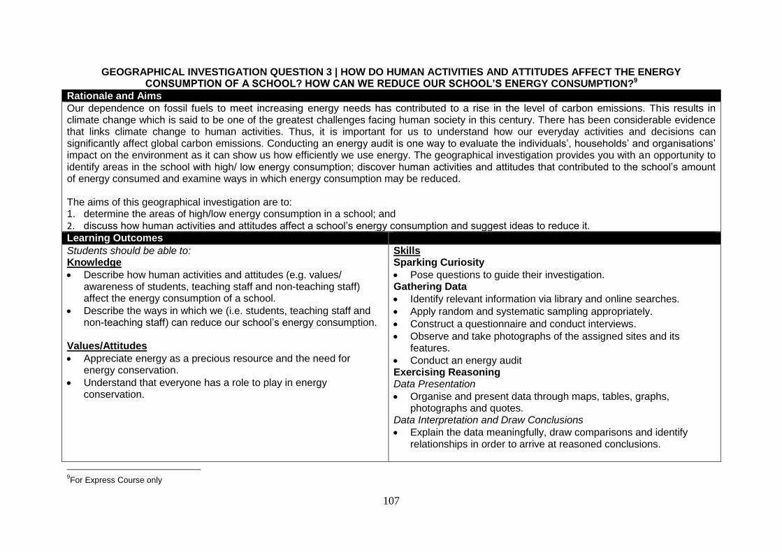
107
GEOGRAPHICAL INVESTIGATION QUESTION 3 | HOW DO HUMAN ACTIVITIES AND ATTITUDES AFFECT THE ENERGY CONSUMPTION OF A SCHOOL? HOW CAN WE REDUCE OUR SCHOOL’S ENERGY CONSUMPTION?9
Rationale and Aims
Our dependence on fossil fuels to meet increasing energy needs has contributed to a rise in the level of carbon emissions. This results in climate change which is said to be one of the greatest challenges facing human society in this century. There has been considerable evidence that links climate change to human activities. Thus, it is important for us to understand how our everyday activities and decisions can significantly affect global carbon emissions. Conducting an energy audit is one way to evaluate the individuals’, households’ and organisations’ impact on the environment as it can show us how efficiently we use energy. The geographical investigation provides you with an opportunity to identify areas in the school with high/ low energy consumption; discover human activities and attitudes that contributed to the school’s amount of energy consumed and examine ways in which energy consumption may be reduced. The aims of this geographical investigation are to: 1. determine the areas of high/low energy consumption in a school; and 2. discuss how human activities and attitudes affect a school’s energy consumption and suggest ideas to reduce it. Learning Outcomes
Students should be able to: Knowledge
Describe how human activities and attitudes (e.g. values/ awareness of students, teaching staff and non-teaching staff) affect the energy consumption of a school.
Describe the ways in which we (i.e. students, teaching staff and non-teaching staff) can reduce our school’s energy consumption.
Values/Attitudes
Appreciate energy as a precious resource and the need for energy conservation.
Understand that everyone has a role to play in energy conservation.
Skills Sparking Curiosity
Pose questions to guide their investigation. Gathering Data
Identify relevant information via library and online searches.
Apply random and systematic sampling appropriately.
Construct a questionnaire and conduct interviews.
Observe and take photographs of the assigned sites and its features.
Conduct an energy audit Exercising Reasoning Data Presentation
Organise and present data through maps, tables, graphs, photographs and quotes.
Data Interpretation and Draw Conclusions
Explain the data meaningfully, draw comparisons and identify relationships in order to arrive at reasoned conclusions.
9For Express Course only
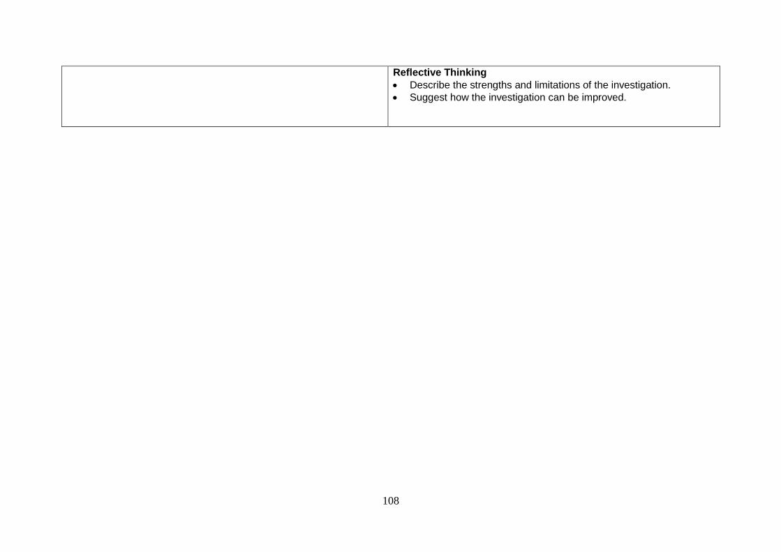
108
Reflective Thinking
Describe the strengths and limitations of the investigation.
Suggest how the investigation can be improved.
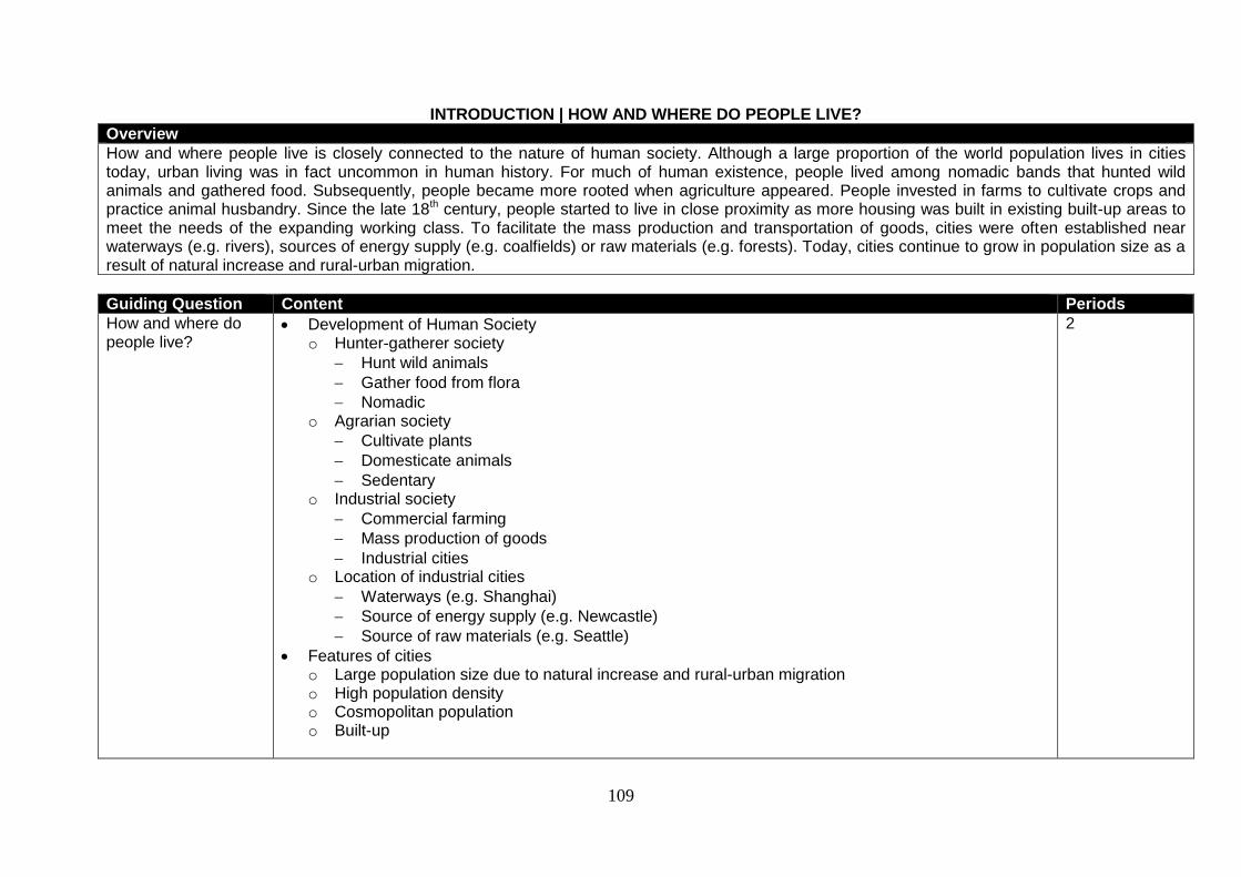
109
INTRODUCTION | HOW AND WHERE DO PEOPLE LIVE?
Overview
How and where people live is closely connected to the nature of human society. Although a large proportion of the world population lives in cities today, urban living was in fact uncommon in human history. For much of human existence, people lived among nomadic bands that hunted wild animals and gathered food. Subsequently, people became more rooted when agriculture appeared. People invested in farms to cultivate crops and practice animal husbandry. Since the late 18th century, people started to live in close proximity as more housing was built in existing built-up areas to meet the needs of the expanding working class. To facilitate the mass production and transportation of goods, cities were often established near waterways (e.g. rivers), sources of energy supply (e.g. coalfields) or raw materials (e.g. forests). Today, cities continue to grow in population size as a result of natural increase and rural-urban migration.
Guiding Question Content Periods
How and where do people live?
Development of Human Society o Hunter-gatherer society
Hunt wild animals
Gather food from flora
Nomadic o Agrarian society
Cultivate plants
Domesticate animals
Sedentary o Industrial society
Commercial farming
Mass production of goods
Industrial cities o Location of industrial cities
Waterways (e.g. Shanghai)
Source of energy supply (e.g. Newcastle)
Source of raw materials (e.g. Seattle)
Features of cities o Large population size due to natural increase and rural-urban migration o High population density o Cosmopolitan population o Built-up
2
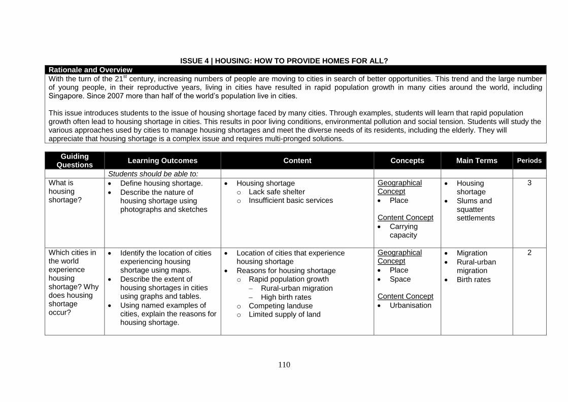
110
ISSUE 4 | HOUSING: HOW TO PROVIDE HOMES FOR ALL? Rationale and Overview
With the turn of the 21st century, increasing numbers of people are moving to cities in search of better opportunities. This trend and the large number of young people, in their reproductive years, living in cities have resulted in rapid population growth in many cities around the world, including Singapore. Since 2007 more than half of the world’s population live in cities. This issue introduces students to the issue of housing shortage faced by many cities. Through examples, students will learn that rapid population growth often lead to housing shortage in cities. This results in poor living conditions, environmental pollution and social tension. Students will study the various approaches used by cities to manage housing shortages and meet the diverse needs of its residents, including the elderly. They will appreciate that housing shortage is a complex issue and requires multi-pronged solutions.
Guiding Questions
Learning Outcomes Content Concepts Main Terms Periods
Students should be able to:
What is housing shortage?
Define housing shortage.
Describe the nature of housing shortage using photographs and sketches
Housing shortage o Lack safe shelter o Insufficient basic services
Geographical Concept
Place Content Concept
Carrying capacity
Housing shortage
Slums and squatter settlements
3
Which cities in the world experience housing shortage? Why does housing shortage occur?
Identify the location of cities experiencing housing shortage using maps.
Describe the extent of housing shortages in cities using graphs and tables.
Using named examples of cities, explain the reasons for housing shortage.
Location of cities that experience housing shortage
Reasons for housing shortage o Rapid population growth
Rural-urban migration
High birth rates o Competing landuse o Limited supply of land
Geographical Concept
Place
Space
Content Concept
Urbanisation
Migration
Rural-urban migration
Birth rates
2
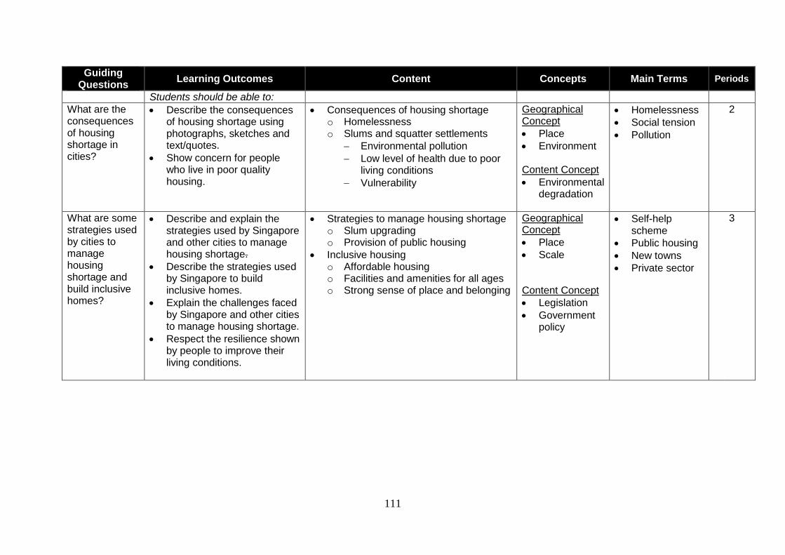
111
Guiding Questions
Learning Outcomes Content Concepts Main Terms Periods
Students should be able to:
What are the consequences of housing shortage in cities?
Describe the consequences of housing shortage using photographs, sketches and text/quotes.
Show concern for people who live in poor quality housing.
Consequences of housing shortage o Homelessness o Slums and squatter settlements
Environmental pollution
Low level of health due to poor living conditions
Vulnerability
Geographical Concept
Place
Environment Content Concept
Environmental degradation
Homelessness
Social tension
Pollution
2
What are some strategies used by cities to manage housing shortage and build inclusive homes?
Describe and explain the strategies used by Singapore and other cities to manage housing shortage.
Describe the strategies used by Singapore to build inclusive homes.
Explain the challenges faced by Singapore and other cities to manage housing shortage.
Respect the resilience shown by people to improve their living conditions.
Strategies to manage housing shortage o Slum upgrading o Provision of public housing
Inclusive housing o Affordable housing o Facilities and amenities for all ages o Strong sense of place and belonging
Geographical Concept
Place
Scale Content Concept
Legislation
Government policy
Self-help scheme
Public housing
New towns
Private sector
3
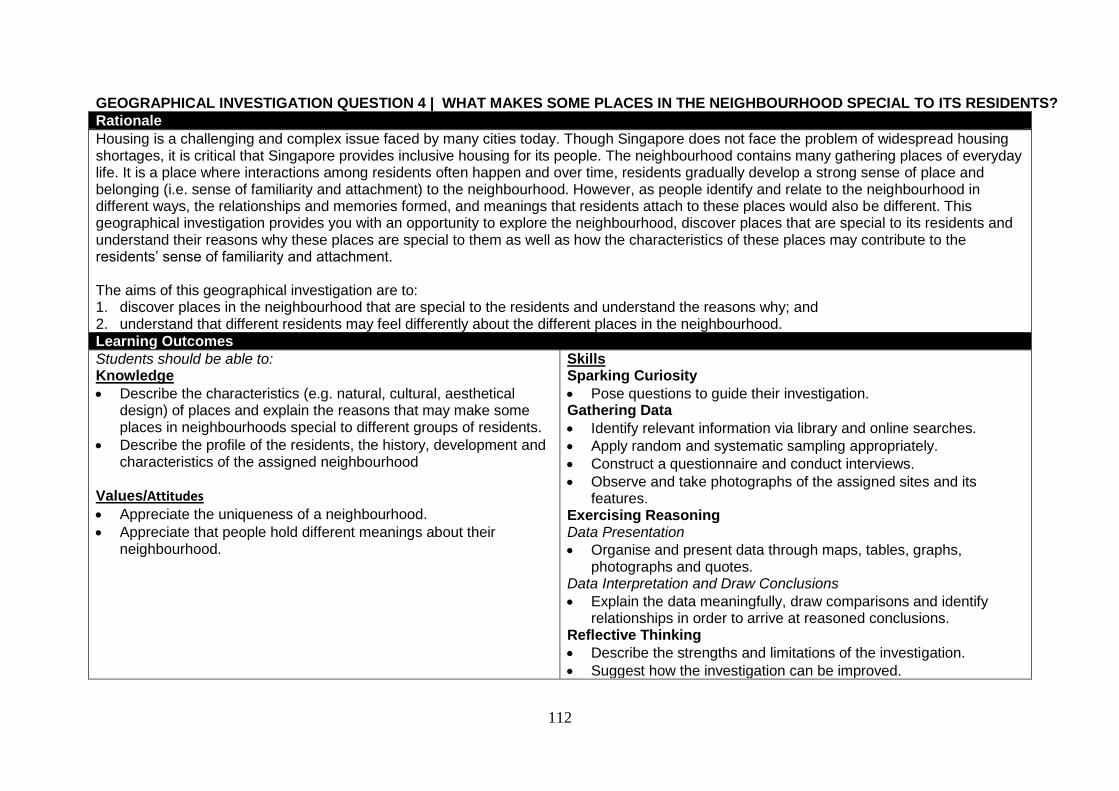
112
GEOGRAPHICAL INVESTIGATION QUESTION 4 | WHAT MAKES SOME PLACES IN THE NEIGHBOURHOOD SPECIAL TO ITS RESIDENTS?
Rationale
Housing is a challenging and complex issue faced by many cities today. Though Singapore does not face the problem of widespread housing shortages, it is critical that Singapore provides inclusive housing for its people. The neighbourhood contains many gathering places of everyday life. It is a place where interactions among residents often happen and over time, residents gradually develop a strong sense of place and belonging (i.e. sense of familiarity and attachment) to the neighbourhood. However, as people identify and relate to the neighbourhood in different ways, the relationships and memories formed, and meanings that residents attach to these places would also be different. This geographical investigation provides you with an opportunity to explore the neighbourhood, discover places that are special to its residents and understand their reasons why these places are special to them as well as how the characteristics of these places may contribute to the residents’ sense of familiarity and attachment.
The aims of this geographical investigation are to: 1. discover places in the neighbourhood that are special to the residents and understand the reasons why; and 2. understand that different residents may feel differently about the different places in the neighbourhood.
Learning Outcomes
Students should be able to: Knowledge
Describe the characteristics (e.g. natural, cultural, aesthetical design) of places and explain the reasons that may make some places in neighbourhoods special to different groups of residents.
Describe the profile of the residents, the history, development and characteristics of the assigned neighbourhood
Values/Attitudes
Appreciate the uniqueness of a neighbourhood.
Appreciate that people hold different meanings about their neighbourhood.
Skills Sparking Curiosity
Pose questions to guide their investigation. Gathering Data
Identify relevant information via library and online searches.
Apply random and systematic sampling appropriately.
Construct a questionnaire and conduct interviews.
Observe and take photographs of the assigned sites and its features.
Exercising Reasoning Data Presentation
Organise and present data through maps, tables, graphs, photographs and quotes.
Data Interpretation and Draw Conclusions
Explain the data meaningfully, draw comparisons and identify relationships in order to arrive at reasoned conclusions.
Reflective Thinking
Describe the strengths and limitations of the investigation.
Suggest how the investigation can be improved.
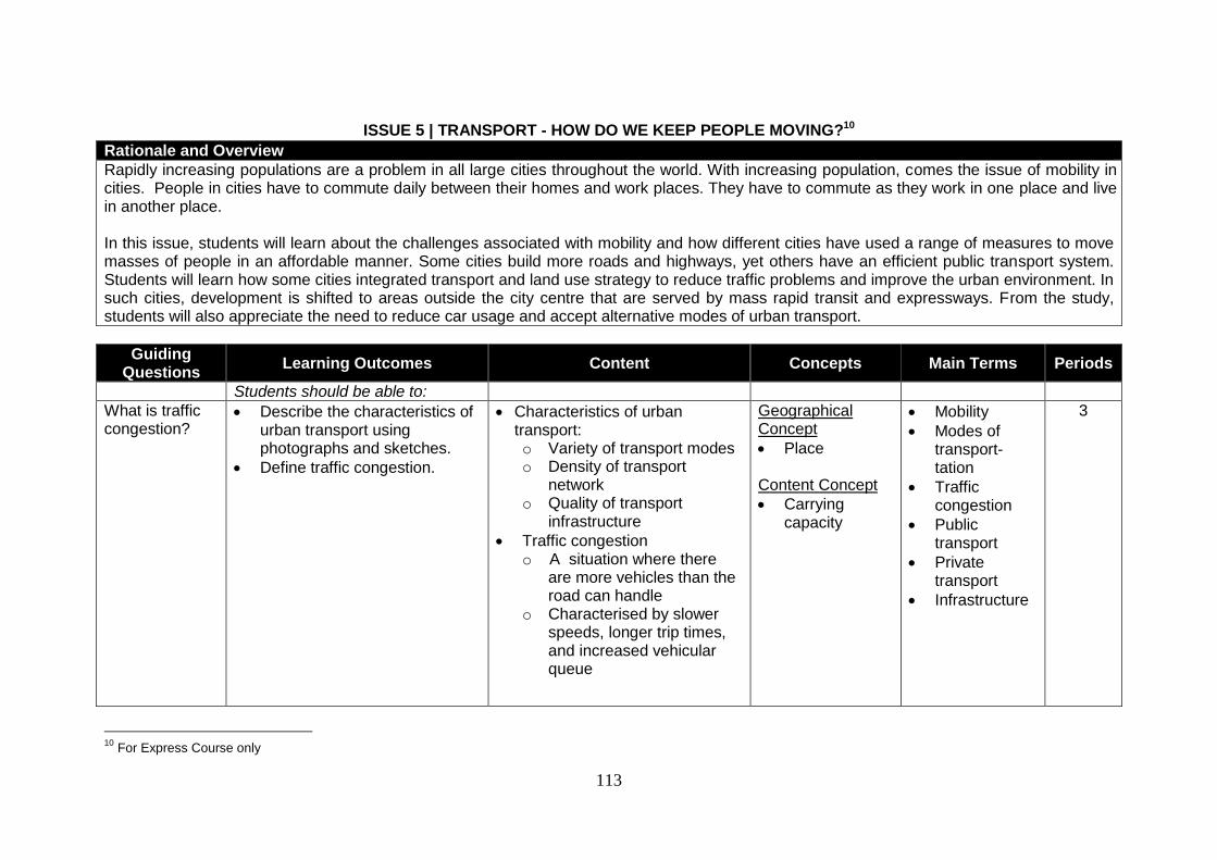
113
ISSUE 5 | TRANSPORT - HOW DO WE KEEP PEOPLE MOVING?10
Rationale and Overview
Rapidly increasing populations are a problem in all large cities throughout the world. With increasing population, comes the issue of mobility in cities. People in cities have to commute daily between their homes and work places. They have to commute as they work in one place and live in another place. In this issue, students will learn about the challenges associated with mobility and how different cities have used a range of measures to move masses of people in an affordable manner. Some cities build more roads and highways, yet others have an efficient public transport system. Students will learn how some cities integrated transport and land use strategy to reduce traffic problems and improve the urban environment. In such cities, development is shifted to areas outside the city centre that are served by mass rapid transit and expressways. From the study, students will also appreciate the need to reduce car usage and accept alternative modes of urban transport.
Guiding Questions
Learning Outcomes Content Concepts Main Terms Periods
Students should be able to:
What is traffic congestion?
Describe the characteristics of urban transport using photographs and sketches.
Define traffic congestion.
Characteristics of urban transport: o Variety of transport modes o Density of transport
network o Quality of transport
infrastructure
Traffic congestion o A situation where there
are more vehicles than the road can handle
o Characterised by slower speeds, longer trip times, and increased vehicular queue
Geographical Concept
Place Content Concept
Carrying capacity
Mobility
Modes of transport-tation
Traffic congestion
Public transport
Private transport
Infrastructure
3
10
For Express Course only
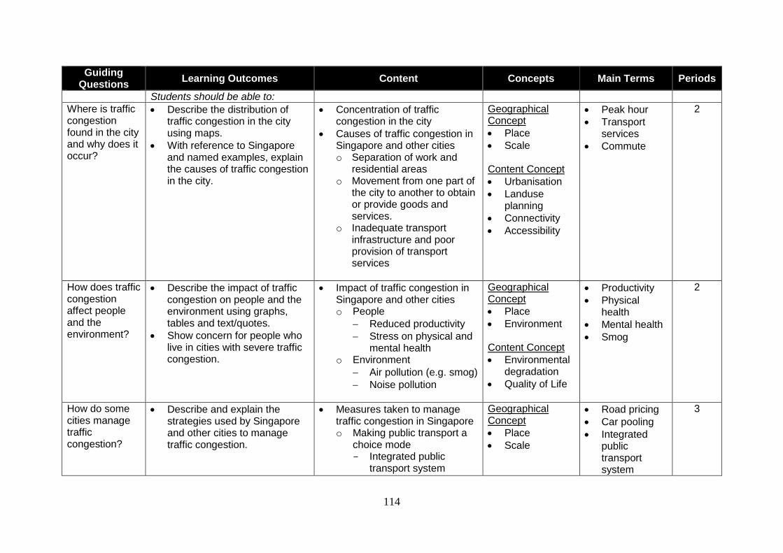
114
Guiding Questions
Learning Outcomes Content Concepts Main Terms Periods
Students should be able to:
Where is traffic congestion found in the city and why does it occur?
Describe the distribution of traffic congestion in the city using maps.
With reference to Singapore and named examples, explain the causes of traffic congestion in the city.
Concentration of traffic congestion in the city
Causes of traffic congestion in Singapore and other cities o Separation of work and
residential areas o Movement from one part of
the city to another to obtain or provide goods and services.
o Inadequate transport infrastructure and poor provision of transport services
Geographical Concept
Place
Scale Content Concept
Urbanisation
Landuse planning
Connectivity
Accessibility
Peak hour
Transport services
Commute
2
How does traffic congestion affect people and the environment?
Describe the impact of traffic congestion on people and the environment using graphs, tables and text/quotes.
Show concern for people who live in cities with severe traffic congestion.
Impact of traffic congestion in Singapore and other cities o People
Reduced productivity
Stress on physical and mental health
o Environment
Air pollution (e.g. smog)
Noise pollution
Geographical Concept
Place
Environment Content Concept
Environmental degradation
Quality of Life
Productivity
Physical health
Mental health
Smog
2
How do some cities manage traffic congestion?
Describe and explain the strategies used by Singapore and other cities to manage traffic congestion.
Measures taken to manage traffic congestion in Singapore o Making public transport a
choice mode - Integrated public
transport system
Geographical Concept
Place
Scale
Road pricing
Car pooling
Integrated public transport system
3
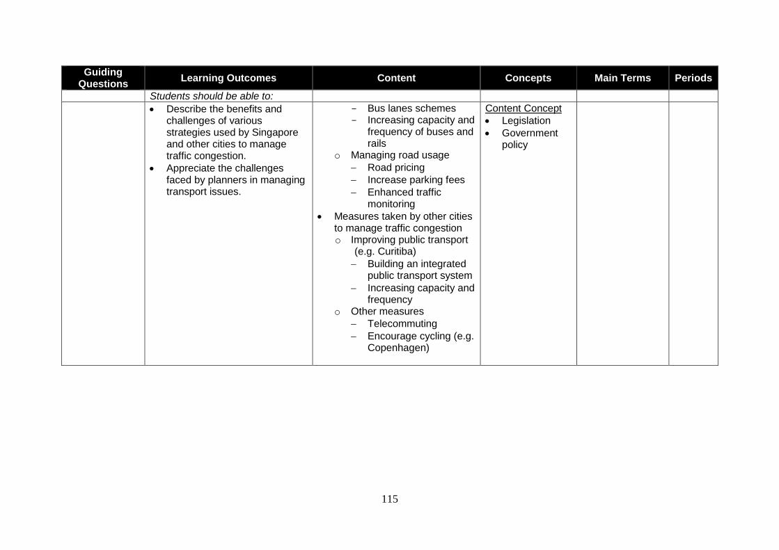
115
Guiding Questions
Learning Outcomes Content Concepts Main Terms Periods
Students should be able to:
Describe the benefits and challenges of various strategies used by Singapore and other cities to manage traffic congestion.
Appreciate the challenges faced by planners in managing transport issues.
- Bus lanes schemes - Increasing capacity and
frequency of buses and rails
o Managing road usage
Road pricing
Increase parking fees
Enhanced traffic monitoring
Measures taken by other cities to manage traffic congestion o Improving public transport
(e.g. Curitiba)
Building an integrated public transport system
Increasing capacity and frequency
o Other measures
Telecommuting
Encourage cycling (e.g. Copenhagen)
Content Concept
Legislation
Government policy

116
GEOGRAPHICAL INVESTIGATION QUESTION 5 | WHAT FEATURES OF OUR PUBLIC TRANSPORT HELP TO ENSURE A SAFE AND COMFORTABLE JOURNEY?11
Rationale Mobility influences the quality of life in cities to a large extent. A majority of the people in the city commute via different modes of public transport, such as buses, Mass Rapid Transit and Light Rail Transit. Certain features of the public transport such as the presence of barrier gates in train stations and hand rails for standing passengers, help to ensure a safe and comfortable journey for commuters. This geographical investigation provides you with an opportunity to explore these features of public transport and understand the different views of commuters on the features of public transport that help to ensure a safe and comfortable journey. The aims of this geographical investigation are to: 1. describe and explain the features of public transport that help to ensure a safe and comfortable journey; and
2. understand the different views of commuters on the features of public transport that help to ensure a safe and comfortable journey.
Learning Outcomes Students should be able to: Knowledge
Describe and explain the features of public transport (bus or rail) in Singapore that help to ensure a safe (e.g., top speed limiter in buses) and comfortable (e.g., air conditioning) journey for commuters.
Describe the different needs and concerns about safety and comfort of commuters (e.g., adults, elderly, families with young children) using public transport.
Values/ Attitudes
Appreciate the features of public transport that help to ensure a safe and comfortable journey for different groups of commuters.
Appreciate that commuters have different views about the features of public transport that help to ensure a safe and
comfortable journey.
Skills Sparking Curiosity Pose questions to guide their investigation. Gathering Data
Identify relevant information via library and online searches.
Apply random and systematic sampling appropriately.
Construct a questionnaire and conduct interviews.
Observe and take photographs of the assigned sites and its features. Exercising Reasoning Data Presentation
Organise and present data through maps, tables, graphs, photographs and quotes.
Data Interpretation and Draw Conclusions
Explain the data meaningfully, draw comparisons and identify relationships in order to arrive at reasoned conclusions.
Reflective Thinking
Describe the strengths and limitations of the investigation.
Suggest how the investigation can be improved.
11
For Express Course only
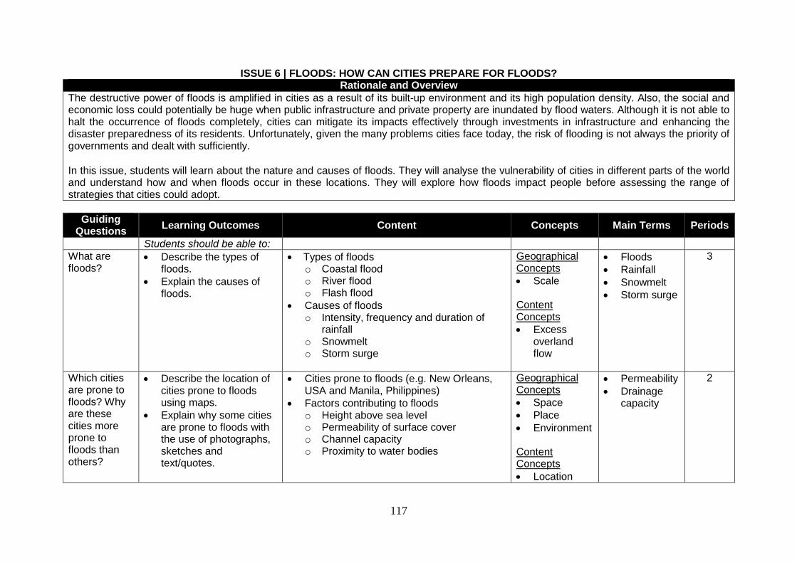
117
ISSUE 6 | FLOODS: HOW CAN CITIES PREPARE FOR FLOODS? Rationale and Overview
The destructive power of floods is amplified in cities as a result of its built-up environment and its high population density. Also, the social and economic loss could potentially be huge when public infrastructure and private property are inundated by flood waters. Although it is not able to halt the occurrence of floods completely, cities can mitigate its impacts effectively through investments in infrastructure and enhancing the disaster preparedness of its residents. Unfortunately, given the many problems cities face today, the risk of flooding is not always the priority of governments and dealt with sufficiently. In this issue, students will learn about the nature and causes of floods. They will analyse the vulnerability of cities in different parts of the world and understand how and when floods occur in these locations. They will explore how floods impact people before assessing the range of strategies that cities could adopt.
Guiding Questions
Learning Outcomes Content Concepts Main Terms Periods
Students should be able to:
What are floods?
Describe the types of floods.
Explain the causes of floods.
Types of floods o Coastal flood o River flood o Flash flood
Causes of floods o Intensity, frequency and duration of
rainfall o Snowmelt o Storm surge
Geographical Concepts
Scale Content Concepts
Excess overland flow
Floods
Rainfall
Snowmelt
Storm surge
3
Which cities are prone to floods? Why are these cities more prone to floods than others?
Describe the location of cities prone to floods using maps.
Explain why some cities are prone to floods with the use of photographs, sketches and text/quotes.
Cities prone to floods (e.g. New Orleans, USA and Manila, Philippines)
Factors contributing to floods o Height above sea level o Permeability of surface cover o Channel capacity o Proximity to water bodies
Geographical Concepts
Space
Place
Environment Content Concepts
Location
Permeability
Drainage capacity
2
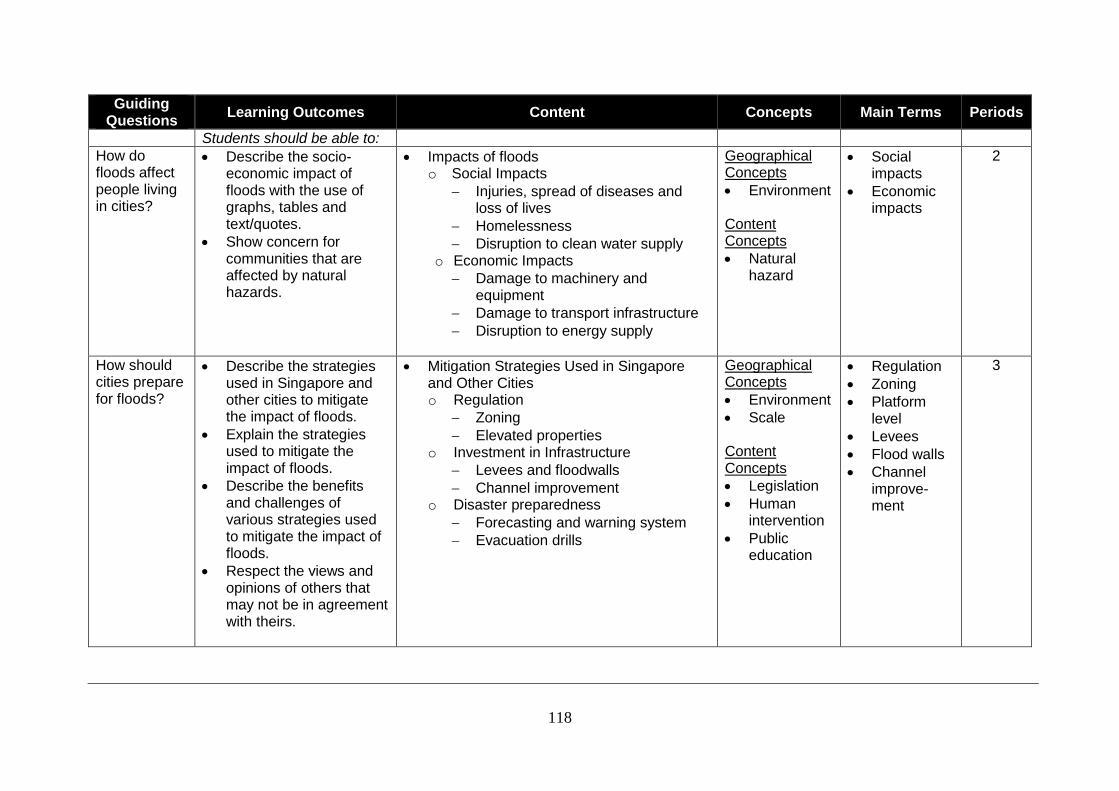
118
Guiding Questions
Learning Outcomes Content Concepts Main Terms Periods
Students should be able to:
How do floods affect people living in cities?
Describe the socio-economic impact of floods with the use of graphs, tables and text/quotes.
Show concern for communities that are affected by natural hazards.
Impacts of floods o Social Impacts
Injuries, spread of diseases and loss of lives
Homelessness
Disruption to clean water supply o Economic Impacts
Damage to machinery and equipment
Damage to transport infrastructure
Disruption to energy supply
Geographical Concepts
Environment Content Concepts
Natural hazard
Social impacts
Economic impacts
2
How should cities prepare for floods?
Describe the strategies used in Singapore and other cities to mitigate the impact of floods.
Explain the strategies used to mitigate the impact of floods.
Describe the benefits and challenges of various strategies used to mitigate the impact of floods.
Respect the views and opinions of others that may not be in agreement with theirs.
Mitigation Strategies Used in Singapore and Other Cities o Regulation
Zoning
Elevated properties o Investment in Infrastructure
Levees and floodwalls
Channel improvement o Disaster preparedness
Forecasting and warning system
Evacuation drills
Geographical Concepts
Environment
Scale Content Concepts
Legislation
Human intervention
Public education
Regulation
Zoning
Platform level
Levees
Flood walls
Channel improve-ment
3
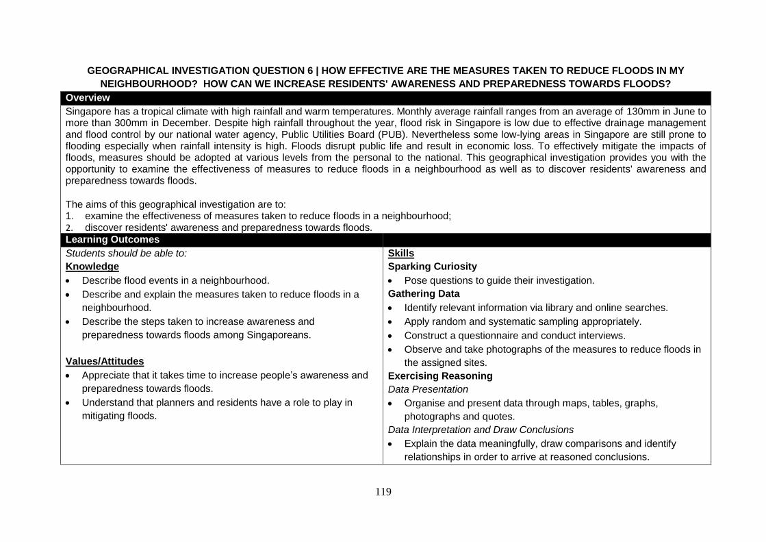
119
GEOGRAPHICAL INVESTIGATION QUESTION 6 | HOW EFFECTIVE ARE THE MEASURES TAKEN TO REDUCE FLOODS IN MY
NEIGHBOURHOOD? HOW CAN WE INCREASE RESIDENTS' AWARENESS AND PREPAREDNESS TOWARDS FLOODS?
Overview
Singapore has a tropical climate with high rainfall and warm temperatures. Monthly average rainfall ranges from an average of 130mm in June to more than 300mm in December. Despite high rainfall throughout the year, flood risk in Singapore is low due to effective drainage management and flood control by our national water agency, Public Utilities Board (PUB). Nevertheless some low-lying areas in Singapore are still prone to flooding especially when rainfall intensity is high. Floods disrupt public life and result in economic loss. To effectively mitigate the impacts of floods, measures should be adopted at various levels from the personal to the national. This geographical investigation provides you with the opportunity to examine the effectiveness of measures to reduce floods in a neighbourhood as well as to discover residents' awareness and preparedness towards floods. The aims of this geographical investigation are to: 1. examine the effectiveness of measures taken to reduce floods in a neighbourhood; 2. discover residents' awareness and preparedness towards floods. Learning Outcomes
Students should be able to:
Knowledge
Describe flood events in a neighbourhood.
Describe and explain the measures taken to reduce floods in a
neighbourhood.
Describe the steps taken to increase awareness and
preparedness towards floods among Singaporeans.
Values/Attitudes
Appreciate that it takes time to increase people’s awareness and
preparedness towards floods.
Understand that planners and residents have a role to play in
mitigating floods.
Skills
Sparking Curiosity
Pose questions to guide their investigation.
Gathering Data
Identify relevant information via library and online searches.
Apply random and systematic sampling appropriately.
Construct a questionnaire and conduct interviews.
Observe and take photographs of the measures to reduce floods in
the assigned sites.
Exercising Reasoning
Data Presentation
Organise and present data through maps, tables, graphs,
photographs and quotes.
Data Interpretation and Draw Conclusions
Explain the data meaningfully, draw comparisons and identify
relationships in order to arrive at reasoned conclusions.

120
Reflective Thinking
Describe the strengths and limitations of the investigation.
Suggest how the investigation can be improved.

0
SECTION 9: RECOMMENDED READING
121
References for Geography Teachers Relevance to Specific Issue on
Pedagogy
Balderstone, D. (ed). (2006). Secondary Geography Handbook. Geographical Association. -
Roberts, M. (2003). Learning through Enquiry: Making sense of geography in the key stage 3 classroom. Geographical Association.
-
Geographical Skills and Investigations
Christian, D. (2009). Essential Geographical Skills. Nelson Thornes.
Topographical Map Reading Skills, Geographical Data and Techniques, and Geographical Investigations
Geography Unit (2003). GeoTrail Labrador. Curriculum Planning and Development Division, Ministry of Education, Singapore. Holmes, D. and Farbrother, D. (2002). A-Z Advancing Geography: Fieldwork. Geographical Association. John, P.S. and Richardson, D. (1989). Methods of Presenting Fieldwork Data. Geographical Association. Kitchin, R. and Tate, N. J. (2000). Conducting Research in Human Geography: theory, methodology and practice. Pearson Education Limited. Lenon, B. and Cleves, P. (2001). Fieldwork Techniques and Projects in Geography (Second Edition). Collins.
Payne, D. (2005). Skills Companion for Geography GCSE AQA Specification A. Heinemann.
Waugh, D. and Bushell, T. (2006). New Key Geography – Foundations. Nelson Thornes.
Environment and Resources
Arundale, J. et al. (2002). Investigating Geography B. Hodder & Stoughton. Resources
Easton, M. (2010). Oxford Big Ideas: Humanities 5. Oxford University Press. Water resource
Easton, M. et al. (2010). Oxford Big Ideas: Humanities 6. Oxford University Press. Water resource, Cities
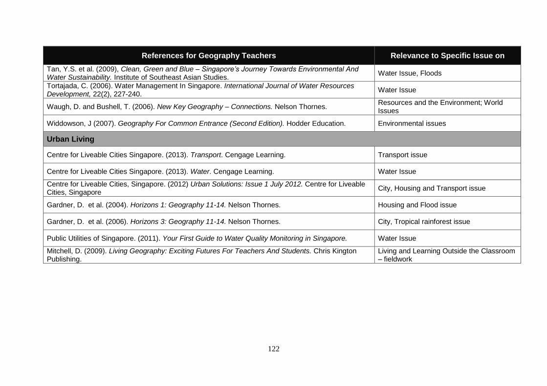
122
References for Geography Teachers Relevance to Specific Issue on
Tan, Y.S. et al. (2009), Clean, Green and Blue – Singapore’s Journey Towards Environmental And Water Sustainability. Institute of Southeast Asian Studies.
Water Issue, Floods
Tortajada, C. (2006). Water Management In Singapore. International Journal of Water Resources Development, 22(2), 227-240.
Water Issue
Waugh, D. and Bushell, T. (2006). New Key Geography – Connections. Nelson Thornes. Resources and the Environment; World Issues
Widdowson, J (2007). Geography For Common Entrance (Second Edition). Hodder Education. Environmental issues
Urban Living
Centre for Liveable Cities Singapore. (2013). Transport. Cengage Learning. Transport issue
Centre for Liveable Cities Singapore. (2013). Water. Cengage Learning. Water Issue
Centre for Liveable Cities, Singapore. (2012) Urban Solutions: Issue 1 July 2012. Centre for Liveable Cities, Singapore
City, Housing and Transport issue
Gardner, D. et al. (2004). Horizons 1: Geography 11-14. Nelson Thornes. Housing and Flood issue
Gardner, D. et al. (2006). Horizons 3: Geography 11-14. Nelson Thornes. City, Tropical rainforest issue
Public Utilities of Singapore. (2011). Your First Guide to Water Quality Monitoring in Singapore. Water Issue
Mitchell, D. (2009). Living Geography: Exciting Futures For Teachers And Students. Chris Kington Publishing.
Living and Learning Outside the Classroom – fieldwork
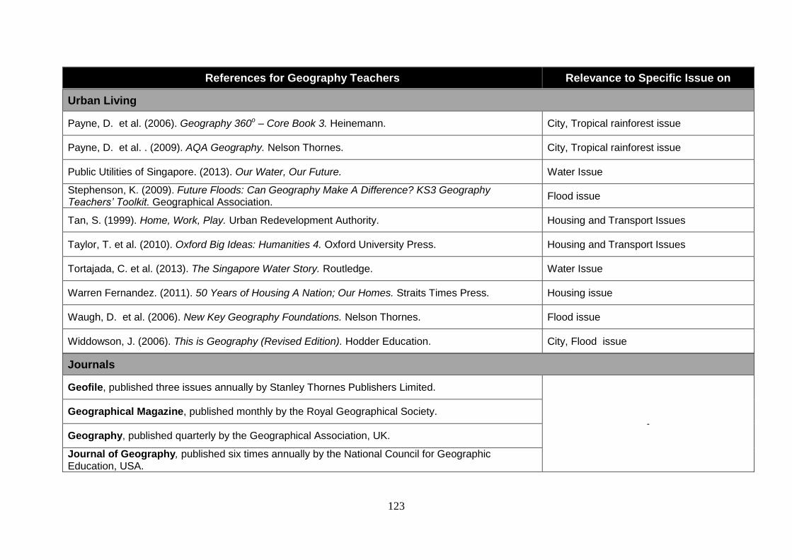
123
References for Geography Teachers Relevance to Specific Issue on
Journals
Geofile, published three issues annually by Stanley Thornes Publishers Limited.
-
Geographical Magazine, published monthly by the Royal Geographical Society.
Geography, published quarterly by the Geographical Association, UK.
Journal of Geography, published six times annually by the National Council for Geographic Education, USA.
Urban Living
Payne, D. et al. (2006). Geography 360o – Core Book 3. Heinemann. City, Tropical rainforest issue
Payne, D. et al. . (2009). AQA Geography. Nelson Thornes. City, Tropical rainforest issue
Public Utilities of Singapore. (2013). Our Water, Our Future. Water Issue
Stephenson, K. (2009). Future Floods: Can Geography Make A Difference? KS3 Geography Teachers’ Toolkit. Geographical Association.
Flood issue
Tan, S. (1999). Home, Work, Play. Urban Redevelopment Authority. Housing and Transport Issues
Taylor, T. et al. (2010). Oxford Big Ideas: Humanities 4. Oxford University Press. Housing and Transport Issues
Tortajada, C. et al. (2013). The Singapore Water Story. Routledge. Water Issue
Warren Fernandez. (2011). 50 Years of Housing A Nation; Our Homes. Straits Times Press. Housing issue
Waugh, D. et al. (2006). New Key Geography Foundations. Nelson Thornes. Flood issue
Widdowson, J. (2006). This is Geography (Revised Edition). Hodder Education. City, Flood issue
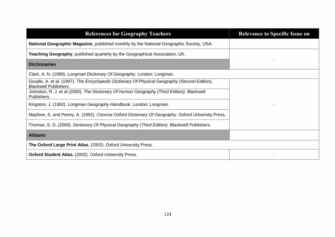
124
References for Geography Teachers Relevance to Specific Issue on
National Geographic Magazine, published monthly by the National Geographic Society, USA.
Teaching Geography, published quarterly by the Geographical Association, UK. -
Dictionaries
Clark, A. N. (1989). Longman Dictionary Of Geography. London: Longman.
Goudie, A. et al. (1997). The Encyclopedic Dictionary Of Physical Geography (Second Edition). Blackwell Publishers.
-
Johnston, R. J. et al (2000). The Dictionary Of Human Geography (Third Edition). Blackwell Publishers.
Kingston, J. (1992). Longman Geography Handbook. London: Longman.
Mayhew, S. and Penny, A. (1992). Concise Oxford Dictionary Of Geography. Oxford University Press.
Thomas, S. D. (2000). Dictionary Of Physical Geography (Third Edition). Blackwell Publishers.
Atlases
The Oxford Large Print Atlas. (2002). Oxford University Press.
Oxford Student Atlas. (2002). Oxford University Press. -