geographical agriculture by allah dad khan
TRANSCRIPT


PRESENTATION BREAK UP
1. What is Geography 2. Introduction to Geography of Pakistan3. Location of Pakistan 4. Natural diversity 5. Some Important terms of Geography and land 6. Climatic conditions 7. Water Source the Indus River and irrigation 8. What is agriculture 9. Agriculture and land use 10. Geographical Agriculture 11. KPK at a glance


1.WHAT IS GEOGRAPHY
Geography (from Greek γεωγραφία, geographia, lit. "earth description" is a field of science dedicated to the study of the lands, the features, the inhabitants, and the phenomena of the Earth.
A literal translation would be "to describe or write about the Earth". The first person to use the word "geography" was Eratosthenes (276–194 BC).

2. GEOGRAPHY OF PAKISTAN

INTRODUCTION TO GEOGRAPHY OF PAKISTAN


GEOGRAPHY OF PAKISTAN The geography of Pakistan (Urdu: ۂجغرافی پاِکستان ) is a profound
blend of landscapes varying from plains to deserts, forests, hills, and plateaus ranging from the coastal areas of the Arabian Sea in the south to the mountains of the Karakoram range in the north. Pakistan geologically overlaps both with the Indian and the Eurasian tectonic plates where its Sindh and Punjab provinces lie on the north-western corner of the Indian plate while Balochistan and most of the Khyber-Pakhtunkhwa lie within the Eurasian plate which mainly comprises the Iranian plateau, some parts of the Middle East and Central Asia. The Northern Areas and Azad Kashmir lie mainly in Central Asia along the edge of the Indian plate and hence are prone to violent earthquakes where the two tectonic plates collide.

GEOGRAPHICAL REGIONS Pakistan is divided into three major geographic areas: the
northern highlands; the Indus River plain, with two major subdivisions corresponding roughly to the provinces of Punjab and Sindh; and the Balochistan Plateau. Some geographers designate additional major regions. For example, the mountain ranges along the western border with Afghanistan are sometimes described separately from the Balochistan Plateau, and on the eastern border with India, south of the Sutlej River, the Thar Desert may be considered separately from the Indus Plain. Nevertheless, the country may conveniently be visualized in general terms as divided in three by an imaginary line drawn eastward from the Khyber Pass and another drawn southwest from Islamabad down the middle of the country. Roughly, then, the northern highlands are north of the imaginary east-west line; the Balochistan Plateau is to the west of the imaginary southwest line; and the Indus Plain lies to the east of that line.

THE NORTHERN HIGHLANDS
The northern highlands include parts of the Hindu Kush, the Karakoram Range, and the Himalayas. This area includes such famous peaks as K2[3] (Mount Godwin Austen, at 8,611 meters the second highest peak in the world). More than one-half of the summits are over 4,500 meters, and more than fifty peaks reach above 6,500 meters. Travel through the area is difficult and dangerous, although the government is attempting to develop certain areas into tourist and trekking sites. Because of their rugged topography and the rigours of the climate, the northern highlands and the Himalayas to the east have been formidable barriers to movement into Pakistan throughout history.

INDUS PLAN The name Indus comes from the Sanskrit word sindhu,
meaning ocean, from which also come the words Sindh, Hindu, and India. The Indus, one of the great rivers of the world, rises in southwestern Tibet only about 160 kilometres west of the source of the Sutlej River, which joins the Indus in Punjab, and the Brahmaputra, which runs eastward before turning southwest and flowing through Bangladesh. The catchment area of the Indus is estimated at almost 1 million square kilometres, and all of Pakistan's major rivers—the Kabul, Jhelum, Chenab, Ravi, and Sutlej—flow into it. The Indus River basin is a large, fertile alluvial plain formed by silt from the Indus. This area has been inhabited by agricultural civilizations for at least 5,000 years.

BALUCHISTAN PLATUE
Balochistan is located at the eastern edge of the Iranian plateau and in the border region between Southwest, Central, and South Asia. It is geographically the largest of the four provinces at 347,190 km² or (134,051 square miles) of Pakistani territory; and composes 48% of the total land area of Pakistan. The population density is very low due to the mountainous terrain and scarcity of water. The southern region is known as Makran. The central region is known as Kalat.

3. LOCATION OF PAKISTAN


4. NATURAL DIVERSITY


5. SOME IMPORTANT TERMS OF GEOGRAPHY AND LAND
Geographic information systems (GIS) deal with the storage of information about the Earth for automatic retrieval by a computer, in an accurate manner appropriate to the information's purpose. In addition to all of the other subdisciplines of geography, GIS specialists must understand computer science and database systems. GIS has revolutionized the field of cartography: nearly all mapmaking is now done with the assistance of some form of GIS software. GIS also refers to the science of using GIS software and GIS techniques to represent, analyze, and predict the spatial relationships. In this context, GIS stands for Geographic Information Science.

REMOTE SENSING
Remote sensing is the science of obtaining information about Earth features from measurements made at a distance. Remotely sensed data comes in many forms, such assatellite imagery, aerial photography, and data obtained from hand-held sensors. Geographers increasingly use remotely sensed data to obtain information about the Earth's land surface, ocean, and atmosphere, because it: a) supplies objective information at a variety of spatial scales (local to global), b) provides a synoptic view of the area of interest, c) allows access to distant and inaccessible sites, d) provides spectral information outside the visible portion of the electromagnetic spectrum, and e) facilitates studies of how features/areas change over time. Remotely sensed data may be analyzed either independently of, or in conjunction with other digital data layers (e.g., in a Geographic Information System).

PHYSICAL GEOGRAPHY
Physical geography (or physiography) focuses on geography as an Earth science. It aims to understand the physical problems and the issues of lithosphere, hydrosphere,atmosphere, pedosphere, and global flora and fauna patterns (biosphere).

6. CLIMATIC CONDITIONS

FOUR SEASON OF PAKISTAN
Pakistan has four seasons: a cool, dry winter marked by mild temperatures from December through February; a hot, dry spring from March through May; the summer rainy season, or southwest monsoon period, from June through September; and the retreating monsoon period of October and November. The onset and duration of these seasons vary somewhat according to location.

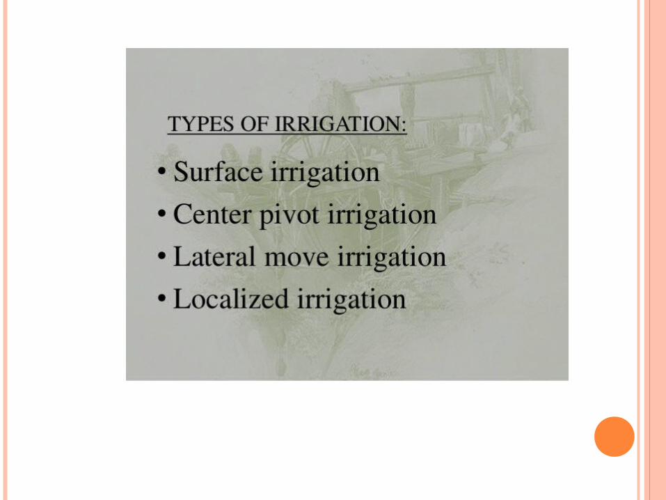
7.WATER SOURCE THE INDUS RIVER AND IRRIGATION

RIVER INDUS BIGGEST SOURCE OF WATER
Pakistan Largest River is known as River Indus which Flows from Tibet China and Enters through Pakistan by KPK. River Indus Systen is Known as Indus System. It is divided Into Two Plains. Upper Indus Plain Which Starts From Northern Pakistan and ends Up to Mithankot. River Indus has Tributaries on both western and eastern side. River Indus eastern tributaries are River Jhelum, Chenab, Sutlej, Ravi and Beas. these Four Rivers Flow in Punjab. These four Rivers meet at Panjnad from where they are known as River Panjnad. River Indus western Tributaries are River Swat, Kabul, Kurrram, Tochi, Gomal, Zhob. These rivers join River Indus at KPK. At Mithankot these Rivers Finally Meet with River Indus. After this River Indus Flows Alone Through Lower Indus Plain. Lower Indus Plain Starts from Mithankot up to Thatta where River Indus Meets with Arabian Sea. This place is also known as Indus Delta.


8. WHAT IS AGRICULTURE
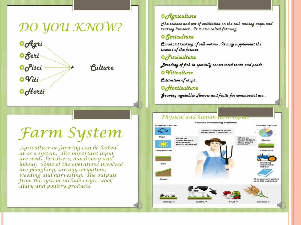


9. AGRICULTURE AND LAND USE


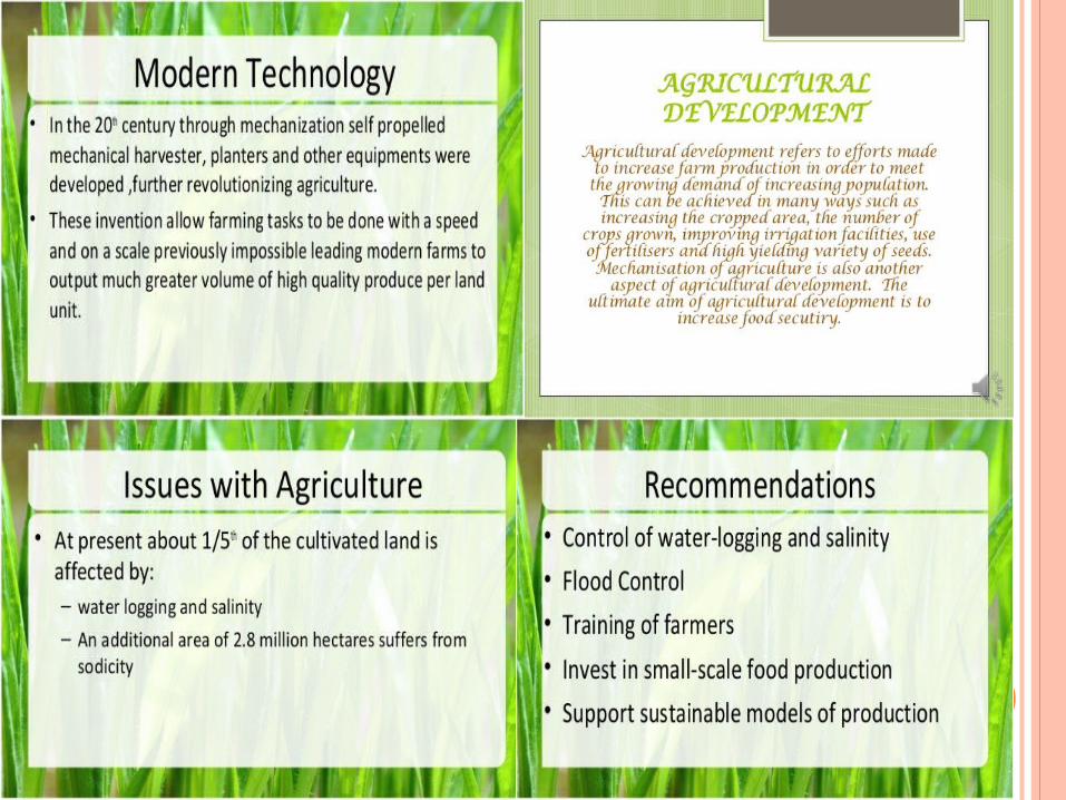
10. GEOGRAPHICAL AGRICULTURE

GEOGRAPHY AGRICULTURE Agricultural geography today focuses specifically on farms
(including ranches) and farming; production of food, fiber, and fuel; economic, policy, and resource issues related to agriculture; and farm household and livelihood concerns. There are connections between agricultural geography and related disciplines, particularly rural sociology and agricultural economics.
Rural geography includes a breadth of topics relevant to rural areas and small towns, from social issues to natural resources management and land use. Traditional agricultural geography focused on spatial patterns and varying agricultural systems, particularly from a basis in economic geography and/or land use.


GEOGRAPHICAL AGRICULTURE AND RELATED TERMS
It is traditionally considered the branch of economic geography that investigates those parts of the Earth's surface that are transformed by humans through primary sector activities. It thus focuses on structures of agricultural landscapes and asks for the processes that lead to these spatial patterns. While most research in this area concentrates rather on production than on consumption,[1] a distinction can be made between nomothetic (e.g. distribution of spatial agricultural patterns and processes) and idiographic research (e.g. human-environment interaction and the shaping of agricultural landscapes). The latter approach of agricultural geography is often applied within regional geography.

11. KHYBER PAKHTUNKHWA AT A GLANCE


