geochemistry and geotechnical analysis of lateritic soils...
TRANSCRIPT

- 4395 -
Geochemistry and Geotechnical Analysis of Lateritic Soils in the
Anambra Basin
Enaworu E.1*, Ugbe F. C.2, Rotimi O. J.1 , Ameloko A. A.1 1. Petroleum Engineering Department, Covenant University, Ota.
2. Geology Department, Delta State University, Abraka. *Corresponding author: e-mail: [email protected]
ABSTRACT In addition to previous work done by Enaworu et al., (2016) on the geochemical and geotechnical (compaction) analysis of lateritic soils located at Okpanam area in the Anambra Basin, this paper presents further work done on lateritic soils at a different location (Azagba – Ogwashi area). The major elements geochemistry and compaction characteristics of lateritic soils in Azagba – Ogwashi area, located in the Anambra Basin were investigated. This was with a view to ascertain their silica-sesquioxide ratio in order to classify them into lateritic soils and assessing the suitability of these lateritic soils as highway sub-base and sub-grade construction materials. Bulk samples of soil were collected from two separate horizons – A and B at depths of 1.08m and 3.42m respectively from an outcrop. The major elements geochemical analysis was carried out by means of Atomic Absorption Spectrometry (AAS). The geotechnical (compaction) analysis, was executed by following the modified American Association of State Highway and Transportation Officials (AASHTO) test (T-180). The amount of total irons in terms of iron III oxide ranged from 6.75% - 8.91% in depths 1.08m and 3.42 respectively. Silica-sesquioxide of iron and aluminum molar ratios at depths of 1.08m and 342m were between 1.77 and 1.64 respectively. Compaction characteristics values for this area varied with sampling depth, at a Maximum Dry Density (MDD) range of 1.86g/cm3 to 1.91g/cm3 and an Optimum Moisture Content (OMC) range of 16.0% to 14.5% for depths 1.08m and 3.42 respectively. With these values, the soils can be compacted at specific optimum moisture contents thereby ensuring the subsequent use of these soils as sub-grade and sub-base highway construction materials. KEYWORDS: Compaction, Geochemistry, Maximum dry density, Optimum moisture content, Silica-sesquioxide ratio, Lateritic soils, laterites.
INTRODUCTION The settlement of un-compacted fills did not result in any serious inconveniences until the
beginning of the 20th century, when the rapid development of the automobile created an increasing demand for hard surface roads. It soon became apparent that concrete roads on un-compacted fills were likely to break up and that the surface of other types of high-grade pavement tended to become very uneven. The necessity for avoiding such undesirable conditions fostered the development of methods of soil compaction that would satisfy the requirement of both economy and efficiency. Simultaneous increase of activity in the field of earth-dam construction provided an additional incentive for the development of compaction methods. The investigation that was made has led to the
Vol. 22 [2017], Bund. 11 4396 conclusion that no one method of compaction is equally suitable for all types of soil. Furthermore, the extent to which a given soil is compacted for a particular procedure mainly depends on the water content of the soil. The greatest degree of compaction is obtained when the water content has a certain value known as the optimum moisture content.
Lateritic soils are soils that have undergone a serious weathering process, enriched with oxides of aluminum, iron or both. They usually contain high quantities of kaolinite and quartz and usually lack the primary silicates and their bases. Attempts have been made by various investigators to produce a method identifying and evaluating lateritic soils for engineering purposes (Gidigasu, 1976; Townsend, 1985). Lateritic soils located in Nigeria have been used extensively in the construction industry as subgrade and sub-base materials for road construction and are usually formed in different drainage and sub-climate environments. Lateritic soils found everywhere shows unique physical, chemical and engineering properties. Therefore, it is necessary that a comprehensive evaluation be carried out on any lateritic soil in order to determine if it meets the requirements of lateritic soils, prior to its utilization for any engineering purpose.
The studied lateritic soils are located along the new Benin-Asaba dual carriage way in Azagba- Ogwashi areas in the North-Eastern part of Delta State, Southern Nigeria. The soils were obtained from an outcrop in two different layers. The Geochemistry and geotechnical (compaction) properties of the lateritic soils have also been studied with a view of classifying the soil into lateritic and non-lateritic soils, and determining the optimum moisture contents (OMC) and maximum dry densities (MDD) at which they can be compacted with a view to assessing their suitability as sub-base and sub-grade materials for road construction purpose.
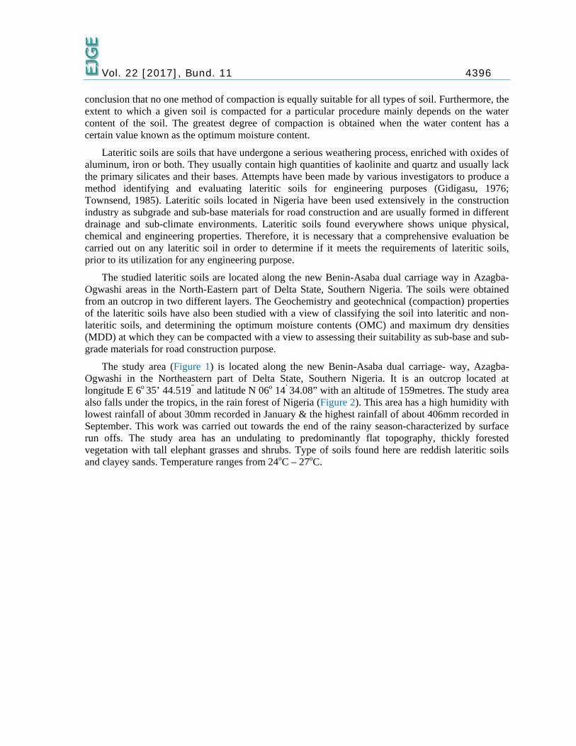
The study area (Figure 1) is located along the new Benin-Asaba dual carriage- way, Azagba- Ogwashi in the Northeastern part of Delta State, Southern Nigeria. It is an outcrop located at longitude E 6o 35’ 44.519” and latitude N 06o 14’ 34.08” with an altitude of 159metres. The study area also falls under the tropics, in the rain forest of Nigeria (Figure 2). This area has a high humidity with lowest rainfall of about 30mm recorded in January & the highest rainfall of about 406mm recorded in September. This work was carried out towards the end of the rainy season-characterized by surface run offs. The study area has an undulating to predominantly flat topography, thickly forested vegetation with tall elephant grasses and shrubs. Type of soils found here are reddish lateritic soils and clayey sands. Temperature ranges from 24oC – 27oC.

Vol. 22 [2017], Bund. 11 4397
Figure 1: Location Map of Study Area.
Figure 2: Vegetation of Study Area
Over the years, considerable works on lateritic soils had been carried in many different countries and parts of Nigeria and already presented are explicit reviews of available literature. Alexander and Cady, (1962) ascertained that a lateritic soil contains kaolinite and quartz in large amounts, lacks bases of primary silicates rich in aluminum and iron oxides, and highly weathered. Gidigasu, (1976)

Vol. 22 [2017], Bund. 11 4398 identified three major stages in the process of laterization. Ola, (1978) calculated the silica sesquioxide molar ratio of lateritic soils, and also evaluated the geotechnical properties and behavior of some lateritic soils in Nigeria. Townsend, (1985) evaluated lateritic soils for the purpose of engineering and stated that the iron oxide present in these soils is considered to play a key role in concentration and aggregate formation, which affects their engineering behavior significantly. Akpokodje, (1986) studied the geotechnical properties of non-lateritic and lateritic soils in the South-eastern part of Nigeria and their evaluations for construction of roads. The chemistry, mineralogy and basic geotechnical properties of some lateritic soils and from southwestern Nigeria were also studied by Ogunsanwo, (1988). Rao et al, (1988) presented a paper which attempts to understand the role of iron oxide and the mechanisms by which the sesquioxides influence the index and compressibility characteristics of a kaolinite rich red soil and a montmorillonite dominant black soil, based on results obtained with remolded saturated specimens tested in the untreated and iron oxide removed (decemented) conditions.
Field Manual (FM 5- 410) on Military Soils Engineering, (1992) listed the compaction specifications and characteristics of various soils, the moisture density relationship for two different soils, sub grade and base compaction requirements; as well as the corrective actions to be taken at different environmental conditions in order to bring out the mechanism that control the compaction characteristics of lateritic soils subjected to some environmental changes. Udoeyo and Abubakar, (2001) designed an experimental programme and studied the influence of compaction delay on some characteristics of laterites stabilized with cement kiln dust-an industrial waste from cement manufacturing company. Adeyemi, (2002) evaluated and studied the geotechnical, clay mineralogy, and geochemical properties of lateritic soils in the Ishara area with a view to assessing the suitability or otherwise of the soil as highway sub-grade and fill material.
Ogunsanwo (2002) studied and investigated some soils from South-western Nigeria in order to ascertain their geotechnical behaviour in the compacted state under the direct shear and consolidation tests in the laboratory. In order to stimulate a condition of inundation, he further examined the behavior of the soils in the remoulded state similar tests. Enaworu et al., (2016), carried out a geochemistry and compaction analysis on laterictic soils on the Okpanam area of the Anambra basin to determine their silica-sesquioxide ratio and determine their suitability of being used as lower grade and sub-base materials for road construction works. From their work, it was confirmed that these soils are not laterites but lateritic soils which can be compacted at precise optimum moisture contents before being used as road construction materials.
Laterites and Lateritic Soils The soil name ‘laterite’ was coined by Buchanan (1807) in India, from a Latin Word ‘later’
meaning brick. It was used by Buchanan to refer to some red, porous ferruginous earth materials in the present-day India, which could be cut with a trowel or a large knife and becomes hardened when exposed to air. Although confusion has risen in the use of the term ‘laterites’, as many material possess various compositions similar to laterites, workers mostly prefer to use the following terms based on hardening: Iron-rich – ferric, silica-rich – silcrete, carbonate-rich – calcrete and bauxite or ‘alcrete’ for aluminum-rich (Fookes, 1997).
Based on the ratios of sesquioxides (Fe2 O3 + Al2 O3) to silica (SiO2) other definitions for laterites have been given. Ratio less than 1.33 depict laterites, between 1.33 – 2.0 indicate lateritic soils while those greater than 2.0 indicate non-lateritic soils (Bell, 1993). Laterites can also be identified based on the value of sesquioxide ratio (Table 1).

Vol. 22 [2017], Bund. 11 4399
Table 1: Identification of laterites based on value of sesequioxide ratio (Source: Military Soils Engineering field manual 5-410: 1992)
Name Sesquioxide ratio
Laterite Lateritic Soil
Non-lateritic, tropical soil
1.33 1.33 - 2.00
2.0
Lateritic soils have similar chemical properties and appearances with laterites. But a lateritic soil is less indurate and softens readily on wetting.
Oyelami & Van Rooy, (2016), gave a recent definition of lateritic soils based on field observations and on their use in the construction/development of sustainable housing in Africa. They termed it as a soil that is well graded, covered with rich concretions of sesquioxide, sub-tropical and tropical soil, highly weathered, with colours ranging from brown to red. They are usually more durable than cohesive soils and more suited to cement stabilization due to the presence of iron oxides that react with the cement. Lateritic soils are also said to consist of non-cohesive (gravels and sands) and cohesive (clay and silt) soils fractions and contain both clay minerals and sesquioxides (Oyelami & Van Rooy, 2016).
REGIONAL GEOLOGY OF ANAMBRA BASIN The Anambra basin is a sedimentary Basin in South central part of Nigeria that covers an area of
40,000sq. km (Udo,1970). The southern boundary of the Anambra Basin coincides with the northern section of the Niger Delta, with the Basin as main precursor and the Basin extends north wards beyond the Benue River (Udo, 1970). The Anambra Basin is linked with the splitting of the Gondwana supercontinent (Reijers, 1996). The Santonian tectonic pulse which dated back to 84my occurred before the formation of the Anambra Basin proper. In the Albian-Santonian, the Benue Trough, with the Abakaliki Basin were essentially intracratonic mobile sedimentary basin, while the proto-Anambra Basin was just a platform thinly covered by older sediments (Reijers, 1996). When the Santonian compressional event occurred, the Abakaliki Basin was folded and uplifted. The westward translation then occurred at the depocenter close to the Anambra Basin. Sediments were generated from the Abakaliki uplands, the Benue fold belt and beyond the Benue hinge line.
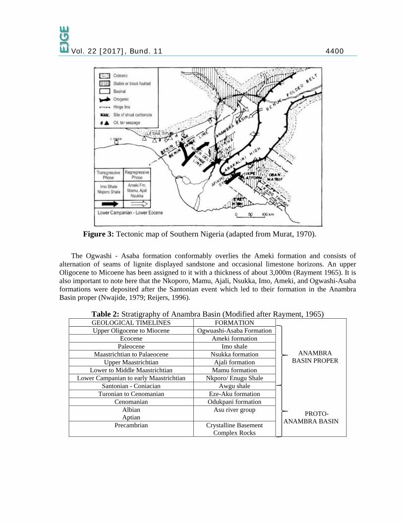
Stratigraphy of the Anambra Basin The sedimentary deposits of the Anambra Basin (Figure 3) according to Murat, (1970) belong to
the Cretaceous – Tertiary age and lies uncomformably on the crystalline basement complex rocks (Reyment, 1965). Generally, the stratigraphic sequence of this basin from the oldest to the youngest is as listed in Table 2.
Vol. 22 [2017], Bund. 11 4400
Figure 3: Tectonic map of Southern Nigeria (adapted from Murat, 1970).
The Ogwashi - Asaba formation conformably overlies the Ameki formation and consists of
alternation of seams of lignite displayed sandstone and occasional limestone horizons. An upper Oligocene to Micoene has been assigned to it with a thickness of about 3,000m (Rayment 1965). It is also important to note here that the Nkoporo, Mamu, Ajali, Nsukka, Imo, Ameki, and Ogwashi-Asaba formations were deposited after the Santonian event which led to their formation in the Anambra Basin proper (Nwajide, 1979; Reijers, 1996).
Table 2: Stratigraphy of Anambra Basin (Modified after Rayment, 1965) GEOLOGICAL TIMELINES FORMATION
ANAMBRA BASIN PROPER
PROTO- ANAMBRA BASIN
Upper Oligocene to Miocene Ogwuashi-Asaba Formation Ecocene Ameki formation
Paleocene Imo shale Maastrichtian to Palaeocene Nsukka formation
Upper Maastrichtian Ajali formation Lower to Middle Maastrichtian Mamu formation
Lower Campanian to early Maastrichtian Nkporo/ Enugu Shale Santonian - Coniacian Awgu shale
Turonian to Cenomanian Eze-Aku formation Cenomanian Odukpani formation
Albian Aptian
Asu river group
Precambrian Crystalline Basement Complex Rocks

Vol. 22 [2017], Bund. 11 4401
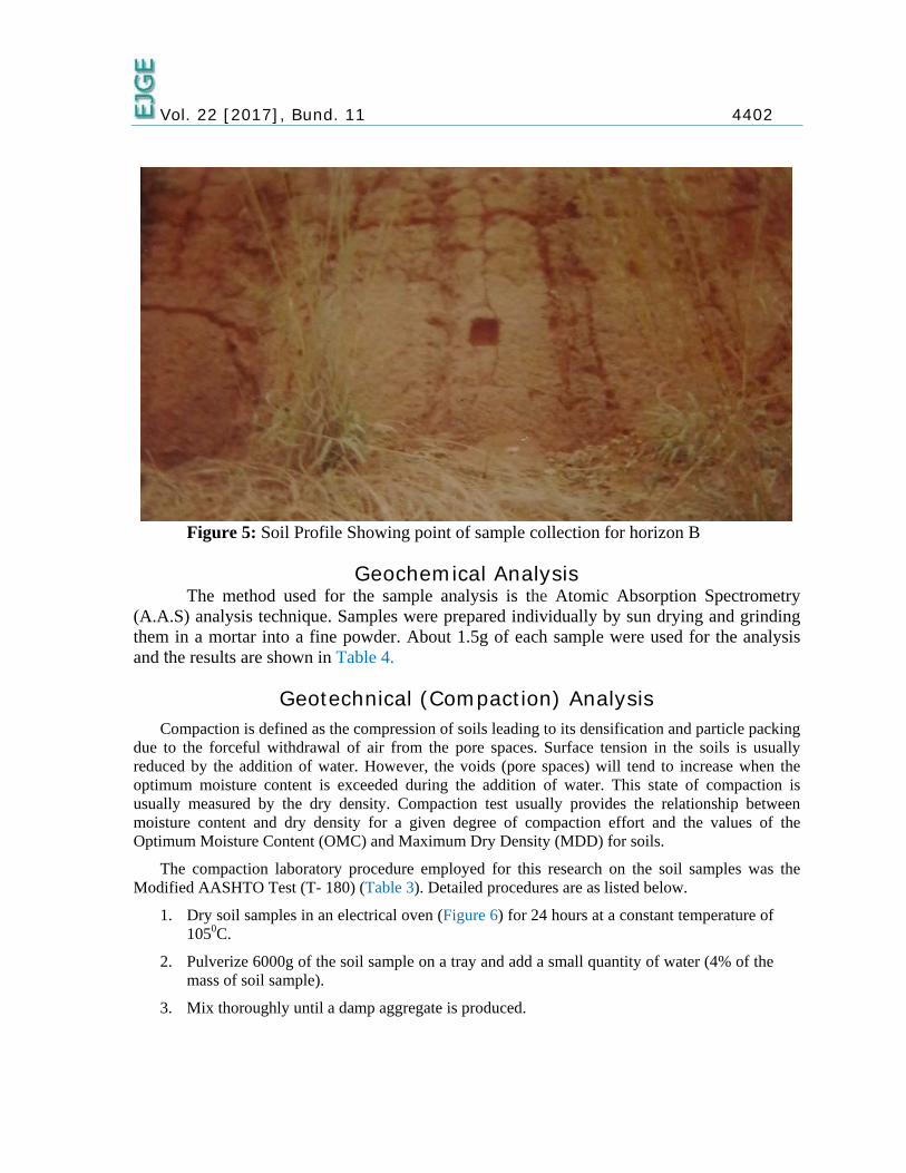
Local Geology Azagba –Ogwashi is an area dominated mainly by lateritic soils of the Quaternary
sediments of the Ogwashi-Asaba formation in the Anambra Basin. Surface exposures of these areas are mainly of humus (top soil) which extends downwards to a depth of 0.04m. The outcrop soil profile observed at Azagba-Ogwashi location is approximately 5.18m with a predominantly flat to undulating topography. There is also a general change in colour and lithological characteristics down the profiles. These changes are probably due to the leaching away of mobile elements from the top of the profile to the bottom. These changes necessitated the assignment of two horizons for this profile. Horizon A (Figure 4) is dark red in colour and moderately grained while horizon B (Figure 5) is reddish in colour with a moderate grain size.
METHODOLOGY The methodology of this research work consists of both field and laboratory (experimental)
procedures.
The field work basically involved the observation of the study areas and collection of fresh samples used for geotechnical (compaction) and geochemical analysis. The site where these samples were collected is an outcrop which is about 5.18 thick. The outcrop was properly exposed; hence, it was possible to easily observe the layers of the soil as a profile. Fresh samples were collected with the aid of a spade and stored in polythene bags after delineating the different soil horizons according to their textural and color variations. The thickness of the soil profile was measured with the aid of a measuring tape. Field instruments include: location map for access to the exact location and a Global Positioning System (GPS) device for obtaining the exact co-ordinates of the study area.
Figure 4: Soil Profile Showing point of sample collection for horizon A
Vol. 22 [2017], Bund. 11 4402
Figure 5: Soil Profile Showing point of sample collection for horizon B
Geochemical Analysis The method used for the sample analysis is the Atomic Absorption Spectrometry
(A.A.S) analysis technique. Samples were prepared individually by sun drying and grinding them in a mortar into a fine powder. About 1.5g of each sample were used for the analysis and the results are shown in Table 4.
Geotechnical (Compaction) Analysis Compaction is defined as the compression of soils leading to its densification and particle packing
due to the forceful withdrawal of air from the pore spaces. Surface tension in the soils is usually reduced by the addition of water. However, the voids (pore spaces) will tend to increase when the optimum moisture content is exceeded during the addition of water. This state of compaction is usually measured by the dry density. Compaction test usually provides the relationship between moisture content and dry density for a given degree of compaction effort and the values of the Optimum Moisture Content (OMC) and Maximum Dry Density (MDD) for soils.
The compaction laboratory procedure employed for this research on the soil samples was the Modified AASHTO Test (T- 180) (Table 3). Detailed procedures are as listed below.
1. Dry soil samples in an electrical oven (Figure 6) for 24 hours at a constant temperature of 1050C.
2. Pulverize 6000g of the soil sample on a tray and add a small quantity of water (4% of the mass of soil sample).
3. Mix thoroughly until a damp aggregate is produced.
Vol. 22 [2017], Bund. 11 4403
4. Pack the damp soil aggregate in 5 equal layers into the cylindrical mould of 4339g weight and compact each layer by 56 blows of a standard 4535g weight rammer (Figure 7), falling from a height of 0.46m.
5. Fill the cylindrical mould with same soil sample and level by scrapping off excess soil beginning at the central axis and working towards the edge of the mould.
6. De-mould the soil and collect some samples into small metal containers of known weight to determine their respective water contents.
7. Oven dry for 24 hours.
8. Pulverize the soil samples further by hand and then add 2% of the original mass of soil for quantity of water, while mixing thoroughly by hand.
9. Repeat the compaction process until there is a drop in the combined weight of the mould and wet soil.
10. Determine the bulk density (wet density) and dry density from equations (1) and (2).
11. Plot the dry density values against moisture contents, showing the relationship between dry density and moisture content (Figure 10 and Figure 11).
Dry Density (ℓd) = W1−WV
(1)
Wet (bulk)density (ℓ) = ℓ1+m
(2) Where, W = weight of mould W1 = weight of wet soil + mould W2 = weight of wet soil W2 = W1 – W V = volume of mould
m = moisture content
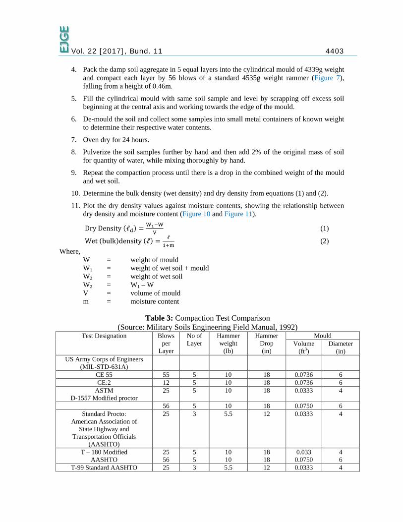
Table 3: Compaction Test Comparison (Source: Military Soils Engineering Field Manual, 1992)
Test Designation Blows per
Layer
No of Layer
Hammer weight
(Ib)
Hammer Drop (in)
Mould Volume
(ft3) Diameter
(in) US Army Corps of Engineers
(MIL-STD-631A)
CE 55 55 5 10 18 0.0736 6 CE:2 12 5 10 18 0.0736 6
ASTM D-1557 Modified proctor
25 5 10 18 0.0333 4
56 5 10 18 0.0750 6 Standard Procto:
American Association of State Highway and
Transportation Officials (AASHTO)
25 3 5.5 12 0.0333 4
T – 180 Modified AASHTO
25 56
5 5
10 10
18 18
0.033 0.0750
4 6
T-99 Standard AASHTO 25 3 5.5 12 0.0333 4
Vol. 22 [2017], Bund. 11 4404
Moisture Content Analysis The moisture content of the soil is the characteristics which are most frequently determined and it
applies to various kinds of soils. The moisture content of a soil is the ratio of the weight of water to the weight of dry soil. Although naturally, soils tend to contain some quantities of water as part of their structure. The moisture content of a soil is the amount of water within the pore space between the soil grains which is removable by oven drying at 1050C – 1070C and expressed as a percentage of the mass of dry soil. Usually, moisture content test is necessary to determine the plasticity and shrinkage limit of fine-grained soils, for which moisture content is used as an index, determining the OMC for the various soil samples and measurement of the moisture content of samples used for laboratory testing, usually both before and after the test. This is normally done on all test samples as a routine procedure. Detailed steps are as listed below.
1. Clean and dry the small containers and then measure the weight of each container.
2. Collect the wet soil sample in the small containers (Figure 8) and weigh to determine the weight of containers and wet soil samples.
3. Place the containers and its wet soil sample content in the oven, for about 24 hours to get dried, at a maintained required temperature of 1050c.
4. Remove the containers and its contents from the oven after 24 hours and allow soil samples to cool down.
5. When fully cooled, replace lids of the containers and weigh in an electrical weighing machine (Figure 9) to determine the weight of the dry soil and container.
6. Calculate the moisture content in percentage using equation (3).
Percentage moisture content = weight of water
Weight of dry soil x 100% = W1 – W2
W2 – W x 100% (3)
Weight of dry soil (Wd) = W2 – W
Weight of water (Ww) = W1 – W2
Where, W = weight of container W1 = weight of wet soil + container W2 = weight of dry soil + container
The value of percentage moisture content for each individual content specimen was calculated to the nearest 0.1%.
Vol. 22 [2017], Bund. 11 4405
Figure 6: Electric Oven
Figure 7: Compaction Tools
Vol. 22 [2017], Bund. 11 4406
Figure 8: Moisture Content Determination Containers
Figure 9: Digital Weighing Machine

Vol. 22 [2017], Bund. 11 4407
RESULT INTERPRETATION AND DISCUSSION
Geochemical Analysis Results The geochemical analysis results of lateritic soils from the study area showing the
major elements are shown below in Table 4. The silica/sesquioxide molar ratios were computed using equation (3).
Table 4: Geochemical Analysis Results for Lateritic Soils. Horizon A Horizon B
Sampling depth 1.08m 3.42m Elemental oxides (%)
SiO2 A12O3 Fe2O3 Na2O MgO K2O TiO2
45.12 39.12 6.75 1.77 1.81 1.06 0.60
43.19 39.14 8.91 1.67 1.72 1.03 0.52
Total 96.23 96.18 Silica/Sesquioxide molar ratio 1.77 1.64
Silica/Sesquioxide Molar Ratio = % SiO2
Mol.Wt.of SiO2
% Al2O3 Mol.Wt.of Al2O3
+ % Fe2O3 Mol.Wt.of Fe2O3
(4)
Molar mass of Si = 28.0g Molar mass of O = 16.0g Molar mass of Al = 27.0g Molar mass of Fe = 56.0g Molar weight of SiO2 = 28 + (16 x 2) = 60.0g Molar weight of Al2O3 = (27.0 x 2) + (16 x 3) = 102.0g Molar weight of Fe2O3 = (56.0 x 2) + (16.0 x 3) = 160.0g
Discussion of Geochemical results From Table 4, there is a general increase in Iron III oxide (Fe2O3) down the soil horizons. This is
evidenced by an increase in the amount of Fe2O3 from 6.75% at a depth of 1.08m to 8.91% at a depth of 3.24m. It was observed by Chandrakaran and Nambiar, (1997) that in the top soil, iron III oxide exist as an inert material whereas in the bottom layers, it exists as a cementing material. Also, according to Rao et al., (1988), iron oxide present in soils binds individual soil particles into coarser aggregates and contributes to the development of random soil structure. Therefore, down the soil horizon, there is more cementing of the soil particles, forming coarser aggregates.
Winterkorn et al., (1952) cited in Adeyemi, (2002) have suggested the use of the silica/sesquioxide of iron and aluminum molar ratio for the classification of soils. While soils with ratio less than 1.33 were classified as true laterites, those with ratio between 1.33 and 2.00 were classified as lateritic soils and soils whose ratio is in excess of 2.00 were decided to be non-lateritic tropical soils. Therefore, with a silica/sesquioxide molar ratio between 1.64 and 1.77 the soils from the study area can thus be described as lateritic soils.
Vol. 22 [2017], Bund. 11 4408
Compaction Analysis Results From the geotechnical analysis, the following compaction results were obtained as shown in
Table 5.
Table 5: Compaction Analysis Results SOIL HORIZON A
Description Determination numbers
1 2 3 4 5 Wet density (g/cm3) 1.84 1.99 2.16 2.10 2.01 Dry density (g/cm3) 1.65 1.75 1.86 1.78 1.68 Moisture content % 11.5 13.7 15.9 17.8 19.7
MDD = 1.86g/cm3 OMC = 16.0%
SOIL HORIZON B
Description Determination number
1 2 3 4 5 wet density (g/cm3) 1.91 2.09 2.19 2.13 2.04 dry density (g/cm3) 1.73 1.85 1.91 1.82 1.72 moisture content% 10.7 13.0 14.5 17.2 18.6
MDD = 1.91g/cm3 OMC = 14.5%
Discussion of Compaction Analysis Results From the compaction laboratory test result for the study area (Table 5), there is an increase in
MDD values and a decrease in OMC values down the soil profile from horizon A to horizon B. this could be due to the filling of available voids in the soil with silica grains down the horizons (Udoeyo and Abubakar, 2001). Generally, there is a variation in compaction properties along the profile. Sample taken from horizons A exhibit lower MDD values and higher OMC values than those taken from horizons B. This is probably due to an increase in hard concretionary particles and quartz down the horizons (Bwalya, 2003). Usually, the higher the MDD, the more well graded, coarse and granular the soils and this enhances their subsequent performance as sub-base and sub-grade construction materials. Lateritic soils from horizon B will then be effective for use as sub-grade and sub-base materials compared to horizon A. Thus, down the soil horizons, their MDD will not be affected by moisture contents. This downward increase in MDD is also in agreement with the findings of Adeyemi (2002), who investigated some lateritic soils developed over quartz schists in Ishara area, South-western Nigeria and Enaworu et al., (2016) who also investigated some lateritic soil samples in Okpanam areas in Southern Nigeria.
From field manual 5 – 410 of Military Soils Engineering, 1992; (Table 3) soils with an optimum moisture content variation from 12% - 25% have been classified as fine grained soils while variation from 7% -12% have been classified as well graded granular soils. From the OMC values of 14.5% - 16.0%, lateritic soils in Azagba – Ogwashi can thus be classified as fine grained soils. The MDD value for this study areas also shows a general increase from 1.86g/cm3 – 1.91g/cm3 for depths 1.08m and 3.42m respectively. This characteristic compaction property further enhances their suitability for use as sub-grade and sub-base road construction materials.

Vol. 22 [2017], Bund. 11 4409
The geochemical analysis result (Table 4) shows an increase in iron oxide content values down the horizons, since there is more effective laterization (sequioxide coating) down the horizons, (Adeyemi, 2002). This increase in iron oxide results in an increase in the cementing and hardening of the concretionary particles and subsequent decrease in OMC and increase in MDD down the horizons for the study areas.
Figure 10: Moisture Content and Dry Density Relationship Graph for Horizon A
Vol. 22 [2017], Bund. 11 4410
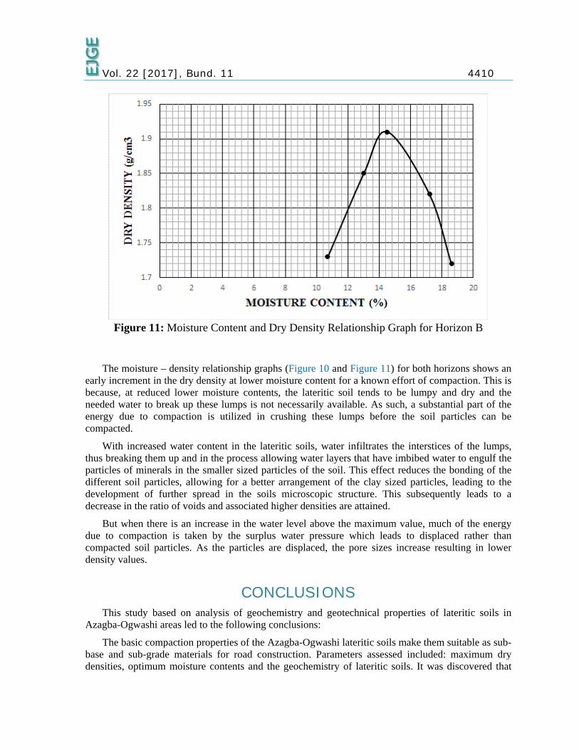
Figure 11: Moisture Content and Dry Density Relationship Graph for Horizon B
The moisture – density relationship graphs (Figure 10 and Figure 11) for both horizons shows an
early increment in the dry density at lower moisture content for a known effort of compaction. This is because, at reduced lower moisture contents, the lateritic soil tends to be lumpy and dry and the needed water to break up these lumps is not necessarily available. As such, a substantial part of the energy due to compaction is utilized in crushing these lumps before the soil particles can be compacted.
With increased water content in the lateritic soils, water infiltrates the interstices of the lumps, thus breaking them up and in the process allowing water layers that have imbibed water to engulf the particles of minerals in the smaller sized particles of the soil. This effect reduces the bonding of the different soil particles, allowing for a better arrangement of the clay sized particles, leading to the development of further spread in the soils microscopic structure. This subsequently leads to a decrease in the ratio of voids and associated higher densities are attained.
But when there is an increase in the water level above the maximum value, much of the energy due to compaction is taken by the surplus water pressure which leads to displaced rather than compacted soil particles. As the particles are displaced, the pore sizes increase resulting in lower density values.
CONCLUSIONS This study based on analysis of geochemistry and geotechnical properties of lateritic soils in
Azagba-Ogwashi areas led to the following conclusions:
The basic compaction properties of the Azagba-Ogwashi lateritic soils make them suitable as sub-base and sub-grade materials for road construction. Parameters assessed included: maximum dry densities, optimum moisture contents and the geochemistry of lateritic soils. It was discovered that

Vol. 22 [2017], Bund. 11 4411 the lower permeability, high shear strength, reduced rate of settling and less volume change made the soils compacted at the drier side of the optimum moisture content more suited for road construction than those compacted at the wetter side of the optimum moisture content.
The Azagba-Ogwashi soil samples are characteristic of soil samples that can be used as sub-grade and sub-base material for road construction. This is due to their increased maximum dry densities which are not affected by an array of moisture contents and decreased optimum moisture content down the horizon. As a result, the higher the maximum dry density, the better graded, coarse and granular the soil becomes.
The presence of sesquioxide (Fe2O3 + A12O3) and SiO2 has a substantial effect on the compaction and geochemical properties of the soils. Down the profile, the intensification of the (Fe2O3 + A12O3) shows that the lateritic soils tend towards laterites which in turn leads to an increase in the height of the free iron oxide covering of soil particles leading to their aggregate formation and cementing. Because of this, horizon B is more suited for use as a sub-grade sub-base grade material for construction purpose.
RECOMMENDATIONS From this study, the following recommendations are made:
To obtain optimum benefits from these lateritic soils for use as sub-grade and sub-base road construction materials, the traffic volume, hydrological regime and climate in which the proposed road is being built, should not be neglected.
Over compaction of the soil to levels of increased fines should be avoided as well as proper drainage should be made available in order to prevent the surge of moisture in the soil to uncontrollable amounts
More work can be done on the other engineering properties (CBR, PSD and Atterberg limits) of the lateritic soils in order to further determine their suitability for use as sub-grade and sub-base materials for road construction purpose.
ACKNOWLEDGEMENT The authors are grateful to Julius Berger Nigeria Plc, Delta State, for enabling us utilize their
laboratory.
REFERENCES [1] Adeyemi, G.O. 2002. Geotechnical properties of lateritic soil developed over Quartz
schist in Ishara Area, Southwestern Nigeria. Journal of Min. and Geol. 38, 65-69.
[2] Akpokodje, E.G. 1986. The Geotechnical properties of Lateritic and Non- lateritic soils of Southeastern Nigeria and their evaluation for road construction. Bull. Int. Assoc. Engr. Geol. 33, 115-121.
[3] Alexander, L.T. and Cady, J G. 1962. Genesis and hardening of laterite in soils. U.S. Dept. Agric. Tech. Bull., 1282, 90.
[4] Bell, F.G. 1993. Engineering Geology, pp. 104. Blackwell Scientific Publications Oxford, London, Edinburgh, Boston, Melbourne, Paris, Berlin, Viena.

Vol. 22 [2017], Bund. 11 4412
[5] Buchanan, F. 1807. A journey from Madras through the Countries of Mysore, Canara and Malabar, pp. 436-560, 2, East India Co., London.
[6] Chandrakaran, S. and Nambiar, M.R.M. 1997. Influence of some environmental factors on the engineering behavior of compacted lateritic soils. Publ. Indian highways, 29-35.
[7] Enaworu E., Ugbe F.C., Rotimi O.J., 2016: The Geochemistry and Geotechnical (Compaction) analysis of lateritic soils: A case study of Okpanam Area. AshEse Journal of Engineering. Vol. 2(3), pp. 075-082.
[8] Field Manual 5-410. 1992. Military Soils Engineering Head Quarters. Dept. of the Army, Washington, DC, 8, 1-13.
[9] Fookes, G. 1997. Tropical Residual Soils. A Geotechnical Society Engineering Group Working party revised report, pp. 21-33. Publ. Geol. Soc. London, Tulsa, New South Australia, Delhi, Tokyo.
[10] Gidigasu, M.D. 1976. Lateritic Soil Engineering, Development in Geotechnical Engineering, pp. 554. Elsevier Sci. Publ. Com., Amsterdam.
[11] Murat, R.C. 1970. Stratigraphy and paleogeography of the Cretaceous and Lower Tertiary in Southern Nigeria. In: T.F.J Dessauvagre and A.J. Whitema (Eds.), Afric. Geol. Univ. Ibadan press, pp, 251-268 Nigeria.
[12] Nwajide, C.S. and Hogue, M. 1979. Trace fossils Nanka formation, Southeastern Nigeria. Jour. Min. Geol, 58, 189-200.
[13] Ogunsanwo, O. 1988. Basic geotechnical properties, chemistry and mineralogy of some lateritic soils from Southwestern Nigerian. Bull. Int. Assoc. Engr. Geol., Paris. 37, 131-135.
[14] Ogunsanwo, O. 2002. Effect of Inundation on the geotechnical properties of some soils from parts of Southwestern Nigeria. Jour. Min. Geol. 38, 57-63.
[15] Ola, S.A. 1978. Geotechnical properties and behaviours of some stabilized Nigerian lateritic soils, Quarterly Journal Engineering Geology, London, 2, 145-160.
[16] Oyelami, C. A. & Van Rooy, J. L., 2016. A review of the use of lateritic soils in the construction/development of sustainable housing in Africa: A geological perspective. Journal of African Earth Sciences, Volume 119, pp. 226-237.
[17] Rao, S.M. Sridharan, A., Chandrakaran, S. 1978. The role of iron oxide in tropical soil properties. Proceedings 2nd Nat. Conf. on geo-mechanics in Tropical soils. Singapore, 1, 43-49.
[18] Reijers, T.J.A. 1996. Selected chapters on Geology. Shell Pet. Dev. Co. Nig. Reprographic services, Warri. 143.
[19] Reyment, R.A. 1965. Aspects of the geology of Nigeria. Ibadan University press. 133.
[20] Townsend, F.C. 1985. Geotechnical Characteristics of residual soils. Geotechnical Engr. Proc. Am. Soc. Engrs. 111, 77- 93.
[21] Udo, R.K. 1970. Geographical regions of Nigeria. pp. 212. Heinemann Educational Books Ltd. London.

Vol. 22 [2017], Bund. 11 4413
[22] Udoeyo, F.F. and Abubakar, M.A. 2001. Influence of Compaction delay on some characteristics of lateritic soil stabilized with cement kilm dust. Glo. Jour. Pure. Appl. Sci., 7, 727-731.
Other EJGE papers on Lateritic Soils:
[23] Aminaton Marto, Nima Latifi, and Houman Sohaei: “Stabilization of Laterite Soil using GKS Soil Stabilizer” Electronic Journal of Geotechnical Engineering, 2012(17.X): 521-532. Available at ejge.com.
[24] Owolabi, T. A. and Aderinola, O.S.: “Geotechnical Evaluation of Some Lateritic Soils in Akure South, South-western Nigeria” Electronic Journal of Geotechnical Engineering, 2014(19.R): 6675-6687. Available at ejge.com.
[25] Oluwapelumi, O. Ojuri and Omotayo. O. Ogundipe: “Modeling Used Engine Oil Impact on the Compaction and Strength Characteristics of a Lateritic Soil” Electronic Journal of Geotechnical Engineering, 2012(17.X): 3491-3501. Available at ejge.com.
[26] Aminaton Marto, Nima Latifi, and Houman Sohaei: “Stabilization of Laterite Soil using GKS Soil Stabilizer” Electronic Journal of Geotechnical Engineering, 2012(17.X): 521-532. Available at ejge.com.
[27] Ige Olusegun Omoniyi, Ogunsanwo Olufemi, Aweda Kolawole, and Abdulwahid: “Geotechnical and Mineralogical Evaluation of Some Lateritic Soils from Southwestern Nigeria” Electronic Journal of Geotechnical Engineering, 2014(19.B): 1301-312. Available at ejge.com.
© 2017 ejge
Editor’s note. This paper may be referred to, in other articles, as:
Enaworu E., Ugbe F. C. Rotimi O. J. , Ameloko A. A.: “Geochemistry and Geotechnical Analysis of Lateritic Soils in the Anambra Basin” Electronic Journal of Geotechnical Engineering, 2017 (22.11), pp 4395-4413. Available at ejge.com.