gaw aerosol lidar observation network (galion)
TRANSCRIPT

GAW Aerosol Lidar Observation Network (GALION)
2008 WMO Report:
ftp://ftp.wmo.int/Documents/PublicWeb/arep/gaw/gaw178-galion-27-Oct.pdf
First WMO Experts Meeting on the
implementation of
the GAW Aerosol Lidar Observation
Network: GALION
Held in March 2007, Hamburg Germany
The Global Atmosphere Watch (GAW) aerosol program (GAW, 2007) strives "to determine the spatio-temporal distribution of aerosol properties related to climate forcing and air quality up to multidecadal time scales".
GALION goal: provide the vertical component of aerosol distributions through advanced laser remote sensing in a network of ground-based stations.
Ray Hoff (UMBC) and Gelsomina Pappalardo (CNR-IMAA) are the GALION Leads
http://alg.umbc.edu/galion/

1st Meeting: Hamburg, MPIMarch 2007
2nd Meeting: Geneva, WMOSeptember 2010

Represented Networks:
Regional/Continental (Dense):
EARLINET (EUROPE)
AD-NET (E ASIA)
CIS-LINET (CIS)
CLN (NE United States)
CORALNET (Canada)
ALINE (Central & South America, Caribbean)
Global (Sparse):
MPLNET
NDACC
* Independent Sites
Conceptually GALION fits GEOSS since it is a Network of Networks and GAW is GEOSS
Implementation:
Steering Group (GAW - network heads)
Technical Working Groups
Technology & Methodology
QA/QC
Data Dissemination & Outreach
Model & Satellite Validation, Data Assimilation
Capacity Building
Development into other regions
Integration with Sunphotometer/Satellite Meas/Modeling
Initial observation schedule based on EARLINET
Minimum 1 obs at sunset on Mon, Thu
If possible, 1 obs midday on Mon

, cloud heights

GALION sites are heterogeneous with respect to:• Lidar capability (what can be retrieved from obs)• Temporal resolution and sampling (continuous, episodic)
• Vertical res varies also, but probably less of an issue• NRT capability• Standard automated processing
The following slides provide an overview of three established networks,all are now 10 years old. Example of the heterogeneous nature of GALION
Typically:
But not always….
Continuous,NRT Availability
Lidar Capability

Micro-Pulse Lidar Network (MPLNET)
http://mplnet.gsfc.nasa.gov
Tropopause
Cirrus
Transported Aerosol(Asian Dust, Pollution)
Boundary Layer(local aerosol)
Example of MPLNET Level 1 Data: Atmospheric Structure
Altitude (
km
)
Time UTC
MPLNET Sites: 2000 - currentSouth Pole MPLNET Site:1999-current
MPLNET:
• A federated network of micro pulse lidar sites around the world, coordinated and lead from Goddard Space Flight Center
• Co-location with related networks, including NASA AERONET• Local, regional, and global scale contributions to atmospheric research• Satellite validation• Aerosol climate and air quality model validation• Impact of aerosol & cloud heights on direct and indirect climate effects• Support for wide variety of field campaigns
What’s New?
• Version 2 products released 2008
• Barbados site activated in 2008
• Kanpur, India and Singapore sites activated in 2009
• Dongsha Island temporary site Spring 2010
• Hanoi, Vietnam planned site by early 2011
• One or two additional sites in SE Asia in support of 7-SEAS
• Other planned sites over next year: Qatar, Spain, Miami, NYC, Montana
Micro Pulse Lidar(GSFC Patent)
The Micro Pulse Lidar Network (MPLNET): Overview
18 Active Sites
4.9 Trillion Laser Shots,and counting …..

May 2, 2001 May 3, 2001
00:00 12:00 00:00 12:00 00:00Morning AfternoonNighttime Nighttime Morning Afternoon
Time UTC
Alt
itu
de
(km
)
Tropospheric Aerosol from Asia
Well Mixed PBL Well Mixed PBLStratified PBL Stratified PBL
Asian aerosol entrainedwithin boundary layer
PBL Growth PBL Decay
Level 1 MPLNET Signals from NASA Goddard
Micro-Pulse Lidar Network (MPLNET)MPLNET Data Products
MPLNET Data Products:
Level 1 NRB Signals, Diagnostics(near real time, no quality screening)
Level 1.5 Level 1.5b: Aerosol, Cloud, PBL Heights and Vertical Feature MaskLevel 1.5a: Aerosol Backscatter, Extinction, Optical Depth Profiles and Lidar Ratio(near real time, no quality screening)
Level 2 Operational Products Under Development (beta data available upon request)(not real time, quality assured)
All data are publicly available in netcdf format. Errors included for all data products.
Data policy same as AERONET. We are a federated network, individual site providers deserve credit.
near real time: 1 hour or 1 day

NIES lidar network (1)AD Net stations
Ryori
Gwangju
Taipei
Mineral dust
Forest fire
Industrial
Biomass burning
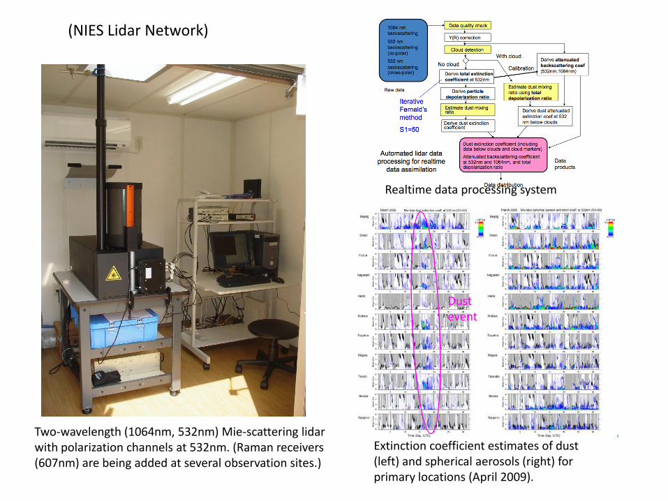
NIES lidar network (2)
Two-wavelength (1064nm, 532nm) Mie-scattering lidar with polarization channels at 532nm. (Raman receivers (607nm) are being added at several observation sites.)
Realtime data processing system
Extinction coefficient estimates of dust (left) and spherical aerosols (right) for primary locations (April 2009).
Dust event
(NIES Lidar Network)

● 27 lidar stations
- 10 multiwavelength Raman lidar
stations
backscatter (355, 532 and 1064 nm) +
extinction (355 and 532 nm) + depol ratio
(532 nm)
- 10 Raman lidar stations
- 7 single backscatter lidar stations
● comprehensive, quantitative, and
statistically significant data base
● Continental and long-term scale
EARLINET-ASOS
European Aerosol Research Lidar Network (2010)
www.earlinet.org

Network: 27 lidar stations distributed over Europe (good coverage at continental
scale)
Available lidar data (including error): extinction and backscatter profiles at 1, 2 or 3
different wavelengths plus aerosol depolarization profiles
Further products: Boundary Layer heigth, identification of layers, aerosol type
classification and in some extent also the retrieval of microphysical properties for
identified layers.
At present EARLINET data are not available in near real time.
A lot of work is in progress in order to establish a single calculus chain for all the
instruments within the network (AERONET like).
This single calculus chain is at moment under test and it should be operational in
early 2011.
This means that we will not have data in near real time in 2011 (within few hours),
but that we could have a larger amount of available Quality Assured data in a much
faster way. These data could be used for systematic data evaluation/comparison.
Representativeness studies are in progress using both satellite and sun-photometer
data.
EARLINET (for model evaluation/comparison)

GALION Goals:
Ensure that users obtain lidar data that meets standards agreed upon lidar experts, with appropriate error
Facilitate cooperation and interaction among different networks to meet community needs• one group can’t do it all
Develop a system that allows users to visit one portal and:• Effectively search for lidar data across otherwise disparate networks and individual stations• Browse quicklooks of data• Easily obtain data products in a standard, common format• Help users navigate complicated data policies and protect data providers
GALION has many challenges but we are confident this is possible
One important challenge:Recognize that our heterogeneous nature is not a “problem”, but an advantage. We need to focus on how to effectively provide ALL that we can from contributing stations, not settle on providing the bare minimum that every station can provide (eg backscatter).
Most important challenge:Money – what else? Funding levels vary widely across GALION contributors, most everyone is supported with research funding, not operational funding. That is a problem for ICAP users who want operational lidar data.
GALION Related Discussion Slides for ICAP

Simple systems contain much useful information on atmospheric structure….

…. But cannot produce highly accurate extinction, or aerosol typing / microphysics

AERONET aerosol typing: column values
Slide from D. Müller, 2nd GALION Workshop
…. Because of the limited information available from observations

- different aerosol types clusterand can be distinguished
- spread of the clusters is limited by natural variations in the end
aerosol type classification
Pure Saharan Dust
Aged Saharan Dust
Biomass Burning Aerosol + Mineral Dust
Canadian Biomass Burning Aerosol
Industrial Pollution Aerosol
Marine Aerosol
Petzold et al. ESA -ICAROHS, 2009Esselborn et al., Appl. Opt., in preparation
Slide from D. Müller, 2nd GALION Workshop

(Sugimoto et al., SOLA 2010)
~Mid-class lidar systems provide more information on aerosol type, and can still provide continuous, NRT capability (but more expensive and have eye-safety issues)

Dust layer
Backsc. Extinc. Lidar rat. Angstr. Depol.
Slide Image from Ulla Wandinger, 2nd GALION Workshop
Single wavelength Raman or HSRL systems can provide accurate extinction,But still have difficulty typing aerosols and cannot do microphysics
Multi-wavelength Raman or HSRL systems (3b+2a or better) can provide it all,but expensive, most have issues running continuously, and microphysical retrievals are complicated and difficult to run (at least now)
* note, some multiwavelength raman systems are running continuously
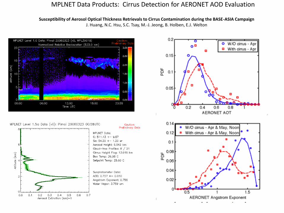
MPLNET Data Products: Cirrus Detection for AERONET AOD Evaluation
Susceptibility of Aerosol Optical Thickness Retrievals to Cirrus Contamination during the BASE-ASIA CampaignJ. Huang, N.C. Hsu, S.C. Tsay, M.-J. Jeong, B. Holben, E.J. Welton

Working Group Issues of Interest to ICAP:
Data archive and distribution still open. Metadata in GEOMs format, station entries should be placed in GAWSIS (problems with data there now)NETCDF or HDFDefine common data descriptions: Level 0, 1, 1.5, 2 (GEOMS and MPLNET standards)Distributed vs centralized data center. Network heads favor distributed to maintain link to data use.
EARLINET, MPLNET, and AD-NET have well developed data centers, how to handle others?NRT Data needs connection to WIS backbone, method may have to be different than normal data
Networks cannot loose connection to data use! Need to justify our funding, and many sites within networks are run/funded independently.
Perhaps easier to track research use of GALION data, but NRT for operational forecasting would be more difficultEven if we put an expiration date on the NRT data for forecasting, still doesn’t capture use of data by op centerLeverage off data providers for verification analysis? They have more time to look into the why (esp with students)

GALION Model & Satellite Validation, Data Assimilation Working Group:
Chairs: Judd Welton (NASA GSFC), Felicita Russo (CNR-ISAC)Members: Stefan Kinne (MPI-Meteorology), Juan Carlos Antuña (Camaguey Met Center), Dave Winker (NASA LaRC),
Thorsten Fehr (ESA), MariaRita Perrone (U Salento), Werner Thomas (?)
Define data products:• Backscatter Profile• Extinction Profile• PBL Height• Cloud Heights• Clear• No Signal• Package co-located AOD data with lidar (eg MPLNET)• Some will be periodic, others continuous• Will require subsetting of sites by products available (and time) to avoid confusing users
Emphasize the following to GALION members:• To avoid bias and misinterpretation by users: Must capture “no data/signal” information, and clouds• Error/uncertainty is key for data assimilation
• separate systematic from random if possible• consider reporting data even if fail internal GALION QA, or at least capture aerosol presence/location• report quality of error calculation… ie, backscatter+sunphoto derived extinction error contains potential bias due to use of constant lidar ratio, raman or HSRL technique can provide direct error calculation… Quality of error not standard across GALION!
Continuous data ideal, but not possible across GALION: modify existing minimum obs schedule to include sat overpass?
Our working group recommendation:Select a past “golden” year to begin building GALION framework, avoids issues some groups have with generating new data products. Tie in with Aerocom hindcast effort, and might stimulate GALION members to contribute their data.
Near real time development possible in the future (1.5 level data not fully QA)
At moment EARLINET performs systematic observations, but not continuous
24hours/7 days a week measurements.
Continuous observations possible at 4 sites at moment (2010) and possible
development for further stations in this direction can be made.
Continuous observations could be implemented but this implies a large difference in
effort/ resources (in terms of man power and hardware/equipment). So before going
for these continuos observations we have first to demostrate that these are really
necessary.
A strong demand for continuous observations could help to find the necessary
resources.
How many sites are necessary for continuous observations in order to be used
for data assimilation at continental scale? The answer to this question will help
us in the implementation.
EARLINET (for data assimilation)
For further info, please contact Gelsomina Pappalardo