garfield township zoning ordinance zoning maps · toc - 1 table of contents garfield township...
TRANSCRIPT
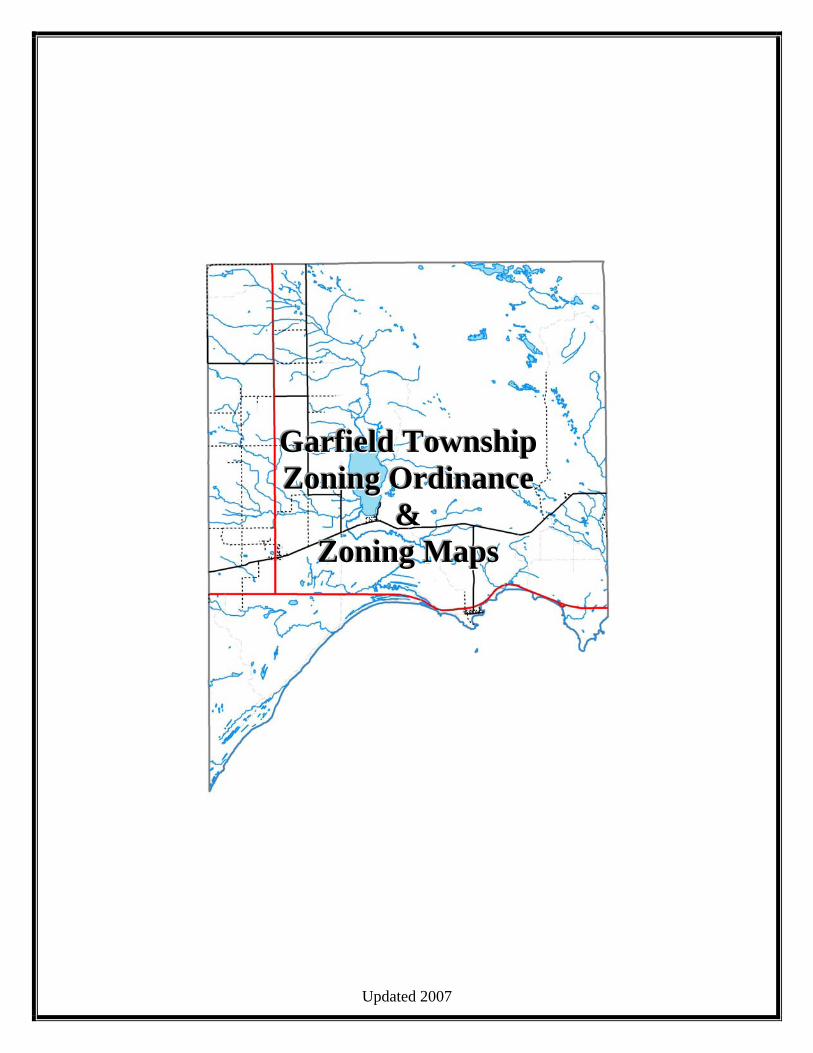
Updated 2007
GGGaaarrrfffiiieeelllddd TTTooowwwnnnssshhhiiippp ZZZooonnniiinnnggg OOOrrrdddiiinnnaaannnccceee
&&& ZZZooonnniiinnnggg MMMaaapppsss
TOC - 1
TABLE OF CONTENTS
GARFIELD TOWNSHIP ZONING ORDINANCE
TITLE............................................................................................................................................................. 1 PREAMBLE................................................................................................................................................... 1 ENACTING CLAUSE ................................................................................................................................... 1 ARTICLE I: GENERAL PROVISIONS........................................................................................................ 1
SECTION 1.01 SHORT TITLE ................................................................................................................ 1 ARTICLE II: DEFINITIONS......................................................................................................................... 1
SECTION 2.01: CONSTRUCTION OF LANGUAGE............................................................................. 1 SECTION 2.02: DEFINITIONS................................................................................................................ 2
ARTICLE III: ZONING DISTRICT AND MAPS......................................................................................... 1 SECTION 3.00: ESTABLISHMENT OF DISTRICTS............................................................................. 1 SECTION 3.01: ZONING DISTRICT MAPS .......................................................................................... 1 SECTION 3.02: OFFICIAL ZONING MAPS .......................................................................................... 1 SECTION 3.03: INTERPRETATION OF THE ZONING MAPS............................................................ 1 SECTION 3.04: APPLICATION OF DISTRICT REGULATIONS......................................................... 2 SECTION 3.05: SCOPE OF PROVISIONS ............................................................................................. 2 SECTION 3.06: CONFLICTING REGULATIONS................................................................................. 2 SECTION 3.07: DISTRICT IR: INTENSIVE RESIDENTIAL................................................................ 3 SECTION 3.08: DISTRICT ER: EXTENSIVE RESIDENTIAL.............................................................. 4 SECTION 3.09: DISTRICT RR: RESORT & RECREATION................................................................. 5 SECTION 3.10: DISTRICT GC: GENERAL COMMERCIAL ............................................................... 5 SECTION 3.11: DISTRICT GI: GENERAL INDUSTRIAL.................................................................... 7 SECTION 3.12: DISTRICT AG: AGRICULTURAL............................................................................... 9 SECTION 3.12.1: DISTRICT AG: AGRICULTURAL DEVELOPMENT STANDARDS................... 10 SECTION 3.13: DISTRICT FR: FOREST RECREATION.................................................................... 11 SECTION 3.14: DISTRICT GLS: GREAT LAKES SHORELAND...................................................... 12 SECTION 3.15: DISTRICT HSC/LS: HIAWATHA SPORTSMAN CLUB/ LAKE SHORE............... 13 SECTION 3.16: PUBLIC LANDS.......................................................................................................... 14 SECTION 3.17: OFFICIAL ZONING MAPS OF GARFIELD TOWNSHIP ........................................ 14
ARTICLE IV: GENERAL REGULATIONS ................................................................................................ 1 SECTION 4.01: AREA, YARD, HEIGHT, BULK AND PLACEMENT RESTRICTIONS ................... 1 SECTION 4.02: MINIMUM FLOOR AREA............................................................................................ 2 SECTION 4.03: MAXIMUM DENSITY FOR MULTIPLE-FAMILY AND CONDOMINIUM DEVELOPMENTS.................................................................................................................................... 2 SECTION 4.04: ACCESSORY BUILDINGS AND USES ...................................................................... 2 SECTION 4.05: ONE PRINCIPAL STRUCTURE OR USE PER LOT................................................... 4 SECTION 4.06: LOTS OR PARCELS OF RECORD .............................................................................. 4 SECTION 4.07: STORM WATER RUNOFF AND DRAINAGE............................................................ 5 SECTION 4.08: OFF-STREET PARKING REQUIREMENTS............................................................... 5 SECTION 4.09: REQUIRED PLANTING SCREENS............................................................................. 7 SECTION 4.10: PARKING LOT LANDSCAPING................................................................................. 7 SECTION 4.11: PLANTING SCREEN SPECIFICATIONS.................................................................... 7 SECTION 4.12: TIME OF COMPLETION FOR PLANTINGS .............................................................. 7 SECTION 4.13: CLEAR VIEW TRIANGLES......................................................................................... 8 SECTION 4.14: WATERFRONT SETBACK .......................................................................................... 8

TOC - 2
SECTION 4.15: STORAGE OF HAZARDOUS MATERIALS............................................................... 8 SECTION 4.16: DISCHARGES TO GROUNDWATER......................................................................... 9 SECTION 4.17: AIRPORTS ..................................................................................................................... 9 SECTION 4.18: CONDOMINIUMS ........................................................................................................ 9 SECTION 4.19: PUBLIC SERVICE INSTALLATIONS....................................................................... 11 SECTION 4.20: MINERAL EXTRACTION.......................................................................................... 12 SECTION 4.21: THE KEEPING OR HUSBANDRY OF ANIMALS ................................................... 15 SECTION 4.22: TEMPORARY USES ................................................................................................... 16
ARTICLE V: SIGNS...................................................................................................................................... 1 SECTION 5.01: INTENT.......................................................................................................................... 1 SECTION 5.02: RESTENTIAL DISTRICT SIGN REGULATIONS ...................................................... 1 SECTION 5.03: DISTRICT GC: GENERAL COMMERCIAL ............................................................... 1 SECTION 5.04: DISTRICT GI: GENERAL INDUSTRIAL.................................................................... 2 SECTION 5.05: CONDITIONAL USE SIGNS........................................................................................ 2 SECTION 5.06: TEMPORARY SIGNS ................................................................................................... 2 SECTION 5.07: CONSTRUCTION SIGNS ............................................................................................. 2 SECTION 5.08: EXEMPT SIGNS............................................................................................................ 2 SECTION 5.09: LIGHTING OF SIGNS................................................................................................... 2 SECTION 5.10: MAINTENANCE OF SIGNS......................................................................................... 3 SECTION 5.11: NONCONFORMING SIGNS......................................................................................... 3 SECTION 5.12: BILLBOARDS ............................................................................................................... 3
ARTICLE VI: SITE PLAN REVIEW............................................................................................................ 1 SECTION 6.01: PURPOSE....................................................................................................................... 1 SECTION 6.02: REQUIRED PLAN APPROVALS................................................................................. 1 SECTION 6.03: EXCEPTIONS................................................................................................................ 1 SECTION 6.04: SITE PLAN REVIEW AND APPROVAL AUTHORITY ............................................ 1 SECTION 6.05: PROCEDURES FOR SITE PLAN REVIEW................................................................. 1 SECTION 6.06: REQUIRED INFORMATION ....................................................................................... 2 SECTION 6.07: GENERAL STANDARDS FOR SITE PLAN APPROVAL.......................................... 3 SECTION 6.08: PLANNING COMMISSION REVIEW ......................................................................... 4 SECTION 6.09: REVISIONS, MODIFICATIONS, OR CORRECTIONS .............................................. 4 SECTION 6.10: FINANCIAL GUARANTEES ....................................................................................... 5 SECTION 6.11: FINAL APPROVAL OF PROJECT............................................................................... 5 SECTION 6.12: TIME LIMIT TO IMPLEMENT APPROVED SITE PLAN ......................................... 5 SECTION 6.13: ORDINANCE INTERPRETATION AND APPEALS .................................................. 5 SECTION 6.14: ZONING BOARD OF APPEALS PROCEDURE ......................................................... 5 SECTION 6.15: AS-BUILT SITE PLAN ................................................................................................. 5 SECTION 6.16: LAND CLEARING ........................................................................................................ 6
ARTICLE VII: CONDITIONAL USE PERMITS......................................................................................... 1 SECTION 7.01: INTENT.......................................................................................................................... 1 SECTION 7.02: APPLICATION PROCEDURE...................................................................................... 1 SECTION 7.03: REVIEW AND FINDINGS............................................................................................ 2 SECTION 7.04: GENERAL STANDARDS............................................................................................. 2 SECTION 7.05: CHILD OR DAY CARE CENTERS.............................................................................. 3 SECTION 7.06: CONDITIONS AND SAFEGUARDS ........................................................................... 3 SECTION 7.07: APPEALS ....................................................................................................................... 4
ARTICLE VIII: NONCONFORMING USES AND STRUCTURES ........................................................... 1 SECTION 8.01: INTENT AND PURPOSE.............................................................................................. 1 SECTION 8.02: ILLEGAL NONCONFORMING USES OR STRUCTURES........................................ 1 SECTION 8.03: DEFINITION AND CLASSIFICATION OF NONCONFORMING USES AND STRUCTURES.......................................................................................................................................... 1 SECTION 8.04: PROCEDURES FOR OBTAINING CLASS A DESIGNATION.................................. 1
TOC - 3
SECTION 8.05: REVOCATION OF CLASS A DESIGNATION ........................................................... 1 SECTION 8.06: REGULATIONS PERTAINING TO CLASS A NONCONFORMING USES AND STRUCTURES.......................................................................................................................................... 1 SECTION 8.07: REGULATIONS PERTAINING TO CLASS B NONCONFORMING USES AND STRUCTURES.......................................................................................................................................... 2 SECTION 8.08: NONCONFORMING LOTS .......................................................................................... 2 SECTION 8.09: NONCONFORMING USES .......................................................................................... 2 SECTION 8.10: REPAIRS AND MAINTENANCE ................................................................................ 2 SECTION 8.11: CHANGE OF TENANCY OR OWNERSHIP ............................................................... 3 SECTION 8.12: DISTRICT CHANGES................................................................................................... 3 SECTION 8.13: HARDSHIP CASES ....................................................................................................... 3
ARTICLE IX: ADMINISTRATION AND ENFORCEMENT ..................................................................... 1 SECTION 9.01: ADMINISTRATION...................................................................................................... 1 SECTION 9.02: ADMINISTRATIVE STANDARDS AND PROCEDURES ......................................... 1 SECTION 9.03: ZONING ADMINISTRATOR ....................................................................................... 2 SECTION 9.04: DUTIES OF THE ZONING ADMINISTRATOR ......................................................... 3 SECTION 9.05: ZONING COMPLIANCE PERMIT............................................................................... 3 SECTION 9.06: ENFORCEMENT AND NOTICE OF VIOLATION..................................................... 3 SECTION 9.07: SPECIAL ZONING ORDERS, MAP AND RECORDS................................................ 3 SECTION 9.08: FEES............................................................................................................................... 4
ARTICLE X: ZONING BOARD OF APPEALS........................................................................................... 1 SECTION 10.01: CREATION AND MEMBERSHIP.............................................................................. 1 SECTION 10.02: PROCEDURES ............................................................................................................ 1 SECTION 10.03: DUTIES AND POWERS ............................................................................................. 1 SECTION 10.04: ADMINISTRATIVE REVIEW.................................................................................... 1 SECTION 10.05: VARIANCES................................................................................................................ 2 SECTION 10.05.1: APPLICATION PROCEDURE................................................................................. 2 SECTION 10.05.2: REVIEW CONSIDERATIONS ................................................................................ 2 SECTION 10.06: VARIANCE STANDARDS......................................................................................... 3 SECTION 10.07: APPEALS ..................................................................................................................... 4 SECTION 10.08: DUTIES ON MATTERS OF APPEAL........................................................................ 4
ARTICLE XI: TOWNSHIP PLANNING COMMISSION:........................................................................... 1 SECTION 11.01: DESIGNATION ........................................................................................................... 1 SECTION 11.02: CHANGES AND AMENDMENTS............................................................................. 1
ARTICLE XII: INTERPRETATION, SEVERABILITY, VESTED RIGHT, PENALTIES, AND EFFECTIVE DATE ....................................................................................................................................... 1
SECTION 12.01: INTERPRETATION AND CONFLICT....................................................................... 1 SECTION 12.02: SEVERABILITY.......................................................................................................... 1 SECTION 12.03: VESTED RIGHT.......................................................................................................... 1 SECTION 12.04: PENALTIES AND REMEDIES................................................................................... 1 SECTION 12.05: EFFECTIVE DATE...................................................................................................... 2 SECTION 12.06: TOWNSHIP SUPERVISOR AND CLERK SIGNATURES ....................................... 2
I - 1
GARFIELD TOWNSHIP
ZONING ORDINANCE
TITLE
AN ORDINANCE enacted pursuant to the authority contained in Act 110 of the Public Acts of Michigan for 2006, as amended, (MCLA 125.3101 et seg.), known as the “Michigan Zoning Enabling Act” to establish a zoning ordinance providing comprehensive zoning regulations governing the unincorporated portions of Garfield Township and utilizing districts and standards to regulate the use of land and resources in the best interest of the public health, safety and welfare. This Ordinance is enacted to establish administrative procedures for the review and processing of land use proposals subject to authority of this Ordinance and to set up the requirements for the administration, enforcement, penalties for violation, provision for amendments and to establish a reasonable schedule of fees to carry out these provisions. This Ordinance also establishes an appeals process along with procedures to be followed for the organization and perpetuation of a Zoning Board of Appeals outlining their authority, duties and responsibilities.
PREAMBLE
In accordance with the authority and intent of Act 110 of the Public Acts of 2006, as amended, Garfield Township desires to provide for its orderly development by utilizing and implementing the various concepts, goals, objectives, policies and directives as outlined in the Garfield Township Community Plan which are essential to the well-being of the community and which will place no undue burden upon residents, commerce, food producers, the natural resources, energy conservation, developers, or industry. The Township further desires to assure adequate sites for residences, food production, recreation, industry and commerce; to provide for the free movement of vehicles upon the streets and highways of the township; to protect residents, food producers, natural resources, energy consumption, industry and commerce against incongruous and incompatible uses of land; to promote the proper use of land and natural resources for the economic well-being of the township as a whole; to assure adequate space for the parking of vehicles of customers and employees using commercial, retail and industrial areas; to assure that all uses of land and buildings within the township are so related as to provide for economy in government and mutual support; and to promote and protect the public health, safety, comfort, convenience and general welfare of all persons and property owners within the township.
ENACTING CLAUSE
THE TOWNSHIP OF GARFIELD, COUNTY OF MACKINAC, STATE OF MICHIGAN ORDAINS:
ARTICLE I: GENERAL PROVISIONS
SECTION 1.01 SHORT TITLE This ordinance shall be known and may be cited as the “GARFIELD TOWNSHIP ZONING ORDINANCE”.
II - 1
ARTICLE II: DEFINITIONS SECTION 2.01: CONSTRUCTION OF LANGUAGE The following rules of construction shall apply to the text of this Ordinance:
A. All words and phrases shall be construed and understood according to the common and approved usage of the language; but technical words and phrases that have a peculiar and appropriate meaning in the law, shall be construed and understood according to such peculiar and appropriate meaning.
B. The particular shall control the general.
C. In case of any difference of meaning or implication between the text of this Ordinance and any
caption or illustration, the text shall control.
D. The word “shall” is always mandatory and not discretionary. The word “may” is permissive.
E. The word “use” includes the words, structures and buildings associated with such use.
F. When not inconsistent with the context, words in the present tense shall include the future and words in the singular number shall include the plural.
G. The word “building” includes the word “structure” and the word “dwelling” includes the word
“residence.” A “building” or “dwelling” includes any part thereof.
H. The words “used” or “occupied” include the words “intended,” “designed,” or “arranged” to be used or occupied.
I. The word “person” includes any firm, association, organization, partnership, trust, corporation, or
similar entity, as well as an individual.
J. The word “lot” includes the words “plot” and “parcel”.
K. Unless the context clearly indicates the contrary, where regulation involves two or more items, conditions, provisions, or events connected by the conjunction “and, “or,” “either...or,” the conjunction shall be interpreted as follows:
1. “And” indicates that all connected items, conditions, provisions, or events shall apply.
2, “Or” indicates that the connected items, conditions, provisions, or events shall apply
singly or in any combination.
3, “Either...Or” indicates that the connected items, conditions, provisions, or events may apply singly but not in combination.
L. Words in the singular number shall include the plural number and words in the plural number shall
include the singular number. The masculine gender shall include the feminine and the feminine gender shall include the masculine.
M. Whenever a reference is made to several sections and the section numbers are connected by the
word “to,” the reference includes both sections whose numbers are given and all intervening sections.

II - 2
N. In computing a period of days, if the first day or the last day of any period is a Saturday, Sunday, or legal holiday, the period is extended to include the next day which is not a Saturday, Sunday, or legal holiday.
O. The Word “Temporary” indicates a time period of one (1) year or less.
SECTION 2.02: DEFINITIONS For the purpose of this Ordinance words pertaining to access, building, property, land use, building use, building measurement, and enforcement shall have the following meaning: A. Accessory Building: A building or structure customarily incidental and subordinate to the principal structure and located on the same lot as the principal building. Accessory Use: A use customarily incidental and subordinate to the principal use of the land or building and located on the same lot as the principal use. Agriculture: The art or science of cultivating the ground, including the harvesting of crops and by extension, the rearing, reproducing and managing of livestock and poultry or other animals upon the ground in fields or pastures or pens. Agricultural activity shall be further identified on the basis of intensity as:
Light agricultural activity: The cultivation of more than a garden but less than a farm, where the primary land use is residential and the production of crops and husbandry of domesticated animals is primarily for the consumption, enjoyment and/or use of the occupants. Traditional agricultural activity: One or more plots of land comprising a farm devoted to the raising of domestic animals and/or the cultivation of crops in quantity for the primary purpose of producing income, and which is operated in accordance with the Michigan Right To Farm Act, Public Act P.A. 93 of 1981. Intensive agricultural activity: The keeping of animals, either in pens or buildings where one or more of the following conditions exist:
1) The quantity of animals exceeds traditional agricultural activity as determined by the Planning Commission.
2) Where animal density would result in destruction of cover vegetation for 50% or more of the enclosure area.
3) Where animals are confined within buildings for extended periods regardless of weather. 4) Where the primary food for purposes of preparation of animals for market is produced
off-site and where grazing or foraging is minimal or does not occur, i.e. feedlot. 5) Where processing operations also occur on the same premises. 6) The operation consists of a fur farm, feedlot (beef, hogs, etc.) or poultry farm. 7) Keeping of exotic, other non-domesticated or musk producing species.
Agricultural Land: Substantially undeveloped land devoted to the production of plants and animals useful to humans, including, but not limited to, forage and sod crops, field crops, dairy products, poultry and poultry products, livestock, herbs, flowers, seeds, grasses, nursery stock, fruits, vegetables, Christmas trees, and other similar uses and activities. Agricultural Produce Stand: A structure which is used seasonally for display and sale of agricultural products.
II - 3
Airport: An airport licensed by the Michigan Department of Transportation, Bureau of Aeronautics under section 86 of the aeronautics code of the State of Michigan, 1945 PA 327, MCL 259.86 Airport Approach Plan: A plan or an amendment to a plan, filed with the Zoning Commission under section 151 of the aeronautics code of the State of Michigan, 1945 PA 327, MCL 259.151 Airport Layout Plan: A plan or an amendment to a plan, filed with the Zoning Commission under section 151 of the aeronautics code of the State of Michigan, 1945 PA 327, MCL 259.151 Airport Manager: That term as defined in Section 10 of the Aeronautics Code of the State of Michigan, 1945 PA 327, MCL 259.10 Airport Zoning Regulations: Airport zoning regulations under the airport zoning act, 1950 (Ex Sess) PA 23, MCL 259.431 to MCL 259.465, for an airport hazard area that lies in whole or part in the area affected by a zoning ordinance under this act. Alley: A public or legally established private thoroughfare, other than a street, affording a secondary means of vehicular access to abutting property and not intended for general traffic circulation. Apartment: A dwelling unit in a “multiple family dwelling” as defined herein. Area, Sign: The entire area within a circle, triangle, rectangle, square or polygon enclosing the extreme limits of writing, representation, emblem, or any figure of similar character, together with any frame or other material or color forming an integral part of the display or used to differentiate the sign from the background on which the sign is placed. Where a sign consists solely of lettering or other sign elements printed or mounted on a wall of a building without any distinguishing border, panel, or background, the area of such a sign shall be computed using the dimension of the rectangle which touches the outermost points of the sign. Automotive Repair Garage: A premise where the following services may be carried out in an enclosed building: general repairs, engine rebuilding, rebuilding or reconditioning of motor vehicles; collision service such as body, frame or fender straightening and repair; painting and undercoating of automobiles. Average Setbacking: The practice of using existing structures to determine the proper distance of a structure from a lot line, road, structure, or other similar items. B. Bar: A structure or part of a structure used primarily for the legal sale and dispensing of liquor by the drink. Basic Utility Services: The erection, construction, alteration, or maintenance by public utilities or municipal departments of underground, surface, or overhead, communication, telephone, electrical, gas, steam, fuel or water transmission or distribution systems, collection, supply, or disposal systems, including poles, wires, mains, drains, sewers, pipes, conduits, cables, fire alarm and police call boxes, traffic signals, hydrants and similar accessories in connection therewith which are necessary for the furnishing of adequate service by such utilities or municipal departments for the general public health, safety, convenience, or welfare, but not including office buildings, substations, towers, or structures which are enclosures or shelters for the service equipment or maintenance depots. Basement: That portion of a building which is partially or wholly below grade, but so located that the vertical distance from the average grade to the floor is greater than the vertical distance from the average grade to the ceiling. A basement shall not be counted as a story.
II - 4
Bed & Breakfast Establishment: As defined in Act No. 112, Public Acts of 1987, being Section 4b (4), and incorporated herein, “Bed and Breakfast” means a single family residence structure that meets all of the following criteria:
1) Has 8 or fewer sleeping rooms, including sleeping rooms occupied by the inn keeper, 1 or more of which are available for rent to transient tenants.
2) Serves breakfast at no extra cost to its transient tenants. 3) Has a smoke detector in proper working order in every sleeping room and a fire extinguisher in
proper working order on every floor. The bed and breakfast use shall be subordinate and incidental to the main residential use of the building. Berm: A man-made, formed, earth mound of definite height and width used for obscuring purposes; the intent of which is to provide a transition between uses of differing intensity. Maximum slope: l unit of rise to 3 units of run on all sides. Block: The property abutting one side of a street and lying between the two nearest intersecting streets (crossing or terminating) or between the nearest such street and railroad right-of-way, unsubdivided acreage, lake, river, stream, or other barrier to the continuity of development. Breezeway: A covered structure connecting an accessory building with the principal structure. For purposes of determining yard and area requirements, such buildings shall be considered as one integral unit. Buffer: A strip of land, including any specified type and amount of planting or structures which may be required to protect one type of land use from another, or minimize or eliminate conflicts between them. Building: Any structure having a roof supported by columns or walls for the shelter support, enclosure of persons, animals or property. Building, Height: The vertical distance measured from the established grade to the highest point of the roof surface for flat roofs, to the deck line of mansard roofs; to the average height between eaves and ridge for gable, hip, and gambrel roofs. Where a building is located on a sloping terrain, the height may be measured from the average ground level of the grade at the building walls. Building, Line: A line parallel to the street line at a distance therefrom equal to the depth of the front yard required for the zoning district in which the lot is located. Building, Principal: A building in which is conducted the main or principal use of the lot on which the building is located. Bulletin Board: A sign whose primary purpose is to announce events or other occurrences related to the premise. C. Carport: A partially open structure, intended to shelter one or more vehicles. Such structure shall comply with all yard requirements applicable to private garages. Certificate of Occupancy: A permit issued by the proper authority allowing the occupancy or use of a structure and land after final inspection for compliance with all applicable codes and ordinances and in accordance with an approved site plan if required. Child Care Center or Day Care Center: A facility other than a private residence, licensed by the State as may be required, receiving 1 or more preschool or school age children for group care for periods of less than 24 hours a day, and where the parents or guardians are not immediately available to the child and which qualifies as a child care center or daycare center as defined by State law. A child care center or day care center includes a facility which provides care for not less than 2 consecutive weeks, regardless of the

II - 5
number of hours of care per day. The facility is generally described as a child care center, daycare center, day nursery, nursery school, parent cooperative preschool, play group, or drop-in center. Church: A building whose primary purpose is the regular assembly for religious worship and which is maintained and controlled by a religious body organized to sustain public worship, together with all accessory buildings and uses customarily associated with such primary purpose. Clinic: A place where mental, medical or dental care is furnished to persons on an out-patient basis by two or more licensed health care professionals. Club: An organization of persons for special purposes or for the promulgation of sports, arts, science, literature, politics or similar activities, but not operated for profit and open only to members and not the general public. Commercial Vehicle: A vehicle licensed as a commercial vehicle registered to do business in the State of Michigan. Community Plan (Master Plan or Land Use Plan): The statement of policy by the Garfield Township Planning Commission relative to the agreed upon and officially adopted guidelines for a desirable physical pattern for future community development. The plan may consist of a series of maps, charts and written materials representing in summary form, the soundest concept for community growth to occur in an orderly, attractive, economical and efficient manner thereby creating the very best community living conditions. Conditional Use Permit: A permit issued by the Zoning Administrator subsequent to a Public Hearing before the Planning Commission where the proposed conditional use is reviewed and approved and a permit issued to a person or persons intending to undertake the operation of a use upon land or within a structure or building specifically identified in the affected Zoning District under “Conditional Uses Authorized by Permit”. Condominium: Condominium Act. Act 59, Public Acts of 1978, as amended. Condominium, Documents: The master deed, recorded pursuant to the Condominium Act, and any other instrument referred to in the master deed or bylaws which affects the rights and obligations of a co-owner of the condominium. Condominium, Lot: The land in a condominium unit, together with the land in the adjacent and appurtenant limited common element, if there is such a limited common element. Condominium, Subdivision Plan: The drawings and information prepared in accordance with Section 66 of the Condominium Act. Condominium, Unit: The portion of a condominium project designed and intended for separate ownership and use, as described in the master deed. Consolidated Master Deed: The final amended master deed for a contractible or expandable condominium project, or a condominium project containing convertible land or convertible space, which final amended master deed fully described the condominium project as completed. Contractible Condominium: A condominium project from which any portion of the submitted land or buildings may be withdrawn in accordance with this Ordinance and Section 33 of the Condominium Act. Conversion Condominium: A condominium project containing condominium units some or all of which were occupied before filing of a Notice of Taking Reservations under Section 71 of the Condominium Act.
II - 6
Expandable Condominium: A condominium project to which additional land may be added in accordance with this Ordinance and Section 32 of the Condominium Act. Master Deed: The condominium document recording the condominium project to which are attached as exhibits and incorporated by reference, the bylaws for the project and the condominium subdivision plan for the project, and all other information required by Section 8 of the Condominium Act. Notice of Proposed Action: The notice required by Section 71, of the Condominium Act, to be filed with the County of Mackinac and other agencies. Site Condominium: A condominium development containing residential, commercial, office, industrial or other structures or improvements for uses permitted in the zoning district in which it is located, and in which each co-owner owns exclusive rights to a volume of space within which a structure or structures may be constructed, herein defined as a condominium unit, as described in the master deed. Contiguous Property: Any portion of an individual lot or property which can be identified as one parcel, including those properties in the same ownership which would otherwise be touching except for a public right-of-way or easement running through them. Property which is joined only at a single common point is not considered contiguous property. Conservation Easement: That term as defined in Section 2140 of the Natural Resources and Environmental Protection Act, 1994 PA 451, MCL 324.2140 D. Day Care Center/Facility: See Child/Family/Group care centers. Development Rights: The right to develop land to the maximum intensity of development as authorized by law. Development Rights Ordinance: An Ordinance which may comprise part of a zoning ordinance adopted under Section 308. Direct Legal Access: Access from a lot or parcel to a road maintained year-round by the Mackinac County Road Commission, which consists of at least one of the following: A common boundary with the right-of-way line of road maintained year-round; a road maintained year-round passing through or extending into the lot or parcel; or a deeded easement giving the lot or parcel access to a road maintained year-round. District: One zoning district. Dwelling, Single-Family: A structure, including a mobile home, designed or used exclusively for residential occupancy by one family. Dwelling, Two-Family: A single structure containing two dwelling units each designed for residential occupancy by one family. Dwelling, Multiple Family: A single structure containing more than two dwelling units each designed for residential occupancy by one family, including condominiums. Dwelling Unit: One or more rooms with bathroom, bedroom, and kitchen facilities designed as a self-contained unit for occupancy by one family for living, cooking and sleeping purposes. Dwelling, Seasonal: A residential building, whether temporary or permanent including a mobile home, which is not intended, situated, designed, or constructed for year-round occupancy.

II - 7
E. Earth Sheltered Home: A building which is partially or entirely below grade and is designed and intended to be used as a single-family dwelling. Essential Governmental Services: The minimum of publicly provided services required for the location of certain land uses as specified in Article III. These services include direct legal access to an existing road maintained year-round by the Mackinac County Road Commission, ready access for emergency vehicles, fire, police, and ambulance, garbage pick-up, a school bus route within ½ mile of the site and mail delivery. Excavation: Any breaking of ground, except common household gardening, general farming and ground care. F. Family: An individual, or two or more persons related by blood, marriage, or adoption, or parents along with their direct lineal descendants, and adopted or foster children, or a group not to exceed three persons not related by blood or marriage, occupying a premises and living in a single cooking, sleeping, and bathroom/housekeeping unit. Every additional group or three or less persons living in such housekeeping unit shall be considered a separate family for the purpose of this Ordinance. This definition shall not apply in instances where family or group day care homes, or State licensed residential facilities have been established under the requirements of P.A. 395 of 1976, as amended. Family Day Care Home: As defined in Section 1 of 1973 PA 116, MCL 722.111, and only apply to the bona fide private residence of the operator of the family home. Farm: A tract of land of at least 20 acres devoted to agriculture for the purpose of raising crops or animals as a source of income. Feed Lot: The place of confined or concentrated feeding of farm animals. Fence: An artificially constructed barrier of earth, wood, metal, stone, or any manufactured materials erected for the separation of yard areas, with a maximum combined height of six feet. Filling: The depositing or dumping of any matter into or onto the ground except common household gardening and general maintenance materials. Floor Area, Gross: The sum of all gross horizontal areas of the several floors of a building or buildings, measured from the outside dimensions of the structure. Unenclosed porches, courtyards, or patios; whether covered or uncovered and basements, and breezeways shall not be considered as part of the gross floor area unless used for commercial purposes, such as nursery beds or sales of outdoor equipment. Floor Area Ratio: Intensity measured as a ratio, derived by dividing the gross floor area of a building(s) by the lot area. Floor Area, Usable: For purposes of computing parking requirements, is that area to be used for the sale of merchandise or services, or for use to serve patrons, clients or customers. Floor area which is specifically used or intended to be used for the storage or processing of merchandise, for hallways, stairways and elevator shafts or for utilities or sanitary facilities shall be excluded from the computation of “Floor Area, Usable”. Measurement of “Floor Area, Usable” shall be the sum of the horizontal areas of the several floors of living areas of the building, measured from the interior faces of the exterior walls, including private garages. Fur Farm: The place of confined keeping, raising or breeding of more than 150 animals for the purpose of producing fur or pelts.
II - 8
G. Garage, Residential: An accessory building, or portion of a principal building, designed or used solely for the storage of non-commercial motor vehicles, boats, and similar items or equipment, and having no public sales or shop services in connection thereof. Gasoline Service Stations: A structure used for the retail sale or supply of fuels, lubricants, air, water and other operating commodities for motor vehicles, and including the customary space and facilities for the installation of such commodities on or in such vehicles, and including space for storage, minor motor repair, or servicing, but not including bumping, painting, refinishing, or conveyor type car wash operations. Grade: A ground elevation established for the purpose of controlling the number of stories and the height of any structure. The building grade shall be determined by the level of ground adjacent to the walls of any structure if the finished grade is level. If the ground is not level, the grade shall be determined by averaging the elevation of the ground for each face of the structure. The average of all faces shall be used to determine the height of a structure. Greenway: A contiguous or linear open space, including habits, wildlife corridors, and trails that link parks, nature reserves, cultural features, or historic sites with each other, for recreation and conservation purposes. Group Day Care Home: A private home licensed by the State as may be required, in which more than six (6) but not more than 12 minor children are given care and supervision for periods of less than 24 hours a day unattended by a parent or legal guardian, except children related to an adult member of the family by blood, marriage, or adoption. Group day care home includes a home that gives care to an unrelated minor child for more than four (4) weeks during a calendar year. As defined in Section 1 of 1973 PA 116, MCL 722.111, and only apply to the bona fide private residence of the operator of the group home. H. Home Occupation: A use or occupation conducted on the premises either within the main residential dwelling or an accessory building which is clearly incidental and secondary use to residential occupancy and does not change the character thereof and meets the standards set out in Section 4.04D and Section 7.04. Without limiting the foregoing, a single family residence used by an occupant of that residence to give instructions in a craft or fine art within the residence shall be considered a home occupation. Hotel: A structure designed, used, or offered for residential occupancy for any period less than one month, including tourist homes, resorts, lodges, motels and youth camps, but does not include hospitals and nursing homes. I. Identification Sign: A sign which pertains to the use of the premises upon which it is located and contains any or all of the following information:
1) The occupant of the use. 2) The address of the use. 3) The kind of business and/or the principle commodity sold on the premises.
Improvements: Those features and actions associated with a project that are considered necessary by the body or official granting zoning approval to protect natural resources or the health, safety, and welfare of the residents of a local unit of government and future users or inhabitants of the proposed project or project area, including roadways, lighting, utilities, sidewalks, screening, and drainage. Improvements do not include the entire project that is the subject of zoning approval.

II - 9
Intensity of Development: The height, bulk, area, density, setback, use, and other similar characteristics of development. J. Junkyard: Any land or building used for abandonment, storage, keeping, collecting, or baling of paper, rags, scrap metals, other scrap or discarded materials, or for abandonment, demolition, dismantling, storage or salvaging of automobiles or other vehicles not in normal running condition, machinery or parts thereof. Kennel: Any activity involving the permanent or temporary keeping or treatment of more than three (3) but less than thirty-one (31) dogs more than six (6) months of age. Such activity involving more than thirty-one (31) dogs older than six (6) months of age shall be considered intensive agricultural activity for the purposes of this Ordinance. L. Loading Space: An off-street space on the same lot with a building, or group of buildings for the temporary parking of a commercial vehicle while loading or unloading merchandise or materials. Legislative Body: A county Board of Commissioners of a county, the Board of Trustees of a Township, The Council of a city or village, or other similar duly elected representative body of a county, township, city, or village. Local Unit of Government: A County, Township, City or Village. Lot: A parcel of land, including any portion in a street or road right-of-way, of a least sufficient size to meet minimum requirements for use, coverage and lot area, and to provide such setback area and other open space as required by this Ordinance. Such lot or parcel shall have adequate vehicular access to a public street, and may consist of:
1) A single lot of record; 2) A portion of a lot of record; 3) Any combination of complete and/or portions of lots of record; 4) A parcel of land described by metes and bounds which was not created in violation of the Land
Division Act, Public Act 591 of 1996, as amended, nor the Garfield Township Land Division Ordinance, provided that in no case of division or combination shall the area of any lot or parcel created, including residuals, be less than that required by this Ordinance.
Lot Area: The area of land within the boundary of a lot excluding any part under water, and, in addition, it is the area of land bounded by any front lot lines (i.e. road centerline/right-of-way line of the highway on which it fronts) and the side lot lines intersecting the front lot line at its ends extended to the rear property (lot) lines. Lot, Corner: A lot which has contiguous frontage on at least two intersecting streets or upon two portions of a curvilinear street where the interior angle between the two tangents is less than 135 degrees. Lot, Depth of: The average distance from the front lot line of the lot to its opposite rear line measured in the general direction of the side lines of the lot. Lot, Interior: A lot other than a corner lot. Lot Line(s): Any of the lines bounding a lot as defined herein.
1) Front Lot Line: In the case of an interior lot, is that line separating said lot from the street. In the case of a through lot, it is both lines separating said lot from either street. In the case of a corner lot, both sides abutting the street are considered front yards and consequently both have front lot lines.
II - 10
2) Rear Lot Line: That lot line opposite and most distant from the front lot line. In the case of an irregularly shaped lot, the rear lot line shall be an imaginary line parallel to the front lot line not less than ten (10) feet in length, lying farthest from the front lot line and wholly within the lot. Where the lot has a discontinuous lot line, all lot lines approximately parallel to the front lot line shall be rear lot lines.
3) Side Lot Lines: Any lot line other than the front lot line or rear lot line.
Lot of Record: A lot described in Garfield Township’s Real Property Final Assessment Roll prepared by the County of Mackinac or described in a deed, land contract, memorandum of land contract or lease agreement for a term of more than one year, provided that such documents were fully executed and acknowledged by a Notary Public prior to the effective date of the Garfield Township Zoning Ordinance, and provided that such lot actually exists as shown or described. Lot, Through: A double frontage lot, not a corner lot, having a street for both front and rear lot lines. Lot, Width: The straight line horizontal distance between the side lot lines, measured at the front lot line. Minimum lot width as used in Article IV, Section 4.01 shall be measured at front setback line and shall not include any encumbrances, such as easements or other such restrictions unless approved either by the Planning Commission or the Zoning Administrator. M. Marquee: A roof-like structure of a permanent nature projecting from the wall of a building. Mineral: An organic or inorganic substance in the earth having a consistent and distinctive set of physical properties and composition that can be expressed by a chemical formula including, but not limited to, iron ore, copper, sand, gravel, stone, gypsum, peat, topsoil, silver, gold, diamonds and other precious and semi-precious stones, and uranium. Mining: The extraction of minerals including the actual removal, processing and transportation of minerals and attendant by-products. Mobile Home: A structure, transportable in one or more sections, which is built on a chassis and designed to be used as a dwelling unit with or without permanent foundation, when connected to the required utilities, and includes the plumbing, heating, air conditioning, and electrical systems contained in the structure. A mobile home does not include a recreational vehicle. All Mobile Homes older than 20 years must have a current HUD approval before being installed in Garfield Township. Mobile Home Park (As defined by Michigan Public Act 96, of 1987, as amended): A parcel or tract of land under the control of a person upon which 3 or more mobile homes are located on a continual non-recreational basis and which are offered to the public as dwelling units regardless of whether or not a charge is made, and, together with any building, structure, enclosure, street, equipment, or facility used or intended for use incident to the occupancy of a mobile home and which is not intended for use as a temporary park. Modular (Pre-Manufactured) Housing Unit: A dwelling unit constructed solely within a factory, as a single unit, or in various sized modulars or components, which are then transported to a site where they are assembled on a permanent foundation to form a single-family dwelling unit meeting all codes and regulations applicable to conventional single-family dwelling unit and all codes and regulations applicable to conventional single-family home construction. N. Night Club: A restaurant that is open until early in the morning and provides food, drink, music or entertainment. Nonconforming Structure: A building, structure or portion thereof, lawfully existing at the time of adoption of this Ordinance or a subsequent amendment thereto, that does not conform to the provisions of this Ordinance relative to height, bulk, area, placement or yards for the zoning district in which it is located.

II - 11
Nonconforming Use: A use of a building or structure or of a lot, parcel or tract of land, lawfully existing at the time of adoption of this Ordinance or subsequent amendment thereto, that does not conform to the regulations of the zoning district in which it is now situated. Nursing Home: An installation other than a hospital, having as its primary function the rendering of nursing care for extended periods of time to persons afflicted with illness, injury, or an infirmity. O. Open Space, Ratio: The ratio between open space on the lot, whether required or not, and the total lot area. Open Space, Required: The yard space of a lot which is established by and between the right-of-way line, or the lot lines and required setback line and which shall be open, unoccupied and unobstructed by any structure or any part thereof, except as otherwise provided in this Ordinance. Other Eligible Land: Land that has a common property line with agricultural land from which development rights have been purchased and is not divided from that agricultural land by a State or Federal limited access highway. P. Parking Lot: A use containing one or more parking spaces located above or below grade available for the storage or parking of permitted vehicles, exclusive of drives and entrance ways providing access thereto. Parking Space: An accessible area of not less than nine (9) by nineteen (19) feet, exclusive of drives, aisles or entrance ways giving access thereto. Permit: Written governmental permission issued by an authorized official empowering the holder thereof to do some act not forbidden by law, but not allowed without such authorization. Personal Services: Establishments primarily engaged in providing services involving the care of a person or for his or her apparel. Planning Commission: The Planning Commission of the Township of Garfield. Plot Plan: The development plan for uses designated in this Ordinance on which is shown the existing and proposed conditions of the lot including: significant natural features, utilities, structure, driveways and other information that reasonably may be required in order for the approving authority to make an informed decision. Population: The population according to the most recent federal decennial census or according to a special census conducted under Section 7 of the Glenn Steil State Revenue Sharing Act of 1971, 1971 PA 140, MCL 141.907, whichever is the most recent. Poultry Farm: The place of confined keeping, raising, or breeding fowl on a commercial scale for the production of eggs or meat. See also: Agriculture, Intensive Agricultural Activity. Premises: A lot, parcel or plot as otherwise used in this Ordinance. Principal Structure: The main structure or building to which the premises are devoted. Principal Use: The main use to which the premises are devoted.
II - 12
Privy: A non-portable outbuilding or outhouse with one or more seats and a pit serving as a toilet. All privies shall be constructed and maintained in accordance with Section 12771 of Act 368, P.A. of 1978, as amended, and the administrative rules promulgated therefrom. Public Land: For the purposes of this document, the term Public Land shall be construed to mean lands owned by the Township or the Engadine Consolidated School system. Public Utility: Any person, firm, or corporation, municipal department, board or commission duly authorized to furnish and furnishing under federal, state, or municipal regulations to the public; gas, steam, electricity, sewage disposal, refuse removal, communication, cable television, telephone, telegraph, transportation or water. R. Reclamation Plan: A plan for reconditioning or rehabilitating a mining area or portions thereof for useful purposes, and the protection of natural resources, including, but not limited to the control of erosion, visual blight and the prevention of land or rock slides and air and water pollution. Recreational vehicle: A vehicle used for pleasure and designed for recreational use and not as a place of domicile, built upon a frame or chassis with wheels attached and not exceeding forty (40) feet in length. Recycling Center: An area or building where waste, used or second hand materials are bought and sold, exchanged, stored, baled, packed, disassembled or handled including, but not limited to scrap iron, steel, or other metals, paper, rags, rubber tires, bottles, and scrap lumber. Restaurant: An establishment where food or beverages are cooked or prepared and offered for sale and where consumption is permitted on the premises whether or not entertainment is offered, and includes establishments commonly known as grills, cafes, drive-ins, and any fast food establishments permitting consumption on the premises. Right-of-Way: A street, alley, or other thoroughfare or easement permanently established for passage of persons, vehicles, or for the location of utilities. The right-of-way is delineated by legally established lines or boundaries. S. Sanitary Landfill: A method of disposing of refuse on land without creating nuisances or hazards to public health or safety. Sawmill: The machinery and appurtenant structures used for the manufacture of wood products. Included, but not limited to, are circular or band saws, planers, de-barkers, chippers and kilns. Screen: A structure providing separation, such as a fence, and a visual barrier between the area enclosed and the adjacent property. A screen may also be non-structured, consisting of shrubs or other living vegetation. Setback: The minimum unoccupied distance between the lot line and the principal and accessory building(s), as required by this Ordinance. Setback Averaging: The required front yard shall be measured from the street/road right-of-way line to an imaginary line across the width of the lot which represents the minimum required front setback distance for that district , provided, however, that where an average setback line less than the required has been established by existing building, such established setback shall apply. However, such reduction shall not exceed 50 percent of the required underlying zone district standard. Setback line for proposed building based on an average of pre-existing buildings on the same side of the street and within 200 feet. Setback averaging only to apply to the Intensive Residential and HSC Districts.
II - 13
Setback, Front: The minimum unoccupied distance, extending the full lot width, between any building or structure and the front lot line. Setback, Rear: The minimum required unoccupied distance extending the full lot width, between the principal and accessory buildings and the lot line opposite the front line. Setback, Side: The minimum required unoccupied distance, extending from the front setback to the rear setback, between the principal and accessory buildings and the side lot line. Shopping Center: A group of commercial establishments planned, constructed and managed as a total entity with customer and employee parking provided on-site, provision for goods delivery separated from customer access, aesthetic considerations and protection from the elements. Sign: A name, identification, image, description, display, or illustration which is affixed to, painted, or represented directly or indirectly upon a building, structure, or piece of land, and which directs attention to an object, product, place, activity, structure, facility, service, event, attraction, person, institution, organization, or business and which is visible from any street, right-of-way, sidewalk, alley, park, or other public property. Customary displays of merchandise or objects and material without lettering placed behind a store window are not signs or parts of signs. Additional Definitions Pertaining to Signs:
Advertising Sign: A sign advertising services or products, activities, persons or vents. Area, Sign: The entire area within a circle, triangle or polygon enclosing the extreme limits of writing representation, emblem, or any fixture or similar character, together with any frame or other material or color framing an integral part of the display or used to differentiate the sign from the background on which the sign is placed. Where a sign consists solely of lettering or other sign elements printed or mounted on a wall of a building without any distinguishing border, panel, or background, the area of such a sign shall be computed using the dimension of the rectangle which touches the outermost points of the sign. Balloon: See Pennant. Banner: See Pennant. Billboard: An off-premise advertising sign which is from 100 to 300 sq. ft. in area. Bulletin Board: A sign whose primary purpose is to announce events or other occurrences related to the premises. Construction Sign: A temporary sign erected during construction of a structure or building for which a valid building permit has been issued. Directional Sign: A temporary sign erected during construction of a structure or building for which a valid building permit has been issued. Face: The portion of a sign upon, against, or through which the message is displayed or illustrated. Flashing Sign: An illuminated sign on or in which artificial light source is not constant in intensity and color whenever such sign is in use. Message signs, defined hereafter, are not flashing signs. Free Standing Sign: A sign having its own support mechanism placed in or upon the ground.
II - 14
Ground Sign: A permanent sign supported by a monument or base. Home Occupation Sign: An on-premise sign used to advertise a home occupation approved in accordance with Sections 4.04, 5.05 and 5.10. Identification Sign: A sign which pertains to the use of a premise and contains any or all of the following information:
1) The occupancy of the use. 2) The address of the use. 3) The kind of business and/or the principle commodity sold on the premises.
Illuminated Sign: A sign which emits or reflects artificial light either by means of exposed tubing or lamps lighting its surface, or by means of light transmitted through the sign face. (Message signs, defined hereafter, are not illuminated signs.) Message Sign: A sign which emits artificial light and shows a message such as time, temperature, date, or other such information or advertisements. Off-Premise Sign: A sign which advertises goods, services or attractions not available on the same site as the sign. On-Premise Sign: A sign which advertises only goods, services, facilities, events, or attractions available on the premises where located, or identifies the owner or occupant or directs traffic on the premises. All other signs are off-premise signs. Pennant: A flexible piece of fabric or other material designed to attract attention or convey information by means of lettering, logos, color, or movement. Permanent Sign: A sign of durable construction and durable materials designed to remain in one location and position either through attachment to a building element or mounting on a standard secured to a below grade footing. Pole Sign: A sign supported by one or more uprights or braces in or upon the ground. Political Sign: A temporary sign which advertises a candidate for public office or urges action on any matter on an election ballot but which is not affixed to a sign structure. Portable Sign: See “Temporary sign”. (A vehicle sign defined hereafter shall not be considered a portable sign.) Projecting Sign: A sign which is attached directly to the building wall, and which extends more than fifteen (15) inches from the face of the wall. Public Signs: Signs of a noncommercial nature and in the public interest, erected by, or on the order of a public officer in the performance of official duty. Real Estate Sign: A temporary sign advertising the sale or rental of property. Roof Sign: A sign mounted or painted on a roof. Roofs with slopes in excess of 60 degrees from a horizontal plane shall be considered walls for the purposes of this ordinance.
Streamer: See Pennant. Structure: Any bracing or device which supports or contains the sign.
II - 15
Swinging Sign: A sign affixed in a manner that allows it to swing freely in the wind. Temporary Sign: A sign intended to be displayed for a limited period of time and one which is without permanent foundations or attached to a permanent building. Vehicle Sign: A sign painted on or affixed to a vehicle. Wall sign: A permanent sign which is painted on or attached directly to a building wall with the face of the sign parallel to and extending not more than fifteen (15) inches from the face of the wall. Window sign: A sign affixed to or placed next to a window.
Site Plan: A plan which includes the documents and drawings required by the zoning ordinance to insure that a proposed land use or activity is in compliance with local ordinances and State and Federal Statutes. Stable: A structure used for the shelter or care of horses, ponies, mules, donkeys or other animals. State Licensed Residential Facility: A structure constructed for residential purposes that is licensed by the State under the Adult Foster Care Facility Licensing Act, 1979 PA 218, MCL 400.701 to 400.737 or 1973 PA 116, MCL 722.128, and provides residential services for 6 or fewer persons under 24-hour supervision or care. Story: That part of a building, except a mezzanine, included between the surface of one floor and the surface of the next floor, or if there is no floor above, then the space between the floor and the ceiling next above it. A story thus defined, shall not be counted as a story when more than fifty (50) percent by cubic content, is below the highest level of the adjoining ground. Street: A public dedicated right-of-way which afford traffic circulation and is a principal means of access to abutting property. Structure: Any constructed, erected or placed material or combination of materials in or upon the ground, including, but not limited to, buildings, manufactured or mobile homes, sheds, free standing signs, fences, storage bins, and satellite dishes, but not including sidewalks, driveways, patios, parking lots, and utility poles. Building areas separated by fire walls or bearing walls shall not be considered separate structures under this Ordinance. T. Tavern: A licensed establishment used primarily for the serving of liquor by the drink to the general public and where food or packaged liquor may be served or sold only as accessory to the primary use. Temporary Structure: A structure without any foundation or footing and which is removed when the designated time period, use or activity for which the temporary structure was erected has ceased. Temporary Use: A use established for a specific time period with the intent to discontinue such use upon the expiration of the time period. Temporary uses will have no permanent effect on the land or structures, and are permitted in designed districts subject to the conditions and standards of Section 4.22; Temporary Uses. Transfer Station: A tract of land, a building and any appurtenances, or a container, or any combination of land, buildings, or containers that is used or intended for use in the re-handling or storage of solid waste, but is not located at the site of generation or the site of disposal of the solid waste. Travel Trailer: A vehicle designed as a travel unit for occupancy as a temporary or seasonal vacation living unit.
II - 16
U. Undeveloped State: A natural state preserving natural resources, natural features scenic or wooded conditions, agricultural use, open space, or a similar use or condition. Land in an undeveloped state does not include a golf course but may include a recreational trail, picnic area, children’s play area, greenway, or linear park. Land in an undeveloped state may be, but is not required to be, dedicated to the use of the public. Use: The purpose for which land or a building is or may be occupied. Use, Principal: The main use to which the premises is devoted and the principal purpose for which the premises exists. V. Variance: A modification of the literal provisions of the Zoning Ordinance, which is authorized by the Zoning Board of Appeals and granted in specific cases when strict enforcement of the Zoning Ordinance would cause practical difficulty or unnecessary hardship to the property owner, due to specific circumstances unique to the individual property on which the variance is granted. A Dimensional Variance is a modification of the literal provisions of the zoning ordinance which is authorized by the Zoning Board of Appeals when strict enforcement of the ordinance would cause practical difficulties for the property owner due to circumstances unique to the property. W. Windmill: Any structure powered by wind to create energy for a specific purpose. Wood Yard: A parcel of land where pulp wood and other logs are gathered from various locations and stored for commercial sale. Y. Yards:
Yard, Front: An open space extending the full width of the lot and lying between the front line of the lot and the nearest line of any building or structure. Yard, Rear: An open space extending the full width of the lot and lying between the rear line of the lot and the nearest line of any building or structure. Yard, Side: An open space between the side line of the lot and the nearest line of any building or structure and extending from the front yard to the rear yard. Yard, Side: Abutting a street or road Right-of-Way.
Z. Zoning Administrator: The Township’s designated agent or representative charged with the responsibility of administering the Garfield Township Zoning Ordinance. Zoning Board: A County Zoning Commission as created under the County Zoning Act, 1943 PA 185, MCL 125.201 to 125.240, or a Township Zoning Board created under the Township Zoning Act, 1943 PA 184, MCL 125.27` to 125.310, that existed prior to the Michigan Enabling Act of 2006 PA 110 of 2006. Zoning Board of Appeals: The Zoning Board of Appeals of the Township of Garfield.

II - 17
Zoning Commission: As defined under Section 301. Zoning Compliance Permit: A permit issued by the Township Zoning Administrator or his agents or assigns, to a person intending to initiate any work or change any use of property or build or construct any buildings or structures within Garfield Township. Zoning Jurisdiction: The area comprised by the legal boundaries of a city or village or to the area comprised by the legal boundaries of as county or township outside the limits of incorporated cites and villages. The zoning jurisdiction of a county does not include the areas subject to township zoning by a township that has adopted a zoning ordinance under this act. UNDEFINED TERMS Any term not defined herein shall have the meaning of common or standard use.

III - 1
ARTICLE III: ZONING DISTRICT AND MAPS SECTION 3.00: ESTABLISHMENT OF DISTRICTS For the purpose of this Ordinance, Garfield Township is hereby divided into the following zoning districts, which shall be known by the following respective symbols and names:
IR: Intensive Residential ER: Extensive Residential RR: Resort & Recreation GC: General Commercial GI: General Industrial AG: Agricultural FR: Forest Recreation GLS: Great Lakes Shoreland HSC: Hiawatha Sportsman Club PL: Public Lands
SECTION 3.01: ZONING DISTRICT MAPS The boundaries of the districts established in Section 3.00 are defined as depicted on the maps entitled “Official Zoning Map of Garfield Township”. These maps are an integral part of this ordinance, and the notations and explanatory matter thereon are as much a part of this ordinance as if described therein. The following areas are covered by the maps: (A) All of Garfield Township located in T42N-R10W, T43N-R9W, T44N-R9W, T43N-R10W, T44N-R10W. (B) Engadine, Naubinway and the immediate vicinity. SECTION 3.02: OFFICIAL ZONING MAPS The map(s) shall be identified by the signature of the Township Supervisor and attested by the Township Clerk. Amendments shall be made in accordance with this ordinance and the Township Rural Zoning Act. The file number of the rezoning petition and effective date along with the signatures of the Supervisor and Clerk shall be placed on the respective map. The official copy of the map(s) shall be kept by the Township Clerk. All maps shall be available for public inspection and shall be the final authority as to the zoning status of any property within the Township. SECTION 3.03: INTERPRETATION OF THE ZONING MAPS Where, due to the scale, lack of detail, or illegibility of the zoning map, there is any uncertainty, contradiction, or conflict, as to the intended location of any zoning district boundary, the Zoning Administrator shall make an interpretation of said map upon request of any person. Any person aggrieved by the interpretation, may appeal to the Zoning Board of Appeals. In interpreting the zoning map or deciding any appeal, the following standards shall apply: Zoning district boundary lines are intended to follow section or 40 lines, lot lines, or be parallel or perpendicular thereto, or along the centerlines of alleys, streets, right-of-way or water courses, unless such boundary lines are fixed by dimensions shown on the zoning map.
III - 2
Where zoning districts boundary lines approximately follow lot lines, the lot lines shall be construed to be the boundary lines. Where a zoning district boundary line divides a lot, the location shall be determined by the use of the map scale shown thereon. If after the application of the foregoing rules, uncertainty still exists as to the exact location of a zoning district boundary line, the boundary line shall be determined in a reasonable manner, considering the history of uses of property and the history of zoning ordinances and amendments as well as all other relevant facts. SECTION 3.04: APPLICATION OF DISTRICT REGULATIONS The regulations established within each Zoning District shall be the minimum regulations for promoting and protecting the public health, safety and general welfare, and shall be uniform for each class of land or buildings and structures throughout each district. Where there are practical difficulties or unnecessary hardships in the way of carrying out the strict letter of this Ordinance, the Zoning Board of Appeals shall have authority to decide appeals in accordance with Article X, to vary or modify any of its rules or provisions so that the spirit, intent, and purposes of this Ordinance shall be observed, public safety secured and substantial justice done as authorized by the Township Rural Zoning Act as amended. SECTION 3.05: SCOPE OF PROVISIONS A. Except as may otherwise be provided in this Ordinance, every building and structure erected,
every use of any lot, building or structure established, every structural alteration or relocation of an existing building or structure occurring, and every enlargement of or addition to an existing use, building or structure occurring after the effective date of this Ordinance shall be subject to all regulations of this Ordinance which are applicable in the Zoning District in which such use, building, or structure shall be located.
B. Uses are permitted by right only if specifically listed as uses permitted by right in the various
Zoning Districts. Where not specifically permitted, either by right or conditionally, uses are thereby prohibited unless construed to be similar to an expressly permitted use. The Zoning Administrator or the designated agent shall determine if a use is similar to an expressly permitted use. Any appeals to the Zoning Administrator’s interpretation shall be to the Zoning Board of Appeals.
C. Accessory uses are permitted as indicated for the various Zoning Districts if such uses are clearly
incidental to the permitted principal uses. D. The uses permitted subject to special conditions are recognized as possessing characteristics of
such unique and special nature (relative to location, design, size, etc,) as necessitating individual standards and conditions in order to safeguard the general health, safety and welfare of the community.
SECTION 3.06: CONFLICTING REGULATIONS Whenever the provisions of this Ordinance impose more stringent requirements, regulations, restrictions or limitations than those imposed by another Ordinance of Garfield Township, the provisions of this Ordinance shall govern. Whenever the provisions of any other law or Ordinance impose more stringent requirements than are imposed or required by this Ordinance, then the provisions of such laws or ordinance shall govern. No vested right shall arise to the property owner for any parcel or use created in violation of the preceding Garfield Township Zoning Ordinance.
III - 3
SECTION 3.07: DISTRICT IR: INTENSIVE RESIDENTIAL A. Intent: To establish and maintain a moderately dense residential environment in accessible and developed areas that is able to support private septic and water systems. B. Permitted Principal Uses (Minimum Lot Size = 20,000 Sq. Ft.)
1. Single Family Detached Dwellings
2. Family and Group Day Care Home C. Permitted Accessory Uses: Accessory structures normally associated with single-family dwellings
and mobile homes, such as a garage, shed for yard tools, playhouse, pens, bath house, swimming pools, woodshed and sauna.
D. Conditional Uses Authorized by Permit: The following uses of land and structures may be
permitted in this District by application for and the issuance of a Conditional Use Permit as provided for in Article VII. Conditional uses in this district shall be permitted only on lots fronting on and with principal driveway access to a paved street and so located, site planned, and designed as to avoid undue noise and other nuisance and dangers and not unreasonable interfere with, degrade or decrease the enjoyment of existing uses of nearby land. (Minimum Lot Size = 30,000 Sq. Ft.).
1. Two family dwellings.
2. Multiple family dwellings.
3. Mobile home parks, together with accessory buildings and uses customarily incidental
thereto, including a residence for the mobile home park owner or operator and his family, but excluding any retail sales of mobile homes unless the same are located upon a developed mobile home site; subject, however to the following conditions and limitations.
All mobile home parks shall comply with the requirements imposed by Michigan Public Act 96 of 1987, as amended and any and all amendments thereto and with any and all regulations promulgated thereunder by the Michigan Mobile Home Commission and the Michigan Department of Public Health.
Prospective applicants for a mobile home park are apprised that the Township may wish to enact more stringent standards regulating mobile home parks than the standards set by the Michigan Mobile Home Commission and the Michigan Department of Public Health depending upon the proposed site and project size. Approval for higher standards shall first be obtained from the Michigan Mobile Home Commission.
To apply for such approval, the Township shall first hold a public hearing on the more stringent standard it proposes to adopt. After the public hearing, the Township shall file its proposed standard with the Michigan Mobile Home Commission for review. Included with the proposed standards shall be:
a. A statement indicating the current state standard for which a more stringent standard is being sought.
b. A statement indicating why the Township requires a stricter standard than that set by the State.
III - 4
c. A statement that the proposed higher standards are not designed to generally exclude mobile homes or persons who engage in any aspect pertaining to the business of mobile homes.
If the Michigan Mobile Home Commission either approves the proposed standards or fails to disapprove the proposed standards within 60 days after it was filed with Michigan Mobile Home Commission, then the Township may adopt the standard by ordinance.
Accordingly, the Planning Commission shall render a decision on the Conditional Use Permit for a mobile home park within one hundred eighty (180) days of the public hearing.
4. Nursing and Convalescent Home.
5. Child or day care centers.
6. Public service installations subject to the conditions of Article IV, Section 4.19.
7. Home occupations, subject to the conditions of Article IV, Section 4.04.D. SECTION 3.08: DISTRICT ER: EXTENSIVE RESIDENTIAL A. Intent: To establish and maintain a residential environment in accessible rural areas at low
densities. This district is designed to accommodate residential opportunities for those who are willing to assume the costs of providing an individual potable water supply and a septic system for the treatment of wastewater on the same lot.
B. Permitted Principal Uses: (Minimum lot size = 25,000 Sq. Ft. unless otherwise specified):
1. Single-family detached dwellings. 2. Two-family dwellings. 3. Family and Group Day Care Homes.
C. Permitted Accessory Uses: Accessory structures normally associated with single-family, two-
family dwellings such as a garage, shed for yard tools, playhouse, pens, bath house, swimming pools, woodshed, and sauna.
D. Conditional Uses Authorized by Permit: The following uses of land and structures may be
permitted in this District by application for and the issuance of a Conditional Use Permit as provided for in Article VII. Conditional uses in this district shall be permitted only on lots fronting on and with principal driveway access to a paved street and so located, site planned, and designed as to avoid undue noise and other nuisance and dangers and not unreasonably interfere with, degrade or decrease the enjoyment of existing uses of nearby land.
1. Child or Day Care Centers. 2. Churches. 3. Private Schools. 4. Public service installations subject to the conditions as specified in Section 4.19. 5. Multiple family dwellings. 6. Home Occupations, subject to the conditions of Article IV, Section 4.04D.

III - 5
SECTION 3.09: DISTRICT RR: RESORT & RECREATION A. Intent: To establish and maintain areas for recreational and/or seasonal uses. The District is designed for areas with frontage on inland lakes and rivers, which because of their natural characteristics, accessibility, and high cost of providing public services, are suited for less intensive development and are intended for resort, recreation, or seasonal use only. Essential Governmental Services may not be provided on year-round basis or may not be provided at all. B. Permitted Principal Uses (Minimum Lot Size = 25,000 Sq. Ft.):
1. Bathing beaches and swimming pools. 2. Clubs. 3. Golf Courses and Driving Ranges. 4. Hotel and motel resorts. 5. Nature trails and museums. 6. Picnic areas. 7. Riding academies. 8. Winter sports centers. 9. Organized group camps. 10. Single Family detached houses. 11. Summer or seasonal residence. 12. Commercial Fishing. 13. Marinas. 14. Restaurants. 15. Bars. 16. Bait shop. 17. Gas Station 18. General Store 19. Recreation structure. 20. Condominiums.
C. Permitted Accessory Uses: The following are permitted accessory uses:
1. Accessory structures normally associated with recreational structures, such as private garage, shed for yard tools, playhouse, pens, boat house, swimming pools, recreational docks, sauna and woodshed.
D. Conditional Uses Authorized by Permit: The following seasonal uses of land and structures may
be permitted in this District by application for and the issuance of a Conditional Use Permit as provided for in Article VII. Conditional uses in this district may be permitted provided they are located and designed to not unreasonably interfere with, degrade or decrease the enjoyment of existing uses of nearby land. (Minimum Lot Size = 1 acre.)
1. Marinas, boat liveries, bathing facilities, fishing piers, resorts, lodges and associated
facilities. 2. Swimming pools. 3. Camps 4. Churches
SECTION 3.10: DISTRICT GC: GENERAL COMMERCIAL A. Intent: To establish a District between residential and retail, and service establishments, that is
compatible with a small town setting serving residents and tourists. This District is designed for small, unincorporated town areas where a mix of residential and retail is in accord with established patterns of land use and the needs of nearby residents. Also, in the event of fire or other
III - 6
unintentional cause, existing residential homes shall be allowed rebuild to their existing size prior to destruction.
B. Permitted Principal Uses (Minimum Lot Size = 25,000 Sq. Ft.
1. Apparel store 2. Antique shops. 3. Art Store 4. Automobile equipment and accessory store. 5. Automobile sales, repair and rental store. 6. Auto Wash. 7. Bakery goods store. 8. Bars, taverns & night clubs. 9. Bed & Breakfast establishments. 10. Boat Sales and repair 11. Cabin colonies. 12. Candy or confectionery store. 13. Churches. 14. Construction and farm equipment sales & service. 15. Day care & child care centers. 16. Delicatessen and meat market. 17. Drive-In eating place. 18. Drug store. 19. Dry Cleaning and laundry establishment 20. Electronic Sales and Service. 21. Fair Products Stand. 22. Fishing bait and tackle shop 23. Gasoline filling stations. 24. Gift Shop. 25. Grocery, fruit and vegetable store. 26. Hotel or motel. 27. Laundromats. 28. Leather goods store. 29. Lock and gunsmith shop. 30. Offices. 31. Parks and recreational facilities. 32. Parking areas. 33. Personal Services. 34. Photographic supply store and studio. 35. Recreational vehicle sales. 36. Restaurants, grills, cafes. 37. Schools. 38. Shoe store and repair shop. 39. Theater. 40. Upholstery shop. 41. General hardware. 42. Lumber and building materials.
III - 7
C. Permitted Accessory Uses:
1. Accessory structures normally associated with general commercial activities.
2. Any structural or mechanical building or use customarily incidental to the permitted principal use.
3. Signs, as required and subject to the regulations established in Article V. D. Conditional Uses Authorized by Permit: The following uses of land and structures may be
permitted in this District following application for and issuance of a Conditional Use Permit as provided in Article VII. Conditional uses in this district may be permitted provided they are located and designed to not unreasonably interfere with, degrade or decrease the enjoyment of existing uses of nearby land.
1. Single family dwellings 2. Multiple family homes. 3. Public service installations subject to the conditions as specified in Section 4.19. 4. Nursing homes. 5. Additions or alterations to existing structures. 6. Accessory structures incidental with single family dwellings. 7. Accessory structures incidental with multiple family dwellings.
SECTION 3.11: DISTRICT GI: GENERAL INDUSTRIAL A. Intent: This District is designed for manufacturing, assembling, and fabricating businesses and
commercial activities which cause a minimum of adverse effect beyond the boundaries of the site upon which they are located.
B. Permitted Principal Uses (Minimum Lot Size = 25,000 square feet):
1. Industrial manufacturing and operations for the servicing, compounding, fabrication, assembling, or treatment of articles or merchandise which do not emanate noise, smoke, odors, dust, dirt, noxious gases, glare, heat, vibration or psychological ill effects which would create a nuisance to owners or occupants of surrounding premises. Such manufacturing operations shall be contained within fully enclosed buildings except for the following permissible outdoor activities:
a) Outdoor storage in the rear yard area shall not exceed 20% of the square foot
area of the principal building upon the premises and must be screened from the adjoining premises of a higher use district classification and also from public streets by a solid fence, wall, or natural screening as approved by the planning commission.
b) Delivery operations to and from said business.
c) Such other temporary outdoor storage as may be allowed under a dimensional or
placement variance permit granted by the Zoning Board of Appeals where, in its discretion, the same would not create a nuisance to adjoining property owners. Such activities shall be in accordance with the intent of the zoning classification district and shall create minimum adverse impact on adjoining premises. Compatible land uses which do not require large land areas for isolation protection are encouraged.
2. Lumber and building material and storage yard, planning mill.

III - 8
3. Ice cream and dairy products plants, bakery and confectionery plant.
4. Produce storage facilities.
5. Boat, cabinet and furniture manufacturing.
6. Chemical, plastics, electronic and pharmaceutical manufacturing.
7. Truck terminals, warehousing and trans-shipment facilities.
8. Machine shops, metal fabrication, printing shops, punch press operations, tool and die
shops.
9. Warehousing.
10. Auto body and paint shops.
11. Research laboratories. C. Permitted Accessory Uses: The following are permitted accessory uses:
1. Any structural or mechanical building or use customarily incidental to the permitted principal use.
2. Signs, as required and subject to the regulations established in Article V.
D. Conditional Uses Authorized by Permit: The following uses of land and structures may be
permitted in this District by application for and the issuance of a Conditional Use Permit as provided for in Article VII. Conditional uses in this district may be permitted provided they are located and designed not to unreasonably interfere with, degrade or decrease the enjoyment of existing uses of nearby land. (Minimum Lot Size = 1 acre unless otherwise specified.)
1. A complex or development of a multiple number of industrial type uses which does not
comply with all conditions and limitations pertinent thereto but which still complies with the spirit of this Ordinance as determined by the Zoning Board of Appeals.
2. Contractor yards and shops.
3. Sawmills.
4. Private Transfer stations.
5. Bulk food processing facilities or operations.
6. Junk yards.
7. Mineral extraction on parcels containing 10 acres or more subject to the conditions of
Section 4.20.
8. Recycling Centers
9. Public service installation subject to the conditions as specified in Section 4.19.
III - 9
SECTION 3.12: DISTRICT AG: AGRICULTURAL A. Intent: To insure that land areas which are uniquely suited for agricultural production are retained
for that use. This district is intended to preserve, enhance and stabilize existing areas which are presently used for agricultural purposes to allow processing and retail of commodities and equipment related to the Agricultural industries.
B. Permitted Principal Uses: Agricultural production and farming operations including the raising or
growing of forages and sod crops; grains and feed crops; dairy and dairy products; livestock, including breeding and grazing; fruits; plans, trees, shrubs, and nursery stock; vegetables; and other similar agricultural uses except feedlots, poultry farms, and fur farms.
1. Single family detached dwelling units. 2. Retail sale of farm products. 3. The growing and harvesting of timber. 4. Rendering, slaughtering and dressing only of animals raised on the premises. 5. Fish farms.
C. Permitted Accessory Uses: Uses or structures customarily incidental to the operation of a farm and
permitted dwellings.
1. Barns and crops. 2. Equipment and storage sheds. 3. Garages. 4. Silos 5. One Windmill per acre.
D. Conditional Uses Authorized by Permit: The following uses of land and structures may be
permitted in this District following application for and issuance of a Conditional Use Permit as provided in Article VII. Conditional uses in this district may be permitted provided they are located and designed to not unreasonably interfere with, degrade or decrease the enjoyment of existing uses of nearby land.
1. Intensive agricultural activities including feedlots, poultry farms, and fur farms provided
that no such operations shall be established within one-quarter (1/4) mile of any existing residence not on the premises.
2. Gravel pits, quarries, and asphalt pits provided that a permit has been issued, where
applicable, under the Soil Erosion and Sedimentation Act.
3. Communication towers subject to the conditions as specified in Section 4.19.
4. Riding stables as specified in Section 4.21.
5. Grain elevators.
6. Agricultural equipment sales.
7. Farm supply stores.
8. Veterinary, animal (clinics) and kennels, as specified in Section 4.04E.
9. Sawmill operations.
III - 10
10. Day or vacation camps.
11. Home occupations in accordance with the requirements of Section 4.04D.
12. Gun clubs, archery, rifle, trap and pistol ranges, hunting or shooting preserves on tracts of
40 acres or more.
13. Commercial Junk yards subject to the following standards:
a) The location, use and nature of the operation will not be in conflict with adjacent land uses.
b) The use will be no more objectionable to adjacent uses than the operation of the
principal permitted uses of the district, by reason of traffic, noise, vibration, dust, fumes, smoke, odor, fire hazard, glare, flashing lights, or disposal of waste or sewage.
c) The use will not discourage or hinder the appropriate development and use of
the adjacent neighborhood. 14. Churches
15. Maintenance and repair facilities.
16. Bed and Breakfasts.
SECTION 3.12.1: DISTRICT AG: AGRICULTURAL DEVELOPMENT STANDARDS A. Site development standards applying to all uses except as noted:
1. Unless otherwise provided for, the minimum lot areas shall be as follows:
a) Minimum lot area for a nonfarm dwelling unit shall be two (2) acres. b) Minimum lot area for a special exception use shall be ten (10) acres.
2. Minimum lot widths shall be as follows:
a) Minimum lot width for a nonfarm dwelling unit shall be 165 feet.
3. Minimum setbacks shall be as follows:
a) Front yard, 50 feet. b) Side yard, 20 feet. c) Rear yard, 30 feet. d) Corner yard, 50 feet.
4. Unless otherwise provided for, the maximum height of buildings shall be 2 ½ stories or
thirty-five (35) feet.
5. The maximum lot width to depth ratio shall be 1:3.

III - 11
B. The following qualifications and exceptions also apply:
1. Each lot for a dwelling unit shall be a separately conveyed parcel of no less than two acres in area and described by a recorded Certificate of Survey unless a larger parcel is required by the Mackinac County Health Department to accommodate a drain field for a septic system or adequate separation between septic wastes and well water. In addition, a lot on which an existing farmstead consisting of a residential dwelling and farm buildings is located may be split off from the main farm acreage in the form of a separate surveyed and recorded lot. Provided that said parcel shall be not less than two (2) acres in size, unless a larger area is necessary to meet required setbacks of this section.
2. The driveway serving a lot shall be separated from adjacent driveways on the same side
of the road by the following minimum distances:
a) Local secondary road: 100 feet. b) County primary/state highway: 125 feet c) Minimum distance from an intersection: 80 feet.
3. After the effective date of this ordinance, all nonfarm dwelling units, farm buildings, and
accessory structures on adjoining lots shall be sited a minimum of 300 feet from one another.
4. All farm buildings over 35 feet shall be set back from a lot line a distance at least equal to the height of the building.
5. Line and structures within existing public Right-of-Ways (not including buildings) of
public utility companies shall be exempt from the area, placement, and height regulations of this section.
6. Accessory buildings, structures and uses to nonfarm dwelling units are prohibited in the area between the front lot line and the setback, although they are permitted on the side and rear of the dwelling provided they conform to setbacks. Rear setbacks may be reduced by the zoning administrator up to 20 feet from the lot line, unless it is a Right-of-Way, upon a showing by the applicant of practical difficulty and no adverse impact on the use or enjoyment of an adjoining parcel, and provided all other requirements of this district are met.
C. Nonfarm dwelling units shall be permitted on lots or parcels of land for which a deed has been
recorded in the office of the Mackinac County Register of Deeds upon or prior to the effective date of this ordinance, or on a lot or parcel of land that would have been a lot of record if the document conveying the lot had been recorded on the date of its execution, provided they are able to meet all applicable standards and requirements of this ordinance and all other applicable Township and county ordinances and be subject to the Land Division Act.
SECTION 3.13: DISTRICT FR: FOREST RECREATION A. Intent: Forestry and outdoor recreation are significant economic factors in the Township and forest
lands, as a tangible resource, offer significant opportunity for increasing interest in outdoor recreational pursuits. This zoning district is intended to preserve and enhance the natural and recreational communities of the Township, and to permit uses, buildings and structures which are compatible with the natural amenities of the district.
III - 12
B. Permitted Principal Uses (Minimum lot size - 30,000 Sq. Ft).
1. Single family detached dwellings. 2. Residential structures. 3. Growing and harvesting of timber 4. County Clubs. 5. Nature trails. 6. Bathing beaches. 7. Home Occupations I subject to conditions as specified in Section 4.04D. 8. Light agricultural activities on three acres or more.
C. Permitted Accessory Uses:
1. Accessory structures normally associated with recreational structures such as private garages, sheds for yard tools, playhouses, boat houses, pens, swimming pools, woodsheds and saunas.
2. Any structural or mechanical building or use customarily incidental to the operation of
sawmills or woodyards. D. Conditional Uses Authorized by Permit:
1. Mineral extraction, subject to the conditions as specified in Section 4.20. 2. Airports, subject to the conditions as specified in Section 4.17. 3. Hunting and fishing clubs. 4. Campgrounds. 5. Commercial recreational facilities. 6. Recreational camps. 7. Motel resorts, hotels. 8. Picnic areas. 9. Public and private parks, playgrounds, access sites. 10. Sawmills, woodyards. 11. Marinas, boat launches, bathing facilities. 12. Resorts, lodges and associated facilities. 13. Gun clubs, archery, rifle, trap and pistol ranges on shooting preserves on tracts of 400
acres or more. 14. Commercial, fire station towers subject to the conditions as specified in Section 4.19. 15. Family group and day care homes. 16. Child and day care centers. 17. Home occupations II, subject to conditions specified in Section 4.04D. 18. Stables subject to the conditions specified in Section 4.21. 19. Kennels subject to the conditions specified in Section 4.04E. 20. Traditional agricultural activity on 20 acres or more. 21. Public service installations subject to the conditions as specified in Section 4.19. 22. Condominiums. 23. Churches
SECTION 3.14: DISTRICT GLS: GREAT LAKES SHORELAND A. Intent: This district is intended to protect the fragile ecosystem in the coastal area, while at the
same time permitting residential and recreational development and limiting other uses that are

III - 13
compatible with the area. Any development in the Great Lakes Shoreland District must be accomplished in a manner that preserves the qualities found within the Lake Michigan coastline as well as protecting any endangered species.
B. Permitted Principal Uses (Minimum lot size = 20,000 Sq. Ft.):
1. Single family dwellings. 2. Public recreational facilities. 3. Family and group day care homes.
C. Permitted Accessory Uses: (The following are permitted)
1. Accessory structures normally associated with single family dwellings, such as a garage, shed for yard tools, playhouse, pens, boat house, swimming pools, woodshed and sauna.
D. Conditional Uses Authorized by Permit: The following uses of land and structures may be
permitted in this District by application for and the issuance of a Conditional Use Permit as provided for in Article VII.
1. Tourists cabins, resorts, lodges and associated facilities. 2. Marinas, boat liveries, bathing facilities and fishing piers and docks. 3. Fish markets. 4. Bed and breakfast facilities. 5. Child care facility. 6. Home occupations in accordance with Article IV, Section 4.04 D. 7. Condominiums.
SECTION 3.15: DISTRICT HSC/LS: HIAWATHA SPORTSMAN CLUB/ LAKE SHORE A. Intent: The intent of this District is to accommodate the existing Lots of Record and to maintain
residential development, recreational and seasonal uses in the existing Hiawatha Sportsman’s Club Platted Subdivisions. The existing area has been intensely developed and it is intended to continue to be utilized as a residential area.
B. Permitted Principal Uses:
1. Single Family Detached Dwellings
2. Recreational - Seasonal Dwellings C. Permitted Accessory Uses: Accessory structures normally associated with single-family, two-
family dwellings such as a garage, shed for yard tools, playhouse, pens, bath house, woodshed, and sauna.
D. Conditional Uses Authorized by Permit: The following uses of land and structures may be
permitted in this District by application for and the issuance of a Conditional Use Permit as provided for in Article VII. Conditional uses in this district shall be permitted only on lots fronting on and with principal driveway access to a paved street and so located, site planned, and designed as to avoid undue noise and other nuisance and dangers and not unreasonably interfere with, degrade or decrease the enjoyment of existing uses of nearby land.

III - 14
1. Child or Day Care Centers.
2. Churches.
3. Private Schools.
4. Public service installations subject to the conditions as specified in Section 4.19. SECTION 3.16: PUBLIC LANDS A. Intent: The intent of this District is to provide a separate and special classification for those lands
owned by Garfield Township and by the Engadine School System. This District recognizes that uses by the Township and by the School are not easily integrated into any other District. Therefore, this District has been established.
B. Permitted Principal Uses:
1. Schools 2. Public Buildings 3. Buildings Associated with the Fire and Ambulance Departments. 4. Cemeteries. 5. Sports complexes.
C. Permitted Accessory Uses: Those uses normally associated with a school or Township
Government. SECTION 3.17: OFFICIAL ZONING MAPS OF GARFIELD TOWNSHIP
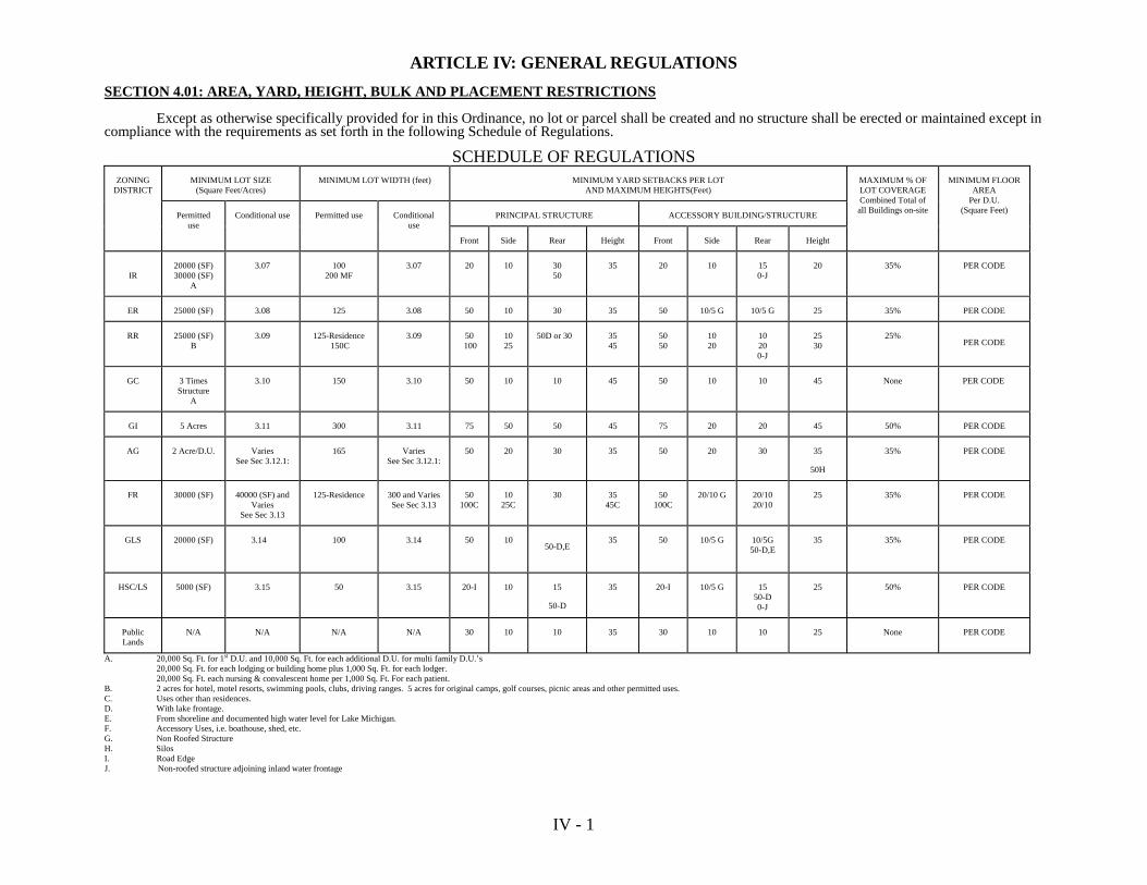
IV - 1
ARTICLE IV: GENERAL REGULATIONS SECTION 4.01: AREA, YARD, HEIGHT, BULK AND PLACEMENT RESTRICTIONS Except as otherwise specifically provided for in this Ordinance, no lot or parcel shall be created and no structure shall be erected or maintained except in compliance with the requirements as set forth in the following Schedule of Regulations.
SCHEDULE OF REGULATIONS MINIMUM LOT SIZE
(Square Feet/Acres) MINIMUM LOT WIDTH (feet) MINIMUM YARD SETBACKS PER LOT
AND MAXIMUM HEIGHTS(Feet)
PRINCIPAL STRUCTURE ACCESSORY BUILDING/STRUCTURE
ZONING DISTRICT
Permitted use
Conditional use Permitted use Conditional use
Front Side Rear Height Front Side Rear Height
MAXIMUM % OF LOT COVERAGE Combined Total of all Buildings on-site
MINIMUM FLOOR AREA
Per D.U. (Square Feet)
IR
20000 (SF) 30000 (SF)
A
3.07 100 200 MF
3.07 20 10 30 50
35 20 10 15 0-J
20 35% PER CODE
ER 25000 (SF) 3.08 125 3.08 50 10 30 35 50 10/5 G 10/5 G 25 35% PER CODE
RR 25000 (SF) B
3.09 125-Residence 150C
3.09 50 100
10 25
50D or 30
35 45
50 50
10 20
10 20 0-J
25 30
25%
PER CODE
GC 3 Times Structure
A
3.10 150 3.10 50 10 10 45 50 10 10 45 None PER CODE
GI 5 Acres 3.11 300 3.11 75 50 50 45 75 20 20 45 50% PER CODE
AG 2 Acre/D.U. Varies See Sec 3.12.1:
165 Varies See Sec 3.12.1:
50 20 30 35 50 20 30 35
50H
35% PER CODE
FR 30000 (SF)
40000 (SF) and Varies
See Sec 3.13
125-Residence
300 and Varies See Sec 3.13
50 100C
10 25C
30
35 45C
50 100C
20/10 G
20/10 20/10
25 35% PER CODE
GLS 20000 (SF) 3.14 100 3.14 50 10
50-D,E
35 50 10/5 G 10/5G 50-D,E
35 35% PER CODE
HSC/LS 5000 (SF) 3.15 50 3.15 20-I 10 15
50-D
35 20-I 10/5 G 15 50-D 0-J
25 50% PER CODE
Public Lands
N/A N/A N/A N/A 30 10 10 35 30 10 10 25 None PER CODE
A. 20,000 Sq. Ft. for 1st D.U. and 10,000 Sq. Ft. for each additional D.U. for multi family D.U.’s 20,000 Sq. Ft. for each lodging or building home plus 1,000 Sq. Ft. for each lodger. 20,000 Sq. Ft. each nursing & convalescent home per 1,000 Sq. Ft. For each patient. B. 2 acres for hotel, motel resorts, swimming pools, clubs, driving ranges. 5 acres for original camps, golf courses, picnic areas and other permitted uses. C. Uses other than residences. D. With lake frontage. E. From shoreline and documented high water level for Lake Michigan. F. Accessory Uses, i.e. boathouse, shed, etc. G. Non Roofed Structure H. Silos I. Road Edge J. Non-roofed structure adjoining inland water frontage
IV - 2
SECTION 4.02: MINIMUM FLOOR AREA Every single and two-family dwelling shall meet existing building code regulations. SECTION 4.03: MAXIMUM DENSITY FOR MULTIPLE-FAMILY AND CONDOMINIUM DEVELOPMENTS
A. The following room assignments shall be used to compute the maximum number of rooms per lot: Efficiency = 1 room One Bedroom = 2 rooms Two Bedrooms = 3 rooms Three Bedrooms = 4 rooms (or more)
B. Plans presented showing 1, 2 or 3 bedroom units and including “den”, “library”, or other extra room shall count such extra room as a bedroom for the purpose of computing density.
C. The area used for computing density shall be the total site area exclusive of any dedicated public right-of-way
of either interior or bounding roads.
D. For multiple family dwellings, the total number of rooms (not including kitchen, dining and sanitary facilities) shall not be more than the area of the parcel, in square feet, divided by:
1. Five Thousand (5,000) with private water and sanitary facilities;
2. Three Thousand Three Hundred and Thirty (3,330) with municipal water and private sanitary facilities.
E. All units shall have at least one (1) living room and one (1) bedroom, except that not more than ten (10) percent of the units may be of an efficiency apartment type.
SECTION 4.04: ACCESSORY BUILDINGS AND USES
Where a lot is devoted to a permitted principal use, customary accessory uses and buildings are authorized except as prohibited specifically or by necessary implication in this or any other ordinance. The following special rules are applicable:
A. An accessory building, including carports, attached to the principal building shall be made structurally a part
thereof, and shall comply in all respects with the requirements of this Ordinance applicable to the principal building. Breezeways, as an attachment between the garage or carport and the main building, shall be considered a part of the main building, but shall not be considered livable floor space.
B. An accessory building, unless attached and made structurally a part of the principal building, shall not be closer
than ten (10) feet to any other structure on the lot. An accessory building may be placed less than ten (10) feet but more than five (5) feet from other structures provided that exterior wall facing the adjacent building have a one-hour fire resistance rating or equivalent as required by the Garfield Township Building Inspector.
C. Home Occupations: There shall be two classes of home occupations. Class I home occupations are authorized
by application for and issuance of a zoning compliance permit by the Zoning Administrator. Class II home occupations shall be authorized upon application for and issuance of a conditional use permit as provided for in Article VII, and upon issuance of a zoning compliance permit by the Zoning Administrator. Class I and II home occupation approvals may be revoked following procedures outlined in Section 9.06.
Class I home occupations shall comply with the following conditions: 1. Home occupations shall employ only those members of the family residing on the premises and
not more than one (1) non-occupant employer.
2. There shall be no outdoor storage and there shall be no exterior evidence of the conduct of home
IV - 3
occupations, other than an approved sign. 3. Specifically excluded is the storage, display and sale of merchandise not produced by such home
occupations.
4. If the home occupation is conducted in an accessory building, it shall not exceed fourteen (14) feet in height, and shall occupy not more than three hundred (300) square feet of said accessory building.
5. No traffic shall be generated by such home occupation in greater volumes than would be
normally expected in that residential neighborhood, and any need for parking generated by the conduct of such home occupation shall meet the requirements of Section 4.08; the home occupation may utilize only stock vehicles such as passenger cars and light utility vehicles such as pick-ups and vans. These vehicles may be parked outside.
6. The use of the dwelling unit for home occupation shall be clearly incidental and subordinate to
its use for residential purposes by its occupants, and if such home occupation is conducted in the principal dwelling, not more than twenty-five (25) percent of the usable floor area of the dwelling shall be used in the conduct of home occupations.
7. No equipment or processes shall be used in such home occupation which creates noise,
vibration, glare, fumes, odors, or electrical interference detectable to the normal senses off the premises. In the case of electrical interference, no equipment or process shall be used which creates visual or audible interference in any radio or television receivers off the premises, or causes fluctuation in line voltage off the premises; and,
8. A sign advertising the home occupation shall not exceed six (6) square feet and shall not be
illuminated or have working parts. All signs shall be in accordance with the requirements of Section 5.02 A (5).
Class II home occupations shall meet all criteria for Class I home occupations except that the Class II
home occupation may:
(1) Employ not more than two (2) non-occupant employees.
(2) May utilize larger vehicles and heavy equipment provided they are stored in an enclosed building.
(3) As a general rule, to assure that the home occupation remains subordinate to the
principal residential use of the property, structures used to store commercial vehicles shall not exceed twice the floor area of the principal structure.
(4) The Planning Commission may place additional conditions upon Class II home occupations to assure compliance with Article VII, and the intent of the specific zoning district.
D. Kennels, as defined in Section 2.02 are permitted provided that they obtain a license from the appropriate
County Regulatory Agency and the following standards are met:
1. Kennels are permitted on lots at least three acres in area. The specific number of dogs allowed is determined by the lot size rounded to the nearest acre.
2. In the AG / FR Districts, ten dogs per acre are permitted provided they are kept at least one
hundred eighty (180) feet from any existing year round and/or seasonal residential dwelling unit not located on the premises.
3. In the AG Districts, ten dogs per acre are permitted up to a maximum of thirty (30) dogs
provided they are kept at least three hundred eighty feet (380) feet from any existing year round and/or seasonal residential dwelling unit not located on the premises.

IV - 4
Note: Kennel activity involving more than thirty (30) dogs older than six (6) months of age shall be considered intensive agricultural activity for the purposes of this Ordinance.
E. Private stables accessory to a principal use are authorized upon application for and issuance of a
Conditional Use Permit as provided for in Article VII and shall meet the standards and requirements in Section 4.21.
F. Seasonal Sale of Farm Products as authorized upon application for and issuance of a Conditional Use
Permit as provided for in Article VII. In addition such uses shall meet the terms as identified below:
1. The maximum length of permit shall be for four (4) months of each calendar year.
2. Sales areas, including the produce stands, shall not be located within the right-of-way of any street or highway. Entrances and exits to the parking lot shall be a minimum of thirty (30) feet from any road intersection.
3. All associated signs shall comply with the regulations set forth in Article V of this Ordinance.
SECTION 4.05: ONE PRINCIPAL STRUCTURE OR USE PER LOT
No more than one principal structure or use shall be permitted on a lot or parcel, unless specifically provided for in this Ordinance.
SECTION 4.06: LOTS OR PARCELS OF RECORD
Minimum lot area and lot width regulations shall not apply to any lawful nonconforming parcel of land shown as a lot described in Garfield Township’s 1973 Real Property Final Assessment Roll as prepared by the County of Mackinac OR to a lawful nonconforming parcel of land described in a deed, land contract, memorandum of land contract or lease agreement for a term of more than one year, provided that such documents were fully executed and acknowledged by a Notary Public prior to the effective date of the Garfield Township Zoning Ordinance, and provided that such lot actually exists as shown or described. No vested right shall exist in the owner of any lot or parcel created in violation of this Zoning Ordinance or any prior Zoning Ordinance applicable to such lot or parcel.
A. Allocation and Reduction of Lot Area
No portion of a lot shall be used more than once in complying with the provisions for lot area and yard dimensions for construction or alteration of buildings. No setback area or lot existing at the time of adoption of this Ordinance shall be reduced in dimensions or area below the minimum requirements set forth herein. All yards shall meet at least the minimum requirements established herein.
B. Height Requirement Exceptions
1. Those purely ornamental in purpose such as church spires, belfries, domes, ornamental towers, flagpoles and monuments;
2. Those necessary appurtenances to mechanical or structural functions, such as chimneys and
smokestacks, water tanks, radio towers, television antennas and satellite dishes, wire transmission structures, and cooling towers. Any commercial radio, television or transmission tower shall be so located that the distance from the base of the tower to the nearest property line shall be fifty (50) feet greater than the height of the tower;
3. Public utility structures; and 4. Agriculture related structures such as barns, silos, elevators and the like. C. Access Through Yards

IV - 5
Access drives may be placed in the required front, side or rear yards so as to provide access to accessory or attached structures. Any walk or other pavement serving a like function shall not be considered a structure and shall be permitted in any required yard.
SECTION 4.07: STORM WATER RUNOFF AND DRAINAGE
Any land use with more than five thousand (5,000) square feet of impermeable surface shall retain all storm water drainage resulting from runoff on-site by diverting the runoff to a stormwater detention or retention pond or into an approved public storm sewer or drainage system. Stormwater runoff and drainage resulting from site development and construction shall be addressed in accordance with the requirements of all existing statutes as well as any applicable county or local ordinances or any rules promulgated by the Mackinac County Drain Commissioner relative to stormwater management.
SECTION 4.08: OFF-STREET PARKING REQUIREMENTS
Except in the Public Lands District (PL) for permitted uses, there shall be provided off-street parking for motor vehicles, and the minimum number of parking spaces to be provided is shown in the following list:
USE SPACES REQUIRED Single and two-family dwellings, recreational 2 per dwelling unit structures
Rooming houses, fraternities, sororities, .4 times the maximum lawful dormitories, convalescent homes, and number of occupants
housing for the elderly.
Hotels and motels 1.2 per room in addition to spaces Required for restaurant facilities
Apartments and townhouses 2 per dwelling unit Churches, theaters, facilities for spectator .35 times the seating capacity sports, auditoriums, concert halls Golf courses 7 per hole Barber shops and beauty parlors 2 plus 1.5 per chair
Bowling alleys 5 per lane plus spaces required for
restaurant facilities
Bed and breakfast establishments 2 per dwelling unit plus 1.2 per rental room
Child or day-care centers, family 1 per employee or care giver and
group day-care homes plus .3 per child
Fast food take-out establishments and 1 per employee plus 1 per 50 sq. ft. drive-in restaurants of gross floor area provided for customer sales and service areas
Restaurants (except drive-ins) 3 per 100 sq. ft. of dining area
Furniture, carpet, and appliance stores .3 per 100 sq. ft. of retail floor
space

IV - 6
Museums and galleries .3 per 100 sq. ft. of display area
Funeral parlors .35 percent of seating capacity Riding or Boarding Stables 1 per horse stall
Gas stations 1 per pump plus 2 per lift (in addition to stopping places adjacent to pumps)
Automotive service center 1 per employee plus 2 per service bay Laundromats .5 per washing machine
Doctor’s and dentist’s offices 1 per 100 sq. ft. of waiting room area and 1 per staff
Banks 1 per employee and 1 per150 sq.
ft. of lobby space
Warehouses 1 per 500 sq. ft. of floor space
Retail stores, service establishments, and repair shops 1 per employee and .3 per 200 sq. ft. of floor space and outdoor sales space
Offices l per 300 sq. ft. of floor
space Other business and industrial use .75 times maximum number
of employees on premises at any one time
Airports 1 per space in hangers or
tie-down areas plus 2 per maximum numbers of employees at any given time
Where calculation in accordance with the foregoing lists results in requiring a fractional space, any fraction less than one-half shall be disregarded and any fraction of one-half or more shall require one space.
The use of any required parking space for the storage of any motor vehicle for sale, or for any other purpose other than the parking of motor vehicles is prohibited.
The following minimum design standards shall be observed in laying out off-street parking facilities.
Parking Curb Parking Stall Aisle Stall to Angle Width Width Length Curb 0 to 15 degrees 9 ft. 12 ft. 23 ft. 30 ft. 16 to 37 degrees 10 ft. 11 ft. 19 ft. 47 ft. 38 to 57 degrees 10 ft. 13 ft. 19 ft. 54 ft. 58 to 74 degrees 10 ft. 18 ft. 19 ft. 61 ft. 75 to 90 degrees 10 ft. 24 ft. 19 ft. 63 ft.
IV - 7
SECTION 4.09: REQUIRED PLANTING SCREENS
In Districts General Commercial (GC) and Industrial (I), or wherever a multiple family use may locate or where any parking lot, trash collection, outdoor storage, merchandising, or service area lies within 50 feet of any Residential District or adjoins an existing residential dwelling within the GC or I District, a planting screen of sufficient length to interfere with the view thereof from the adjoining property shall be required except where the view is blocked by a change in grade or other natural or man-made features.
Where, because of intense shade or soil conditions, the planting screen cannot be expected to thrive, a six (6) foot high fence whether it be an opaque wooden fence, a chain link fence with interwoven slats, or a masonry wall may be substituted.
SECTION 4.10: PARKING LOT LANDSCAPING
Where the provision of off-street parking for 50 or more vehicles is required, there shall be landscaped open space within the perimeter of the parking area, or areas, in the minimum amount of 18 sq. ft. for each parking space, which shall be so located that no parking space is more that 120 feet from a position of the landscaped open space required by this Section. Landscaped open space required by this Section shall be kept continuously planted with living vegetation. The required landscaped open space need not be contiguous, but there shall be at least one tree in each separate area. Required trees shall be at least six (6) feet high when planted or when this Ordinance becomes applicable thereto, shall be maintained in a healthy condition, and shall not be pruned, except to remove dead wood, in such a manner as to prevent growth to a height of at least 15 feet or to reduce existing height below 15 feet. The following varieties of trees are prohibited in meeting the requirements of this Ordinance: Poplars, Willows, American Elm, Birch, seed-bearing Locusts, and Box Elders. All plant materials shall be kept pruned to maximize visibility through them between the heights of three and eight feet so as not to create a hazard to drivers or pedestrians.
SECTION 4.11: PLANTING SCREEN SPECIFICATIONS
All planting screens required by this Ordinance shall consist of plants, at least 30 inches high when planted, maintained in a healthy condition and so pruned as to provide maximum opacity from the ground to a height of five feet. One of the plant materials in the following list shall be used and plants shall be located no farther apart than the distance indicated in each case and shall not be located where they will obstruct vision at the intersecting roadways or driveway entrances.
PLANT DISTANCE APART Lilac 3 feet Privet 1 ½ feet Arbor Vitae 4 feet Pfitzer 4 feet Scotch Pine 5 feet Jack Pine 5 feet Spruce 5 feet
Substitution of other plant materials shall be permitted only upon certification to the Zoning Administrator that the proposed plantings can be expected to thrive and provide equivalent screening and will create no nuisance or hazard.
SECTION 4.12: TIME OF COMPLETION FOR PLANTINGS
All plantings required by this Ordinance shall be installed prior to occupancy or commencement of use. Where compliance is not possible because of the season of the year, the Zoning Administrator shall grant an appropriate delay. Any Zoning Compliance Permit may be revoked, after 30 days written notice to the person assessed for taxes on the affected lot and to the occupant, whenever plantings are not maintained as required in this Ordinance.

IV - 8
SECTION 4.13: CLEAR VIEW TRIANGLES
In order to provide a clear view of intersecting roadways for motorists, triangular areas of clear vision shall be provided at the intersection of any public and/or private roadway formed by the right-of-way lines of the two intersecting roadways and a line connecting a point on each right-of-way line thirty (30) feet from the intersection of the right-of-way lines.
No fence, wall, sign, screen or planting shall be located or maintained in any way which could obstruct vision or interfere with traffic visibility between a height of two and one-half (2-1/2) and ten (10) feet above average grade within the clear view triangle described above, nor shall anything obstruct vision at curves and driveway entrances. Determination of vision obstruction shall be made by the Zoning Administrator. Clear View Triangles must also comply with Michigan Department of Transportation guidelines.
SECTION 4.14: WATERFRONT SETBACK
All structures located on lots or parcels abutting inland lakes, ponds, rivers, creeks and streams of water except those located within the GLS, Great Lakes Shoreland District, shall be established in accordance with the requirements of the Inland Lakes and Streams Act No. 346, P.A. 1972, and the Goemaere-Anderson Wetland Protection Act No. 203, P.A. 1979. All structures shall maintain a fifty (50) foot minimum setback as measured from the ordinary high water mark or from a legally established lake level elevation or specified datum plane. All sauna drains and/or discharges and on-site sanitary septic systems shall not be located closer than seventy-five (75) feet from said ordinary high water mark or legally established lake level elevation. That part of the waterfront setback located within 15 feet of the water’s edge shall be maintained in its natural condition. Trees and shrubs in a space 50 feet wide may be trimmed or pruned for a view of the fronting waters and for access thereto. No change shall be made in the natural grade. A lot shall be regarded in its natural condition when there is at least one tree or shrub having a height of at least 15 feet for each 100 square feet of area thereof in wooded areas or sufficient natural ground cover in open areas. All uses shall be subject to the waterfront setback except private bathing facilities, saunas, storage sheds, and associated facilities which shall maintain a minimum setback of 30 feet as measured from the river bank or lake bluff line unless otherwise specified.
A. Limitation of “Funnel Development”
Any development in any zoning district which shares a common lakefront or stream area may not permit more than one (1) single family home, cottage, condominium or apartment unit to the use of each one hundred (100) feet of lake or stream frontage in such common lakefront or stream area as measured along the water’s edge of normal high water mark of the lake or stream. This restriction is intended to limit the number of users of the lake or stream frontage to preserve the quality of the waters, avoid congestion, and to preserve the quality of recreational use of all waters and recreational lands within the Township. This restriction shall apply to any parcel regardless of whether access to the water shall be gained by easement, common fee ownership, single fee ownership or lease.
EXCEPTION: This restriction shall not apply to an official public access site. SECTION 4.15: STORAGE OF HAZARDOUS MATERIALS
A. Storage tanks and associated equipment shall be screened from adjoining residential areas with an opaque
fence or screen.
B. The storage, handling, dispensing and use of the hazardous materials shall be done in accordance applicable Federal, State, County and any local rules and regulations.
C. Hazardous materials storage and handling areas shall be equipped with structures or systems designed to
prevent direct or indirect discharge to groundwater.

IV - 9
D. Storage tanks and associated equipment shall meet all applicable yard requirements for principal buildings.
E. Plans regarding storage of hazardous materials shall be reviewed and approved by the Fire Chief responsible for fire protection in the Township.
SECTION 4.16: DISCHARGES TO GROUNDWATER
No discharges to groundwater, whether direct or indirect, shall be permitted without evidence of required permits and approvals from all Federal, State, and County agencies administering such permit or approval programs.
SECTION 4.17: AIRPORTS
Airfields, airstrips, and airports are authorized upon application for and issuance of a Conditional Use Permit as provided in Article VII and shall meet the following standards:
A. The area shall be sufficient and the site otherwise adequate to meet the standards of the Federal Aviation
Agency and the Michigan Bureau of Aeronautics for the class of airport proposed, in accordance with their published Rules and Regulations.
B. Any building, hangar, or other structure shall be at least one hundred (100) feet from any right-of-way or
boundary line.
C. Any runway, taxiway, or hangar shall be located at least one thousand (1000) feet from the nearest existing residence not located on the premises.
D. Any proposed runway or landing strip shall be situated so that the approach zones are free of any flight
obstructions such as towers, chimneys, other tall structures, or natural obstructions outside the airport site.
E. There shall be sufficient distance between the end of each usable landing strip and the airport boundary to satisfy the requirements of the Federal Aviation Agency. If air rights or easements have been acquired from the owners of abutting properties in which approach zones fall, satisfactory evidence thereof shall be submitted with the application.
F. The number, size, weight and type of aircraft may be limited in the Conditional Use Permit if required to
assure public safety and welfare. SECTION 4.18: CONDOMINIUMS
A. Approval Required: Pursuant to authority conferred by Section 141 of the Condominium Act, preliminary and final site plans for all site condominiums shall be approved by the Planning Commission. In determining whether to approve a site plan for a site condominium, the Planning Commission shall consult with the Zoning Administrator, Township Attorney and Township Engineer regarding the adequacy of the master deed, deed restrictions, utility systems and streets, site layout and design, and compliance with all requirements of the Condominium Act and this Ordinance.
B. General Requirements:
1. No construction, grading, work, or other development shall be done upon the land intended to be used for a site condominium until a final site plan has been approved, unless written permission from the Planning Commission has been secured. No permits for erosion or sanitary sewage facilities shall be issued for property in a site condominium development until a final site plan therefore has been approved by the Planning Commission and is in effect. This requirement shall include contractible, conversion, and expandable site condominiums.
2. If a building, structure, or use to be placed on a condominium lot requires site plan approval under
Article VI herein, a site plan for that building, structure, or use shall be approved in accordance with Article VI herein, before a zoning compliance permit may be issued.
3. The Planning Commission shall have the authority to review and approve or deny preliminary and
final site plans for site condominiums.
IV - 10
4. Each condominium unit shall be located within a zoning district that permits the proposed use. 5. For the purposes of this Ordinance, each condominium lot shall be considered equivalent to a
single lot and shall comply with all regulations of the zoning district in which located. In the case of a site condominium containing single-family detached dwelling units, not more than one dwelling unit shall be located on a condominium lot, nor shall a dwelling unit be located on a condominium lot with any other principal structure or use. Required yards shall be measured from the boundaries of a condominium lot.
6. Each condominium lot shall be connected to public water facilities and to sanitary sewer facilities
if available.
7. Relocation of boundaries between adjoining condominium lots, if permitted in the condominium documents, as provided in Section 48 of the Condominium Act, shall comply with all regulations of the zoning district in which located and shall be approved by the Zoning Administrator. These requirements shall be made a part of the bylaws and recorded as part of the master deed.
8. Each condominium lot that results from a subdivision of another condominium lot, if such
subdivision is permitted by the condominium documents, as provided in Section 49 of the Condominium Act, shall comply with all regulations of the zoning district in which located and shall be approved by the Zoning Administrator. These requirements shall be made a part of the condominium bylaws and recorded as part of the master deed.
9. All information required by this Ordinance shall be updated and furnished to the Zoning
Administrator until applicable zoning compliance permits have been issued in accordance with the requirements set forth.
C. Preliminary Site Plan Requirements
1. A preliminary site plan shall be filed for approval at the same time the notice of proposed action is
filed with Garfield Township.
2. The preliminary site plan shall include all land that the developer intends to include in the site condominium project.
3. The preliminary site plan shall include all information required in Article VI, herein except in the
case of a development that consists only of condominium lots and not buildings or other structures at the time of site plan application, the location and dimensions of condominium lots and all required yards, rather than individual buildings, shall be shown on the preliminary site plan.
D. Final Site Plan Requirements
1. A final site plan shall be filed for review for each phase of development shown on the approved
preliminary site plan.
2. A final site plan for any phase of development shall not be filed for review by the Planning Commission unless a preliminary site plan has already been approved by the Planning Commission and is in effect.
3. A final site plan shall include all information required in Section 66 of the Condominium Act, and
the master deed and bylaws. The final site plan shall also include all information required in Article VI, herein, except in the case of a development that consists only of condominium lots and not buildings or other structures at the time of site plan application, the location and dimensions of condominium lots rather than individual buildings, and required yards shall be shown on the final site plan.
4. The applicant shall provide proof of approvals by all County and State agencies having jurisdiction
over the improvements in the site condominium development, including but not limited to the

IV - 11
Mackinac County Drain Commissioner and the County Health Department. The Planning Commission shall not approve a final site plan until each County and State agency having such jurisdiction has approved that portion of the final site plan that is subject to its jurisdiction.
E. Revision of Condominium Subdivision Plan. If the condominium subdivision plan is revised, the final
site plans shall be revised accordingly and submitted for review and approval or denial by the Planning Commission before building permit may be issued, where such permit is required.
F. Streets. All streets proposed for any site condominium, shall be developed in the minimum design,
construction, inspection, approval, and maintenance requirements of the Mackinac County Road Commission.
G. Amendment to Master Deed or Bylaws. Any amendment to a master deed or bylaws that affects the
approved preliminary or final site plan, shall be reviewed and approved by the Planning Commission before any building permit may be issued, where such permit is required. The Planning Commission may require review of any amended site plan if, in its opinion, such changes in the master deed or bylaws require corresponding changes in the approved site plan.
H. Development Agreement. The Planning Commission may require, as a condition of approval, that the
applicant enters into a development agreement with the Planning Commission and Garfield Township, incorporating the terms and conditions of final site plan approval and record the same in the Office of the Register of Deeds for Mackinac County.
I. Construction Located in General Common Element. Any application for a building permit for
construction to be located in a general common element shall include written authorization by the Condominium Association for the application.
J. Monuments and Lot Irons. Monuments shall be set at all boundary corners and deflection points and all
road right-of-way line intersections, corners and deflection points. Lot irons shall be set at all condominium lot corners and deflection points along condominium lot lines. The Planning Commission may grant a delay in the setting of required monuments or irons for a reasonable time, but not to exceed one year, on condition that the developer deposit with the Township Clerk cash, a certified check, or any irrevocable bank letter of credit running to Garfield Township, whichever the developer selects, in an amount as determined from time to time by resolution of the Township Board.
Such deposit shall be returned to the developer upon receipt of a certificate by a Professional Land Surveyor licensed in the State of Michigan that the monuments and irons have been set as required, within the time specified. If the developer defaults, the Township Board shall promptly require a Professional Land Surveyor to set the monuments and irons in the ground as shown on the condominium site plans, at a cost not to exceed the amount of the security deposit.
K. Rights-of-Way and Utility Easements. All rights-of-way and utility easements shall be described
separately from individual condominium lots and shall be accurately delineated by bearings and distances on the condominium subdivision plan and the final site plan. The rights-of-way and utility easements shall be separately designed for their individual purpose, such as access, roadway, location, installation, maintenance and replacing of public utilities. The developer shall dedicate to Garfield Township all easements for utilities. All streets shall be constructed in accordance with the standards and specifications of the Mackinac County Road Commission. Water, sewer and electrical easements may be placed within streets, subject to the approval of the Township and in accordance with the standards and specifications of the Mackinac County Road Commission.
SECTION 4.19: PUBLIC SERVICE INSTALLATIONS
A. The following standards shall apply to public utility transformer stations and substations, gas regulator
station, and radio, television, microwave transmitting and receiving apparatus or towers, windmills and enclosures or shelters for the service equipment or maintenance depots.
B. Basic utility services as defined in Article II, Section 2.02 are exempt from these and the other regulations
of this Article.
IV - 12
C. Standards:
1. The lot area and width shall not be less than that specified for the district in which the proposed use is located.
2. The yard and setback requirements shall not be less than that specified for the district in which the
proposed use is located.
3. The horizontal distance from the base of any building or tower to the nearest lot line shall be at least the height of the structure plus fifty (50) feet.
4. Not more than thirty (30%) percent of the lot area may be covered by buildings.
5. All buildings shall be harmonious in appearance with the surrounding residential area and screened by suitable plant material or shall be fenced as approved by the Planning Commission.
6. Where mechanical equipment is located in the open it shall be screened from the surrounding
residential areas by suitable plant material and shall be fenced as approved by the Planning Commission.
7. All signs and off-street parking shall be in compliance with this Ordinance.
8. In Districts where these installations are conditional uses, the public utility must prove the necessity of locating within that district.
SECTION 4.20: MINERAL EXTRACTION
A. Mineral extraction is the extraction and/or processing of iron ore, copper, gravel, sand, stone, gypsum, peat,
topsoil or silver, gold uranium, and other minerals. It is the intent of these regulations to:
1. Provide for the proper environmental management during the site planning, operational and reclamation states of the mineral extraction process;
2. Provide the Township with information important to overall planning and orderly economic
growth; and 3. Provide for the right to extract mineral deposits where located.
B. Any grading, land balance, or soil erosion control measures shall be designed and constructed in accordance with the requirements as set forth in Act 347 of the Public Acts of 1972, as amended, The Soil Erosion and Sedimentation Control Act, and in compliance with the regulation for Soil Erosion and Sediment Control as administered by the Mackinac County. All fill or temporary or permanent storage areas, located in other than public road right-of-ways, shall be approved by the Planning Commission prior to placement.
C. The following shall not require an application for a mineral extraction permit:
1. Any active mining operation at the date of enactment of this Ordinance to continue mineral extraction from existing holes or shafts, which may be enlarged on the land constituting the site on the effective date of this Ordinance. This exemption does not apply to new holes or shafts.
2. An extraction of less than five hundred (500) cubic yards of minerals from a parcel.
I.e.: A 0.5 foot extraction over 27,000 square feet = 500 cubic yards A 1.0 foot extraction over 13,500 square feet = 500 cubic yards A 2.0 foot extraction over 6,750 square feet = 500 cubic yards A 3.0 foot extraction over 3,375 square feet = 500 cubic yards
IV - 13
3. Site preparation authorized by Zoning Compliance Permit.
4. Grading or site preparation associated with public roadway construction, reconstruction, or maintenance within the right-of-way.
D. Application for Mineral Extraction Permit
No mineral extraction, except those activities exempted by Subsection B, shall be undertaken without first obtaining a Mineral Extraction Permit from the Planning Commission and upon payment of a permit fee established by the Township Board. The Zoning Administrator, upon receipt of the application for Mineral Extraction Permit and the designated fee, shall forward all necessary information within thirty (30) days to the Planning Commission for their review and action. The Planning Commission shall review the application for Mineral Extraction Permit at a public hearing, to be scheduled in accordance with the provisions of Section 9.02, and they shall approve, approve with conditions, or reject the mineral extraction permit with explanation. If any of the application information is available in the form of an Environmental Impact Assessment or other appropriate documents which are required to be submitted to various County, State and/or Federal agencies, a copy of that information may be submitted in place of the following appropriate sections.
An application for a Mineral Extraction Permit must contain a Site Plan, Operation Plan, and Reclamation
Plan as described herein. All information and conditions including the site plan, operation plan, and reclamation plan submitted as part of an application for a mineral extraction permit and as approved by the Planning Commission shall be subsequently become conditions of the permit. The Planning Commission may require a financial guarantee as provided for in Section 6.10 to ensure compliance with the conditions of the permit. Any revisions, modifications or corrections to an approved site plan, operation plan, or reclamation plan shall be done in accordance with Section 6.09. The applicant shall submit the following documents, including a cover letter with the signature of the applicant or the applicant’s authorized agent to the Zoning Administrator.
1. Site Plan Requirements
A site plan consisting of twelve (12) identical copies on one or more sheets at a scale adequate to illustrate the proposed operation.
a. A legal description of the property; the name, address and telephone number of the
owner, developer and designer. b. Date, north point, and scale.
c. All dimensions for the proposed development area as shown on a site plan and stated in the field by a surveyor or engineer, with the survey stakes visible showing the relationship of the subject property to abutting properties.
d. The location of all existing and proposed structures on the subject property and all
existing structures on land immediately adjacent to the site within 100 feet of any parcel boundary line.
e. The location of all existing and proposed drives and parking areas.
f. The location of right-of-way widths of all abutting streets, alleys, and private easements.
g. The location of proposed planting and screening, fencing, signs and advertising features. h. The height and floor area of all proposed structures. i. The size and location of all existing and proposed public and private utilities and required
landscaping. j. Proposed location, area extent, estimated depth of excavation.

IV - 14
k. Proposed location of waste dumps, tailing ponds, sediment basins, stockpiles, and other permanent or temporary facilities used for mining operations.
l. A narrative description of the general groundwater conditions and the possible impact
mining operations may have upon adjacent groundwater levels and quality. The operator must identify and outline plans to alleviate possible problems in the groundwater supply to adjacent land owners.
m. Additional information as noted and as required in Section 6.06 of this Ordinance.
2. Operation Plan Requirements Shall Include the Following:
a. A narrative description outlining the estimated time span which the operation will cover; the type of material to be extracted; the type of mining operation and processing equipment to be used; measures to control noise, vibration, and pollution from the operation; effect on groundwater condition; proposed travel routes to be used to transport the mined material to processing plant or markets, and the proposed steps to be taken to relieve adverse effects.
b. A narrative description of the social and economic impact on Garfield Township
including an estimate of the number of potential employees, proposed transportation routes for employees and any changes to the present road system that might be made necessary by the proposed operation.
c. Sight buffers as reasonable and practical along all boundaries of the mining operation
which abut any IR, ER, RR, GLS, or FR Zoning Districts. These buffers shall be so constructed as to screen the mining operation from view and protect individuals from injury.
The following techniques may be used, but are not limited to the following screening methods:
Buffer Zone: An area of sufficient depth as to screen the operation from view.
Earth Berms: Earth berms, constructed to a height of at least six feet above the mean elevation of the center line of the public highway adjacent to the mining property, or six feet above the general level of terrain along property lines. Berms shall have slopes not to exceed of one foot vertical to four feet horizontal, and shall be planted with trees and shrubs.
Plantations: Plantations of coniferous or other suitable species in rows parallel to the boundaries of the property with the spacing of rows and the spacing of trees in the rows sufficient to provide effective screening.
Fencing: Solid fences or masonry walls constructed to a height of six feet and inconspicuous as compared to color.
d. A description of the measures to be taken to assure that any dangerous excavations, pits,
pond areas, banks, or slopes be adequately guarded or fenced and posted with signs to prevent injury to individuals.
e. Identify plans for utilities, access roads, drainage, traffic plans, and other site
improvements showing appropriate measures that have been, are, or will be provided. 3. Reclamation Plan Requirements A reclamation plan shall include a map and description showing:
IV - 15
a. Final grading, anticipated final slope angles, wall reduction, benching and terracing of slopes, slope stabilization and revegetation, and erosion control, and alternative future land uses.
b. Description of topsoil stripping and conservation during storage and replacement.
c. Plan and description of anticipated final topography, water impoundments, and artificial
lakes on property.
d. Plans for disposition of surface structures, roads, and related facilities after cessation of mining.
e. A plan for disposal or treatment of any harmful or toxic materials found in any formation
penetrated by the mining operations or produced during the processing of minerals, and of chemicals or materials used during the mining or processing operations.
f. A timetable for completion of reclamation requirements.
E. General Standards. The Planning Commission shall review the particular facts and circumstances of each Application for a Mineral Extraction Permit in terms of the following standards and shall find adequate evidence showing that the proposed use:
1. Will be harmonious with and in accordance with the general policies and specific objectives of the
Garfield Township Master Plan;
2. Will provide adequate site drainage so that waters will not adversely affect neighboring properties;
3. Will not be hazardous or cause serious consequences to existing neighboring uses, including, but not limited to, its affect from noise, traffic, smoke, fumes, glare, or odors;
4. Will be served adequately by essential public facilities and services;
5. Will not create excessive financial burdens at public cost in providing public facilities and services and will not be detrimental to the economic welfare of the community; and
6. Will protect the public health, safety and welfare of the community. SECTION 4.21: THE KEEPING OR HUSBANDRY OF ANIMALS
A. The following regulations apply to the keeping or husbandry of animals as part of light, traditional, or
intensive agricultural operations or stables. The regulation specified in this section shall not apply to ordinary household pets or kennels.
B. Minimum enclosure area per animal:
1. Horses, mules, donkeys, cows, sheep, llamas, alpacas, deer, or other similar animals:
a. two acres for the first horse if animals are pastured; one acre for each animal afterward b. 4,000 square feet if animals are fed and not required to graze or forage.
c. If animals are kept inside a building, one stall shall be provided for each animal: a tie down stall shall be a minimum size of four (4) feet by eight (8) feet; a box stall shall be a minimum size of ten (10) feet by ten (10) feet.
2. Goats, pigs, or other similar animals: a. 3/acre if animals are pastured; b. 2,000 square feet if animals are fed and not required to graze or forage.
IV - 16
3. Turkeys, geese, ducks, or other similar animals: a. 2,500 square feet if animals are pastured; b. 100 square feet if animals are fed and not required to graze or forage. 4. Poultry, fowl, rabbits, or other similar animals: a. 900 square feet if animals are pastured; b. 36 square feet if animals are fed and not required to graze or forage; c. 9 square feet if animals are kept exclusively indoors. C. The following minimum setbacks shall be provided:
1. To minimize odor and to avoid nuisance problems, pastures, stables, corrals, enclosures, and piles of manure, which are part of or incidental to, either light or traditional agricultural operations, or stables shall be located at least fifty (50) feet from any street right-of-way line or lot line and at least six hundred sixty (660) feet from any existing year round and/or seasonal residential dwelling unit not located on the premises.
NOTE: If small animals such as poultry, fowl and rabbits are kept exclusively indoors the minimum distance from an existing residence not on the premises shall be three hundred (300) feet.
NOTE: The minimum setback from existing residence not on the premises may be reduced providing the owners of all existing properties within the minimum distance of the proposed site grant written permission to the applicant. This written permission shall be recorded as a Special Zoning Order by the Zoning Administrator as specified in Section 9.07 and shall become a part of the permanent record and shall run with the land regardless of transfer of ownership unless otherwise specified in the Conditional Use Permit.
2. Manure shall be piled, stored, removed and/or applied to land in accordance with the Mackinac
County Health Department regulations; however, manure shall not be applied to any land that is closer than one hundred (100) feet to a residential lot line.
D. A one hundred (100) foot wide area of vegetative cover, exclusive of pasture area, shall be maintained
between any corral, unvegetated exercise area, manure pile, manure application area, and any surface water or well, in order to minimize runoff, prevent erosion, and promote quick nitrogen absorption.
E. In areas with a slope of five (5) percent or less: corrals, unvegetated exercise areas, and manure piles shall
be a minimum of one hundred and fifty (150) feet from a well and two hundred (200) feet from any surface water, unless the location of the surface water is upgrade or there is adequate diking to comply with the Mackinac County Health Department standards.
F. Corrals, un-vegetated exercise areas, manure piles, and manure application areas are prohibited on lands
with slopes greater than five (5) percent, in areas designated as ten (10) year flood plains, in any waterways, and on soils classified as very poorly drained by the U.S.D.A. Soil Conservation Service Soil Survey of Mackinac County, Michigan.
G. Area requirements for agricultural uses will be determined based upon the definition of lot area. The
minimum area requirements may be met by any combination of lands under common ownership.
Upon the granting of a conditional use permit under this section, the owner/applicant, successors, heirs and assigns are responsible to maintain, under common ownership, a lot area meeting minimum requirements for the duration of that use.
SECTION 4.22: TEMPORARY USES
IV - 17
A Temporary Use may be permitted in a designated zoning district for a fixed period of time with the approval of the Zoning Administrator or as otherwise stated, upon completion of an application form and payment of a fee and based upon findings of fact that the location of such activity will not adversely affect adjoining properties nor adversely affect public health, safety, and the general welfare.
A. A Temporary Use Permit may be issued by the Zoning Administrator or as otherwise stated, upon
completion of an application form, for a fixed time period upon complying with the specific standards of this section and upon payment of a fee as established by the Garfield Township Board.
B. Specific Temporary Uses Permitted Include: 1. Christmas tree sales 2. Contractor’s office and materials/equipment storage for site under construction 3. Real estate/sales office 4. Portable asphalt or concrete batch plant 5. Temporary shelter 6. Tent or warehouse sales of retail goods C. General Standards 1. Christmas Tree Sales
a. Permitted in all zoning districts with approval of the Zoning Administrator.
b. The maximum length of permit for display and open-lot sales shall be forty-five (45) days.
2. Contractor’s Office and Materials/Equipment Storage for Site Under Construction
a. Such uses are permitted in all zoning districts with the approval of the Zoning Administrator where the use is incidental to a construction project. An office or shed shall not contain sleeping or cooking accommodations.
b. The maximum length of permit shall be one (1) year and may be renewed by written
request, stating the reasons for such request.
c. An office or shed shall be removed upon completion of the construction project.
d. All materials or equipment shall be removed upon completion of the construction project. 3. Real Estate/Sales Office
a. Permitted in any district for any new subdivision with the approval of the Township Zoning Administrator.
b. A model home may be used as a temporary sales office. c. Maximum length of permit shall be one (1) year.
d. Office shall be removed upon completion of the development of the subdivision. 4. Portable Asphalt or Concrete Batch Plant

IV - 18
a. Due to the potential for high impact regarding land uses of this nature, the applicant shall follow the procedures and requirements as outlined in Article VII, Conditional Use Permits.
b. Maximum length of permit shall not exceed one (1) construction season or nine (9)
months, whichever is less. 5. Temporary Shelter
When fire or natural disaster has rendered a single-family residence unfit for human habitation, the temporary use of a manufactured or mobile home located on the single-family lot during rehabilitation of the original residence or construction of a new residence is permitted with the approval of the Zoning Administrator and subject to the following additional regulations.
a. Require a potable water supply and sanitary facilities must be provided.
b. The maximum length of the permit shall be six (6) months; however, the Zoning Administrator may extend the permit for a period or periods not to exceed sixty (60) days in the event of extenuating circumstances. Application for the extension shall be made at least fifteen (15) days prior to expiration of the original permit.
6. Tent or Warehouse Sales of Retail Goods
a. Permitted in the applicable zoning districts as approved by the Zoning Administrator.
b. The maximum length of permit shall be for thirty (30) days, and may be renewed for an additional thirty (30) days. The maximum length of time allowed for a Temporary Use shall not exceed ninety (90) days.
D. Additional Regulations:
1. The above temporary uses shall also be subject to the following regulations as required:
a. Documentation from the Mackinac County Health Department stating that adequate arrangements for a potable water supply and temporary sanitary facilities have been provided.
b. Permanent or temporary lighting shall not be installed without an electrical permit
and inspection.
c. All uses shall be confined to the dates specified on the Temporary Use Permit.
d. Hours of operation shall be limited to those specified on the Temporary Use Permit.
e. The site shall be cleared of all debris at the end of the fixed time period and all temporary structures shall be removed within thirty (30) days after the temporary use has been discontinued. A cash deposit, certified check, bond or other financial guarantee acceptable to the Township shall be provided by the applicant in an amount, as determined by the Planning Commission, sufficient to fulfill the faithful performance of the agreement, shall be posted or a signed contract with a disposal firm shall be required as part of the application for a Temporary Use Permit to ensure that the premises will be kept free of all debris during and after the temporary use has ceased.
f. Public parking for the exclusive use of the facility shall be provided, and a stabilized
drive to the parking area shall be maintained. It shall be the responsibility of the applicant to guide traffic to and from these areas and to prevent patrons from unlawful parking. Parking will be required exclusively on private property.
IV - 19
g. Traffic control requirements as specified by the Michigan State Police and/or the Mackinac County Sheriffs Department shall be arranged for by the applicant with written confirmation provided to the Township.
h. A cash deposit, certified check, bond or other financial guarantee acceptable to the
Township shall be posted by the applicant in an amount, as determined the Planning Commission, sufficient to ensure the repair for any damage resulting to any public property or right-of-way as a result of the Temporary Use activity.
E. Appeals
1. Appeals, concerning the decision of the Planning Commission and/or the Zoning Administrator, relating to Temporary Uses or Temporary Use Permits shall be made to the Garfield Township Zoning Board of Appeals in accordance with the requirements and procedures as set forth in Article VII, Conditional Use Permits, Section 7.07: Appeals, and Article X, Zoning Board of Appeals,Section10.07:Appeals.

V - 1
ARTICLE V: SIGNS SECTION 5.01: INTENT
It is hereby determined that regulation of the location, size, placement, and certain features of signs is necessary to enable the public to locate goods, services, and facilities without difficulty and confusion, to prevent wasteful use of natural resources in competition among businesses for attention, to prevent hazards of life and property, and to assure the continued attractiveness of the community and protect property values. It is further determined that signs which may lawfully be erected and maintained under the provisions of this Ordinance are consistent with customary usage, and that signs which may not lawfully be erected or maintained under the provisions hereof are not consistent with customary usage, are an abuse thereof, and are unwarranted invasions of the right of legitimate business interests and of the public.
SECTION 5.02: RESTENTIAL DISTRICT SIGN REGULATIONS A. Sign regulations within all residential districts shall be permitted as follows:
1. One sign to announce the sale or rent of property whose area shall not exceed six (6) square feet.
2. Churches shall be permitted a total sign area of 20 square feet. 3. One sign per vehicle entrance which identifies a platted subdivision development not exceeding 32
square feet and eight feet in height.
4. Multiple dwellings and nursing homes shall be permitted one identification sign not to exceed 12 square feet and eight feet in height.
5. One sign shall be permitted to advertise a home occupation not to exceed six (6) square feet and
shall not be illuminated or have working parts. It may be attached flush to the building or placed to the front of the lot or parcel and shall not detract from the visual appearance of the neighborhood.
6. Signs shall not be located on or within the right-of-way and shall not interfere with traffic
visibility.
7. All signs shall be located a minimum of ten (10) feet from any boundary line other then a road right-of-way line or in accordance with Section 4.01, relative to minimum setbacks for side yards whichever is more restrictive.
SECTION 5.03: DISTRICT GC: GENERAL COMMERCIAL
A. Signs are permitted in the General Commercial (GC) District on parcels that are already developed. Free-standing (ground) signs are permitted having an area not exceeding six (6) square feet for each ten (10) feet frontage, or sixty (60) square feet for each acre of area of the developed premises. There shall be a maximum of one hundred (100) square feet of sign area for each developed parcel. Where a premise has more than one occupant, the permitted sign area shall be divided among them in the same proportion as floor space and outdoor sales as occupied by them. Where a premise has more than two occupants and has a name distinct from that of the occupants, as in a shopping center, an additional two (2) square feet of sign for each ten (10) feet of street frontage, up to a maximum of two hundred (200) square feet, is permitted only for signs identifying the developed premises.
B. Signs shall be subject to the following setback requirements:
1. A minimum five (5) foot setback is required when the distance from the centerline of the road to the right-of-way line is less than fifty (50) feet. A sign maybe located at the right-of-way line when the distance from the centerline of the road to the right-of-way line is greater than fifty (50) feet. The setback shall be measured from the right-of-way line to the closest part of the sign, whether it be at or above grade. Signs shall be subject to the height regulations for the General Commercial District and shall be located a minimum of ten (10) feet from said boundary line other than a road right-of-way line.
V - 2
SECTION 5.04: DISTRICT GI: GENERAL INDUSTRIAL In the General Industrial District, on-premise signs shall be permitted having a sign area not to exceed one hundred (100) square feet. Off-premise signs shall be permitted having a maximum sign area of three hundred (300) square feet per sign. Back-to-back signs shall have a maximum of three hundred (300) square feet for each side and shall be no more than four (4) feet apart. Individual signs shall be located at least three hundred (300) feet apart and shall maintain a minimum forty (40) foot setback. The maximum height for signs in the General Industrial District shall be thirty (30) feet and shall be located a minimum of ten (10) feet from said boundary line other than a road right-of-way line.
SECTION 5.05: CONDITIONAL USE SIGNS
On-premise signs are permitted to identify or advertise an approved conditional use or activity however, such signs shall not advertise a specific product which has not been produced on the premise. Signs shall have a maximum sign area of sixteen (16) square feet and shall not exceed eight (8) feet in height. Signs shall be subject to the following setback requirements:
A) A minimum five (5) foot setback is required when the distance from the centerline of the road to the right-
of-way line is less than fifty (50) feet;
B) A sign may be located at the right-of-way line when the distance from the centerline of the road to the right-of-way line is greater than fifty (50) feet. The setback shall be measured from the right-of-way line to the closest part of the sign, whether it be at or above grade. Sign regulations in this Section shall not apply to any conditional use located in the GC or GI Districts, or to churches, multiple family dwellings, nursing homes or home occupations.
SECTION 5.06: TEMPORARY SIGNS
Signs which are intended to identify or advertise a non-profit, annual or one time event or occurrence, such as a fair or other event of general public interest, shall be authorized by written permit of the Zoning Administrator for a period not to exceed two (2) months by upon finding that the proposed sign is not contrary to the spirit and purpose of this Ordinance and shall conform to all size limitations set forth by this Ordinance. The applicant is responsible for both the erection and removal of all temporary signs which shall be removed no later than ten (10) days after the end of the event.
SECTION 5.07: CONSTRUCTION SIGNS
One (1) construction sign is permitted per project not to exceed sixteen (16) square feet for residential districts and thirty-two (32) square feet for General Commercial or General Industrial Districts. Signs shall not be erected more than five (5) days prior to the beginning of construction for which a valid building permit has been issued, shall not be confined to the site of construction, and shall be removed prior to occupancy.
SECTION 5.08: EXEMPT SIGNS
The following signs shall not exceed nine (9) square feet and are otherwise exempt from this Ordinance.
A. Public Signs of a noncommercial nature and in the public interest, erected by, or based upon the order of a public officer in the performance of official duty.
B. Political Signs which are intended to advertise a public election, an individual actively participating in such
an election, or other public ballot issue, are permitted on private property with the owner’s permission. All political signs must be removed within ten (10) days after the election date and shall not be located on or within the public right-of-way.
C. No hunting and no trespassing signs. D. Signs which identify the name of a farm or farming operations.
E. Residential Identification Signs. SECTION 5.09: LIGHTING OF SIGNS
No lighted signs shall be permitted within any residential district. No strobe or other pulsating lights shall be permitted in any district. No sign shall be lighted so as to create a traffic hazard or to adversely affect neighboring
V - 3
land uses. No sign may be lighted to such intensity or in such a manner that it creates a public nuisance or adversely affects the public health, safety, or general welfare.
SECTION 5.10: MAINTENANCE OF SIGNS
Dilapidated signs and/or structures which may cause injury or degrade the surrounding area, and signs which advertise a closed business, past event or political election, are no longer legible, or are otherwise untimely or unsafe, are hereby declared a nuisance and a potential hazard to the general health, safety and welfare. All signs shall be maintained in a safe condition and good repair, and failure to maintain a sign as required by this Ordinance, or to remove it upon notice from the Zoning Administrator, shall constitute a violation of this Ordinance.
SECTION 5.11: NONCONFORMING SIGNS
A. It is the intent and purpose of this Section to eliminate all nonconforming signs just as rapidly as the police power of the Township allows, except as may be otherwise provided for in Article VIII of this Ordinance.
B. Non-conforming Signs:
1. Shall not be structurally altered to prolong the life of the signs, nor shall the shape, size, type, or design of the sign/structure be altered.
2. Shall not be continued after the activity, business, or usage to which it relates has been
discontinued for thirty (30) days or longer.
3. Shall not be reconstructed after damage or destruction if the estimated expense of reconstruction exceeds 50% of the sign value.
4. Shall not be altered or changed to create another non-conforming use or structure.
5. May have the face or message updated but shall not be structurally altered in any way.
SECTION 5.12: BILLBOARDS
All billboards shall meet the provisions of the Highway Advertising Act of 1972, Act 106 of 1972, as amended.

VI - 1
ARTICLE VI: SITE PLAN REVIEW
SECTION 6.01: PURPOSE The purpose of site plan review is to insure that a proposed land use or activity is in compliance with local ordinances and State and Federal statutes. The term “Site Plan” includes all documents, plans and drawings required by the Zoning Ordinance. The site plan should specifically denote the detailed intent of the petitioner. The specified standards and required procedures contained herein are intended to promote the orderly development of Garfield Township, assure compliance with all applicable Federal, State and local ordinances and to promote and protect the public health, safety and general welfare of Township residents and the public at large.
SECTION 6.02: REQUIRED PLAN APPROVALS
Site plan review is required for all proposed land uses and activities including any subdivisions of land developed in accordance with the requirements of P.A. 59, 1978, the Condominium Act, and subsequent amendments as specified in P.A. 538, 1982, as well as other requests for zoning status where the Zoning Administrator determines that a site plan is necessary for the accurate review and/or documentation of the petitioner’s request except as provided for in Section 6.03 of this Ordinance.
SECTION 6.03: EXCEPTIONS
Site Plan Review is not required for any permitted proposed land uses or activities in the Public Lands District (PL). Single-family residential lots, for which off-street parking areas are provided as required in this Ordinance, are exempted from the site plan approval requirement when the proposed building and plot plan have been reviewed and approved by the Zoning Administrator and where a building permit has been issued. Wherever conflict may arise between the required information to be provided with an application for Site Plan Review as stated in Section 6.06 of this Article, with the requirements as set forth in Public Act 96 of 1987, as amended, relative to Mobile Home Parks, the State Statute shall prevail. All other required information items noted in this section shall, however, be provided as stated herein.
SECTION 6.04: SITE PLAN REVIEW AND APPROVAL AUTHORITY
The Township Planning Commission is the official designated legal entity charged with the review and approval of all site plan documents except as provided for in Section 6.03.
SECTION 6.05: PROCEDURES FOR SITE PLAN REVIEW
Upon request, an application form shall be provided to the petitioner by the Township Zoning Administrator. All questions on the form shall be completed in ink and signed by the petitioner or his representative, and returned to the Township Zoning Administrator along with the proposed site plan, specifications and the required payment of a nonrefundable fee, as outlined in the “Schedule of Fees”, to offset processing and review costs. If the Township Zoning Administrator determines that the site plan submission does not include all of the required information as required herein, a written notice of denial, including all the reasons for rejection along with instructions for revising the submission to make it acceptable, will be provided to the petitioner within thirty (30) days of the original application date and plan submission.
It shall be the responsibility of the Township Zoning Administrator to forward the completed application along with all other final plan documents to the Planning Commission for review and consideration at their next regularly scheduled meeting if all of the required information has been received at least ten (10) days prior to the date of the next regularly scheduled meeting.
To assure full disclosure of relevant information to all potentially impacted review and/or approval agencies having jurisdiction within the proposed project development area, the Township Zoning Administrator may transmit one (1) copy of the complete site plan to each of the following agencies for their review and comment:
a) Mackinac County Drain Commissioner b) Mackinac County Road Commission c) Mackinac County Health Department
VI - 2
d) Superintendent of Schools e) Fire Chief f) Chief of the Local Law Enforcement Authority g) Affected utility companies
h) Other Federal, State, County or local agencies which may be impacted by the proposed development plan.
The Planning Commission shall base its review and evaluation of the site plan upon the specific requirements and standards as established within each individual Zoning District Classification and upon the General Standards for Site Plan Approval.
SECTION 6.06: REQUIRED INFORMATION
Every application will be accompanied by the following informational requirements unless the proposed structure contains less than 3500 square feet of gross floor area, the land use activity requires less than six (6) off-street parking spaces, and the specific informational requirements are waived in writing by the Zoning Administrator and approved by the Planning Commission.
1 An application form as provided by the Township Zoning Administrator fully completed in ink
and signed by the petitioner, agent or his representative.
2) A minimum of four (4) copies of all plans, documents and/or drawings containing the following information and data for all proposed land uses and activities except as provided for in Section 6.03.
3) A complete legal description of the parcel(s) as it appears on the deed, and the gross and net area
of the proposed site plan in acres.
4) A fully dimensioned map/drawing, at a readable scale, showing all relevant data including building setbacks, spatial relationship of all buildings, scale, directional arrow, original dates, revision dates, if any, and a vicinity sketch or location map.
5) The name of the proposed project/development/activity.
6) The name, address, and telephone number of all fee interest holders and type of ownership.
7) Any proposed deed restrictions or covenants affecting the proposed plan and future on or off-site development.
8) The size, shape, location and use of all existing and proposed structures.
9) The location of all existing and proposed driveways, curb cuts, and points of ingress and egress.
10) The location, names and widths of all existing and proposed, public or private rights-of-way including roads, railroads, easements, clear view triangles, utility licenses, and the jurisdiction of ownership status of each.
11) The location and names of all existing and proposed water courses, water bodies, flood plains,
surface drainage ways, either natural or man-made.
12) The existing and proposed zoning classification of the plan site and all adjacent or abutting properties, and if platted, the Liber and Page numbers of record plats.
13) The designated access locations for fire vehicles and emergency apparatus along with fire lane
widths, type of road surfacing, and any turnaround areas along with all relevant dimensions.
14) The notation of any significant or distinctive topographical features which may be desirable to protect as natural features.
15) The nature, size, type and specific location of any forest or vegetative cover.
VI - 3
16) The existing and proposed pavement widths, condition, and type, and the location of any
acceleration or deceleration lanes existing or proposed.
17) The existing or proposed vehicular, bicycle, and pedestrian circulation systems including all relevant dimensions; parking space sizes and numbers; designated handicapped parking areas and numbers; customer/employee parking areas.
18) The location, size and depth as may be required for all public or private utility lines, individual
service leads, storage tanks, existing and/or proposed to service the project.
19) The definition and location of all loading areas, truck docks, service drives, and truck wells, with relevant dimensions.
20) The location of all permanent or temporary signs, existing or proposed, including their design,
area, size, height, illumination and the type of construction.
21) A complete landscaping plan, including the location of all greenbelts, buffer yards, fencing or screening with specific indication of all landscape materials to be utilized.
22) The location of all proposed trash and refuse receptacles and the method to be used for screening
these areas.
23) The existing and proposed topography of the site with elevations based upon USGS, on site or relative datum and mapped utilizing two (2) foot minimum contour intervals; five (5) foot intervals may be used where grades are in excess of ten percent (10%). All benchmark locations, descriptions and elevations shall be noted.
24) A complete set of architectural floor plans including all relevant square footage calculations,
exterior building elevations, and the existing and proposed building grades and heights. Multiple unit proposals shall include all density and area calculations.
25) All available information relative to on-site soil conditions, profiles, inventories, borings and the
source of all related reference material.
26) All available information on sub-surface water table depths or elevations, along with the quantity and quality of potential potable water supplies as required.
27) Any existing and proposed exterior lighting plans which may be anticipated for parking areas, and
general information regarding maximum illumination and candlepower of proposed lighting systems.
28) Any such other information as may be required and/or deemed necessary by the Planning
Commission to properly and adequately evaluate the proposed project site plan or land use activity.
29) Project completion schedule and/or development phases.
30) The seal of the licensed engineer, architect, landscape architect, land surveyor or community planner who prepared the plan.
SECTION 6.07: GENERAL STANDARDS FOR SITE PLAN APPROVAL
1) The site plan shall be organized into a document reflecting adequate consideration to the various design alternatives in accommodating the dictates of the physical site characteristics and constraints. The site plan shall further reflect the use of lands in accordance with their character and adaptability providing for orderly development within the framework of this Ordinance.
2) The proposed land use and activity will be established in conformance with the requirements of
the existing or proposed zoning district for the site, and shall be developed in such manner as to maximize the harmony and compatibility with the surrounding area.
VI - 4
3) Any adverse effects created on site by the proposed land use or activity shall be minimized
utilizing effective landscaping design and screening techniques.
4) The natural features of the site shall be protected and preserved in their original state in so far as practical and wherever they can be utilized to enhance the development of the site.
5) The proposed plan shall reflect a proper relationship between existing and proposed streets and
highways within the vicinity. Every structure shall have adequate pedestrian access to public right-of-way, walkway or other common use areas.
6) All buildings and structures within the proposed site plan shall be accessible on all sides by
emergency vehicles and emergency apparatus systems. Emergency vehicle access shall be available to the site by a public street and provided through the site utilizing fire lanes clearly marked and identified for that purpose.
7) Physical improvements to the site, including vehicular and pedestrian circulation systems, water,
sewer service, storm drainage, electric power, and telephone utilities, as well as land balance, grading and erosion control measures shall be designed and constructed in strict compliance with all the requirements of the individual, Federal, State, County or local agencies’ adopted standards and specifications.
8) Adequate measures shall be taken to control and minimize adverse impacts to neighboring areas
due to on-site land uses or activities. Nuisance controls, addressing problems of noise, vibration, smoke, odor, glare, light, heat and drifted snow, sand or fugitive materials shall be incorporated into the plan as required.
9) A storm water management plan that addresses on-site surface runoff problems and which can be
integrated into a general drainage scheme for the area, shall be provided to assure against any adverse affects to neighboring or off-site property owners.
10) Accessibility, ingress and egress to the site shall be designed to assure safety and convenience to
the general public. All parking areas located within the proposed site plan shall be in compliance with the requirements set forth in this Ordinance.
11) Exterior lighting plans should anticipate adverse impact to adjacent properties, therefore, adequate
design considerations shall be required to deflect or limit excessive light and glare which could impede the vision of drivers on adjacent roads or become a nuisance to adjacent property owners.
SECTION 6.08: PLANNING COMMISSION REVIEW
Upon receipt of the complete site plan submission along with the receipt of comments from any affected Federal, State, County or local approving agencies, the Planning Commission shall proceed with the review of the site plan documents to determine compliance with the requirements and general intent of the Zoning Ordinance. The Planning Commission at its option may schedule and conduct a public hearing prior to the final approval of any site plan required by this Ordinance. Within thirty (30) days, the Planning Commission shall respond to the petitioner through the Township Zoning Administrator with a written approval, approval with conditions of modification or a denial. If approved, the Planning Commission Chairman, and the Township Zoning Administrator shall sign and date three (3) complete sets of the site plan. One (1) approved, signed and dated set shall be returned to the petitioner and the other two (2) copies shall be retained by the Township for record purposes. If the site plan is denied approval, the reasons will be set forth in writing and forwarded to the petitioner by the Township Zoning Administrator.
SECTION 6.09: REVISIONS, MODIFICATIONS, OR CORRECTIONS TO AN APPROVED SITE PLAN
Once a site plan has been reviewed and approved by the Planning Commission, it shall become a part of the record of approval. Subsequent actions relating to the authorized activity shall be consistent with the
VI - 5
approved site plan unless a change, conforming with this Zoning Ordinance, received mutual agreement of the petitioner and the Planning Commission. Except for minor changes, any changes requested specifically by the petitioner shall require a resubmission of the revised site plan and payment of an additional review fee.
SECTION 6.10: FINANCIAL GUARANTEES
To insure the construction and installation of the necessary site improvements, and unless the site plan review requirements, as specified in Section 6.06 have been specifically waived in writing by the Zoning Administrator and approved by the Planning Commission in accordance with said Section 6.06, the Planning Commission may require that a cash deposit, certified check, bond, irrevocable bank Letter of Credit or other financial guarantee be provided by the petitioner prior to the issuance of the official site plan approval and Certificate of Occupancy.
Surety shall be provided in an amount sufficient to fulfill the faithful performance of the agreement. The Planning Commission, at its option, may authorize proportional rebates of the financial guarantee to the petitioner as the construction work progresses and upon the completion of significant phases of the scheduled improvements.
SECTION 6.11: FINAL APPROVAL OF PROJECT
When the site has been substantially developed in compliance with the approved site plan documents, the petitioner shall request an on-site inspection by the Township Zoning Administrator. The joint on-site inspection shall require the review and approval of all the required plan elements to the satisfaction of the Township Zoning Administrator in strict accordance to the requirements as set forth in this Ordinance. An as-built site plan, in accordance with Section 6.15, shall be submitted at this time.
After the joint field inspection has been completed, and the site has been approved by the Township Zoning Administrator, a letter of acceptance will be forwarded to the Petitioner by certified mail, return receipt requested. If there are deficiencies on the site and the improvements are not in compliance with the approved site plan documents, a similar certified letter setting forth the reasons for such denial shall be sent to the petitioner. Until such time as the stated deficiencies are corrected, an official letter of acceptance will not be authorized.
SECTION 6.12: TIME LIMIT TO IMPLEMENT APPROVED SITE PLAN
The approved site plan shall be implemented and all required improvements completed no later than two (2) years after the date of initial approval. The Planning Commission, at its option, may authorize a one (1) year extension to the initial approval if extenuating circumstances justify an extension of time.
SECTION 6.13: ORDINANCE INTERPRETATION AND APPEALS
An individual aggrieved by an action of the Planning Commission in the approval, conditional approval, or denial of a site plan submission may appeal any interpretations of this Ordinance to the Township Zoning Board of Appeals for their review and final determination. The factual basis for the appeal must be exclusive, in writing and filed with the Township Clerk within seven (7) days after the date of the decision of the Planning Commission. An appeal shall stay action on the issuance of any permit pursuant to an approved site plan.
SECTION 6.14: ZONING BOARD OF APPEALS PROCEDURE
The Zoning Board of Appeals shall review the record of action taken on the final site plan and shall determine whether the record supports the action taken. No new evidence shall be presented. The Zoning Board of Appeals shall approve the final site plan if the requirements of this Section and other applicable ordinance requirements are met. The Zoning Board of Appeals shall make written findings in support of its opinion on the appeal.
SECTION 6.15: AS-BUILT SITE PLAN
Upon completion of the installation of required improvements as shown on the approved site plan, the property owner shall submit to the Zoning Administrator one (1) reproducible Mylar copy or other acceptable media copy at the discretion of the Zoning Administrator of an “as built” site plan, certified by a licensed professional as noted in Section 6.06 (30), at least one week prior to the anticipated
VI - 6
occupancy of any building. The Zoning Administrator may circulate the as built plans among the appropriate agencies for review to insure conformity with the approved site plan and other Township, County, State or Federal requirements.
Each agency shall have a thirty (30) day period to review the as-built plans, after which the Zoning Administrator may make the final inspection and issue any other necessary permits if all requirements of the approved site plan and this Ordinance have been satisfied.
SECTION 6.16: LAND CLEARING
No person shall undertake or carry out any such activity or use, including any grading, clearing, cutting and filling, excavating, or tree removal associated therewith for which site plan approval is first required by this Ordinance. Nor shall such activity proceed prior to obtaining necessary soil erosion and sedimentation control permits, wetlands permits, or floodplain permits. Any violation of this provision is subject to the fines and penalties prescribed in Section 12.04 of this Ordinance for each day of the violation from the day of discovery of the incident until a restoration plan, or a site plan has been approved.

VII - 1
ARTICLE VII: CONDITIONAL USE PERMITS SECTION 7.01: INTENT
The functions and characteristics of an increasing number of new kinds of land uses combined with some of the older, more familiar kinds of uses call for more flexibility and equitable procedure for properly accommodating these activities in the community. The forces that influence decisions regarding the nature, magnitude, and location of such types of land use activities are many and varied depending upon functional characteristics, competitive situations and the availability of land. Rather than assign all uses to special, individual, and limited zoning districts, it is important to provide the necessary control and reasonable flexibility in establishing the requirements for certain kinds of uses, and at the same time, to ensure that adequate provisions have been made for the health, safety, convenience and general welfare of the community’s inhabitants.
To accomplish such a dual objective, provision is made in this Ordinance not only for flexibility in individual district regulations, but also for a more detailed consideration of certain specified activities as each may relate to proposed conditions of location, design, size, operation, intensity of use, generation of traffic movements, concentration of population, processes and equipment employed, amount and kind of public facilities and services required, together with many other possible factors. Land and structure uses possessing these particularly unique characteristics are designated as Conditional Uses and may be authorized by the issuance of a Conditional Use Permit with such conditions and safeguards attached as may be deemed necessary for the protection of the public welfare.
The following Sections together with previous references in other Sections designate what uses require a Conditional Use Permit.
SECTION 7.02: APPLICATION PROCEDURE
A. Any person having an interest in a property may file an application for a Conditional Use Permit for the zoning district in which the land is situated.
B. Applications shall be submitted through the Zoning Administrator to the Planning Commission.
Each application shall be signed by the property owner and accompanied by the payment of a fee in accordance with the duly adopted “Schedule of Fees” to cover costs of processing the application. No part of any fee shall be refundable.
C. Every application shall be accompanied by the following information and data:
1. Conditional Use Permit Application form provided by the Zoning Administrator and
filled out by the applicant.
2. Uses proposed to occur entirely on a single family residentially zoned and utilized lot, for which adequate off-street parking areas are provided, shall submit a Plot plan. All other proposed uses shall submit four (4) copies of a site plan meeting the requirements of Article VI (Site Plan Review), Section 6.06.
3. A statement with supporting evidence regarding the required findings specified in Section
7.04.
D. Upon receipt of such materials, the Zoning Administrator, may transmit one copy to the road commission, drain commissioner, health department, school district, fire chief, local law enforcement authority, affected utility companies and other Federal, State, County or Local agencies impacted by the proposal and the Planning Commission for their review and comment. Each agency will be requested to review the document and forward any comments to the Zoning Administrator. The Zoning Administrator shall transmit a copy of the site plan along with any agency response to the Planning Commission for their review.
VII - 2
E. Approval of a Conditional Use Permit shall be valid regardless of change of ownership, provided that all terms and conditions of the permit are met by all subsequent owners.
F. In instances where development authorized by a Conditional Use Permit has essentially changed
in nature, extent or character, the Planning Commission shall review the permit in relation to the applicable standards and requirements of the Ordinance. Upon finding that there has been a violation in the conditions of the Conditional Use Permit granted under the provisions of this Ordinance, the Planning Commission may declare the permit null and void.
G. If on-site activities relative to the development of a Conditional Use Permit have not commenced
within one year from the date of issuance, said permit shall expire automatically. The Planning Commission can approve an extension for one additional year upon request by the applicant. Where differences and/or conflicts may arise with the time constraints as set forth in Section 7.02, of this Ordinance with the time schedules as outlined in Rule 905(6), of the Mobile Home Commission General Rules based upon Public Act 96 of 1987, as amended, then the State Statute and Rule shall prevail. However, all other requirements as set forth within Section 7.02 of this Article shall be accommodated.
SECTION 7.03: REVIEW AND FINDINGS
A. Planning Commission Public Hearing: The Planning Commission shall review the application within thirty (30) days of the date of the application. The Zoning Administrator shall cause to be published one (1) notice of public hearing, not less than fifteen (15) days in advance of such hearing and shall notify by regular mail or personal delivery the parties of interest and all property owners within three hundred (300) feet of the subject property. Such notice shall describe the nature of the request, indicate the property involved, state the time and place of the hearing and indicate when and where written comments will be received concerning the request, pursuant to the Zoning Enabling Act, Public Act 110 of 2006, as amended.
B. Planning Commission Action: The Planning Commission shall approve, approve with conditions,
or reject the application within thirty (30) days of the hearing based upon materials received and testimony recorded at the public hearing. The Planning Commission shall set forth the reasons in writing for approval, denial, or modification of the conditional use permit application. Following favorable action by the Planning Commission, the Zoning Administrator shall issue a Conditional Use Permit, in accordance with the site plan and any conditions placed on such permit by the Planning Commission. All conditions shall be clearly specified in writing and the petitioner has one year from date of hearing to comply with all specified conditions except as provided for in Section 7.02 G. Compliance shall occur prior to the commencement of the use, unless a specified time is set in the motion granting the Conditional Use Permit.
SECTION 7.04: GENERAL STANDARDS
The Planning Commission shall review the particular facts and circumstances of each proposal in terms of the following standards and shall find adequate evidence showing that the proposed use:
A. Will be harmonious with and in accordance with the general policies or with any specific
objectives of the Garfield Township Community Master Plan.
B. Will be designed, constructed, operated, and maintained to be harmonious and appropriate in appearance with the existing or intended character of the general vicinity and that the use will not change the essential character of the area;
C. Will not be hazardous or disturbing to existing or future neighboring uses
D. Will not diminish the value of land, buildings, or structures in the District;
E. Will be served adequately by essential public facilities and services, such as highways, streets, police and fire protection drainage structures, refuse disposal, or schools, and that the persons or agencies responsible for the establishment of the
VII - 3
proposed use shall be able to adequately provide such services;
F. Will not create excessive additional requirements at public cost for public facilities and services and will not be detrimental to the economic welfare of the community;
G. Will not involve uses, activities, processes, materials and equipment and conditions of operation
that will be detrimental to any person, property, or the general welfare by reason of excessive production of noise, traffic, smoke, fumes, glare, or odors;
H. Will protect the public health, safety and general welfare of the community;
I. Will be consistent with the intent and purpose of the specific zoning district in which it is located.
SECTION 7.05: CHILD OR DAY CARE CENTERS
The following standards shall be utilized by the Planning Commission when considering the location for child or day care centers:
A. The proposed site shall not be located closer than 1,500 feet to any of the following:
1) A licensed family or group day-care home.
2) An adult foster care small group home or large group home licensed under the Adult Foster Care Facility Licensing Act, Act No. 218 of the Public Acts of 1979, being Sections 400.701 to 400.737 of the Michigan Compiled Laws.
3) A facility offering substance abuse treatment and rehabilitation service to seven or more
people licensed under Article 6 of the Public Health Code, Act No. 368 of the Public Acts of 1978, being Sections 333.6101 to 333.6523 of the Michigan Compiled Laws.
4) A community correction center, resident home, halfway house, or other similar facility
which houses an inmate population under the jurisdiction of the Department of Corrections.
B. There will be appropriate fencing for the safety of the children in the child or day-care center as
determined by the Township Planning Commission.
C. The maintenance of the property will be consistent with the visible characteristics of the neighborhood.
D. The proposed use shall not exceed 16 hours of operation during a 24-hour period. The Township
may limit but not prohibit the operation of a child or day-care center between the hours of 10 p.m. and 6 a.m.
E. The proposed use shall meet regulations of this ordinance governing signs used by the child or
day-care center to identify itself.
F. A child or day-care center operator shall provide off-street parking accommodations for all employees as required by this ordinance.
SECTION 7.06: CONDITIONS AND SAFEGUARDS
A. Prior to granting any Conditional Use Permit, the Planning Commission may impose conditions or limitations upon the establishment, location, construction, maintenance or operation of the use authorized by the Conditional Use Permit as in its judgment may be necessary for the protection of the public interest. Conditions imposed shall further be designed to protect natural resources, the health, safety and welfare, as well as the social and economic well-being of those benefiting from the land use or activity under consideration, residents and landowners immediately adjacent to the proposed land use or activity and the community as a whole; and be consistent with the general standards listed in Section 7.04 of this Ordinance.
B. Conditions and requirements stated as part of Conditional Use Permit
authorization shall be a continuing obligation of landholders. The Zoning Administrator shall make periodic investigations of developments authorized by Conditional Use Permit to determine compliance with all requirements.
VII - 4
C. Conditional Use Permits may be issued for time periods as determined by the
Planning Commission. Conditional Use Permits may be renewed in the same manner as originally applied for.
D. In authorizing a Conditional Use Permit, the Planning Commission may require
that a cash deposit, certified check, bond, irrevocable bank letter of credit or other financial guarantee acceptable to the Township, of ample sum be furnished by the developer to insure compliance with such requirements as drives, walks, utilities, parking, landscaping and the like. The financial guarantee shall be deposited with the Township Treasurer at the time of issuance of the permit authorizing the use or activity. As work progresses, the Planning Commission may authorize a proportional rebate of the financial guarantee upon completion of significant phases or improvements.
E. Revocation of a Conditional Use Permit by the Planning Commission shall be
made at a public hearing following the same procedures as the original approval to the effect that:
1) Such conditions as may have been prescribed in conjunction with the
issuance of the original permit included the requirement that the use be discontinued after a specified time period; or
2) Violations of conditions pertaining to the granting of the permit
continue to exist more than thirty (30) days after a written order to correct has been issued. Violations of any conditions set by the Planning Commission are violations of this zoning ordinance.
F. All plans, specifications and statements submitted with the application for a
Conditional Use Permit shall become, along with any changes ordered by the Planning Commission, a part of the conditions of any Conditional Use Permit issued.
G. No application for a Conditional Use Permit which had been denied wholly or in
part by the Planning Commission shall be resubmitted until the expiration of six (6) months or more from the date of such denial, except on appeal or on grounds of newly discovered evidence or proof of changed conditions found to be sufficient to justify reconsideration by the Planning Commission.
H. The foregoing general standards are basic to all conditional uses, and the
specific requirements accompanying the individual sections relating to particular uses are in addition to and shall be required in all applicable situations.
SECTION 7.07: APPEALS
A. Appeals concerning the decision relating to a Conditional Use Permit by the Planning Commission shall be made to the Garfield Township Zoning Board of Appeals by filing a written notice of appeal, in accordance with Section 10.07, within thirty (30) days of the date of denial specifying the basis of appeal. The Planning Commission shall transmit copies of all data constituting the record to the Township Zoning Board of Appeals.
B. An additional fee shall be required for an appeal concerning denial of a Conditional Use Permit.
VII - 5
C. The Township Zoning Board of Appeals shall consider the appeal at the next regularly scheduled Board meeting or at a special meeting called specifically for that purpose. The applicant and all parties notified for the initial hearing shall be notified by Certified Mail no less than five (5) days prior to the date of the hearing. The notice shall describe the nature of the appeal, indicate the property involved, state the time and place of public hearing and indicate where and when written comments will be received.
D. Any party or parties may appear at the public hearing in person or may be
represented by an agent or legal counsel.
E. Based upon the materials received and the testimony recorded at the Public Hearing, the Zoning Board of Appeals shall affirm or reverse the decision of the Planning Commission, or revise and correct the conditions imposed upon the issuance of any Conditional Use Permit. The Township Zoning Board of Appeals shall set forth in writing the reasons for approval, approval with conditions or denial and transmit the information to the Planning Commission.
F. Any appeal relative to the final decision of the Township Zoning Board of
Appeals shall be to the Circuit Court of Mackinac County, as provided by law.
VIII - 1
ARTICLE VIII: NONCONFORMING USES AND STRUCTURES SECTION 8.01: INTENT AND PURPOSE
It is the intent of this Article to permit legal nonconforming structures or uses to continue until they are removed. But, not to encourage their continued existence. It is recognized that there exists within the districts established by the Ordinance and subsequent amendments lots, structures and uses of land and structures; which were it the intent of this Article to permit legal nonconforming structures or uses to continue until they are lawful before this Ordinance was passed or amended, which would be prohibited, regulated or restricted under the terms of this Ordinance or future amendments.
SECTION 8.02: ILLEGAL NONCONFORMING USES OR STRUCTURES
Nonconforming uses or structures existing at the effective date of this Ordinance that were established without approval of zoning compliance or without a valid building permit or those nonconforming uses which cannot be proved conclusively as existing prior to the effective date of this Ordinance, shall be declared illegal nonconforming uses and are not entitled to the status and rights accorded legally established nonconforming uses.
SECTION 8.03: DEFINITION AND CLASSIFICATION OF NONCONFORMING USES AND STRUCTURES
Nonconforming uses and structures are those which do not conform to a provision or requirement of this Ordinance but were lawfully established prior to the time of its applicability. Class A nonconforming uses or structures are those which have been so designated by the Zoning Board of Appeals, after application by an interested person or the Zoning Administrator, upon findings that continuance thereof would not be contrary to the public health, safety, or welfare, or to the spirit of this Ordinance; that the use of structure does not and is not likely to significantly depress the value of nearby properties; that the use or structure was lawful at the time of its inception; and that no useful purpose would be served by strict application of the provisions or requirements of this Ordinance with which the use or structure does not conform. All legally established nonconforming uses and structures not designated as Class A are Class B nonconforming uses or structures.
SECTION 8.04: PROCEDURES FOR OBTAINING CLASS A DESIGNATION
A written application shall be filed setting forth the name and address of the applicant, giving a legal description of the property to which the application pertains, and including such other information as may be necessary to enable the Zoning Board of Appeals to make a determination of the matter. The Zoning Board of Appeals may require the furnishing of such additional information as it considers necessary. The notice and hearing procedure before the Zoning Board of Appeals shall be the same as in the case of an application for a variance. The decision shall be in writing and shall set forth the findings and reasons on which it is based. Conditions shall be attached, including any time limit, where necessary to assure that the use or structure does not become contrary to the public health, safety, or welfare or the spirit and purposes of this Ordinance.
SECTION 8.05: REVOCATION OF CLASS A DESIGNATION
Any Class A designation shall be revoked, following the same procedures required for designation, upon a finding that as a result of any change of conditions or circumstances the use or structure no longer qualifies for Class A designation.
SECTION 8.06: REGULATIONS PERTAINING TO CLASS A NONCONFORMING USES AND STRUCTURES
A. No Class A nonconforming use shall be resumed if it has been discontinued for a continuous period of at least 18 months or if it has been changed to a conforming use for any period, or if the structure in which such use is conducted is damaged by fire or other casualty to the extent that the cost of reconstruction or repair exceeds 75% of the replacement cost of the structure.
B. No Class A structure shall be used, altered, or enlarged in violation of any condition imposed in its
designation.
VIII - 2
C. No Class A nonconforming structure shall be enlarged or structurally altered nor shall it be repaired or reconstructed if damaged by fire or other casualty to the extent that the cost of reconstruction or repair exceeds 75% of the replacement cost of the structure.
SECTION 8.07: REGULATIONS PERTAINING TO CLASS B NONCONFORMING USES AND STRUCTURES
It is a purpose of this Ordinance to eliminate Class B nonconforming uses and structures as rapidly as is permitted by law without payment of compensation.
A. No Class B nonconforming use shall be resumed if it has been discontinued for a continuous
period of at least 18 months or if it has been changed to a conforming use for any period, or if the structure in which such use is conducted is damaged by fire or other casualty to the extent that the cost of reconstruction or repair exceeds 50% of the assessed value of the structure.
B. No Class B nonconforming structure shall be enlarged or structurally altered, nor shall it be
repaired or reconstructed if damaged by fire or other casualty to the extent that the cost of reconstruction or repair exceeds 50% of the assessed value of the structure.
C. In the case of mineral removal operations, existing holes or shafts may be worked or enlarged on
the land which constitute the lot on which operations were conducted at the time of becoming nonconforming, but no new holes or shafts shall be established.
SECTION 8.08: NONCONFORMING LOTS
Any nonconforming parcel of land shown as a lot in a map recorded with the County Register of Deeds, or described in a deed or land contract or lease agreement which has been perpetual, executed together with an affidavit or acknowledgment of a notary public, prior to the effective date of this Ordinance, and which lot actually exists as shown or described may be used for permitted uses even though the lot area and/or dimensions are less than those required for the District in which the lot is located, provided that yard dimensions and other requirements of the District, not involving lot area or width, are met. If a parcel contains more than one nonconforming lot, which is contiguous and in one ownership and would make one or more conforming lots, then only one structure would be permitted per conforming parcel. In addition, if a parcel contains more than one nonconforming lot which is contiguous and in one ownership but would not make one or more conforming lots, then only one structure would be permitted per parcel. The spirit of this provision is to limit density in areas of historically small lots to provide the proper isolation for wells, septic systems, drainage and similar public health considerations. No vested right shall arise to the property owner for any parcel created in violation of any preceding Garfield Township Ordinance.
SECTION 8.09: NONCONFORMING USES
Any nonconforming use, whether Class A or Class B, may be continued, so long as it remains otherwise lawful, subject to the following provisions:
A. A nonconforming use shall not be enlarged or increased, nor extended to occupy a greater area of
land than occupied at the effective date of adoption or amendment of this Ordinance.
B. A nonconforming use shall not be moved in whole or in part to any other portion of the lot or parcel occupied by such use at the effective date of adoption or amendment of this Ordinance.
C. A nonconforming use shall not be extended throughout any parts of a building which were not
manifestly arranged or designed for such use, and which existed at the time of adopting or amendment of this Ordinance. No such use shall be extended to occupy any land outside such building.
SECTION 8.10: REPAIRS AND MAINTENANCE
On any nonconforming structure or any structure devoted in whole or in part to a nonconforming use, work may be done in any period of twelve (12) consecutive months on ordinary repairs, or on repair or replacement of nonbearing walls, fixtures, wiring or plumbing to an extent not exceeding fifty (50%) percent of the assessed value of the building, provided that the cubic content of the building as it existed at
VIII - 3
the time of passage or amendment of this ordinance shall not be increased. Nothing in this section shall be deemed to prevent the strengthening or restoring to a safe condition of any building or part thereof declared to be unsafe by any official charged with protecting the public safety, upon order of such official.
SECTION 8.11: CHANGE OF TENANCY OR OWNERSHIP
As long as there is no change in the character or nature of the nonconforming use, a change of tenancy or ownership is allowed.
SECTION 8.12: DISTRICT CHANGES
Whenever the boundaries of a district shall be changed so as to transfer an area from one district to another district of another classification, the provisions of this Section shall also apply to any existing uses that become nonconforming as a result of the boundary changes.
SECTION 8.13: HARDSHIP CASES
Nonconforming buildings or structures may be structurally changed, altered or enlarged with the approval of the Zoning Board of Appeals when it finds that the request is a case of exceptional hardship in which failure to grant the relief requested would unreasonably restrict continued use of the property or would restrict valuable benefits that the public currently derives from the property as used in its nonconforming status, EXCEPT that any approval for structural changes, alteration or enlargement may be granted only with a finding by the Zoning Board of Appeals that approval will not have an adverse affect on surrounding property and that it will be the minimum necessary to relieve the hardship.

X - 1
ARTICLE IX: ADMINISTRATION AND ENFORCEMENT SECTION 9.01: ADMINISTRATION
The administration and enforcement of this Ordinance shall be the responsibility of the Township Board who shall have the right to delegate said responsibility to appropriate Township officers or employees. The person or persons administering and enforcing this Ordinance shall be known as the Zoning Administrator(s).
SECTION 9.02: ADMINISTRATIVE STANDARDS AND PROCEDURES
A. In the course of administration and enforcement of this Ordinance, when it is necessary or desirable to make administrative decisions, unless other standards are provided in this Ordinance, such decisions shall not be contrary to the spirit and purpose of this Ordinance or injurious to the surrounding neighborhood.
B. Where a public hearing is required in the administration of this Ordinance, the Zoning Board of
Appeals and the Planning Commission: 1. Shall base their decision upon facts presented at a public hearing;
2. For Conditional Uses, Mineral Extraction Permits, and for the Zoning Board of Appeals hearings, the Zoning Administrator shall publish notice of the public hearing in a newspaper of general distribution. Such notice is to be given not less than fifteen (15) days prior to the public hearing. Also, notification by mail or personal service shall be given to all property owners to whom real property is assessed within three hundred (300) feet of the boundary of the property in question, and to all occupants of structures within three hundred (300) feet. The current year’s tax assessment role shall be used as prima facia evidence of record ownership. If a structure contains more than one dwelling unit or spatial area owned or leased by different individuals, partnerships, businesses or organizations, one occupant of each unit or spatial area shall receive notice. In the case of a single structure containing more than four dwelling units or other distinct spatial areas owned or leased by different individuals, partnerships, businesses or organizations, notice may be given to the manager or owner of the structure who shall be requested to post the notice at the primary entrance to the structure;
3. For amendments, the Zoning Administrator shall publish notices in a newspaper of
general circulation in the Township, at least fifteen (15) days before the hearing. Said notice shall also go to utilities and railroads registered to receive the notice, and if the amendment is rezoning, also notification by mail or personal service shall be given to all property owners to whom real property is assessed within three hundred (300) feet of the boundary of the property in question, and to all occupants of structures within three hundred (300) feet. The current year’s assessment role shall be used as prima facia evidence of record ownership. The rezoning notices shall be sent at least fifteen (15) days before the hearing;
4. All hearing notices shall include the time, place and nature of the request, the geographic
area included in the zoning proposal, where and when written comments will be received, and where and when the zoning ordinance and proposals or applications may be examined;
5. All interested parties at the hearing shall be permitted to present and rebut information
either supporting or opposing the zoning action under consideration; NOTE: In addition, the Zoning Administrator or designated representative:
X - 2
6. Shall prepare a comprehensive summary record of the hearing, including an exact record
of motions, votes and other official action;
7. Shall set forth in writing and in detail any denial, approval, conditional approval, or order and the facts supporting such decision;
8. Shall file the record, written testimony, or documents submitted with regard to the
hearing, and the decision with the Township Clerk, and maintain an affidavit of mailing for each mailing made under this section;
9. Shall comply with all other requirements under the law; and
10. Shall have all administrative actions recorded in the Official Zoning Orders Book and
Map.
C. Wherever a discretionary decision is authorized in this Ordinance, such as, but not limited to, the issuance of conditional use permits, conditions (including, but not limited to greater setbacks, parking, screening, drainage, access control and other similar requirements), may be imposed provided they are:
1. Designed to protect natural resources, the health, safety and welfare and the social and
economic well-being of those who will use the land or activity under consideration, residents and landowners immediately adjacent to the proposed use or activity, and the community as a whole;
2. Related to the valid exercise of the police power, and the purposes which are affected by
the proposed use or activity;
3. Necessary to meet the intent and purpose of the zoning ordinance, are related to standards established in the Ordinance for the land use or activity under consideration, and are necessary to insure compliance with those standards; and
4. The conditions imposed with respect to the approval of a land use or activity and shall be
recorded in the record of the approval action, and shall remain unchanged except upon the mutual consent of the approving authority and the landowner. A record of changed condition shall also be maintained.
D. All administrative guides or rules developed to assist the Zoning Board of Appeals or the Planning
Commission in the administration of this Ordinance shall be filed with the Township Clerk and be open to public inspection.
SECTION 9.03: ZONING ADMINISTRATOR
The Zoning Administrator shall be appointed by the Township Board and shall possess the necessary qualifications to fulfill the duties of the office as outlined in this ordinance, and shall receive such compensation as the Township Board may, from time to time, determine. The Zoning Administrator may also serve in some other capacity as an employee or appointed officer of the Township. The Zoning Administrator, or the designated agent, shall administer the provisions of this Ordinance and shall have all administrative powers and authority in connection therewith which are not specifically assigned to some other officer or body. The Zoning Administrator, Township officer, employee or designated agent shall have neither power nor authority to vary or waive the requirements of this Ordinance.
X - 3
SECTION 9.04: DUTIES OF THE ZONING ADMINISTRATOR A. The Zoning Administrator shall have the power and authority to issue Zoning Compliance Permits
and to review Site Plans to determine whether it is in proper form, contains all of the required information and is in accordance with the provisions of this Ordinance.
B. The Zoning Administrator shall make inspections of premises and collect such investigative data
deemed necessary to carry out the duties of the office and to issue necessary permits and notices in the administration of this Ordinance.
C. If the Zoning Administrator shall find that any provision of this Ordinance is being violated, the
Administrator shall take such action as authorized to prevent violation of the provisions of this Ordinance.
D. The Zoning Administrator shall not vary, change or grant exceptions to any terms of this
Ordinance, or to any person making application under the requirements of this Ordinance.
E. The Zoning Administrator shall interpret the provisions of this Ordinance, both the text and map, in such a way as to carry out the intent and purpose of this Ordinance. Any determination of the Zoning Administrator may be appealed to the Zoning Board of Appeals.
F. It shall be unlawful for the Zoning Administrator to issue a Zoning Compliance Permit or other
such permits, for any construction or use until all required and pertinent information has been received and found to conform with the requirements of this Ordinance.
SECTION 9.05: ZONING COMPLIANCE PERMIT
A. It shall be unlawful to use or occupy or permit the use or occupancy of any structure, building, premises, or part thereof hereafter created, erected, changed, converted, or wholly or partly altered, or enlarged in its use or structure until a Zoning Compliance Permit has been issued by the Zoning Administrator. The Permit shall be issued to the petitioner upon sufficient documentation that the building, structure, and lot, and use thereof, conform to the requirements of this Ordinance.
B. The Zoning Administrator shall maintain a record of all Zoning Compliance Permits and said
record shall be open for public inspection. Failure to obtain a Zoning Compliance Permit shall be a violation of this Ordinance.
SECTION 9.06: ENFORCEMENT AND NOTICE OF VIOLATION
A. Whenever the Zoning Administrator determines that a violation of this Ordinance exists, a written notice of violation shall be issued.
B. Such notice shall be directed to each owner of or a party in interest in whose name the property
appears on the last local tax assessment records.
C. All notices shall be in writing and shall be served upon the person to whom they are directed personally, or in lieu of personal service may be mailed by regular mail, addressed to such owner or party in interest at the address shown on the tax records. An affidavit of mailing shall be maintained.
D. All violations shall be corrected within a period of time as specified on the notice of violation. A
violation not corrected within the specified period shall be reported to the Township Attorney who may initiate prosecution procedures.
SECTION 9.07: SPECIAL ZONING ORDERS, MAP AND RECORDS
The Zoning Administrator shall maintain records, to be known as the Special Zoning Orders which shall list with a brief description, all variances, conditional use permits, applicable condominium information, designations of nonconformance, written grants and/or authorizations and any terminations thereof. Each item shall be assigned a number when entered. The Zoning Administrator shall also keep a map, to be known as the Special Zoning Orders Map, on which shall be recorded the numbers of the Special Zoning Orders indicating the locations affected by the items in the records. The Special Zoning Orders Map and Records shall be open to public inspection.

X - 4
SECTION 9.08: FEES
The Township Board shall periodically establish by resolution a schedule of fees for administering this Ordinance. The schedule of fees shall be available at the Township office and may be revised only by the Township Board. Administrative procedures shall not commence and neither permit nor certificate shall be issued unless all required fees have been paid in full.
X - 1
ARTICLE X: ZONING BOARD OF APPEALS SECTION 10.01: CREATION AND MEMBERSHIP
The Zoning Board of Appeals is hereby established in accordance with the Zoning Enabling Act (ZEA) Public Act 110 of 2006 as amended. The Board shall consist of three (3) members and two (2) alternate members to be designated at the option of the Garfield Township Board. The first member of the Zoning Board of Appeals shall be a member of the Planning Commission and the remaining members shall be selected from the electors residing in Garfield Township. One member may be a member of the Township Board, however, an elected officer of the Township shall not serve as chairperson and an employee or contractor of the Township Board may not serve as a member nor an employee of said Board of Appeals. The term of office shall be for 3 years, except for ex-officio members of the Planning Commission or Township Board, whose terms shall be limited to their official terms as Commissioner and/or Board Member respectively or to such lesser periods as determined by resolution of the Township Board.
SECTION 10.02: PROCEDURES
A. The Zoning Board of Appeals may adopt rules and regulations to govern its procedures. The Zoning Board of Appeals shall appoint one of its members as Chairperson. The concurring vote of a majority of the members of the Zoning Board of Appeals shall be necessary to revise any order, requirements, decision or interpretation of the Zoning Administrator or to decide in favor of an applicant any matter upon which they are required to pass under this Ordinance or to effect any variation in this Ordinance.
B. Meetings of the Zoning Board of Appeals shall be held at the call of the Chairperson and at such
times in its rules of procedure may specify. Minutes shall be kept of each meeting and the Board shall record into the minutes all findings, conditions, facts and other relevant factors, including the vote of each member upon any question or if absent or failing to vote indicating such fact, and all of its official actions. All meetings and records shall be open to the public. All minutes shall be filed in the office of the Township Clerk.
C. The Zoning Board of Appeals shall fix a reasonable time and date for a hearing. The Board shall
give due notice of the hearing by regular mail to the parties of interest and to owners of adjacent property in accordance with the provisions of Section 9.02.
SECTION 10.03: DUTIES AND POWERS
A. The Zoning Board of Appeals shall perform its duties and exercise its powers as provided in the Zoning Enabling Act, Public Act 110 of 2006, as amended, so that the objectives of this Ordinance shall be attained, the public health, safety, and welfare secured, and substantial justice done. The Zoning Board of Appeals shall hear and decide only those matters which it is specifically authorized to hear and decide as provided herein; administrative review, interpretation of the Zoning Ordinance, including the zoning map and variances.
B. The Zoning Board of Appeals shall not have the power nor authority to alter or change the zoning
district classification of any property, nor make any change in the terms or intent of this Ordinance, but does have authority to act on those matters specifically provided for in this Ordinance.
C. The Township Zoning Board of Appeals shall not conduct business unless a majority of the
members of the Board are present, and a member shall disqualify themselves from a vote in which they may have a conflict of interest.
SECTION 10.04: ADMINISTRATIVE REVIEW
A. The Zoning Board of Appeals shall hear and decide appeals from and review any order, requirements, decision or determination of the Zoning Administrator.
B. The Zoning Board of Appeals shall have the authority to:
1. Interpret, upon request, the provisions of this Ordinance in such a way as to carry out the intent and purpose of this Ordinance;

X - 2
2. Determine the precise location of the boundary lines between zoning districts when there is dissatisfaction with a decision made by the Zoning Administrator;
3. Determine the off-street parking requirements for any use not specifically mentioned
either by classifying it with one of the groups listed in Section 4.08 or by an analysis of the specific needs.
SECTION 10.05: VARIANCES SECTION 10.05.1: APPLICATION PROCEDURE
A. Any person having an interest in a property may file an application for a variance for the zoning district in which the land is situated.
B. Applications shall be submitted through the Zoning Administrator to the Zoning Board of
Appeals. Each application shall be signed by the property owner and accompanied by the payment of a fee in accordance with the duly adopted “Schedule of Fees” to cover costs of processing the application. No part of any fee shall be refundable.
C. Every application shall be accompanied by the following information and data:
1. Variance Request Application form provided by the Zoning Administrator and filled out
by the applicant.
2. Variances requested affecting land, buildings or structures on a single family residentially zoned and utilized lot, for which adequate off-street parking areas are provided, shall submit a Plot plan. All other proposed uses shall submit four (4) copies of a site plan meeting the requirements of Article VI (Site Plan Review), Section 6.06.
3. A statement with supporting evidence regarding the required standards specified in
Section 10.06 SECTION 10.05.2: REVIEW CONSIDERATIONS
A. The Zoning Board of Appeals shall have the authority and duty to authorize, upon appeal in specified cases such variance from the provisions of this Ordinance as will not be contrary to the public interest where, owning to special conditions, a literal enforcement of the provisions of this Ordinance would result in unnecessary hardship or practical difficulty.
B. Any nonconforming use of neighboring lands, structures, or buildings shall not be considered
grounds for the issuance of a variance.
C. The Zoning Board of Appeals shall make findings that the requirements of this Section have been met by the applicant.
D. The Zoning Board of Appeals shall further find that the reasons set forth in the application justify
the granting of a variance, and that it is the minimum variance that will make possible the reasonable use of the land, building, or structure.
E. The Zoning Board of Appeals shall further find that the granting of a variance will be in harmony
with the general purpose and intent of this Ordinance, and will not be injurious to the neighborhood, or otherwise detrimental to the public interest.
F. In granting any variance, the Zoning Board of Appeals may prescribe appropriate conditions and
safeguards with this Ordinance. Violations of such conditions and safeguards, when made a part of the terms under which the variance is granted shall be deemed a violation of this Ordinance.
X - 3
G. Under no circumstances shall the Zoning Board of Appeals grant a variance to allow a use not permissible under the terms of this Ordinance in the district involved, or any use expressly or by implication prohibited by the terms of this Ordinance in said district.
H. In exercising the above mentioned powers, the Zoning Board of Appeals may, so long as such
action is in conformity with the terms of this Ordinance, reverse or affirm wholly or partly or may modify the order, requirements, decision, or determination appealed from and may make such order, requirements, decision, or determination as ought to be made, and to that end shall have the powers of the public official from whom the appeal was taken.
I. Each variance granted under the provisions of this Ordinance shall become null and void unless
the occupancy of land or buildings, or the construction authorized by such variance has commenced within one hundred eighty (180) days after the granting of such variance.
SECTION 10.06: VARIANCE STANDARDS
Prior to the authorization and granting of any Variance, the Zoning Board of Appeals shall determine that the following standards have been satisfied:
A. Unnecessary Hardships:
The applicant must show that an Unnecessary Hardship exists which shall require demonstrating:
1. That the property could not be used, or be put to a reasonable use, for the purposes permitted in that zone.
2. That the appeal is due to unique circumstances peculiar to the property and not to general
neighborhood conditions. 3. That the use would not alter the essential character of the area. 4. That the problem is not self-created. B. Practical Difficulty or Dimensional Variance Standards: The applicant must show Practical Difficulty by demonstrating:
1. Whether strict compliance with area, setbacks, frontage, height, bulk or density would unreasonably prevent the owner from using the property for a permitted purpose, or would render conformity unnecessarily burdensome.
2. Whether a variance would do substantial justice to the applicant as well as to other
property owners in the District, or whether a lesser relaxation would give substantial relief and be more consistent with justice to others.
3. Whether the appeal of the owner is due to unique circumstances of the property.
4. Whether the problem is self-created.
NOTE: In the granting of any variance, the Zoning Board of Appeals shall insure that the spirit of the ordinance is observed, public safety secured and substantial justice done.
X - 4
SECTION 10.07: APPEALS A. Appeals concerning interpretation or the administration of this Ordinance shall be made in
accordance with Section 6.13 regarding “Site Plan Approval” or for other contested actions by filing a notice of appeal specifying the grounds thereof with the Zoning Administrator within thirty (30) days from the date of the contested decision. The Zoning Administrator shall transmit to the Zoning Board of Appeals copies of all the information constituting the record upon which the action appealed was based upon.
B. The appeal fee, established by the Township Board, shall be paid to the Township at the time of
filing the notice of appeal.
C. Any party or parties may appear at the hearing in person or may be represented by an agent or any attorney.
D. The Zoning Board of Appeals shall decide upon all matters within a reasonable time. The
decision of the Board shall be in the form of a resolution containing a full record of its findings and determinations in each case.
E. An appeal shall stay all proceedings in furtherance of the action appealed, unless the Zoning
Administrator certifies to the Zoning Board of Appeals, that a stay would cause imminent peril to life or property, in which case the proceedings should not be stayed, other than by a restraining order granted by the courts.
SECTION 10.08: DUTIES ON MATTERS OF APPEAL
All questions concerning application of the provisions of this Ordinance shall first be presented to the Zoning Administrator. Such questions shall be presented to the Zoning Board of Appeals only on appeal from the decisions of the Zoning Administrator. Recourse from decisions of the Zoning Board of Appeals shall be to the Circuit Court of Mackinac County, as provided by law.
XI - 1
ARTICLE XI: TOWNSHIP PLANNING COMMISSION: PLANNING AND ZONING AUTHORITY
SECTION 11.01: DESIGNATION
The Garfield Township Planning Commission, created as provided by the Zoning Enabling Act, Public Act 110 of 2006, as amended, shall advise the Township Board on all matters relating to planning. The Garfield Township Board, however, reserves the right as final authority on all planning and zoning matters within the Township except as specifically delegated by this Ordinance or by specific resolution.
SECTION 11.02: CHANGES AND AMENDMENTS
Only the Township Board may amend this Ordinance. Proposals for amendments or changes may be initiated by the Township Board on its own motion, by the Planning Commission, or by an individual.
A. Each petition shall be submitted to the Zoning Administrator, accompanied by the proper fee, and
then referred to the Planning Commission for their review at a public hearing, which shall be held in accordance with Section 9.02 of this Ordinance. A copy of such petition shall be submitted to the Mackinac County Planning Commission.
B. Following the public hearing, the Planning Commission shall transmit their recommendation and a
summary of the comments received at the public hearing to the Township Board.
C. The Township Board may hold additional public hearings if it considers it necessary. Notice of public hearing held by the Township Board shall be published in a newspaper which is circulated in the Township. The notice shall be given not less than 15 days before the hearing. After receiving the recommended change or amendment, the Township Board, at a regular meeting or at a special meeting called for that purpose, shall consider the recommendations and vote upon the change or amendment for the Township. Any changes or amendments shall be approved by a majority vote of the members of the Township Board. The Township Board shall not make a change or departure from the plans, text, or maps as certified by the Planning Commission unless the proposed change or departure is first submitted to the Planning Commission for advice or suggestions. Formal response from the Planning Commission shall be within a time frame specified by the Township Board.
D. No petition for amendment, which has been disapproved by the Township Board, shall be
resubmitted for a period of one year from the date of disapproval, except as may be permitted by the Township Board after learning of new and significant facts or conditions which might result in favorable action upon resubmittal. Resubmittal shall follow the same procedure as outlined in this Section.
E. The petitioner shall transmit a detailed description of the petition to the Zoning Administrator.
When the petition involves a change in the Zoning Map, the petitioner shall submit the following information:
1. A completed application form as provided by the Zoning Administrator,
2. A legal description of the property;
3. A scaled map of the property correlated with the legal description clearly showing the property’s location;
4. The name and address of the petitioner; 5. The petitioner’s interest in the property; 6. Date of filing with the Zoning Administrator;
7. Signatures of petitioner(s) and owner(s) certifying the accuracy of the required information;
8. The desired change and the detailed reasons for such change.
XI - 2
F. In reviewing any petition for a zoning change or amendment, the Planning Commission shall identify and evaluate all factors relevant to the petition, and shall report its findings in full, along with its recommendations for disposition of the petition, to the Township Board within thirty (30) days after the date of the public hearing on the petition. Questions to be considered by the Planning Commission shall include, but are not limited to the following:
1. If a rezoning request, is the area proposed to be rezoned an appropriate location for the
proposed zone, and is the requested zoning change or amendment justified by reason of a change in conditions since the original ordinance was adopted or was there any error in judgment, procedure or administration which justifies the petitioned change;
2. Is the requested zoning change or amendment consistent with the goals and policies, and
other elements of the Garfield Township Community Master Plan;
3. What may be the long term effects of precedent which may result from approval or denial of the petition;
4. Does the Township or other affected government agencies have the capabilities to
provide the necessary services, facilities, and/or programs that might be required if the petition is approved;
5. Are there any significant and/or negative environmental impacts which could potentially
occur if the petitioned zoning change were approved and the resulting permitted structures built, including but not limited to, surface water drainage problems, wastewater disposal problems, or the loss of a locally valuable natural resource;
6. The potential effect of either approval or denial of the petition upon adopted development
policies of the Township or other governmental units;
NOTE: All findings of fact, regarding any petition for change or amendment, shall be recorded in the official minutes and made a part of the public record for all meetings of the Planning Commission, the Township Board, and the Zoning Board of Appeals.

XII -1
ARTICLE XII: INTERPRETATION, SEVERABILITY, VESTED RIGHT, PENALTIES, AND EFFECTIVE DATE
SECTION 12.01: INTERPRETATION AND CONFLICT
In interpreting and applying the provisions of this Ordinance, they shall be held to be the minimum requirements adopted for the promotion of the public health, safety, comfort, convenience, prosperity and general welfare. Unless specifically provided for, it is not intended by this Ordinance to repeal, abrogate, annul or in any way impair or interfere with the existing and unrepealed provision of law or ordinance or any rules, regulations, or permits previously adopted or issued pursuant to law relating to the use of building or land, provided, however, that where this Ordinance imposes a greater restriction upon the use of buildings or structures or land or upon the courtyards or other open spaces that are imposed or required by such existing provisions of law or ordinance or by such rules, regulations or permits, the provisions of this Ordinance shall control.
SECTION 12.02: SEVERABILITY
This Ordinance and the various parts, sections, subsections, and clauses, thereof, are hereby declared to be severable. If any part, sentence, paragraph, subsection, section, or clause is adjudged unconstitutional or invalid, it is hereby provided that the remainder of the Ordinance shall not be affected thereby. If any part, sentence, paragraph, subsection, section, or clause is adjudged unconstitutional, or invalid as applied to a particular property, building, or structure, it is hereby provided that the application of such portion of the Ordinance to other property, buildings, or structures shall not be affected thereby. Whenever any condition or limitation is included in an order authorizing any conditional use permit, variance, zoning compliance permit, site plan approval, or designation of nonconformance, it shall be conclusively presumed that the authorizing officer or body considered such condition or limitation necessary to carry out the spirit and purpose of this Ordinance or the requirement of some provision thereof, and to protect the public health, safety, and welfare, and that the officer or board would not have granted the authorization to which the condition or limitation pertains except in the belief that the condition or limitation was lawful.
SECTION 12.03: VESTED RIGHT
Nothing in this Ordinance should be interpreted or construed to give rise to any permanent vested rights in the continuation of any particular use, district, zoning classification or any permissible activities therein; and, they are hereby declared to be subject to subsequent amendment, change or modification as may be necessary to the preservation or protection of public health, safety, and welfare.
SECTION 12.04: PENALTIES AND REMEDIES
A. Civil Law: Any building, structure or use constructed, altered, moved or maintained in violation of the provisions of this Ordinance is hereby declared to be a nuisance per se.
B. Civil Infraction: Violations of the provisions of this Ordinance or failure to comply with any of its
requirements, including violations of conditions and safeguards established in connection with variances and conditional uses, and violations of approved site plans, shall constitute a civil infraction.
Any person or entity who admits responsibility or is adjudged to be responsible for a violation of this Ordinance, or fails to comply with any of its requirements, shall, upon admission or judgment thereof, pay a civil fine of not less than Fifty dollars ($50.00), plus costs and other sanctions, for each infraction.
1. Each day such violation continues shall be considered a separate offense. As used in this section, “repeat offense” means a second (or any subsequent) municipal civil infraction
XII -2
violation of the same requirement or provision of this Zoning Ordinance committed by a violator within any twelve month period, for which the violator admits responsibility or is determined to be responsible.
2. The increased fine for a repeat offense under this Ordinance shall be as follows:
(a) The fine for any offense which is a first repeat offense shall be not less than One
Hundred Fifty Dollars ($150.00), plus costs and other sanctions for each infraction; and
(b) The fine for any offense which is a second repeat offense or any subsequent
repeat offense shall be not less than Three Hundred Dollars ($300.00), plus costs and other sanctions for each infraction.
C. Remedies: In addition to any other civil remedies provided for in this Ordinance, the Township Board may also institute proceedings for injunction, mandamus, abatement, or other appropriate remedies to prevent, enjoin, abate or remove any violations of this Ordinance. The imposition and payment of any civil penalty shall not exempt the violator from compliance with the provisions of this Ordinance.
SECTION 12.05: EFFECTIVE DATE
In accordance with the provisions and procedures as outlined in Section 15 of the Township Zoning Act (MCLA 125.281a), a Notice of Ordinance Adoption shall be published within fifteen (15) days of the date this Ordinance is adopted by the majority vote of the Township Board membership. By order of the Township Board, the Zoning Ordinance for Garfield Township shall take immediate effect.
OFFICIALLY ADOPTED BY THE TOWNSHIP BOARD OF THE TOWNSHIP OF GARFIELD, MACKINAC COUNTY, MICHIGAN ON THIS XX DAY OF XXXX, 2007.
EFFECTIVE DATE XXXX, 2007 PUBLICATION DATE OF NOTICE OF ORDINANCE ADOPTION XXXXX XX, 2007. SECTION 12.06: TOWNSHIP SUPERVISOR AND CLERK SIGNATURES ____________________________________________ Clio Smith Garfield Township Supervisor ____________________________________________ Linda Bennett Garfield Township Clerk

! !
!!
!
! ! ! ! ! ! !
!!
!
!!
!!!
! ! ! ! ! !
!!
!
!!
!!
!
!
!!
!!
!
!!
! ! ! ! ! !
!!
!
!!
!
!!
!
!!
!
! !
!
!!
! ! ! !
!
!
!
! ! !
!
!!
!!
!!
!
!!
!
!
!
!!
!
!
!
!
!!
!
!!
!
!!
!
! !
!!
!
!!
!!
!
!!
!
!!
!
!!
!
!
!
!
! ! ! !!
!
!
!!
!!!!
!!
!!!
!!
!
!
!
!!
!
!!
!
!!
!!
!
!
!
!!
!
!!
!!
!!
!
!!
!
!
!!
!
!
!!
!!
!
!!
!
! !!
!
!!
!
!!
!
!
! !!
!
! ! ! ! ! ! ! !
!
!!
!!
!!
!!!
!!
!!
!!
!
! ! ! ! ! ! ! ! !
!!
!
!
!!
!!!
!
!
!
!!
!
!!
!
!!
!!
!!
!!
!!
!!
!
!!
!!
!
!!
!!
!!
!
!!
!
!!
!!
!
!!
!
!!
!
!!
!
!
!!
!
! !!
!
!
!!
!
!!!
! !!
!!
!
!!
!
!!!
! !!
!
!!
!!
!
! ! !!!
!!!
!!
! ! !
!
!!
!!
!!
!!
!
!!
!!
!
!
!
!
!!
!
!!
!
! ! !! ! !
! ! ! !
!!
!
!!
!
!!
!
! !!
!!
!
!!
!
!!
!
! ! !
!!
!
!
!!
!! !
!!
!
!!
!
!!
!
!!
!
!!
!
!!
!
!!
!
!!
!!
!!
!!
!
!!
!
!!
!
£¤US 2
OPM 117
43N09W15
42N10W07
43N10W11
44N10W03
43N09W1443N09W16
43N09W1143N09W10
43N10W14
44N09W18
44N10W02
44N09W07
44N10W01
43N09W13
43N10W23
44N10W16
44N09W06
44N09W11
44N09W15
42N10W06
43N09W17
44N09W36
43N09W05
44N10W22
44N10W33
43N10W30
43N09W08
44N09W12
44N09W22
44N09W13
43N09W03
43N09W09
44N10W09
43N09W24
44N09W10
44N10W15
43N10W02
44N09W3544N09W34
43N10W19
44N10W28
43N09W20
44N10W04
43N10W17
44N09W20
43N09W06
44N10W27
43N10W21
44N10W21
43N09W23
43N10W13
44N09W17
43N09W21
43N09W0443N10W01
44N10W32
44N09W19
44N09W33
43N09W02
44N10W12
43N09W18
43N10W08
44N10W13
44N09W32
44N09W2744N09W29
44N09W16
44N10W31
43N09W07
44N09W09
43N10W16
44N10W29
44N09W05
43N10W06
44N09W31
43N09W19
44N10W17
44N09W30
43N10W20 43N10W22
44N10W10 44N09W08
43N10W18
44N09W14
44N10W08
43N10W07 43N10W09
44N09W25
43N10W24
43N10W03
44N10W20
42N10W05
43N10W04
44N10W34
44N10W14
44N09W28
44N10W07
44N09W2444N10W23
44N09W26
43N10W29
44N09W21
43N10W05 43N09W01
43N10W31 43N10W32
44N10W2644N10W30
44N09W23
43N10W12
44N10W11
44N10W35
43N10W10
44N09W04
44N10W24
44N10W36
43N10W27
44N10W19
43N10W33
44N10W25
43N10W15
43N10W28
44N09W03
43N09W25
44N10W06 44N10W05
44N10W18
44N09W02
43N09W12
44N09W01
43N09W22
42N10W08
42N10W18
43N09W2943N10W26
42N10W04
43N09W26
43N10W34
43N09W30
43N09W36
43N09W28
!1
!29
!18 !17
!8
!6
!15
!3
!14!13
!20 !19
!10
!16
!2
!22
!11
!23
!12
!21
!5 !7
!9
!27!24
!4
!28!25 !26
Garfield Township Zoning2007
This map is a general overview of Garfield Township Zoning. It does not containsufficient detail for site specific planning. Please refer to the Garfield TownshipZoning Ordinance / Zoning Maps for more specific and detailed information.
µ
1 inch equals 1.893929 miles
0 0.6 1.2 1.8 2.4Miles
Zoning DistrictsAGRICULTURE
EXTENSIVE RESIDENTIAL
FOREST/RECREATION
GENERAL COMMERCIAL
GENERAL INDUSTRIAL
HIAWATHA SPORTSMANS CLUB
INTENSIVE RESIDENTIAL
MIXED USE - (COMMERCIAL/EXTENSIVE RESIDENTIAL)
MIXED USE - (COMMERCIAL/INTENSIVE RESIDENTIAL)
MIXED USE - (FOREST/RECREATION - RESORT/RECREATION)
PUBLIC LAND
LegendRoads
State Trunkline
County Primary
County Local
City Major
City Minor! ! ! ! Two Track
Section Lines
Rivers
Lakes
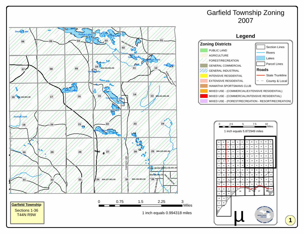
004-116-001-00 004-111-001-00
004-103-001-00
004-123-001-00
004-127-001-00 004-135-001-00
004-101-001-00
004-1
36-00
3-00
004-136-005-00
004-136-001-10
004-136-001-20004-136-002-00
Pullup Lake Tee Lake
Dollar Lake
Cranberry Lake
Nelson Lake
Ear Lake
Lake Louise
Goat Lake
Finn Lake
Devine Lake
Lucky Lake
Jocko Creek
18
07
15
36
12
22
13
06
10
3534
20
17
19
3332
27
11
29
16
09
05
31
30
08
14
2528
24
26
21 23
04 0302
01
Cran
berry
Lake
Dollar Lake Truck
11 11
11
15
07
03
14
11
16
10
14
18
02
07
01
13
23
16
06
15
06
17
36
05
22
33
30
08
12
22
13
03
09
09
24
10
15
02
3534
19
28
20
04
17
20
06
27
21
21
23
13
17
21
0401
32
19
33
02
12
18
08
13
32
2729
16
31
07
09
16
29
05
06
31
19
17
30
20 22
10 08
18
14
08
07 09
25
24
03
20
05
04
34
14
28
07
2423
26
29
21
05 01
31 32
2630
23
12
35
10
04
24
36
27
19
33
25
15
28
03
25
06 05
18
02
12
01
22
08
18
2926
04
26
34
30
36
28
19
!1
!29
!18 !17
!8
!6
!15
!3
!14!13
!20 !19
!10
!16
!2
!22
!11
!23
!12
!21
!5 !7
!9
!27!24
!4
!28!25 !26
Garfield Township Zoning2007
0 0.75 1.5 2.25 3Miles
1 inch equals 0.994318 miles µ
0 2.5 5 7.5 10Miles
Section Lines
Rivers
Lakes
Parcel Lines
RoadsState Trunkline
County & Local
Garfield TownshipSections 1-36
T44N R9W
Zoning DistrictsPUBLIC LAND
AGRICULTURE
FOREST/RECREATION
GENERAL COMMERCIAL
GENERAL INDUSTRIAL
INTENSIVE RESIDENTIAL
EXTENSIVE RESIDENTIAL
HIAWATHA SPORTSMANS CLUB
MIXED USE - (COMMERCIAL/EXTENSIVE RESIDENTIAL)
MIXED USE - (COMMERCIAL/INTENSIVE RESIDENTIAL)
MIXED USE - (FOREST/RECREATION - RESORT/RECREATION)
1
Legend
1 inch equals 5.872949 miles
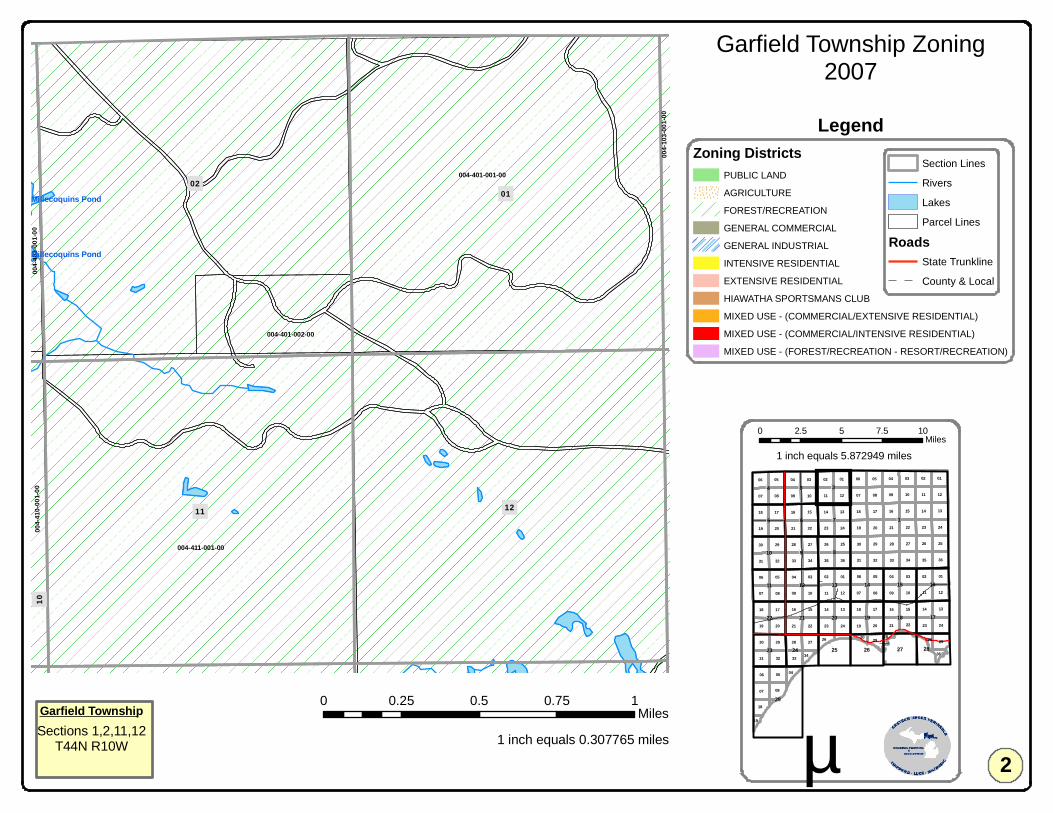
004-411-001-00
004-401-001-00
004-401-002-00
004-4
10-00
1-00
004-4
03-00
1-00
004-1
03-00
1-00
Millecoquins Pond
Millecoquins Pond
0201
1211
10 11 11
11
15
07
03
14
11
16
10
14
18
02
07
01
13
23
16
06
15
06
17
36
05
22
33
30
08
12
22
13
03
09
09
24
10
15
02
3534
19
28
20
04
17
20
06
27
21
21
23
13
17
21
0401
32
19
33
02
12
18
08
13
32
2729
16
31
07
09
16
29
05
06
31
19
17
30
20 22
10 08
18
14
08
07 09
25
24
03
20
05
04
34
14
28
07
2423
26
29
21
05 01
31 32
2630
23
12
35
10
04
24
36
27
19
33
25
15
28
03
25
06 05
18
02
12
01
22
08
18
2926
04
26
34
30
36
28
19
!1
!29
!18 !17
!8
!6
!15
!3
!14!13
!20 !19
!10
!16
!2
!22
!11
!23
!12
!21
!5 !7
!9
!27!24
!4
!28!25 !26
Garfield Township Zoning2007
0 0.25 0.5 0.75 1Miles
1 inch equals 0.307765 miles µ
0 2.5 5 7.5 10Miles
Section Lines
Rivers
Lakes
Parcel Lines
RoadsState Trunkline
County & Local
Garfield TownshipSections 1,2,11,12
T44N R10W
Zoning DistrictsPUBLIC LAND
AGRICULTURE
FOREST/RECREATION
GENERAL COMMERCIAL
GENERAL INDUSTRIAL
INTENSIVE RESIDENTIAL
EXTENSIVE RESIDENTIAL
HIAWATHA SPORTSMANS CLUB
MIXED USE - (COMMERCIAL/EXTENSIVE RESIDENTIAL)
MIXED USE - (COMMERCIAL/INTENSIVE RESIDENTIAL)
MIXED USE - (FOREST/RECREATION - RESORT/RECREATION)
2
Legend
1 inch equals 5.872949 miles

004-403-001-00
004-404-001-00
004-410-001-00
004-410-002-00
004-409-010-00
004-409-001-00
004-410-003-00
004-409-002-00
004-409-014-00
004-403-002-00
004-409-011-00
004-409-013-00004-409-009-00 004-409-012-00
004-404-005-00
004-404-004-00
004-410-004-00
004-404-002-00004-404-003-00
004-4
09-00
5-00004-409-006-00
004-4
01-00
1-00
004-409-006-10
004-409-004-10
Millecoquins Pond
Mc Alpine Creek
Mc Alpine CreekMc Alpine Creek
Skunk Creek
Mc Alpine Creek
03
09
04
10
Krau
se
Brown
11 11
11
15
07
03
14
11
16
10
14
18
02
07
01
13
23
16
06
15
06
17
36
05
22
33
30
08
12
22
13
03
09
09
24
10
15
02
3534
19
28
20
04
17
20
06
27
21
21
23
13
17
21
0401
32
19
33
02
12
18
08
13
32
2729
16
31
07
09
16
29
05
06
31
19
17
30
20 22
10 08
18
14
08
07 09
25
24
03
20
05
04
34
14
28
07
2423
26
29
21
05 01
31 32
2630
23
12
35
10
04
24
36
27
19
33
25
15
28
03
25
06 05
18
02
12
01
22
08
18
2926
04
26
34
30
36
28
19
!1
!29
!18 !17
!8
!6
!15
!3
!14!13
!20 !19
!10
!16
!2
!22
!11
!23
!12
!21
!5 !7
!9
!27!24
!4
!28!25 !26
Garfield Township Zoning2007
0 0.25 0.5 0.75 1Miles
1 inch equals 0.307765 miles µ
0 2.5 5 7.5 10Miles
Section Lines
Rivers
Lakes
Parcel Lines
RoadsState Trunkline
County & Local
Garfield TownshipSections 3,4,9,10
T44N R10W
Zoning DistrictsPUBLIC LAND
AGRICULTURE
FOREST/RECREATION
GENERAL COMMERCIAL
GENERAL INDUSTRIAL
INTENSIVE RESIDENTIAL
EXTENSIVE RESIDENTIAL
HIAWATHA SPORTSMANS CLUB
MIXED USE - (COMMERCIAL/EXTENSIVE RESIDENTIAL)
MIXED USE - (COMMERCIAL/INTENSIVE RESIDENTIAL)
MIXED USE - (FOREST/RECREATION - RESORT/RECREATION)
3
Legend
1 inch equals 5.872949 miles
!M 117
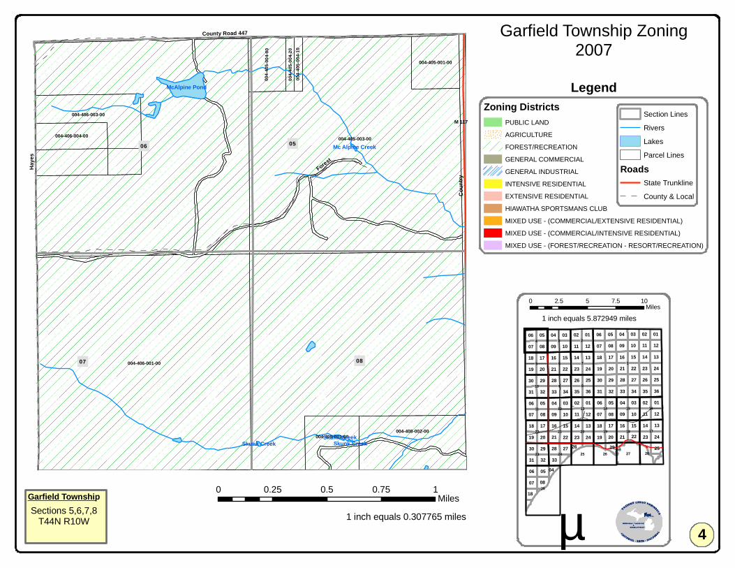
004-406-001-00
004-405-003-00
004-406-003-00
004-408-002-00
004-405-001-00
004-4
05-00
4-00
004-408-001-00
004-406-004-00
004-4
05-00
4-10
004-4
05-00
4-20
McAlpine Pond
Skunk CreekSkunk Creek
Mc Alpine Creek
Skunk Creek
0807
06 05
Haye
s
Forest
Coun
try
County Road 447
11 11
11
15
07
03
14
11
16
10
14
18
0207
01
13
23
16
06
15
06
17
36
05
22
33
30
08
12
22
13
03
09
09
24
10
15
02
3534
19
28
20
04
17
20
06
27
21
21
2313
17
21
040132
19
33
02
12
18
08
13
32
2729
16
31
07
09
16
29
05
06
31
19
17
30
20 22
10 08
18
1408
07 09
25
24
03
20
05
04
34
14
28
07
242326
29
21
05 01
31 32
2630
23
12
35
10
04
24
36
27
19
33
25
15
28
03
25
06 05
18
02
12
01
22
08
18
2926
04
!1
!29
!18 !17
!8
!6
!15
!3
!14!13
!20 !19
!10
!16
!2
!22
!11
!23
!12
!21
!5 !7
!9
!27!24
!4
!28!25 !26
Garfield Township Zoning2007
0 0.25 0.5 0.75 1Miles
1 inch equals 0.307765 miles µ
0 2.5 5 7.5 10Miles
Section Lines
Rivers
Lakes
Parcel Lines
RoadsState Trunkline
County & Local
Garfield TownshipSections 5,6,7,8
T44N R10W
Zoning DistrictsPUBLIC LAND
AGRICULTURE
FOREST/RECREATION
GENERAL COMMERCIAL
GENERAL INDUSTRIAL
INTENSIVE RESIDENTIAL
EXTENSIVE RESIDENTIAL
HIAWATHA SPORTSMANS CLUB
MIXED USE - (COMMERCIAL/EXTENSIVE RESIDENTIAL)
MIXED USE - (COMMERCIAL/INTENSIVE RESIDENTIAL)
MIXED USE - (FOREST/RECREATION - RESORT/RECREATION)
4
Legend
1 inch equals 5.872949 miles
!M 117
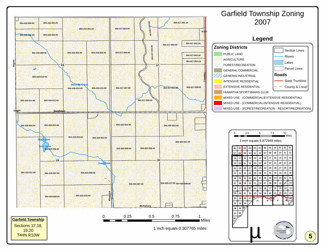
004-420-007-00 004-420-008-00
004-419-011-00
004-420-001-00
004-417-002-00
004-419-009-00
004-418-001-00
004-419-002-00
004-418-010-00
004-417-007-00004-418-014-00 004-418-013-00
004-418-009-00
004-417-011-00
004-420-017-00
004-419-001-00
004-417-009-00
004-419-010-00
004-406-001-00
004-417-008-00
004-419-007-00
004-419-006-00 004-420-005-00
004-417-005-00
004-420-006-00
004-418-003-00004-418-002-00
004-417-003-00
004-420-004-00004-419-003-00
004-418-012-00
004-417-001-10
004-418-011-00
004-419-008-00
004-419-004-00 004-420-002-00
004-408-002-00
004-417-004-00
004-4
17-00
6-00
004-418-004-00
004-418-005-00
004-418-006-00
004-418-008-00
004-417-002-10
004-417-002-40
004-417-002-20
004-408-001-00
Doe Creek
Doe Creek
Doe Creek
Maloney Creek
17
20
18
19
07 08
Sandtown
Haye
s
Coun
tryMcKelvey
Pleas
ant
Gager
11 11
11
15
07
03
14
11
16
10
14
18
0207
01
13
23
16
06
15
06
17
36
05
22
33
30
08
12
22
13
03
09
09
24
10
15
02
3534
19
28
20
04
17
20
06
27
21
21
2313
17
21
040132
19
33
02
12
18
08
13
32
2729
16
31
07
09
16
29
05
06
31
19
17
30
20 22
10 08
18
1408
07 09
25
24
03
20
05
04
34
14
28
07
242326
29
21
05 01
31 32
2630
23
12
35
10
04
24
36
27
19
33
25
15
28
03
25
06 05
18
02
12
01
22
08
18
2926
04
!1
!29
!18 !17
!8
!6
!15
!3
!14!13
!20 !19
!10
!16
!2
!22
!11
!23
!12
!21
!5 !7
!9
!27!24
!4
!28!25 !26
Garfield Township Zoning2007
0 0.25 0.5 0.75 1Miles
1 inch equals 0.307765 miles µ
0 2.5 5 7.5 10Miles
Section Lines
Rivers
Lakes
Parcel Lines
RoadsState Trunkline
County & Local
Garfield TownshipSections 17,18,
19,20T44N R10W
Zoning DistrictsPUBLIC LAND
AGRICULTURE
FOREST/RECREATION
GENERAL COMMERCIAL
GENERAL INDUSTRIAL
INTENSIVE RESIDENTIAL
EXTENSIVE RESIDENTIAL
HIAWATHA SPORTSMANS CLUB
MIXED USE - (COMMERCIAL/EXTENSIVE RESIDENTIAL)
MIXED USE - (COMMERCIAL/INTENSIVE RESIDENTIAL)
MIXED USE - (FOREST/RECREATION - RESORT/RECREATION)
5
Legend
1 inch equals 5.872949 miles
!M 117
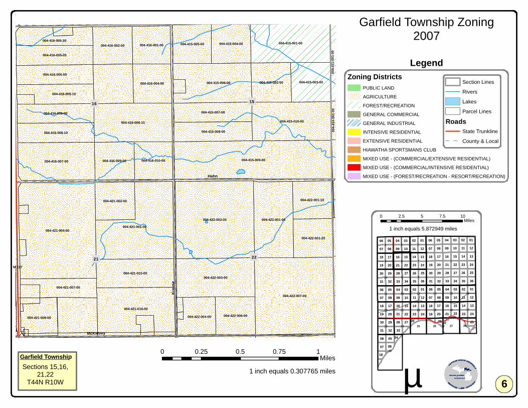
004-421-004-00
004-422-007-00
004-422-002-00
004-415-009-00
004-421-001-00
004-421-016-00
004-415-001-00
004-415-010-00
004-422-003-00
004-416-008-10
004-422-001-00
004-415-006-00
004-416-007-00
004-421-015-00
004-415-003-00004-415-002-00
004-422-001-20
004-415-004-00
004-415-007-00
004-415-008-00
004-415-005-00
004-416-005-05
004-416-006-10
004-421-002-00
004-416-002-00
004-416-004-00
004-416-009-00
004-422-006-00
004-416-006-00
004-416-005-00
004-422-001-10
004-416-001-00
004-416-010-00
004-416-005-10
004-422-004-00004-421-008-00
004-421-007-00
004-416-005-30
004-410-001-00004-409-014-00004-409-011-00 004-410-004-00
004-4
11-00
1-00
004-4
14-00
1-00
16
22
15
21
09 10
HahnKr
ause
McKelvey
Brown
11 11
11
15
07
03
14
11
16
10
14
18
0207
01
13
23
16
06
15
06
17
36
05
22
33
30
08
12
22
13
03
09
09
24
10
15
02
3534
19
28
20
04
17
20
06
27
21
21
2313
17
21
040132
19
33
02
12
18
08
13
32
2729
16
31
07
09
16
29
05
06
31
19
17
30
20 22
10 08
18
1408
07 09
25
24
03
20
05
04
34
14
28
07
242326
29
21
05 01
31 32
2630
23
12
35
10
04
24
36
27
19
33
25
15
28
03
25
06 05
18
02
12
01
22
08
18
2926
04
!1
!29
!18 !17
!8
!6
!15
!3
!14!13
!20 !19
!10
!16
!2
!22
!11
!23
!12
!21
!5 !7
!9
!27!24
!4
!28!25 !26
Garfield Township Zoning2007
0 0.25 0.5 0.75 1Miles
1 inch equals 0.307765 miles µ
0 2.5 5 7.5 10Miles
Section Lines
Rivers
Lakes
Parcel Lines
RoadsState Trunkline
County & Local
Garfield TownshipSections 15,16,
21,22T44N R10W
Zoning DistrictsPUBLIC LAND
AGRICULTURE
FOREST/RECREATION
GENERAL COMMERCIAL
GENERAL INDUSTRIAL
INTENSIVE RESIDENTIAL
EXTENSIVE RESIDENTIAL
HIAWATHA SPORTSMANS CLUB
MIXED USE - (COMMERCIAL/EXTENSIVE RESIDENTIAL)
MIXED USE - (COMMERCIAL/INTENSIVE RESIDENTIAL)
MIXED USE - (FOREST/RECREATION - RESORT/RECREATION)
6
Legend
1 inch equals 5.872949 miles
!M 117

Jocko Pond
004-411-001-00
004-423-001-00
004-425-001-00
004-423-004-00
004-423-002-10
004-423-002-20
004-414-001-10
004-423-005-00
004-414-001-00
004-423-002-00
004-414-001-20
004-423-003-00
004-414-002-00
004-1
16-00
1-00
004-4
22-00
7-00
1314
23 24
11 12
18Co
ld Cr
eek
11 11
11
15
07
03
14
11
16
10
14
18
0207
01
13
23
16
06
15
06
17
36
05
22
33
30
08
12
22
13
03
09
09
24
10
15
02
3534
19
28
20
04
17
20
06
27
21
21
2313
17
21
040132
19
33
02
12
18
08
13
32
2729
16
31
07
09
16
29
05
06
31
19
17
30
20 22
10 08
18
1408
07 09
25
24
03
20
05
04
34
14
28
07
242326
29
21
05 01
31 32
2630
23
12
35
10
04
24
36
27
19
33
25
15
28
03
25
06 05
18
02
12
01
22
08
18
2926
04
!1
!29
!18 !17
!8
!6
!15
!3
!14!13
!20 !19
!10
!16
!2
!22
!11
!23
!12
!21
!5 !7
!9
!27!24
!4
!28!25 !26
Garfield Township Zoning2007
0 0.25 0.5 0.75 1Miles
1 inch equals 0.306187 miles µ
0 2.5 5 7.5 10Miles
Section Lines
Rivers
Lakes
Parcel Lines
RoadsState Trunkline
County & Local
Garfield TownshipSections 13,14
23,24T44N R10W
Zoning DistrictsPUBLIC LAND
AGRICULTURE
FOREST/RECREATION
GENERAL COMMERCIAL
GENERAL INDUSTRIAL
INTENSIVE RESIDENTIAL
EXTENSIVE RESIDENTIAL
HIAWATHA SPORTSMANS CLUB
MIXED USE - (COMMERCIAL/EXTENSIVE RESIDENTIAL)
MIXED USE - (COMMERCIAL/INTENSIVE RESIDENTIAL)
MIXED USE - (FOREST/RECREATION - RESORT/RECREATION)
7
Legend
1 inch equals 5.872949 miles
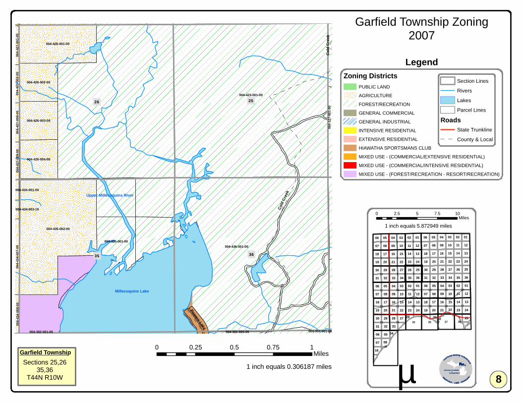
004-423-001-00
004-436-001-00
004-435-002-00
004-426-001-00
004-435-001-00
004-426-004-00
004-426-002-00
004-426-003-00
004-425-001-00
004-1
27-00
1-00
004-4
34-00
7-00
004-4
34-00
8-00
004-4
27-00
8-00
004-4
27-00
9-00
004-4
27-00
2-00
004-4
27-00
1-00
004-301-005-00
004-434-001-00
004-434-003-10
004-422-007-00 004-116-001-00
004-302-001-00 004-004-001-00
Millecoquins Lake
Upper Millecoquins River
26
35 36
25
23 24
Cold
Cree
k
Powers Lake
Cold
Cree
k
11 11
11
15
07
03
14
11
16
10
14
18
0207
01
13
23
16
06
15
06
17
36
05
22
33
30
08
12
22
13
03
09
09
24
10
15
02
3534
19
28
20
04
17
20
06
27
21
21
2313
17
21
040132
19
33
02
12
18
08
13
32
2729
16
31
07
09
16
29
05
06
31
19
17
30
20 22
10 08
18
1408
07 09
25
24
03
20
05
04
34
14
28
07
242326
29
21
05 01
31 32
2630
23
12
35
10
04
24
36
27
19
33
25
15
28
03
25
06 05
18
02
12
01
22
08
18
2926
04
!1
!29
!18 !17
!8
!6
!15
!3
!14!13
!20 !19
!10
!16
!2
!22
!11
!23
!12
!21
!5 !7
!9
!27!24
!4
!28!25 !26
Garfield Township Zoning2007
0 0.25 0.5 0.75 1Miles
1 inch equals 0.306187 miles µ
0 2.5 5 7.5 10Miles
Section Lines
Rivers
Lakes
Parcel Lines
RoadsState Trunkline
County & Local
Garfield TownshipSections 25,26
35,36T44N R10W
Zoning DistrictsPUBLIC LAND
AGRICULTURE
FOREST/RECREATION
GENERAL COMMERCIAL
GENERAL INDUSTRIAL
INTENSIVE RESIDENTIAL
EXTENSIVE RESIDENTIAL
HIAWATHA SPORTSMANS CLUB
MIXED USE - (COMMERCIAL/EXTENSIVE RESIDENTIAL)
MIXED USE - (COMMERCIAL/INTENSIVE RESIDENTIAL)
MIXED USE - (FOREST/RECREATION - RESORT/RECREATION)
8
Legend
1 inch equals 5.872949 miles
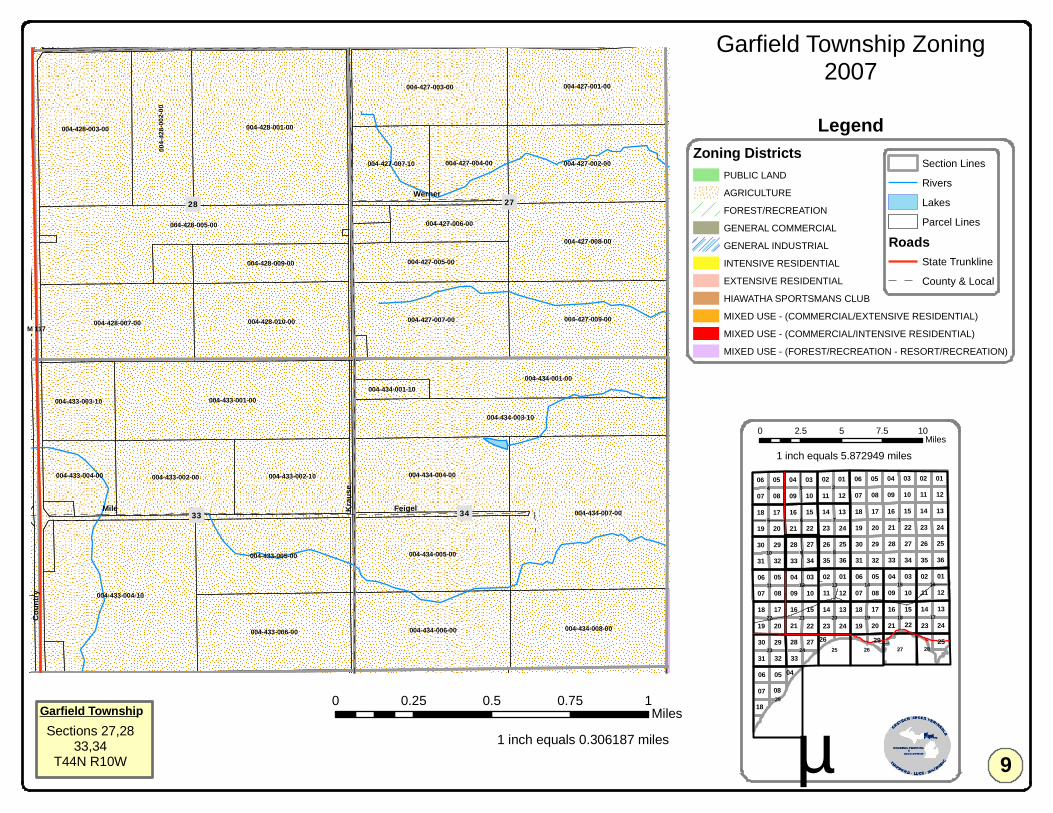
004-434-007-00
004-428-001-00
004-433-004-10
004-433-001-00
004-428-005-00
004-428-003-00
004-427-008-00
004-427-002-00
004-427-009-00
004-427-001-00
004-428-010-00
004-434-008-00
004-434-003-10
004-427-003-00
004-428-007-00
004-434-006-00004-433-006-00
004-427-007-00
004-433-005-00 004-434-005-00
004-434-004-00
004-434-001-00
004-4
28-00
2-00
004-433-002-00 004-433-002-10
004-427-005-00004-428-009-00
004-427-004-00004-427-007-10
004-433-003-10
004-433-004-00
004-427-006-00
004-422-007-00
004-434-001-10
004-422-004-00 004-422-006-00004-421-008-00 004-421-016-00
33
28 27
34
21 22
Krau
se
Coun
try
Mile
McKelvey
Feigel
Werner
11 11
11
15
07
03
14
11
16
10
14
18
0207
01
13
23
16
06
15
06
17
36
05
22
33
30
08
12
22
13
03
09
09
24
10
15
02
3534
19
28
20
04
17
20
06
27
21
21
2313
17
21
040132
19
33
02
12
18
08
13
32
2729
16
31
07
09
16
29
05
06
31
19
17
30
20 22
10 08
18
1408
07 09
25
24
03
20
05
04
34
14
28
07
242326
29
21
05 01
31 32
2630
23
12
35
10
04
24
36
27
19
33
25
15
28
03
25
06 05
18
02
12
01
22
08
18
2926
04
!1
!29
!18 !17
!8
!6
!15
!3
!14!13
!20 !19
!10
!16
!2
!22
!11
!23
!12
!21
!5 !7
!9
!27!24
!4
!28!25 !26
Garfield Township Zoning2007
0 0.25 0.5 0.75 1Miles
1 inch equals 0.306187 miles µ
0 2.5 5 7.5 10Miles
Section Lines
Rivers
Lakes
Parcel Lines
RoadsState Trunkline
County & Local
Garfield TownshipSections 27,28
33,34T44N R10W
Zoning DistrictsPUBLIC LAND
AGRICULTURE
FOREST/RECREATION
GENERAL COMMERCIAL
GENERAL INDUSTRIAL
INTENSIVE RESIDENTIAL
EXTENSIVE RESIDENTIAL
HIAWATHA SPORTSMANS CLUB
MIXED USE - (COMMERCIAL/EXTENSIVE RESIDENTIAL)
MIXED USE - (COMMERCIAL/INTENSIVE RESIDENTIAL)
MIXED USE - (FOREST/RECREATION - RESORT/RECREATION)
9
Legend
1 inch equals 5.872949 miles
!M 117
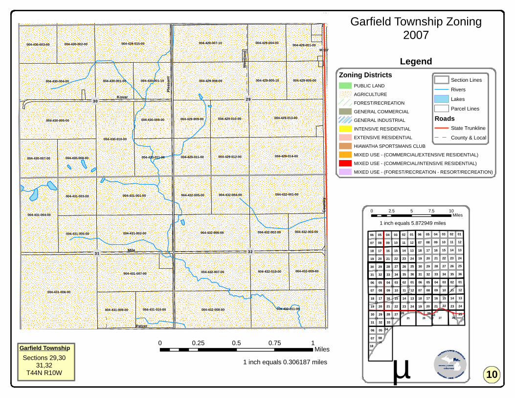
004-431-006-00
004-431-001-00 004-432-001-00
004-429-015-00
004-430-010-00
004-432-008-00
004-429-008-00
004-431-004-00
004-430-005-00
004-432-011-00
004-432-007-00
004-429-014-00
004-431-002-00 004-432-006-00
004-430-004-00
004-429-013-00
004-429-007-10
004-431-007-00
004-431-003-00 004-432-004-00
004-430-008-00
004-429-005-10
004-429-012-00
004-429-010-00
004-430-007-00
004-430-002-00
004-432-010-00
004-430-011-00
004-430-003-00
004-432-005-00
004-429-004-00
004-431-005-00
004-429-011-00
004-432-002-00
004-429-009-00
004-430-001-00
004-431-009-00
004-430-009-00
004-430-001-10
004-431-010-00
004-429-005-00
004-432-009-00
004-432-003-00
004-429-001-00
004-420-007-00004-419-010-00 004-420-008-00004-419-011-00 004-419-008-00
32
29
31
30
19 20
Mile
Pleas
ant
Coun
try
Kovar
McKelvey
Patzer
Wentl
and
11 11
11
15
07
03
14
11
16
10
14
18
0207
01
13
23
16
06
15
06
17
36
05
22
33
30
08
12
22
13
03
09
09
24
10
15
02
3534
19
28
20
04
17
20
06
27
21
21
2313
17
21
040132
19
33
02
12
18
08
13
32
2729
16
31
07
09
16
29
05
06
31
19
17
30
20 22
10 08
18
1408
07 09
25
24
03
20
05
04
34
14
28
07
242326
29
21
05 01
31 32
2630
23
12
35
10
04
24
36
27
19
33
25
15
28
03
25
06 05
18
02
12
01
22
08
18
2926
04
!1
!29
!18 !17
!8
!6
!15
!3
!14!13
!20 !19
!10
!16
!2
!22
!11
!23
!12
!21
!5 !7
!9
!27!24
!4
!28!25 !26
Garfield Township Zoning2007
0 0.25 0.5 0.75 1Miles
1 inch equals 0.306187 miles µ
0 2.5 5 7.5 10Miles
Section Lines
Rivers
Lakes
Parcel Lines
RoadsState Trunkline
County & Local
Garfield TownshipSections 29,30
31,32T44N R10W
Zoning DistrictsPUBLIC LAND
AGRICULTURE
FOREST/RECREATION
GENERAL COMMERCIAL
GENERAL INDUSTRIAL
INTENSIVE RESIDENTIAL
EXTENSIVE RESIDENTIAL
HIAWATHA SPORTSMANS CLUB
MIXED USE - (COMMERCIAL/EXTENSIVE RESIDENTIAL)
MIXED USE - (COMMERCIAL/INTENSIVE RESIDENTIAL)
MIXED USE - (FOREST/RECREATION - RESORT/RECREATION)
10
Legend
1 inch equals 5.872949 miles
!M 117

004-306-005-00
004-305-008-00
004-305-001-00
004-308-006-10
004-306-004-00
004-307-004-00
004-307-001-00
004-307-005-00
004-308-004-00
004-307-002-00
004-306-006-00 004-305-009-00
004-305-010-00
004-306-003-00
004-308-001-00
004-308-015-00
004-306-001-00
004-308-002-00004-308-005-00
004-308-016-00004-307-009-00
004-305-002-10
004-307-008-00
004-307-007-00 004-308-010-00004-307-006-00
004-305-002-00
004-307-011-00
004-305-006-00
004-431-006-00 004-432-008-00 004-432-011-00
004-305-007-00
004-307-013-10
004-305-005-00
004-307-013-00
004-3
08-00
6-00
004-431-009-00 004-431-010-00
004-305-006-10
08
06
07
05
31 32
LinckCo
untry
Pleas
ant
Patzer
11 11
11
15
07
03
14
11
16
10
14
18
0207
01
13
23
16
06
15
06
17
36
05
22
33
30
08
12
22
13
03
09
09
24
10
15
02
3534
19
28
20
04
17
20
06
27
21
21
2313
17
21
040132
19
33
02
12
18
08
13
32
2729
16
31
07
09
16
29
05
06
31
19
17
30
20 22
10 08
18
1408
07 09
25
24
03
20
05
04
34
14
28
07
242326
29
21
05 01
31 32
2630
23
12
35
10
04
24
36
27
19
33
25
15
28
03
25
06 05
18
02
12
01
22
08
18
2926
04
!1
!29
!18 !17
!8
!6
!15
!3
!14!13
!20 !19
!10
!16
!2
!22
!11
!23
!12
!21
!5 !7
!9
!27!24
!4
!28!25 !26
Garfield Township Zoning2007
0 0.25 0.5 0.75 1Miles
1 inch equals 0.306187 miles µ
0 2.5 5 7.5 10Miles
Section Lines
Rivers
Lakes
Parcel Lines
RoadsState Trunkline
County & Local
Garfield TownshipSections 5,6
7,8T43N R10W
Zoning DistrictsPUBLIC LAND
AGRICULTURE
FOREST/RECREATION
GENERAL COMMERCIAL
GENERAL INDUSTRIAL
INTENSIVE RESIDENTIAL
EXTENSIVE RESIDENTIAL
HIAWATHA SPORTSMANS CLUB
MIXED USE - (COMMERCIAL/EXTENSIVE RESIDENTIAL)
MIXED USE - (COMMERCIAL/INTENSIVE RESIDENTIAL)
MIXED USE - (FOREST/RECREATION - RESORT/RECREATION)
11
Legend
1 inch equals 5.872949 miles
!M 117
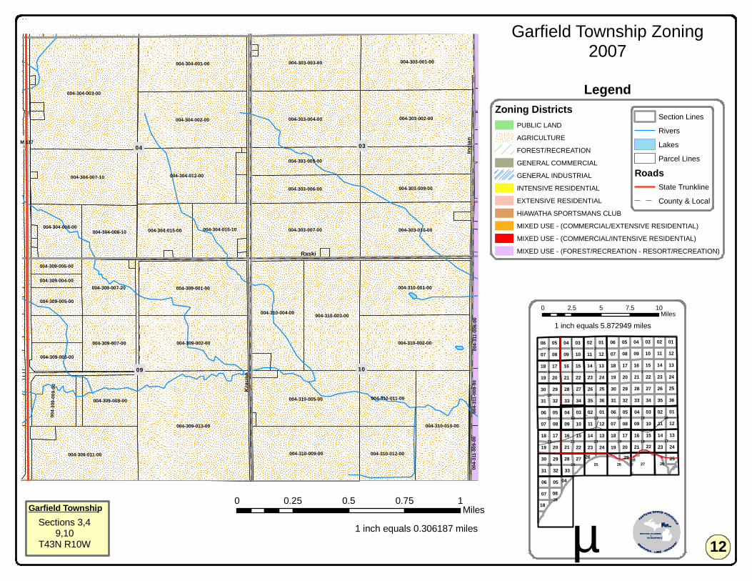
004-309-013-00
004-304-003-00
004-303-001-00
004-303-002-00004-303-004-00
004-303-003-00
004-310-003-00
004-304-002-00
004-310-002-00
004-304-001-00
004-309-002-00
004-310-001-00004-309-001-00
004-303-007-00
004-310-010-00
004-303-010-00
004-310-009-00
004-304-007-10
004-310-005-00
004-304-012-00
004-310-004-00
004-309-011-00
004-310-011-00
004-303-009-00004-303-006-00
004-310-012-00
004-303-005-00
004-309-007-00
004-304-008-10 004-304-015-00
004-309-007-20
004-309-008-00
004-304-015-10004-304-008-00
004-3
09-00
9-00
004-433-006-00 004-434-006-00004-433-004-10 004-434-008-00
004-309-003-00
004-309-005-00
004-309-006-00
004-309-004-00
004-3
11-00
6-00
004-3
11-00
9-00
004-3
11-00
8-00
09
0304
10
33 34
Raski
Indian
Krau
se
11 11
11
15
07
03
14
11
16
10
14
18
0207
01
13
23
16
06
15
06
17
36
05
22
33
30
08
12
22
13
03
09
09
24
10
15
02
3534
19
28
20
04
17
20
06
27
21
21
2313
17
21
040132
19
33
02
12
18
08
13
32
2729
16
31
07
09
16
29
05
06
31
19
17
30
20 22
10 08
18
1408
07 09
25
24
03
20
05
04
34
14
28
07
242326
29
21
05 01
31 32
2630
23
12
35
10
04
24
36
27
19
33
25
15
28
03
25
06 05
18
02
12
01
22
08
18
2926
04
!1
!29
!18 !17
!8
!6
!15
!3
!14!13
!20 !19
!10
!16
!2
!22
!11
!23
!12
!21
!5 !7
!9
!27!24
!4
!28!25 !26
Garfield Township Zoning2007
0 0.25 0.5 0.75 1Miles
1 inch equals 0.306187 miles µ
0 2.5 5 7.5 10Miles
Section Lines
Rivers
Lakes
Parcel Lines
RoadsState Trunkline
County & Local
Garfield TownshipSections 3,4
9,10T43N R10W
Zoning DistrictsPUBLIC LAND
AGRICULTURE
FOREST/RECREATION
GENERAL COMMERCIAL
GENERAL INDUSTRIAL
INTENSIVE RESIDENTIAL
EXTENSIVE RESIDENTIAL
HIAWATHA SPORTSMANS CLUB
MIXED USE - (COMMERCIAL/EXTENSIVE RESIDENTIAL)
MIXED USE - (COMMERCIAL/INTENSIVE RESIDENTIAL)
MIXED USE - (FOREST/RECREATION - RESORT/RECREATION)
12
Legend
1 inch equals 5.872949 miles
!M 117

004-312-001-00
004-301-005-00
004-311-006-00
004-311-001-00
004-311-008-00
004-302-012-00
004-302-001-00
004-311-007-00
004-312-003-00
004-31
1-009-
00
004-302-008-10
004-312-002-00
004-0
08-00
1-00
004-311-005-00
004-302-005-00
004-436-001-00
004-302-006-10
004-0
04-00
1-00
Millecoquins Lake
Lower Millecoquins River
Furlong Creek
11
02 01
12
35
Powers Lake
Hiawatha
1st
Lake
Riverview
Main
Cold Creek
Carte
r
3rd2nd
Lake
view Lawson
Ryan
Chase Point
3rd
2nd
11 11
11
15
07
03
14
11
16
10
14
18
0207
01
13
23
16
06
15
06
17
36
05
22
33
30
08
12
22
13
03
09
09
24
10
15
02
3534
19
28
20
04
17
20
06
27
21
21
2313
17
21
040132
19
33
02
12
18
08
13
32
2729
16
31
07
09
16
29
05
06
31
19
17
30
20 22
10 08
18
1408
07 09
25
24
03
20
05
04
34
14
28
07
242326
29
21
05 01
31 32
2630
23
12
35
10
04
24
36
27
19
33
25
15
28
03
25
06 05
18
02
12
01
22
08
18
2926
04
!1
!29
!18 !17
!8
!6
!15
!3
!14!13
!20 !19
!10
!16
!2
!22
!11
!23
!12
!21
!5 !7
!9
!27!24
!4
!28!25 !26
Garfield Township Zoning2007
0 0.25 0.5 0.75 1Miles
1 inch equals 0.306187 miles µ
0 2.5 5 7.5 10Miles
Section Lines
Rivers
Lakes
Parcel Lines
RoadsState Trunkline
County & Local
Garfield TownshipSections 1,2
11,12T43N R10W
Zoning DistrictsPUBLIC LAND
AGRICULTURE
FOREST/RECREATION
GENERAL COMMERCIAL
GENERAL INDUSTRIAL
INTENSIVE RESIDENTIAL
EXTENSIVE RESIDENTIAL
HIAWATHA SPORTSMANS CLUB
MIXED USE - (COMMERCIAL/EXTENSIVE RESIDENTIAL)
MIXED USE - (COMMERCIAL/INTENSIVE RESIDENTIAL)
MIXED USE - (FOREST/RECREATION - RESORT/RECREATION)
13
Legend
1 inch equals 5.872949 miles
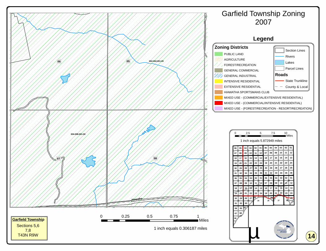
004-004-001-00
004-008-001-00
004-127-001-00
05
08
06
07
Hiawatha
11 11
11
15
07
03
14
11
16
10
14
18
0207
01
13
23
16
06
15
06
17
36
05
22
33
30
08
12
22
13
03
09
09
24
10
15
02
3534
19
28
20
04
17
20
06
27
21
21
2313
17
21
040132
19
33
02
12
18
08
13
32
2729
16
31
07
09
16
29
05
06
31
19
17
30
20 22
10 08
18
1408
07 09
25
24
03
20
05
04
34
14
28
07
242326
29
21
05 01
31 32
2630
23
12
35
10
04
24
36
27
19
33
25
15
28
03
25
06 05
18
02
12
01
22
08
18
2926
04
!1
!29
!18 !17
!8
!6
!15
!3
!14!13
!20 !19
!10
!16
!2
!22
!11
!23
!12
!21
!5 !7
!9
!27!24
!4
!28!25 !26
Garfield Township Zoning2007
0 0.25 0.5 0.75 1Miles
1 inch equals 0.306187 miles µ
0 2.5 5 7.5 10Miles
Section Lines
Rivers
Lakes
Parcel Lines
RoadsState Trunkline
County & Local
Garfield TownshipSections 5,6
7,8T43N R9W
Zoning DistrictsPUBLIC LAND
AGRICULTURE
FOREST/RECREATION
GENERAL COMMERCIAL
GENERAL INDUSTRIAL
INTENSIVE RESIDENTIAL
EXTENSIVE RESIDENTIAL
HIAWATHA SPORTSMANS CLUB
MIXED USE - (COMMERCIAL/EXTENSIVE RESIDENTIAL)
MIXED USE - (COMMERCIAL/INTENSIVE RESIDENTIAL)
MIXED USE - (FOREST/RECREATION - RESORT/RECREATION)
14
Legend
1 inch equals 5.872949 miles
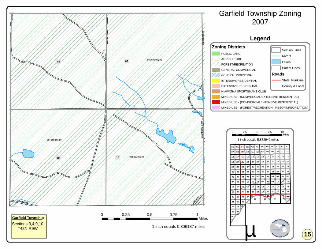
004-011-001-00
004-004-001-00
004-008-001-00
004-127-001-00
004-0
01-00
1-00
10
03
09
04
33 34
Cran
berry
Lake
Hiawatha Hiawath
a
11 11
11
15
07
03
14
11
16
10
14
18
0207
01
13
23
16
06
15
06
17
36
05
22
33
30
08
12
22
13
03
09
09
24
10
15
02
3534
19
28
20
04
17
20
06
27
21
21
2313
17
21
040132
19
33
02
12
18
08
13
32
2729
16
31
07
09
16
29
05
06
31
19
17
30
20 22
10 08
18
1408
07 09
25
24
03
20
05
04
34
14
28
07
242326
29
21
05 01
31 32
2630
23
12
35
10
04
24
36
27
19
33
25
15
28
03
25
06 05
18
02
12
01
22
08
18
2926
04
!1
!29
!18 !17
!8
!6
!15
!3
!14!13
!20 !19
!10
!16
!2
!22
!11
!23
!12
!21
!5 !7
!9
!27!24
!4
!28!25 !26
Garfield Township Zoning2007
0 0.25 0.5 0.75 1Miles
1 inch equals 0.306187 miles µ
0 2.5 5 7.5 10Miles
Section Lines
Rivers
Lakes
Parcel Lines
RoadsState Trunkline
County & Local
Garfield TownshipSections 3,4,9,10
T43N R9W
Zoning DistrictsPUBLIC LAND
AGRICULTURE
FOREST/RECREATION
GENERAL COMMERCIAL
GENERAL INDUSTRIAL
INTENSIVE RESIDENTIAL
EXTENSIVE RESIDENTIAL
HIAWATHA SPORTSMANS CLUB
MIXED USE - (COMMERCIAL/EXTENSIVE RESIDENTIAL)
MIXED USE - (COMMERCIAL/INTENSIVE RESIDENTIAL)
MIXED USE - (FOREST/RECREATION - RESORT/RECREATION)
15
Legend
1 inch equals 5.872949 miles
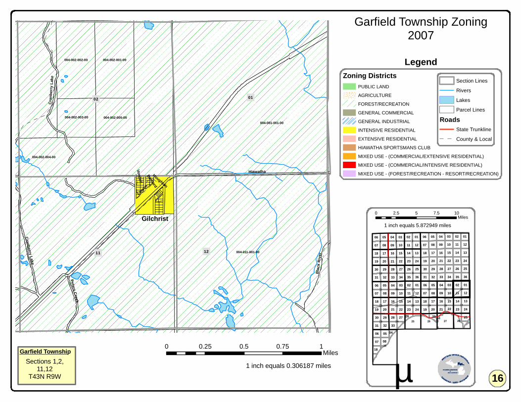
004-011-001-00
004-001-001-00
004-002-001-00
004-002-004-00
004-002-002-00
004-002-005-00004-002-003-00
004-135-001-00 004-136-003-00 004-136-004-00 004-136-001-30
11
02 01
12
35 36
Hiawatha
Cran
berry
Lake
Blac
k Rive
r
Peters Creek
Lowen
Vondell
Houghton
Bernard
Cranberry Lake
11 11
11
15
07
03
14
11
16
10
14
18
0207
01
13
23
16
06
15
06
17
36
05
22
33
30
08
12
22
13
03
09
09
24
10
15
02
3534
19
28
20
04
17
20
06
27
21
21
2313
17
21
040132
19
33
02
12
18
08
13
32
2729
16
31
07
09
16
29
05
06
31
19
17
30
20 22
10 08
18
1408
07 09
25
24
03
20
05
04
34
14
28
07
242326
29
21
05 01
31 32
2630
23
12
35
10
04
24
36
27
19
33
25
15
28
03
25
06 05
18
02
12
01
22
08
18
2926
04
!1
!29
!18 !17
!8
!6
!15
!3
!14!13
!20 !19
!10
!16
!2
!22
!11
!23
!12
!21
!5 !7
!9
!27!24
!4
!28!25 !26
Garfield Township Zoning2007
0 0.25 0.5 0.75 1Miles
1 inch equals 0.306187 miles µ
0 2.5 5 7.5 10Miles
Section Lines
Rivers
Lakes
Parcel Lines
RoadsState Trunkline
County & Local
Garfield TownshipSections 1,2,
11,12T43N R9W
Zoning DistrictsPUBLIC LAND
AGRICULTURE
FOREST/RECREATION
GENERAL COMMERCIAL
GENERAL INDUSTRIAL
INTENSIVE RESIDENTIAL
EXTENSIVE RESIDENTIAL
HIAWATHA SPORTSMANS CLUB
MIXED USE - (COMMERCIAL/EXTENSIVE RESIDENTIAL)
MIXED USE - (COMMERCIAL/INTENSIVE RESIDENTIAL)
MIXED USE - (FOREST/RECREATION - RESORT/RECREATION)
16
Legend
1 inch equals 5.872949 milesGilchrist
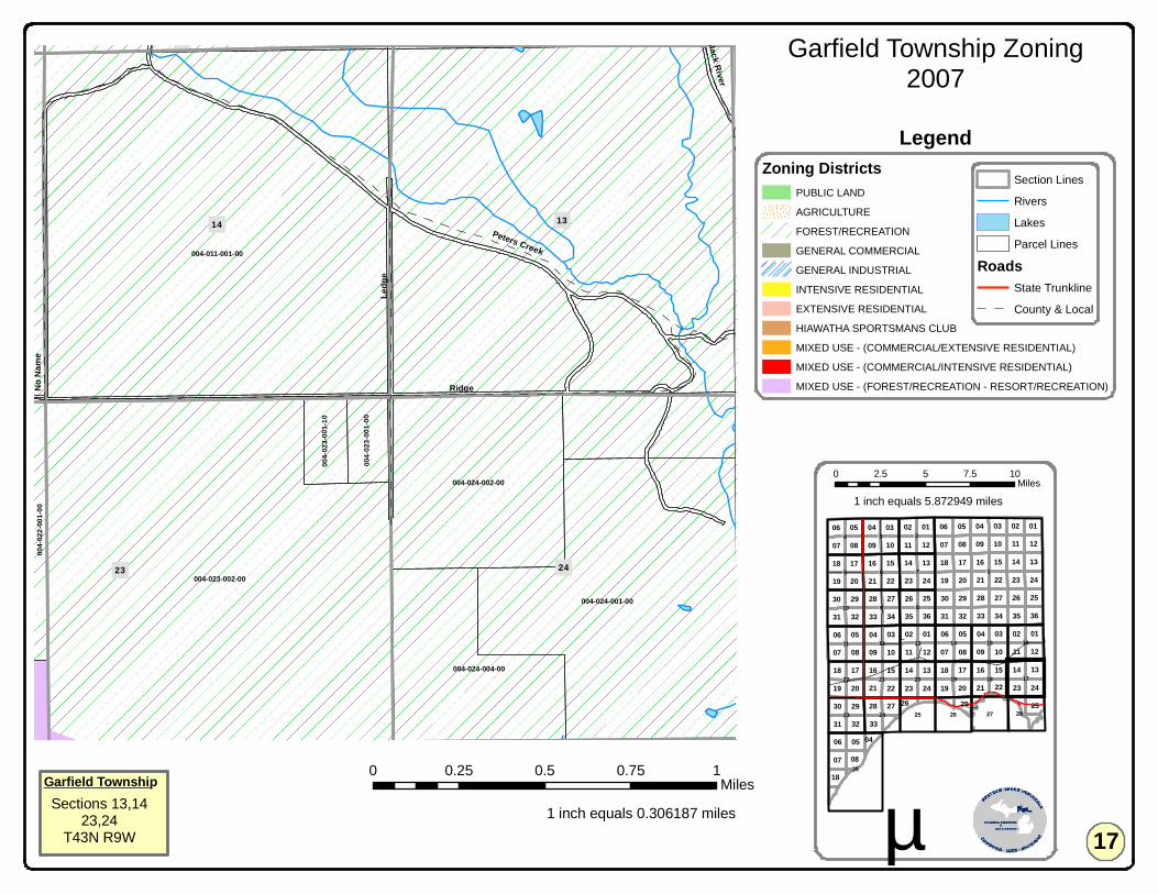
004-023-002-00
004-011-001-00
004-024-001-00
004-024-002-00
004-024-004-00
004-0
23-00
1-10
004-0
23-00
1-00
004-0
22-00
1-00
14 13
2423
11
RidgeLe
dge
Peters Creek
No N
ame
Black River
11 11
11
15
07
03
14
11
16
10
14
18
0207
01
13
23
16
06
15
06
17
36
05
22
33
30
08
12
22
13
03
09
09
24
10
15
02
3534
19
28
20
04
17
20
06
27
21
21
2313
17
21
040132
19
33
02
12
18
08
13
32
2729
16
31
07
09
16
29
05
06
31
19
17
30
20 22
10 08
18
1408
07 09
25
24
03
20
05
04
34
14
28
07
242326
29
21
05 01
31 32
2630
23
12
35
10
04
24
36
27
19
33
25
15
28
03
25
06 05
18
02
12
01
22
08
18
2926
04
!1
!29
!18 !17
!8
!6
!15
!3
!14!13
!20 !19
!10
!16
!2
!22
!11
!23
!12
!21
!5 !7
!9
!27!24
!4
!28!25 !26
Garfield Township Zoning2007
0 0.25 0.5 0.75 1Miles
1 inch equals 0.306187 miles µ
0 2.5 5 7.5 10Miles
Section Lines
Rivers
Lakes
Parcel Lines
RoadsState Trunkline
County & Local
Garfield TownshipSections 13,14
23,24T43N R9W
Zoning DistrictsPUBLIC LAND
AGRICULTURE
FOREST/RECREATION
GENERAL COMMERCIAL
GENERAL INDUSTRIAL
INTENSIVE RESIDENTIAL
EXTENSIVE RESIDENTIAL
HIAWATHA SPORTSMANS CLUB
MIXED USE - (COMMERCIAL/EXTENSIVE RESIDENTIAL)
MIXED USE - (COMMERCIAL/INTENSIVE RESIDENTIAL)
MIXED USE - (FOREST/RECREATION - RESORT/RECREATION)
17
Legend
1 inch equals 5.872949 miles

004-016-001-00
004-021-001-00
004-011-001-00
004-022-001-00
004-008-001-00
004-018-001-00
004-022-007-00
1516
2122
09 10
US 2
Beac
h
Hiawatha
No N
ame
Naubinway
Frazier
Beach
11 11
11
15
07
03
14
11
16
10
14
18
0207
01
13
23
16
06
15
06
17
36
05
22
33
30
08
12
22
13
03
09
09
24
10
15
02
3534
19
28
20
04
17
20
06
27
21
21
2313
17
21
040132
19
33
02
12
18
08
13
32
2729
16
31
07
09
16
29
05
06
31
19
17
30
20 22
10 08
18
1408
07 09
25
24
03
20
05
04
34
14
28
07
242326
29
21
05 01
31 32
2630
23
12
35
10
04
24
36
27
19
33
25
15
28
03
25
06 05
18
02
12
01
22
08
18
2926
04
!1
!29
!18 !17
!8
!6
!15
!3
!14!13
!20 !19
!10
!16
!2
!22
!11
!23
!12
!21
!5 !7
!9
!27!24
!4
!28!25 !26
Garfield Township Zoning2007
0 0.2 0.4 0.6 0.8Miles
1 inch equals 0.306187 miles µ
0 2.5 5 7.5 10Miles
RoadsState Trunkline
County & Local
Section Lines
Rivers
Lakes
Parcel Lines
Garfield TownshipSections 15,16,
21,22T43N R9W
Zoning DistrictsPUBLIC LAND
AGRICULTURE
FOREST/RECREATION
GENERAL COMMERCIAL
GENERAL INDUSTRIAL
INTENSIVE RESIDENTIAL
EXTENSIVE RESIDENTIAL
HIAWATHA SPORTSMANS CLUB
MIXED USE - (COMMERCIAL/EXTENSIVE RESIDENTIAL)
MIXED USE - (COMMERCIAL/INTENSIVE RESIDENTIAL)
MIXED USE - (FOREST/RECREATION - RESORT/RECREATION)
18
Legend
1 inch equals 5.872949 miles
300ft
Mixed-Use boundary extends 300ftfrom the Right of Way (ROW) where
no property lines are present
300ft
£¤US 2

004-016-001-00
004-020-003-00
004-019-001-00
004-008-001-00
004-020-001-00
Elbow LakeLower Millecoquins River
Threemile Creek
Lower Millecoquins River
17
20
18
19
07 08
Boucha
Naub
inway
Hiawatha
River
River
11 11
11
15
07
03
14
11
16
10
14
18
0207
01
13
23
16
06
15
06
17
36
05
22
33
30
08
12
22
13
03
09
09
24
10
15
02
3534
19
28
20
04
17
20
06
27
21
21
2313
17
21
040132
19
33
02
12
18
08
13
32
2729
16
31
07
09
16
29
05
06
31
19
17
30
20 22
10 08
18
1408
07 09
25
24
03
20
05
04
34
14
28
07
242326
29
21
05 01
31 32
2630
23
12
35
10
04
24
36
27
19
33
25
15
28
03
25
06 05
18
02
12
01
22
08
18
2926
04
!1
!29
!18 !17
!8
!6
!15
!3
!14!13
!20 !19
!10
!16
!2
!22
!11
!23
!12
!21
!5 !7
!9
!27!24
!4
!28!25 !26
Garfield Township Zoning2007
0 0.25 0.5 0.75 1Miles
1 inch equals 0.306187 miles µ
0 2.5 5 7.5 10Miles
Section Lines
Rivers
Lakes
Parcel Lines
RoadsState Trunkline
County & Local
Garfield TownshipSections 17,18,
19,20T43N R9W
Zoning DistrictsPUBLIC LAND
AGRICULTURE
FOREST/RECREATION
GENERAL COMMERCIAL
GENERAL INDUSTRIAL
INTENSIVE RESIDENTIAL
EXTENSIVE RESIDENTIAL
HIAWATHA SPORTSMANS CLUB
MIXED USE - (COMMERCIAL/EXTENSIVE RESIDENTIAL)
MIXED USE - (COMMERCIAL/INTENSIVE RESIDENTIAL)
MIXED USE - (FOREST/RECREATION - RESORT/RECREATION)
19
Legend
1 inch equals 5.872949 miles
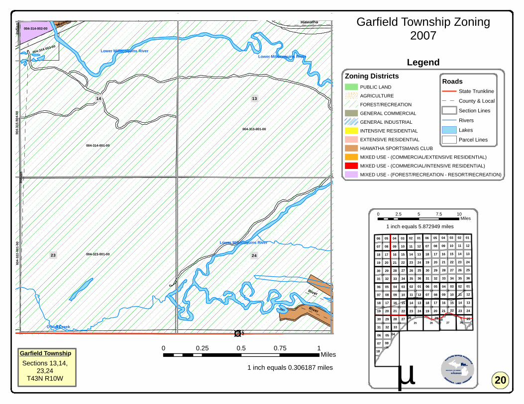
004-323-001-00
004-313-001-00
004-314-001-00
004-314-003-00
004-3
22-00
1-00
004-314-002-00
004-3
15-00
4-00
004-312-001-00004-311-009-00 004-311-005-00 004-312-002-00
Lower Millecoquins River
Lower Millecoquins RiverLower Millecoquins River
O'Niel Creek
14
23
13
24
11
US 2
Indian
Hiawatha
River
HiawathaInd
ian
River 11 11
11
15
07
03
14
11
16
10
14
18
0207
01
13
23
16
06
15
06
17
36
05
22
33
30
08
12
22
13
03
09
09
24
10
15
02
3534
19
28
20
04
17
20
06
27
21
21
2313
17
21
040132
19
33
02
12
18
08
13
32
2729
16
31
07
09
16
29
05
06
31
19
17
30
20 22
10 08
18
1408
07 09
25
24
03
20
05
04
34
14
28
07
242326
29
21
05 01
31 32
2630
23
12
35
10
04
24
36
27
19
33
25
15
28
03
25
06 05
18
02
12
01
22
08
18
2926
04
!1
!29
!18 !17
!8
!6
!15
!3
!14!13
!20 !19
!10
!16
!2
!22
!11
!23
!12
!21
!5 !7
!9
!27!24
!4
!28!25 !26
Garfield Township Zoning2007
0 0.25 0.5 0.75 1Miles
1 inch equals 0.306187 miles µ
0 2.5 5 7.5 10Miles
RoadsState Trunkline
County & Local
Section Lines
Rivers
Lakes
Parcel Lines
Garfield TownshipSections 13,14,
23,24T43N R10W
Zoning DistrictsPUBLIC LAND
AGRICULTURE
FOREST/RECREATION
GENERAL COMMERCIAL
GENERAL INDUSTRIAL
INTENSIVE RESIDENTIAL
EXTENSIVE RESIDENTIAL
HIAWATHA SPORTSMANS CLUB
MIXED USE - (COMMERCIAL/EXTENSIVE RESIDENTIAL)
MIXED USE - (COMMERCIAL/INTENSIVE RESIDENTIAL)
MIXED USE - (FOREST/RECREATION - RESORT/RECREATION)
20
Legend
1 inch equals 5.872949 miles
£¤US 2

004-322-001-00
004-315-004-00
004-890-001-00
004-316-002-00004-315-005-00
004-316-081-00
004-315-002-00
004-321-005-00
004-321-006-00
004-321-001-00
004-316-004-00
004-316-017-00
004-316-084-00
004-315-007-00004-316-003-00
004-316-001-00
004-321-007-00
004-321-004-00
004-316-018-00 004-315-010-00
004-321-009-00004-321-008-00
004-315-006-10
004-316-079-00
004-315-001-00
004-321-002-00
004-316-072-00
004-316-016-00
004-3
23-00
1-00
004-316-080-00
004-309-013-00 004-310-009-00004-309-011-00
004-316-008-00
004-316-005-00
004-3
14-00
1-00
004-316-011-00
004-310-012-00 004-310-010-00
004-321-002-10
004-315-006-00
O Neil Creek
O Neil Creek
O Neil Creek
21
16
22
15
1009
US 2
Hiawatha
Indian
Krau
se
Elm
Park
Boucha
Park
moor
Cedar
Railroad
Henry H
Indian
11 11
11
15
07
03
14
11
16
10
14
18
0207
01
13
23
16
06
15
06
17
36
05
22
33
30
08
12
22
13
03
09
09
24
10
15
02
3534
19
28
20
04
17
20
06
27
21
21
2313
17
21
040132
19
33
02
12
18
08
13
32
2729
16
31
07
09
16
29
05
06
31
19
17
30
20 22
10 08
18
1408
07 09
25
24
03
20
05
04
34
14
28
07
242326
29
21
05 01
31 32
2630
23
12
35
10
04
24
36
27
19
33
25
15
28
03
25
06 05
18
02
12
01
22
08
18
2926
04
!1
!29
!18 !17
!8
!6
!15
!3
!14!13
!20 !19
!10
!16
!2
!22
!11
!23
!12
!21
!5 !7
!9
!27!24
!4
!28!25 !26
Garfield Township Zoning2007
0 0.25 0.5 0.75 1Miles
1 inch equals 0.306187 miles µ
0 2.5 5 7.5 10Miles
Section Lines
Rivers
Lakes
Parcel Lines
RoadsState Trunkline
County & Local
Garfield TownshipSections 15,16,
21,22T43N R10W
Zoning DistrictsPUBLIC LAND
AGRICULTURE
FOREST/RECREATION
GENERAL COMMERCIAL
GENERAL INDUSTRIAL
INTENSIVE RESIDENTIAL
EXTENSIVE RESIDENTIAL
HIAWATHA SPORTSMANS CLUB
MIXED USE - (COMMERCIAL/EXTENSIVE RESIDENTIAL)
MIXED USE - (COMMERCIAL/INTENSIVE RESIDENTIAL)
MIXED USE - (FOREST/RECREATION - RESORT/RECREATION)
21
Legend
1 inch equals 5.872949 miles
Engadine Village - East of M117Page 21a
Engadine
!M 117
£¤US 2
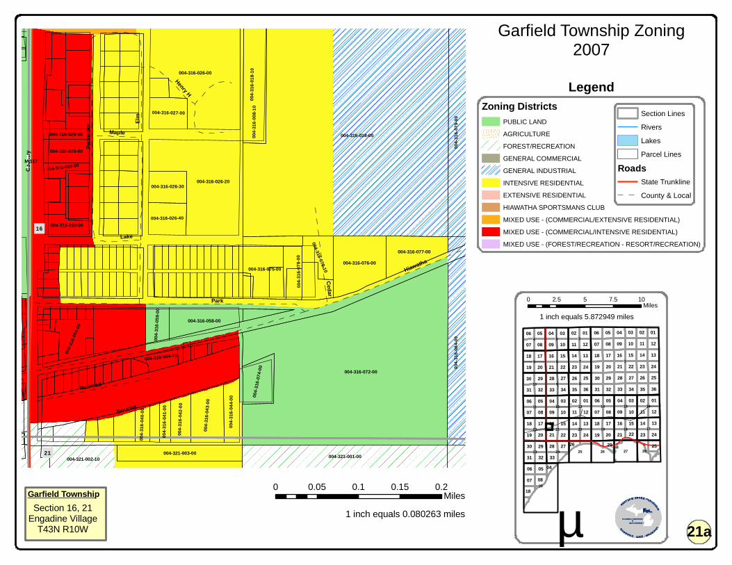
004-316-018-00
004-316-072-00
004-316-026-00
004-316-026-20
004-321-001-0000
4-316
-079-0
000
4-316
-084-0
0
004-316-076-00
004-3
16-01
8-10
004-3
16-00
8-10
004-321-002-10
004-316-075-00
004-321-003-00
004-316-017-00
004-316-058-00
004-316-077-00
004-3
16-04
3-00
004-3
16-07
8-00
004-316-016-00
004-3
16-07
4-00
004-3
16-06
4-00
004-316-026-40
004-316-026-30
004-316-027-00
004-316-020-00
004-316-078-10
004-3
16-04
4-00
004-3
16-04
2-00
004-3
16-05
9-00
004-316-030-00
004-316-004-10
004-316-028-00
004-3
16-04
0-00
004-316-029-00
004-3
16-04
1-00
16
21
Elm
Park
Coun
try
Hiawatha
Boucha
Park
moor
Cedar
Railroad
Lake
Maple
Henry H
11 11
11
15
07
03
14
11
16
10
14
18
0207
01
13
23
16
06
15
06
17
36
05
22
33
30
08
12
22
13
03
09
09
24
10
15
02
3534
19
28
20
04
17
20
06
27
21
21
2313
17
21
040132
19
33
02
12
18
08
13
32
2729
16
31
07
09
16
29
05
06
31
19
17
30
20 22
10 08
18
1408
07 09
25
24
03
20
05
04
34
14
28
07
242326
29
21
05 01
31 32
2630
23
12
35
10
04
24
36
27
19
33
25
15
28
03
25
06 05
18
02
12
01
22
08
18
2926
04
!1
!29
!18 !17
!8
!6
!15
!3
!14!13
!20 !19
!10
!16
!2
!22
!11
!23
!12
!21
!5 !7
!9
!27!24
!4
!28!25 !26
Garfield Township Zoning2007
0 0.05 0.1 0.15 0.2Miles
1 inch equals 0.080263 miles µ
0 2.5 5 7.5 10Miles
Section Lines
Rivers
Lakes
Parcel Lines
RoadsState Trunkline
County & Local
Garfield TownshipSection 16, 21
Engadine VillageT43N R10W
Zoning DistrictsPUBLIC LAND
AGRICULTURE
FOREST/RECREATION
GENERAL COMMERCIAL
GENERAL INDUSTRIAL
INTENSIVE RESIDENTIAL
EXTENSIVE RESIDENTIAL
HIAWATHA SPORTSMANS CLUB
MIXED USE - (COMMERCIAL/EXTENSIVE RESIDENTIAL)
MIXED USE - (COMMERCIAL/INTENSIVE RESIDENTIAL)
MIXED USE - (FOREST/RECREATION - RESORT/RECREATION)
21a
Legend
1 inch equals 5.872949 miles
!M 117
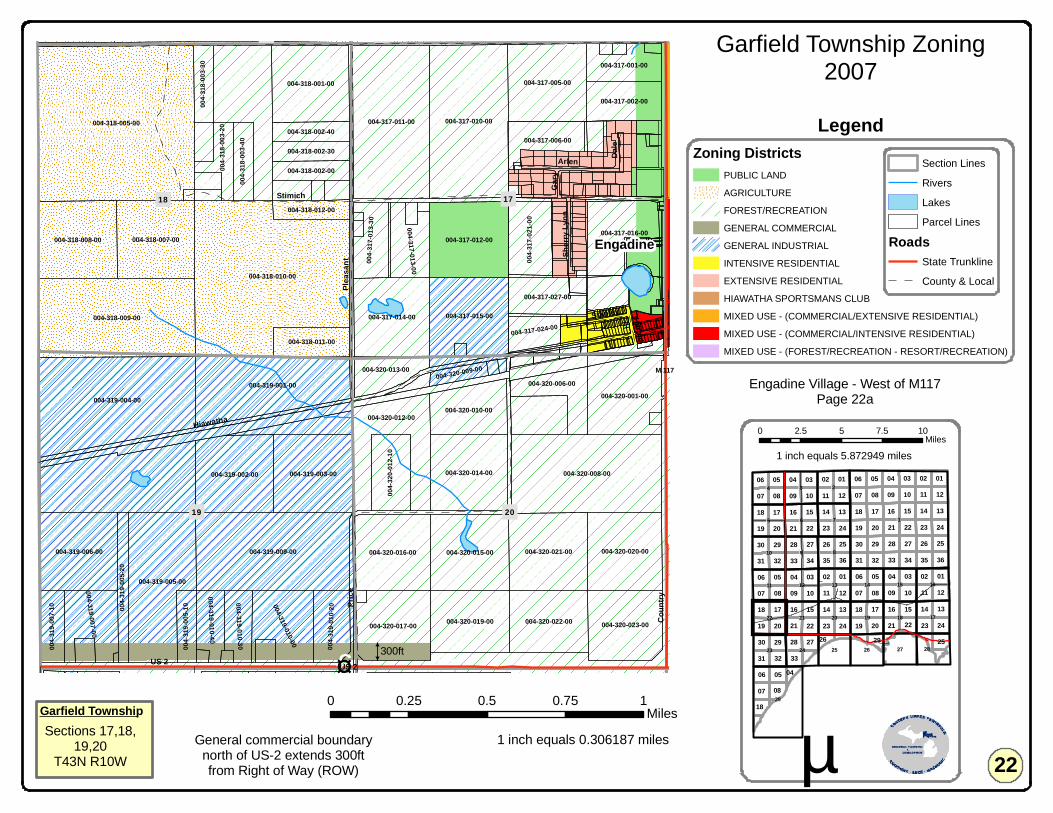
004-318-005-00
004-318-010-00
004-319-004-00
004-318-009-00
004-317-010-00
004-319-009-00
004-320-008-00
004-317-011-00
004-319-005-00
004-319-001-00
004-319-003-00
004-320-021-00
004-318-007-00004-318-008-00
004-317-005-00
004-319-006-00
004-319-002-00
004-317-015-00
004-317-012-00
004-320-015-00
004-317-014-00
004-318-001-00
004-320-014-00
004-320-020-00004-320-016-00
004-320-012-00
004-320-001-00
004-320-017-00 004-320-023-00004-320-022-00004-320-019-00
004-317-016-00
004-319-010-00
004-320-010-00
004-3
17-02
1-00
004-319-007-00
004-317-006-00
004-317-002-00
004-3
20-01
2-10
004-317-027-00
004-317-013-00
004-3
19-01
0-20
004-320-006-00
004-317-001-00
004-3
17-01
3-30
004-318-011-00
004-320-013-00
004-319-010-30
004-308-015-00
004-319-010-40
004-317-024-00
004-3
19-00
7-10
004-3
18-00
3-20
004-3
18-00
3-40
004-3
19-00
5-20
004-318-002-00
004-318-002-30
004-318-002-40
004-318-012-0000
4-318
-003-3
0
004-3
19-00
5-10
004-307-007-00004-307-006-00 004-307-013-00 004-308-010-00
004-320-009-00
004-307-011-00
19
17
20
18
07 08
US 2
Linck
Coun
try
Hiawatha
Stimich
Price
Pleas
ant
Arlen Dale
Stanley
Sherr
y Lyn
nGa
ry
Harold
11 11
11
15
07
03
14
11
16
10
14
18
0207
01
13
23
16
06
15
06
17
36
05
22
33
30
08
12
22
13
03
09
09
24
10
15
02
3534
19
28
20
04
17
20
06
27
21
21
2313
17
21
040132
19
33
02
12
18
08
13
32
2729
16
31
07
09
16
29
05
06
31
19
17
30
20 22
10 08
18
1408
07 09
25
24
03
20
05
04
34
14
28
07
242326
29
21
05 01
31 32
2630
23
12
35
10
04
24
36
27
19
33
25
15
28
03
25
06 05
18
02
12
01
22
08
18
2926
04
!1
!29
!18 !17
!8
!6
!15
!3
!14!13
!20 !19
!10
!16
!2
!22
!11
!23
!12
!21
!5 !7
!9
!27!24
!4
!28!25 !26
Garfield Township Zoning2007
0 0.25 0.5 0.75 1Miles
1 inch equals 0.306187 miles µ
0 2.5 5 7.5 10Miles
Section Lines
Rivers
Lakes
Parcel Lines
RoadsState Trunkline
County & Local
Garfield TownshipSections 17,18,
19,20T43N R10W
Zoning DistrictsPUBLIC LAND
AGRICULTURE
FOREST/RECREATION
GENERAL COMMERCIAL
GENERAL INDUSTRIAL
INTENSIVE RESIDENTIAL
EXTENSIVE RESIDENTIAL
HIAWATHA SPORTSMANS CLUB
MIXED USE - (COMMERCIAL/EXTENSIVE RESIDENTIAL)
MIXED USE - (COMMERCIAL/INTENSIVE RESIDENTIAL)
MIXED USE - (FOREST/RECREATION - RESORT/RECREATION)
22
Legend
1 inch equals 5.872949 miles
Engadine Village - West of M117Page 22a
Engadine
300ft
General commercial boundarynorth of US-2 extends 300ftfrom Right of Way (ROW)
!M 117
£¤US 2
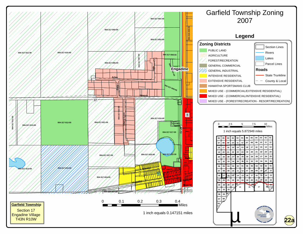
004-317-010-00004-317-011-00
004-317-015-00
004-317-012-00
004-317-005-00
004-317-016-00
004-317-014-00
004-317-021-00
004-317-006-00
004-317-002-00
004-317-027-00
004-317-013-00
004-317-001-00
004-317-024-00
004-317-032-00 004-317-032-30
004-317-017-00
004-3
17-01
3-30
004-317-009-00
004-317-007-00
004-3
17-02
2-00
004-3
17-00
7-60 004-317-008-00
004-3
16-00
8-00
004-317-032-20
004-320-007-00
17
16Co
untry
Stimich
Hiawatha
Arlen
Dale
Stanley
Sherr
y Lyn
n
Gary
Harold
Park
BouchaRailroad
11 11
11
15
07
03
14
11
16
10
14
18
0207
01
13
23
16
06
15
06
17
36
05
22
33
30
08
12
22
13
03
09
09
24
10
15
02
3534
19
28
20
04
17
20
06
27
21
21
2313
17
21
040132
19
33
02
12
18
08
13
32
2729
16
31
07
09
16
29
05
06
31
19
17
30
20 22
10 08
18
1408
07 09
25
24
03
20
05
04
34
14
28
07
242326
29
21
05 01
31 32
2630
23
12
35
10
04
24
36
27
19
33
25
15
28
03
25
06 05
18
02
12
01
22
08
18
2926
04
!1
!29
!18 !17
!8
!6
!15
!3
!14!13
!20 !19
!10
!16
!2
!22
!11
!23
!12
!21
!5 !7
!9
!27!24
!4
!28!25 !26
Garfield Township Zoning2007
0 0.1 0.2 0.3 0.4Miles
1 inch equals 0.147151 miles µ
0 2.5 5 7.5 10Miles
Section Lines
Rivers
Lakes
Parcel Lines
RoadsState Trunkline
County & Local
Garfield TownshipSection 17
Engadine VillageT43N R10W
Zoning DistrictsPUBLIC LAND
AGRICULTURE
FOREST/RECREATION
GENERAL COMMERCIAL
GENERAL INDUSTRIAL
INTENSIVE RESIDENTIAL
EXTENSIVE RESIDENTIAL
HIAWATHA SPORTSMANS CLUB
MIXED USE - (COMMERCIAL/EXTENSIVE RESIDENTIAL)
MIXED USE - (COMMERCIAL/INTENSIVE RESIDENTIAL)
MIXED USE - (FOREST/RECREATION - RESORT/RECREATION)
22a
Legend
1 inch equals 5.872949 miles
Engadine
!M 117
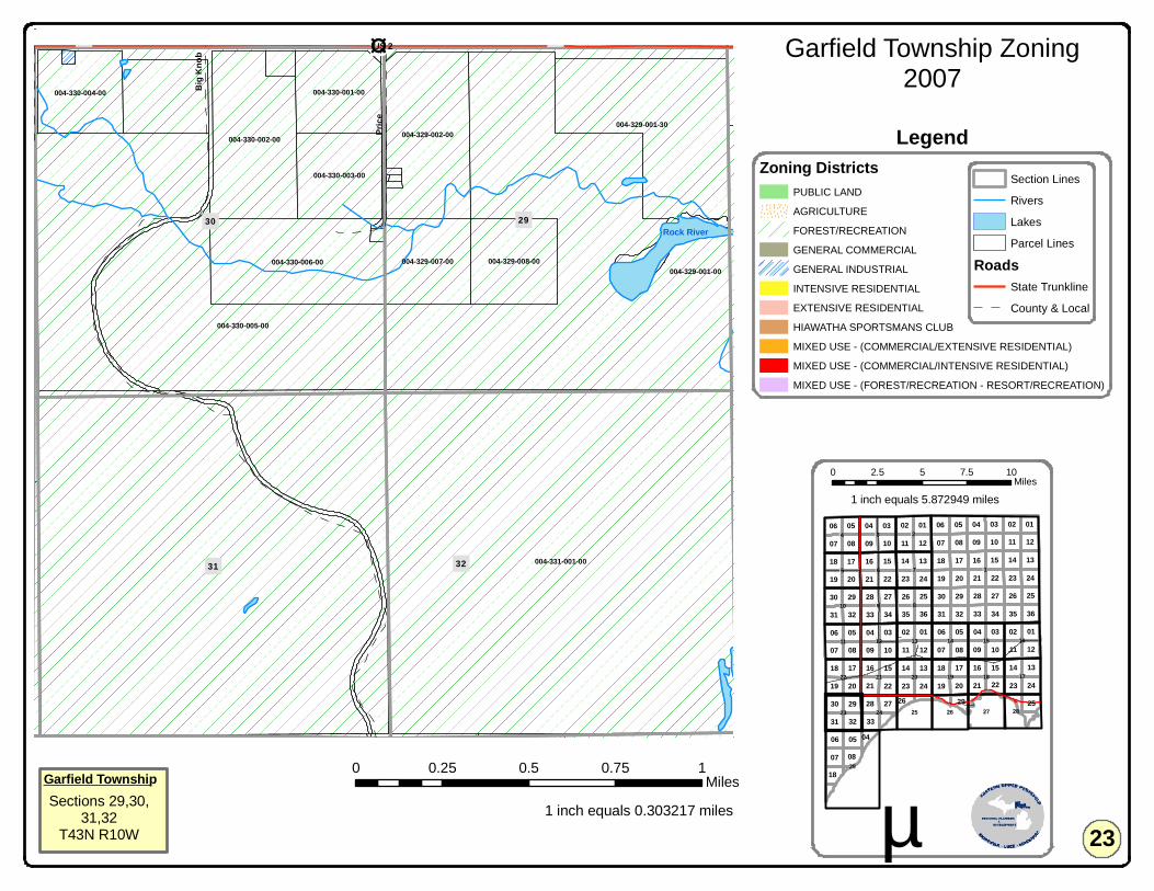
004-331-001-00
004-329-001-00
004-330-005-00
004-329-001-30
004-330-006-00
004-329-002-00004-330-002-00
004-329-008-00004-329-007-00
004-330-003-00
004-330-001-00004-330-004-00
004-319-005-00
Rock River30 29
31 32
19 20US 2
Big K
nob
Price
11 11
11
15
07
03
14
11
16
10
14
18
0207
01
13
23
16
06
15
06
17
36
05
22
33
30
08
12
22
13
03
09
09
24
10
15
02
3534
19
28
20
04
17
20
06
27
21
21
2313
17
21
040132
19
33
02
12
18
08
13
32
2729
16
31
07
09
16
29
05
06
31
19
17
30
20 22
10 08
18
1408
07 09
25
24
03
20
05
04
34
14
28
07
242326
29
21
05 01
31 32
2630
23
12
35
10
04
24
36
27
19
33
25
15
28
03
25
06 05
18
02
12
01
22
08
18
2926
04
!1
!29
!18 !17
!8
!6
!15
!3
!14!13
!20 !19
!10
!16
!2
!22
!11
!23
!12
!21
!5 !7
!9
!27!24
!4
!28!25 !26
Garfield Township Zoning2007
0 0.25 0.5 0.75 1Miles
1 inch equals 0.303217 miles µ
0 2.5 5 7.5 10Miles
Section Lines
Rivers
Lakes
Parcel Lines
RoadsState Trunkline
County & Local
Garfield TownshipSections 29,30,
31,32T43N R10W
Zoning DistrictsPUBLIC LAND
AGRICULTURE
FOREST/RECREATION
GENERAL COMMERCIAL
GENERAL INDUSTRIAL
INTENSIVE RESIDENTIAL
EXTENSIVE RESIDENTIAL
HIAWATHA SPORTSMANS CLUB
MIXED USE - (COMMERCIAL/EXTENSIVE RESIDENTIAL)
MIXED USE - (COMMERCIAL/INTENSIVE RESIDENTIAL)
MIXED USE - (FOREST/RECREATION - RESORT/RECREATION)
23
Legend
1 inch equals 5.872949 miles
£¤US 2

004-331-001-00
004-328-002-00004-327-002-00
004-334-012-00
004-327-004-00
004-328-001-00004-328-003-00 004-327-003-00
004-334-006-40
004-334-010-00
004-322-001-00
004-32
7-002-
20
004-33
3-001-
00
004-334-009-20
004-334-009-00
004-334-006-30
004-334-010-10
004-321-008-00 004-321-009-00
Miller Lake
Rock River 27
33
28
34
2221 US 2
Carn
egie
Beach
11 11
11
15
07
03
14
11
16
10
14
18
0207
01
13
23
16
06
15
06
17
36
05
22
33
30
08
12
22
13
03
09
09
24
10
15
02
3534
19
28
20
04
17
20
06
27
21
21
2313
17
21
040132
19
33
02
12
18
08
13
32
2729
16
31
07
09
16
29
05
06
31
19
17
30
20 22
10 08
18
1408
07 09
25
24
03
20
05
04
34
14
28
07
242326
29
21
05 01
31 32
2630
23
12
35
10
04
24
36
27
19
33
25
15
28
03
25
06 05
18
02
12
01
22
08
18
2926
04
!1
!29
!18 !17
!8
!6
!15
!3
!14!13
!20 !19
!10
!16
!2
!22
!11
!23
!12
!21
!5 !7
!9
!27!24
!4
!28!25 !26
Garfield Township Zoning2007
0 0.25 0.5 0.75 1Miles
1 inch equals 0.303217 miles µ
0 2.5 5 7.5 10Miles
Section Lines
Rivers
Lakes
Parcel Lines
RoadsState Trunkline
County & Local
Garfield TownshipSections 27,28,
33,34T43N R10W
Zoning DistrictsPUBLIC LAND
AGRICULTURE
FOREST/RECREATION
GENERAL COMMERCIAL
GENERAL INDUSTRIAL
INTENSIVE RESIDENTIAL
EXTENSIVE RESIDENTIAL
HIAWATHA SPORTSMANS CLUB
MIXED USE - (COMMERCIAL/EXTENSIVE RESIDENTIAL)
MIXED USE - (COMMERCIAL/INTENSIVE RESIDENTIAL)
MIXED USE - (FOREST/RECREATION - RESORT/RECREATION)
24
Legend
1 inch equals 5.872949 miles
£¤US 2
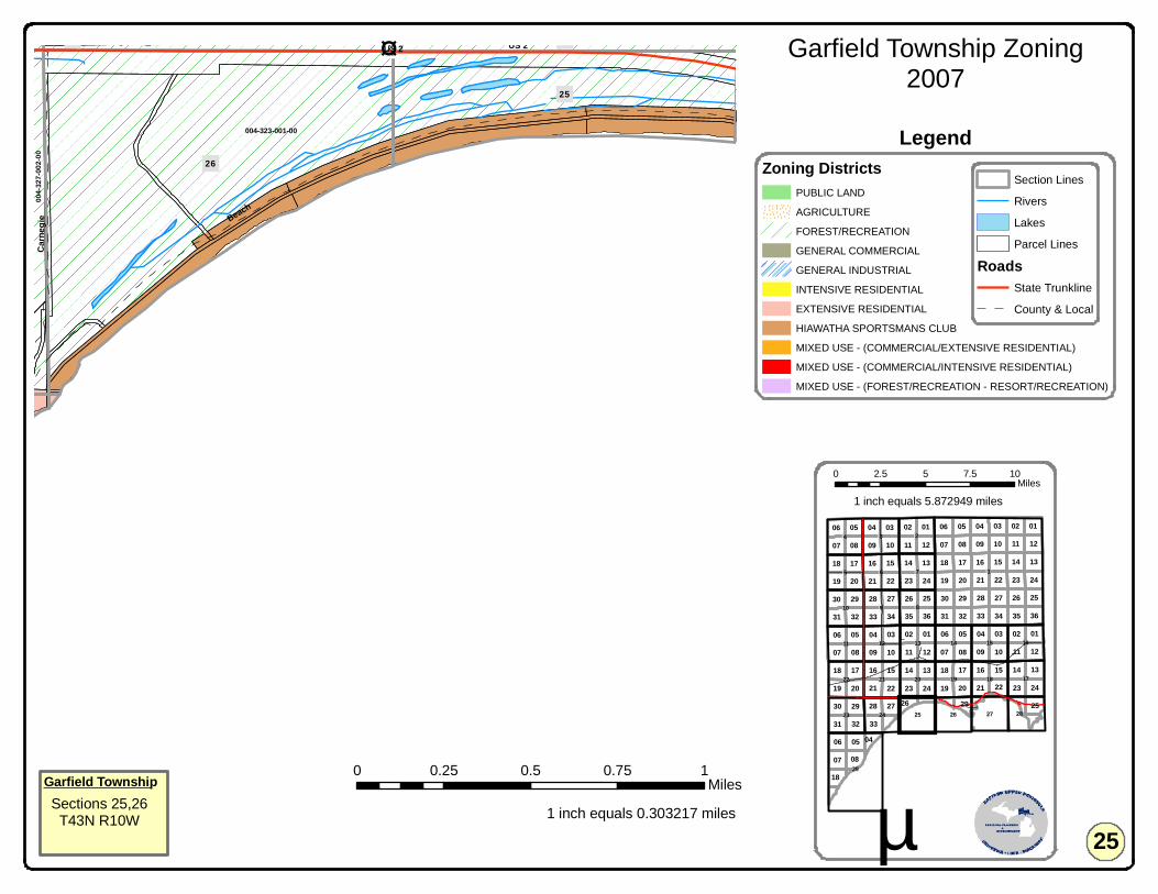
004-323-001-00
004-3
27-00
2-00
O'Niel Creek
26
25
23 24US 2
Beach
Carn
egie
11 11
11
15
07
03
14
11
16
10
14
18
0207
01
13
23
16
06
15
06
17
36
05
22
33
30
08
12
22
13
03
09
09
24
10
15
02
3534
19
28
20
04
17
20
06
27
21
21
2313
17
21
040132
19
33
02
12
18
08
13
32
2729
16
31
07
09
16
29
05
06
31
19
17
30
20 22
10 08
18
1408
07 09
25
24
03
20
05
04
34
14
28
07
242326
29
21
05 01
31 32
2630
23
12
35
10
04
24
36
27
19
33
25
15
28
03
25
06 05
18
02
12
01
22
08
18
2926
04
!1
!29
!18 !17
!8
!6
!15
!3
!14!13
!20 !19
!10
!16
!2
!22
!11
!23
!12
!21
!5 !7
!9
!27!24
!4
!28!25 !26
Garfield Township Zoning2007
0 0.25 0.5 0.75 1Miles
1 inch equals 0.303217 miles µ
0 2.5 5 7.5 10Miles
Section Lines
Rivers
Lakes
Parcel Lines
RoadsState Trunkline
County & Local
Garfield TownshipSections 25,26T43N R10W
Zoning DistrictsPUBLIC LAND
AGRICULTURE
FOREST/RECREATION
GENERAL COMMERCIAL
GENERAL INDUSTRIAL
INTENSIVE RESIDENTIAL
EXTENSIVE RESIDENTIAL
HIAWATHA SPORTSMANS CLUB
MIXED USE - (COMMERCIAL/EXTENSIVE RESIDENTIAL)
MIXED USE - (COMMERCIAL/INTENSIVE RESIDENTIAL)
MIXED USE - (FOREST/RECREATION - RESORT/RECREATION)
25
Legend
1 inch equals 5.872949 miles
£¤US 2
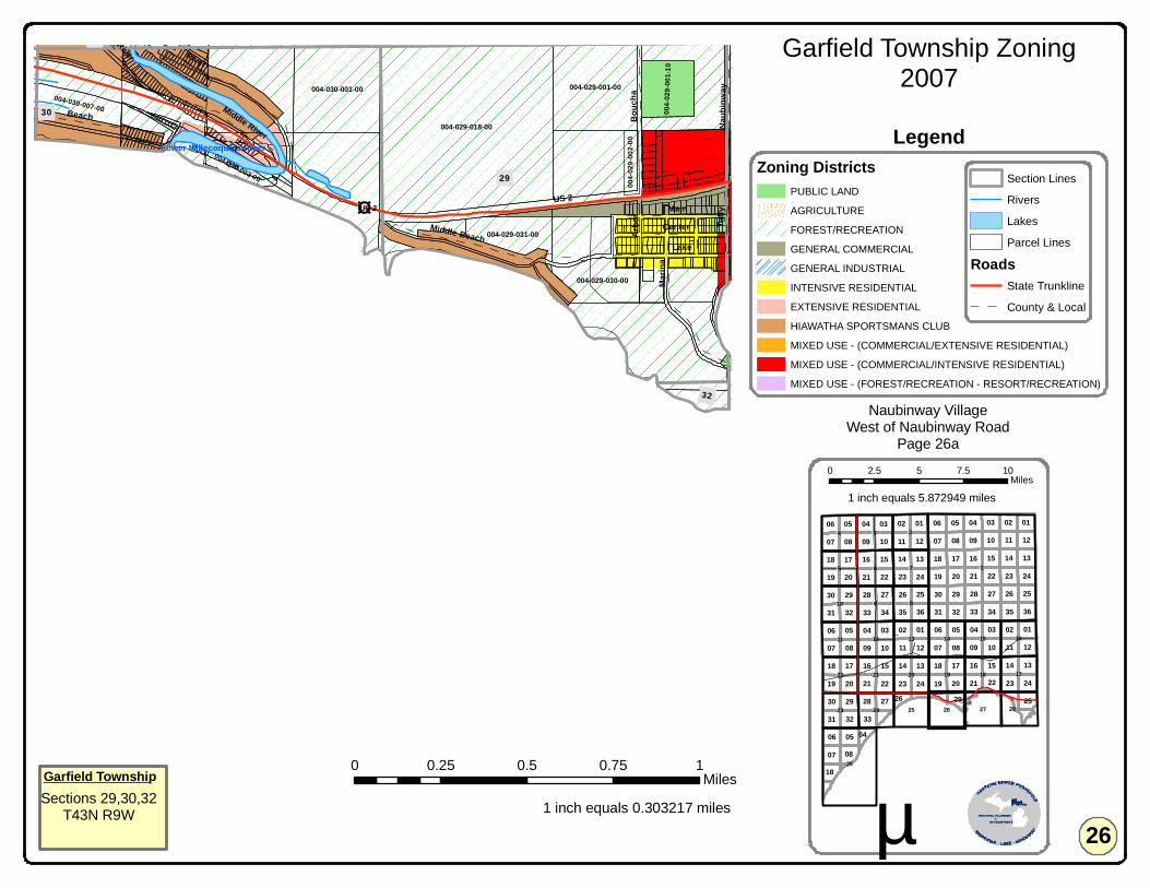
004-029-018-00
004-030-001-00 004-029-001-00
004-020-003-00
004-029-030-00
004-0
29-00
1-10
004-016-001-00
004-029-031-00
004-030-007-00
004-030-003-00
004-019-001-00
004-0
29-00
2-00
Lower Millecoquins River
29
30
19
32
US 2
River
Beach
Main
Bouc
ha
Marin
a
LakeCenter Tu
ffyNa
ubinw
ay
Middle Beach Arbo
r
Middle River
River
11 11
11
15
07
03
14
11
16
10
14
18
0207
01
13
23
16
06
15
06
17
36
05
22
33
30
08
12
22
13
03
09
09
24
10
15
02
3534
19
28
20
04
17
20
06
27
21
21
2313
17
21
040132
19
33
02
12
18
08
13
32
2729
16
31
07
09
16
29
05
06
31
19
17
30
20 22
10 08
18
1408
07 09
25
24
03
20
05
04
34
14
28
07
242326
29
21
05 01
31 32
2630
23
12
35
10
04
24
36
27
19
33
25
15
28
03
25
06 05
18
02
12
01
22
08
18
2926
04
!1
!29
!18 !17
!8
!6
!15
!3
!14!13
!20 !19
!10
!16
!2
!22
!11
!23
!12
!21
!5 !7
!9
!27!24
!4
!28!25 !26
Garfield Township Zoning2007
0 0.25 0.5 0.75 1Miles
1 inch equals 0.303217 miles µ
0 2.5 5 7.5 10Miles
Section Lines
Rivers
Lakes
Parcel Lines
RoadsState Trunkline
County & Local
Garfield TownshipSections 29,30,32
T43N R9W
Zoning DistrictsPUBLIC LAND
AGRICULTURE
FOREST/RECREATION
GENERAL COMMERCIAL
GENERAL INDUSTRIAL
INTENSIVE RESIDENTIAL
EXTENSIVE RESIDENTIAL
HIAWATHA SPORTSMANS CLUB
MIXED USE - (COMMERCIAL/EXTENSIVE RESIDENTIAL)
MIXED USE - (COMMERCIAL/INTENSIVE RESIDENTIAL)
MIXED USE - (FOREST/RECREATION - RESORT/RECREATION)
26
Legend
1 inch equals 5.872949 miles
Naubinway VillageWest of Naubinway Road
Page 26a
£¤US 2

004-029-018-00
004-029-030-00
004-029-031-00
004-029-017-00
004-0
29-00
2-00
004-0
29-02
2-00
004-032-001-00
004-029-001-00
004-02
9-004-
00
004-029-004-10
004-0
29-01
6-10
29
32
US 2Main
Marin
a
Lake
Center
Tuffy
Arbo
rBo
ucha
Park
Middle Beach
Naub
inway
Church
11 11
11
15
07
03
14
11
16
10
14
18
0207
01
13
23
16
06
15
06
17
36
05
22
33
30
08
12
22
13
03
09
09
24
10
15
02
3534
19
28
20
04
17
20
06
27
21
21
2313
17
21
040132
19
33
02
12
18
08
13
32
2729
16
31
07
09
16
29
05
06
31
19
17
30
20 22
10 08
18
1408
07 09
25
24
03
20
05
04
34
14
28
07
242326
29
21
05 01
31 32
2630
23
12
35
10
04
24
36
27
19
33
25
15
28
03
25
06 05
18
02
12
01
22
08
18
2926
04
!1
!29
!18 !17
!8
!6
!15
!3
!14!13
!20 !19
!10
!16
!2
!22
!11
!23
!12
!21
!5 !7
!9
!27!24
!4
!28!25 !26
Garfield Township Zoning2007
0 0.1 0.2 0.3 0.4Miles
1 inch equals 0.121863 miles µ
0 2.5 5 7.5 10Miles
RoadsState Trunkline
County & Local
Section Lines
Rivers
Lakes
Parcel Lines
Garfield TownshipSections 29,30,32Naubinway Village
T43N R9W
Zoning DistrictsPUBLIC LAND
AGRICULTURE
FOREST/RECREATION
GENERAL COMMERCIAL
GENERAL INDUSTRIAL
INTENSIVE RESIDENTIAL
EXTENSIVE RESIDENTIAL
HIAWATHA SPORTSMANS CLUB
MIXED USE - (COMMERCIAL/EXTENSIVE RESIDENTIAL)
MIXED USE - (COMMERCIAL/INTENSIVE RESIDENTIAL)
MIXED USE - (FOREST/RECREATION - RESORT/RECREATION)
26a
Legend
1 inch equals 5.872949 miles
£¤US 2
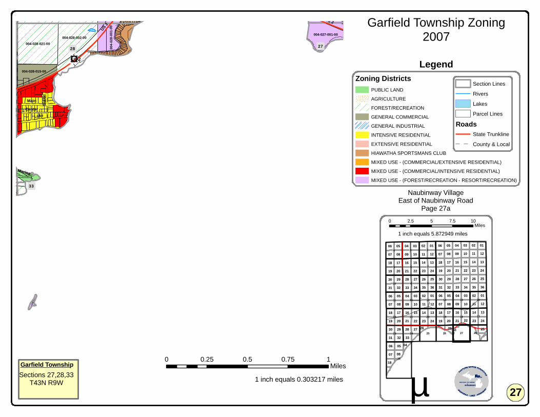
004-021-001-00
28 27
33
004-028-021-00004-028-002-00
004-021-001-00
004-027-001-00
004-028-015-00
004-0
28-00
1-00
US 2
Lake
Main Blak
e
Center
Marina
US 2
11 11
11
15
07
03
14
11
16
10
14
18
0207
01
13
23
16
06
15
06
17
36
05
22
33
30
08
12
22
13
03
09
09
24
10
15
02
3534
19
28
20
04
17
20
06
27
21
21
2313
17
21
040132
19
33
02
12
18
08
13
32
2729
16
31
07
09
16
29
05
06
31
19
17
30
20 22
10 08
18
1408
07 09
25
24
03
20
05
04
34
14
28
07
242326
29
21
05 01
31 32
2630
23
12
35
10
04
24
36
27
19
33
25
15
28
03
25
06 05
18
02
12
01
22
08
18
2926
04
!1
!29
!18 !17
!8
!6
!15
!3
!14!13
!20 !19
!10
!16
!2
!22
!11
!23
!12
!21
!5 !7
!9
!27!24
!4
!28!25 !26
Garfield Township Zoning2007
0 0.25 0.5 0.75 1Miles
1 inch equals 0.303217 miles µ
0 2.5 5 7.5 10Miles
Section Lines
Rivers
Lakes
Parcel Lines
RoadsState Trunkline
County & Local
Garfield TownshipSections 27,28,33
T43N R9W
Zoning DistrictsPUBLIC LAND
AGRICULTURE
FOREST/RECREATION
GENERAL COMMERCIAL
GENERAL INDUSTRIAL
INTENSIVE RESIDENTIAL
EXTENSIVE RESIDENTIAL
HIAWATHA SPORTSMANS CLUB
MIXED USE - (COMMERCIAL/EXTENSIVE RESIDENTIAL)
MIXED USE - (COMMERCIAL/INTENSIVE RESIDENTIAL)
MIXED USE - (FOREST/RECREATION - RESORT/RECREATION)
27
Legend
1 inch equals 5.872949 miles
Naubinway VillageEast of Naubinway Road
Page 27a
£¤US 2

004-028-021-00
004-028-002-00
004-028-015-00
004-028-001-00004-0
28-00
2-10
004-02
8-014-
00
004-540-002-00
28
28
US 2
Lake
Main
Blake
Naub
inway
Center
Pear
l
Marina
Unknown 97 4 1
11 11
11
15
07
03
14
11
16
10
14
18
0207
01
13
23
16
06
15
06
17
36
05
22
33
30
08
12
22
13
03
09
09
24
10
15
02
3534
19
28
20
04
17
20
06
27
21
21
2313
17
21
040132
19
33
02
12
18
08
13
32
2729
16
31
07
09
16
29
05
06
31
19
17
30
20 22
10 08
18
1408
07 09
25
24
03
20
05
04
34
14
28
07
242326
29
21
05 01
31 32
2630
23
12
35
10
04
24
36
27
19
33
25
15
28
03
25
06 05
18
02
12
01
22
08
18
2926
04
!1
!29
!18 !17
!8
!6
!15
!3
!14!13
!20 !19
!10
!16
!2
!22
!11
!23
!12
!21
!5 !7
!9
!27!24
!4
!28!25 !26
Garfield Township Zoning2007
0 0.1 0.2 0.3 0.4Miles
1 inch equals 0.135903 miles µ
0 2.5 5 7.5 10Miles
Section Lines
Rivers
Lakes
Parcel Lines
RoadsState Trunkline
County & Local
Garfield TownshipSection 28
Naubinway VillageT43N R9W
Zoning DistrictsPUBLIC LAND
AGRICULTURE
FOREST/RECREATION
GENERAL COMMERCIAL
GENERAL INDUSTRIAL
INTENSIVE RESIDENTIAL
EXTENSIVE RESIDENTIAL
HIAWATHA SPORTSMANS CLUB
MIXED USE - (COMMERCIAL/EXTENSIVE RESIDENTIAL)
MIXED USE - (COMMERCIAL/INTENSIVE RESIDENTIAL)
MIXED USE - (FOREST/RECREATION - RESORT/RECREATION)
27a
Legend
1 inch equals 5.872949 miles
£¤US 2
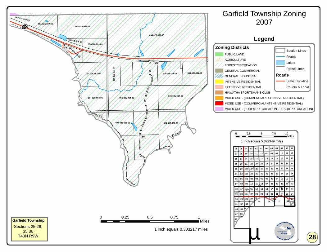
004-025-001-00
004-026-001-00
004-025-004-00 004-025-007-00
004-036-002-00
004-026-002-00
004-023-002-00
004-026-004-00
004-025-002-00004-025-006-00
004-036-001-00
004-026-007-00
004-0
25-00
3-00
004-026-003-00
004-024-004-00 004-024-001-00
004-026-005-00
004-026-008-00
004-026-006-00
25
26
36
23 24
35
US 2
11 11
11
15
07
03
14
11
16
10
14
18
0207
01
13
23
16
06
15
06
17
36
05
22
33
30
08
12
22
13
03
09
09
24
10
15
02
3534
19
28
20
04
17
20
06
27
21
21
2313
17
21
040132
19
33
02
12
18
08
13
32
2729
16
31
07
09
16
29
05
06
31
19
17
30
20 22
10 08
18
1408
07 09
25
24
03
20
05
04
34
14
28
07
242326
29
21
05 01
31 32
2630
23
12
35
10
04
24
36
27
19
33
25
15
28
03
25
06 05
18
02
12
01
22
08
18
2926
04
!1
!29
!18 !17
!8
!6
!15
!3
!14!13
!20 !19
!10
!16
!2
!22
!11
!23
!12
!21
!5 !7
!9
!27!24
!4
!28!25 !26
Garfield Township Zoning2007
0 0.25 0.5 0.75 1Miles
1 inch equals 0.303217 miles µ
0 2.5 5 7.5 10Miles
Section Lines
Rivers
Lakes
Parcel Lines
RoadsState Trunkline
County & Local
Garfield TownshipSections 25,26,
35,36T43N R9W
Zoning DistrictsPUBLIC LAND
AGRICULTURE
FOREST/RECREATION
GENERAL COMMERCIAL
GENERAL INDUSTRIAL
INTENSIVE RESIDENTIAL
EXTENSIVE RESIDENTIAL
HIAWATHA SPORTSMANS CLUB
MIXED USE - (COMMERCIAL/EXTENSIVE RESIDENTIAL)
MIXED USE - (COMMERCIAL/INTENSIVE RESIDENTIAL)
MIXED USE - (FOREST/RECREATION - RESORT/RECREATION)
28
Legend
1 inch equals 5.872949 miles
£¤US 2
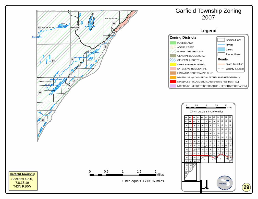
004-205-001-00
004-218-001-00
004-204-001-00
004-331-001-00
004-218-001-10
Knob LakeCrow Lake
Mc Neil Creek
Mc Neil Creek
Crow River
Mc Neil Creek
Mc Neil Creek
07
06 05
08
18
04
19
31 32 33
17
09
Big Knob
Carneg
ie
11 11
11
15
07
03
14
11
16
10
14
18
0207
01
13
23
16
06
15
06
17
36
05
22
33
30
08
12
22
13
03
09
09
24
10
15
02
3534
19
28
20
04
17
20
06
27
21
21
2313
17
21
040132
19
33
02
12
18
08
13
32
2729
16
31
07
09
16
29
05
06
31
19
17
30
20 22
10 08
18
1408
07 09
25
24
03
20
05
04
34
14
28
07
242326
29
21
05 01
31 32
2630
23
12
35
10
04
24
36
27
19
33
25
15
28
03
25
06 05
18
02
12
01
22
08
18
2926
04
!1
!29
!18 !17
!8
!6
!15
!3
!14!13
!20 !19
!10
!16
!2
!22
!11
!23
!12
!21
!5 !7
!9
!27!24
!4
!28!25 !26
Garfield Township Zoning2007
0 0.5 1 1.5 2Miles
1 inch equals 0.713107 miles
0 2.5 5 7.5 10Miles
Section Lines
Rivers
Lakes
Parcel Lines
RoadsState Trunkline
County & Local
Garfield TownshipSections 4,5,6,
7,8,18,19T43N R10W
Zoning DistrictsPUBLIC LAND
AGRICULTURE
FOREST/RECREATION
GENERAL COMMERCIAL
GENERAL INDUSTRIAL
INTENSIVE RESIDENTIAL
EXTENSIVE RESIDENTIAL
HIAWATHA SPORTSMANS CLUB
MIXED USE - (COMMERCIAL/EXTENSIVE RESIDENTIAL)
MIXED USE - (COMMERCIAL/INTENSIVE RESIDENTIAL)
MIXED USE - (FOREST/RECREATION - RESORT/RECREATION)
29
Legend
1 inch equals 5.872949 miles
µ