g38 soil and water management (soil and water management … · under g38, an erosion and sediment...
TRANSCRIPT
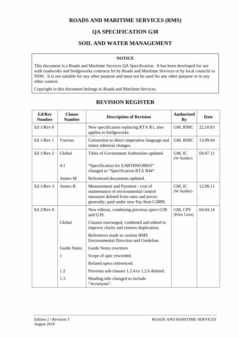
ROADS AND MARITIME SERVICES (RMS)
QA SPECIFICATION G38
SOIL AND WATER MANAGEMENT
NOTICE
This document is a Roads and Maritime Services QA Specification. It has been developed for use with roadworks and bridgeworks contracts let by Roads and Maritime Services or by local councils in NSW. It is not suitable for any other purpose and must not be used for any other purpose or in any other context.
Copyright in this document belongs to Roads and Maritime Services.
REVISION REGISTER
Ed/Rev Number
Clause Number Description of Revision Authorised
By Date
Ed 1/Rev 0 New specification replacing RTA R1, also applies to bridgeworks
GM, RNIC 22.10.03
Ed 1/Rev 1 Various Conversion to direct imperative language and minor editorial changes.
GM, RNIC 13.09.04
Ed 1/Rev 2 Global Titles of Government Authorities updated. GM, IC (W Stalder)
04.07.11
4.1 “Specification for EARTHWORKS” changed to “Specification RTA R44”.
Annex M Referenced documents updated.
Ed 1/Rev 3 Annex B Measurement and Payment - cost of maintenance of environmental control measures deleted from rates and prices generally; paid under new Pay Item G38P8.
GM, IC (W Stalder)
12.08.11
Ed 2/Rev 0 New edition, combining previous specs G38 and G39.
GM, CPS (Peter Letts)
04.04.14
Global Clauses rearranged, combined and edited to improve clarity and remove duplication.
References made to various RMS Environmental Direction and Guideline.
Guide Notes Guide Notes rewritten.
1 Scope of spec reworded.
Related specs referenced.
1.2 Previous sub-clauses 1.2.4 to 1.2.6 deleted.
1.3 Heading title changed to include “Acronyms”.
Edition 2 / Revision 3 ROADS AND MARITIME SERVICES August 2018
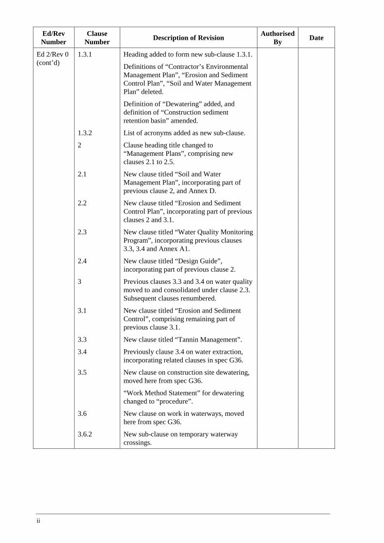
Ed/Rev Number
Clause Number Description of Revision Authorised
By Date
Ed 2/Rev 0 (cont’d)
1.3.1 Heading added to form new sub-clause 1.3.1.
Definitions of “Contractor’s Environmental Management Plan”, “Erosion and Sediment Control Plan”, “Soil and Water Management Plan” deleted.
Definition of “Dewatering” added, and definition of “Construction sediment retention basin” amended.
1.3.2 List of acronyms added as new sub-clause.
2 Clause heading title changed to “Management Plans”, comprising new clauses 2.1 to 2.5.
2.1 New clause titled “Soil and Water Management Plan”, incorporating part of previous clause 2, and Annex D.
2.2 New clause titled “Erosion and Sediment Control Plan”, incorporating part of previous clauses 2 and 3.1.
2.3 New clause titled “Water Quality Monitoring Program”, incorporating previous clauses 3.3, 3.4 and Annex A1.
2.4 New clause titled “Design Guide”, incorporating part of previous clause 2.
3 Previous clauses 3.3 and 3.4 on water quality moved to and consolidated under clause 2.3. Subsequent clauses renumbered.
3.1 New clause titled “Erosion and Sediment Control”, comprising remaining part of previous clause 3.1.
3.3 New clause titled “Tannin Management”.
3.4 Previously clause 3.4 on water extraction, incorporating related clauses in spec G36.
3.5 New clause on construction site dewatering, moved here from spec G36.
“Work Method Statement” for dewatering changed to “procedure”.
3.6 New clause on work in waterways, moved here from spec G36.
3.6.2 New sub-clause on temporary waterway crossings.
ii
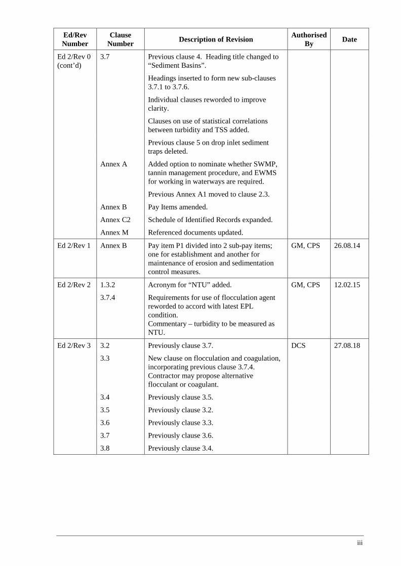
Ed/Rev Number
Clause Number Description of Revision Authorised
By Date
Ed 2/Rev 0 (cont’d)
3.7 Previous clause 4. Heading title changed to “Sediment Basins”.
Headings inserted to form new sub-clauses 3.7.1 to 3.7.6.
Individual clauses reworded to improve clarity.
Clauses on use of statistical correlations between turbidity and TSS added.
Previous clause 5 on drop inlet sediment traps deleted.
Annex A Added option to nominate whether SWMP, tannin management procedure, and EWMS for working in waterways are required.
Previous Annex A1 moved to clause 2.3.
Annex B Pay Items amended.
Annex C2 Schedule of Identified Records expanded.
Annex M Referenced documents updated.
Ed 2/Rev 1 Annex B Pay item P1 divided into 2 sub-pay items; one for establishment and another for maintenance of erosion and sedimentation control measures.
GM, CPS 26.08.14
Ed 2/Rev 2 1.3.2 Acronym for “NTU” added. GM, CPS 12.02.15
3.7.4 Requirements for use of flocculation agent reworded to accord with latest EPL condition. Commentary – turbidity to be measured as NTU.
Ed 2/Rev 3 3.2 Previously clause 3.7. DCS 27.08.18
3.3 New clause on flocculation and coagulation, incorporating previous clause 3.7.4. Contractor may propose alternative flocculant or coagulant.
3.4 Previously clause 3.5.
3.5 Previously clause 3.2.
3.6 Previously clause 3.3.
3.7 Previously clause 3.6.
3.8 Previously clause 3.4.
iii
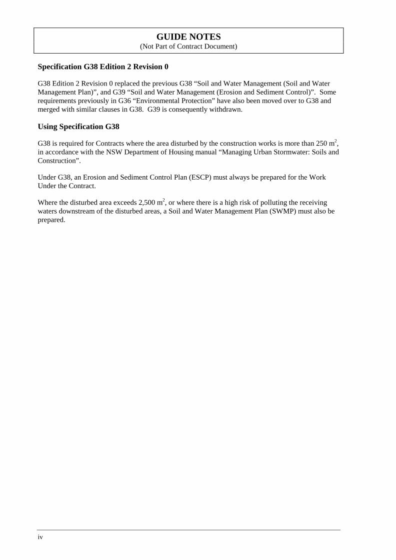
GUIDE NOTES (Not Part of Contract Document)
Specification G38 Edition 2 Revision 0
G38 Edition 2 Revision 0 replaced the previous G38 “Soil and Water Management (Soil and Water Management Plan)”, and G39 “Soil and Water Management (Erosion and Sediment Control)”. Some requirements previously in G36 “Environmental Protection” have also been moved over to G38 and merged with similar clauses in G38. G39 is consequently withdrawn.
Using Specification G38
G38 is required for Contracts where the area disturbed by the construction works is more than 250 m2, in accordance with the NSW Department of Housing manual “Managing Urban Stormwater: Soils and Construction”.
Under G38, an Erosion and Sediment Control Plan (ESCP) must always be prepared for the Work Under the Contract.
Where the disturbed area exceeds 2,500 m2, or where there is a high risk of polluting the receiving waters downstream of the disturbed areas, a Soil and Water Management Plan (SWMP) must also be prepared.
iv
QA SPECIFICATION G38
SOIL AND WATER MANAGEMENT Copyright – Roads and Maritime Services
IC-QA-G38
VERSION FOR: DATE:
Edition 2 / Revision 3 ROADS AND MARITIME SERVICES August 2018

Soil and Water Management G38
CONTENTS
CLAUSE PAGE
FOREWORD ............................................................................................................................................... II RMS Copyright and Use of this Document ................................................................................... ii Revisions to Previous Version ....................................................................................................... ii Project Specific Changes ............................................................................................................... ii
1 GENERAL ........................................................................................................................................ 1 1.1 Scope .............................................................................................................................. 1 1.2 Structure of the Specification ......................................................................................... 1 1.3 Definitions and Acronyms .............................................................................................. 2
2 MANAGEMENT PLANS .................................................................................................................... 3 2.1 Soil and Water Management Plan .................................................................................. 3 2.2 Erosion and Sediment Control Plan ............................................................................... 4 2.3 Water Quality Monitoring Program ............................................................................... 6 2.4 Design Guide .................................................................................................................. 6 2.5 Management Review ...................................................................................................... 7
3 SOIL AND WATER MANAGEMENT MEASURES ............................................................................... 7 3.1 Erosion and Sediment Control ....................................................................................... 7 3.2 Sediment Basins ............................................................................................................. 8 3.3 Flocculation and Coagulation ....................................................................................... 10 3.4 Construction Site Dewatering ...................................................................................... 11 3.5 Stockpile Management ................................................................................................. 12 3.6 Tannin Management ..................................................................................................... 12 3.7 Work in Waterways ...................................................................................................... 12 3.8 Water Extraction .......................................................................................................... 13
ANNEXURE G38/A – PROJECT REQUIREMENTS ..................................................................................... 14
ANNEXURE G38/B – MEASUREMENT AND PAYMENT ............................................................................ 15
ANNEXURE G38/C – SCHEDULES OF HOLD POINTS, WITNESS POINTS AND IDENTIFIED RECORDS ...... 16 C1 Schedule of Hold Points and Witness Points ............................................................... 16 C2 Schedule of Identified Records .................................................................................... 16
ANNEXURE G38/D – PLANNING DOCUMENTS ....................................................................................... 16
ANNEXURE G38/E – DESIGN AVERAGE RECURRENCE INTERVALS ....................................................... 17
ANNEXURES G38/F TO G38/K – (NOT USED) ........................................................................................ 17
ANNEXURE G38/L – MINIMUM FREQUENCY OF TESTING ..................................................................... 17
ANNEXURE G38/M – REFERENCED DOCUMENTS .................................................................................. 18
LAST PAGE OF THIS DOCUMENT IS .......................................................................................................... 19
Ed 2 / Rev 3 i
G38 Soil and Water Management
FOREWORD
RMS COPYRIGHT AND USE OF THIS DOCUMENT
Copyright in this document belongs to Roads and Maritime Services.
When this document forms part of a contract
This document should be read with all the documents forming the Contract.
When this document does not form part of a contract
This copy is not a controlled document. Observe the Notice that appears on the first page of the copy controlled by RMS. A full copy of the latest version of the document is available on the RMS Internet website: http://www.rms.nsw.gov.au/business-industry/partners-suppliers/specifications/index.html
REVISIONS TO PREVIOUS VERSION
This document has been revised from Specification RMS G38 Edition 2 Revision 2.
All revisions to the previous version (other than minor editorial and project specific changes) are indicated by a vertical line in the margin as shown here, except when it is a new edition and the text has been extensively rewritten.
PROJECT SPECIFIC CHANGES
Any project specific changes are indicated in the following manner:
(a) Text which is additional to the base document and which is included in the Specification is shown in bold italics e.g. Additional Text.
(b) Text which has been deleted from the base document and which is not included in the Specification is shown struck out e.g. Deleted Text.
ii Ed 2 / Rev 3
(RMS COPYRIGHT AND USE OF THIS DOCUMENT - Refer to the Foreword after the Table of Contents)
RMS QA SPECIFICATION G38
SOIL AND WATER MANAGEMENT
1 GENERAL
1.1 SCOPE
This Specification sets out the requirements for preventing water pollution, minimising soil erosion and controlling sedimentation on work sites.
Other specifications cover related matters on environmental protection (Specification RMS G36), clearing and grubbing (Specification RMS G40), earthworks (Specification RMS R44) and revegetation (Specification RMS R178).
1.2 STRUCTURE OF THE SPECIFICATION
This Specification includes a series of annexures that detail additional requirements.
1.2.1 Project Requirements
Details of Project Requirements are shown in Annexure G38/A.
1.2.2 Measurement and Payment
The method of measurement and payment is detailed in Annexure G38/B.
1.2.3 Schedules of HOLD POINTS, WITNESS POINTS and Identified Records
The schedules in Annexure G38/C list the HOLD POINTS and WITNESS POINTS that must be observed. Refer to Specification RMS Q for the definitions of HOLD POINTS and WITNESS POINTS.
The records listed in Annexure G38/C are Identified Records for the purposes of RMS Q Annexure Q/E.
1.2.4 Planning Documents
The PROJECT QUALITY PLAN must include each of the documents and requirements listed in Annexure G38/D and must be implemented.
1.2.5 Frequency of Testing
Your Inspection and Test Plan must nominate the proposed testing frequency to verify conformity of the item, which must not be less than the frequency specified in Annexure G38/L.
Where a minimum frequency is not specified, nominate an appropriate frequency.
Frequency of testing must conform to the requirements of RMS Q.
Ed 2 / Rev 3 1
(RMS COPYRIGHT AND USE OF THIS DOCUMENT - Refer to the Foreword after the Table of Contents)
G38 Soil and Water Management
1.2.6 Referenced Documents
Unless specified otherwise, the applicable issue of a referenced document, other than an RMS Specification, is the issue current at the date one week before the closing date for tenders, or where no issue is current at that date, the most recent issue.
Standards, specifications and test methods are referred to in abbreviated form (e.g. AS 1234). For convenience, the full titles are given in Annexure G38/M.
1.3 DEFINITIONS AND ACRONYMS
1.3.1 Definitions
The terms “you” and “your” mean “the Contractor” and “the Contractor’s” respectively.
The following definitions apply to this Specification:
Catch drain An open channel constructed along the high side of a road cutting or embankment, outside the batter, to intercept and redirect surface water.
Construction sediment retention basin
Temporary ponds or impoundments designed to intercept sediment-laden runoff and retain most sediment and other materials, thereby protecting downstream waterways from pollution. The retention is generally achieved by the settling of the suspended sediment from the stormwater flow, combined with the interception of bedload material.
Dewatering Any activity that involves the removal of ponded stormwater or infiltrated groundwater from any location on Site and the subsequent reuse or discharge of that water.
Diversion bank A bank constructed to provide an open channel without excavation.
Diversion drain An excavated open channel that leads water away from a given area.
Earth bank Temporary open channel constructed at a low gradient across a slope in the form of a ditch with a bank on its lower side to intercept and divert runoff from the site to nearby stable areas at non-erosive velocities.
Level spreader (or level sill)
A flat stabilised area at the outlet of an open drain which spreads the water over a sufficient width to reduce the velocity and energy of the water and prevent downstream erosion.
Open drain An open channel constructed to intercept and redirect surface runoff water including catch drains, diversion banks and drains, earth banks, batter drains and inlet and outlet drains.
Operational basin
A permanent structure provided to capture a significant proportion of the sediment and other pollutants which may enter the stormwater system from the road environment following construction and opening to traffic. May also be designed to trap chemical spills. Usually shown on the Drawings and their locations and design are not necessarily satisfactory for construction sediment retention purposes.
2 Ed 2 / Rev 3
(RMS COPYRIGHT AND USE OF THIS DOCUMENT - Refer to the Foreword after the Table of Contents)
Soil and Water Management G38
Sediment traps and filters
Temporary measures used to trap or filter sediment in runoff from small areas. Examples include straw bales and filter fences.
1.3.2 Acronyms CEMP Contractor’s Environmental Management Plan
ESCP Erosion and Sediment Control Plan
EPA Environment Protection Authority
EWMS Environmental Work Method Statement
NTU Nephelometric Turbidity Unit
SWMP Soil and Water Management Plan
TSS Total Suspended Solids
WQMP Water Quality Monitoring Program
2 MANAGEMENT PLANS
2.1 SOIL AND WATER MANAGEMENT PLAN
2.1.1 General
If specified in Annexure G38/A, prepare a Soil and Water Management Plan (SWMP) for the Work Under the Contract. The SWMP will form part of the Contractor’s Environmental Management Plan (CEMP) specified in RMS G36, and incorporates the Erosion and Sediment Control Plan (ESCP) (refer Clause 2.2).
The SWMP must be prepared by a person with demonstrated skills and experience in preparing the SWMP in accordance with the guidelines in the publication “Managing Urban Stormwater: Soils and Construction Volumes 1 and 2d” (the BLUE BOOK).
2.1.2 Plan Requirements
The Soil and Water Management Plan (SWMP) must identify all risks relating to soil erosion, and pollution caused by sediments and other materials, and describes how these risks will be addressed during construction.
The SWMP must include details of the following, where relevant:
(a) Purpose and objectives of SWMP.
(b) Approvals, licence requirements and relevant legislation.
(c) Site investigation and assessment of the following: (i) soil properties (including dispersion properties and presence of acid sulphate soils); (ii) rainfall records and design parameters; (iii) waterways and other water related sensitive environments; (iv) groundwater; (v) possibilities of, and limitations on, water extraction.
(d) Environmental control measures, including:
Ed 2 / Rev 3 3
(RMS COPYRIGHT AND USE OF THIS DOCUMENT - Refer to the Foreword after the Table of Contents)
G38 Soil and Water Management
(i) responsibility for its implementation, including the names and contact details of the person(s) responsible;
(ii) resources required for its construction, monitoring, maintenance and removal; (iii) implementation schedule for the measures, related to construction activities; (iv) monitoring and maintenance of the environmental controls.
(e) Other associated plans, Environmental Work Method Statements (EWMS) and procedures.
(f) Construction sediment retention basins, including details of the following: (i) design of the construction sediment retention basins, including any temporary
modifications to the operational basins, providing details of the approach, standards, criteria and references used in the design of the basins;
(ii) management of the basins; (iii) procedures for testing, treatment and discharge of water from the basins; (iv) procedures for the periodic removal and disposal of the sediment collected within the
basins.
(g) Training, including: (i) site induction; (ii) environmental training; (iii) toolbox training.
(h) Inspection and auditing.
In addressing items (g) and (h) above, refer to RMS G36.
Detail here any specific SWMP requirements, such as from the EIS, REF, Submissions Report or planning consent/approval. Include any requirements for preparation of the plan in consultation with a Government agency.
2.2 EROSION AND SEDIMENT CONTROL PLAN
2.2.1 General
Prepare an Erosion and Sediment Control Plan (ESCP) for the Work Under the Contract. The ESCP will form part of the CEMP, and where a SWMP is also required, the ESCP will be incorporated in the SWMP.
The ESCP must be prepared by a person with demonstrated skills and experience in preparing the ESCP in accordance with the BLUE BOOK guidelines.
2.2.2 Plan Requirements
The ESCP must identify all erosion and sediment control risks and describe how these will be addressed during construction.
The ESCP must include details of the following where relevant:
(a) erosion and sediment control measures required: (i) before clearing and grubbing of the Site; (ii) before removal of topsoil and commencement of earthworks within the catchment area;
(b) how upstream water will be managed so it is not polluted by the construction activities;
4 Ed 2 / Rev 3

(RMS COPYRIGHT AND USE OF THIS DOCUMENT - Refer to the Foreword after the Table of Contents)
Soil and Water Management G38
(c) method of tree removal in intermittent watercourses, leaving grasses and small understorey species undisturbed wherever possible;
(d) scour protection measures for haul roads and access tracks when these are an erosion hazard due to either their steepness, soil erodibility or potential for concentrating runoff flow;
(e) measures for stabilising temporary drains;
(f) measures to minimise erosion during construction of embankments;
(g) measures to minimise erosion and control sedimentation from stockpiles;
(h) methods of constructing batters to assist the retention of topsoil on the batter slopes;
(i) measures to temporarily trap sediment in median areas at regular intervals;
(j) controls in runoff flow paths to reduce flow velocities and minimise the potential for erosion;
(k) measures for controlling waste water discharge on or around the Site from dewatering (refer to Clause 3.4), surface washing, grit blasting, saw cutting, drilling, washing vehicles and plant and any other activities which add pollutants to water;
(l) measures to be put in place during an extended shut-down of the Site or when rainfall above a certain trigger level is predicted;
(m) maintenance of erosion and sediment control structures including measures to restore their capacity;
(n) inspection and auditing program for all erosion and sediment controls to ensure that no disturbed area is left without adequate erosion and sediment controls.
In addressing item (k) above, refer to RMS G36.
Detail here any specific ESCP requirements, such as from the EIS, REF, Submissions Report or planning consent/approval. Include any requirements for preparation of the plan in consultation with a government agency.
2.2.3 Plan Preparation
When preparing the ESCP, subdivide the site into sections based on the separate catchment areas, or alternatively into high risk areas, that will be affected by Work Under the Contract.
Progressively, before work begins on any section of the Site, prepare a drawing for that section showing all controls required to avoid erosion and sedimentation of the Site, surrounding areas, watercourses, drainage systems, water bodies and wetlands.
Update each drawing regularly as the site conditions changes during the progress of Work Under the Contract. Include as part of the ESCP a procedure for updating the drawings, and keep a register of all such drawings with the dates of submission, approval, and commencement of work on that section.
Include on the drawings locations of all ancillary activities and/or areas that may impact on water quality, such as: (a) access and haulage tracks; (b) borrow pits; (c) stockpile and storage areas; (d) temporary work areas; (d) materials processing areas; (e) compound areas;
Ed 2 / Rev 3 5
(RMS COPYRIGHT AND USE OF THIS DOCUMENT - Refer to the Foreword after the Table of Contents)
G38 Soil and Water Management
(f) concrete and asphalt batching areas.
2.3 WATER QUALITY MONITORING PROGRAM
If specified in Annexure G38/A, prepare a Water Quality Monitoring Program (WQMP), as a supplement to the ESCP, in accordance with the RMS Guideline for Construction Water Quality Monitoring and EPA publication “Approved Methods for the Sampling and Analysis of Water Pollutants in NSW.”.
Include the following in the WQMP:
(a) objectives of the monitoring (including EPA licence requirements);
(b) map showing the water sampling locations;
(c) sampling protocol, including sample collection, chain of custody information and sample preservation;
(d) parameters to be monitored;
(e) method for interpretation of field results and identifying exceedance of water quality criteria;
(f) accountabilities, responsibilities and training required the meet the monitoring objectives;
(g) method of comparison of results between sampling locations (e.g. upstream and downstream) and any water quality criteria and/or targets;
(h) reporting and recording of the monitoring results;
(i) responsibility for planning, implementing, checking and reviewing each element of the monitoring;
(j) methodology for using monitoring results to assess and manage identified problems;
(k) reporting requirements in the case the monitoring results exceed the set criteria.
Laboratories used in the monitoring program must be accredited by the National Association of Testing Authorities (NATA).
2.4 DESIGN GUIDE
In preparing the SWMP and/or ESCP, be guided by the BLUE BOOK.
Comply with the following requirements:
(i) estimate peak flows and other parameters needed to design drains and drainage structures using the methods described in Australian Rainfall and Runoff;
(ii) use the Average Recurrence Interval (ARI) shown in Annexure G38/E for the design of erosion and sediment control measures, unless site conditions or risks to life, property or the environment suggest that other values are applicable;
(iii) superimpose the drawings accompanying the plans on A3 sized drainage drawings of the Works.
You do not need to submit the calculations carried out during preparation of the SWMP or ESCP with the plan, but you must retain them as an Identified Record. Forward a copy to the Principal upon request.
6 Ed 2 / Rev 3
(RMS COPYRIGHT AND USE OF THIS DOCUMENT - Refer to the Foreword after the Table of Contents)
Soil and Water Management G38
2.5 MANAGEMENT REVIEW
Develop a documented process to periodically review the effectiveness and proper implementation of the SWMP and ESCP. The management review process must identify opportunities for continual improvement of your environmental management processes and practices, and ensure that the SWMP and ESCP remain current and relevant to the Work Under the Contract.
3 SOIL AND WATER MANAGEMENT MEASURES
3.1 EROSION AND SEDIMENT CONTROL
3.1.1 Implementation
In addition to the erosion and sediment control measures stated in Clause 2.2, implement the following:
(i) placing the locations of site compounds, access tracks, stockpile sites and temporary work areas to minimise erosion;
(ii) staging of work and programming of construction activities to minimise the duration and extent of soil that is left exposed. This includes minimising the time between clearing and initial earthworks and commencement of subsequent works in intermittent and permanent watercourses;
(iii) temporary modification of operational basins during the construction period for additional capture of stormwater runoff;
(iv) installing and lining catch drains and diversion banks in accordance with the requirements of Specification RMS R11 before earthworks commence;
(v) installing scour protection at the base of permanent and temporary drainage outlets;
(vi) constructing drains to direct runoff from disturbed areas to sediment basins or to areas with adequate sediment trapping/filtering devices and away from watercourses;
(vii) filtering of sediment prior to water entering any pit and management of stormwater discharge through any pit;
(viii) staged re-vegetation of the Site as work proceeds, progressively undertaking topsoiling and vegetation work as specified in RMS R178.
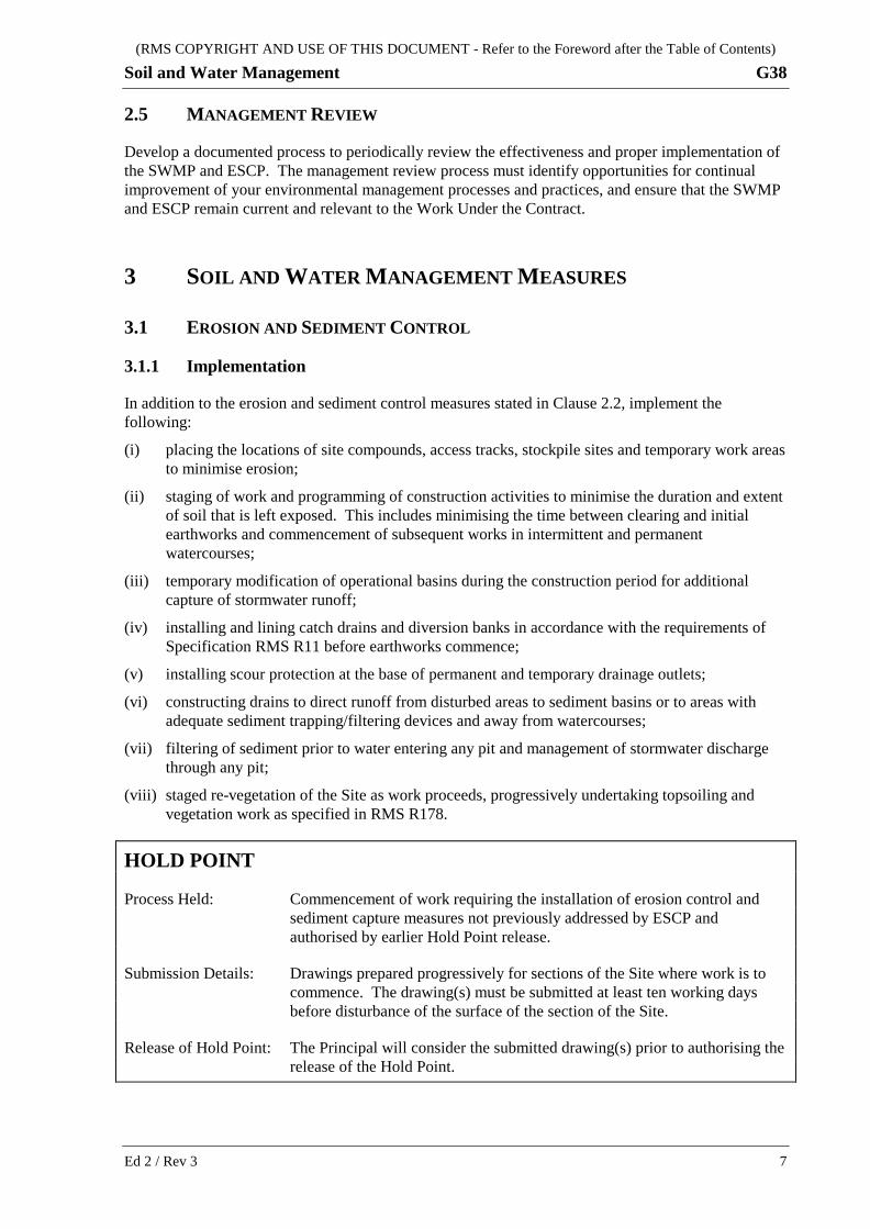
HOLD POINT
Process Held: Commencement of work requiring the installation of erosion control and sediment capture measures not previously addressed by ESCP and authorised by earlier Hold Point release.
Submission Details: Drawings prepared progressively for sections of the Site where work is to commence. The drawing(s) must be submitted at least ten working days before disturbance of the surface of the section of the Site.
Release of Hold Point: The Principal will consider the submitted drawing(s) prior to authorising the release of the Hold Point.
Ed 2 / Rev 3 7
(RMS COPYRIGHT AND USE OF THIS DOCUMENT - Refer to the Foreword after the Table of Contents)
G38 Soil and Water Management
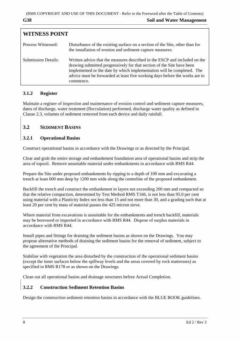
WITNESS POINT
Process Witnessed: Disturbance of the existing surface on a section of the Site, other than for the installation of erosion and sediment capture measures.
Submission Details: Written advice that the measures described in the ESCP and included on the drawing submitted progressively for that section of the Site have been implemented or the date by which implementation will be completed. The advice must be forwarded at least five working days before the works are to commence.
3.1.2 Register
Maintain a register of inspection and maintenance of erosion control and sediment capture measures, dates of discharge, water treatment (flocculation) performed, discharge water quality as defined in Clause 2.3, volumes of sediment removed from each device and daily rainfall.
3.2 SEDIMENT BASINS
3.2.1 Operational Basins
Construct operational basins in accordance with the Drawings or as directed by the Principal.
Clear and grub the entire storage and embankment foundation area of operational basins and strip the area of topsoil. Remove unsuitable material under embankments in accordance with RMS R44.
Prepare the Site under proposed embankments by ripping to a depth of 100 mm and excavating a trench at least 600 mm deep by 1200 mm wide along the centreline of the proposed embankment.
Backfill the trench and construct the embankment in layers not exceeding 200 mm and compacted so that the relative compaction, determined by Test Method RMS T166, is not less than 95.0 per cent using material with a Plasticity Index not less than 15 and not more than 30, and a grading such that at least 20 per cent by mass of material passes the 425 micron sieve.
Where material from excavations is unsuitable for the embankments and trench backfill, materials may be borrowed or imported in accordance with RMS R44. Dispose of surplus materials in accordance with RMS R44.
Install pipes and fittings for draining the sediment basins as shown on the Drawings. You may propose alternative methods of draining the sediment basins for the removal of sediment, subject to the agreement of the Principal.
Stabilise with vegetation the area disturbed by the construction of the operational sediment basins (except the inner surfaces below the spillway levels and the areas covered by rock mattresses) as specified in RMS R178 or as shown on the Drawings.
Clean out all operational basins and drainage structures before Actual Completion.
3.2.2 Construction Sediment Retention Basins
Design the construction sediment retention basins in accordance with the BLUE BOOK guidelines.
8 Ed 2 / Rev 3
(RMS COPYRIGHT AND USE OF THIS DOCUMENT - Refer to the Foreword after the Table of Contents)
Soil and Water Management G38
Construct the basins in accordance with the requirements of Clause 3.2.1 for operational basins, unless alternative designs using alternative materials and construction methods are proposed.
If such alternative designs are used, provide details of the alternative design in the ESCP. The alternative design must be prepared by a suitably qualified engineer experienced in the type of work, and its use is subject to the agreement of the Principal.
If you propose to use operational basins for sedimentation control during the duration of the Contract, the environmental requirements specified for any discharge must be complied with.
3.2.3 Inlets, Outlets and Spillways
Construct inlets, outlets and spillways as soon as possible using rock filled woven galvanised steel mattresses laid on a needle punched, mechanically bonded, non-woven geotextile filter fabric. The rock filled mattresses must comply with Specification RMS R55 and the geotextile must comply with the requirements of Specification RMS R63 for Application Category G4, unless shown otherwise on the Drawings.
You may propose alternative methods for constructing the inlets, outlets and spillways, subject to the agreement of the Principal.
3.2.4 Maintenance of Sediment Basins
Clean out sediment basins, at minimum, whenever the accumulated sediment exceeds 60% of the sediment storage zone.
Remove accumulated sediment from sediment basins and traps in such a manner as not to damage the structures. Dispose of the sediment removed in such locations that the sediment will not be conveyed back into the construction areas, into watercourses or off site.
Provide and maintain suitable access to sediment basins and sediment traps to allow cleaning out in all weather conditions.
3.2.5 Removal of Basins
Remove all construction sediment retention basins and sediment traps before Completion, but not before all upstream areas have been vegetated or otherwise stabilised in accordance with BLUE BOOK.
Restore the ground disturbed by the construction of the sediment basins/traps to a similar condition to that previously existing. Include the following in the restoration work:
(a) removal of all redundant mattresses from the inlets and spillway(s) and their subsequent burial into the basin area or their use as scour protection or their removal from Site;
(b) spreading and compaction of the embankment material into the basin area;
(c) removal of access roads.
Compact the disturbed ground to at least the relative density of the material in the ground adjacent to it.
Ed 2 / Rev 3 9
(RMS COPYRIGHT AND USE OF THIS DOCUMENT - Refer to the Foreword after the Table of Contents)
G38 Soil and Water Management
3.3 FLOCCULATION AND COAGULATION
3.3.1 Using Gypsum (Calcium Sulphate)
Where gypsum is proposed for use to settle suspended sediments, determine the appropriate application rate for the site specific sediment type(s) and the prevailing weather conditions.
State in your SWMP or ESCP your method of applying the gypsum.
3.3.2 Using Flocculants or Coagulants Other Than Gypsum (Calcium Sulphate)
You may propose to the Principal for approval to use a flocculant or coagulant other than gypsum. Demonstrate in your submission that the proposed flocculant or coagulant is suitable for use. Use the RMS template “Alternative flocculants and coagulants – template to propose use” to prepare your submission. The template is available on the RMS Internet website: http://www.rms.nsw.gov.au/about/environment/soil-water-quality/index.html
The Principal will provide a written response to your proposal within ten working days. Submission of a proposal does not guarantee approval to use a flocculant or coagulant other than gypsum.
3.3.3 Time of Application
Apply the flocculant or coagulant (whether gypsum or another approved material) to settle suspended sediments within 24 hours of the conclusion of each rain event causing runoff.
3.3.4 Water Quality Discharge Criteria
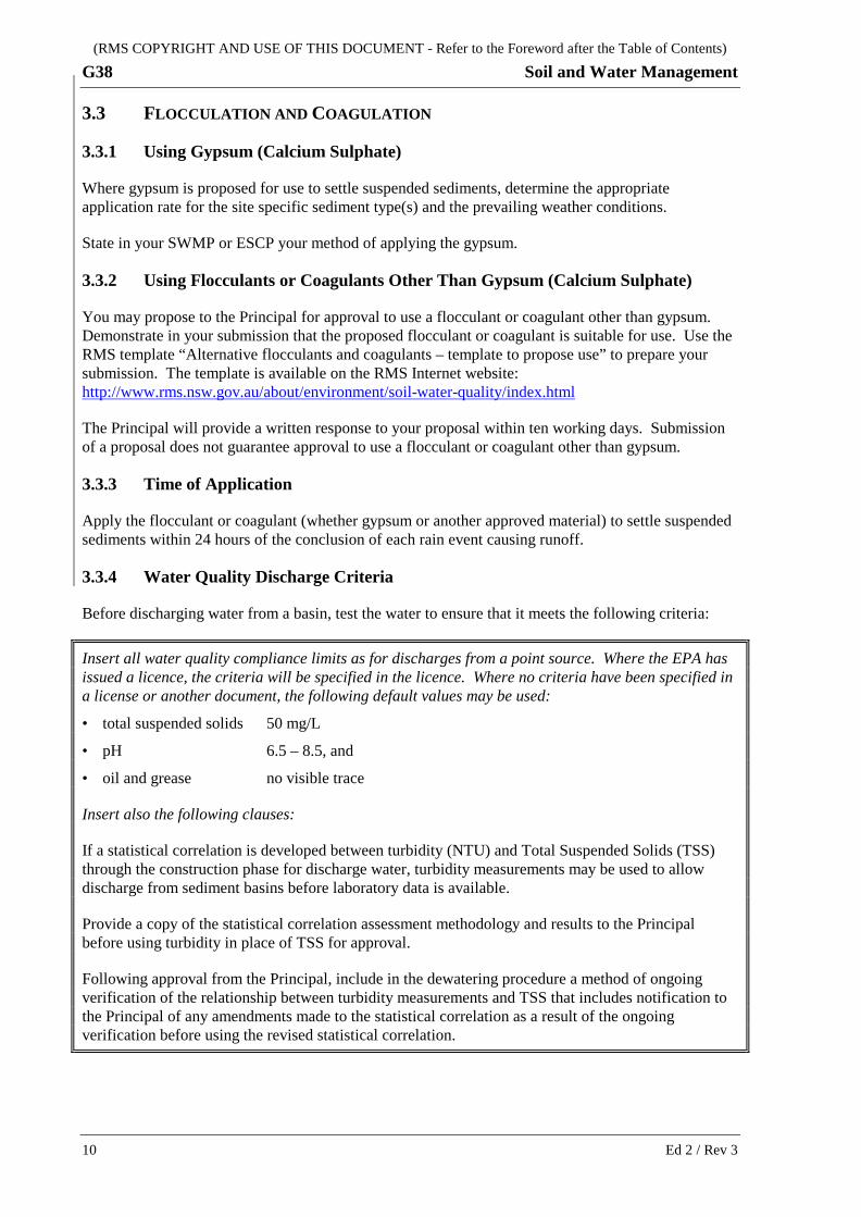
Before discharging water from a basin, test the water to ensure that it meets the following criteria:
Insert all water quality compliance limits as for discharges from a point source. Where the EPA has issued a licence, the criteria will be specified in the licence. Where no criteria have been specified in a license or another document, the following default values may be used:
• total suspended solids 50 mg/L
• pH 6.5 – 8.5, and
• oil and grease no visible trace
Insert also the following clauses:
If a statistical correlation is developed between turbidity (NTU) and Total Suspended Solids (TSS) through the construction phase for discharge water, turbidity measurements may be used to allow discharge from sediment basins before laboratory data is available.
Provide a copy of the statistical correlation assessment methodology and results to the Principal before using turbidity in place of TSS for approval.
Following approval from the Principal, include in the dewatering procedure a method of ongoing verification of the relationship between turbidity measurements and TSS that includes notification to the Principal of any amendments made to the statistical correlation as a result of the ongoing verification before using the revised statistical correlation.
10 Ed 2 / Rev 3
(RMS COPYRIGHT AND USE OF THIS DOCUMENT - Refer to the Foreword after the Table of Contents)
Soil and Water Management G38
3.4 CONSTRUCTION SITE DEWATERING
3.4.1 General
Conduct any dewatering activities in a manner that does not cause erosion and/or pollute the environment.
3.4.2 Procedure
Prepare a procedure for all identified dewatering activities as part of the SWMP or ESCP. Further guidance for the preparation of a dewatering procedure is provided in RMS Technical Guideline EMS-TG-011: Environmental Management of Construction Site Dewatering.
Detail here any specific requirements for dewatering, such as from the EIS, REF, Submissions Report or planning consent/approval.
3.4.3 Personnel
The personnel responsible for approval and/or carrying out dewatering activities must be adequately trained and inducted on the use of the dewatering procedure.
3.4.4 Implementation
Prior to the commencement of dewatering, inspect the entire system, including intakes and outlets, pumping and discharge locations.
Wherever possible, supervise any dewatering activities directly. If you choose not to directly supervise dewatering, carry out a risk assessment and implement mitigation measures to eliminate the risks of pollution and to prevent the occurrence of the following:
(i) intake suction placed within the deposited sediments resulting in discharge of sediment laden waters;
(ii) erosion at discharge locations and downstream areas;
(iii) inadvertent or intentional controlled discharge of untreated waters.
3.4.5 Records
Keep records of the following:
(i) dewatering procedure;
(ii) date and time for each discharge at each location;
(iii) water quality test results for each discharge;
(iv) personnel approving the dewatering activities;
(v) evidence of discharge monitoring, or risk assessment and mitigation measures used to eliminate the risks of pollution or erosion;
(vi) any other EPA licence requirements where issued.
Ed 2 / Rev 3 11
(RMS COPYRIGHT AND USE OF THIS DOCUMENT - Refer to the Foreword after the Table of Contents)
G38 Soil and Water Management
3.5 STOCKPILE MANAGEMENT
Establish erosion control and sediment capture measures, and maintain them regularly, to divert offsite stormwater, manage onsite stormwater runoff and stabilise stockpiles in accordance with RMS Technical Guideline EMS-TG-010: Stockpile Site Management and the BLUE BOOK guidelines.
Install erosion control and sediment capture measures prior to stockpiling material.
Comply with the following:
(a) Locate stockpiles outside of the tree protection zone of trees or native vegetation identified for retention. Delineate the tree protection zone in accordance with AS 4970.
(b) Locate stockpiles at least 5 m from likely areas of concentrated water flows and at least 10 m from waterways that are classified as Class 1 and Class 2 from the DPI Fisheries guideline “Why do Fish Need to Cross the Road? Fish Passage Requirements for Waterway Crossings”.
(c) Keep stockpile heights to no greater than 2 m, unless otherwise approved by the Principal, and slopes to no steeper than 2:1.
(d) Cover, or otherwise protect from erosion, stockpiles that will be in place for more than 20 days as well as any stockpiles that are susceptible to wind or water erosion, within 10 days of forming each stockpile.
(e) Keep topsoil that is not contaminated by noxious weeds in stockpiles for later spreading on fill batters and other areas. Other material may also be stockpiled but kept separated from the topsoil stockpiles.
(f) Implement measures to prevent the growth of weeds in topsoil stockpiles.
If any stockpile site is to be located on private land, obtain from the landholder an approved notice under s.143 of the Protection of the Environment Operations Act 1997 prior to commencement of stockpiling.
3.6 TANNIN MANAGEMENT
Prepare a procedure to manage the use and stockpiling of mulch on Site and to reduce the risk of tannin leachate from mulch flowing into waterways, and include this within the SWMP or ESCP. Prepare the procedure in accordance with RMS Environmental Direction 25: Management of Tannins from Vegetation Mulch.
3.7 WORK IN WATERWAYS
3.7.1 Environmental Work Method Statement
Where work is required within waterways, prepare an Environmental Work Method Statement (EWMS) for the work(s). Refer to RMS G36 for guidance on preparing an EWMS.
The EWMS for work in waterways must detail the control measures to avoid or minimise erosion and any adverse impact on water quality and riparian fauna and flora, and must include the following:
(a) plan the Work Under the Contract to avoid, where practicable, any activities in aquatic habitats and riparian zones;
(b) properly protect and signpost as environmentally sensitive areas, all waterways areas in or adjacent to the Site which are excluded from the work areas. Refer to RMS G36 for the requirements for working in environmentally sensitive areas;
12 Ed 2 / Rev 3
(RMS COPYRIGHT AND USE OF THIS DOCUMENT - Refer to the Foreword after the Table of Contents)
Soil and Water Management G38
(c) minimise riparian vegetation removal where practicable, and restrict access to the waterways to the minimum amount of bank length required for the activity;
(d) retain stumps in riparian zones and aquatic habitats, where practicable, to reduce the potential for bank erosion;
(e) carry out any refuelling of plant and equipment, chemical storage and decanting at least 50 m away from aquatic habitats unless otherwise approved by the Principal;
(f) operate your boats or other watercraft in a manner that prevent boat wash which could cause erosion of the banks, and propeller damage to seagrass beds.
3.7.2 Temporary Waterway Crossings
Provide temporary waterway crossings if required to maintain the flow in the waterway. To minimise impacts on the waterways, take into consideration the following:
(a) design, construct and maintain the crossing in accordance with the requirements of the BLUE BOOK;
(b) maintain fish passage in accordance with DPI Fisheries guideline “Why do Fish Need to Cross the Road? Fish Passage Requirements for Waterway Crossings”;
(c) use material that will not result in fine sediment material entering the waterway. Rock used must be hard, sound, durable rock, free of fine particles and not contaminated with foreign materials;
(d) provide erosion and sediment controls at entry/exits points of the crossing to minimise mudtracking on the crossing.
Detail here any specific requirements for work in waterways, such as from the EIS, REF, Submissions Report or planning consent/approval.
3.8 WATER EXTRACTION
Where relevant, describe in the SWMP or ESCP the proposed water source(s) intended for use for construction activities. Obtain all necessary approvals and licences from the New South Wales Office of Water, the Local Council and/or any other persons or authorities having responsibility for the chosen source(s) before commencing extraction.
If the proposed source is other than a town water supply or natural water source, include procedures for regular testing to ensure that the water is suitable for the purpose and is not hazardous to health and the environment.
The use of reclaimed water must comply with the requirements of RMS Environmental Direction 19: Use of Reclaimed Water.
Detail here any specific requirements or exclusions for water extraction, such as from the EIS, REF, Submissions Report or planning consent/approval.
Ed 2 / Rev 3 13
(RMS COPYRIGHT AND USE OF THIS DOCUMENT - Refer to the Foreword after the Table of Contents)
G38 Soil and Water Management
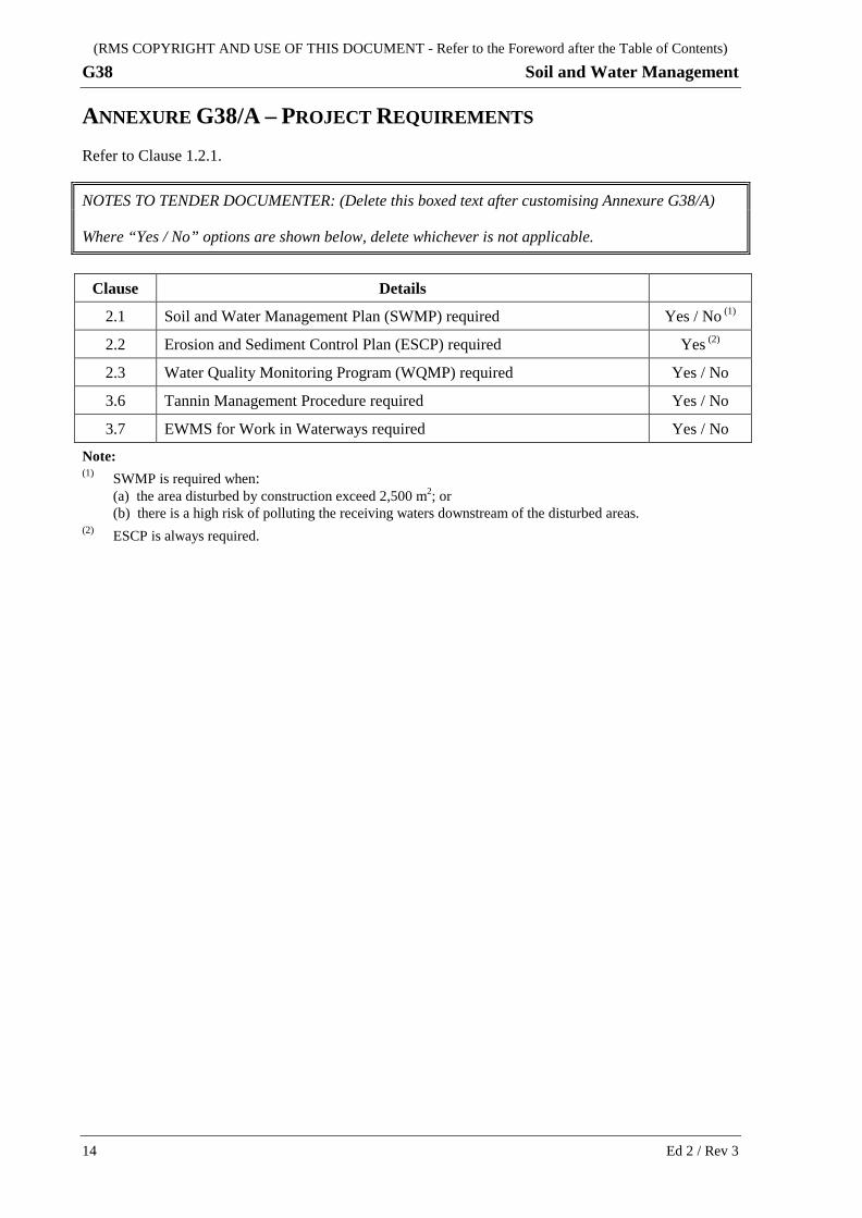
ANNEXURE G38/A – PROJECT REQUIREMENTS Refer to Clause 1.2.1.
NOTES TO TENDER DOCUMENTER: (Delete this boxed text after customising Annexure G38/A)
Where “Yes / No” options are shown below, delete whichever is not applicable.
Clause Details
2.1 Soil and Water Management Plan (SWMP) required Yes / No (1)
2.2 Erosion and Sediment Control Plan (ESCP) required Yes (2)
2.3 Water Quality Monitoring Program (WQMP) required Yes / No
3.6 Tannin Management Procedure required Yes / No
3.7 EWMS for Work in Waterways required Yes / No
Note: (1) SWMP is required when:
(a) the area disturbed by construction exceed 2,500 m2; or (b) there is a high risk of polluting the receiving waters downstream of the disturbed areas.
(2) ESCP is always required.
14 Ed 2 / Rev 3
(RMS COPYRIGHT AND USE OF THIS DOCUMENT - Refer to the Foreword after the Table of Contents)
Soil and Water Management G38
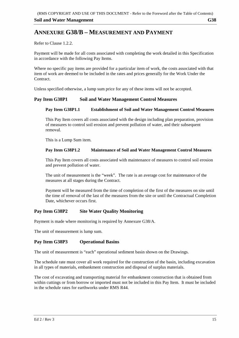
ANNEXURE G38/B – MEASUREMENT AND PAYMENT Refer to Clause 1.2.2.
Payment will be made for all costs associated with completing the work detailed in this Specification in accordance with the following Pay Items.
Where no specific pay items are provided for a particular item of work, the costs associated with that item of work are deemed to be included in the rates and prices generally for the Work Under the Contract.
Unless specified otherwise, a lump sum price for any of these items will not be accepted.
Pay Item G38P1 Soil and Water Management Control Measures
Pay Item G38P1.1 Establishment of Soil and Water Management Control Measures
This Pay Item covers all costs associated with the design including plan preparation, provision of measures to control soil erosion and prevent pollution of water, and their subsequent removal.
This is a Lump Sum item.
Pay Item G38P1.2 Maintenance of Soil and Water Management Control Measures
This Pay Item covers all costs associated with maintenance of measures to control soil erosion and prevent pollution of water.
The unit of measurement is the “week”. The rate is an average cost for maintenance of the measures at all stages during the Contract.
Payment will be measured from the time of completion of the first of the measures on site until the time of removal of the last of the measures from the site or until the Contractual Completion Date, whichever occurs first.
Pay Item G38P2 Site Water Quality Monitoring
Payment is made where monitoring is required by Annexure G38/A.
The unit of measurement is lump sum.
Pay Item G38P3 Operational Basins
The unit of measurement is “each” operational sediment basin shown on the Drawings.
The schedule rate must cover all work required for the construction of the basin, including excavation in all types of materials, embankment construction and disposal of surplus materials.
The cost of excavating and transporting material for embankment construction that is obtained from within cuttings or from borrow or imported must not be included in this Pay Item. It must be included in the schedule rates for earthworks under RMS R44.
Ed 2 / Rev 3 15
(RMS COPYRIGHT AND USE OF THIS DOCUMENT - Refer to the Foreword after the Table of Contents)
G38 Soil and Water Management
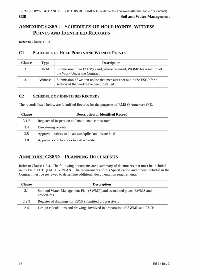
ANNEXURE G38/C – SCHEDULES OF HOLD POINTS, WITNESS POINTS AND IDENTIFIED RECORDS
Refer to Clause 1.2.3.
C1 SCHEDULE OF HOLD POINTS AND WITNESS POINTS
Clause Type Description
3.1 Hold Submission of an ESCP(s) and, where required, WQMP for a section of the Work Under the Contract.
3.1 Witness Submission of written notice that measures set out in the ESCP for a section of the work have been installed.
C2 SCHEDULE OF IDENTIFIED RECORDS
The records listed below are Identified Records for the purposes of RMS Q Annexure Q/E.
Clause Description of Identified Record
3.1.2 Register of inspection and maintenance measures
3.4 Dewatering records
3.5 Approval notices to locate stockpiles on private land
3.8 Approvals and licences to extract water
ANNEXURE G38/D – PLANNING DOCUMENTS Refer to Clause 1.2.4. The following documents are a summary of documents that must be included in the PROJECT QUALITY PLAN. The requirements of this Specification and others included in the Contract must be reviewed to determine additional documentation requirements.
Clause Description
2.1 Soil and Water Management Plan (SWMP) and associated plans, EWMS and procedures
2.2.3 Register of drawings for ESCP submitted progressively
2.4 Design calculations and drawings involved in preparation of SWMP and ESCP
16 Ed 2 / Rev 3
(RMS COPYRIGHT AND USE OF THIS DOCUMENT - Refer to the Foreword after the Table of Contents)
Soil and Water Management G38
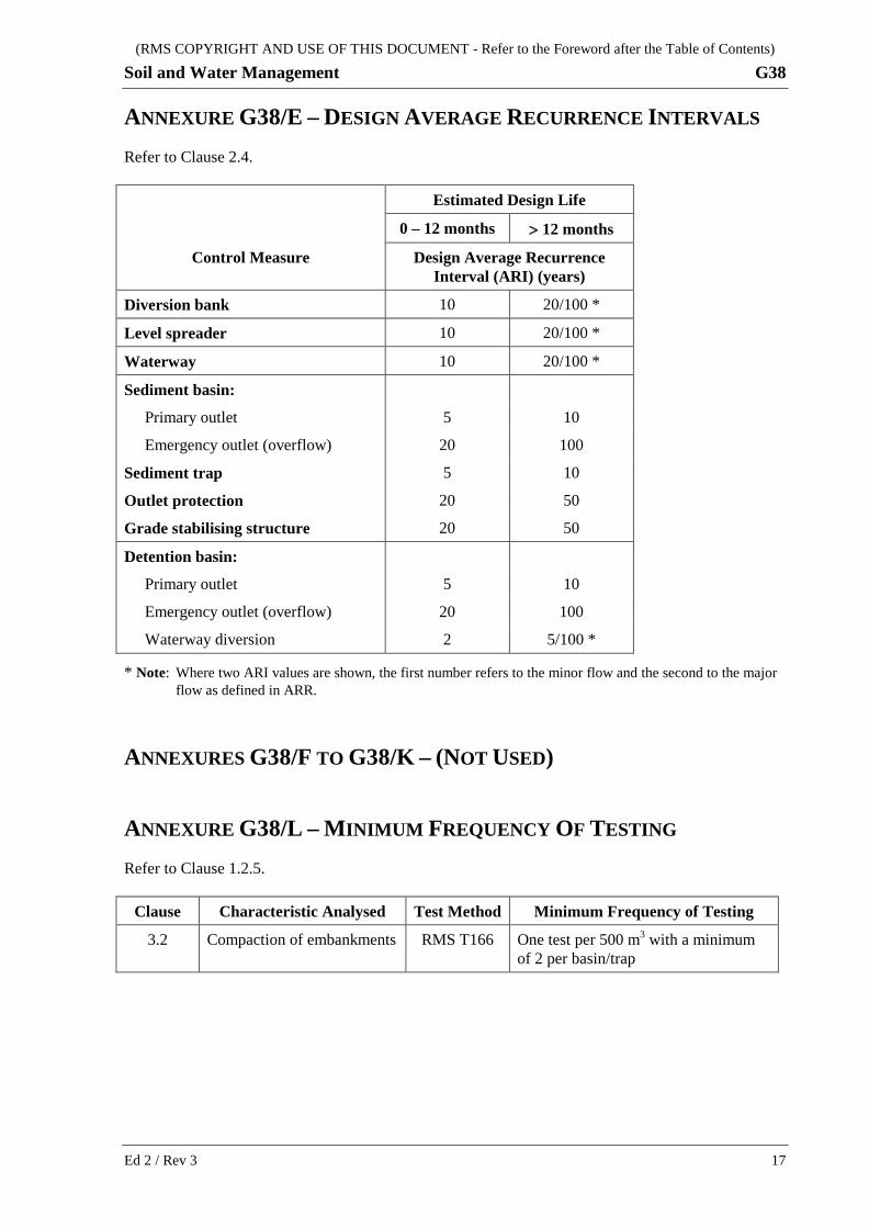
ANNEXURE G38/E – DESIGN AVERAGE RECURRENCE INTERVALS Refer to Clause 2.4.
Estimated Design Life
0 – 12 months > 12 months
Control Measure Design Average Recurrence Interval (ARI) (years)
Diversion bank 10 20/100 *
Level spreader 10 20/100 *
Waterway 10 20/100 *
Sediment basin:
Primary outlet 5 10
Emergency outlet (overflow) 20 100
Sediment trap 5 10
Outlet protection 20 50
Grade stabilising structure 20 50
Detention basin:
Primary outlet 5 10
Emergency outlet (overflow) 20 100
Waterway diversion 2 5/100 *
* Note: Where two ARI values are shown, the first number refers to the minor flow and the second to the major flow as defined in ARR.
ANNEXURES G38/F TO G38/K – (NOT USED)
ANNEXURE G38/L – MINIMUM FREQUENCY OF TESTING Refer to Clause 1.2.5.
Clause Characteristic Analysed Test Method Minimum Frequency of Testing
3.2 Compaction of embankments RMS T166 One test per 500 m3 with a minimum of 2 per basin/trap
Ed 2 / Rev 3 17
(RMS COPYRIGHT AND USE OF THIS DOCUMENT - Refer to the Foreword after the Table of Contents)
G38 Soil and Water Management
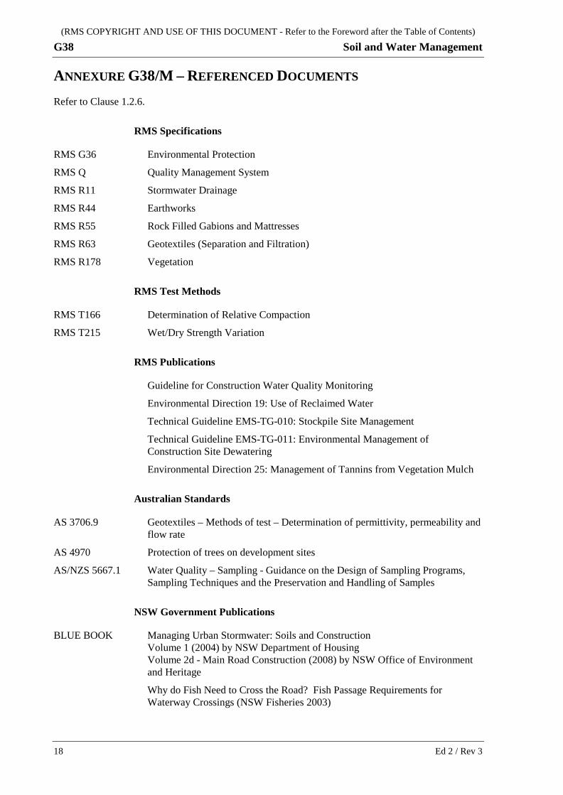
ANNEXURE G38/M – REFERENCED DOCUMENTS Refer to Clause 1.2.6.
RMS Specifications
RMS G36 Environmental Protection
RMS Q Quality Management System
RMS R11 Stormwater Drainage
RMS R44 Earthworks
RMS R55 Rock Filled Gabions and Mattresses
RMS R63 Geotextiles (Separation and Filtration)
RMS R178 Vegetation
RMS Test Methods
RMS T166 Determination of Relative Compaction
RMS T215 Wet/Dry Strength Variation
RMS Publications
Guideline for Construction Water Quality Monitoring
Environmental Direction 19: Use of Reclaimed Water
Technical Guideline EMS-TG-010: Stockpile Site Management
Technical Guideline EMS-TG-011: Environmental Management of Construction Site Dewatering
Environmental Direction 25: Management of Tannins from Vegetation Mulch
Australian Standards
AS 3706.9 Geotextiles – Methods of test – Determination of permittivity, permeability and flow rate
AS 4970 Protection of trees on development sites
AS/NZS 5667.1 Water Quality – Sampling - Guidance on the Design of Sampling Programs, Sampling Techniques and the Preservation and Handling of Samples
NSW Government Publications
BLUE BOOK Managing Urban Stormwater: Soils and Construction Volume 1 (2004) by NSW Department of Housing Volume 2d - Main Road Construction (2008) by NSW Office of Environment and Heritage
Why do Fish Need to Cross the Road? Fish Passage Requirements for Waterway Crossings (NSW Fisheries 2003)
18 Ed 2 / Rev 3
(RMS COPYRIGHT AND USE OF THIS DOCUMENT - Refer to the Foreword after the Table of Contents)
Soil and Water Management G38
Approved Methods for the Sampling and Analysis of Water Pollutants in NSW (NSW Environment Protection Authority)
Engineers Australia
Australian Rainfall and Runoff (ARR)
Ed 2 / Rev 3 19