fulletby &horncastle, lincolnshire...
TRANSCRIPT
Lincolnshire WalksBe a responsible walker
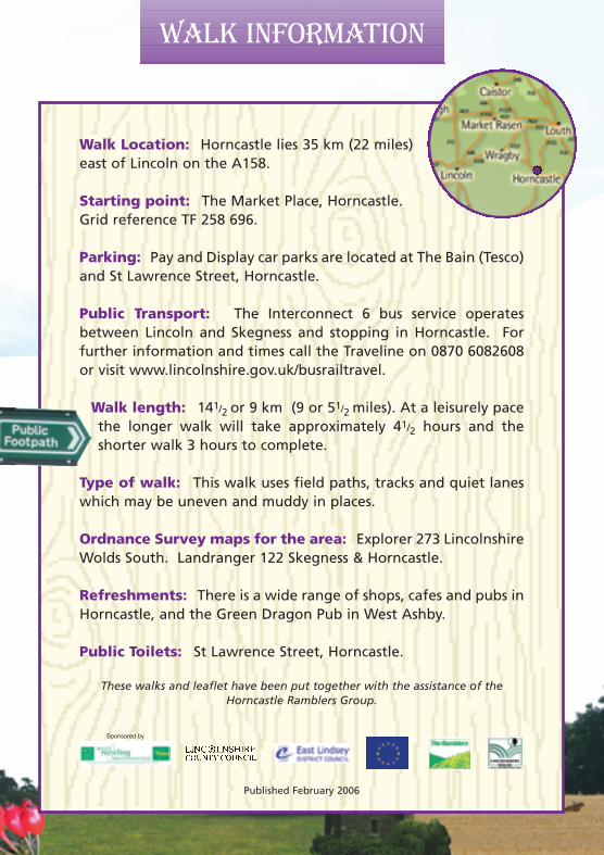
Walk Location: Horncastle lies 35 km (22 miles)east of Lincoln on the A158.
Starting point: The Market Place, Horncastle.Grid reference TF 258 696.
Parking: Pay and Display car parks are located at The Bain (Tesco)and St Lawrence Street, Horncastle.
Public Transport: The Interconnect 6 bus service operatesbetween Lincoln and Skegness and stopping in Horncastle. Forfurther information and times call the Traveline on 0870 6082608or visit www.lincolnshire.gov.uk/busrailtravel.
Walk length: 141/2 or 9 km (9 or 51/2 miles). At a leisurely pacethe longer walk will take approximately 41/2 hours and theshorter walk 3 hours to complete.
Type of walk: This walk uses field paths, tracks and quiet laneswhich may be uneven and muddy in places.
Ordnance Survey maps for the area: Explorer 273 LincolnshireWolds South. Landranger 122 Skegness & Horncastle.
Refreshments: There is a wide range of shops, cafes and pubs inHorncastle, and the Green Dragon Pub in West Ashby.
Public Toilets: St Lawrence Street, Horncastle.
These walks and leaflet have been put together with the assistance of the Horncastle Ramblers Group.
Please remember the countryside is a place where people liveand work and where wildlife makes its home. To protect theLincolnshire countryside for other visitors please respect it andon every visit follow the Countryside Code. Thank you.
• Be safe - plan ahead and follow any signs• Leave gates and property as you find them• Protect plants and animals, and take litter home• Keep dogs under close control• Consider other people
Most of all enjoy your visit to the Lincolnshire countryside
This leaflet is one in a series of walk leaflets produced byLincolnshire County Council’s Conservation ServicesSection to help you explore and enjoy the County’scountryside. If you have enjoyed these walks andwould like information on other walking routes inLincolnshire then please visit our website.
If you encounter any problems whilst on these walks, suchas an overgrown path or a broken sign post, please let usknow so they can be corrected.
We would also welcome your comments and suggestions on thewalk and leaflet to help improve future editions.
Lincolnshire County CouncilConservation Services
Tel: 01522 782070 Minicom: 01522 552055Email: [email protected]
Website: www.lincolnshire.gov.uk/countryside
Horncastle is an attractive market town lying at the south-west footof the Lincolnshire Wolds and noted for its antique shops. The townis located where the Rivers Bain and Waring meet, and on the site ofthe Roman fort or Bannovallum.
Horncastle means ‘the Roman town on a horn-shaped piece of land’,the Old English ‘Horna’ is a projecting horn-shaped piece of land,especially one formed in a river bend.
This walk follows part of the Viking Way, the long distance footpathbetween the Humber and Rutland Water, to gently ascend into theLincolnshire Wolds Area of Outstanding Natural Beauty (AONB) andthe village of Fulletby. The Wolds AONB covers 558 square kilometres(216 square miles) and forms the highest ground in eastern Englandbetween Kent and Yorkshire, and Fulletby is the second highestvillage in the Wolds.
Between Farthorpe and West Ashby look out for the lumps andbumps in the fields, evidence of the existence of the medieval villagesof Farthorpe and Norcotes. Back in the 12th and 13th centuriesLincolnshire was one of the most densely populated areas of England,unlike today. Many villages that existed then have disappearedaltogether or have been reduced in size to just a farm or hamlet. Thiswas perhaps partly due to The Black Death (1349-51) but more to dowith changes in land use from the 14th century onwards. Looking formore profit, landowners enclosed their land to grazesheep at the cost of their tenants who relied onthe land for their living. Unable to survive theywere forced to move away and look for work inthe towns, leaving villages deserted.
This is one in a series of walks from Horncastle. The others are:
• Round horncastle• Horncastle Canal• Horncastle Town Walk
We hope you enjoy them.
IntroductionWalk Information
Published February 2006
If this leaflet is not in a format that meets your needsplease contact Conservation Services
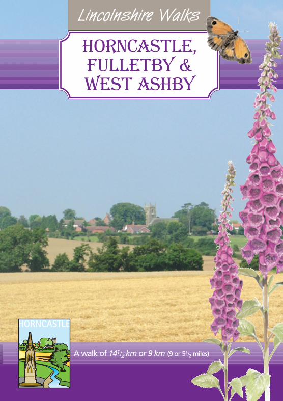
Horncastle,Fulletby &West Ashby
Sponsored by
A walk of 141/2 km or 9 km (9 or 51/2 miles)
Leaflet 3/3/06 08:29 Page 1
Lincolnshire WalksBe a responsible walker
Walk Location: Horncastle lies 35 km (22 miles)east of Lincoln on the A158.
Starting point: The Market Place, Horncastle.Grid reference TF 258 696.
Parking: Pay and Display car parks are located at The Bain (Tesco)and St Lawrence Street, Horncastle.
Public Transport: The Interconnect 6 bus service operatesbetween Lincoln and Skegness and stopping in Horncastle. Forfurther information and times call the Traveline on 0870 6082608or visit www.lincolnshire.gov.uk/busrailtravel.
Walk length: 141/2 or 9 km (9 or 51/2 miles). At a leisurely pacethe longer walk will take approximately 41/2 hours and theshorter walk 3 hours to complete.
Type of walk: This walk uses field paths, tracks and quiet laneswhich may be uneven and muddy in places.
Ordnance Survey maps for the area: Explorer 273 LincolnshireWolds South. Landranger 122 Skegness & Horncastle.
Refreshments: There is a wide range of shops, cafes and pubs inHorncastle, and the Green Dragon Pub in West Ashby.
Public Toilets: St Lawrence Street, Horncastle.
These walks and leaflet have been put together with the assistance of the Horncastle Ramblers Group.
Please remember the countryside is a place where people liveand work and where wildlife makes its home. To protect theLincolnshire countryside for other visitors please respect it andon every visit follow the Countryside Code. Thank you.
• Be safe - plan ahead and follow any signs• Leave gates and property as you find them• Protect plants and animals, and take litter home• Keep dogs under close control• Consider other people
Most of all enjoy your visit to the Lincolnshire countryside
This leaflet is one in a series of walk leaflets produced byLincolnshire County Council’s Conservation ServicesSection to help you explore and enjoy the County’scountryside. If you have enjoyed these walks andwould like information on other walking routes inLincolnshire then please visit our website.
If you encounter any problems whilst on these walks, suchas an overgrown path or a broken sign post, please let usknow so they can be corrected.
We would also welcome your comments and suggestions on thewalk and leaflet to help improve future editions.
Lincolnshire County CouncilConservation Services
Tel: 01522 782070 Minicom: 01522 552055Email: [email protected]
Website: www.lincolnshire.gov.uk/countryside
Horncastle is an attractive market town lying at the south-west footof the Lincolnshire Wolds and noted for its antique shops. The townis located where the Rivers Bain and Waring meet, and on the site ofthe Roman fort or Bannovallum.
Horncastle means ‘the Roman town on a horn-shaped piece of land’,the Old English ‘Horna’ is a projecting horn-shaped piece of land,especially one formed in a river bend.
This walk follows part of the Viking Way, the long distance footpathbetween the Humber and Rutland Water, to gently ascend into theLincolnshire Wolds Area of Outstanding Natural Beauty (AONB) andthe village of Fulletby. The Wolds AONB covers 558 square kilometres(216 square miles) and forms the highest ground in eastern Englandbetween Kent and Yorkshire, and Fulletby is the second highestvillage in the Wolds.
Between Farthorpe and West Ashby look out for the lumps andbumps in the fields, evidence of the existence of the medieval villagesof Farthorpe and Norcotes. Back in the 12th and 13th centuriesLincolnshire was one of the most densely populated areas of England,unlike today. Many villages that existed then have disappearedaltogether or have been reduced in size to just a farm or hamlet. Thiswas perhaps partly due to The Black Death (1349-51) but more to dowith changes in land use from the 14th century onwards. Looking formore profit, landowners enclosed their land to grazesheep at the cost of their tenants who relied onthe land for their living. Unable to survive theywere forced to move away and look for work inthe towns, leaving villages deserted.
This is one in a series of walks from Horncastle. The others are:
• Round horncastle• Horncastle Canal• Horncastle Town Walk
We hope you enjoy them.
IntroductionWalk Information
Published February 2006
If this leaflet is not in a format that meets your needsplease contact Conservation Services
Horncastle,Fulletby &West Ashby
Sponsored by
A walk of 141/2 km or 9 km (9 or 51/2 miles)
Leaflet 3/3/06 08:29 Page 1
The walk The walk The walk
4 Turn right and walk along theroad, taking the left fork toFulletby.
1 With your back to the Post Officewalk across the Market Placetowards the Bank and turn leftalong High Street to its junctionwith North Street and Bull Ring.
2 Take Banks Street, the narrowstreet directly in front of you. Atthe end of Banks Street is theRiver Waring. Follow the river toa T-junction.
3 Turn left and then take the nextright, Bowl Alley Lane. Walkpast the schools and where theroad bends to the left, follow thewaymarked lane that goesstraight ahead behind thehouses. Continue along this pathas it turns left to reach a road.
At the junction with a footpath,cross the bridge and bear right ata slight angle towards abungalow where there is a stilein the fence, turn left to followthe driveway to the lane.
Turn right and at the end of thelane turn left and follow thefootpath diagonally across thefield towards a gate in a dog legin the hedge.
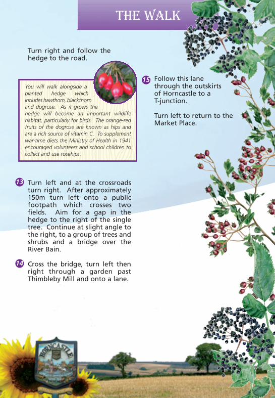
You will walk alongside aplanted hedge whichincludes hawthorn, blackthornand dogrose. As it grows thehedge will become an important wildlifehabitat, particularly for birds. The orange-redfruits of the dogrose are known as hips andare a rich source of vitamin C. To supplementwar-time diets the Ministry of Health in 1941encouraged volunteers and school children tocollect and use rosehips.The lump and bumps in this field are
earthworks, and include the remains of amoat, which form part of Norcotes desertedmedieval village.
This path is edged with a variety oftrees and shrubs, some of which have
been planted. Many of the species bearberries in the autumn, including
hawthorn, elder, blackthorn andspindle, and attract a variety of birds.If you are quiet you may be lucky andsee a few.
7 To continue the walk, turn leftand leave the Viking Way andwalk along the road as itdescends to cross the RiverWaring and then climbs to itsjunction with the A153.
8 Cross the road with care andfollow the road to Farthorpe.
9 At the bottom of the hill crossthe stream and turn left. Aftercrossing the stream again, turnright along the bridleway besidethe stream and ponds, and thenon in the same direction along afield edge.
Turn right and follow thehedge to the road.
the map
6
7
3
2
1
8
5
4
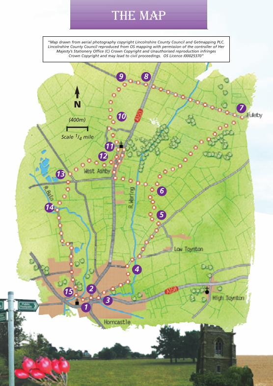
Scale 1/4 mile
(400m)
N
“Map drawn from aerial photography copyright Lincolnshire County Council and Getmapping PLC.Lincolnshire County Council reproduced from OS mapping with permission of the controller of Her
Majesty’s Stationery Office (C) Crown Copyright and Unauthorised reproduction infringes Crown Copyright and may lead to civil proceedings. OS Licence I00025370”
Follow this lanethrough the outskirtsof Horncastle to a T-junction.
Turn left to return to theMarket Place.
9
10
1112
13
14
15There are some significant views as you climbover the Lincolnshire countryside if you pauseand look back. To your left you should also beable to spot the Belmont TV mast, at 385m thehighest in the country, and on a clear day theoutline of Lincoln cathedral, some 20 miles tothe west.
10
Cross the next field by bearingdiagonally left to the corner ofthe field and end of the wall.
Turn right through the gate andfollow the path across the fieldby keeping the hedge on theright to the field corner andlane.
Turn left along the lane. Leavethe lane as it turns left, tocontinue straight on along atrack.
At the end of the track take thefootpath on the right. Cross thefield by heading to the left ofthe telegraph pole in the hedge,to a stile.
13 Turn left and at the crossroadsturn right. After approximately150m turn left onto a publicfootpath which crosses twofields. Aim for a gap in thehedge to the right of the singletree. Continue at slight angle tothe right, to a group of trees andshrubs and a bridge over theRiver Bain.
Cross the bridge, turn left thenright through a garden pastThimbleby Mill and onto a lane.
To visit Fulletby turn right.
The wide verges each side of this road are partof the Protected Roadside Verge Schememanaged by the Lincolnshire Wildlife Trust.Verges are often unimproved flower richgrassland and these verges in particular containorchids and cowslips.
This area is the site of Farthorpe medieval villageand there is still evidence on the ground of fieldbanks and a moated site. The impressiveGrange on the left is a listed building.
11
12
14
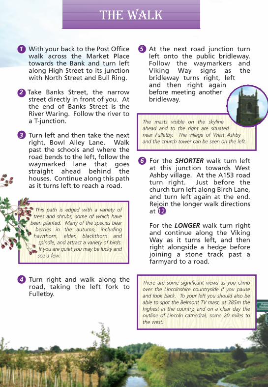
5 At the next road junction turnleft onto the public bridleway.Follow the waymarkers andViking Way signs as thebridleway turns right, leftand then right againbefore meeting anotherbridleway.
The masts visible on the skylineahead and to the right are situatednear Fulletby. The village of West Ashbyand the church tower can be seen on the left.
6 For the SHORTER walk turn leftat this junction towards WestAshby village. At the A153 roadturn right. Just before thechurch turn left along Birch Lane,and turn left again at the end.Rejoin the longer walk directionsat 12.
For the LONGER walk turn rightand continue along the VikingWay as it turns left, and thenright alongside a hedge beforejoining a stone track past afarmyard to a road.
15
Fulletby
Leaflet 3/3/06 08:29 Page 2
The walk The walk The walk
4 Turn right and walk along theroad, taking the left fork toFulletby.
1 With your back to the Post Officewalk across the Market Placetowards the Bank and turn leftalong High Street to its junctionwith North Street and Bull Ring.
2 Take Banks Street, the narrowstreet directly in front of you. Atthe end of Banks Street is theRiver Waring. Follow the river toa T-junction.
3 Turn left and then take the nextright, Bowl Alley Lane. Walkpast the schools and where theroad bends to the left, follow thewaymarked lane that goesstraight ahead behind thehouses. Continue along this pathas it turns left to reach a road.
At the junction with a footpath,cross the bridge and bear right ata slight angle towards abungalow where there is a stilein the fence, turn left to followthe driveway to the lane.
Turn right and at the end of thelane turn left and follow thefootpath diagonally across thefield towards a gate in a dog legin the hedge.
You will walk alongside aplanted hedge whichincludes hawthorn, blackthornand dogrose. As it grows thehedge will become an important wildlifehabitat, particularly for birds. The orange-redfruits of the dogrose are known as hips andare a rich source of vitamin C. To supplementwar-time diets the Ministry of Health in 1941encouraged volunteers and school children tocollect and use rosehips.The lump and bumps in this field are
earthworks, and include the remains of amoat, which form part of Norcotes desertedmedieval village.
This path is edged with a variety oftrees and shrubs, some of which have
been planted. Many of the species bearberries in the autumn, including
hawthorn, elder, blackthorn andspindle, and attract a variety of birds.If you are quiet you may be lucky andsee a few.
7 To continue the walk, turn leftand leave the Viking Way andwalk along the road as itdescends to cross the RiverWaring and then climbs to itsjunction with the A153.
8 Cross the road with care andfollow the road to Farthorpe.
9 At the bottom of the hill crossthe stream and turn left. Aftercrossing the stream again, turnright along the bridleway besidethe stream and ponds, and thenon in the same direction along afield edge.
Turn right and follow thehedge to the road.
the map
6
7
3
2
1
8
5
4
Scale 1/4 mile
(400m)
N
“Map drawn from aerial photography copyright Lincolnshire County Council and Getmapping PLC.Lincolnshire County Council reproduced from OS mapping with permission of the controller of Her
Majesty’s Stationery Office (C) Crown Copyright and Unauthorised reproduction infringes Crown Copyright and may lead to civil proceedings. OS Licence I00025370”
Follow this lanethrough the outskirtsof Horncastle to a T-junction.
Turn left to return to theMarket Place.
9
10
1112
13
14
15There are some significant views as you climbover the Lincolnshire countryside if you pauseand look back. To your left you should also beable to spot the Belmont TV mast, at 385m thehighest in the country, and on a clear day theoutline of Lincoln cathedral, some 20 miles tothe west.
10
Cross the next field by bearingdiagonally left to the corner ofthe field and end of the wall.
Turn right through the gate andfollow the path across the fieldby keeping the hedge on theright to the field corner andlane.
Turn left along the lane. Leavethe lane as it turns left, tocontinue straight on along atrack.
At the end of the track take thefootpath on the right. Cross thefield by heading to the left ofthe telegraph pole in the hedge,to a stile.
13 Turn left and at the crossroadsturn right. After approximately150m turn left onto a publicfootpath which crosses twofields. Aim for a gap in thehedge to the right of the singletree. Continue at slight angle tothe right, to a group of trees andshrubs and a bridge over theRiver Bain.
Cross the bridge, turn left thenright through a garden pastThimbleby Mill and onto a lane.
To visit Fulletby turn right.
The wide verges each side of this road are partof the Protected Roadside Verge Schememanaged by the Lincolnshire Wildlife Trust.Verges are often unimproved flower richgrassland and these verges in particular containorchids and cowslips.
This area is the site of Farthorpe medieval villageand there is still evidence on the ground of fieldbanks and a moated site. The impressiveGrange on the left is a listed building.
11
12
14
5 At the next road junction turnleft onto the public bridleway.Follow the waymarkers andViking Way signs as thebridleway turns right, leftand then right againbefore meeting anotherbridleway.
The masts visible on the skylineahead and to the right are situatednear Fulletby. The village of West Ashbyand the church tower can be seen on the left.
6 For the SHORTER walk turn leftat this junction towards WestAshby village. At the A153 roadturn right. Just before thechurch turn left along Birch Lane,and turn left again at the end.Rejoin the longer walk directionsat 12.
For the LONGER walk turn rightand continue along the VikingWay as it turns left, and thenright alongside a hedge beforejoining a stone track past afarmyard to a road.
15
Fulletby
Leaflet 3/3/06 08:29 Page 2
Lincolnshire WalksBe a responsible walker
Walk Location: Horncastle lies 35 km (22 miles)east of Lincoln on the A158.
Starting point: The Market Place, Horncastle.Grid reference TF 258 696.
Parking: Pay and Display car parks are located at The Bain (Tesco)and St Lawrence Street, Horncastle.
Public Transport: The Interconnect 6 bus service operatesbetween Lincoln and Skegness and stopping in Horncastle. Forfurther information and times call the Traveline on 0870 6082608or visit www.lincolnshire.gov.uk/busrailtravel.
Walk length: 141/2 or 9 km (9 or 51/2 miles). At a leisurely pacethe longer walk will take approximately 41/2 hours and theshorter walk 3 hours to complete.
Type of walk: This walk uses field paths, tracks and quiet laneswhich may be uneven and muddy in places.
Ordnance Survey maps for the area: Explorer 273 LincolnshireWolds South. Landranger 122 Skegness & Horncastle.
Refreshments: There is a wide range of shops, cafes and pubs inHorncastle, and the Green Dragon Pub in West Ashby.
Public Toilets: St Lawrence Street, Horncastle.
These walks and leaflet have been put together with the assistance of the Horncastle Ramblers Group.
Please remember the countryside is a place where people liveand work and where wildlife makes its home. To protect theLincolnshire countryside for other visitors please respect it andon every visit follow the Countryside Code. Thank you.
• Be safe - plan ahead and follow any signs• Leave gates and property as you find them• Protect plants and animals, and take litter home• Keep dogs under close control• Consider other people
Most of all enjoy your visit to the Lincolnshire countryside
This leaflet is one in a series of walk leaflets produced byLincolnshire County Council’s Conservation ServicesSection to help you explore and enjoy the County’scountryside. If you have enjoyed these walks andwould like information on other walking routes inLincolnshire then please visit our website.
If you encounter any problems whilst on these walks, suchas an overgrown path or a broken sign post, please let usknow so they can be corrected.
We would also welcome your comments and suggestions on thewalk and leaflet to help improve future editions.
Lincolnshire County CouncilConservation Services
Tel: 01522 782070 Minicom: 01522 552055Email: [email protected]
Website: www.lincolnshire.gov.uk/countryside
Horncastle is an attractive market town lying at the south-west footof the Lincolnshire Wolds and noted for its antique shops. The townis located where the Rivers Bain and Waring meet, and on the site ofthe Roman fort or Bannovallum.
Horncastle means ‘the Roman town on a horn-shaped piece of land’,the Old English ‘Horna’ is a projecting horn-shaped piece of land,especially one formed in a river bend.
This walk follows part of the Viking Way, the long distance footpathbetween the Humber and Rutland Water, to gently ascend into theLincolnshire Wolds Area of Outstanding Natural Beauty (AONB) andthe village of Fulletby. The Wolds AONB covers 558 square kilometres(216 square miles) and forms the highest ground in eastern Englandbetween Kent and Yorkshire, and Fulletby is the second highestvillage in the Wolds.
Between Farthorpe and West Ashby look out for the lumps andbumps in the fields, evidence of the existence of the medieval villagesof Farthorpe and Norcotes. Back in the 12th and 13th centuriesLincolnshire was one of the most densely populated areas of England,unlike today. Many villages that existed then have disappearedaltogether or have been reduced in size to just a farm or hamlet. Thiswas perhaps partly due to The Black Death (1349-51) but more to dowith changes in land use from the 14th century onwards. Looking formore profit, landowners enclosed their land to grazesheep at the cost of their tenants who relied onthe land for their living. Unable to survive theywere forced to move away and look for work inthe towns, leaving villages deserted.
This is one in a series of walks from Horncastle. The others are:
• Round horncastle• Horncastle Canal• Horncastle Town Walk
We hope you enjoy them.
IntroductionWalk Information
Published February 2006
If this leaflet is not in a format that meets your needsplease contact Conservation Services
Horncastle,Fulletby &West Ashby
Sponsored by
A walk of 141/2 km or 9 km (9 or 51/2 miles)
Leaflet 3/3/06 08:29 Page 1