foul water drainage strategy 66-68 monkton road … · foul water drainage strategy 66-68 monkton...
TRANSCRIPT
Foul Water Drainage Strategy
66-68 Monkton Road
Minster
CT12 4EE
RMB Consultants (Civil Engineering) Ltd
May 2016
RMB Consultants (Civil Engineering) Ltd 66-68 Monkton Road, Minster, CT12 4EE Foul Water Drainage Strategy
1
RMB Consultants (Civil Engineering) Ltd
39 Cossington Road
Canterbury
Kent
CT1 3HU
Tel 01227 472128
www.rmbconsultants.co.uk
This report has been prepared by RMB Consultants (Civil Engineering) Ltd in accordance with the
instructions of their client for their sole and specific use. Any other persons who use any information
contained herein do so at their own risk.
© RMB Consultants (Civil Engineering) Ltd 2016
RMB Consultants (Civil Engineering) Ltd 66-68 Monkton Road, Minster, CT12 4EE Foul Water Drainage Strategy
2
CONTENTS
1. Background and Introduction 3
2. Development Description and Location 4
Development Location
Development Proposals
3. Policy Background 6
Thanet District Council Strategic Flood Risk Assessment
Draft Thanet District Council Local Plan to 2031
4. Site Characteristics 7
5. Foul Drainage Strategy 8
Existing Infrastructure
Strategy Approach
6. Conclusion 13
Appendix A Southern Water Capacity Check
Appendix B Draft Foul Drainage Design

RMB Consultants (Civil Engineering) Ltd 66-68 Monkton Road, Minster, CT12 4EE Foul Water Drainage Strategy
3
1. Background and Introduction
The following Foul Water Drainage Strategy accompanies a planning application submitted to
Thanet District Council. The planning application is for residential development on land at 66-68
Monkton Road, Minster, CT12 4EE.
RMB Consultants (Civil Engineering) Ltd 66-68 Monkton Road, Minster, CT12 4EE Foul Water Drainage Strategy
4
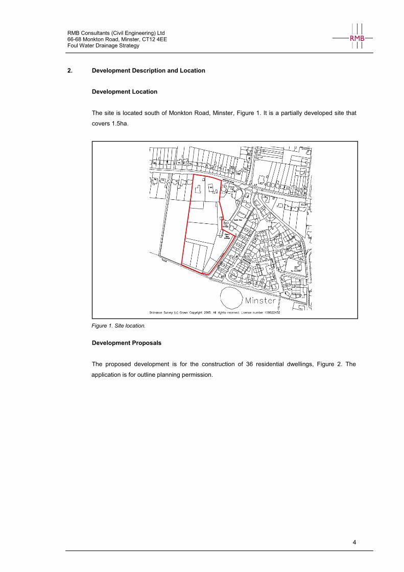
2. Development Description and Location
Development Location
The site is located south of Monkton Road, Minster, Figure 1. It is a partially developed site that
covers 1.5ha.
Figure 1. Site location.
Development Proposals
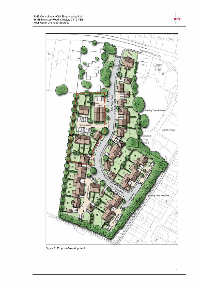
The proposed development is for the construction of 36 residential dwellings, Figure 2. The
application is for outline planning permission.
RMB Consultants (Civil Engineering) Ltd 66-68 Monkton Road, Minster, CT12 4EE Foul Water Drainage Strategy
5
Figure 2. Proposed development.
RMB Consultants (Civil Engineering) Ltd 66-68 Monkton Road, Minster, CT12 4EE Foul Water Drainage Strategy
6
3. Policy Background
Thanet District Council Strategic Flood Risk Assessment
Thanet District Council published a Strategic Flood Risk Assessment in 2009. A detailed
assessment of drainage was not undertaken as part of the SFRA. However it does states that:
In many areas, drains are designed for both surface water and foul water, and should these reach capacity
ahead of heavy rainstorms, the risk of sewage flooding can be high. The introduction of impermeable surfaces
such as roofs, roads and parking areas associated with new developments therefore have the potential to
increase surface water runoff compared with the natural undeveloped surfaces and also may reduce the
natural recharge of groundwater.
LPA’s are required to promote the application of SuDS, the preferred option in PPS25 being infiltration
techniques as opposed to discharging into watercourses. Where this is not possible, preference should be
given to the discharge of surface water into watercourses rather than foul water drains.
Draft Thanet District Council Local Plan to 2031
The following Draft Local Plan policies are relevant to foul water drainage at the site.
Policy H01– Housing Development
Permission for new housing development will be granted on:
1) sites allocated for such purposes, subject to consistency with indicative phasing,
2) non-allocated sites within the existing built up confines consisting of previously developed land,
3) residential gardens where not judged harmful to the local area in terms of the character and
amenity considerations set out in Policy QD01, and provided that all the following criteria are met:
4) The relevant area specific housing objectives set out in the housing strategy section are addressed.
5) It is demonstrated that adequate infrastructure will be in place to serve each unit ready for
occupation.
6) Satisfactory details are provided showing how any physical conditions including land stability and
contamination, affecting the site can be overcome.
7) Sufficient mitigation is provided in accordance with Policy SP25 to protect designated nature
conservation sites.
8) There is no conflict with other policies.
In determining applications for development under this policy the Council will seek to ensure that development
does not increase recreational pressure on designated nature conservation sites without sufficient mitigation.
Alternative development on sites allocated for residential development will not be permitted.
RMB Consultants (Civil Engineering) Ltd 66-68 Monkton Road, Minster, CT12 4EE Foul Water Drainage Strategy
7
4. Site Characteristics
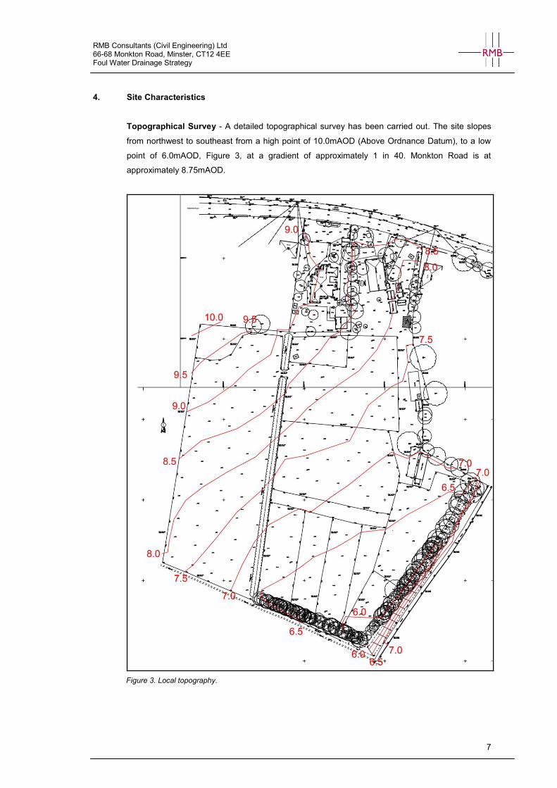
Topographical Survey - A detailed topographical survey has been carried out. The site slopes
from northwest to southeast from a high point of 10.0mAOD (Above Ordnance Datum), to a low
point of 6.0mAOD, Figure 3, at a gradient of approximately 1 in 40. Monkton Road is at
approximately 8.75mAOD.
Figure 3. Local topography.
RMB Consultants (Civil Engineering) Ltd 66-68 Monkton Road, Minster, CT12 4EE Foul Water Drainage Strategy
8
5. Foul Water Management Strategy
Existing Infrastructure
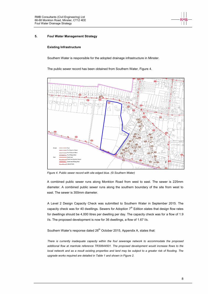
Southern Water is responsible for the adopted drainage infrastructure in Minster.
The public sewer record has been obtained from Southern Water, Figure 4.
Figure 4. Public sewer record with site edged blue. (© Southern Water)
A combined public sewer runs along Monkton Road from west to east. The sewer is 225mm
diameter. A combined public sewer runs along the southern boundary of the site from west to
east. The sewer is 300mm diameter.
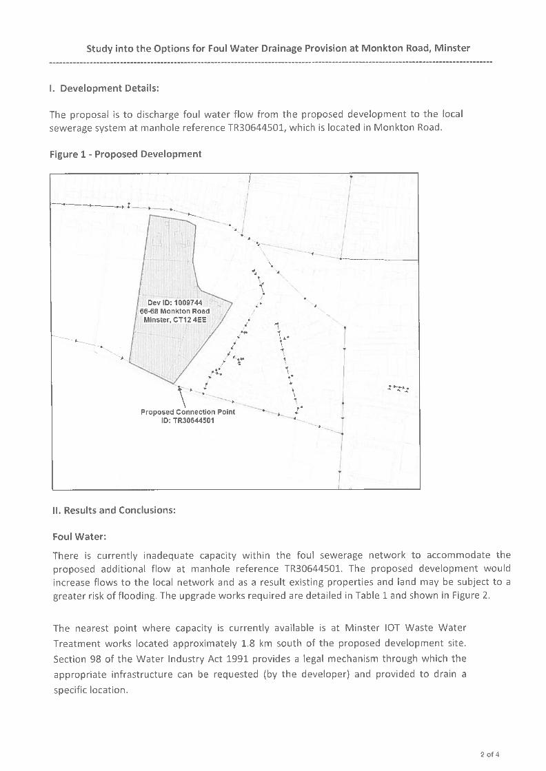
A Level 2 Design Capacity Check was submitted to Southern Water in September 2015. The
capacity check was for 40 dwellings. Sewers for Adoption 7th Edition states that design flow rates
for dwellings should be 4,000 litres per dwelling per day. The capacity check was for a flow of 1.9
l/s. The proposed development is now for 36 dwellings, a flow of 1.67 l/s.
Southern Water’s response dated 26th
October 2015, Appendix A, states that:
There is currently inadequate capacity within the foul sewerage network to accommodate the proposed
additional flow at manhole reference TR30644501. The proposed development would increase flows to the
local network and as a result existing properties and land may be subject to a greater risk of flooding. The
upgrade works required are detailed in Table 1 and shown in Figure 2.
RMB Consultants (Civil Engineering) Ltd 66-68 Monkton Road, Minster, CT12 4EE Foul Water Drainage Strategy
9
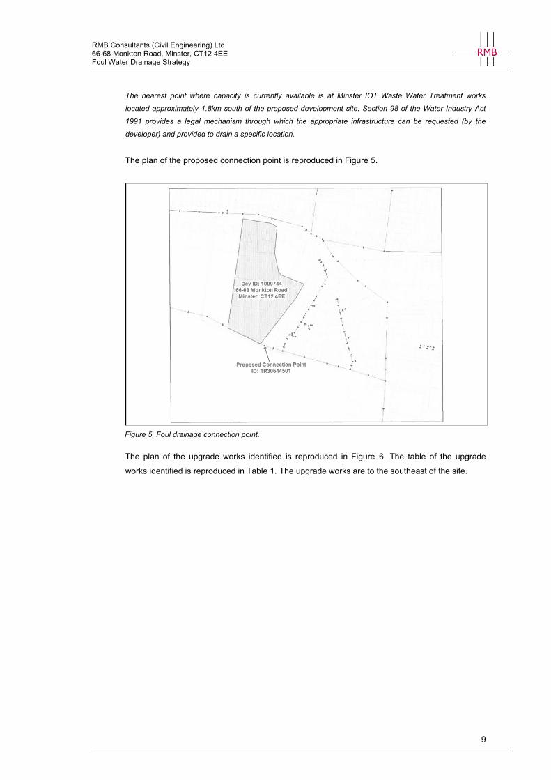
The nearest point where capacity is currently available is at Minster IOT Waste Water Treatment works
located approximately 1.8km south of the proposed development site. Section 98 of the Water Industry Act
1991 provides a legal mechanism through which the appropriate infrastructure can be requested (by the
developer) and provided to drain a specific location.
The plan of the proposed connection point is reproduced in Figure 5.
Figure 5. Foul drainage connection point.
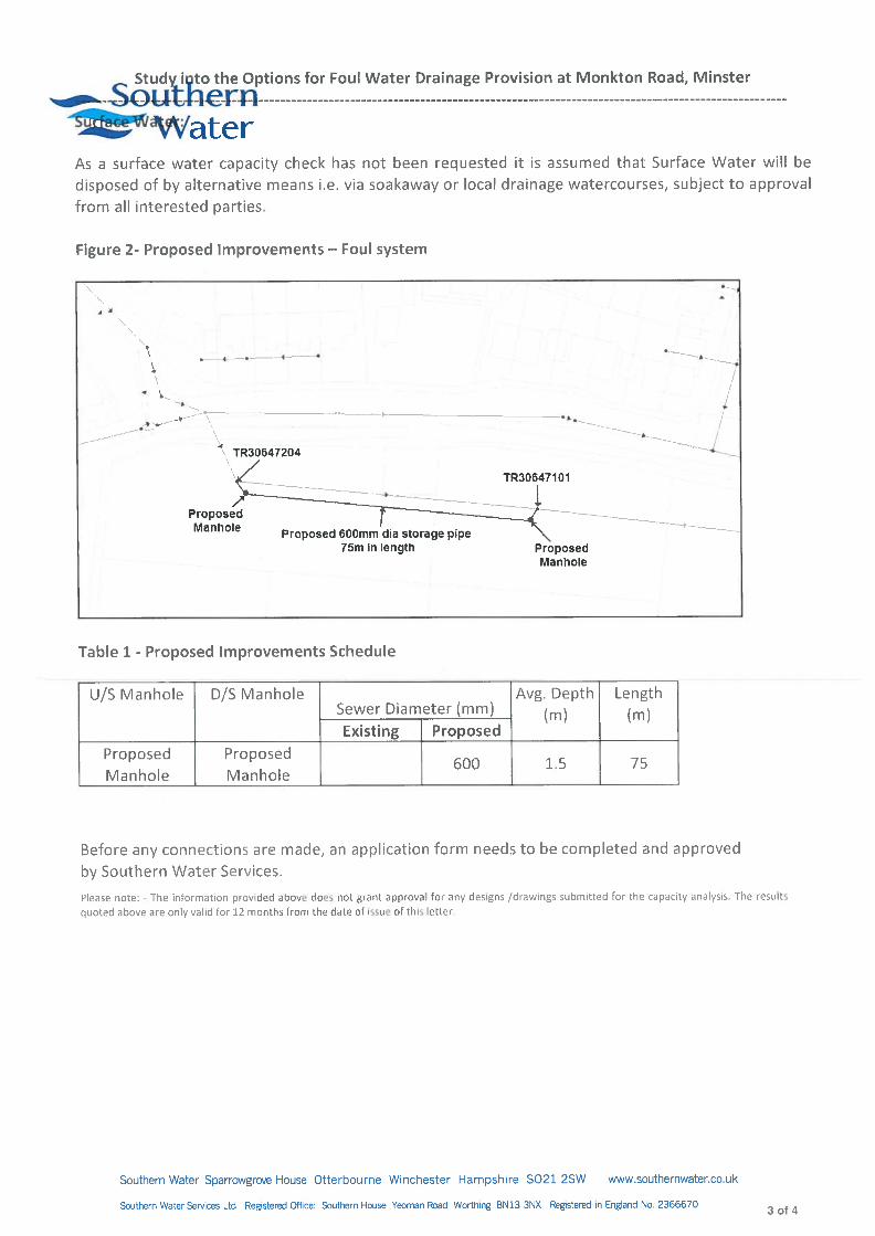
The plan of the upgrade works identified is reproduced in Figure 6. The table of the upgrade
works identified is reproduced in Table 1. The upgrade works are to the southeast of the site.
RMB Consultants (Civil Engineering) Ltd 66-68 Monkton Road, Minster, CT12 4EE Foul Water Drainage Strategy
10
Figure 6. Foul drainage network upgrades identified by Southern Water.
U/S Manhole D/S Manhole
Sewer Diameter (mm) Avg. Depth
(m) Length (m)
Existing Proposed
Proposed manhole
Proposed manhole
- 600 1.5 75
Table 1. Proposed public sewer improvements schedule.
Strategy Approach
This strategy provides a solution for the on-site foul drainage in line with Sewers for Adoption 7th
Edition.
The topography allows foul water to be drained by gravity to the southern boundary of the site.
The public combined sewer running along the southern boundary has a very shallow invert level
at 6.56mAOD. Connection to this sewer via gravity is not feasible and a pumping station is
proposed at the southern boundary. From here a pumped connection can be made to the
combined sewer at a suitable point.
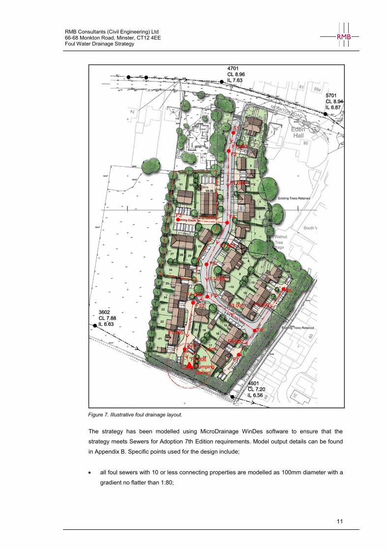
An illustrative foul drainage layout has been produced, Figure 7.
RMB Consultants (Civil Engineering) Ltd 66-68 Monkton Road, Minster, CT12 4EE Foul Water Drainage Strategy
11
Figure 7. Illustrative foul drainage layout.
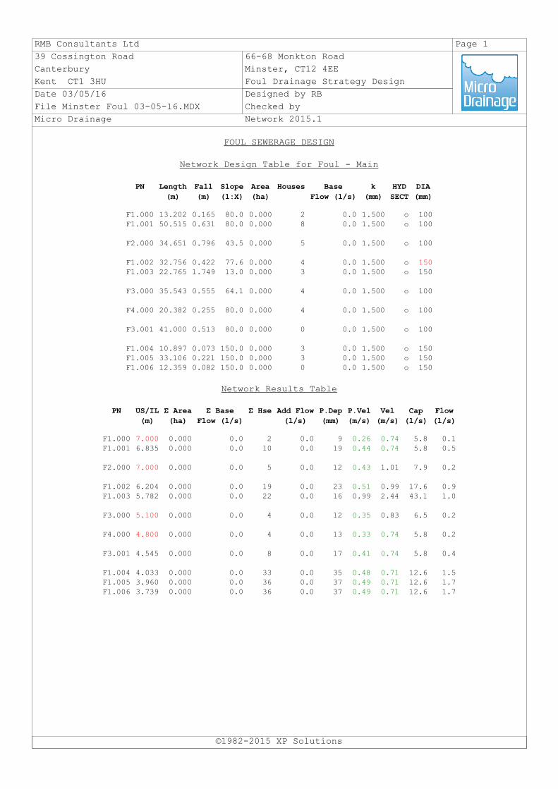
The strategy has been modelled using MicroDrainage WinDes software to ensure that the
strategy meets Sewers for Adoption 7th Edition requirements. Model output details can be found
in Appendix B. Specific points used for the design include;
all foul sewers with 10 or less connecting properties are modelled as 100mm diameter with a
gradient no flatter than 1:80;

RMB Consultants (Civil Engineering) Ltd 66-68 Monkton Road, Minster, CT12 4EE Foul Water Drainage Strategy
12
sewers with more than 10 properties connected are 150mm at a slope no flatter than 1:150;
any sewer backdrops within the strategy are no less than 1m high.
The area set aside for the pumping station is 12m x 8m with the wet well located 15m from the
nearest properties in accordance with Sewers for Adoption 7th Edition.
The modelling demonstrates that development can be served by foul drainage infrastructure.
RMB Consultants (Civil Engineering) Ltd 66-68 Monkton Road, Minster, CT12 4EE Foul Water Drainage Strategy
13
6. Conclusion
This following Foul Water Drainage Strategy accompanies a planning application submitted to
Thanet District Council. The planning application is for residential development on land at 66-68
Monkton Road, Minster, CT12 4EE.
Minster is served by public combined sewers. Combined public sewers run along Monkton Road
and along the southern boundary of the site. These drain to the east and then south to the
Minster Waste Water Treatment works located approximately 1.8km south of the site.
A capacity check has been submitted to Southern Water. The response indicates that there is
currently inadequate capacity within the local foul sewerage network to accommodate the foul
flow from the proposed development. The capacity check identifies upgrade works necessary to
provide sufficient capacity and the developer proposes to requisition foul sewers under Section
98 of the Water Industry Act 1991 to ascertain the most efficient mechanism for providing foul
sewerage infrastructure.
This strategy provides a solution for the on-site foul drainage in line with Sewers for Adoption 7th
Edition. The topography allows foul water to be drained by gravity to the southern boundary of the
site. The public combined sewer running along the southern boundary has a very shallow invert
level and connection to this sewer via gravity is not feasible. A pumping station is proposed at the
southern boundary. From here a pumped connection can be made to the combined sewer at a
suitable point.
This Strategy shows that that the development can be adequately served by foul sewers and that
sufficient capacity is available within the local network for the disposal of wastewater, providing
off-site improvement works are carried out. The proposals are considered to be acceptable from a
foul drainage perspective.
RMB Consultants (Civil Engineering) Ltd 66-68 Monkton Road, Minster, CT12 4EE Foul Water Drainage Strategy
Appendix A - Southern Water Capacity Check


RMB Consultants (Civil Engineering) Ltd 66-68 Monkton Road, Minster, CT12 4EE Foul Water Drainage Strategy
Appendix B - Draft Foul Drainage Design
RMB Consultants Ltd Page 1
39 Cossington Road 66-68 Monkton Road
Canterbury Minster, CT12 4EE
Kent CT1 3HU Foul Drainage Strategy Design
Date 03/05/16 Designed by RB
File Minster Foul 03-05-16.MDX Checked by
Micro Drainage Network 2015.1
FOUL SEWERAGE DESIGN
Network Design Table for Foul - Main
©1982-2015 XP Solutions
PN Length
(m)
Fall
(m)
Slope
(1:X)
Area
(ha)
Houses Base
Flow (l/s)
k
(mm)
HYD
SECT
DIA
(mm)
F1.000 13.202 0.165 80.0 0.000 2 0.0 1.500 o 100F1.001 50.515 0.631 80.0 0.000 8 0.0 1.500 o 100
F2.000 34.651 0.796 43.5 0.000 5 0.0 1.500 o 100
F1.002 32.756 0.422 77.6 0.000 4 0.0 1.500 o 150F1.003 22.765 1.749 13.0 0.000 3 0.0 1.500 o 150
F3.000 35.543 0.555 64.1 0.000 4 0.0 1.500 o 100
F4.000 20.382 0.255 80.0 0.000 4 0.0 1.500 o 100
F3.001 41.000 0.513 80.0 0.000 0 0.0 1.500 o 100
F1.004 10.897 0.073 150.0 0.000 3 0.0 1.500 o 150F1.005 33.106 0.221 150.0 0.000 3 0.0 1.500 o 150F1.006 12.359 0.082 150.0 0.000 0 0.0 1.500 o 150
Network Results Table
PN US/IL
(m)
Σ Area
(ha)
Σ Base
Flow (l/s)
Σ Hse Add Flow
(l/s)
P.Dep
(mm)
P.Vel
(m/s)
Vel
(m/s)
Cap
(l/s)
Flow
(l/s)
F1.000 7.000 0.000 0.0 2 0.0 9 0.26 0.74 5.8 0.1F1.001 6.835 0.000 0.0 10 0.0 19 0.44 0.74 5.8 0.5
F2.000 7.000 0.000 0.0 5 0.0 12 0.43 1.01 7.9 0.2
F1.002 6.204 0.000 0.0 19 0.0 23 0.51 0.99 17.6 0.9F1.003 5.782 0.000 0.0 22 0.0 16 0.99 2.44 43.1 1.0
F3.000 5.100 0.000 0.0 4 0.0 12 0.35 0.83 6.5 0.2
F4.000 4.800 0.000 0.0 4 0.0 13 0.33 0.74 5.8 0.2
F3.001 4.545 0.000 0.0 8 0.0 17 0.41 0.74 5.8 0.4
F1.004 4.033 0.000 0.0 33 0.0 35 0.48 0.71 12.6 1.5F1.005 3.960 0.000 0.0 36 0.0 37 0.49 0.71 12.6 1.7F1.006 3.739 0.000 0.0 36 0.0 37 0.49 0.71 12.6 1.7
RMB Consultants Ltd Page 2
39 Cossington Road 66-68 Monkton Road
Canterbury Minster, CT12 4EE
Kent CT1 3HU Foul Drainage Strategy Design
Date 03/05/16 Designed by RB
File Minster Foul 03-05-16.MDX Checked by
Micro Drainage Network 2015.1
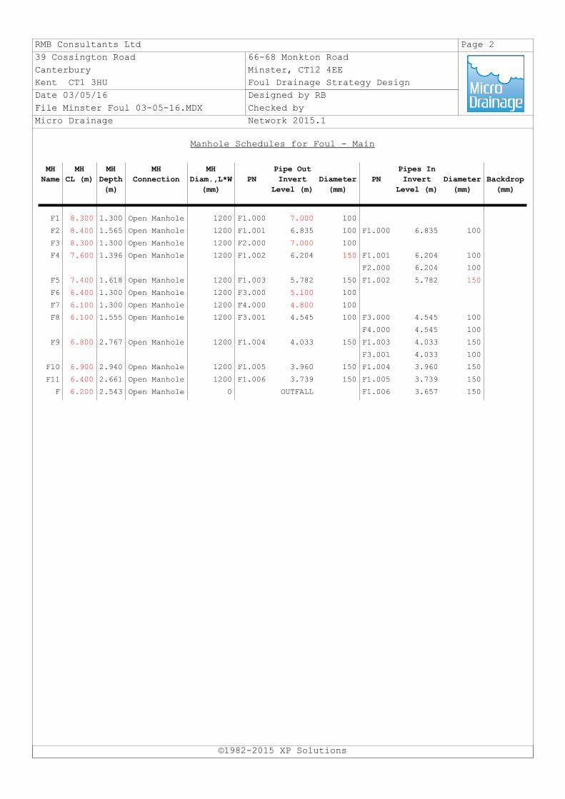
Manhole Schedules for Foul - Main
©1982-2015 XP Solutions
MH
Name
MH
CL (m)
MH
Depth
(m)
MH
Connection
MH
Diam.,L*W
(mm)
PN
Pipe Out
Invert
Level (m)
Diameter
(mm)
PN
Pipes In
Invert
Level (m)
Diameter
(mm)
Backdrop
(mm)
F1 8.300 1.300 Open Manhole 1200 F1.000 7.000 100
F2 8.400 1.565 Open Manhole 1200 F1.001 6.835 100 F1.000 6.835 100
F3 8.300 1.300 Open Manhole 1200 F2.000 7.000 100
F4 7.600 1.396 Open Manhole 1200 F1.002 6.204 150 F1.001 6.204 100
F2.000 6.204 100
F5 7.400 1.618 Open Manhole 1200 F1.003 5.782 150 F1.002 5.782 150
F6 6.400 1.300 Open Manhole 1200 F3.000 5.100 100
F7 6.100 1.300 Open Manhole 1200 F4.000 4.800 100
F8 6.100 1.555 Open Manhole 1200 F3.001 4.545 100 F3.000 4.545 100
F4.000 4.545 100
F9 6.800 2.767 Open Manhole 1200 F1.004 4.033 150 F1.003 4.033 150
F3.001 4.033 100
F10 6.900 2.940 Open Manhole 1200 F1.005 3.960 150 F1.004 3.960 150
F11 6.400 2.661 Open Manhole 1200 F1.006 3.739 150 F1.005 3.739 150
F 6.200 2.543 Open Manhole 0 OUTFALL F1.006 3.657 150
RMB Consultants Ltd Page 3
39 Cossington Road 66-68 Monkton Road
Canterbury Minster, CT12 4EE
Kent CT1 3HU Foul Drainage Strategy Design
Date 03/05/16 Designed by RB
File Minster Foul 03-05-16.MDX Checked by
Micro Drainage Network 2015.1
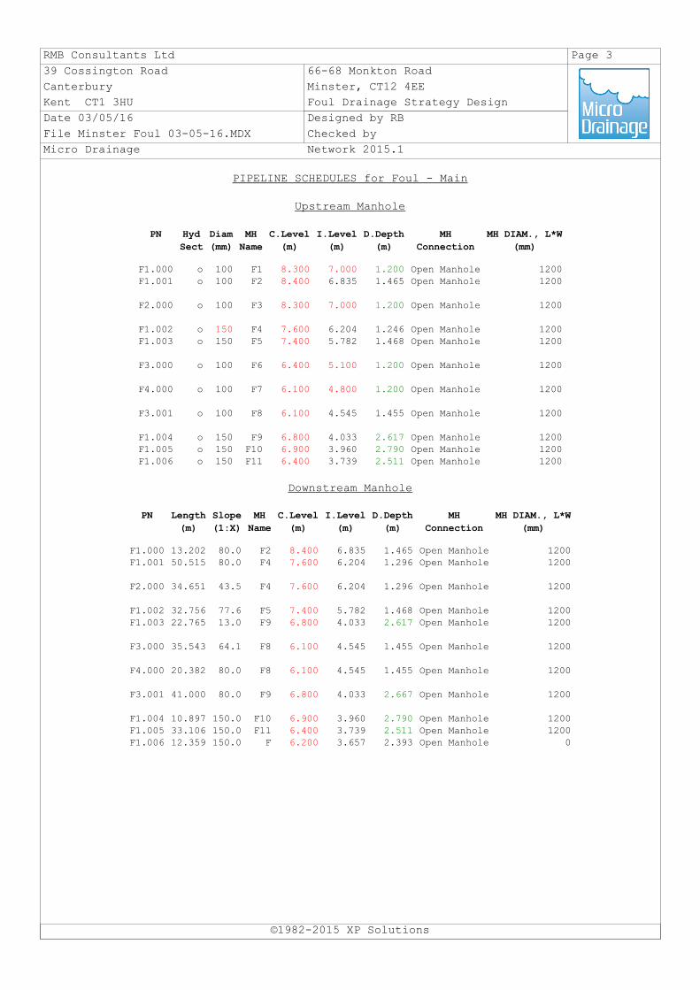
PIPELINE SCHEDULES for Foul - Main
Upstream Manhole
©1982-2015 XP Solutions
PN Hyd
Sect
Diam
(mm)
MH
Name
C.Level
(m)
I.Level
(m)
D.Depth
(m)
MH
Connection
MH DIAM., L*W
(mm)
F1.000 o 100 F1 8.300 7.000 1.200 Open Manhole 1200F1.001 o 100 F2 8.400 6.835 1.465 Open Manhole 1200
F2.000 o 100 F3 8.300 7.000 1.200 Open Manhole 1200
F1.002 o 150 F4 7.600 6.204 1.246 Open Manhole 1200F1.003 o 150 F5 7.400 5.782 1.468 Open Manhole 1200
F3.000 o 100 F6 6.400 5.100 1.200 Open Manhole 1200
F4.000 o 100 F7 6.100 4.800 1.200 Open Manhole 1200
F3.001 o 100 F8 6.100 4.545 1.455 Open Manhole 1200
F1.004 o 150 F9 6.800 4.033 2.617 Open Manhole 1200F1.005 o 150 F10 6.900 3.960 2.790 Open Manhole 1200F1.006 o 150 F11 6.400 3.739 2.511 Open Manhole 1200
Downstream Manhole
PN Length
(m)
Slope
(1:X)
MH
Name
C.Level
(m)
I.Level
(m)
D.Depth
(m)
MH
Connection
MH DIAM., L*W
(mm)
F1.000 13.202 80.0 F2 8.400 6.835 1.465 Open Manhole 1200F1.001 50.515 80.0 F4 7.600 6.204 1.296 Open Manhole 1200
F2.000 34.651 43.5 F4 7.600 6.204 1.296 Open Manhole 1200
F1.002 32.756 77.6 F5 7.400 5.782 1.468 Open Manhole 1200F1.003 22.765 13.0 F9 6.800 4.033 2.617 Open Manhole 1200
F3.000 35.543 64.1 F8 6.100 4.545 1.455 Open Manhole 1200
F4.000 20.382 80.0 F8 6.100 4.545 1.455 Open Manhole 1200
F3.001 41.000 80.0 F9 6.800 4.033 2.667 Open Manhole 1200
F1.004 10.897 150.0 F10 6.900 3.960 2.790 Open Manhole 1200F1.005 33.106 150.0 F11 6.400 3.739 2.511 Open Manhole 1200F1.006 12.359 150.0 F 6.200 3.657 2.393 Open Manhole 0