format, font and styling - brisbanedocs.brisbane.qld.gov.au/city plan/v09_00_20180216/text... ·...
TRANSCRIPT
7.2.1.1 Acacia Ridge—Archerfield neighbourhood plan code
7.2.1.1.1 Application
(1) This code applies to assessing a material change of use, reconfiguring a lot, operational work or building work in the Acacia Ridge—Archerfield neighbourhood plan area if:
(a) assessable development where this code is an applicable code identified in the assessment benchmarks column of a table of assessment for a neighbourhood plan (section 5.9); or
(b) impact assessable development.
(2) Land in the Acacia Ridge—Archerfield neighbourhood plan area is identified on the NPM-001.1 Acacia Ridge—Archerfield neighbourhood plan map and includes the following precincts:
(a) Archerfield Airport precinct (Acacia Ridge—Archerfield neighbourhood plan/NPP-001);
(b) Archerfield north (Granard Road) and Archerfield east (Desgrand Street) precinct (Acacia Ridge—Archerfield neighbourhood plan/NPP-002);
(c) Jackson Road precinct (Acacia Ridge—Archerfield neighbourhood plan/NPP-003);
(d) Elizabeth Street residential precinct (Acacia Ridge—Archerfield neighbourhood plan/NPP-004);
(e) Hellawell Road residential precinct (Acacia Ridge—Archerfield neighbourhood plan/NPP-005);
(f) Coopers Plains residential precinct (Acacia Ridge—Archerfield neighbourhood plan/NPP-006);
(g) Beaudesert Road centre precinct (Acacia Ridge—Archerfield neighbourhood plan/NPP-007):
(i) Beaudesert Road centre south - Elizabeth Street sub-precinct (Acacia Ridge—Archerfield neighbourhood plan/NPP-007a);
(ii) Beaudesert Road centre north - O’Connel Street sub-precinct (Acacia Ridge—Archerfield neighbourhood plan/NPP-007b).
(h) Postle Street precinct (Acacia Ridge—Archerfield neighbourhood plan/NPP-008):
(i) Mixed light industry and centre activities sub-precinct (Acacia Ridge—Archerfield neighbourhood plan/NPP-008a);
(ii) District centre sub-precinct (Acacia Ridge—Archerfield neighbourhood plan/NPP-008b);
(iii) Residential uses sub-precinct (Acacia Ridge—Archerfield neighbourhood plan NPP-008c).
(i) Coopers Plains centre/office and industry precinct (Acacia Ridge—Archerfield neighbourhood plan/NPP-009);
Part 7 – Neighbourhood Plans (Acacia Ridge–Archerfield) Effective 1 December 2017

(j) Queensland Government strategic sites (QGSS) precinct (Acacia Ridge—Archerfield neighbourhood plan/NPP-010):
(i) Intermodal freight terminal sub-precinct (Acacia Ridge—Archerfield neighbourhood plan/NPP-010a);
(ii) Postle Street logistics sub-precinct (Acacia Ridge—Archerfield neighbourhood plan/NPP-010b);
(iii) Technical and trades training sub-precinct (Acacia Ridge—Archerfield neighbourhood plan/NPP-010c).
(k) Gateway industry/business precinct (Acacia Ridge—Archerfield neighbourhood plan/NPP-011).
(3) When using this code, reference should be made to section 1.5, section 5.3.2 and section 5.3.3.
Note—The following purpose, overall outcomes, performance outcomes and acceptable outcomes comprise the assessment benchmarks of this code.
Note—This neighbourhood plan includes a table of assessment with variations to categories of development and assessment. Refer to Table 5.9.1.A, Table 5.9.1.B, Table 5.9.1.C and Table 5.9.1.D.
7.2.1.1.2 Purpose
(1) The purpose of the Acacia Ridge—Archerfield neighbourhood plan code is to provide finer grained planning at a local level for the Acacia Ridge—Archerfield neighbourhood plan area.
(2) The purpose of the Acacia Ridge—Archerfield neighbourhood plan code will be achieved through overall outcomes including overall outcomes for each precinct of the neighbourhood plan area.
(3) The overall outcomes for the neighbourhood plan area are:
(a) The neighbourhood plan area continues to provide a broad range of industrial and transport employment within the region.
(b) Housing choice and diversity is improved in well-located and serviced locations.
(c) Land subject to development constraints or character or environmental values indicated in a figure in this neighbourhood plan code or shown in an overlay map is protected from inappropriate development in order to maintain its character, natural and environmental significance.
(d) Open space, parks and recreational facilities meet the needs of the community and are located in accessible locations that are well connected within the neighbourhood plan area.
(e) Businesses and services that support industry are located as either ancillary office uses in established industry areas or identified centre precincts.
(f) District centres identified in this neighbourhood plan will serve the retail, commercial, community and service needs of the local community.
Part 7 – Neighbourhood Plans (Acacia Ridge–Archerfield) Effective 1 December 2017
(g) Development in residential areas provides housing choice and accessible accommodation options.
(h) Development that seeks to increase residential density such as multiple dwellings or small lot subdivision close to existing industrial areas must incorporate measures to protect future residents from the impacts of the industry and protect existing adjacent industry from incompatible land uses.
(i) Archerfield Airport provides a focus for light aircraft and commercial aircraft activities.
(j) Development is of a height, scale and form which is consistent with the amenity and character, community expectations, and infrastructure assumptions intended for the relevant precinct, sub-precinct or site and is only developed at a greater height, scale and form where there is both a community need and an economic need for the development.
(4) Archerfield Airport precinct (Acacia Ridge—Archerfield neighbourhood plan/NPP-001) overall outcomes are:
(a) Industrial development that has a nexus with and supports the function of the airport and surrounding industrial/transport services corridor is consistent with the outcomes sought.
(b) Although the airport is regulated by federal legislation, the Archerfield Airport Corporation is encouraged to address the following in any redevelopment of the Archerfield Airport:
(i) appropriate road layout, vehicular access and manoeuvring;
(ii) adequate car parking;
(iii) appropriate building heights and setbacks;
(iv) landscape and acoustic buffering to residential land south of Mortimer Road;
(v) protection of habitat areas, wetlands and ecological and waterway corridors of the Oxley Creek catchment;
(vi) access to public transport;
(vii) protection of buildings of heritage significance such as the God’s Acre Cemetery, Archerfield Airport Administration Building and noted hangars.
(5) Archerfield north (Granard Road) and Archerfield east (Desgrand Street) precinct (Acacia Ridge—Archerfield neighbourhood plan/NPP-002) overall outcomes are:
(a) Dwelling houses are the preferred form of residential development in this precinct, particularly south of Granard Road.
(b) Industrial uses are not supported unless a defined amalgamation of land within these precincts can be achieved through an approved structure plan in accordance with the sequencing strategy identified in Figure a and Figure b and development does not result in isolated groups of residential lots.
Part 7 – Neighbourhood Plans (Acacia Ridge–Archerfield) Effective 1 December 2017

(c) Any transition from residential to industrial activities is in an orderly manner and does not compromise residential amenity.
(d) Multiple dwellings, childcare centres, educational establishments and health care services are not supported in this precinct.
(e) Industrial activities adjoining residential areas continue to minimise their impacts in terms of air quality, noise, traffic, car parking, hours of external site operations and visual intrusion.
(6) Jackson Road precinct (Acacia Ridge—Archerfield neighbourhood plan/NPP-003) overall outcomes are:
(a) Redevelopment is to be for education or other public benefit purposes.
(b) Redevelopment is to ensure the following:
(i) development footprints are to be minimised to retain endangered vegetation such as the Melaleuca quinquenervia open forest vegetation community;
(ii) a vegetated link between the two parkland areas is retained;
(iii) retention of the substantial vegetated buffer for the established residential area on Jackson Road to the adjoining industrial sites to the west.
(7) Elizabeth Street residential precinct (Acacia Ridge—Archerfield neighbourhood plan/NPP-004) overall outcome is:
(a) Community uses located in Mitchell Street between Elizabeth and Amherst streets where either facing or adjoining the existing centre are accommodated where impacts on residents can be managed.
(8) Hellawell Road residential precinct (Acacia Ridge—Archerfield neighbourhood plan/NPP-005) overall outcomes are:
(a) Development of the remaining Emerging community zone land is to be for low density residential uses.
(b) Development is to ensure the following:
(i) safe pedestrian and cycle access to the Neighbourhood centre and bus stops;
(ii) no direct access from new lots onto either Jackson or Hellawell roads;
(iii) achieving a permeable and integrated road network that provides connectivity for vehicles, pedestrians and cyclists from Jayef Street to Kingman Crescent and Haseler Crescent;
(iv) retention of significant vegetation.
(9) Coopers Plains residential precinct (Acacia Ridge—Archerfield neighbourhood plan/NPP-006) overall outcomes are:
(a) Any expansion of the existing area of local shops on Troughton Road is not consistent with the outcomes sought.
Part 7 – Neighbourhood Plans (Acacia Ridge–Archerfield) Effective 1 December 2017
(b) The access plan identified in Figure d outlines the preferred road hierarchy, priority intersections, specialised road treatments and pedestrian connections for development in this precinct.
(10) Beaudesert Road centre precinct (Acacia Ridge—Archerfield neighbourhood plan/NPP-007) overall outcomes are:
(a) Redevelopment in this precinct provides footpath improvements to achieve safe and well-connected pedestrian and cycle access, with shade ways in each centre and to adjoining areas.
(b) The centre located south and north of Beaudesert Road is the primary services and retail facilities hub for local residents and surrounding businesses.
(c) Development in the Beaudesert Road centre south—Elizabeth Street sub-precinct (Acacia Ridge—Archerfield neighbourhood plan/NPP-007a):
(i) achieves an active frontage along Mitchell Street to improve the centre’s interface and access to surrounding residential areas;
(ii) results in a safe pedestrian environment that provides good access to public transport and community facilities in C.A. O’Sullivan Park;
(iii) provides quality landscaping (including deep planting beds) and amenity improvements;
(iv) for residential development within the centre is supported provided that noise impacts from Beaudesert Road and the railway corridor are adequately mitigated and that quality building design and open space outcomes are maintained;
(v) along the southern boundary of the precinct complements the scale of neighbouring residential development;
(vi) provides a mix of shops and offices to achieve an active streetscape;
(vii) on Mitchell Street between Elizabeth Street and Chardean Street provides:
(A) a pedestrian link/cycle path along Mitchell Street between Elizabeth Street and Chardean Street;
(B) active frontages abutting the pedestrian link/cycle path along Mitchell Street, Elizabeth Street and Chardean Street to ensure casual surveillance;
(C) vehicular access to either Chardean Street or Mitchell Street with no access from Beaudesert Road.
(d) Development in the Beaudesert Road centre north - O’Connel Street sub-precinct (Acacia Ridge—Archerfield neighbourhood plan/NPP-007b):
(i) on the northern side of Beaudesert Road is to provide a mix of shops and short-term accommodation to cater for the local business, industry and the technical and trades training facility;
(ii) for public transport is to provide access to the suburban district centre and the technical and trades training facility.
Part 7 – Neighbourhood Plans (Acacia Ridge–Archerfield) Effective 1 December 2017
(11) Postle Street precinct (Acacia Ridge—Archerfield neighbourhood plan/NPP-008) overall outcomes are:
(a) Development must consolidate the sub-precincts (refer to Figure e) to minimise conflicts between uses.
(b) Development in the Mixed light industry and centre activities sub-precinct (Acacia Ridge—Archerfield neighbourhood plan/NPP-008a):
(i) provides low impact industry and office uses that support local industry and business;
(ii) of lots fronting Postle Street shown in Figure e is to have shared access to Postle Street only;
(iii) presents an attractive building and landscape appearance to Beaudesert Road and Postle Street;
(iv) direct access to Beaudesert Road from this sub-precinct is not consistent with the overall outcomes.
(c) Development in the District centre sub-precinct (Acacia Ridge—Archerfield neighbourhood plan/NPP-008b):
(i) residential uses in the centre are not supported due to the proximity of established industrial uses;
(ii) for redevelopment achieves the following:
(A) pedestrian and cycle access through the centre connecting Beaudesert Road to Postle Street;
(B) active uses abutting the pedestrian and cycle link to maximise surveillance of the path;
(C) safe on-site traffic and pedestrian movement system including catering for mobility impaired customers;
(D) safe access and linkages to public transport stops;
(E) building form/s that have active frontages to both Beaudesert Road and Postle Street;
(F) subtropical design and landscaping including shade ways and deep planting beds;
(G) buffering to adjoining residential uses.
(d) Development in the Residential uses sub-precinct (Acacia Ridge—Archerfield neighbourhood plan/NPP-008c):
(i) multiple dwellings including short-term accommodation are supported where in a zone in the Residential zones category, to increase accommodation choice for transport-related business workers and students who attend the nearby SkillsTech Australia campus;
(ii) for residential development achieves the following:
Part 7 – Neighbourhood Plans (Acacia Ridge–Archerfield) Effective 1 December 2017

(A) minimises vehicular access to Beaudesert Road;
(B) is designed and constructed to manage air quality to internal spaces and reduce noise amenity impacts from Beaudesert Road;
(C) presents an attractive building and landscape appearance to Beaudesert Road and the rail corridor.
(12) Coopers Plains centre/office and industry precinct (Acacia Ridge—Archerfield neighbourhood plan/NPP-009) overall outcomes are:
(a) Development provides a range of services to local businesses and employees.
(b) Land in the Low impact industry zone or General industry A zone precinct of the Industry zone is to develop as a mixed office and low impact industry area capitalising on its location near the railway station.
(c) Office uses are supported adjacent to the neighbourhood centre, centre activities other than office are not supported.
(d) Residential development, short-term accommodation and childcare centres are not supported in the neighbourhood centre due to its proximity to the industrial area.
(e) The design of future road/rail infrastructure works (which may include grade separation) maintains accessibility to this centre from Boundary Road.
(13) Queensland Government strategic sites (QGSS) precinct (Acacia Ridge—Archerfield neighbourhood plan/NPP-010) overall outcomes are:
(a) Activities and site design integrate with surrounding development, particularly with existing centres and public transport nodes.
Note—There are three significant Queensland Government project areas within this precinct known as the Intermodal Freight Terminal, Postle Street Logistics area and the Technical and Trades Training (SkillsTech) Campus as identified on NPM-001.1 Acacia Ridge—Archerfield neighbourhood plan map.
(b) Development in the Intermodal freight terminal sub-precinct (Acacia Ridge—Archerfield neighbourhood plan/NPP-010a):
(i) of the Intermodal Freight Terminal addresses impacts on industrial and residential areas, including:
(A) vehicle access impacts on Beaudesert Road and the local road network;
(B) future expansion of the passenger rail network;
(C) pedestrian access from the technical and trades facility to transport, retail and service facilities in the Beaudesert Road centre;
(D) noise and air quality impacts;
(E) stormwater quality and quantity management;
(F) flammable and hazardous goods management.
Part 7 – Neighbourhood Plans (Acacia Ridge–Archerfield) Effective 1 December 2017

(c) Development in the Postle Street logistics sub-precinct (Acacia Ridge—Archerfield neighbourhood plan/NPP-010b):
(i) the Postle Street logistics area develops as an extension to the Intermodal Freight Terminal as an industry/warehousing precinct;
(ii) does not adversely affect amenity or increase the level of hazards to the established community, especially residential properties along Scouse Street and the Postle Street centre;
(iii) provides a high-quality landscape and acoustic buffer along the southern boundary of the Postle Street logistics area to mitigate impacts on existing residential properties in Scouse Street (refer Figure c and Figure d in the Industry code);
(iv) ensures all car parking generated from uses in the sub-precinct be accommodated on site and not intrude into neighbouring residential and industrial areas;
(v) ensures freight traffic accesses the site from Kerry Road with no provision of freight access movements from either Postle Street or Scouse Street;
(vi) provides an active frontage and pedestrian access along Postle Street.
(d) Development in the Technical and trades training sub-precinct (Acacia Ridge—Archerfield neighbourhood plan/NPP-010c):
(i) provides a safe and identifiable public pedestrian and cycle thoroughfare from the Elizabeth Street centre through to Bradman Street;
(ii) supports safe pedestrian and cycle routes to Banoon Station;
(iii) supports efficient public transport routes to railway stations and the existing centres;
(iv) accommodates private transport parking on site and does not result in on-street parking in industrial and residential streets;
(v) includes any ancillary activities to support the needs of students and staff, such as small-scale offices, shops and food and drink outlets.
(14) Gateway industry/business precinct (Acacia Ridge—Archerfield neighbourhood plan/NPP-011) overall outcomes are:
(a) Development of a combined industrial–business service precinct for the Acacia Ridge—Archerfield and surrounding industrial areas is supported in accordance with the gross floor area provisions in Figure f.
(b) Office activities are only supported where they are ancillary to industry.
(c) Vehicular access to this precinct from Beaudesert Road is not supported.
(d) The precinct is not intended for residential uses or to service the needs of residents in surrounding localities.
(e) Centre activities that primarily support residential uses outside this precinct are not consistent with the outcomes sought.
Part 7 – Neighbourhood Plans (Acacia Ridge–Archerfield) Effective 1 December 2017
7.2.1.1.3 Performance outcomes and acceptable outcomes
Table 7.2.1.1.3.A— Performance outcomes and acceptable outcomesPerformance outcomes Acceptable outcomes
General
PO1Development is of a height, scale and form that achieves the intended outcome for the precinct, improves the amenity of the neighbourhood plan area, contributes to a cohesive streetscape and built form character and is:
(a) consistent with the anticipated density and assumed infrastructure demand;
(b) aligned to community expectations about the number of storeys to be built;
(c) proportionate to and commensurate with the utility of the site area and frontage width;
(d) designed to avoid a significant and undue adverse amenity impact to adjoining development;
(e) sited to enable existing and future buildings to be well separated from each other and to avoid affecting the potential development of adjoining sites.
Note—Development that exceeds the intended number of storeys or building height can place disproportionate pressure on the transport network, public space or community facilities in particular.
Note—Development that is over-scaled for its site can result in an undesirable dominance of vehicle access, parking and manoeuvring areas that significantly reduce streetscape character and amenity.
AO1Development complies with the number of storeys and building height in Table 7.2.1.1.3.B.
Note—Neighbourhood plans will mostly specify maximum number of storeys where zone outcomes have been varied in relation to building height. Some neighbourhood plans may also specify height in metres. Development must comply with both parameters where maximum number of storeys and height in metres is specified.
If in the Jackson Road precinct (Acacia Ridge—Archerfield neighbourhood plan/NPP-003)
PO2Development provides for community activity purposes which must be designed to maintain a visual and acoustic buffer to the adjoining industrial uses.
AO2Development provides a 2m high acoustic fence along the boundary with industrial land.
If in the Hellawell Road residential precinct (Acacia Ridge—Archerfield neighbourhood plan/NPP-005)
PO3Development must:
(a) integrate with the adjoining road
AO3Development is consistent with Figure c.
Part 7 – Neighbourhood Plans (Acacia Ridge–Archerfield) Effective 1 December 2017

network;
(b) provide a permeable vehicular and pedestrian network connecting Jayef Street to Kingman Crescent and Haseler Crescent;
(c) provide safe vehicular lot access;
(d) minimise impacts by limiting direct vehicular access from lots to Jackson Road or Hellawell Road.
If in the Beaudesert Road centre precinct (Acacia Ridge—Archerfield neighbourhood plan/NPP-007), where in the Beaudesert Road centre south - Elizabeth Street sub-precinct (Acacia Ridge—Archerfield neighbourhood plan/NPP-007a)
PO4Development provides for:
(a) continuity and connectivity of streetscape with high-quality pedestrian paths on street frontages that promote integration with the surrounding area and the rest of the centre;
(b) a safe high-quality pedestrian environment along Mitchell Street, Beaudesert Road, Elizabeth Street and Chardean Street;
(c) an active building frontage along Mitchell Street, Elizabeth Street and Chardean Street.
AO4No acceptable outcome is prescribed.
PO5Development is of a building scale and bulk which is consistent with buildings in the locality.
AO5Development has a maximum plot ratio of 125% of the site area.
If in the Beaudesert Road centre precinct (Acacia Ridge—Archerfield neighbourhood plan/NPP-007), where in the Beaudesert Road centre north - O’Connel Street sub-precinct (Acacia Ridge—Archerfield neighbourhood plan/NPP-007b)
PO6Development must establish:
(a) a safe, high-quality pedestrian path on Beaudesert Road;
(b) an active frontage along Beaudesert Road.
Note—If public access is established to the Technical and trades training sub-precinct via the railway corridor and local roads, safe, high-quality pedestrian links are required.
AO6No acceptable outcome is prescribed.
If in the Coopers Plains centre/office and industry precinct (Acacia Ridge—Archerfield neighbourhood plan/NPP-009)
PO7 AO7.1
Part 7 – Neighbourhood Plans (Acacia Ridge–Archerfield) Effective 1 December 2017
Development of the shopping centre at the corner of Henley Street and Boundary Road complements the architectural style and character of the area in terms of building form, scale, materials (‘timber and tin’) and signage.
Development along Henley Street is built to the front boundary.
AO7.2Development incorporates:
(a) parapets above footpath awnings;
(b) awnings over the footpath along the length of the frontage;
(c) glazing design to include a 600–800mm painted wall panel at the lowest part of the ground level streetscape elevation.
AO7.3Development has external building materials including:
(a) painted masonry or timber materials to all wall surfaces;
(b) custom-orb profile metal sheeting for the roof.
AO7.4Development has parking which is provided at the rear of the site to minimise visual impact from the driveway entries, parking and servicing areas.
AO7.5Development involving future road infrastructure works must maintain accessibility to this centre from Boundary Road.
If in the Archerfield north (Granard Road) and Archerfield east (Desgrand Street) precinct (Acacia Ridge—Archerfield neighbourhood plan/NPP-002)
PO8Development for industry uses:
(a) does not occur in a residential area nor result in the fragmentation and isolation of a residential area;
(b) ensures that it can protect residential amenity;
(c) must not result in an area of isolated residential use within the precinct, as residential amenity is likely to be compromised.
AO8.1Development is only to occur as a result of whole amalgamated site areas being developed in their entirety as shown in Figure a and Figure b.
AO8.2Development for industrial uses can only occur in the Archerfield north (Granard Road) precinct, site area B (as identified in Figure a) and is only suitable for industrial development once site areas A or C are developed.
AO8.3Development for industrial uses that adjoin residential uses provides a buffer that includes 5m of landscaping fronting the separating road between the two sites and
Part 7 – Neighbourhood Plans (Acacia Ridge–Archerfield) Effective 1 December 2017

an acoustic fence behind the landscaping.
Note—Once the adjoining site is developed for industrial uses (i.e. no longer residential), the buffer can be removed and used for industrial purposes.
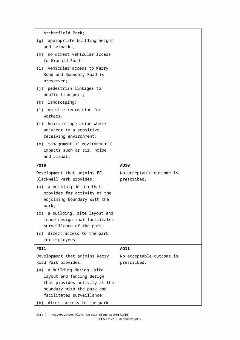
PO9Development of sites for industrial uses requires a structure plan to be prepared over the whole precinct (site areas A, B and C as identified in Figure a and Figure b) that demonstrates management of the following aspects:
(a) significant visual and acoustic buffering to residential uses in the adjoining sites;
(b) on-site car parking;
(c) vehicular access;
(d) traffic management to minimise impacts of adjoining residential sites;
(e) on-site manoeuvring for heavy vehicles;
(f) visual and physical connections to EC Blackwell Park and Archerfield Park;
(g) appropriate building height and setbacks;
(h) no direct vehicular access to Granard Road;
(i) vehicular access to Kerry Road and Boundary Road is preserved;
(j) pedestrian linkages to public transport;
(k) landscaping;
(l) on-site recreation for workers;
(m) hours of operation where adjacent to a sensitive receiving environment;
(n) management of environmental impacts such as air, noise and visual.
AO9No acceptable outcome is prescribed.
PO10Development that adjoins EC Blackwell Park provides:
(a) a building design that provides for activity at the adjoining boundary with the park;
(b) a building, site layout and fence design that facilitates surveillance of the park;
(c) direct access to the park for employees.
AO10No acceptable outcome is prescribed.
PO11Development that adjoins Kerry Road Park provides:
(a) a building design, site layout and
AO11No acceptable outcome is prescribed.
Part 7 – Neighbourhood Plans (Acacia Ridge–Archerfield) Effective 1 December 2017

fencing design that provides activity at the boundary with the park and facilitates surveillance;
(b) direct access to the park for employees.
Table 7.2.1.1.3.B—Maximum building heightDevelopment Building height
(number of storeys)Building height (m)
If in the Beaudesert Road centre precinct (Acacia Ridge—Archerfield neighbourhood plan/NPP-007)
Development of a site in the Beaudesert Road centre south - Elizabeth Street sub-precinct (Acacia Ridge—Archerfield neighbourhood plan/NPP-007a)
3 10.5
If in the Postle Street precinct (Acacia Ridge—Archerfield neighbourhood plan/NPP-008)
Development of a site in the District centre sub-precinct (Acacia Ridge—Archerfield neighbourhood plan/NPP-008b) where within 10m of the boundary adjoining the Residential uses sub-precinct (Acacia Ridge—Archerfield neighbourhood plan NPP-008c)
2 9.5
Part 7 – Neighbourhood Plans (Acacia Ridge–Archerfield) Effective 1 December 2017

View the high resolution of Figure a–Granard Road area (PDF file size is 102Kb)
Part 7 – Neighbourhood Plans (Acacia Ridge–Archerfield) Effective 1 December 2017
View the high resolution of Figure b–Desgrand Street area (PDF file size is 75Kb)
Part 7 – Neighbourhood Plans (Acacia Ridge–Archerfield) Effective 1 December 2017
View the high resolution of Figure c–Hellawell Road residential precinct (PDF file size is 79Kb)
Part 7 – Neighbourhood Plans (Acacia Ridge–Archerfield) Effective 1 December 2017
View the high resolution of Figure d–Coopers Plains residential precinct (PDF file size is 150Kb)
Part 7 – Neighbourhood Plans (Acacia Ridge–Archerfield) Effective 1 December 2017

View the high resolution of Figure e–Postle Street precinct (PDF file size is 114Kb)
Part 7 – Neighbourhood Plans (Acacia Ridge–Archerfield) Effective 1 December 2017

View the high resolution of Figure f–Gateway industry/business precinct (PDF file size is 116Kb)
Part 7 – Neighbourhood Plans (Acacia Ridge–Archerfield) Effective 1 December 2017