floodplain geomorphic processes and … geomorphic processes and environmental impacts of human...
TRANSCRIPT

FLOODPLAIN GEOMORPHIC PROCESSES AND ENVIRONMENTAL IMPACTSOF HUMAN ALTERATION ALONG COASTAL PLAIN RIVERS, USA
Cliff R. Hupp1, Aaron R. Pierce2, and Gregory B. Noe1
1U.S. Geological Survey
430 National Center, Reston, Virginia, USA 20192
E-mail: [email protected]
2Department of Biological Sciences, Nicholls State University
Thibodaux, Louisiana, USA 70310
Abstract: Human alterations along stream channels and within catchments have affected fluvial
geomorphic processes worldwide. Typically these alterations reduce the ecosystem services that
functioning floodplains provide; in this paper we are concerned with the sediment and associated
material trapping service. Similarly, these alterations may negatively impact the natural ecology of
floodplains through reductions in suitable habitats, biodiversity, and nutrient cycling. Dams, stream
channelization, and levee/canal construction are common human alterations along Coastal Plain fluvial
systems. We use three case studies to illustrate these alterations and their impacts on floodplain
geomorphic and ecological processes. They include: 1) dams along the lower Roanoke River, North
Carolina, 2) stream channelization in west Tennessee, and 3) multiple impacts including canal and
artificial levee construction in the central Atchafalaya Basin, Louisiana. Human alterations typically shift
affected streams away from natural dynamic equilibrium where net sediment deposition is,
approximately, in balance with net erosion. Identification and understanding of critical fluvial
parameters (e.g., stream gradient, grain-size, and hydrography) and spatial and temporal sediment
deposition/erosion process trajectories should facilitate management efforts to retain and/or regain
important ecosystem services.
Key Words: channelization, dams, ecosystem services, fluvial geomorphology, sediment
INTRODUCTION
Human alterations to the landscape such as flow
regulation through dam construction, land clearance
with upland erosion and downstream aggradation,
stream channelization, and canal and levee con-struction (Figure 1) may lead to channel incision or
filling and large changes in sediment supply
conditions depending on the geomorphic setting.
Most of the world’s largest rivers have been dammed
(Nilsson et al. 2005). The downstream impacts from
dam construction that most affect the floodplain are
typically severe reductions in the peak stages,
frequency and duration of over bank flows, andsediment transport (Williams and Wolman 1984).
Land clearance with upland erosion and down-
stream aggradation (legacy sedimentation dynamics,
Jacobson and Coleman 1986, Pierce and King
2007a) has led to channel and valley filling and
sometimes-subsequent channelization. Additionally,
stream channelization has been a common, albeit
controversial, practice along many rivers in parts ofthe Coastal Plain Physiographic Province of North
America (Simon and Hupp 1992, Hupp and
Bazemore 1993; hereafter referred to as ‘‘Coastal
Plain) to reduce flooding and facilitate row-crop
agriculture on floodplains; the impact on the riparian
zone is a severe reduction in overbank flow. Levee
construction, particularly along the Mississippi
River and large tributaries and distributaries has
occurred over a long period and has had profound
impacts (Mossa 1996, Biedenharn et al. 2000) on
streamflow and sedimentation dynamics. In general,
all of the aforementioned alterations heavily impact
the connectivity of the floodplain to sediment-laden
flood flow, either by reductions in connectivity that
compromise the trapping function of the ecosystem
service or by anomalous connectivity increases that
facilitate extreme sedimentation (Hupp et al. 2008).
A spectacular analog to the Mississippi River where
large sediment fluxes have developed in response to
massive alterations is the Yellow River in China
(Wang et al. 2005, Wang et al. 2007). The stream-
floodplain flux of macro nutrients (N and P), organic
material (C), trace elements, and other contaminants
that are mediated through sediment dynamics
(Figure 2) are likewise affected by these human
WETLANDS, Vol. 29, No. 2, June 2009, pp. 413–429’ 2009, The Society of Wetland Scientists
413
alterations. Geomorphic analyses (Leopold et al.
1964, Jacobson and Coleman 1986, Noe and Hupp
2005, Hupp et al. 2008) verify that riparian retention
of sediment and associated material is a common and
important fluvial process, yet retention time of
sediment (Malmon et al. 2005) and biogeochemical
transformation during storage may be the most
poorly understood, generally unquantified aspects of
sediment, both mineral and organic, and associated
material (e.g., macro nutrients) budgets (Hupp
2000). Coastal Plain floodplains are the last signif-
icant areas for sediment, nutrient, and carbon
storage before reaching tidewater and critical estu-
arine ecosystems.
The purposes of our paper include the description
of floodplain fluvial geomorphic responses to flow
regulation from dams, valley aggradation and
stream channelization, and levee and canal con-
struction using, principally, the lower Roanoke
River, NC, the west Tennessee Coastal Plain, and
the Atchafalaya Basin, LA, respectively, as examples
(Figure 1). We also hope to identify ecological and
environmental implications associated with disrup-
tions in the natural trapping function of these
floodplains, which should facilitate modeling of
these responses and lead toward more targeted
management of these critical systems. We believe
there are a few common, systematically linked
parameters/concepts involved in the dynamic re-
sponses to human alterations, whose understanding
may allow for an efficient approach to management.
Three important unifying concepts may include 1)
hydraulic connectivity between streamflow and the
riparian zone (e.g., bars, bank, and floodplains), 2)
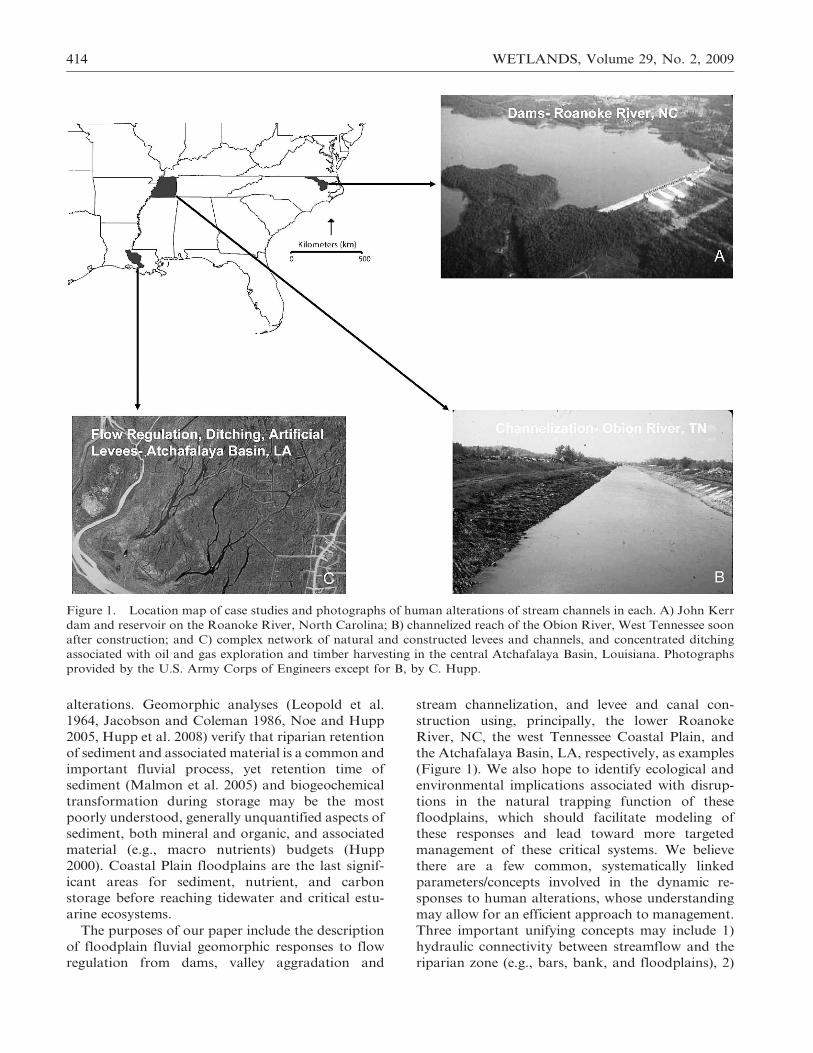
Figure 1. Location map of case studies and photographs of human alterations of stream channels in each. A) John Kerr
dam and reservoir on the Roanoke River, North Carolina; B) channelized reach of the Obion River, West Tennessee soon
after construction; and C) complex network of natural and constructed levees and channels, and concentrated ditching
associated with oil and gas exploration and timber harvesting in the central Atchafalaya Basin, Louisiana. Photographs
provided by the U.S. Army Corps of Engineers except for B, by C. Hupp.
414 WETLANDS, Volume 29, No. 2, 2009
spatially migrating impetuses/thresholds for rapid
geomorphic change (migrating channel knick-
points), and perhaps most importantly 3) dynamic
equilibrium in fluvial systems (Hack 1960). Dynamic
equilibrium in geomorphology refers to the mutual
adjustment of a catchment with its geologic underpin-
ning and the streams that drain it such that a stream is
capable of entraining, transporting, and storing the
delivered sediment in fluvial landforms in a balanced
fashion (typically no excessive net fluvial erosion or
deposition, Figure 3). The concept of dynamic equi-
librium offers a process-oriented explanation for
dramatic responses to some human alterations and
may also allow for prediction of the direction (erosion
vs. deposition) and magnitude of the change. States of
dynamic equilibrium with sustained characteristic
fluvial landforms may occur on streams that maintain
an erosional regime (e.g., steep mountain streams) or
on streams that maintain a sediment-storage regime
(e.g., most Coastal Plain streams) (Figure 3). Streams
that are not in dynamic equilibrium have been
subjected to dramatic, usually rapid, regime shifts;
this may happen naturally (e.g., earthquakes) or
through human alteration, the subject of this paper.
Floodplains are frequently flooded riparian fea-
tures that occur at a great extent in the Coastal Plain
(Hunt 1967), predominantly in southeastern United
States. Floodplains in the context of this paper are
inundated at least every one to about three years.
Less frequently flooded alluvial features are likely
terraces as defined in detail by Osterkamp and Hupp
(1984). Coastal Plain floodplains typically are
broad, alluvial features with low gradients that
develop along meandering streams, many of which
terminate downstream in tidal estuaries (Hupp
2000). Coastal Plain systems develop broad bottom-
lands including floodplains that may regularly flood
every year for prolonged periods. In southeastern
United States, these floodplains, in their natural
state, are typically forested wetlands that support
bottomland hardwood forests (Wharton et al. 1982,
Sharitz and Mitsch 1993) along with attendant
baldcypress/tupelo (Taxodium distichum (L.) Rich-
ard/Nyssa aquatica L.) swamps in the most hydric
situations. Floodplains with substantial hydrologic
connection to streamflow may trap (riparian reten-
tion, Figure 2) large amounts of sediment and
associated nutrients and other contaminants (Brin-
son 1988, Hupp et al. 1993, 2008, Noe and Hupp
2005, in press). Unfortunately, these water quality
functions of floodplains may be disrupted or
compromised where there has been widespread
alteration of fluvial processes by human activity,
e.g., dam construction, channelization, and concen-
trated land use (Mitsch and Gosselink 1993, Sharitz
and Mitsch 1993). The long-term impacts from the
reduction of floodplain ecosystem services (e. g.
sediment trapping) is poorly understood and per-
haps also under appreciated.
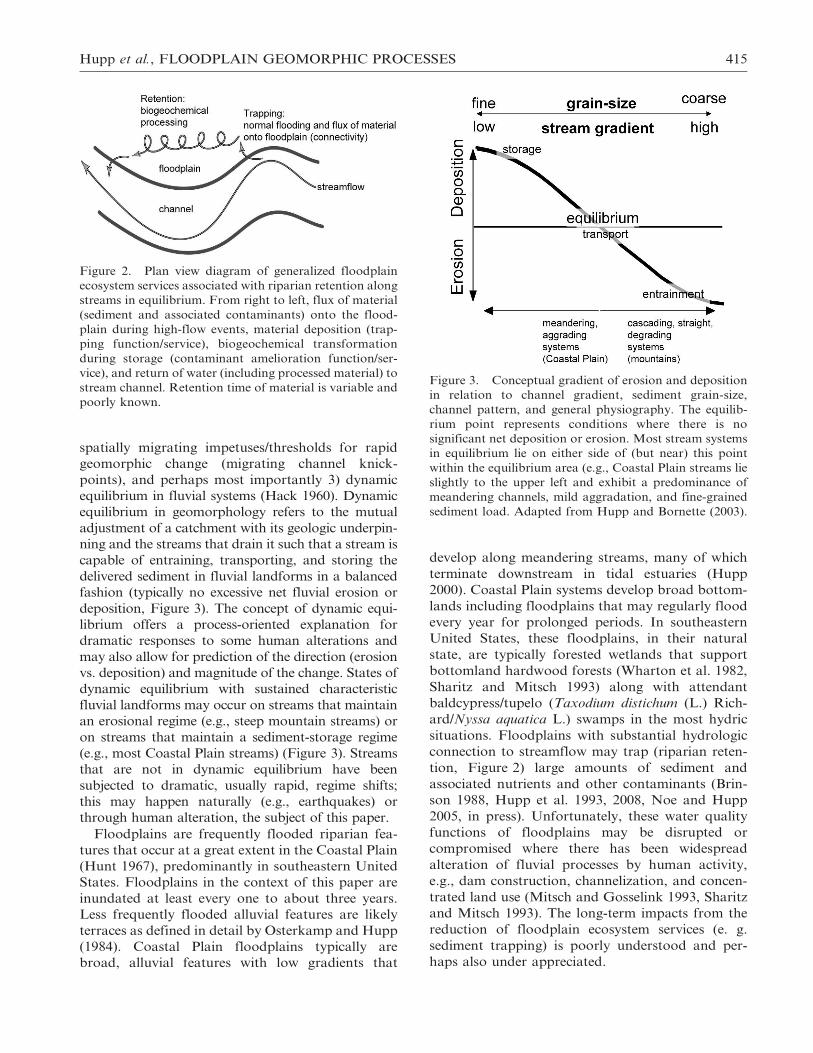
Figure 2. Plan view diagram of generalized floodplain
ecosystem services associated with riparian retention along
streams in equilibrium. From right to left, flux of material
(sediment and associated contaminants) onto the flood-
plain during high-flow events, material deposition (trap-
ping function/service), biogeochemical transformation
during storage (contaminant amelioration function/ser-
vice), and return of water (including processed material) to
stream channel. Retention time of material is variable and
poorly known.
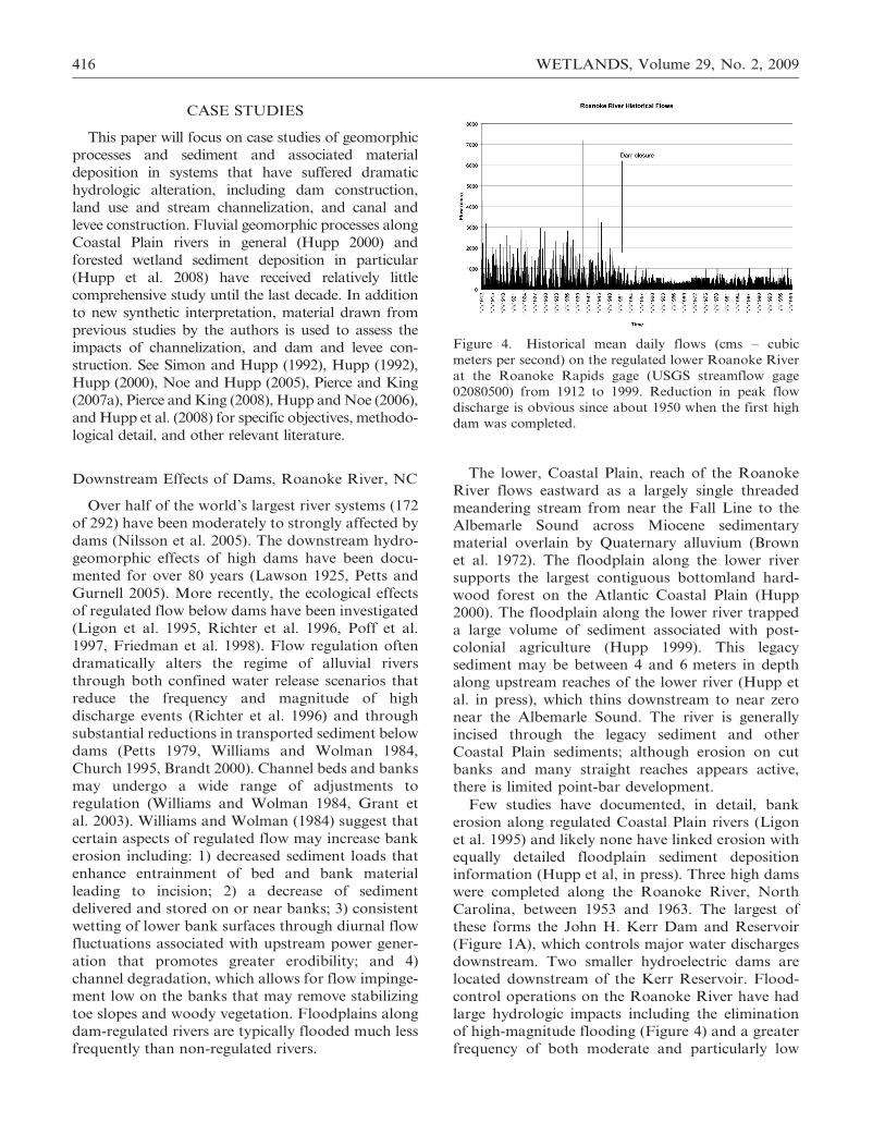
Figure 3. Conceptual gradient of erosion and deposition
in relation to channel gradient, sediment grain-size,
channel pattern, and general physiography. The equilib-
rium point represents conditions where there is no
significant net deposition or erosion. Most stream systems
in equilibrium lie on either side of (but near) this point
within the equilibrium area (e.g., Coastal Plain streams lie
slightly to the upper left and exhibit a predominance of
meandering channels, mild aggradation, and fine-grained
sediment load. Adapted from Hupp and Bornette (2003).
Hupp et al., FLOODPLAIN GEOMORPHIC PROCESSES 415
CASE STUDIES
This paper will focus on case studies of geomorphic
processes and sediment and associated material
deposition in systems that have suffered dramatic
hydrologic alteration, including dam construction,
land use and stream channelization, and canal and
levee construction. Fluvial geomorphic processes along
Coastal Plain rivers in general (Hupp 2000) and
forested wetland sediment deposition in particular
(Hupp et al. 2008) have received relatively little
comprehensive study until the last decade. In addition
to new synthetic interpretation, material drawn from
previous studies by the authors is used to assess the
impacts of channelization, and dam and levee con-
struction. See Simon and Hupp (1992), Hupp (1992),
Hupp (2000), Noe and Hupp (2005), Pierce and King
(2007a), Pierce and King (2008), Hupp and Noe (2006),
and Hupp et al. (2008) for specific objectives, methodo-
logical detail, and other relevant literature.
Downstream Effects of Dams, Roanoke River, NC
Over half of the world’s largest river systems (172
of 292) have been moderately to strongly affected by
dams (Nilsson et al. 2005). The downstream hydro-
geomorphic effects of high dams have been docu-
mented for over 80 years (Lawson 1925, Petts and
Gurnell 2005). More recently, the ecological effects
of regulated flow below dams have been investigated
(Ligon et al. 1995, Richter et al. 1996, Poff et al.
1997, Friedman et al. 1998). Flow regulation often
dramatically alters the regime of alluvial rivers
through both confined water release scenarios that
reduce the frequency and magnitude of high
discharge events (Richter et al. 1996) and through
substantial reductions in transported sediment below
dams (Petts 1979, Williams and Wolman 1984,
Church 1995, Brandt 2000). Channel beds and banks
may undergo a wide range of adjustments to
regulation (Williams and Wolman 1984, Grant et
al. 2003). Williams and Wolman (1984) suggest that
certain aspects of regulated flow may increase bank
erosion including: 1) decreased sediment loads that
enhance entrainment of bed and bank material
leading to incision; 2) a decrease of sediment
delivered and stored on or near banks; 3) consistent
wetting of lower bank surfaces through diurnal flow
fluctuations associated with upstream power gener-
ation that promotes greater erodibility; and 4)
channel degradation, which allows for flow impinge-
ment low on the banks that may remove stabilizing
toe slopes and woody vegetation. Floodplains along
dam-regulated rivers are typically flooded much less
frequently than non-regulated rivers.
The lower, Coastal Plain, reach of the Roanoke
River flows eastward as a largely single threaded
meandering stream from near the Fall Line to the
Albemarle Sound across Miocene sedimentary
material overlain by Quaternary alluvium (Brown
et al. 1972). The floodplain along the lower river
supports the largest contiguous bottomland hard-
wood forest on the Atlantic Coastal Plain (Hupp
2000). The floodplain along the lower river trapped
a large volume of sediment associated with post-
colonial agriculture (Hupp 1999). This legacy
sediment may be between 4 and 6 meters in depth
along upstream reaches of the lower river (Hupp et
al. in press), which thins downstream to near zero
near the Albemarle Sound. The river is generally
incised through the legacy sediment and other
Coastal Plain sediments; although erosion on cut
banks and many straight reaches appears active,
there is limited point-bar development.
Few studies have documented, in detail, bank
erosion along regulated Coastal Plain rivers (Ligon
et al. 1995) and likely none have linked erosion with
equally detailed floodplain sediment deposition
information (Hupp et al, in press). Three high dams
were completed along the Roanoke River, North
Carolina, between 1953 and 1963. The largest of
these forms the John H. Kerr Dam and Reservoir
(Figure 1A), which controls major water discharges
downstream. Two smaller hydroelectric dams are
located downstream of the Kerr Reservoir. Flood-
control operations on the Roanoke River have had
large hydrologic impacts including the elimination
of high-magnitude flooding (Figure 4) and a greater
frequency of both moderate and particularly low
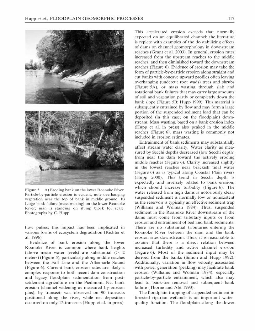
Figure 4. Historical mean daily flows (cms – cubic
meters per second) on the regulated lower Roanoke River
at the Roanoke Rapids gage (USGS streamflow gage
02080500) from 1912 to 1999. Reduction in peak flow
discharge is obvious since about 1950 when the first high
dam was completed.
416 WETLANDS, Volume 29, No. 2, 2009
flow pulses; this impact has been implicated in
various forms of ecosystem degradation (Richter et
al. 1996).
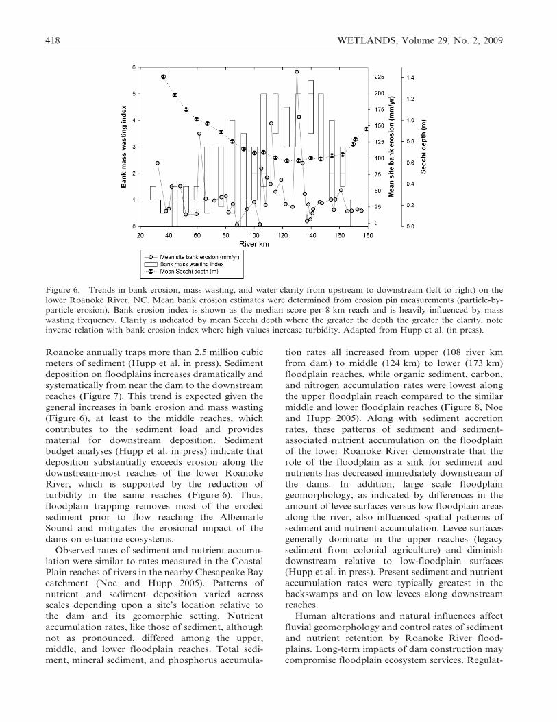
Evidence of bank erosion along the lower
Roanoke River is common where bank heights
(above mean water levels) are substantial (. 2
meters) (Figure 5), particularly along middle reaches
between the Fall Line and the Albemarle Sound
(Figure 6). Current bank erosion rates are likely a
complex response to both recent dam construction
and legacy floodplain sedimentation from post-
settlement agriculture on the Piedmont. Net bank
erosion (channel widening as measured by erosion
pins), by transect, was observed on 90 transects
positioned along the river, while net deposition
occurred on only 12 transects (Hupp et al. in press).
This accelerated erosion exceeds that normally
expected on an equilibrated channel; the literature
is replete with examples of the de-stabilizing effects
of dams on channel geomorphology in downstream
reaches (Grant et al. 2003). In general, erosion rates
increased from the upstream reaches to the middle
reaches, and then diminished toward the downstream
reaches (Figure 6). Evidence of erosion may take the
form of particle-by-particle erosion along straight and
cut banks with concave upward profiles often leaving
overhanging (undercut root wads) trees and shrubs
(Figure 5A), or mass wasting through slab and
rotational bank failures that may carry large amounts
of soil and vegetation partly or completely down the
bank slope (Figure 5B; Hupp 1999). This material is
subsequently entrained by flow and may form a large
portion of the suspended sediment load that can be
deposited (in this case, on the floodplain) down-
stream. Mass wasting, based on a bank erosion index
(Hupp et al. in press) also peaked in the middle
reaches (Figure 6); mass wasting is commonly not
included in erosion estimates.
Entrainment of bank sediments may substantially
affect stream water clarity. Water clarity as mea-
sured by Secchi depths decreased (low Secchi depth)
from near the dam toward the actively eroding
middle reaches (Figure 6). Clarity increased slightly
in the lowest reaches near brackish tidal water
(Figure 6) as is typical along Coastal Plain rivers
(Hupp 2000). This trend in Secchi depth is
expectedly and inversely related to bank erosion,
which should increase turbidity (Figure 6). The
water released from high dams is notoriously clear;
suspended sediment is normally low or nonexistent
as the reservoir is typically an effective sediment trap
(Williams and Wolman 1984). Thus, suspended
sediment in the Roanoke River downstream of the
dams must come from tributary inputs or from
erosion and entrainment of bed and bank sediments.
There are no substantial tributaries entering the
Roanoke River between the dam and the bank
erosion sites downstream. Thus, it is reasonable to
assume that there is a direct relation between
increased turbidity and active channel erosion
(Figure 6). Most of the sediment input may be
derived from the banks (Simon and Hupp 1992).
Additionally, variation in flow velocity associated
with power generation (peaking) may facilitate bank
erosion (Williams and Wolman 1984), especially
particle-by-particle entrainment, which also may
lead to bank-toe removal and subsequent bank
failure (Thorne and Abt 1993).
The floodplain trapping of suspended sediment in
forested riparian wetlands is an important water-
quality function. The floodplain along the lower
Figure 5. A) Eroding bank on the lower Roanoke River.
Particle-by-particle erosion is evident, note overhanging
vegetation near the top of bank in middle ground. B)
Large bank failure (mass wasting) on the lower Roanoke
River; man is standing on slump block for scale.
Photographs by C. Hupp.
Hupp et al., FLOODPLAIN GEOMORPHIC PROCESSES 417
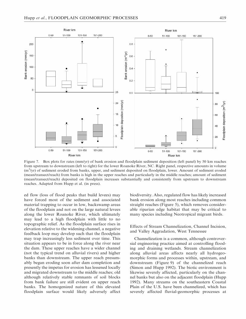
Roanoke annually traps more than 2.5 million cubic
meters of sediment (Hupp et al. in press). Sediment
deposition on floodplains increases dramatically and
systematically from near the dam to the downstream
reaches (Figure 7). This trend is expected given the
general increases in bank erosion and mass wasting
(Figure 6), at least to the middle reaches, which
contributes to the sediment load and provides
material for downstream deposition. Sediment
budget analyses (Hupp et al. in press) indicate that
deposition substantially exceeds erosion along the
downstream-most reaches of the lower Roanoke
River, which is supported by the reduction of
turbidity in the same reaches (Figure 6). Thus,
floodplain trapping removes most of the eroded
sediment prior to flow reaching the Albemarle
Sound and mitigates the erosional impact of the
dams on estuarine ecosystems.
Observed rates of sediment and nutrient accumu-
lation were similar to rates measured in the Coastal
Plain reaches of rivers in the nearby Chesapeake Bay
catchment (Noe and Hupp 2005). Patterns of
nutrient and sediment deposition varied across
scales depending upon a site’s location relative to
the dam and its geomorphic setting. Nutrient
accumulation rates, like those of sediment, although
not as pronounced, differed among the upper,
middle, and lower floodplain reaches. Total sedi-
ment, mineral sediment, and phosphorus accumula-
tion rates all increased from upper (108 river km
from dam) to middle (124 km) to lower (173 km)
floodplain reaches, while organic sediment, carbon,
and nitrogen accumulation rates were lowest along
the upper floodplain reach compared to the similar
middle and lower floodplain reaches (Figure 8, Noe
and Hupp 2005). Along with sediment accretion
rates, these patterns of sediment and sediment-
associated nutrient accumulation on the floodplain
of the lower Roanoke River demonstrate that the
role of the floodplain as a sink for sediment and
nutrients has decreased immediately downstream of
the dams. In addition, large scale floodplain
geomorphology, as indicated by differences in the
amount of levee surfaces versus low floodplain areas
along the river, also influenced spatial patterns of
sediment and nutrient accumulation. Levee surfaces
generally dominate in the upper reaches (legacy
sediment from colonial agriculture) and diminish
downstream relative to low-floodplain surfaces
(Hupp et al. in press). Present sediment and nutrient
accumulation rates were typically greatest in the
backswamps and on low levees along downstream
reaches.
Human alterations and natural influences affect
fluvial geomorphology and control rates of sediment
and nutrient retention by Roanoke River flood-
plains. Long-term impacts of dam construction may
compromise floodplain ecosystem services. Regulat-
Figure 6. Trends in bank erosion, mass wasting, and water clarity from upstream to downstream (left to right) on the
lower Roanoke River, NC. Mean bank erosion estimates were determined from erosion pin measurements (particle-by-
particle erosion). Bank erosion index is shown as the median score per 8 km reach and is heavily influenced by mass
wasting frequency. Clarity is indicated by mean Secchi depth where the greater the depth the greater the clarity, note
inverse relation with bank erosion index where high values increase turbidity. Adapted from Hupp et al. (in press).
418 WETLANDS, Volume 29, No. 2, 2009
ed flow (loss of flood peaks that build levees) may
have forced most of the sediment and associated
material trapping to occur in low, backswamp areas
of the floodplain and not on the large natural levees
along the lower Roanoke River, which ultimately
may lead to a high floodplain with little to no
topographic relief. As the floodplain surface rises in
elevation relative to the widening channel, a negative
feedback loop may develop such that the floodplain
may trap increasingly less sediment over time. This
situation appears to be in force along the river near
the dam. These upper reaches have a wider channel
(not the typical trend on alluvial rivers) and higher
banks than downstream. The upper reach presum-
ably began eroding soon after dam completion and
presently the impetus for erosion has lessened locally
and migrated downstream to the middle reaches; old
although relatively stable remnants of soil blocks
from bank failure are still evident on upper reach
banks. The homogenized nature of this elevated
floodplain surface would likely adversely affect
biodiversity. Also, regulated flow has likely increased
bank erosion along most reaches including commonstraight reaches (Figure 5), which removes consider-
able riparian edge habitat that may be critical to
many species including Neotropical migrant birds.
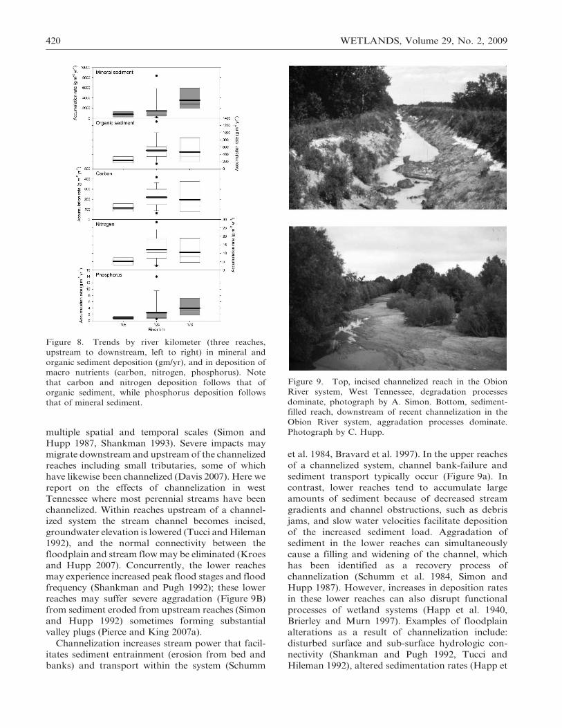
Effects of Stream Channelization, Channel Incision,
and Valley Aggradation, West Tennessee
Channelization is a common, although controver-
sial engineering practice aimed at controlling flood-ing and draining wetlands. Stream channelization
along alluvial areas affects nearly all hydrogeo-
morphic forms and processes within, upstream, and
downstream (Figure 9) of the channelized reach
(Simon and Hupp 1992). The biotic environment is
likewise severely affected, particularly on the chan-
nel banks but also on the adjacent floodplain (Hupp
1992). Many streams on the southeastern CoastalPlain of the U.S. have been channelized, which has
severely affected fluvial-geomorphic processes at
Figure 7. Box plots for rates (mm/yr) of bank erosion and floodplain sediment deposition (left panel) by 50 km reaches
from upstream to downstream (left to right) for the lower Roanoke River, NC. Right panel, respective amounts in volume
(m3/yr) of sediment eroded from banks, upper, and sediment deposited on floodplain, lower. Amount of sediment eroded
(mean/transect/reach) from banks is high in the upper reaches and particularly in the middle reaches; amount of sediment
(mean/transect/reach) deposited on floodplain increases substantially and consistently from upstream to downstream
reaches. Adapted from Hupp et al. (in press).
Hupp et al., FLOODPLAIN GEOMORPHIC PROCESSES 419
multiple spatial and temporal scales (Simon and
Hupp 1987, Shankman 1993). Severe impacts may
migrate downstream and upstream of the channelized
reaches including small tributaries, some of which
have likewise been channelized (Davis 2007). Here we
report on the effects of channelization in west
Tennessee where most perennial streams have been
channelized. Within reaches upstream of a channel-
ized system the stream channel becomes incised,
groundwater elevation is lowered (Tucci and Hileman
1992), and the normal connectivity between the
floodplain and stream flow may be eliminated (Kroes
and Hupp 2007). Concurrently, the lower reaches
may experience increased peak flood stages and flood
frequency (Shankman and Pugh 1992); these lower
reaches may suffer severe aggradation (Figure 9B)
from sediment eroded from upstream reaches (Simon
and Hupp 1992) sometimes forming substantial
valley plugs (Pierce and King 2007a).
Channelization increases stream power that facil-
itates sediment entrainment (erosion from bed and
banks) and transport within the system (Schumm
et al. 1984, Bravard et al. 1997). In the upper reaches
of a channelized system, channel bank-failure and
sediment transport typically occur (Figure 9a). In
contrast, lower reaches tend to accumulate large
amounts of sediment because of decreased stream
gradients and channel obstructions, such as debris
jams, and slow water velocities facilitate deposition
of the increased sediment load. Aggradation of
sediment in the lower reaches can simultaneously
cause a filling and widening of the channel, which
has been identified as a recovery process of
channelization (Schumm et al. 1984, Simon and
Hupp 1987). However, increases in deposition rates
in these lower reaches can also disrupt functional
processes of wetland systems (Happ et al. 1940,
Brierley and Murn 1997). Examples of floodplain
alterations as a result of channelization include:
disturbed surface and sub-surface hydrologic con-
nectivity (Shankman and Pugh 1992, Tucci and
Hileman 1992), altered sedimentation rates (Happ et
Figure 8. Trends by river kilometer (three reaches,
upstream to downstream, left to right) in mineral and
organic sediment deposition (gm/yr), and in deposition of
macro nutrients (carbon, nitrogen, phosphorus). Note
that carbon and nitrogen deposition follows that of
organic sediment, while phosphorus deposition follows
that of mineral sediment.
Figure 9. Top, incised channelized reach in the Obion
River system, West Tennessee, degradation processes
dominate, photograph by A. Simon. Bottom, sediment-
filled reach, downstream of recent channelization in the
Obion River system, aggradation processes dominate.
Photograph by C. Hupp.
420 WETLANDS, Volume 29, No. 2, 2009
al. 1940, Pierce and King 2008), reduced lateral
channel migration that creates sloughs and oxbow
lakes (Shankman 1993), loss of aquatic habitat
(Hohensinner et al. 2004), reduced growth and
premature mortality of floodplain tree species
(USDA 1986), loss of plant species diversity (Miller
1990), changes in plant species composition (Oswalt
and King 2005, Pierce 2005), and negative effects on
fish and wildlife communities (Hunter et al. 1993,
Hoover and Kilgore 1997).
Past land-use practices, in west Tennessee, con-
tributed to hillslope erosion and floodplain aggra-
dation and now facilitate contemporary channel
erosion and sedimentation. In the 1800s, the region
was rapidly colonized and forested areas of the loess
regions were cleared and replaced with agricultural
fields of corn, cotton, and tobacco (Wilder 1998).
Clearing of the upland areas resulted in erosion and
gullying of erodible loess and sandy soils (Saucier
1994); increasing sedimentation rates in down-
stream reaches from 2–9 mm/yr (before settlement)
to 30 mm/yr (post-settlement) (Wolfe and Diehl 1993).
Streams became clogged with sediment and debris,
reducing channel flood capacity and causing frequent
and prolonged flooding in the bottomlands (Morgan
and McCrory 1910). Several periods of stream
channelization occurred to alleviate flooding and
facilitate row-crop agriculture beginning at the turn
of the last century but prominently in the 1920s, again
in the 1940s, and most recently (Figure 1b) in the
1970s (Simon and Hupp 1992). Over 260 km of
streams were channelized; shortening them by 44%,
lowering their bed elevation by 170%, and increasing
the stream gradient by 600% (Speer et al. 1965,
Robbins and Simon 1983, Simon and Hupp 1992).
The Obion-Forked Deer River system suffered
considerable alterations while the impacts to the
Hatchie River were restricted to its tributary system
(USDA 1986, Simon 1994); the mainstem Hatchie
River is the only major river in the region largely
unchannelized.
Historically, the high meandering rate and low
gradient of the rivers did not allow for substantial
transport of the sand. However, channelization
greatly increased their stream power and facilitated
sediment transport, resulting in dramatic geomor-
phic changes (Diehl 2000, Pierce and King 2008).
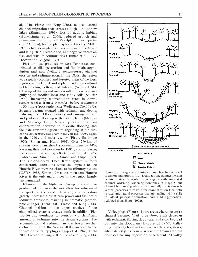
Channel incision in the upper reaches of the
channelized systems creates bank instability (Fig-
ure 10) and continues to contribute a significant
amount of sediment into the stream systems. The
accumulation of sediment in the lower reaches
(Schumm et al. 1984, Wyzga 2001) can lead to the
formation of valley plugs (Happ et al. 1940, Diehl
2000, Pierce and King 2007a, Pierce and King 2008).
Valley plugs (Figure 11) are areas where the entire
channel becomes filled to or above bank elevation
with sediment, forcing floodwater and sand bedload
out into the floodplain (Happ et al. 1940). Valley
plugs typically form in the lower reaches of systems,where debris jams form or where the stream gradient
decreases causing deposition of sediment. At valley
Figure 10. Diagram of six-stage channel evolution model
of Simon and Hupp (1987). Degradation, channel incision
begins in stage 3, continues in stage 4 with associated
channel widening, widening continues in stage 5 but
channel bottom aggrades. Stream initially reacts through
vertical processes (arrows) after channelization then both
vertical and lateral processes operate, ending with a shift
to lateral process domination and mild aggradation.
Adapted from Hupp (1992).
Hupp et al., FLOODPLAIN GEOMORPHIC PROCESSES 421
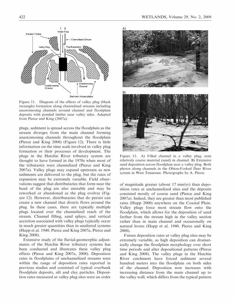
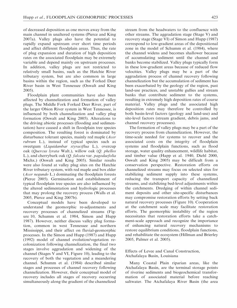
plugs, sediment is spread across the floodplain as the
stream diverges from the main channel forming
anastomosing channels throughout the floodplain
(Pierce and King 2008) (Figure 12). There is little
information on the time scale involved in valley plug
formation or their processes of development. The
plugs in the Hatchie River tributary system are
thought to have formed in the 1970s when most of
the tributaries were channelized (Pierce and King
2007a). Valley plugs may expand upstream as new
sediments are delivered to the plug, but the rates of
expansion may be extremely variable. Field obser-
vations suggest that distributaries that form near the
head of the plug are also unstable and may be
reworked or abandoned as the plug evolves (Fig-
ure 12). However, distributaries that do persist can
create a new channel that diverts flows around the
plug. In these cases, there are typically multiple
plugs located over the channelized reach of the
stream. Channel filling, sand splays, and vertical
accretion associated with valley plugs typically occur
in much greater quantities than in unaltered systems
(Happ et al. 1940, Pierce and King 2007a, Pierce and
King 2008).
Extensive study of the fluvial-geomorphic adjust-
ments of the Hatchie River tributary systems has
been conducted and illustrates these valley plug
effects (Pierce and King 2007a, 2008). Deposition
rates in floodplains of unchannelized streams were
within the range of deposition rates reported in
previous studies and consisted of typical overbank
floodplain deposits, silt and clay particles. Deposi-
tion rates measured at valley plug sites were an order
of magnitude greater (about 17 mm/yr) than depo-
sition rates at unchannelized sites and the deposits
consisted mostly of coarse sand (Pierce and King
2007a). Indeed, they are greater than most published
rates (Hupp 2000) anywhere on the Coastal Plain.
Valley plugs force most stream flow onto the
floodplain, which allows for the deposition of sand
farther from the stream high in the valley section
rather than in main channel and occasionally on
natural levees (Happ et al. 1940, Pierce and King
2008).
Future deposition rates at valley plug sites may be
extremely variable, as high deposition can dramat-
ically change the floodplain morphology over short
time periods and alter depositional patterns (Pierce
and King 2008). The valley plugs in the Hatchie
River catchment have forced sediment several
hundred meters into the floodplain on both sides
of the channel. Deposition now increases with
increasing distance from the main channel up to
the valley wall, which differs from the typical pattern
Figure 11. Diagram of the effects of valley plug (black
rectangle) formation along channelized streams including
anastomosing channels around channel and floodplain
deposits with ponded timber near valley sides. Adapted
from Pierce and King (2007a).
Figure 12. A) Filled channel in a valley plug, note
relatively coarse material (sand) in channel. B) Extensive
sand deposition across floodplain near a valley plug. Both
photos along channels in the Obion-Forked Deer River
system in West Tennessee. Photographs by A. Pierce.
422 WETLANDS, Volume 29, No. 2, 2009
of decreased deposition as one moves away from the
main channel in unaltered systems (Pierce and King
2007a). Valley plugs also have the potential to
rapidly expand upstream over short time periods
and affect different floodplain areas. Thus, the rate
of plug expansion and duration of high deposition
rates on the associated floodplain may be extremely
variable and depend mainly on upstream processes.
In addition, valley plugs are not restricted to
relatively small basins, such as the Hatchie River
tributary system, but are also common in large
basins within the region, such as the Forked Deer
River basin in West Tennessee (Oswalt and King
2005).
Floodplain plant communities have also been
affected by channelization and formation of valley
plugs. The Middle Fork Forked Deer River, part of
the larger Obion River system in West Tennessee, is
influenced by both channelization and valley plug
formation (Oswalt and King 2005). Alterations to
the driving abiotic processes (flooding and sedimen-
tation) have caused a shift in floodplain tree species
composition. The resulting forest is dominated by
disturbance tolerant species, mainly red maple (Acer
rubrum L.), instead of typical species such as
sweetgum (Liquidambar styraciflua L.), overcup
oak (Quercus lyrata Walt.), willow oak (Q. phellos
L.), and cherrybark oak (Q. falcata var. pagodaefolia
Michx.) (Oswalt and King 2005). Similar results
were also found at valley plug sites on the Hatchie
River tributary system, with red maple and box elder
(Acer negundo L.) dominating the floodplain forests
(Pierce 2005). Germination and establishment of
typical floodplain tree species are also influenced by
the altered sedimentation and hydrologic processes
that may prolong the recovery process (Walls et al.
2005, Pierce and King 2007b).
Conceptual models have been developed to
understand the geomorphic re-adjustments and
recovery processes of channelized streams (Fig-
ure 10, Schumm et al. 1984, Simon and Hupp
1987). However, neither discuss valley plug forma-
tion, common in west Tennessee and northern
Mississippi, and their affect on fluvial-geomorphic
processes. In the Simon and Hupp (1987) and Hupp
(1992) model of channel evolution/vegetation re-
colonization following channelization, the final two
stages involve aggradation and widening of the
channel (Stages V and VI, Figure 10), leading to the
recovery of both the vegetation and a meandering
channel. Schumm et al. (1984) described similar
stages and processes of channel recovery following
channelization. However, their conceptual model of
recovery includes all stages of recovery occurring
simultaneously along the gradient of the channelized
stream from the headwaters to the confluence with
other streams. The aggradation stage (Stage V) and
recovery stage (Stage VI) of Simon and Hupp (1987)
correspond to low-gradient areas of the depositional
zone in the model of Schumm et al. (1984), where
the channel widens and becomes shallower because
of accumulating sediment until the channel and
banks become stabilized. Valley plugs typically form
in these low-gradient areas because of reduced flow
velocities. Valley plugs may be a part of the
aggradation process of channel recovery following
channelization but the accumulation of sediment has
been exacerbated by the geology of the region, past
land-use practices, and unstable gullies and stream
banks that contribute sediment to the systems,
resulting in extremely high deposition rates of coarse
material. Valley plugs and the associated high
deposition rates may therefore be controlled by
both basin-level factors (geology and land-use) and
site-level factors (stream gradient, debris jams, and
channel recovery processes).
The formation of valley plugs may be a part of the
recovery process from channelization. However, the
time-scale needed for systems to recover and the
associated costs on the integrity of floodplain
systems and floodplain functions, such as flood
storage, water quality enhancement, wildlife habitat,
and timber value (Happ et al. 1940, Diehl 2000,
Oswalt and King 2005) may be difficult from a
conservation perspective. Restoration efforts on
channelized streams may focus on selected sites for
stabilizing sediment supply into these systems,
reducing the transport capacity of channelized
streams, and stabilizing bed-level adjustments within
the catchments. Dredging of within channel sedi-
ment deposits and other site-specific disturbances
may compromise restoration efforts by setting back
natural recovery processes (Figure 10). Cooperation
at the catchment scale may facilitate restoration
efforts. The geomorphic instability of the region
necessitates that restoration efforts take a catch-
ment-scale approach and recognize the importance
of enhancing natural recovery mechanisms to
restore equilibrium conditions, floodplain functions,
and rehabilitate the ecosystem (Hillman and Brierley
2005, Palmer et al. 2005).
Effects of Levee and Canal Construction,
Atchafalaya Basin, Louisiana
Many Coastal Plain riparian areas, like the
Atchafalaya Basin, are the terminal storage points
of riverine sediments and biogeochemical transfor-
mation of associated material before reaching
saltwater. The Atchafalaya River Basin (the area
Hupp et al., FLOODPLAIN GEOMORPHIC PROCESSES 423
between the Mississippi River and the Atchafalaya
distributary) contains the largest relatively intact,
functioning riparian area in the lower Mississippi
Valley and the largest contiguously forested bottom-
land in North America. Sediment accretion rates on
these floodplains may be among the highest of any
physiographic province in the U.S. (Hupp et al. 2008).
Recent studies have shown that coastal lowlands may
be an important sink for carbon (Raymond and
Bauer 2001, Ludwig 2001) and associated nutrients
(Noe and Hupp 2005), which may be stored in these
systems as organic rich sediment (nitrogen) or mineral
sediment (in the case of phosphorus). This organic
material presumably is from both autochthonous and
allochthonous sources.
The Atchafalaya Basin wetland (5670 km2) is
about 70% forested and the remainder is marshland
and open water. Most of the generally north-south
trending Basin is bounded by flood-protection levees
on the east and west separated by 20 to 30 km; the
Basin has an average discharge of about 6410 m3/s,
among the top five in the U.S (Demas et al. 2001).
The forested wetlands are generally of three major
types: 1) typical bottomland hardwoods (Sharitz and
Mitsch 1993) on levees and higher floodplains, 2)
baldcypress/tupelo swamps on low backwater flood-
plains, and 3) young stands of predominantly black
willow (Salix nigra Marshall) that have developed
on recently aggraded point and longitudinal channel
bars (silt and sand). Most of the relatively young
forests (70 years or less) have grown since lumbering
of old growth baldcypress and bottomland hard-
woods was completed by the early 1930s (King et al.
2005). Additionally, the filling of open water areas
since the middle of the last century (Tye and
Coleman 1989), has created numerous and extensive
surfaces for forest establishment. All flow within the
Basin is regulated by structures upstream operated
by the Corps of Engineers (Figure 1C). Flow in
many of the bayous and canals may carry high
sediment loads resulting from the ambient alluvial
nature of both the Mississippi and Red Rivers and,
in some cases, due to substantial resuspension of
channel sediment.
Over the past several decades the Atchafalaya
Basin has experienced rapid and substantial
amounts of sediment deposition. Approximately
25% of Mississippi River flow on an annual basis
and all of the Red River flow passes through the
Basin. The entire suspended- and bed-sediment load
of the Red River and as much as 35% of the
suspended and up to 60% of the bed sediment load
of the Mississippi River (Mossa and Roberts 1990) is
now diverted through the Atchafalaya Basin. Many
open water areas in the Basin have now filled
(Roberts et al. 1980, Tye and Coleman 1989,
McManus 2002). Regionally, the Basin provides a
sharp contrast to most of the remaining Louisiana
coastal area, which is sediment starved and experi-
ences subsidence and coastal erosion. The Atchafa-
laya Basin is a complex of many meandering bayous
and lakes that have been altered dramatically by
natural processes and human impacts (Figure 1d)
including channelization and levee construction for
oil and gas exploration and transmission, timber
extraction, flood control, and navigation (Hupp et
al. 2008). The pervasive natural geomorphic process
affecting the Basin is and has for the past few
centuries been that of a prograding delta (Mis-
sissippi delta complex, Fisk 1952), which had filled
much of the Basin with sediment by 1970 (Tye and
Coleman 1989). The Grand Lake area, in the south,
continues to fill as shown by rapid sedimentation in
what was recently open lake. The Basin suffers
simultaneously from exceptionally high sedimenta-
tion rates at sites with high connectivity to the main
river and from hypoxia in stagnant areas with little
connection to the main river. Both of these results
may be detrimental to socially and economically
important crawfish and fin-fish fisheries (Demas et
al. 2001).
The Atchafalaya Basin traps substantial amounts
of suspended sediment annually. Some areas have
the highest documented ‘‘normal’’ sedimentation
rates in forested wetlands of the United States, some
backswamp locations exceeded 110 mm/yr as mea-
sured above artificial markers. Unusually high
deposition rates may also occur in valley plugs
(Pierce and King 2008) and during episodic events
(e.g., major floods; Jacobson and Oberg 1997).
Hupp et al. (2008) estimated an annual average
13.4 kg/m2 of sediment with a mean 12% organic
material is trapped in the central part of the Basin.
Thus, the central part of the Basin annually traps a
net 6.7?106 Mg of sediment, of which 8.2 ?105 Mg
are organic material. Sediment accumulation rates
are likely low in the upper basin where much of the
floodplain has already filled (short hydroperiod) and
a relatively high elevation bottomland exists. In
contrast, much of the lower basin, which was
previously open water, began filling more recently
(McManus 2002) is distinctly low in elevation
relative to the upper and central parts of the Basin,
and continues filling today. The annual sediment
trapping rates of mineral and organic sediment in
the Atchafalaya Basin correspond to 6.4?108 kg C/
yr, 2.0?107 kg N/yr, and 7.5?106 kg P/yr, estimated
using average floodplain sediment nutrient concen-
trations in mineral and organic sediments from
other Coastal Plain floodplain studies (Noe and
424 WETLANDS, Volume 29, No. 2, 2009
Hupp 2005). These N and P accumulation rates
represent 5% and 27%, respectively, of their annual
loading rates to the Atchafalaya Basin (Turner and
Rabalais 1991, Goolsby et al. 2001). It should be
noted that these are coarse estimates that do not
account for movement of sediment within the Basin,
separate autochthonous from allochthonous sources
of nutrients, or account for long-term biogeochem-
ical processing of nutrients in deposited sediments
(Noe and Hupp 2005). Furthermore, these estimates
rely on the assumption that Atchafalaya floodplain
sediment nutrient concentrations are similar to other
Coastal Plain floodplains. The large amount of
sediment in retention allows for important biogeo-
chemical transformations that potentially reduce
contaminant, nutrient, and carbon inputs into the
Gulf of Mexico.
Depositional patterns within the Basin vary and
shed considerable light on understanding the factors
that facilitate sedimentation, including: 1) high
connectivity to sediment-laden river water, 2) long
hydroperiods, 3) multiple sources flow, and 4) low-
flow velocities due to flows from opposite directions.
Human intervention such as cutting new canals or
plugging existing channels has resulted in highly
altered flow paths that may conduct substantially
more or less sediment-laden water than previously and
in some cases have led to flow reversals and hydraulic
damming depending on the flood stage (Hupp et al.
2008). Levees both constructed and natural may be
relatively high in elevation (about 4 m above sea
level), have a relatively short hydroperiod, have very
low contemporary sedimentation rates (, 3 mm/yr),
and relatively high amounts of organic material. Some
backswamp sites may be stagnant and low in elevation
with relatively decreased sedimentation rates and high
percentages of organic material. Other sites have
moderate to relatively high sedimentation rates,
particularly on low levees where sedimentation may
be uniform across the floodplain (Figure 13A) or
concentrated on levees or backswamps (Figure 13B,
C). Sites that have the highest rates of sediment
deposition also have great connectivity to sediment
laden water and are typically associated with sediment
sources other than or in addition to the nearest
channel (Figure 14). In contrast, backswamps with
poor connectivity to sediment-laden river water tend
to have low deposition rates and may become
stagnant and hypoxic (Hupp et al. 2008).
The greatest percent organic material in the
sediment tends to be in sites with low mineral-
sediment deposition rates; this organic material is
thus presumably autochthonous. However, in a few
high-deposition rate sites the percentage of organic
material was also high, which suggests that some
Figure 13. Variation in spatial patterns of sediment
deposition at three sites in the central Atchafalaya Basin
for the period 2001 through 2003. Pad numbers along a
single transect begin on the levee (1) and end in the
backswamp (4 or 5). A) Illustrates relatively uniform
sediment deposition that may be characteristic of high
elevation sites with low deposition rates or, conversely, of
low sites in formerly open water with high deposition
rates; B) Represents sites whose sediment source is the
adjacent channel where sedimentation is highest on the
levee and diminishes toward the backswamp (common
along many Coastal Plain streams); and C) Illustrates sites
where water in the adjacent channel rarely overtops the
levee but is impacted from sediment-laden water from
floodplain sources away from the adjacent channel.
Adapted from Hupp et al. (2008).
Hupp et al., FLOODPLAIN GEOMORPHIC PROCESSES 425
areas may be trapping large amounts of allochtho-
nous organic material. Coarse sediments (sand) were
most common on levees and along sloughs associ-
ated with levee crevasses. Sedimentation rates and
size clasts diminished from the levee to the back-
swamp where the adjacent channel is the dominant
source of floodplain inundation.
Human altered hydrologic patterns, from small
scale opening or closing of single bayous to the
diversion structure at the head of the basin on the
Mississippi River, have increased the severity of
local non-equilibrium sedimentation patterns
throughout the Basin. Although sediment trapping
and aggradation are normal near the mouths of
large alluvial rivers, hydrologic alterations have
created areas with excessive deposition where there
was once open water and, conversely, prevented
river water from flowing in other areas that now
experience periods of hypoxia. The impact of these
alterations has been felt in the Basin for many
decades, possibly as far back as the initial levee
construction on the Mississippi River. The Atch-
afalaya Basin may serve as a model area for
restoration of coastal areas where wetlands are
receding. High sedimentation regimes, as a wetland
constructional process, may provide for an impor-
tant buffer in hurricane-prone areas and provide
valuable ecosystem services.
SYNTHESIS
Fluvial geomorphic systems, by nature, tend to
maintain a dynamic equilibrium (Hack 1960) among
ambient sediment load, water discharge, and chan-
nel geometry (Osterkamp and Hedman 1977).
Streams or reaches of streams are typically deemed
‘‘in equilibrium’’ when the stream and its hydro-
geomorphic form and process are sufficiently (but
not overly) competent to entrain, transport, and
store the sediment provided by the associated
catchment in a balanced fashion (Hack 1960).
Equilibrium conditions may occur in a zone around
the boundary between net erosion and deposition
(Figure 3). For instance, streams in mountainous
areas may have a naturally net erosion (entrainment)
stream regime, while streams in the Coastal Plain
tend to have a naturally net depositional (storage)
stream regime (Hupp 2000). Streams in between
these two geographic settings, such as those in the
Piedmont, may have a sediment transport dominat-
ed regime as shown in the conceptual gradient
(Hupp and Bornette 2003) of stream conditions
(Figure 3). Sediment grain size, stream gradient, and
channel pattern (meandering, cascading, and
straight) may adjust along the conceptual gradient
to maintain near equilibrium conditions. Human
alterations (dams, levees, channelization, and land
use) within the catchment or along the stream that
substantially affect one or more important fluvial
parameters may lead to disequilibrium conditions.
For instance, dramatic shifts in stream gradient may
initiate a period of pronounced fluvial adjustment
and excessive erosion or deposition, or both.
Streams in equilibrium typically do not exhibit
pronounced directional changes in sediment size,
stream gradient, or channel pattern, which may be
indicated by severely eroded banks or highly
depositional floodplains.
The natural hydraulic connectivity of a site is
critical to maintaining important ecosystem services
of floodplains; many human alterations substantial-
ly affect this connectivity. Severe reductions in
connectivity can lead to hypoxia. Whereas, severe
increases in connectivity may lead to deposition
rates that bury ecosystems and lead to reduced
hydroperiods. Reduction of sediment load and
confined discharges that result from dams may
cause downstream reaches to be starved of sediment
and facilitate channel erosion and bank failure.
Channelization and levee construction affect fluvial
systems in similar ways but are facilitated by
increases in channel gradient that affect flow velocity
and erosion upstream, while downstream deposition
(valley plugs) may occur from constricted flow and
high sediment loads. Loss of stream and floodplain
connectivity in upper reaches and the reduced
gradient of lower reaches force sediment and
material trapping processes to move upstream (or
downstream in the case of dams). As this process
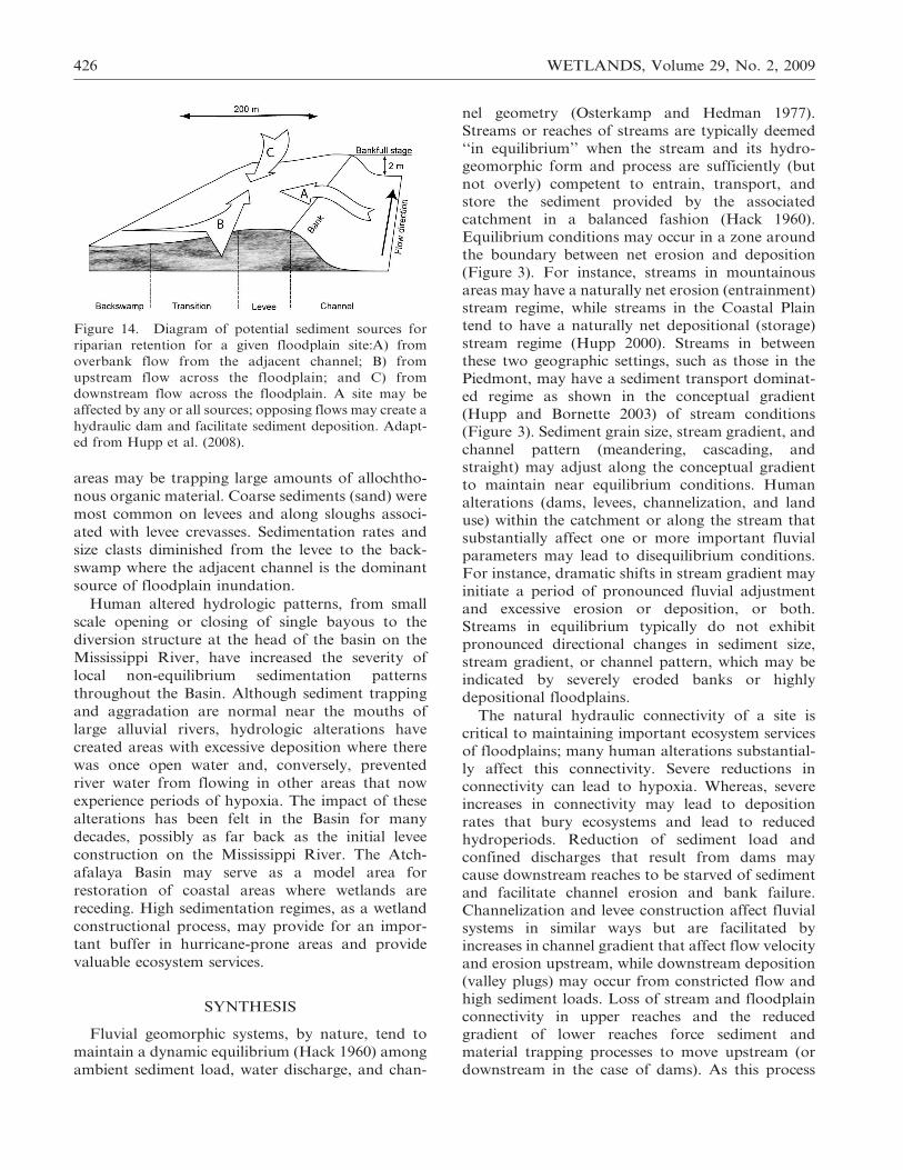
Figure 14. Diagram of potential sediment sources for
riparian retention for a given floodplain site:A) from
overbank flow from the adjacent channel; B) from
upstream flow across the floodplain; and C) from
downstream flow across the floodplain. A site may be
affected by any or all sources; opposing flows may create a
hydraulic dam and facilitate sediment deposition. Adapt-
ed from Hupp et al. (2008).
426 WETLANDS, Volume 29, No. 2, 2009
moves, it initiates recovery processes of the system
that may also reduce topographic relief and create
relatively high floodplains with low internal relief
that may affect biodiversity. In other situations, the
active floodplain may become restricted within
highly incised banks reducing the original floodplain
to terraces with little to no flooding, substantially
reducing floodplain habitat. This negative feedback
will reduce the sediment and material trapping
function of the floodplain over time. The homoge-
nized nature of floodplain surfaces may affect the
hydroperiod, which, in turn, may affect nutrient
loading and cycling with cascading negative effects
on plant and wildlife biodiversity.
Although human alterations to hydrology and
geomorphology have had definitive impacts on
floodplain ecosystems, the large Coastal Plain
floodplains of the southeastern United States still
have important functioning capacities to improve
water quality. These systems annually accumulate
very large amounts of mineral and organic sediment
and its associated carbon, nitrogen, and phospho-
rus. As we have shown, floodplain accumulation
rates are increased at some locations (e.g., associated
with land clearing in catchment and valley plugs)
and decreased at other locations (e.g., dam and
channelization impacts) depending on the specific
hydrogeomorphic alteration and setting. We esti-
mate that the extensive Coastal Plain floodplains of
the Roanoke River and Atchafalaya Basin, as well
as those of the Chesapeake Bay catchment (Noe and
Hupp in press), currently cumulatively trap
9.7?1012 g/yr of sediment, 7.7?1011 g/yr of C,
4.0?1010 g/yr of N, and 1.1?1010 g/yr of P. These
trapping rates can translate into large percent
retention of annual river loads. The C fluxes
represent 1.3% of the total C sequestration of North
American wetlands and 14.6% of C sequestration by
freshwater mineral wetlands in the conterminous
U.S. (Bridgham et al. 2006), due in part to the much
higher sedimentation rates observed in our focal
systems compared to the mean estimate for fresh-
water mineral wetlands. Investigation of lowland
fluvial systems may be critical towards our under-
standing of global carbon cycling, nutrient accumu-
lation, and biogeochemical processes which in turn
have direct implications for natural remediation,
aquatic ‘‘dead zones’’, and global climate change
(Hupp and Noe 2006). The high sediment and
contaminant trapping and C sequestration functions
of Coastal Plain floodplains suggest that natural
resource managers including engineers, policy mak-
ers, and constituency groups might focus efforts that
buffer these ecosystem services from the deleterious
impacts of hydrogeomorphic alterations by, for
instance, maintaining or restoring the ‘‘natural’’
hydrologic connectivity of streamflow with adjacent
floodplains. This kind of effort by land managers
would require catchment- rather than local-scale
analyses to detect and interpret large-scale pro-
cesses that may profoundly affect most sites within a
basin.
LITERATURE CITED
Biedenharn, D. S., C. R. Thorne, and C. C. Watson. 2000. Recentmorphological evolution of the lower Mississippi River.Geomorphology 34:227–49.
Brandt, S. A. 2000. Classification of geomorphological effectsdownstream of dams. Catena 40:375–401.
Bravard, J. P., C. Amoros, G. Pautou, G. Bornette, M.Bournaud, M. C. Des Chatelliers, J. Gibert, J. L. Peiry, J. F.Perrin, and H. Tachet. 1997. River incision in south-eastFrance: morphological phenomena and ecological effects.Regulated Rivers: Research & Management 13:75–90.
Bridgham, S. D., J. Patrick Megonigal, J. K. Keller, N. B. Bliss,and C. Trettin. 2006. The carbon balance of North Americanwetlands. Wetlands 26:889–916.
Brierley, G. J. and C. P. Murn. 1997. European impacts ondownstream sediment transfer and bank erosion in Cobargocatchment, New South Wales, Australia. Catena 31:119–36.
Brinson, M. M. 1988. Strategies for assessing the cumulativeeffects of wetland alteration on water quality. EnvironmentalManagement 12:655–62.
Church, M. 1995. Geomorphic response to river flow regulation:case studies and time-scale. Regulated Rivers: Research andManagement 11:3–22.
Davis, L. 2007. Spatial patterns of geomorphic processes inchannelized tributary streams. Physical Geography 28:301–10.
Demas, C. R., S. T. Brazelton, and N. J. Powell. 2001. TheAtchafalaya Basin — River of Trees. U. S. Geological Survey,Reston, VA, USA, Fact Sheet 021-02.
Diehl, T. 2000. Shoals and valley plugs in the Hatchie RiverWatershed. U. S. Geological Survey, Nashville, TN, USA,Open-File Report 00-4279.
Fisk, H. N. 1952. Geological Investigation of the AtchafalayaBasin and the Problem of Mississippi River Diversion.Waterways Experiment Station, Vicksburg, MS, USA.
Friedman, J. M., W. R. Osterkamp, M. L. Scott, and G. T.Auble. 1998. Downstream effects of dams on channel geometryand bottomland vegetation: regional patterns in the GreatPlains. Wetlands 18:619–33.
Goolsby, D. A., W. A. Battaglin, B. T. Aulenbach, and R. P.Hooper. 2001. Nitrogen input to the Gulf of Mexico. Journal ofEnvironmental Quality 30:329–36.
Grant, G. E., J. C. Schmidt, and S. L. Lewis. 2003. A geologicalframework for interpreting downstream effects of dams onrivers. p. 209–25. In J. E. O’Connor and G. E. Grant (eds.)A Peculiar River. American Geophysical Union, Water Scienceand Application 7.
Hack, J. T. 1960. Interpretation of erosional topography inhumid temperate regions. American Journal of Science 258-A:80–97.
Happ, S., G. Rittenhouse, and G. Dobson. 1940. Some principlesof accelerated stream and valley sedimentation. U.S. Depart-ment of Agriculture, Washington, DC, Technical Bulletin 695.
Hillman, M. and G. Brierley. 2005. A critical review ofcatchment-scale rehabilitation programmes. Progress in Phys-ical Geography 29:50–76.
Hohensinner, S., H. Habersack, M. Jungwirth, and G. Zauner.2004. Reconstruction of the characteristics of a natural alluvialriver-floodplain system and hydromophological changes fol-lowing human modifications: The Danube River (1812–1991).River Research and Applications 20:25–41.
Hupp et al., FLOODPLAIN GEOMORPHIC PROCESSES 427
Hoover, W. G. and K. J. Killgore. 1997. Fish communities.p. 237–60. In M. G. Messina and W. H. Conner (eds.) SouthernForested Wetlands: Ecology and Management. Lewis Publish-ers, Boca Raton, FL, USA.
Hunt, C. B. 1967. Physiography of the United States. W. H.Freeman and Co., San Francisco, CA, USA.
Hunter, W. M., M. Carter, D. Pashley, and K. Barker. 1993. ThePartners in Flight Species Prioritization Scheme. GeneralTechnical Report RM-227, USDA Forest Service, Fort Collins,CO.
Hupp, C. R. 1992. Riparian vegetation recovery patternsfollowing stream channelization: a geomorphic perspective.Ecology 73:1209–26.
Hupp, C. R. 1999. Relations among riparian vegetation, channelincision processes and forms, and large woody debris.p. 219–45. In S. E. Darby and A. Simon (eds.) Incised RiverChannels. John Wiley and Sons, Chichester, UK.
Hupp, C. R. 2000. Hydrology, Geomorphology, and Vegetationof Coastal Plain Rivers in the Southeastern United States.Hydrological Processes 14:2991–3010.
Hupp, C. R. and D. E. Bazemore. 1993. Temporal and spatialpatterns of wetland sedimentation, West Tennessee. Journal ofHydrology 141:179–96.
Hupp, C. R. and G. Bornette. 2003. Vegetation, fluvial processesand landforms in temperate areas. p. 269–88. In H. Piegay andM. Kondolf (eds.) Tools in Geomorphology. John Wiley andSons, Chichester, UK.
Hupp, C. R., C. R. Demas, D. E. Kroes, R. H. Day, and T. W.Doyle. 2008. Recent sedimentation patterns with the centralAtchafalaya Basin, Louisiana. Wetlands 28:125–40.
Hupp, C. R., E. R. Schenk, J. M. Richter, R. K. Peet, and P. A.Townsend. In Press. Bank erosion along the regulated lowerRoanoke River, North Carolina. The Geological Society ofAmerica, Special Paper 451.
Jacobson, R. B. and D. J. Coleman. 1986. Stratigraphy and recentevolution of Maryland Piedmont floodplains. AmericanJournal of Science 286:617–37.
Jacobson, R. B. and K. A. Oberg. 1997. Geomorphic changes ofthe Mississippi River floodplain at Miller City, Illinois, as aresult of the flood of 1993. U.S. Geological Survey Circular1120-J, p. 22.
King, S. L., J. P. Shepard, K. Ouchley, J. A. Neal, and K.Ouchley. 2005. Bottomland hardwood forests: Past, present,and future. p. 1–17. In L. H. Frederickson, S. L. King, and R.M. Kaminski (eds.) Ecology and Management of BottomlandHardwood Systems. University of Missouri, Gaylord Labora-tory, Puxico, MO, USA. Special Publication No. 10.
Kroes, D. E., C. R. Hupp, and G. B. Noe. 2007. Sediment,nutrient, and vegetation trends along the tidal forestedPocomoke River, Maryland, p. 113–37. In W. H. Conner, T.W. Doyle, and K. W. Krauss (eds.) Ecology of TidalFreshwater Forested Wetlands of the Southeastern UnitedStates. Springer, Netherlands.
Lawson, J. M. 1925. Effect of Rio Grande storage on rivererosion and deposition. Engineering News-Record 95:372–74.
Ligon, F. K., W. E. Dietrich, and W. J. Trush. 1995. Downstreamecological effects of dams. Bioscience 45:183–92.
Leopold, L. B., M. G. Wolman, and J. P. Miller. 1964. FluvialProcesses in Geomorphology. W. H. Freeman and Co., SanFrancisco, CA, USA.
Ludwig, W. 2001. The age of river carbon. Nature 409:466–67.Malmon, D. V., S. L. Reneau, T. Dunne, D. Katzman, and P. G.
Drakos. 2005. Influence of sediment storage on downstreamdelivery of contaminated sediment. Water Resources Research41:W05008. doi:10.1029/2004WR003288,2005.
McManus, J. 2002. The history of sediment flux to AtchafalayaBay, Louisiana. p. 210–26. In S. J. Jones and L. E. Frostick(eds.) Sediment Flux to Basins: Causes, Controls, andConsequences. The Geological Society of London, London,UK.
Miller, N. A. 1990. Effects of permanent flooding on bottomlandhardwoods and implications for water management in theForked Deer River Floodplain. Castanea 55:106–12.
Mitsch, W. J. and J. G. Gosselink. 2000. Wetlands, third edition.John Wiley & Sons, New York, NY, USA.
Morgan, A. E. and S. H. McCrory. 1910. Preliminary reportupon the drainage of the lands overflowed by the North andMiddle Forks of the Forked Deer River and the RutherfordFork of the Obion River in Gibson County, TN. State ofTennessee, State Geological Survey, Nashville, TN.
Mossa, J. 1996. Sediment dynamics in the lowermost MississippiRiver. Engineering Geology 45:457–79.
Mossa, J. and H. H. Roberts. 1990. Synergism of riverine andwinter storm-related sediment transport processes in Louisi-ana’s coastal wetlands. Gulf Coast Association of GeologicalSocieties Transactions 40:635–42.
Nilsson, C., C. A. Reidy, M. Dynesius, and C. Revenga. 2005.Fragmentation and flow regulation of the world’s large riversystems. Science 308:405–08.
Noe, G. B. and C. R. Hupp. 2005. Carbon, nitrogen, andphosphorus accumulation in floodplains of Atlantic CoastalPlain rivers, USA. Ecological Applications 15:1178–90.
Noe, G. B. and C. R. Hupp. In Press. Retention of riverinesediment and nutrient loads by Coastal Plain floodplains.Ecosystems.
Osterkamp, W. R. and E. R. Hedman. 1977. Variation of widthand discharge for natural high-gradient stream channels. WaterResources Research 13:256–58.
Osterkamp, W. R. and C. R. Hupp. 1984. Geomorphic andvegetative characteristics along three northern Virginia streams.Bulletin of the Geological Society of America 95:501–13.
Oswalt, S. N. and S. L. King. 2005. Channelization andfloodplain forests: impacts of accelerated sedimentation andvalley plug formation on floodplain forests of the Middle ForkForked Deer River, Tennessee, USA. Forest Ecology andManagement 215:69–83.
Palmer, M. A., E. S. Bernhardt, J. D. Allan, P. S. Lake, G.Alexander, S. Brooks, J. Carr, S. Clayton, C. N. Dahm, J.Follstad Shah, D. L. Galat, S. G. Loss, P. Goodwin, D. D.Hart, B. Hassett, R. Jenkinson, G. M. Kondolf, R. Lave, J. L.Meyer, T. K. O’Donnell, L. Pagano, and E. Sudduth. 2005.Standards for ecologically successful river restoration. Journalof Applied Ecology 42:208–17.
Petts, G. E. 1979. Complex response of river channel morphologysubsequent to reservoir construction. Progress in PhysicalGeography 3:329–62.
Petts, G. E. and A. M. Gurnell. 2005. Dams and geomorphology:Research progress and future directions. Geomorphology71:27–47.
Pierce, A. R. 2005. Sedimentation, hydrology, and bottomlandhardwood forest succession in altered and unaltered tributariesof the Hatchie River, Tennessee Ph.D. Dissertation. Universityof Tennessee, Knoxville, TN, USA.
Pierce, A. R. and S. L. King. 2007a. The influence of valley plugsin channelized streams on floodplain sedimentation dynamicsover the last century. Wetlands 27:631–43.
Pierce, A. R. and S. L. King. 2007b. The effects of flooding andsedimentation on seed germination of two bottomland hard-wood tree species. Wetlands 27:588–94.
Pierce, A. R. and S. L. King. 2008. Spatial dynamics of overbanksedimentation in floodplain systems. Geomorphology 100:256–68.
Poff, N. L., J. D. Allan, M. B. Bain, J. R. Karr, K. L.Prestegaard, B. D. Richter, R. E. Sparks, and J. C. Stromberg.1997. The natural flow regime. Bioscience 47:769–84.
Raymond, P. A. and J. E. Bauer. 2001. Riverine export of agedterrestrial organic matter to the North Atlantic Ocean. Nature409:497–500.
Robbins, C. H. and A. Simon. 1983. Man-induced channeladjustment in Tennessee streams. USGS Water ResourcesInvestigations Report 82-4098.
Roberts, H. H., R. D. Adams, R. Cunningham, G. P. Kemp, andS. Majersky. 1980. Evolution of sand-dominant sub-aerialphase, Atchafalaya Delta, Louisiana. American Association ofPetroleum Geologists Bulletin 64:264–79.
428 WETLANDS, Volume 29, No. 2, 2009
Richter, B. D., J. V. Baumgartner, J. Powell, and D. P. Braun.1996. A method for assessing hydrologic alteration withinecosystems. Conservation Biology 10:1163–74.
Saucier, R. T. 1994. Geomorphology and quaternary geologichistory of the lower Mississippi Valley. Volume 1. U. S. ArmyCorps of Engineers, Vicksburg, MS, USA.
Shankman, D. 1993. Channel migration and vegetation patternsin the Southeastern Coastal Plain. Conservation Biology7:176–83.
Shankman, D. and T. B. Pugh. 1992. Discharge response tochannelization for a Coastal Plain stream. Wetlands 12:157–62.
Simon, A. 1994. Gradation processes and channel evolution inmodified West Tennessee streams: process, response, and form.U. S. Geological Survey, Washington, DC, USA, ProfessionalPaper 1470.
Simon, A. and C. R. Hupp. 1987. Geomorphic and vegetativerecovery processes along modified Tennessee streams: aninterdisciplinary approach to disturbed fluvial systems.p. 251–62. In Proceedings of the International Symposium onForest Hydrology and Watershed Management. InternationalAssociation of Scientific Hydrology, Vancouver, Canada.
Simon, A. and C. R. Hupp. 1992. Geomorphic and vegetativerecovery processes along modified stream channels of WestTennessee. U.S. Geological Survey, Nashville, TN, Open-FileReport 91-502.
Schumm, S. A., M. D. Harvey, and C. C. Watson. 1984. IncisedChannels: Morphology, Dynamics, and Control. Water Re-sources Publications, Littleton, CO, USA.
Sharitz, R. R. and W. J. Mitsch. 1993. Southern floodplainforests. p. 311–72. In W. H. Martin, S. G. Boyce, and A. C.Echternacht (eds.) Biodiversity of the Southeastern UnitedStates, Lowland Terrestrial Communities. John Wiley andSons, New York, NY, USA.
Speer, P. R., W. J. Perry, J. A. McCabe, and O. G. Lara. 1965.Low-flow characteristics of streams in the Mississippi embay-ment in Tennessee, Kentucky, and Illinois. U. S. GeologicalSurvey, Washington, DC, USA, Professional Paper 448-H.
Thorne, C. R. and S. R. Abt. 1993. Analysis of riverbankinstability due to toe scour and lateral erosion. Earth SurfaceProcesses and Landforms 18:835–44.
Tucci, P. and G. E. Hileman. 1992. Potential effects of dredgingthe South Fork Obion River on ground-water levels nearSidonia, Weakley County, Tennessee. U.S. Geological Survey,Water-Resources Investigations Report 90-4041.
Turner, R. E. and N. N. Rabalais. 1991. Changes in MississippiRiver water quality this century and implications for coastalfood webs. BioScience 41:140–47.
Tye, R. S. and J. H. Coleman. 1989. Evolution of Atchafalayalucustrine deltas, south-central Louisiana. Sedimentary Geolo-gy 65:95–112.
U.S. Department of Agriculture Soil Conservation Service. 1986.Sediment transport analysis report, Hatchie River Basin specialstudy, Tennessee and Mississippi: U.S. Department of Agri-culture Soil Conservation Service, p. 17.
Walls, R. L., D. H. Wardrop, and R. P. Brooks. 2005. The impactof experimental sedimentation and flooding on the growth andgermination of floodplain trees. Plant Ecology 176:203–13.
Wang, G., B. Wu, and Z.-Y. Wang. 2005. Sedimentationproblems and management strategies of Sanmenxia Reservoir,Yellow River, China. Water Resources Research 41:W09417.doi:10.1029.2004WR003919.
Wang, H., Z. Yang, Y. Saito, J. P. Liu, X. Sun, and Y. Wang.2007. Stepwise decreases of the Huanghe (Yellow River)sediment load (1950–2005): impacts of climate change andhuman activities. Global and Planetary Change 57:331–54.
Wharton, C. H., W. M. Kitchens, E. C. Pendleton, and T. W.Sipe. 1982. The ecology of bottomland hardwood swamps ofthe southeast: a community profile. FWS/OBS-81/37. U.S. Fishand Wildlife Service, Biological Services Program, Washington,DC, USA.
Wilder, T. C. 1998. A comparison of mature bottomlandhardwood forests in natural and altered settings in WestTennessee. M.S. Thesis, Tennessee Technological University,Cookeville, TN.
Williams, G. P. and M. G. Wolman. 1984. Downstream effects ofdams on alluvial rivers: U.S. Geological Survey ProfessionalPaper 1286, p. 83.
Wolfe, W. J. and T. H. Diehl. 1993. Recent sedimentation andsurface-water flow patterns on the floodplain of the NorthFork Forked Deer River, Dyer County, Tennessee. USGS, incooperation with TWRA, Nashville, TN. Water ResourcesInvestigations Report 92-4082.
Manuscript received 23 July 2008; accepted 5 February 2009.
Hupp et al., FLOODPLAIN GEOMORPHIC PROCESSES 429