flood damage emergency reconstruction project –...
TRANSCRIPT
KINGDOM OF CAMBODIA
Nation Religion King
Ministry of Water Resources and Meteorology
Asian Development Bank
Flood Damage Emergency Reconstruction Project – Additional Financing ADB Loan Number : 3125-CAM(SF)
GoA (DFAT) Grant Number: 0285-CAM(EF)
SUBPROJECT PROFILE
TUMNUB SRAE LOOR Version 1
January 2015
In association with
KEY CONSULTANTS (CAMBODIA)
Egis Eau Document quality information
Page 2 Flood Damage Emergency Reconstruction Project – Additional Financing Version 1
Document quality information
General information
Directed by Chann Sinath, Project Director, PIU
Author(s) FDERP-AF MOWRAM TA: Egis Eau/KCC
Project name Flood Damage Emergency Reconstruction Project – Additional Financing
Document name Tumnub Srae Loor Subproject Profile
Date 27 January 2015
Reference
Addressee(s)
Sent to:
Name Organisation Sent on (date):
Huy Vantha Project Manager, PIU 2 February 2015
Copy to:
Name Organisation Sent on (date):
PIU (3) PIU
PCMU (2) PCMU
ADB (3) ADB
History of modifications
Version Date Written by Approved & signed by:
Version 1 27 January 2015 FDERP-AF: Egis Eau/KCC Leighton Williams, TL/IE
Egis Eau Contents
Page 3 Flood Damage Emergency Reconstruction Project – Additional Financing Version 1
Contents
Chapter 1 - INTRODUCTION.............................................................................7
1. Background..................................................................................................7 1.1. FDERP-AF ...........................................................................................................7 1.2. Project History......................................................................................................8
2. Flood Damage ..............................................................................................9
Chapter 2 - SUBPROJECT DESCRIPTION ....................................................10
1. Location......................................................................................................10 2. Existing Situation ......................................................................................11
2.1. Description of Facilities ......................................................................................11 2.2. State of Repair ...................................................................................................11
3. Socio-economic and Agriculture .............................................................13 3.1. Area....................................................................................................................13 3.2. Cultivated Area and Beneficiaries......................................................................13 3.3. Agriculture Practices ..........................................................................................14 3.4. Cropping Patterns ..............................................................................................15 3.5. Agricultural Product Marketing...........................................................................15 3.6. Economic Rate of Return...................................................................................15
4. FWUC/FWUG ..............................................................................................17 4.1. Profile of the FWUC ...........................................................................................17 4.2. Infrastructure Works since FWUC Establishment..............................................19 4.3. Conclusions........................................................................................................19
5. O&M ............................................................................................................20 5.1. Operation ...........................................................................................................20 5.2. Maintenance.......................................................................................................20 5.3. Water Distribution...............................................................................................20
6. Hydrology ...................................................................................................20
Chapter 3 - SCOPE OF WORKS.....................................................................23
1. Proposed Interventions.............................................................................23 1.1. Stage 2 Civil Works............................................................................................23 1.2. Stage 3 Civil Works............................................................................................23 1.3. Recommended Additional Works.......................................................................23
2. Cost Estimate.............................................................................................23 3. Photographs...............................................................................................24
Chapter 4 - SUB-PROJECT SCREENING ......................................................26
1. General and Irrigation Specific Screening ..............................................26 1.1. Stage 2...............................................................................................................26 1.2. Stage 3...............................................................................................................26
2. Safeguards Screening: Resettlement ......................................................26 2.1. Scope of Land Acquisition and Resettlement ....................................................26 2.2. Resettlement Impact Categorisation Check-list.................................................26 2.3. Voluntary Resettlement......................................................................................26 2.4. Suggested Follow-up Activities ..........................................................................27
3. Safeguards Screening: Environment.......................................................27 3.1. Environmental Assessment Check-list...............................................................27 3.2. Beneficial impacts ..............................................................................................27 3.3. Potential Negative Environmental Impacts ........................................................28
3.3.1. Siting concerns.................................................................................................... 28
Egis Eau Contents
Page 4 Flood Damage Emergency Reconstruction Project – Additional Financing Version 1
3.3.2. Construction impacts........................................................................................... 28 3.4. Environmental Category ....................................................................................28 3.5. Environmental Management Plan......................................................................29
Chapter 5 - CONCLUSIONS............................................................................30
1. Screening ...................................................................................................30 2. Proposed Interventions.............................................................................30
References .....................................................................................................55
List of appendices
Appendix 1 – Hydrology...............................................................................................................31
Appendix 2 – Sketches of Emergency Repairs............................................................................41
Appendix 3 – Stage 2 Assessment and Confirmation Sheet .......................................................42
Appendix 4 – Selection Criteria Screening ..................................................................................43
Appendix 5 – Involuntary Resettlement Impact Check-list ..........................................................45
Appendix 6 – ADB Resettlement Principles and Policy Frameworks ..........................................46
Appendix 7 – Screening for Environmental Impacts....................................................................47
Appendix 8 – Environmental Management Plan (EMP) ..............................................................51
List of figures
Figure 1 – Location of Tumnub Srae Loor Irrigation System.......................................................10
Figure 2 – Layout of Tumnub Srae Loor Irrigation Sytem............................................................12
Figure 3 – Existing Cropping Pattern Chork Subproject ..............................................................15
Figure 4 Organizational Structure of Tumnub Tumnub Srae Loor Construction, Care and Repair Committee ...........................................................................................................18
Figure 5 – Tumnub Srae Loor Catchment ...................................................................................31
Figure 6 – Summary of monthly rainfall at Thma Pouk................................................................33
Figure 7 – Summary of monthly rainfall at Svay Chek.................................................................33
Figure 8 – Summary of monthly rainfall at Bankurat, Thailand....................................................34
Figure 9 – Rainfall-intensity-duration curves for Bankraut, Thailand...........................................34
Egis Eau Contents
Page 5 Flood Damage Emergency Reconstruction Project – Additional Financing Version 1
List of tables
Table 1 – Area and population in the target area of Tumnub Srae Loor subproject....................13
Table 2 – Cultivated area and benefiting families........................................................................13
Table 3 – Agricultural practices at Tumnub Srae Loor subproject...............................................14
Table 4 – Without the project crop budget and gross margin ......................................................16
Table 5 – With the project crop budget and gross margin ...........................................................16
Table 6.– Economic Cash Flow at Tumnub Srae Loor subproject ..............................................16
Table 7 – 24 Hour raingauge records for locations closest to Tumnub Srae Loor reservoirs and command area ...............................................................................................32
Table 8 – Summary of various estimates of peak discharge at Tumnub Srae Loor Gates .........37
Table 9 – Water availability (MCM) entering Tumnub Srae Loor.................................................39
Table 10 – Water availability (m3/s) entering Tumnub Srae Loor ................................................40
Egis Eau Acronyms and Abbreviations
Page 6 Flood Damage Emergency Reconstruction Project – Additional Financing Version 1
Acronyms and Abbreviations
ADB Asian Development Bank
CARM Cambodian Resident Mission (of ADB)
EA Executing Agency
ECOSORN Economic and Social Relaunch of Northwest Provinces in Cambodia
EMP Environmental Management Plan
FDERP Flood Damage Emergency Reconstruction Project
FDERP-AF Flood Damage Emergency Reconstruction Project – Additional Financing
FMC FWUC Management Committee
FWUC Farmer Water User Community
GoA (DFAT) Government of Australia (Department of Foreign Affairs and Trade)
IA Implementing Agency
IDA International Development Association
IEE Initial Environmental Examination
IFAD International Fund for Agricultural Development
IMT Irrigation Management Transfer
IRS Irrigation Rehabilitation Study
ISF Irrigation Service Fee
MAF Mean Annual Flood
MEF Ministry of Economy and Finance
MOU Memorandum of Understanding
MOWRAM Ministry of Water Resources and Meteorology
MRD Ministry of Rural Development
NGO Non-Governmental Organisation
O&M Operation and Maintenance
PAM Project Administration Manual
PCMU Project Coordination and Monitoring Unit (MEF)
PDWRAM Provincial Department of Water Resources and Meteorology
PIMD Participatory Irrigation Management Development
PIU Project Implementation Unit
PP Procurement Plan
RGC Royal Government of Cambodia
RRP Report and Recommendation of the President (to board of directors)
SPS Safeguard Policy Statement
TA Technical Assistance
TOR Terms of Reference
UNHCR United Nations High Commissioner for Refugees
UNTAC United Nations Transitional Authority In Cambodia

Egis Eau Subproject Profile – Tumnub Srae Loor
Page 7 Flood Damage Emergency Reconstruction Project – Additional Financing Version 1
Chapter 1 - INTRODUCTION
1. Background
1.1. FDERP-AF
During the period September to November 2013, Cambodia and neighbouring countries suffered floods from the Mekong River and heavy rainfall in river catchments at similar levels to the floods which affected Cambodia in 2011. The 2013 flooding triggered RGC/ADB/GoA (DFAT)* emergency aid actions leading to the Flood Damage Emergency Reconstruction Project – Additional Financing (FDERP-AF) as well as a review of damage to recently repaired infrastructure for the Flood Damage Emergency Reconstruction Project (FDERP) and North West Irrigation Sector Project (NWISP).
An ADB fact finding mission on the 2013 flood damage undertaken in January 2014 produced a proposal for the Additional Financing to Flood Damage Emergency Reconstruction Project. The Bank and RGC initiated an emergency approach similar to the FDERP project to formulate a new project. The new project was renamed FDERP-AF and the agreement for Loan No.3125-CAM (SF) between RGC and ADB was finally signed 23 April 2014 and the loan became effective on the 30 May 2014. The loan is divided between several sectors with responsibility for Irrigation Rehabilitation and Flood Management as Output 3 implemented by the Ministry of Water Resources and Meteorology (MOWRAM).
The emergency repairs were categorised into 3 phases, Stage 1 to 3 as: Stage 1: Immediate repairs to re-establish use of the infrastructure on a temporary basis
and restore communications. Stage 2: Fast track repairs where it was considered necessary to repair the damage before
the next wet season to secure the existing (undamaged) works. Stage 3: Remaining flood damage restoration to complete the remaining damage repairs,
preferably within the following two to three dry season construction periods.
The immediate Stage 1 repairs were done following the flood. At MOWRAM work on Stage 2 began in February 2014 and repair works commenced in June 2014 and have continued into 2015. Stage 3 works will be carried out during the dry season 2015 and 2016.
Stage 2 and Stage 3 works are identified in the Procurement Plan (PP). However the PP was a hastily prepared list of subprojects requiring interventions with guess estimates of cost. Thus it is a requirement of the Project Administration Manual (PAM) that Stage 3 subprojects be confirmed prior to commencing detailed design†.
* Royal Government of Cambodia/Asian Development Bank/Government of Australia (Department of Foriegn Affairs - Formerly AusAID)
† Actually, MOWRAM has substantially complete designs so the confirmation process is to review and improve these designs before procedding to prepation of contract documents.
Egis Eau Subproject Profile – Tumnub Srae Loor
Page 8 Flood Damage Emergency Reconstruction Project – Additional Financing Version 1
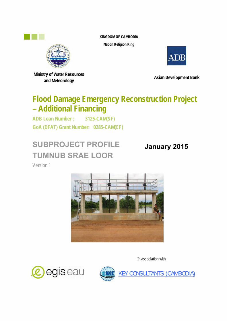
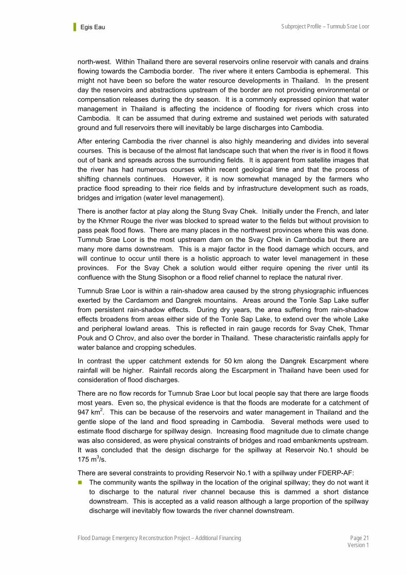
This subproject profile concerns the Stage 3 interventions for Tumnub Srae Loor Irrigation System located in Banteay Meanchey Province. The work comprises provision of a new spillway and rehabilitation of three main canals total length about 2,367 m. These works are additional to urgent Stage 2 works which comprised repairs to two earthen embankment dams of total length 6.4 km, provision of gates for nine existing box and pipe culverts along the dam plus two new gated box and pipe culvert also along the dams.
1.2. Project History
The existing system comprises two low embankment dams forming two shallow reservoirs used for flood spreading and water supply. Sections of both dams are a road under the responsibility of the Ministry of Rural Development (MRD).
The system was originally developed during the French colonial period between 1930 and 1950. It was known as Tumnub Ta Sao supplied by the Stung Svay Chek known locally as the Stung Kork Romeat. The catchment rises on the Dangrek Escarpment and is 85% in Thailand.
Between 1976 and 1977 the Khmer Rouge regime used forced labour from Thmor Pouk District to extend the dams, construct four box culverts with wooden gates, and excavate four main canals to irrigate rice fields.
Following the fall of the Khmer Rouge in 1979 there was a period of chaos and uncertainty. Civil war raged along the Cambodia-Thailand border. People who had been forced from the area by the Khmer Rouge could not return and even more people moved from the villages to Thmor Pouk or Serei Sisophon for safety. Others were in refugee camps in Thailand under the UNHCR‡. It was not until 1991 during the UNTAC§ period that people could start to return to the area and this is when there was some small labour based maintenance of Tumnub Srae Loor repairing embankment erosion, filling potholes along the dam crests and repairing embankment slippage.
In 1998 the road along the dam was rehabilitated through the Commune/Sangkat Fund under the Seila Program**; the work included some irrigation check structures. Again in 2005, the Commune/Sangkat Fund was used to maintain the road and dam together with some broken irrigation facilities. The 2008 European Union ECOSORN†† project improved the road from Kouk Romeat but this did not include the road along the dams.
The dams were damaged during floods caused by Typhoon Ketsana in 2009, and the prolonged floods in 2011. The sections of road along the dam were subsequently repaired by the World Bank Ketsana Project IDA-Grant No.613.Kh. This was a road project under the MRD and the work included Laterite pavement and some pipe and box culverts but the vertical alignment was not raised to function as a dam and the culverts made no provision for gates or stoplogs.
‡ United Nations High Commissioner for Refugees
§ United Nations Transitional Authority In Cambodia
** The Seila program started in 1996 was a national program with multilateral donor support aiming to achieve poverty reduction through local development and improved local governance; it facilitated small infrastructure works supported by the RGC Commune/Sangkat Fund
†† Economic and Social Relaunch of Northwest Provinces in Cambodia
Egis Eau Subproject Profile – Tumnub Srae Loor
Page 9 Flood Damage Emergency Reconstruction Project – Additional Financing Version 1
The floods in 2013 damaged both dams and opened breaches but the road repaired under the Ketsana project did not suffer serious damage.
The FDERP-AF has made emergency repairs to the dam as a Stage 2 subproject. The two dams were raised to consistent levels; the raising included the sections of road rehabilitated under the Ketsana project. The road was then paved with Laterite. Seven existing culverts were converted to water gates and two new water gates added. However, no spillway was constructed and the small existing damaged spillway was buried within the rehabilitated dam.
Since 2012 a new road (designation 56A) has been constructed by the Army upstream of the reservoirs. This includes a 48 m span bridge and road embankment crossing the full width of the Stung Svay Chek valley. In combination with other roads and bridges upstream these works act to attenuate the inflow flood hydrograph at Srae Loor reservoirs.
Local people and the local authorities have said that up until 2013 the Tumnub Tumnub Srae Loor reservoirs had never stored water since the time of the Khmer Rouge regime. They also report that there is a big flood in most years which has caused frequent damage to the dams and other infrastructure.
2. Flood Damage As mentioned the dams had suffered flood damage over many years and were further damaged during 2013. Both dams were breached but not the sections of road rehabilitated by the Ketsana Project. The small existing spillway was severely damaged and undermined by erosion and scour. The existing canals which had become silted and overgrown and in places used as rice paddy generally could not be used. Although the dam and water gates have been repaired under FDERP-AF Stage 2 there is no spillway for Reservoir No.1 which is online with the Stung Svay Chek (Reservoir No.2 is offline). A spillway in needed to reduce the risk of future flood damages to the dam. Also the canals required rehabilitation.

Egis Eau Subproject Profile – Tumnub Srae Loor
Page 10 Flood Damage Emergency Reconstruction Project – Additional Financing Version 1
Chapter 2 - SUBPROJECT DESCRIPTION
1. Location Tumnub Srae Loor Irrigation Scheme is located in Thmor Pouk District, Banteay Meanchey Province. It is 44 km via National Road No.56 north of the provincial capital Serei Sisophon.
Figure 1 – Location of Tumnub Srae Loor Irrigation System
Tumnub Srae Loor
Egis Eau Subproject Profile – Tumnub Srae Loor
Page 11 Flood Damage Emergency Reconstruction Project – Additional Financing Version 1
2. Existing Situation
2.1. Description of Facilities
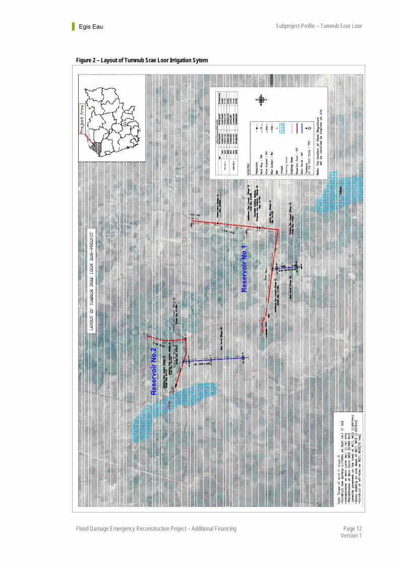
It is estimated by MOWRAM that the reservoirs in combination with improved canals will facilitate supplementary irrigation by flood spreading to a gross area 1,800 ha. The general arrangement of the existing reservoirs and canals is shown by Figure 2. There are two reservoirs at Tumnub Srae Loor formed by two “L” shaped earth embankment dams. Reservoir No.1 is the lower (downstream) reservoir and is online with the main channel of the Stung Svay Chek. Reservoir No.2 is the upper (upstream) reservoir; it is offline in that it captures overland flow on the right bank flood plain of the Stung Svay Chek. The east to west arms of each dam are the MRD road, the south to north arms are used for access to fields. There are small areas of permanent water within both reservoirs but according to local people neither reservoir has stored significant water since the fall of Khmer Rouge regime. But in any case the original system built by the French was designed for flood spreading rather than water storage.
Since completion of the FDERP-AF Stage 2 repairs there are four box and one pipe culvert water gates along Reservoir No.1 dam and two box and two pipe culvert water gates along Reservoir No.2 dam. Neither reservoir has a spillway; the small damaged spillway at Reservoir No.1 was buried when the dam was repaired under the FDERP-AF.
There are no water gates for direct release of water from Reservoir No.1 to the Stung Prek Chik downstream. The now abandoned spillway was not aligned with the river channel but discharged across paddy fields on the eastern flank of the Reservoir. The reason is that the river is blocked a few kilometres downstream for flood spreading, and at many more locations further downstream from this. Therefore a spillway which discharged from Reservoir No.1 would have a domino effect downstream as the peak flood hydrograph moves down the valley because everywhere the river is blocked. Although damming the river might work by providing flood spreading during a normal flood season during a large flood the water will overtop and breach the dams and seek out alternative flow paths downstream. This explains the recurring damage to infrastructure which has been happening all down the valley of the Stung Svay Chek. A solution is beyond the current scope of the FDERP-AF.
There are two original canals downstream from Reservoir No.1, both of which will be rehabilitated and developed during Stage 3. There are three original canals downstream from Reservoir No.2 varying between 1,066 m and 1,253 m long. The middle canal is 1,167 m long and will be rehabilitated during Stage 3 but the other two canals will not be improved.
2.2. State of Repair
Following the works carried out under FDERP-AF Stage 2 both dams are in a good state of repair and have sufficient culverts with water gates for flood spreading and impounding water at the end of the wet season. In contrast the canals are in bad condition. In some cases the alignment remains but they are silted up and overgrown. In many places they are used as rice paddy. All the canals are in urgent need of rehabilitation.
There is a high risk of further flood damage until an adequately sized replacement spillway is constructed at Reservoir No.1. Water gate culverts do not remove the need for a spillway because even if all the gates are open they do not have the capacity to pass a large flood discharge. A spillway is also desirable for Reservoir No.2 although the risks are lower because the reservoir is not online.
Egis Eau Subproject Profile – Tumnub Srae Loor
Page 12 Flood Damage Emergency Reconstruction Project – Additional Financing Version 1
Figure 2 – Layout of Tumnub Srae Loor Irrigation Sytem
Res
ervo
ir N
o.1
Res
ervo
ir N
o.2
Egis Eau Subproject Profile – Tumnub Srae Loor
Page 13 Flood Damage Emergency Reconstruction Project – Additional Financing Version 1
3. Socio-economic and Agriculture
3.1. Area
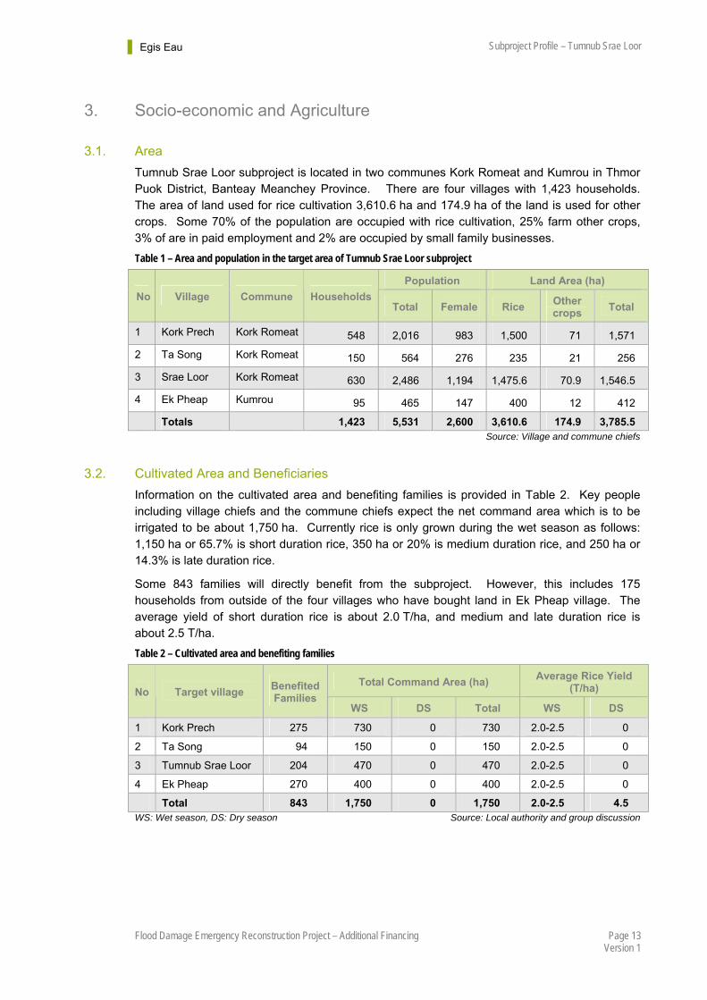
Tumnub Srae Loor subproject is located in two communes Kork Romeat and Kumrou in Thmor Puok District, Banteay Meanchey Province. There are four villages with 1,423 households. The area of land used for rice cultivation 3,610.6 ha and 174.9 ha of the land is used for other crops. Some 70% of the population are occupied with rice cultivation, 25% farm other crops, 3% of are in paid employment and 2% are occupied by small family businesses.
Table 1 – Area and population in the target area of Tumnub Srae Loor subproject
Population Land Area (ha)
No Village Commune Households Total Female Rice
Other crops
Total
1 Kork Prech Kork Romeat 548 2,016 983 1,500 71 1,571
2 Ta Song Kork Romeat 150 564 276 235 21 256
3 Srae Loor Kork Romeat 630 2,486 1,194 1,475.6 70.9 1,546.5
4 Ek Pheap Kumrou 95 465 147 400 12 412
Totals 1,423 5,531 2,600 3,610.6 174.9 3,785.5 Source: Village and commune chiefs
3.2. Cultivated Area and Beneficiaries
Information on the cultivated area and benefiting families is provided in Table 2. Key people including village chiefs and the commune chiefs expect the net command area which is to be irrigated to be about 1,750 ha. Currently rice is only grown during the wet season as follows: 1,150 ha or 65.7% is short duration rice, 350 ha or 20% is medium duration rice, and 250 ha or 14.3% is late duration rice.
Some 843 families will directly benefit from the subproject. However, this includes 175 households from outside of the four villages who have bought land in Ek Pheap village. The average yield of short duration rice is about 2.0 T/ha, and medium and late duration rice is about 2.5 T/ha.
Table 2 – Cultivated area and benefiting families
Total Command Area (ha) Average Rice Yield
(T/ha) No Target village Benefited Families
WS DS Total WS DS
1 Kork Prech 275 730 0 730 2.0-2.5 0
2 Ta Song 94 150 0 150 2.0-2.5 0
3 Tumnub Srae Loor 204 470 0 470 2.0-2.5 0
4 Ek Pheap 270 400 0 400 2.0-2.5 0
Total 843 1,750 0 1,750 2.0-2.5 4.5 WS: Wet season, DS: Dry season Source: Local authority and group discussion
Egis Eau Subproject Profile – Tumnub Srae Loor
Page 14 Flood Damage Emergency Reconstruction Project – Additional Financing Version 1
3.3. Agriculture Practices
Currently the main crop grown in the Tumnub Srae Loor subproject area is wet season rice. Rice is broadcast, rainfed and where possible irrigated. Farmers on average use about 150 kg/ha of chemical fertilizer for wet season rice.
Rice varieties being grown are Phkar Romduol and Phkar Malis (fragrant rice) for short duration rice, Phkar Khnhey for medium duration rice and Raing Chey and Car 9 for late duration rice. It is mentioned that on average 100 kg/ha of rice seed used by farmers is bought from neighbours or kept from the previous crop.
In general, the farmers have done late duration rice before short and medium duration rice in the flooded area in the early wet season to avoid rotten rice with too much water. Wet season rice starts from May to June with land preparation and harvesting in November (short duration rice) and December or January (medium and late duration rice).
In the future situation if there is effective irrigation infrastructure there is potential to improve rice production. This can be achieved through the System of Rice Intensification to improve soil fertility, rice seed, and water management to increase rice yields.
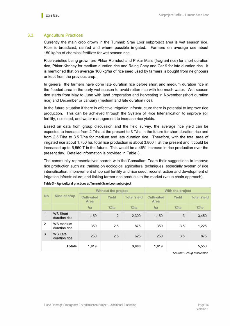
Based on data from group discussion and the field survey, the average rice yield can be expected to increase from 2 T/ha at the present to 3 T/ha in the future for short duration rice and from 2.5 T/ha to 3.5 T/ha for medium and late duration rice. Therefore, with the total area of irrigated rice about 1,750 ha, total rice production is about 3,800 T at the present and it could be increased up to 5,550 T in the future. This would be a 46% increase in rice production over the present day. Detailed information is provided in Table 3.
The community representatives shared with the Consultant Team their suggestions to improve rice production such as: training on ecological agricultural techniques, especially system of rice intensification, improvement of top soil fertility and rice seed; reconstruction and development of irrigation infrastructure; and linking farmer rice products to the market (value chain approach).
Table 3 – Agricultural practices at Tumnub Srae Loor subproject
Without the project With the project
No Kind of crop Cultivated Area
Yield Total Yield Cultivated Area
Yield Total Yield
ha T/ha T/ha ha T/ha T/ha
1 WS Short duration rice
1,150 2 2,300 1,150 3 3,450
2 WS medium duration rice
350 2.5 875 350 3.5 1,225
3 WS Late duration rice
250 2.5 625 250 3.5 875
Totals 1,819 3,800 1,819 5,550
Source: Group discussion
Egis Eau Subproject Profile – Tumnub Srae Loor
Page 15 Flood Damage Emergency Reconstruction Project – Additional Financing Version 1
WS Medium Duration Rice
WS Late Duration Rice
WS Short Duration Rice
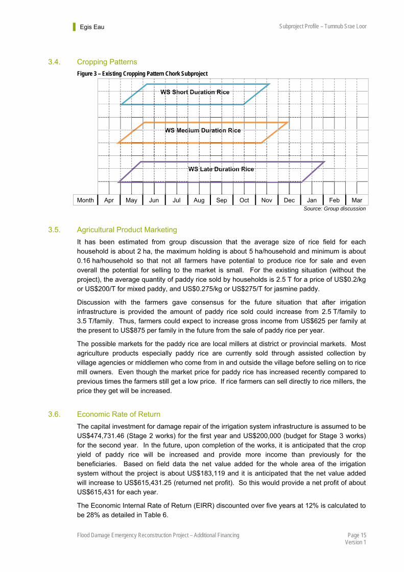
3.4. Cropping Patterns
Figure 3 – Existing Cropping Pattern Chork Subproject
Month Apr May Jun Jul Aug Sep Oct Nov Dec Jan Feb Mar Source: Group discussion
3.5. Agricultural Product Marketing
It has been estimated from group discussion that the average size of rice field for each household is about 2 ha, the maximum holding is about 5 ha/household and minimum is about 0.16 ha/household so that not all farmers have potential to produce rice for sale and even overall the potential for selling to the market is small. For the existing situation (without the project), the average quantity of paddy rice sold by households is 2.5 T for a price of US$0.2/kg or US$200/T for mixed paddy, and US$0.275/kg or US$275/T for jasmine paddy.
Discussion with the farmers gave consensus for the future situation that after irrigation infrastructure is provided the amount of paddy rice sold could increase from 2.5 T/family to 3.5 T/family. Thus, farmers could expect to increase gross income from US$625 per family at the present to US$875 per family in the future from the sale of paddy rice per year.
The possible markets for the paddy rice are local millers at district or provincial markets. Most agriculture products especially paddy rice are currently sold through assisted collection by village agencies or middlemen who come from in and outside the village before selling on to rice mill owners. Even though the market price for paddy rice has increased recently compared to previous times the farmers still get a low price. If rice farmers can sell directly to rice millers, the price they get will be increased.
3.6. Economic Rate of Return
The capital investment for damage repair of the irrigation system infrastructure is assumed to be US$474,731.46 (Stage 2 works) for the first year and US$200,000 (budget for Stage 3 works) for the second year. In the future, upon completion of the works, it is anticipated that the crop yield of paddy rice will be increased and provide more income than previously for the beneficiaries. Based on field data the net value added for the whole area of the irrigation system without the project is about US$183,119 and it is anticipated that the net value added will increase to US$615,431.25 (returned net profit). So this would provide a net profit of about US$615,431 for each year.
The Economic Internal Rate of Return (EIRR) discounted over five years at 12% is calculated to be 28% as detailed in Table 6.

Egis Eau Subproject Profile – Tumnub Srae Loor
Page 16 Flood Damage Emergency Reconstruction Project – Additional Financing Version 1
Table 4 – Without the project crop budget and gross margin
Crop Area Yield Total of yield
Price Gross financial revenue
Cost Gross cost
Net income
ha T/ha T US$/T US$ US$/ha US$ US$
WS Short duration rice
1,150 2 2,300 275 632,500 430.88 495,506 136,994
WS medium duration rice
350 2.5 875 200 175,000 423.13 148,094 26,906
WS Late duration rice
250 2.5 625 200 125,000 423.13 105,781 19,219
Total 1,750 183,119
Table 5 – With the project crop budget and gross margin
Crop Area Yield Total of yield
Price Gross financial revenue
Cost Gross cost
Net income
ha T/ha T US$/T US$ US$/ha US$ US$
WS Short duration rice
1150 3 3450 275 948,750 433.13 498,094 450,656
WS medium duration rice
350 3.5 1225 200 245,000 425.38 148881 96,119
WS Late duration rice
250 3.5 875 200 175,000 425.38 106,344 68,656
Total 1,750 615,431
Table 6.– Economic Cash Flow at Tumnub Srae Loor subproject
Year Capital Costs
O&M costs (a)
Engineer- ing &
services
Income foregone for land losses
Total costs
Phased increment-
al crop benefits (b)
Total Benefits
Net benefits
US$ US$ US$ US$ US$ US$ US$ US$
1 474,731 Nil Nil Nil 474,731 -474,731
2 200,000 Nil Nil Nil 200,000 -200,000
3 Nil Nil Nil Nil Nil 432,313 432,313 432,313
4 Nil Nil Nil Nil Nil 432,313 432,313 432,313
5 Nil Nil Nil Nil Nil 432,313 432,313 432,313
EIRR 28%
ENPV $244,255
B/C ratio 1.41 Discount Factor: 12%

Egis Eau Subproject Profile – Tumnub Srae Loor
Page 17 Flood Damage Emergency Reconstruction Project – Additional Financing Version 1
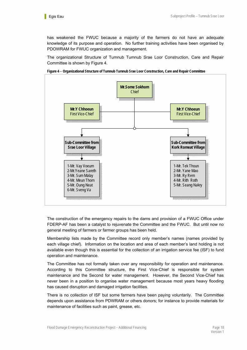
4. FWUC/FWUG There has been community involvement for Tumnub Srae Loor irrigation system. This has been organised by village and commune chiefs mainly for urgent repair and maintenance works of the local and international donor projects and implemented through group works organized by the village chiefs, mostly under the direction of the commune council.
During 2001 the Banteay Meanchey Provincial Department of Water Resource and Meteorology (PDWRAM) introduced the Tumnub Srae Loor community to participatory irrigation management development (PIMD). The participants included some farmers, elders, monks, village and commune chiefs, representatives of the local authority and other institutions involved in the community.
4.1. Profile of the FWUC
In 2001 PDWRAM gave the community some training in PIMD which was based upon MOWRAM Prakas 306, June 2000. This covered the overall framework for the formation of the FWUC and irrigation management transfer (IMT) to the FWUC. Prakas 306 includes several important documents relating to policy and guidelines for implementation of PIMD: Circular No 1 on the Implementation Policy for Sustainable Irrigation Systems. Policy for Sustainability of O&M‡‡ of Irrigation Systems. The statute of the farmer water user communities. Steps in the formation of a Farmer Water Users’ Community.
The process for formation of a FWUC includes the activities mentioned both under the eight steps given in Parkas 306 and the ten steps given in the Training Manual 5 of MOWRAM. The FWUC at Tumnub Srae Loor was initiated and presided over by the Commune Chief to form a Construction, Care and Repair Committee. This Committee was formed on an assumed structure that included Chief, First and Second Vice-Chief and members who had been selected from volunteers. This established an organized community structure. The Committee is in charge of the overall management of the irrigation system. General roles of the three leaders are as follows: Chief, general management of the whole system; First Vice-Chief, maintenance of irrigation facilities; and Second Vice-Chief; operation to distribute water.
Apart from their role with the Committee each of these individuals has other existing or previous roles in the wider community: Chief as a Commune Council member; First Vice-Chief as ex-village chief; and Second Vice-Chief; ex-village chief;
The community has organised ad-hoc assemblies. Previously when there were needs to repair canals and the dams the community representatives circulated a verbal invitation amongst the membership and there was a 45% attendance. In contrast at the meeting held for formation of the FWUC in percentage terms very few farmers were present. The low level of participation
‡‡ Operation and maintenance
Egis Eau Subproject Profile – Tumnub Srae Loor
Page 18 Flood Damage Emergency Reconstruction Project – Additional Financing Version 1
has weakened the FWUC because a majority of the farmers do not have an adequate knowledge of its purpose and operation. No further training activities have been organised by PDOWRAM for FWUC organization and management.
The organizational Structure of Tumnub Tumnub Srae Loor Construction, Care and Repair Committee is shown by Figure 4.
Figure 4 Organizational Structure of Tumnub Tumnub Srae Loor Construction, Care and Repair Committee
The construction of the emergency repairs to the dams and provision of a FWUC Office under FDERP-AF has been a catalyst to rejuvenate the Committee and the FWUC. But until now no general meeting of farmers or farmer groups has been held.
Membership lists made by the Committee record only member’s names (names provided by each village chief). Information on the location and area of each member’s land holding is not available even though this is essential for the collection of an irrigation service fee (ISF) to fund operation and maintenance.
The Committee has not formally taken over any responsibility for operation and maintenance. According to this Committee structure, the First Vice-Chief is responsible for system maintenance and the Second for water management. However, the Second Vice-Chief has never been in a position to organise water management because most years heavy flooding has caused disruption and damaged irrigation facilities.
There is no collection of ISF but some farmers have been paying voluntarily. The Committee depends upon assistance from PDWRAM or others donors; for instance to provide materials for maintenance of facilities such as paint, grease, etc.
Mr.Some Sokhom Chief
Mr.Y Chhoeun First Vice-Chief
Mr.Y Chhoeun First Vice-Chief
Sub-Committee from Srae Loor Village
Sub-Committee from Kork Romeat Village
1-Mr. Vay Voeurn 2-Mr.Yeane Sareth 3-Mr. Sum Malay 4-Mr. Meun Thorn 5-Mr. Oung Neat 6-Mr. Sveng Va
1-Mr. Tek Thoun 2-Mr. Yane Mao 3-Mr. Ry Rem 4-Mr. Rith Roth 5-Mr. Seang Nakry
Egis Eau Subproject Profile – Tumnub Srae Loor
Page 19 Flood Damage Emergency Reconstruction Project – Additional Financing Version 1
4.2. Infrastructure Works since FWUC Establishment
The Kork Romeat and Komrou communes are remote areas near the border with Thailand. The RGC, International Organisations and NGO§§s are encouraged to launch projects which improve infrastructure, water supply, hygiene education and kinds of sanitation, etc. This has included:
In 2008 ECOSORN funded by the European Union and the RGC constructed a 6,200 m long community road.
Completed in October 2013, the MRD under the World Bank Ketsana Project IDA*** Grant No. H613-KH for rehabilitation of infrastructure destroyed by the typhoon, constructed a 12,650 m Laterite community road from Pram Minea village to Srae Loor Village. Some sections of this road through the villages have been sealed with DBST (double bitumen surface treatment) for dust suppression.
The MRD/ADB WATSAN (water sanitation) project improved water supply in several ways:
Some village areas were provided with a set of water ponds comprising an open pond connected to a covered filtration basin with tap outlet and hand pump. This supplied households with water for cooking, bathing and drinking after boiling.
Other households were provided with giant water jars for rain water collection and storage. The provision of the jars was subsidised but each household needed to pay a fee (50,000 Riels) for a set of three jars. The roof gutter, down pipe and the jar stand also had to be provided by the household.
Where groundwater was available a tubewell equipped with an India made ‘Afridev’ hand pump has been used to supply groups of 10 to 15 households.
Some people use an ox-cart or hand-tractor and oil drums to transport water from Tumnub Srae Loor Reservoir for household use.
4.3. Conclusions
The Construction, Care and Repair Committee is currently performing the functions of the FWUC for the Tumnub Tumnub Srae Loor irrigation system. It also participates in other infrastructure developments and organises community participation in providing labour. However, the FWUC as it stands has no statute or regulation and is not collecting ISF. It functions through Kork Romeat Commune Council.
The FWUC should be established with statute and regulations following MOWRAM guidelines. The membership list should be consolidated to facilitate ISF collection to fund operation and maintenance. Especially the FWUC requires training support from MOWRAM and PDWRAM.
Members of the Committee are busy people with other roles in the community. It is unfortunate but on many issues farmers are not willing to obey the leaders and Committee. The authority of a properly constituted FWUC is important to settle various conflicts amongst farmers. The farmers know that the FWUC is not fully functioning and are therefore always requesting assistances from the RGC.
§§ Non-governmental organisation.
*** The International Development Association (IDA) is the part of the World Bank that helps the world’s poorest countries.
Egis Eau Subproject Profile – Tumnub Srae Loor
Page 20 Flood Damage Emergency Reconstruction Project – Additional Financing Version 1
5. O&M There are currently no Operation or Maintenance Manuals
5.1. Operation
Srae Loor reservoirs are supplied by the Stung Svay Chek and during the flood season overland flow from flood spreading. Flows are greatest during September and October and this is the time of year when most flood damages occur.
The new gates fitted to culverts and additional water gates along the reservoir provided under FDERP-AF Stage 2 were not completed until after the 2014 wet season. In the preceding years the original gates that existed had gone missing, culverts had been constructed without gates and the dams had eroded and breached. Basically there was no way of controlling flood spreading and no control was exercised. The situation is changed by the new gates.
The reservoirs start to fill about July and flood spreading can begin. The gates need to be operated to hold water levels in the reservoir at sufficient level to flow to all the outlets. If the reservoir rises too high the gates can be fully opened in sequence to pass the flood. Without a spillway the gates alone will not be able to pass a large flood.
The river and overland flow is normally receding during November and river flow can stop completely during the dry season. At this time all the gates can be closed to store water into the early dry season. At Reservoir No.1 the gates are operated by Kork Prich Village Chief and at Reservoir No.2 by Srae Loor Village Chief.
During the dry season if farmers want to use water available in the reservoirs they must arrange for a representative to ask Mr. Ney Pov, Kork Romeat Commune Chief to operator the appropriate gate to release water to the land or canal.
5.2. Maintenance
Currently the Construction, Care and Repair Committee performs some small scale emergency maintenance but has very limited capability. The new gates will require maintenance including lubrication, painting and clearing trash and obstructions. Similarly the earthworks at the dams and canals including Laterite pavement will require maintenance.
5.3. Water Distribution
Tumnub Srae Loor command area has not been divided into blocks. Water is distributed by flood spreading. Some farmers must pump to get water to their fields. Now that the water gates are functioning the farmers will have to organise for a representative to request for gates to be opened if they are not getting sufficient water, or to ask for the gates to be closed for harvest.
6. Hydrology The Hydrology of Tumnub Srae Loor is discussed at Appendix 1.
Tumnub Srae Loor Sub-project is based around two shallow reservoirs on the Stung Svay Chek. The topographic catchment area is 947 km2 of which more than 85% is in Thailand (Figure 5). The Stung Svak Chek rises on the Dangrek escarpment about 60 km to the west-
Egis Eau Subproject Profile – Tumnub Srae Loor
Page 21 Flood Damage Emergency Reconstruction Project – Additional Financing Version 1
north-west. Within Thailand there are several reservoirs online reservoir with canals and drains flowing towards the Cambodia border. The river where it enters Cambodia is ephemeral. This might not have been so before the water resource developments in Thailand. In the present day the reservoirs and abstractions upstream of the border are not providing environmental or compensation releases during the dry season. It is a commonly expressed opinion that water management in Thailand is affecting the incidence of flooding for rivers which cross into Cambodia. It can be assumed that during extreme and sustained wet periods with saturated ground and full reservoirs there will inevitably be large discharges into Cambodia.
After entering Cambodia the river channel is also highly meandering and divides into several courses. This is because of the almost flat landscape such that when the river is in flood it flows out of bank and spreads across the surrounding fields. It is apparent from satellite images that the river has had numerous courses within recent geological time and that the process of shifting channels continues. However, it is now somewhat managed by the farmers who practice flood spreading to their rice fields and by infrastructure development such as roads, bridges and irrigation (water level management).
There is another factor at play along the Stung Svay Chek. Initially under the French, and later by the Khmer Rouge the river was blocked to spread water to the fields but without provision to pass peak flood flows. There are many places in the northwest provinces where this was done. Tumnub Srae Loor is the most upstream dam on the Svay Chek in Cambodia but there are many more dams downstream. This is a major factor in the flood damage which occurs, and will continue to occur until there is a holistic approach to water level management in these provinces. For the Svay Chek a solution would either require opening the river until its confluence with the Stung Sisophon or a flood relief channel to replace the natural river.
Tumnub Srae Loor is within a rain-shadow area caused by the strong physiographic influences exerted by the Cardamom and Dangrek mountains. Areas around the Tonle Sap Lake suffer from persistent rain-shadow effects. During dry years, the area suffering from rain-shadow effects broadens from areas either side of the Tonle Sap Lake, to extend over the whole Lake and peripheral lowland areas. This is reflected in rain gauge records for Svay Chek, Thmar Pouk and O Chrov, and also over the border in Thailand. These characteristic rainfalls apply for water balance and cropping schedules.
In contrast the upper catchment extends for 50 km along the Dangrek Escarpment where rainfall will be higher. Rainfall records along the Escarpment in Thailand have been used for consideration of flood discharges.
There are no flow records for Tumnub Srae Loor but local people say that there are large floods most years. Even so, the physical evidence is that the floods are moderate for a catchment of 947 km2. This can be because of the reservoirs and water management in Thailand and the gentle slope of the land and flood spreading in Cambodia. Several methods were used to estimate flood discharge for spillway design. Increasing flood magnitude due to climate change was also considered, as were physical constraints of bridges and road embankments upstream. It was concluded that the design discharge for the spillway at Reservoir No.1 should be 175 m3/s.
There are several constraints to providing Reservoir No.1 with a spillway under FDERP-AF: The community wants the spillway in the location of the original spillway; they do not want it
to discharge to the natural river channel because this is dammed a short distance downstream. This is accepted as a valid reason although a large proportion of the spillway discharge will inevitably flow towards the river channel downstream.
Egis Eau Subproject Profile – Tumnub Srae Loor
Page 22 Flood Damage Emergency Reconstruction Project – Additional Financing Version 1
The original spillway location is between two water gate structures separated by less than 111 m.
There is only US$200,000 budget to provide a spillway and to rehabilitate 1,667 m of canal.
The proposed solution is to provide a 100 m long spillway about the original location between the two water gate structures mentioned above. The crest of the spillway will be set at reservoir full supply level 18.26 m elevation project datum. The spillway crest will be a concrete road slab with upstream and downstream downstands. The upstream and downstream slopes will be armoured with gabion mattress with an additional gabion mattress apron downstream to control scour. In combination with open head regulators this will just pass the design discharge with the water level at the crest of the dam. With water this high there will also be flow around the end of the dam which will provide a margin of safety.
It is emphasised that this is not an ideal solution. Rather it is a comprise acceptable to the community and achievable within the available FDERP-AF budget which will improve flood resilience for Tumnub Srae Loor compared to before. The spillway can be upgraded in the future which should be done in combination with a solution for the dammed river channel downstream.
Water resource estimates have been based on 14 years observations of flows in the Stung Sreng at Kralanh. The limitations of the estimates are acknowledged but they are nevertheless the best data based upon observation that is available for estimation of water availability from Tumnub Srae Loor.

Egis Eau Subproject Profile – Tumnub Srae Loor
Page 23 Flood Damage Emergency Reconstruction Project – Additional Financing Version 1
Chapter 3 - SCOPE OF WORKS
1. Proposed Interventions
1.1. Stage 2 Civil Works
The 2013 flood damage to the dam was repaired as FDERP-AF Stage 2 works under contract FDERP-AF-MOWRAM-CW 02. The works were completed by the end of October 2014. The works included: repair and rehabilitation of two embankment dams with a total length 6,400 m; Laterite pavement to the dam crests with a total length 6,400 m; installation of gates on existing box and pipe culverts at seven locations; construction of new box and pipe culverts including installation of gates at two locations; grass sodding at repaired locations of the dams; and construction of a new FWUC building.
Therefore both dams and appurtenant structures are in good repair.
1.2. Stage 3 Civil Works
The proposed Stage 3 works which are shown by Figure 2 are: Provision of a spillway for Reservoir No.1; Rehabilitation and development of three main canals with a total length 1,667 m; and Construction of 5 No. double off-takes.
1.3. Recommended Additional Works
No additional emergency repair works are recommended for Tumnub Srae Loor.
2. Cost Estimate The Final cost for Stage 2 repairs to Tumnub Srae Loor is US$474,731.46 against the PP budget US$500,000.
The design of Stage 3 works is ongoing and the Engineers Estimate is not yet available. However the estimated cost is expected to be within the US$200,000 budget sum allocated in the PP.
Egis Eau Subproject Profile – Tumnub Srae Loor
Page 24 Flood Damage Emergency Reconstruction Project – Additional Financing Version 1
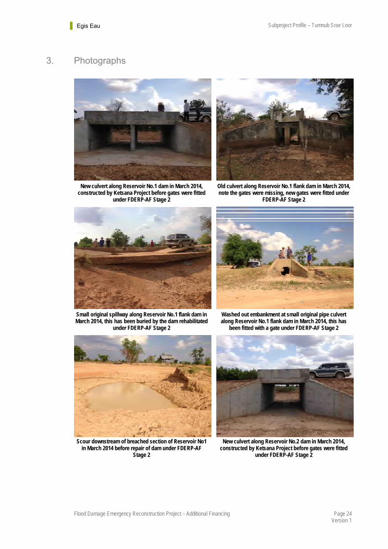
3. Photographs
New culvert along Reservoir No.1 dam in March 2014, constructed by Ketsana Project before gates were fitted
under FDERP-AF Stage 2
Old culvert along Reservoir No.1 flank dam in March 2014, note the gates were missing, new gates were fitted under
FDERP-AF Stage 2
Small original spillway along Reservoir No.1 flank dam in March 2014, this has been buried by the dam rehabilitated
under FDERP-AF Stage 2
Washed out embankment at small original pipe culvert along Reservoir No.1 flank dam in March 2014, this has
been fitted with a gate under FDERP-AF Stage 2
Scour downstream of breached section of Reservoir No1 in March 2014 before repair of dam under FDERP-AF
Stage 2
New culvert along Reservoir No.2 dam in March 2014, constructed by Ketsana Project before gates were fitted
under FDERP-AF Stage 2

Egis Eau Subproject Profile – Tumnub Srae Loor
Page 25 Flood Damage Emergency Reconstruction Project – Additional Financing Version 1
Reservoir No.2 flank dam in March before repair of the dam under FDERP-AF Stage 2
Reservoir No.2 flank dam in March 2014, an intact section before repair of dam under FDERP-AF Stage 2
Reservoir No.1 dam after repair under FDERP-AF Stage 2 Reservoir No.1 dam and Ketsana box culvert fitted with
gates under FDERP-AF Stage 2
Reservoir No.2 dam after repair under FDERP-AF Stage 2 Reservoir No.2 dam and Ketsana box culvert fitted with
gates under FDERP-AF Stage 2
Existing canal downstream for Reservoir No.2 which will be rehabilitated under FDERP-AF Stage 3
New FWUC building constructed under FDERP-AF Stage 2
Egis Eau Subproject Profile – Tumnub Srae Loor
Page 26 Flood Damage Emergency Reconstruction Project – Additional Financing Version 1
Chapter 4 - SUB-PROJECT SCREENING
1. General and Irrigation Specific Screening
1.1. Stage 2
The subproject satisfied the screening requirements for Stage 2 work. The completed Assessment and Confirmation Sheet for the Stage 2 works as per Table A1-1 of the Project Administration Manual (PAM) is at Appendix 3.
1.2. Stage 3
Acceptance of Stage 2 works means that the subproject already satisfied the General Selection Criteria set out in Appendix 1, Item 1 of the PAM. This subproject profile confirms that the General Selection Criteria is satisfied.
The screening of additional criteria for irrigation, Appendix 1, Item 4 of the PAM is shown at Appendix 4.
2. Safeguards Screening: Resettlement
2.1. Scope of Land Acquisition and Resettlement
There is no evidence of involuntary resettlement impact from the proposed Stage 3 works at Tumnub Srae Loor subproject. The proposed works comprise provision of a new spillway for Reservoir No.1 and rehabilitation and development of three main canals, generally pre-existing. There is land encroachment by the villagers on the right of way of the canals such as making use of the canals to grow rice but there are no affected structures.
2.2. Resettlement Impact Categorisation Check-list
The resettlement impact check-list is included in Appendix 5 and confirms that there are no involuntary resettlement impacts and that the project interventions are within the Category C for resettlement as per the Safeguard Policy Statement (ADB’s SPS. 20091).
The screening for resettlement categorization was conducted from the 25 to 28 November 2014 by the national resettlement specialist accompanied by other team members including design engineers, socio-agricultural economist, FWUC specialist and environmental specialist.
Initial screening for involuntary resettlement is to be revisited once the designs are finalised.
2.3. Voluntary Resettlement
Since the scope of work is along an existing dam and canals there is no indication that there will be involuntary resettlement identified at this stage. There will be no affected houses, stores, fences, perennial trees and timber trees. However, potentially some rice paddy will be affected.

Egis Eau Subproject Profile – Tumnub Srae Loor
Page 27 Flood Damage Emergency Reconstruction Project – Additional Financing Version 1
If this is the case the resettlement will be voluntary because the affected persons have agreed to contribute small areas of paddy field to the project. Based upon the resettlement checklist and informal discussions with local authorities the commune chiefs from Kork Romeat and Komrou have suggested that the footprint for rehabilitated canals should not exceed the 9.0 m right of way to avoid resettlement complications. The local authorities have agreed on behalf of their people as long as the width of the footprint follows their suggestion and the ADB requirements which are included at Appendix 5 of this subproject profile. The Resettlement Framework in the PAM and a Resettlement Plan will not therefore be necessary for Tumnub Srae Loor.
2.4. Suggested Follow-up Activities
The screening process, using the Screening Checklist, identified some households which are marginally affected by the sub-project. The affected asset per affected person is less than 5% of their total ownership; therefore it is not expected to cause significant loss to the affected persons. The subproject, on the other hand, is foreseen to provide benefits, in terms of flood protection and agricultural activities. Damage to crops and other assets will be reduced. The tracks which will be constructed alongside the main canals will improve access to fields.
However, for further activities the resettlement specialist will:
1. Determine the impacts of people and communities, social, cultural, and economic parameters into account.
2. Identify gender and resettlement impacts, and the socioeconomic situation, impacts, needs, and priorities of women when the detail design completed.
3. Conduct public consultation with potential affected people to disseminate project and resettlement information during project detail design and preparation for engaging stakeholders.
3. Safeguards Screening: Environment The objective of environmental screening is to identify and assess potential impacts arising from the subproject implementation on social and natural environments and pollution, and to recommend measures to avoid and mitigate adverse impacts.
3.1. Environmental Assessment Check-list
The potential issues, concerns and impacts identified using the ADB Rapid Environmental Assessment Checklist are listed below. Appendix 7 presents the completed checklist.
3.2. Beneficial impacts
The proposed subproject will have beneficial impacts including: (i) improved flood resilience; (ii) improved agricultural productivity; (iii) improved access roads along the canals; and (iv) as outcomes, improved living standards of local beneficiaries.
Overall, the subproject will significantly contribute to a qualitative improvement in the lives of residents through the increase in agricultural productivity in the subproject area.
Egis Eau Subproject Profile – Tumnub Srae Loor
Page 28 Flood Damage Emergency Reconstruction Project – Additional Financing Version 1
3.3. Potential Negative Environmental Impacts
3.3.1. Siting concerns
The works are provision of one new spillway and rehabilitation of three main canals including its associated structures. No new works locations will be introduced. Therefore there are no siting concerns.
3.3.2. Construction impacts
Potential environmental impacts during the construction phase can have negative effects on the environment and local residents unless properly managed. Major environmental impacts associated with the construction phase are as follows.
Environmental concerns related to worker camp
The works contractor has to establish a camp or rent facilities to provide accommodation to workers, drivers, technicians and other personnel for the duration of the rehabilitation works. A works compound for heavy construction machinery, maintenance and materials storage may also be required. Depending on the total number of persons and equipment, the duration of the construction and the location of the works contractor activities, the environment may be adversely impacted in a number of ways by the works contractor presence and the activities that take place: pressure on available water resources during the dry season, pollution by fuel, engine lubricants, and wastewater.
Impacts on air quality
Dust, suspended particles, noise, gas emissions and vibration will be generated from construction activities, practices and materials. Dust and noise will be more salient during the construction period. These issues and impacts will be temporary but, if not mitigated, will have potentials to result in long-term consequences to the health of the affected communities and the construction workers.
3.4. Environmental Category
The proposed subproject is not environmentally critical. The subproject is therefore assessed as Category B (see sidebox ‘Environment Categorization’ below). The works are repairs and improvements to an existing irrigation dam and canals. No new works locations will be introduced. No activity will have long term impacts to environmental health; rather the activities will have socio-economic benefit to the community. The few adverse direct impacts during construction are expected to be localised and will be temporary and short-term, most likely to occur during the peak construction period. These will not be sufficient to threaten or weaken the surrounding resources.
Egis Eau Subproject Profile – Tumnub Srae Loor
Page 29 Flood Damage Emergency Reconstruction Project – Additional Financing Version 1
Environment Categorization
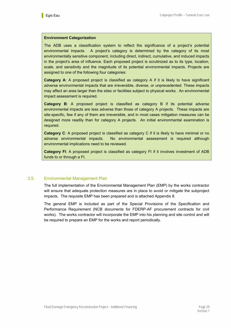
The ADB uses a classification system to reflect the significance of a project’s potential environmental impacts. A project’s category is determined by the category of its most environmentally sensitive component, including direct, indirect, cumulative, and induced impacts in the project’s area of influence. Each proposed project is scrutinized as to its type, location, scale, and sensitivity and the magnitude of its potential environmental impacts. Projects are assigned to one of the following four categories:
Category A: A proposed project is classified as category A if it is likely to have significant adverse environmental impacts that are irreversible, diverse, or unprecedented. These impacts may affect an area larger than the sites or facilities subject to physical works. An environmental impact assessment is required.
Category B: A proposed project is classified as category B if its potential adverse environmental impacts are less adverse than those of category A projects. These impacts are site-specific, few if any of them are irreversible, and in most cases mitigation measures can be designed more readily than for category A projects. An initial environmental examination is required.
Category C: A proposed project is classified as category C if it is likely to have minimal or no adverse environmental impacts. No environmental assessment is required although environmental implications need to be reviewed.
Category FI: A proposed project is classified as category FI if it involves investment of ADB funds to or through a FI.
3.5. Environmental Management Plan
The full implementation of the Environmental Management Plan (EMP) by the works contractor will ensure that adequate protection measures are in place to avoid or mitigate the subproject impacts. The requisite EMP has been prepared and is attached Appendix 8.
The general EMP is included as part of the Special Provisions of the Specification and Performance Requirement (NCB documents for FDERP-AF procurement contracts for civil works). The works contractor will incorporate the EMP into his planning and site control and will be required to prepare an EMP for the works and report periodically.
Egis Eau Subproject Profile – Tumnub Srae Loor
Page 30 Flood Damage Emergency Reconstruction Project – Additional Financing Version 1
Chapter 5 - CONCLUSIONS
1. Screening The Tumnub Srae Loor subproject works are not new construction. The Stage 3 works will improve reservoir safety by provision of a spillway and rehabilitate three main canals to improve water distribution to paddy fields. This in turn will allow formal registration and strengthening of the existing FWUC which is key to the sustainable operation and maintenance of the irrigation system.
The subproject has previously satisfied the General Selection Criteria for Stage 2 work. This subproject profile confirms that the General Selection Criterion is satisfied (see Appendix 3).
The screening for additional criteria for irrigation, Appendix 1, Item 4 of the PAM, March 2014 is shown at Appendix 4 of this subproject profile, together requirements from the Report and Recommendations of the President (RRP). Tumnub Srae Loor subproject is deemed to satisfy all selection criteria except that the FWUC does not yet have statutes and by-law which limits its function.
No involuntary resettlement impacts have been identified and the subproject interventions are within Category C for resettlement.
The Tumnub Srae Loor subproject is not situated in a protected area. The subproject proposals will have minimal or no adverse environmental impacts. Short-term environmental impacts may occur during the construction phase. The subproject is therefore assessed as Environmental Category B requiring an initial environmental examination.
Average repair costs under FDERP-AF (Stage 2 and Stage 3 works) will amount to about UD$389/ha of gross area (agricultural lands) which is within the acceptable ceiling of US$2,000/ha†††. Furthermore, the EIRR is calculated to be 28% discounted over five years which is greater than the minimum EIRR of 12% required by the PAM and paragraph 23 of the (RRP)‡‡‡.
2. Proposed Interventions The proposed subproject interventions for civil works are described at Chapter 3 -1.2. They comprise provision of a new spillway at Reservoir No.1 and rehabilitation of three man canals over a total length about 2,367 m with appurtenant structures.
††† PAM March 2014, Appendix 1, Item 4 (viii).
‡‡‡ RRP April 2014, III. Due Diligence, A. Economic and Financial, paragraph 23.
Egis Eau Subproject Profile – Tumnub Srae Loor
Page 31 Flood Damage Emergency Reconstruction Project – Additional Financing Version 1
Appendix 1 – Hydrology
Hydrological setting
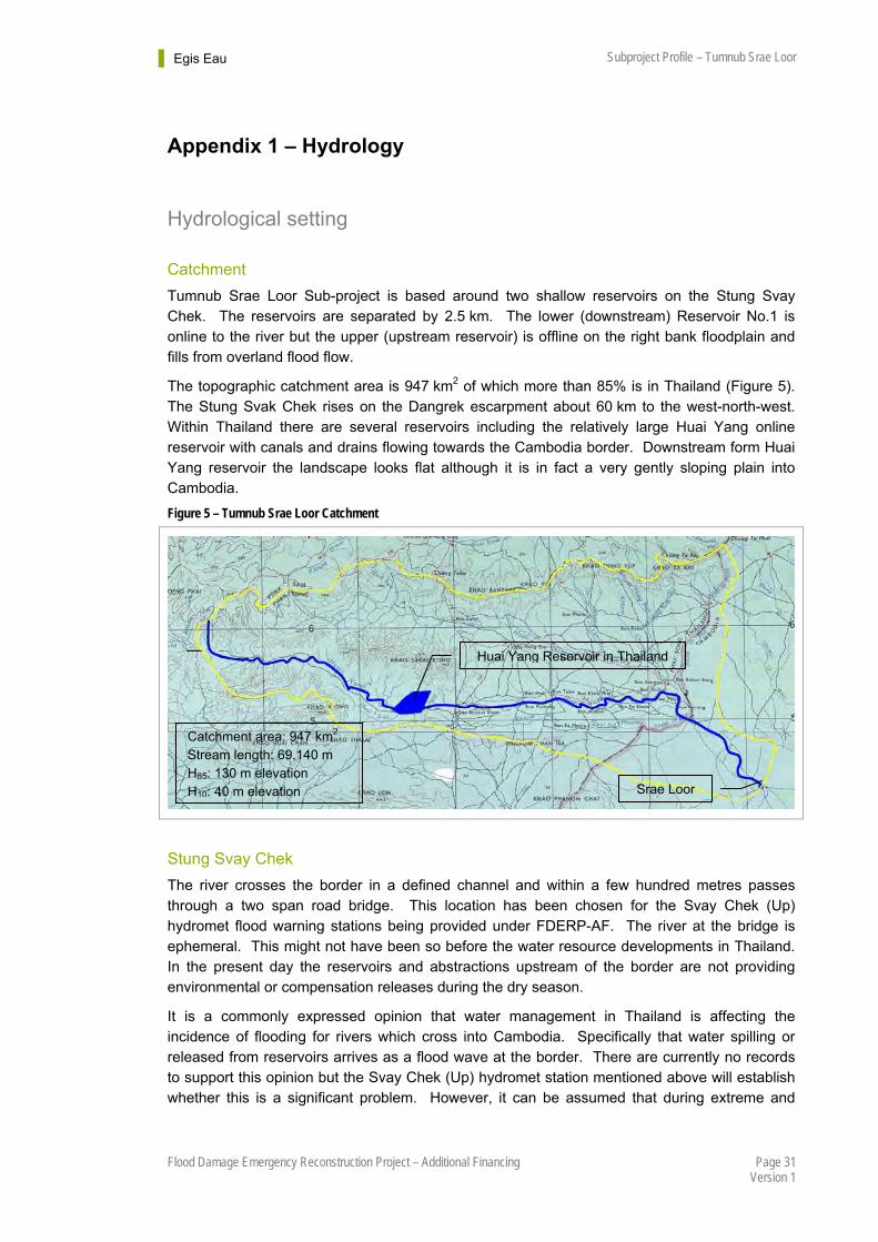
Catchment
Tumnub Srae Loor Sub-project is based around two shallow reservoirs on the Stung Svay Chek. The reservoirs are separated by 2.5 km. The lower (downstream) Reservoir No.1 is online to the river but the upper (upstream reservoir) is offline on the right bank floodplain and fills from overland flood flow.
The topographic catchment area is 947 km2 of which more than 85% is in Thailand (Figure 5). The Stung Svak Chek rises on the Dangrek escarpment about 60 km to the west-north-west. Within Thailand there are several reservoirs including the relatively large Huai Yang online reservoir with canals and drains flowing towards the Cambodia border. Downstream form Huai Yang reservoir the landscape looks flat although it is in fact a very gently sloping plain into Cambodia.
Figure 5 – Tumnub Srae Loor Catchment
Stung Svay Chek
The river crosses the border in a defined channel and within a few hundred metres passes through a two span road bridge. This location has been chosen for the Svay Chek (Up) hydromet flood warning stations being provided under FDERP-AF. The river at the bridge is ephemeral. This might not have been so before the water resource developments in Thailand. In the present day the reservoirs and abstractions upstream of the border are not providing environmental or compensation releases during the dry season.
It is a commonly expressed opinion that water management in Thailand is affecting the incidence of flooding for rivers which cross into Cambodia. Specifically that water spilling or released from reservoirs arrives as a flood wave at the border. There are currently no records to support this opinion but the Svay Chek (Up) hydromet station mentioned above will establish whether this is a significant problem. However, it can be assumed that during extreme and
Catchment area: 947 km2 Stream length: 69,140 m H85: 130 m elevation H10: 40 m elevation
Huai Yang Reservoir in Thailand
Srae Loor
Egis Eau Subproject Profile – Tumnub Srae Loor
Page 32 Flood Damage Emergency Reconstruction Project – Additional Financing Version 1
sustained wet periods with saturated ground and full reservoirs there will inevitably be large discharges into Cambodia.
Downstream from the road bridge mentioned above the Svay Chek has a smaller channel than upstream. The channel is also highly meandering and divides into several courses. This is because of the almost flat landscape such that when the river is in flood it flows out of bank and spreads across the surrounding fields. It is apparent from satellite images that the river has had numerous courses within recent geological time and that the process of shifting channels continues. However, it is now somewhat managed by the farmers who practice flood spreading to their rice fields and by infrastructure development such as roads, bridges and irrigation (water level management). Before reaching Tumnub Srae Loor the main channel flows through a small single span road bridge and further downstream a newly constructed 48 m span road bridge.
There is another factor at play along the Stung Svay Chek. Initially under the French, and later by the Khmer Rouge the river was blocked to spread water to the fields but without provision to pass peak flood flows. There are many places in the northwest provinces where this was done. Tumnub Srae Loor is the most upstream dam on the Svay Chek in Cambodia but there are many more dams downstream. This is a major factor in the flood damage which occurs, and will continue to occur until there is a holistic approach to water level management in these provinces. For the Svay Chek a solution would either require opening the river until its confluence with the Stung Sisophon or a flood relief channel to replace the natural river.
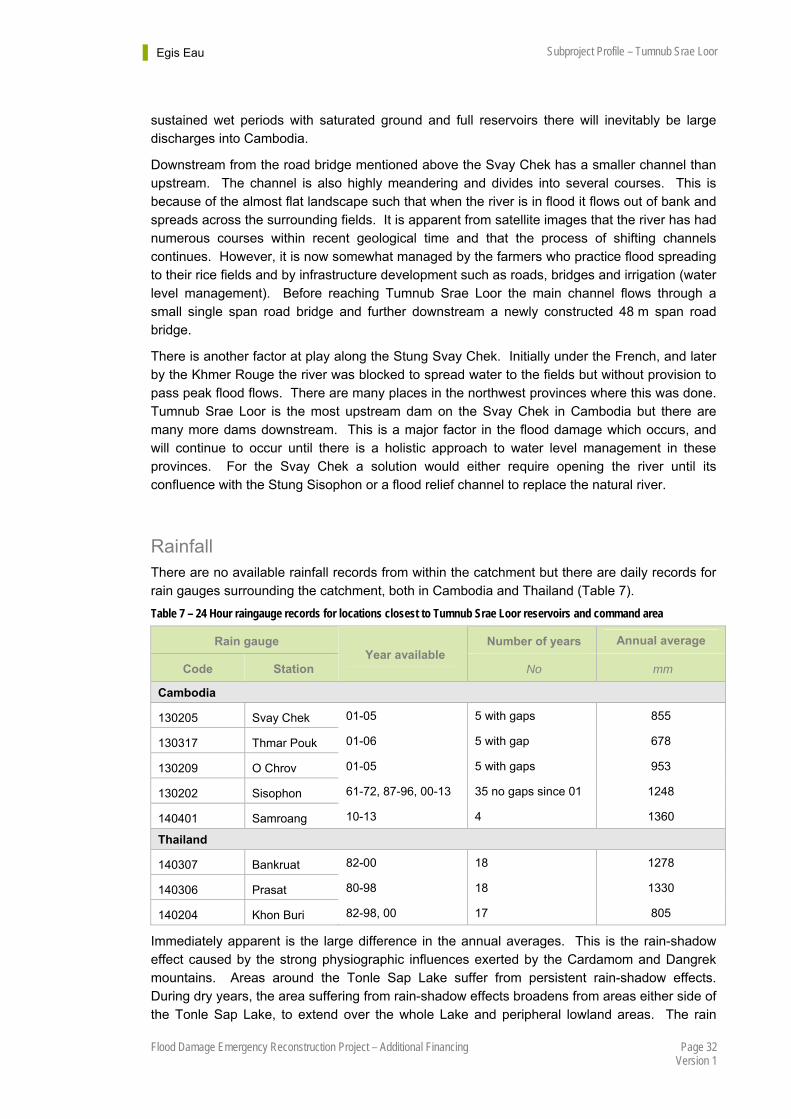
Rainfall There are no available rainfall records from within the catchment but there are daily records for rain gauges surrounding the catchment, both in Cambodia and Thailand (Table 7).
Table 7 – 24 Hour raingauge records for locations closest to Tumnub Srae Loor reservoirs and command area
Rain gauge Number of years Annual average
Code Station Year available
No mm
Cambodia
130205 Svay Chek 01-05 5 with gaps 855
130317 Thmar Pouk 01-06 5 with gap 678
130209 O Chrov 01-05 5 with gaps 953
130202 Sisophon 61-72, 87-96, 00-13 35 no gaps since 01 1248
140401 Samroang 10-13 4 1360
Thailand
140307 Bankruat 82-00 18 1278
140306 Prasat 80-98 18 1330
140204 Khon Buri 82-98, 00 17 805
Immediately apparent is the large difference in the annual averages. This is the rain-shadow effect caused by the strong physiographic influences exerted by the Cardamom and Dangrek mountains. Areas around the Tonle Sap Lake suffer from persistent rain-shadow effects. During dry years, the area suffering from rain-shadow effects broadens from areas either side of the Tonle Sap Lake, to extend over the whole Lake and peripheral lowland areas. The rain
Egis Eau Subproject Profile – Tumnub Srae Loor
Page 33 Flood Damage Emergency Reconstruction Project – Additional Financing Version 1
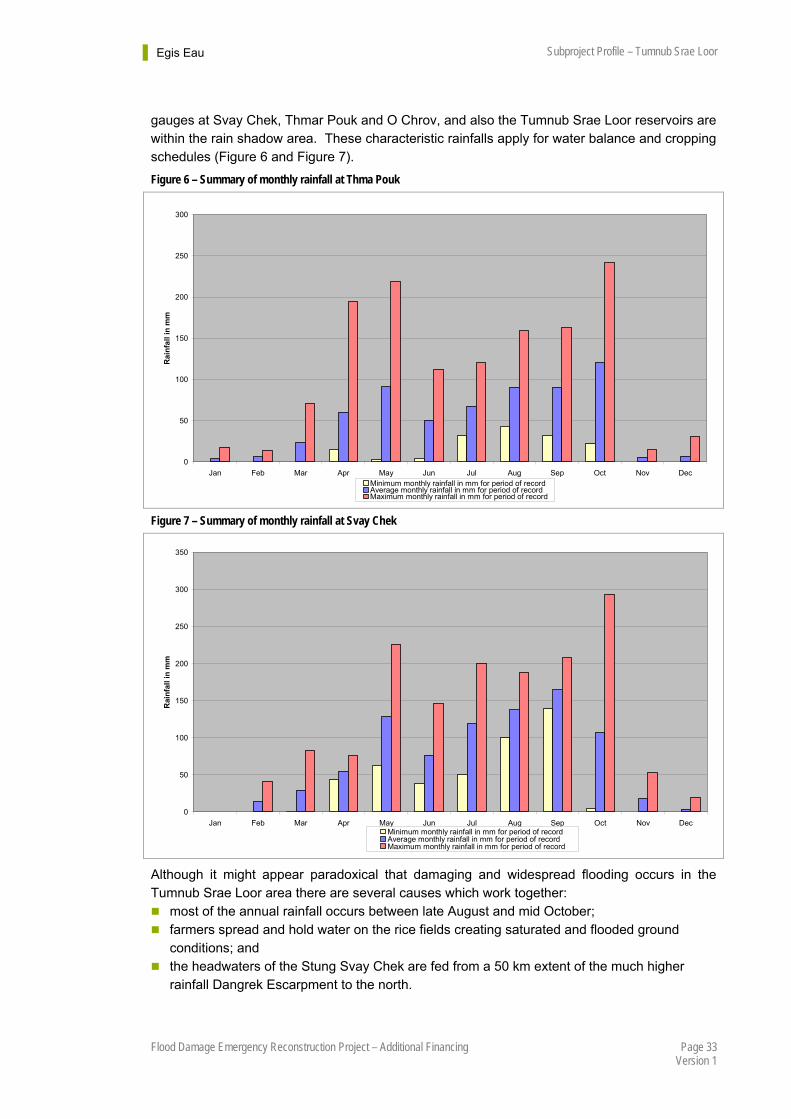
gauges at Svay Chek, Thmar Pouk and O Chrov, and also the Tumnub Srae Loor reservoirs are within the rain shadow area. These characteristic rainfalls apply for water balance and cropping schedules (Figure 6 and Figure 7).
Figure 6 – Summary of monthly rainfall at Thma Pouk
0
50
100
150
200
250
300
Jan Feb Mar Apr May Jun Jul Aug Sep Oct Nov Dec
Ra
infa
ll in
mm
Minimum monthly rainfall in mm for period of recordAverage monthly rainfall in mm for period of recordMaximum monthly rainfall in mm for period of record
Figure 7 – Summary of monthly rainfall at Svay Chek
0
50
100
150
200
250
300
350
Jan Feb Mar Apr May Jun Jul Aug Sep Oct Nov Dec
Rai
nfa
ll in
mm
Minimum monthly rainfall in mm for period of recordAverage monthly rainfall in mm for period of recordMaximum monthly rainfall in mm for period of record
Although it might appear paradoxical that damaging and widespread flooding occurs in the Tumnub Srae Loor area there are several causes which work together: most of the annual rainfall occurs between late August and mid October; farmers spread and hold water on the rice fields creating saturated and flooded ground
conditions; and the headwaters of the Stung Svay Chek are fed from a 50 km extent of the much higher
rainfall Dangrek Escarpment to the north.

Egis Eau Subproject Profile – Tumnub Srae Loor
Page 34 Flood Damage Emergency Reconstruction Project – Additional Financing Version 1
There are no rain gauges on the escarpment. Within Cambodia the closest rain gauge is at Samroang but this currently has only four years of record. In Thailand the Bankruat and Prasat rain gauges are relative close to the escarpment, each with 18 years record and also with very similar annual rainfalls to the short record at Samroang. The Thai rain gauge data can therefore be used for estimation of flood discharge and spillway design. The highest daily rainfalls have been recorded at Bankraut and therefore this record can be used. The summary recode is shown in Figure 8 and the derived rainfall-intensity-duration curves in Figure 9.
Figure 8 – Summary of monthly rainfall at Bankurat, Thailand
0.0
100.0
200.0
300.0
400.0
500.0
600.0
Jan Feb Mar Apr May Jun Jul Aug Sep Oct Nov Dec
Ra
infa
ll in
mm
Minimum monthly rainfall in mm for period of recordAverage monthly rainfall in mm for period of recordMaxima monthly rainfall in mm for period of record
Note: The high maximum for February is for a single storm in 1991 and appears anomalous although there are several other instances on the record of high rainfalls in February.
Figure 9 – Rainfall-intensity-duration curves for Bankraut, Thailand
1
10
100
1000
0.0 0.1 1.0 10.0 100.0
Duration in hours
Rai
nfa
ll I
nte
nsi
ty i
n m
m/h
2.33 yr return period
5 yr return period
10 yr return period
25 yr return period
50 yr return period
100 yr return period
Egis Eau Subproject Profile – Tumnub Srae Loor
Page 35 Flood Damage Emergency Reconstruction Project – Additional Financing Version 1
Flood Discharge
Factors Controlling Flood Discharge
It is necessary to explain the special circumstances at Tumnub Srae Loar to understand the nature of the flood discharge and the limitations on works which can be done under FDERP-AF.
The combination of natural and man-made factors means that peak flood discharges experienced at Tumnub Srae Loor reservoirs are much smaller than estimated from simple rainfall-runoff methods or regional formula. The reason is a combination of the flat landscape, the interception and water use in Thailand, and the flood spreading in Cambodia. In fact within Cambodia the Stung Svay Chek has been blocked at multiple locations between the border with Thailand and its confluence with the Stung Sisophon. The reason is to force flood spreading to supply rice paddy. As mentioned above, this was first done during the French Colonial period. Later the Khmer Rouge raised, extended and added additional embankments as an expedient method to meet their target of increased rice production. But there was never any provision to pass large floods and to this day the rivers remain obstructed or blocked which causes dams and road embankments to breach whenever there is a large flood. A further complication is that farmers are accustomed to flood spreading and don’t want the river reopened. In fact dealing with single blockages in isolation would not be a solution, also as mentioned above the river would need to be restored over its full length or a parallel flood relief channel provided.
The new hydromet station at Svay Chek (Up) being established under FDERP-AF immediately downstream of the border with Thailand will be useful for flood warning, but it will not alone indicate discharge at locations downstream because the flood is immediately dispersed by flood spreading.
The following sections first consider theoretical discharge estimates, then consider the embankments, bridges and flow paths where water flows into Tumnub Srae Loor. The objective is to determine an economic solution to reduce the risk of flood damage.
Climate Change
There is limited specific guidance for climate resilience for Cambodia which can be applied for engineering design. However, the recent NDF/ADB Climate Change Adaptation Project §§§ has used hydrological modelling to predict the potential increase in flooding until the end of the century. This indicates that flood flows may on average increase by 10% to 20% and that corresponding flood depths might increase by 0.3 m to 0.5 m. These estimates must be treated with caution, in particular local infrastructure developments and changes in land use have potential for greater change in flood regimes. But nevertheless the figures do provide a quantifiable basis for considering climate adaptation.
For high risk infrastructure such as dams and spillways it is prudent to err on the side of caution. It is therefore proposed that design discharges are increased by 20% being the upper bound average increase predicted by the Climate Change Adaptation Project.
§§§ Nordic Development Fund/Asian Development Bank Climate Change Adaptation Project, RRP.CAM 42334, Ministry of Rural Development.
Egis Eau Subproject Profile – Tumnub Srae Loor
Page 36 Flood Damage Emergency Reconstruction Project – Additional Financing Version 1
Theoretical Estimates of Discharge
Without any actual record of discharge at Tumnub Srae Loor it is necessary to consider several methods to estimate the discharge to decide whether these correspond with physical evidence of flood flows at the site. Table 8 lists the estimates from four different methods. The "Design" estimate is the 1 in 100 year return period peak discharge increased by 20% to allow increasing peak discharge because of climate change. The following paragraphs give a brief description of each method.
Modified IRS Method
The Modified Irrigation Rehabilitation Study (IRS) is a refinement of the original IRS Method 2 3 based on regional flood frequency analysis for Cambodian catchments. The mean annual flood (MAF) is estimated from the following equation:
9.03981.0 AREAMAF
Where MAF = Mean Annual Flood (i.e. the maximum flood expected in an average year)
AREA = Catchment area (km2)
The growth factors for the 1 in 50 and 100 years floods are 2.0 and 2.2 respectively. Applied for Tumnub Srae Loor the Modified IRS method yields a MAF of the order 190 m3/s. Although this is a credible estimate for the catchment area the evidence at Tumnub Srae Loor indicates a much lower discharge because of interception in Thailand and flood spreading in Cambodia.
Direct Estimate of MAF
It is clearly stated for the IRS Method that for detailed design for a particular site it will generally be possible to make an estimate of MAF from local records or memories of flood water levels and the application of hydraulic principles. Hydraulic principles can be applied using the slope-area method and Regime Theory to estimate the in-bank discharge of the existing river channel. Under Regime Theory this provides an estimate of the MAF.
Regime Theory was developed in the 19th Century for the design of earthen irrigation canals in India. It is an empirical method based on the hypothesis that for a steady discharge a channel has an equilibrium elliptical cross section depending on the channel slope and the soils forming the bed and bank. There are a number of empirical equations used to estimate the width of a channel between top of bank, the depth from top of bank to the deepest point, the cross-section flow area when flowing full, and the bed slope. Although rivers are subject to very variable discharge it has been found that the width and depth of channels are generally those for the dominant discharge which is normally similar to the MAF. This is reasonable because in nature a river forms a channel to accommodate normal seasonal flows and will only flood out of bank when there are abnormally large flows or some external interference such as a too small bridge. Hence the width of a channel between top of banks, and the depth, can be used to estimate the MAF.
The river channel upstream of Tumnub Srae Loor is meandering. There is a relatively consistent top of bank width about 21 m. This width would suggest a MAF of the order 59 m3/s and applying the IRS growth factors the Q50 is 117 m3/s and Q100 is 129 m3/s. Assuming an additional 20% for climate change in the future the Q100 might increase to 155 m3/s.
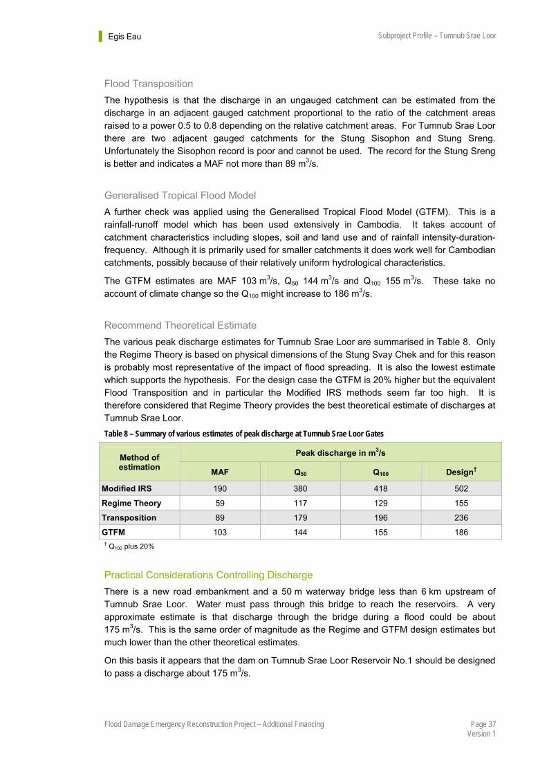
Egis Eau Subproject Profile – Tumnub Srae Loor
Page 37 Flood Damage Emergency Reconstruction Project – Additional Financing Version 1
Flood Transposition
The hypothesis is that the discharge in an ungauged catchment can be estimated from the discharge in an adjacent gauged catchment proportional to the ratio of the catchment areas raised to a power 0.5 to 0.8 depending on the relative catchment areas. For Tumnub Srae Loor there are two adjacent gauged catchments for the Stung Sisophon and Stung Sreng. Unfortunately the Sisophon record is poor and cannot be used. The record for the Stung Sreng is better and indicates a MAF not more than 89 m3/s.
Generalised Tropical Flood Model
A further check was applied using the Generalised Tropical Flood Model (GTFM). This is a rainfall-runoff model which has been used extensively in Cambodia. It takes account of catchment characteristics including slopes, soil and land use and of rainfall intensity-duration-frequency. Although it is primarily used for smaller catchments it does work well for Cambodian catchments, possibly because of their relatively uniform hydrological characteristics.
The GTFM estimates are MAF 103 m3/s, Q50 144 m3/s and Q100 155 m3/s. These take no account of climate change so the Q100 might increase to 186 m3/s.
Recommend Theoretical Estimate
The various peak discharge estimates for Tumnub Srae Loor are summarised in Table 8. Only the Regime Theory is based on physical dimensions of the Stung Svay Chek and for this reason is probably most representative of the impact of flood spreading. It is also the lowest estimate which supports the hypothesis. For the design case the GTFM is 20% higher but the equivalent Flood Transposition and in particular the Modified IRS methods seem far too high. It is therefore considered that Regime Theory provides the best theoretical estimate of discharges at Tumnub Srae Loor.
Table 8 – Summary of various estimates of peak discharge at Tumnub Srae Loor Gates
Peak discharge in m3/s Method of estimation
MAF Q50 Q100 Design†
Modified IRS 190 380 418 502
Regime Theory 59 117 129 155
Transposition 89 179 196 236
GTFM 103 144 155 186 † Q100 plus 20%
Practical Considerations Controlling Discharge
There is a new road embankment and a 50 m waterway bridge less than 6 km upstream of Tumnub Srae Loor. Water must pass through this bridge to reach the reservoirs. A very approximate estimate is that discharge through the bridge during a flood could be about 175 m3/s. This is the same order of magnitude as the Regime and GTFM design estimates but much lower than the other theoretical estimates.
On this basis it appears that the dam on Tumnub Srae Loor Reservoir No.1 should be designed to pass a discharge about 175 m3/s.
Egis Eau Subproject Profile – Tumnub Srae Loor
Page 38 Flood Damage Emergency Reconstruction Project – Additional Financing Version 1
Spillway Design
Practical Constraints
There are several constraints to providing Reservoir No.1 with a spillway under FDERP-AF: The community wants the spillway in the location of the original spillway; they do not want it
to discharge to the natural river channel because this is dammed a short distance downstream. This is accepted as a valid reason although a large proportion of the spillway discharge will flow towards the river downstream.
The original spillway location is between two water gate structures separated by less than 111 m.
There is only US$200,000 budget to provide a spillway and to rehabilitate 2,367 m of canal.
Recommended Spillway
The proposed solution is to provide a 100 m long spillway about the original location between the two water gate structures mentioned above. The crest of the spillway will be set at reservoir full supply level 18.26 m elevation project datum. The spillway crest will be a concrete road slab with upstream and downstream downstands. The upstream and downstream slopes will be armoured with gabion mattress with an additional gabion mattress apron downstream to control scour.
These dimensions will pass a discharge 122 m3/s with the reservoir level at 19.06 m elevation the same as the crest of the dam. If all five gates are open they may pass 54 m3/s. The combined discharge would then be 176 m3/s. If the reservoir water level is this high it will also flow around the northern flank of the dam where the ground level is about 18.20 m. Under these conditions there will be no freeboard. However, the situation will be an improvement on the previous condition and provide some flood resilience. The spillway can be upgraded in the future as part of a comprehensive solution to the problem of flooding along the Svay Chek and based upon flow records from the new Svay Chek (Up) hydromet station.
There are rice fields downstream of the spillway. The recommend design will spread the flood rather than concentration it in one place as would happen with a narrow spillway. This will mitigate the damage to fields downstream.
It is emphasised that this is not an ideal solution. Rather it is a comprise acceptable to the community and achievable within the available FDERP-AF budget which will improve flood resilience for Tumnub Srae Loor compared to before.
Water Resources Estimate There are currently no useable water resource observations for Tumnub Srae Loor. The best available records are for the Stung Sreng at Kralanh and these are of dubious quality.
The data for the Stung Sreng was most recently published by the Water Resources Management Sector Development Program (WRMSDP), although it is the same as published earlier in the Tonle Sap Lowland Stabilization Project, Report on Water Availability4. This the WRMSDP study was a program component to address national water resources management and irrigation policy issues in Cambodia, and an investment component to assist MOWRAM to rehabilitate small- and medium-scale irrigation systems and deliver irrigation services within the
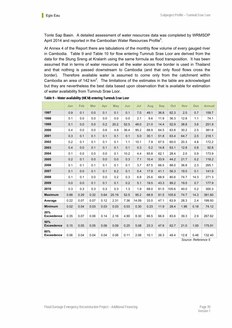
Egis Eau Subproject Profile – Tumnub Srae Loor
Page 39 Flood Damage Emergency Reconstruction Project – Additional Financing Version 1
Tonle Sap Basin. A detailed assessment of water resources data was completed by WRMSDP April 2014 and reported in the Cambodian Water Resources Profile5.
At Annex 4 of the Report there are tabulations of the monthly flow volume of every gauged river in Cambodia. Table 9 and Table 10 for flow entering Tumnub Srae Loor are derived from the data for the Stung Sreng at Kralanh using the same formula as flood transposition. It has been assumed that in terms of water resources all the water across the border is used in Thailand and that nothing is passed downstream to Cambodia (and that only flood flows cross the border). Therefore available water is assumed to come only from the catchment within Cambodia an area of 142 km2. The limitations of the estimates in the table are acknowledged but they are nevertheless the best data based upon observation that is available for estimation of water availability from Tumnub Srae Loor.
Table 9 – Water availability (MCM) entering Tumnub Srae Loor
Jan Feb Mar Apr May Jun Jul Aug Sep Oct Nov Dec Annual
1997 0.9 0.1 0.0 0.1 0.1 0.1 7.0 49.1 36.8 62.3 2.5 0.7 159.7
1998 0.1 0.0 0.0 0.0 0.0 0.0 2.1 9.6 11.9 36.3 12.8 1.1 74.1
1999 0.1 0.0 0.0 0.2 20.2 52.5 48.0 21.0 14.4 52.9 38.8 3.6 251.9
2000 0.4 0.0 0.0 0.6 4.9 36.4 95.2 68.9 64.5 63.8 30.2 2.5 381.6
2001 0.3 0.1 0.1 0.1 0.1 0.1 5.0 30.1 51.8 63.4 64.7 2.5 218.1
2002 0.2 0.1 0.1 0.1 0.1 1.1 10.1 7.9 67.5 60.0 20.3 4.8 172.2
2003 0.4 0.0 0.1 0.1 0.1 0.1 0.3 0.2 14.8 63.1 12.8 0.8 92.8
2004 0.1 0.0 0.0 0.0 0.1 10.2 4.4 65.8 62.1 28.4 2.0 0.9 173.9
2005 0.2 0.1 0.0 0.0 0.0 0.3 7.1 10.4 33.9 44.2 21.7 0.2 118.2
2006 0.1 0.1 0.1 0.1 0.1 0.1 3.7 67.5 66.5 88.0 36.8 2.3 265.1
2007 0.1 0.0 0.1 0.1 6.2 0.1 0.4 17.9 41.1 56.3 19.5 0.1 141.9
2008 0.1 0.1 0.0 0.0 0.2 0.3 6.8 25.6 68.9 80.6 74.7 14.3 271.3
2009 0.0 0.0 0.1 0.1 0.1 0.2 5.1 19.5 43.3 89.2 19.5 0.7 177.9
2010 0.3 0.3 0.3 0.3 0.3 1.3 1.9 68.0 81.5 105.6 40.0 0.2 300.3
Maximum 0.88 0.29 0.32 0.64 20.19 52.5 95.2 68.9 81.5 105.6 74.7 14.3 381.60
Average 0.22 0.07 0.07 0.12 2.31 7.36 14.09 33.0 47.1 63.9 28.3 2.4 199.93
Minimum 0.02 0.04 0.03 0.03 0.03 0.03 0.30 0.23 11.9 28.4 1.96 0.18 74.12
20% Exceedence 0.35 0.07 0.06 0.14 2.16 4.90 8.30 66.5 66.9 83.6 39.3 2.9 267.62
50% Exceedence 0.15 0.05 0.05 0.06 0.09 0.25 5.08 23.3 47.6 62.7 21.0 1.00 175.91
80% Exceedence 0.06 0.04 0.04 0.04 0.06 0.11 2.06 10.1 26.3 49.4 12.8 0.48 132.40
Source: Reference 5
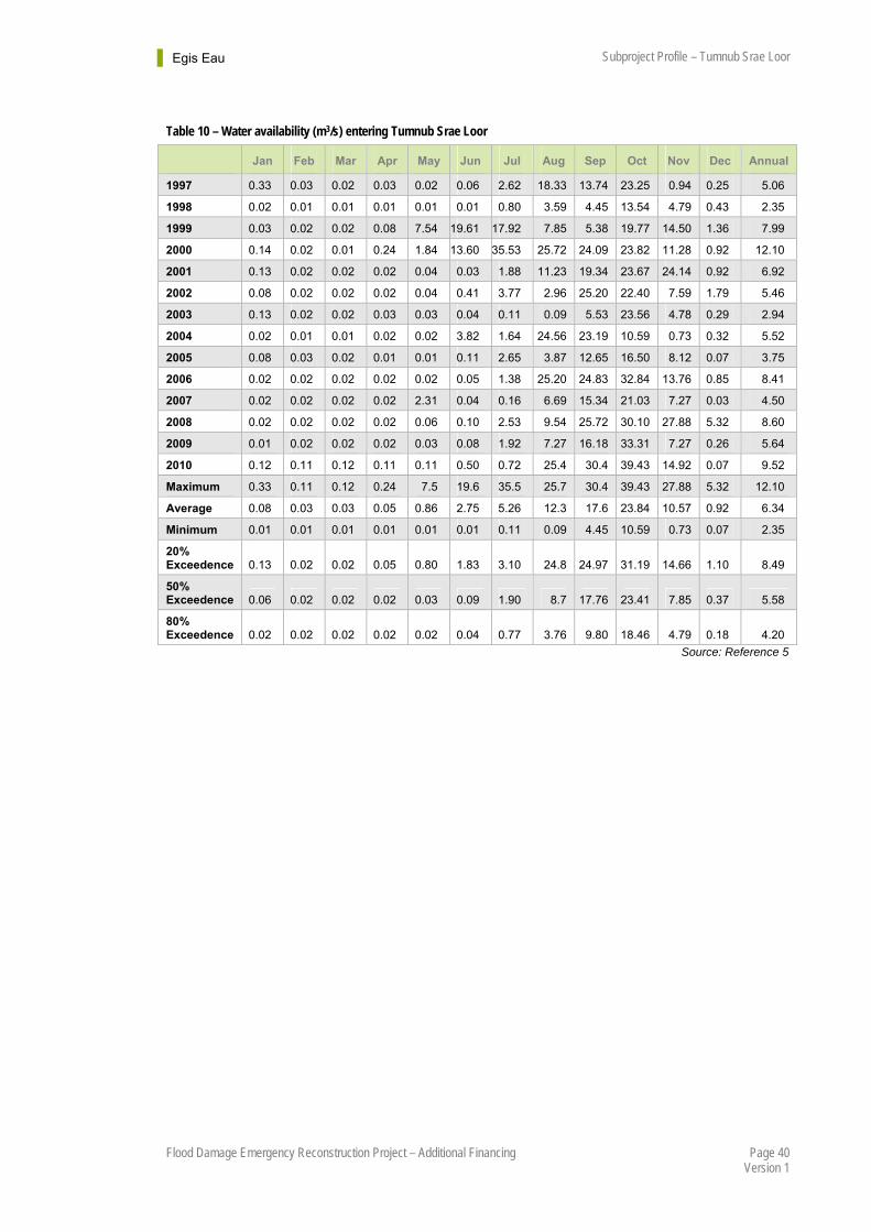
Egis Eau Subproject Profile – Tumnub Srae Loor
Page 40 Flood Damage Emergency Reconstruction Project – Additional Financing Version 1
Table 10 – Water availability (m3/s) entering Tumnub Srae Loor
Jan Feb Mar Apr May Jun Jul Aug Sep Oct Nov Dec Annual
1997 0.33 0.03 0.02 0.03 0.02 0.06 2.62 18.33 13.74 23.25 0.94 0.25 5.06
1998 0.02 0.01 0.01 0.01 0.01 0.01 0.80 3.59 4.45 13.54 4.79 0.43 2.35
1999 0.03 0.02 0.02 0.08 7.54 19.61 17.92 7.85 5.38 19.77 14.50 1.36 7.99
2000 0.14 0.02 0.01 0.24 1.84 13.60 35.53 25.72 24.09 23.82 11.28 0.92 12.10
2001 0.13 0.02 0.02 0.02 0.04 0.03 1.88 11.23 19.34 23.67 24.14 0.92 6.92
2002 0.08 0.02 0.02 0.02 0.04 0.41 3.77 2.96 25.20 22.40 7.59 1.79 5.46
2003 0.13 0.02 0.02 0.03 0.03 0.04 0.11 0.09 5.53 23.56 4.78 0.29 2.94
2004 0.02 0.01 0.01 0.02 0.02 3.82 1.64 24.56 23.19 10.59 0.73 0.32 5.52
2005 0.08 0.03 0.02 0.01 0.01 0.11 2.65 3.87 12.65 16.50 8.12 0.07 3.75
2006 0.02 0.02 0.02 0.02 0.02 0.05 1.38 25.20 24.83 32.84 13.76 0.85 8.41
2007 0.02 0.02 0.02 0.02 2.31 0.04 0.16 6.69 15.34 21.03 7.27 0.03 4.50
2008 0.02 0.02 0.02 0.02 0.06 0.10 2.53 9.54 25.72 30.10 27.88 5.32 8.60
2009 0.01 0.02 0.02 0.02 0.03 0.08 1.92 7.27 16.18 33.31 7.27 0.26 5.64
2010 0.12 0.11 0.12 0.11 0.11 0.50 0.72 25.4 30.4 39.43 14.92 0.07 9.52
Maximum 0.33 0.11 0.12 0.24 7.5 19.6 35.5 25.7 30.4 39.43 27.88 5.32 12.10
Average 0.08 0.03 0.03 0.05 0.86 2.75 5.26 12.3 17.6 23.84 10.57 0.92 6.34
Minimum 0.01 0.01 0.01 0.01 0.01 0.01 0.11 0.09 4.45 10.59 0.73 0.07 2.35
20% Exceedence 0.13 0.02 0.02 0.05 0.80 1.83 3.10 24.8 24.97 31.19 14.66 1.10 8.49
50% Exceedence 0.06 0.02 0.02 0.02 0.03 0.09 1.90 8.7 17.76 23.41 7.85 0.37 5.58
80% Exceedence 0.02 0.02 0.02 0.02 0.02 0.04 0.77 3.76 9.80 18.46 4.79 0.18 4.20
Source: Reference 5
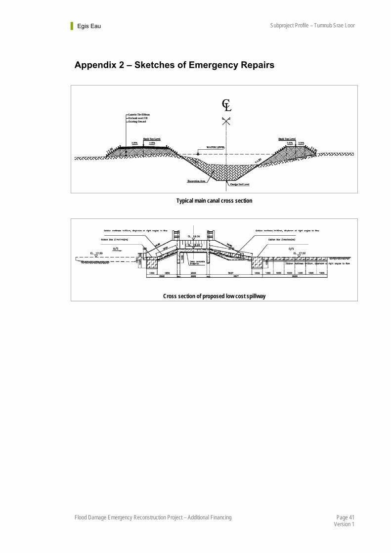
Egis Eau Subproject Profile – Tumnub Srae Loor
Page 41 Flood Damage Emergency Reconstruction Project – Additional Financing Version 1
Appendix 2 – Sketches of Emergency Repairs
Typical main canal cross section
Cross section of proposed low cost spillway
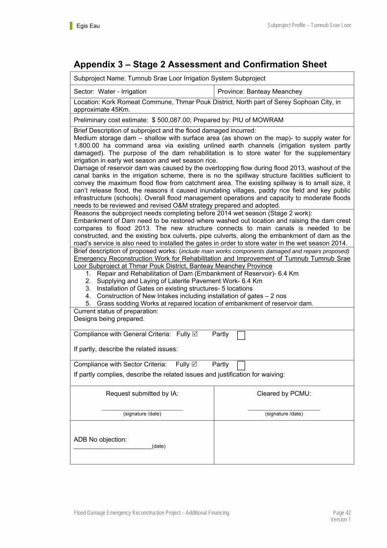
Egis Eau Subproject Profile – Tumnub Srae Loor
Page 42 Flood Damage Emergency Reconstruction Project – Additional Financing Version 1
Appendix 3 – Stage 2 Assessment and Confirmation Sheet
Subproject Name: Tumnub Srae Loor Irrigation System Subproject
Sector: Water - Irrigation Province: Banteay Meanchey
Location: Kork Romeat Commune, Thmar Pouk District, North part of Serey Sophoan City, in approximate 45Km.
Preliminary cost estimate: $ 500,087.00; Prepared by: PIU of MOWRAM
Brief Description of subproject and the flood damaged incurred: Medium storage dam – shallow with surface area (as shown on the map)- to supply water for 1,800.00 ha command area via existing unlined earth channels (irrigation system partly damaged). The purpose of the dam rehabilitation is to store water for the supplementary irrigation in early wet season and wet season rice. Damage of reservoir dam was caused by the overtopping flow during flood 2013, washout of the canal banks in the irrigation scheme, there is no the spillway structure facilities sufficient to convey the maximum flood flow from catchment area. The existing spillway is to small size, it can’t release flood, the reasons it caused inundating villages, paddy rice field and key public infrastructure (schools). Overall flood management operations and capacity to moderate floods needs to be reviewed and revised O&M strategy prepared and adopted. Reasons the subproject needs completing before 2014 wet season (Stage 2 work): Embankment of Dam need to be restored where washed out location and raising the dam crest compares to flood 2013. The new structure connects to main canals is needed to be constructed, and the existing box culverts, pipe culverts, along the embankment of dam as the road’s service is also need to installed the gates in order to store water in the wet season 2014. Brief description of proposed works: (include main works components damaged and repairs proposed) Emergency Reconstruction Work for Rehabilitation and Improvement of Tumnub Tumnub Srae Loor Subproject at Thmar Pouk District, Banteay Meanchey Province
1. Repair and Rehabilitation of Dam (Embankment of Reservoir)- 6.4 Km 2. Supplying and Laying of Laterite Pavement Work- 6.4 Km 3. Installation of Gates on existing structures- 5 locations 4. Construction of New Intakes including installation of gates – 2 nos 5. Grass sodding Works at repaired location of embankment of reservoir dam.
Current status of preparation: Designs being prepared. Compliance with General Criteria: Fully Partly If partly, describe the related issues: Compliance with Sector Criteria: Fully Partly
If partly complies, describe the related issues and justification for waiving:
Request submitted by IA:
____________________________ (signature /date)
Cleared by PCMU:
_________________________ (signature /date)
ADB No objection: ___________________________(date)

Egis Eau Subproject Profile – Tumnub Srae Loor
Page 43 Flood Damage Emergency Reconstruction Project – Additional Financing Version 1
Appendix 4 – Selection Criteria Screening
In addition to the General selection criteria, irrigation subprojects must satisfy the following requirements (Appendix 1, Item 4, of the PAM, March 2014).
(i) The subproject will have an already established Farmer Water User Communities (FWUC) made up of the beneficiaries. The FWUC must at least have agreed and adopted statutes and by-laws, registered its members and elected the FWUC Board of Directors and be well advanced towards being registered with the Department of FWUC. The FWUC should be active and working effectively and with a confirmed commitment to participate and contribute to preparation and implementation of the physical repairs.
Partially satisfies selection criteria. There is an existing FWUC registered with PDWRAM but there are not yet statutes and by-laws.
(ii) Proposed subprojects must have been impacted by flash flood (i.e. upland runoff and/or dam break) as a result of the 2013 wet season rainfall and climate impacts;
Satisfies selection criteria. Significant damage caused by 2013 floods in Stung Sen, vulnerability to climate change from flood and drought.
(iii) Auxiliary works (e.g. channel scour protection) may be included if they are required to ensure the effectiveness of other flood repairs and prevent possible degradation of the overall system
Satisfies selection criteria.
(iv) Works for repair of canals will be limited to main and secondary canals only. For the smaller canals, the Project will provide structures on the condition that the FWUC agrees to complete the minor earthwork repairs.
Satisfies selection criteria. Work on canals is confined to main canals.
(v) Any Stage 2 works proposed will involve no resettlement.
Criteria previously satisfied. There was no resettlement for Stage 2 works.
(vi) The proposed subproject shall be located in an area cleared of land-mines;
Satisfies selection criteria. Areas cleared of mines.
(vii) Where conditions have changed from when the original facility was constructed thereby requiring a major improvement, the proposed improvement will be regarded as Stage 3 work and will be subject to economic evaluation and prior approval of ADB. In this case, justification for inclusion must include a description of the effect and extent of damage caused by the 2013 flood.
Satisfies selection criteria. Conditions have not changed from when the original facility was constructed.
(viii) If the average repair costs of the scheme are US$1,000/ha or less over the gross area to be irrigated after the repairs are complete, then implementation may proceed without the need to verify economic viability;
Satisfies selection criteria. Average repair cost is UD$394/ha.
Egis Eau Subproject Profile – Tumnub Srae Loor
Page 44 Flood Damage Emergency Reconstruction Project – Additional Financing Version 1
(ix) Average repair costs of any one irrigation system should not exceed $2,000/ha across the gross area that will be in operation when the repair work is completed, and if it is more than $1,000/ha, will have a minimum EIRR of 12% based on detailed studies.
Criteria not applicable, cost is less than US$1000/ha.
(x) MOWRAM will develop effective and sustainable water and flood management strategies for all flash flood affected water storage and irrigation systems, and when additional hydromet data becomes available, integrate the new data in real time into updated flood management and flood response planning to mitigate flood risk across all sectors.
Criteria can be met by detailed design and O&M Plan.
There is an additional criteria to be met, not included in the PAM, March 2014. This is included in the RRP, April 2014, III. Due Diligence, A. Economic and Financial, paragraph 23.
The economic internal rate of return for all stage 3 subprojects is expected to be greater than 12%.
Satisfies selection criteria: EIRR is 28%.
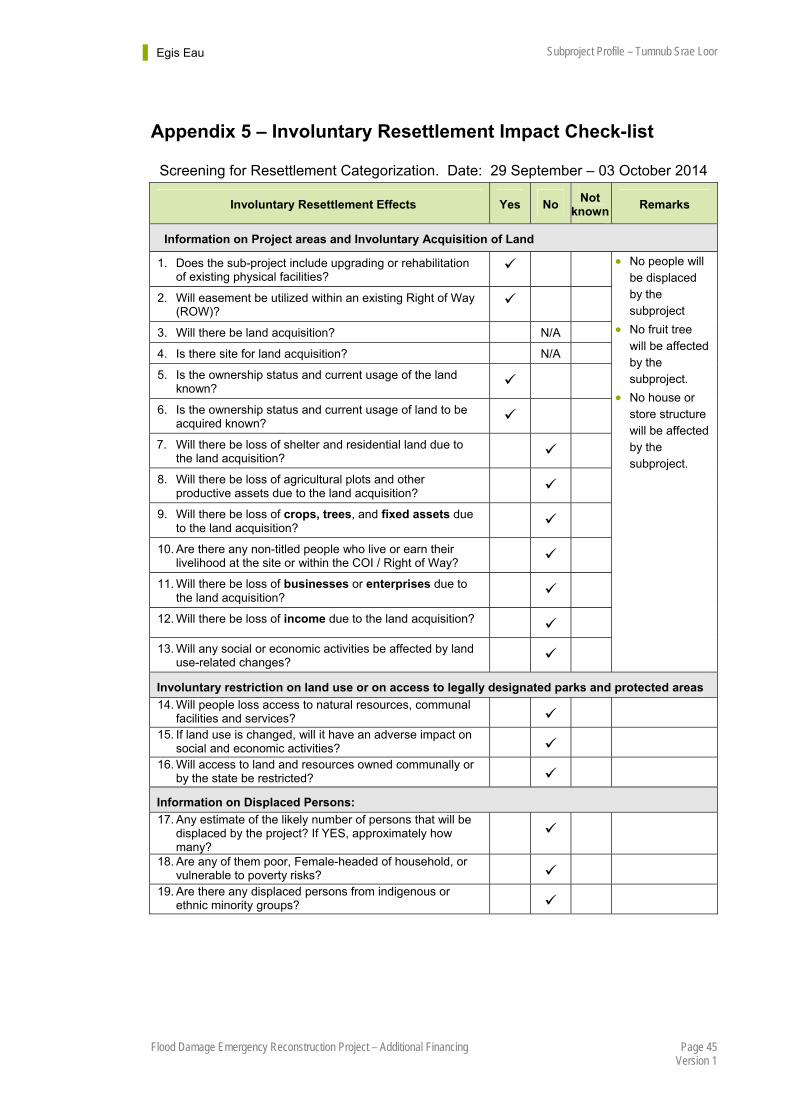
Egis Eau Subproject Profile – Tumnub Srae Loor
Page 45 Flood Damage Emergency Reconstruction Project – Additional Financing Version 1
Appendix 5 – Involuntary Resettlement Impact Check-list
Screening for Resettlement Categorization. Date: 29 September – 03 October 2014
Involuntary Resettlement Effects Yes No Not
known Remarks
Information on Project areas and Involuntary Acquisition of Land
1. Does the sub-project include upgrading or rehabilitation of existing physical facilities?
2. Will easement be utilized within an existing Right of Way (ROW)?
3. Will there be land acquisition? N/A
4. Is there site for land acquisition? N/A
5. Is the ownership status and current usage of the land known?
6. Is the ownership status and current usage of land to be acquired known?
7. Will there be loss of shelter and residential land due to the land acquisition?
8. Will there be loss of agricultural plots and other productive assets due to the land acquisition?
9. Will there be loss of crops, trees, and fixed assets due to the land acquisition?
10. Are there any non-titled people who live or earn their livelihood at the site or within the COI / Right of Way?
11. Will there be loss of businesses or enterprises due to the land acquisition?
12. Will there be loss of income due to the land acquisition?
13. Will any social or economic activities be affected by land use-related changes?
No people will be displaced by the subproject
No fruit tree will be affected by the subproject.
No house or store structure will be affected by the subproject.
Involuntary restriction on land use or on access to legally designated parks and protected areas
14. Will people loss access to natural resources, communal facilities and services?
15. If land use is changed, will it have an adverse impact on social and economic activities?
16. Will access to land and resources owned communally or by the state be restricted?
Information on Displaced Persons:
17. Any estimate of the likely number of persons that will be displaced by the project? If YES, approximately how many?
18. Are any of them poor, Female-headed of household, or vulnerable to poverty risks?
19. Are there any displaced persons from indigenous or ethnic minority groups?
Egis Eau Subproject Profile – Tumnub Srae Loor
Page 46 Flood Damage Emergency Reconstruction Project – Additional Financing Version 1
Appendix 6 – ADB Resettlement Principles and Policy Frameworks
The following summarizes the key ADB policies relevant to the preparation of Resettlement Plan for the project. The resettlement categorization report has been prepared based on ABD’s Policy on Involuntary Resettlement. The main purposes of this policy are to:
1 avoid land acquisition and involuntary resettlement wherever feasible; and
2 minimize it where it is unavoidable and insure that AHs or AP receive assistance, so that they would be at least as well off as they would have been in the absence of the project.
In cases where subprojects involve voluntary donation and no other land acquisition and involuntary resettlement impacts, the subproject will be classified as Category C. However, the PIU will prepare a report to ADB (to be attached to the classification form) which will document that: (i) The subproject site is selected in full consultation with landowners and any non-titled
affected people; (ii) voluntary donations do not severely affect the living standards of affected people and
the amount of agricultural or other productive land to be acquired from each affected household does not exceed 5% of the total productive landholdings of the household;
(iii) Voluntary donations are linked directly to benefits for the affected household; (iv) Any voluntary donation will be confirmed through written record and verified by an
independent third party such as the external monitoring organization; (v) There is an adequate grievance process; (vi) No affected household will be displaced from housing and severely affected; and (vii) No affected household is vulnerable.

Egis Eau Subproject Profile – Tumnub Srae Loor
Page 47 Flood Damage Emergency Reconstruction Project – Additional Financing Version 1
Appendix 7 – Screening for Environmental Impacts
Rapid Environmental Assessment Checklist
Screening Questions Yes No Remarks
A. PROJECT SITING
Is the project area adjacent to or within any of the following environmentally sensitive areas?
Protected area
Wetland
Mangrove
Estuarine
Buffer zone of protected area
Special area for protecting biodiversity
No protected area, buffer zone of protected area, wetland, mangrove, estuarine, and special area for protecting biodiversity is adjacent to or within the subproject area.
B. POTENTIAL ENVIRONMENTAL IMPACTS
Will the project cause…
loss of precious ecological values (e.g. result of encroachment into forests/swamplands or historical/cultural buildings/areas, disruption of hydrology of natural waterways, regional flooding, and drainage hazards)?
As the subproject is to deepen and widen the existing canal and add some structures, no precious ecological values will be lost due to such rehabilitation.
conflicts in water supply rights and related social conflicts?
Conflicts in water supply rights and related social conflicts are not expected.
impediments to movements of people and animals?
No impediments to movements of people and animals will occur from the subproject rehabilitation.
potential ecological problems due to increased soil erosion and siltation, leading to decreased stream capacity?
The subproject will not provide any potential ecological problems due to increased soil erosion and siltation and will also be away from the stream.
Insufficient drainage leading to salinity intrusion?
No salinity intrusion is expected from the subproject site.
over pumping of groundwater, leading to salinisation and ground subsidence?
No groundwater will be used and ground subsidence is not expected.
impairment of downstream water quality and therefore, impairment of downstream beneficial uses of water?
Impairment of downstream water quality is not expected.
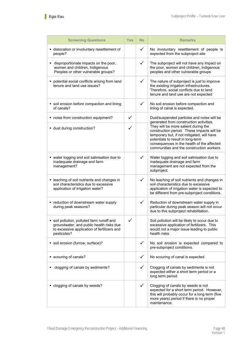
Egis Eau Subproject Profile – Tumnub Srae Loor
Page 48 Flood Damage Emergency Reconstruction Project – Additional Financing Version 1
Screening Questions Yes No Remarks
dislocation or involuntary resettlement of people?
No involuntary resettlement of people is expected from the subproject site
disproportionate impacts on the poor, women and children, Indigenous Peoples or other vulnerable groups?
The subproject will not have any impact on the poor, women and children, indigenous peoples and other vulnerable groups
potential social conflicts arising from land tenure and land use issues?
The nature of subproject is just to improve the existing irrigation infrastructures. Therefore, social conflicts due to land tenure and land use are not expected
soil erosion before compaction and lining of canals?
No soil erosion before compaction and lining of canal is expected.
noise from construction equipment?
dust during construction?
Dust/suspended particles and noise will be generated from construction activities. They will be more salient during the construction period. These impacts will be temporary but, if not mitigated, will have potentials to result in long-term consequences in the health of the affected communities and the construction workers.
water logging and soil salinisation due to inadequate drainage and farm management?
Water logging and soil salinisation due to inadequate drainage and farm management are not expected from the subproject.
leaching of soil nutrients and changes in soil characteristics due to excessive application of irrigation water?
No leaching of soil nutrients and changes in soil characteristics due to excessive application of irrigation water is expected to be different from pre-subproject conditions.
reduction of downstream water supply during peak seasons?
Reduction of downstream water supply in particular during peak season will not occur due to this subproject rehabilitation.
soil pollution, polluted farm runoff and groundwater, and public health risks due to excessive application of fertilizers and pesticides?
Soil pollution will be likely to occur due to excessive application of fertilizers. This would not a major issue leading to public health risks.
soil erosion (furrow, surface)? No soil erosion is expected compared to pre-subproject conditions.
scouring of canals? No scouring of canal is expected.
clogging of canals by sediments? Clogging of canals by sediments is not expected either a short term period or a long term period.
clogging of canals by weeds? Clogging of canals by weeds is not expected for a short term period. However, this will probably occur for a long term (five more years) period if there is no proper maintenance.

Egis Eau Subproject Profile – Tumnub Srae Loor
Page 49 Flood Damage Emergency Reconstruction Project – Additional Financing Version 1
Screening Questions Yes No Remarks
seawater intrusion into downstream freshwater systems?
The subproject rehabilitation will not be adjacent to seawater. Therefore, seawater intrusion into downstream freshwater systems will not occur.
introduction of increase in incidence of waterborne or water related diseases?
The subproject rehabilitation will not cause increase in incidence of waterborne diseases.
dangers to a safe and healthy working environment due to physical, chemical and biological hazards during project construction and operation?
Dangers may occur but can be avoidable during construction by strictly implementing safety plan from the contractor e.g., fence active work sites and strictly disallow unauthorized entries, post watchman to secure sites and ensure no loitering near the site.
large population influx during project construction and operation that causes increased burden on social infrastructure and services (such as water supply and sanitation systems)?
There might have minor population influx not during subproject construction but operation period. However, this may not put a burden on social infrastructure and services.
social conflicts if workers from other regions or countries are hired?
Priority in labour employment will be provided to local residents while outsiders will be considered in case of lack in labour.
risks to community health and safety due to the transport, storage, and use and/or disposal of materials such as explosives, fuel and other chemicals during construction and operation?
No transport, storage, and use and/or disposal of hazardous materials such as explosives, and other chemicals during construction and operation is expected.
community safety risks due to both accidental and natural hazards, especially where the structural elements or components of the project (e.g., irrigation dams) are accessible to members of the affected community or where their failure could result in injury to the community throughout project construction, operation and decommissioning?
Working conditions at construction site will be secured. Only workers and subproject staff will be allowed to enter the construction and operation sites.
C. CLIMATE CHANGE AND DISASTER RISK
The following questions are not for environmental categorization. They are included in this checklist to help identify potential climate and disaster risks.
Is the Project area subject to hazards such as earthquakes, floods, landslides, tropical cyclone winds, storm surges, tsunami or volcanic eruptions and climate changes?
Flood and drought are the main natural hazards of Cambodia. These hazards will not occur from the subproject rehabilitation. However the subproject will improve the beneficiaries resilience to climate change.
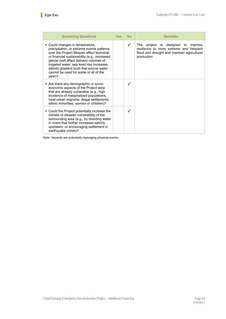
Egis Eau Subproject Profile – Tumnub Srae Loor
Page 50 Flood Damage Emergency Reconstruction Project – Additional Financing Version 1
Screening Questions Yes No Remarks
Could changes in temperature, precipitation, or extreme events patterns over the Project lifespan affect technical or financial sustainability (e.g., increased glacial melt affect delivery volumes of irrigated water; sea level rise increases salinity gradient such that source water cannot be used for some or all of the year)?
The project is designed to improve resilience to more extreme and frequent flood and drought and maintain agricultural production.
Are there any demographic or socio-economic aspects of the Project area that are already vulnerable (e.g., high incidence of marginalized populations, rural-urban migrants, illegal settlements, ethnic minorities, women or children)?
Could the Project potentially increase the climate or disaster vulnerability of the surrounding area (e.g., by diverting water in rivers that further increases salinity upstream, or encouraging settlement in earthquake zones)?
Note: Hazards are potentially damaging physical events.

Egis Eau Subproject Profile – Tumnub Srae Loor
Page 51 Flood Damage Emergency Reconstruction Project – Additional Financing Version 1
Appendix 8 – Environmental Management Plan (EMP)
Institutional Responsibilities Project Phase Project Activity
Potential Environmental
Impacts Proposed Mitigation Measures
Implement Supervise
Supervision Consultant, IA/EA
Supervision Consultant, IA/EA
1. Damage to existing structures The design should maximize benefits or avoid impacts on assets. Resettlement framework for the subproject based on Cambodian laws, policies, and regulations should be applied.
Supervision Consultant, IA/EA
Supervision Consultant, IA/EA
Pre-construction Detailed design 2. Risk of land mine or UXO Consultative meetings with local
authorities and communities are necessary to know where there are risks of mines or UXO. Also, unsafe areas should be cleared before project implementation.
Supervision Consultant, IA/EA
Supervision Consultant, IA/EA
Construction
Earthworks, site clearing, hauling of construction material
3. Dust generation The contractor shall prepare and strictly implement dust control measures such as periodical water spray.
The contractor shall maintain their construction equipments in adequate working conditions.
The contractor shall keep clean road surfaces.
The driver of construction vehicles should comply with speed limits to minimize road dust.
The contractor and supervision consultant shall provide prior notification to the local community on schedule of construction activities.
The contractor shall prepare and strictly implement a traffic management plan around construction site.
The supervision consultant shall monitor dust, exhaust gas and complaint from the
Contractor and Supervision Consultant
Supervision Consultant, IA/EA
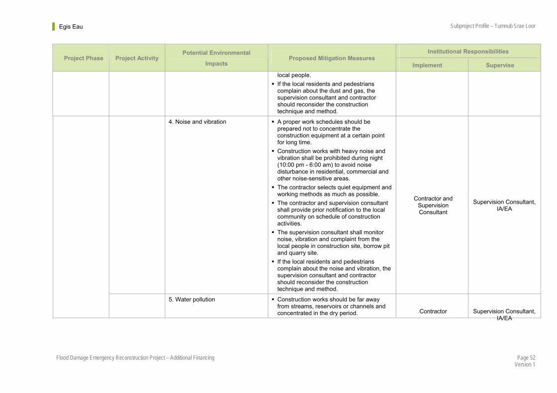
Egis Eau Subproject Profile – Tumnub Srae Loor
Page 52 Flood Damage Emergency Reconstruction Project – Additional Financing Version 1
Institutional Responsibilities Project Phase Project Activity
Potential Environmental
Impacts Proposed Mitigation Measures
Implement Supervise
local people.
If the local residents and pedestrians complain about the dust and gas, the supervision consultant and contractor should reconsider the construction technique and method.
4. Noise and vibration A proper work schedules should be prepared not to concentrate the construction equipment at a certain point for long time.
Construction works with heavy noise and vibration shall be prohibited during night (10:00 pm - 6:00 am) to avoid noise disturbance in residential, commercial and other noise-sensitive areas.
The contractor selects quiet equipment and working methods as much as possible.
The contractor and supervision consultant shall provide prior notification to the local community on schedule of construction activities.
The supervision consultant shall monitor noise, vibration and complaint from the local people in construction site, borrow pit and quarry site.
If the local residents and pedestrians complain about the noise and vibration, the supervision consultant and contractor should reconsider the construction technique and method.
Contractor and Supervision Consultant
Supervision Consultant, IA/EA
5. Water pollution Construction works should be far away from streams, reservoirs or channels and concentrated in the dry period. Contractor Supervision Consultant,
IA/EA
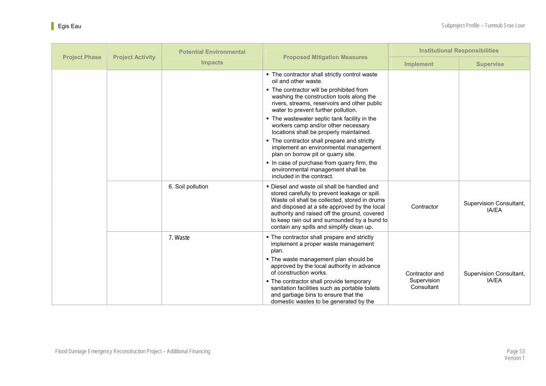
Egis Eau Subproject Profile – Tumnub Srae Loor
Page 53 Flood Damage Emergency Reconstruction Project – Additional Financing Version 1
Institutional Responsibilities Project Phase Project Activity
Potential Environmental
Impacts Proposed Mitigation Measures
Implement Supervise
The contractor shall strictly control waste oil and other waste.
The contractor will be prohibited from washing the construction tools along the rivers, streams, reservoirs and other public water to prevent further pollution.
The wastewater septic tank facility in the workers camp and/or other necessary locations shall be properly maintained.
The contractor shall prepare and strictly implement an environmental management plan on borrow pit or quarry site.
In case of purchase from quarry firm, the environmental management shall be included in the contract.
6. Soil pollution Diesel and waste oil shall be handled and stored carefully to prevent leakage or spill. Waste oil shall be collected, stored in drums and disposed at a site approved by the local authority and raised off the ground, covered to keep rain out and surrounded by a bund to contain any spills and simplify clean up.
Contractor Supervision Consultant,
IA/EA
7. Waste The contractor shall prepare and strictly implement a proper waste management plan.
The waste management plan should be approved by the local authority in advance of construction works.
The contractor shall provide temporary sanitation facilities such as portable toilets and garbage bins to ensure that the domestic wastes to be generated by the
Contractor and Supervision Consultant
Supervision Consultant, IA/EA
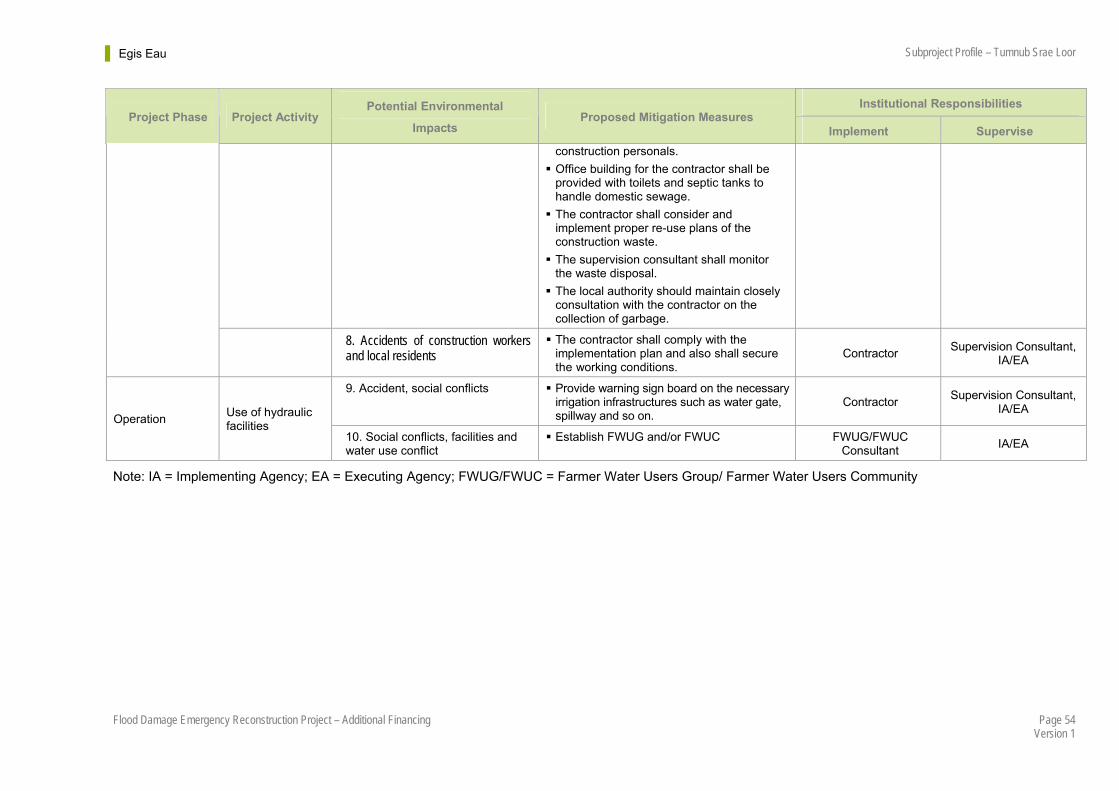
Egis Eau Subproject Profile – Tumnub Srae Loor
Page 54 Flood Damage Emergency Reconstruction Project – Additional Financing Version 1
Institutional Responsibilities Project Phase Project Activity
Potential Environmental
Impacts Proposed Mitigation Measures
Implement Supervise
construction personals.
Office building for the contractor shall be provided with toilets and septic tanks to handle domestic sewage.
The contractor shall consider and implement proper re-use plans of the construction waste.
The supervision consultant shall monitor the waste disposal.
The local authority should maintain closely consultation with the contractor on the collection of garbage.
8. Accidents of construction workers and local residents
The contractor shall comply with the implementation plan and also shall secure the working conditions.
Contractor Supervision Consultant,
IA/EA
9. Accident, social conflicts Provide warning sign board on the necessary irrigation infrastructures such as water gate, spillway and so on.
Contractor Supervision Consultant,
IA/EA Operation
Use of hydraulic facilities
10. Social conflicts, facilities and water use conflict
Establish FWUG and/or FWUC FWUG/FWUC Consultant
IA/EA
Note: IA = Implementing Agency; EA = Executing Agency; FWUG/FWUC = Farmer Water Users Group/ Farmer Water Users Community
Egis Eau Sub-project Profile – Tumnub Srae Loor
Page 55 Flood Damage Emergency Reconstruction Project – Additional Financing Version 1
References
1 ADB. Safeguard Policy Statement, Policy Paper, Asian Development Bank, Manila, June 2009.
2 Sir William Halcrow & Partners Ltd. Annex A Hydrology, Irrigation Rehabilitation Study in Cambodia, Final Report, Sir Wiiliam Halcrow & Partners Ltd in association with Mandala Agricultural Development Corporation, 1994
3 Farquharson F, Green C, Meigh J and Sutcliffe J. Regional Flood Frequency Analysis, Ed V P Singh, D Reidel, 1986.
4 Fraser Thomas with SDC. Report on Water Availability, Tonle Sap Lowland Stabilization Project, TA No. 4756-CAM, ADB, Manila, September 2006.
5 Egis Eau. Cambodian Water Resources Profile, Water Resources Management Sector Development Program, ADB Loan 2673-CAM and TA 7610-CAM, Phnom Penh, April 2014.