final reber circle haer report - atst.nso.edu reber... · also an amateur radio operator. ... the...
TRANSCRIPT

REBER CIRCLE, GROTE REBER RADIO TELESCOPE SITE HAER No. HI-118(Haleakala High Observatory Site) Pukalani Vicinity Maui County Hawaii
PHOTOGRAPHS
WRITTEN HISTORICAL AND DESCRIPTIVE DATA
HISTORIC AMERICAN ENGINEERING RECORD U.S. Department of the Interior
National Park Service San Francisco, California

HISTORIC AMERICAN ENGINEERING RECORD
INDEX TO PHOTOGRAPHS
REBER CIRCLE, GROTE REBER RADIO TELESCOPE SITE HAER No. HI-118(Haleakala High Observatory Site) Pukalani Vicinity Maui County Hawaii David Franzen, Photographer September 2012
HI-118-1 OVERVIEW OF REBER CIRCLE FROM ROOF OF ADJACENT BUILDING.
VIEW FACING NORTHEAST.
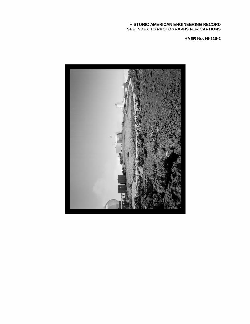
HI-118-2 OVERVIEW OF REBER CIRCLE. VIEW FACING SOUTHEAST.
HI-118-3 WALL SECTION SHOWING BOARD FORMED CONCRETE SECTIONS AND RAIL BOLTS. VIEW LOOKING EAST.
HI-118-4 DETAIL OF BOARD FORMED WALL SECTIONS. VIEW FACING SOUTH.
HI-118-5 VIEW OF WALL LOOKING TOWARD HALEAKALA SUMMIT HOUSE. VIEW FACING NORTH.
HI-118-6 DETAIL OF RAIL TIE-DOWN REMNANT. VIEW FACING WEST.

REBER CIRCLE, GROTE REBER RADIO TELESCOPE SITE (Haleakala High Observatory Site)
HAER No. HI-118 INDEX TO PHOTOGRAPHS
(Page 2)
PHOTO KEY
1
2
3
4
5
6

HISTORIC AMERICAN ENGINEERING RECORD
REBER CIRCLE, GROTE REBER RADIO TELESCOPE SITE
HAER No. HI-118
Location: Haleakala High Altitude Observatory Site (on Pu‘u Kolekole hill)
Pukalani Vicinity Maui, Hawaii
U.S.G.S. Topographic map, Kilohana Quadrangle 1991 (7.5 minute series) Universal Transverse Mercator Coordinates NAD 83: 04.785505. 2292557
Present Owner: University of Hawaii Institute for Astronomy Present Use: None Significance: Reber Circle is a significant resource in the history of the development of
Haleakala for astronomical observation, as well as the development of Radio Astronomy generally. Reber’s telescope was the first to make use of Haleakala’s peak for the observation of celestial objects. It was also an important early radio telescope; guiding radio astronomers toward better placement of receiving antennas, with data gathered through it leading to Reber’s discoveries that modified ionospheric theory.
Historian: Lesleigh Jones
Mason Architects, Inc. 119 Merchant Street, Suite 501 Honolulu, HI 96813
Project Information: This report is part of a mitigation measure for the construction of the
Advanced Technology Solar Telescope (ATST). This documentation was required under Section I.H. (2-7) of the Advanced Technology Solar Telescope Project Programmatic Agreement (PA), which was signed by the National Science Foundation, the National Park Service, the Advisory Council on Historic Preservation, the Hawaii State Historic Preservation Officer, The Association of Universities for Research In Astronomy, and the University of Hawai‘i (for the benefit of its Institute for Astronomy. The documentation is in accordance with the letter dated June 14, 2006 from Peter Young, Chair of the State Board of Land and Natural Resources and the State Historic Preservation Officer, State of Hawai'i Department of Land and Natural Resources to Erik Fredericksen, Xamanek Researchers, regarding Data Recovery Plan for SIHP 50-50-11-5443 (Reber Circle) which specifies the details of the required documentation efforts, including HAER documentation for this site. Archival photographs were taken by David Franzen, Franzen Photography, Kailua, HI. The field work was conducted and the initial report prepared in September - October 2012.

REBER CIRCLE, GROTE REBER RADIO TELESCOPE SITE (Haleakala High Observatory Site)
HAER No. HI-118 (Page 2)
Part I. Historical Information:
A. Physical History:
1. Date of construction: 1952.1
2. Engineer: Grote Reber, engineer and astronomer. Reber was educated at Illinois Institute of Technology, with a Bachelor’s degree in Electrical Engineering. Reber was also an amateur radio operator. After reading about Carl Jansky’s 1933 discovery of the emission of radio waves by extra-planetary sources, Reber constructed his first radio telescope in the back yard of his home in Illinois. Reber came to Hawaii in 1951 to erect a telescope at the top of Haleakala. The drawings for which were completed in 1951.
3. Builder/ Contractor/ Supplier: Grote Reber, Maui Vocational School (now Maui College).
4. Original plans and construction: Reber Circle was originally built as a foundation ring for a rotating radio telescope. The dipole array telescope itself sat atop the stone and concrete ring and was able to rotate 360 degrees on a steel track embedded into the top of the concrete. The antenna was constructed of steel and bamboo support beams with copper receiving elements.
5. Alterations and additions: A 1957 ice storm destroyed the superstructure of the telescope, leaving only the concrete and stone base ring. Additional telescope and ancillary building construction nearby has covered or demolished much of the southern half of the ring structure.
B. Historical Context: Reber Circle is located at the top of Haleakala, near the summit, on Pu‘u Kolekole. It is also at the border of two ahupua‘a (traditional Hawaiian land divisions, typically running from mountain to ocean) on the Island of Maui. The ahupua‘a are Pulehunui in the northwest, and Mahamenui in the southwest. These ahupua‘a are in separate moku (larger land divisions that include multiple ahupua‘a), Pulehunui is in the moku of Kula and Mahamenui is in the moku of Kahikinui. Kula had a sizable population, fishing and cultivating taro for sustenance during the pre-contact period. More recently, Kula has supported diversified agriculture, as well as ranching. Kahikinui was much less populous than Kula during the pre-contact period, with villages mainly along the coastline, where fishing was good, but few crops could be cultivated. Native Hawaiians consider Haleakala’s summit area sacred. It is the location from which the demi-god Maui lassoed the sun and slowed its progress across the sky; its many craters were used for burials of the deceased, and in at least one location, of umbilical cords; heiau (temples) were also located on Haleakala.
Grote Reber is considered the “father of radio astronomy,” and his work was the first dedicated to gathering data from and about the universe through radio waves. According to the National Radio Astronomy Observatory,
“Reber built the world's first radio telescope, was the world's first radio astronomer, and for almost ten years was the only person in the world devoting significant research time to radio astronomy. Reber's pioneering work was ultimately recognized by the professional astronomy community. He received the
1 Charles Schauer. Summary of the Research Corporation's early association with Grote Reber, 1950-1957. ca. 1957

REBER CIRCLE, GROTE REBER RADIO TELESCOPE SITE (Haleakala High Observatory Site)
HAER No. HI-118 (Page 3)
Franklin Institute’s Cresson Prize, an honorary Doctor of Science from Ohio State University, the American Astronomical Society’s Russell Lecture Prize, the Bruce Medal of the Astronomical Society of the Pacific, the Associated Universities Inc. Jansky Lectureship, and the Jackson-Gwilt Medal of the Royal Astronomical Society”.2
In 1933, Karl Jansky’s discovery of radio signals emanating from stars in the Milky Way was publicized. This discovery inspired Reber to begin his research into radio astronomy. Reber had become a licensed amateur radio operator while in high school, and then trained as an electrical engineer, graduating from Illinois Institute of Technology, with a Bachelor’s degree in 1933. He constructed his own radio telescope in his backyard in 1937, after learning of Jansky’s discovery. Reber went on to systematically study radio waves coming from stars, mainly during his time off from his work as an engineer. Reber worked as an engineer while pursuing his hobby of astronomy from the time that he constructed his first telescope until he left his job with the National Bureau of Standards in Washington DC in 1951 to build his telescope at Haleakala. His work at Haleakala was the first in which he was able to work strictly on astronomy, and he went on to become the National Radio Astronomy Observatory’s first visiting scientist.
A radio telescope functions by focusing radio signals, typically gathered by a parabolic dish, to a receiver located at some distance above the dish. In the case of Reber’s first telescope, this was a dish 31’-4¾” in diameter, with a receiver 20 feet above. He used this telescope to scan the skies on a part time basis, while he continued to work as an engineer in the radio industry.
By 1950, Reber came to believe that the ideal location for a radio telescope was most likely atop a near equatorial mountain that was surrounded, as close to 360 degrees as possible, by water. By November of the same year, he was looking at the Hawaiian Islands as a likely location. Though Mauna Kea or Mauna Loa would have been more preferable locations, due to the lack of a road to their summits, Reber chose Haleakala instead.
By building the receiver at the top of Haleakala, Reber planned to use the surrounding Pacific Ocean as a magnifying dish. The dish would act as an interferometer, with radio waves coming both directly from the source in space, and reflected off the ocean. Measurement of the interference between the two was able to show the location in space from which the signal had originated. Reber initially believed that the location at the top of Haleakala would be distant enough from any significant radio interference to gather a large amount of data from his ocean-sized magnifying dish.
Reber drew up plans in 1951 for the construction of the telescope. He initially intended to use mainly bamboo as support and copper dipoles for the receiver, but had trouble acquiring bamboo of the correct size that had been properly aged, and instead substituted steel for some of the supporting structure. Drawings for the structure called for a concrete and stone base 82’ in diameter, with a 40#/yard steel track laid atop the circle. In his plans Reber described the concrete and stone base as “a pile of rocks cemented together like a stone fence”. Seventy-two pairs of ¾” x 2’ steel rods were to be embedded vertically approximately 3-1/8” apart and spaced at approximately 5 degrees apart. These rods were also to be bent outward by 30 degrees at their lowest 4 inches, to act as anchors.
On top of the track, Reber planned a 58’ square steel structure with motorized wheels at each corner to drive the rotation of the telescope. He expected rotation to be at a rate of one degree 2 National Radio Astronomy Observatory “Finding Aid to the Papers of Grote Reber” Biography section. 2012

REBER CIRCLE, GROTE REBER RADIO TELESCOPE SITE (Haleakala High Observatory Site)
HAER No. HI-118 (Page 4)
per second, with a full rotation taking approximately six minutes. Above the steel square, he planned a “light frame or trellis”3 which he hoped to construct from bamboo, and from which the antenna’s wires would hang. Reber expected the overall dimensions of the frame to be 216’ long, 63’ wide and 50’ high. He anticipated the structure’s weight to be 10-11 tons. Descriptions and photographs after construction show a modified structure. According to the Honolulu Star-Bulletin, the telescope was about 30’ high, and in the accompanying photo (as well as other photos available) the rotating antenna appears to be less than 216’ long.
Reber earned a grant from the Research Corporation of New York in 1952, which funded his lease of a parcel of land at Pu‘u Kolekole, at Haleakala’s summit, construction of his radio telescope receiver, and operations of the telescope. Though his funding did not come through until 1952, Reber had already gone to Maui and secured his lease, drawn up plans and begun construction in 1951. Reber constructed his telescope during the summers of 1951 and 1952, and began making observations in 1952. Reber continued making observations, primarily on his own during the winters of 1952-1954. He discovered early on that observations were not optimal during the summer, and at no time were up to his expectations. In 1954, he ceased operations, and moved to Tasmania to begin work there, having seen the work that was being done by other astronomers at that latitude. The telescope remained in place, with Reber anticipating revisiting it to check in periodically. In 1957, however, an ice storm destroyed the antenna structure, leaving only the mortared stone base ring.
In subsequent years, additional buildings and telescopes have been built nearby, and their construction has resulted in the destruction or covering of the southern half of the ring.
Part II. Structural/ Design Information:
A. General Statement: 1. Character: Reber Circle is the remains of a stone and concrete mortar foundation for the
circular metal track that the 1952 radio telescope rotated on. Its design of a level, circular, low height, roughly laid stone and mortar wall convey the proportions and size of the radio telescope mounted above it.
2. Condition of Fabric: Fair, about half of the original circular foundation is visible above grade.
B. Description:
Reber Circle is half of a masonry ring of natural stone from the site, roughly laid in thick concrete mortar. The ring is typically about 3' wide at its base and is about 82'-0" in diameter (on the center of the ring). The sides of the ring taper up from the base to a concrete top surface that is typically about 8" wide with an undulating, roughly level surface that bears the 3½" wide impression of the circular steel track. The overall height of the ring above grade varies from only a few inches at the east end to about 3' in places, due to the sloping terrain. The remaining portion of the original masonry ring is the north section, forming an approximate half-circle, and two small portions of stone and mortar, each about 2'-6" long at the west and south sides of the original circle. The remainder of the south portion of the ring is either gone, or buried below grade. Loose gravel that is primarily composed of crushed rock brought from off-site covers the interior of the ring.
3 Grote Reber, Description of Antenna Installation at Kolekole. 1951

REBER CIRCLE, GROTE REBER RADIO TELESCOPE SITE (Haleakala High Observatory Site)
HAER No. HI-118 (Page 5)
Short lengths of ¾" threaded steel bolts that formerly secured the metal track protrude up from the concrete top surface of the ring. These bolts are set in pairs that straddled the base of the track. The bolts of each pair are about 6" apart and pairs of bolts are spaced between 2'-1" to 2'-7" along the length of the remaining ring. A number of these bolts retain rectangular steel plates, secured by nuts, which held the track.
Within the stone and concrete mortar construction of the ring are four roughly pyramidal sections of concrete about 4' long at the base that extend through the thickness of the ring. These sections appear to be blocks of board formed concrete, about 2'-6" high that were put in place before the stone and concrete mortar ring was built around them, leaving three of their faces exposed in the side of the ring. The top concrete surface of the ring that bears the track impressions is formed over the tops of these blocks. These blocks show the horizontal impressions of the 7" wide boards that were used in forming.
On the edges of the ring, at its east end, are sections of unformed, poured concrete that are about level with grade. One section runs about 7' along the interior edge of the ring and is about 3' wide. The other adjacent section, along the exterior edge of the ring is about 6' long and 3' wide. These appear to be recently added with no readily identifiable purpose.
About 72' southwest of the center of the circle is a small rectangular concrete building about 6' x 8' in plan, with a flat roof. This small building is at the site of a "concrete house" that is shown on original 1951 sketches for the design of the ring foundation.4 This building is constructed of CMU with inset quoins. It has a louver panel door on the west side. This building is attached to a larger concrete building (approximately 15' x 15' in plan) on its south side. This larger building appears to have been built at a later date than the 6' x 8' structure. It has a flat roof with several meteorological instruments and an access stairway to the roof. Also on the roof is a small monument containing a portion of Grote Reber’s cremains, and a metal plaque commemorating him.
C. Site Information:
Reber Circle is located near the summit of Haleakala Volcano. Although the terrain at the site, has not changed from the barren windswept cinders and rocks, and the nearby National Park structures remain the same as at the time of construction, the setting has been altered by several increments of construction at the adjacent scientific compound, adding numerous buildings, telescopes and other structures.
Part III. Sources of Information:
A. Primary Sources:
Architectural Drawings and Early Views
Original drawings of the Reber Telescope, including Reber Circle and the site, as well as correspondence, Research Corporation original materials, and photographs, are electronic files (pdf) available through the National Radio Astronomy Observatory Archives website at:
http://www.nrao.edu/archives/Reber/reber.shtml
Including: “Description of antenna installation at Kolekole." “Drawings of Layout, Sections, Center Post.” “Kolekole Hill, Hawaii Land Lease” in Range 6B Box 53 4 Grote Reber, "Layout" sketch. April 28, 1951; At http://www.nrao.edu/archives/Reber/reber.shtml

REBER CIRCLE, GROTE REBER RADIO TELESCOPE SITE (Haleakala High Observatory Site)
HAER No. HI-118 (Page 6)
And: Schauer, Charles H. Summary of the Research Corporation's early association with Grote
Reber, 1950-1957. Range 6B Box 2 Papers of Grote Reber. Archives, National Radio Astronomy Observatory / Associated Universities, Inc. Courtesy of Research Corporation, a foundation for the advancement of science., 1957.
Photographs and papers of Grote Reber found in the Archives of the National Radio Astronomy Observatory/Associated Universities, Inc. are not restricted and are considered in the public domain.
Additional photographs in electronic format are available at the Grote Reber Museum website at: http://www.groterebermuseum.org.au/gallery.
B. Secondary Sources:
Malone, John. It Doesn't Take a Rocket Scientist. Hoboken: John Wiley & Sons, Inc., 2002.
Ramsey, John. "Research May Open Fresh Concepts of Outer Space." Honolulu Star-Bulletin, October 1952: B-1, B-4.
Sterling, Elspeth P. Sites of Maui. Honolulu: Bishop Museum Press, 1998.
C. Likely Sources Not Yet Investigated:
University of Hawaii Institute for Astronomy may have additional photographic material. Grote Reber Museum in Tasmania may also have Photographic and archival material.

REBER CIRCLE, GROTE REBER RADIO TELESCOPE SITE (Haleakala High Observatory Site)
HAER No. HI-118 (Page 7)
Location Map – arrow showing location of Reber Circle at Haleakala High Observatory Site on Pu‘u Kolekole hill (base map source: USGS Kilohana and Lualailua quadrangles)
Map Area

REBER CIRCLE, GROTE REBER RADIO TELESCOPE SITE (Haleakala High Observatory Site)
HAER No. HI-118 (Page 8)
1949 Territorial survey showing extent of Reber’s leased property on Pu‘u Kolekole. No scale. Papers of Grote Reber. (public domain).

REBER CIRCLE, GROTE REBER RADIO TELESCOPE SITE (Haleakala High Observatory Site)
HAER No. HI-118 (Page 9)
Grote Reber 1951 drawing of site with base ring and instrument building. No scale. Papers of Grote Reber (public domain).

REBER CIRCLE, GROTE REBER RADIO TELESCOPE SITE (Haleakala High Observatory Site)
HAER No. HI-118 (Page 10)
Undated photograph showing person at center of telescope structure (note rail track indicating extent of Reber Circle at bottom). Source: Grote Reber Museum

HISTORIC AMERICAN ENGINEERING RECORD SEE INDEX TO PHOTOGRAPHS FOR CAPTIONS HAER No. HI-118-1
HISTORIC AMERICAN ENGINEERING RECORD SEE INDEX TO PHOTOGRAPHS FOR CAPTIONS HAER No. HI-118-2

HISTORIC AMERICAN ENGINEERING RECORD SEE INDEX TO PHOTOGRAPHS FOR CAPTIONS HAER No. HI-118-3

HISTORIC AMERICAN ENGINEERING RECORD SEE INDEX TO PHOTOGRAPHS FOR CAPTIONS HAER No. HI-118-4

HISTORIC AMERICAN ENGINEERING RECORD SEE INDEX TO PHOTOGRAPHS FOR CAPTIONS HAER No. HI-118-5

HISTORIC AMERICAN ENGINEERING RECORD SEE INDEX TO PHOTOGRAPHS FOR CAPTIONS HAER No. HI-118-6