final damage assessment and restoration plan and ......1 final damage assessment and restoration...
TRANSCRIPT
1
FINAL DAMAGE ASSESSMENT and RESTORATION PLAN
and
ENVIRONMENTAL ASSESSMENT
for the
JULY 2, 2005,
M/V CASITAS GROUNDING
at
PEARL AND HERMES ATOLL, NORTHWEST HAWAIIAN ISLANDS,
HAWAIIAN ISLANDS NATIONAL WILDLIFE REFUGE
PAPAHĀNAUMOKUĀKEA MARINE NATIONAL MONUMENT
Prepared by:
The Natural Resource Trustees
for the M/V Casitas Grounding, Hawaii
U.S. Department of Commerce
National Oceanic and Atmospheric Administration
U.S. Department of the Interior
U.S. Fish and Wildlife Service
State of Hawaii
Department of Land and Natural Resources
March 2011
2
TABLE OF CONTENTS
1.0 INTRODUCTION: PURPOSE OF AND NEED FOR RESTORATION .................................. 3
1.1 INTRODUCTION ............................................................................................................... 3
1.2 NATURAL RESOURCE TRUSTEES AND AUTHORITIES .......................................... 5
1.3 OVERVIEW OF OIL POLLUTION ACT OF 1990 REQUIREMENTS .......................... 6
1.4 COORDINATION WITH THE RESPONSIBLE PARTY ................................................ 7
1.5 PUBLIC PARTICIPATION ............................................................................................... 8
1.6 ADMINISTRATIVE RECORD ......................................................................................... 8
1.7 SUMMARY OF THE NATURAL RESOURCE DAMAGEs CLAIM ............................. 9
2.0 ENVIRONMENT ...................................................................................................................... 10
2.1 Terrestrial Resources ......................................................................................................... 10
2.2 Shallow Reef Marine Resources ....................................................................................... 13
3.0 INJURY DETERMINATION AND QUANTIFICATION....................................................... 15
3.1 Summary of preassessment activities ................................................................................ 15
3.2 Preassessment approach .................................................................................................... 15
3.3 Marine Preassessment ....................................................................................................... 15
3.3.1 Evaluation of oil exposure ......................................................................................... 17
3.3.2 Evaluation of physical injury ..................................................................................... 18
3.3.3 Debris Recovered ....................................................................................................... 20
3.3.4 Recovery Period ......................................................................................................... 20
4.0 Restoration Planning .................................................................................................................. 22
4.1 Restoration Strategy .......................................................................................................... 22
4.2 Evaluation Criteria ............................................................................................................ 23
4.3 Evaluation of Restoration Alternative 1: No Action/Natural Recovery .......................... 24
4.4 Evaluation of Restoration Alternative 2: Ecological Restoration ..................................... 25
4.4.1 Scaling Approach: Lost Ecological Services ............................................................. 25
4.4.2 Selected Project: Derelict Net and Debris Removal in the Monument ..................... 26
4.4.3 Non-Preferred Alternatives ........................................................................................ 28
4.4.3.1 Primary Restoration: Cementing loose coral fragments and substrate .................... 28
4.4.3.2 Compensatory Restoration: Orphan vessel removal in the Monument ................... 28
4.4.3.3 Compensatory restoration: Alien algae removal in the main Hawaiian Islands ...... 29
5.0 COORDINATION WITH OTHER PROGRAMS, PLANS, AND REGULATORY
AUTHORITIES ............................................................................................................................... 31
5.1 OVERVIEW...................................................................................................................... 31
5.2 KEY STATUTES, REGULATIONS AND POLICIES ................................................... 31
6.0 REFERENCES .......................................................................................................................... 36
APPENDIX A: FIELD REPORT for the M/V CASITAS VESSEL GROUNDING INITIAL
INJURY PREASSESSMENT SURVEYS ...................................................................................... 39
APPENDIX B. Consent Decree ....................................................................................................... 87
APPENDIX C. NATURAL RECOVERY PROJECTIONS ......................................................... 106
APPENDIX D: List of Contributors .............................................................................................. 111
3
LIST OF FIGURES
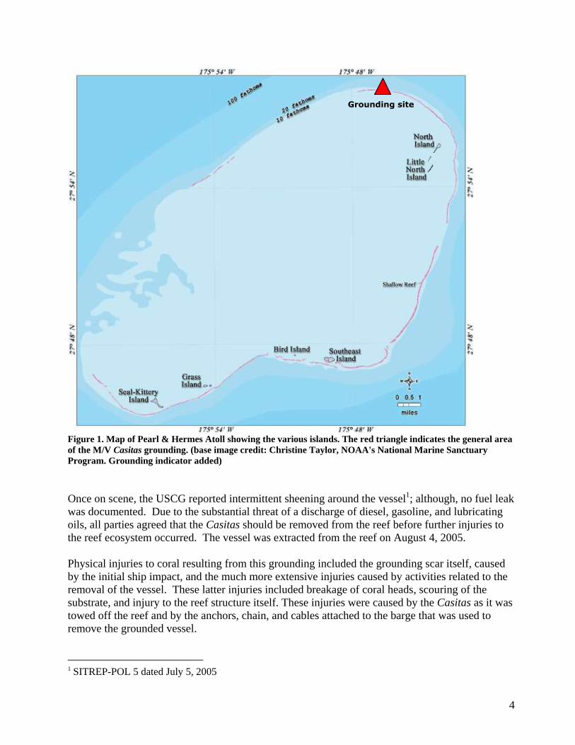
Figure 1. Map of Pearl & Hermes Atoll showing the various islands. The red triangle indicates the
general area of the M/V Casitas grounding. (base image credit: Christine Taylor, NOAA's
National Marine Sanctuary Program. Grounding indicator added) ................................................... 4
Figure 2. Map showing the Papahanaumokuakea Marine National Monument and the main
Hawaiian Islands. ............................................................................................................................. 10
Figure 3. Coral and sediment sampling locations. ........................................................................... 17
Figure 4. Sum of detected PAHs between reef sites within the reference transect and the “down
current” grounding transect. ............................................................................................................. 18
LIST OF TABLES
Table 1. Estimated coral injury based on area of injury, extent of injury, and estimated coral cover.
.......................................................................................................................................................... 20
1.0 INTRODUCTION: PURPOSE OF AND NEED FOR RESTORATION
1.1 INTRODUCTION
The M/V Casitas, a 145 ft (44 m) research vessel chartered by the National Oceanic and Atmospheric
Administration (NOAA) for marine debris removal, ran aground at Pearl and Hermes Atoll (27° 57.690' N,
175° 46.320' W) within the Hawaiian Islands National Wildlife Refuge (now also part of the
Papahānaumokuākea Marine National Monument) on July 2, 2005. At the time of the grounding, the
vessel carried 23 adults and had aboard numerous 55-gallon drums containing approximately 1,850
gallons of gasoline, about 30,000 gallons of diesel in the fuel tanks, lines, and engine, and about
200 gallons of lubricating oils in storage. Because the grounding created the substantial threat of a
release of oil, the U.S. Coast Guard (USCG) and other federal and state agencies immediately
began operations to prevent or minimize any releases of oil into the environment.
4
Figure 1. Map of Pearl & Hermes Atoll showing the various islands. The red triangle indicates the general area
of the M/V Casitas grounding. (base image credit: Christine Taylor, NOAA's National Marine Sanctuary
Program. Grounding indicator added)
Once on scene, the USCG reported intermittent sheening around the vessel1; although, no fuel leak
was documented. Due to the substantial threat of a discharge of diesel, gasoline, and lubricating
oils, all parties agreed that the Casitas should be removed from the reef before further injuries to
the reef ecosystem occurred. The vessel was extracted from the reef on August 4, 2005.
Physical injuries to coral resulting from this grounding included the grounding scar itself, caused
by the initial ship impact, and the much more extensive injuries caused by activities related to the
removal of the vessel. These latter injuries included breakage of coral heads, scouring of the
substrate, and injury to the reef structure itself. These injuries were caused by the Casitas as it was
towed off the reef and by the anchors, chain, and cables attached to the barge that was used to
remove the grounded vessel.
1 SITREP-POL 5 dated July 5, 2005
Grounding site
5
In addition, the grounding created a threat of introducing invasive species to the atoll. At least 17
people who were on board the vessel evacuated to North Island, Pearl and Hermes Atoll, where
they stayed for several hours before moving to Southeast Island in the same atoll. Because this
was an unexpected landing, the individuals involved did not have the opportunity to comply with
the National Wildlife Refuge‟s standard quarantine protocols that are required to prevent the
introduction of non-native plants, insects, fungi, and pathogens to these sensitive island
environments. The group had just come from Midway Atoll where there are invasive species that
pose a great risk to the habitats at Pearl and Hermes Atoll.
A survey team consisting of staff from the United States Fish and Wildlife Service (USFWS),
NOAA, the State of Hawaii Division of Aquatic Resources (DAR) (collectively, the Trustees), and
POLARIS Applied Sciences, Inc., (representing F/V Northwind, Inc., the Responsible Party (RP))
conducted an injury preassessment at the site August 22-30, 2005. Concurrently, the USFWS
conducted baseline terrestrial surveys as a preliminary means to determine if invasive species may
have been introduced to North Island as a result of the personnel evacuation following the
grounding. In November 2005, the Trustees and RP collaboratively prepared a Field Report
providing an approximation of the injuries to the coral reef that were caused by the grounding and
vessel removal operations. The total injured area of reef was estimated as 0.42 acres (ac) (1,700
m2), of which 0.11 ac (445 m
2) was coral.
This vessel grounding and subsequent response activities are referred to in this Final Damage
Assessment and Restoration Plan and Environmental Assessment (Final DARP/EA) as the
“Incident.”
The purpose and need for action is to restore the affected area and injured resources impacted by
the Incident. This document provides summarized information regarding the environmental
consequences of the Incident, including the affected environment, determination and
quantification of natural resource injuries, and natural resource restoration projects selected to
address those injuries. This document also serves, in part, as the agencies‟ compliance with the
National Environmental Policy Act (NEPA) and Title 19, Chapter 343, of the Hawaii Revised
Statutes (see Section 5 for additional information).
1.2 NATURAL RESOURCE TRUSTEES AND AUTHORITIES
The Final DARP/EA has been prepared jointly by the USFWS, on behalf of the U.S. Department
of the Interior, NOAA, on behalf of the U.S. Department of Commerce; and the Department of
Land and Natural Resources (DLNR), on behalf of the State of Hawaii. Collectively, these
agencies are referred to as the “Trustees” or “Natural Resource Trustees.”
Each of these agencies acts as a Natural Resource Trustee pursuant to the Oil Pollution Act of
1990 (OPA) (33 USC §§ 2701 et seq.), and the National Oil and Hazardous Substances Pollution
Contingency Plan (NCP) (40 CFR § 300.600), for natural resources injured by the Incident.
Executive Order (EO) 12777 designates the Federal Trustees for oil spills while the Governor of
Hawaii designates the State Trustees for oil spills in Hawaii. As a designated Trustee, each
agency is authorized to act on behalf of the public under State and/or Federal law to assess and
6
recover natural resource damages and to plan and implement actions to restore natural resources
and resource services injured or lost as the result of a discharge, or substantial threat of a
discharge, of oil. The Trustees designated the USFWS as Lead Administrative Trustee (LAT) (15
CFR § 990.14(a)).
The State of Hawaii acts under the authority of its Environmental Response Law (Haw. Rev. Stat.,
Title 10, Ch. 128D). This authority is in addition to any liability which may arise under Federal
law.
1.3 OVERVIEW OF OIL POLLUTION ACT OF 1990 REQUIREMENTS
Under OPA, Trustees can recover the cost of restoring, rehabilitating, replacing or acquiring the
equivalent of the injured natural resources (“primary restoration”); the diminution in value of
those injured natural resources pending restoration (“compensatory restoration”); and reasonable
assessment costs.
Before initiating a natural resource damage assessment and restoration (NRDAR), the Trustees
must determine that an Incident has occurred; the Incident is not from a public vessel; the Incident
is not from an onshore facility subject to the Trans-Alaska Pipeline Authority Act; the Incident is
not permitted under Federal, State or local law; and public trust natural resources and/or services
may have been injured as a result of the Incident.
Natural resources are defined as “land, fish, wildlife, biota, air, ground water, drinking water
supplies, and other such resources belonging to, managed by, held in trust by, appertaining to, or
otherwise controlled by the United States, any State or local government or Indian tribe” (15 CFR
§ 990.30). As described in the OPA regulations, a NRDAR consists of three phases –
preassessment, restoration planning, and restoration implementation.
Based on information collected during the preassessment phase, the Trustees make a preliminary
determination as to whether natural resources and/or services have been injured and/or are likely
to be injured by the Incident. Through coordination with response agencies (e.g., the USCG), the
Trustees next determine whether the oil spill response actions will eliminate the injury or the
threat of injury to natural resources. If injuries are expected to continue and feasible restoration
alternatives exist to address such injuries, the Trustees may proceed with the restoration planning
phase. Restoration planning also may be necessary if injuries are not expected to continue or
endure but are nevertheless suspected to have resulted in interim losses of natural resources and/or
services from the time of the Incident until the time the resources recover.
The purpose of the restoration planning phase is to evaluate the potential injuries to natural
resources and services and to use that information to determine the need for and scale of
associated restoration actions. This phase provides the link between injury and restoration and has
two basic components – injury assessment and restoration selection. The goal of injury
assessment is to determine the nature and extent of injuries to natural resources and services, thus
providing a factual basis for evaluating the need for, type of, and scale of restoration actions. As
the injury assessment is completed, the Trustees develop a plan for restoring the injured natural
7
resources and services. The Trustees then identify a reasonable range of restoration alternatives,
evaluate and select the preferred alternative(s), develop a draft restoration plan presenting the
alternative(s) to the public, solicit public comment on the draft restoration plan, and incorporate
comments into a final restoration plan.
During the restoration implementation phase, the draft restoration plan may be presented to the
responsible party Northwind Inc. (hereafter referred to as the “RP”) to implement or to fund the
Trustees‟ estimated costs of implementing the restoration plan. This provides the opportunity for
settlement of damage claims without litigation. Should the RP decline to settle, OPA authorizes
Trustees to bring a civil action against RPs for damages or to seek funding from the USCG‟s Oil
Spill Liability Trust Fund.
Trustees may settle claims for natural resource damages under OPA at any time during the damage
assessment process, provided that the settlement is adequate in the judgment of the Trustees to
satisfy the goals of OPA and is fair, reasonable, and in the public interest, with particular
consideration of the adequacy of the settlement to restore, replace, rehabilitate, or acquire the
equivalent of the injured natural resources and services. Sums recovered in settlement of such
claims, other than reimbursement of Trustees‟ costs, may only be expended in accordance with a
restoration plan, which must be made available for public review.
1.4 COORDINATION WITH THE RESPONSIBLE PARTY
The OPA regulations direct the Trustees to invite the RP to participate in the damage assessment
and restoration process. Although the RP may contribute to the process in many ways, final
authority to make determinations regarding injury and restoration rests solely with the Trustees.
In this case, the RP funded and participated in the injury preassessment at Pearl and Hermes Atoll
on August 22-30, 2005. The resulting November 30, 2005, injury preassessment report entitled
“Field report for the initial injury preassessment surveys” was prepared collaboratively by the
Trustees and RP (see Appendix A).
Due to the remoteness of the injury site and sometimes severe weather and sea conditions, extreme
financial, logistical, environmental, and safety constraints are associated with accessing the site for
further injury assessment surveys. The Trustees, therefore, decided to develop potential
restoration projects based on the preassessment. After considering several restoration options
(described in this Final DARP/EA), the Trustees used two potential restoration projects that they
considered (Marine Debris Removal and Monitoring of Natural Recovery at the grounding site) to
develop a settlement proposal. This proposal was then presented to the RP on June 25, 2007,
along with a request that the RP fund and/or implement, in part, the restoration projects as a means
to settle the Trustees‟ natural resource damages claims resulting from the Incident. The RP
responded on July 20, 2007, with a request for a mediation/settlement conference. A settlement
conference, mediated by Magistrate Kurren of the U.S. District Court Hawaii, was subsequently
held in San Francisco, California, on May 22, 2008, immediately following which the settlement
terms were agreed upon. These terms were memorialized in a Consent Decree that was made
available for public comment on December 5, 2008 (73 F.R. 74192) and subsequently entered by
the U.S. District Court on February 13, 2009 (Appendix B).
8
The RP agreed to provide $2,857,626.48 to the Trustees for “further assessment and for the
design, implementation, permitting (as necessary), monitoring, and oversight of restoration
projects and for the costs of complying with the requirements of the law to conduct a restoration
planning and implementation process.” This Final DARP/EA describes the projects that the
Trustees selected to implement with these settlement funds.
1.5 PUBLIC PARTICIPATION
Public review of the draft DARP/EA is an integral component of the restoration planning process.
Through the public review process, the Trustees seek public comment on the projects being
proposed to restore injured natural resources or replace services provided by those resources. The
draft DARP/EA provided the public with information about the nature and extent of the natural
resource injuries identified and the restoration alternatives evaluated.
Public review of the draft DARP/EA was consistent with all federal and State laws and regulations
that apply to the NRDAR process, including Section 1006 of OPA, the OPA regulations (15 CFR
Part 990), NEPA, as amended (42 USC §§ 4372 et seq.), and its implementing regulations (40
CFR Parts 1500-1508). The public review period for the draft DARP/EA was conducted by the
Trustees in early 2011.
A notice of availability for public comment was published in the Honolulu Star Advertiser on
January 14 and 15, 2011 and was also posted on Trustee websites. The notice included a link to
the draft DARP/EA on the NOAA website as well as the libraries around the State where hard
copies of the DARP/EA were available (five libraries on the islands of Hawaii, Maui, Kauai, and
Oahu). Following the notice of availability the public was provided a 30 day period to submit
comments verbally, via email, or in writing to Matthew Parry of the NOAA Restoration Center. A
public meeting was held on February 15, 2011, from 6-8 pm at the Liliha Public library, which
was chosen because of its central location in Honolulu.
No public comments were received during the 30 day comment period.
1.6 ADMINISTRATIVE RECORD
The Trustees have compiled an administrative record, which contains documents considered by
the Trustees in the development of the draft DARP/EA and, ultimately, this Final DARP/EA. The
administrative record is available for inspection by appointment during normal business hours at
the U.S. Fish and Wildlife Service‟s Pacific Islands Fish and Wildlife Service Office, 300 Ala
Moana Boulevard, Room 3-122, Honolulu, Hawaii 96813 (phone: 808/792-9400) and at:
Hawaii State Library
478 S. King Street
Honolulu, HI 96813
Telephone: 808-586-3500
9
Hours of operation:
10am – 5pm Monday & Wednesday
9am - 5pm Tuesday, Friday & Saturday
9am – 8pm Thursday
Closed Sunday
This Final DARP/EA along with associated documents may also be viewed and downloaded at the
following website: http://www.darrp.noaa.gov/.
1.7 SUMMARY OF THE NATURAL RESOURCE DAMAGES CLAIM
The NRDAR damages claim for the Incident encompasses primary and compensatory restoration
actions for injuries and potential injuries to the following natural resources and services:
Coral colonies
Three dimensional reef structure
Reef habitat
Marine fish
Marine Invertebrates
Marine algal communities
The Trustees selected natural recovery and monitoring as the primary restoration alternative.
The selected compensatory restoration actions include:
Derelict net and debris removal at Pearl and Hermes Atoll; and,
Derelict net and debris removal at nearby Atolls.
10
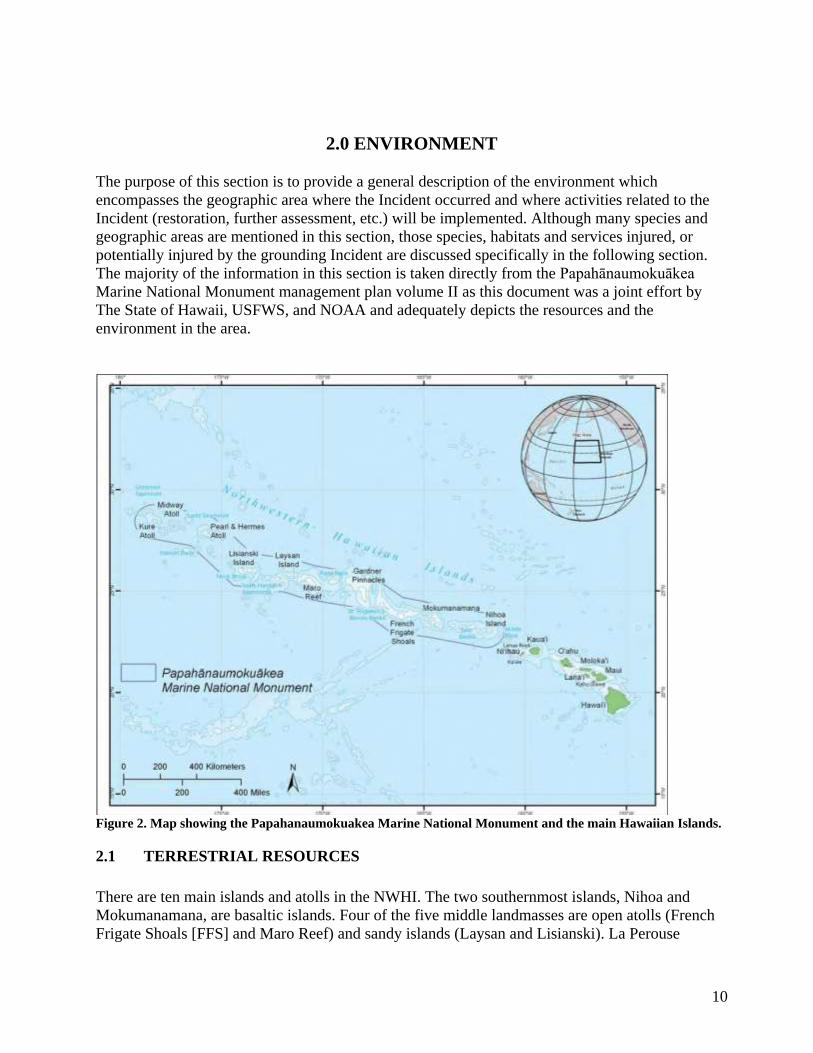
2.0 ENVIRONMENT
The purpose of this section is to provide a general description of the environment which
encompasses the geographic area where the Incident occurred and where activities related to the
Incident (restoration, further assessment, etc.) will be implemented. Although many species and
geographic areas are mentioned in this section, those species, habitats and services injured, or
potentially injured by the grounding Incident are discussed specifically in the following section.
The majority of the information in this section is taken directly from the Papahānaumokuākea
Marine National Monument management plan volume II as this document was a joint effort by
The State of Hawaii, USFWS, and NOAA and adequately depicts the resources and the
environment in the area.
Figure 2. Map showing the Papahanaumokuakea Marine National Monument and the main Hawaiian Islands.
2.1 TERRESTRIAL RESOURCES
There are ten main islands and atolls in the NWHI. The two southernmost islands, Nihoa and
Mokumanamana, are basaltic islands. Four of the five middle landmasses are open atolls (French
Frigate Shoals [FFS] and Maro Reef) and sandy islands (Laysan and Lisianski). La Perouse
11
Pinnacle (at FFS) and Gardner Pinnacles are small basaltic outcrops, remnants of islands similar to
Nihoa and Mokumanamana. The three northernmost landmasses, Pearl and Hermes, Midway, and
Kure, are classical atolls. This emergent land is vital habitat to the 14 million resident and
migratory seabirds, which rely on these islands for roosting and breeding habitat and on the
surrounding waters for food and which are protected under the Migratory Bird Treaty Act.
Included in the 5.5 million seabirds that nest on these islands annually are more than 95 percent of
the world‟s Laysan (Phoebastria immutabilis) and black-footed (Phoebastria nigripes) albatross
(Naughton and Flint 2004). Four endangered endemic bird species that are not seabirds (Laysan
duck [Anas laysanensis], Laysan finch [Telespiza cantans], Nihoa finch [Telespiza ultima], and
Nihoa millerbird [Acrocephalus familiaris kingi]) also breed on the islands.
Nihoa‟s seabird colony boasts one of the largest populations of Tristam‟s storm-petrel
(Oceanodroma tristrami), Bulwer‟s petrel (Bulweria bulwerii), and blue noddies (Procelsterna
cerulea) in the Hawaiian Islands and very possibly the world. The island is a unique example of a
lowland native community, resembling those lowland communities that once occurred on the main
Hawaiian Islands but are now almost completely gone (Wagner et al. 1999). The island‟s
vegetation can be classified as part coastal mixed community (Sida mixed shrub and grassland)
and coastal dry shrubland dominated by „ilima (Sida fallax), „aweoweo (Chenopodium oahuense),
and „ohai (Sesbania tomentosa). The island supports 21 native plant species, including 3
endemics: a palm or loulu (Pritchardia remota), an amaranth (Amaranthus brownii), and an herb
(Scheidea verticillata) (Wagner et al. 1999). The avifauna of the island includes two
endemic passerine birds, the Nihoa finch and the Nihoa millerbird, both listed as endangered under
the federal ESA and HRS 195D. The arthropod fauna of the island includes 33 species of mites, 3
species of spiders, and 182 species of insects, 17 of which are endemic, including a katydid
(Banza nihoa), a giant tree cricket (Thaumatogryllus conantae), 2 species of endemic seed bugs
(Nysius nihoae and Nysius suffusus), and an endemic trapdoor spider (Nihoa mahina) (Evenhuis
and Eldredge 2004). Nihoa also has a rich cultural heritage, with at least 88 known wahi kupuna
(ancestral sites), constructed by pre-contact Hawaiians, who inhabited the island for 700 years
until 1700 AD, and listed on the NRHP. In Nihoa‟s Loulu Coastal Forest Community, Pritchardia
remota assumes complete dominance with a closed canopy and thick layers of fallen fronds in the
understory. Native plants growing nearby include Chenopodium oahuense, Sesbania tomentosa,
Solanum nelsonii, and Sida fallax. Lichens grow on the trunks of the trees (U.S. Fish and Wildlife
Service 1998). In this system, P. remota provides nesting habitat for red-footed boobies (Sula
sula) and perching space for brown noddies (Anous stolidus), which are two resident seabirds at
Nihoa (U.S. Fish and Wildlife Service 1998).
Because of its limited size, Mokumanamana supports only 5 indigenous plant species and no land
birds but does harbor 3 species of mites, 2 species of spiders, and 70 species of insects, 11 of
which are endemic, including a large weevil (Rhycogonus biformis), 2 species of seed bugs
(Nysius neckerensis and N. chenopodii), and a trapdoor spider (Nihoa hawaiiensis) (Evenhuis and
Eldredge 2004). Sixteen species of seabirds breed here, including the black noddy (Anous
minutus), which historically was called the Necker Island tern.
Hawaiian monk seals utilize most of the Monument, including the atolls, islands, and waters of the
Monument, with varying population (numbers and age structure) and some exchange within the
NWHI and the main Hawaiian Islands. The sandy islets of FFS provide nesting sites for 90 percent
12
of the threatened green turtle (Chelonia mydas) population breeding in the Hawaiian Archipelago.
In addition, 19 of Hawai„i‟s 22 seabird species are found on the island, giving it the highest
species richness of breeding seabirds within the Monument. The dry coastal shrublands of the
larger islets within the atoll also support an endemic seed bug (Nysius frigatensis), moth (Agrotis
kerri), and mite (Phauloppia bryani) (Usinger 1942; Nishida 2002).
Due to the limited size of the Gardner Pinnacles, they support only a single species of land plant
(Portulaca lutea) and a few terrestrial arthropod species, but they are by contrast excellent habitat
for seabirds (Clapp 1972). Guano from such seabirds gives the peaks a “frosted” appearance,
indicating their importance as roosting and breeding sites for at least 12 subtropical species.
Landings and terrestrial surveys rarely take place due to the difficulty of getting ashore under all
but the calmest ocean conditions.
Maro Reef is a largely submerged open atoll (Clague 1996), with less than 1-acre (4,046.8 square
meters) of periodically emergent land. At very low tide, only a small coral rubble outcrop of a
former island is believed to break above the surface; as a result, Maro supports no terrestrial biota.
Laysan Island‟s ring of sandy dunes surrounds a 173 acre (0.7square kilometers) hypersaline
interior lake, a feature unique within the Hawaiian Archipelago and rare within the Pacific as a
whole. Because of its elevation of about 40 feet (12 meters), Laysan is well vegetated, supporting
at least 30 species of flowering plants, including 5 subspecies that were endemic prior to human
contact (Athens et al. 2007), many of which were driven to extinction by the misguided
introduction of rabbits (Oryctolagus cuniculus) in 1902 during the guano mining era (Ely and
Clapp 1973). The plant community is divided into five different associations arrayed in concentric
rings around the interior hypersaline lake: coastal shrubs, interior bunchgrass, vines, interior
shrubs, and wetland vegetation (Newman 1988). The island also previously harbored five endemic
birds, two of which, the Laysan finch and the Laysan duck still survive (Pratt et al.1987). In
addition, approximately two million seabirds nest here, including boobies, frigate birds, terns,
shearwaters, noddies, and the world‟s second-largest black-footed and Laysan albatross colonies.
The island also supports a relatively rich collection of arthropods, including a large endemic
weevil (Rhyncogonus bryani), four endemic moths, an endemic wasp, and three endemic mites. A
successful 12-year eradication project to remove the sandbur (Cenchrus echinatus), a plant that
had displaced native vegetation over 30 percent of the island, has been completed, and an active
ecological restoration project is under way to bring back a number of other plants and animals that
were lost after the introduction of rabbits (Morin and Conant 1998).
Lisianski supports no endemic land plant or bird species, although it does harbor an endemic seed
bug (Nysius fullawayi flavus) and an endemic moth (Helicoverpa minuta) (Usinger 1942; Nishida
2002). The island also hosts large Bonin petrel (Pterodroma hypoleuca) and sooty tern
(Onychoprion fuscata) colonies, as well as a variety of other seabirds. Lisianski has the only grove
of Pisonia grandis trees in the entire Hawaiian Archipelago; this tree is dispersed by seabirds and
is favored as a nesting site for many tree-nesting seabird species.
Pearl and Hermes Atoll is a true atoll, fringed with shoals, permanent emergent islands, and
ephemeral sandy islets. These features provide vital dry land for Hawaiian monk seals, the
Hawaiian population of green sea turtles, and a multitude of seabirds, with 16 seabird species
breeding here. The permanent islands with higher dunes support an endemic subspecies of native
13
seed bug (Nysius fullawayi infuscatus) (Usinger 1942). Pearl and Hermes also hosts a small
population of endangered Laysan finches that were translocated here in the 1960s.
Although Midway‟s native vegetation and insects have been greatly altered by more than a century
of human occupation, the island boasts the largest nesting colonies of Laysan and blackfooted
albatrosses in the world, forming the largest colony of albatrosses in the world. The Navy, FWS,
and U.S. Department of Agriculture-Wildlife Services (USDA Wildlife Services) successfully
eradicated black rats (Rattus rattus), accidentally introduced during World War II, from Midway,
removed a small forest of mature ironwood trees (an alien invasive species) from Eastern Island
and new ironwood seedling from the remaining seedbank are removed as they are detected.
Currently the cover on all of the islands at Midway is approximately 30 percent paved or with
structures, 23 percent grass and forbs, 18 percent woodland, 7 percent sand and bare ground, 22
percent shrublands, and less than 0.23 percent wetland. Midway Atoll also supports the first
successful reintroduced population of endangered Laysan ducks, translocated from Laysan Island
in 2004-2005. Laysan ducks utilize both the largely introduced vegetation of Midway Atoll and
restored patches of native vegetation. This reintroduction is significant because Island ducks are
globally threatened taxa, and because the Laysan duck is the most endangered waterfowl in the
Northern Hemisphere and the U.S. Introduced canaries (Serinus canaria) breed among historic
buildings that mark the beginning of cable communication across the Pacific near the beginning of
the 20th century.
Kure Atoll is an important breeding habitat for Christmas shearwaters (Puffinus nativitatis),
Laysan and black-footed albatross. Kure has at least 11 terrestrial arthropods endemic to Hawai„i
and one that is apparently endemic to Kure.
2.2 SHALLOW REEF MARINE RESOURCES
As with the definition of ecosystem, the depth to which the shallow reef is defined is subjective.
For this Final DARP/EA, this ecosystem is defined as all waters to a depth of 98 feet (30 meters).
Because reef-building corals have a symbiotic relationship with microalgae that allows them to
grow and thrive in the nutrient-poor waters of the tropics, these reefs have a depth limit based on
the penetration of sunlight into the water column. Generally, coral reefs grow in water less than 98
feet (30 meters) (Grigg and Epp 1989), although non-reef-building corals are able to grow in much
deeper waters (Maragos and Jokiel 1986; Veron 1986). In addition, there is a much better
understanding of the shallow reef, as most coral reef assessment and monitoring is done in waters
shallower than 98 feet (30 meters) (Maragos et al. 2004).
Coral reef ecosystems consist of much more than the reef-building corals for which they are
named, including sand and unconsolidated sediments, colonized hard bottom, non-reef-building
corals, and macroalgae. Reefs make up approximately 50 percent of the biomass, providing habitat
structure, refuge, and food to the diverse group of organisms (Garrison 1999). Even in this
relatively pristine coral reef habitat, the percentage of coral cover varies widely. A recent
assessment of this habitat determined that coral cover for individual islands ranges from 4.4
percent to 64.1 percent across the chain, and less than 1 percent to close to 100 percent within the
14
various habitats of the islands (Friedlander et al. 2005). The highest diversity and highest percent
coral cover occurs in the middle of the Monument, at the large open atolls of FFS and Maro Reef.
Reef, hard bottom, and sediment habitat are interspersed to create a variety of environmental
niches and resources for the diverse array of species.
The shallow reef is a dynamic environment, experiencing constant wave surges and powerful
winter storms. Tropical storms and hurricanes can generate extreme wave energy that can damage
shallow coral reef habitat. These events are the primary natural force in altering and shaping coral
reef community structure (Dollar 1982; Dollar and Grigg 2004). They represent potential but
infrequent threats to the shallow coral reef ecosystems of the NWHI. There is a growing concern
that global warming and the concurrent acidification of the ocean may cause drastic changes to
corals in the coming century (Hoegh-Guldberg 1999). While the northern extent of the NWHI,
from Kure to Pearl and Hermes Atolls, experiences sea surface temperatures from less than 64°
Fahrenheit (18° Celsius) in winter to summer highs exceeding 82° F (28° C), a temperature
anomaly of only 1.8° F (1ºC) in the summer of 2002 resulted in widespread mass coral bleaching
(Hoeke et al. 2006). Acidification, caused by increased levels of CO2 in the ocean, inhibits the
deposition of calcium carbonate, the primary component of the coral skeleton (Kleypas et al.
2006). Events such as these may be more devastating in the NWHI because these reefs grow more
slowly than most other reefs (Friedlander et al. 2005). Fifty-seven species of coral have been
identified in the NWHI, with 30 percent of them being endemic. To date, 355 species of algae and
838 species of invertebrates have been documented in a thorough assessment of the Monument‟s
living resources (Friedlander et al. 2005).
Characteristics of the shallow water coral reef habitat change with both island geology and reef
orientation to the island. Due to strong wave action and currents, the basalt islands in the southern
portion of the Monument have no fringing reef. The underwater habitat is composed primarily of
vertical walls and wave-cut benches (Friedlander et al. 2005). Caves, overhangs, and trenches
provide small-scale habitat for corals, although basalt blocks, boulders, and pavement are the
principal bottom cover. Species diversity is low, relative to the middle and northern atolls. The
shallow reef habitat in the middle of the Monument (FFS, Maro Reef, and Lisianski Island) is a
series of open atolls that exhibit the highest levels of coral abundance and diversity (Friedlander et
al. 2005). The largest pod found in the NWHI of spinner dolphins (Stenella longirostris) occurs at
FFS (Andrews et al. 2006). The northernmost atolls (Pearl and Hermes, Midway, and Kure) are
formed by a continuous barrier reef, where the lagoon is connected to the outside ocean through a
series of channels and grooves.
Structurally, apex predators, such as sharks and jacks, dominate fish communities on the reefs in
the NWHI. In addition, abundance and biomass estimates indicate that the reef community is
characterized by a smaller proportion of herbivores, such as surgeonfish (Family Acanthuridae),
and more carnivores, such as damselfish (Family Pomacentridae), goatfish (Family Mullidae), and
scorpionfish (Family Scorpaenidae). A comparison of both biomass and trophic structure between
reef fish communities in the NWHI and main Hawaiian Islands was conducted in 2000. Across
similar habitats, biomass was 260 percent greater in the NWHI (Friedlander and DeMartini 2002).
Additionally, 54 percent of the biomass in the NWHI was composed of apex predators, compared
to 3 percent in the main Hawaiian Islands.
15
3.0 INJURY DETERMINATION AND QUANTIFICATION
3.1 SUMMARY OF PREASSESSMENT ACTIVITIES
There are three pre-conditions set forth in the OPA natural resource damage assessment
regulations before restoration planning can proceed:
1. Injuries have resulted, or are likely to result, from the Incident or response to the
Incident;
2. Response actions have not adequately addressed, or are not expected to address, the
injuries resulting from the Incident; and
3. Feasible primary and/or compensatory restoration actions exist to address the potential
injuries.
A cooperative preassessment was conducted by the Trustees and the responsible party
representatives, Polaris Applied Sciences, Inc., with the information collected being used to satisfy
the three criteria listed above. The information collected during the preassessment described the
impacts related to the Incident and confirmed the need for restoration planning to address the
overall injury.
3.2 PREASSESSMENT APPROACH
The goal of injury preassessment under OPA is to determine the jurisdiction of the trustees,
determine that the Incident is not excluded under another authority, and to determine whether
resources under trusteeship may have been, or may be, injured as a result of the Incident (§
990.40). Injury determination begins with the identification and selection of potential injuries to
investigate given the nature and scope of the Incident. The focus of the cooperative preassessment
was to investigate possible injury in both the aquatic (marine) and terrestrial realms.
The Trustees main focus was to pursue restoration as quickly as possible rather than expensive,
multi-year injury studies. With this in mind the preassessment used simple, cost effective
procedures to document potential exposures and injuries to natural resources and services within
both the marine and terrestrial realms.
3.3 MARINE PREASSESSMENT
The marine preassessment focused on documenting potential injury to:
● Coral colonies and reef habitat
● Reef structure
● Fishes
● Invertebrates
● Macroscopic Algae
16
There had been anecdotal reports of a “sheen” of oil that had occurred during the lightering
process of removing oil and fuel from the vessel in addition to photos of a sediment “plume”
moving into the lagoon over the reef crest. Additionally, given the large scale barge operations
required to remove the vessel, there was reason to suspect physical injuries had occurred to the
benthos. The marine preassessment component focused on two potential types of injury, toxic
exposure to oil as well as physical injury which may have occurred during response and removal
actions during the Incident. Given the remote location and limited amount of time available for the
preassessment team to conduct its work the different tasks were prioritized as follows:
1) Document evidence of spill injury and other types of pollutant injuries (e.g., paint and
other types of substances from vessel) via sampling of bleached corals, sediment, and other
invertebrates.
a) High Priority Objective: Collect bleached coral samples for evidence of petroleum
toxicity. (1) Set up a survey grid to look for bleached coral around the Casitas.
Habitat zones evaluated for bleached coral included by priority: a) the coral reef
crest immediately adjacent to the vessel; b) inter-islet reef zone; c) lagoon slope;
and areas within the lagoon.
b) High Priority Objective: Collect sediment samples for petroleum and other
chemical analyses
c) Low Priority Objective: Collect other invertebrate organisms as necessary to detect
effects of toxicity
2) Document injury in the grounding area as well as surrounding areas.
a) High Priority Objective: Use Aquamap™ system to measure extent of vessel
grounding scar.
b) High Priority Objective: Measure scar and all physical injury using GPS
technology and standard measurement protocols to augment and verify Aquamap
measurements.
c) Medium Priority Objective: Record qualitative observations of the various types of
injuries associated with groundings (scarred reef, pulverized reef, sedimentation,
etc) and possible response injury.
d) Medium Priority Objective: Record qualitative observations of any and all
biological impacts, mortalities and injury to live coral, invertebrates, fishes, etc.
3) Document general habitat of vessel grounding impact areas and affected habitat areas (reef
slope zone, reef crest zone, inter-islet reef zone, lagoon slope zone, coral communities
within the lagoon that may have been exposed to petroleum products, using digital video
and photo.
a) Photo and video document various types of habitats and link with spatial data in the
vicinity of the grounding.
4) If present remove debris and paint chips left behind from vessel.
5) Conduct more specific photo documentation and other biological assessments with any
available expertise and resources
17
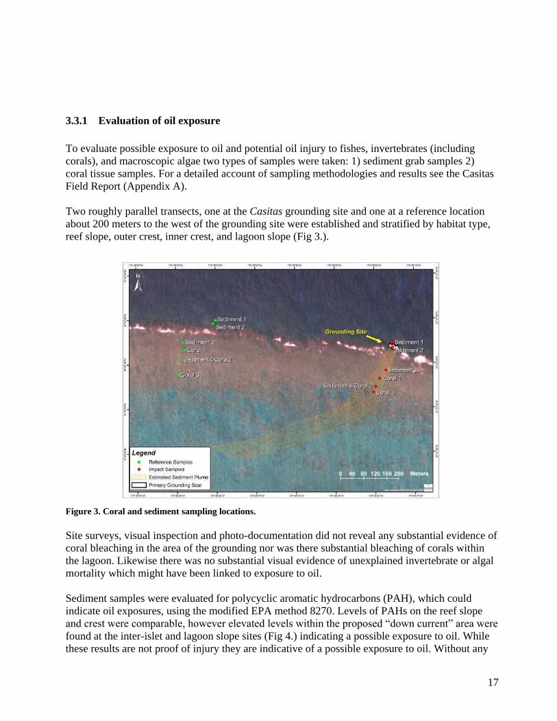
3.3.1 Evaluation of oil exposure
To evaluate possible exposure to oil and potential oil injury to fishes, invertebrates (including
corals), and macroscopic algae two types of samples were taken: 1) sediment grab samples 2)
coral tissue samples. For a detailed account of sampling methodologies and results see the Casitas
Field Report (Appendix A).
Two roughly parallel transects, one at the Casitas grounding site and one at a reference location
about 200 meters to the west of the grounding site were established and stratified by habitat type,
reef slope, outer crest, inner crest, and lagoon slope (Fig 3.).
Figure 3. Coral and sediment sampling locations.
Site surveys, visual inspection and photo-documentation did not reveal any substantial evidence of
coral bleaching in the area of the grounding nor was there substantial bleaching of corals within
the lagoon. Likewise there was no substantial visual evidence of unexplained invertebrate or algal
mortality which might have been linked to exposure to oil.
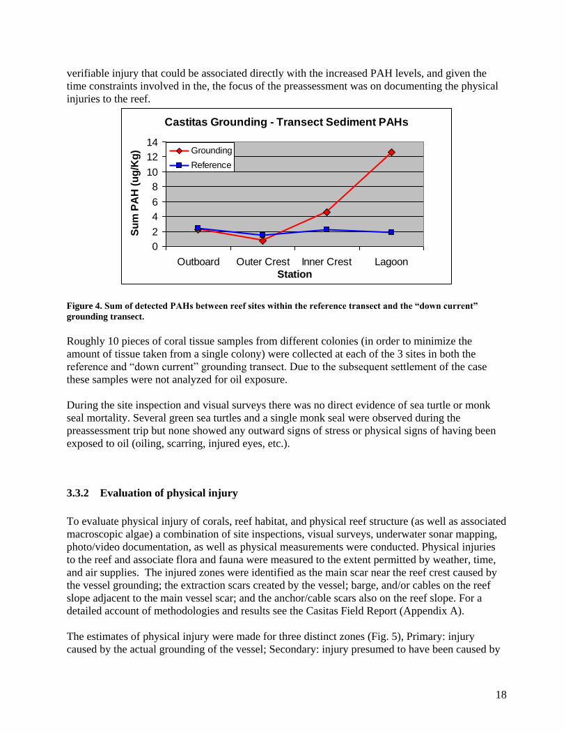
Sediment samples were evaluated for polycyclic aromatic hydrocarbons (PAH), which could
indicate oil exposures, using the modified EPA method 8270. Levels of PAHs on the reef slope
and crest were comparable, however elevated levels within the proposed “down current” area were
found at the inter-islet and lagoon slope sites (Fig 4.) indicating a possible exposure to oil. While
these results are not proof of injury they are indicative of a possible exposure to oil. Without any
18
verifiable injury that could be associated directly with the increased PAH levels, and given the
time constraints involved in the, the focus of the preassessment was on documenting the physical
injuries to the reef.
Castitas Grounding - Transect Sediment PAHs
0
2
4
6
8
10
12
14
Outboard Outer Crest Inner Crest Lagoon
Station
Su
m P
AH
(u
g/K
g) Grounding
Reference
Figure 4. Sum of detected PAHs between reef sites within the reference transect and the “down current”
grounding transect.
Roughly 10 pieces of coral tissue samples from different colonies (in order to minimize the
amount of tissue taken from a single colony) were collected at each of the 3 sites in both the
reference and “down current” grounding transect. Due to the subsequent settlement of the case
these samples were not analyzed for oil exposure.
During the site inspection and visual surveys there was no direct evidence of sea turtle or monk
seal mortality. Several green sea turtles and a single monk seal were observed during the
preassessment trip but none showed any outward signs of stress or physical signs of having been
exposed to oil (oiling, scarring, injured eyes, etc.).
3.3.2 Evaluation of physical injury
To evaluate physical injury of corals, reef habitat, and physical reef structure (as well as associated
macroscopic algae) a combination of site inspections, visual surveys, underwater sonar mapping,
photo/video documentation, as well as physical measurements were conducted. Physical injuries
to the reef and associate flora and fauna were measured to the extent permitted by weather, time,
and air supplies. The injured zones were identified as the main scar near the reef crest caused by
the vessel grounding; the extraction scars created by the vessel; barge, and/or cables on the reef
slope adjacent to the main vessel scar; and the anchor/cable scars also on the reef slope. For a
detailed account of methodologies and results see the Casitas Field Report (Appendix A).
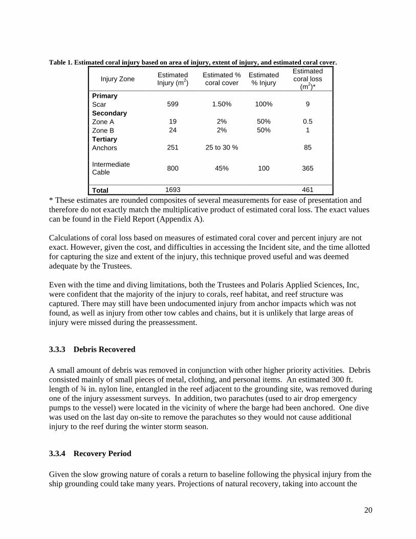
The estimates of physical injury were made for three distinct zones (Fig. 5), Primary: injury
caused by the actual grounding of the vessel; Secondary: injury presumed to have been caused by

19
removing the vessel, either from cables or the ship itself; Tertiary: injury farther out from the reef
crest caused by anchors and cable movements. The secondary injury zone was split up into two
distinct areas, the vessel removal zone A and vessel removal zone B. The tertiary injury zone was
split up into injury from the anchors and their associated cables (when found), and an intermediate
cable injury zone where it was presumed that the salvage barge was located. Table 1 shows all of
the estimated injuries. Many of the injury estimates are mixtures of physical measurements,
AquaMap™ measurements, areas calculated in ArcGIS from AquaMap™ data, and informed
estimation. The estimated coral loss was then calculated from the injury area estimate and
informed estimates of coral cover for the different zones of injury.
Figure 5 Skiff Based GPS Tracklines Representing Dive/Search Tracks. The map shows areas searched and
types of injury found.
20
Table 1. Estimated coral injury based on area of injury, extent of injury, and estimated coral cover.
Injury Zone Estimated Injury (m
2)
Estimated % coral cover
Estimated % Injury
Estimated coral loss
(m2)*
Primary
Scar 599 1.50% 100% 9
Secondary
Zone A 19 2% 50% 0.5
Zone B 24 2% 50% 1
Tertiary
Anchors 251 25 to 30 % 85
Intermediate Cable
800 45% 100 365
Total 1693 461
* These estimates are rounded composites of several measurements for ease of presentation and
therefore do not exactly match the multiplicative product of estimated coral loss. The exact values
can be found in the Field Report (Appendix A).
Calculations of coral loss based on measures of estimated coral cover and percent injury are not
exact. However, given the cost, and difficulties in accessing the Incident site, and the time allotted
for capturing the size and extent of the injury, this technique proved useful and was deemed
adequate by the Trustees.
Even with the time and diving limitations, both the Trustees and Polaris Applied Sciences, Inc,
were confident that the majority of the injury to corals, reef habitat, and reef structure was
captured. There may still have been undocumented injury from anchor impacts which was not
found, as well as injury from other tow cables and chains, but it is unlikely that large areas of
injury were missed during the preassessment.
3.3.3 Debris Recovered
A small amount of debris was removed in conjunction with other higher priority activities. Debris
consisted mainly of small pieces of metal, clothing, and personal items. An estimated 300 ft.
length of ¾ in. nylon line, entangled in the reef adjacent to the grounding site, was removed during
one of the injury assessment surveys. In addition, two parachutes (used to air drop emergency
pumps to the vessel) were located in the vicinity of where the barge had been anchored. One dive
was used on the last day on-site to remove the parachutes so they would not cause additional
injury to the reef during the winter storm season.
3.3.4 Recovery Period
Given the slow growing nature of corals a return to baseline following the physical injury from the
ship grounding could take many years. Projections of natural recovery, taking into account the

21
variety of coral species present in the area, estimate that 90% of the injury will recover in 20 years
while 100% recovery wouldn‟t be reached until roughly 40 years after the Incident. Recovery
projections were conducted by Dr. Steve Kolinski (NOAA Pacific Islands Region, Habitat
Conservation Division). Recovery projections can be seen in their entirety in Appendix C.
22
4.0 RESTORATION PLANNING
4.1 RESTORATION STRATEGY
The goal of this Final DARP/EA under the OPA regulations, OPA § 990.10, is to “make the
environment and the public whole for injuries to natural resources and services resulting from an
Incident involving discharge or substantial threat of a discharge of oil…”. Specifically this plan is
designed to restore lost natural resources and services resulting from the July 2, 2005 grounding of
the Casitas off of Pearl and Hermes Atoll. The OPA NRDA regulations provide that this goal be
achieved by returning injured natural resources to their baseline condition and by compensating
for any interim losses of natural resources and services during the period of recovery to baseline.
Restoration actions under the OPA regulations are designated as either primary or compensatory.
Primary restoration is/are action(s) taken to return injured natural resources and services to
baseline on an accelerated time frame (e.g.- faster than would occur naturally). The OPA NRDA
regulations provide that Trustees consider natural recovery as potential primary restoration. Some
considerations that weigh in the favor of natural recovery as a preferred alternative include 1) if
active primary restoration is infeasible, 2) if active primary restoration is not cost-effective, and 3)
if injured natural resources will recover to baseline at a reasonable rate without human
intervention. Alternative primary restoration activities can range from natural recovery, to actions
that prevent interference with natural recovery, to more intensive actions expected to return
injured natural resources and services to baseline faster and/or with greater certainty than natural
recovery.
Compensatory restoration is/are action(s) taken to compensate for the interim losses of natural
resources and/or services between the time of injury and recovery to baseline. The type and scale
of compensatory restoration can depend on the nature of the primary restoration action(s) and the
timeline and scope of recovery of injured resources to baseline. When identifying the
compensatory restoration components of the restoration alternatives, Trustees must first consider
compensatory restoration actions that provide resources and/or services of the same type and
quality and of comparable value as those that were lost. If a reasonable range of alternative
compensatory actions cannot provide resources and/or services of the same type, quality, and
comparable value as those lost then Trustees can consider actions that will at least provide
resources and/or services of comparable type and quality.
In considering restoration for injuries resulting from the Incident, the Trustees first evaluated
possible primary restoration actions for the injury. Based on that analysis, the Trustees determined
that most primary restoration options were infeasible. In addition, the area of injury is expected to
recover to baseline naturally within a reasonable amount of time. Given these circumstances the
Trustees determined that no active primary restoration actions should be taken and that natural
recovery of resource injury was appropriate. In addition to natural recovery, one primary
restoration option was considered but deemed inappropriate. In order to balance the interim loss of
23
natural resources and services until natural recovery to baseline, compensatory restoration
alternatives were considered and are presented below.
Reasonable compensatory restoration alternatives must be scaled to ensure that the size or quantity
of the proposed project reflects the magnitude of the injuries from the grounding Incident. The
Trustees relied on the OPA regulations to select the scaling approach for reasonable compensatory
restoration actions. The scaling methods will be discussed in the sections below.
The restoration alternatives included in this plan are projected costs and outcomes based on known
methodologies which have been previously applied either to other Incidents, or to related natural
resource recovery activities. Specific project details may require additional refinements or
adjustments to reflect changing conditions or factors. The Trustees expect that implementation of
restoration will begin in 2011. Should implementation be substantially delayed beyond this time
period, the Trustees may revise their scaling calculations.
4.2 EVALUATION CRITERIA
The OPA NRDA regulations (§ 990.54) provide that Trustees develop a reasonable range of
primary and compensatory restoration alternatives and then identify the preferred alternatives
based on the six criteria listed in the regulations:
1. Cost to carry out the alternative action,
2. Extent to which each alternative is expected to meet the Trustees‟ goals and objectives
in returning the injured natural resources and services to baseline and/or compensating
for interim losses,
3. Likelihood of success of each alternative,
4. Extent to which each alternative will prevent future injury as a result of the Incident and
avoid collateral injury as a result of implementing the alternative,
5. Extent to which each alternative benefits more than one natural resource and/or service,
and
6. Effect of each alternative on public health and safety.
In addition, the Trustees considered several other factors including:
1. Nexus to geographic location of the injury,
2. Opportunities to collaborate with other entities involved in restoration projects,
3. Compliance with applicable federal and state laws and policies.
NEPA applies to restoration actions taken by federal Trustees. To reduce transaction costs and
avoid delays in restoration, the OPA regulations encourage the Trustees to conduct the NEPA
process concurrently with the development of the draft restoration plan.
To comply with the requirements of NEPA, the Trustees considered the effects of each alternative
on the quality of the human environment. NEPA‟s implementing regulations direct federal
agencies to evaluate the potential significance of proposed actions by considering both context and
24
intensity. For the actions proposed in the draft DARP/EA and selected in this Final DARP/EA, the
appropriate context for considering potential significance of the action is local, as opposed to
national or worldwide.
With respect to evaluating the intensity of the impacts in the proposed action, the NEPA
regulations (40 CFR 1508.27) and NOAA‟s Administrative Order 216-6 require consideration of
the following factors:
1. Likely impacts of the proposed projects,
2. Likely effects of the projects on public health and safety,
3. Unique characteristics of the geographic area in which the projects are to be
implemented,
4. Controversial aspects of the project or its likely effects on the human environment,
5. Degree to which possible effects of implementing the project are highly uncertain or
involve unknown risks,
6. Precendential effect of the project on future actions that may significantly affect the
human environment,
7. Possible significance of cumulative impacts from implementing this and other similar
projects,
8. Effects of the project on National Historic Places, or likely impacts to significant
cultural, scientific or historic resources,
9. Degree to which the project may adversely affect endangered or threatened species or
their critical habitat,
10. Likely violations of environmental protection laws,
11. Unique characteristics of the geographic area
12. Degree to which endangered or threatened species, or their critical habitat as defined
under the Endangered Species Act of 1973, are adversely affected,
13. Whether a violation of Federal, state, or local law for environmental protection is
threatened, and
14. Whether a Federal action may result in the introduction or spread of a nonindigenous
species.
4.3 EVALUATION OF RESTORATION ALTERNATIVE 1: NO ACTION/NATURAL
RECOVERY
NEPA requires the Trustees to consider a “no action” alternative, and the OPA NRDA regulations
also include evaluation of a “natural recovery” option pursuant to §990.53. Under this alternative
the Trustees would take no direct action to restore injured natural resources or compensate for lost
services. In lieu of direct action the Trustees would rely on natural processes of recruitment and
growth for recovery of the injured natural resources including, but not limited to, corals, algae,
sessile invertebrates and coralline algae. While natural recovery would occur over varying time
scales for various injured resources (see recovery projections Appendix C), the public would not
be compensated for interim losses under the no action alternative.
25
OPA clearly establishes Trustee authority to seek compensation for interim losses pending
recovery of the injured natural resources. Such compensation will not be provided through a no
action alternative. While the Trustees have determined that natural recovery is appropriate as
primary restoration for injuries to coral reef resources at the injury site, the no action alternative is
rejected because it fails to provide appropriate compensatory restoration. Natural resource losses
were, and continue to be, incurred by the public during this period of recovery from the grounding
event and technically feasible alternatives exist to compensate for these losses within a justifiable
cost framework.
There are several advantages to natural recovery as primary restoration. Conducting on-site
primary restoration would be logistically very difficult and could present severe risks to worker
health and safety. Because this area is expected to recover naturally it would make sense to, in
essence, “let nature take its course.”
4.4 EVALUATION OF RESTORATION ALTERNATIVE 2: ECOLOGICAL
RESTORATION
Although there was most likely little or no oil released during the M/V Casitas grounding, the
Incident and response still caused substantial physical injury to public trust resources in the
Monument. Lost ecological services from the Incident are characterized primarily by loss of reef
related organisms (mainly coral) and substrate resulting in the reduced ability of the habitat to
perform ecological functions such as providing shelter, food, and platforms for recruitment,
settlement, and growth of benthic flora and fauna.
4.4.1 Scaling Approach: Lost Ecological Services
The OPA NRDA regulations provide that the Trustees consider compensatory restoration actions
that provide services of the same type and quality and of comparable value to those that were
injured. When these ecological services can be gained (or saved from loss) the OPA regulations
prescribe the “service-to-service” scaling approach to determine the appropriate scale of
compensatory restoration.
The Trustees determined that services of the same type and quality and of comparable value to the
lost ecological services could be provided through preventing and avoiding coral and substrate
injury. Consistent with the OPA regulations, the Trustees followed the “service to service”
approach to scale the compensatory restoration project that addresses lost ecological services. To
implement this scaling approach the Trustees used the Habitat Equivalency Analysis method, or
HEA. HEA is commonly applied in NRDA cases to scale compensatory restoration projects that
address lost ecological services. The HEA method is described in the preamble to the OPA
regulations as a potential approach to scaling such projects.
In HEA, compensatory restoration projects are scaled so that the quantity of replacement services
provided equals the quantity of lost services. In this case the services were quantified based on
physical units of measure such as square meters of coral lost and their time to recovery. The
26
Trustees must evaluate whether compensatory restoration projects can provide services that are
comparable to the lost services. In order to do this, the Trustees relied on available data,
experience, and best professional judgment, coupled with certain simplifying assumptions, to
conduct the HEA calculations.
4.4.2 Selected Project: Derelict Net and Debris Removal in the Monument
Project Description: Marine debris (particularly derelict fishing gear) is a substantial
source of coral injury in the Monument. Nets, which frequently get lodged on coral, smother or
break the coral underneath. This project will result in the removal of nets from coral reefs in the
Monument, thus compensating for coral reef injuries incurred during the M/V Casitas vessel
grounding and subsequent response. Previous work in the Monument has identified areas where
derelict nets and marine debris have accumulated and those general areas of known concentrations
will be targeted for maximum effectiveness. Removing derelict nets and debris will have the
following benefits which directly restore injury on a resource-to-resource basis: (1) preventing
further mortality of the coral colonies under the net debris, (2) preventing further coral mortality
by abrasion of nearby coral colonies as the net sways with the water motion, (3) preventing further
injury to other areas that would occur if the net or debris breaks loose and settles in a new un-
injured area, (4) enhancing coral recruitment by removing debris that would inhibit, through
abrasion, the settlement and growth of juvenile corals, and (5) providing benefits to other natural
resources such as endangered monk seals, threatened green sea turtles, fishes, and endangered
birds in the areas by reducing the probability of entanglement.
Restoration Objectives: The goal of the selected project is to remove derelict nets and
debris from areas within the Monument that have high concentrations of these foreign materials.
Based upon observations and measurements made during the injury assessment, the Trustees
scaled the project based on the loss of 452 m2 of coral. After applying the data collected and a
variety of necessary assumptions (e.g., the percent loss of coral from a net injury, the average size
of a net, the time to recovery after net removal), the Trustees determined that they would need to
recover approximately 800 nets or pieces of debris to satisfy the compensatory restoration
requirement. Because the settlement has already occurred and there is a set amount of money, the
overall goal is to maximize the restoration efforts such that the greatest amounts of nets/debris are
removed given the fixed amount of restoration monies.
Probability of Success: The probability of success for this project is high. Net/debris
removal is a proven restoration technique that has been taking place in Hawaii for over a decade
and continues to be conducted in the Hawaiian Islands. Net removal techniques are well-
established and relatively easy to implement. The remoteness of the areas in the Monument, as
well as the costs associated with working there, makes the planning and logistics difficult but by
no means insurmountable.
Performance Criteria and Monitoring: Because the damages settlement has resulted in a
fixed amount of restoration money, the overall performance criteria will be that the required
amount of nets/debris are removed in the Monument area under that cost ceiling. Much of the
performance criteria for the removal activities will fall under established protocols of contract
27
work in the Monument and for the type of in-water work being done; use of divers/snorkelers,
small boat usage, large vessel protocols etc. Trustee representatives will have authority to
designate the geographic area where work will occur, to select which nets will be removed, and to
provide directions on removing nets to minimize injury to coral or other living marine resources.
Benefits and Environmental Impacts: Derelict nets and debris cause injury to the near shore
coral reef environment by smothering, breaking, and abrading benthic flora and fauna. Nets also
cause mortality to fishes, sea turtles, marine mammals, and birds as they continue to “fish” and
organisms get entangled even though the nets are abandoned. Marine debris removal would
beneficially affect the Monument resources by eliminating debris and the injuries it causes.
The potential adverse environmental impacts of marine debris removal in the Monument have
previously been analyzed under the Papahānaumokuākea Marine National Monument
Management Plan (MMP) and its associated Environmental Assessment (MMP/EA) (USFWS, et
al., 2008). These documents were promulgated by the Trustees in 2008 as a comprehensive plan
for the management of Monument resources and include an analysis of numerous activities –
including marine debris removal. The Trustees hereby incorporate by reference the impacts
analysis of marine debris removal conducted on pages 179-180 of the MMP/EA.
The MMP/EA concludes that marine debris removal activities conducted in accordance with the
MMP‟s best management practices (BMPs) (See Monument Management Plan, Volume III,
Appendix F) would have primarily beneficial effects and only minor, short-term and minimal
adverse impacts that can be effectively mitigated through use of the BMPs. For example, marine
debris worker could encounter endangered species or marine mammals during restoration
activities. To avoid adverse impacts and prevent the potential for unauthorized “takes” of marine
mammals or species listed under the Endangered Species Act (ESA), divers observing or
encountering marine mammals or ESA-listed species while removing debris would be required to
cease all activity until the animal departs the area. Similarly, debris removal workers will not
approach or come within 150 ft (46 meters) of any Hawaiian monk seals that are hauled out on a
beach. In addition, if nets or debris are heavily encrusted and firmly anchored to the substrate,
only those sections that are free would be removed. Completely encrusted nets that are fully
incorporated as part of the substrate would not be removed. Live coral colonies, fish, and benthic
invertebrates which are caught in the nets and debris as they are removed will be returned to the
sea in the general vicinity as soon as practical and to the greatest extent possible. Accordingly,
potential adverse impacts are expected to be minor, short term, minimal in nature.
Evaluation: Derelict nets and debris are well documented hazards to marine life in the
Hawaiian Islands as well as in the Monument where they will substantially degrade the habitat and
cause injury to near shore coral reef resources. Derelict nets and debris have also been found to
entangle monk seals, sea turtles, and seabirds in the Monument (Boland, 1997). While there will
be some minor, small scale disturbances to natural resources resulting from efforts to remove nets
and debris, the Trustees expect these adverse impacts to be short term and minimal, and that the
project‟s overall environmental impacts will be positive.
28
4.4.3 Non-Preferred Alternatives
Several restoration alternatives were developed under the guidelines in §990.53 for
primary, as well as compensatory, restoration of the M/V Casitas grounding site. These
alternatives were evaluated based on the standards suggested in §990.54, which include: (1) the
costs of the alternatives, (2) the extent to which the project is expected to return the resource and
services to baseline, (3) the likelihood of success, (4) the probability of preventing future injury,
(5) the benefit to other resources, and (6) the effects on public health and safety. These following
alternatives were not selected as the preferred restoration method because of feasibility and
cost/benefit concerns. The non-preferred alternatives are listed below with their associated
explanations and concerns.
4.4.3.1 Primary Restoration: Cementing loose coral fragments and substrate
Cementing loose coral fragments at the grounding site is a non-preferred restoration
alternative. Stabilizing the loose coral and associated debris from a grounding could have the
following benefits which should accelerate the return of the resources to baseline: (1) preventing
further coral mortality of the inured coral fragments from abrasion; (2) preventing further coral
mortality by abrasion of nearby coral colonies from debris generated by the grounding, effectively
increasing the overall injury; (3) replacing three dimensional habitat complexity in areas where
rugosity was lost; and (4) enhancing natural recovery through increased coral recruitment in
comparison to areas where debris has not been stabilized.
Cementing loose coral fragments and substrate is not a preferred alternative for primary
restoration based on factors such as the length of time which has passed since the grounding, the
currently unknown number and state of coral fragments and loose substrate, safety concerns
arising from operations in a high wave energy environment, and the costs associated with this type
of activity in the remote area of Pearl and Hermes Atoll. The M/V Casitas grounded at Pearl and
Hermes Atoll in July of 2005 and was removed in the beginning of August 2005. Given that six
winter swell seasons of high wave energy have already passed since the grounding the fate of
much of the coral fragments and debris is unknown. In all likelihood the coral fragments have
undergone complete mortality by this point and have been scattered widely throughout the
environment. Associated loose substrate has most likely also been dispersed so that re-attaching
debris generated by the grounding is untenable. The possibility that coral recruitment will be
enhanced by avoiding scour from debris (by stabilizing the area) is low given that much of the
debris has most likely dispersed. Without a clear outcome for positive restoration benefits (given
that much of the debris has likely dispersed) and the safety concerns associated with this type of
activity in a high wave environment, this is not a preferred option.
4.4.3.2 Compensatory Restoration: Orphan vessel removal in the Monument
When there is no financially viable party that is responsible for addressing a specific vessel
grounding the vessel is often referred to as an “orphan.” In many cases, orphan vessels will remain
on the reef for years as they break apart and generate debris which increases the initial injury to
29
reef resources. Orphan vessels are often left in place because there are no clear authorities for
removing the vessel, nor are there dedicated sources of funds to pay for removal. Removing
orphan vessels from the Monument could have the following benefits: (1) preventing further coral
mortality from secondary impacts and movement of the vessel during high wind and wave events,
(2) preventing further coral mortality as the vessel breaks apart over the years and large pieces of
the vessel move over the reef environment, (3) preventing possible secondary impacts from
materials associated with the vessel such as algae blooms caused by introduction of iron into the
environment.
Removing future orphan vessels from the NWHI Monument is not a preferred alternative
because the number and frequency of vessels that will ground is not known and restoration would
be delayed in anticipation of orphan grounding events. Removing known orphan vessels is also
not the preferred alternative, since the costs associated with salvaging a vessel in the Monument
are extremely high relative to the amount of coral mortality which would be avoided.
Accordingly, relatively little restoration could be accomplished with the available restoration
funds. Most of the orphan vessels are fairly small, but the costs of sending salvage teams into the
remote areas of the Monument would be too high to justify the benefits. Costs associated with
chartering a vessel to conduct this type of restoration work will be high (~ $12-15k per day
minimum) with several days transit back and forth from the atoll. Additional costs for hiring
salvers and small boat operations would add substantially to the overall costs. Given the
unpredictable nature of these types of Incidents and injuries the restoration benefits, relative to the
preferred alternative, do not justify the costs.
4.4.3.3 Compensatory restoration: Alien algae removal in the main Hawaiian Islands.
This project would provide compensatory restoration for injury to corals by removing and
containing alien algae before it smothers existing coral colonies. Invasive alien algae such as
Kappaphycus/Eucheuma spp., Gracilaria salicornia, and Hypnea musciformis are overgrowing,
smothering, and killing otherwise healthy corals around the Main Hawaiian Islands. Removing
algae from areas around the Main Hawaiian Islands could have the following coral restoration
benefits: (1) preventing the mortality of corals which are currently covered by alien algae, (2)
preventing healthy corals free of algae from being covered by the spread of algae from nearby
areas of high algal density, (3) allowing for a return of displaced native benthic and reef associated
flora and fauna. The State of Hawaii Division of Aquatic Resources, University of Hawaii Botany
Dept., and The Nature Conservancy have a great deal of experience in removing invasive alien
algae around the Main Hawaiian Islands and currently have programs which are actively dealing
with this issue; thus feasibility for this alternative is high.
Alien algae removal in the main Hawaiian Islands is not a preferred alternative because of
the vast geographic distance between the site of the injury and the restoration work, the disparity
between resources lost at Pearl and Hermes Atoll and those which would be restored around the
main Hawaiian Islands, and the unique cultural and ecological significance of the resources at
Pearl and Hermes Atoll. Given that the unique status of the area (a newly minted national
Monument) has recently been officially recognized the Trustees prefer that restoration activities,
where feasible, be directed at restoring resources located within the Monument itself. While alien
algae removal remains a viable alternative for restoration, in order to compensate for the loss at

30
Pearl and Hermes Atoll and to make the public whole, this is not a preferred restoration
alternative.
31
5.0 COORDINATION WITH OTHER PROGRAMS, PLANS, AND
REGULATORY AUTHORITIES
5.1 OVERVIEW
Two major federal laws guiding the restoration of the injured resources and services from the M/V
CASITAS Incident are OPA and NEPA. OPA and its regulations provide the basic framework for
natural resource damage assessment and restoration. NEPA, as a procedural law, sets forth a
specific process of impact analysis and public review. The Trustees elected to combine the
Restoration Plan, required under OPA, with the environmental review processes required under
NEPA. This is expected to enable the Trustees to implement restoration more rapidly than had
these processes been undertaken sequentially.
In addition, the Trustees also consider other applicable laws, regulations and policies at the
federal, state and local levels. In particular the restoration planning has focused on coordination
with the newly formed Papahānaumokuākea Marine National Monument. The potentially relevant
laws, regulations and policies are set forth below.
In addition to laws and regulations, the Trustees must consider relevant environmental programs
that are ongoing or planned for in the affected environment. For example, as previously stated,
restoration projects and related activities may be occurring in areas currently being monitored or
focused on with other programs such as the NOAA Coral Reef Conservation Program, NOAA
Marine Debris Program, or as part of the USFWS Refuges Program. The Trustees must ensure that
their proposed restoration activities neither impede nor duplicate such programs or plans. By
coordinating restoration with other relevant programs and plans, the Trustees can enhance the
overall effort to improve the environment of Pearl and Hermes reef and the surrounding
Papahānaumokuākea Marine National Monument.
5.2 KEY STATUTES, REGULATIONS AND POLICIES
Oil Pollution Act of 1990 (OPA), 33 USC 2701, et seq.; 15 CFR Part 990
OPA establishes a liability regime for oil spills, or threats of spills, which injure or are likely to
injure natural resources and/or the services that those resources provide to the ecosystem or
humans. Federal and State agencies and Indian tribes act as Trustees on behalf of the public to
assess the injuries, scale restoration to compensate for those injuries and implement restoration.
Section 1006(e)(1) of OPA [33 USC 2706 (e)(1)] requires the President, acting through the Under
Secretary of Commerce for Oceans and Atmosphere (NOAA), to promulgate regulations for the
assessment of natural resource damages resulting from a discharge or substantial threat of a
discharge of oil. Assessments are intended to provide the basis for restoring, replacing,
rehabilitating, and acquiring the equivalent of injured natural resources and services.
32
This rule provides a framework for conducting sound natural resource damage assessments that
achieve restoration. The process emphasizes both public involvement and participation by the
Responsible Party(ies). Though the regulations are optional, the Trustees have generally followed
them in this assessment.
Hawaii Environmental Response Law, Title 10, chapter 128D, Hawaii Revised Statutes
The State of Hawaii response law addresses the release or threatened release of any hazardous
substance, including oil, into the environment. It creates an environmental response fund which
can be used to pay for, among other things, costs of removal actions and costs incurred to restore,
rehabilitate, replace or acquire the equivalent of any natural resources injured, destroyed or lost as
the result of a release of a hazardous substance. The statute further provides that there shall be no
double recovery for natural resource damages. The statute states that upon the request of the
Department of Health, the attorney general will recover such costs from the responsible parties.
The State of Hawaii Department of Health has promulgated regulations to address the cleanup of
releases of hazardous substances. The federal and state Trustees have participated in cooperative
injury assessment and restoration planning activities so as to avoid the possibility of any double
recovery.
National Environmental Policy Act (NEPA), as amended, 42 USC 4321, et seq. 40 CFR Parts
1500-1508
Congress enacted NEPA in 1969 to establish a national policy for the protection of the
environment. NEPA applies to federal agency actions that affect the human environment. NEPA
established the Council on Environmental Quality (CEQ) to advise the President and to carry out
certain other responsibilities relating to implementation of NEPA by federal agencies. Pursuant to
Presidential Executive Order, federal agencies are obligated to comply with the NEPA regulations
adopted by the CEQ. These regulations outline the responsibilities of federal agencies under
NEPA and provide specific procedures for preparing environmental documentation to comply
with NEPA. NEPA requires that an Environmental Assessment (EA) be prepared in order to
determine whether the proposed restoration actions will have a significant effect on the quality of
the human environment.
Generally, when it is uncertain whether an action will have significant effect, federal agencies will
begin the NEPA planning process by preparing an EA. The EA may undergo a public review and
comment period. Federal agencies may then review the comments and make a determination.
Depending on whether an impact is considered significant, an environmental impact statement
(EIS) will be prepared or a finding of no significant impact (FONSI) will be issued.
The Trustees have integrated this Restoration Plan with the NEPA process to comply, in part, with
those requirements. This integrated process is recommended under §1500.2 “(c) Integrate the
requirements of NEPA with other planning and environmental review procedures required by law
or by agency practice so that all such procedures run concurrently rather than consecutively.”
33
Hawaii Environmental Impact Statements, Title 19, Chapter 343, Hawaii Revised Statutes
In this chapter, Hawaii has established a system of environmental review to ensure that
environmental concerns are given appropriate consideration in decision making along with
economic and technical considerations. The statute provides for public review and opportunity for
comments on a range of activities such as proposed use of state or county lands or proposed use
within the shoreline area. The statute notes that when an action is subject both to this chapter and
NEPA, the state agencies “shall cooperate with federal agencies to the fullest extent possible to
reduce duplication between federal and state requirements.” This cooperation would include
concurrent public review.
The Trustees will integrate the federal and state environmental review requirements as they
proceed with restoration planning and implementation.
Coastal Zone Management Act (CZMA), 16 USC 1451, et seq., 15 CFR Part 923
The goal of the CZMA is to preserve, protect, develop, and where possible, restore and enhance
the nation‟s coastal resources. The federal government provides grants to the states with federally-
approved coastal management programs. The State of Hawaii has a federally-approved program.
Section 1456 of the CZMA requires that any federal action inside or outside of the coastal zone
that affects any land or water use or natural resources of the coastal zone shall be consistent, to the
maximum extent practicable, with the enforceable policies of approved state management
programs. It states that no federal license or permit may be granted without giving the State the
opportunity to concur that the project is consistent with the state‟s coastal policies. The regulations
outline the consistency procedures.
The selected project is consistent to the maximum extent practicable with the enforceable policies
of the state coastal program. The Papahānaumokuākea Marine National Monument‟s
Management Plan, which has been promulgated jointly by NOAA, the USFWS, and the State of
Hawaii, provides a description of activities that will be undertaken to preserve and maintain
environmental quality within the Monument. Section 3.3.1 of the Management Plan and its
associated Environmental Assessment outline a Marine Debris Action Plan that includes projects
like the selected marine debris project in this Final DARP/EA. As the Management Plan was
jointly prepared by the State of Hawaii, the Trustees anticipate that no further coordination under
the CZMA will be required. The Trustees will, however, continue to coordinate closely with the
Monument‟s Management Board regarding the selected project.
Endangered Species Act (ESA), 16 USC 1531, et seq., 50 CFR Parts 17, 222, 224
The ESA directs all federal agencies to conserve endangered and threatened species and their
habitats and encourages such agencies to utilize their authorities to further these purposes. Under
the Act, the NOAA Fisheries and the USFWS publish lists of endangered and threatened species.
Section 7 of the Act requires that federal agencies consult with these two agencies to minimize the
effects of federal actions on endangered and threatened species.
34
Several threatened and endangered species occur in the project areas for this Final DARP/EA,
including green sea turtles and Hawaiian monk seals. For the marine debris removal project that is
selected in this final DARP/EA, the Trustees and the project implementer have evaluated the
potential effects of the project on ESA-listed species and ESA critical habitat. Based on this
analysis, the Trustees and the project implementer have determined that by following the best
management practices developed for marine debris removal activities there will be no potential for
“take” or other adverse impacts to ESA-listed species. Therefore, consultation with the USFWS
and/or NOAA Fisheries pursuant to Section 7 of the ESA is not required. The Trustees have
determined that marine debris removal around Pearl and Hermes and elsewhere in the
Papahānaumokuākea Marine National Monument will not adversely affect and will likely benefit
some ESA-listed species such as green sea turtles and Hawaiian monk seals.
Magnuson-Stevens Fishery Conservation and Management Act, 16 USC 1801 et seq.
The Magnuson-Stevens Fishery Conservation and Management Act (Magnuson-Stevens Act)
requires federal fishery management plans to describe the habitat essential to the fish being
managed and describe threats to that habitat from both fishing and non-fishing activities. In
addition, in order to protect this Essential Fish Habitat (EFH), federal agencies are required to
consult with the National Marine Fisheries Service (NMFS) on activities that may adversely affect
EFH.
The Trustees do not anticipate that the selected project in this Final DARP/EA has the potential to
adversely affect an EFH. If, upon development of further site-specific information, it is
determined that either project could affect an EFH, the Trustees and/or the project implementer, as
appropriate, will consult with appropriate NOAA officials.
Hawaii Conservation of Aquatic Life, Wildlife, and Land Plants, Title 12, Chapter 195D
Recognizing that many species of flora and fauna unique to Hawaii have become extinct or are
threatened with extinction, the state established procedures to classify species as locally
endangered or threatened. The statue directs the DLNR to determine what conservation measures
are necessary to ensure the continued ability of species to sustain themselves.
Fish and Wildlife Coordination Act (FWCA), 16 USC 661, et seq.
The FWCA requires that federal agencies consult with the USFWS, NMFS, and state wildlife
agencies for activities that affect, control or modify waters of any stream or bodies of water, in
order to minimize the adverse impacts of such actions on fish and wildlife resources and habitat.
This consultation is generally incorporated into the process of complying with Section 404 of the
Clean Water Act, NEPA or other federal permit, license or review requirements.
If necessary, the Trustees and/or the project implementers will consult with appropriate agencies
as they pursue any required permitting for specific actions that may trigger such consultation.
Executive Order (EO) 13089 Coral Reef Protection
35
On June 11, 1998, President Clinton issued EO 13089, Coral Reef Protection to address impacts
to coral reefs. Sec. 2. Policy states (a) All Federal agencies whose actions may affect U.S. coral
reef ecosystems shall: (a) identify their actions that may affect U.S. coral reef ecosystems; (b)
utilize their programs and authorities to protect and enhance the conditions of such ecosystems;
and (c) to the extent permitted by law, ensure that any actions they authorize, fund, or carry out
will not degrade the conditions of such ecosystems. Given that this DARP/EA is designed to
restore injured coral and coral reef habitat the compliance with EO 13089 is inherent within the
project.
36
6.0 REFERENCES
Andrews, K., L. Karczmarski, W. Au, S. Rickards, C. Vanderlip, and R. Toonen. 2006. Patternsof
genetic diversity of the Hawaiian spinner dolphin. Atoll Research Bulletin, vol. 543: 65-74.
Athens, J.S., J.V. Ward, and D.W. Blinn. 2007. Vegetation History of Laysan Island,
Northwestern Hawaiian Islands. Pacific Science 61: 17-37.
Clague, D.A. 1996. The Growth and Subsidence of the Hawaiian-Emperor volcanic chain. In: The
origin and evolution of Pacific Island biotas, New Guinea to Eastern Polynesia: patterns and
processes. :Keast, A.:Miller, S.E.: (Editors), SPB Academic Publishing, Amsterdam. 35-50.
Clapp, R.B. 1972. The natural history of Gardner Pinnacles, northwestern Hawaiian Islands.
AtollResearch Bulletin. 163:1-25.
Dollar, S. J. 1982. “Wave stress and coral community structure in Hawai`i.” Coral Reefs 1:71-81.
Dollar, S. J., and R.W. Grigg. 2004. “Anthropogenic and natural stresses on selected coral reefs in
Hawai`i: A multi-decade synthesis of impact and recovery.” Pacific Science, vol. 58(2): 281-304.
Ely, C.A., and R.B. Clapp. 1973. The natural history of Laysan Island, Northwestern
HawaiianIslands. Atoll Research Bulletin. 171: 1-361.
Evenhuis, N.L. and L.G. Eldredge, (eds). 2004. Natural History of Nihoa and Necker Islands.
Bishop Museum Press, Honolulu.
Friedlander, A., and E. DeMartini. 2002. “Contrasts in density, size, and biomass of reef fishes
between the northwestern and main Hawaiian Islands: the effects of fishing down apex predators.”
Mar. Ecol. Prog. Ser., 230: 253-264.
Friedlander, A., G. Aeby, R. Brainard, A. Clark, E. DeMartini, S. Godwin, J. Kenyon, J.
Maragos, R. Kosaki, and P. Vroom. 2005. The Status of the Coral Reefs of the Northwest
Hawaiian Islands. In: J. E. Waddell (ed.). The State of Coral Reef Ecosystems of the United States
and Pacific Freely Associated States: 2005, pp.270-311. NOAA Technical Memorandum NOS
NCCOS 11. NOAA/NCCOS Center for Coastal Monitoring and Assessment‟s Biography Team.
Silver Spring, MD.
Garrison, Tom. 1999. Oceanography: An Invitation to Marine Science. 3rd ed. Wadsworth
Publishing Co. Belt, California.
Grigg, R.W., and D. Epp. 1989. “Critical depth for the survival of coral islands: effects on the
Hawaiian archipelago.” Science, vol. 243: 638-640.
Hoeke, R., R. Brainerd, R. Moffitt, and M. Merrifield. 2006. “The role of oceanographic
37
conditions and reef morphology in the 2002 coral bleaching event in the Northwestern Hawaiian
Islands.” Atoll Research Bulletin, vol. 543: 489-503.
Huegh-Guldberg, O. 1999. “Climate, change, coral bleaching and the future of the world‟s coral
reefs.” Marine and Freshwater research, vol. 50(8): 839-866.
Kleypas, J. A., R. A. Feely, V. J. Fabry, C. Langdon, C. L. Sabine, and L. L. Robbins. 2006.
“Impacts of ocean acidification on coral reefs and other Marine calcifiers: a guide for future
research.” Report of a workshop held April 18-20, 2005, St. Petersburg, Florida, sponsored by
NSF, NOAA, and the US Geological Survey.
Maragos, J.E. and P.L. Jokiel. 1986. Reef corals of Johnston Atoll: One of the world‟s most
isolated reefs. Coral Reefs 4:141-150.
Maragos, J. E., D. Potts, G. Aeby, D. Gulko, J. Kenyon, D. Siciliano, and D. Van
Ravenswaay.2004. “2000-2002 Rapid ecological assessments of corals (Anthazoa) on shallow
reefs of theNorthwestern Hawaiian Islands. Part I: Species and distribution.” Pacific Science, vol.
58 (2):211-230.
Morin, M. and S. Conant. 1998. Laysan Island Ecosystem Restoration Plan (draft). University of
Hawaii at Manoa, Dept. of Zoology, Honolulu. 111pp.
Naughton, M. and E. Flint. 2004. Populations and conservation status of seabirds nesting in the
Northwestern Hawaiian Islands. Paper read at Northwestern Hawaiian Islands Third Scientific
Symposium, Honolulu.
Newman, A.L. 1988. Mapping and Monitoring Vegetation Change on Laysan Island.
Thesis,University of Hawai„i, Department of Geography, Honolulu.
Nishida, G. 2002. Hawaiian Terrestrial Arthropod Checklist, 4th Edition. Bishop Museum
Technical Report 22., Bishop Museum Press, Honolulu. pp i–iv, 1–313.
Pratt, H.D., P.L. Bruner, and D.G. Berrett. 1987. A Field Guide to the Birds of Hawaii and
theTropical Pacific. Princeton University Press, Princeton, New Jersey
U.S. Fish and Wildlife Service. 1998. Final Recovery Plan for Three Plant Species on Nihoa
Island. Region 1, Portland, Oregon, 81 pp.
U.S. Fish and Wildlife Service, National Oceanic and Atmospheric Administration, State of
Hawaii. 2008. Papahänaumokuäkea Marine National Monument Management Plan Vol II.
Environmental Assessment. 477 pp. Available electronically at
http://www.papahanaumokuakea.gov/management/mp/vol2_ea_mmp08.pdf. For additional
information contact the Monument‟s office by calling 808-397-2660.
Usinger, R.L. 1942. The Genus Nysius and Its Allies in the Hawaiian Islands (Hemiptera,

38
Lygaeidae, Orsillini). Bernice P. Bishop Museum Bulletin 173. Bishop Museum Press, Honolulu.
pp 1–167.
Veron, J. E. N. 1986. Corals of Australia and the Indo-Pacific. Angus and Robertson, London.
Wagner, W.L., D. Herbst, and S.H. Sohmer. 1990. Manual of the Flowering Plants of Hawai„i,
Revised Edition. University of Hawai„i Press, Bishop Museum Press, Special Publication. 83: 1-
1853.
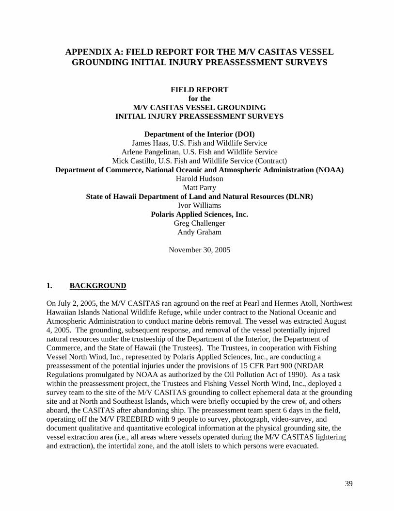
39
APPENDIX A: FIELD REPORT FOR THE M/V CASITAS VESSEL
GROUNDING INITIAL INJURY PREASSESSMENT SURVEYS
FIELD REPORT
for the
M/V CASITAS VESSEL GROUNDING
INITIAL INJURY PREASSESSMENT SURVEYS
Department of the Interior (DOI)
James Haas, U.S. Fish and Wildlife Service
Arlene Pangelinan, U.S. Fish and Wildlife Service
Mick Castillo, U.S. Fish and Wildlife Service (Contract)
Department of Commerce, National Oceanic and Atmospheric Administration (NOAA)
Harold Hudson
Matt Parry
State of Hawaii Department of Land and Natural Resources (DLNR)
Ivor Williams
Polaris Applied Sciences, Inc.
Greg Challenger
Andy Graham
November 30, 2005
1. BACKGROUND
On July 2, 2005, the M/V CASITAS ran aground on the reef at Pearl and Hermes Atoll, Northwest
Hawaiian Islands National Wildlife Refuge, while under contract to the National Oceanic and
Atmospheric Administration to conduct marine debris removal. The vessel was extracted August
4, 2005. The grounding, subsequent response, and removal of the vessel potentially injured
natural resources under the trusteeship of the Department of the Interior, the Department of
Commerce, and the State of Hawaii (the Trustees). The Trustees, in cooperation with Fishing
Vessel North Wind, Inc., represented by Polaris Applied Sciences, Inc., are conducting a
preassessment of the potential injuries under the provisions of 15 CFR Part 900 (NRDAR
Regulations promulgated by NOAA as authorized by the Oil Pollution Act of 1990). As a task
within the preassessment project, the Trustees and Fishing Vessel North Wind, Inc., deployed a
survey team to the site of the M/V CASITAS grounding to collect ephemeral data at the grounding
site and at North and Southeast Islands, which were briefly occupied by the crew of, and others
aboard, the CASITAS after abandoning ship. The preassessment team spent 6 days in the field,
operating off the M/V FREEBIRD with 9 people to survey, photograph, video-survey, and
document qualitative and quantitative ecological information at the physical grounding site, the
vessel extraction area (i.e., all areas where vessels operated during the M/V CASITAS lightering
and extraction), the intertidal zone, and the atoll islets to which persons were evacuated.
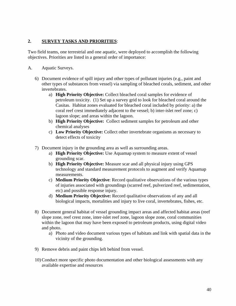
40
2. SURVEY TASKS AND PRIORITIES:
Two field teams, one terrestrial and one aquatic, were deployed to accomplish the following
objectives. Priorities are listed in a general order of importance:
A. Aquatic Surveys.
6) Document evidence of spill injury and other types of pollutant injuries (e.g., paint and
other types of substances from vessel) via sampling of bleached corals, sediment, and other
invertebrates.
a) High Priority Objective: Collect bleached coral samples for evidence of
petroleum toxicity. (1) Set up a survey grid to look for bleached coral around the
Casitas. Habitat zones evaluated for bleached coral included by priority: a) the
coral reef crest immediately adjacent to the vessel; b) inter-islet reef zone; c)
lagoon slope; and areas within the lagoon.
b) High Priority Objective: Collect sediment samples for petroleum and other
chemical analyses
c) Low Priority Objective: Collect other invertebrate organisms as necessary to
detect effects of toxicity
7) Document injury in the grounding area as well as surrounding areas.
a) High Priority Objective: Use Aquamap system to measure extent of vessel
grounding scar.
b) High Priority Objective: Measure scar and all physical injury using GPS
technology and standard measurement protocols to augment and verify Aquamap
measurements.
c) Medium Priority Objective: Record qualitative observations of the various types
of injuries associated with groundings (scarred reef, pulverized reef, sedimentation,
etc) and possible response injury.
d) Medium Priority Objective: Record qualitative observations of any and all
biological impacts, mortalities and injury to live coral, invertebrates, fishes, etc.
8) Document general habitat of vessel grounding impact areas and affected habitat areas (reef
slope zone, reef crest zone, inter-islet reef zone, lagoon slope zone, coral communities
within the lagoon that may have been exposed to petroleum products, using digital video
and photo.
a) Photo and video document various types of habitats and link with spatial data in the
vicinity of the grounding.
9) Remove debris and paint chips left behind from vessel.
10) Conduct more specific photo documentation and other biological assessments with any
available expertise and resources
41
B. Terrestrial Surveys.
High Priority Objective: Conduct terrestrial surveys on islets to which CASITAS
personnel were evacuated to serve as baseline for future monitoring to ascertain whether invasive
species may have been introduced as a result of the personnel evacuation and other response
activities.
3. METHODS/RESULTS.
The survey team arrived at Midway Island NWR on Tuesday, 23 August 2005, and embarked on
the M/V FREEBIRD. Following the transit from Midway, the team was on-site at Pearl and
Hermes Atoll 24-29 August 2005, returning to Midway the morning of 30 August for the return
flight to Honolulu. Although logistical problems were generally limited, one significant issue
emerged. After the second day of diving it was discovered that the air compressor borrowed from
Midway Island NWR was inoperative. The captain of the FREEBIRD was able to restore some
function, but throughout the remainder of the survey period tanks could only be filled to about half
capacity, reducing the diving time available.
A. Aquatic Surveys.
1) Sample Collection. Samples of corals were collected for toxicity analysis although no
evidence of bleached corals or corals with extruded tissue indicative of toxicity were
encountered as specified in the objectives and methods of the assessment plan. Six coral
and 24 sediment samples were collected following the protocols in Appendix A Samples
were taken following a stratified sampling plan. Two transects, one at the CASITAS
grounding site and one at a reference location about 200 meters to the west of the
grounding site were established and stratified by habitat type, reef slope, reef crest, inter-
islet, and lagoon slope.
a) Tissue samples. Coral samples were collected at three locations on each transect
as close to the reef crest as practicable (given weather conditions and the need to
have samples on liquid nitrogen within ten minutes of collection), the inter-islet
area, and the lagoon slope. Roughly ten pieces of Porites sp. were collected at each
location, placed in a plastic falcon tube, and then placed in a liquid nitrogen
container within ten minutes of collection. All collection sites were marked
individually by GPS at the time of collection. Analytical results will be
incorporated into the preassessment report when received.
b) Sediment samples. Sediment samples were collected at four locations along
each transect; the reef slope, the reef crest (as close as practicable), the inter-islet
reef, and the lagoon slope. Three grab samples were collected at each location, one
for metals analysis and two for polycyclic aromatic hydrocarbon (PAH) analyses
by modified EPA method 8270. Sediments were collected in 250 ml jars and
refrigerated after collection. Each collection site was marked by GPS at the time of
collection. Coral and sediment collection locations are shown in Figure 1. The
42
sample log is attached as Appendix C. Analytical results are attached as Appendix
D.
c) Other invertebrate samples. Invertebrate samples were not collected due to
time constraints and limited availability of mollusks.
2) Physical Injuries. Physical injuries to the reef were measured to the extent permitted by
weather, time, and air supplies. The injured zones were identified as the main scar near the
reef crest caused by the vessel grounding, the extraction scars created by the vessel, barge,
and/or cables on the reef slope adjacent to the main vessel scar, and anchor/cable scars also
on the reef slope. The following describes the physical measurements of injured areas,
qualitative observations and other activities associated with the physical assessment.
a) Aquamap Measurements. The Aquamap system was employed as described in
Appendix A to measure extraction and anchor/cable scars. In the main scar area,
the Aquamap system was used in conjunction with physical measures due to
limited water depth and sea conditions. The raw Aquamap data files were provided
to the Trustees.
b) GPS and Standard Measurements. The estimated GPS coordinates of the
anchors provided to the survey team proved to be un-reliable and only injury at
anchor sites 4, 5, and most likely 3 could be located with reasonable certainty. No
scars associated with anchor sites 1, 2, and 6 were located; however, several scars
that seemed to be associated with anchor cables were located between the estimated
sites of anchors 2 and 6 and the vessel extraction zone. It is possible anchors 1 and
2 were located further offshore than surveyed, but no evidence of anchor scars were
found. No evidence of a scar from anchor 6 was found, indicating that either the
anchor was placed in sand or the injury was not surveyed. The mapped areas of
injury are shown in Figure 2.
The main scar was measured using GPS technology, Aquamap, and standard measurement
protocols as described in Appendix A. The measurements and compass orientations are
shown in Figure 3. Additional measurements were made of scars in the extraction areas
identified as A and B in Figure 3. Nine scars were marked in Vessel Extraction Zone A
with stainless steel pins so they can be relocated in future surveys. Vessel extraction Zone
B was measured by Aquamap only. Measurements, GPS coordinates, and descriptions of
the injured areas are described in the Casitas Preassessment Marine Report (Appendix E),
with a supporting Excel spreadsheet. Figures 4 and 5 show the areas searched in two
ways: Figure 4 shows the boat tracks documented by GPS, and Figure 5 shows the
estimated sizes of the search polygons.
c and d) Qualitative Observations. Video footage, photographs, and written
narratives from divers were used to make qualitative observations of the various
types of physical and biological injuries associated with groundings (scarred reef,
pulverized reef, sedimentation, etc) and possible response/extraction injury.
43
Videos and photographs have been provided electronically to all agencies. Diver
observations are incorporated into Appendix E.
3) General habitat documentation. Linked with tasks 2(c) and 2(d), above.
4) Debris removal. A small amount of debris was removed incidentally to other higher
priority activities. Debris consisted mainly of small pieces of metal, clothing, and personal
items such as cassette tapes. An estimated 300 ft. length of ¾ in. nylon line, entangled in
the reef adjacent to the grounding site, was removed during one of the injury assessment
surveys. In addition, two parachutes were located in the vicinity that remained from
equipment having been airlifted into the grounding site during the response. One dive was
used on the last day on-site to remove the parachutes so they would not cause additional
damage to the reef during the winter storm season.
5) Archival photo-quadrat data. The RP representatives collected a small number of photo-
quadrats within injured and uninjured areas
B. Terrestrial Surveys.
Terrestrial surveys were conducted on North Island and Southeast Islands in accordance with the
protocols described in Appendices B and Pacific Remote Islands National Wildlife Refuge
Complex Special Conditions and Rules for Moving between Islands and Atolls and Packing for
Field Camps of July 2001.
1) North Island surveys were conducted from the morning of 24 August to the morning of 27
August 2005. Eight invertebrate samples were collected as anticipated. The terrestrial
sample log is included in Appendix C. The narrative descriptions of the team‟s activities
are contained in Appendix F. Invertebrate identifications will be incorporated into the
preassessment report when received.
2) Southeast Island surveys were conducted from the morning of 27 August to the afternoon
of 29 August 2005. Seven invertebrate samples were collected as anticipated. The
terrestrial sample log is included in Appendix C. The narrative descriptions of the team‟s
activities are contained in Appendix F. Invertebrate identifications will be incorporated
into the preassessment report when received.
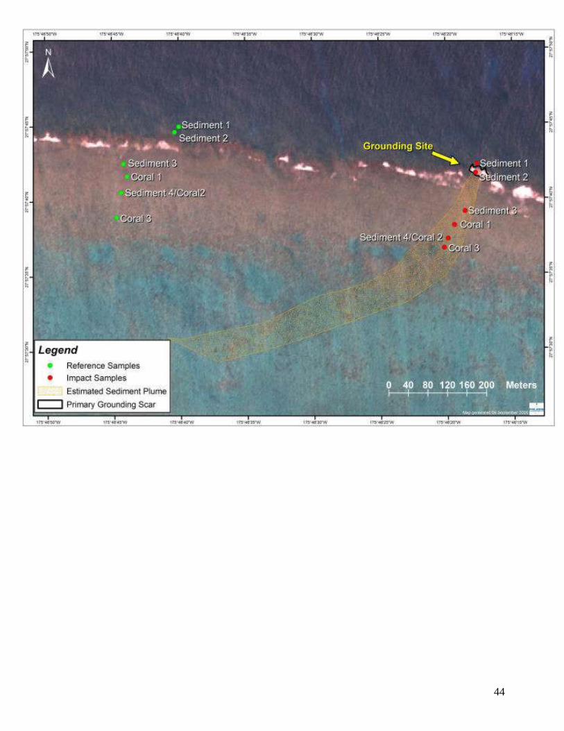
44

45
Figure 1. Coral and sediment sampling locations.
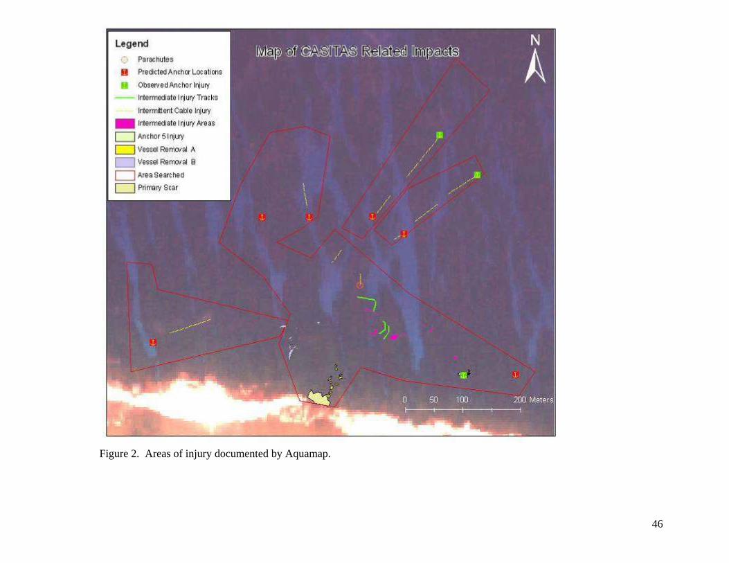
46
Figure 2. Areas of injury documented by Aquamap.
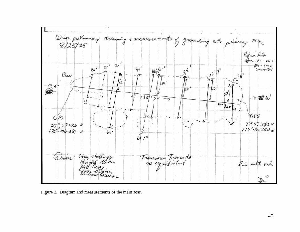
47
Figure 3. Diagram and measurements of the main scar.
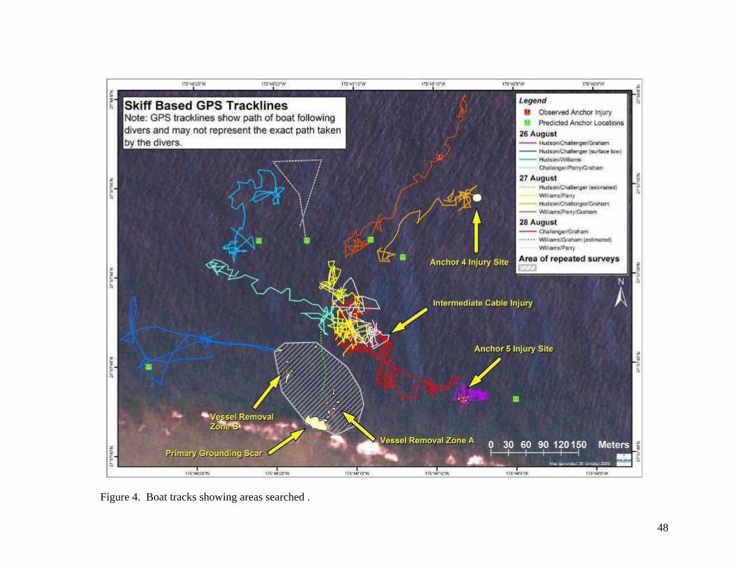
48
Figure 4. Boat tracks showing areas searched .
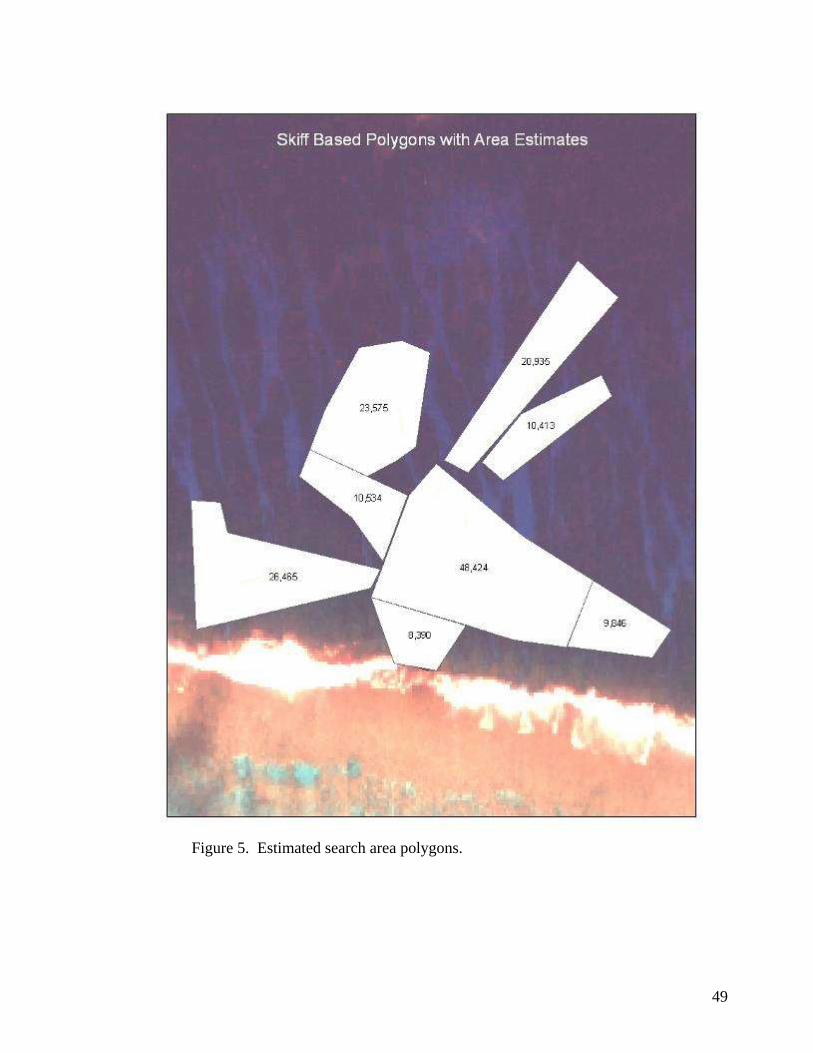
49
Figure 5. Estimated search area polygons.
50
APPENDIX A
MV Casitas Grounding Preassessment Expedition
Methodology and Protocols for Marine Assessment
The following priority tasks will be conducted:
a) Toxicity Exposure
High Priority: Document evidence of spill injury such as bleached corals, coral tissue
extrusion, and invertebrate mortality.
There is no confirmation of substantial fuel release and the fuel recovery indicates the
petroleum products on-board are largely accounted for. The projected path of sediment
and any potentially released fuel will be the initial focus of evidentiary surveys for
exposure.
If evidence mentioned above is encountered, the team will collect samples of indicator
invertebrates if available for potential chemical analytical analysis of polycyclic aromatic
hydrocarbons (Modified EPA method 8270) and biomarkers in the source oils to determine
if exposure to the specific source oils occurred. Certain invertebrates such as filter feeders
concentrate contaminants and are ideally suited to determine exposure. Appropriate
permits and approval must be obtained. Composite samples of at least 8 oz of tissue are
required for each sample. Samples must be wrapped in foil, enclosed in plastic, and stored
on ice or frozen until shipment to the laboratory under chain of custody.
If evidence of coral bleaching or tissue extrusion is encountered and is unique to
potentially exposed areas (or there is uncertainty), coral samples will be collected for
evidence of petroleum toxicity. Corals are not ideally suited to determine exposure to the
source oil since forensic chemistry is not possible without ample tissue quantity. However,
it is possible to apply general knowledge about exposure to hydrocarbons.
A survey pattern to look for bleached coral and other potential evidence of oil exposure
around the Casitas will follow the potential trajectory. Habitat zones that should be
evaluated should begin close to the vessel and fan outward until all areas are covered or no
further evidence is encountered. These areas include: a) The coral reef crest immediately
adjacent to the vessel; b) inter-islet reef zone; c) lagoon slope; and areas within the lagoon.
High Priority: Document evidence of petroleum spill and/or other toxic chemical releases
into the environment (e.g., anti-corrosive materials from exterior of M/V Casitas) by
collection and analysis of sediment samples.
Lower Priority: Remove small debris and paint chips left behind from vessel.
51
b) Physical Injury
High Priority: Document injury in the grounding area as well as surrounding areas
An AquaMap underwater SONAR system will be used to measure the aerial extent of
vessel grounding scar in coordination with natural resource trustees. AquaMap consists of
3 stationary transducers and a hand-held data collection unit. The three transducers are
moored underwater and the hand-held unit records its position relative to the three
transducers. A GPS position of one of the transducers can be taken and used to place the
area in a global reference, but the GPS position is not used when calculating distances and
areas measured. AquaMap will be calibrated by using it in concert with a measuring tape
for validation.
The trustees will also measure the scar and all physical damage using GPS technology and
standard measurement protocols to augment AquaMap measurements. However, GPS on
the site has been reported to be very inaccurate. The size of the scar may dictate that
measuring tape may be a better method of verification. Video documentation of all
AquaMap data collection will be recorded to provide post-survey verification of the scar
measurement by other trustees not participating in the Preassessment survey.
The area of injury will be marked by representatives of Polaris Applied Sciences and the
trustee agencies using snorkeling or SCUBA equipment where appropriate with multiple
lead weights and flagging tape such that all trustees agree on boundary locations. The time
to complete a SONAR survey of the flagging tape markers around each injury area is very
short, accurate, and saves many days of tedious and less accurate measurements using GPS
or measuring tape. A video with an embedded chart can be created that tracks the
movement of the dive team and shows the imagery from the position on the chart. From
the digital AquaMap files, the area of injury can be calculated. Traditional methods will be
used as verification.
In the event that the AquaMap system does not prove to be effective in documenting the
injury (extremely shallow water, technical difficulties, etc.) standard measurement
protocols will be used. A measuring tape will be placed along the long axis of each injury
polygon marked by the joint assessment team members. Divers will use a second
measuring tape to measure the width of the polygon perpendicular to the longitudinal
measuring tape at defined intervals. Depending on the size of the injury the intervals can
range from 1 to 5 meters. GPS positions will be recorded at each end of the longitudinal
axis to place the injury polygons in GIS in their relative positions at the site.
Following measurement of the scar and surrounding habitats, qualitative observations of
the various types of injuries associated with groundings (scared reef, pulverized reef,
sedimentation, etc) will be recorded on underwater slates and with still image and video
documentation. Qualitative observations of any and all biological impacts, mortalities and
damage to live coral, invertebrates, fishes, etc. will also be recorded.
52
The general habitat of vessel grounding impact areas and affected habitat areas (reef slope
zone, reef crest zone, inter-islet reef zone, lagoon slope zone, coral communities within
the lagoon that may have been exposed to petroleum products will be documented using
digital video and still photography. AquaMap can be used to support these tasks by
recording photo and observation locations.
Lower Priority: If time permits and if deemed useful based on the qualitative high priority
data collection, video transects within the injury area, establishment of permanent
transects, photo quadrats, rugosity measurements and other quantitative data may be
collected in impact and reference locations in consultation with participating members.
AquaMap can be used to support these tasks by identifying sample locations.
For safety, dives will be limited to less than 60‟ and within 2 letter groups of no-
decompression limits to avoid the need for a hyperbaric chamber.
.
53
APPENDIX B
MV Casitas Grounding Preassessment Expedition
Terrestrial Survey Methodology and Protocols
Rationale: After the evacuation of the M/V Casitas at least 17 people were transported to North
Island, Pearl and Hermes Reef, where they stayed for several hours before moving to Southeast
Island in the same atoll. Because this was an unexpected landing, the individuals involved did not
have the opportunity to observe the National Wildlife Refuge‟s quarantine protocols (see
Attachment 3) that are required to prevent the introduction of non-native plants, insects, fungi,
and pathogens to these sensitive island environments. The group had just come from Midway
Atoll where there are invasive species that pose a great risk to Pearl and Hermes Reef.
By describing the plant and terrestrial arthropod communities that currently exist at North and
Southeast Islands we will have a basis from which to evaluate the same ecological communities
later on in order to detect whether or not new species possibly carried to North or Southeast
Islands by the crew and passengers of the Casitas have established themselves. As time permits,
the terrestrial survey team will also survey the Laysan Finch population at Southeast Island and
record other bird and sea turtle observations, as listed below.
Objectives: (In order of their priority)
1. Survey terrestrial environment at North Island and Southeast Island to describe current
species composition, phenology, and spatial distribution of plants.
2. Survey terrestrial environment at each site to describe species composition and relative
abundance of terrestrial invertebrate species.
3. Do standard survey to estimate population size of the Laysan Finch at Southeast Island.
4. Record species, count active nests, and note breeding chronology of seabirds.
5. Record shorebird species and any other vagrants or migrant birds.
6. Count number of green turtle nests and note evidence of hatching. Count turtles resting on
shore at night.
Botanical Survey Methods Survey entire island, noting all species observed, their phenology and size. Map vegetation
associations. Note condition of plants and record evidence of herbivory, salt spray damage or
disruption from turtles digging nests. Using approved monk seal and turtle approach guidelines
search high tide line for seeds or other plant propagules. Collect or photograph if you are unable
to identify them in the field.
Invertebrate Survey Methods
Ant Surveys and Pitfall Surveys
Establish a transect that bilaterally dissects each island. Along that transect, identify equally
spaced sampling points (recommend about 5 for the smaller island and approximately 10 stations
for the larger lobe of Southeast Island and 5 for the western lobe). Using the GPS receiver mark a
waypoint at each station. At these stations on each island, conduct ant surveys using bait cards
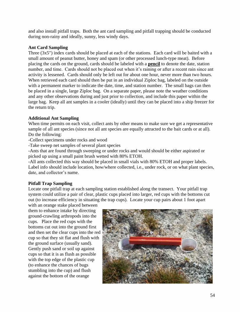
54
and also install pitfall traps. Both the ant card sampling and pitfall trapping should be conducted
during non-rainy and ideally, sunny, less windy days.
Ant Card Sampling
Three (3x5") index cards should be placed at each of the stations. Each card will be baited with a
small amount of peanut butter, honey and spam (or other processed lunch-type meat). Before
placing the cards on the ground, cards should be labeled with a pencil to denote the date, station
number, and time. Cards should not be placed out when it‟s raining or after a recent rain since ant
activity is lessened. Cards should only be left out for about one hour, never more than two hours.
When retrieved each card should then be put in an individual Ziploc bag, labeled on the outside
with a permanent marker to indicate the date, time, and station number. The small bags can then
be placed in a single, large Ziploc bag. On a separate paper, please note the weather conditions
and any other observations during and just prior to collection, and include this paper within the
large bag. Keep all ant samples in a cooler (ideally) until they can be placed into a ship freezer for
the return trip.
Additional Ant Sampling
When time permits on each visit, collect ants by other means to make sure we get a representative
sample of all ant species (since not all ant species are equally attracted to the bait cards or at all).
Do the following:
-Collect specimens under rocks and wood
-Take sweep net samples of several plant species
-Ants that are found through sweeping or under rocks and would should be either aspirated or
picked up using a small paint brush wetted with 80% ETOH.
-All ants collected this way should be placed in small vials with 80% ETOH and proper labels.
Label info should include location, how/where collected, i.e., under rock, or on what plant species,
date, and collector‟s name.
Pitfall Trap Sampling
Locate one pitfall trap at each sampling station established along the transect. Your pitfall trap
system could utilize a pair of clear, plastic cups placed into larger, red cups with the bottoms cut
out (to increase efficiency in situating the trap cups). Locate your cup pairs about 1 foot apart
with an orange stake placed between
them to enhance intake by directing
ground-crawling arthropods into the
cups. Place the red cups with the
bottoms cut out into the ground first
and then set the clear cups into the red
cup so that they sit flat and flush with
the ground surface (usually sand).
Gently push sand or soil up against
cups so that it is as flush as possible
with the top edge of the plastic cup
(to enhance the chances of bugs
stumbling into the cup) and flush
against the bottom of the orange
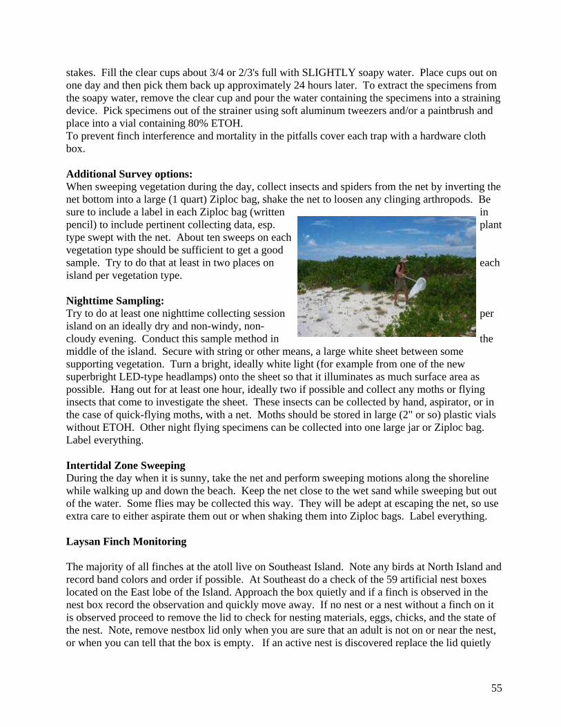
55
stakes. Fill the clear cups about 3/4 or 2/3's full with SLIGHTLY soapy water. Place cups out on
one day and then pick them back up approximately 24 hours later. To extract the specimens from
the soapy water, remove the clear cup and pour the water containing the specimens into a straining
device. Pick specimens out of the strainer using soft aluminum tweezers and/or a paintbrush and
place into a vial containing 80% ETOH.
To prevent finch interference and mortality in the pitfalls cover each trap with a hardware cloth
box.
Additional Survey options:
When sweeping vegetation during the day, collect insects and spiders from the net by inverting the
net bottom into a large (1 quart) Ziploc bag, shake the net to loosen any clinging arthropods. Be
sure to include a label in each Ziploc bag (written in
pencil) to include pertinent collecting data, esp. plant
type swept with the net. About ten sweeps on each
vegetation type should be sufficient to get a good
sample. Try to do that at least in two places on each
island per vegetation type.
Nighttime Sampling:
Try to do at least one nighttime collecting session per
island on an ideally dry and non-windy, non-
cloudy evening. Conduct this sample method in the
middle of the island. Secure with string or other means, a large white sheet between some
supporting vegetation. Turn a bright, ideally white light (for example from one of the new
superbright LED-type headlamps) onto the sheet so that it illuminates as much surface area as
possible. Hang out for at least one hour, ideally two if possible and collect any moths or flying
insects that come to investigate the sheet. These insects can be collected by hand, aspirator, or in
the case of quick-flying moths, with a net. Moths should be stored in large (2" or so) plastic vials
without ETOH. Other night flying specimens can be collected into one large jar or Ziploc bag.
Label everything.
Intertidal Zone Sweeping
During the day when it is sunny, take the net and perform sweeping motions along the shoreline
while walking up and down the beach. Keep the net close to the wet sand while sweeping but out
of the water. Some flies may be collected this way. They will be adept at escaping the net, so use
extra care to either aspirate them out or when shaking them into Ziploc bags. Label everything.
Laysan Finch Monitoring
The majority of all finches at the atoll live on Southeast Island. Note any birds at North Island and
record band colors and order if possible. At Southeast do a check of the 59 artificial nest boxes
located on the East lobe of the Island. Approach the box quietly and if a finch is observed in the
nest box record the observation and quickly move away. If no nest or a nest without a finch on it
is observed proceed to remove the lid to check for nesting materials, eggs, chicks, and the state of
the nest. Note, remove nestbox lid only when you are sure that an adult is not on or near the nest,
or when you can tell that the box is empty. If an active nest is discovered replace the lid quietly
56
and do not attempt to ascertain nest contents if the adult does not flush. Record band
combinations on Southeast Island as well. Note general area in which you sighted bird.
Laysan Finch Survey
As time permits do up to 100 transects on Southeast Island between the hours of 0700 and 1100 to
estimate finch density on the island. Each transect should be 100' long by 16.5' wide (8.25' to each
side). These quaint measurements are due to the fact that this same methodology has been used
since the 1960‟s. The width of the line, 16.5 feet, is a rod (160 square rods equal an acre) Orient
transects on a magnetic North-South bearing. Using the measuring tape learn the number of your
paces that equals 100 feet and carry a piece of cord with a small weight tied to the end that equals
8.25 feet to extend periodically to know how wide to make your counting area. With lines and
counters in hand, two observers can walk simultaneously two parallel transects separated by about
20' and in this manner walk in a straight line and completed as many 100' transect segments as will
fit within the vegetated portion of the island. Any finches that were observed within the reach of
the pole to the front and sides should be counted. Finches that are observed to enter into the count
area while the survey was in progress should not be tallied. The number of finches counted on
each transect is then divided by the area of a transect (1650 square feet) and an estimate of the
mean density and the variance of all the transects can be calculated. This density is then multiplied
by the total vegetated area of the island to determine an island population estimate. There are
43,650 square feet per acre and there was 30.1 acres of vegetated area at Southeast in 2001.
Seabird and Shorebird Survey
Note each species of seabird observed and whether or not it is breeding. For surface nesting and
shrub-nesting species attempt to count or estimate numbers of nests and record breeding stage at
eggs or one of the phenological categories on the Breeding Chronology key that will be included
in your survey forms. For burrow nesters sketch the general areas on each island that appear to
have burrow entrances. Note each species of migrant shorebird seen and estimate numbers.
Turtle Activity Monitoring
Map areas of signs of turtle nesting activity. Map areas of night haul-outs. Look for pre-hatch
pits. Look for hatchlings that may be tangled in vegetation. After dark, carefully count the
numbers of turtles that come ashore for the night. Try not to use lights at all and avoid frightening
the turtles back into the ocean. Use the recommended camp sites situated away from favored
night haul-out areas and control light in camp to avoid confusing hatchling turtles. There has
rarely been an overnight stay at North Island so mapping night haul-outs will be new information.
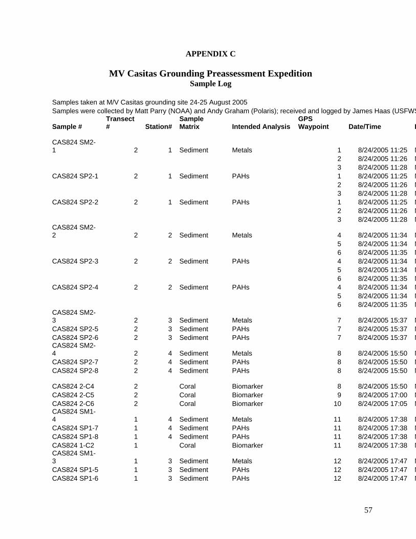
57
APPENDIX C
MV Casitas Grounding Preassessment Expedition Sample Log
Samples taken at M/V Casitas grounding site 24-25 August 2005
Samples were collected by Matt Parry (NOAA) and Andy Graham (Polaris); received and logged by James Haas (USFWS)
Sample # Transect # Station#
Sample Matrix Intended Analysis
GPS Waypoint Date/Time Latitude/Longitude Notes
CAS824 SM2-1 2 1 Sediment Metals 1 8/24/2005 11:25 N27 57.701 W175 46.297 Three GPS readings taken to average positions
2 8/24/2005 11:26 N27 57.706 W175 46.295
3 8/24/2005 11:28 N27 57.707 W175 46.292
CAS824 SP2-1 2 1 Sediment PAHs 1 8/24/2005 11:25 N27 57.701 W175 46.297
2 8/24/2005 11:26 N27 57.706 W175 46.295
3 8/24/2005 11:28 N27 57.707 W175 46.292
CAS824 SP2-2 2 1 Sediment PAHs 1 8/24/2005 11:25 N27 57.701 W175 46.297
2 8/24/2005 11:26 N27 57.706 W175 46.295
3 8/24/2005 11:28 N27 57.707 W175 46.292 CAS824 SM2-2 2 2 Sediment Metals 4 8/24/2005 11:34 N27 57.695 W175 46.296 Three GPS readings taken to average positions
5 8/24/2005 11:34 N27 57.695 W175 46.297
6 8/24/2005 11:35 N27 57.696 W175 46.296
CAS824 SP2-3 2 2 Sediment PAHs 4 8/24/2005 11:34 N27 57.695 W175 46.296
5 8/24/2005 11:34 N27 57.695 W175 46.297
6 8/24/2005 11:35 N27 57.696 W175 46.296
CAS824 SP2-4 2 2 Sediment PAHs 4 8/24/2005 11:34 N27 57.695 W175 46.296
5 8/24/2005 11:34 N27 57.695 W175 46.297
6 8/24/2005 11:35 N27 57.696 W175 46.296 CAS824 SM2-3 2 3 Sediment Metals 7 8/24/2005 15:37 N27 57.653 W175 46.310
CAS824 SP2-5 2 3 Sediment PAHs 7 8/24/2005 15:37 N27 57.653 W175 46.310
CAS824 SP2-6 2 3 Sediment PAHs 7 8/24/2005 15:37 N27 57.653 W175 46.310 CAS824 SM2-4 2 4 Sediment Metals 8 8/24/2005 15:50 N27 57.622 W175 46.331
CAS824 SP2-7 2 4 Sediment PAHs 8 8/24/2005 15:50 N27 57.622 W175 46.331
CAS824 SP2-8 2 4 Sediment PAHs 8 8/24/2005 15:50 N27 57.622 W175 46.331
CAS824 2-C4 2 Coral Biomarker 8 8/24/2005 15:50 N27 57.622 W175 46.331 Porites collected for all coral samples; in nitrogen within 10 minutes unless otherwise noted
CAS824 2-C5 2 Coral Biomarker 9 8/24/2005 17:00 N27 57.637 W175 46.323 Sample placed in liquid N in 10.5 min.
CAS824 2-C6 2 Coral Biomarker 10 8/24/2005 17:05 N27 57.612 W175 46.336 CAS824 SM1-4 1 4 Sediment Metals 11 8/24/2005 17:38 N27 57.676 W175 46.739
CAS824 SP1-7 1 4 Sediment PAHs 11 8/24/2005 17:38 N27 57.676 W175 46.739
CAS824 SP1-8 1 4 Sediment PAHs 11 8/24/2005 17:38 N27 57.676 W175 46.739
CAS824 1-C2 1 Coral Biomarker 11 8/24/2005 17:38 N27 57.676 W175 46.739 CAS824 SM1-3 1 3 Sediment Metals 12 8/24/2005 17:47 N27 57.708 W175 46.736
CAS824 SP1-5 1 3 Sediment PAHs 12 8/24/2005 17:47 N27 57.708 W175 46.736
CAS824 SP1-6 1 3 Sediment PAHs 12 8/24/2005 17:47 N27 57.708 W175 46.736
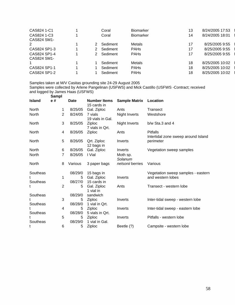
58
CAS824 1-C1 1 Coral Biomarker 13 8/24/2005 17:53 N27 57.694 W175 46.732 Sample placed in liquid N in 11 min.
CAS824 1-C3 1 Coral Biomarker 14 8/24/2005 18:01 N27 57.648 W175 46.745 CAS824 SM1-2 1 2 Sediment Metals 17 8/25/2005 9:55 N27 57.743 W175 46.672
CAS824 SP1-3 1 2 Sediment PAHs 17 8/25/2005 9:55 N27 57.743 W175 46.672
CAS824 SP1-4 1 2 Sediment PAHs 17 8/25/2005 9:55 N27 57.743 W175 46.672 CAS824 SM1-1 1 1 Sediment Metals 18 8/25/2005 10:02 N27 57.749 W175 46.667
CAS824 SP1-1 1 1 Sediment PAHs 18 8/25/2005 10:02 N27 57.749 W175 46.667
CAS824 SP1-2 1 1 Sediment PAHs 18 8/25/2005 10:02 N27 57.749 W175 46.667
Samples taken at M/V Casitas grounding site 24-29 August 2005 Samples were collected by Arlene Pangelinan (USFWS) and Mick Castillo (USFWS -Contract; received and logged by James Haas (USFWS)
Island Sample # Date Number Items Sample Matrix Location
North 1 8/25/05 15 cards in Gal. Ziploc Ants Transect
North 2 8/24/05 7 vials Night Inverts Westshore
North 3 8/25/05 19 vials in Gal. Ziploc Night Inverts b/w Sta.3 and 4
North 4 8/26/05 7 vials in Qrt. Ziploc Ants Pitfalls
North 5 8/26/05 Qrt. Ziploc Inverts Intertidal zone sweep around Island perimeter
North 6 8/26/05 12 bags in Gal. Ziploc Inverts Vegetation sweep samples
North 7 8/26/05 I Vial Moth sp.
North 8 Various 3 paper bags Solanum nelsonii berries Various
Southeast 1
08/29/05
15 bags in Gal. Ziploc Inverts
Vegetation sweep samples - eastern and western lobes
Southeast 2
08/27/05
15 cards in Gal. Ziploc Ants Transect - western lobe
Southeast 3
08/29/05
1 vial in sandwich Ziploc Inverts Inter-tidal sweep - western lobe
Southeast 4
08/28/05
1 vial in Qrt. Ziploc Inverts Inter-tidal sweep - eastern lobe
Southeast 5
08/28/05
5 vials in Qrt. Ziploc Inverts Pitfalls - western lobe
Southeast 6
08/29/05
1 vial in Gal. Ziploc Beetle (?) Campsite - western lobe

59
APPENDIX D
MV Casitas Preassessment Expedition Analytical Results for Sediment Samples
(See Attached)
60
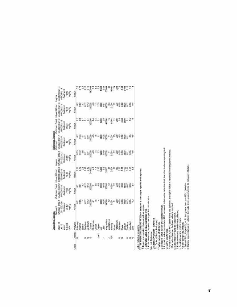
61
62
APPENDIX E

63
MV Casitas Preassessment Expedition Marine Report
(See Attached)

64
APPENDIX F
MV Casitas Grounding Preassessment Expedition Terrestrial Survey Team Narrative Report
Arlene Pangelinan2
J. Michael Castillo3
2 Department of Interior, U.S. Fish and Wildlife Service, Pacific Islands Office, Honolulu, Hawai„i 3 Hawai„i Natural Resource Services, LLC, Kamuela, Hawai„i
65
1. Project Name: M/V Casitas Vessel Grounding Terrestrial Survey Report
2. Location: Pearl and Hermes Atoll, Hawaii Islands National Wildlife
Refuge
3. Dates: Expedition: August 23-August 30, 2005
Survey: August 24-August 29, 2005
4. Background:
The Responsible Party and Trustees traveled to the grounding site of the M/V CASITAS (aground
July 2, 2005, off Pearl and Hermes Atoll, NWHI) to collect data as part of the Preassessment
Phase under the Oil Pollution Act (OPA). Two survey teams were deployed to the grounding site
and two islets within the atoll in order to assess the aquatic and terrestrial impacts associated with
the grounding incident and the evacuation of the CASITAS crew. The marine team, which was
comprised of six members, documented impacts to the coral reef at the grounding site and
surrounding marine environments. The terrestrial team, which was comprised of two members,
documented the existing ecological conditions on the two islets that served as temporary
evacuation sites for the Casitas crew following the grounding.
The primary goal of the terrestrial survey team was to conduct baseline surveys of the existing
vegetation and insect assemblages at North Island and Southeast Island. Information on the
existing ecological structure and composition of plant and terrestrial arthropod communities
provides a benchmark from which to determine whether or not new species may have been carried
to North or Southeast Islands by the crew and passengers of the Casitas and have a likelihood of
colonizing and establishing themselves on these islets over time.
The specific objectives of the terrestrial survey, in order of priority, were to:
Survey terrestrial environment at North Island and Southeast Island to describe current
species composition, phenology, and spatial distribution of plants.
Survey terrestrial environment at each site to describe species composition and relative
abundance of terrestrial invertebrate species.
Do standard survey to estimate population size of the Laysan finch at Southeast Island.
Record species, count active nests, and note breeding chronology of seabirds.
Record shorebird species and any other vagrants or migrant birds.
Count number of green turtle nests and note evidence of hatching. Count turtles resting
on shore at night.
Special Conditions and Rules for Moving Between Islands and Atolls and Packing for Field
Camps within the Pacific Remote Islands National Wildlife Refuge Complex identified in the
Scope of Work were observed and adhered to (Annex 1).
Terrestrial preassessment survey activities were conducted over six field days. The survey
personnel spent three days each on North Island and Southeast Island. Activities included
surveying, monitoring, photographing, and documenting the ecological condition of the atoll islets
of North Island and Southeast Island.
66
5. Introduction
Pearl and Hermes atoll consists of a lagoon surrounded on three sides by a fringing reef that spans
approximately 7 kilometers (km) north-south, and 10 km east-west. North Island is positioned
approximately 450 meters (m) inside the northeast corner of the fringing reef and is approximately
14 acres in size. The island is shaped like a tadpole, with the head of the island pointing north-
northeast and a long sinuous sandy tail that is essentially unvegetated extending to the south-
southwest. The vegetated northern section comprises most of the land area and was where
sampling was focused. Southeast Island is positioned approximately 100 m inside the outer
fringing reef near the eastern corner of the atoll. It is larger and consists of two distinct lobes that
are connected by a narrow band of beach sand along the island‟s northern shore. The two lobes of
the island, East and West, together comprise approximately 35 to 40 acres of land area separated
by a central lagoon of relatively high salinity.
6. Methods
Vegetation - Vegetation on each island was surveyed and plant communities described. Plant
species were identified in the field and the phenological stage of each species was recorded. Plant
communities were differentiated based upon visible distinctions in dominant species composition
and physiognomic structure.
Invertebrate Sampling – Invertebrate fauna was collected on both islands using an array of sample
methods. Samples were either placed in sealed and labeled Ziplock bags, or in small glass and
plastic vials. All samples included a paper label. Samples were stored in a cooler until they could
be transported to the freezer aboard the Freebird vessel, after which time they remained stored in a
cooler with ice packs or in an upright freezer until they could be identified. Identification of
specimens is being conducted by US Fish and Wildlife Staff in cooperation with biologists at the
Bishop Museum in Honolulu.
Bird censuses were not conducted on North Island nor Southeast Island. Due to intolerably high
levels of disturbance resulting from sampling and traveling through seabird and finch habitat, a
decision was made to conduct invertebrate sampling only on the West lobe. This decision was
based in part upon the assumption that insect distribution and abundance was somewhat similar
between the two lobes, particularly with respect to ants.
Ant Bait Card Sampling. One invertebrate sampling transect was established on each island
(Figures 4 and 5). Five sampling points equally spaced were established along a central transect
on each island using a compass, pacing, and a handheld Garmin GPS unit. On North Island this
transect measured 300 m in length and bisected the island running in a north-south direction. The
sample stations were spaced 50 m apart along this transect. At Southeast Island the transect
bisected the West lobe of the island also had a north-south orientation, but measured 210 m in
length and sample stations were spaced 35 m apart. At each sampling point three ant bait cards
were placed 10 feet apart in a line perpendicular to and centered on the transect sample point.
Each ant bait card was labeled by island, transect sample point, position, date, time, and sampler‟s
names, then baited with small amounts of each of three baits: peanut butter, spam, and honey.
67
The cards were picked up approximately one hour after deployment and each placed (with bait and
insects attached) into a separate quart-sized Ziploc bag which was labeled using a permanent black
marker. Bait card sampling was conducted on non-windy days (less than 5 miles per hour (mph)
under full to nearly-full sun conditions.
Pitfall Surveys – A double-cup pitfall trap was installed at each of the five sample stations on each
island following methodology described in the Terrestrial Survey Methodology (Appendix B of
this Field Report). Pitfall sampling stations were installed adjacent to ant bait card sampling
points as described above. Pitfall traps were revisited 24 hours after deployment, and insects
removed from the soapy water solution and
placed into vials of 80 % Ethyl alcohol with a
label showing island, transect sample station,
date, and collector‟s names. Pitfall
sampling was conducted on non-windy days
(less than 5 mph) under full to nearly- full
sun conditions. Each pitfall trap was
covered with a mesh-wire box
constructed of hardware cloth to prevent
finch interference (Figure 1).
Figure 1. Example of double-cup pitfall
trap design with finch exclusion cover on
North Island, Pearl and Hermes Atoll, Remote Pacific Islands National Wildlife Refuge.
Nighttime Sampling - Two nighttime collecting sessions were conducted on North Island. Due to
windy conditions, nighttime sampling was not conduced on Southeast Island. The night sampling
on North Island occurred at two separate locations. The first sample location was at the
southeastern end of the island in lightly vegetated coral rubble substrate that supported a relatively
low density of nesting seabirds. The second sample location was near the center of the island
along the interface between two dominant vegetation types described as Type A and Type B. A
white full size bed sheet was strung between two vertical poles and secured with string. Two
Petzel LED-type headlamps were used to illuminate the sheets for over one hour each night. All
insects that were attracted to the sheet were collected by hand or using an aspirator and placed into
a separate vial without ethyl alcohol. Each vial contained a label with information on the island,
date, collector‟s names, and time. All vials were placed in a one-gallon Ziploc bag which was
labeled using a black permanent marker.
Vegetation Sweeps – During daylight hours, two sweep samples were gathered from each
vegetation type per island. Each sweep sample included 10 swings of the net across the top of the
vegetation, each swing consisting of an arc in two directions. Samples were stored in a Ziploc
with a label describing island, vegetation type, collector‟s names, date, and time.
Intertidal Zone Sweeping - During the day when it was sunny, sweeps were conducted along the
shoreline around the perimeter of each island. On North Island shoreline sweeps occurred over
sand. Sweeps on Southeast Island were over sand and corral rubble on East lobe, but also over
karst substrate bordering the central lagoon and southern shoreline on West Lobe. Samples were
68
placed into Ziploc bags, and later transferred to vials. Each vial had a label identifying island,
date, collector, and time inserted.
7. Results
Vegetation – Six vegetation types from North Island and seven vegetation types from Southeast
Island were recorded. Five vegetation types occurred on both islands. The dominant vegetation
type on North Island was the native Eragrostis variabilis which was noticeably absent from
Southeast Island. The East lobe of Southeast Island possessed a large tidal salt marsh dominated
by a monotypic stand of Sesuvium portulacastrum surrounded by a nearly monotypic stand of
Verbesina encelioides, both of which were absent from North Island.
The vegetated northerly section of North Island
was dominated in stature by the endemic
lovegrass Eragrostis variabilis which
covered a large patch in the central portion of the
island and became mixed with other species (Figure
2). The indigenous perennial herb nohu
(Tribulus cistoides) occurred over much of the
island and occurred mixed with the exotic bristly
foxtail (Setaria verticillata) in the northern portion
of the island, and mixed with the indigenous alena
(Boerhavia repens) and the indigenous grass
Lepturus repens in the southern end and in narrow
bands along western and eastern shorelines. Perhaps the most noteworthy aspect of North Island‟s
vegetation is the fact that it supports a reproductively vigorous population of the rare endemic
Solanum nelsonii in the north central portion of the island (shown at right). S. nelsonii is a
candidate for listing under both the US Endangered Species Act of 1973 and the Hawai„i State
Endangered Species Law HRS 195D. In addition to the Solanum shrub, two other woody plants
exist on North Island. Two exotic beach heliotrope (Tournefortia argentea) occur, one on each
side of the island, and serve as perches for frigate birds and Red-footed boobies. Also, three
young native naupaka (Scaevola sericea) occur along the island‟s western shore just above the
high water line (Table 1).
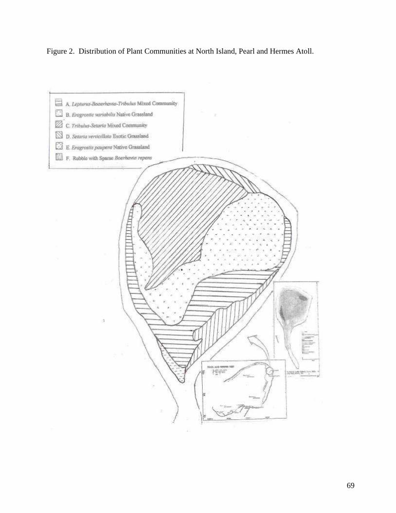
69
Figure 2. Distribution of Plant Communities at North Island, Pearl and Hermes Atoll.
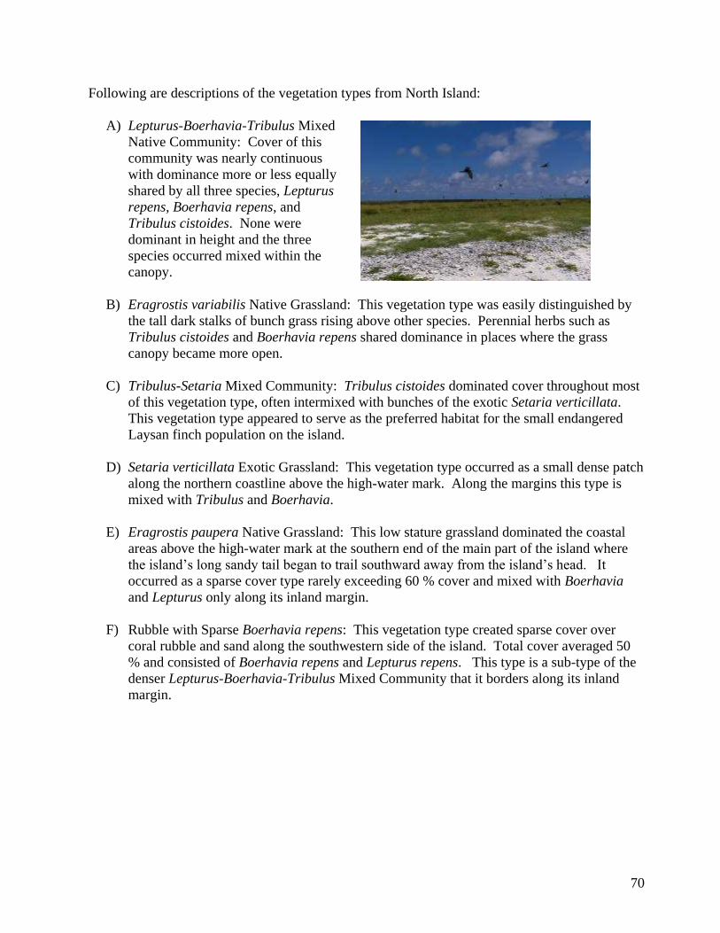
70
Following are descriptions of the vegetation types from North Island:
A) Lepturus-Boerhavia-Tribulus Mixed
Native Community: Cover of this
community was nearly continuous
with dominance more or less equally
shared by all three species, Lepturus
repens, Boerhavia repens, and
Tribulus cistoides. None were
dominant in height and the three
species occurred mixed within the
canopy.
B) Eragrostis variabilis Native Grassland: This vegetation type was easily distinguished by
the tall dark stalks of bunch grass rising above other species. Perennial herbs such as
Tribulus cistoides and Boerhavia repens shared dominance in places where the grass
canopy became more open.
C) Tribulus-Setaria Mixed Community: Tribulus cistoides dominated cover throughout most
of this vegetation type, often intermixed with bunches of the exotic Setaria verticillata.
This vegetation type appeared to serve as the preferred habitat for the small endangered
Laysan finch population on the island.
D) Setaria verticillata Exotic Grassland: This vegetation type occurred as a small dense patch
along the northern coastline above the high-water mark. Along the margins this type is
mixed with Tribulus and Boerhavia.
E) Eragrostis paupera Native Grassland: This low stature grassland dominated the coastal
areas above the high-water mark at the southern end of the main part of the island where
the island‟s long sandy tail began to trail southward away from the island‟s head. It
occurred as a sparse cover type rarely exceeding 60 % cover and mixed with Boerhavia
and Lepturus only along its inland margin.
F) Rubble with Sparse Boerhavia repens: This vegetation type created sparse cover over
coral rubble and sand along the southwestern side of the island. Total cover averaged 50
% and consisted of Boerhavia repens and Lepturus repens. This type is a sub-type of the
denser Lepturus-Boerhavia-Tribulus Mixed Community that it borders along its inland
margin.
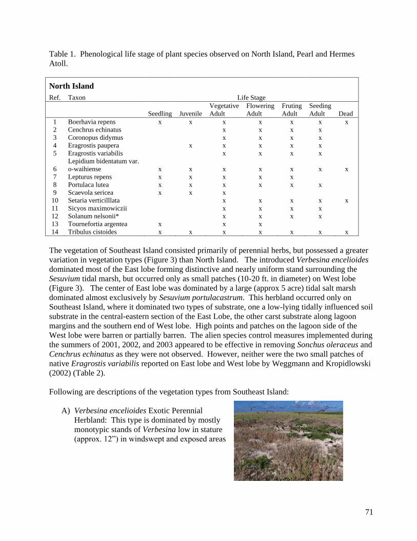
71
Table 1. Phenological life stage of plant species observed on North Island, Pearl and Hermes
Atoll.
North Island
Ref. Taxon Life Stage
Seedling Juvenile
Vegetative
Adult
Flowering
Adult
Fruting
Adult
Seeding
Adult Dead
1 Boerhavia repens x x x x x x x
2 Cenchrus echinatus x x x x
3 Coronopus didymus x x x x
4 Eragrostis paupera x x x x x
5 Eragrostis variabilis x x x x
6
Lepidium bidentatum var.
o-waihiense x x x x x x x
7 Lepturus repens x x x x x
8 Portulaca lutea x x x x x x
9 Scaevola sericea x x x
10 Setaria verticilllata x x x x x
11 Sicyos maximowiczii x x x x
12 Solanum nelsonii* x x x x
13 Tournefortia argentea x x x
14 Tribulus cistoides x x x x x x x
The vegetation of Southeast Island consisted primarily of perennial herbs, but possessed a greater
variation in vegetation types (Figure 3) than North Island. The introduced Verbesina encelioides
dominated most of the East lobe forming distinctive and nearly uniform stand surrounding the
Sesuvium tidal marsh, but occurred only as small patches (10-20 ft. in diameter) on West lobe
(Figure 3). The center of East lobe was dominated by a large (approx 5 acre) tidal salt marsh
dominated almost exclusively by Sesuvium portulacastrum. This herbland occurred only on
Southeast Island, where it dominated two types of substrate, one a low-lying tidally influenced soil
substrate in the central-eastern section of the East Lobe, the other carst substrate along lagoon
margins and the southern end of West lobe. High points and patches on the lagoon side of the
West lobe were barren or partially barren. The alien species control measures implemented during
the summers of 2001, 2002, and 2003 appeared to be effective in removing Sonchus oleraceus and
Cenchrus echinatus as they were not observed. However, neither were the two small patches of
native Eragrostis variabilis reported on East lobe and West lobe by Weggmann and Kropidlowski
(2002) (Table 2).
Following are descriptions of the vegetation types from Southeast Island:
A) Verbesina encelioides Exotic Perennial
Herbland: This type is dominated by mostly
monotypic stands of Verbesina low in stature
(approx. 12”) in windswept and exposed areas
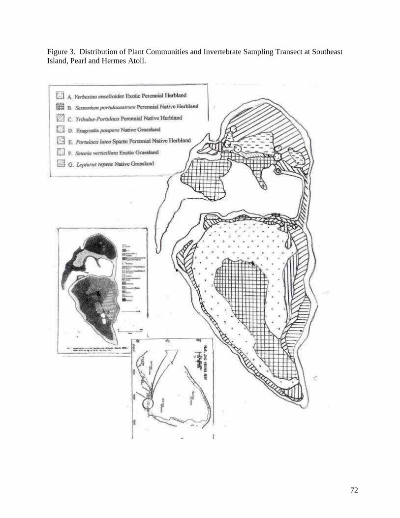
72
Figure 3. Distribution of Plant Communities and Invertebrate Sampling Transect at Southeast
Island, Pearl and Hermes Atoll.
73
B) Sesuvium portulacastrum Perennial Native
Herbland: Monotypic stands that vary in
size. Along shorelines above the high-water
mark small patches occur on karst substrate.
Within a low-lying area in the central to
eastern portion of the East lobe this type
occurs as a large monotypic patch in a
tidally-influenced marsh approximately 5
acres in size. Within this tidal marsh, the
Sesuvium supports a wide variety of insects,
including lacewings, medium-sized moths, ants, bugs, flies, and bees and wasps. Wedge-
tailed shearwater burrows are in such high abundance within this vegetation type that the
ground has developed honeycomb-type structure beneath the Sesuvium plants.
C) Tribulus-Portulaca Perennial Native Herbland: This vegetation type is dominated by low-
stature Tribulus cistoides and large sprawling Portulaca lutea perennial herbs.
Codominant species vary from place to place and include Lepturus, Setaria, Eragrostis
paupera, Boerhavia, and Sicyos, and on the southeast shore of the East lobe, Lepidium
bidentatum var. o-waihiense.
D) Eragrostis paupera Native Grassland: A low-
stature grassland dominated almost
exclusively by Eragrostis paupera that occurs
mostly as a narrow band just above the high-
water mark. Cover ranges from 20 % to 60 %
on sand substrate.
E) Portulaca lutea Sparse Perennial Native
Herbland: Sprawling Portulaca lutea plants
dominate coral rubble substrate towards the center of West lobe. Plant cover is sparse and
ranges from 25 % to 65 %. Associated species include Tribulus, Verbesina, Setaria, and
Boerhavia.
F) Setaria verticillata Exotic Grassland: Often occurring as monotypic patches of stands near
shoreline, but above and inland of the Eragrostis paupera grassland strand community, in
some places mixing with the Verbesina Exotic Herbland and Tribulus-Portulaca Herbland
along margins. Associated species include Verbesina, Tribulus, Portulaca, Boerhavia, and
Letpturus.
G) Lepturus repens Native Grassland: This grassland type occurs as monotypic or nearly
monotypic patches along the coastal strand zone obove the high-water mark. This type
occupies a similar niche as the Eragrostis paupera Grassland and sometimes becomes
mixed with it. Associated species include Tribulus, Eragrostis paupera, Boerhavia, and
Portulaca.
74
Table 2. Phenological life stage of plant species observed on Southeast Island, Pearl and Hermes
Atoll.
Southeast Island
Ref. Taxon Life Stage
Seedling Juvenile
Vegetative
Adult
Flowering
Adult
Fruiting
Adult
Seeding
Adult Dead
1 Boerhavia repens x x x x x
2 Coronopus didymus x x x x x x x
3 Eragrostis paupera x x x x x x x
4
Lepidium bidentatum var.
o-waihiense x x x x x
5 Lepturus repens x x x x x x x
6 Portulaca lutea x x x x x x x
7 Scaevola sericea x
8 Sesuvium portulacastrum x x x x x x x
9 Setaria verticilllata x x x x x x x
10 Sicyos maximowiczii x x x x
11 Tournefortia argentea x
12 Tribulus cistoides x x x x x x x
13 Verbesina enceliioides x x x x x x x
Invertebrates – Invertebrate sampling resulted in at least 9 orders of insects and 2 types of spiders
collected from North Island (Table 3) and at least 9 orders of insects and 2 families of Arachnids
collected from Southeast Island (Table 4). Ants appeared to be the most abundant group of insects
on North Island. Southeast Island also had an abundance of ants, but also had a high number of
bird ticks and aphids.
1. Ant Bait Card Samples. Five samples of three cards each were collected from the single
transect that bisected the island and ran from the northern tip of the island to the base of the
southern point of the island. Station 1 fell within vegetation type C, station 2 fell within
vegetation type B, station 3 fell long the interface between vegetation types A and B, and stations
4 and 5 fell within vegetation type A. Stations 1-3 yielded the highest ant abundance. Samples
were dated Aug. 25, and Aug 28, 2005.
2. Pitfall Trap Samples: Specimens collected in pit fall double cup samples on North Island
included primarily ants, thrips, and earwigs. It is believed that the thrips came from the flowers of
the Tribulus. Stations 1-3 yielded the highest abundance of invertebrate specimens. On Southeast
Island a few thrips were collected, however there was a high abundance of an undescribed insect
collected from the pitfall traps. Samples were dated Aug. 26, and Aug 28, 2005.
3. Night Light Samples: Night lighting was used to gather samples on North Island over two
nights. Conditions became too windy for night sampling on Southeast Island and no night
collecting was conducted there. This method yielded most of the Lepidoptera collected. Samples
were dated Aug 24 and Aug 25, 2005.
Table 3. Invertebrate Taxon Collected at North Island, Pearl and Hermes Atoll.
75
* Verified identification of invertebrate taxa provided as Attachment 1.
4. Vegetation Sweep Samples: Two sweep samples were collected for each vegetation sample per
island. Sweep sampling yielded the highest number of species of any of the sampling methods
and included several species that were unrepresented in other sample methods, including large
flies, lacewings, bugs, plant hoppers, and bees/wasps. Samples were dated Aug. 26, and Aug 29,
2005.
5. Intertidal Zone Sweeps: The intertidal zone was swept around the perimeter of each island.
This method yielded almost exclusively sand flies which were numerous within this zone, but also
extended slightly inland into coastal vegetation types. Samples were collected between on Aug.
26, and between Aug. 29, 2005.
6. Grab Samples: A single large moth was collected using a sweep net along the north shore of
North Island on Aug. 26, 2005. There were at least three individuals similar in size observed
fluttering about the island before this one was caught. In addition, a single bug or beetle was
collected by hand from within a tent at Southeast Island on Aug. 29, 2005.
North Island
Ref. Phylum
Common
Name Order Family* Genus*
Relative
Abundance
Sum of
Samples Sample Method
bait
card
pitfall
trap
night
lighting sweep grab
1 Hexapoda Beetle 1 Coleoptera Low x
2 Hexapoda Beetle 2 Coleoptera Low x
3 Hexapoda Earwig Dermaptera High x
4 Hexapoda Sand fly Diptera Very High
5 Hexapoda House fy Diptera Mod x
6 Hexapoda
Plant
hopper Homoptera Mod x
7 Hexapoda
Leaf
hopper Homoptera Low x
8 Hexapoda Bug 1 Heteroptera High x
9 Hexapoda Bug 2 Heteroptera Mod x
10 Hexapoda
Bee/wasp
1 Hymenoptera Low x
11 Hexapoda
Bee/wasp
2 Hymenoptera Low x
12 Hexapoda Ant 1 Hymenoptera Formicidae Very High x x x
13 Hexapoda Ant 2 Hymenoptera Formicidae High x x x
14 Hexapoda
Large
moth Lepidoptera Low 1 x
15 Hexapoda Microlep Lepidoptera Very High x x x
16 Hexapoda Thrip Thysanoptera High x
17 Arachnida Spider 1 Araneae Mod x x
18 Arachnida Spider 2 Araneae Low x
Southeast Island
76
Table 4. Invertebrate Taxon Collected at Southeast Island, Pearl and Hermes Atoll.
Birds –
Seabirds - Seabirds were abundant on both islands. Brown Noddy‟s dominated the avifauna of
North Island, where Masked Boobies, Grey-backed Terns, and Great Frigate Birds also were in
abundance (Table 5). On North Island, Brown Noddys appeared to use all habitats for nesting and
nested on open rubble, under Eragrostis variabilis bunches, and in unoccupied burrows.
Avifauna of Southeast Island was
dominated in numbers by Black and Brown
Noddys, and on East lobe the drier
portions of the Sesuvium tidal marsh
supported a nesting colony of Wedge- tailed
Shearwaters, as shown at right, as well as
nesting Sooty and Grey-backed Terns (Table
6).
Ref Phylum Common Name Order Family Genus
Relative
Abund.
Sum of
Samples Sample Method
bait
card
pitfall
trap sweep grab
1 Hexapoda Beetle 1 Coleoptera Low x
2 Hexapoda Sand fly Diptera
Very
High x
3 Hexapoda House fly Diptera Mod x
4 Hexapoda Earwig Dermaptera Mod x
5 Hexapoda Plant hopper Homoptera High x
6 Hexapoda Leaf hopper Homoptera Low x
7 Hexapoda Lacewing Heteroneura Low x
8 Hexapoda Bug 1 (longbug) Heteroptera High x x
9 Hexapoda Bug 2 Heteroptera Low x
10 Hexapoda Bee/wasp 1 Hymenoptera Low x
11 Hexapoda Bee/wasp 2 Hymenoptera Low x
12 Hexapoda Ant 1 Hymenoptera Formicidae
Very
High x x
13 Hexapoda Ant 2 Hymenoptera Formicidae High x x
14 Hexapoda Microlep Lepidoptera
Very
High x x
15 Arachnida Bird tick Acari
Very
High x x
16 Arachnida Spider 1 Araneae Mod x
17 Arachnida Spider 2 Araneae Low x
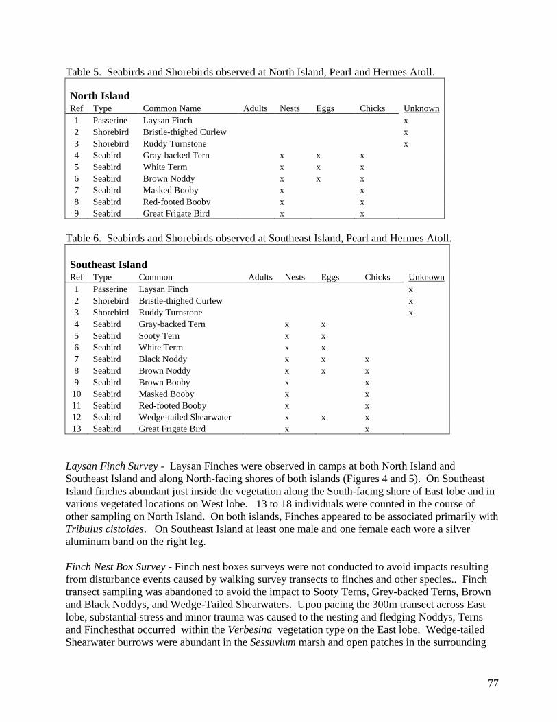
77
Table 5. Seabirds and Shorebirds observed at North Island, Pearl and Hermes Atoll.
North Island
Ref Type Common Name Adults Nests Eggs Chicks Unknown
1 Passerine Laysan Finch x
2 Shorebird Bristle-thighed Curlew x
3 Shorebird Ruddy Turnstone x
4 Seabird Gray-backed Tern x x x
5 Seabird White Term x x x
6 Seabird Brown Noddy x x x
7 Seabird Masked Booby x x
8 Seabird Red-footed Booby x x
9 Seabird Great Frigate Bird x x
Table 6. Seabirds and Shorebirds observed at Southeast Island, Pearl and Hermes Atoll.
Southeast Island
Ref Type Common Adults Nests Eggs Chicks Unknown
1 Passerine Laysan Finch x
2 Shorebird Bristle-thighed Curlew x
3 Shorebird Ruddy Turnstone x
4 Seabird Gray-backed Tern x x
5 Seabird Sooty Tern x x
6 Seabird White Term x x
7 Seabird Black Noddy x x x
8 Seabird Brown Noddy x x x
9 Seabird Brown Booby x x
10 Seabird Masked Booby x x
11 Seabird Red-footed Booby x x
12 Seabird Wedge-tailed Shearwater x x x
13 Seabird Great Frigate Bird x x
Laysan Finch Survey - Laysan Finches were observed in camps at both North Island and
Southeast Island and along North-facing shores of both islands (Figures 4 and 5). On Southeast
Island finches abundant just inside the vegetation along the South-facing shore of East lobe and in
various vegetated locations on West lobe. 13 to 18 individuals were counted in the course of
other sampling on North Island. On both islands, Finches appeared to be associated primarily with
Tribulus cistoides. On Southeast Island at least one male and one female each wore a silver
aluminum band on the right leg.
Finch Nest Box Survey - Finch nest boxes surveys were not conducted to avoid impacts resulting
from disturbance events caused by walking survey transects to finches and other species.. Finch
transect sampling was abandoned to avoid the impact to Sooty Terns, Grey-backed Terns, Brown
and Black Noddys, and Wedge-Tailed Shearwaters. Upon pacing the 300m transect across East
lobe, substantial stress and minor trauma was caused to the nesting and fledging Noddys, Terns
and Finchesthat occurred within the Verbesina vegetation type on the East lobe. Wedge-tailed
Shearwater burrows were abundant in the Sessuvium marsh and open patches in the surrounding
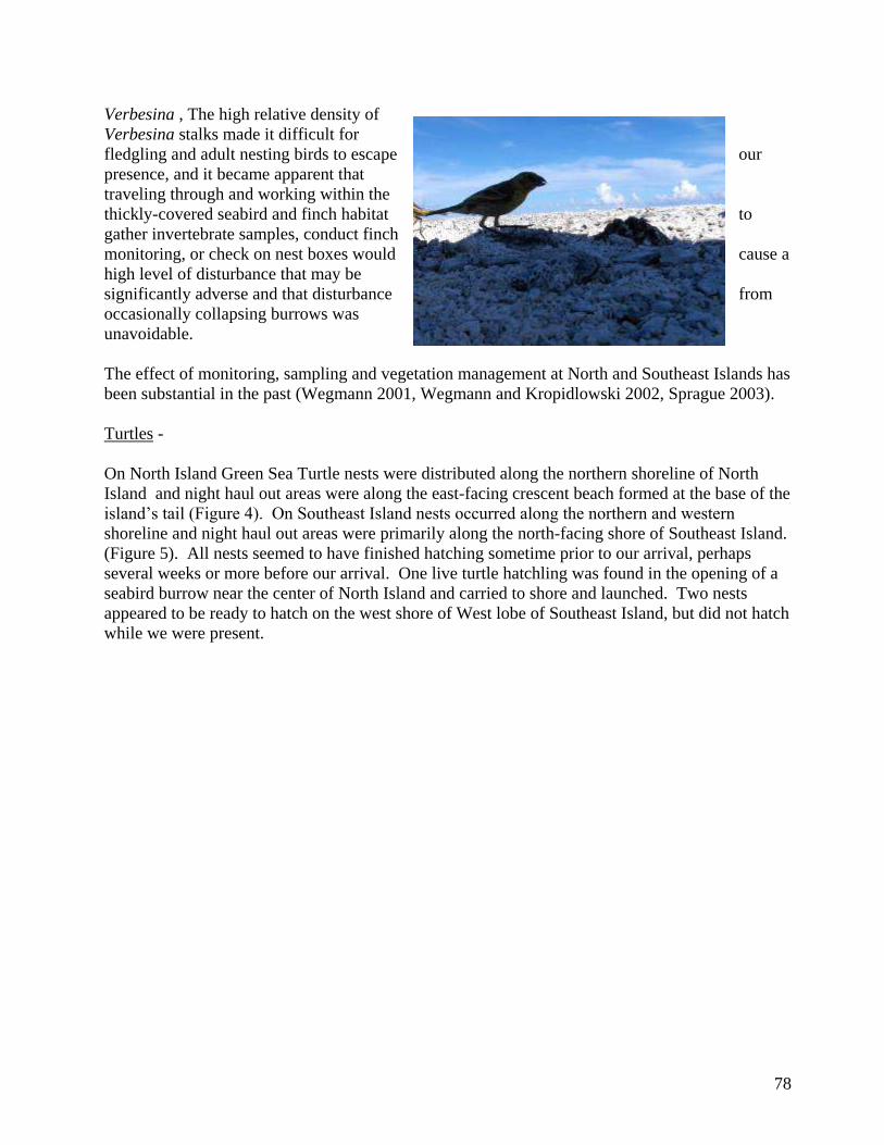
78
Verbesina , The high relative density of
Verbesina stalks made it difficult for
fledgling and adult nesting birds to escape our
presence, and it became apparent that
traveling through and working within the
thickly-covered seabird and finch habitat to
gather invertebrate samples, conduct finch
monitoring, or check on nest boxes would cause a
high level of disturbance that may be
significantly adverse and that disturbance from
occasionally collapsing burrows was
unavoidable.
The effect of monitoring, sampling and vegetation management at North and Southeast Islands has
been substantial in the past (Wegmann 2001, Wegmann and Kropidlowski 2002, Sprague 2003).
Turtles -
On North Island Green Sea Turtle nests were distributed along the northern shoreline of North
Island and night haul out areas were along the east-facing crescent beach formed at the base of the
island‟s tail (Figure 4). On Southeast Island nests occurred along the northern and western
shoreline and night haul out areas were primarily along the north-facing shore of Southeast Island.
(Figure 5). All nests seemed to have finished hatching sometime prior to our arrival, perhaps
several weeks or more before our arrival. One live turtle hatchling was found in the opening of a
seabird burrow near the center of North Island and carried to shore and launched. Two nests
appeared to be ready to hatch on the west shore of West lobe of Southeast Island, but did not hatch
while we were present.
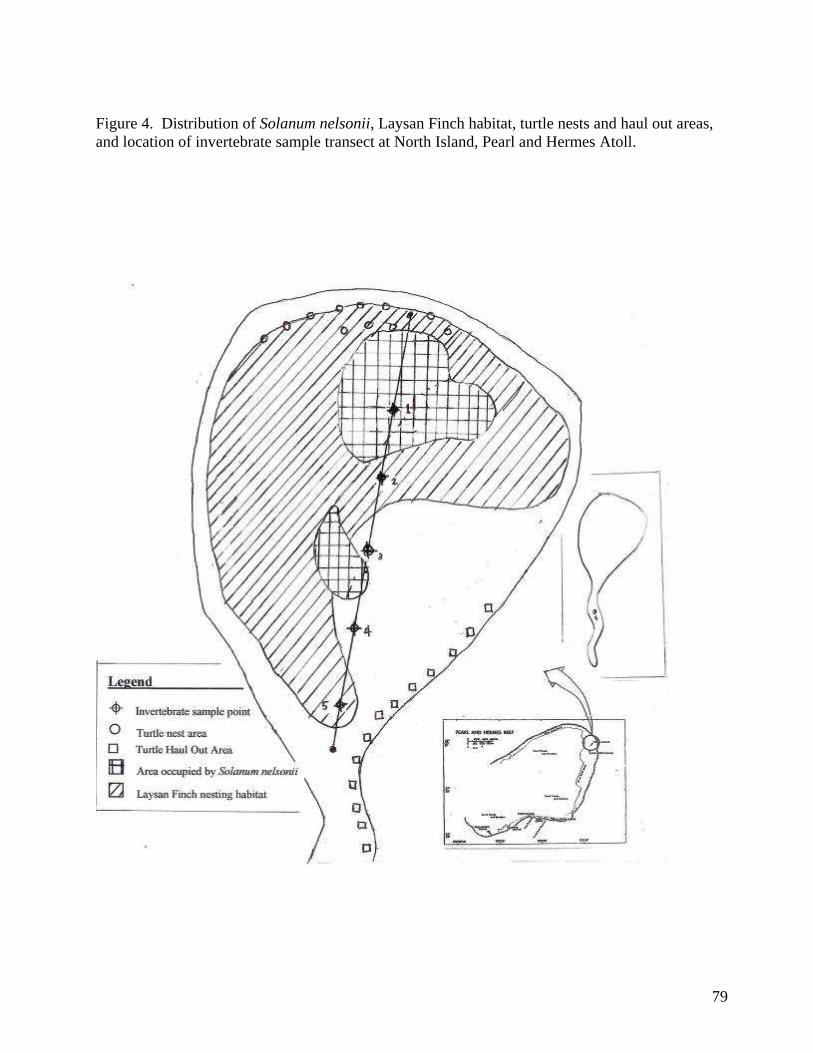
79
Figure 4. Distribution of Solanum nelsonii, Laysan Finch habitat, turtle nests and haul out areas,
and location of invertebrate sample transect at North Island, Pearl and Hermes Atoll.
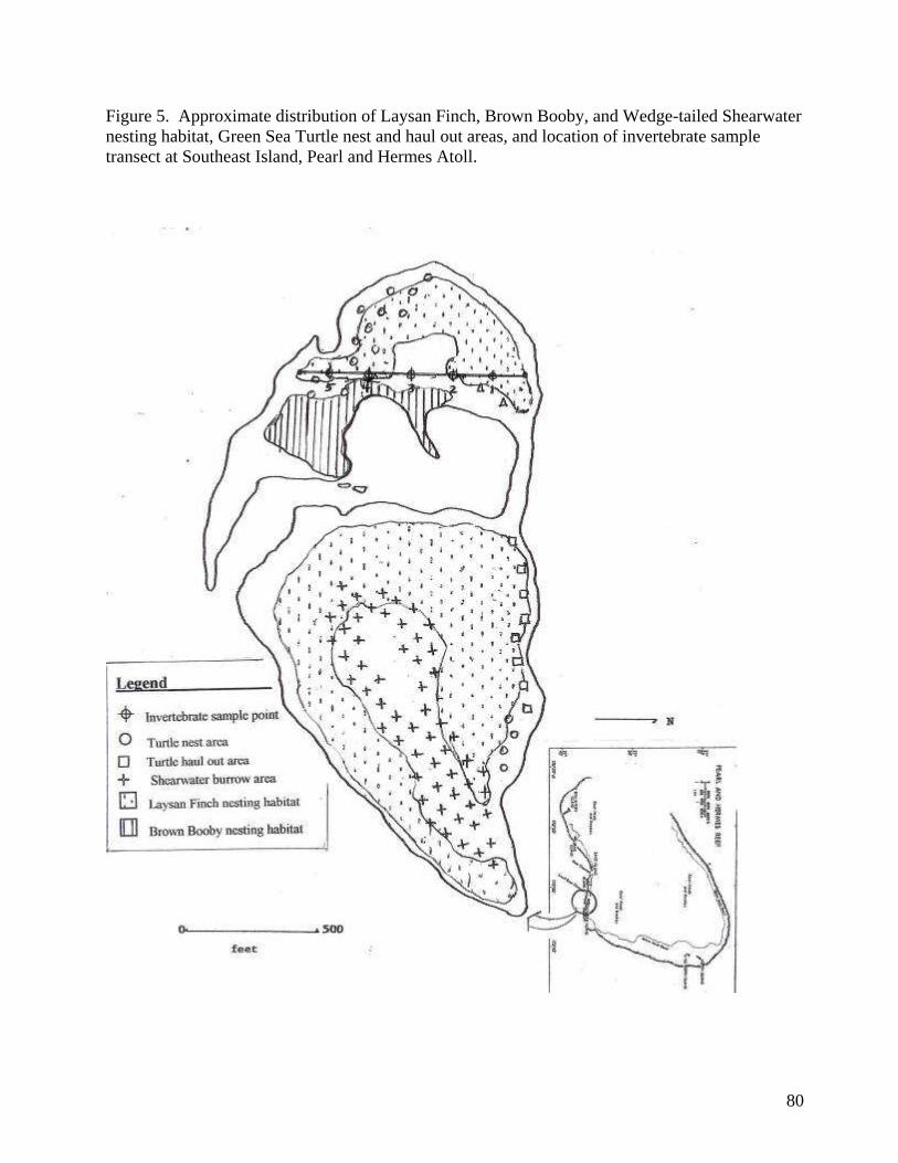
80
Figure 5. Approximate distribution of Laysan Finch, Brown Booby, and Wedge-tailed Shearwater
nesting habitat, Green Sea Turtle nest and haul out areas, and location of invertebrate sample
transect at Southeast Island, Pearl and Hermes Atoll.

81
8. References
Sprague, J.C. 2003. Alien Species Control Plan and Biological Assessment at Pearl and Hermes
Reef, Northwest Hawaiian Islands (19 May to 4 August). Administrative Report U.S. Fish and
Wildlife Service, Honolulu, Hawai„i.
Wegmann, A. and S.J. Kropidlowski. 2002. Alien Species Control Plan and Biological
Assessment at Pearl and Hermes Reef, Northwestern Hawaiian Islands (24 March to 15 May,
2002). Administrative Report – U.S. Fish and Wildlife Service, Honolulu, Hawai„i.
Wegmann, A.S. 2001. Alien Species Control Plan and Biological Assessment at Pearl and
Hermes Reef, Northwest Hawaiian Islands (19 May to 21 July). Administrative Report U.S. Fish
and Wildlife Service, Honolulu, Hawai„i.
Unknown report. Unknown date. Figures 34 and 44, Vegetation Maps of North Island and
Southeast Island, March 1965. Redrawn from PSBSP map by W.O. Wirtz, II.
82
ANNEX 5. PACIFIC REMOTE ISLANDS NATIONAL WILDLIFE REFUGE COMPLEX,
SPECIAL CONDITIONS & RULES FOR MOVING BETWEEN ISLANDS &
ATOLLSANDPACKING FOR FIELD CAMPS
July 2001
The islands and atolls of the Pacific Remote Islands National Wildlife Refuge Complex are special
places providing habitat for many rare, endemic plants and animals. Many of these species are
formally listed as Endangered under the Endangered Species Act. Endemic plants and insects, and
the predators they support, are especially vulnerable to the introduction of competing or
consuming species. Such introductions may cause the extinction of island endemics, or even the
destruction of entire island ecological communities. Notable local examples include: the
introduction of rabbits to Laysan Island in 1902 which caused the extinction of numerous plant
and insect species, and 3 endemic landbird species; the introduction of rats to many Pacific Islands
causing the elimination of many burrowing seabird colonies; the introduction of the annual grass,
sandbur, to Laysan Island where it has crowded out native bunch grass thus, eliminating nesting
habitat for the Endangered Laysan finch; and, the introduction and proliferation of numerous ant
species throughout the Pacific Islands to the widespread detriment of endemic plant and insect
species.
Several of the islands within the Refuge Complex are especially pristine, and as a result are rich in
rare and special plants and animals. Nihoa Island has 13 potential candidate Endangered insect
species, numerous Endangered plants and 2 Endangered birds. Necker Island has Endangered
plants and 7 endemic insects that are candidates for the Endangered Species List. Laysan Island
has Endangered plants, 5 potential candidate Endangered insect species and the Endangered
Laysan finch and Laysan duck. Other islands in the Refuge Complex such as Lisianski, Howland,
Baker, and Jarvis and islets in Atolls such as Rose, Pearl and Hermes Reef and French Frigate
Shoals provide homes for a variety of endemic and endangered species and require special
protection from alien species.
Other Pacific Island such as Kure and the Ahigh islands@ (Oahu, Hawaii, Maui, Kauai, etc.) as well
as, certain islands within Midway Atoll, Pearl and Hermes Reef and French Frigate Shoals have
plants and animals that are of high risk for introduction to the relatively pristine islands discussed
above. Of special concerns are snakes, rats, ants and a variety of other insect and plant species.
Harmful plant species of highest concern that we know of are Verbesina encelioides, Cenchrus
echinatus, and Setaria verticillata.
83
The U. S. Fish and Wildlife Service is responsible for the management and protection of the
islands and wildlife of the Pacific Remote Islands NWR Complex. No one is permitted to set foot
on any of the Refuge's islands without the express permission of the Refuge Manager and an
appropriate Special Use Permit. Because of the above concerns, the following restrictions on the
movement of personnel and materials to the islands of the Refuge Complex exist. Note: Kure
Island and Midway Atoll are not part of this Refuge Complex.
With the exception of Tern Island. French Frigate Shoals, the following rules apply:
Clothing and Soft Gear:
1. Any personnel landing boats at any island should have clean clothes and shoes.
2. Any personnel going ashore at any island and moving inshore from the immediate area in
which waves are breaking at the time of landing must have new footwear, new or island
specific clothes and new or island specific soft gear. All must be frozen for at least 48
hours prior to landing.
3. At the discretion of the local USFWS representative, personnel from the NOAA ship R/V
Townsend Cromwell, or any other vessel servicing the Refuge, may be allowed on shore to
visit predesignated areas for guided tours. For such tours, personnel must have new
footwear, clean clothes and clean soft gear all frozen for at least 48 hours prior to landing.
4. Otherwise, any personnel entering any vegetated area, regardless of how sparse the
vegetation, must have new footwear, new clothes and new soft gear all frozen for at least
48 hours prior to landing.
Definitions:
"New" means off the shelf and never used anywhere but the island in question.
"Clothing" is all apparel, shoes, and socks, over and under garments.
"Soft gear" is all gear such as daypacks, fanny packs, packing foam or similar material, camera
bags, camera/binocular straps, microphone covers, nets, holding or weighing bags, bedding, tents,
luggage, or any fabric or material capable of harboring seeds or insects.
Clothing or gear coming off Kure and Midway should never be moved to any of the other
refuge islands:
During transit, clothing and gear coming off Kure and Midway must be carefully
sequestered to avoid contamination of gear bound for cleaner islands. Special care must be
taken to avoid contaminating gear storage areas and quarters aboard transporting vessels
with seeds or insects from these islands.
General Rules:
1. Regardless of origin or destination, inspect and clean all equipment, supplies, etc., just
prior to any trip to the Refuge. Carefully clean all clothing, footwear and soft gear following use to
minimize risk of cross contamination of materials between islands.
84
2. Pack supplies in plastic buckets with fitted lids or other salable metal or plastic containers
since they can be thoroughly cleaned inside and out. Cardboard is not permitted on islands.
Cardboard boxes disintegrate in a short time and harbor seeds, animals, etc., which cannot be
easily found or removed. Wood is not permitted unless sealed on all surfaces.
Wooden boxes can also harbor insects and seeds and therefore are only allowed if well
constructed (tight fitting seams are required). All wood must be treated, and inside and
outside surfaces must be painted or varnished to provide a smooth, cleanable finish that
seals all holes.
3. Freeze or tarp and fumigate then seal all equipment (clothes, books, tents, everything) just
prior to departure. Food and cooking items need not be fumigated but should be cleaned and
frozen, if freezable. Cameras, binoculars, radios, and other electronic equipment must be
thoroughly cleaned, including internal inspection whenever possible, but do not need to be frozen
or fumigated. Such equipment can only be packed in wooden crates if treated as in #2 above. Any
containers must contain new, clean packing materials and be frozen or fumigated.
4. At present, Tern Island is the singular exception to the above rule, having less stringent
rules due to the large number of previously established alien species. Careful inspection of all
materials and containers is still required. However, it is acceptable to use wooden and cardboard
containers for transporting supplies to Tem Island. Also, there is no requirement for freezing or
fumigating items disembarked at Tem. Although requirements for Tem Island are more lax, the
Refuge is still concerned about the possibilities of new introductions. Do not wear clothing to
Tern Island that has been worn at Pearl and Hermes, Midway Atoll or Kure Atoll.
Additional Special Conditions for Travel to Nihoa Island:
Nihoa is one of the most pristine locations in the Refuge Complex. It is also home to the highest
number of federally listed endangered species in the Refuge. It is a small rugged island with many
inaccessible areas. Introduction of any alien species could have disastrous results in a very short
time. It would be almost impossible to mount any kind of control or eradication program on this
island should an alien species become established. Because of these reasons, access to Nihoa is
strictly limited, and rules governing entry are more stringent.
Access to Nihoa by permittees will only be allowed under the accompaniment and supervision of a
Refuge Representative. The representative, who shall be appointed by the Refuge Manager, will
work with permittees to assure careful compliance with all rules for inspection, handling and
preparation of equipment. The Refuge Representative will have the authority to control and limit
access to various parts of the island to protect animals, plants and archaeological sites, especially
endangered species. The Refuge Representative will have the authority to disallow access to the
island, or order an immediate departure from the island if conditions for working on the island
aren't met or are violated in some way.
All field equipment made out of fabric material or wood must be new, and never previously used
in the Northwestern or main Hawaiian Islands. Equipment previously purchased or made for use
on Nihoa that has been carefully sealed and stored while away from Nihoa, and not used
85
elsewhere, may also be brought onto the island. Rules for freezing and/or fumigating are as
described for other sites in the Refuge (see above).
Clothing and personal effects must be new or never used anywhere else but at Nihoa. All footwear
(shoes, slippers, socks, etc.) must be new, unused, or previously only used on Nihoa and carefully
sealed and stored while off of the island.
Additional Special Conditions for Travel Within Pearl and Hermes Atoll:
In recent years Verbesina encelioides has been introduced to Southeast Island within Pearl and
Hermes Atoll. This noxious weed has taken over a large portion of the island. To prevent the
further spread of this weed to the other islets within this atoll the following precaution must be
taken:
If when visiting Pearl and Hermes Atoll, personnel travel to any other islet other than Southeast
Island, a new pair of shoes and socks must be worn. In other words you must have a new pair of
shoes and socks for Southeast Island and one other pair of new shoes and socks that can be worn
around to the other islets within the atoll. Do not wear the outer islet shoes and socks on
Southeast Island. All other clothing and gear must be carefully inspected before going from
Southeast Island to any other islet in the atoll.
Rules Regarding Food:
Fresh foods that are typically transported to island field camps (potatoes, onions, cabbage, apples,
oranges, etc.) are not likely to become established and flourish on the Refuge Complex and are
allowed. However, other food items such as tomatoes could easily become established. Soil can
contain many seeds, eggs, larvae, etc., and cannot be transported to or between islands. Leafy or
stalk vegetables may carry scale insects so are forbidden also
Other food species such as alfalfa, mustard and cress, commonly used for sprouted greens, could
potentially become established and cannot be brought to the islands. Other species such as mung
beans, soy beans and radishes would not likely survive on the islands and can be used for fresh
greens. A list of fresh foods and seeds that are prohibited is provided below. Permittees should
contact the Refuge Manager for more information, or for questions about items not included on
this list.
Strictly Prohibited:
Tomatoes (any variety), ray sunflower seeds, alfalfa seeds, mustard seeds.
Bulk dried fruits are allowed but should be frozen solid for at least one day to kill any insects.

86
Attachment 1, Invertebrate Taxa collected at North and Southeast Islands, September 2005.
(To be provided following sample identification.)

87
APPENDIX B. CONSENT DECREE
88
89
90
91
92
93
94
95
96
97
98
99

100
101
102
103

104
105
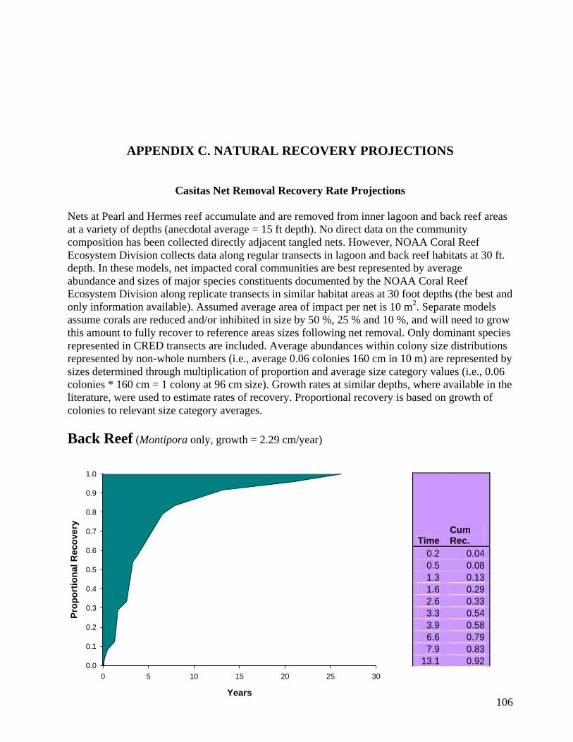
106
APPENDIX C. NATURAL RECOVERY PROJECTIONS
Casitas Net Removal Recovery Rate Projections
Nets at Pearl and Hermes reef accumulate and are removed from inner lagoon and back reef areas
at a variety of depths (anecdotal average = 15 ft depth). No direct data on the community
composition has been collected directly adjacent tangled nets. However, NOAA Coral Reef
Ecosystem Division collects data along regular transects in lagoon and back reef habitats at 30 ft.
depth. In these models, net impacted coral communities are best represented by average
abundance and sizes of major species constituents documented by the NOAA Coral Reef
Ecosystem Division along replicate transects in similar habitat areas at 30 foot depths (the best and
only information available). Assumed average area of impact per net is 10 m2. Separate models
assume corals are reduced and/or inhibited in size by 50 %, 25 % and 10 %, and will need to grow
this amount to fully recover to reference areas sizes following net removal. Only dominant species
represented in CRED transects are included. Average abundances within colony size distributions
represented by non-whole numbers (i.e., average 0.06 colonies 160 cm in 10 m) are represented by
sizes determined through multiplication of proportion and average size category values (i.e., 0.06
colonies * 160 cm = 1 colony at 96 cm size). Growth rates at similar depths, where available in the
literature, were used to estimate rates of recovery. Proportional recovery is based on growth of
colonies to relevant size category averages.
Back Reef (Montipora only, growth = 2.29 cm/year)
Time Cum Rec.
0.2 0.04
0.5 0.08
1.3 0.13
1.6 0.29
2.6 0.33
3.3 0.54
3.9 0.58
6.6 0.79
7.9 0.83
13.1 0.92
Years
0 5 10 15 20 25 30
Pro
po
rtio
nal R
eco
very
0.0
0.1
0.2
0.3
0.4
0.5
0.6
0.7
0.8
0.9
1.0
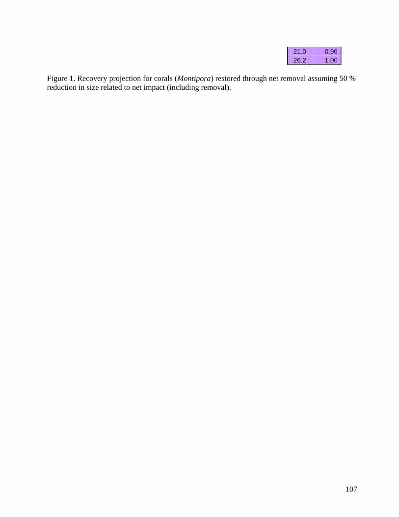
107
21.0 0.96
26.2 1.00
Figure 1. Recovery projection for corals (Montipora) restored through net removal assuming 50 %
reduction in size related to net impact (including removal).
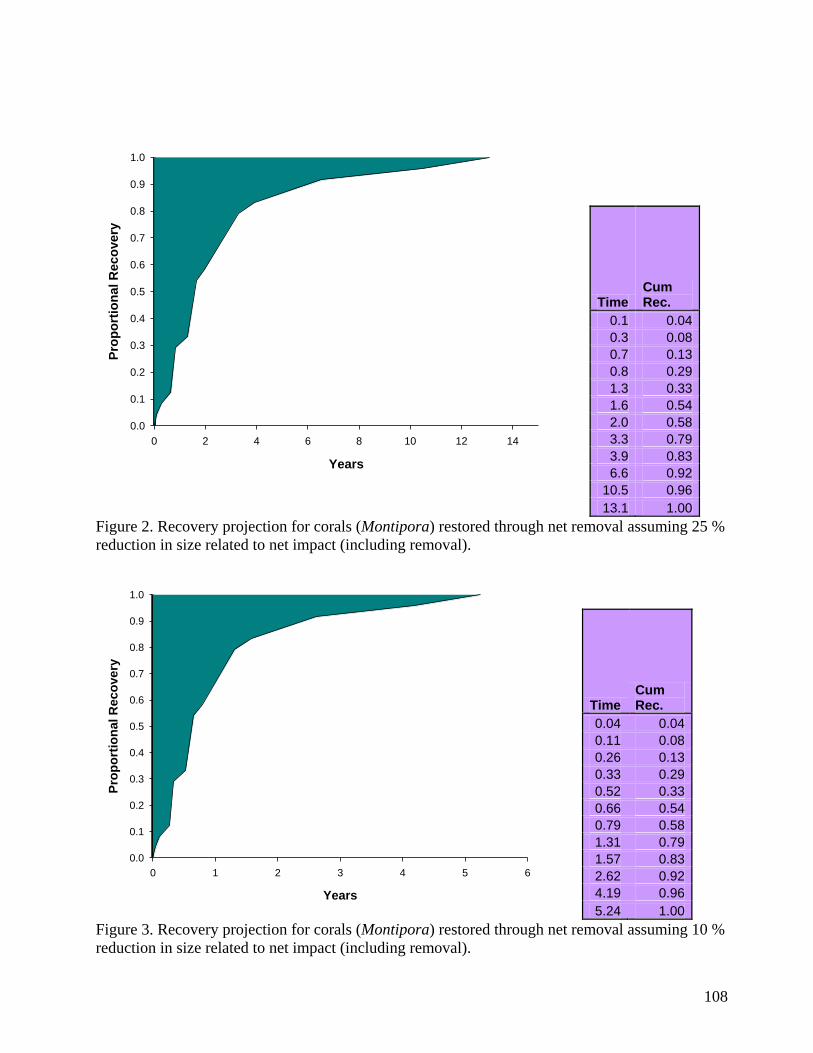
108
Time Cum Rec.
0.1 0.04
0.3 0.08
0.7 0.13
0.8 0.29
1.3 0.33
1.6 0.54
2.0 0.58
3.3 0.79
3.9 0.83
6.6 0.92
10.5 0.96
13.1 1.00
Figure 2. Recovery projection for corals (Montipora) restored through net removal assuming 25 %
reduction in size related to net impact (including removal).
Time Cum Rec.
0.04 0.04
0.11 0.08
0.26 0.13
0.33 0.29
0.52 0.33
0.66 0.54
0.79 0.58
1.31 0.79
1.57 0.83
2.62 0.92
4.19 0.96
5.24 1.00
Figure 3. Recovery projection for corals (Montipora) restored through net removal assuming 10 %
reduction in size related to net impact (including removal).
Years
0 2 4 6 8 10 12 14
Pro
po
rtio
na
l R
ec
ove
ry
0.0
0.1
0.2
0.3
0.4
0.5
0.6
0.7
0.8
0.9
1.0
Years
0 1 2 3 4 5 6
Pro
po
rtio
na
l R
ec
ove
ry
0.0
0.1
0.2
0.3
0.4
0.5
0.6
0.7
0.8
0.9
1.0

109
Lagoon (Montipora capitata growth rate = 2.29 cm/yr, Porites compressa growth rate = 4.1
cm/yr, and P. lobata growth rate = 2.26 cm/yr)
Time Cum Rec.
0.16 0.05
0.22 0.09
0.30 0.18
0.33 0.23
0.55 0.27
0.69 0.32
1.64 0.50
1.83 0.73
3.66 0.86
5.85 0.91
11.71 0.95
15.61 1.00
Figure 4. Recovery projection for corals (Montipora, Porites compressa, P. lobata) restored
through net removal assuming 50 % reduction in size related to net impact (including removal).
Time Cum Rec.
0.08 0.05
0.11 0.09
0.15 0.18
0.16 0.23
0.27 0.27
0.34 0.32
0.82 0.50
0.91 0.73
1.83 0.86
2.93 0.91
5.85 0.95
7.80 1.00
Figure 5. Recovery projection for corals (Montipora, Porites compressa, P. lobata) restored
through net removal assuming 25 % reduction in size related to net impact (including removal).
Years
0 2 4 6 8 10 12 14 16
Pro
po
rtio
nal R
eco
very
0.0
0.1
0.2
0.3
0.4
0.5
0.6
0.7
0.8
0.9
1.0
Years
0 1 2 3 4 5 6 7 8
Pro
po
rtio
na
l R
ec
ove
ry
0.0
0.1
0.2
0.3
0.4
0.5
0.6
0.7
0.8
0.9
1.0
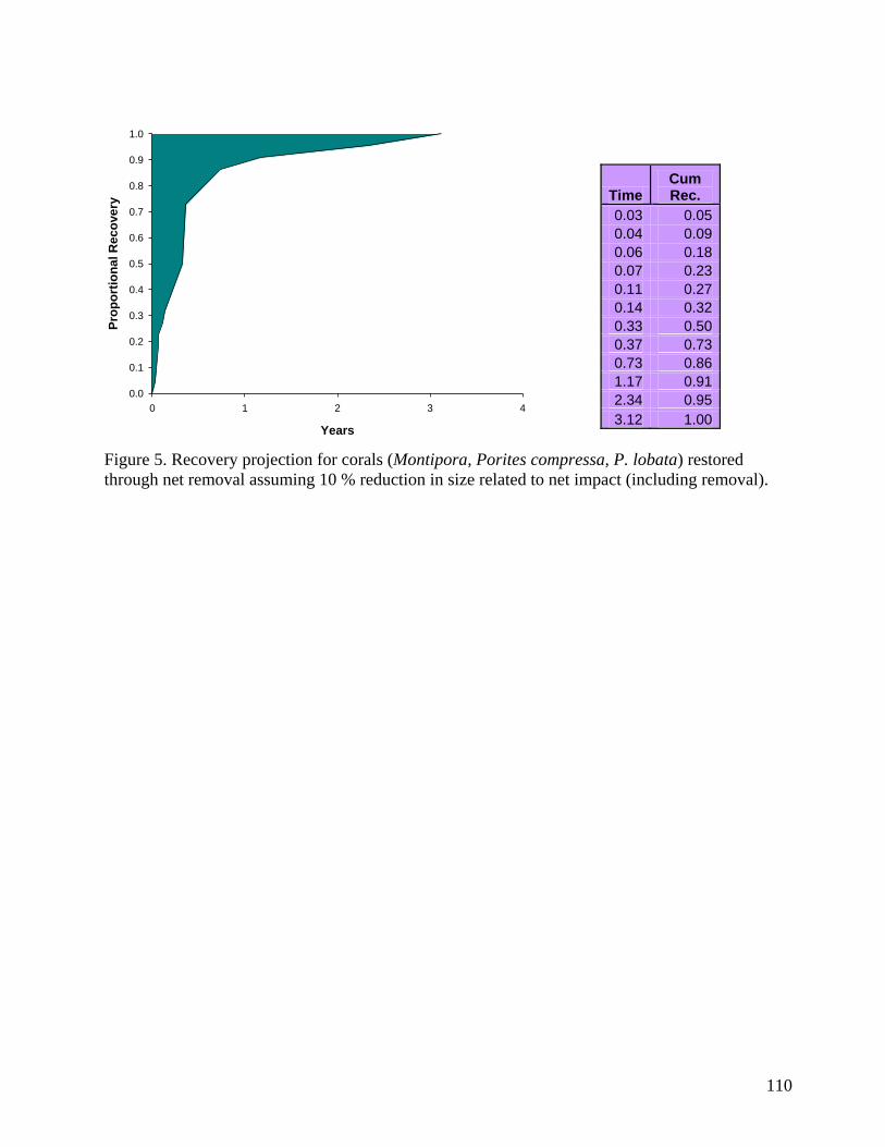
110
Time Cum Rec.
0.03 0.05
0.04 0.09
0.06 0.18
0.07 0.23
0.11 0.27
0.14 0.32
0.33 0.50
0.37 0.73
0.73 0.86
1.17 0.91
2.34 0.95
3.12 1.00
Figure 5. Recovery projection for corals (Montipora, Porites compressa, P. lobata) restored
through net removal assuming 10 % reduction in size related to net impact (including removal).
Years
0 1 2 3 4
Pro
po
rtio
na
l R
ec
ove
ry
0.0
0.1
0.2
0.3
0.4
0.5
0.6
0.7
0.8
0.9
1.0
111
APPENDIX D: LIST OF CONTRIBUTORS
Preparers, agencies, and persons consulted.
National Oceanic and Atmospheric Administration
Matthew Parry, Restoration Center, Honolulu, HI
Patrick Rutten, Restoration Center, Santa Rosa, CA
Christopher Plaisted, Office of General Council, Long Beach, CA
Gerry Davis, Pacific Islands Regional Office, Honolulu, HI
Alan Everson, Pacific Islands Regional Office, Honolulu, HI
Doug Helton, National Ocean Service, Seattle, WA
Steve Kolinski, Pacific Islands Regional Office, Honolulu, HI
Aulani Wilhelm, National Ocean Service, Honolulu, HI
Scott Godwin, National Ocean Service, Honolulu, HI
Hokuala Johnson, National Ocean Service, Honolulu, HI
Julie Whitaker, Pacific Islands Fisheries Science Center, Honolulu, HI
Kyle Koyanagi, Pacific Islands Fisheries Science Center, Honolulu, HI
Kevin Wong, Pacific Islands Fisheries Science Center, Honolulu, HI
Kris McElwee, National Ocean Service, Honolulu, HI
U.S. Department of the Interior
Susan White, U.S. Fish and Wildlife Service, Honolulu, HI
LeeAnn Woodward, U.S. Fish and Wildlife Service, Honolulu, HI
Charles McKinley, U.S. Fish and Wildlife Service, Oakland, CA
Karen Marlowe, U.S. Fish and Wildlife Service, Honolulu, HI
James Haas, U.S. Fish and Wildlife Service, Sacramento, CA
Arlene Pangelinan, U.S. Fish and Wildlife Service, Honolulu, HI
Kevin Foster, U.S. Fish and Wildlife Service, Honolulu, HI
Jeff Philips, U.S. Fish and Wildlife Service, Honolulu, HI
State of Hawaii Department of Land and Natural Resources
Dan Polhemus, Division of Aquatic Resources, Honolulu, HI
Francis Oishi, Division of Aquatic Resources, Honolulu, HI
Kathy Ho, Office of Attorney General, Honolulu, HI
Tony Montgomery, Division of Aquatic Resources, Honolulu, HI
Ivor Williams, Division of Aquatic Resources, Honolulu, HI
Additional Contributors
Steve O‟Rourke, Department of Justice, Washington, D.C.
Greg Challenger, Polaris Applied Sciences Inc., Seattle, WA
Andrew Graham, Polaris Applied Sciences Inc., Seattle, WA