fifteenth street and riverside & ontario … · riverside & ontario avenues draft report...
TRANSCRIPT
FIFTEENTH STREET ANDRIVERSIDE & ONTARIO AVENUESDRAFT REPORTForRESIDENTIAL DEVELOPMENT PLANForMILDURA RURAL CITY COUNCIL
August 2006
FREEMAN & FREEMANLAND SURVEYORSMILDURA.
CONTENTS:
Section 1: IntroductionSection 2: Context of the SiteSection 3: On Site Issues and CharacteristicsSection 4: Engineering ConstraintsSection 5: The Concept - Vision PlanSection 6: The Concept – Indicative Components
Appendix 1: Summary of Consultation Feedback
MRCC DEVELOPMENT PLAN (FIFTEENTH ST AND RIVERSIDE & ONTARIO AVE’S) PAGE 2 OF 31
SECTION 1: INTRODUCTION
Draft Report – Fifteenth Street andRiverside & Ontario AvenuesResidential Development Plan
This report outlines the draft residential development plan for thegreenfield site of approximately 16 hectares of residential zoned landbounded by Fifteenth Street (which abuts the south-west boundary of thesite) and Riverside & Ontario Avenues. The aim of the plan is to identifythe characteristics of the site and its surrounds and to put in place aframework for the future residential development of the land that willensure good quality subdivision/development at an affordable price. Theconcept and themes adopted by the new Development Plan prepared byconsultants David Lock Associates and GHD, for the Etiwanda, Irymple,Riverside and Nichols Point areas, have been included in this plan (withthe permission and support of the MRCC and the consultants) in order tomaintain consistency of standard and to ensure that future residents willenjoy living in the area and that the development of the area is in keepingwith the existing environment. However; this report recognizes that partsof the subject area/land may not be as high quality as the four above-mentioned areas and, as such, the density of proposed lots may be greater(i.e. smaller lot sizes) to cater for more affordable land and housedemands. Regardless of this, the vision still achieves a design that willensure future residents will live in a neighbourhood that is accessible,pleasant, attractive and stimulating and that will foster social engagement.This was achieved by consultation with Land Owners, Developers,Servicing Authorities and Council Officers/Departments.
The process adopted in the study has four principal stages. They areunderstanding the context of the site (Section 2), understanding the mainsite issues and characteristics (Section 3), understanding theengineering/servicing constraints (Section 4) and identifying a vision(framework for future development) for the site.
The Context of the Site (Section 2) identifies the relationship between theparcels in separate ownership (that form the site) and relationship of thesite as a whole with the surrounding area and with the wider MilduraCommunity (and its facilities and services.)
MRCC DEVELOPMENT PLAN (FIFTEENTH ST AND RIVERSIDE & ONTARIO AVE’S) PAGE 3 OF 31
The Issues and Characteristics (Section 3) identifies factors thought to beimportant by the parties who were consulted and by the Consultantsthemselves.
The Engineering/Servicing Constraints (Section 4) relates mainly todrainage, sewerage, salinity and road network matters.
The Concepts (Section 5 & 6) relate to firstly the road and open spacelayout and secondly the characteristics of different types of roads and openspace. The first part (Section 5) was achieved by going through a processof preparing subdivision layout concept plans (which took into account theresults of Section 2, 3 & 4) for comment from the landowners, the Counciland Lower Murray Water. The four separate landowners consist of longtime owners who intend to subdivide/develop their land, a recentpurchaser who intends immediate subdivision and long time owners whointend to sell to developers. Preparation of subdivision layout conceptplans was possible due the relatively small area involved and provided thelandowners with an idea of what could actually be achieved and giveCouncil and Lower Murray Water an idea of what was likely to beproposed in the future. The second part (Section 6) is extracted directfrom the new Development Plan prepared by David Lock Associates andGHD, with theirs and Councils support and consent, to ensure a consistenthigh standard of future subdivision in the Municipality. Section 7 (TheConcepts – Design Guidelines) part of the new Development Plan byDavid Lock Associates and GHD has not been incorporated into this plan.Developments of a high standard should always be encouraged and Urbandesign Guidelines should be promoted, but the achievement of a highstandard subdivision by this Development Plan should ensure that futurehousing (which can occur without reference to this plan) will be of a highstandard as well as being affordable.
This Draft Report is provided to Council for comment and discussion,prior to provision of the Final Report (for exhibition).
MRCC DEVELOPMENT PLAN (FIFTEENTH ST AND RIVERSIDE & ONTARIO AVE’S) PAGE 4 OF 31

Neighbourhood principles
Given its relatively small area, the subject site will not be creating a newneighbourhood. Rather it will be part of an existing neighbourhood.However the detailed design of this compact site, in order to have apositive impact on the neighbourhood, is envisaged to reflect the StatesNew Sustainable Neighbourhoods planning provisions, including thestandards set in Clause 56 of the Planning Scheme, which can besummarized as:
Compact walkable neighbourhoods where neighbourhood Centressupport local services and facilities. Reduced car use is encouragedbecause public transport is easy to use and walking and cycling arepromoted.
Environmentally friendly development where lot layout and designsupports more energy efficient dwellings.
Diverse lot sizes and a range of lot types will be provided to bettermeet future community housing needs.
Integrated water management that conserves our drinking water andlocally manages the quality of urban run-off.
Socially responsible development that is connected, overlooked andcontributes to safety and perceptions of safely.
Detailed Design Principles
These neighbourhood principles will be implemented through applicationof detailed design principles:
Provide an attractive sense of arrival at each entrance to the site and toeach character precinct, through the use of water and landscape.
Articulate decision points in the movement network through the use ofattractive and distinctive built form and landscape.
MRCC DEVELOPMENT PLAN (FIFTEENTH ST AND RIVERSIDE & ONTARIO AVE’S) PAGE 5 OF 31
Provide a permeable movement network for pedestrians and cyclists.
Ensure that all streets and parks are overlooked by houses, to enhancetheir safety for pedestrians and cyclists.
Promote traffic speeds and behaviour appropriate to a residentialenvironment through the design of local streets and appropriate trafficcalming measures.
Ensure that the swales and overland flow paths are attractive spaceseven when dry.
Align secondary streets and lots to maximize the potential solar access.
Key Features
The vision plan incorporated into this report applies these principalsthroughout the design. However there are some key features that areparticularly important to achieving the vision. These relate to:
Responding to Existing Characteristics
The unique 45 degree grid layout of Mildura provides a challenge andopportunity to respond creatively. This arrangement is sub-optimal forsolar access which is an important consideration given is represents themost abundant source of “free” energy to manage comfort within thehouse. Making best use of this resource requires lots which can facilitatedevelopment which can have their longside facing north.
The vision plan seeks to ensure desire lines are catered for, encouragingwalking and cycling a relatively more attractive way of getting around forshorter journeys. Routes are designed to link up key destinations and siteassets with primary movement routes to provide for direct and logicalmovement through the site.
The road alignment is designed to respect drainage lines and use thenatural fall of the land to provide an ecologically sustainable stormwatermanagement system.
MRCC DEVELOPMENT PLAN (FIFTEENTH ST AND RIVERSIDE & ONTARIO AVE’S) PAGE 6 OF 31
The roads and open spaces are designed to retain healthy trees and usesthem as a generator of local identity. They introduce new qualities in partsof the site with little intrinsic quality.
The Concepts incorporate variations in density to respond to existingdevelopment beyond the site. Due to the nature of the site, in comparisonwith nearby developed land, it is anticipated that much of the site will bebest suited to the development of more affordable housing on smaller lots.
The Road layout and construction design will be in keeping with bestpractice water sensitive urban design (WSUD) and as reflected in Councilsnew Water Sensitive Urban Design Guidelines (by Parsons Brinckerhoff)and the new Clause 56. The impact of stormwater is reduced byincorporating WSUD to protect and enhance natural water systems and tointegrate stormwater management into the landscape. The proposed openspace will contribute significantly to the area’s character and provide apark within a comfortable walking distance of anywhere in the study area,and promote walking and cycling.
The location of the proposed Avenue/Boulevard and the connecting roadfrom Fifteenth Street will ensure Secondary streets/courts are alignedwhere possible to provide a direct visual link to the POS and ensure thatswale drains can be used to filter stormwater run-off and mitigate peakflows. The design of secondary streets and adjoining built form andlandscape will provide a clear expression of the street hierarchy, whichwill help make the neighbourhood more legible and less homogenous.
In residential 1 zoned land where the smaller lots make getting good solaraccess issues more of a challenge, most streets will be generally orientatednorth-south to ensure the long side of most lots face north to facilitategood solar access.
Intersections will be designed to avoid conflict and ensure there is noambiguity as to priority.
MRCC DEVELOPMENT PLAN (FIFTEENTH ST AND RIVERSIDE & ONTARIO AVE’S) PAGE 7 OF 31

Neighbourhood focal point
A development node around a village green containing play, recreationand social infrastructure around a distinctive and striking landscapefeature, is located at the junctions of the primary movement networks and(where possible) the drainage line to:
- Create a neighbourhood focal point
- Reinforce the clarity of the overall urban structure
- Create a more visually interesting experience as one moves throughthe new neighbourhood.
- Generate local identity on a walkable neighbourhood scale –reflecting the characteristic density gradients of regional city in arural environment.
-
Developing character areas
Landscaping, road layout, lot layout and lot sizes are all used to create arange of different character areas. This will enhance the visual interestand distinctiveness of the area and provide an appropriate way ofaccommodating the transition from urban to rural common to all areas. Agreen skyline and shaded streets will improve the amenity of the roads andother public spaces of the area and facilitate more pedestrian activityduring summer.
MRCC DEVELOPMENT PLAN (FIFTEENTH ST AND RIVERSIDE & ONTARIO AVE’S) PAGE 8 OF 31
SECTION 2: CONTEXT OF SITE
Draft Report – Fifteenth Street andRiverside & Ontario AvenuesResidential Development Plan
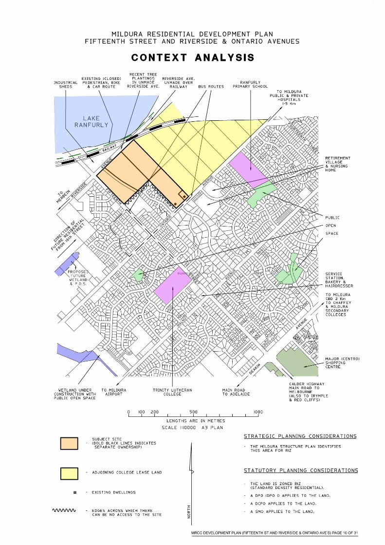
The diagram on the following page (page 10)details the context of the site.The site is small (about 16 hectares) and on the edge of the 2030Residential Growth Boundary shown on the Mildura Town Structure PlanIt adjoins, and is nearly to, both existing residential developments and anon urban (Rural) zone. It is nearby to some shops, schools andcommunity facilities, but some distance from Mildura CBD. The majorMildura South residential growth areas are nearby and slightly furtheragain from the Mildura CBD. The Industrial type sheds situated directlyacross Riverside Avenue from the subject site detract from the visualamenity that Lakes Ranfurly and Hawthorn could provide the site. Futurerezoning of the adjacent land to LDRZ, in keeping with other land on thelake side of Riverside Avenue, may be a method of encouraging a changein land use. There are no possible links into the property from adjoiningresidential land, excepting the (remote) possibility of pedestrian accessfrom Sterling Drive via what is currently a Sewerage Reserve. Theexisting retaining wall, at the rear of the Sterling Drive Subdivision, is adetraction that requires attention by this plan. Council may no longer beproceeding with the roundabout that was proposed for the corner ofFifteenth Street and Riverside Avenue. It is likely that there will begiveway signs in Fifteenth Street, with the extension of Fifteenth Streettowards the lakes (across Riverside Avenue) only having a narrowpavement. As well as the Development Plan Overlay (which is the reasonfor this plan) and a Development Contribution Plan Overlay, the site isaffected by a Salinity Management Overlay the Schedule to the Overlaycontains a diagram (REM Preliminary Assessment Tool: InterpretedUrban Salinity Risk (Figure 3 July 2004)) that indicates that part of thesite has a Very High Interpreted Urban Salinity Risk.
MRCC DEVELOPMENT PLAN (FIFTEENTH ST AND RIVERSIDE & ONTARIO AVE’S) PAGE 9 OF 31
SECTION 3: ON SITE ISSUES AND CHARACTERISTIES
Draft Report – Fifteenth Street andRiverside & Ontario AvenueResidential Development Plan
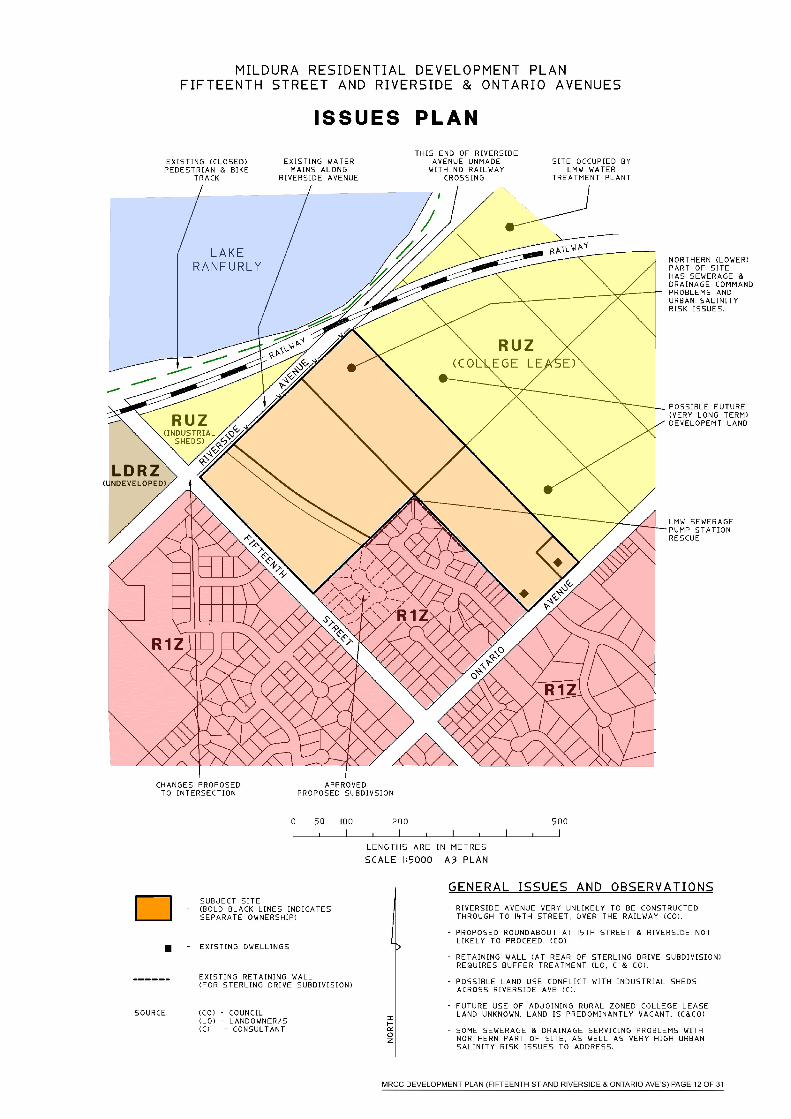
The design on the following page (page 12) details the on site issues andcharacteristics. The site is small (about 16 hectares) and consists ofparcels in four separate ownerships. The main issue to the landowners isthe retaining wall at the rear of the Sterling Drive subdivision. It isunsightly and some owners feel it does not appear to be constructed welland they strongly believe that improvements necessary to the wall orbuffering of the wall should not be at their (or a developers) expense at thetime of subdivision. Lower Murray Water indicated that the northern(lowest) most parcel “will be difficult to sewer”. It is likely that thenorthern part of that lot will also be difficult to drain. It is about the samearea that has the Interpreted Very High Urban Salinity Risk. There is anexisting Sewerage Pump Station Reserve that could possibly provide apedestrian link between the end of Sterling Drive and the proposed PublicOpen Space. Lower Murray Water have given no commitment, but haveindicated they would consider the matter “if a formal request was made”.At the time of development/subdivision of the properties providing thePOS, Council could consider asking the Sterling Drive residents if theywould like direct access to the parkland.
MRCC DEVELOPMENT PLAN (FIFTEENTH ST AND RIVERSIDE & ONTARIO AVE’S) PAGE 11 OF 31
SECTION 4: ENGINEERING CONTRAINTS
Draft Report – Fifteenth Street andRiverside & Ontario AvenueResidential Development Plan
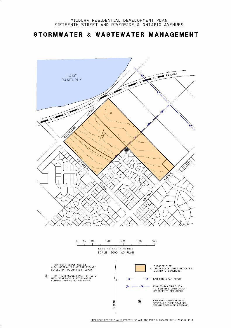
Development of the site will complete a small section of Residential zonedland in the area.The diagram on page 16 details existing Stormwater and Wastewaterinfrastructure for the area
Stormwater Drainage
The Mildura Rural City Council is the urban drainage authority. The sitewill be drained to the nearby existing open channel/drain that passesthrough College Lease land from Ontario Avenue to Lake Ranfurly. Thenorthern (lower) corner of the site may need to be built up, or dealt withby some initiative way, to be commanded.
Sewerage
Lower Murray Water is the relevant servicing authority. They wereconsulted. There is an existing sewerage pump station at the end ofSterling Drive that can service a majority of the site. The northern (lower)corner of the site may need to be built up, or dealt with by some initiativeway, in order to be serviced.
Potable (Town) Water
Lower Murray Water is the relevant authority. Subject to internalreticulation to LMW standards the site can be serviced. Lower MurrayWater have a (ring) water main along unmade Riverside Avenue and itsposition should be taken into account in the design of any works alongRiverside Avenue.
MRCC DEVELOPMENT PLAN (FIFTEENTH ST AND RIVERSIDE & ONTARIO AVE’S) PAGE 13 OF 31
Electricity Supply
Powercor advise that electricity can be made available, subject to theirstandard conditions of supply.
Telecommunications
The provision of telecommunications services should not be a problem.Telstra and Neighbourhood Cable should be contacted at the time ofsubdivision design.
Natural Gas
Origin Energy advise that gas can be made available, subject to theirstandard conditions of supply.
Rural Irrigation and Drainage
The subject properties are in the First Mildura Irrigation Trust (FMIT)irrigation and drainage district. They may have assets on or near the sitethat need to be protected. They may require easements to be created overtheir assets. Other assets/pipes may become redundant as the result ofresidential development. Applications (under the water act) will need tobe made to the Trust and their requirements, including excision ofdevelopment land from the Trusts district, met.
Traffic & Public Transport
Mildura Bus Lines were consulted. They have bus routes in FifteenthStreet and Ontario Avenue, with bus stops along both roads very near thesubject site, and do not envisage a bus route through the site.
Council no longer envisage a roundabout at the corner of RiversideAvenue and Fifteenth Street. Giveway signs are proposed in FifteenthStreet. Any road, through the site, between Riverside and OntarioAvenues should be designed to discourage “through” traffic looking for ashort cut.
MRCC DEVELOPMENT PLAN (FIFTEENTH ST AND RIVERSIDE & ONTARIO AVE’S) PAGE 14 OF 31
Salinity
A Salinity Management Overlay affects the site. Any permit applicationwill need to address the requirements (as appropriate) at Clause 44.02.2(of the Salinity Management Overlay) and any permit application forsubdivision will need to be accompanied by a Site Capability Report asper Clause 1.0 for the Schedule to the Salinity Management Overlay. Therisks identified by the required detailed site analysis will take precedenceover the current Interpreted Risks. The Interpreted Very High Risk landwill require a lower level risk result from the detailed site analysis prior toany development being permitted. A Salinity Action Statement will berequired at the time of subdivision.
MRCC DEVELOPMENT PLAN (FIFTEENTH ST AND RIVERSIDE & ONTARIO AVE’S) PAGE 15 OF 31
SECTION 5: THE CONCEPT – VISION PLAN
Draft Report – Fifteenth Street andRiverside & Ontario AvenueResidential Development Plan
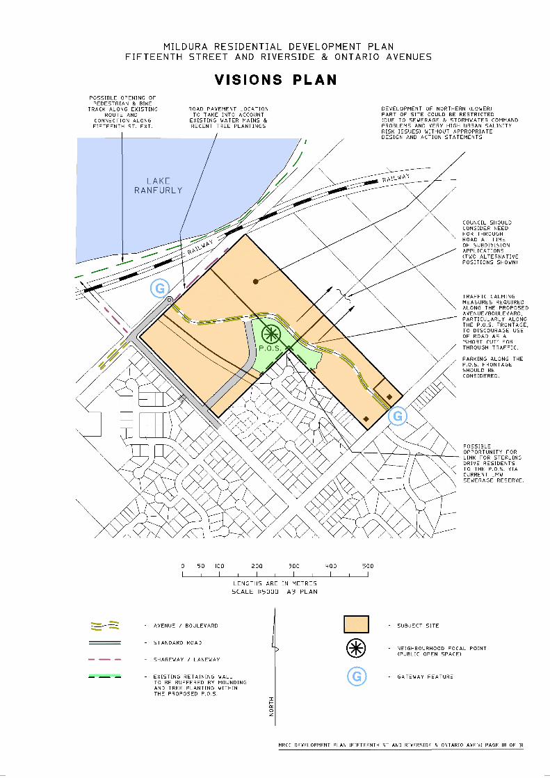
The diagram on the following page (page 18) details the Vision Plan. Awide landscaped Avenue/Boulevard is proposed through the site betweenOntario and Riverside Avenues. A Gateway Feature is proposed at eachend of the Avenue/Boulevard. A connecting road is proposed from theAvenue/Boulevard out to Fifteenth Street. This will provide furtherresidents easy access directly out to all 3 existing collector streets. Asignificant area of Public Open Space is proposed at a central point of thesite. It will also be affective in buffering the existing retaining wall fromthe future residential development.
MRCC DEVELOPMENT PLAN (FIFTEENTH ST AND RIVERSIDE & ONTARIO AVE’S) PAGE 17 OF 31
SECTION 6: THE CONCEPT – INDICATIVE COMPONENTS
Following pages (pages 20 to 31) are extracts from the new DevelopmentPlan (for the Etiwanda, Irymple, Riverside and Nichols Point areas)prepared by David Lock Associates and GHD. They are included in thisplan with the permission and support of MRCC and the consultants.
MRCC DEVELOPMENT PLAN (FIFTEENTH ST AND RIVERSIDE & ONTARIO AVE’S) PAGE 19 OF 31
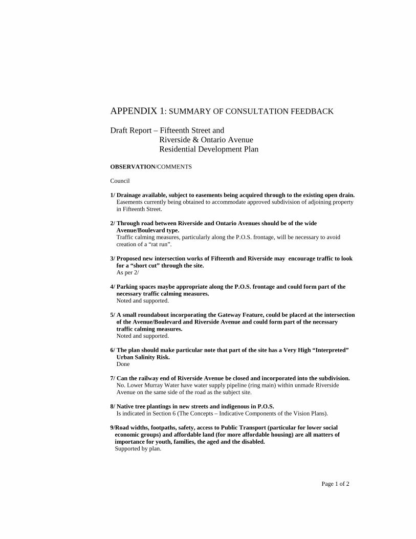
APPENDIX 1: SUMMARY OF CONSULTATION FEEDBACK
Draft Report – Fifteenth Street andRiverside & Ontario AvenueResidential Development Plan
OBSERVATION/COMMENTS
Council
1/ Drainage available, subject to easements being acquired through to the existing open drain.Easements currently being obtained to accommodate approved subdivision of adjoining propertyin Fifteenth Street.
2/ Through road between Riverside and Ontario Avenues should be of the wideAvenue/Boulevard type.Traffic calming measures, particularly along the P.O.S. frontage, will be necessary to avoidcreation of a “rat run”.
3/ Proposed new intersection works of Fifteenth and Riverside may encourage traffic to lookfor a “short cut” through the site.As per 2/
4/ Parking spaces maybe appropriate along the P.O.S. frontage and could form part of thenecessary traffic calming measures.Noted and supported.
5/ A small roundabout incorporating the Gateway Feature, could be placed at the intersectionof the Avenue/Boulevard and Riverside Avenue and could form part of the necessarytraffic calming measures.Noted and supported.
6/ The plan should make particular note that part of the site has a Very High “Interpreted”Urban Salinity Risk.Done
7/ Can the railway end of Riverside Avenue be closed and incorporated into the subdivision.No. Lower Murray Water have water supply pipeline (ring main) within unmade RiversideAvenue on the same side of the road as the subject site.
8/ Native tree plantings in new streets and indigenous in P.O.S.Is indicated in Section 6 (The Concepts – Indicative Components of the Vision Plans).
9/Road widths, footpaths, safety, access to Public Transport (particular for lower socialeconomic groups) and affordable land (for more affordable housing) are all matters ofimportance for youth, families, the aged and the disabled.Supported by plan.
Page 1 of 2
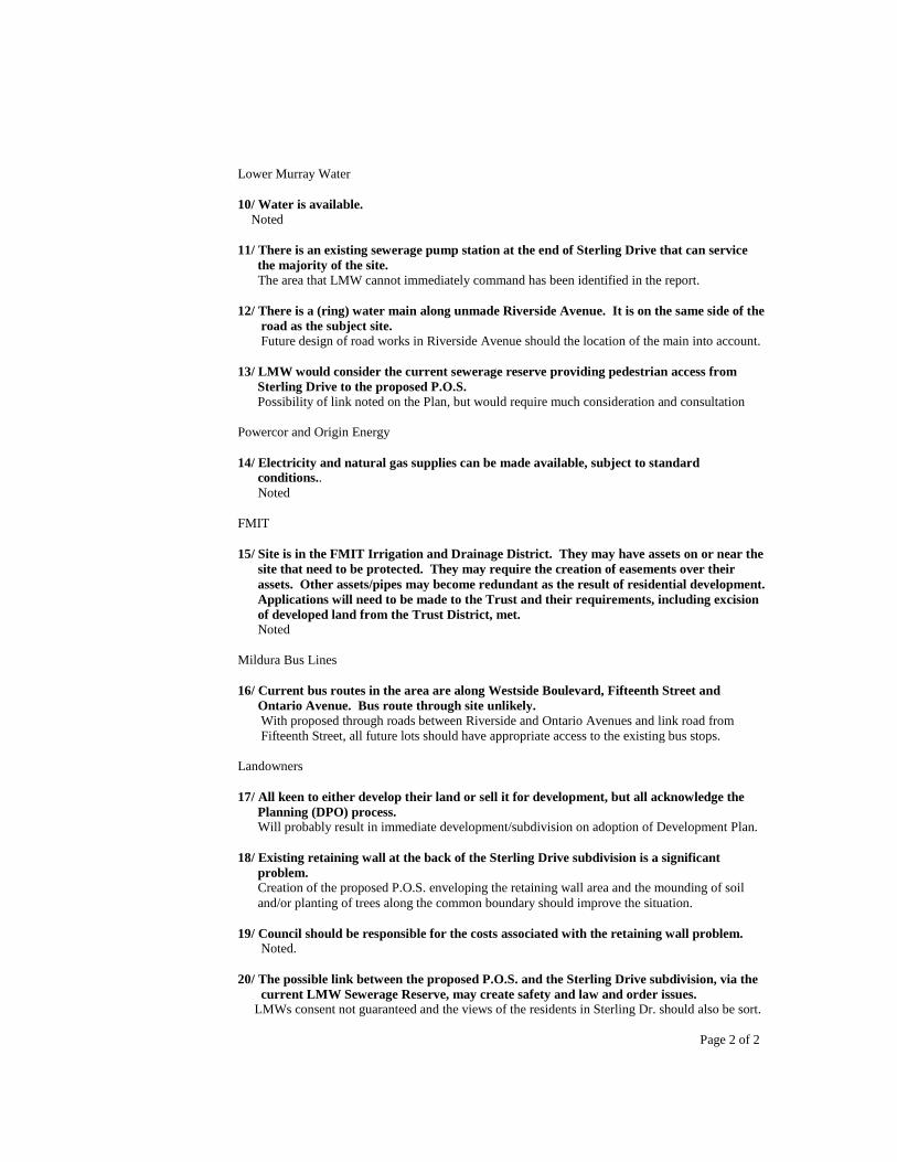
Lower Murray Water
10/ Water is available.Noted
11/ There is an existing sewerage pump station at the end of Sterling Drive that can servicethe majority of the site.The area that LMW cannot immediately command has been identified in the report.
12/ There is a (ring) water main along unmade Riverside Avenue. It is on the same side of theroad as the subject site.Future design of road works in Riverside Avenue should the location of the main into account.
13/ LMW would consider the current sewerage reserve providing pedestrian access fromSterling Drive to the proposed P.O.S.Possibility of link noted on the Plan, but would require much consideration and consultation
Powercor and Origin Energy
14/ Electricity and natural gas supplies can be made available, subject to standardconditions..Noted
FMIT
15/ Site is in the FMIT Irrigation and Drainage District. They may have assets on or near thesite that need to be protected. They may require the creation of easements over theirassets. Other assets/pipes may become redundant as the result of residential development.Applications will need to be made to the Trust and their requirements, including excisionof developed land from the Trust District, met.Noted
Mildura Bus Lines
16/ Current bus routes in the area are along Westside Boulevard, Fifteenth Street andOntario Avenue. Bus route through site unlikely.With proposed through roads between Riverside and Ontario Avenues and link road fromFifteenth Street, all future lots should have appropriate access to the existing bus stops.
Landowners
17/ All keen to either develop their land or sell it for development, but all acknowledge thePlanning (DPO) process.Will probably result in immediate development/subdivision on adoption of Development Plan.
18/ Existing retaining wall at the back of the Sterling Drive subdivision is a significantproblem.Creation of the proposed P.O.S. enveloping the retaining wall area and the mounding of soiland/or planting of trees along the common boundary should improve the situation.
19/ Council should be responsible for the costs associated with the retaining wall problem.Noted.
20/ The possible link between the proposed P.O.S. and the Sterling Drive subdivision, via thecurrent LMW Sewerage Reserve, may create safety and law and order issues.
LMWs consent not guaranteed and the views of the residents in Sterling Dr. should also be sort.
Page 2 of 2