field guide to soils and the environment applications of soil surveys || soil profile descriptions
TRANSCRIPT

Soil profile descriptions
PU RPOSE The pu rpose of th is exercise is to take the student into the field to dig in soils, to appreciate the characteristics of soil differences outlined in pages 1-40 of the textbook. This exercise can consist of several short field trips, or several half-days of describing different soils according to the format given on pages 8 and 10 of the textbook.
PROCEDURE Dig several pits in the middle of several different, well-defined landscape segments, as illustrated in Figure 1. The pits should exhibit highly contrasting soil properties. Each student should describe the environment and horizon characteristics in each pit according to Tables 1 and 2. Preparation includes discussion of pages 1-40 of the textbook and instruction on soils of the local area. Classroom exhibits of sand, clay, mottles, blocky and platy structures, and so on, can provide useful preparation for fieldwork. Instructions in determination of textures, consistence, and pH can be conveniently done in the classroom before students go into the field to make a soil profile description. Pages 24-26 of the textbook describe a practical exercise for determining soil texture that has proved to be quite useful in preparing to teach about soil profile descriptions.
COMPETITION A competitive element can be introduced into the student activity by using the forms illustrated in Tables 3 and 4. Under the sponsorship of the American Society of Agronomy, soils contests are held each fall (regionally) and each spring (nationally) in the United States. Host states are rotated among colleges offering B.s. training in soils. Thus, by participating in soils
contests for four years, undergraduates have the opportunity to see many different soils and to meet the people working in the profession. Of course, unofficial contests can be held among participants of any class or group. The scorecards in Tables 3 and 4 offer a convenient means to grade individual performance in description of a soil. Each scorecard is changed somewhat from year to year and modified to fit local soil situations. Typically, numerous pages of explanatory materials accompany the scorecards for the students and coaches to study. The scorecards also require some classifications and interpretive judgments to be made about the soils, so that the value of the descriptive data are readily apparent to the students.
CHANGES Soil survey is one area of study where change is a continual process and a mark of progress. In 1981, for example, soil profile horizon designations given on page 14 of the textbook were modified somewhat to fit the international nomenclature more closely. Guthrie and Witty (1982) provided a synoptic comparison between the old (1962) and new {1981} designations for soil horizons and layers, also given in Table 5. Of course, most current published soil survey reports contain the nomenclature given on page 14 of the textbook, and the new terminology will not appear in many soil survey reports until after a number of years have passed.
REFERENCE
Guthrie, R. L. and J. E. Witty. 1982. New designations for soil horizons and layers and the new Soil Survey Manual. Soil Science Society of America Journal 46:443-444.
FIGURE ljSchematic diagram of a soil pit in a soil map landscape unit, from which the soil profile description area has been expanded to give a better view.
3
G. W. Olson, Field Guide to Soils and the Environment Applications of Soil Surveys© Dowden & Culver, Inc. 1984

TABLE 1/ Form for describing environment around the site (cut, pit, or trench) for a soil profile description.
Soil type File No.
Area Date Stop No.
Classification
Location
N. veg. (or crop) I Climate
Parent material
Physiography
Relief Drainage Salt or alkali
Elevation Gr. water Stoniness
Slope Moistur('
Aspect Root distrib.
Erosion
Permeability
Additional notes
TABLE 2/Form for describing horizons of a soil profile.
Color Consistence Hori- Depth Texture Struc- Re- Bound zon ture action ary
Dry Moist Dry Moist Wet
4 / Field Guide to Soils and the Environment

\.Il
TA
BLE
3jS
core
card
for
the
798
0 re
gion
al s
oils
con
test
in N
ew Y
ork
Stat
e.
Co
nte
st N
umbe
r
Pit
Num
ber _
__
__
_
Par
t I
-S
ite C
hara
cte
rist
ics
POSI
TIO
N
OF
SIT
E
(5)
__
Flo
od
pla
in
Str
eam
terr
ace
__
Upl
and
__
Fo
ots
lop
e
__
Dep
ress
ion
PARE
NT
MA
TERI
AL
(5)
Res
iduu
m
All
uviu
m
Col
luvi
um
Gla
cial
Til
l
Loe
ss
Mar
ine
and
/or
lacu
stri
ne
Gla
cial
out
was
h
SLO
PE
(5)
__
Nea
rly
lev
el
0-3%
__
Gen
tly
slo
pin
g 3
-8%
Mod
erat
ely
slo
pin
g 8
-15%
Str
on
gly
slo
pin
g 1
5-25
%
Mod
erat
ely
stee
p 2
5-35
%
__
Ste
ep 3
5+
%
ERO
SIO
N
(5)
__
__
Dep
osi
tio
n
Non
e to
sli
gh
t
Mod
erat
e
Sev
ere
1980
NOR
THEA
ST
REG
ION
AL
COLL
EGIA
TE
SOIL
S CO
NTE
ST
SCOR
ECAR
D O
ctob
er I
I, 1
980
Sco
re I
II ----
Co
rnel
l U
niv
ersi
ty
Par
t I
-co
nti
nu
ed
SURF
ACE
RUN
OFF
(5)
Pond
ed
__
Ver
y sl
ow
Slow
Med
ium
__
Rap
id
__
Ver
y ra
pid
Par
t II
-S
oil
Cla
ssif
icati
on
EPIP
EDO
N
(5)
Ant
hrop
ic
His
tic
Mo
llic
Och
ric
__
Pla
ggen
Um
bric
SUBS
URF
ACE
HO
RIZO
N
(5)
__
Agr
ic
Alb
ic
Arg
illi
c
Cal
cic
Cam
bic
__
Dur
ipan
Fra
gip
an
__
Gyp
sic
ORDE
R (5
)
Alf
iso
l
Ari
dis
ol
En
tiso
l
His
toso
l
__
In
cep
tiso
l
Nat
ric
Oxi
c
Pet
roca
lcic
__
_ P
etro
gy
psi
c
Pla
cic
Sal
ic
Som
bric
__
Spo
dic
Su
lfu
ric
Mo
llis
ol
Ox
iso
l
__
Spo
doso
l
Ult
iso
l
Ver
tiso
l
III
IV
& V
----
TOTA
L _
__
_
Par
t II
I -
So
il I
nte
rpre
tati
on
Lim
itat
ion
s
SEPT
IC T
ANK
ABS
ORP
TIO
N
FIEL
D
(5)
Sli
gh
t
Mod
erat
e
Sev
ere
DWEL
LING
WIT
H BA
SEM
ENT
(5)
Sli
gh
t
Mod
erat
e
Sev
ere
LOCA
L RO
ADS
AND
STRE
ETS
(5)
Sli
gh
t
Mod
erat
e
Sev
ere
LAND
C
APA
BIL
ITY
CL
ASS
AN
D
SUBC
LASS
(1
0)
0'1
TA
BL
E 3
(co
ntin
ued)
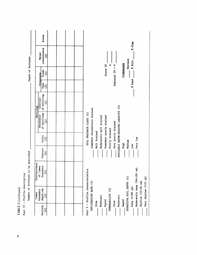
Part
IV
-
Pro
file
desc
rip
tio
n
Num
ber
of
ho
rizo
ns
to b
e d
escr
ibed
D
epth
of
ho
rizo
ns _
__
__
__
_ _
Low
er
Dis
tin
ctn
ess
bo
unda
ry
of
low
er
Hor
izon
d
epth
,cm
. bo
unda
ry
(4)
(2)
(2)
Part
V -
Pro
file
ch
ara
cte
rist
ics
INFI
LTR
ATI
ON
RA
TE
(5)
Slow
Mod
erat
e
Rap
id
PER
MEA
BIL
ITY
(5
)
Slow
Mod
erat
e
Rap
id
EFFE
CTI
VE
SOIL
D
EPTH
(5
)
Dee
p (>
100
cm)
Mo
der
atel
y d
eep
(50-
100
cm)
Sha
llow
(2
5-50
cm
)
Ver
y sh
allo
w
«2
5 c
m)
Mo
ttli
ng
A
bund
ance
1 Cont
ract
T
extu
re
Co
lor
of
mo
ttli
ng
o
f m
ott
lin
g
(4)
(2)
__
(I)
_
_ (1
)
SOIL
D
RAIN
AG
E CL
ASS
(5
)
__
Som
ewha
t ex
cess
ivel
y d
rain
ed
Wel
l d
rain
ed
Mo
der
atel
y w
ell
dra
ined
____
_ So
mew
hat
po
orl
y d
rain
ed
____
_ P
oo
rly
dra
ined
____
_ V
ery
po
orl
y d
rain
ed
AV
AIL
ABL
E W
ATE
R-H
OLD
ING
CA
PACI
TY
(5)
__
Hig
h
St .
... ,.
......
.. M
oist
T
ype I G
rade
co
nsi
sten
ce
Sco
re
(2)
(2)
(2)
-
Sco
re I
V _
____
_ __
V _
__
_
Su
bto
tal
IV
+
V _
____
_ __
TIEB
REA
KER
Hor
izon
M
ediu
m
Low
_
_ %
San
d _
_ %
Sil
t _
_ %
Cla
y
Ver
y lo
w
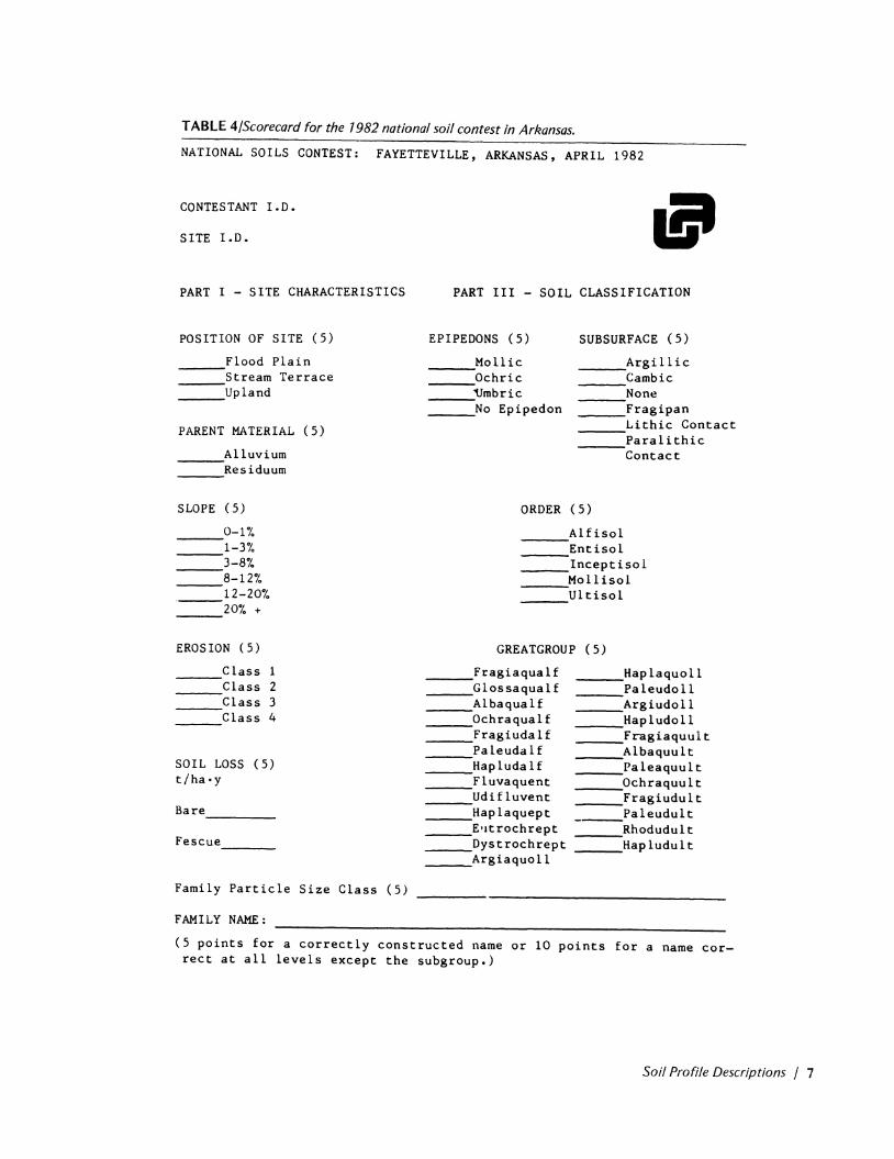
TABLE 4j5corecard for the 1982 national soil contest in Arkansas.
NATIONAL SOILS CONTEST: FAYETTEVILLE, ARKANSAS, APRIL 1982
CONTES TANT 1. 0 •
SITE 1.0.
PART I - SITE CHARACTERISTICS
POSITION OF SITE (5)
Flood Plain ---___ Stream Terrace ___ Upland
PARENT MATERIAL (5)
___ ,Alluvium ___ Residuum
SLOPE (5 )
0-1 "I. 1-3% 3-8% 8-12% 12-20% .---20% +
EROSION (5)
Class 1 Class 2 Class 3 Class 4
SOIL LOSS (5) t/ha·y
Ba re _______ _
Fescue ____ _
Family Particle Size Class (5)
FAMILY NAME:
PART III - SOIL CLASSIFICATION
EPIPEDONS (5)
___ Mollic ___ Ochric ___ 'Umbric ___ No Epipedon
SUBSURFACE (5)
___ Argillic ___ Cambic ___ None ___ Fragipan ____ Lithic Contact ____ Paralithic
Contact
ORDER (5)
____ ,A1£isol ____ Entisol _____ Inceptisol ___ -.:Moll isol ___ Ultisol
GREATGROUP (5)
____ Fragiaqualf ____ Glossaqualf ___ A 1 baqua 1£ ___ Ochraqualf ____ Fragiudalf ___ Paleuda1£ ___ Hapluda1£ ___ Fluvaquent ___ Udifluvent ____ Haplaquept ____ E·ltrochrept _ __ Dystrochrept _____ Argiaquoll
____ Haplaquoll ____ Paleudo11 ____ .Argiudoll ___ Hap 1 udo 11 ____ Fragiaquult ____ Albaquult ____ Paleaquult ____ Ochraquult ___ Fragiudult ______ Paleudult _ __ Rhodudult ____ Hapludult
(5 points for a correctly constructed name or 10 points for a name correct at all levels except the subgroup.)
Soil Profile Descriptions j 7

00
TA
BL
E 4
(co
ntin
ued)
PA
RT
II
-SO
IL
MO
RPH
OLO
GY
Ho
rizo
n
Dep
th
Bo
un
dar
y
San
d C
lay
T
extu
re
em
Dis
t.
%
%
(2)
(2)
(2)
(1)
(1)
(3)
--
__
__
__
__
__
_
I _
__
--
PART
IV
-
INTE
RPR
ETA
TIO
NS
HY
DRA
ULI
C C
ON
D./S
UR
FAC
E (5
)
__
_ H
igh
Mo
der
ate
---
Low
---
HY
DRA
ULI
C C
ON
D./S
OIL
(5
)
__
_ H
igh
__
_ M
od
erat
e _
__
Low
WAT
ER
RET
ENTI
ON
D
IF.
(5)
Hig
h >
22
.5
em
Med
ium
1
5-2
2.5
em
Lo
w
7.5
-15
em
V
ery
Low
<
7.5
em
WET
NES
S C
LASS
(5
)
Cla
ss
1:
>15
0 em
C
lass
2
: 1
00
-15
0 e
m
Cla
ss
3:
50
-10
0
em
----
Cla
ss
4:
25
-50
em
C
lass
5
: <2
5 em
Co
lor
(2)
Mo
ttli
ng
S
tru
ctu
re
Gra
de
Sha
pe
(2)
(2)
(2)
USE
FULN
ESS
TO
AG
RIC
ULT
UR
E (8
)
__
__
_ P
rim
e F
arm
lan
d
__
__
Ad
dit
ion
al
Far
mla
nd
----
of
Sta
tew
ide
Imp
ort
ance
N
eit
her
of
the
Abo
ve
ON
SITE
W
AST
EWA
TER
REN
OV
ATI
ON
(8
)
__
__
Sta
nd
ard
F
ilte
r F
ield
I I I
__
__
,Mod
ifie
d S
tan
dard
/Pre
s.
Dis
t.
__
_ N
eit
her
of
the
Abo
ve
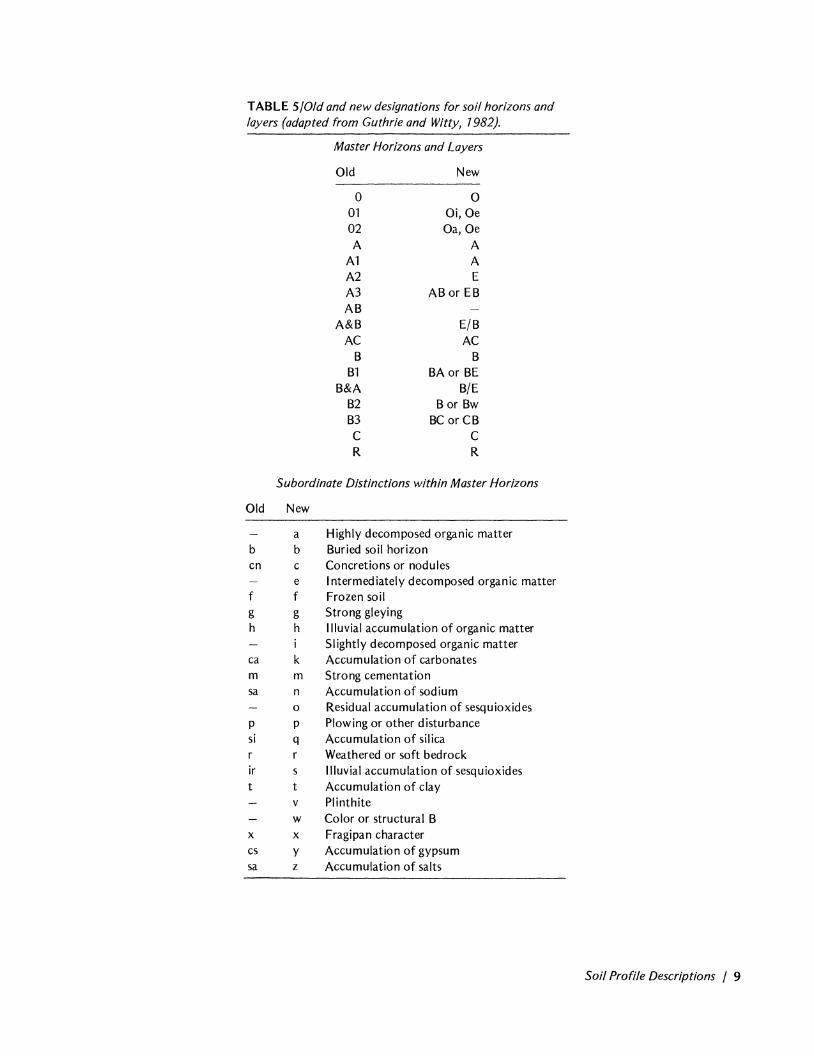
TABLE 5/01d and new designations for soil horizons and layers (adapted from Guthrie and Witty, 7982).
Master Horizons and Layers
Old New
0 0 01 Oi,Oe 02 Oa,Oe A A
A1 A A2 E A3 AB or EB AB
A&B E/B AC AC
B B B1 BA or BE
B&A B/E B2 B or Bw B3 BC or CB C C R R
Subordinate Distinctions within Master Horizons
Old New
b cn
f g h
ca m sa
P si
ir t
x cs sa
a b c e f g h
k m n o p q
s t v
Highly decomposed organic matter Buried soil horizon Concretions or nodules Intermediately decomposed organic matter Frozen soil Strong gleying Iliuvial accumulation of organic matter Slightly decomposed organic matter Accumulation of carbonates Strong cementation Accumulation of sodium Residual accumulation of sesquioxides Plowing or other disturbance Accumulation of silica Weathered or soft bedrock Illuvial accumulation of sesquioxides Accumulation of clay Plinthite
w Color or structural B x y z
Fragipan character Accumulation of gypsum Accumulation of salts
Soil Profile Descriptions / 9