faulting and effects of earthquakes on minoan archaeological sites in crete (greece)
TRANSCRIPT
www.elsevier.com/locate/tecto
Tectonophysics 382 (2004) 103–116
Faulting and effects of earthquakes on Minoan archaeological
sites in Crete (Greece)
C. Monaco*, L. Tortorici
Dipartimento di Scienze Geologiche and Centro di Archeologıa Cretese, Universita di Catania, Corso Italia 55, 95129 Catania, Italy
Received 13 December 2002; accepted 10 December 2003
Abstract
Examination of damages affecting the buildings of the archaeological sites of Phaistos and Agia Triada (southern Crete)
suggests that these Minoan settlements were probably destroyed by two major seismic events characterized by MKS intensities
of IX–X and occurred at the end of the Protopalatial (1700 BC) and the Neopalatial (1450 BC) periods. Geological and
morphological studies carried out in the neighbouring areas show the occurrence of E–W trending Quaternary normal fault
segments (Spili and Agia Galini faults) that control the present topography and morphology, and exhibit steep young scarps
mostly Holocene in age. These fault segments are related to a NW–SE extension direction, which is consistent with that
indicated by the available focal mechanisms of the earthquakes occurring in this area in the last 50 years. Combining structural
and seismic data we can infer that the Spili and Agia Galini fault segments could represent good candidates to be considered
active faults generating large earthquakes (Mi6.5) that were responsible for the damages of Phaistos and Agia Triada. This
hypothesis suggests that the Minoan palatial centres were destroyed by several large earthquakes related to ruptures along
distinct fault segments rather than by a single catastrophic event that caused the abrupt destruction of the Minoan civilisation in
the eastern Mediterranean.
D 2004 Elsevier B.V. All rights reserved.
Keywords: Archaeoseismology; Seismotectonics; Quaternary; Normal faulting; Seismicity; Crete; Aegean arc
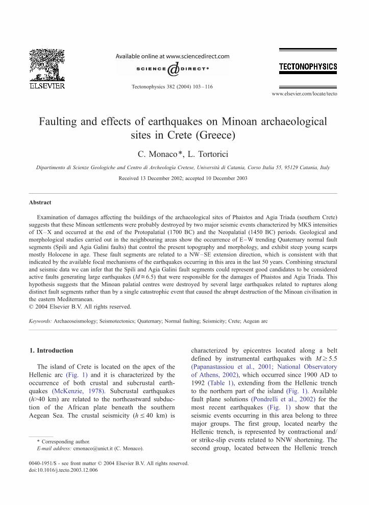
1. Introduction characterized by epicentres located along a belt
The island of Crete is located on the apex of the
Hellenic arc (Fig. 1) and it is characterized by the
occurrence of both crustal and subcrustal earth-
quakes (McKenzie, 1978). Subcrustal earthquakes
(h>40 km) are related to the northeastward subduc-
tion of the African plate beneath the southern
Aegean Sea. The crustal seismicity (hV 40 km) is
0040-1951/$ - see front matter D 2004 Elsevier B.V. All rights reserved.
doi:10.1016/j.tecto.2003.12.006
* Corresponding author.
E-mail address: [email protected] (C. Monaco).
defined by instrumental earthquakes with Mz 5.5
(Papanastassiou et al., 2001; National Observatory
of Athens, 2002), which occurred since 1900 AD to
1992 (Table 1), extending from the Hellenic trench
to the northern part of the island (Fig. 1). Available
fault plane solutions (Pondrelli et al., 2002) for the
most recent earthquakes (Fig. 1) show that the
seismic events occurring in this area belong to three
major groups. The first group, located nearby the
Hellenic trench, is represented by contractional and/
or strike-slip events related to NNW shortening. The
second group, located between the Hellenic trench
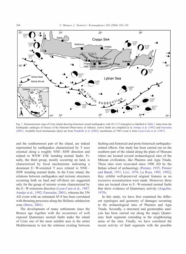
Fig. 1. Seismotectonic map of Crete island showing historical crustal earthquakes with Mz 5.5 (triangles) as labelled in Table 1 (data from the
Earthquake catalogue of Greece of the National Observatory of Athens). Active faults are compiled as in Armijo et al. (1992) and Fassoulas
(2001). Available focal mechanisms (dots) are from Pondrelli et al. (2002); mechanism of 1965 event is from Lyon-Caen et al. (1987).
C. Monaco, L. Tortorici / Tectonophysics 382 (2004) 103–116104
and the southernmost part of the island, are indeed
represented by earthquakes characterized by T axes
oriented along a roughly NNE–SSW direction and
related to WNW–ESE trending normal faults. Fi-
nally, the third group, mostly occurring on land, is
characterized by focal mechanisms indicating a
dominant E–W-oriented T axes related to NNE–
SSW trending normal faults. In the Crete island, the
relations between earthquakes and tectonic structures
occurring both on land and off-shore are suggested
only for the group of seismic events characterized by
the E–W extension direction (Lyon-Caen et al., 1987;
Armijo et al., 1992; Fassoulas, 2001), whereas the 356
AD event with an estimated M>8 has been correlated
with thrusting processes along the Hellenic subduction
zone (Stiros, 2001).
The development of many settlements since the
Bronze age together with the occurrence of well
exposed Quaternary normal faults make the island
of Crete one of the most suitable area in the entire
Mediterranean to test the relations existing between
faulting and historical and proto-historical earthquake-
related effects. Our study has been carried out on the
southern part of the island along the plain of Messara
where are located several archaeological sites of the
Minoan civilization, like Phaistos and Agia Triada.
These sites were excavated since 1900 AD by the
Italian school of archaeology (Pernier, 1935; Pernier
and Bandi, 1951; Levi, 1976; La Rosa, 1985, 1992);
they exhibit well-preserved original features as no
excessive reconstruction were made. Moreover, these
sites are located close to E–W-oriented normal faults
that show evidence of Quaternary activity (Angelier,
1979).
In this study, we have first examined the differ-
ent typologies and geometry of damages occurring
in the archaeological sites of Phaistos and Agia
Triada. Secondly, a structural and geomorphic anal-
ysis has been carried out along the major Quater-
nary fault segments extending in the neighbouring
areas of the sites. Finally, we have correlated the
recent activity of fault segments with the possible
Table 1
Location of the instrumental earthquakes with Mz 5.5 which
occurred since 1900 AD to 1992 (data from the National
Observatory of Athens, 2002)
N Date Lat. Long. Depth
(H)
M
1 3/10/1923 34j.62 26j.53 12 5.5
2 24/3/1927 35j.45 26j.39 2 5.7
3 5/12/1938 35j.15 26j.24 23 5.8
4 16/6/1942 34j.40 26j.29 40 5.5
5 1/9/1942 35j.19 26j.73 22 6.0
6 4/5/1946 35j.29 23j.65 40 5.6
7 30/8/1947 35j.50 23j.37 34 6.2
8 22/5/1948 34j.65 24j.31 38 5.5
9 24/7/1948 34j.49 24j.49 20 6.4
10 17/12/1953 34j.47 24j.22 17 6.6
11 7/2/1953 34j.83 24j.11 33 5.7
12 14/5/1959 35j.11 24j.65 23 6.1
13 9/4/1965 35j.06 24j.31 39 5.9
14 27/4/1965 35j.65 23j.53 37 5.7
15 12/6/1969 34j.43 25j.04 ? 5.8
16 2/8/1969 34j.65 24j.01 ? 5.5
17 4/5/1972 35j.15 23j.56 14 5.9
18 29/11/1973 35j.18 23j.81 37 5.7
19 11/9/1977 35j.00 23j.10 – 5.9
20 21/6/1984 35j.31 23j.28 25 5.9
21 30/4/1992 35j.07 26j.63 20 5.6
22 30/4/1992 35j.22 26j.75 5 5.6
C. Monaco, L. Tortorici / Tectonop
destructive earthquakes responsible for damages in
the archaeological sites.
2. Damages on Phaistos and Agia Triada
The archaeological excavations of the Minoan
sites of Phaistos and Agia Triada show that the ruins
of these sites are affected by destructions compatible
with earthquakes and fire (La Rosa, 1995). Consid-
ering that these two sites developed in a time-span of
650 years, between 2000 and 1450 BC, a study of
the damages affecting the archaeological ruins can
provide useful information to obtain time-constraints
for possible natural events responsible for destruc-
tion. A detailed study has been thus carried out on
different typologies of damages of the two sites and
on their distribution. This study has been accompa-
nied by observations on the local geology to define
the possible relations between lithology and struc-
tures (fracture pattern) of the bedrock and building
damages.
2.1. Geological setting
The archaeological sites of Phaistos and Agia Triada
are located on the western part of the Plain of Messara,
an E–W-elongated Neogene–Quaternary basin that
separates the Psiloritis massif to the north from the
Asterousia ridge to the south (Fig. 1). This portion of
the island of Crete is a segment of the alpine orogenic
belt essentially formed by two major structural ele-
ments made up of several thrust sheets deriving from
the oceanic realm of the Neothetys and from the
Apulian continental margin (Bonneau, 1984; Hall et
al., 1984). The uppermost structural element includes
broken formations and melange terranes with ophio-
lites (Vatos and Arvi nappes) representing distinct
portions of an original accretionary wedge tectonically
overlain by crystalline rocks (Asteroussia nappe) be-
longing to the European paleomargin (Bonneau, 1984).
The lower structural element is made up of Mesozoic
carbonates of the Apulian paleomargin (Bonneau,
1984; Hall et al., 1984) which are represented by
distinct thrust sheets deriving from the deformation of
platform (Psiloritis and Tripolitza units) and pelagic
(Pindo and Ethia units) domains. During the Neogene,
the mountain building was accompanied (Hall et al.,
1984; Kilias et al., 1993; Fassoulas et al., 1994;
Fassoulas, 2001) by the development of a series of
syntectonic basins filled by coarse-grained continental
deposits (Tortonian Ambelouza Formation, Messinian
Varvara Formation and Lower Pliocene Courtes For-
mation). In the latest stages, Plio–Quaternary exten-
sional tectonics (Fassoulas, 2001) produced normal
fault systems which bound the major structural depres-
sions of the island, such as the Plain of Messara.
The palace of Phaistos and the center of Agia
Triada are located on an E–W trending hill made up
of sediments of the Messinian Varvara Formation
(Fig. 2). The bottom of this hill is formed by a 30-
m-thick sequence of whitish marls and silty clays
containing thin levels of marly limestones. These
sediments grade upward to a 10-m-thick interval
characterized by the occurrence of several beds of
yellowish calcarenites. At the top of the hill, well-
cemented calcarenites become dominant forming a
20-m-thick substratum on which the Phaistos palace
was built on.
The whole sequence is cut by two main sets of
fractures which have been clearly observed in the
hysics 382 (2004) 103–116 105
Fig. 2. Morphotectonic map of the Kedros mountain region and the northwestern sector of the Messara Plain (location in Fig. 1). In the inset,
lower hemisphere equal-area projection showing the attitude of the fault planes and associated slickensides collected along the Spili fault is
reported; large arrows indicate the mean extension direction obtained by inversion of slickensides data.
C. Monaco, L. Tortorici / Tectonophysics 382 (2004) 103–116106
upper calcarenitic interval (Fig. 3a). The first set is
mainly oriented N45jE and is characterized by a
spacing ranging 60–100 cm. The second set has
N130jE direction with a spacing of 40–70 cm.
These two sets enclose sub-rectangular blocks, which
favoured the quarrying of the rocks by the Minoan
people, as observed in the ancient quarry located at
the southernmost edge of the site of Phaistos.
From the morphological point of view, the slopes
of the hill exhibit several landslides because of the
clay nature of the sequence that forms its backbone.
The continuous retreat of landslide-scarps joining the
cliff of the top of the Messinian sequence has caused
the occurrence of large rock-falls affecting the calcar-
enitic interval. The most impressive rock-fall occur-
ring in the area affects the SE corner of the central
court of the palace of Phaistos, which was partially
destroyed (Fig. 4).
2.2. Phaistos
Phaistos is the best preserved archaeological site
of the Minoan civilisation. In this site two super-
imposed palaces related to the Protopalacial period
(2000–1700 BC) and to the Neopalacial period
(1700–1450 BC) are well preserved (Pernier, 1935;
Pernier and Bandi, 1951; Levi, 1976; La Rosa, 1985,
1989, 1992). The older building (first palace) is
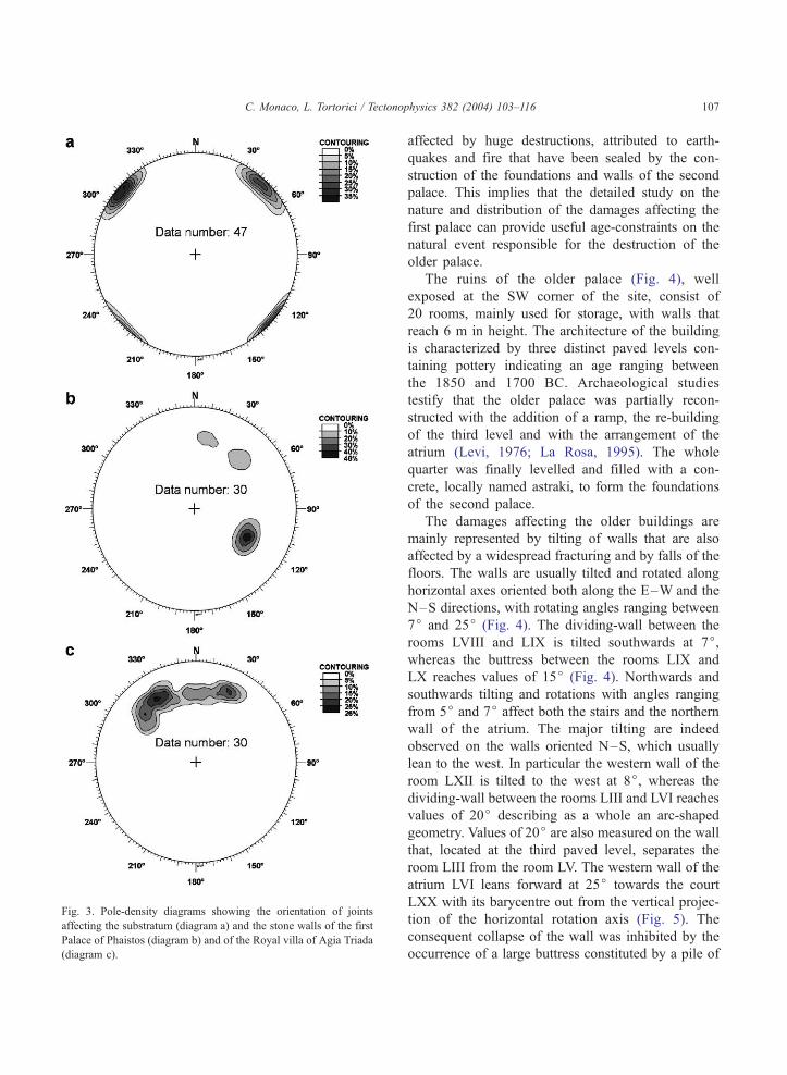
Fig. 3. Pole-density diagrams showing the orientation of joints
affecting the substratum (diagram a) and the stone walls of the first
Palace of Phaistos (diagram b) and of the Royal villa of Agia Triada
(diagram c).
C. Monaco, L. Tortorici / Tectonophysics 382 (2004) 103–116 107
affected by huge destructions, attributed to earth-
quakes and fire that have been sealed by the con-
struction of the foundations and walls of the second
palace. This implies that the detailed study on the
nature and distribution of the damages affecting the
first palace can provide useful age-constraints on the
natural event responsible for the destruction of the
older palace.
The ruins of the older palace (Fig. 4), well
exposed at the SW corner of the site, consist of
20 rooms, mainly used for storage, with walls that
reach 6 m in height. The architecture of the building
is characterized by three distinct paved levels con-
taining pottery indicating an age ranging between
the 1850 and 1700 BC. Archaeological studies
testify that the older palace was partially recon-
structed with the addition of a ramp, the re-building
of the third level and with the arrangement of the
atrium (Levi, 1976; La Rosa, 1995). The whole
quarter was finally levelled and filled with a con-
crete, locally named astraki, to form the foundations
of the second palace.
The damages affecting the older buildings are
mainly represented by tilting of walls that are also
affected by a widespread fracturing and by falls of the
floors. The walls are usually tilted and rotated along
horizontal axes oriented both along the E–W and the
N–S directions, with rotating angles ranging between
7j and 25j (Fig. 4). The dividing-wall between the
rooms LVIII and LIX is tilted southwards at 7j,whereas the buttress between the rooms LIX and
LX reaches values of 15j (Fig. 4). Northwards and
southwards tilting and rotations with angles ranging
from 5j and 7j affect both the stairs and the northern
wall of the atrium. The major tilting are indeed
observed on the walls oriented N–S, which usually
lean to the west. In particular the western wall of the
room LXII is tilted to the west at 8j, whereas the
dividing-wall between the rooms LIII and LVI reaches
values of 20j describing as a whole an arc-shaped
geometry. Values of 20j are also measured on the wall
that, located at the third paved level, separates the
room LIII from the room LV. The western wall of the
atrium LVI leans forward at 25j towards the court
LXX with its barycentre out from the vertical projec-
tion of the horizontal rotation axis (Fig. 5). The
consequent collapse of the wall was inhibited by the
occurrence of a large buttress constituted by a pile of
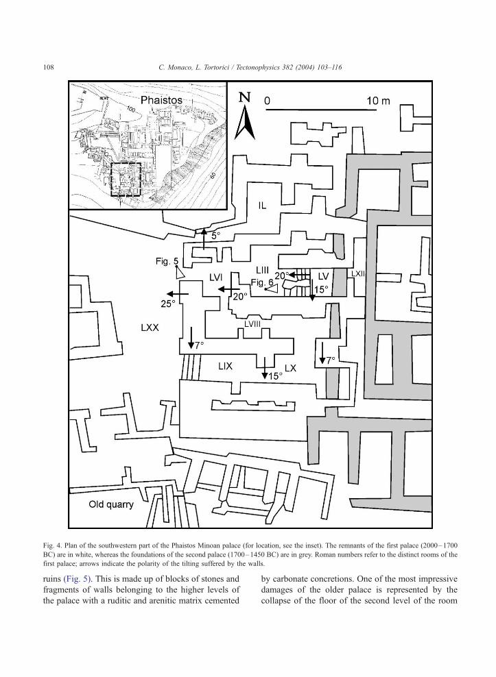
Fig. 4. Plan of the southwestern part of the Phaistos Minoan palace (for location, see the inset). The remnants of the first palace (2000–1700
BC) are in white, whereas the foundations of the second palace (1700–1450 BC) are in grey. Roman numbers refer to the distinct rooms of the
first palace; arrows indicate the polarity of the tilting suffered by the walls.
C. Monaco, L. Tortorici / Tectonophysics 382 (2004) 103–116108
ruins (Fig. 5). This is made up of blocks of stones and
fragments of walls belonging to the higher levels of
the palace with a ruditic and arenitic matrix cemented
by carbonate concretions. One of the most impressive
damages of the older palace is represented by the
collapse of the floor of the second level of the room
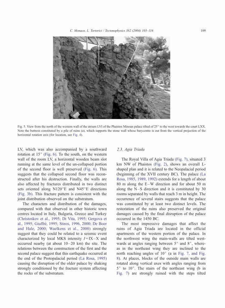
Fig. 5. View from the north of the western wall of the atrium LVI of the Phaistos Minoan palace tilted of 25j to the west towards the court LXX.Note the buttress constituted by a pile of ruins (a), which supports the stone wall whose barycentre is out from the vertical projection of the
horizontal rotation axis (for location, see Fig. 4).
C. Monaco, L. Tortorici / Tectonophysics 382 (2004) 103–116 109
LV, which was also accompanied by a southward
rotation at 15j (Fig. 6). To the south, on the western
wall of the room LV, a horizontal wooden beam slot
running at the same level of the un-collapsed portion
of the second floor is well preserved (Fig. 6). This
suggests that the collapsed second floor was recon-
structed after his destruction. Finally, the walls are
also affected by fractures distributed in two distinct
sets oriented along N120jE and N45jE directions
(Fig. 3b). This fracture pattern is consistent with the
joint distribution observed on the substratum.
The characters and distribution of the damages,
compared with that observed in other historic town
centres located in Italy, Bulgaria, Greece and Turkey
(Christoskov et al., 1995; Di Vita, 1995; Gergova et
al., 1995; Giuffre, 1995; Stiros, 1996, 2000; De Boer
and Hale, 2000; Waelkens et al., 2000) strongly
suggest that they could be related to a seismic event
characterized by local MKS intensity I = IX–X and
occurred nearby (at about 10–20 km) the site. The
relations between the construction of the first and the
second palace suggest that this earthquake occurred at
the end of the Protopalacial period (La Rosa, 1995)
causing the disruption of the older palace by shaking
strongly conditioned by the fracture system affecting
the rocks of the substratum.
2.3. Agia Triada
The Royal Villa of Agia Triada (Fig. 7), situated 3
km NW of Phaistos (Fig. 2), shows an overall L-
shaped plan and it is related to the Neopalacial period
(beginning of the XVII century BC). The palace (La
Rosa, 1985, 1989, 1992) extends for a length of about
80 m along the E–W direction and for about 50 m
along the N–S direction and it is constituted by 30
rooms separated by walls that reach 3 m in height. The
occurrence of several stairs suggests that the palace
was constituted by at least two distinct levels. The
restoration of the ruins also preserved the original
damages caused by the final disruption of the palace
occurred in the 1450 BC.
The most impressive damages that affect the
ruins of Agia Triada are located in the official
apartments of the western portion of the palace. In
the northwest wing the main-walls are tilted west-
wards at angles ranging between 5j and 8j, where-as in the northeast wing they are inclined to the
north reaching angles of 10j (a in Fig. 7, and Fig.
8). At places, blocks of the outside main walls are
rotated along vertical axes with angles ranging from
5j to 10j. The stairs of the northeast wing (b in
Fig. 7) are strongly ruined with the steps tilted
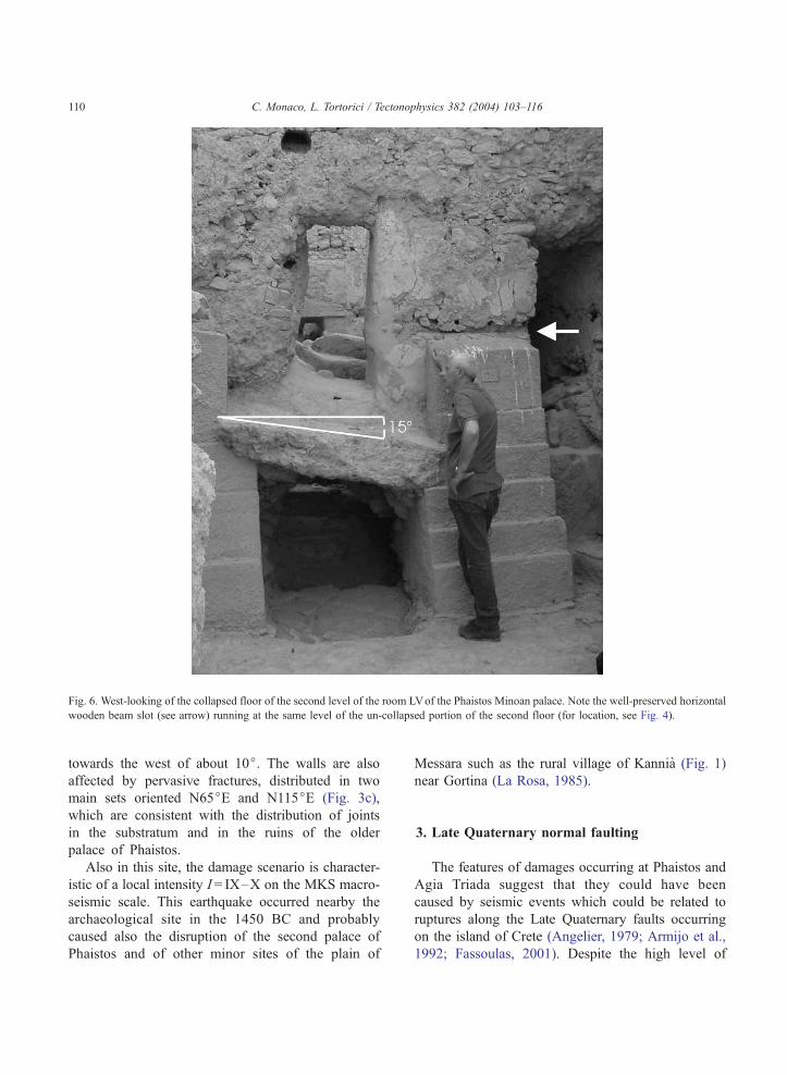
Fig. 6. West-looking of the collapsed floor of the second level of the room LVof the Phaistos Minoan palace. Note the well-preserved horizontal
wooden beam slot (see arrow) running at the same level of the un-collapsed portion of the second floor (for location, see Fig. 4).
C. Monaco, L. Tortorici / Tectonophysics 382 (2004) 103–116110
towards the west of about 10j. The walls are also
affected by pervasive fractures, distributed in two
main sets oriented N65jE and N115jE (Fig. 3c),
which are consistent with the distribution of joints
in the substratum and in the ruins of the older
palace of Phaistos.
Also in this site, the damage scenario is character-
istic of a local intensity I = IX–X on the MKS macro-
seismic scale. This earthquake occurred nearby the
archaeological site in the 1450 BC and probably
caused also the disruption of the second palace of
Phaistos and of other minor sites of the plain of
Messara such as the rural village of Kannia (Fig. 1)
near Gortina (La Rosa, 1985).
3. Late Quaternary normal faulting
The features of damages occurring at Phaistos and
Agia Triada suggest that they could have been
caused by seismic events which could be related to
ruptures along the Late Quaternary faults occurring
on the island of Crete (Angelier, 1979; Armijo et al.,
1992; Fassoulas, 2001). Despite the high level of
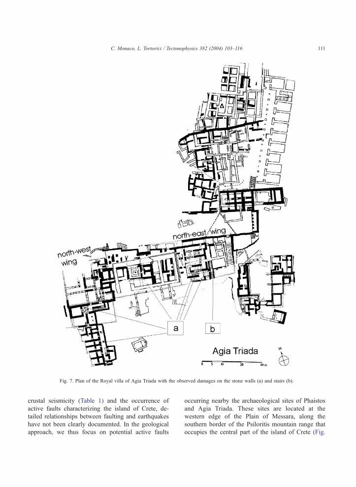
Fig. 7. Plan of the Royal villa of Agia Triada with the observed damages on the stone walls (a) and stairs (b).
C. Monaco, L. Tortorici / Tectonophysics 382 (2004) 103–116 111
crustal seismicity (Table 1) and the occurrence of
active faults characterizing the island of Crete, de-
tailed relationships between faulting and earthquakes
have not been clearly documented. In the geological
approach, we thus focus on potential active faults
occurring nearby the archaeological sites of Phaistos
and Agia Triada. These sites are located at the
western edge of the Plain of Messara, along the
southern border of the Psiloritis mountain range that
occupies the central part of the island of Crete (Fig.
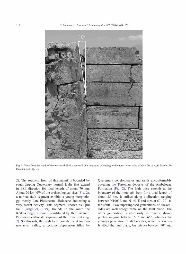
Fig. 8. View from the south of the westward tilted stone wall of a magazine belonging to the north–west wing of the villa of Agia Triada (for
location, see Fig. 7).
C. Monaco, L. Tortorici / Tectonophysics 382 (2004) 103–116112
2). The southern front of this massif is bounded by
south-dipping Quaternary normal faults that extend
in ESE direction for total length of about 70 km.
About 20 km NW of the archaeological sites (Fig. 2),
a normal fault segment exhibits a young morpholo-
gy, mostly Late Pleistocene–Holocene, indicating a
very recent activity. This segment, known as Spili
fault (Angelier, 1979), bounds to the south the
Kedros ridge, a massif constituted by the Triassic–
Paleogene carbonate sequence of the Ethia unit (Fig.
2). Southwards, the Spili fault bounds the Akoumia-
nos river valley, a tectonic depression filled by
Quaternary conglomerates and sands unconformably
covering the Tortonian deposits of the Ambelouza
Formation (Fig. 2). The fault trace extends at the
boundary of the mountain front for a total length of
about 25 km. It strikes along a direction ranging
between N100jE and N140jE and dips at 60–70j to
the south. Two superimposed generations of slicken-
sides are well recognizable on the fault plane. The
older generation, visible only in places, shows
pitches ranging between 50j and 65j, whereas the
younger generation of slicknesides, which pervasive-
ly affect the fault plane, has pitches between 90j and
C. Monaco, L. Tortorici / Tectonophysics 382 (2004) 103–116 113
110j. Inversion of the youngest slickensides data
yield a roughly NE extension direction (see inset a in
Fig. 2).
The cumulative height of the Spili fault scarp varies
along strike and reaches values of 300 m at its
northwestern edge. Between the villages of Kria Brisi
and Spili (Fig. 2), a 8–10-m high rejuvenated scarp is
well exposed at the base of the cumulative degraded
escarpment. In this sector, the footwall is entrenched
by narrow V-shaped canyons and wine glass valleys.
On the hangingwall that is characterized by the occur-
rence of an unentrenched drainage network, syntec-
tonic sedimentary wedges occur. They are constituted
by alluvial and colluvial deposits made up of calcar-
eous breccias and conglomerates deriving from the
unroofing of the uplifting footwall. The thickness of
these sediments strongly decreases from the hanging-
wall to the footwall, where they are represented by a
few metres thick indurated breccias directly lying on
the calcareous bedrock. Deposits with similar features
Fig. 9. View of the Spili fault escarpment (for location, see Fig. 2). Note
endured Wurmian deposits.
have been observed along other active fault in Pelo-
ponnesus such as the Sparta and Kalamata faults
(Armijo et al., 1991, 1992). These deposits have been
related to cold and dry climate occurring during the
Wurmian glaciation (Dufaure, 1977), which gave rise
to uniform steep slopes (z 30j) at the base of Qua-
ternary fault escarpment. Thus they constitute a good
marker to evaluate the fault activity since 10–11 ka,
when the glacial conditions ceased and the slip rate
outpaced erosion and sedimentation rates (Armijo et
al., 1992; Benedetti et al., 2002). The 8–10-m high
scarp at the base of the mountain front has been
interpreted as the result of the Holocene activity along
the Spili fault. In fact, as along the Sparta and Kala-
mata faults, this scarp offsets the calcareous slope near
the mountain-piedmont junction, where the alluvial
and colluvial deposits are severely deformed showing
in place roll-over anticlines and mountain-wards tilting
with angles that reach values of 30j. This young scarpmay be interpreted as resulting from several faulting
the 1.5-m high scarplet located at the mid-slope which offsets the
C. Monaco, L. Tortorici / Tectonophysics 382 (2004) 103–116114
events consequent to crustal earthquakes as observed
along other active faults in Afar, Greece and Italy
(Tapponnier et al., 1990; Armijo et al., 1991, 1992;
Stewart and Hancock, 1991; Piccardi et al., 1999;
Benedetti et al., 2002). On this basis, a rough vertical
slip-rate of about 0.7 mm/year can be estimated for the
Spili fault during the last 10 ka. Between Spili and Kria
Brisi (Fig. 9), the Holocene scarp is also characterized
by the occurrence of a 12-km long and 1–1.5-m high
light-coloured basal ribbon which could be related to
the last seismic event.
Along the northern border of the Plain of Messara
(Fig. 2), the E–W trending Agia Galini fault charac-
terized by a very young morphology occurs. To the
west, this fault extends offshore along the coastline
between Agia Pavlos and Agia Galini defining on the
footwall a coastal cliff with a maximum height of 400
m. Onshore, to the East of Agia Galini, this fault
segment is defined by a 100-m high cumulative scarp,
characterized by the occurrence of a series of trape-
zoidal and triangular facets. The Agia Galini fault
separates the Tortonian clastic deposits cropping out
on the footwall from the Quaternary alluvial deposit
of the Plain of Messara on the hangingwall (Fig. 2).
On the footwall, two main marine terraces occurring
at a maximum elevation of 163 m and 223 m are
recognizable, testifying for a sustained uplift of the
upthrown block.
4. Conclusions
The analysis of damages affecting the archaeolog-
ical sites of Phaistos and Agia Triada reveals that
these settlements were probably destroyed by two
large seismic events with IX–X MKS intensity oc-
curred around 1700 and 1450 BC, respectively. More-
over, geological and morphological studies carried out
in the neighbouring areas show the occurrence of E–
W trending Quaternary fault segments belonging to a
50-km long system that control the present topogra-
phy and exhibit steep young scarps with very sharp
morphology, mostly Holocene in age. These normal
faults are activated by a NW–SE-oriented extension
which is consistent with the seismicity (see focal
mechanisms in Fig. 1) characterizing this area in the
last 50 years. On this basis, we may infer that the Spili
and Agia Galini faults are good candidates to be
considered active faults generating large earthquakes
that could have destroyed the settlements of Phaistos
and Agia Triada.
The empirical relations of magnitude versus surface
rupture length (SRL) and magnitude versus maximum
vertical displacement (MVD) compiled for historical
and instrumental earthquakes from the broader Aegean
region (Pavlides and Caputo, 2004) represent a good
tool to estimate the magnitude of a possible earthquake
related to ruptures occurring along the Spili fault. This
fault segment, which extends for a total length of about
25 km, is characterized by a 8–10-m high Holocene
escarpment and by a 12-km long and 1.5-m high
scarplet. Assuming that the up to 1.5-m high scarplet
has been generated by a single seismic event and that
the rupture at the surface corresponds to a length of 12
km, both the relations M versus SRL and M versus
MVD suggest that the Spili fault could generate earth-
quakes with Mi6.5. These estimated values of mag-
nitude and surface rupture are also consistent with the
empirical relationships among magnitude, rupture
length and surface displacement obtained for the active
normal faults all over the world (Wells and Copper-
smith, 1994). Taking into account that the 8–10-m
high Holocene scarp of the Spili fault could be
considered as the result of the summation of 5–7
earthquakes with Mi6.5, for this fault segment a
recurrence interval of 1.4–2.0 ka for the last 10 ka
could be inferred. The Spili fault extending NNW of
the sites of Agia Triada and Phaistos may thus be
considered as potential source of seismic events that,
characterized by Mi6.5, were responsible for the
damages in these Minoan settlements. Nevertheless,
the recurrence interval estimated for this structure is
not compatible with the lapse of time of about 250
years occurring between the two inferred earthquakes
that destroyed Phaistos (1700 BC) and Agia Triada
(1450 BC). Two distinct hypotheses can be inferred to
explain this irregularity of earthquake time intervals.
The first hypothesis assumes that the two events were
generated by ruptures occurring along two distinct
faults (e.g. the Spili and the Agia Galini faults)
belonging to the same seismogenic zone. Different
ruptures along adjacent fault segments could be
explained with changes of the Coulomb failure stress
caused by earthquake ruptures occurring along a fault,
triggering the subsequent shock on the other one (King
et al., 1994; Jacques et al., 1996, 2001). Following this
C. Monaco, L. Tortorici / Tectonophysics 382 (2004) 103–116 115
line of reasoning, we suggest that when a rupture
occurred along the Spili fault, this perturbed the stress
state of the adjacent segments (e.g. the Agia Galini
fault) favouring subsequent ruptures. The second hy-
pothesis supposes that the Spili fault is characterized
by the occurrence of non-periodic earthquakes. This
assumption is suggested by cosmogenic dating
obtained on the Sparta normal fault scarp which show
time intervals ranging between 500 and 4500 years
(Benedetti et al., 2002).
Finally, both of the hypotheses imply that the
Minoan palatial centres were destroyed by large
earthquakes related to ruptures along distinct faults
affecting the Crete island rather than a single cata-
strophic event that caused the abrupt destruction of
the Minoan civilisation in the eastern Mediterranean
(see Driessen and Macdonald, 2000 and reference
therein).
Acknowledgements
We wish to thank Vincenzo La Rosa, Head of the
Centro di Archeologia Cretese of the University of
Catania, for access to the Minoan sites of Phaistos and
Agia Triada and for thoughtful discussions and for
providing the archaeological data reported in this
paper.
References
Angelier, J., 1979. Neotectonique de l’Arc egeen. Soc. Geol. Du
Nord 3 (418 pp.).
Armijo, R., Lyon-Caen, H., Papanastassiou, D., 1991. A possibile
normal fault rupture for the 464 BC Sparta earthquake. Nature
351, 137–139.
Armijo, R., Lyon-Caen, H., Papanastassiou, D., 1992. E–W exten-
sion and Holocene normal fault scarps in the Hellenic arc. Ge-
ology 20, 491–494.
Benedetti, L., Finkel, R., Papanastassiou, D., King, G., Armino, R.,
Ryerson, F., Farber, D., Flerit, F., 2002. Post-glacial slip history
of the Sparta fault (Greece) determined by 36Cl cosmogenic
dating: evidence for a non-periodic earthquakes. Geophys.
Res. Lett. 29 (87), 1–4.
Bonneau, M., 1984. Correlation of the Hellenides nappes in the
south-east Aegean and their tectonic reconstruction. In: Dixon,
J.E., Robertson, A.H.F. (Eds.), The Geological Evolution of the
Eastern Mediterranean. Geol. Soc. London, Spec. Publ., 17,
pp. 517–528.
Christoskov, L., Gergova, D., Iliev, I., Rizzo, V., 1995. Traces of
seismic effects on archaeological sites in Bulgaria. Ann. Geofis.
38, 907–918.
De Boer, J.Z., Hale, J.R., 2000. The geological origins of the oracle
at Delphi, Greece. In: McGuire, W.G., Griffiths, D.R., Hancock,
P.L., Stewart, I.S. (Eds.), The Archaeology of Geological Cata-
strophes. Geol. Soc. London, Spec. Publ., 171, pp. 399–412.
Di Vita, A., 1995. Archaeologists and earthquakes: the case of 365
A.D. Ann. Geofis. 38, 971–976.
Driessen, J., Macdonald, C.F., 2000. The eruption of the Santorini
volcano and its effects on Minoan Crete. In: McGuire, W.G.,
Griffiths, D.R., Hancock, P.L., Stewart, I.S. (Eds.), The Archaeo-
logy of Geological Catastrophes. Geol. Soc. London, Spec.
Publ., 171, pp. 81–93.
Dufaure, J.J., 1977. Neotectonique et morphogenese dans une
peninsula mediterraneenne: Le Peloponnese. Rev. Geogr. Phys.
Geol. Dyn. 19, 27–58.
Fassoulas, C., 2001. The tectonic development of a Neogene basin
at the leading edge of the active European margin: the Heraklion
basin, Crete, Greece. J. Geodyn. 31, 49–70.
Fassoulas, C., Kilias, A., Mountrakis, D., 1994. Post-nappe stack-
ing extension and exhumation of HP/LT rocks in the island of
Crete, Greece. Tectonics 13, 127–138.
Gergova, D., Iliev, I., Rizzo, V., 1995. Evidence of a seismic event
on Thracian tombs dated to Hellenistic period (Sveshtari, north-
eastern Bulgaria). Ann. Geofis. 38, 919–926.
Giuffre, A., 1995. Seismic damage in historic town centres and
attenuation criteria. Ann. Geofis. 38, 837–843.
Hall, R., Audley-Charles, M.G., Carter, D.J., 1984. The signifi-
cance of Crete for the evolution of the eastern Mediterranean.
In: Dixon, J.E., Robertson, A.H.F. (Eds.), The Geological Evo-
lution of the Eastern Mediterranean. Geol. Soc. London, Spec.
Publ., 17, pp. 499–516.
Jacques, E., King, G.C.P., Tapponnier, P., Ruegg, J.C., Manighetti,
I., 1996. Seismic activity triggered by stress changes after the
1978 events in the Asal Rift, Djibuti. Geophys. Res. Lett. 23,
2481–2484.
Jacques, E., Monaco, C., Tapponnier, P., Tortorici, L., Winter, T.,
2001. Faulting and earthquake triggering during the 1783 Cala-
bria seismic sequence. Geophys. J. Int. 147, 499–516.
Kilias, A., Fassoulas, C., Mountrakis, D., 1993. Tertiary extension
of continental crust and uplift of the Psiloritis metamorphic core
complex at the central part of the Hellenic arc. Bull. Geol. Soc.
Greece 28, 297–314.
King, G.C.P., Stein, R.S., Lin, J., 1994. Static stress changes and the
triggering of earthquakes. Bull. Seism. Soc. Am. 84, 935–953.
La Rosa, V., 1985. Preliminary considerations on the problem of the
relationship between Phaistos and Haghia Triada. Scripta Med-
iterranea 6, 45–54.
La Rosa, V., 1989. Nouvelle donnees du Bronze moyen au Bronze
recent a Hagia Triada. Aegeum 3, 81–92.
La Rosa, V., 1992. Ayia Triada and Phaistos. In: Myers, J.W.,
Myers, E.E., Cadogan, G. (Eds.), The Aerial Atlas of Ancient
Crete. Univ. of California Press, Berkeley, pp. 70–77.
La Rosa, V., 1995. A hypothesis on earthquakes and political power
in Minoan Crete. Ann. Geofis. 38, 881–891.
Levi, D., 1976. Festos e la civilta minoica. Ateneo, Roma, p. 864.
Lyon-Caen, H., Armijo, R., Drakopoulos, J., Baskoutass, J., Deli-
C. Monaco, L. Tortorici / Tectonophysics 382 (2004) 103–116116
bassis, N., Gaulon, R., Kouskouna, V., Latoussakis, J., Makro-
poulos, K., Papadimitriou, P., Papanastassiou, D., Pedotti, G.,
1987. The 1986 Kalamata (South Peloponnesus) earthquake:
detailed study of a normal fault, evidences for east–west exten-
sion in the Hellenic arc. J. Geophys. Res. 93, 14967–15000.
McKenzie, D., 1978. Active tectonics of the Mediterranean region.
Geophys. J. R. Astron. Soc. 30, 109–185.
National Observatory of Athens, 2002. Earthquake Catalogue of
Greece. Web site http://www.gein.noa.gr.
Papanastassiou, D., Lataoussakis, J., Stavrakakis, G., 2001. A re-
vised catalogue of earthquakes in the broader area of Greece for
the period 1950–2000. Bull. Soc. Geol. Greece 34, 1563–1566.
Pavlides, S., Caputo, R., 2004. Magnitude versus faults’ surface
parameters: quantitative relationships from the Aegean Region.
Tectonophysics 380, 159–188.
Pernier, L., 1935. Il palazzo minoico di Festos. La Libreria dello
Stato, Roma, p. 786.
Pernier, L., Bandi, L., 1951. Il palazzo minoico di Festos. La Libre-
ria dello Stato, Roma, p. 647.
Piccardi, L., Gaudemer, Y., Tapponnier, P., Boccaletti, M., 1999.
Active oblique extension in the central Apennines (Italy):
evidence from the Fucino basin. Geophys. J. Int. 139,
499–530.
Pondrelli, S., Morelli, A., Ekstrom, G., Mazza, S., Boschi, E.,
Dziewonski, A.M., 2002. European–Mediterranean regional
centroid-moment tensors: 1997–2000. Phys. Earth Planet. Inter.
130, 71–101.
Stewart, I., Hancock, P.L., 1991. Scales of structural heterogeneity
within neotectonic normal fault zones in the Aegean region.
J. Struct. Geol. 13, 191–204.
Stiros, S.C., 1996. Identification of earthquakes from archaeological
data: methodology, criteria and limitations. In: Stiros, S., Jones,
R.E. (Eds.), Archaeoseismology. British School at Athens, Fitch
Laboratory Occasional Paper, vol. 7, pp. 129–152.
Stiros, S.C., 2000. Fault pattern of Nisyros Island volcano (Aegean
Sea, Greece): structural, coastal and archaeological evidences.
In: McGuire, W.G., Griffiths, D.R., Hancock, P.L., Stewart, I.S.
(Eds.), The Archaeology of Geological Catastrophes. Geol. Soc.
London, Spec. Publ., 171, pp. 385–398.
Stiros, S.C., 2001. The AD 365 Crete earthquake and possible
seismic clustering during the fourth to sixth centuries AD in
the eastern Mediterranean: a review of historical and archaeo-
logical data. J. Struct. Geol. 23, 545–562.
Tapponnier, P., Armijo, R., Manighetti, I., Courtillot, V., 1990.
Bookshelf faulting and horizontal block rotations between over-
lapping rifts in southern Afar. Geophys. Res. Lett. 17, 1–4.
Waelkens, M., Sintubin, M., Muchez, P., Paulissen, E., 2000. Ar-
chaeological, geomorphological and geological evidence for a
major earthquake at Sagalassos (SW Turkey) around the middle
of the seventh century AD. In: McGuire, W.G., Griffiths, D.R.,
Hancock, P.L., Stewart, I.S. (Eds.), The Archaeology of Geo-
logical Catastrophes. Geol. Soc. London, Spec. Publ., 171,
pp. 373–384.
Wells, D.L., Coppersmith, J.K., 1994. New empirical relationship
among magnitude, rupture length, rupture width, rupture area
and surface displacement. Bull. Seism. Soc. Am. 84, 974–1002.