fao -unesco soil map of the world · use of soils: climate, vegetation, geology and lithology, and...
TRANSCRIPT

FAO -Unesco
Soil mapof the world
Volume IXSoutheast Asia

FAO-Unesco
Soil map of the world
1 : 5 000 000
Volume IX
Southeast Asia

FAO-Unesco
Soil map of the world
Volume I LegendVolume II North AmericaVolume III Mexico and Central AmericaVolume IV South AmericaVolume V EuropeVolume VI AfricaVolume VII South AsiaVolume VIII North and Central AsiaVolume IX Southeast AsiaVolume X Australasia

NES
FOOD AND AGRICULTURE ORGANIZATION OF THE UNITED NATIONS
UNITED NATIONS EDUCATIONAL, SCIENTIFIC AND CULTURAL ORGANIZATION
FAO - Unesco
Soil mapof the world
: 5 000 000
Volume IXSoutheast Asia
Prepared by the Food and Agriculture Organizationof the United Nations
Unesco - Paris 1979

The designations employed and the presentation ofmaterial in this publication do not imply the expressionof any opinion whatsoever on the part of the Foodand Agriculture Organization of the United Nationsor the United Nations Educational, Scientific andCultural Organization concerning the legal status ofany country, territory, city or area or of its author-ities, or concerning the delimitation of its frontiersor boundaries.
Printed by Tipolitografia F. Failli, Romefor the Food and Agriculture Organization of theUnited Nationsand the United Nations Educational, Scientific andCultural Organization
Published in 1979 by the United NationsEducational, Scientific and Cultural OrganizationPlace de Fontenoy, 75700, Paris
© FAO/Unesco 1979 ISBN 92-3-101363-7Printed in Italy

The project for a joint FAO/Unesco Soil Map ofthe World was undertaken following a recommenda-tion of the International Society of Soil Science. Itis the first attempt to prepare, on the basis of inter-national cooperation, a soil map covering all thecontinents of the world in a uniform legend, thusenabling the correlation of soil units and comparisonson a global scale. The project, which started in 1961,fills a gap in present knowledge of soil potentialitiesthroughout the world and provides a useful instru-ment in planning agricultural and economic develop-ment programmes.
The project has been carried out under the scientificauthority of an international advisory panel, withinthe framework of FAO and Unesco programmes.The different stages of the work included comparativestudies of soil maps, field and laboratory work, andthe organization of international expert meetings andstudy tours. The secretariat of the joint project,located at FAO Headquarters, was vested with theresponsibility of compiling the technical information,
PREFACE
correlating the studies and drafting the maps andtext. FAO and Unesco shared the expenses involvedin the realization of the project, and Unesco under-took publication of its results. The services of anassociate expert were made available by the Govern-ment of the Netherlands to assist in the preparationof the soil map of Southeast Asia.
The present volume, covering the soils of South-east Asia, is the ninth of a set of ten which makeup the complete publication of the Soil Map of theWorld. The first volume records introductory in-formation and presents the definitions of the elementsof the legend which is used uniformly throughoutthe publication. Each of the nine following volumescomprises an explanatory text and the correspondingmap sheets covering the main regions of the world.
FAO and Unesco wish to express their gratitudeto the government institutions, the InternationalSociety of Soil Science, and the many individualsoil scientists who have contributed so much to thisinternational project.

CONTENTS
Summaries
EnglishFrenchRussian ..Spanish
I. Introduction
2. Acknowledgements
Topographic base .
Map unitsCartographic representationSources of information
ClimateVegetationGeology and lithologyPhysiography.
5. The soils of Southeast Asia
Distribution of major soils
3
3. The map 5
5
55
7
4. Environmental conditions 9
914
18
25
AcrisolsCambisolsRendzinasFerralsolsGleysolsLithosols .
Fluvisols . .
L. LuvisolsNitosolsHistosols .PodzolsArenosols .
RegosolsT. AndosolsV. VertisolsConclusions
Appendix
Morphological, chemical and physical prop-erties of Southeast Asian soils: data fromselected profiles
Figures (at back of volume)
Climatic regionsVegetation regionsOceanic basins and morphostructuralregions
Geological regions
34 5. Lithological regions6. Physiographic regions
34 7. Soil regions
5557
5959
61636364666769697071
73
74
77
Preface 6. Land use and soil suitability 54
This volume describes the Southeast Asian sectionof the 1: 5 000 000 Soil Map of the World.
The map
The Soil Map of Southeast Asia is drawn ontopographic base maps of the 1: 5 000 000 series ofthe American Geographical Society. The map unitsare associations of soil units divided in.to textureand slope classes. They are marked on the mapby symbols. The dominant soils are shown bycolours and phase differences are shown by over-prints.
A small inset map shows three grades of reliabilityof the soil information from which the map wascompiled.
Detailed definitions of the soil units and fulldescriptions of all the terms used may be found inVolume I of the set.
The text
The first chapter describes the development of theproject in Southeast Asia and gives some notes onuses of the map. The second acknowledges thecooperation of the agencies and the many personswho contributed to the map and text, and the thirdaives a summary of the material in Volume I onthe map units, legend and sources of information.
The main chapters of this volume deal with environ-mental conditions, soil distribution and land use andsoil suitability.
ENVIRONMENTAL CONDITIONS
C hapter 4 contains brief accounts of four environ-mental factors which influence the development anduse of soils: climate, vegetation, geology and lithology,and physiography.
Climate is discussed on the basis of five broadclimatic zones. Since the criteria used in delimiting
SUMMARY
units are those that are important to crop growth,the climatic map is supplementary to the soil mapin the transfer of crop information from one partof the world to another. Here only the highercategories are discussed. The 15 climatic regionsare outlined on a small-scale map (Figure 1).
Vegetation is discussed on the basis of 11 broadvegetation regions distinauished according to habitat(either climatic or edaphic) and the physiognomyand structure of the vegetation. The distributionof the vegetation regions is outlined on a small-scalemap (Figure 2). The text gives some brief notes onthe location and nature of each region.
Geology is considered under four morphostructuralregions, 13 geological regions and 46 geologicalunits. Oceanic basins and morphostructural regionsare shown in Figure 3, and geological regions inFigure 4. Lithology is considered under 10 regionsin Figure 5. The text outlines the geological originsand nature of the main surfaces at present exposed.
Physiography is considered under 10 physiographicregions and 30 physiographic units. A small-scalemap (Figure 6) shows the physiographic regions.The text gives some brief notes on the landscapeand location of each region and subt egion.
SOILS AND LAND USE
Chapters 5 and 6, describing the soils of SoutheastAsia, contain an extensive table of soil associations,an account of the distribution of the main soils,and a discussion of land use and soil suitabilitiesfor agriculture.
The table of soil associations lists all the mapunits in alphabetical order of symbols. Othercolumns show:
Associated soilsInclusionsPhasesAreas of units in 1 000 hectaresClimate symbolsCountries of occurrence
Viii SOIL MAP OF SOUTHEAST ASIA
The distribution of major soils is discussed on thebasis of 19 broad soil regions and 10 subregionswhich are outlined on a small-scale map (Figure 7).The main soils of each region are discussed in relationto factors of the environment.
Present land use and suitabilities for agricultureare discussed at first in general. Then the main soilsare considered separately, their present use beingdescribed and their suitability outlined.
Conclusions
A general outline of the distribution of the mainsoil units and their suitability is given in Chapter 6.
The dominance of Acrisols, which cover 51 percentof the region, is noted, and stress is laid on theessential management inputs needed to allow foragricultural expansion and minimize risks of seriousand widespread soil degradation.
The Appendix
Site and profile data, including profile descriptionsand analyses, are given in the Appendix for someof the main soil units. For easier reference, thesoil pi ofiles are listed in alphabetical order ofsymbols.

Le present volume décrit la partie relative à l'Asiedu Sud-Est de la Carte mondiale des sols au 15 000 000.
La carte
La carte des sols de l'Asie du Sud-Est est établied'après les fonds topographiques au I: 5 000 000de l'American Geographical Society. Les unitescartographiques sont des associations d'unités péclo-logiques divisées en classes de texture et de pente.Elles sont indiquées sur la carte par des symboles.Les sols dominants sont représentes par des couleurset les differences de phase sont indiquées en sur-charge.
Une carte à petite echelle reproduite en carton surla carte principale precise les trois degrés de fiabilitedes données pédologiques utilisées pour l'établisse-ment de la carte.
On trouvera dans le volume I de cette série lesdefinitions détaillées des unites pédologiques et unedescription complète de tous les termes employes.
Le texte
Le chapitre 1 fait l'historique du projet en Asiedu Sud-Est et donne quelques informations surl'utilisation de la carte. Dans le chapitre 2, les auteursrendent hommage aux institutions et aux nombreusespersonnes qui ont collaboré à l'établissement de lacarte et du texte. Le chapitre 3 donne un résumédu volume I relatif aux unités cartographiques, auxlégendes et aux sources d'information.
Les principaux chapitres de ce volume traitent dumilieu, de la répartition des sols, de l'utilisation desterres et de la vocation des sols.
LE MILIEU
Le chapitre 4 expose brièvement les quatre facteursdu milieu qui influencent la répartition et l'utilisation
des sols: climat, vegetation, géologie et lithologie,et physiographie.
Le climat est traité sur la base de cinq grandessubdivisions climatiques. Etant donne que pourdelimiter ces unites on a retenu les critères importantspour la croissance des plantes, la carte climatiquecomplète la carte des sols et doit ètre consultée pourle transfert des données sur les cultures d'une partiedu monde a une autre. 11 n'est tenu compte ici quedes catégories supérieures. Les 15 régions climatiquessont délimitées sur la carte à petite echelle (figure 1).
La vegetation est répartie en 11 grandes regionsclassées selon l'habitat (climatique ou éclaphique),la physionomie et la structure de la vegetation. Cesregions sont localisées sur une carte à petite échelle(figure 2). Le texte donne quelques brèves indicationssur l'emplacement et la nature de chaque region.
La géologie est traitée sur la base de quatre regionsmorphostructurelles. 13 regions géologiques et 46unités géologiques. La figure 3 indique les bassinsoaaniques et les régions rnorphostructurelles; lafigure 4 donne les régions géologiques. La lithologieest étudiée sur la base de 10 régions (figure 5). Letexte indique l'origine géologique et la nature desprincipales surfaces qui sont actuellement exposées.
La physiographie est étudiée dans le cadre de 10regions et de 30 unites physiographiques. Une carte
petite échelle (figure 6) montre les elements dumodelé de l'Asie du Sud-Est. Le texte donne, quelquesbrèves indications sur le paysage et l'emplacementde chaque region et sous-region.
LES SOLS ET LEUR,S UTILISATIONS
Les chapitres 5 et 6, qui décrivent les sois de l'Asiedu Sud-Est, comprennent un tableau détaillé desassociations de sols, une etude de leur répartitionpar grandes regions pédologiques, et un examen del'utilisation des terres et de leur vocation agricole.
Le tableau des associations de sols énumère toutesles unites cartographiques dans l'ordre alphabétique
RESUME

SOIL MAP OF SOUTHEAST ASIA
des symboles. Les autres colonnes sont consacréesaux jrubriques suivantes:
Sols associésnclusions
PhasesSuperficie en milliers d'hectaresClimatLocalisation par pays.
La répartition des principaux sols est étudiée surla base de 19 grandes regions pédologiques et de 10sous-regions qui figurent sur une carte A petite échelle(figure 7). Les principaux sols de chaque region sontétudiés en fonction des facteurs du milieu.
L'utilisation actuelle des terres et leur vocationagrieole sont étudiées d'abord d'une maniere générale.On passe ensuite à l'examen des principaux sols prisséparément; leur utilisation actuelle est indiquée etleur aptitude A l'agriculture est analysée.
Conclusions
Le chapitre 6 donne une description générale dela répartition des principales unites pédologiques etde leur vocation. Il signale la predominance desacrisols, qui couvrent 51 pour cent de la region, etinsiste sur les ressources qu'il est indispensable d'af-fecter à l'aménagement pour permettre l'expansionde l'agriculture et réduire au minimum les risquesd'une grave degradation générale des sols.
Annexe
On trouvera à l'annexe des renseignements concer-nant les sites et les profits, y compris des descriptionsde profils et des analyses concernant certaines desprincipales unites pédologiques. Pour plus de com-modité, les profils des sols sont donnés dans l'ord realphabétique des symboles.

Pe3mme pacppeneneHme MOHB H NCHOSIb30BaHHe3OTATIU, a TaK/KO IlpHrOZHOCTB no.
naHHom Tome M3.110OHO onmcaHmepa3nena 101"0-BOCTOHBOM A3MH HogBeHHonFapTui mmpa macwTaba 1: 5 000 000.
KapTa
EOHBOHHaR mapTa tOro-BocTo4Ho2A3mm cocTaBneHa Ha ocHoBe Tonorpacpm-gecFmx ba3oBbix xapT macwTaba1: 5 000 000 AmepmrcaHcxoro reorpacDH-ilecyoro o011ecTBa. KapTorpa*mLiecmmeenmHmubs - 3T0 HogBeHHHe accoumaumm,Honpa3neneHHEe Ha FnaccH B 33BHCH-MOCTH OT cTpyFTypEA H penbecl)a. OHEnorca3aHE Ha FapTe PIFulexcamm. Ilpeobna-ZalOWHe HOHBM BEZOTIOHH 11BOTaME, acl)a3oBe p03nml1mpf - MTpMXOBKOM.
ManaFf FapTa-Bpe3Fa n0ic03uBaeTTpm cTerleHm gOCTOBOpHOCTH gaRBIDIX OnoLiBe, Ha ocHoBe FoTopbix 6una cocTa-BneHa KapTa.
nonpobHble onpeneneHms1 FlogBeHHuxegmHmu m flonHble OEHCaHHH Bcex npmme-HeHHIDiX TepmmHoB MO>M10 HaMTH B LTome KomnflexTa.
TexcT
nepBofi rnaBe ODACHB3OTCHpa3paboTica npoeFTaB fOro-BocTollHoMA3ME M cozep>KaTcR HemoTopEe 3ameTFHO E0.7.1D30BaHHH HapTamm. BO BTOpOErnaBe Be1p0xcaeTc5T DPH3EaTOJELHOCTID 3acoTpynHmllecTBo yl-ipe>i<neHmsim H MHOPHMnmHam, FoTopEe npmHsinm yl-lacTme 15
COCTaBlIOHHH FapTH m EOZPOTOBKO 'l'ex--OTO, U B TpeTbek rnaBe naHo pe310memaTepmanoB,conep)KaavAxcH B Tome I,noHapTorpaq)nnechnm ennninTamnerel-unamnMCTOHHMKBM HOOpMaHMH.
OCHOBHMX rnaBax aTOPO TomaocBe00mTca ycnoBmsa oFpy>kamigeM cpezbi,
YaTIOBHH OKPY)KAME2 CPE,HEA
PE310ME
B rnaBe 4 npmBegeHH FpammecBeneHmg o geTupex cDaFTopax oFpyA.ca-muleM cpeBbi, BTINHIOMHX Ha (DopmmpoBaHme
HCDOITB30BaHHe noLIB: FnmmaTe, pac-THTellbHOCTN, reonOrmm M IINTOTIOPHH,clo143morpa4)mH.
KnHmaT paccmaTpHBaeTcB HaOCHOFl2T1106011IpHUX MaTHHOCKMX 30H.
DocKoribicy ,HTIA onpezeneHmHMCM0flb30BaHM IcpmTepmm, mmemilwebonbuloe 3HaeHme nnq pocTa 3epHoBux,Fnmm'aTwlecicasi HapTa ,L101-1011H2OT mog-BeHHym vapTy B HnaHe nepenagm cse-neHHH o 3epHo BMX 143 0HOH HaCTHmHpa B npyrylo. B ,HaHBOM cnyLiaepaccmaTpmBamTcH TIMMb Hambonee Fpy-nHue FaTeropmm. Ha menkomacuiTabHo2BugeneHH 15 KTEEMaTM FapTe /cxema 1/geommx 30H.
PaCTHTenBHOCTb paccmaTpmBaeTcHHa ocHoBe 11 061JJHpHEX 30H pacTmTenb-HOCTH, sunefulemux B 3aB1-fCHMOCT14 OTOCTeCTBeHHOM cpen1,1 /KIIMMaTHLIO CHOP1mnm no4HeHHo2/, a Taroke 4)M3MOPHOMHICH
cTpyr(TypEd pacTnTenbuocTm.PacnpegefleHme 30H pacTmTenbHocTm
yKa3aHo Ha merwomacuTabHoM KapTe/cxema 2/. B mane npmHoL1HTcg HeKo-Topue KPaTKNO 3aMOHaHHH OTHOCHTenb-HO pacnonox(eHm2 H xapaKTepa Kahczo23OHM.
Feoflorms,1 paccmaTpmsaeTcH noleTupem mopcDocTpyKTypHum permoHam,13 reonormgecKmm permoHam m 46 reo-flormLiecKmm e,qmilmuam. Baccef:Hu oKeaHa
mopcDocTpyRTypHue pePHOHE 1-10Ka3aHMHa cxeme 3, a reanormllecKme permoHu- Ha cxeme 4. nwronormg paccmaTpm-BacTcH no 10 3o1Iam,noKa3aHHEDIM Ha

cxeme 3. B TCKCTC OTM0,1aCTCH reono-rmmecxaa npmpoga i xapaRTep OCHOBHNXobHaNceHHux B HacToRuwe upemR noblep-xHocTek.
0143morpaOHR paccmaTpmBaeTca no10 $1,13morpa*mLiecxmm permoHam m 30(m3morpa(D1-Imecxmm egmHmmam. Ha menxo-macwTabHo xapTe /cxema 6/ MOKa3aHIDI(1)113morpaUmecxme permoHu. B TexcTenpmiiogRTER HexoTope xpaT xme 3ame-gaHMH OTBOCHTellIDHO naHgwa*Ta Hpacnono)<eHHR Ka)-Kgoro perEoHa mcybpermoba.
r10BU U HCI10111330BAflEE 3EM111,1
B rnaBax 5 [I 6, MOCBHIlleHHIDIX1-10,-1BaM POPO-BOCTO4HO11 A314m, cogep-MCMTCH ot5wmpHaa Tabrimna nomBeHHuxacconmaumk, cymmmpymulaR cBegeHmR opacnpegeneHmm OCMOBHHX nomB, mpaccmaTpmBaeTcH Bonpoc o 3emnenonb-30BaHMH M npmrogHocTm nomBu gnRCaTMDCKOFO.X0351MCTBa.
B Ta6nmne nomBeHHux acconmaum2B ancDaBmTHom nopRgxe mHgexcoB npmpo-gMTCR nepememb Bcex xapTorpacDmmecxmxegmlimn. B gpyrmx xonoHxax yxa3aHu:
ConyTcTsymutme MOgBHCnopagmmecxmeOa3uPaRoHu egmlimm B 1 000 rexTapoBKnmmaTmmecxme mHgexcuCTpaHu mx pacnonox(eHmRPacmpegeneHme OCHOBHHX nomp
o6cyxcgaeTcR Ha ocHoBe 19 oftimpHux
E04BeHHinIX 30H H 10 nog3oH, xoTopueomepmeHu Na menxomacalTabHoM xapTe/cxema 7/. OCETOBHHe 110,IBE KaK/10ft30HU paccmaTpmBamTcR B CB5i3M CcDaxTopamm oxpYmcammeM cpegu.
CospemeHHoe m000nb3oBaHme 3eMJIHM ee npmrogHocTb gnn cenbcxoro X03REcTBa paccmaTpmBamTcH BHamane BHen0M. 3aTem ocHoBHue nomBu paccma-TPMBaMTCR B oTgenbHocTm ogHoBpemeHHoC yxa3a Hmem Ha mx npmmeHeHme BHacToRwee Bpema m mx npmrogHocTb.
BHBOZU
B rnaBe 6 gaH oblumft 0630p pac-npegeneHmR OCHOBHHX nomBeHHux egmHmum mx npmrogHocTm. OTmemaeTcR npe-obnagaHme axpmconek, xoTopue oxpaTu-BaMT 51 npon. 30HH, M genaeTcR yEopHa He06XOZHMOCTB npmHRTmR BaNCHHX mepno ynpaBneHmm B nengx obecnemeHmaPa3BMTHR cenbcKoro X03512CTBa HCBMAKeHMA OflaCHOCTH cepbe3Horo Hilimpoxoro yxyylmeHmR nomBu.
rIpmnoxceHme
B npmnoxelimm npmBegeHu gaHHue opacnonomceHmm m npocDmnRx, BxnmmaRonmcaHmR m aHanm3 npo(Dmilen HexoTopuxOCHOBEINX 110qBeHHIDIX egmHmE. AnRo6nermeHmR cnpaBox nepemeHb npoUnelanomB npmBegeH B anfiaBmTHom nopRgxemHgexcoB.
xii SOIL MAP OF SOUTHEAST ASIA

En este volumen se describe la sección del Asiasudoriental del Mapa Mundial de Suelos a escala1 : 5 000 000.
El mapa
El Mapa de Suelos, que comprende el Asia sud-oriental, se ha trazado sobre los mapas topográficosbase de la serie a escala 1 : 5 000 000, de la AmericanGeographical Society. Las unidades del mapa sonasociaciones de unidades de suelos divididas enclases texturales y de inclinación. Se indican en elmapa por medio de símbolos. Los suelos dominantesse muestran por colores, mientras que las diferentesfases se indican con sobreimpresiones.
Un pequeño mapa intercalado indica tres gradosde fiabilidad de la información sobre suelos, quesirvió de base para la compilación del mapa.
En el Volumen I de la serie pueden encontrarselas definiciones detalladas de las unidades de suelosy descripciones completas de todos los términosutilizados.
El texto
En. el primer capítulo se describe el desarrollo delproyecto en el Asia sudoriental y se dan algunasnotas sobre los usos del mapa. En el segundo se dacuenta de la cooperación de organismos y del grannúmero de personas que han colaborado en losmapas y en el texto, y en el tercero se presenta unresumen del material contenido en el Volumen Isobre las unidades cartográficas, las leyendas y lasfuentes de información.
Los capítulos más importantes de este volumentratan de las condiciones del medio, de la distribucióndel suelo y de la utilización de las tierras y aptitudde los suelos.
CONDICIONES DEL MEDIO
El Capítulo 4 contiene breves reseñas de cuatrofactores del medio que influyen sobre la formacióny utilización de los suelos: el clima; la vegetación;la geología y litología, y la fisiografía.
El clima se estudia sobre la base de cinco ampliaszonas climáticas. Como los criterios que se hanseguido para la delimitación de las unidades sonaquellos que tienen importancia para el desarrollode los cultivos, el mapa climático es complementariodel mapa de suelos para la transferencia de infor-mación sobre cultivos de una parte del mundo aotra. Aquí sólo se examinan las categorías superiores.Las 15 regiones climáticas se señalan en un mapaa pequeña escala (Figura 1).
La vegetación se estudia sobre la base de 11 am-plias regiones de vegetación que se distinguen segúnel hábitat (ya sea climático o edáfico) y la fisionomíay estructura de la vegetación. La distribución de lasregiones de vegetación se señalan en un mapa apequeña escala (Figura 2). El texto contiene algunasbreves notas sobre el emplazamiento y naturalezade cada región.
La geología se examina con arreglo a- cuatro re-giones morfoestructurales, 13 regiones geológicas y46 unidades geológicas. Las cuencas oceánicas y lasregiones morfoestructurales se muestran en la Figura3, y las regiones geológicas en la Figura 4. La lito-logía se estudia con arreglo a 10 regiones en la Fi-gura 5. El texto bosqueja los orígenes geológicos yla naturaleza de las principales superficies expuestasactualmente.
La fisiografía se examina con arreglo a 10 regionesfisiográficas y 30 unidades fisiográficas. Un mapaa pequeña escala (Figura 6) muestra las regionesfisiográficas. El texto contiene algunas notas brevessobre el paisaje y emplazamiento de cada región ysubregién.
RESUMEN

xiv SO/L MAP OF SOUTHEAST ASIA
LOS SUELOS Y EL USO DE LA TIERRA
Los capítulos 5 y 6, en que se describen los suelosde Asia sudoriental, contienen un extenso cuadrode asociaciones de suelos, una reseña de la distribu-ción de los suelos principales y un examen del usode la tierra y de las aptitudes del suelo para la agri-cultura.
El cuadro de asociaciones de suelos enumera todaslas unidades del mapa por orden alfabético de lossímbolos. En las otras columnas se presentan:
Suelos asociados
Inclusiones
Fases
Superficie de las unidades en millares de hectáreas
Símbolos climáticos
Paises en que se presentan
La distribución de los suelos principales se examinasobre la base de 19 amplias regiones edáficas y 10subregiones, que se esbozan en el mapa a pequeñaescala (Figura 7). Los suelos principales de cada re-gión se estudian en relación con los factores delambiente.
El uso actual de la tierra y su aptitud para la agri-cultura se examinan al principio en líneas generales.Se consideran después, por separado, los principalessuelos, describiéndose su uso actual y esbozándosesu aptitud.
Conclusiones
En el Capítulo 6 se da un bosquejo general de ladistribución de las principales unidades edáficas yde su aptitud. Se pone de relieve la dominancia delos acrisoles, que cubren un 51 por ciento de laregión, y se hacen resaltar los insumos de ordenaciónesenciales y necesarios para permitir una expansiónagrícola y minimizar los riesgos de una degradacióngrave y generalizada de los suelos.
El Apéndice
En el Apéndice se dan datos sobre lugares y perfiles,incluidos las descripciones y los análisis de los perfilespara algunas de las principales unidades edaficas.Para facilitar la consulta, los perfiles de suelos seenumeran en orden alfabético de los símbolos.

History of the project
Recognizing the need for an integrated knowledgeof the soils of the world, the Seventh Congress ofthe International Society of Soil Science held in 1960in Madison, Wisconsin, United States, recommendedthat ways and means be found for the publicationof soil maps of the great regions of the world. Asa follow-up to this recommendation, FAO andUnesco agreed in 1961 to prepare jointly a Soil Mapof the World based on the compilation of availablesoil survey material and on additional field correlation.The secretariat of the joint project was located atFAO Headquarters in Rome. It was responsiblefor collecting and compiling the technical information,undertook correlation studies and drafted the mapsand text.
In June 1961 an Advisory Panel composed of prom-inent soil scientists representing various parts ofthe world was convened by FAO and Unesco tostudy the methodological, scientific, and various otherproblems related to the preparation of a Soil Mapof the World.2
In June 1964 a meeting was convened in Tokyoon the classification and correlation of soils fromvolcanic ash.
A regional seminar on soil survey and soil fertilityresearch in Asia and the Far East was held in NewDelhi in February 1971.
In July 1972 the Government of Indonesia hostedthe Second ASEAN (Association of South-East AsianNations) Soil Conference in Jakarta. Field tripsorganized for the conference afforded opportunitiesfor the correlation of many of the inajor soil unitsof the Southeast Asia region.
The history of the project as a whole is dealt with morecompletely in Volume 1 .
2 The participants in this meeting were:Consultants: G. Aubert (France), M. Camargo (Brazil),
J. D'Hoore (Belgium), E.V. Lobova (U.S.S.R.), S.F. Ray-chaudhuri (India), G.D. Smith (United States), C.G. Stephens(Australia), R. Tavernier (Belgium), N.H. Taylor (New Zealand),1V. Tiurin (U.S.S.R.) and F.A. van Barca (Netherlands).
Unesco Secretariat: V.A. Kovda and M. Batisse.FAO Secretariat: D. Luis Bramao, R. Dudal and F. George.
1. INTRODUCTION
The final draft of the general Soil Map of SoutheastAsia was compiled in the Soil Resources Develop-ment and Conservation Service of FAO in 1975. Itincorporates updated information on soil distributionresulting from a number of FAO/UN DP field projects,and entirely revised soil maps for several countriessuch as Indonesia, Malaysia, the Philippines andThailand.
The main sources of information used in the prep-aration of the Soil Map of Southeast Asia aredescribed in Chapter 3.
Objectives
Transfer of knowledge and experience from onearea of the earth to another can only be successfulwhen allowance is made for similarities and differencesin the geographical, soil and climatic conditions ofthe regions or countries involved. Furthermore, theeconomic feasibility of different management tech-niques under prevailing socio-economic conditionsneeds to be assessed before they can be recommendedfor adoption. In order to do so, reliable informationon the nature and distribution of the major soils ofthe world is of fundamental importance. However,the preparation of regional and continental soil mapsrequires a uniform legend and nomenclature and thecorrelation of existing soil classification systems.One of the principal objectives of the FAO/UnescoSoil Map of the World project was to promote co-operation among soil scientists all over the world toagree on an international soil correlation system.
In Southeast Asia agricultural research is centredmainly on increased output from existing croplandand evaluation studies of the agricultural potentialof vast areas which have scarcely been touched byman, together with the rehabilitation of land whichhas suffered degradation due to man's irresponsibleactivities. Many experts under international andbilateral programmes are assisting the governmentsin this task. This regional soils study attempts topresent a synthesis of the knowledge available at thepresent stage of development of soil science in South-

2 SOIL MAP OF SOUTHEAST ASIA
east Asia. It is hoped that it will promote betterunderstanding among soil scientists, planners andfarmers, provide useful coordination of national andinternational soils work, and stimulate research andits application in the region.
Value and limitations of the map
The Soil Map of Southeast Asia is meant to bea source of factual data providing a basis and frame-work for further regional and national soil surveysat a more detailed scale. It may assist in selectingmethods of reclamation, crop production, fertilizerapplication and general use of soils. Until now allattempts to make overall plans or forecasts for agri-culture have been hampered by lack of uniformityin the terminology, nomenclature and classificationof soils and by the lack of a comprehensive pictureof the world's soil resources.
Through a systematic interpretation of the SoilMap of the World it will be possible to appraisethe disti ibution and production potential of the majorsoils on a continental basis and to delineate broadpriority areas which deserve further study. Thisinventory of soil resources will bring to light thelimitations and potentialities of the different regionsfor increased food production.
in addition, a regional soil map such as the SoilMap of Southeast Asia can be a valuable teachingaid for the training of geographers, soil scientists,agronomists and all those who are interested in thestudy of the environment.
Although the publication of the map and textmarks a significant step forward, it is necessary topoint out its inherent limitations. The accuracy anddetail of information vvhich can be shown are ob-viously limited by the small scale of the map andby the fact that soil data for some areas are scarcebecause of inadequate field correlation or lack ofdirect observations. On the other hand, difficultieshave arisen in the use of available information forthe compilation of the regional map because of thedifference in the methods of field and laboratorystudies. These limitations may also apply to theinterpretative data, since they can only be as accurateas the soils information on which they are based.Yet despite these shortcomings, the Soil Map of
Southeast Asia is the most recent and detailed in-ventory of soil resources based on internationalcooperation. Its limitations emphasize the necessityof intensifying soil correlation and obtaining betterknowledge of the nature and distribution of soilsin areas of the region where information is lackingor inadequate.
Use of the map and explanatory text
Against the background of the topographic basethe soil map shows the broad pattern of dominantsoils marked by different colours. Clusters of closelyrelated colours have been used for soils which havesimilar characteristics, so that major soil regions canbe recognized.
More detailed information about each map unitcan be derived from the soil association symbols.The composition of 143 soil associations is given inTable 4 of Chapter 5, where they are listed alpha-betically and numerically and are described in termsof climate, extension and main areas of occurrence.A table showing the composition of the soil associa-tions is also given on the back of the map sheet.
The meaning of the textural and slope classes whichaccompany the symbols of the map units and theoverprints which indicate phases are indicated on thesoil map and further described in Chapter 3. Thedefinitions of the soil units involved can be found inVolume I. The profile descriptions and analyticaldata in the Appendix illustrate and further clarifythe soil definitions.
The geographical distribution of the broad soilregions is shown in Figure 7 and discussed in Chap-ter 5.
For information on the occurrence, land use,limitations, suitabilities and potentialities of the soilunits, Chapter 6 should be consulted. Here thespecific management problems of the soil units arediscussed.
Those who are interested not only in the nature,distribution and suitabilities of the soils (the " agri-cultural angle "), but also in the natural environ-ment, will find additional reading in Chapter 4.This chapter deals with climate, vegetation, geologyand lithology, and physiography.

The preparation of the Soil Map of SoutheastAsia could only have been accomplished with thecooperation of government institutions and many soilscientists.
Those who gave particular help to the project arelisted below. Sincere appreciation is also expressedhere to all those whom it has not been possible tosingle out.
Contributors
OFFICIAL AGENCIES
Burma
Malaysia
Portugal
Sineapore
Land Use Bureau and IrrigationDepartment, Ministry of Lands andForests, Rangoon
Ministère de l'agriculture, PhnomPenh
Soil Research Institute, Departmentof Agriculture, Bogor
Direction de l'agriculture, Ministèrede l'économie et de la planification,Vientiane
Soil Science and Soil Survey Divi-sions, Department of Aericulture,Kuala Lumpur
Royal Tropical Institute, Amster-dam
Bureau of Soils, Department ofAgriculture and Natural Resources,Manila
Missdo de Estudos Agronómicosdo Ultramar (Portuguese OverseasOrganization for Agricultural Re-search), Lisbon
Department of Geography, Uni-versity of Singapore, Singapore
' Democratic Kampuchea was known as Cambodia andsouthern Viet Nam as the Republic of Viet Nam at the timethe Soil Map of Southeast Asia was prepared.
Thailand Soil Survey Division, Land Devel-opment Department, Bangkok
United Kingdom Land Resources Division, Ministryof Overseas Development, Surbiton,Surrey
United States Agency for International Develop-ment (USAID), Washington, D.C.
Viet Nam 1 Direction des etudes et recherchesagronomiques, forestières et zoo-techniques, Ministère de l'agricul-ture, Ho-Chi-min city
Committee for Coordination of Investigations of theLower Mekong Basin, Economic and Social Com-mission for Asia and the Pacific, Bangkok
INDIVIDUAL CONTRIBUTORS(by country to which their work relates)
Burma
DemocraticKampuchea
Indonesia
Lao
Malaysia andSingapore
Philippines
Thailand
Viet Nam
2 FAO staff.
2. ACKNOWLEDGEMENTS
B.I. Gasanov 2, M.F. Purnell 2, B.G.Rozanov
G.D. Crocker
P. Driessen, F.J. Dent 2, J.F. liar-rop 2, P.L.J. de Jongh 2, D. Mul-jadi, G. H.. Robinson 2, M. Soe-praptohardjo
J. Fromaget, W. van der Kevie 2,E. Saurin
W.M. Law, P. Thomas, LET.Wong
J.A. Mariano, A.T. ValmidianoC. Changprai, F.J. Dent 2, W.van der Kevie 2, F.R. Moormann 2,S. Panichapong, G.H. Robinson 2,S. Rojanasoonthon, J.J. Scholten 2
V.M. Fridland, F.R. Moormann 2,A. Pécrot 2
Netherlands
Philippines
DemocraticKampuchea
Indonesia
Lao
4 SOIL MAP OF SOUTHEAST ASIA
Preparation of the map
In close collaboration with the above-listed govern-ment institutions, soil specialists and FAO staff, theoverall map of Southeast Asia was assembled at FAOHeadquarters in 1976 under the supervision of A.Pécrot. Intercontinental correlation was carried outby R. Dudal.
Grateful acknowledgement is made of the permis-sion 6ven by the American Geographical Society- ofNew York to use its 1 : 5 000 000 Vvrorld Map as abasis for the preparation of the Soil Map of the World.
Preparation of the explanatory text
The final draft of the text was completed andassembled by F.J. Dent at FAO Headquarters in
August 1978. P. Arens contributed to the chapteron land use and soil suitability. Background infor-mation for the sections on climate, aeology andlithology, and physiography was contributed by
P.L.J. de Jongh.
Financial support
The costs of the preparation and the printing ofthe Soil Map of Southeast Asia were shared by FAOand Unesco. Acknowledgement is also made hereto the Government of the Netherlands, which madethe services of P.L.J. de Jongh available to the projectfrom 1970 to 1972.
Topographic base
The soil map of Southeast Asia was prepared onthe basis of the 1: 5 000 000 topographic map seriesof the American Geographical Society of New York,assuming an average radius of the earth of 6 378 388metres. For Southeast Asia this map is in one sheet,IX. The Miller oblated stereographic projectionwas used.
Areas of land surfaces measured directly on themap with a planimeter are subject to variations dueto the projection of less than 8 percent. Distancesbetween land points measured directly on the mapare subject to errors of less than 4 percent. Accuracycan be greatly improved by use of the Key on theAmerican Geographical Society map, which giveslines of equal scale departure and conversion tablesbased on mean scale departure ratio.
The map unit consists of a soil unit or of an as-sociation of soil units. The textural class is indicatedfor the dominant soil unit while a slope class reflectsthe topography in which the soil association occurs.Furthermore, the associations may be phased accord-ing to the presence of indurated layers or hard rockat shallow depth, stoniness and salinity. The soilunits, classes and phases are defined in Volume I.
Each soil association is composed of dominant andsubdominant soil units, the latter estimated to coverat least 20 percent of the delimited area. Importantsoil units which cover less than 20 percent of thearea are added as inclusions.
The symbols of the map units show the soil unit,textural class and slope class as follows:
I. Soil units
The symbols used for representation of the soilunits are those shown in Table I.2. Textural classes
The textural classes, coarse, medium and fine, areshown by the symbols 1, 2 and 3 respectively.3. Slope classes
The slope classes, level to gently undulating, rollingto hilly, and strongly dissected to mountainous, areindicated by the letters a, b and c respectively.
Cartographic representation
SYMBOLS
The soil associations are noted on the map bythe symbols representing the dominant soil unit,followed by a figure which refers to the descriptivelegend on the back of the map in which the fullcomposition of the association is outlined.
3. THE MAP
Po27 Orthic Podzols, Albic Areno-sols and Gleyic Podzols
Associations in which Lithosols are dominant aremarked by the Lithosol symbol I combined withone or two associated soil units.
Examples: I-Lv Lithosols and Vertic LuvisolsI-Lc-Bk Lithosols, Chromic Luvisols
and Calcic Cambisols
If information on the textural class of the surfacelayers (upper 30 cm) of the dominant soil is available,the textural class figure (1, 2 or 3) follows the asso-ciation figure, separated from it by a dash.
Examples: Bh24-2 Humic Cambisols, medium-textured, Humic Acrisols andLithosols
Po27-1 Orthic Podzols, coarse-textured,Albic Arenosols and GleyicPodzols
Examples: Bh24 Humic Cambisols and HumicMap units Acrisols
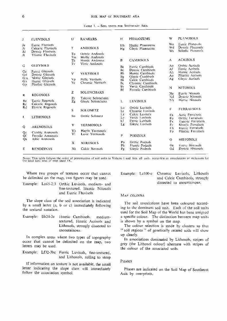
NOTE: This table follows the order of presentation of soil units in Volume 1 and lists all units occurring as associations or inclusions forthe total land arca of map sheet IX.
Where two uoups of textures occur that cannotbe delimited on the map, two figures may be used.
Example: Lo65-2,3 Orthic Luvisols, medium- andfine-textured, Humic Nitosolsand Eutric Fluvisols
The slope class of the soil association is indicatedby a small letter (a, b or c) immediately followingthe textural notation.
Example: Bh24-2c Humic Cambisols, medium-textured, Humic Acrisols andLithosols, strongly dissected tomountainous.
In complex areas where two types of topographyoccur that cannot be delimited on the map, twoletters may be used.
Example: Lf32-3bc Ferric Luvisols, fine-textured,and Lithosols, rolling to steep
If information on texture is not available, the smallletter indicating the slope class will immediatelyfollow the association symbol.
Example: Lc100-c Chromic Luvisols, Lithosolsand Calcic Cambisols, stron,glydissected to mountainous.
MAP COLOURS
The soil associations have been coloured accord-ing to the dominant soil unit. Each of the soil unitsused for the Soil Map of the World has been assigneda specific colour. The distinction between map unitsis shown by a symbol on the map.
The colour selection is made by clusters so that" soil regions " of genetically related soils will showup clearly.
In associations dominated by Lithosols, stripes ofgrey (the Lithosol colour) alternate with stripes ofthe colour of the associated soils.
PITASES
Phases are indicated on the Soil Map of SoutheastAsia by overprints.
6 SOIL MAP OF SOUTHEAST ASTA
TAFILE 1. SOIL UNITS FOR SOUTHEAST ASIA
FLUVISOLS U RANKERS H PHAEOZEMS W PLANOSOLS
Je Eutric Fluvisols H h Haplic Phaeozems We Eutric PlanosolsJcJd
Calcaric FluvisolsDystric Fluvisols
T ANDOSOLS Hg Gleyic Phaeozems WdWs
Dystric PlanosolsSolodic P I anosols
J Thionic Fluvisols To Ochric AndosolsTm Mollie AndosolsTh Humic Andosols B CAM BISOLS A ACRISOLS
GLEYSOLS Tv Vitric AndosolsBe Eutric Cambisols Ao Orthic Acrisols
GeGdGmG'nGp
Eutric G/eysolsDystric GleysolsMollic GleysolsHumic GleysolsPlinthic Gleysols
V
VpVe
VERT ISOLS
Pellic VertisolsChromic Vert isols
BdBhBgI3kBcI3v13f
.Dystric CambisolsHumic CambisolsGleyic CambisolsCalcic CarnbisolsChromic CambisolsVertic CambisolsFerralic Cambisols
AfAhApAg
N
Ferric AcrisolsHumic AcrisolsPlinthic AcrisolsGleyic Acrisols
NITOSOLS
Re
REGOSOLS
Eutric Regosols
Z
ZtZg
SOLONCHAKS
Takyric SolonchaksGleyic Solonchaks LUVISOLS
NeNdNh
Eutric NitosolsDyst ric NitosolsHumic Nitosols
Re Calcaric RegosolsRd Dystric Regosols
S SOLONETZLoLc
Orthic LuvisolsChromic Luvisols FERRALSOLS
LITHOSOLS So Orthic Solonetz LkLv
Calcic LuvisolsVertic Luvisols
FaFo
Acric FerralsolsOrthic Ferralsols
Lf Ferric Luvisols Fx Xanthic Ferralsols
ARENOSOLS Y YERMOSOLS Lg Gleyic Luvisols FrFh
R hod ic FerralsolsHumic Ferralsols
QcQf
Cambic A renosolsFerralic Arenosols
YhVI
Haplic YermosolsLuvic Yermosols PODZOLS
Fp Plinthic Ferralsols
Qa Albic A renosols O H ISTOSOLSX XEROSOLS Po Orthic Podzols
Ph Humic Podzols Oe Eutric HistosolsE RENDZINAS X k Calcic Xerosols Pg Gleyic Podzols Od Dystric Histosols

The petric and petroferric phases show the presenceof concretionary and petroferric horizons, respectively,within 100 cm of the surface.
The stony or gravelly phase marks areas where thepresence of gravel, stones, boulders or rock outcropsmakes the use of mechanized agricultural equipmentimpracticable.
A lithic phase indicates shallow soils with an aver-age depth of 10 to 50 cm.
The saline phase shows that certain soils of theassociation (not necessarily the dominant ones) areaffected by salt to the extent that they have a conduc-tivity greater than 4 mmhos/cm in some part of thesoil within 125 cm of the surface for some part ofthe year. The phase is intended to mark present orpotential salinization.
Sources of information
A map showing the sources of information of theSoil Map of Southeast Asia is shown as an inset onthe soil map. A separation is made between theareas compiled from systematic soil surveys, soilreconnaissance, and general information supplementedby occasional local field observations.
About 19 percent of the Southeast Asia region isnow covered by soil survey maps based on sufficientground control to be placed in reliability class I.Inevitably, among these maps there is variation inaccuracy depending on a number of factors such asscale, methodology and purpose of preparation. Theuse of diNverse methods of classification also makescorrelation more difficult and reduces the reliabilityof the map. Further uncertainty is introduced bythe influence on soil boundaries of differing conceptsused in defining the units.
Approximately 34 percent of the soil map inreliability class II has been prepared from soil recon-naissance designed to give, in combination with basicinformation on the natural environment, a fair ideaof the composition of the soil pattern. Ach antagewas taken of marked changes in the vegetational,geomorphological, lithological and climatic patternsin the preparation of the soil maps of certain areaswhere coverage by soil surveys was insufficient.
Reliability class III, covering 47 percent of theregion, refers to areas which are unexplored, or inwhich occasional soil studies have not supplied suf-ficient basic data for the compilation of more thana rough sketch of the soil pattern, even at 1 : 5 000 000scale. To understand the soil pattern of these regions,therefore, further studies still need to be undertaken.Aerial photographs are seldom available. However,since these regions are mostly thinly populated andhave poor accessibility, they usually have a low
THE MAP 7
priority position for development. It may take along time before the necessary data for appreciablyimproving the map are at hand. New aerial photo-graphs and other information that may becomeavailable through remote sensing from spacecraftand satellites may eventually be used.
In the preparation of the Soil Map of SoutheastAsia a large number of documents was consulted.Although it is impossible to mention all of them,the main ones, covering the countries listed belowor specifically prepared for the project, are recordedhere by country of origin. Comment is also madeon the reliability of the maps in the areas discussed.
DEMOCRATIC KAMPUCHEA
The main source of information was a generalsoil map of Cambodia at a scale of 1: 1 000 000compiled in 1963 by G.D. Crocker of USAID. Themap is of a reconnaissance nature and was based oninterpretations of available information on geology,geography, topography and soils supported by aerialphotograph review and field observations and sam-pling.
INDONESIA
The main source of information was a general soilmap of Indonesia at 1: 2 500 000 scale compiled in1973 by P.L.J. de Jongh, FAO Associate Expert,who completed a two-year assignment in Indonesiawith the FAO/UNDP Land Capability AppraisalProject. The map is largely a desk study based oninterpretations of soil maps prepared by the SoilResearch Institute, and information available ongeology, geomorphology, vegetation, climate and soils.
LAO
Very few soils data exist for Lao, consequentlysoil unit delineation and identification are based oninterpretations of a geological map of Indochina at1: 2 000 000 scale compiled in 1952 by J. Fromagetand E. Saurin, and the 1: 1 000 000 USAF K-10Operational Navigation Chart published in 1965.Interpretations resulted in a general soil map of thelower Mekong basin at 1: 5 000 000 scale compiledin 1972 by W. van der Kevie of FAO, who wasseconded for three months to the Committee forCoordination of Investigations of the Lower MekongBasin.
PENINSULAR MALAYSIA AND SINGAPORE
The main sources of information were the SoilMap of Malaya at 1: 1 520 000 (approx.) compiled
8 SOIL MAP OF SOUTHEAST ASIA
in 1962 by the Soil Science Division, Ministry ofAgriculture; and the Generalized Soil Map of WestMalaysia at a scale of 1: 760 320 compiled in 1970under the supervision of W.M. Law of the Depart-ment of Agriculture on the basis of systematic recon-naissance soil survey.
PHILIPPINES
The main source of information was the Soil Mapof the Philippines at a scale of 1: 1 600 000 compiledin 1972 by J.A. Mariano and A.T. Valmidiano ofthe Bureau of Soils, Department of Agriculture andNatural Resources. This map is based on interpreta-tions of available information on soils, geology, landuse, vegetation and climate.
SABAH
The main source of information was the Soil Mapof Sabah at a scale of 1: 5 000 000 compiled in 1974by P. Thomas of the Regional Soil Survey and LandCapability Classification Project, Sabah, Malaysia.This map is based on a reduction of 1: 250 000 to1: 100 000 scale soil maps of Malaysia.
SARAWAK
The main source of information was the Soil Mapof Saravvak, Malaysia Timor, at a scale of 1: 500 000compiled in 1968 by the Soil Survey Division, Re-search Branch, Department of Agriculture, Sarawak,Malaysia, and printed in 1970. The map is based oninterpretations of available information on soils,geology, geomorphology, vegetation and climate.
THAILAND
The main sources of information were the GeneralSoil Map of the Kingdom of Thailand at a scale of1: 1 250 000 compiled in 1972 by F.R. Moormannof FAO and S. Rojanasoonthon of Kasetsart Uni-versity, the Reconnaissance Soil Map of PeninsularThailand at a scale of 1: 750 000 compiled in 1972by F.J. Dent of FAO, and a map of the main land-forms of Thailand at a scale of 1: 2 500 000 compiledin 1973 by J.J. Scholten of FAO and C. Siriphantof the Department of Land Development. Both soilmaps were based on systematic reconnaissance soilsurveys which cover all of peninsular Thailand andimportant parts of the remainder of the country.
VIET NAM
The main sources of information NA ere the SoilMap of North Viet Nam at a scale of 1: 3 000 000compiled in 1961 by V.M. Fridland of the U.S.S.R.Academy of Sciences, and the General Soil Map ofthe Republic of Viet Nam at a scale of 1 1 000 000
compiled in 1961 by F.R. Moormann of FAO. Bothmaps were based on interpretations of availableinformation on soils, geology, geomorphology, landuse and climate supported by field observations andsampling.
References
CROCKER, G.D. Reconnaissance survey of the soils of Cambodia.1963 Phnom Pen'n, Royal Cambodian Government Sois
Commission/USAID.
DE JONGH, P.L.J. Soils of Indonesia. Bogor, FAO/Soil1973 Research Institute. Working Paper No. 4.
DENT, F.J. Reconnaissance soil survey of peninsular Thailand.1972 Bangkok, Department of Land Development. Report
SSR No. 94.FRIDLAND, V.M. Nature of North Viet Nam, explanatory text1961 to Soil map of North Viet Nam. Moscow, U.S.S.R.
Academy of Sciences.
FROMAGET, J. & SAuRIN, E. Carte géologique de l'Indochine.1952 2nd ed. (Lao and North Viet Nam)LAW, W.M. The generalized soil map of west Malaysia. Kuala1970 Lumpur, Department of Agriculture.
MALAYSIA. SOIL SCIENCE DIVISION. Soil map of Malaya.1962 Kuala Lumpur, Ministry of Agriculture.
MALAYSIA. SOIL SURVEY DIVISION. Soil map of Sarawak,1970 Malaysia Timor. Kuching.
MARIANO, J.A. & VALMIDIANO, A.T. Classification of Philip-1972 pines soils in the higher categories. Manila, Bureau of
Soils.
MOORMANN, F.R. The soils of the Republic of Viet iVam.1961 Saigon, Ministry of Agriculture.
MOORMANN, F.R. & ROJANASOONTHON, S. The soils of the1972 Kingdoni of Thailand. Bangkok, Department of Land
Development. Report SSR No. 72A.SCHOUTEN, J.J. & SIRIPHANT, C. Soils and landforms of1973 Thailand. Bangkok, Department of Land Development.
Report SSR No. 97.THOMAS, P. Soil map of Sabah. Regional Soil Survey and1974 Land Capability Classification Project. Kota Kinabalu,
Department of Agriculture.U.S. AIR FORCE. Operational navigation chart K-10 (Cam-1965 bodia, Laos, Thailand, Viet Nam). 3rd ed. St. Louis,
Aeronautical Chart and Information Center.VAN DER KEVIE, W. General soil map of the lower Mekong1972 basin. Bangkok, Committee for Coordination of
Investigations of the Lower Mekong Basin, Economicand Social Commission for Asia and the Pacific.
In this chapter brief outlines are given of fouraspects of the environtnent that are important in thedevelopment of soils. These are climate, vegetation,eeology and lithology, a.nd physiogra.phy.
These outlines indicate the loca.tion and natureof the major regions in which important variants ofclimate, vegetation, rock types and landscape occur.Small-scale ma.ps illustratine these environ mentalfactors appear at the back of this volume.
CLIMATE'
Climatic factors
The climate is generally determined by the monsoonregime, upon which tiericulture is dependent. Therainfall pattern is modified by the orientation ofimportant mountain ranges such as the Tenasserimmountains in eastern Burma, the Annam chain inViet Nam, the Taman range in Peninsular Malaysiaand the mountains in the eastern parts of Indonesiaand the Philippines.
Average temperatu res remain practically uniform(around 27°C) throughout the year in the coastalparts of Thailand and Democratic Kampuchea andmost of the refzion lying south of 17°N. North ofthis latitude the mean range of temperature increasesslightly with latitude over coastal regions but showshigh variation over inland areas. These inland areasalso have a large mean daily diurnal range owingto their continentality. In addition, altitude has amoderatine influence on high summer temperaturesand humidity.
Following is a brief description of the reeion'smain climatic zones. A classification of its climaticand ecological reeions is given in Tables 2 and 3.
Information used in compiling this section was taken withthe authorization of Unesco from P. Koteswaram's paper,Climate and meteorology of humid tropical Asia, in Naturalresources of humid tropical .4sia, Unesco, 1974.
4. ENVIRONMENTAL CONDITIONS
I. THAILAND
The country is influenced by the northeast monsoonfrom October to February and by the southwestmonsoon from May- to September. The highesttemperatures of the year are registered during theinter-monsoon season (March and April), when daytemperatures rarely fall below 32°C.
Heavy rainfall does not normally occur, as thecountry is sheltered from the summer monsoon bythe Tenasserim range and from the winter monsoonby the mountainous relief of Viet Nam. The meanannual rainfall ranges from 1 000 to 1 500 mm overmuch of the country, and in the south and southeastexceeds 2 000 min. Following the thunder-showersof March and April, the bulk of the rainfall occursfrom May to October. The southwest monsoon isestablished over the country by mid-May and retreatsin October before the advancing northeast monsoon.The monthly rainfall pattern shows two maximacorresponding to these two periods. In June andJuly the Tenasserim coast receives heavy orographicrainfall due to the strong southwest monsoon current,while the interior receives very little precipitation.A branch of the moist southerly current also brinesrainfall as high as 400 mm on the coast east ofBangkok. Rainy days are most numerous in Septem-ber (10-15); there are about seven days each inJuly, August and October, and less than live daysin other months.
The rainfall of the southwest monsoon is determinedby the interaction of the monsoon trough with west-ward-moving perturbations at high altitudes. Thesouthwest monsoon may also be intensified by rem-nants of typhoons moving eastward from the Chinaseas. During the northeast monsoon the seasonaltrough is far to the south of the country, often result-ing in dry, cool, pleasant weather.
2. LAO, DEMOCRATIC KAMPUCHEA ANI) VIET NAM
The climate is tropical in the southern parts ofthese countries, but in the north winters are moderately
cool. There are two main seasons, the northeastmonsoon from October to March and the southwestmonsoon from mid-May to late September, withshort intervals between. The pattern of the relieffeatures and their orientation in relation to theprincipal monsoon currents are the main factors af-fecting climatic contrasts, which are noticeable overeven small areas. Most parts of these countriesreceive the major portion of their annual rainfallfrom May to October. The period from Decemberto March is fairly dry, with the exception of thenortheast coast of Viet Nam. Typhoons reach thecoast north of latitude 150N once or twice a yearbetween early May and August, bringing gales andvery heavy rain for two to three days.
Following the southward shift of the seasonaltrough, the northwest monsoon commences in Octoberand continues until March. Over the most northerlyparts of Lao and Viet Nam, air currents from theAsian anticyclone are usually fresh and cool. Latein the season, occasional incursions of northeast tradewinds across warmer seas into this area are associatedwith thick, very low clouds and drizzling rain whichusually lasts for two to three days, and sometimesfor as long as a week.
Along the northeast coast of Viet Nam, moisture-laden winds arrive after a long passage over the sea.The incidence of the northeast monsoon in Octoberis characterized by the marked increase in the meanmonthly rainfall of Quang Tri from 400 mm inSeptember to 500 mm in October. Heavy rainfalloccurs along the northeast coast during October andremains high (about 570 mm) in November, butusually diminishes during December and January,and by February is negligible. October and Novem-ber are the wettest months of the year in this coastalarea.
Toward the end of March and in April, as theland mass of Southeast Asia becomes increasinglywarmer and the low-pressure zone develops oversouthwestern China, the northeasterlies of the wintermonsoon are replaced by light variable winds. Asthe season advances, convective activity and thunder-storms become more frequent over the interior.
The southwest monsoon is established by the endof May and continues until late September. Duringthis season the winds over the open sea vary fromsoutheasterlies to westerlies. Inland they generallycome from the southwest, but tend to follow theconfigurations of the terrain. For most parts of thearea other than the central east coast, this is theprincipal rainy- season of the year. Almost 80 percentof the annual rainfall occurs from May to September.Steady continuous precipitation is rare during thesouthwest monsoon, the rain usually falling in heavyshowers and during thunderstorms, the frequency
of the latter usually being high in mountainous terrain.Typhoons which tend to N,veaken and sometimesdeflect off the Annam range on the coast may bringseveral days of heavy continuous rain.
3. PENINSULAR MALAYSIA AND SINGAPORE
The climate is characterized by high humidity.abundant rainfall and little variation in temperaturethroughout the year. Owing to the maritime exposureof the peninsula, the annual mean daily range oftemperature is no more than 9°C. The excessiveday temperatures registered in continental areas arenever experienced, the highest temperature everrecorded in the peninsula being 39.4°C. Nevertheless,because of the high humidity days are often oppressivein the plains from April to June. December andJanuary have the lowest mean daily temperature.
The southwest monsoon and the northeast monsoon,associated with the periodic changes in prevailingwinds, are the two main seasons in the year, withtwo shorter transitional seasons separating the mon-soons. The times of commencement of the monsoonsvary to some extent. The southwest monsoon is
usually established by the latter half of May or earlyJune, and ends in September. The northeast monsoonusually commences in late October or November andends in March. 111 the two transition periods, Aprilto May and October, winds are generally light andvariable.
From April to November the region is overlainby a warm, moist, conditionally unstable equatorialmaritime air mass. Heavy rain and thunderstormsdevelop in the Strait of Malacca and move with theprevailing southwesterly winds to west coast districtsand Singapore.
Topography greatly affects the distribution ofseasonal rainfall in Peninsular Malaysia. The majortopographic features are oriented roughly north-northwest to south-southeast and comprise thewestern ranges, the central valley and the easternranges. During the northeast monsoon (Novemberto January) the east coast districts receive the highestrainfall. June and July, during the southwest mon-soon, are the driest months in most districts. Thecentral and northwestern parts of the peninsula aresheltered from the northeast monsoon by the easternranges and from the southwest monsoon by themountains of Sumatra; consequently the highestrainfall occurs between the monsoons, owing toconvective activity. The monthly rainfall patterntherefore shows two maxima separated by two min-ima. The higher maximum generally occurs dur-ing the autumn transition. The southwest coastalarea is also sheltered from the southwest monsoonby the highlands of Sumatra, but experiences frequent
10 SOIL MAP OF SOUTHEAST ASIA

thunderstorms from May to August. In conse-quence, this area shows only one maximum (Octoberto November) and one minimum (February) in themonthly rainfall pattern. Although it varies fromplace to place, the annual rainfall is high over theentire peninsula (2 000 to 3 000 mm) without theclimate being extremely dry or wet.
Heavy precipitation is common but of short du-ration, except on the east coast during the northeastmonsoon, particularly in November and December.Very heavy rain storms causing severe flooding arefrequent, and more than 380 mm in 24 hours havebeen recorded along the east coast. On the westcoast the heaviest daily precipitation rarely exceeds300 mm, although 430 mm in eight hours have beenrecorded at Penang.
Dry spells lasting for three or four weeks occuroccasionally.
4. INDONESIA, SABAH AND SARAWAK
Lying within 10° on either side of the equator andsurrounded by warm tropical seas, this zone is gener-ally characterized by a hot, humid climate in allseasons. However, this general tendency towardequatorial uniformity is significantly modified by themountainous character of most of the islands andthe variety of topographic and geographic features.
The main wind currents are different on eitherside of the equator during much of the year. Southof the equator the year can be conveniently dividedinto two main wind regimes: the west monsoonfrom November to March, and the east monsoonfrom June to September.
During the west monsoon the area from southernSumatra to Irian Jaya 1 lies on the northern sideof the equatorial trough of the summer in thesouthern hemisphere. Here there is considerableweather change resulting from the warm, humidlower tropospheric westerlies and the westward-moving tropical perturbations. This is the principalrainy season for most localities in this area. Theeast monsoon brings a comparatively dry season ow-ing to a relatively dry and divergent wind regime inlower tropospheric levels. Over Sumatra and mostof Borneo 2 the annual rainfall is fairly uniformlydistributed. However, in the southern part of thearea there is a sharp distinction between dry andrainy seasons. In Java this distinction is well devel-oped in the west and becomes much stronger in the
'Irian Jaya was previously called West Irian and later IrianBarat as shown on the topographic base of the Soil Map.
The name Borneo is used to designate the entire island;Kalimantan designates the Indonesian part of the island ofBorneo.
east and in places in the central part of the island,the greater part of which is practically rainless dur-ing several months. The dry season resulting fromthe east monsoon becomes more pronounced fromwest to east through eastern Java and the LesserSunda Islands, with Flores and Timor approachinga semiarid climate.
During the transition periods the weather overmost of the zone is determined by the activity ofthe equatorial trough. In April and May the trouahof the southern hemisphere shifts northward andapproaches the equator. In consequence, the zoneof convergence between the northeast and southeasttrade winds of the two hemispheres becomes narrowerthan at other times of the year and leads to convectiveactivity. The line of confluence fluctuates and shiftsits position, often erratically, according to the strength-ening and weakening of the conflicting trade windcirculations. When convergence is strong, the result-ing large-scale vertical motion of the highly humidand unstable air mass along the entire narrow zoneproduces long lines of heavy cumulo-nimbus for-mations, brinQing violent thunderstorms and heavyrainfall. When the trade wind regimes are weak,the weather is generally sultry with light winds orcalms, and often oppressive.
Parts of the zone in the northern hemisphereexperience a northeast monsoon (with the exceptionof northern Sumatra, which has a northwest monsoon)from November to March and a southwest monsoonfrom June to September with two short transitionperiods (April to May, October) between the twomonsoons. Monthly rainfall distribution shows thelowest minimum during the southwest monsoon whenthe zone comes under a divergent wind regime insurface and lower tropospheric levels. During thespring transition (March and April) showery weatheris frequent and in some places the frequency ofthunderstorms is as high as fifteen per month. Inautumn (October and November) the equatorialtrough is relatively more active than in spring, witha well-marked zone of confluence running across thenorthern part of the zone. Consequently this is aperiod of maximum rainfall over most northern areas.The monthly rainfall pattern shows two maximacorresponding to the two transitions and two minirnacorresponding to the two monsoons. The highermaximum is reached during the autumn transitionand the lower minimum during the southwest mon-soon. Eddies normally occur in January and Julyover northern Sumatra, Borneo, and to the northof Irian Jaya.
Indonesia as a whole is free from tropical cyclones.However, the occurrence of a tropical cyclone inthe neighbourhood of the Philippines influences theamount of precipitation received in Borneo and Java.
ENVIRONMENTAL CONDITIONS 11
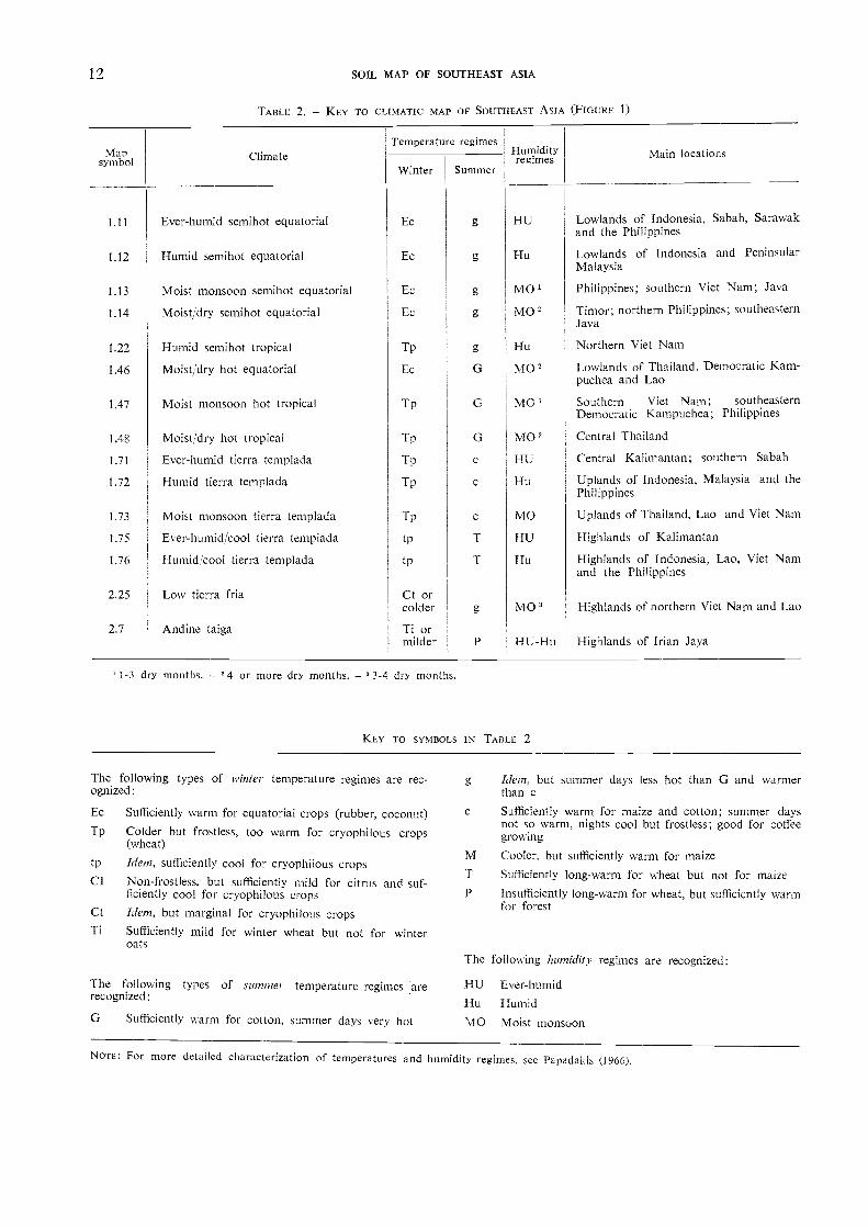
The following types of winter temperature regimes are rec-ognized:
Ec Sufficiently warm for equatorial crops (rubber, coconut)Tp Colder but frostless, too warm for cryophilous crops
(wheat)
tp Idetn, sufficiently cool for cryophilous cropsCI Non-frostless, but sufficiently mild for citrus and suf-
ficiently cool for cryophilous crops
Ctkm, but marginal for cryophilous cropsTi Sufficiently mild for winter wheat but not for winter
oats
The following types of stunmer temperature regimes :arerecognized:
Sufficiently warrn for cotton, summer days very hot
1-3 dry months. 4 or more dry months. 3-4 dry months.
KEY TO SYMBOLS IN TABLE 2
NOTE: For more detailed characterization of temperatures and humidity regimes, see Papadakis (1966).
Meru, but summer days less hot than G and warmerthan cSufficiently warm for maize and cotton; summer daysnot so warm, nights cool but frostless; good for coffeegrowing
Cooler, but sufficiently warm for maize
Sufficiently long-warm for wheat but not for maizeInsufficiently long-warm for wheat, but sufficiently warmfor forest
The following humidity regimes are recognized:
Mapsymbol Climate
Temperature regimesHumidityregimes Main locations
Winter Summer
1.11 Ever-humid semihot equatorial Ec g HU Lowlands of Indonesia, Sabah, Sarawakand the Philippines
1.12 Humid semihot equatorial Ec g Hu Lowlands of Indonesia and PeninsularMalaysia
1.13 Moist monsoon semihot equatorial Ec g MO' Philippines; southern Viet Nam; Java
1.14 Moist/dry sernihot equatorial Ec g MO= Timor; northern Philippines; southeasternJava
1.22 Humid semihot tropical Tp g Hu Northern Viet Nam
1.46 Moist/dry hot equatorial Ec G MO' Lowlands of Thailand. Democratic Kam-puchea and Lao
1.47 Moist monsoon hot tropical Tp G MO" Soto hem Viet Nam; southeasterrDemocratic Kampuchea; Philippines
1.48 Moist/dry hot tropical Tp G MO' Central Thailand
1.71 Ever-humid tierra templada Tp e HU Central Kalimantan; southern Sabah
1.72 Humid tierra templada Tp c Hu Uplands of Indonesia, Malaysia and thcPhilippines
1.73 Moist monsoon tierra templada Tp c MO Uplands of Thailand, Lao and Viet Nair
1.75 Ever-humid/cool tierra templada tp T HU Highlands of Kalimantan
1.76 Humid:cool tierra templada tp T Hu Highlands of Indonesia, Lao, Viet Nan.and the Philippines
2.25 Low tierra fria Ct orcolder g N40 3 Highlands of northern Viet Nam and Lac
2.7 Andine taiga Ti ormilder P HU-Hu Highlands of Irian Jaya
12 SOIL MAP OF SOUTHEAST ASIA
TABLE 2. KEY TO CLIMATIC MAP OF SOUTHEAST ASIA (FIGURE 1)
HU Ever-humid
Hu Humid
N,10 Moist monsoon

Lying on the equator an surrounded by large oceanicareas, Indonesia has a generally sultry climate, andthe temperature is practically uniform throughoutthe year. However, on the high plateaus the climateis cool and bracing.
5. PHILIPPINTS
The Philippines, extending north-south betweenlatitudes 5"N and nearly 200N, can be divided clima-tologically into three main areas.
Durin2 the northeast monsoon Luzon and adjoin-ing areas receive very little rainfall and have a warmwinter as a result of subsidence associated with themid-tropospheric anticyclone which predominatesover the area during this season.
The eastern parts of the Philippines receive thehighest rainfall during the northeast monsoon as aresult of the stroiw, humid monsoon current strikingthe highlands flanking the coasts. The drier periodis from March to August, when the zone lies leewardof the prevailing winds.
Southern parts of the Philippines receive someprecipitation during the northeast monsoon, butmost rain falls during the southwest monsoon.
Therefore, with the exception of the eastern parts,the Philippines receive most of their annual rainfall
from May to October, the percentage increasingtoward the north.
Following the zenithal march of the sun southwardacross the equator in September, the seasonal troughshifts from Luzon southward across the zone duringlate September and October. During this transitionperiod, frequent westward-moving tropical distur-bances bring abundant rain. With the exception ofplaces in the northern and eastern central parts ofthe Philippines, the patterns of monthly rainfalldistribution show a double peak, with the highermaximum generally occurring in the transition periodfollowing the southwest monsoon.
Most of the typhoons and tropical depressionsdevelop in the area between the Philippines andlongitude 1600E, moving in an approximate west-northwesterly direction. They generally form fromMay to November, with the highest frequency inSeptember. Typhoons developing east of the Philip-pines and having a west-northwesterly track bringgales, torrential rain and floods in Luzon duringtheir passage, giving the Philippines a serious tropicalcyclone problem.
Climatic regions
The climatic regions of Southeast Asia are shownin Figure 1. The climatic criteria selected (e.g.
TABLE 3. - CLIMATIC CHARACTERISTICS OF SOME PLACES REPRESENTING THE CLIMATIC REGIONS OF THE MAP
° The meteorological definitions of the symbols and their agricultural potentialities are given in Papadakis (1966). Annual potentialevapotranspiration is computed month by month on the basis of midday saturation deficit (Papadakis. 1961). Leaching rainfall israinfall minus potential evapotranspiration during the humid season. ° Drought stress is the potential evapotranspiration minus rainfallduring the non-humid season, A month is humid when rainfall exceeds potential evapotranspiration, it is dry when rainfall plus thewater stored in the soil from previous rains covers less than half of potential evapotranspiration, and intermediate between these. Thefigures in the columns indicate the months when the season begins and ends. 11-10 means that the humid season begins with Novem-ber OD, terminates with October (10); both November and October are included, so that it covers all the year. 0 means that thereis no dry season. Months that are not mentioned in the humid or dry season are intermediate.
Cli-mate' Place Winter
typeSummer
type1:114-
m regicilm%
AnnualPotentialtervaargnoi-._
ration 2
Annualrainfall
Leachingrainfall '
Droughtstress
Humidseason '
Dryseason 5
mm
1.11 Balikpapan, Indonesia Ec g HU 800 2 227 1 420 11-10 0
1.12 Jakarta, Indonesia Ec g Hu 980 1 798 690 117 10-6 0
1.13 Surabaja, Indonesia. Ec g MO I 340 1 740 830 439 12-5 8-10
1.14 Kupang, Indonesia Ec g MO 1 420 1 440 890 870 12-3 6-10
1.22 Hanoi, Viet Nam . Tp g Hu 890 1 681 900 113 4-10 0
1.46 Bangkok, Thailand Tp G MO 1 330 1 397 610 548 5-10 1-4
1.47 Saigon, Viet Nam Ec G MO I 310 1 984 1 220 520 5-11 2-4
1.48 Chiang Mai, Thailand . Tp G MO 1 540 I 080 390 849 6-10 12-4
1.71 Tamansari, Indonesia Tp c HU 760 1 610 1 870 10-9 0
1.72 Lembang, Indonesia . Tp e Hu 710 1 966 1 360 98 10-6 0
1.75 Tjibodas, Indonesia Tp M HU 570 3 290 2 710 8-7 o
2.7 Pangrango, Indonesia Ci P HU-Hu 410 3 454 2 820 8-7 0
ENVIRONMENTAL CONDITIONS 13

14 SOIL MAP OF SOUTHEAST ASIA
drought stress, duration of humid and dry seasons,and potential evapotranspiration) are closely relatedto crop requirements and distribution, so that theclimatic regions delineated by Papadakis (1961, 1966)are of significance to agriculture.
Each region shown on the map has a number rep-resenting the climate. Main climatic characteristicsand locations of ecological zones are outlined in Ta-ble 2 and the rela.ted keys. Climatic data from somerepresentative places in the various regions are givenin Table 3.
In the table of soil associations in Chapter 5 thetype of climate as characterized in Table 2 andFigure I is given for each map unit.
VEGETATION
The broad vegetation regions
Throughout Southeast Asia climax-type vegetationin equilibrium with the environment consists basi-cally of forest. Dense evergreen forest covers regionsthat are sufficiently humid, a.nd broadleaf deciduousforest develops in regions where the ecological, cli-matic or edaphic conditions are less favourable.
Human occupation of the region in general, andthe practice of shifting cultivation by burning inparticular, have resulted in a variety of more or lessdegraded types of secondary vegetation.
In the most favourable conditions, where limitedstretches of land in dense humid evergreen forestare cleared for cultivation, heliophilic pioneer speciesgrow rapidly again to form a forest with a completeupper canopy. The repr,cement by ombrophilousspecies which were part ot the original growth takesconsiderably longer, but the potential for reconstitut-ing the climax is preserved.
In less favourable conditions, forest removal mayresult in greater destruction of the forest soil andthe formation of savanna, which when regularlyburned by man makes reconstitution of the climaximpossible.
Southeast Asia is divided into 11 broad vegetationregions (Figure 2) based on the World VegetationMap drafted by J. Schmithiisen. The regions aredistinguished on the basis of habitat (either climaticor edap'nie), and the physiognomy and structure ofthe vegetation.
' Information used in compiling this section was taken withUnesco's authorization from papers by P. Legris, R.O. Whyteand M. Jacobs in Natural resources of humid tropical Asia,Unesco, 1974.
TROPICAL LOWLAND EVERGREEN RAIN FOREST
Tropical lowland evergreen rain forest occurs inareas of low to medium altitude characterized by arelatively high rainfall (usually exceeding 2 000 mm)well distributed throughout the year, and lack of aprolonged dry season. The annual thermal ampli-tude is under 3°C. This forest type forms the climaxvegetation over large areas of the Philippines, IrianJaya, Borneo, Sulawesi, the Moluccas, western Java,Sumatra, the Malay Peninsula and southern Thailand.It also occurs at low altitude along the coast ofDemocratic Kampuchea and southern Viet Namwhere high annual rainfall balances the effect ofthe short dry season and encourages the develop-ment of a dense humid forest of a quasi-equatorialtype.
This forest is extremely complex and very rich inspecies. It is usually characterized by three treestoreys with an undergrowth of shrubs and seedlingsand an abundance of lianas and epiphytes.
The dominant storey is usually 35 to 50 m highand is discontinuous with a few trees of up to 65 min height and a girth of 3 m or more. This storeyis characterized by a high occurrence (up to 50 percent)of evergreen Dipterocarpaceae, (e.g. Dipterocarpusalatus, D. turbinatus) with Parashorea stellata, Ani-soptera &bra, Hopea odorata and Shorea assamica.Riverine evergreen forest is more homogeneous andis distinguished by the abundance of Hopea odorataand Dipterocarpvs alatus in Viet Nam, whilein Democratic Kampuchea Eugenia cambodiuna,E. fkaiatills, Diospyros helferi and Finetia rivularisare common species.
The second storey forms an almost continuouscanopy between 25 and 35 m in height, and consistsof young trees of the upper storey species in associa-tion vvith a number of other species.
The lower storey contains young saplings of thedominant storeys together with shrub species. Thegrass layer consists mainly of young seedlings. Her-bac,eous vegetation is scarce because of light deficiency.There is no accumulation of litter owing to rapiddecomposition of organic matter, and the organicmatter content of the topsoil is low.
The secondary forest which develops after removalof the original vegetation is also a closed vegetationbut does not show an orderly structure, and nostrata can be distinguished in the first stages ofdevelopment.
TROPICAL INUNDATED SWAMP AND BOG FORESTS
Swamp and bog forests occur in regions whichare more or less permanently inundated by freshwater. Vast tracts of these forests are found on

the east coast of Sumatra, the west coast of Borneo,the Meervlakte intermontane plain and the southcoast of Irian Jaya, the west coast of the MalayPeninsula, and to a lesser extent the Chao Phaya,Mekong and Red river flood plains.
Trees belong mainly to primary rain forest genera.Most are taller than 20 m and are equipped withbuttresses, pneumatophores, or stilt roots. Two mainforest types are recognized: mixed swamp forest and" padang " forest.
Mixed swamp forest occurs on the fringes of thevast ombrogenous peat bogs of the region and on theless extensive topogenous bogs and swamps. Upperstorey dominants common to mixed swamp forestin Borneo and Sumatra include Alstonia pneumato-phora and Lophopetalum multinerVil4M on shallowpeat, Campnosperma coriacea, Gonystylus bancanus,Pala quium burckii, Tetramerista glabra, Durio cari-natus, Koompassia malaccensis, Parastemon urophyl-lum, Dyera lowii, Mezzettia leptopoda, Shorea platy-carpa, S. teysmanniana, and S. uliginosa. In themiddle and lower storeys characteristic species includeBlumeodendron tokbrai, B. kurzii, Neoscortechiniakingii, Horsfieldia crassifolia, Gymnacanthera eugetzii-folia, Eugenia elliptilimba, Engelhardtia serrata, Dios-pyros pseudomalabarica, D. siamang, 1/ex sclerophyl-loides, I. hypoglauca, Mangifera havilandil, San tirialaevigata and S. rubiginosa.
Padang forest occurs over central domed areas ofoinbrogenous peat bogs and is poorer in species thanmixed swamp forest. In Borneo common padangforest species include Pala quium cochleariifolium,Diospyros evena, Dactylocladus stenostachys, Litho-carpus dasystachyus, Parastemon spicatum, Garciniacuneifolia, Sterculia rhoidifolia and Xylopia coriifolia.These species are either absent, or have not yet beenrecorded in the padang forest of Sumatra, whichis composed mainly of smaller trees of the samespecies that occur in mixed swamp forest.
Trees in mixed swamp forest have a larger diameteron average than those of padang forest, althoughbasal areas per hectare are low in comparison \viththose of hill forest.
In the most extreme padang forest of Sarawakthe trees are very small and stunted, giving thevegetation a savanna-like aspect.
3. MANGROVE FOREST
Mangrove forest occurs only within the tidal rangeof the estuaries and coastal mud flats of the region.It is composed almost entirely of evergreen sclero-phyllous broadleaf trees and/or shrubs with eitherstilt roots or pneumatophores. Epiphytes are gener-
ENVIRONMENTAL CONDITIONS 15
ally rare, with the exception of lichens on branchesand adnate algae on the lower parts of trees.
The main areas of occurrence are the littoral fringesof the coastal plains of Thailand, Malaysia andIndonesia, and the Ca Mau region at the southerntip of Viet Nam. The most developed species belongto the genera Rhizophora, Bruguiera, Ceriops, Avi-cennia, Carapa, Sonneratia, Heritiera and Lumnitzera.Species of the first three genera listed produce valuabletimber. Many mangrove forests are backed by almostpure stands of Melaleuca leucadendron, which is oflocal importance for the extraction of gomenol andthe production of charcoal.
TROPICAL EVERGREEN SEASONAL RAIN FOREST
Seasonal rain forest occurs in humid bioclimateswith an average dry season of up to four or fivemonths and an annual rainfall of over 2 000 mm, ora shorter dry season of one or two months and anannual rainfall of 1 500 to 2 000 mm. It includesa number of physiognomical types varying consider-ably according to altitude and intensity of drought.Its floristic composition is largely determined byedaphic conditions.
Dipterocarpaceae are dominant in the upper storeyof the dense forests of northern and central Thailand.Characteristic trees are Dipterocarpus costatus, D.dyeri, and D. artocatpifolius, Anisoptera cochichinen-sis, Shorea vulgaris, and Sterculia lychnophora. Thedominant storey contains Mesua ferrea, Vatica andDalbergia, while dominants in the undergrowth areoften Euphorbiaceae, Anonaceae and Ebenaceae.An intermediate type of mixed semideciduous forestwith Lagerstroemia and Leguminosae dominants alsooccurs. The degradation facies are brakes composedof Tiliaceae (Grewia), Hypericaceae (Cratoxylon) andRubiaceae (Psychotria, Ixora, Randia, Gardenia).Further degradation results in the formation ofImperata scrub or its equivalent, the Eupatoriumstands with a woody vegetation of fire-resistantspecies, Albizzia, Careya and Phyllanthus.
TROPICAL MOIST DECIDUOUS FOREST
Mixed moist deciduous forest occurs principallyin northern and central Thailand and Java in areaswith an annual rainfall of about 1 500 mm and adry season of four to five months. The mean tem-perature of the coldest month lies between 15 and20°C. Two types are distinguished according towhether these forests are teak-bearing or not.
Teak-bearing forest (Tectona grandis) occurs mainlyin areas with cooler humid bioclimates. This forest

16 SOIL MAP OF SOUTHEAST ASIA
type frequently occupies valleys and foothills innorthern Thailand and Java with well-drained soils,abundant occult precipitation and slight saturationdeficits. Teakless mixed deciduous forest occursmainly in central Thailand. Dominant species otherthan teak in both forest types include Pterocarpusmacrocarpus, Xylia kerii, Lagerstroemia calyculata,L. tomentosa, L. balansae, Schleichera trijuga, Afzeliaxylocarpa, Adina cordifolia, Mitragyna javanica, Ter-mina/ja chebula, T. be/enea, T. tomentosa, Anogeissusacuminata, Eriolaena candollei, Lannea coromandelica,Tetrameles nudiflora, Sponndias pinnata, Premna pyra-midata, Grewia vestita, Mi/feria brandisiana, Dilleniaand Sterculia. Bamboos are prevalent in the under-growth.
TROPICAL LOWLAND SEMIDECIDUOUS RAIN FOREST
AND TROPICAL MOIST DECIDUOUS FOREST
An association of lowland semideciduous rainforest and moist deciduous forest occurs in Laoand northern Viet Nam. The former consists ofdense hemi-ombrophilous forests containing a major-ity of evergreen spec.es and a large proportion ofdeciduous species. The dominants in the arborealstorey are Dipterocarpaceae, Papilionaceae, Legumi-nosae, Meliaceae and Sapindaceae, while the middlestorey is dominated by Anonaceae, Rubiaceae andEuphorbiaceae.
If the vegetation is cleared, its place is taken bya Eupatorium or Saccharum arundinaceum scrub whichmay ultimately develop into the original forest, butpeniclimax open woodland may develop whereexploitation is followed by repeated burning.
Two types of moist deciduous forest are distin-guished: one on high ground, in which bamboosare prevalent, and the other in low-lying alluvialregions. The best represented families are theLeguminosae with fourteen species, the Verbenaceaewith five species, and the Combretaceae with fourspecies. The undergrowth consists of Gramineaeand Bambuseae. Teak occurs in the moist deciduousforest of Lao, but is absent in similar forest in VietNam.
TROPICAL DRY DECIDUOUS FOREST
The typical Dipterocarpaceae open woodland is
mainly confined to subhumid hot bioclimates with afive-to-six-month dry season and an annual rainfallof 1 000 to 1 500 mm. These climatic conditionsare extremely conducive to outbreaks of fite andrapid degradation of the soil. This forest typeoccurs mainly in northeastern Thailand, Democratic
Kampuchea, Lao and Viet Nam, the Lesser SundaIslands, and seasonal parts of Luzon.
Some forests of this type appear to be stabilizedon permeable sandy soils (Koulens sandstone inDemocratic Kampuchea), or on skeletal soils oftenof schistose origin (Pentacme siamensis and Termi-na/ja tomentosa types) in Viet Nam. Open wood-land on sandy soil frequently contains bamboos(Oxytenanthera sp.) and Imperata cylindrica. Anotherwoodland in the wetter eastern Mekong regions(Stung Treng) seems to correspond to stages in theregeneration of the forest after removal of vegetation,which has not progressed further owing to regularoutbreaks of fire.
In Thailand dry deciduous forest covers the Koratplateau, extending into the Savannakhet and Vien-tiane regions of Lao, and the northern half of Demo-cratic Kampuchea. Typical dominants include Dip-terocarpus tuberculatus, D. obtusifolius, D. intricatus,Pentacme siarnensis, Shorea obtusa, Termina/ja tomen-tosa, T. mucronata, Buchanania lanzan, and Emblicaofficinalis. In the graminaceous undergrowth thereis a proliferation of Cycas and Phoenix acaulis.
TROPICAL MONTANE RAIN FOREST
The tropical montane rain forest of western Thai-land, Malaysia, Indonesia and the Philippines is, inmany respects, the poor relation of tropical lowlandevergreen rain forest. There is no sharp distinctionbetween the two, the main difference being a shiftin the floristic composition of the dominants in theupper and main tree storeys. Many of the commonlowland forest species occur in montane forest,although not frequently. The many montane forestspecies absent in the lowlands belong to familiessuch as the Elaeocarpaceae, Ericaceae, Pagaceae,Lauraceae, Symplocaceae and Theaceae. Speciescommon to the subtropics (conifers, tree ferns andherbs) also occur, and there is an increase of mossgrowth and epiphytes.
Except for big trees on ridge tops, the large treesof montane forest are usually shorter and slightlysmaller than those of lowland forest. The densityof wide-girth trees on ridge tops is greater than inlowland forest and there are correspondingly fewertrees in the under storey and the lower part of themain storey. The ground flora on ridge tops isusually extremely poor, owing in part to the commonoccurrence of the palm Eugeissona triste. Thevegetation on the slopes is often poorly stocked inwoody species and the under storey is rich in stem-med and stemless palms and rattans. In intermon-tane valley bottoms large woody species are com-paratively poor, and the forest is characterized by

the richness in the ground flora and shrub layer.Alocasia sp., Colocasia sp., Donax grandis and manyground ferns are common.
Montane ericaceous forest occurs in the cloudbelt above 2 400 m or on exposed ridges and summitsat lower altitudes. It is typically composed of asingle tree storey with a dwarf structure seldom morethan a few metres high. Trees are frequently gnarledand there is an increase in the development of liver-worts, mosses and filmy ferns, both on the trunksof trees and on the ground. Sphagnum spp. are com-mon. Oaks are limited to a few species and theforest is characterized by the presence of ericaceousspecies. Epiphytic orchids are common and rhodo-dendrons frequent. This forest type is also charac-terized by an accumulation of acid humus and peataround the roots of the trees in which epiphytes,mosses, filmy ferns and herbs abound.
9. MONTANE LAUREL FOREST
The 20°C isotherm, which is located between 800and 1 000 m at latitudes around 11 to 120N, seemsto correspond A,vith the base of the Laurisylva beltin which most of the Lauraceae, Fagaceae, Magno-liaceae, Juglandaceae and conifers occur. It is alsoat this level that the low-altitude formations ofDipterocarpaceae, Leguminosae and Lythraceae large-ly disappear. Increasing altitude affects the bio-climates in the following ways: the dry season becomesprogressively shorter and may even be absent; themean monthly thermal amplitude diminishes, althoughdaily amplitude increases; the rainfall becomes steadilyhigher up to intermediate altitudes of about 1 700 mon eastern slopes and from 800 to 1 000 m on westernslopes.
In the Laurisylva belt there are patches of Dacry-dium and Podocarpus imbricatus as well as open pineforest. Pinus merkusii and P. khasya occur in Laoand Viet Nam. P. insularis, which is closely relatedto P. khasya, has also been reported in Viet Nam.P. dalatensis, a five-leafed pine comparable with P.excelsa of the Himalayas, is found on the southernplateaus of Viet Nam.
The base of the true mountain belt, comprisingFagaceae, Ericaceae and conifers (Pinus krempfi'l,P. armandii, Fokienia hodginsii, Keteeleria davidiana),is situated, on average, at an altitude of 1 700 min low latitudes. This belt is locally well preservedin Lao and Viet Nam.
The bioclimates in this belt are humid or veryhumid and are characterized by a fairly cool seasonin which the temperature is lower than 15°C andmay occasionally fall below 0°C. As the latituderises, the various vegetation belts are found at pro-
ENVIRONMENTAL CONDITIONS 17
gressively lower elevations owing to the effect ofdiminishing temperatures and increasing thermalamplitude. Consequently, stands of Fagaceae growat a lower altitude in the Hue region than in southernparts of Viet Nam.
Pine forests are also found in the mountains ofnorthern Sumatra (Pinus merkusii), Luzon (P. mer-kusii, P. insularis), and Mindoro (P. insularis) ataltitudes of 1 200 to 2 400 ni. Here the undergrowthinvariably consists of grass and bracken.
10. SAVANNA
Savanna, which represents destroyed monsoonforest, consists of grass vegetation with scatteredtrees which are often fire-resistant. Areas subjectedto repeated and severe burning, such as the drierparts of northwestern Sumatra and the coastal plainsof Viet Nam, have a vegetation consisting of littleelse but grass.
In Southeast Asia, Gramineae other than Bam-buseae are of little importance in the climax forma-tions. The occurrence of Gramineae characteristicof India and China appears to be related to humanintervention. Gramineae play a much more impor-tant role in the secondary formations, particularlyopen forest and savanna. The first Gramineae toappear after forest removal are the Paniceae, Cyrto-coccum patens, C. trigonum, Pan icum sarmentosumand Paspalum conjugatum. On cultivated land Digi-taria rnarginata and various species of Paspalumoccur, while in the shade of plantations the swardsare dominated by Paspalum conjugatum, Axonopuscompressus, Cyrtococcum trigo/mm and Centothecalappacea. After several years of shifting cultivationthe sward gradually deteriorates to Imperata cylin-drica savanna.
A particular type of ecological regression is seenin the extensive areas of non-forest land, called "veal"in Democratic Kampuchea, where the herbaceouscover is composed of Cynodon dactylon, Pseudopogo-natherum sp., Imperata cylindrica (rare), variousRosaceae, Cyperaceae and small bamboos. Theplain of Veal Trea is a treeless, jeep-high communityof Cyperaceae, Fimbristylis sp., Commelinaceae, andabove all the grasses, Echinochloa crusgalli, Themedasp. and Panicum luzonense. These grasses are burnedeach year for hunting purposes, and become greenagain and flower with the first rains in May.
Delvert (1961) concludes that the " veal " is asecondary formation covering sites that were culti-vated in ancient times, as aerial photographs of thearea show former rice paddies, smaller in size thanthose of today, numerous ponds, old canals androads. The " veal " must formerly have been
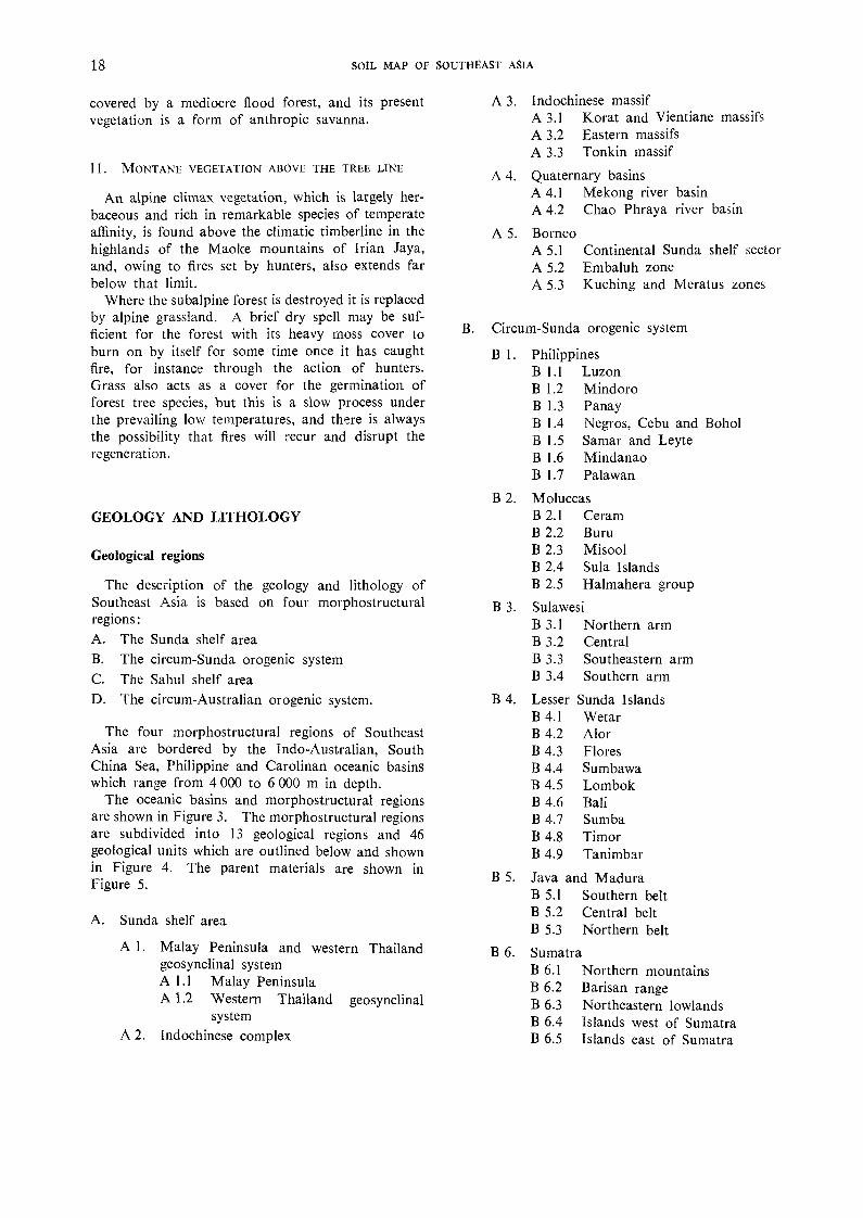
covered by a mediocre flood forest, and its presentvegetation is a form of anthropic savanna.
11. MONTANE VEGETATION ABOVE THE TREE LINE
An alpine climax vegetation, which is largely her-baceous and rich in remarkable species of temperateaffinity, is found above the climatic timberline in thehighlands of the Maoke mountains of Irian Jaya,and, owing to fires set by hunters, also extends farbelow that limit.
Where the subalpine forest is destroyed it is replacedby alpine grassland. A brief dry spell may be suf-ficient for the forest with its heavy moss cover toburn on by itself for some time once it has caughtfire, for instance through the action of hunters.Grass also acts as a cover for the germination offorest tree species, but this is a slow process underthe prevailing low temperatures, and there is alwaysthe possibility that fires will recur and disrupt theregeneration.
GEOLOGY AND LITHOLOGY
Geological regions
The description of the geology and lithology ofSoutheast Asia is based on four morphostructuralregions:
The Sunda shelf areaThe circum-Sunda orogenic systemThe Sahul shelf areaThe circum-Australian orogenic system.
The four morphostructural regions of SoutheastAsia are bordered by the Indo-Australian, SouthChina Sea, Philippine and Carolinan oceanic basinswhich range from 4 000 to 6 000 m in depth.
The oceanic basins and morphostructural regionsare shown in Figure 3. The morphostructural regionsare subdivided into 13 geological regions and 46geological units which are outlined below and shownin Figure 4. The parent materials are shown inFigure 5.
A. Sunda shelf area
Malay Peninsula and western Thailandgeosynclinal systemA 1.1 Malay PeninsulaA 1.2 Western Thailand geosynclinal
systemIndochinese complex
A 3. Indochinese massifA 3.1 Korat and Vientiane massifsA 3.2 Eastern massifsA 3.3 Tonkin massif
A 4. Quaternary basinsA 4.1 Mekong river basinA 4.2 Chao Phraya river basin
A 5. BorneoA 5.1 Continental Sunda shelf sectorA 5.2 Embaluh zoneA 5.3 Kuching and Meratus zones
B. Circum-Sunda orogenic system
1. Philippines1.1 Luzon1.2 Mindoro1.3 Panay1.4 Negros, Cebu and Bohol1.5 Samar and Leyte1.6 Mindanao1.7 Palawan
B 2. MoluccasB 2.1 Ceram
2.2 BuruB 2.3 MisoolB 2.4 Sula Islands
2.5 Halmahera group
3. Sulawesi3.1 Northern arm3.2 Central3.3 Southeastern arm3.4 Southern arm
4. Lesser Sunda Islands4.1 Wetar4.2 Alor
B 4.3 FloresB 4.4 Sum bawaB 4.5 LombokB 4.6 BaliB 4.7 Sumba
4.8 Timor4.9 Tanimbar
5. Java and Madura5.1 Southern belt5.2 Central belt5.3 Northern belt
6. Sumatra6.1 Northern mountains6.2 Barisan range6.3 Northeastern lowlands6.4 Islands west of Sumatra6.5 Islands east of Sumatra
18 SOIL MAP OF SOUTHEAST ASIA
C. Sahul shelf areaC 1. Aru Islands
D. Circum-Australian orogenic system
D 1. Irian Jaya1.1 Doberai Peninsula1.2 Central1.3 Southern alluvial plain
A. SUNDA SHELF AREA
The Sunda shelf comprises the Indochinese Penin-sula, the greater part of Borneo, the east coast ofSumatra, Bangka and Belitung (Billiton) togetherwith the shallow South China Sea. Toward the northit includes the Shan highlands.
The Sunda shelf has been stable for a considerableperiod of time, but at present is extensively inundated,with only its higher parts standing above the sea.Advanced peneplanation of the area is evident fromthe unconformity of the seas which now cover thecontinental shelf, and the presence of the Linggaand Riau archipelagoes and Bangka and Belitungislands, which may be considered monadnocks.
The basement complex of the Sunda shelf consistsof rocks of Precambrian to Jurassic age. The oldestparts of the shelf, the Indochinese and eastern massifs,were affected by the Hercynian orogeny toward theend of the Carboniferous. The Kimmeridgian orogenyduring the late Triassic and Jurassic affected the entirearea, while the Himalayan orogeny probably onlyresulted in local rejuvenation.
Al. Malay Peninsula and western Thailand geo-synclinal system
The Malay Peninsula consists of parallel rangeswhich run obliquely to its general direction and gradeinto the western Thailand geosynclinal system inthe north. The latter unit, an extension of the Shanhighlands of Bufma, consists of an intensely foldedold mountain system of shale, schist and limestonewhich is in an advanced stage of erosion. The coresof the mountain system, which consist of granite andother intrusives, are exposed in north-south-trendingranges.
A1.1. The Malay Peninsula consists of an alternationof locally metamorphosed limestone, shale and sand-stone, and acid intrusives and extrusives. The lime-stone is massive and resistant. The sandstone andshale normally overlie the limestone and containchert beds. In the eastern and southern parts ofthe peninsula the sandstone and shale have beenmetamorphosed to schist, quartzite, phyllite andslate. The acid intrusives consist of syenite and
ENVIRONMENTAL CONDITIONS 19
hornblende-granite. The Pahang volcanic series oc-curs locally in the central part of the peninsula. Itis a mixed group of extrusives, mainly volcanic ash,pumice beds, lapilli and lava, varying from rhyoliteto basaltic rocks.
A1.2. The western Thailand geosynclinal systemcomprises parts of the Shan highlands in the northand the Bilauktaung range in the centre, and gradesinto the mountains of the Malay Peninsula in the south.
The Carboniferous Kauchanabari system outcropsin the Shan highlands. This system consists mainlyof shale, siltstone and other argillaceous sedimentsassociated with greywacke, sandstone, limestone andmarl, and local granitic intrusions. Permian andCarboniferous limestone, locally dolomitic, outcropsto the south. The rocks of the Bilauktaung rangeare thought to be Cambrian, and consist of thePhuket series composed of dark-coloured pebblyshale and sandstone which are metamorphosed aroundlate Cretaceous or early Tertiary muscovite andbiotite granite intrusions.
The Korat series west of Nakhon Si Thammaratwhich consists of sandstone, conglomerate and shaleis locally metamorphosed to quartz-phyllite and slate.Permian limestone occurs near the mountains of thepeninsula. The limestone is often dolomitic and islocally overlain by Devonian sandstone and shale.
Indochinese complex
The Indochinese complex is the region betweenthe western Thailand geosynclinal system and theIndochinese massif. The region consists of a numberof depression zones appearing as long narrow troughs.These troughs were formed at the beginning of theMesozoic, either from tectonic grabens, or from vastsubsidence basins in which marine and continentalsediments accumulated to form the Korat series.The Cardamom mountains, a peneplained, foldedstructure along the Gulf of Thailand, form the south-eastern limit of the Indochinese complex.
The Korat series predominates throughout theregion except for the area east of the Chao Phrayabasin, where the Ratburi limestone complex out-crops. The Korat series contains sandstone, grey-wacke, arkose and conglomerate which are generallyinterbedded with various shales, limestones and coalseams. Pre-Permian gneiss and schist outcrop south-east of Bangkok and west of Vientiane. Basic andacid igneous rocks occur locally.
Indochinese massif
The Indochinese massif is subdivided into theVientiane massif, the eastern massif and the Tonkinmassif to the north.

20 SOIL MAP OF SOUTHEAST ASIA
A3.1. The Korat and Vientiane massifs consist inthe main of the Khok Kruat and Salt formations.
The Khok Kruat formation is largely composedof sandstone, shale and siltstone. The sandstone isvery fine to fine grained, medium hard and feld-spathic, and is locally cemented with iron. Theinterbedded shale and siltstone are soft.
The Salt formation, overlying the Khok Kruatformation, is less resistant and consists of sandstone,sandy shale and siltstone together with beds of gyp-sum, anhydrite and rock salt. The Phu Kadung andKanchanaburi series occur in the western part of theKorat plateau. The Phu Kadung formation consistsof sandstone, shale, siltstone and calcareous conglom-erates, and the Kanchanaburi series of shale andsandstone which is metamorphosed in places to slate,phyllite and quartzite.
A3.2. The eastern massif consists, from north tosouth, of the Hue-Thakhek, Kontum and Annammassifs.
The greater part of the Hue-Thakhek massif iscomposed of limestone, dolomite and marble. Largemasses of granite and granodiorite also occur,especially to the south.
The basement rock of the Kontum massif consistsof gneiss, granite, gabbro, epidiorite and quartzitewhich in the southwest are covered by basalts.
The eastern part of the Annam massif is charac-terized by outcrops of acid effusive rocks such asdacite, rhyolite and andesite, and late Carboniferousbasalts occur in the west. The greater part of theinter-massif zone consists of sandstones of the Koratseries. The Plateau des Bolovens consists of basalts,and acid effusives occur to the south.
A3.3. The Tonkin massif consists of a basement ofPrecambrian and Paleozoic igneous and metamorphicrocks overlain by Mesozoic limestone and sandstone.The basement rocks consist of crystalline schists,gneiss, micaschist and amphibolite which are oftenintruded by granite. The western and northeasternparts of the Tonkin massif are locally covered bysandstones of the Korat series.
Permian limestones and sandstones outcrop alongthe Red river valley. The valley floor and delta ofthe river consist of Quaternary and recent deposits.
A4. Qua ternary basins
Two extensive Quaternary basins occur in theSunda shelf area: the Mekong and Chao Phrayariver basins.
A4.1. The Mekong river basin consists of recentand older alluvial deposits of silt and clay whichare sometimes interbedded with sandy layers. The
higher river terraces are composed of sandy materials,while the Mekong delta alluvial deposits are generallyclayey with occasional belts of fluvial sands in thecoastal area. Isolated hills of granite, gabbro, sand-stone and conglomerate are scattered throughout theriver basin.
A4.2. The Chao Phraya river basin is made up ofrecent and older alluvium consisting of interbeddedsand, silt and clay. In the north, latente and weaklyconsolidated sediments occur together with gravellayers. Clayey alluvial deposits are found in thedelta.
A5. Borneo
Although the eastern part of Borneo was slightlyaffected by the folding of the circum-Sunda orogenicsystem, the island as a whole forms part of the Sundashelf and is divided into three main geological units.
A5.1. The continental Sunda shelf sector of Borneoconsists of more or less stable parts of western Borneowhich have not been subjected to Tertiary diastro-phism. Three parts are distinguished:
In the northwest, the Chinese district consists ofintensely metamorphosed Permo-Carboniferous de-posits. Upper Triassic formations also occur as twofacies: a metamorphosed flysch facies and a volcanicfacies consisting of acid extrusives such as rhyolite.
In the south, the central axis, or Schwaner area,is almost entirely composed of a great quartz-dioriteor tonalite plutonic massif.
The southern part of the Ketapang area consistsof the Ketapang and Matan complexes. The Keta-pang complex consists of a sandy shale with a typicalflysch facies, but is almost entirely overlain by basalticrocks of the Matan complex.
A5.2. The Embaluh zone consists of the Danauformation in the south grading northward to theRajang formation. The Danau formation is com-posed of a complicated, intensely folded and over-thrust succession of quartzite, shale, sandstone andlimestone interbedded with ancient pyroclastic rocks.The Rajang formation consists of phyllitic and ar-gillaceous sandstone. Mount Kinabalu in the northof the zone consists of granite, gneiss and schist.
A5.3. The Kuching zone extends east-west betweenthe Upper Kapuas and the Schwaner mountainsfrom Kuching toward the Makassar Strait and ischaracterized by gentle folds and fault structures ofPaleogene age. The greater part of the Kuchingzone consists of Paleogene and Neogene continentalsandstone and Paleogene marine sandstone and marl.
South of the Kuching zone, the Meratus zone ismade up of crystalline schists. The southern part

of the Meratus range consists of basic intrusivesincluding peridotite and pyroxenite.
B. CIRCUM-SUNDA OROGENIC SYSTEM
The circum-Sunda orogenic system includes thePhilippines in the northeast and merges southwestwardinto the great Sunda mountain system. Unlike theSunda mountain system, no geosynclinal conditionsappeared in the Philippines until after the Mioceneperiod.
The great Sunda mountain system has a totallength of about 7 000 km and extends from theBanda arc in the east along the Lesser Sunda Islands,Java, Sumatra and the Andaman and Nicobar Islandsto the Arakan Yoma in Burma, where it meets theHimalayan system at a sharp angle of intersection.Throughout its length the Sunda mountain systemconsists of two parallel belts of mountain ranges,island arcs and submarine ridges. The inner beltis volcanic and the outer belt non-volcanic.
Two main phases of orogeny are recognized. Anintensive phase which occurred toward the end ofthe Mesozoic and the beginning of the Tertiary wasaccompanied by intrusions of deep-lying igneousrocks, granites and peridotites. The second phase,which took place at the end of the Tertiary, wasless violent than the first.
Bl. The Philippines
The Philippines are characterized by high tectonicinstability and volcanic activity. The basementconsists chiefly of pre-Jurassic igneous rocks whichoutcrop in extensive areas of Mindanao, Palawan,Mindoro and Leyte. Two groups of igneous rocksare distinguished. The first comprises volcanic rocksand the second deep-lying plutonic rocks exposed bylong, continuous erosion. Mesozoic sedimentaryrocks outcrop, particularly in the north of Luzon,Mindoro and Panay. Granites and other plutonicrocks are more widely represented. Many are ofTertiary origin, contemporary with the great tectonicmovements which began in the Miocene after aperiod of vigorous sedimentation during the Oligo-Miocene era resulting in the very thick deposit ofthe Vigo series. An unconformity, marking an ero-sion phase, separates these beds from the PlioceneMalumbang series.
Vertical movement continued until recent times,as can be seen by the uplifted Pliocene coral forma-tions on Mount St. Thomas at an elevation of nearly2 000 m. Post-glacial movements are best shown byraised beaches as high as 500 m above sea level, andfilled-in valleys on the east coast.
The geology of the main islands of the Philippinesis summarized as follows:
B1.1. The basic and ultrabasic intrusives whichoutcrop south of the Lingayen Gulf in Luzon arecomposed of gabbro, peridotite, pyroxenite andrhyolite. Effusives occupy a large part of the island.In the north they are composed of spilite and basalt,keratophyre and andesite of Cretaceous and Paleo-gene ages. The Pliocene and Quaternary volcanicswhich occur near Manila Bay and on the southeastarm of Luzon are composed chiefly of pyroxene-andesite and dacite, together with pyroclastics andbasalt.
Much of Luzon is covered by the Vigo series,which is composed of marine Oligo-Miocene shelfdeposits with greywacke, shale and limestone, andof the Mio-Pliocene molasse deposits of the Mu-lumbang series overlain by pyroclastics and tuffaceoussedimentary rocks. Reef limestone often occursalong the coe.st of Luzon. Extensive areas of recentand Pleistocene alluvial deposits are found in theplains of the Cagayan, Agno and Pampanga rivervalleys.
B1.2. The basement complex which outcrops onMindoro consists of amphibolite, quartz and mica-schist, phyllite, quartzite and slate, together withsome ultrabasic and basic plutonic rocks. In theeastern and western parts of the island the basementcomplex is overlain by the Tertiary Vigo series andQuaternary sediments.
B1.3. The greater part of Panay consists of the Vigoand Malumbang series, predominantly sandstone,shale and some limestone. Oligocene basic effusivesincluding keratophyre and andesite occur in thenortheast and northwest, often in association withpyroclastics.
B1.4. Volcanics occur in the north and south ofthe island of Negros. Their pyroxene-andesite coreis surrounded by dacite and andesite flows andpyroclastics. The central part of the island consistsof Mesozoic and Plio-Pleistocene clastic sediments,except for a small area in the southeast where Creta-ceous metamorphics outcrop together with basiceffusives.
Cebu and Bohol consist of the Malumbang series,Plio-Pleistocene limestone and sandstone, and somesmall outcrops of Cretaceous to Paleocene basiceffusives.
B1.5. The northern part of Samar consists of theMalumbang series, which is locally overlain bypyroclastics. Cretaceous to Paleocene basic effu-sives occur to the south.
ENVIRONMENTAL CONDITIONS 21

22 SOIL MAP OF SOUTHEAST ASIA
The greater part of Leyte is covered by the Ma-lumbang series. The metamorphic basement com-plex outcrops over a small area in the northeasternpart of the island.
B1.6. The western part of Mindanao consists ofthe metamorphic basement complex, which is overlainto the east by the Vigo series. The central part ofthe island consists of Tertiary and Quaternary vol-canoes with pyroxene-andesite and dacite coressurrounded by pyroclastics and basalt. The easternpart is very complicated. In the northeast the base-ment complex outcrops together with basic intrusives.Tertiary sandstone, limestone, shale and conglom-erate occur to the south. Near the Davao Gulf,Plio-Pleistocene volcanic products cover an extensivearea. Recent alluvial deposits occur along theAgusan and Mindanao rivers.
B1.7. In the northern part of Palawan the meta-morphic basement complex is covered by Jurassicelastic sediments including arkose, greywacke andmudstone. To the south there are Cretaceous ultra-basic and basic plutonic rocks, predominantly peri-dotite associated with gabbro and diabase dikes.The southern part of the island consists of metamor-phosed lava flows of spilite, basalt, keratophyre andandesite which to the west are overlain by the Vigoseries.
B2. The Moluccas
The Moluccas form a group of islands betweenSulawesi (Celebes) and Irian Jaya. There is a strongcontrast between volcanic islands and those formedmainly of sedimentary rocks. The volcanic islandsare found in the Banda arc (Banda, Damar, etc.)and form a continuation of the active volcanic chainof Sumatra, Java and the Lesser Sunda Islands.The islands of this group are too small to be shownon the map.
The group comprising Ceram, Buru, Misool, Obiand their continuation in the Sula Islands are non-volcanic. Here schists and granites are ringed withMesozoic beds and overlain by Tertiary remnants.These are nearly horizontal in Misool and Obi, butare strongly folded in Ceram and Buru. The com-plexity of recent movements is shown by the veryunequal uplifting of the Pliocene and Quaternarycoral formations.
B2.1. The greater part of Ceram consists of Triassicsandstone of a flysch facies. It covers a belt ofcrystalline schists, predominantly phyllites, whichoutcrop in the southwestern part of the island. Abelt of Quaternary deposits borders the northeastcoast.
B2.2. The northern part of Buru consists of crystal-line schist, gneiss, phyllite and amphibolite. Triassicflysch sandstone outcrops to the south.
B2.3. Misool consists almost entirely of limestoneand marl of Jurassic to Pleistocene age. Triassicshale and quartzite outcrop only in a southern beltalong the coast.
B2.4. The Sula Islands consist mainly of crystallineschists with granitic intrusions forming the basementcomplex. In the eastern part of Taliabu and thewestern part of Mangole, the schists are overlainby Jurassic and Cretaceous quartz-sandstone, calca-reous sandstone and conglomerates.
B2.5. The core of the islands of the Halmaheragroup is formed by the crystalline basement complexwhich covers the southern part of the main islandwhere basic intrusions also occur. To the norththe basement complex is covered by Eocene tuff,sandstone and marl, and by andesitic and basalticlava flows.
Cretaceous marl and limestone outcrop in severalplaces, as do Tertiary and Quaternary limestone.Active volcanoes are found in the northern arm ofthe main island facing the Molucca Sea.
B3. Sulawesi
The irregular form of Sulawesi is due to manyintersecting faults and important tectonic movements.During uplift in Tertiary and Quaternary timesvolcanism was very intense. The presence of raisedPlio-Pleistocene coral reefs indicates that there havebeen repeated vertical movements during very recentor even contemporary times. The occurrence ofseveral river captures supports this view.
B3.1. The northern arm of Sulawesi consists of theMinahasa zone in the east and the Gorontalo zonein the west. The Minahasa zone is characterizedby active volcanoes and the surface consists of andesiteand basalt flows, together with pyroclastics. YoungNeogene sandstone outcrops along the west of thezone. The Gorontalo zone is east-west-trending.In the east, granite massifs are widely exposed. Apolymetamorphic series of crystalline schist andphyllitic shale occurs toward the west.
B3.2. Central Sulawesi consists of three geologiczones. The Kolonodale zone in the eastern part ischaracterized by extensive outcrops of basic andultrabasic igneous rocks, together with Mesozoiclimestone and chert. The Poso zone in the centralpart consists largely of crystalline schist. The Paluzone in the west is characterized by extensive massifsof granodioritic rock, crystalline schist and sandstone.

B3.3. In the southeastern arm of Sulawesi south ofthe Kolonodale zone, metamorphic rocks consist ofthe Kolonabay beds of calcareous schist and shale,the Baitu beds of phyllite, quartzite and clay shale,and the Kendari beds of quartz-sandstone, quartziteand clay shale.
Muna and Butu islands consist of upper Triassicflysch deposits and Neogene marine sediments oflimestone, marly shale and micaceous sandstone.
The core of Kabaena consists of ultrabasic peri-dotite and serpentinite, most of which are overlainby Neogene limestone.
B3.4. The southern arm of Sulawesi is divided intonorthern and southern parts, separated by an alluvialplain.
The Quarles and Latimodjong mountains of thenorthern part are composed of gneiss and crystallineschists, which also occur south of the alluvial plain.North of Mandar Bay and in the extreme south isthe volcanic Maroro formation, which is composedof andesite, basalt and volcanic tuffs.
B4. Lesser Sunda Islands
The Lesser Sunda Islands are divided into theinner arc, comprising Wetar, Alor, Flores, Sumbawa,Lombok and Bali, and the outer arc, of which themain islands are Sumba, Timor and Tanimbar.
The significant difference between the two chainsof islands is that the inner arc is volcanic, whereasthe outer arc is covered by sedimentary formations.
B4. I. The western part of Wetar consists of andesiteand dacite occurring as lava flows and volcanic brec-cia. In the east basalt becomes dominant withrhyolite occurring in places.
B4.2. Alor consists mainly of basalt and andesitewith intercalated tuffs, limestone and marl showingcharacteristics of submarine volcanism. Quartz-andesite and dacite occur locally.
B4.3. Flores is almost entirely composed of dacite,andesite, basalt and some rhyolite effusives. Upliftedreef limestone of Plio-Pleistocene age occurs alongthe northwest coast. Miocene intrusive rocks, pre-dominantly eranodiorite, outcrop in small areas ofcentral Flores.
B4.4. Sumbawa is composed of Neogene marinelimestone and calc-alkaline rocks in the south, andin the north is crowned with volcanoes characterizedby leucitic rocks.
B4.5. The southern part of Lombok consists offolded Tertiary volcanic breccias, tuffs and clay.The breccias contain andesitc, dacite, trachite and
ENVIRONMENTAL CONDITIONS 23
liparite. In most places this complex is coveredby limestone containing fragments of dacite tuff.Northern Lombok, separated from the south by analluvial plain, consists of young basaltic and andesiticproducts.
B4.6. In the northern part of Bali young volcanismhas produced basaltic rocks. The eastern part ismainly composed of the Batur complex consistingof andesite and basalt. The southern part of theisland is composed of Miocene limestone.
B4.7. Sumba is covered by predominantly soft marland limestone which are products of coral reefsuplifted during the Neogene. Igneous rocks suchas rhyolite, andesite and basalt outcrop locally.
B4.8. The central part of Timor consists of theSonnebait and Kekneno series, both composed ofelastic sediments. The Sonnebait series is Permianand Mesozoic shallow-water sandstone and mudstonewith some trachyt-basalt and olivine fragments. TheKekneno series is a Permian and Triassic flyschformation.
South of Dili the Palelo series, consisting of crystal-line schists, is bounded on the east by the Ophiolitecomplex of ultrabasic and basic intrusives.
The greater part of the island is overlain by Neo-gene deposits, predominantly limestone, tuffaceousmarls and shales.
B4.9. Much of Tanimbar cons sts of Mesozoicelastic sediments overlain by an upper Cretaceouslimestone. Tertiary sediments, which cover theMesozoic deposits in the southern part of the island,are predominantly limestone and marl.
B5. Java and Madura
Geologically, Java and Madura belong to theyoung Tertiary mountain system bordering the pre-Tertiary Sundaland.
Although older Cretaceous strata appear in smalllocalities, Tertiary and Quaternary rocks are dominantand volcanic deposits are extensive.
The region is divided into three longitudinal belts.
B5.1. The southern belt is composed of Miocenelimestone, marl, sandstone and conglomerate whichare often mixed 1,vith volcanic materials. Clasticsediments occurring in the west consist of the Kebubeds composed of Miocene shale, tuffite and conglo-merate, and the Butak beds composed of sandstoneand shale.
The limestone plateaus consist of the Wonosaribeds composed of platy marl and limestone, and theKepek beds composed of Globigerine marl.

B5.2. The central belt is a volcanic zone composedof a succession of volcanoes whose products havecovered the older landscape with lava, ash outpour-ings and lahars. Lapilli and volcanic ash cover thegreater part of this area. Lavas are basic and consistmainly of pyroxene-andesite and basalt. In theextreme west is a granite massif covered by Eocenesandstone.
B5.3. The northern belt consists of the Rembang-Madura anticlinorium in the east and the alluvialplain near Jakarta.
The Rembang-Madura anticlinorium is composedof two belts of massive limestone separated by alow central belt of marly sedimentaries which aremostly overlain by Quaternary alluvial deposits.
On the northwestern side of this belt is MountMurjo, a volcano consisting of leucite-tephrite, abasic effusive composed of calcic plagioclase andleucite.
B6. Sumatra
Geotectonically, Sumatra is divided into two parts:the wide coastal plains in the northeast, and thewestern mountain ranges.
The northeastern coastal plains form part of theSunda shelf, and the western mountain ranges belongto the circum-Sunda orogenic system which continueson through the Arakan Yoma range in westernBurma.
B6.1. In the northern mountains, metamorphiccrystalline schists, orthogneiss, quartzitic sandstoneand marble predominate around Atjeh, togetherwith diabase, andesite and gabbro basic effusives.There are also some granitic outcrops. Tertiaryformations of limestone, marl, conglomerate, sand-stone and shale outcrop on the north coast.
South of Atjeh effusive liparitic tuffs occur in thevicinity of Lake Toba. These overlie Paleozoicquartzitic sandstone and slate, and have been partlyeroded.
B6.2. The Barisan range forms the mountainouspart of Sumatra south of Lake Toba. In the northare two parallel ranges: the western range composedof granite with micaschist and quartzite, and theeastern one composed of shale and limestone, withconglomerate, quartzite and some limestone to thesouth. The southern part of the Barisan range ismainly composed of basic and some acid effusives.The Tigapula range, however, consists of sandy clayshale and quartzitic sandstone. Tertiary sandstoneand liparitic tuffs outcrop near the coast, but furtherinland these are overlain by young volcanic materials.
B6.3. In the northeastern lowlands the Tertiarydeposits occurring adjacent to the Barisan range are
clay marl overlain by a thick series of liparitic tuffand sandstone. Tertiary limestone, marl, conglom-erate and some sandstone and shale are foundnear Atjeh. The remaining part of the lowlands iscovered by alluvial deposits consisting mainly offluvial sediments which for the greater part areinterbedded with acid volcanic deposits.
B6.4. The islands west of Sumatra consist of lime-stone and sandstone locally covered by recent sedi-ments. Simeulue Island in the north consists ofNeogene sandstone, except on the east coast wherecoral limestone outcrops. Nias Island consists ofNeogene sandstone, shale, tuffaceous siltstone andsilty clay. Siberut Island is composed of limestone,calcareous and tuffaceous sandstone, and marl. TheMentawai Islands in the south consist mainly ofquartz-sandstone and some marly limestone over-lying pre-Tertiary quartzite and amphibolite.
B6.5. The biotite-granite core of Bangka and Be-litung Islands east of Sumatra is mostly overlainby sedimentary formations of sandstone, quartziteand clay shale.
SAHUL SHELF AREA
As the main parts of the Sahul shelf fall within theAustralasia region (Volume X), this area is onlybriefly discussed here.
The Sahul shelf is similar to the Sunda shelf inits morphology, and is the northern extension ofthe Australian continental mass that is partiallyinundated by the shallow Arafura Sea. The southernalluvial plain of Irian Jaya and the Aru Islands formpart of the shelf, which was not affected by theTertiary orogenies.
Cl. Arte Islands
The Aru Islands lie on the northern edge of theSahul shelf area. They are divided by three narrowchannels which have been variously interpreted asremnant stream courses that once traversed theformer land surface between Irian Jaya and theAru Islands, or as fault lines.
The Aru Islands are mainly composed of horizontalbeds of coraline limestone, although granite is exposedon the southern island of Trangan.
CIRCUM-AUSTRALIAN OROGENIC SYSTEM
As with the Sahul shelf, the greater part of thecircum-Australian orogenic system falls within theAustralasia region (Volume X) and is only brieflydiscussed here.
24 SOIL MAP OF SOLTTHEAST ASIA

The circum-Australian orogenic system extendsalong the central axis of Irian Jaya throuah thearchipelagoes east of Australia to New Zealand.
Dl. Irian Jaya
The mountainous area of Irian Jaya consistsmainly of sedimentary and low-grade metamorphicrocks. The majority of the lithological formationsare of Tertiary to Pleistocene age, with considerableareas of Paleozoic rocks in the central part formingthe backbone of the main island from northwest tosoutheast. Lithologically there appears to be agradual decrease in acidity of the rocks from westto east. In the central parts of the main island themountain ranges are of considerable width and containseveral large intermontane valleys filled with Pleisto-cene and recent alluvial deposits.
D1.1 The northern part of the Doberai (Vogelkop)Peninsula consists of the Kemum formation composedof Paleozoic and Mesozoic sandstone and shale whichfor the greater part are metamorphosed to phylliticslate and quartzitic greywacke. To the north andeast this formation is overlain by the Betanta for-mation comprising basic effusive rocks of basalt,keratophyre, pyroclastics and tuffs.
The southern part of the peninsula consists ofthe Miocene Klasaman, Marchesa and Steenkoolformations.
The Klasafat formation outcrops in a small areanear Sorong and consists of Globigerina marl withlenses of limestone. The upper part is sandy. TheKais formation runs from Klamono in the west toSarera (Geelvink) Bay in the east and consists ofchalky limestone overlain by coral fraaments in amatrix of marly clay.
The sandy clay Klasaman formation is marly inthe lower part and intercalated with clayey and cal-careous sand. it occurs in the western part of theDoberai Peninsula and Salawati Island together withthe Marchesa formation, which consists of limestonedebris from raised coral reefs.
The Steenkool formation in the southeastern partof the Doberai consists of elastic sediments of alter-nating sandstone and clay with intercalations ofconglomerate.
The Bomberai Peninsula consists of the Plio-Pleistocene Buru formation, which is composed ofthin-bedded sandy, silty and sometimes marly shalewith abundant shells and carbonized plant remains.
The Onin Peninsula consists of the Eocene Oninformation composed of hard marl and limestone,with some minor sandstone and quartzitic layers.
The Kumawa mountains consist of the OligoceneKumawa formation composed of argillaceous lime-stone overlain by sandy marl.
Waigeo Island northwest of the Doberai consistsof basic intrusives and, to the south, the massivecoral limestone deposits of the Waigeo formation.
D1.2. The central part of Irian Jaya consists ofthe Van Rees mountains which are separated fromthe Maoke mountains by the Meervlakte intermon-tane depression. The Van Rees mountains aremainly composed of the Plio-Pleistocene Mamberamoformation of sandstone and conglomerate withintercalations of limestone, marl and siltstone. Ultra-basic igneous rocks and local rnetamorphic green-schist occur near Djajapura (formerly Hollandia)and 50 km south of Sarmi.
The core of the Maoke mountains consists ofPaleozoic and Mesozoic sediments largely metamor-phosed to quartz-micaschist with some chlorite andgraphite, and intruded with granite and granodiorite.On northern slopes toward the west is the CretaceousKembelangan formation consisting of shale andsandstone with intercalations of quartzitic sandstone.On southern slopes calcareous sediments predominatein the form of Mesozoic and Tertiary limestone andmarl with a minor occurrence of shale and sandstone.The Buru formation outcrops along the southernfoothills of the Maoke mountains. Chalky limestonewith intercalations of calcareous clays of the Digulformation outcrop in the Digul river area.
D1.3. The southern alluvial plain consists of twodominant types of sediments: recent and subrecentalluvial and deltaic deposits, and Plio-Pleistocenealluvial deposits.
The recent and subrecent alluvial deposits in thelower parts of the alluvial plain comprise poorlydrained level flood plains and swamps of recentalluvium, peat and locally some better drained leveesand terraces. The Plio-Pleistocene alluvial depositsoccur in a gently undulating to rolling landscapecomprising the higher parts of the southern alluvialplain up to an elevation of 400 m.
PHYSIOGRAPHY
To facilitate description, Southeast Asia has beendivided into 10 physiographic regions which arefurther subdivided into 30 physiographic units. Thenames given to these regions and units have meaningwhen applied to Southeast Asia as a whole and donot in all instances conform to national names.(For example, the Korat plateau as used hereextends beyond the Korat plateau of Thailand.)The physiographic features of these regions andunits are described in this section and shown inFigure 6.
ENVIRONMENTAL CONDITIONS 25
26 SOIL MAP OF SOUTHEAST ASIA
To the south six are recognized, diminishing in heightsouthward until they disappear beneath the sea,emerging again as the hills of Lingga, Riau andBangka islands. In general, relief is diversified, andthere are extensive tracts of low undulating land.The Korbu range is the most continuous and risesto a height of 2 850 m near the frontier with Thailand.
West of the Korbu range the terrain is undulatingand extensively developed. Large plains and ex-tensive mangrove swamps occur along the west coast.Some of these lowlands are formed by alluvial depositswashed down by rivers, while others are the resultof the denudation to base level of soft tracts of shale.
East of the Korbu range there are extensive forestedmountains and the terrain is less developed than onthe western side. Although generally hilly, the eastcoast comprises several broad open plains of varyingextent which are usually under cultivation.
lb. Western highlands
These comprise the Bilauktaung range in the southand the southern part of the Shan highlands in thenorth. They consist of a narrow continuous areawith parallel north-south-running ranges separatedby narrow, steep-sided valleys. The mountains arelargely sharp-crested with steep, highly dissectedslopes and narrow V-shaped valleys. Several moun-tain and hill ranges, particularly in the south, havehighly weathered limestone ridges with isolated pin-nacles and numerous caverns and sinkholes.
le. Central highlands
These are characterized by a series of discontinuous,north-south mountain and hill ranges separated bylong, narrow valley plains and intermontane basins.
The northern part of the central highlands is anintensely folded old mountain system in an advancedstage of erosion. Mountains and hills with steep, dis-sected slopes predominate, becoming more roundedand flat-topped toward the south. The northern-most rivers join the Mekong, but for the greater partthe area drains southward into the Chao Phraya.The valleys range from narrow forested gorges tobroad, open cultivated tracts toward the south.Most plains and basins are rolling and dissected withsmall scattered hills. Wide banks of alluvium bor-dering the streams form the principal agricultural land.The highlands decrease in elevation toward the south.Along the Gulf of Thailand rugged uplands risesteeply above a narrow coastal plain. The Carda-mom mountains and the Chaine de l'Eléphant arenearly continuous ranges, but the western end of theuplands is quite broken, with hills and mountainsseparated by rolling and dissected plains. A number
1. Indochinese Peninsulala. Malay Peninsulalb. Western highlandsle. Central highlandsId. Korat plateaule. Eastern highlands1f. Northern highlandslg. Chao Phraya lowlands1h. Mekong lowlands
2. Borneo
3. PhilippinesLuzonMindoro
3e. PanayNegros, Cebu and BoholSamar and LeyteMindanaoPalawan
4. MoluccasCeramBuru
4e. MisoolObiSula IslandsHalmahera
5. Sulawesi
6. Lesser Sunda IslandsWetarAlor
6e. FloresSumbawaLombokBaliSumbaTimorTanimbar
7. Java and Madura
8. Sumatra
9. Aru Islands
10. Irian Jaya
1. INDOCHINESE PENINSULA
la. Malay Peninsula
Physiographically, the Malay Peninsula is consideredas the southern part of the Indochinese Peninsula,and extends to the alluvial plain of the Khirirat riverin the north. The peninsula consists of a numberof north-south-running parallel mountain ridges.In the central part eleven ridges are distinguished.
of alluvial valleys are found in the Cardamom moun-tains. The low hills of these peneplained foldedrocks extend to the straight eastern side of the Bightof Bangkok where a fault structure extends the lineof the Dong Paya scarp. Along the coast there areflat to gently undulating plains, and the coastline isfairly irregular with many rugged headlands andsteep cliffs.
1d. Korat plateau
The Korat plateau is a large saucer-shaped basintilted toward the southeast and surrounded by hillsand mountains. The basin floor, a flat to gentlyrolling plain 150 m in elevation, is drained by theMekong, which skirts its northern and eastern edges.The landscape is characterized by broad, flat, incisedvalleys and flat-topped mesa-like interfluves wherethe water table remains well below the surface formost of the year. Salt-affected soils occur, especiallyin regions under cultivation. Wide marshy tractsextend along the Nam Mun and Nam Chi rivers.The Mekong enters a gorge-like valley below theconfluence with the Nam Mun. During heavy rainsthis gorge causes the Nam Mun valley to inundatefar upstream. Numerous scattered hills occur inrolling and dissected plains of the Korat plateau.The nearly continuous Pnom Dang Rek hill rangeforms the edge of the plateau in the south and south-east, and the western limit is formed by the DongPaya scarp.
le. Eastern highlands
The eastern highlands mainly consist of the Annamrange, a massive range of mountains and hills 50 to330 km wide which extends some 1 000 km fromnorth to south to form the watershed of the Mekongriver basin. In the west the Annam range extendsinto Lao through a series of plateaus, including thePlateau des Bolovens in the north and the Mongplateau in the south.
Mountains dominate the north and central partsof the eastern highlands, but to the south dissectedhills and rolling to hilly plateaus are more common.In the north the Khammouane plateau is largely sur-rounded by an extensive hilly limestone area contain-ing a maze of steep ridges and pinnacles with numer-ous sinkholes, caves and disappearing streams. Up-land plains and plateaus are most extensive in theKontum and Dar Lac areas. Along the westernperiphery smaller upland plains are common, compris-ing generally rolling or dissected terrain with numerousscattered small hills. Along the coast, narrow dis-continuous plains are separated by rugged mountainsand hilly outliers of the main range. In most places
ENVIRONMENTAL CONDITIONS 27
the mountains and hills of the Annam range are rug-ged, steeply sloping and highly dissected. The valleysare narrow and steep-sided, especially on the easternside. In the south the hills are generally less ruggedand the crests are more rounded.
Along the coast a narrow strip of alluvium hasaccumulated between the scarp of the Annam rangeand the belt of sand dunes piled up by tide and windwhich form a long island off the mouth of the Hueriver.
lf. Northern highlands
The greater part of the northern highlands consistsof an extensive rugged mountain area in which themain ranges trend northeast-southwest. The moun-tains are rough and sharp-crested with steep, highlydissected slopes and narrow V-shaped valleys. Thereare some scattered hill areas and numerous inter-montane basins, and on the Xieng Khouang plateauis the large Plain of Jars upland. Although themountains are not particularly high, in the north theyform a great square block of tangled and denselyforested highlands.
The Red river has incised its course in the north-ern highlands, and toward the Gulf of Tonkin thevalley plains of this river and its tributaries, especiallythe Song Bo (Black river), cover a great area. TheRed river is extremely difficult to control. Its esti-mated annual silt load is 2 000 million m3, most ofwhich is carried into the sea. Owing to the depo-sition of sediments in the river bed, the river levelnear Hanoi is sometimes 6 m above that of thebordering alluvial land. The delta of the Red river,most of which lies at less than 3 m above sea level,is a network of distributaries carrying off water fromthe Red river and other streams rising in the defor-ested northern highlands.
lg. Chao Phraya lowlands
The Chao Phraya lowlands form a large lowlandplain extending northwest from the Gulf of Thai-land for about 650 km. The lowlands are drainedprimarily by the southward-flowing tributaries ofthe Chao Phraya river. In the north, narrow plainsextend into the highlands along major streams. Flatto gently rolling plains predominate. In the souththe extremely flat, poorly drained plains of the ChaoPhraya delta are crisscrossed by numerous canals,drainage ditches and streams. The plains lie barelyabove sea level and are subject to regular annualflooding. They are drained by slow-running rivers,of which the Chao Phraya is the largest. Its bedhas been raised several metres above the level ofthe plain by alluvial accumulation.

Several groups of hills and mountains interruptthe monotony of the plains, and isolated limestonepinnacles and ridges are scattered throughout. Thecoastline is low and irregular.
lh. Mekong lowlands
The Mekong lowlands comprise an extensive low-land plain drained primarily by the north-south-trending Mekona and the northwest-southeast-trend-ing Lake Tonle. The lowlands extend for about800 km north to south and 600 km east to west.The surface consists of flat to gently rolling plainswhich become more rolling and dissected toward thenorth and east. South of Phnom Penh the poorlydrained flat plains of the low-lying Mekong deltaare crossed by numerous canals, ditches, small streams,and the wide Mekong tributaries. Natural leveesoccur along the larger streams which contain numer-ous large, flat islands. Many small groups of hills,isolated hills and a few mountain groups are scatteredthroughout the area, except in the extreme south.The coastline is fairly regular, with few embankmentsand hilly promontories. Mudftats border most ofthe coast and tidal streams. Larae areas of the deltaare still occupied by marshes, and other areas suchas the Plaine des Joncs are flooded during part of theyear.
2. BORNEO
Borneo, with an area of 740 000 km2, is the sec-ond largest island of the Indonesian archipelago.It is flanked on the west and south by shallow seasscarcely 50 m deep, but to the north and east thereis only a narrow continental platform and the seafloor slopes steeply to depths of 3 000 to 4 000 m.
A broad mountain system traverses the island fromthe Kinabalu range in the north with mount Ki.la-balu (4 101 m), via the Muller mountains, to theSchwaner range in the southwest. This complexmountain system forms the divide of the island fromwhich other chains branch off to the east and west.The western branches of the central mountain systemare the Upper Kapuas mountains, the Hose moun-tains and the Dulit range. The eastern branchesare the Brassey range, ending in the peninsula northof Darvel Bay, and a second mountain range end-ing in the Mangkalihat Peninsula. In the southwest-ern part of the island only a few isolated peaks reach1 000 m, but in the east the highland forms a com-pact mass with peaks reaching an altitude of 2 000 m.In the southeastern part of the island the north-south-trending Meratus range has a more isolatedposition.
Large parts of the central Borneo highlands havereached an advanced stage of geomorphological ma-turity, varying from the rounded slopes of igneousrocks to the flat-topped interfluves of sandstonecountry, such as the Madi plateau in which ravine-like valleys have been cut.
Much of the island is covered by dense forest, andlowlands are so poorly drained that little cultivationis practised. In the north and northeast the hillsand mountains almost reach the sea, while in thesouth and southwest the coastal plains extend farinland. Here the coast consists of a succession ofdeltaic swamps and peat formations, some of them100 km wide, fringed with mangrove swamps andNipa palms. On the east coast the Mahakam andMentarang rivers have built up extensive deltas.
3. THE PHILIPPINES
The Philippines consist of 10 large islands andabout 7 000 smaller ones, most of which are littlemore than isolated rocks or corals standing abovethe sea. Except for the shallow sea to the south,the Philippines are separated from the Asiatic main-land by deep seas, including the Mindanao Trench,which is over 10 km deep.
3a. Luzon
Two north-south-trending mountain ranaes extendinto northern Luzon: the central mountains in thewest, including Luzon's hiahest peak, Mount Pulog(2 929 m); and the Sierra Madre in the cast. Theyare separated by the Cagayan valley, whic,h is one ofthe most important cropland areas in the Philippines.Toward the south the central lowlands run fromManila Bay to the Lingayen Gulf, forming a generallyflat plain which for the most part rises only a fewmetres above sea level. The rugged, densely forestedZambales area alona the west coast is separated fromthe sea by a narrow coastal plain consisting of raisedcoral reefs and recent alluvium.
The southern peninsula of Luzon consists of analternation of northwest-southeast-trending moun-tains, volcanoes including the active 2 462-metre-high Mount Mayon, and interior plains.
3b. _Mindoro
The northwestern part of the island is an area ofrecent volcanic activity. The mountain chain travers-ing the island from northwest to southeast includesMount Halcon (2 600 m) and Mount Baco (2 500 m).Toward the east and west this chain is bordered bycoastal plains.
28 SOIL MAP OF SOUTHEAST ASIA
Panay
A mountain range bordering the west coast, it haspeaks of over 2 000 m. To the north and east isan extensive plain which in places is occupied bymarshes, especially where deltas have built up.
Negros, Cebu and Bohol
Negros consists of a north-south-trending moun-tain range and, to the northwest, of a 30-km-widecoastal plain covered with volcanic deposits. Volca-noes occur at the northern and southern extremitiesof the mountain range; Mount Canlaon, an activevolcano in the north, is nearly 2 500 m high.
Cebu consists of a single mountain chain sur-rounded by erosional surfaces with coral depositsuplifted to varying levels.
Bohol shows an advanced stage of karstic evolu-tion with numerous limestone hills rising from aplateau.
Samar and Leyte
The island of Samar is a deeply incised plateau ofTertiary and volcanic rocks. Leyte is characterizedby longitudinal ridges which are mostly rugged rem-nants of volcanoes rising to 1 300 m above sea level.Extensive lowlands, some of them marshy, occur inthe northern part of Samar and on both islands nearthe narrow San Juanico Strait.
Mindanao
Mindanao is characterized by two great tectonicdepressions that were filled in in recent times. Theseare the plain of the Agusan river in the northeastand that of the Cotabato river in the southwest.Both plains are formed by the silting up of an armof the sea. They are littered with lakes, swamps andcreeks, and are fringed with mangrove swamps alongthe coast. The Agusan plain is separated from theeast coast by the Dinata range, which rises to a heightof 2 200 m at Mount Kampalili in the south. Anorth-south-trending range rising to the west of theplain includes Mount Apo (2 965 m), the highestpeak in the Philippines. A huge volcanic complexwest of this range includes Lake Lanao, which wasformed by a lava-dam at an altitude of 700 m. Thewestern part of Mindanao is formed by the 10-km-wide isthmus of the Zamboanga Peninsula. Ridgeswith flat tops at about 1 800 m are surmounted byeroded volcanoes such as Mount Malindang (2 425 m).The ridges are tilted toward the west and disappearbeneath the sea, forming the Sulu Islands whichconnect Mindanao with northern Borneo.
Palawan
The island of Palawan consists of an elongated,northeast-southwest-trending mountain range whichis immediately bordered by the sea, almost withoutcoastal plains. The highest peak of the island isMount Mantalingajan (nearly 2 100 m) in the south.
4. THE MOLUCCAS
The Moluccas comprise most of the islands be-tween Sulawesi (Celebes) and Irian Jaya and be-tween the Philippines and Timor. Structurally, theislands are grouped into three arcs. The first arcpasses through Damar and Banda as a contin-uation of the active volcanic chains of Sumatra,Java and the Lesser Sunda Islands. These islandsare all of volcanic origin, but are too small to war-rant separate description. The second arc consistsof the nonvolcanic islands of Ceram and Buru. Thethird arc runs from Obi through Misool to the SulaIslands with a northern outlier formed by Halma-hera Island.
Ceram
Ceram is predominantly mountainous, rising to3 000 m in the centre. Toward the eastern part ofthe island the ranges become hilly and there areseveral low and swampy plains. The mountain rangesare generally undulating, without clearly defined peaks.Most of the island is densely forested. The Ambonislands southeast of Ceram are of volcanic origin.
Buru
Buru is an oval-shaped non-volcanic island. Inthe high mountains in the western part, Mount To-maku reaches an altitude of 2 400 m. Toward theeast the mountains are comparatively low, and awide circular level plain surrounds Kajeli Bay. Mostof the island is forested; only the northern part isbare of trees. Extensive marshy lowlands occuralong the coast.
Misool
Misool is flat to gently rolling in the north, andbecomes hilly toward the south, with peaks risingto almost 1 000 m. The island is surrounded by manycoral islets.
Obi
The island of Obi is very mountainous, rising toover 2 000 m in the centre. A 10-km-wide coastalplain borders the sea on the east and west, but onthe north and south the densely wooded mountainsdescend steeply to an irregular coastline.
ENVIRONMENTAL CONDITIONS 29
30 SOIL MAP OF SOUTHEAST ASIA
Sula Islands
The Sula Islands consist of three large islands andmany smaller ones. They are non-volcanic, havehilly interiors, and are fringed with swampy coastalplains. The greater part of the islands is denselyforested.
Hahnah era
Halmahera is shaped roughly like Sulawesi. Thefour long peninsulas are high, densely forested moun-tain chains which join in the centre of the island.The northern peninsula is volcanic with three activepeaks. Broad flat valleys border the mountains andcoral formations occur in the island interior.
5. SULAWESI
Sulawesi has an irregular shape and consists of aseries of mountain ranges and plateaus intersected inplaces by tectonic depressions and river valleys, of-ten forming narrow gorges. Lakes are numerous,particularly in the central part of the island. Somelakes were formed tectonically and are very deep,such as Lake Poso (500 m) and Lake Matana (600 m).Other lakes have been filled in and form marshy in-land flats. The generally rocky coast often rises insteep cliffs fringed by coral reefs.
The Minahasa peninsula of the northern arm ofSulawesi is characterized by volcanoes such as MountKiabat (2 022 m). To the northeast the mountainsdiminish in height and disappear below the sea,forming scattered small islands. To the west, theGorantalo sector comprises a mountain chain whichmerges southward into the Palu zone, where thehighest point is Mount Nokilalaki (3 300 m).
To the south Mount Gandadiwata (3 074 m) formsthe highest peak of the central highlands. To thewest of these highlands is a broad marshy plainwhere the Lariang river has built up its delta. Tothe east the highlands grade into a peneplain-typeplateau which is dissected by a tectonic depressionin which lies Lake Poso.
The northeastern peninsula is formed by the Bu-lutumpu range. Along the coast extensive alluvialplains are bordered by mangrove swamps.
The southeastern arm is separated from centralSulawesi by an extensive alluvial plain. To the westis a mountain massif, and in the eastern part of thesoutheast arm there are extensive marshy lowlands.The Muna and Butung islands, separated from thesoutheastern peninsula by the shallow Tioro andButung straits, are mainly lowlands fringed withmangrove swamps.
The southern arm of Sulawesi consists predominant-ly of lowlands with elevations of less than 200 m.
Only Mount Rantekombola (3 455 m) in the north,which is an extension of the central highlands, andthe more isolated Mount Lompobatang (2 371 m)in the south are surrounded by uplands. Extensivelowlands, often fringed with mangrove swamps, oc-cur along the coast, while the Sidereng-Tempe lakebelt traverses the southern peninsula from west toeast.
6. LESSER SUNDA ISLANDS
The Lesser Sunda Islands are divided into thevolcanic inner arc, consisting of Wetar, Alor, Flores,Sumbawa, Lombok and Bali, and the non-volcanicouter arc of Sumba, Timor and Tanimbar.
Wetar
The island of Wetar is formed by volcanoes, thehighest of which exceeds 1 000 m. The terrain ishilly and almost bare of trees. The coast is irreg-ular and steep and is fringed with coral reefs.
Alor
Alor is very mountainous, the highest peaks beingthe old volcanoes of Mount Kolana (1 900 m) in theeast and Mount Mina (1 400 m) in the southwest.Five volcanoes on the island are active. The surface,dissected by steep ravines, comprises a plateau anda number of small coastal plains. The coast is mainlyrocky with few indentations, but on the west coastKalabahi Bay separates a northwestern promontoryfrom the rest of the island, with which it is connectedby a very low narrow alluvial isthmus. The islandis covered mainly by low trees and alang-alang glass(Imperata cylindrica).
Flores
Flores is the most mountainous island of the Les-ser Sunda group. Elevations reach 2 400 m andthere are practically no lowlands. Mountain areasand plateau areas in the east are deeply dissected byextensively branched streams. Valleys are narrow,steep-sided, deeply incised, and extend to within ashort distance of the coastline, leaving a very narrowcoastal plain. There are numerous active volcanoeson the island.
Sumba wa
Sumbawa is a partially volcanic mountainous island.The highest point is the active volcano of MountTambora (2 850 m). A mountain chain traversesthe island from east to west, decreasing in height inthe central part, where it forms a narrow land bridge.

There are only a few stretches of alluvium along thecoast and the island is surrounded by coral reefs.Most of the island is under forest.
Lombok
The greater part of the island consists of rollingplains extending from the coast to an interior eleva-tion of 500 m above sea level. The central part istraversed by an alluvial depression running from eastto west which separates the southern mountainsfrom the northern Rindjani range. The entire land-scape shows the effects of volcanism.
Bali
Bali is dominated by volcanism. A chain of activevolcanoes occurs in the northern part of the island.Mount Agung (3 150 m) is the highest, and MountBatur the most active. The northern slopes of thevolcanoes are scored by short streams. On southernslopes large streams fan southward to build an in-clined alluvial plain.
Sumba
The dominant physiographic features of Sumbaare extensive marine terraces and the mountainsalong the south coast. The marine terraces extendfrom the coastline some 20 to 30 km inland to ele-vations of 600 m. The upper terraces grade intohilly and deeply dissected plateaus. The centralplains and plateaus are surrounded by slightly higherand more rugged terrain, but elevations are generallyless than 800 m. The south coast mountains areeroded and bare, and reach elevations of up to 1 200 m.
Timor
Timor is a mountainous non-volcanic island.The Mutis mountains in the southwest, rising to2 450 m at Mount Miumafo, are separated by a cen-tral alluvial depression from the northeastern range,which attains an elevation of 2 900m. The mountainsrise steeply from the north and east coasts. To thesouth they grade into low hills and plains, but thewidth of the coastal plain, in which the rivers end asmarshes, barely exceeds 5 km. In eastern Timor aseries of karstic Triassic limestone plateaus surroundedby mesas rise to 1 200 m.
Tanimbar
The Tanimbar Islands consist of a group of 66islands, of which Jamdena is the largest. All theislands are non-volcanic and low-lying, with elevationsrarely exceeding 200 m. Much of the terrain consistsof impenetrable swamps. The higher parts of Jam-dena island are under forest.
ENVIRONMENTAL CONDITIONS 31
JAVA AND MADURA
Physiographically, Java and Madura are dividedinto four units : the north coast limestone platforms,the southern mountains, the volcanic zone and thenorthern alluvial belt.
The north coast limestone platforms of Rembang(Java) and Madura consist of a nearly continuouskarstic plateau with an average height of 250 m.In Rembang the plateau consists of gently slopinghills interrupted by wide valleys. In Madura a lowlongitudinal belt with undulating relief runs throughthe middle of the island. A very narrow alluvialplain fringes the Rembang coast and the cliff-likelimestone hills. In the extension into Madura, thealluvial fringe is discontinuous and only small al-luvium embayments separate the steep limestone cliffs.
The southern mountains consist of a number oflimestone plateaus which rise steeply from the coastand form a landscape of tropical karst. The lime-stone is porous and the surface generally barren withno surface rivers. The coast is rocky and stronglyindented by deep inlets.
In Java volcanoes are mainly distributed along themedial ridge and valley belt comprising an older,mature dissected landscape. They rise steeply to greatheights above all other relief forms; 14 cones exceed3 000 m. The landscape pattern depends on whetherthe volcanic ejecta were deposited as molten lava,ash, or lahars. The latter is a mud flow resultingfrom a torrential flow of water acting upon volcanicdebris.
The northern alluvial belt is divided into two parts.The discontinuous, inner portion near the uplands islined by low terraces running roughly parallel to thecoast. It rises in places to altitudes of 100 m andhas an irregular topography due to the incision ofwatercourses below terrace level. The outer por-tion of the alluvial belt is flat and less than 15 mabove sea level. Rapid delta formation is takingplace, at a rate which increases temporarily wheneverthere is an outburst of volcanic activity in the interior.
SUMATRA
The physiography of Sumatra is fairly simple.Its backbone is formed by the Barisan range extend-ing into the northern mountains and including theSemanko rift zone. The slopes toward the IndianOcean are generally steep and consequently the south-west coastal belt is mountainous. The northeasternpart of the island is occupied by broad, hilly tracts ofTertiary formations, and a very extensive lowlandplain occurs along the northeast coast.
The Barisan range with its northern extension isI 650 km long and about 100 km wide. It runs along
32 SOIL MAP OF SOUTHEAST ASIA
the entire southwest coast and consists of small ranges,jagged ridges and plateaus of tuff often broken bycanyons and volcanoes. The moutain area is groovedby the longitudinal trough of the Semanko riftzone, which can be followed from the northwest tothe extreme southeast. The altitude of the Semankorift zone is variable, and it is often interrupted byvolcanoes such as the Batak hills containing LakeToba. Nearly all recent volcanoes, of which there areabout one hundred, are found in this trench or onits edge. Twelve are still active.
The northeastern lowlands occupy roughly halfof Sumatra. On the equator and in the latitude ofPalembang these lowlands are about 200 km wide.In central Sumatra the alluvial plain is for the great-er part covered by volcanic deposits originating fromthe Toba hill mass.
A band about 100 km wide along the coast con-tains extensive oligotrophic ombrogenous peat swampformations which are fringed with mangrove swamps.
The islands off the east coast are related to theMalay Peninsula. Here ridges and hills suddenlyrise from gently undulating surfaces, reaching heightsof nearly 1 200 m in Pulau and Lingga. Mangroveswamps fringe the coast in many places, particularlyon the Riau and Lingga islands.
9. ARU ISLANDS
The Aru group consists of around a hundred islands,of which only five are large. The entire group isclosely packed, with individual islands being separatedby narrow water channels. The terrain is flat and low;it consists of extensive marshes along the coasts andriver banks and is broken by low hills which aredensely forested. On the southern islands grassyplains are fringed with mangrove swamps along thecoasts and rivers.
10. IR AN JAYA
Irian Jaya is an area of great physiographic con-trasts. Rugged mountain ranges, some 2 000 to4 000 m high, rise abruptly from the sea, formingyoung alluvial flood plains, or are flanked by lowerfoothills which are generally dissected. Very extensiveplains are found on the south and north coasts. Inter-montane plains such as the Meervlakte also occurwidely.
Physiographically, Irian Jaya is divided into theRaja Ampat area, the Doberai (Vogelkop) Peninsula,the Maoke mountains, the Meervlakte intermontanedepression, the Van Rees mountains, and the southernalluvial plain.
The Raja Ampat area and the western part of theDoberai are formed by a large number of islandsseparated by deep channels. The islands generallyhave steep cliff coastlines. The largest island, Wai-geo, is hilly to mountainous with pinnacle topographyin its calcareous part.
The Doberai Peninsula consists of a massive moun-tain complex in its northern part rising to the 3 100-metre peak of Mount Gwamongga. Northern slopesfall steeply to the Pacific Ocean, almost without acoastal plain. Southern slopes diminish in heightto form an extensive rolling plain grading to marshylowlands which are separated from the sea by beltsof tidal mangrove swamps or a series of low beachridges. The Bomberai Peninsula consists almost en-tirely of an extensive marshy alluvial plain which isbounded on the south and west by the Kumawa andOnin mountains.
The Maoke mountains form a complex ruggedmountain system with a maximum altitude of over5 000 m the highest in Southeast Asia. The rangesare dissected by river valley systems. Large dome-shaped masses of intrusive rocks commonly standout in the landscape.
The Meervlakte, which is only 50 m above sealevel, is an intermontane depression situated betweenthe Maoke mountains and the Van Rees mountains.The plain is entirely covered with recent and sub-recent alluvium of the Taritatu (Idenburg) and Tariku(Rouffaer) rivers which join in the north to form theMamberamo river.
The southern part of Irian Jaya consists mainlyof a swampy plain traversed by numerous tidal riv-ers that carry large amounts of silt. A sandy beachridge often occurs along the coast. In the southernplain remnants of old river terraces occur locally,forming flat-topped narrow hills composed of sandymaterial with small well-rounded pebbles.
References
CLIMATE
KOTESWARANI, P . Climate and meteorology of humid tropical1974 Asia. In Natural resources of humid tropical Asia,
p. 27-85. Paris, Unesco.PAPADAKIS, J. Climatic tables for the world. Buenos Aires.1961
PAPADAKIS, J. Climates of the world and their agricultural1966 potentialities. Buenos Aires.
VEGETATION
ANDERSON, J.A.R. Observations on the ecology of five peat1976 swamp forests in Sumatra and Kalimantan. In Peat
and podzolic soils and their potential Jro agriculture inIndonesia, p. 45-55. Bogar, Soil Research Institute.Bulletin No. 3.

DELVERT, J. Le paysan canibodgien. Paris and The Hague,1961 Mouton. 740 p.
JACOBS, M. Botanical panorama of the Malesian archipelago1974 (vascular plants). In Natural resources of humid tropical
Asia, p. 263-294. Paris, Unesco.
LEGRIS, P. Vegetation and floristic composition of humid1974 tropical continental Asia. In Natural resources of
humid tropical Asia, p. 217-238. Paris, Unesco.
SCHM I THOSEN, J. Atlas zur Biogeographie. Mannheim/Wien/1976 Zürich, Geographisch-Kartographisches Institut Meyer.
VAN STEENIS, C.G.G.J. Vegetation map of Malaysia. 1:1958 5 000 000. Paris, Unesco.
WHYTE, R.O. Grasses and grasslands. In Natural resources1974 of humid tropical Asia, p. 239-262. Paris, Unesco.
WYATT-SMITH, J. A preliminary vegetation map of Malaya1964 with descriptions of the vegetation types. J. trap.
Geogr., 18: 200-213.
GEOLOGY AND PHYSIOGRAPHY
ANON. Nusa Tenggara survey report, p. 10-57.1961
BIROT, P. Les régions naturelles du globe, p. 282-298. Paris,1970 Masson.
BRONI NG, K. Harms Erdkunde. Band 3. Asien, p. 12-14.1958 Miinchen, Paul List Verlag.
CRESSEY, G.B. Asia's lands and peoples. New York, McGraw1963 Hill. 663 p.
D AMES, T.W.G. The soils of east central Java, p. 11-18.1955 Bogor, General Agricultural Research Station. Con-
tribution No. 14.DOBBY, E.H.G. Southeast Asia. London, University of1967 London Press. 415 p.DOBBY, E.H.G. et al. Paddy landscapes of Malaya. The1955 Malayan Journal of Tropical Geography, Vol. 4. 94 p.ENGINEER AGENCY FOR RESOURCES INVENTORIES. Land reform1968 Viet-Nam. Pilot drainage and irrigation project, Thanh
Quoi, An Giang province. Feasibility study, p. 19-21.Washington, D.C., Department of the Army.
ENG I NEER AGENCY FOR RESOURCES INV ENTORI ES. Vietnam1970 subject index maps, p. 49, 53-55. Washington, D.C.,
Department of the Army.FAO/UNDP. Soil fertility survey and research. The Philip-1969 pines. Field experiments, plant nutrition and soil clas-
sification. Rome. 220 p. LA:SF/PHI 10. TechnicalReport No. 1.
HA ANTJES, H.A. et al. Major soil groups of New Guinea and1967 their distribution. Amsterdam, Royal Tropical Institute.
87 p.HAwoRnt, H.F. et al. Ground water resources development of1966 northeastern Thailand, p. 18-50. Bangkok, Ground
Water Division, Department of Mineral Resources,Ministry of National Development. Ground WaterBulletin No. 2.
KENNEDY, R. Islands and peoples of the Indies. Washington,1943 D.C., Smithsonian Institution.KING, L.C. The morphology of the earth. London, Oliver1962 and Boyd. 699 p.LEE, W. Reconnaissance geological report on northeastern1923 Thailand. Reprinted October 1954. U.S. Operations
Mission to Thailand.LYDE, L.W. The continent of Asia. London, Macmillan,1933 777 p.MOHR, E.C.J. De boden der tropen in het algemeen en die1937 van Nederlandsch-Indie in het bijzonder. 5 vols. Amster-
dam, De Bussy. 816 p.
MOORMANN, F.R. & ROJANASOONTHON, S. Soils of Thailand,1968 p. 1-7. Bangkok, Department of Land Development.
Report SSR No. 72.
REYNDERS, J.S. A pedo-ecological study on soil genesis. In1964 The tropics from sea-level to eternal snow. Star moun-
tains, central New Guinea, p. 9-11, 21-39. Utrecht,University of Utrecht. (Thesis)
REYNDERS, J.S. The landscape in the Maro and Koentbe river1961 district, p. 104-119. Boor en Spade 11.ROBEQUAIN, C. Malaya, Indonesia, Borneo and the Philippines,1966 p. 8-27, 113-258. London, Longmans.
SCHROO, H. An inventory of soils and soil suitabilities in1963 West Irian. Reprint, Neth. agric. Sci., 11(4-5), 12 (1).
29 p.
SION, J. Géographie ttniverselle. Tome 9. Asie des MOUSS011S.1929 Paris, Armand Colin. 548 p.STAMP, L.D. Asia. 12th ed. London, Methuen. 731 p.1967
UNEsco/ECAFE. Geological map of Asia and the Far East.1972 Explanatory note. 2nd ed. Paris, Unesco. 100 p.UNITED NATIONS. 4/las of physical, economic and social1968 resources of the lower Mekong basin, p. 1-71. New
York.
VAN BEMMELEN, R.W. Geology of Indonesia. Vol. 1. TheHague. 732 p.
VI SSER , W.A. & HERMES, J.J. Geological results of the explo-1962 ration for oil in Netherlands New Guinea. In Verhan-
delingen van het Koninklijk Geologisch MijnbouwkundigGenootschap. Part 20.
WONG, I.F.T. Reconnaissance soil survey of Selangor, p. 3-6.1966 Kuala Lumpur, Ministry of Agriculture, Co-operatives
and Lands. Malayan Soil Survey Report No. 6/1966.
GEOLOGICAL NIAPS USED FOR THE COMPILATION OF FIGURE 4.
Undated Carte géologique de l'Indochine, I 500 000.
Undated Map of the Republic of the Philippines, 1: 600 000.M.M. Alicante, Bureau of Soil Conservation.
1896 Soil map of Java, 1: 1 000 000. Verbeek and Fennema.
1938 Atlas van Tropisch Nederland.
1948 Geological map of Malaya, 1: 300 000.
1949 Geological maps. In R.W. van Bemmelen, Geologyof Indonesia, Vol. 3.
1949 Physiographic sketch map of Java, 1: I 000 000. Panne-koek.
1957 Geological map of Burma, 1: 1 000 000. Burma Geo-logical Department.
1961 Geological map of Asia and the Far East. UN/ECAFE.
1962 Geological map of West Irian. In W.A. Visse andJ.J. Hermes, Geological results of the exploration for oilin Netherlands New Guinea.
1963 Geological map of the Philippines, 1. 1 000 000. Depart-ment of Agricultural and Natural Resources. Bureauof Mines.
1964 Geological map of northeastern Thailand, 1: 750 000.In: Ground water resources development in NE Thailand.
1965 Soil map of New Guinea, In H.A. Haantjes et al.,Major soil groups of New Guinea and their distribution.
1968 Atlas of physical and social resources of the lower Mekongdelta, Plates p. 3 and 22. United Nations.
ENVIRONMENTAL CONDITIONS 33
5. THE SOILS OF SOUTHEAST ASIA
The legend of the Soil Map of Southeast Asiaconsists of 347 map units in 143 different soil as-sociations, each of which is composed of one ormore soils occupying characteristic positions in thelandscape. The sequence of their occurrence is relatedmainly to topography, physiography and lithology.
Each soil association is characterized by the domi-nant soil the soil occupying the largest area inthe map unit and by associated soils and inclu-sions which occur in lesser proportion. Fifty differentdominant soils have been indicated on the map.
For convenience and brevity the soil associationshave been listed in Table 4.' The following infor-mation is given:
Map symbol. The map symbol of the dominantsoil, followed by the number specifying thecomposition of the soil association, a secondnumber indicating the textural class of thedominant soil, and a small letter indicatingthe slope class of the soil association. Texturalclass numbers are: (1) coarse, (2) medium and(3) fine. Slope class letters are: (a) level toundulating, (b) rolling to hilly and (c) steeplydissected to mountainous.
Associated soils. Subdorninant soils which covermore than 20 percent of the map unit.
Inclusions. Inclusions of important soils occupyingless than 20 percent of the map unit.
Phase. Phases related to the presence of induratedlayers, hard rock, salinity or alkalinity in thesoil.
Extension. An estimate of the area of the unit inthousands of hectares.
Climate. The climate symbols.'
Occurrence. The countries or regions of occurrence.
The soil associations listed in Table 4 refer only to VietNam, Democratic Kampuchea, Lao, Thailand, Malaysia,Indonesia and the Philippines. Other soil associations shownon map sheet IX are listed in Volume VII (South Asia), Vol-ume VIII (North and Central Asia) and Volume X (Australasia).
2 According to the Papadakis system. See J. Papadakis,Climates of the world and their agricultural potentialities, BuenosAires, 1966.
Distribution of major soils
The environmental conditions in Southeast Asiavary cohsiderably. This applies to climate, vegeta-tion, physiography, geology and lithology, andconsequently to soils.
To aid in understanding the soil geography, South-east Asia has been divided into 19 soil regions and10 soil subregions (Figure 7). Each is described interms of climate, natural vegetation, main rocks,and distribution of the main soils.
1. FLUVISOL-GLEYSOL ASSOCIATION OF THE CHAOPHRAYA, MEKONG AND RED RIVER DELTAS
This region comprises the deltas and alluvial plainsof the Chao Phraya, Mekong and Red rivers, whichform the most extensive area of Fluvisols in South-east Asia. The relief is generally level, but becomesundulating along the inland borders of the region.Raised natural levees along the main rivers, theirtributaries and their distributaries form a distinctivemicrorelief. Mudflats line much of the coast andtidal streams, and are inundated daily by sea water.Elevation is at or near sea level, and much of theregion is either permanently saturated or subject toregular annual floods which coincide with peakdischarge periods of the main rivers during the humidmonths (May to October). Annual rainfall rangesfrom 1 300 to 2 000 mm.
The soils are developed from recent alluvial depos-its and unconsolidated materials, most of whichshow hydromorphic properties. Fluvisols predomi-nate in the present flood plains and deltas of therivers. The majority of Fluvisols of the region arefine textured; coarser textures are generally restrictedto natural levees.
Eutric Fluvisols, generally developed from non-calcareous sediments, predominate in the flood plainsof all three rivers. However, in the deltas and oncoastal alluvial plains Thionic Fluvisols have developedfrom brackish-water clays that have a high contentof sulphides which have been fixed and accumulatedby reduction of sulphates from sea water. Physicallyand chemically unripe soils formed on sulphide-rich

Mapsymbol
Associatedsoils Inclusi ons Phase Extension
(1 000 ha) Climate Occurrence
Afl 1 -2/3a Fx Jd 1.11 SumatraAf-11-2/3a
Afll -2/3a
Af55-3b Bf Ap
Fx Jd
Fx JdBd
1 908 1.11,
1.11,
1.11
1.12,
1.12
1.72 Java
Kalimantan
Irian JayaAf55-3b Bf Ap Bd Petric 3 452 1.11 Sulawesi
Af55-36 Bf Ap Bd Petric 1.11 SumatraAf56-2a
Af57-2a
Af57-2a
QfAg OdAg Od
Ap AgQf ApQf Ap
Petric
Petric
Petric
}
980 1.12,
1.12,
1.12,
1.11
1.11
Sumatra
Kalimantan
Sumatra
Af59-1/2ab Ag Ao Stony 684 1.46 Lao
Af59-1/2ab
Af60-1/2ab Ao BfAg AoAg Q1
Stony 1 017
41
1.48,
1.46
1.46 Thailand
Lao
Af60-1/2ab
Af60-1/2ab
Ao BfAo Bf
Ag Q1Ag Q1
2 251
6 615
1.76,
1.47,1.73
1.46,
1.48-,
1.47,
1.46,
1.22
1.12,
Viet Nam
Thailand
Af60-1/2ab
Af60-1/2ab
Ao BfAo Bf
Ag Q1
Ag Q1
2 505
121
1.47,
1.12
1.46 Democratic Kampuchea
Peninsular MalaysiaAf61-1/2ab
Af61-1/2ab
Af61-1/2ab
Af61-1/2ab
Ap
Ap
Ap
Ap
Ag GdAg GdAg Gd
Ag Jd
388
1 690
2 544
58
1.73,
1.22,
1.11,
1.11
1.46
1.47,
1.12
1.13, 1.46
Lao
Viet Nam
Peninsular Malaysia
SingaporeAf61-1/2ab Ap Ag Jd 1 601 1.46 Democratic KampucheaAg15-2/3a Jd Rd 140 1.12 Java
Ag16-2a
Ag16-2a
Ao LgAo Lg
Ap Sg GdAp Sg Gd
1 276
324
1.73,
1.47
1.46 Lao
Viet NamAg16-2a Ao Lg Ap Sg Gd 3 668 1.73,
1.121.48, 1.46, 1.47, Thailand
Ag16-2a
Ag17-1/2ab
Ao LgAf Bf Lg
Ap Sg GdWd Gd
3 466
415
1.47,
1.22
1.46 Democratic Kampuchea
Viet Nam
Ag17-1/2ab Af Bf Lg Wd Gd 7 028 1.47,1.13
1.73, 1.48, 1.46, Thailand
Ah25-2c
Ah25-2c
Ao Fh IAo Fh I
365
83
1.11,
1.75
1.75 Sarawak
Sabah
Ah25.-2c
Ah25-2c
Ao Fh IAo Fh I
6 228
1.71,
1.76
1.75, 1.12 Kalimantan
Sulawesi
Ah25-2c Ao Fh I 1.11 Irian JayaAh25-2c
Ah26-3c
Ah27-2/3c 1
Ao Fh ITv Th INd Lithic
797
6 648
1.11,
1.11,
1.11'
1.76
1.76
1.12
Sumatra
Sumatra
Kalimantan
Ah27-2/3c I Nd Lithic 1.76, 1.11, 1.72 Sumatra
Ao70-2/3b
Ao70-2/3b
Ao70-2/3b
Bd
Bd
Bd
Jd Ag AfJd Ag AfJd Ag Af
241 1.73,
1.11,
1.12
1.14
1.12
Lesser Sunda IslandsKalimantan
Java
Ao70-2/3b
Ao70-2/36
Bd
Bd
Jd Ag AfJd Ag Af
7 0411.11,
1.11
1.12 Sulawesi
Moluccas
Ao70-2/3b Bd Jd Ag Af 1.11 Irian Jaya
Ao70-2/3b Bd Jd Ag Af 1.11, 1.72 Sumatra
THE SOI S OF SOUTHEAST ASIA 35
TABLE 4. - SOIL ASSOCIATIONS AND RELATED INFORMATION
Maps mho!
As.sociatedsoils
Inclusions PhaseExtension(I 000 ha) Climate Occurrence
Ao71 -2/3c I Ah 1.11 Irian Jaya
Ao71-2/3c I Ah 561 1.11 Moluccas
Ao71 -2/3c I Ah 1.12, 1.72 Java
Ao82-2/3b Jd Fo Qf 1.72 Java
Ao82-213b Jd Fo Qf 1.76 Sulawesi8 564
Ao82-2/3b
Ao82-2/3b
Ao83-2/3c
Ao83-2/3c
Jd Fo QfJd Fo QfI Fo BdI Fo Bd
I
1 038
1.11,
1.11,
1.72,
1.12
1.71
1.12
1.12
Moluccas
Sumatra
Java
Lesser Sunda Islands
Ao83 -2/3c I Fo Bd 1.11 Sumatra
Ao90-2/3c Ah Bd I Lithic 16 244 2.25,1.73
1.48, 1.46, 1.76, Lao
Ao90-2/3c
Ao90-2/3c
Ao90-213c
Ao90-2/3c
Ao103-3ab
Ao103-3ab
Ah
Ah
Ah Bd 1
Ah Bd 1Ah Bd 1
Ah Bd IFx Jd
Fx Jd
Lithic
Lithic
Lithic
Lithic
}
11 890
4 041
15 240
3 840
1 178
2.25,1.46,
1.76,
1.76,1.13,
1.72,
.
1.11
1.11
1.76,1.22,
1.47,
1.46,1.12,
1.12
1.47,1.73
1,46
1.731.47
1.13,
.48,
Viet Nam
Democratic Kampuchea
Thailand
Peninsular Malaysia
Moluccas
Kalimantan
Ao104-2/3c
Ao104-2/3c
Ao104-2/3c
Ao104-2/3c
Ao104-2/3c
Ao104-2/3c
Ah BdAh Bd
Ah BdAh Bd
Ah BdAh Bd
Bc Ag
Bc Ag
Bc AgBc Ag
Bc Ag
Bc Ag
7 105
3 537
136
23 508
1.71,
1.71,
1.71,
1.71,
1.11,
1.11
1.11,
1.11,
1.75,
1.12,
1.12,
1.75
1.13
1.11
1.11
1.76
Sarawak
Sabah
Brunei
Kalimantan
Sulawesi
Moluccas
Ao104-2/3c Ah Bd Bc Ag 1.11 Irian JayaAo104-2/3c
Ao105-2/3c
Ah BdI
Bc AgAh Lithic
1.11,
1.11.
1.76, 1.12 Sumatra
KalimantanAo105-2/3c I Ah Lithic
1 1281.76 Sumatra
Ao106-2/3b
Ao106-2/3b
Ao106-2/3b
Af LAf LAf L
Gd
Gd
Gd
2 608
1 865
258
1.71,
1.11,
1.11
1.11
1.71, 1.13
Sarawak
Sabah
BruneiAo106-2/3b
Ao106-2/3b
Af LAf L
Gd
Gd }651
1.11
1.11
Sulawesi
KalimantanAo107-2bc
Ao107-2bc
Af NdAf Nd
Bf IBf I
3 294
5 035
1.48,
1.22
1.46, 1.73 Lao
Viet NamAo107-2bc
Ao107-2bc
Af Nd
Af Nd
Bf I
Bf I
3 379
75
1.47,1.12,
1.46
1.48,1.73
1.46, 1.13, Thailand
Democratic KampucheaAo108-2ab Af Nd Ag Vc 3 539 1.72 Peninsular MalaysiaAo108-2ab Af Nd Ag Vc 2 805 1.48,
1.731.46, 1.13, 1.12, Thailand
Ao109-2/3c
Ap25-2/3a
Bd I
Af
Ah Nd
Qf Ag
7 143
665
1.14,1.12,
1.11
1.47,1.72,
1.11,1.76
1.13, Philippines
SumatraAp27-2a Ag Bf J Fo Hg 1 046 1.11, 1.12 Irian Jaya
36 SOIL MAP OF SOUTHEAST ASIA
TABLE 4. - SOIL ASSOCIATIONS AND RELATED INFORMATION (connnued)

Nlaps mhol
Associatedsoils
Inclusions Phase Extension(1 000 ha) Occurrence
Bd58-2c
Bd58-2c
R AoR Ao
Bf I U LoBf I U Lo
1.11,
1.11
1.71 Molucca's
EwabBd58-2c
Bd58-2c
R AoR Ao
Bf I U LoBf I U Lo
4 460 2.7,
1.12
1.11, 1.72 Irian Jaya
Lesser Sunda IslandsBd58-2c
Bd59-3c
R Ao
Ge Lg
Bf I U LoBe E I A 732
1.11,
1.11
1.72 Sumatra
Irian JayaBd62-2/3a Gd Jd Rd 1.12 AruBd62-2/3a Gd Jd Rd j 295
1.11 SumatraBd63-2/3b Ao Af Fo Stony 1.11 MoluccasBd63-2/3b Ao Af Fo Stony
}457
1.12 SumatraBe116-2c
Bel 16-2e
Tv Re ITv Re I
757
1.12,
1.12,
1.76
1.72
Sulawesi
Lesser Sunda IslandsBel 16-2e Tv Re I 1.72 Java
Be116-2c
Bf13-2/3b
Tv Re IAh Fo
J
24
1.11,
1.11
1.76 Sumatra
Sarawak
Bf13-2/3b
Bg7-2/3a Gh
Ah FoJe
522
56
1.11,
1.12
1.12 Kalimantan
Java
Bg8-2/3a
Bh17-2bc
Bh21-2c
Bd Be 'Lg
U Bd
G Vp
Jd AhI R 1
3 360
2 727
1.14,1.12,
1.11,
2.7
1.47,1.72
1.76,
1.11,
1.77
1.13, Philippines
Sumatra
Irian Jaya2 497
Bh21-2c U Bd I R 3 1.72 Sumatra
Bh24-2c
Bv17-3a
E13-2c
Ah
Od I
I
Vp Je Ge
Le Ah Lg
2 721
140
1 122
1.11,
1.12,
2.7
1.72
1.13
Irian Jaya
Java
Irian Jaya
E18-3c Le I Re 160 1.11 Irian Jaya
E18-3c Le I Re Lithic 1.11 Irian Jaya
E18-3c Le I Re Lithic 1.12 Lesser Sunda IslandsE18-3c
E18-3c
Le I
Lc I
Re
Re
Lithic
Lithic
830 1.11,
1.11
1.72 Sumatra
Ewab
E18-3c Le I Re Lithic 1.12 Sulawesi
E21-3ab Re I 1.12 Sulawesi
E21-3ab Re I1 332
1.11 Moluccas
E21-3ab Re I 1.12 Aru
E21-3ab Re I 1.12 Lesser Sunda Islands
Fa14-3ab Af F I 221 1.76 Viet Nam
Fh12-2/3c Ah I Petroferric 1.11, 1.72 Sumatra
Fh12-2/3c Ah I Petroferric }460
1.11 Kalimantan
Fh13-2b Qf Jd Petrie 1 577 1.11 Kalimantan
Fh14-2/3c Ah I Petroferric 1.11 Kalimantan
Fh 14-2/3c
Fh 14-2/3e
Ah
Ah
I
I
Petroferric
Petroferric
3 815 1.11,
1.11,
1.76
1.72
Sulawesi
Irian Jaya
THE SOILS OF SOUTHEAST ASIA 37
TABLE 4. - SOIL ASSOCIATIONS AND RELATED INFORNIATION (COntii/UCd)
Mapsxmbol
Extension(1 000 ha) Climate Occurrence
Fo101-2b Qf Petroferric 1.11 Kalimantan
FolOr-2b Qf Petroferric4 048
1.12, 1.76 Sulawesi
Fo101-2b
Fo101-2b
Fo102-3ab Fh
Qf
Qf
Af G
Petroferric
Petroferric121
1.11,
1.12,
1.76
1.72
1.11, 1.76, 1.72
Moluccas
Sumatra
Viet Nam
Fo102-3ab Fh Af G 247 1.48 Thailand
Fr31 -2/3b Jd Ag Petric 153 1.73 Lesser Sunda Islands
Fr31 -2/3b Jd Ag Petric 421 1.11 Kalimantan
Fr32-2/3c
Fr32-213c
Ao
Ao
Petroferric
Petroferric 497
1.11,
1.72
1.76 Sulawesi
Irian Jaya
Fr32-2/3c Ao Pctroferric 31.11 Kalimantan
Fr33-3ab
Fr33-3ab
Fr33-3ab
Fo
Fo
Fo
Nd I VNd 1 VNd 1 V
1 681
72
368
1.76,
1.12,
1.46
1.47,
1.72
1.46 Viet Nam
Peninsular Malaysia
Democratic Kampuchea
Fx32-2ab Of Jd Ag Petric
}931
1.11 Sumatra
Fx32-2ab Of Jd Ag Petric 1.11 Kalimantan
Fx38-2c Fh Ah I Petric 236 1.11 Kalimantan
Gd28-3a Gh Bg Jd Od 180 1.11 Kalimantan
Gd28-3a Gh Bg Jd Od 275 1.11 Sarawak
Gd28-3a Gh Bg Jd Od 317 1.11 Sabah
Gd29-3a
Gd29-3a
Gm Gh JeGm Gh Je
1 850
64
1.48,
1.46
1.46 Thailand
Lao
Gd29-3a
Gd29-3a
Gm Gh JeGm Gh Je
920
165
1.22,
1.12
1.47 Viet Nam
Peninsular MalaysiaGe54-3a Gh Je Re 1.13 Jaya
95Ge54-3a Gh Je Re 1.12 KalimantanGe55-3a
Ge55-3a
Ge55-3a
Ge55-3a
Bg JtBg Jt
Bg JtBg Jt
Saline
Saline
Saline
Saline
440
1 456
689
174
1.22,
1.47,
1.11,
1.47
1.47
1.46,
1.12
1.13, 1.12
Viet Nam
Thailand
Peninsular Malaysia
Democratic KampucheaGe56-3a
Ge56-3a
Gm
Gm
Gh JeGh Je
2 547
22
1.22,
1.46
1.47, 1.13 Viet Nam
LaoGe56-3a Gm Gh Je 92 1.46 ThailandGe56-3a Gm Gh Je 1 646 1.46 Democratic KampucheaGe57-3a Gm Je 1 099 1.46 Democratic KampucheaGe58-1/2a
Ge59-2/3a
Gh20-3a
Je BgBg Be
Jd Od Jt
302
353
1.47,
1.47,
1.76
1.13
1.11, 1.13
-Philippines
Philippines
SulawesiGh20-3a Jd Od Jt 1.11, 2.7 Irian JayaGh20-3a
Gh20-3a
Jd
Jd
Od JtOd Jt
1.11,
1.11
1.12 Kalimantan
SumatraGh21-3a Wd Jd Bd 1.11 Irian JayaGh21-3a Wd Jd Bd 617
1.11 Sumatra
I-Af-3c
I-Ao-2/3c-
713
1.22,
1.72,
2.25
1.12, 1.11
Viet Nam
Java
38 SOIL MAP OF SOUTHEAST ASIA
TABLE' 4. - SOIL ASSOCIATIONS AND RELA ED INFOR 1 ION (continued)

Mapsm boly
Associatedsoils Inclusions Phase Extension
000(1 ha) Climate Occurrence
I-E-3bc
I-E-3bc1.11, 1.12,
1.12
1.14 Java
Sulawesi1 010
I-E-3bc 1.11 MoluccasI-E-3bc 1.12 Lesser Sunda IslandsI-Lc-3b 1.13, 1.14 JavaI-Lc-3b
1 8121.71, 1.12 Lesser Sunda Islands
I-Lc-Bk-c
I-Lc-Bk-c
1 356
465
1.48, 1.46,
1.46, 1.73
1.73 Thailand
LaoI-Lc-Bk-c 907 2.25, 1.22 Viet NamI-Lc-Bk-c 400 1.12, 1.72 Peninsular MalaysiaI-Lc-Bk-c 42 1.46 Democratic KampucheaI-Lk-3bc 1 572 1.73, 1.14 Lesser Sunda IslandsI-Lv-3b 457 1.13 Java
I-Od-U-lc 78'5 2.7, 1.72 Irian Jaya
Jd9-2/3a Gd Bd Rd Od 1.11 Irian JayaJd9-2/3a Gd Bd Rd Od 1.11, 1.12 Sumatra
Jd9-2/3a Gd Bd Rd Od 1.11 Moluccas9 897
Jd9-2/3a Gd Bd Rd Od 1.11, 1.12 Sulav,'esi
Jd9-2/3a Gd Bd Rd Od 1.12 Java
Jd9-2/3a Gd Bd Rd Od 1.11, 1.12 KalimantanJd10-2/3a Bd Gh Rd 1.12 Java
Jd10-2/3a Bd Gh Rd2 272
1.11, 1.76 Sulawesi
Jd10-2/3a Bd Gh Rd 1.11, 1.72 Irian JayaJd10-2/3a Bd Gh Rd 1.12 Sumatra
Jd11-la Rd Od Gh 252 1.11, 1.12 Kalimantan
Jd12-2/3a Od Jt Gd2 642
1.11, 1.12 Sulawesi
Jd 12-2/3a Od Jt Ud 1.11 Sumatra
Je13-la Ge 72 1.14, 1.47 Philippines
Je62-2/3a
Je62-2/3a
Be
Be
Ge VpGe Vp
1.12, 1.14,1.76
1.12, 1.73 Lesser Sunda Islands
Sumatra
Je62-2/3a Be Ge Vp 1.11 Irian JayaJe62-2/3a Be Ge Vp 2 467 1.11 [Moluccas
Je62-2/3a Be Ge Vp 1.11, 1.12 Sulawesi
Je62-2/3a
Je62-2/3a
Be
Be
Ge VpGe Vp
1.13, 1.12,
1.12
1.76, 1.72 Java
Kalimantan
Je63-2/3a Ge Re Vp 1.12 Kalimantan
Je63-213a Ge Re Vp 1.13, 1.76 Java
Je63-2/3a Ge Re Vp
}
589 1.12, 1.11 Sulawesi
Je63-2/3a Ge Re Vp 1.12 Le sser Sunda Islands
Je63-2/3a Ge Re Vp 1.72 Sumatra
Je70-3a Gh Oe Re 230 1.11 Kalimantan
Je72-2a
Je72-2a
Ge
Ge
Gm
Gm
1 265
595
1.48, 1.46,
1.22, 1.47
1.73 Thailand
Viet Nam
Je72-2a Ge Gm 557 1.46, 1.47 Democratic Kampuchea
Je73-3a Ji Zg Re Saline 543 1.13, 1.47 Viet Nam
Je73-3a Jt Zg Re Saline 413 1.11, 1.12 Peninsular Malaysia
THE SOILS OF SOUTHEAST ASIA 39
TABLE 4. - SOL ASSOCIATIONS AND RELA FED INFORMATION (continued)
Mapsxmbol
Associatedsoils
Inclusions PhaseExtension(I 000 ha)
Climate OceNrrence
:
Je73-3a Jt Zg Re Saline 216 1.47 Democratic Kampuchea
Je84-3a Oe Jd Hh 600 1.11 Irian Jaya
Je85-3a
Jt12-3a
Jt12-3a
Oe
Od
Od
Gh JdGd R PGd R P
Saline
Saline
2 250
281
53
1.11,
1.12,
1.11
1.12
1.11
Irian Jaya
Kalimantan
Sarawak
Jt12-3a Od Gd R P Saline 400 1.11 Sabah
Jt13-3a
Jt13-3a
Jt14-3a
Jt14-3a
Gh
Gh
Gh
Gh
Gd
Gd
1 119
222
1 424
531
1.22,
1.47,
1.46,
1.47
1.47
1.46
1.13, 1.47, 1.12
Viet Nam
Democratic Kampuchea
Thailand
Viet Nam
Jt14-3a
Lc78-3c
Gh
Bh
Gd
E Lk I Stony
427 1.11,
1.14,
1.12
1.71, 1.12
Peninsular Malaysia
Lesser Sunda Islands
Lc78-3c
Lc78-3c
Lc78-3c
Lc97-3b
Bh
Bh
Bh
E Lk IE Lk IE Lk IJe Gh
Stony
Stony
Stony
I662
1 504
1.11,
1.12,
1.13,
1.12
1.72
1.76
1.12, 1.11, 1.72
Irian Jaya
Sulawesi
Java
Lesser Sunda Islands
Lc97-3b
Lc98-3c Ne
Je GhTh I
1.11,
1.11
1.72, 1.12 Sumatra
Kalimantan
Lc98-3c
Lc98-3c
Lc98-3c
Ne
Ne
Ne
Th ITh ITh I
9711.13,
1.12
1.12,
1.12
1.71, 1.14
Java
Sulawesi
Lesser Sunda Islands
Lc99-2b
Lc100-c
Lc100-c
Lf32-3bc
Nd
I
I
G IBk
Bk
I
Lithic
Lithic
Petric
236
408
638
64
1.13,
1.73,
1.73,
2.25
1.47
1.22
1.46
Viet Nam
Viet Nam
Thailand
Lao
Lg39-3ab Lo Ge Ag Je 24 1.73 Lao
Lg39-3ab
Lg39-3ab
Lo GeLo Ge
Ag JeAg Je
678
641
1.73,
1.46
1.48 Thailand
Democratic Kampuchea
Lk19-2/3a Lc R 84 1.11 Sabah
Lo65-213b Nh Je 1.12 Lesser Sunda IslandsLo65-2/3b
Lo65-2/3b
Nh
Nh
Je
Je 794
1.12,
1.11
1.11 Sulawesi
Moluccas
Lo65-2/3b Nh Je 1.11 SumatraLo65-2/3b
Lo66-2/3c
Lo66-2/3c
Lo66-2/3c
Lo67-2/3c
Lo67-2/3c
Nh
Fo Le
Fo Le
leLe Je ILe Je ILe Je IBc I NdBc I Nd
2 011
1 160
359
1.72,
1.11,
1.11,
1.11,
1.71,
1.11
1.12
1.12
1.12
1.12,
1.11
1.76
Java
Kalimantan
Java
Sulawesi
Sabah
KalimantanLo68-2/3b
Lv5-3b
Lv5-3b
Be Lg Ao F
Th Tv
Th Tv
3 433
} 1 198
1.14,1.12,
1'721.13,
1.47,1.72
1.72,
1.11,
1.14,
1.13,
1.76
Philippines
Lesser Sunda IslandsJava
Ly6-36 Ne Le 90 1.12 Java
40 SOIL MAP OF SOUTHEAST ASIA
TABLE 4. - SOIL ASSOCIATIONS AND RL1,A FEL) INFORMAtION (continued)
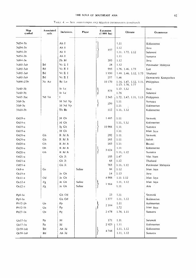
Map.s mho!
Associatedsoils Inclusions Phase Extension
(1 001) ha) Climate Occurrence
Nd54-3b Ah I 1.11 KalimantanNd54-3b Ah I
}
1.12 Java
Nd54-36
Nd54-36
Nd64-3a
Ah IAh IFh Jd
457
393
1.11,
1.11
1.12
.72, 1.12 Sulawesi
Sumatra
Java
Nd65-3ab Bd Vc E I 28 1.12 Peninsular MalaysiaNd65-3ab
Nd65-3ab
Nd65-3ab
Bd
Bd
Bd
Vc E IVc E IVc E I
955
1 930
257
1.76,
1.48,
1.46
1.46,
1.46,
1.73
1.12, 1.73
Lao
Thailand
Democratic KampucheaNd66-2/3b
Ne60-3b
Ne Ao Be Lo
Je Lc
10 170 1.14,1.13,
1.13.
1.47,1.76,
1,12
1.12,1.77
1.11, Philippines
JavaNe60-3b Je Le
5751.76 Sulawesi
Ne65-3bc
Nh9-3a
Nd To I
Jd Nd Vp2 343 1.72,
1.11
1.47, 1.11, 1.13 Philippines
Sumatra250
Nh9-3a Jd Nd Vp 1.11 Kalimantan
Nh10-3b
0d19-a
Th Be
Jd Oh
112
1 485
1.11,
1.11
1.12 Kalimantan
Sarawak
0d19-a0d19-a
Jd OhJg Oh 10 968
1.11,
1.11
1.12 Kalimantan
Sumatra
Od 1 9-a Jd Gh 1.11 Irian Jaya
0d20-a Oh R Jd Jt 292 1.11 Sarawak
0d20-a Oh R Jd Jt 165 1.11 Sabah
0d20-a Oh R Jd Jt 183 1.11 Brunei
0d20-a Oh R Jd Jt1.11
Kalimantan
Od20-a Oh R Jd Jt} 3 024
1.11, 1.12 Sumatra
0d21-a Oh JI 183 1.47 Viet Nam
Od21-a Oh It 68 1.12 Thailand
0d21-a0e9-a Ge
Oh JtSaline
763
84
1.11,
1.12
1.12 Peninsular Malaysia
Irian Jaya
0e10-a Je Oh 14 1.13 Java
Oell-a Od Je Oh 4 988 1.11 1.12 Irian Jaya
0e12-a0e12-a
Zg
Zg
Je OhJe Gh
Saline
Saline} 1 964
1.11,
1.11
1.12 Irian Jaya
Aru
Pg4-la Oh Od 23 1.11 Sarawak
Pg4-la
Ph12-lb Qa
Oh Od
Pp
1 377 1.11,
1.11
1.12 Kalimantan
Kalimantan
Ph12-16 Qa Pp} 2 104
1.72 Irian Jaya
Po27-la
Qa17-la
Qa
Po
Pg
Jd
2 478
171
1.76,
1.11
1.11 Sumatra
Sarawak
Qa17-la Po Jd 2 923 1.11 Kalimantan
Qc59-lab
Qc59-lab
Bd
Bd
Ah JdAh Jd
4 7461.11,
1.11,
1.12
1.12
Kalimantan
Sumatra
THE SOILS OF SOUTHEAST ASIA 41
TABLE 4. - SOIL ASSOCIATIONS AND RELA FED INFOR lATION (count/tied)

Mapsx mbol
Asxociatedsoils
Inclusions Phase Extension(1 000 ha ) Climate Occurrence
Qc60-laQf48- 1 b
Bd JAf
Ge
Ag Fo
323
440
1.47,
1.11
1.13 Philippines
Moluccas
Rc46- la Bc 112 1.12 Sulawesi
Rd10-la Gd Od Gh Jt S 1.11 Kalimantan
Rd10-la Gd Od Gh Jt S }28
1.72 Irian Jaya
Re62 - 1 ab
Re82 - lbc Tv
Je GhAh Gh Stony
65
314
1.12,
1.12
1.72 Lesser Sunda Islands
Lesser Sunda Islands
Re82 -1 bc
Re83 -lab
Re83 -1 ab
Re83-lab
Tv
Qf QaQf QaQf Qa
Ah GhG Je PG Je PG Je P
Stony }603
314
130
1.13,
1.47,
1.13,
1.12
1.76,
1.13,
1.12
1.14
1.22
Java
Viet Nam
Thailand
Peninsular Malaysia
Th17-2c
Th17 -2c
Th17 -2c
Th18-2ab
Tv
Tv
Tv
Gh
Be Re IBe Re 1
Be Re IBe Re
2 384
682
1.12,
1.72,
1.76,
1.12
1.76,
1.76
1.11,
1.72
1.72
Java
Sulawesi
Sumatra
Sumatra
Tm23-2c
Tm23-2c
Tv
Tv
I ReI Re
/898
1.76,
1.11
1.13, 1.14 Java
Moluccas
Tm23-2c Tv I Re 1.72, 1.71, 1.12 Lesser Sunda IslandsTo24 -2c
To24-2c
Tv
Tv
I ReI Re 1 627
1.76,
1.11
1.72, 1.12 Java
Moluccas
To24-2c
To25 -2b
Tv
Lv
I ReJe
1.12,
1.76,
1.71
1.14
Lesser Sunda IslandsJava
To25-2b Lv Je }567
1.12 Lesser Sunda IslandsTo26-2bc
To27-2/3bc
Tv38-1 bc
Tv38- 1 bc
Be Ne
I
Re
Re
Ne
Th ToTh To
Stony
Stony
734
514
1.47,
1.47,
1.12,
1.76
1.11,
1.11,
1.13,
1.13,
1.13,
1.72,
1.72
1.72
1.76
Philippines
Philippines
Java
SulawesiTv38- 1 bc Re Th To Stony 1 470 1.11 MoluccasTv38- 1 bc
Tv38-1 bc
Vc57-3ab
Vc59-3a
Re
Re
Le
Th ToTh To
Je
Bg Ge
Stony
Stony
213
87
1.76,
1.12,
1.72,
1.47
1.11,
1.72
1.12
1.72 Sumatra
Lesser Sunda Islands
Java
PhilippinesVp61 -3a BY Je 1.13 JavaVp61-3a By Je
/805 1.12 Sulawesi
Vp61-3a By le 1.14, 1.12 Le sser Sunda IslandsVp62-3b
Vp62-3bLe
Le
I
I }525
1.13,
1.12
1.12 Java
Lesser Sunda IslandsVp63-3ab
Vp63-3ab
Lv
Lv
Je
Je
/561
1.13,
1.12,
1.14
1.11
Java
SulawesiVp63-3ab Lv Je 1.12 Lesser Sunda IslandsVp64-3a
Vp64-3a
I Ve
1 Vc
F GF G
Lithic
Lithic
330
159
1.48,
1.73
1.46 Thailand
Lao
42 SOIL MAP OF SOUTHEAST ASIA
TABLE 4. - SOIL ASSOCIA 'IONS AND RELA TED INFORMATION (continued)

permanently saturated clays in brackish water witha Rhizophora-Bruguiera mangrove forest cover arepotentially acid sulphate soils. Where natural orartificial drainage has occurred, the material hasslowly ripened to form acid sulphate soils whosehigh acidity is due to the formation of sulphuric acidthrough oxidation. Both are grouped as ThionicFluvisols, which are most extensive in the ChaoPhraya and Mekong deltas. In the Red river deltathey cover a relatively limited area. Eutric Fluvisolsalso occur along the littoral fringes of the deltas,and on banks of rivers and tidal channels. Saline-phase Eutric Fluvisols occur on the littoral fringesof the Chao Phraya and Mekong deltas, while theEutric Fluvisols of the Red river delta are succeededby Eutric Regosols along the coast.
Eutric Gleysols have developed in the plains anddeltas where better natural or artificial drainageconditions have resulted in the ripening of materialsin which little sulphide has accumulated, or whichcontain neutralizing components that prevent strongacidification after oxidation of the sulphides upondrainage. Saline Eutric Gleysols occur along thelittoral fringes of the Chao Phraya and Mekongdeltas. Gleysols are the principal rice-growing soilsof the region.
The main inclusions of other soils within the regionare fine-to-medium-textured Gleyic Acrisols whichhave developed from subrecent alluvium on old ter-races bordering the present flood plains. An inclu-sion of Pellic Vertisols developed from lacustrinedeposits borders the Chao Phraya flood plain in theeast.
2. FLUVISOL-GLEYSOL ASSOCIATION OF IRIAN JAYA,THE CIRCUM-SUNDA ARCHIPELAGOES AND THE MALAYPENINSULA
Narrow coastal plains occur along the east coastof the Malay Peninsula, the northeast coast of Su-matra, the north coast of Java, and the west coastsof Sulawesi and Irian Jaya. The formations arecharacteristic of emergent shorelines, and while themajority of the individual plains are too small to
appear on the soil regions map, five of the largestoccurrences have been combined to form the secondFluvisol-dominant soil region of Southeast Asia.The relief is predominantly level, with an undulat-ing microrelief occurring on natural levees and beachridges of the littoral fringe. Elevation is at or nearsea level, and much of the region is either permanent-ly saturated or subject to annual flooding during therainy season. Annual rainfall ranges from 1 500 toover 2 000 mm.
The soils are developed from recent alluvial depositsand unconsolidated materials. The Fluvisols of theregion are mainly unripe and permanently saturated,but Gleysols have ripened to some degree owing tobetter natural or artificial drainage. The majorityof Gleysols and the Fluvisols of northern Java areused for rice growing, while other Fluvisols areunder mangrove forest and marsh vegetation.
Fine-textured Thionic Fluvisols and Eutric Gley-sols have developed from non-calcareous materialsbordering Lake Thale in southern Thailand. EutricRegosols are formed from beach and dune sedimentsalong the littoral fringe, and inclusions of fine-to-medium-textured Gleyic Acrisols occur inland.
Medium-to-fine-textured Dystric Fluvisols de-veloped from non-calcareous materials occupy thecoastal plains of northeastern Sumatra, northernJava and western Sulawesi. Inland inclusions aremainly Orthic Acrisols, although in Java ChromicVertisols and Dystric Nitosols also occur.
Fine-textured Humic Gleysols and medium-to-fine-textured Dystric Fluvisols occupy the extensive,marshy alluvial plain of the Bomberai Peninsula ofIrian Jaya. The principal inclusions are EutricHistosols in the marshy interior, and fine-texturedRendzinas and Chromic Luvisols in the borderinguplands.
3. GLEYSOL-VERTISOL ASSOCIATION OF LAKE TONLE
This region consists of the Lake Tonle and Mekongbasins north of Phnom Penh, which form the prin-cipal lowlands of Democratic Kampuchea. Therelief is predominantly level. An undulating micro-
Nlaps. mhol
Associatedsoils Inclusions Phase ENtension
(I IM)) ha) Climate Occurrence
Vp64-3a
Vp64-3a
Vp65-3a
I Vc
I Vc
Ge
F GF GBg Lo
Lithic
Lithic
596
901
991
1.76,
1.46
1.14,1.76
1.47,
1.47,
1.46
1.11, 1.13,
Viet Nam
Democratic Kampuchea
Philippines
THE SOILS OF SOUTHEAST ASIA 43
TABLE 4. SOIL ASSOCIATIONS AND RELATED INFORMATION (ay/chided)

44 SOIL MAP OF SOUTHEAST ASIA
relief characterizes the natural levees of the Mekongriver, and a " gilgai " microrelief the Vertisols foundin the east of the region. The average elevation isless than 50 m above sea level, and much of theregion is inundated during the rainy season (Mayto October), when the flood waters of the Mekongriver flow back into the immense Lake Tonle. Theaverage annual rainfall is 1 400 mm.
These predominantly fine-textured soils are devel-oped from recent and subrecent lacustrine depositsof mixed origin: clay and silt-laden flood waters ofthe Mekong river, and local mixed basic and acidsource materials to the north, west and south of thelake. There are significant inclusions of mont-morillonitic clays.
Eutric Gleysols are the dominant soils of the region.They encircle Lake Tonle and are submerged annuallyto depths of two to four metres during the rainyseason, drying out in the dry season when the lakeempties the flood waters back into the Mekong river.Fresh water mangrove forest occurs adjacent to LakeTonle. Large areas are planted to " floating rice"when the water is high during the rainy season.Upland crops are planted locally during the dryseason when the flood waters recede.
The fine-textured Pellic Vertisols predominatingeast and north of the Mekong river above PhnomPenh are developed from subrecent unconsolidatedcalcareous materials. These soils, which occupyslightly higher positions than the Gleysols, are rarelyinundated and are used extensively for the cultivationof cotton, bananas, rice and pineapples.
Medium-textured Eutric Fluvisols, developed fromrecent alluvial deposits on the levees of the Mekongriver, are traditionally settlement sites. Medium-textured Gleyic Acrisols are the principal inclusionsalong the northern, eastern and southern borders ofthe region, while fine-textured Gleyic Luvisols occurto the west in the vicinity of Battambang.
4. LITHOSOLS
Lithosols are by definition soils limited in depthby continuous coherent hard rock within 10 cm ofthe surface. In Southeast Asia they are found insmall spots in areas of excessive relief. They mayhave a forest or savanna cover, or may be bare ofvegetation, and may occur in any climatic region.The majority of occurrences are too small to appearon the Soil Map of Southeast Asia and hence onthe soil regions map. However, in a number ofareas these soils are extensive and have been com-bined to form the Lithosols soil region.
The main areas of occurrence have one featurein common. In every case the parent materialconsists of carbonate sediments, usually consolidated
limestone or dolomite. The landscape is typicallytropical karstic with highly weathered limestoneridges, isolated pinnacles and numerous caverns andsinkholes.
The Lithosols of the Tonkin massif of Viet Nam,the eastern massifs of Lao and Viet Nam, the westernhighlands of Thailand and the Malay Peninsula occuron Carboniferous-Permian and Ordovician limestonewhich is massive and locally dolomitic. The prin-cipal associated soils are fine-textured ChromicLuvisols and Calcic Cambisols. Lithosols occur inassociation with fine-textured Ferric Acrisols alongthe border between Viet Nam and China. In eachinstance the slope class is steeply dissected to moun-tainous.
The Lithosols of the southern belt of Java, Sum-bawa, Sumba and Timor occur on barren, rolling-to-hilly karstic plateaus of Triassic limestone risingsteeply from the coast. The main associated soilsare fine-textured Chromic Luvisols in Java, Sumbawaand Sumba. The Lithosols of Timor occur inassociation with fine-textured Calcic Luvisols.
5. ARENOSOL-ACRISOL ASSOCIATION OF BORNEO
This region, located on the continental Sundashelf part of western Borneo, consists of a centralcore of metamorphic and acid effusive and intrusiverocks surrounded by a belt of Mio-Pliocene coastaldeposits. Forest and forest-savanna cover most ofthe region. The relief is level to undulating inperipheral parts of the area, but becomes rolling,hilly and steeply dissected in places in the interior.Elevation ranges from 50 to over 1 000 m, but isless than 200 m throughout most of the region.The soils are well to excessively drained. Annualrainfall exceeds 2 000 mm and is evenly distributedthroughout the year.
Arenosols have developed from coarse-texturedclastic deposits in the Mio-Pliocene coastal belt.Acrisols have developed from metamorphic rocksand remnants of old acid effusive and intrusivecomplexes.
The coarse-textured Mio-Pliocene deposits of thecoastal belt consist of a thick layer of white quartzsand. Cambic Arenosols have developed on leachedsands, while Albic Arenosols have developed onslightly finer materials. Texture, however, remainscoarse and most of these soils are excessively drained.The Arenosols grade inland to medium-to-fine-textured, well-drained Orthic Acrisols which havedeveloped on metamorphic rocks and acid effusives.Orthic Acrisols developed from metamorphic rockshave a rolling to hilly relief, while those developedfrom acid effusives are steeply dissected.
The main inclusions are fine-to-medium-texturedOrthic Ferralsols and Rhodic Ferralsols developedfrom acid intrusive and acid effusive rocks, respec-tively. Dystric Fluvisols occupy the narrow valleysof the main rivers.
RENDZINAS
Rendzinas are not extensive in Southeast Asia,but occur locally in parts of the Indonesian archi-pelago where they are intimately associated withshallower Lithosols and deeper Luvisols and Cam-bisols. They rarely exist as a continuous unit cover-ing extensive areas. Principal occurrences are inparts of Irian Jaya, the Aru, Kai (Ewab) and LesserSunda Islands, the Moluccas, Sulawesi and Sumatra.These have been combined to form the Rendzinassoil region.
Rendzinas occur under climates ranging fromever-humid semihot equatorial in Sumatra to humidsemihot equatorial as in Sulawesi and the Moluccas,and approach Andine taiga in Irian Jaya. Underever-humid conditions a special type of rain forestrelatively poor in species occurs. Areas of thesesoils with a more pronounced dry season supportonly a poor natural vegetation which in places isxerophytic. Where moisture supply is sufficient,Rendzinas are locally used for the production offruit crops.
Rendzinas, developed on carbonate sediments oflimestone and marl, are of two distinct types. Thefirst type consists of well-drained Rendzinas developedon massive limestone rocks of Tertiary or older agewhich occur in northern Sumatra, southeasternSulawesi and western Irian Jaya. Slopes are oftensteeply dissected and elevations range from sea levelto over 2 000 m on the southern slopes of the Maokemountains of Irian Jaya. These Rendzinas are finetextured and occur in association with ChromicLuvisols in Sulawesi, Lithosols, Dystric Cambisolsand Humic Cambisols in Irian Jaya, and lithicHumic and Orthic Acrisols in Sumatra.
The second type of Rendzinas is developed onraised Neogene and Paleogene coral reefs. Mainoccurrences are in the Moluccas and the Aru, Kaiand Lesser Sunda Islands on undulating to rollingterraces in littoral zones at elevations mainly below100 m. These Rendzinas are well drained and finetextured and occur in association with ChromicLuvisols, Dystric Cambisols and Orthic Acrisols.
ANDOSOLS OF THE MOLUCCAS AND LESSER SUNDA
ISLANDS
This region consists of the volcanic inner arc ofthe Lesser Sunda Islands and its northeast extension
THE SOILS OF SOUTHEAST ASIA 45
through the Banda arc of the Moluccas. The vol-canic islands of Bali, Lombok, Flores, Alor, Wetarand the northern peninsula of Halmahera form theeasterly continuation of the active volcanic chainof the great Sunda mountain system. Individuallythese islands are of small extent, but are combinedas a soil region because of their unique soil land-scape features.
Most of the islands comprising this region areentirely volcanic in origin. Gently rolling lowlandsare virtually non-existent. The majority of slopesare steeply dissected to mountainous, and volcanoesrise virtually out of the sea to elevations of 1 000
to 3 750 m.The prevailing climate is modified by altitude.
Lower slopes experience a humid semihot equatorialclimate with a distinct dry season (everhumid onHalmahera), while the higher peaks have a humidtierra templada climate.
Although the intensively cultivated areas of Balisupport a high population density, most of the regionremains under monsoon forest stratified accordingto elevation. The slopes of the more active volcanoesare under pioneer vegetation where the original coverhas been destroyed by volcanic eruptions and ashfalls.
The Andosols of the region are developed onrecent andesitic to basaltic pyroclastic material. Theexchange complex of most of these soils is dominatedby amorphous material (allophane and relatedminerals). Bulk densities are commonly low andmany of these soils have a smeary consistency whenmoist.
Mollie Andosols developed from andesitic volcanicash or andesitic to basaltic pyroclastic materialsoccur on long slopes of recent volcanoes in Bali,Lombok, Flores and Halmahera. They are generallymedium textured and well to somewhat excessivelydrained.
Ochric Andosols are developed from andesiticpyroclastic materials on the slopes of young andesiticvolcanoes in Bali, Flores, Alor, Wetar and Halmahera.They are generally medium-to-fine-textured and welldrained.
Vitric Andosols, the coarse-textured, gravelly andstony members of the Andosols, are developed fromandesitic volcanic ejecta comprising pumice andvolcanic glass. These soils are somewhat excessivelydrained and are located on the slopes of youngvolcanoes and mudflows in Bali, Lombok, Alor andHalmahera.
The principal soil inclusions of the region areEutric Cambisols and Regosols in Bali, Vertic Luvi-sols and Pellic Vertisols in Lombok, Chromic Luvi-sols and Lithosols in Flores and Alor, and OrthicLuvisols in Wetar and Halmahera.
46 SOIL MAP OF SOUTHEAST ASIA
8. ANDOSOL-LUVISOL ASSOCIATION OF JAVA
The central volcanic belt of Java is composed ofa succession of volcanoes whose products have coveredthe older maturely dissected landscape forms withlava, ash and lahars. Much of the area has rollingto hilly slopes punctuated by steep-sloped volcanoes.About 14 of these cones have elevations exceeding3 000 m. The prevailing climate of the region ismarked by the influence of altitude and the increasein dry months toward the east. Higher slopes havea humid tierra templada climate, while the climateof lower slopes grades from humid semihot equatorialin the west to moist monsoon semihot equatorialin the east. This region is one of the most intensivelycultivated and populous areas in Southeast Asia.Little original monsoon or rain forest vegetationremains. Most of the rolling to hilly land has beenterraced and planted to permanent food crops forgenerations, and as population pressure has increased,many of the higher slopes have been cleared andplanted intermittently or permanently to food cropsdespite the danger of soil degradation.
The Andosols and Luvisols of the central volcaniczone of Java are intimately linked with the volcanicorigins of the region. Andosols are developed fromrecent andesitic and basaltic pyroclastic materials,and exchange complexes are dominated by amorphousmaterial (allophane and related minerals). Luvisolsare largely developed on older volcanic complexeswith kaolinite being the dominant clay mineral incombination with some illitic clays. The charac-teristic volcanic downslope catena of the region isAndosols on young materials grading to Luvisolson older deposits, with Vertisols rich in montmoril-lonitic clays occupying intervening volcanic plains.
In the humid western part of the region medium-textured, well-drained Humic Andosols are developedfrom recent andesitic pyroclastic materials on thehigher volcanic cones. These are succeeded bymedium-textured, well-drained Ochric Andosols onsteeply dissected upper slopes. Rolling to hillylower slopes are characterized by well-drained,medium-to-fine-textured Orthic Luvisols and fine-textured Vertic Luvisols. The main inclusions inthis part of the region are Lithosols, Orthic Acrisolsand Eutric Cambisols on steeply dissected upperslopes, and Dystric Nitosols and Chromic Vertisolson lower slopes and volcanic plains, respectively.
Unlike the west, the eastern part of the region hasa pronounced dry season, and most soils have ahigher percentage of base saturation. Medium-tex-tured, well to somewhat excessively drained MollieAndosols and Ochric Andosols are developed fromrecent andesitic to basaltic pyroclastic materials onthe steeply dissected upper slopes. Coarse-textured,
somewhat excessively drained Vitric Andosols havealso developed on recent andesitic volcanic ejecta.Rolling to hilly lower slopes are dominated bywell-drained fine Vertic Luvisols developed on oldervolcanic deposits. The main inclusions in theeastern part of the region are Eutric Regosols andLithosols on upper slopes and Pellic Vertisols onvolcanic lahars.
9. VERTISOL-FLUVISOL ASSOCIATION OF JAVA ANDMADURA
The northern belt of eastern Java and Maduraconsists of the Rembang-Madura anticlinorium whichis made up of two longitudinal belts of massivelimestone separated by marly sedimentaries andoverlain by Quaternary alluvial deposits. In Javathe nearly continuous karstic plateau is characterizedby gently sloping hills interrupted by wide valleyswith a narrow fringe of alluvial plain along thecoast. Madura consists of a low longitudinal beltwith undulating relief fringed by a discontinuousalluvial plain along the coast. The elevation of thekarstic plateau rarely exceeds 250 m. The prevail-ing climate is moist monsoon semihot equatorial.Annual rainfall usually exceeds 1 500 mm, but thereis a distinct dry season from August to October.Most of this region is intensively cultivated and hasa very high population density. Where sufficientirrigation water is available, rice, sugar cant and avariety of annual or perennial crops are grown.Limestone scarp slopes are planted to teak forest.
The Vertisols of this region are developed fromweathering products of limestone and marl. Theyconsist of fine-textured material 'and develop deepcracks when dry. The soils are self-mulching andoften show " gilgai " microrelief. The dominantclay mineral is montmorillonite. Fluvisols aredeveloped on recent alluvial deposits consisting ofmedium-to-fine-textured materials. Except for thebetter-drained soils on the natural levees of the mainrivers, most Fluvisols in the area show hydromorphiccharacteristics and are inundated annually duringthe rainy season.
Pellic Vertisols are the dominant soils of the area.Their macrorelief is nearly flat to slightly undulatingin the central belt of marly sediments, and rollingto hilly over much of the karstic plateau. Thenatural drainage of these soils is imperfect to poorin the rainy season. During the dry season theydry quickly and crack deeply.
Eutric Fluvisols are the principal soil componentsof the alluvial plains along the coastal fringe. Theyare medium-to-fine-textured and are generally poorlydrained.
The main inclusions on the karstic plateau areLithosols and Vertic Luvisols, with Chromic Luvisolsoccurring on steeply dissected slopes.
10. CAMBISOLS OF IRIAN JAYA
The Cambisols of Southeast Asia generally occurin small patches in hilly or mountainous country.One of the largest continuous areas of occurrencelies in the rugged mountains of Irian Jaya: theVan Rees ranges and the Maoke mountains, whichare separated by the Meervlakte intermontane plain.The macrorelief of this region is predominantlysteeply dissected to mountainous, and the maximumaltitude exceeds 5 000 m. The prevailing climate isinfluenced by altitude and ranges from ever-humidsemihot equatorial through humid tierra templadato Andine taiga. Annual rainfall usually exceeds2 000 mm and is uniformly distributed throughoutthe year, with no distinct dry season. Most of theregion is under rain forest which is stratified accord-ing to elevation and contains valuable hardwoodtrees. Shifting cultivation is practised in low-lyingand more accessible parts of the region.
Cambisols are young soils developed on parentmaterials that are subject to continuous erosion orhave recently accumulated. These conditions arefound on steep slopes and talus slopes of colluviumover much of the Van Rees mountains and the north-ern slopes of the Maoke mountains in Irian Jaya.In the Van Rees mountains Cambisols are developedon weathering products and colluvium derived fromPlio-Pleistocene deposits consisting mainly of sand-stone and conglomerate. The Cambisols of theMaoke mountains are developed on Paleozoic andMesozoic formations consisting of quartz micaschistwith intrusions of granite and granodiorite.
Humic Cambisols generally occupy higher partsof both mountain systems and are medium texturedand well to somewhat excessively drained. DystricCambisols occur on lower slopes south and east ofthe Meervlakte, and are medium textured and welldrained.
The principal soil inclusions of the Van Reesmountains are Humic Ferralsols and Ferric Acrisols.Eutric Fluvisols occur along narrow river valleysand Lithosol-Dystric Histosol associations are foundon the northern slopes of the Maoke mountains.
1 1 . CAMBISOL-ANDOSOL ASSOCIATION OF SUMATRA
The active volcanic inner arc of the great Sundamountain system is represented in Sumatra by theBarisan range, which forms a mountainous south-western coastal belt rising steeply from the IndianOcean to elevations of up to 3 800 m. Eastern slopes
THE SOILS OF SOUTHEAST ASIA 47
rising from the adjacent dissected peneplains have aless severe macrorelief which is predominantly hilly,and in some places steeply dissected. The climateof the area is influenced by altitude and ranges fromever-humid semihot equatorial through humid tierratemplada. Annual rainfall usually exceeds 2 000 mmand is uniformly distributed throughout the yearwith no distinct dry season. Large areas remainunder rain forest which is stratified according toelevation. Highland coffee and pepper are grownlocally, and shifting cultivation is practised on lower,more accessible slopes.
Andosols developed on intermediate to acid pyro-clastic deposits occur extensively on the higher slopesof recent and subrecent volcanoes. Volcanic parentmaterial is generally more acid in Sumatra than inJava and the Lesser Sunda Islands. Cambisols aredeveloped from older pyroclastic materials on mid-slopes in the southern part of the region. In thenorthern part they are developed on steep slopessubject to continuous erosion and talus slopes ofcolluvium derived from granite, micaschist andquartzite.
Medium-textured, well-drained Humic Andosolswith a steeply dissected macrorelief are developedon upper-slope pyroclastic deposits of recent andsubrecent volcanoes. Coarse-textured, gravelly andstony Vitric Andosols are developed from volcanicejecta consisting of pumice and volcanic glass. Thesesoils are somewhat excessively drained, have a steeplydissected macrorelief, and are located on the slopesof recent volcanoes and mudflows.
Medium-textured, well-drained Humic and DystricCambisols are developed on weathering products andcolluvium derived from older volcanic material,granite, micaschist and quartzite. Humic Cambisolsusually occur on upper and eastern slopes, whileDystric Cambisols are more common on west-ward-facing mid-slopes. A small patch of EutricCambisols also occurs on more basic volcanic materialin the extreme southern part of the region.
The main soil inclusions along the eastern flanksof the Barisan range are lithic Humic Acrisols,Orthic Acrisols and Orthic Ferralsols. A narrowbelt of Orthic Acrisols and discontinuous inclusionsof Dystric Fluvisols and Dystric Histosols fringe thesouthwest coast, and Chromic Luvisols occur in thesoutheastern tip of the region.
12. CAMBISOL-LUVISOL-NITOSOL ASSOCIATION OF THEPHILIPPINES
The central part of Luzon southwest of a linedrawn between the Lingayan Gulf in the northwestand the Ragay Gulf in the southeast consists of thecentral lowlands, the western Zambales mountains,

48 SOIL MAP OF SOUTHEAST ASIA
the southern extremity of the Sierra Madre mountainsin the east, and the Bondoc Peninsula in the south.Except for the narrow eastern and western moun-tainous zones, the macrorelief is gently undulatingto rolling. The maximum elevation in the mountainsis 1 200 m, but most of the region is below 100 m.A moist monsoon hot tropical climate prevails.Annual rainfall ranges from 1 500 to 2 000 mm.There is a distinct dry season, and the rainy seasonoccurs between May and October. The greater partof the region has been cleared and cultivated, prin-cipal crops being rice and coconut. However, naturalmonsoon forest vegetation remains on the ruggedZambales mountains.
Cambisols are developed on weakly stratifiedrecent alluvial deposits of slightly dissected lowcontinental river terraces. Luvisols are developedfrom Pliocene-Miocene marine clastic sediments,principally greywacke, shale and reef limestone.Nitosols are developed on Pliocene-Quaternary vol-canics composed of pyroxene, andesite and dacite,together with pyroclastics and basalt. Medium-to-coarse-textured Gleyic Cambisols occur mainlyin the central lowlands between the Lingayan Gulfand Manila Bay. They are poorly drained soilsand ground water stands close to the surfaceduring part of the year; some have been artificiallydrained. Their macrorelief is nearly flat to undulat-ing. Medium-to-fine-textured Orthic Luvisols aredominant in the Bondoc Peninsula. They are well-drained soils with a rolling to hilly macrorelief.
Fine-to-medium-textured Dystric Nitosols occuron hilly to mountainous terrain along the easternand western borders of the region and are developedon pyroxene, andesite and dacite. Fine-texturedEutric Nitosols are developed from pyroclastics andbasalt. The macrorelief of both soils is predominantlyrolling to hilly, but in some places is steeply dissected.The soils are well drained.
The main soil inclusions in the central lowlandsand narrow coastal plains are Eutric Fluvisols, EutricGleysols and Cambie Arenosols developed on recentcoarse-textured alluvium, and Pellic Vertisols devel-oped from fine-textured weathering products oflimestone and basalt. Steeply dissected, medium-tofine-textured Orthic Acrisols are developed from theCretaceous-Paleogene peridotite and gabbro whichform the core of the Zambales mountains. OchricAndosols occur on upper slopes of volcanoes.
13. LuvisoLs
Luvisols are generally found in regions with along distinct dry season, an annual rainfall of lessthan 1 500 mm, and a mean annual temperature of
over 20°C. This combination of climatic conditionsis uncommon in humid Southeast Asia, and conse-quently occurrences of those soils tend to be localizedand are rarely continuous or extensive. Elsewherein this chapter, Luvisols are described for soil regionswhere they occur as inclusions or as secondary com-ponents of associations. However, in a number ofplaces they are dominant. The two main types ofoccurrence are combined to form the Luvisols soilregion.
The first type consists of Gleyic Luvisols developedon Quaternary alluvium and colluvium from mixedbasic and acid sources. These soils are fine texturedand poorly to somewhat poorly drained. Theirmacrorelief is nearly flat to gently rolling. Theprevailing climate is moist monsoon to hot tropical.Annual rainfall ranges between 1 000 and 1 500 mm.There is a pronounced dry season, and the rainyseason occurs from May to October. During thepeak of the rainy season ground water approachesthe soil surface for short periods. These soils areprimarily used for rice cultivation. They occurmainly in the Ping and Yom basins of northernThailand and the Battambang outwash plains ofDemocratic Kampuchea. The principal inclusionsare Eutric Fluvisols and Gleysols developed on recentalluvium. Orthic Acrisols, Ferric Acrisols and Dys-tric Nitosols occur along upland borders.
The second type consists of medium-to-fine-texturedOrthic and Chromic Luvisols developed on olivinebasalt and limestone plateaus. These soils are welldrained and their macrorelief ranges from rolling tosteeply dissected. They occur mainly in the south-eastern tip of Sumatra and Siberut Island, north-eastern Kalimantan, central Irian Jaya, and south-ern and southeastern Sulawesi. The prevailing cli-mate is humid semihot equatorial. Annual rainfallexceeds 1 500 mm. There is no distinct dry season.Natural monsoon forest vegetation remains on thesteeper slopes in Irian Jaya and southeastern Sula-wesi, but much of the area has been subjected toshifting cultivation, resulting in the spread of an-thropic savanna. The main inclusions are EutricFluvisols and Dystric Cambisols in narrow valleysand small coastal plains. Eutric Cambisols, HumicAndosols, Vitric Andosols, and Rendzinas occurlocally in mountainous areas.
14. PODZOLS OF SUMATRA AND BORNEO
Lowland Podzols occur on nearly level to gentlyrolling old coastal terraces in southern Borneo andon the islands of Bangka and Belitung (Billiton) offthe east coast of Sumatra. Elevations are usuallyless than 50 m. The prevailing climate is ever-humid
semihot equatorial. Annual rainfall exceeds 2 000mm and is uniformly distributed over the year. Theselowland Podzols have a characteristic natural vegeta-tion known as " kerangas " forest which includesspecies such as Dacrydium elatim, Casuarina suma-trana, Agathis dammara, A. alba and Whiteodendronmoultanian. When degraded, the kerangas forest isreplaced by " padang " vegetation consisting ofscattered stunted trees over patches of ground mosses.White pepper is grown on these soils in Bangka andBelitung, while in Borneo farmers use them for pigrearing.
The Podzols of the region are coarse textured andare developed on Neogene siliceous sand depositsprobably derived from Mio-Pliocene coastal sedi-ments.
In southern Borneo Podzols occupy a wide beltbetween the coastal peat swamps and the uplands ofthe interior. Gleyic Podzols occupy low positionsand exhibit hydromorphic characteristics within 50cm of the soil surface. At slightly higher elevationsHumic Podzols are more extensive. They are welldrained, but probably evolved in conditions ofimpeded drainage. The main inclusions along thecoastal strip are Dystric Histosols, Humic Gleysolsand Dystric Fluvisols. Inland, Humic Podzols gradeto Orthic Acrisols and Albic Arenosols. The latterare probably developed on reworked material fromold Podzols.
Orthic Podzols are extensive in the islands ofBangka and Belitung. They are coarse textured andwell drained, but like the Humic Podzols of Borneo,probably evolved under conditions of impededdrainage. Inclusions of Dystric Histosols and HumicGleysols occur along the coast, and Xanthic Ferral-sols developed on acid volcanic tuff and Neogenesand deposits occupy slightly higher positions.
15. ACRISOLS
Acrisols are the most widespread soils of SoutheastAsia. They are estimated to cover some 197 millionha, representing 51 percent of the region. Theirmacrorelief ranges from nearly level to steeply dis-sected or mountainous. They occur over a widerange of elevation and climate, although most arefound in regions where annual rainfall exceeds 1 500mm and there is no marked dry season. These soilsform on acid to moderately basic parent materials,mostly on residuals of sedimentary, igneous ormetamorphic rocks, and on terraces and dissectedpeneplains of old alluvial deposits. Acrisols are verypoor in nutrients and highly susceptible to erosion.Hence successful continuous cultivation of these soilsrequires improved agricultural practices including
THE SOILS OF SOUTHEAST ASIA. 49
fertilizer application, soil conservation and waterstorage. Consequently their use, or misuse, variesconsiderably throughout the region.
To aid in understanding the soil geography ofAcrisols, the region has been subdivided into tensoil subregions.
Acrisols of continental Southeast Asia
Fine-to-medium-textured and well to somewhatexcessively drained, lithic Orthic Acrisols occur overvast tracts of steeply dissected terrain of the mainmountain systems of Viet Nam, Lao, DemocraticKampuchea and Thailand. They are developed onresiduals of consolidated clastic sediments and meta-morphic and acid intrusive rocks. Most remainunder natural broadleaf and pine forest, but arelocally used for shifting cultivation by itinerant hilltribes, and for tea in Viet Nam.
Deeper, well-drained medium-textured Orthic Acri-sols developed on residual materials and old alluvialdeposits occur on steeply dissected foothills androlling terraces, respectively. Steeper slopes remainunder forest, while much of the rolling terrain isused for shifting cultivation, maize, and locally forrubber in southeastern Thailand, Democratic Kam-puchea and Viet Nam.
Coarse-to-medium-textured, well to moderatelywell-drained Ferric Acrisols and poor to somewhatpoorly drained Gleyic Acrisols are developed on oldalluvium and occur on nearly level to rolling lowerterraces. The original forest vegetation has beencleared in most places. Shifting cultivation is prac-tised on these soils, with extensive areas being aban-doned to anthropic savanna. Flat, low-lying GleyicAcrisols are used for rice growing.
The main inclusions are Lithosols and DystricNitosols, with Eutric Gleysols and Eutric Fluvisolsand Dystric Fluvisols occurring in river valleys.
Acrisols of the Malay Peninsula
Fine- and medium-textured, well to somewhatexcessively drained lithic Orthic Acrisols on steeplydissected terrain are dominant on the mountain rangeswhich form the backbone of the peninsula. Theyare developed on residuals of granite intrusives andmetamorphic and consolidated clastic rocks. Mostremain under dense rain forest vegetation, althoughtea is grown locally in Malaysia.
Deeper, well-drained, medium-textured Orthic Acri-sols on foothills and rolling old terraces are widelyused for rubber in southern Thailand and Malaysia.Oil palm is grown in Malaysia and coconuts areplanted on Orthic Acrisols occupying littoral zonesof the west and east coasts.

50 SOIL MAP OF SOUTHEAST ASIA
Coarse- and medium-textured, well to moderatelywell-drained Ferric Acrisols and poorly to somewhatpoorly drained Gleyic Acrisols developed on oldalluvium on lower terraces support poor stands ofrubber and are often abandoned to anthropic savanna.Rice is grown on flat, low-lying Gleyic Acrisols.
The main inclusions are Rhodic Ferralsols, DystricNitosols and Lithosols. Eutric Gleysols, EutricFluvisols and Dystric Fluvisols occur in river valleysand narrow coastal plains, and Eutric Regosols arefound on beach ridges and dunes fringing the eastcoast of the peninsula.
15e. Acrisols of Sumatra
Fine- and medium-textured, well-drained lithicHumic Acrisols are dominant on the steeply dissectedforested slopes of the northern mountains of Su-matra. They are developed on residuals frommetamorphic and acid igneous rocks. Orthic Acri-sols occupy similar physiographic positions wherethe natural forest vegetation has been cleared. Coffeeand tea are grown locally.
The dominant soils on the Neogene landscape ofthe northeastern lowlands are medium- and fine-tex-tured, well-drained Orthic Acrisols on rolling to hillydissected peneplains, and petric Ferric Acrisols onnearly level to undulating lower old terraces. Theyare developed on a thick series of Neogene liparitictuff and sandstone. Most of these soils have beencleared of the original forest vegetation and havelong been subjected to shifting cultivation. Rubberis an important component within the shifting cyclethroughout the subregion, but over wide areas a firedisclimax of anthropic savanna, or " alang-alang "(Imperata cylindrica) vegetation occurs.
The main inclusions are a petroferric phase ofOrthic Ferralsols developed on andesitic material,Humic Andosols and Vitric Andosols developed onrecent volcanic materials, Cambie Arenosols developedon coarse Neogene deposits, and Orthic Podzolsdeveloped on coarse-textured liparitic tuff. DystricHistosols, Humic Gleysols and Dystric Fluvisolsoccur along the eastern transition between the low-lands and the extensive coastal peat swamps.
15d. Acrisols of Borneo
The dominant soils of the mountain system com-prising much of Borneo are medium- and fine-textured,well-drained Orthic Acrisols, and to a lesser extentHumic Acrisols, including a lithic phase. Thesesoils are developed on residuals of non-calcareousconsolidated clastic sediments, metamorphic andgneous rocks. Most of the steeply sloping mo un-
tainous terrain remains under a primary forest vegeta-tion which forms the basis of a flourishing timberindustry.
Orthic Acrisols are also the principal soils of thefoothills and limited areas of rolling old terraces.A petric phase of Ferric Acrisols developed fromNeogene liparitic tuff and sandstone occurs on lowernearly level to undulating terraces. Rubber, oilpalm, coconut, and in Sabah, cocoa, are the maincrops grown on Orthic Acrisols having gentler relief.However, although agricultural exploitation is increas-ing, most of the area is still under natural rain forest.
The main inclusions are petric and petroferricOrthic Ferralsols and Humic Ferralsols developedon igneous rocks, Cambie Arenosols and Albic Are-nosols developed on Mio-Pliocene coastal deposits,and Orthic Luvisols developed on limestone, olivinebasalt and pyroclastic rocks. Dystric Histosols,Humic Gleysols, Eutric Fluvisols and Dystric Fluvi-sols occur in the transition between the coastal beltand the uplands of the interior.
Acrisols of Sulawesi
Medium- and fine-textured, well-drained HumicAcrisols and Orthic Acrisols with a steeply dissectedto mountainous macrorelief are widespread through-out northern, central and southeastern Sulawesi.They are developed on granite, quartzite, crystallineschist and phyllitic shale. In central Sulawesi smallareas of fine- and medium-textured, well-drainedOrthic Acrisols and petric Ferric Acrisols with arolling to hilly macrorelief are developed on Neogenesandstone and liparitic tuff.
Most of the Acrisols of Sulawesi remain undernatural forest. Gently sloping and accessible areasare used locally for shifting cultivation.
The main inclusions are petroferric phases ofHumic Ferralsols and Orthic Ferralsols developedfrom igneous and strongly metamorphosed rocks,Chromic Luvisols developed from limestone, HumicAndosols and Vitric Andosols from subrecent volcanicdeposits, and Eutric Nitosols from old intermediatevolcanic materials. Eutric Fluvisols and DystricFluvisols occur along narrow river valleys and insmall embayments along the rugged coast.
Acrisols of Irian Jaya
Fine-textured, moderately well to poorly drainedFerric Acrisols and medium-textured Plinthic Acrisolswith a nearly level to rolling macrorelief occupy alowland belt between the Maoke mountains and theextensive coastal peat swamps of southern Irian Jaya.These soils are developed from partly reworked
Plio-Pleistocene acid volcanic tuff deposits. Muchof the subregion remains under natural rain forest.Anthropic savanna-type vegetation has developed inareas cleared for shifting cultivation.
The main inclusions are Eutric Histosols and EutricFluvisols,
Acrisol-Gleysol association of the Korat plateau
The Korat plateau of northeastern Thailand ismainly composed of the broad Quaternary terracesof the Mekong and its tributaries, the Mun and Chirivers. Low, middle and high terrace levels arerecognized. Fine-textured, poorly drained DystricGleysols are developed on old alluvium of level, lowterraces which are inundated during the rainy season.Medium- and coarse-textured, poorly to somewhatpoorly drained Gleyic Acrisols and moderately well-drained Ferric Acrisols are developed on old alluviumof middle terraces and have a predominantly undulat-ing macrorelief. Fine-textured, well-drained OrthicFerralsols occur on older high terrace remnants.
The main inclusions are Orthic Acrisols on thesteeply dissected slopes of scattered hills and border-ing scarps.
The Korat plateau has been largely cleared ofits original dipterocarp forest vegetation.
Rice is cultivated during the rainy season on low-lying level Dystric Gleysols and Gleyic Acrisols,and kenaf is widely grown on predominantlyundulating terrain.
Acrisol-Nitosol association of Java
The dominant soils on the Neogene peneplain ofwestern Java are fine- and medium-textured, well-drained Orthic Acrisols developed from non-calcareousconsolidated clastic sediments and low-grade meta-morphic rocks. The macrorelief is undulating torolling. Fine-textured, well-drained Dystric Nitosolsare developed on lahar complexes bordering thecoastal plain of northwestern Java and have a nearlylevel to undulating macrorelief.
The main inclusions are Humic Andosols, OrthicAndosols and Vitric Andosols developed on subrecentunconsolidated volcanic deposits.
The subregion's natural rain forest vegetation hasbeen almost entirely removed.
Dystric Nitosols are intensively planted to riceand a variety of annual food crops. OrthicAcrisols are planted extensively to rubber and,to a lesser extent, tea. In places, alang-alang(Imperata cylindrica) vegetation has developedas a fire disclimax.
Acrisol-Cambisol association of the Moluccas
Ceram and Buru are the principal non-volcanicislands of the Moluccas. Fine- and medium-textured,well-drained Orthic Acrisols and medium-texturedDystric Cambisols are developed from stronglyfolded Triassic sandstone, crystalline schist andgneiss. Orthic Acrisols have an undulating to hillymacrorelief, while Dystric Cambisols occur on steeplydissected to mountainous terrain.
The main inclusions are Dystric Fluvisols in narrowcoastal swamps and Rendzinas on uplifted Plioceneand Quaternary coral formations.
Both islands remain under natural monsoon forestvegetation, although the northern part of Buru hasa savanna cover.
Acrisol-Nitosol association of the Philippines
Fine- and medium-textured, well-drained OrthicAcrisols are the dominant soils of Mindoro, Palawan,Samar, Leyte, Negros and southern and centralMindanao. Their macrorelief is predominantlysteeply dissected to mountainous. The Orthic Acri-sols of the subregion are developed from micaschist,phyllite and quartzite in Mindoro; Mesozoic andPlio-Pleistocene clastic sediments in Negros; Mio-Pliocene molasse deposits and tuffaceous sedimentaryrocks in Samar and Leyte; Tertiary sandstone, shaleand conglomerate in eastern central Mindanao; andperidotite and gabbro in Palawan. Dystric Nitosols,the secondary component of the association, aredeveloped from pyroclastics, basalt and dacitic orandesitic plugs. The macrorelief of Dystric Nitosolsis generally rolling to hilly.
The main inclusions are Gleyic Cambisols andOrthic Luvisols developed on recent alluvial depositsand Pliocene-Miocene marine clastic sediments,respectively.
A large proportion of the subregion remains underdipterocarp forest, evergreen forest and anthropicsavanna. Maize and upland rice are grown in areaswhere shifting cultivation is practised. Permanentagriculture is largely restricted to fruit crops, rubber,abaca and coconuts.
16. NITOSOLS OF THAILAND AND LAO
Nitosols are developed mainly from basalt, dioriteand andesite, or biotite-rich granite and gneiss.Their macrorelief ranges from undulating to hilly.These soils occur in areas with an annual rainfall of1 000 to 3 000 mm, a dry season of less than fourmonths, and an annual temperature above 22°C.
In continental Southeast Asia Nitosols rarely occurover extensive areas and are mainly restricted to
THE SOILS OF SOUTHEAST ASIA 51
52 SOIL MAP OF SOUTHEAST ASIA
local basalt plateaus. Two main occurrences are inthe central highlands of Thailand and the Plateaudes Bolovens in Lao. Here fine-textured, deep,well-drained Dystric Nitosols are developed onbasaltic lava flows.
The main inclusions are Lithosols, lithic OrthicAcrisols, Ferric Acrisols and, in Thailand, PellicVertisols.
The Nitosols of the Plateau des Bolovens areextremely degraded owing to repeated burning ofthe vegetation. The form of shifting cultivationpractised in the area includes coffee and vegetablesin the rotation. In the central highlands of ThailandNitosols have recently been extensively cleared ofnatural dipterocarp forest vegetation and are widelyplanted to maize and sorghum.
17. NITOSOL-ACRISOL ASSOCIATION OF THE PHILIP-P INES
Nitosols are the dominant soils of northern andsouthern Luzon, Panay, Cebu, Bohol, and westernand eastern Mindanao. Their macrorelief rangesfrom rolling to steeply dissected or mountainous.Acrisols form the secondary component of the as-sociation occurring on steeply dissected to mountain-ous terrain.
The climate of the region is influenced by altitudeand ranges from ever-humid semihot equatorialto humid tierra templada. Annual rainfall rangesfrom 1 000 to over 3 000 mm, and the dry seasonis most pronounced along the west coast of northernLuzon. Elevations range from sea level to nearly3 000 m.
Medium- and fine-textured, deep, well-drainedDystric Nitosols are developed from Cretaceous andPaleogene spilite, basalt, keratophyre and andesite.Fine-textured, deep, well-drained Eutric Nitosols areless extensive and are developed on Pliocene andQuaternary volcanics in the southern peninsula ofLuzon and in Mindanao. Medium- and fine-textured,well-drained Orthic Acrisols are developed fromnon-calcareous consolidated elastic sediments andmetamorphic and igneous rocks.
The main inclusions are Gleyic Cambisols andPellic Vertisols developed on recent alluvial deposits,Orthic Luvisols on Pliocene-Miocene marine elasticsediments, and Orthic Andosols on subrecent volcanicmaterials.
Much of the region remains under natural forest.Anthropic savanna occurs in deforested areas, usuallyas a consequence of shifting cultivation. Permanentcultivation of fruit crops, coconuts, abaca and rubberis largely restricted to the more gently sloping andaccessible Nitosols.
FERRALSOLS
Ferralsols occur mainly in Viet Nam, DemocraticKampuchea, Borneo, Irian Jaya and Sulawesi. Themacrorelief ranges from undulating to steeply dissectedor mountainous, while elevations range from 100to over 3 000 m. These soils are mainly fossil for-mations occurring under present climates rangingfrom ever-humid semihot equatorial in Borneo andIrian Jaya, through moist inonsoon hot tropical inDemocratic Kampuchea, to humid tierra templadain Sulawesi, Irian Jaya and Viet Nam.
In Democratic Kampuchea and Viet Nam RhodicFerralsols are developed on old basalt plateaus withan undulating to rolling macrorelief. Main inclu-sions are Ferric Acrisols and lithic-phase OrthicAcrisols. Rhodic Ferralsols are extensively used forshifting cultivation and rubber, tea and coffee plan-tations.
In Borneo Ferralsols are developed on igneousrocks of old complexes in the Schwaner and Meratusmountain ranges. Petroferric or petric Humic Fer-ralsols are most extensive on rolling and steeplydissected terrain. Petroferric Orthic Ferralsols andpetric Rhodic and Xanthic Ferralsols are less extensive,occurring on areas with an undulating to rollingmacrorelief. The main inclusions are lithic Orthicand Humic Acrisols, petric Ferric Acrisols and AlbicArenosols. Most Humic Ferralsols are under naturalrain forest vegetation. Shifting cultivation is prac-tised on gentler slopes of the more accessible OrthicFerralsols, Rhodic Ferralsols and Xanthic Ferralsols.
Petroferric Humic and Rhodic Ferralsols aredeveloped from old basic and ultrabasic rocks incentral and southeastern Sulawesi. Their macro-relief is steeply dissected to mountainous. Most ofthese soils remain under natural forest cover. Themain inclusions are Orthic Acrisols and Humic Acri-sols and petric Ferric Acrisols.
In Irian Jaya petroferric Humic and Rhodic Fer-ralsols are developed from old basic to intermediatevolcanic rocks in the Doberai (Vogelkop) Peninsula.Their macrorelief is steeply dissected to mountainousand the soils have a dense forest cover. The maininclusions are Orthic Acrisols, Chromic Luvisols andHumic Cambisols.
HISTOSOLS
The Histosols of Southeast Asia are estimated tocover some 23 million ha. The majority are foundin the vast coastal peat bogs of Sumatra, Borneo,Irian Jaya, and to a lesser extent the Malay Peninsula.Inland occurrences are comparatively rare.
The development of lowland peat in the area isestimated to have started 4 000 to 5 000 years ago
when a slowing in the rise of the sea level led tothe formation of extensive coastal plains and deltas.Initially a topogenous or ground water bog nucleuswould develop in a slightly depressed and concaveenvironment. This gradually became ombrogenous(entirely rain-dependent) as the bog extended radiallyto cover the entire basin, with the surface rising overthe former ground water level to form a body ofdomed peat often more than 15 m thick at the centre.
Most Histosols in the region occur on rain-depen-dent, nutrient-poor ombrogenous bogs. Topogenousground water peat bogs cover a relatively small areaand their soils vary widely owing to local differencesin environmental factors, such as the chemical qualityof the ground water. Most Histosols are permanentlywet, with the water table close to or above the soilsurface. Associated soils are Fluvisols and Gleysolsoccurring along natural levees, in bog frinizes, and onyoung marine deposits along the coast. The deepsoils of the central dome areas are under a lightdegraded forest composed of relatively few species,while soils of the peripheral zones are under mixedswamp forest.
Dystric Histosols are the dominant soils of thecoastal swamps of Sumatra, Borneo, central IrianJaya and the Malay Peninsula. Thionic Fluvisolsand Dystric Fluvisols occur on recent fluvial andmarine deposits on narrow levees and in coastalfringes. Humic Gleysols are developed on subrecentalluvium along transitional zones between the leveesand the elevated peat domes. A saline phase ofEutric Gleysols occurs along the west coast of theMalay Peninsula.
Eutric Histosols are dominant in the extensivetidal swamps along the south coast of Irian Jaya,where they occur in association with Eutric Fluvisolsdeveloped on recent fluvial and marine deposits onevees and in the narrow littoral zone.
References
ANDRIESSE, J.P. Tropical lowland peats in Southeast Asia.1974 Amsterdam, Royal Tropical Institute. Communication
No. 63.BREEMEN VAN, N. Soil forming processes in acid sulphate1973 soils. In Proceedings of tire International Symposium
on Acid Sulphate Soils. Wageningen. ILRI Publication18, Vol. 1.
CROCKER, C.D. Reconnaissance surve_y of the soils of Catnbodia.1962 Phnom Penh, Royal Cambodian Government Soil
Commission/ USAID.
DE JONGH, P.L.J. Soils- of Indonesia. Bogor, FAO/Soil1973 Research Institute. Working Paper No. 4.DENT, F.J. Reconnaissance soil survey of peninsular Thailand.1972 Bangkok, Department of Land Development. Report
SSR No. 94.
DENT, F.J., DESAUNETTES, J.R. & MALINGREAU, J.P. Detailed1977 reconnaissance land resources survey. Cimanuk water-
shed area ()vest Java). Bogor, FAO/Soil ResearchInstitute. Working Paper No. 14.
DRIESSEN, P.M. & SOEPRAPTOHARDJO, M. Soils for agrkultural1974 expansion in Indonesia. Bogor, Soil Research Institute.
Bulletin No. I.DUDAL, R. & MOORMANN, F.R. Major soils of Southeast1964 Asia. J. trop. Geog., 18.DUDAL, R., MOORMANN, FR. & RIQUIER, J. Soils of humid1974 tropical Asia. In Natural resources- of humid tropical
Asia, p. 159-178. Paris, Unesco.MOORMANN, F.R. Tire soils of the Republic of Viet Nam.1961 Saigon, Ministry of Agriculture.MOORMANN, F.R. Acid sulphate soils (cat-clays) of the tropics.1963 Soil Sci., 95(4).MOORMANN, F.R. & ROJANASOONTHON, S. The soils of the1972 Kingdotn of Thailand. Bangkok, Department of Land
Development. Report SSR No. 72A.PONS, L.J. & VAN DER KEVIE, W. Acid sulphate soils. in1969 Thailand. Bangkok, Department of Land Development.
Report SSR No. 81.VAN DER KEVIE, W. Physiography, classification and mapping1973 of acid sulphate soils. In Proceedings of the Interna-
tional Symposium on Acid Sulphate Soils. Wageningen.ILRI Publication 18, Vol. 1.
WONG, I.F.T. The present land use of West Malaysia. Kuala1966 Lumpur, Ministry of Agriculture, Co-operatives and
Lands.
THE SOILS OF SOUTHEAST ASIA 53

6. LAND USE AND SOIL SUITABILITY
The land use of an area depends on interactionsbetween soil, climate, hydrological characteristicsand prevailing socio-economic conditions. Soil is
only one of the factors that influence land use.Ecological conditions, and hence land use, varyconsiderably, but one feature common to all countrieswithin the region is the predominance of rice grow-ing, paddy accounting for over 70 percent of thetotal cereal production.
Over 80 percent of the region's work force is
engaged in an agriculture in which rice and plantationcrops are predominant. Subsistence agriculture is
prevalent in large areas of Southeast Asia, witharable land being divided into small holdings ownedor tenanted by farmers.
Nucleated village settlements are more commonthan isolated homesteads. The pattern of landutilization in agricultural areas is complicated, ascan be expected on land where crops have beenraised continuously for over 40 centuries. In thefollowing, land use is discussed briefly for each ofthe territories in the region, in alphabetical order.'
Brunei. About 75 percent of the land area remainsunder forest. Rubber is the only cash crop of im-portance. Coconut, rice and sago are grown assubsistence crops.
Democratic Kampuchea. Rice growing dominatesthe agricultural economy. Citrus, banana and coco-nut growing are essentially subsistence activities,with 90 percent of the products being consumed onthe farms. Vegetable growing, market gardeningand cultivation of various cash and industrial cropsincluding maize, tobacco and cotton are carried outon riverine land. Vegetables are mainly consumedby the grower except for dry beans and soybeans,which are sold on the home market or exported.Rubber growing is an important industry. Othercrops for export or industrial use are brown maizeand green beans.
Land-use data are from the Istituto Geografico De Ago-stini, World atlas of agriculture, Vol. 2, 1973.
Indonesia. Subsistence farm agriculture is based onfood crops including rice, maize, cassava and otherroot crops, pulses, groundnuts and soybeans. How-ever, rice must be imported to supplement nationalproduction. Cash crops, usually grown in home gar-dens, include coconut, rubber, coffee, tea, kapok, arecanut, pepper, cloves, nutmeg, sugar cane, tobacco,cinchona, cocoa and oil palm. Of these, only rubber,copra, tea, coffee, sugar, tobacco, oil palm, pepper,kapok and tapioca products enter the world market.Commercial plantations are mainly of rubber, coffee,tea, coconut, sugar cane, cinchona, oil palm, kapok,cocoa and tobacco. In addition, considerable foreignexchange is derived from forest exploitation.
Lao. Paddy, the main crop in the lowlands duringthe rainy season, is followed by dry-season tobaccoand vegetables. Elsewhere, the shifting cultivationof upland rice intercropped with maize, gourds orsweet potato is essentially a subsistence activity.Cotton is grown as a single crop, and so-calledindustrial crops of coffee and poppies are grownalmost entirely by the mountain people.
Peninsular Malaysia and Singapore. Some 19 percentof the land area is under cultivation. Rubber, whichoccupies about 67 percent of all agricultural land, isfollowed in order of magnitude by rice, coconutand oil palm. Agriculture is dominated by com-mercial crops, and 35 to 45 percent of the total ricetequirements are imported.
The Philippines. About 49 percent of the land arearemains under forest, 31 percent is arable land, and20 percent is under rough grazing. Some 40 percentof the total farm land is devoted to rice growing.Other crops in order of importance are coconut,maize and sugar cane, the Philippines being theworld's leading source of copra. Natural rubberhas recently become an important domestic product,and forest products constitute a large share of in-dustrial production.
Sabah. About 80 percent of the land area is underforest which is exploited for timber and exported

in log form, and 12 percent is under shifting culti-vation. Rice, rubber and coconut are grown assubsistence crops, and about 35 percent of the totalrice requirements must be imported. Rubber, coco-nut, oil palm, cocoa and abaca are grown com-mercially.
Sarawak. About 73 percent of the land area remainsunder forest, and 20 percent is under shifting cultiva-tion. Timber exports are increasing, and the maincash crops are rubber, pepper, sago, coconut andoil palm. Rice, grown as a subsistence crop, meetsabout half of the total rice requirements.
Thailand. Rice is the dominant crop, and Thailandis one of the world's leading rice suppliers. Rubberis second to rice as a foreign exchange earner. Othermajor commercial crops are sugar cane, tobacco andcotton for domestic processing industries, and maizeand kenaf for export. The production of cassava,soybeans, groundnuts and castor seed is increasingsignificantly. Fruit and truck crops are grown forlocal consumption. Forests are lightly but unevenlyexploited, with teak forests being seriously overcut.
Viet Nam. A large proportion of the land areaconsists of uncultivable terrain. Permanent agri-culture is largely restricted to the coastal lowlandsand deltas where the monocultural production ofpaddy is the main activity. Other crops includemaize, sweet potato, cassava, soybeans, groundnuts,haricot beans, sugar cane, tobacco, cotton, jute,coconut, banana and a variety of fruit trees. Teaand rubber are the main plantation crops.
Land use by soil units is discussed in more detailas follows. The soil units are arranged in alphabet-ical order of symbols.
A. Acrisols
Af. FERRIC ACRISOLS
Use. Ferric Acrisols are found in the more humidparts of continental Southeast Asia and Indonesia.Important concentrations occur in central Demo-cratic Kampuchea and Viet Nam, southern Thailand,Malaysia, and Kalimantan and Sumatra in Indonesia.The macrorelief is undulating to rolling. The naturalvegetation is tropical lowland evergreen rain forest.Large tracts of land have been brought under shiftingcultivation of upland rice and cassava, with poorresults, leading to the development of anthropicsavanna dominated by Imperata cylindrica.
Suitability. Ferric Acrisols are acid, have a loworganic matter content, and are low in bases and
phosphate. Although these soils at present aremoderately well to well drained, they have sufferedfrom impeded drainage at some stage in their develop-ment. In consequence, hard iron concretions ofvariable size, or distinct semihard nodules haveaccumulated in the argillic B horizon. The presenceof hard concretions and somewhat cemented orindurated nodules within rooting depth is a limitingfactor for plant growth, depending on the relativeintensity and depth of occurrence. In addition,natural fertility and productivity are low. Continuouscultivation requires heavy applications of phosphate,potassium and nitrogen fertilizers. Rubber, undercareful management, is probably the best tree cropfor these soils. However, no satisfactory growth ofany crop can be expected where large concretionsare abundant at shallow depth.
Ag. GLEYIC ACRISOLS
Use. Gleyic Acrisols occur mainly in north-eastern Thailand and adjacent areas of DemocraticKampuchea and Lao. Their macrorelief rangesfrom nearly level to rolling. The natural vegetationis tropical dry deciduous forest. In low-lying andlevel areas one crop of rice is grown annually duringthe rainy season, and crop failures may occur inyears with low or poorly distributed rainfall. Riceyields are generally low, ranging from 1 350 to 1 650kg per ha. Kenaf is grown as a monoculture forup to five years on undulating to rolling areas whichare subsequently abandoned to low-intensity grazing.Fruits, vegetables and mulberries are grown locallyon the slightly better soils of levelled termite mounds.
Suitability. These highly leached soils are physi-cally and chemically very poor. They have a lownatural fertility, a low organic matter content, lowpH, and are low in bases. The water economy ofthese soils is also poor, for although they are describedas being poorly to somewhat poorly drained, theydry out very quickly and a drought of one or twoweeks during the rainy season may result in cropfailure. In addition, salt-affected spots may occurin low-rainfall years. Complex technical problemsneed to be solved before continuous cultivation canbe established on these soils. Irrigation, wherefeasible, may safeguard crops from failure throughdrought. The introduction of green manuring cropsin a rotation and heavy fertilizer application (possiblyincluding micro-elements) are also required. How-ever, any or all of these measures are only rarelyeconomically justifiable under present conditions.Rice appears to be the most suitable crop on low-lying level terrain where supplementary irrigation
LAND USE AND SOIL SUITABILITY 55

56 SOIL MAP OF SOUTHEAST ASIA
water can be provided. The recent development ofimproved pasture seems to provide a partial economicanswer for soils on undulating to rolling terrain.
Ah. HUMIC ACRISOLS
Use. Humic Acrisols are the typical non-volcanicmountain soils of the more humid parts of SoutheastAsia. They occur mainly on mountain slopes andin montane valleys of Borneo, Sumatra and Sulawesi.The macrorelief is steeply dissected to mountainous.The natural vegetation, tropical montane rain forest,has been cleared in more accessible areas and plantedto tea, coffee and cinchona, or replaced by secondaryforest where shifting cultivation is the dominant landuse.
Suitability. These soils vary considerably in thick-ness, and shallow lithic phases are common on upperslopes. They have a moderate natural fertility duelargely to their relatively high organic matter content,but are acid and low in bases. They have goodphysical characteristics and are mainly well drained,but erosion hazard is great if slopes are exposed.
Tea (Camellia sinensis, Thea sinensis) is well suitedfor deep, well-drained soils of mountain slopes above800 m, with optimum elevations between 1 000 and1 500 m near the equator, provided that rainfallexceeds the crop moisture requirement. Conserva-tion of sufficient organic matter in the topsoil isessential, and hence mulching and open shading ofexposed slopes are considered prudent. Coffee andcinchona are grown with moderate success, but bothrequire a higher level of mineral reserves and basesaturation for optimal growth and quality. Thesame holds for Aleurites montana, a tung oil produc-ing tree, and a number of fruit crops, notably soursopand cherimoya.
On lower slopes food crops such as cassava, sweetpotato, upland rice, a variety of beans, groundnutsand maize can be grown satisfactorily. However,continuous cultivation is dependent on a high stan-dard of management involving soil conservationmeasures and a rational use of fertilizers, withoutwhich rapid soil deterioration and erosion will occur.
Ao. ORTHIC ACRISOLS
Use. These soils, the most common of SoutheastAsia, cover about one third of the region. Theyare developed from sedimentary rocks, old alluvialdeposits, and acid and intermediate igneous andmetamorphic rocks. The majority are found onmore or less well-drained gently undulating to rollinguplands, hilly land and mountain slopes of low and
intermediate elevations, and on well-drained oldalluvial terraces. A lithic phase is common onsteeply dissected and mountainous slopes. Thenatural vegetation ranges from tropical evergreenrain forest in the Philippines, Indonesia, Malaysia,southern Thailand and southern parts of DemocraticKampuchea and Viet Nam to tropical deciduousand montane laurel forest in northern Viet Nam,northern Thailand and Lao. Shifting cultivation hasbeen practised over wide areas since ancient times,often resulting in the development of a fire climaxof anthropic savanna. During the last century,however, important areas have been brought underpermanent crops, of which rubber and oil palm arethe most important.
Suitability. Except for lithic phases, most OrthicAcrisols are physically in fairly good condition.They are chemically poor, being acid, low in organicmatter content and bases, and lacking in naturalfertility if weatherable minerals are exhausted. Al-though these soils' natural fertility is generally low,it varies considerably, as they are developed fromsuch a wide range of parent materials. Most soilsare moderately well to well drained, but compactnessof the argillic B horizon makes them susceptible toerosion if exposed on slopes under a torrential rain-fall regime.
Rubber (Hevea brasiliensis) requires deep,well-drained, acid, medium-to-heavy-textured soilswith ample moisture throughout the year, and givesgood results on the Orthic Acrisols of the hot, humidparts of the region. Best results are obtained onwell-drained uplands between latitudes 150N and10°S at elevations below 500 m. Phosphate andnitrogen applications are required in the early yearsof growth. Rubber also affords good protectionagainst erosion of sloping lands provided that contouror bench terracing measures are applied, giving asolid permanent basis for rural development in areasotherwise unsuited for permanent cropping.
Oil palm (Elaeis guineensis) is more stringent inits soil requirements than rubber, but performsreasonably on the more fertile, deep, moderatelywell to well-drained Orthic Acrisols that have a goodmoisture retention capacity and adequate soil moistureavailability throughout the year. Regular applica-tions of phosphate, potassium and nitrogen fertilizersare essential, and moisture requirements restrictgrowth to the more humid parts of the region.
Food and cash crops including maize, cassava,groundnuts, soybeans and pineapple can be grownto some extent, but in general natural fertility limita-tions and erosion hazard on exposed slopes introducea risk element if these soils are used intensively forthe production of annual crops on a large scale.

Successful utilization for annual food or cash cropsrequires a relatively high standard of managementinvolving soil conservation measures, a rotationincluding nitrogen-fixing legumes, and regular ap-plications of complete fertilizers (possibly includingmicro-elements) and lime. The costs involved maynot be economically justifiable, and attempts to utilizethese soils for permanent annual crop productionwithout adequate management inputs will lead torapid soil degradation.
Steeper slopes should be reserved for forestry.However, erosion hazard is severe if slopes areexposed, so logging operations should be kept to aminimum.
Ap. PLINTHIC ACRISOLS
Use. Plinthic Acrisols are not extensive, occurringmainly in southern Sumatra and southern IrianJaya. They are develop from Neogene acid lipa-ritic and dacitic tuff deposits and Plio-Pleistocenealluvial deposits on flat, poorly drained surfaces ofdissected peneplains, and have a nearly level toundulating macrorelief. The natural vegetation is
tropical lowland evergreen rain forest. Shiftingcultivation and rough grazing, the main forms ofland use, have led to the development of Imperatacy/indrica-dominated anthropic savanna or poorscrub forest.
Suitability. Plinthic Acrisols suffer frorn impededdrainage and are physically and chemically poor.They are acid, low in organic matter content andbases, and have a low natural fertility. A continuousplinthic horizon occurs within 125 cm of the soilsurface, which is compact and relatively impermeable.Hard iron concretions may also occur at or nearthe surface. These soils are generally not suitablefor agriculture owing to a combination of limitingfactors including low fertility, impeded drainage androoting limitations. Drainage amendments are im-practicable, as plinthite will harden irreversibly ondrying to form ironstone. These soils are best leftunder permanent vegetation.
B. Cambisols
Bd. DYSTRIC CAMBISOLS
Use. Dystric Cambisols are found in all countriesof the region, but are most extensive in Sumatra,Irian Jaya, the Moluccas, the Lesser Sunda Islands,Aru and Ewab. They occur on a variety of land-forms and acid to intermediate parent rocks. Theirmacrorelief is predominantly steeply dissected to
LAND USE AND SOIL SUITABILITY 57
mountainous, but ranges through rolling to undulat-ing. These soils occur over a wide elevation rangeunder a humid climate where soil leaching is almostcontinuous and where geological erosion constantlyrenews the surface. Large tracts remain undertropical evergreen rain forest containing valuablehard woods. Shifting cultivation is practised onmore accessible slopes, and locally they are plantedto tea, highland coffee, rubber, oil palm, bananas,fruit trees and tobacco.
Suitability. Dystric Cambisols are medium tofine textured, well drained, and have good physicalproperties. They are slightly acid to acid, and theircontent of organic matter and bases is low to medium.Their natural fertility is low, but they respond wellto applications of potassium, nitrogen, lime andphosphate fertilizers, and to other good managementpractices. Soil depth is variable, and many of thesoils in mountainous areas of Irian Jaya, Sumatraand the Moluccas are relatively shallow. However,deep to very deep soils occur in the flat lowlands ofSumatra and Aru. Low natural fertility, the mainlimitation of all Dystric Cambisols, may be correctedthrough rational fertilizer application. Soils onsloping terrain are subject to severe erosion whenexposed unless properly terraced.
Sloping soils are best planted to perennial treecrops for sustained production. Tea gives excellentresults above 1 000 m if its moisture requirementcan be met. Highland coffee demands higher man-agement inputs owing to its more stringent nutrientrequirements. In humid lowlands below about 400 m,rubber, oil palm, cloves, bananas and a varietyof fruit trees give satisfactory results. Maize, cocoa,sugar cane, tobacco and a variety of fruit crops thriveunder a monsoon climate. Rice can also be grownup to 2 000 m with irrigation from springs. How-ever, successful continuous cultivation requires properbench and contour terrace construction, good culti-vation practices, and the regular application offertilizers in order to combat erosion and maintainand improve soil fertility.
Shallow soils in mountainous areas should be leftunder natural forest for watershed protection andas a forest reserve.
Be. EUTRIC CAMBISOLS
Use. Eutric Cambisols are not extensive in theregion, occurring mainly in Java, Sumatra, Sulawesiand the Lesser Sunda Islands. They are developedfrom basic to intermediate parent materials of volcanicorigin and are usually found on mid-slopes of vol-canoes. . Their macrorelief is steeply sloping, butindividual slopes are long. Natural vegetation is

58 SOIL MAP OF SOUTHEAST ASIA
tropical montane evergreen rain forest. In Java andBali, however, the majority of these soils are terracedand intensively cultivated to irrigated rice or " tega-Ian " rainfed crops including cassava, maize, tobacoc,beans, potato, cabbage and occasionally upland rice,while home gardens support fruit trees, vegetablesand coffee.
Suitability. Eutric Cambisols are generally deepand medium textured, and have good physical prop-erties. They are slightly acid to neutral in reaction.Their organic matter content is usually sufficientand they have a moderate supply of bases, and henceare quite fertile. Initially, only nitrogen and phospho-rus are required to give good yields, although potas-sium should be added after a number of years'continuous use. The soils are easily worked to agood tilth. Their main limitations are susceptibilityto water erosion on unprotected slopes, and occasionalmoisture shortage due to inadequate rainfall. Soilconservation measures are a prerequisite to utilization.
Tea and highland coffee are well suited on upperslopes above approximately 1 000 m. Permanentagriculture should be limited to deep soilswith moderate slopes. Terraced rainfed food andcash crops give satisfactory results, especially ifnitrogen-fixing legumes are introduced into therotation, but phosphate application is necessary forsustained production of groundnuts and other legumes.Terraced continuous rice cultivation is also successfulwhere spring water irrigation is feasible. However,as these soils are usually situated within catchmentareas, it may be better to combine one crop of riceduring the rainy season with a summer legume cropwith less demanding water requirements than ricein order to release water resources for downstreamirrigation. Steep land with shallow soils shouldremain under forest or be allowed to revert to forest.
Bf. FERRALIC CAMBISOLS
Use. Ferralic Cambisols occur in associationwith Humic Acrisols and Orthic Ferralsols in limitedareas in Sarawak and Kalimantan. They are devel-oped from acid tuff deposits and Paleogene sand-stone on foot slopes bordering river plains, and havea rolling to hilly macrorelief. The majority of thesesoils remain under tropical lowland evergreen rainforest which is locally cleared for shifting cultivation.
Suitability. Ferralic Cambisols are deep, fine tomedium textured, and well drained. They havegood physical properties and a medium organicmatter content. They are strongly acid, low in bases,and have a low cation exchange capacity. The mainlimitations to permanent agriculture are low natural
fertility and susceptibility to water erosion. Thesesoils are best suited for the production of perennialcrops such as rubber, oil palm, banana, abaca andcoconut. However, sustained agricultural produc-tion requires regular fertilizer application, at leastduring the early years of growth for tree crops, andadequate protection against erosion on sloping land.
Bg. GLEYIC CAMBISOLS
Use. Gleyic Cambisols occur mainly in the Philip-pines and to a lesser extent in Java. They aredeveloped on subrecent alluvial deposits derivedfrom intermediate to basic parent materials, andoccupy broad, slightly dissected low continental riverterraces. Their macrorelief is nearly level to gentlyundulating, and ground water is at or near thesurface during the peak of the rainy season. Thenatural vegetation is tropical lowland evergreen rainforest, but little of this remains as most of thesesoils are under intensive permanent agriculture. Inthe Philippines they are planted to irrigated rice,maize, tomatoes, cabbage, beans, cucumbers andmelons. In Java they support irrigated rice rotatedevery three years with sugar cane (Glebagan system)which is not ratooned.
Suitability. Gleyic Cambisols are deep, mediumto fine textured, and poorly to somewhat poorlydrained. They are slightly acid to neutral in reaction,and have a moderate supply of bases and a moderateto high cation exchange capacity. The physical andchemical properties of these soils are highly favour-able for the sustained cultivation of a wide range ofcrops. They are considered best suited to irrigatedrice and to short-season vegetables and cash cropsof relatively high value which can pay the cost ofirrigation and fertilizer inputs. The main limitationis occasional flooding. However, high yields canbe expected with good management, good culturalmethods, moisture control, improved crop varietiesand adjustment of planting time to minimize theflooding hazard.
Bh. HUMIC CAMBISOLS
Use. Humic Cambisols are not extensive in theregion, occurring mainly in Sumatra and Irian Jaya.They are developed from acid to intermediate parentrocks and occupy upper slopes of the Barisan rangein Sumatra and the Maoke and Van Rees mountainsof Irian Jaya. Their macrorelief is predominantlysteeply dissected to mountainous, although areas ofhilly to rolling terrain occur in Sumatra. The naturalvegetation is tropical montane evergreen rain forest.

Shifting cultivation is practised on some accessiblelower slopes, and tea and highland coffee are grownlocally in Sumatra.
Suitability. These are deep, medium-textured,well-drained soils. They are slightly acid in reactionand have a moderate to high organic matter content,but are relatively low in bases. They have goodphysical properties and a moderate natural fertilitydue largely to their high organic matter content.However, they are highly susceptible to erosionwhen exposed on slopes subject to frequent torrentialrains. Consequently, perennial crops offer the bestpossibilities for permanent agriculture on gentlerslopes, and steeply dissected land should remainunder forest. Tea and cinchona give satisfactoryresults at elevations above 1 000 m, but highlandcoffee demands higher management inputs owing toits more stringent nutrient requirements. Regularphosphate, potassium and nitrogen fertilizer applica-tions and bench or contour terracing protection againsterosion are mandatory for sustained cultivation ongentler slopes.
By. VERTIC CAMBISOLS
Use. Vertic Cambisols are mainly restricted tosmall areas of central Java. They are developed onfine-textured subrecent fluvial and colluvial depositsderived from intermediate to basic rocks, and havea nearly level to gently undulating macrorelief.Most of the natural vegetation (tropical moist de-ciduous forest) has been removed. The soils areplanted to rice and sugar cane where irrigation is
feasible. Rainfed crops include maize, cassava anda variety of pulses. Many areas are left fallow forlow-intensity grazing during the dry season.
Suitability. Vertic Cambisols are moderately deepto deep, fine textured and well drained. They areslightly acid to neutral in reaction, have a moderateorganic matter content, and are fairly high in bases.Although these soils are relatively fertile, theirphysical properties are less favourable for tillage;they crack deeply during the dry season when moisturedeficiency limits plant growth. The availability ofsufficient moisture during the dry season is the keyto productivity on these soils. Where irrigationwater is available, rice and sugar cane are well suitedunder good management including rational fertilizerapplication to maintain fertility. If irrigation is notfeasible, a rotation of maize or rainfed rice withpulses such as Javanese soybeans (" kedele ") orchick-peas is fairly successful. Certain varieties ofmango, guava, papaya and pineapple may be consid-ered provided that the dry season is not too pro-
LAND USE AND SOIL SUITABILITY 59
nounced. Where this is the case, dry-season utili-zation is limited to low-intensity grazing.
Reiadzinas
Use. Rendzinas are not widespread in the region.They are mainly found in parts of Irian Jaya, Aru,Ewab, the Lesser Sunda Islands, the Moluccas,Sulawesi and Sumatra, where they occur in associationwith Lithosols, Chromic Luvisols and Regosols. InIrian Jaya, Sulawesi and Sumatra, Rendzinas aredeveloped from Tertiary or older limestone rocks,while those of the Moluccas and Lesser Sunda Islandsare developed from Quaternary coral limestone.Their macrorelief is variable, ranging from gentlyundulating to steeply dissected. Elevations rangefrom near sea level to over 1 000 m. The naturalvegetation is a poor tropical evergreen rain forestin Sumatra, Irian Jaya and Sulawesi, and tropicaldry deciduous forest elsewhere. Only calciophilespecies survive and thrive well in a limestone habitat.Rendzinas are not extensively cultivated. Fruitcrops are grown locally and cloves are successful inAmbon. Where these soils have been used forpasture, serious overgrazing has occurred.
Suitability. Rendzinas are shallow to moderatelydeep, fine-textured, well to somewhat excessivelydrained soils. They are chemically rich and wellprovided with plant nutrients, and have a near-neutralto slightly alkaline soil reaction. However, theirproductive capacity is determined by their water-retention capacity, which varies widely dependingon the combination of depth and organic mattercontent of the mollic topsoil, and physical factorsincluding depth and the hardness or brittleness ofthe underlying limestone. In addition, soils onexposed slopes are highly susceptible to erosion.
In general, tropical Rendzinas are better suited forperennial or permanent crops than for annual foodcrops. On gently sloping moderately deep soilswhere sufficient moisture is available, cloves, mango,papaya, avocado, cashew nut and a variety of fruitcrops give good-quality products. Elsewhere, thesesoils are best left under forest.
Ferralsols
Fa. ACRIC FERRALSOLS
Use. Acric Ferralsols occur only in the Pleiku-Kontum region of Viet Nam. They are developedfrom basaltic parent material and have an undulat-ing to rolling macrorelief. Most of the natural

60 SOIL MAP OF SOUTHEAST ASIA
vegetation (tropical dry deciduous forest) has beencleared for shifting rice cultivation, which has ledto the development of anthropic short-grass pseudo-steppe vegetation. Tea is also grown on a limitedscale.
Suitability. Aerie Ferralsols are deep, fine-textured,well-drained soils. They have a strongly acid soilreaction, are low in bases and organic matter content,and have a low cation exchange capacity. Theyhave a poor water-retention capacity and dry outdeeply during the dry season, which is pronouncedeven though annual rainfall exceeds 2 000 mm. Lowfertility and poor moisture-retention capacity leadingto moisture deficiency during the dry season arethe main limitations. Heavy use of phosphate andnitrogen fertilizers (possibly micro-elements), limingand irrigation are required if these soils are to becontinuously cultivated. Tree crops stand a betterchance of success than annual food or cash crops.Tea has given satisfactory yields where sprinklerirrigation has been applied. In general, however,regeneration of forest should be encouraged wherebetter soils are available for agriculture.
Eh. HUMIC FERRALSOLS
Use. Humic Ferralsols are mainly restricted toparts of Sumatra, Kalimantan, Sulawesi and IrianJaya. They occur as petroferric and petric phases,and are developed from old complex volcanic de-posits and acid to intermediate ianeous rocks. Theirmacrorelief is predominantly steeply dissected tomountainous, although a rolling to hilly petric phaseoccurs in Kalimantan. Elevations range from 200to over 1 000 M. The natural vegetation is tropicalmontane evergreen rain forest. These soils are rarelyexploited for agricultural purposes and remain largelyunder dense forest.
Suitability. Humic Ferralsols are moderately deepto deep, medium-to-fine-textured, well-drained soils.They have a strongly acid soil reaction and lowcation exchange capacity and are low in bases, buthave a moderate to high organic matter content.A petroferric horizon consisting of a more or lesscontinuous layer of indurated material or a layer ofhard ironstone concretions occurs within the rootingzone, causing limitations to plant growth. Thecombination of limitations within the rooting zone,low soil fertility and high susceptibility to erosionon exposed slopes generally precludes these soilsfrom permanent cultivation. Rubber is a possiblecrop on the rolling petric phase of Humic Ferralsolsin Kalimantan, but the high management inputsrequired to overcome the limitations may not be
economically justifiable under present conditions.Hence these soils are best left under forest, and anyexploitation for timber should be carried out in acautious and conservative manner.
Fo. ORTHIC FERRALSOLS
Use. Orthic Ferralsols occur in association withHumic Ferralsols in Thailand and Viet Nam, anda petroferric phase is found in Kalimantan, Sulawesi,Sumatra and the Moluccas. In Viet Nam they aredeveloped on ancient basalt plateaus, and in Thailandon old alluvial terrace remnants. Orthic Ferralsolsin Indonesia are developed on highly weathered,acid to intermediate old volcanic rock complexes.Their macrorelief is generally undulating to rolling.The natural vegetation ranges from tropical lowlandevergreen forest in Indonesia to tropical dry de-ciduous forest in Thailand and Viet Nam. Themajority of Indonesian Orthic Ferralsols remainunder dense forest, but locally an Imperata cylin-drica-dominated anthropic savanna has developedwhere shifting cultivation has long been practised.In Thailand and Viet Nam most of these soils havebeen subjected to shifting cultivation and are oftenabandoned to anthropic savanna. However, in VietNam tea and coffee are grown locally.
Suitability. These soils are medium to fine tex-tured, moderately deep to deep, and well drained.They have a strongly acid soil reaction, a low contentof organic matter and bases, and a low cation exchangecapacity. Consequently, their natural fertility is low.In Viet Nam and Thailand they are fine texturedand rather impervious, and superficial waterloggingis a common feature during the rainy season whenthey are sticky and difficult to work. In the dryseason they dry out deeply and moisture deficiencybecomes a limiting factor. In Indonesia OrthicFerralsols are characterized by the presence of amore or less continuous petroferric horizon in therooting zone which limits plant growth. In addition,all these soils are susceptible to erosion on un-protected slopes. Regular applications of phosphateand nitrogen fertilizers (possibly micro-elements) andliming are required for successful cultivation. Sprin-kler irrigation is beneficial, where feasible, in Thailandand Viet Nam. Sloping land also requires protectivemeasures to guard against erosion.
Tree crops offer better possibilities for continuoususe than annual crops. In Indonesia rubber and avariety of fruit trees, including durian, give satisfac-tory results under good management. Tea and coffeehave pi oved satisfactory crops in Viet Nam. InThailand a more pronounced dry season and lack ofirrigation water have resulted in most of these soils
being abandoned to low-intensity grazing as thehigh management inputs required to bring themunder permanent cultivation are not economicallyjustifiable under present conditions. Here, recentdevelopments in improved pasture offer the best pos-sibilities for future use.
Fr. RHODIC FERRALSOLS
Use. Rhodic Ferralsols are not extensive in theregion, occurring mainly in Kalimantan, Irian Jaya,Sulawesi and the Lesser Sunda Islands where petro-ferric and petric phases are dominant; and in Penin-sular Malaysia, Viet Nam and Democratic Kam-puchea. In Indonesia and Peninsular Malaysia theyare developed from highly weathered basic to inter-mediate igneous rocks and, to a lesser extent, acidextrusive volcanic rocks. In Viet Nam and Demo-cratic Kampuchea they are developed on ancientbasalt plateaus. Their macrorelief ranges fromundulating to steeply dissected. The natural vegeta-tion in Indonesia and Peninsular Malaysia is tropicalevergreen rain forest, most of which remains, exceptwhere lower slopes have been subjected to shiftingcultivation or planted to rubber. In Viet Nam andDemocratic Kampuchea little natural forest remains,as most of these soils are under shifting rice culti-vation, rubber or coffee, and secondary forest andanthropic savanna are the dominant vegetation types.In the coastal regions of Viet Nam Rhodic Ferralsolsare used for intensive cultivation of a wide varietyof food crops.
Suitability. These soils are deep to moderatelydeep (petroferric phase), medium to fine textured,and well drained. Soil reaction varies from slightlyto stronely acid, organic matter content is moderate,bases are generally low, and cation exchange capacityis low. Natural soil fertility is generally low, butsoils with slightly higher pH tend to have a morefavourable nutrient status. The physical propertiesof Rhodic Ferralsols are generally good; the soilstructure in upper layers is typically crumb, whichenables rain water to infiltrate rapidly and conse-quently makes them fairly resistant to erosion. InIndonesia the presence of a petroferric horizon ora layer of hard iron concretions within rooting depthlimits plant growth. Moisture deficiency is usuallynot serious, as these soils do not appear to havedeveloped in areas with a distinct dry season.
Under good management, including regular phos-phate and nitrogen fertilizer application, gently slop-ing soils have a high agricultural potential for planta-tion crops (rubber, coffee), fruit trees, pepper andindustrial crops (fibres, tobacco). Good possibilitiesexist for dryland food crops (maize, groundnuts,
LAND USE AND SOIL SUITABILITY 61
soybeans) and vegetables, and terraced rice givessatisfactory results where irrigation is feasible.Steeply sloping petroferric phases require greatermanagement inputs and should be restricted to treecrops (rubber and fruit trees below 800 m, highlandcoffee and tea above 1 000 m), or reserved for forestry.
Ex. XANTHIC FERRALSOLS
Use. These soils occur only as a petric phase inwestern parts of Kalimantan and the Sumatranislands of Bangka, Belitung and Riau, wherethey are found in association with Ferralic Are-nosols. They are developed from acid igneousand metamorphic rocks and on Neogene coastalsand deposits. Their macrorelief is generally undulat-ing to rolling, although they also occur on steeplydissected terrain in Kalimantan. The natural vegeta-tion is a poor tropical evergreen rain forest whichhas degraded to Imperata cylindrica-dominatedsavanna over wide areas. Shifting cultivation is themain land use. White pepper is cultivated locally.
Suitability. Depth is variable, being shallow tomoderately deep on steeply dissected slopes, andmoderately deep to deep on undulating to rollingterrain. Xanthic Ferralsols are medium texturedand well to excessively drained. Soil reaction isstrongly to extremely acid. Organic matter contentis medium to low. They are low in bases and havea low cation exchange capacity. The presence ofa layer of hard iron concretions within rooting depthlimits plant growth, the degree of limitation dependingon the depth of occurrence and abundance of concre-tions. Low natural fertility and the presence of apetric layer within rooting depth are the main limita-tions to permanent cultivation, while steeper membersare susceptible to erosion on unprotected slopes.Heavy regular applications of phosphate, nitrogenand potassium fertilizers (possibly micro-elements)are required, the cost of which may not be econom-ically justifiable under present conditions. Undergood management, coconuts, rubber, pepper, cashewnuts and pineapples deserve consideration. Annualfood and cash crops are generally not economicallyviable, and the agricultural potential of these soilsis low. Steeply sloping members should remainunder, or be allowed to revert to, natural forest.
G. Gleysols
Gd. DYSTRIC GLEYSOLS
Use. Dystric Gleysols occur mainly in Thailand,Malaysia, Lao, Viet Nam and Kalimantan. They

are developed on subrecent marine and riverinealluvium and occupy positions on raised coastalflats and low river terraces. Their macrorelief ispredominantly fiat. They are waterlogged andinundated during the rainy season, but dry out tosome depth during the dry season. The naturalvegetation (mixed swamp forest) has been largelycleared for rice cultivation. Most areas produce onecrop of rainfed rice a year, or two crops a yearwhere irrigation is possible. Yields are generallylow (1 350 to 1 650 kg per ha in Thailand), andwhere irrigation is not feasible the soils are left infallow for low-intensity grazing during the dry season.
Suitability. Dystric Gleysols are strongly leached,fine-textured kaolinitic clay soils with poor to verypoor drainage. Soil reaction is strongly to slightlyacid, and they have a low to moderate organic mattercontent and are low in bases. Poor drainage andregular inundation generally preclude the cultivationof dryland crops or tree crops. Natural conditionsare best suited to paddy cultivation, especially whereirrigation water is available during the dry season.However, drainage measures may be necessary inareas where flash flooding endangers crop growthduring the rainy season. Under irrigation, two cropsof rice or one crop of rice followed by a summerlegume crop can be grown in most years. Thesesoils have low natural fertility, and in northeasternThailand potential or actual salinity is a limitingfactor in dry years. In addition, aluminium toxicityin strongly acid soils may depress yields. Conse-quently, good management involving regular phos-phate, nitrogen and potassium fertilizer applications,careful cultural practices, and water control is es-sential for successful continuous cultivation.
Ge. EUTRIC GLEYSOLS
Use. Eutric Gleysols occur in parts of Lao, VietNam, Democratic Kampuchea, Thailand, PeninsularMalaysia, Java, Kalimantan and the Philippines.They occupy raised coastal flats and low river ter-races, but, unlike Dystric Gleysols, are developedon subrecent alluvium derived from more basicparent material. They have been largely cleared ofthe original mixed swamp forest and are intensivelyused for continuously irrigated rice, or rice in rotationwith vegetables, pulses, tobacco and occasionallysugar cane. Saline-phase soils occurring on the coastalflats of Thailand, Peninsular Malaysia and Viet Namare used for salt pans.
Suitability. Eutric Gleysols are mainly fine tex-tured, although medium- and coarse-textured soils
occur in the Philippines. They are poorly to verypoorly drained, being waterlogged and inundatedduring the rainy season, but dry out to some depthduring dry periods. Soil reaction is generally slightlyacid to neutral, organic matter content is moderateto low, and they have a moderate supply of basesand a moderate to high cation exchange capacity.Consequently, these soils are fairly fertile. Theiragricultural potential depends on the degree of watercontrol feasible. A combination of irrigation dur-ing the dry season and drainage during the rainyseason to restrict flooding allows for intensive useunder good management, especially as irrigationwater is usually of good quality. Continuous ricecultivation gives good results, with yields of between4 000 and 5 000 kg per ha being recorded with regularfertilizer application. Rice in rotation with vegetables,pulses and tobacco is a satisfactory use in drierareas, while sugar cane is worth while where gooddrainage works are feasible. The saline phases areunsuited for agriculture, but provide a livelihoodfrom salt extraction.
Gh. HUMIC GLEYSOLS
Use. Humic Gleysols occur mainly in Sumatra,Kalimantan, Irian Jaya and Sulawesi, where theyoccupy peripheral zones of coastal peat swamps.They are developed on acid subrecent alluvium over-lain by partially decomposed organic material. Theirmacrorelief is flat and they are waterlogged andinundated for long periods, although they dry outto some depth during dry spells. Original mixedswamp forest remains over wide areas. The prin-cipal land use is shifting rice cultivation.
Suitability. These soils are fine textured and poorlyto very poorly drained. Soil reaction is generallystrongly acid. Organic matter content is high owingto the presence of dystric histic material in surfacelayers not exceeding 40 cm in depth. They are lowin bases and have a low natural fertility. Rainfedpaddy is grown with some success under good man-agement, but where the level of management is lowand without regular fertilizer applicatiOn and liming,a shifting pattern develops with land being abandonedafter two or three years' cultivation. Pineapples,cassava and even rubber are grown where elementarydrainage can be installed. In general, however,these soils can only support poor subsistence cultiva-tion without high management inputs, which arerarely economically justifiable under present condi-tions.
62 SOIL MAP OF SOUTHEAST ASIA

Lithosols
Use. Lithosol associations occur in all countriesof the region. Associated soils are mainly Rendzinas,Calcic Luvisols and Cambisols, Chromic Luvisols,Orthic Acrisols and Ferric Acrisols. Small occur-rences of Lithosols are found on a wide variety ofparent rocks, but they are most extensive on lime-stone. Their macrorelief is generally steeply dis-sected to mountainous. The landscape is of a veryrugged character. Forest cover is patchy with manyvirtually bare rock outcrops. Cultivation is generallynot practicable and land use is restricted to shiftingcultivation on associated deeper soils.
Suitability. Lithosols are shallow, poor soilswith little agricultural potential. They are highlysusceptible to erosion, and stoniness, rock outcropsand steep slopes generally make them unsuitablefor plough cultivation or irrigation. In some areasterrace construction might allow for arable cropcultivation, or tree crop cultivation where the under-lying rock is sufficiently broken to afford deep rootpenetration, but the costs and labour required wouldrarely be economically justifiable. These soils arebest left or put under forest.
Fluvisols
Jd. DYSTRIC FLUVISOLS
Use. Dystric Fluvisols occur mainly in Sumatra,Java, Kalimantan, Irian Jaya, Sulawesi and theMoluccas. They are developed on recent fluviatile,marine and lacustrine deposits and occupy positionson river levees, present flood plains, deltas and lakeshores where alluvium is derived from predominantlyacid parent rocks. Their macrorelief is generallyflat, although levees often have an undulating micro-relief. Soils subject to deep flooding remain undermixed swamp forest. Along coasts, soils which areperiodically inundated by sea water are mainly undermangrove vegetation, which is intensively used inplaces for charcoal making. Where flooding is nottoo deep, or where flood protection and drainageworks have been constructed, these soils are intensivelyused for paddy cultivation. Levee soils are tradition-ally used for settlement sites with home gardens,orchards and banana plantations. The better-drainedDystric Fluvisols of northern Sumatra produce Deliwrapper tobacco, and rubber and oil palm give veryhigh yields.
Suitability. Most Dystric Fluvisols are stratified,medium to fine textured, and poorly to very poorlydrained, although better-drained soils occur on levees.
LAND USE AND SOIL SUITABILITY 63
Soil reaction is slightly to strongly acid. Organicmatter content is variable, but generally moderateto high. These soils are low in bases, but respondwell to moderate applications of nitrogen and phos-phate fertilizers. Water control presents the mainproblem for the successful utilization of these soils.A combination of irrigation during the dry seasonand flood protection and drainage during the rainyseason is required on poorly drained soils. Wherethis is feasible, two crops of rice a year can beachieved, giving high yields under good managementinvolving the use of high-yielding varieties, regularfertilizer application, and the use of insecticides andpesticides. In drier areas where irrigation water islimited, rainfed rice followed by a summer legumecrop or tobacco gives satisfactory results under goodmanagement. Rubber, oil palm and sugar canethrive where drainage is adequate. Where no drain-age or flood control is required, these soils may becultivated under a wide range of food, fruit andindustrial crops with moderate applications of fer-tilizers. Where flood control is not feasible, recentdevelopments in the breeding of floating rice varietiesseem promising. The better-drained levee soils aregenerally fully utilized for settlement sites, homegardens, orchards and banana plantations.
Je. EuTRIc FLuvisoLs
Use. Eutric Fluvisols occur in all countries ofthe region, although their combined area is less thanthat of Dystric Fluvisols. In Indonesia they arefound on virtually all of the Greater and LesserSunda Islands, the Moluccas and Irian Jaya. Inthe Philippines they are dominant in the fertile alluvialplains of Pangasinan and Nueva Ecija on Luzon.They occur in the alluvial plains of the Chao Phraya,Mekong and Red rivers upstream of the deltas andare dominant in the coastal plains of southern Thai-land, Peninsular Malaysia and Viet Nam. Land-forms, macrorelief and natural vegetation are similarto those described for Dystric Fluvisols. However,unlike Dystric Fluvisols, these soils are developedon recent alluvium derived mostly from intermediateto basic parent rocks. Extensive areas of EutricFluvisols are under annual crops. Rice, the dominantcrop, can be grown twice a year if sufficient irrigationwater is available and the soils are afforded floodprotection. On better-drained levee soils a greatnumber of fruit and vegetable crops are growntogether with industrial crops such as abaca, coconutsand cocoa.
Suitability. Like Dystric Fluvisols, these soils aremore or less stratified, and are generally medium-to-fine-textured. Most are poorly to very poorly

drained, although better-drained members are foundon levees. Organic matter content is moderate tohigh, and soil reaction is neutral to slightly acid.Unlike Dystric Fluvisols, these soils have a moderatebase status. Their agricultural potential is generallyhigh, but is again dependent on water control forpoorly to very poorly drained soils, while in drierareas moisture deficiency may be experienced onbetter-drained members during the dry season ifinsufficient irrigation water is available. Under goodmanagement excellent rice yields may be obtained,with two crops possible with irrigation. A widerange of annual and perennial crops can be grownon the better-drained soils and the need for fertilizerapplication is less than on Dystric Fluvisols. Specificcrops respond well to fertilizers where the moisturefactor is not a limitation.
Jt. THIONIC FLUVISOLS
Use. Thionic Fluvisols occur mainly in the ChaoPhraya and Mekong deltas, and to a lesser extentin tidal swamps along the coasts of Viet Nam, Demo-cratic Kampuchea, Thailand, Peninsular Malaysia,Sumatra and Sulawesi. A saline phase occurs inKalimantan, Sarawak and Sabah. They are devel-oped on brackish water alluvium containing consider-able amounts of sulphides, mainly pyrites. Potentialacid sulphate soils occur where the parent materialremains totally reduced. However, developed acidsulphate soils occur after drainage and aeration oforiginally waterlogged and reduced parent material.The oxidation of the sulphides produces acid sulphates.These are partly neutralized by neutralizing compo-nents and possibly partly by leaching, but the remain-ing acid attacks the clay minerals, causing the libera-tion of aluminium ions in amounts toxic for plantroots and micro-organisms. The natural vegetationconsists mainly of Avicennia and Rhizophora man-groves. There are also dense stands of Melaleucaleucadendron which are a good source of firewoodand cajeput oil. Attempts to grow rice, includingfloating varieties, have produced poor results. Oilpalm has given satisfactory yields in Malaysia undercareful reclamation on soils where the toxic layeroccurs below 75 cm and where the water table is
controlled to minimize oxidation of the sulphidichorizon.
Suitability. These soils are characterized by thepresence of a sulphuric horizon or of sulphidicmaterials within a depth of 125 cm. The limitationsgenerally ascribed to these soils are due partly to thephysiographic setting and partly to their inherentdynamic instability. Environmental problems areeither poor external drainability and permanent
flooding, or large seasonal fluctuations in groundwater levels. Cortection by drainage producescatastrophic acidification and toxic concentrationsof Al+++, Fe ++ and often Mn++, poor microbiologicalactivity, and deficiencies in macronutrients andmicronutrients. Subsequent flooding only partlyreverses the acidification and its side effects, andintroduces risks of Fe and H2S toxicity and salinity.At present it is not possible to suggest generallyapplicable techniques for improved agriculture onThionic Fluvisols. Ground water conti ol and leach-ing are possibilities, but it takes ten or more years toremove most of the pyrite and there is the problemof utilizing the soils during this period, as intenseacidity develops during the leaching process. Experi-ments with liming have been reported, but calculationsof the amounts required to neutralize the potentialacidity show as much as 150 tons/ha, which is un-economic. The agricultural potential of ThionicFluvisols, therefore, is generally very low, eventhough they occur over large areas of flat land whichcould be supplied with irrigation.
L. Luvisols
Lc. CHROMIC LUVISOLS
Use. Chromic Luvisols occur over small areas ofThailand, Viet Nam, Sumatra, Java, Kalimantan,Sulawesi, the Lesser Sunda Islands and Irian Jaya.A stony phase is found in Java, Sulawesi, the LesserSunda Islands and Irian Jaya, and a lithic phasein Viet Nam. They are developed from the weather-ing products of olivine basalt, intermediate volcanictuff and lahar, and from limestone, marl and clay-stone. Their macrorelief is predominantly steeplydissected, although they also occur on rolling terrainin Viet Nam, Sumatra and the Lesser Sunda Islands.Steep, stony and shallow members remain undertropical evergreen rain forest or tropical deciduousforest. On gentler slopes many of these soils havebeen used for shifting cultivation and are oftenabandoned to scrub and anthropic savanna follow-ing excessive erosion. In Thailand maize, sorghum,cotton, vegetables and a variety of fruit crops aregrown on Chromic Luvisols, and in Indonesia deepersoils are terraced for intensive rainfed annual foodcrop production a nd to a lesser extent irrigated riceand sugar cane.
Suitability. These soils are fine textured and wellto excessively drained. Soil reaction is slightly acidto neutral, and they have a moderate to high supplyof bases and cation exchange capacity. Organicmatter content is variable, but is usually moderate
64 SOIL MAP OF SOUTHEAST ASIA

to low. Soil depth ranges from shallow (lithicphase) to deep, and the presence of stones (stonyphase) is often sufficient to preclude plough cultiva-tion or necessitate extensive stone clearing operations.Chromic Luvisols are highly susceptible to erosionon unprotected slopes, and moisture deficiency is
experienced in areas with a marked dry season.Chemically, they are fairly rich, but intensive use isrestricted by s'nallowness, stoniness, erosion hazardand moisture limitations. Deeper, gently slopingmembers have a good potential for agriculturaldevelopment under good management involvingphosphate, nitrogen and some potassium fertilizerapplications, stringent weed control, and adequateprotection against erosion. Where feasible, supple-mentary irrigation is profitable and increases thechoice of crops. Satisfactory results can be ob-tained from fruits and vegetables, groundnuts, maize,sorghum, pulses and oilseeds. Sugar cane and riceperfoim well under irrieation. Rubber and oilpalm are feasible under more humid conditions, andcoconuts are favoured in coastal areas. Tea, coffee,spices and other high-value crops may offset thecost of bench terracing on steep slopes, but generallythese are better left or put under permanent vegeta-tion. Good management is essential for thecontinuous use of these soils, for they will degeneraterapidly without intensive soil conservation measures,fertilizer applications and weeding.
U. FERRIC LUVISOLS
Use. Ferric Luvisols arc restricted to a minoroccurrence of a petric phase in northern Lao. Thesesoils are developed from weathering products oflimestone plateaus, and have a rolling to steeplydissected macrorelief. The natural vegetation is
mixed moist deciduous forest, and land use is re-stricted to a form of shifting cultivation practised bymountain people. Upland rice, maize, gourds andsweet potatoes are intercropped, together with theopium poppy.
Suitability. These soils are fine textured and welldrained. Soil reaction is slightly acid to neutral.Organic matter content is moderate, and the cationexchange capacity and content of bases are low.They are high in aluminium oxides and have severedeficiencies of phosphate, potassium, calcium andmagnesium. The presence of a layer of hard ironconcretions within rooting depth also limits plantgrowth, and they are susceptible to erosion on un-protected slopes. Potential for agricultural develop-ment is rather low. Continuous production ofadapted annual crops or tree crops such as tea orcoffee requires high management inputs which are
rarely economically justifiable under present condi-tions. Consequently, these soils are best left or putunder permanent vegetation.
Lg. GLEY1C LUVISOLS
Use. Gleyic Luvisols are not extensive, occurringmainly in parts of Lao, Thailand and DemocraticKampuchea. They are developed on old terracealluvium in intermontane basins in northern Thailandand Lao, while in Democratic Kampuchea theyoccur on outwash plains developed from old colluvialmaterials from mixed basic and acid sources. Theirmacrorelief is nearly level to rolling. The originalvegetation (dry deciduous forest) has been largelycleared for rainfed rice cultivation, with steeperslopes being terraced. Tobacco is also importanton somewhat poorly drained higher members, andrice is followed by a summer vegetable or pulse cropwhere supplementary irrigation is possible.
Suitability. Gleyic Luvisols are fine textured andpoorly to somewhat poorly drained. Soil reactionranges from slightly acid to mildly alkaline andincreases with depth. Organic matter content isgenerally low, while base status and cation exchangecapacity are moderate to high. Physical and chemicalproperties are generally good. These soils are quitefertile and crops respond well to phosphate andnitrogen fertilizer applications. The ground waterlevel fluctuates, standing at or near the surface dur-ing the peak of the rainy season, and falling rapidlyat the onset of the marked dry season when moisturedeficiency occurs. Consequently, the agriculturalpotential of these soils is largely dependent on theavailability of irrigation water during the pronounceddry season. Under rainfed conditions and goodmanagement one crop of rice a year is possible,with average yields of between 2 000 and 2 600 kgper ha. If sufficient irrigation water is available,two crops of rice would be feasible; otherwise sup-plementary irrigation could support a short-seasonsummer vegetable crop utilizing a ridge-and-furrowcultivation system. Other cropping possibilitiescapable of giving satisfactory results are pulsesincluding soybeans, vegetable crops, tobacco, cotton,sweet potato, coconut and mango. Irish potatoand wheat could be cultivated in northern Thailandand Lao during the cool season from November toFebruary.
Lk. CALCIC LUVISOLS
Use. Calcic Luvisols occur only along the north-west coast of Sabah. They are found on gentlysloping coastal terraces and are developed from
LAND USE AND SOIL SUITABILITY 65
66 SOIL MAP OF SOUTHEAST ASIA
weathering products of coral limestone. The naturalvegetation is tropical lowland evergreen rain forest,but an Imperata cy/indrica-dominated anthropicsavanna has developed where this has been clearedfor shifting cultivation. Coconut, oil palm, maize,and recently cocoa are the main crops.
Suitability. Calcic Luvisols are moderately deepto deep, fine-to-medium-textured, well-drained soils.Organic matter content is moderate, and base statusand cation exchange capacity are high. Soil reactionis mildly alkaline. Uncle' good management, includ-ing the use of complete fertilizers and soil conservationmeasures, these soils are excellent for a wide rangeof crops and have a high agricultural potential.
Lo. ORTHIC LUVISOLS
Use. Orthic Luvisols occur mainly in parts ofSumatra, Java, Kalimantan, Sulawesi, the Moluccas,the Lesser Sunda Islands, Sabah and the Philippines.They are developed from weathering products oflimestone, basic and intermediate volcanic rocks,and basic and intermediate volcanic ash and lahardeposits. Their macrorelief ranges from rolling tosteeply dissected. Tropical evergreen rain foresta.nd, in drier areas, tropical dry deciduous forestremain on steeper slopes, but most of the rollingterrain occupied by these soils has been cleared forcultivation. Where irrigation is feasible, they areused intensively for terraced rice, and to a lesserextent sugar cane. Rainfed crops include rice, pulses,maize, cassava and vegetables. In the Philippinesthese soils are important for coconut production.Fruit crops thrive in home gardens and orchards,and rubber, oil palm and cocoa are grown in Sabah.
Suitability. Orthic Luvisols are medium-to-fine-textured, well-drained soils. The majority are deep,although shallow members occur in association withLithosols. Soil reaction is slightly acid to neutraland organic matter content is generally moderateto low. Base status and cation exchange capacityare moderate to high. These soils have a goodstructure and are easily worked. They are fairlyfertile and respond well to applications of phosphate,nitrogen and some potassium fertilizers. The mainlimitations to continuous cultivation are high suscep-tibility to erosion and moisture deficiency in drierareas. However, under good management they aresuitable for the cultivation of a wide range of crops,especially if supplemental irrigation is feasible.Irrigated rice, sugar cane, groundnuts, maize, sorghum,pulses, oilseeds and vegetables give satisfactoryresults. Fruit crops such as banana and mango,coconut, rubber, oil palm, cocoa and spices areprofitable if moisture requirements can be met. On
steeper slopes these soils are better left or put underpermanent vegetation, unless bench terracing is doneat high cost to grow high-value crops such as tea,coffee, fruits and vegetables.
Lv. VERT IC LUVISOLS
Use. Vertic Luvisols occur only in parts of Javaand the Lesser Sunda Islands. They are developedfrom intermediate to basic volcanic ash, tuff andlahar deposits, and from limestone, marl and clay-stone. Their macrorelief is predominantly rollingto hilly and they occupy positions on footslopes ofvolcanoes and, to a lesser extent, on karstic plateauswhere they occur in association with Lithosols.Little natural forest vegetation remains on thesesoils, which have long been intensively cultivatedfor irrigated rice and sugar cane, and a wide varietyof rainfed annual crops including maize, sorghum,cassava, pulses and vegetables. Fruit trees arefound in home gardens and orchards, and highlandcoffee and tea are the main plantation crops above1 000 m elevation. Where moisture deficiency occursin areas with a marked dry season, these soils areleft in fallow and used for low-intensity grazing.
Suitability. Vertic Luvisols are fine-textured,well-drained soils. Their depth varies, but mostare deep. Soil reaction is slightly acid to neutral.Organic matter content is low, and base status andcation exchange capacity are moderate to high. Thesesoils are relatively fertile, but physical properties areless favourable for tillage; they crack deeply duringthe dry season when moisture deficiency limits plantgrowth. Agricultural potential is dependent on theavailability of sufficient moisture during the dryseason. Where irrigation water is available, rice andsugar cane are well suited under good managementinvolving rational fertilizer application to maintainfertility and terracing to provide adequate protectionagainst erosion. If irrigation is not feasible, maize,sorghum or raided rice in rotation with short-seasonpulses or chick-peas is fairly successful. Mango,guava, papaya and pineapple give good results,provided that the dry season is not too pronounced.Steep slopes are erosion-prone and are best left orput under permanent vegetation, unless bench terrac-ing is done at high cost to grow high-value cropssuch as highland coffee, tea, fruits and vegetables.
N. Nitosols
Nd. DYSTRIC NITOSOLS
Use. Dystric Nitosols occur in parts of Lao,Democratic Kampuchea, Thailand, Malaysia and

Indonesia, and are extensive in the Philippines. Theyare developed on a wide variety of highly weatheredrocks and sediments and have a nearly level to hillymacrorelief. The natural vegetation is mainly trop-ical evergreen rain forest, but wide areas have beencleared for both shifting and permanent cultivation.They are terraced foi irrigated rice in Java and sup-port annual crops such as groundnuts, sweet potato,beans and cassava. Fruit crops are grown togetherwith sisal and kapok in home gardens and orchards.Main plantation crops are rubber, oil palm, coffeeand cocoa. In the Philippines these soils are mainlyused for a shifting cultivation of maize and uplandrice which does not appear to cause appreciabledegradation. Permanent agricultural use is directedtoward fruit crops, rubber, abaca and coconut.
Suitability. Dystric Nitosols are predominantlyfine-textured, deep, well-drained soils. Soil reactionis slightly to strongly acid. Organic matter contentis moderate to low, and base status and cationexchange capacity are low. Although chemicallypoor, these soils respond well to combined dressingsof phosphate and nitrogen fertilizers, but occasion-ally require trace elements. They have excellentphysical properties for tillage and are erosion-resistant.Consequently, they have a fairly high agriculturalpotential. Under good management involving reg-ular fertilizer application, sound cultural practicesand adequate conservation measures, good resultscan be expected from terraced irrigated rice; annualcrops such as maize, groundnuts, pulses, oilseeds,sweet potato and cassava; fruit crops such as papaya,citrus, jackfruit, banana and pineapple; and plantationcrops such as rubber, oil palm, coffee, cocoa, coconutand abaca.
Ne. EurRic NITOSOLS
Use. Eutric Nitosols are extensive in the Philip-pines and occur over smaller areas in parts of Demo-cratic Kampuchea, Java and Sulawesi. They aredeveloped from highly weathered intermediate tobasic volcanic rocks and have a rolling to steeplydissected macrorelief. Most steeply sloping areasremain under original tropical evergreen rain forest.In Java they have long been cleared for intensivecultivation including terraced irrigated rice andrainfed annual crops, and fruit trees are commonlygrown in home gardens. The main plantation cropsare coffee and cocoa. In Sulawesi and the Philip-pines shifting cultivation of upland rice, maize andcassava is the main land use, and fruits, coconut,abaca and rubber are the dominant permanent crops.
Suitability. These deep, fine-textured, well-drainedsoils have good physical properties for tillage, and
LAND USE AND SOIL SUITABILITY 67
are erosion-resistant. Soil reaction is slightly acidto neutral, organic matter content is moderate, andbase status and cation exchange capacity are moderateto high. They have a higher level of natural fertilitythan Dystric Nitosols, and have a high agriculturalpotential. Under good management involving mod-erate fertilizer inputs, good cultural practices andadequate conservation measui es, these soils aresuitable for the cultivation of a wide range of annualand perennial crops as described for Dystric Nitosols.Soils on steep slopes, however, should be kept underpermanent vegetation, or bench-terraced at high costfor growing high-value crops such as coffee, fruitsand vegetables.
Nh. Humic NITOSOLS
Use. Humic Nitosols occur only in small partsof Sumatra and Kalimantan. They are developedfrom deeply weathered acid to intermediate volcanictuff and lahar deposits and have a nearly level torolling macrorelief. They occupy volcanic plainsand footslopes, and are mainly under original tropicalevergreen rain forest, although in western Sumatrathey are used for terraced irrigated rice cultivation,and support fruit trees in home gardens.
Suitability. These deep, well-drained, fine-texturedsoils have good physical properties for tillage andare erosion-resistant. Soil reaction is strongly toslightly acid, organic matter content is medium tohigh, and base status and cation exchange capacityare generally low. They respond well to phosphateand nitrogen fertilizer applications, and under goodmanagement have a fairly high agricultural potential.Good results can be expected from terraced irrigatedrice, groundnuts, pulses and vegetables, fruit crops,rubber, oil palm, coffee and cocoa.
O. Histosols
Od. DYSTRIC HISTOSOLS
Use. These soils are extensive in low coastal areasof Sumatra, Borneo and Irian Jaya, and occurover smaller areas near the coasts of PeninsularMalaysia, Thailand and Viet Nam. They havedeveloped over subrecent coastal swamps with aflat to slightly depressed concave environment whereconditions are favourable for the accumulation oforganic matter and plant debris. The majority ofDystric Histosols occur in rain-dependent, nutrient-poor ombrogenous peat bogs which are more orless domed. Most remain under tropical inundationbog forest. Land use is mainly restricted to the

68 SOIL MAP OF SOUTHEAST ASIA
gathering of useful natural products, which areplentiful in certain areas. In Borneo and Sumatramany palms provide thatching, notably the nipapalm (Nypa fruticans), which also yields palm sugar.In Irian Jaya sago palms (Metroxylon sp.) are cutto harvest sago, producing as much as 125 kg pertree trunk. Elsewhere rattan palms (Calamos sp.)and locally raffia palms (Raphia sp.) are gatheredfor fibre and furniture making. Valuable hardwoodsare exploited for timber, although extraction is
difficult under permanently waterlogged conditions.In locally reclaimed areas, mainly on shallow peat,oil palm, rubber, coconuts, pineapples, root crops,ramie fibre and vegetable crops are grown. Shiftingcultivation of paddy is also carried out on bog fringes,but yields are generally poor and the crop failscompletely on deeper peats.
Suitability. The reclamation of Dystric Histosolsis hindered by a number of serious limitations. Theyare chemically poor, and oligotrophic peats withash contents of 1 percent or less occur over wideareas. In addition, physical properties are onlymarginal, even after reclamation. Main problemsare:
high subsidence after drainage and stripping ofvegetation;
locally, extremely rapid horizontal hydraulicconductivity or extremely slow vertical conduc-tivity;
high heat capacity and low thermal conductivity;
locally, slight decomposition of organic materialand/or a high wood content;low bearing capacity (transportation of produceis difficult) and poor rooting capacity (trees andtop-heavy plants topple over);
rapid oxidation/decomposition of organic ma-terial after drainage; and
irreversible shrinkage resulting in adverse waterretention characteristics and increased sensitivityto erosion.
Many of these problems would not occur if thesoils could be kept permanently inundated and usedfor paddy. Unfortunately, the generative growth ofrice on stagnant peat " sawahs " has proved a com-plete failure, possibly owing to certain organic com-pounds, notably polyphenolic lignin degradationproducts, which hinder directly or indirectly (throughcopper fixation) one or more essential enzyme-ca talyzed carbohydrate formations.
The agricultural potential of these soils will remainlow until ways are found to suitably reclaim andutilize them.
Oe. EUTRIC HISTOSOLS
Use. Eutric Histosols occur extensively in tidalswamps along the south coast of Irian Jaya, oversmaller areas in the Greater Sunda Islands of Indo-nesia, and locally in Malaysia. They are developedin tidal swamps accumulated behind beach bars ofrecent origin and have a slightly convex surface.The saline Eutric Histosols of Aru and Irian Jayaoccur in association with Gleyic Solonchaks in
unique wildlife areas where the gathering of usefulnatural products is the only form of land use. Thebark of many Rhizop hora and Avicennia spp. containsgood-quality tannin and the wood makes goodcharcoal. Further inland, where conditions are lesssaline, palms dominate the vegetation pattern, provid-ing thatching, palm sugar and sago. Several screw-pines (Pandanus sp.) also occur, providing edibleseeds and very tough leaves used in basket, mat andhat making, and for thatching. Little or no perma-nent agriculture is practised on these soils.
Suitability. The natural fertility of Eutric Histosolsis greater than that of Dystric Histosols, providedthat the level of soil salinity does not interfere withcrop growth. The diagnostic difference betweenEutric Histosols and Dystric Histosols is in the pHof the solum, the former having pH values above5.5 and thus excluding the preserce of sulphidicmaterial. However, under the influence of brackishwater many Eutric Histosols are slightly to stronglysaline, notably those in the tidal swamps of IrianJaya. The more or less decomposed plant debrisfrom which these soils originated is largely the sameas that of Dystric Histosols, although in the tidalswamp environment there is a dominance of materialfrom typical mangrove vegetation, giving a lessfibrous peat than the accumulated debris of palms.Natural drainage is very poor and the occurrenceof water lenses in the peat is common in tidal swamps,and diagnosis of the extent and depth of such hydriclayers is required before any attempt is made atreclamation. The non-saline Eutric Histosols haveconsiderable productive potential when the watertable is effectively under control. Problems afterreclamation are similar to those described for DystricHistosols, but are thought to be less severe. How-ever, under cautious drainage to minimize subsidence,and with specialized cultural practices, oil palm,rubber. liberica coffee, pineapple, ramie fibre, anda variety of tuber and root crops could be grownon non-saline Eutric Histosols. Sugar cane and ricecould be considered only if sufficient mineral soilmaterial were present at shallow depth or incorporatedin histic layers.

P. Podzols
Pg. GLEYIC PODZOLS
Use. Gleyic Podzols occur mainly in Kalimantanand Sarawak. They are developed on Neogene sanddeposits probably derived from Mio-Pliocene coastalsediments, and have a nearly level to undulatingmacrorelief lying at an elevation of about 25 m.The natural vegetation is " kerangas " forest, charac-teristic species being Dacrydium elatim, Casuarinasumatrana, Agathis dammara, A. alba, and White-odendron moultanian. Orchids and mosses areabundant, both on trees and on the ground. Landuse is restricted to subsistence crops and vegetablesaround settlements,_and some farmers rear pigs.
Suitability. Gleyic Podzols are deep, coarse-tex-tured, very poor wet soils with a slowly permeablelayer impeding diainage. Soil reaction is stronglyacid. Organic matter is moderate to high. Thecarbon: nitrogen ratio ranges from 15 to 20 in surfacehorizons to a maximum of 100 in-the B horizon.Base status is generally very low. The chemical andphysical properties of these soils are poor and theiragricultural potential is low. Regrowth after removalof natural vegetation is very slow. Possible usesare vegetables on night soil, pineapples, cashews andcoconuts, although yields are generally low. Thesesoils are better left under permanent vegetation orreforested with casuarina or Pinus caribaea.
Ph. Humic PODZOLS
Use. Humic Podzols occur mainly in parts ofKalimantan and Irian Jaya, where they are developedon Neogene sand deposits. Their macrorelief isundulating to rolling, and altitude ranges from 25to 75 m. The natural vegetation is kerangas forestwhich, where degraded, is replaced by padang vegeta-tion consisting of scattered groups of stunted treesand patches of ground mosses. Land use is confinedto cultivation of coconuts, subsistence agriculturearound settlements, and pig rearing by some farmersin Kalimantan.
Suitability. Burnie Podzols are deep, coarse-tex-tured, well to excessively drained soils, althoughimpeded drainage conditions probably occurred atsome stage of their development. Dispersed organicmatter occurs in the spodic B horizon which has ahigh carbon: nitrogen ratio. Soil reaction is stronglyacid and base status is very low. They are physicallyand chemically poor and suffer from moisturedeficiency during dry spells owing to excessive drain-age. Consequently, their agricultural potential islow. Coconuts, cashews and pineapples may be
LAND USE AND SOIL SUITABILITY 69
grown, but generally give low yields. These soilsare better left under permanent vegetation or reforestedwith casuarina or Pinus caribaea.
Po. ORTHIC PODZOLS
Use. Orthic Podzols occur in small areas westof Lake Toba in northern Sumatra and on the islandsof Bangka, Belitung and Riau. They are developedfrom liparitic tuff and Triassic sandstone, marl andslate, and have a nearly level to undulating macro-relief. The natural vegetation comprises kerangasforest on the islands east of Sumatra where whitepepper growing is the main form of permanentagriculture, and Pinus merkusii forest in northernSumatra.
Suitability. Orthic Podzols are deep, coarse-to-medium-textured, well to excessively drained soils.Soil reaction is strongly acid and base status is verylow. They have a characteristic albic E horizon whichoverlies a dark-coloured spodic B horizon contain-ing organic matter with iron or aluminium, or both.They are physically and chemically poor and sufferfrom moisture deficiency during dry spells owing toexcessive drainage. Their agricultural potential islow, although satisfactory yields of white pepper:areobtained under good management. In general, how-ever, these soils are best left under permanent vegeta-tion or reforested with casuarina or pines.
Q. Arenosols
Qa. ALBIC ARENOSOLS
Use. Albic Arenosols occur in association withOrthic Podzols in parts of western Kalimantan andSarawak. Developed on reworked Mio-Pliocenecoastal deposits, they occupy positions on nearlylevel to undulating plains. The natural vegetationis kerangas forest or poor tropical lowland evergreenrain forest. Anthropic savanna has developed inareas utilized for shifting cultivation, and permanentagriculture is restricted to pepper and rubber.
Suitability. Albic Arenosols are deep, coarse-to-medium-textured, excessively drained to well-drainedsoils. Soil reaction is strongly acid and base statusand cation exchange capacity are low. These soilsare characterized by the presence of a thick albicE horizon. They are physically and chemically poorand coarser members suffer from moisture deficiencyduring dry spells. Their agricultural potential isgenerally low, but under good management involv-ing complete fertilizer applications and good cultural

70 SOIL MAP OF SOUTHEAST ASIA
practices pepper, rubber and coconuts give fairlysatisfactory results. In general, however, these soilsare better left or put under permanent vegetation.Improved pasture under low-intensity grazing is apossible alternative
Qc. CAMBIC ARENOSOLS
Use. Cambic Arenosols occur in associationwith Dystric Cambisols, mainly in Sumatra, Kali-mantan and the Philippines. They are developedfrom slightly consolidated Miocene sandstone andhave a nearly level to rolling macrorelief. Muchof the original tropical lowland evergreen rain foresthas been replaced by Imperata cylindrica-dominatedanthropic savanna as a result of shifting cultivationand irresponsible burning by hunters. Rubber andpepper growing are the main forms of permanentagriculture in Indonesia, and coconuts in the Philip-pines.
Suitability. Cambic Arenosols are deep, coarse-textured, excessively drained soils showing colouringor alteration characteristics of a cambic B horizonimmediately below the A horizon. Soil reaction isstrongly acid, and base status, cation exchangecapacity and organic matter content are low. Thesesoils are physically and chemically poor and sufferfrom moisture deficiency owing to excessive drainage.Their agricultural potential is low, and permanentcultivation of annual crops would involve highmanagement inputs to correct fertility and moisturelimitations which in general are not economicallyjustifiable under present conditions. Pepper andplantation crops such as rubber and coconut canbe grown under good management practices, amongwhich complete fertilizer applications are essential.In general, however, these soils are best left or putunder permanent vegetation. Improved pastureunder low-intensity grazing is a possible alternative.
Qf. FERRALIC ARENOSOLS
Use. Ferralic Arenosols occur in association withFerric Acrisols over limited areas of the Moluccasand are secondary components of Eutric Regosolassociations in Viet Nam, Thailand and PeninsularMalaysia. In the Moluccas they are developed onold acid igneous deposits and Triassic sandstoneand have a predominantly rolling macrorelief. Mostremain under poor tropical lowland evergreen rainforest. Land use is largely limited to shifting culti-vation of upland rice and cassava.
Suitability. Ferralic Arenosols are deep, coarse-textured, excessively drained soils. Soil reaction is
strongly acid, organic matter content is low, andbase status and cation exchange capacity are verylow. They are physically and chemically poor andhave low moisture- and nutrient-retention capacities.Consequently, their agricultural potential is lov,, andpermanent cultivation of annual crops would requirehigh management inputs which are not economicallyjustifiable under present conditions. Rubber, coco-nut and pepper offer possibilities under good man-agement providing moisture requirements can be met.Improved pasture under low-intensity grazing is
another alternative. In general, however, these soilsare best kept under permanent vegetation.
R. Regosols
Rc. CALCARIC REGOSOLS
Use. Calcaric Regosols occur only over minorareas of southeastern Sulawesi. They are developedon calcareous Neogene coastal sand deposits and havean undulating to rolling macrorelief. Mangrovesoccur along the littoral fringe, but most of these soilsare under a poor tropical lowland everueen rainforest dominated by calciophile species. Land useis restricted to shifting cultivation of upland rice andcassava, which has resulted in the deelopment oftracts of Imperata cylindrica-dominated anthiopicsavanna. Coconut growing is the main form ofpermanent agriculture.
Suitability. These soils are deep and coarsetextured. In general they are excessively drained,but along the coast they are poorly drained. Soilreaction is neutral at the surface and the subsoil iscalcareous. Organic matter content is generally low,but base status is high. These soils are chemicallyfairly rich, but they have a low moisture-retentioncapacity and suffer from moisture deficiency duringdry spells owing to excessive drainage. Their agri-cultural potential depends on the availability of sup-plemental irrigation water. Where irrigation is
feasible tobacco, soybeans, groundnuts, sweet potatoand maize are possible annual crops under goodmanagement, and coconut can be expected to givegood results where the water table is not too deep.
Rd. DYSTRIC REGOSOLS
Use. Dystric Regosols occur in association withDystric Gleysols and Histosols in parts of Kalimantanand Irian Jaya. They are developed on leached sandycoastal sediments and dunes with a nearly level togently undulating macrorelief. The vegetation isgenerally sparse and scrub-like, grading to mixed

swamp forest along transitions with Dystric Gleysolsand Histosols, and mangroves occur on the littorafringe. These soils are not exploited to any greatextent and coconut growing is the only form ofpermanent agriculture.
Suitability. Dystric Regosols are deep, coarse.textured, excessively drained soils. Soil reaction isstrongly to slightly acid, organic matter content islow to medium, and base status is low. These soilsare physically and chemically poor, having lowrnoisture- and nutrient-retention capacities. Theyhave a low agricultural potential and are generallynot cultivated, except for coconut plantations wherethe water table is not too deep. With adequaterainfall pineapple may be grown, or reforestationwith casuarina or pines may be considered.
Re. EUTRIC REGOSOLS
Use. Eutric Regosols occur on recent sandycoastal sediments and dunes along the shores ofViet Nam, Thailand, Peninsular Malaysia and theLesser Sunda islands. in addition, a stony phasedeveloped on interrnediate to basic volcanic tuff,ashes and lahar deposits occurs in Java and theLesser Sunda Islands. Eutric Regosols on recentbeach and dune deposits have a nearly level to rollingmacrorelief, and those on volcano slopes occupyhilly to steeply dissected terrain. Vegetation on thecoastal sandy members is sparse and scrub-like, andthe main land uses are coconut and casuarina planta-tions and recreation. Stony phases in the LesserSunda Islands largely remain under original forest,but in Java many areas have been cleared and plantedto vegetables, groundnuts, pulses, and root andtuber crops. Where sufficient spring irrigation wateris available, they are terraced for paddy cultivation.
Suitability. The sandy Eutric Regosols of beachesand dunes are coarse textured, deep, and excessivelydrained. Soil reaction is slightly acid, organic mattercontent is low, and base status is moderate. Themoisture- and nutrient-retention capacities of thesesoils are generally low, and so is their agriculturalpotential. Coconut and casuarina or pine plantationsoffer the best possibilities for permanent agriculture.They also provide attractive recreation sites.
The stony Eutric Regosols of volcano slopes arecoarse-to-medium-textured, well to excessively drained,and vary considerably in depth. Soil reaction is
slightly acid, organic matter content is moderate tolow, and base status is moderate. Their moisture-and nutrient-retention capacities are better than thoseof sandy Regosols. Their main limitations are stoni-ness and depth, which may be sufficient to hinder
LAND USE AND SOIL SUITABILITY 71
tillage and produce moisture deficiency and erosionhazard on unprotected slopes. Under good manage-ment involving phosphate and nitrogen fertilizer ap-plications, careful cultural practices, terracing andwater control, satisfactory results can be expectedfrom spring irrigated rice on less stony and deepsoils below approximately 1 000 m. Where springirrigation is insufficient for rice, good results areobtained from tobacco, soybeans, groundnuts, sweetpotato and maize. Above 1 000 m permanent forestshould be maintained unless bench terraces areconstructed at high cost for growing high-value cropssuch as highland coffee, tea, fruit and vegetables.Shallow and very stony soils should be kept underpermanent vegetation.
T. Andosols
Th. Humic ANDOSOLS
Use. Humic Andosols occur in the vicinity ofyoung volcanoes on the Greater and Lesser SundaIslands of Indonesia. They are developed on recentpyroclastic sediments mainly of andesitic nature andoccur at elevations ranging from lowland to over1 500 m. These soils commonly occur on longsmooth slopes of volcanic mountain complexes whichare only slightly sloping in the lowlands but becomegradually steeper in the mountains and are frequentlydissected by deep gullies and incised valleys. Theoriginal vegetation is tropical evergreen rain forest,but extensive areas of Humic Andosols are underpermanent cultivation or some form of shiftingcultivation with intermittent secondary forest fallow.Common crops are upland rice, groundnuts, soybeans,tobacco, pulses, root and tuber crops, fruits, vegetablesand spices. Tea is the main crop in the highlands.
Suitability. Humic Andosols are deep, medium-textured, well-drained soils. They generally have alow bulk density and a texture dominated by thesilt fraction. The exchange complex is dominatedby amorphous materials (allophane and relatedminerals) of high exchange capacity which are capableof fixing large amounts of phosphate. They normallyhave a considerable reserve of weatherable mineralsin the silt and sand fraction which supplies elementsfor plant growth. Although well drained andpermeable, these soils have a high moisture-retentioncapacity, and physical conditions are excellent forplant growth. Steeply sloping soils are subject toerosion when exposed to heavy rains, but this is nota major problem on gentler slopes. Chemicalconditions are sometimes more limiting, as someHumic Andosols may have considerable exchangeable
aluminium in the exchange complex. ExchangeableAl+++ is apparent only in soils with a pH below5.2, and is toxic to a number of plants. In addition,some soils may have certain micro-element deficiencies,notably boron.
In general these soils have a high agriculturalpotential, and virtually any crop requiring deep,well-drained, medium-textured soils under a nearlycontinuous high moisture regime will grow well onnon-acid Humic Andosols. Recommended lowlandcrops include tobacco, nutmeg, sugar cane, rubber,oil palm, coconut and a wide variety of fruits andvegetables. Tea is an excellent crop for highlandacid Humic Andosols, as it is an aluminium accumu-lator and a calcifuge. Lowland acid Humic Ando-sols give disappointing yields of crops susceptible toaluminium toxicity, such as upland rice, groundnuts,soybeans and pulses. All Humic Andosols have aslight phosphate deficiency seconded by a low potashstatus, but under good management involving fertilizeramendments, good cultural practices, conservationmeasures and water control, these soils are highlyproductive.
Tm. MOLLIC ANDOSOLS
Use. Mollie Andosols occur only in parts of Java,the Lesser Sunda Islands and the Moluccas havinga more or less pronounced dry season. They aredeveloped from recent pyroclastic sediments whichare andesitic or basaltic in nature, and are found onlong slopes of recent volcanoes. Upper slopes aremoderately steep to steep, while lower slopes arenearly level and are frequently dissected by deepgullies and incised valleys. The natural vegetationis tropical deciduous forest and is stratified accordingto elevation. Extensive areas have long been clearedfor cultivation. Where irrigation water is available,terraced rice is grown during the rainy season followedby pulses and other short-season crops if rainfallpermits. Filler tobacco and sugar cane are alsogrown, although the latter crop performs better onheavier soils. Fruit trees, coffee and cocoa are alsogrown extensively. On the slopes of the more activevolcanoes soils are often under a pioneer vegetation,as existing vegetation is periodically destroyed byrepeated volcanic eruptions and ash falls.
Suitability. Mollie Andosols are deep, medium-textured, well to somewhat excessively drained soils,and their water-retention capacity relates to theirorganic matter content and its distribution throughoutthe solum. Under prevailing climatic conditions theamount of leaching is insufficient to cause deepdesaturation and acidification. Consequently, theirbase status and pH are higher than those of Humic
Andosols. Mollie Andosols generally have a some-what coarser texture than Humic Andosols. Theirinternal physical and chemical characteristics aregood, and they have a high productive capacity whereavailable moisture, slope and elevation are not limit-ing factors. Where irrigation water is available,terraced rice followed by short-season crops givessatisfactory returns. Under rainfed conditions fillertobacco, a variety of fruit trees and annual or bien-nial fruits requiring a certain dry season give goodresults. Coffee and cocoa grow well, with coffeebeing particularly well suited for higher Mollic Ando-sols. Soil moisture deficiency, slope and erosionhazard are the main limitations. However, manyof these soils have a high agricultural potential undergood management, and generally respond well togenerous applications of phosphate and, to a lesserextent, potassium and nitrogen fertilizers.
To. OCHRIC ANDOSOLS
Use. These are the most widespread Andosols ofthe region, occurring in Java, the Lesser SundaIslands and the Moluccas in Indonesia, and onLuzon, Mindanao and smaller volcanic islands inthe Philippines, where they occur in association withNitosols. They are developed from recent andesiticpyroclastic material. Landforms are virtually thesame as for other Andosols, the soils occurring onlong slopes of young andesitic volcanoes at elevationsranging from near sea level to over I 500 m. Slopesare smooth and increase regularly in gradient withincreasing elevation. The original vegetation consistsof tropical evergreen or deciduous forest stratifiedaccording to elevation. Extensive areas have longbeen cleared for shifting cultivation and are plantedintermittently or permanently to food crops. Ter-raced rice cultivation is common where irrigationwater is available. Clove trees are extensivelyplanted on many smaller volcanic islands, whilecoffee, tea and cinchona are the main highland crops.
Suitability. Ochric Andosols are medium-textured,moderately permeable, well-drained soils with a goodstructure. They are generally deep, although steeplysloping members are shallow and occur in associationwith Lithosols. They have a low bulk density andhave a typical smeary consistence when moist owingto the dominance of allophane in the clay fraction.Erosion is a hazard on slopes where soils are exposedunder a torrential rainfall regime. The naturalproductivity of these soils is moderate to high, but isdependent on pH and levels of exchangeable alumini-um, soil texture, organic matter content, and mineralsoil reserves. Acid lowland Ochric Andosols pro-duce poor yields from crops susceptible to aluminium
72 SOIL MAP OF SOUTHEAST ASIA
toxicity (e.g. rice, groundnuts, soybeans and pulses),and the planting of adaptable crops or crop varietiesis recommended rather than utilizing corrective soilamendments. Non-acid lowland Ochric Andosolsare well suited to a variety of crops including paddyand upland rice, pulses, cassava, filler tobacco,sugar cane, banana, cocoa, cloves, nutmeg and fruits.Acid highland Ochric Andosols are well suited fortea if they are deep enough and not too coarse intexture. Coffee and cinchona require non-acid soilsand are better suited for Mollic Andosols. Goodmanagement including liberal applications of nitrogen,phosphate and potassium fertilizers is required foroptimal crop production, with special attention beingdirected to problems of pH and phosphate fixation.Ochric Andosols on high, steep slopes where shallowand lithic soils appear are better left under protectivenatural vegetation as a measure of watershed conser-vation.
Tv. VITRIC ANDOSOLS
Use. These soils are of local importance onvolcanic slopes in Java, Sulawesi, the Moluccas, theLesser Sunda Islands and Sumatra, where they aremapped as a stony phase. They are developed fromrecent andesitic volcanic ejecta occupying the slopesof young volcanoes and mudflows derived fromthem, and have a rolling to steeply dissected ormountainous macrorelief. Many Vitric Andosolsare barren or under a pioneer vegetation of fernsand shrubs creeping up the volcanic slopes. Low-land Vitric Andosols and those formed on mudflowsare usually under foiest.
Agricultutal exploitation is generally restricted toshifting cultivation.
Suitability. Vitric Andosols are coarse texturedand somewhat excessively drained, and have a poorwater-retention capacity. The coarse fraction consistsof pumice, gravel or stones and boulders. They arechemically rich and have an abundant mineral reserve,but lack sufficient capacity to retain cations. Theclay mineral that is first formed ftom pumice andvolcanic glass is amorphous gel-like allophane, whichis by no means constant in chemical composition.Cations are easily released from Vitric Andosols,but phosphate is retained. The natural productivityof these soils is mainly dependent on texture, degreeof stoniness, and abundance of boulders. If textureand stone and boulder content permit, coffee, cocoaand cinchona can be grown on non-acid members,and tea is a possibility on acid members. Intensivecultivation of annual crops is generally not recom-mended, but a variety of biennial or perennial fruitcrops could be considered. In general, however,
LAND USE AND SOIL SLTITABILITY 73
Vitric Andosols are best left under natural vegetationor brought undet forest for conservation purposes.
V. Vertisols
VC. CHROMIC VERTISOLS
Use. Chromic Vertisols are found mainly in Javaand Luzon, and occur elsewhere in the region assecondary components in Pellic Vertisol associations.They are developed from a variety of parent materials,but are commonly found near footslopes of oldalluvial areas, on calcareous sedimentary claystonesand marl, or on old volcanic matetials in areas witha pronounced dry season. Their macrorelief isnearly level to gently undulating, and a distinctivegilgai microrelief is common. Most Chromic Ver-tisols are under a savanna vegetation comprisinghard grasses, drought-tolerant shrubs and low trees.Where irrigation water is available, these soils havebeen cleared and put under paddy. Sugar cane anda variety of fruit crops are extensively cultivatedwhere the dry season is not too marked and thesoils are not waterlogged during the rainy season.
Suitability. Chromic Vertisols are deep, fine-tex-tured soils. They are imperfectly to poorly drained,during the rainy season but dry out rapidly and crackdeeply in the dry season. This recurring drying andwetting cycle results in the formation of slickensidesin deeper layers and gilgai microrelief at the surfaceowing to the presence of expandable clay minerals.The occurrence of large wedge-shaped structural ag-gregates is common in the lower solum where accumu-lations of soluble salts or gypsum may be found. Thesesoils are chemically rich, are well saturated withexchangeable bases, and have a relatively high cationexchange capacity. Their main limitations are ad-verse physical properties and poor workability. Theiruse for paddy cultivation is largely dependent onthe availability of sufficient irrigation water. Whereirrigation is possible, a rotation of rice with Javanesesoybeans or chick-peas gives satisfactory results.In areas with a short dry season sugar cane, mango,guava, papaya and pineapple grow well if the soilsare not waterlogged in the rainy season. These soilsare capable of sustaining continuous cropping anddo not require a rest period for recovery, but whereno source of irrigation water is available, the overallproductivity remains low and dry-season utilizationis limited to low-intensity grazing.
Vp. PELLIC VERTISOLS
Use. These are the most widespread Vertisols ofthe region, occurring in parts of Java, the Lesser
74 SOIL MAP OF SOUTHEAST, ASIA
Sunda Islands, Luzon, Lao, Viet Nam, DemocraticKampuchea and Thailand where a pronouncedmonsoon climate prevails. They are developedfrom a variety of parent materials including oldclay terrace alluvium, old basic volcanic rocks, andlimestone-clay sediments. Their macrorelief is nearlylevel to gently undulating and is sometimes dissectedby erosion gullies and crevices, and a distinctivegilgai microrelief is common. Most Pellic Vertisolsare under some form of cultivation. If sufficientirrigation water is available, one or two paddy cropsare grown yearly. Where the supply of irrigationwater is limited, as in parts of Java and the LesserSunda Islands, pulses and food crops are grown inrotation with rice. Where no source of irrigation wateris available, the soils are left for low-intensity grazing.
Suitability. Pellic Vertisols are deep clay soilsdistinguished by a dark topsoil which is a result ofclay-organic matter complex formation and is nodirect indication of organic matter content. Drainageis imperfect to poor during the rainy season. Thesesoils crack deeply when drying out and swell whenmoistened owing to dominant expandable clay mineralsin the solum. Pellic Vertisols with strong biologicalactivity in the topsoil may develop a fine granularstructure, but many have a strong coarse blockystructure and ate much more difficult to work. Theirpermeability is very slow and they ate susceptibleto water erosion in the rainy season if no protectivemeasures aie taken. Most Pellic Vertisols arechemically rich, are well provided with exchangeablebases, and have a relatively high cation exchangecapacity. Their physical conditions are often morefavourable than those of Chromic Vertisols, andconsequently their productive capacity is generallyhigher. Moisture availability and distribution arethe main problems limiting the agricultural potentialof these soils. If climatic conditions are favourable,or if sufficient irrigation water can be supplied, Pe1-lie Vertisols are adaptable to a wide variety of annualor perennial crops including continuous rice, ricein rotation with pulses or short-season food crops,filler tobacco, sugar cane, maize, sweet potato, cas-sava, a variety of peas or beans, bananas, cocoa andfibre crops. In general, permanent types of utili-zation such as paddy, sugar cane or adapted perennialcrops are more desirable than repeated cycles ofannual crops that require frequent tillage of the land.
Conclusions
A remarkable feature of the soils of SoutheastAsia is the predominance of Acrisols, which coversome 51 percent of the total land area. Orthic
Acrisols alone account for about 35 percent of theregion's area. The majority of the steeply sloping,lithic, stony and petric members of Acrisols havesevere physical limitations due to continuous cultiva-tion which, when combined with their inherent lowfertility, results in a low to very low agriculturalpotential. Deep, gently sloping Acrisols withoutphysical limitations within rooting depth have a lownatural fertility and are susceptible to erosion onexposed slopes. Their use for permanent agricultureis entirely dependent on the level of managementfeasible. Under good management involving regularfertilizer application, adapted crops or varieties ofcrops, adequate erosion protection, good culturalpractices and careful water control, satisfactoryresults can be expected from a number of annualand perennial food and commercial crops. However,these soils are easier to manage and maintain undercommercial tree crops such as rubber and oil palm.Expansion of permanent agriculture on these soilsis practicable only if the essential high managementinputs are economically justifiable under prevailingsocio-economic conditions. Attempts to expandagricultural production on these soils without essentialmanagement inputs will introduce a high risk elementwhich may lead to serious and widespread soildegradation.
Nitosols, Luvisols and Cambisols, each coveringapproximately 5 percent of the total land area ofthe region, have moderate to high agricultural po-tential, except for members with strongly dissectedslopes or adverse physical properties. Althoughtheir natural fertility is low to moderate, they respondwell to phosphate and nitrogen fertilizer applications.Under good management satisfactory productioncan be expected from a variety of annual and peren-nial food and commercial crops, and from com-mercial tree crops. Luvisols have a moderate tohigh natural fertility and perform well under goodmanagement if crop moisture requirements can bemet. In drier areas their intensive use is dependenton the availability of irrigation water, while adequateprotection against erosion is essential if soil degrada-tion is to be avoided. The natural fertility of Cam-bisols varies considerably. Poorer members requireheavy fertilizer treatment if under sustained agri-cultural production. However, their physical prop-erties are usually good, and under good managementsatisfactory production can be expected from avariety of irrigated and rainfed food and commercialcrops on gently sloping members.
Ferralsols cover approximately 4 percent of theregion's total land area. Petric and petroferricphases of these soils, which have severe physicallimitations to plant growth in the rooting zone anda low natural fertility, are usually not suitable for

sustained agricultural production. 'However, deep,gently sloping members have Qood physical propertieswhich somewhat offset their poor natural fertility,a.nd have a moderate agricultural potential undergood management.
Fluvisols and Gleysols, covering approximately 8and 5 percent of the total area, respectively, are themain paddy-growing soils of the region. 1 lowever,Thionic Fluvisols and saline phases of Eutric Fluvi-sols and Eutric Gleysols have severe actual or potentiallimitations to sustained cultivation. Other Fluvisols andGleysols are moderately to highly productive underwater control involving drainage and flood protectionin the rainy season and irrigation in the dry season.
Flistosols cover approximately 6 percent of thetotal land area of the region. At first sight theirenvironmental properties appear to favour paddycultivation, but to date attempts to grow rice onthese soils have proved complete failures. Reclama-tion for dryland cultivation also introduces a numberof physical limitations to sustained agriculture. Theiroverall potential will remain low until continuedresearch provides answers to utilization problems.
Andosols and Vertisols cover approximately 2 andI percent of the region, respectively. Andosols ingeneral have a high agricultural potential, and underizood management support intensive cultivation ofa wide variety of annual, perennial and tree crops.Acid Andosols support a narrower range of cropsowing to aluminium toxicity and phosphate fixation,but give satisfactory results when planted to adapt-able crops or varieties. Vitric Andosols are generallyunsuitable for permanent cultivation owing to stoni-ness and poor nutrient- and moisture-retention capac-ities, and are best left under permanent vegetation.Vertisols are chemically rich, but ate difficult towork and suffer from moisture deficiency during thedry season. However, these soils have a high agri-cultural potential if supplemental irrigation water isavailable, and high yields can be expected from avariety of annual and perennial food and commercialcrops and a number of fruit trees provided thatgood management is maintained.
Podzols and Arenosols each cover approximately2 percent of the region, and Regosols occur overless than 1 percent. Most of these soils are notsuitable for sustained cultivation owing to their coarsetexture and poor water- and nutrient-retention capac-ities. They are best left under permanent vegetationor planted to casuarinas or pines. Pepper has givengood results under good management on some Pod-zols and Arenosols, while sustained intensive cultiva-tion of a wide variety of crops has been achievedon finer-textuted Regosols developed on recentvolcanic materials. In general, however, these soilshave a low a.gricultutal potential.
Lithosols and Rendzinas cover approximately 3a nd 1 percent of the total area of the rereion, tespec-tively. Their shallowness and the presence of storiesand rock outcrops generally preclude permanentcultivation. Consequently, these soils are best leftunder permanent vegetation.
References
ANDR1ESSE, J.P. The .soils of west Sarawak. Kuching, Soil1972 Survey Division, Department of Agriculture.ANDRIESSE, J.P. Tropical lowland peats in Southeast Asia.1974 Amsterdam, Royal Tropical Institute. Communication
No. 63.BUSNAWI, I. Reconnaissance soil survey of southeast Somalia.1973 Palembang. Working Paper, FAO/UNDP Project INS/
69/518.
Comm', E.Z. & REIMER, A.H. Soils of An Giang province,1969 Viet Nam, Washington, D.C., Department of the
Army, Engineer Agency for Resource Inventories.EARI Development Research Series. Report No. I.
COULTER, J.K. The management of acid sulphate and pseudo-1973 acid sulphate soils for agriculture and other uses. in
Proceedings of the International Symposium on AcidSulphate Soils. NVageningen. 1LRI Publication 18,Vol. I.
CROCKER, C.D. Reconnaissance survey of the soils of Carn-1963 bodia. Phnom Penh, Royal Cambodian Government
Soil Commission/USA1D.DE JONGH, P.L.J. Soils of Indonesia. Bogor, FAO/Soil1973 Research Institute. Working Paper No. 4.DErrr, F.J. Final Report of the Technical Officer (S'oil Survey).1968 Hat Yai. FAO/UNDP Rubber Development Project
No. 176.
DENT, F.J. General land .suitability for crop diversrfication in1969 peninsular Thailand. Bangkok, Department of Land
Development. Report SSR No. 76.DENT, F.J. Reconnaissance soil survey of peninsular Thailand.1972 Bangkok, Department of Land Development. Report
SSR No. 94.DENT., F.J. Land capability of southeast Sumatra. Palem-1974 bang. Working Paper, FAO/UNDP Project INS/69/
518.
DENT, F.J., DESAUNETTES. J.R. & MALINGRLAU, J.P. Detailed1977 reconnaissance land resources SUIT:7. Cimanuk water-
shed area (west Java). Bogor, FAO/Soil ResearchInstitute. Working Paper No. 14.
DRIESSEN, P.M. & SOEPRAPTOHARDJO, M. Sods for agricultural1974 expansion in Indonesia. Bogor, Soil Research Institute.
Bulletin No. I.DR1ESSEN, P.M. & SUHARDJO, H. On the defective grain1976 formation of sawah rice on peat. In Peat and poclzolic
soils and their potential for agriculture in Indonesia.Bogar, Soil Research institute. Bulletin No. 3.
DUDAL, R. Dark clay soils of tropical and subtropical regions.1965 Rome, FAO, 161 p. FAO Agricultural Development
Paper No. 83.DUDAL, R. & MOORNIANN, F.R. Major SOilS of Southeast1964 Asia. J. trop. Geog.. 18.
DUDAL. R., MOORA1ANN, F.R. & RIQUIrR, J. Soils of humid1974 tropical Asia. In Natural resources of humid tropical
Asia, p. 159-178. Paris, Unesco.
LANDE USE AND SOIL SLTITABILITY 75

ISTITUTO GEOGRAFICO DE AGOSTINI. World atlas of agri-1973 culture. Vol. 2. Novara.
MARIANO, J.A. & VALMIDIANO, A.T. Classification of Philip-1972 pines soils in the higher categories. Manila, Bureau of
Soils.
MOORMANN, F.R. The soils of the Republic of Viet Nam.1961 Saigon, Ministry of Agriculture.
MOORNIANN, F.R. Acid sulphate soils (cat-clays) of the tropics.1963 Soil Sci., 95(4).MOORMANN, F.R. & ROJANASOONTHON, S. The soils of the1972 Kingdom of Thailand. Bangkok, Department of Land
Development. Report SSR No. 72A.
NGUYEN VAN-HOAI. Inventory and nomenclature of Viet Nam1962 soils. Ithaca, N.Y., Cornell University. (Thesis)
PONS, L.J. Outline of genesis, characteristics, classification1973 and improvement of acid sulphate soils. In Proceed-
ings of the International Symposium on Acid SulphateSoils. Wageningen. ILRI Publication 18, Vol. 1.
PONS, L.J. & VAN DER KEVIE, W. Acid sulphate soils in Thailand.1969 Bangkok, Department of Land Development. Report
SSR No. 81.ROJANASOONTHON, S. Morphology and genesis of grey podzolic1972 soils in Thailand. Corvallis, Oregon State University.
(Thesis)
SCHOLTEN, J.J. & BooNyAwA-r, W. Detailed reconnaissance1972 soil survey of Nan province. Bangkok, Department of
Land Development. Report SSR No. 90.
SOEPRAPTOHARDJO, M. & DRIESSEN, P.M. The lowland peats1976 of Indonesia, a challenge for the future. In Peat and
podzolic soils and their potential for agriculture in Indo-nesia. Bogor, Soil Research Institute. Bulletin No. 3.
THOMAS, P., Lo, F.K.C. & HEPBURN, A.J. The land classffica-1976 ¡Ion of Sabah. Surbiton, Surtey, Land Resources
Division, Ministry of Overseas Development. LandResource Study 25.
Tour guides for the pre- and post-Conference tours. Conference1977 on Classification and Management of Tropical Soils,
Kuala Lumpur.VAN BREEMEN, N. Soil forming processes in acid sulphate1973 soils. In Proceedings of the International Symposium
on Acid Sulphate Soils. Wageningen. ILRI Publica-tion 18, Vol. 1.
VAN DER KEVIE, W. Physiography, classification and mapping1973 of acid sulphate soils. In Proceedings of the International
Symposium on Acid Sulphate Soils. Wageningen.ILRI Publication 18, Vol. 1.
VAN DER KEVIE, W. & YENMANAS, B. Detailed reconnaissance1972 soil survey of southern central plain. Bangkok. Depart-
ment of Land Development. Report SSR No. 89.
VAN DER KEVIE, W. & YENMANAS, B. Semi-detailed survey of1972 a part of the central plain. Bangkok, Department of
Land Development. Report SSR No. 88.WONG, I.F.T. The present land use of West Malaysia. Kuala1966 Lumpur, Ministry of Agriculture, Co-operatives and
Lands.
76 SOIL MAP OF SOUTHEAST ASIA

MORPHOLOGICAL, CHEMICAL AND PHYSICAL PROPERTIES OFSOUTHEAST ASIAN SOILS: DATA FROM SELECTED PROFILES
In this Appendix data are presented on typicalprofiles representing several of the major soil unitsthat occur as dominant or associated soils on theSoil Map of Southeast Asia.
The profiles were selected from published and un-published material available to the project. Sourcesof data are listed, by country, in the Refeiencessection.
The purpose of including these descriptions andtables is to help define more clearly the nature of thesoil units used in the map. Naturally, the descrip-tion and analyses of one or two profiles will notshow the range of characteristics within such broadunits but, combined with the definitions in Volume 1and with the descriptions and analyses of othervolumes, they should help at least to establish theconcepts on which the legend is based.
For most of the soil units only one profile isdescribed. However, for some of the more-extensiveunits up to three profiles are presented to give someimpression of the range that can be expected.
The data have been set out systematically to includemost of the items generally available in survey reports.With such a variety of sources there is of courseconsiderable diversity in the information supplied.However, an attempt has been made to present itas uniformly as possible so that valid comparisonscan be made. Where established standards such asthe U.S. Department of Agriculture Soil surveymanual (Soil Survey Staff, 1951) have been used,there is no difficulty. In other places there may besome uncertainty in the definition of terms, andcare in interpretation is needed.
Presentation of data
Whenever possible the data have been taken fromthe original documents without alteration. How-ever, some changes have been made for the sake ofbrevity or uniformity of presentation.
SITE DESCRIPTION
The information used to describe the site is asfollows:
Location: An attempt was made to locate the sitcof each profile by the distance and direction fromthe main town. In many reports insufficientinformation was given to determine accurate siting.
Altitude: The altitude is given in metres abovemean sea level.
Physiography: Where possible, the natuie of thelandscape is given.
Drainage: The drainage description is usually given,as in the U.S. Department of Agriculture Soilsurvey manual (Soil Survey Staff, 1951), as a syn-thesis of runoff, permeability, and inteinal soildrainage.
Parent material: Where possible, the nature of theparent material or parent rock is given.
Vegetation: Only general terms are used to describethe kind of natural plant cover or present landuse.
Climate: The climatic type is described in generalterms. Where possible, annual rainfall and timeand duration of the rainy season are indicated.
PROFILE DESCRIPTION
Only minor, if any, changes have been made inthe profile descriptions. The pattern outlined inGuidelines ,for soil profile description (FAO, 1977) isfollowed in most cases. Horizon designations havebeen altered to conform with the definitions givenin Volume 1. Where they were not included in theoriginal desciiption, they have been added on thebasis of the descriptive and analytical informationavailable.
APPENDIX

78 SOIL MAP OF SOUTHEAST ASIA
ANALYSES
When considering analyses, it is important toknow the methods that have been used. In mostreports these are described or at least outlined, anda refetence is given.
Figures have sometimes been rounded for the sakeof uniformity.
pH: This is usually measured on saturated soilpiste, but 1 : 1 and 1 : 2.5 soil/water tatios arealso used. Measurements in N KC1 are givenwhere they are available.
Particle size analysis: Unless otherwise specified,the international system is used to determine thesize limits of soil separates.
Cation exchange capacity (cEc): Methods used todetermine CEC vary from country to country, butin general ammonium acetate, IN, pH 7.0 are usedin accordance with soil laboratory methods andprocedures outlined in Soil survey laboratorymethods and procedures Jro collecting soil samples(Soil Conservation Service, 1972).
Exchangeable cations: In general Ca-Mg-K-Na aredetermined by extracting with normal ammoniumacetate. Ca and Mg are measured by atomicabsorption spectroscopy and K and Na by flamephotometry.
Organic matter: The Walkley-Black method is used,with or without modification.
Nitrogen: The Kjeldahl or semi-micro Kjeldahlmethod using a selenium-copper catalyst is generallyapplied.
Calcium carbonate: The calcimeter method withHCI is generally used.
Soluble salts ate quoted as electrical conductivity(Ec) in mmhos/cm at 25°C of a saturated soilpaste or saturation extract.Other analyses are explained in the tables where
necessary.
Discussion
Because of the limited number of profiles presented,t is not possible to discuss the properties of the soilunits in any detail. Furthermore, profiles were notsampled specifically to characterize the particularsoil units, but rather were selected as satisfactoryrepresentatives of the various units within the limitsof the data available.
The variations may be viewed in two ways. First,there are the variations in properties from unit to
unit, and second, there are the variations withineach unit.
Despite the scarcity of samples in a sequence suchas Fluvisols-Cambisols-Acrisols-Ferralsols, the fallingpH, falling bases and phosphorus, and increasingclay content are examples of the trends present.Some of the differences, of course, follow from theuse of such factors as cation exchange capacity,percent base saturation and percent clay in the defini-tions, but the overall pattern is consistent with ourconcepts of these soils. The very low levels ofpotassium and phosphorus in the more developedsoils is a notable feature that will be of particularimportance in their agricultural development and use.
Soil profiles are the result of the operation of acomplex array of factors. Changes in any givenfactor do not necessarily show up in clear differencesin properties. However, the site information andthe morphological, physical and chemical data dogive a useful overall picture of each unit. Theyalso help us to understand how the soils were formed,how they are related, how they may be classifiedand how they may be used.
References
GENERAL
FAO. Guidelines for soil profile description. 2nd ed. Rome.1977
SOIL CONSERVATION SERVICE. Soil survey laboratory methods1972 and procedures for collecting soil samples. Washington,
D.C., U.S. Department of Agriculture. Soil SurveyInvestigations Report No. 1.
Son. SURVEY STAFF. Soil survey manual. Washington, D.C.,1951 U.S. Department of Agriculture. Agriculture Hand-
book No. 18.
INDONESIA
BUSNAWI, I. Reconnaissance soil survey of southeast Sumatra.1973 Palembang. Work.ing Paper, FAO/UNDP INS 18
Project.
INDONESIA. MINISTRY OF AGRICULTURE. Field trip gunle1972 book, Second ASEAN Soil Conference, July 22-29, 1972.
Bogor.
INDONESIA. SOIL RESEARCH INSTITUTE. Peat and podzolic1976 soils and their potential for agriculture in Indonesia.
Bogor.
MALAYSIA
Tour guides for the pre- and post-Conference tours. Conference1977 on Classification and Management of Tropical Soils,
Kuala Lumpur.
PHILIPPINES
MARIANO, J.A. & VALMIDIANO, A.T. Classification of Philip-1972 pines soils in the higher categories. Manila, Bureau
of Soils.

SARAWAK
ANDRIESSE, J.P. The soils of west Sarawak. Kuching, Soil1972 Survey Division, Department of Agriculture.
THAILAND
DENT, F.J. Final report of the technical officer (Soil Survey).1968 Hat Yai. FAO/UNDP Rubber Development Project
No. 176.
ROJANASOONTHON, S. Morphology and genesis of gray podzolic1972 soils in Thailand. Corvallis, Oregon State University.
(Thesis)
SCHOLTEN, J.J. & BOONYAWAT, W. Detailed reconnaissance1972 soil survey of Nan province. Bangkok, Department of
Land Development. Report SSR No. 90.
LIST OF SOIL PROFILES
VAN DER KEVIE, W. & YENMANAS, B. Detailed reconnaissance1972 soil survey of southern central plain. Bangkok. Depart-
ment of Land Development. Report SSR No. 89.VAN DER KEVIE, W. & YENMANAS, B. Semi-detailed soil survey1972 of a part of the central plain. Bangkok, Department
of Land Development. Report SSR No. 88.
VIET NAM
Comm', E.Z. & REIMER, A.H. Soils of An Giang province,1969 Viet Nam. Washington, D.C., Department of the
Army, Engine,er Agency for Resources Inventories.EARI Development Research Series, Report No. 1.
MOORMANN, F.R. Unpublished field notes.1960-61
NGUYEN, VAN-HOAI. Inventory and nomenclature of Vietnam1962 soils. Ithaca, N.Y., Cornell University. (Thesis)
liymbol Unit Country Page Symbol Unit Country Page
Af ACRISOL Ferric Thailand 80 Je FLuvisoL Calcaric Thailand 116Af Ferric Sabah 82 Jt Thionic Viet Nam 118Ag Gleyic Thailand 84 Jt Thionic Thailand 120Ah Humic Thailand 86Ah Humic Indonesia 88 Lf LuvisoL Ferric Sabah 122Ao Orthic Sarawak 90 Lg Gleyic Thailand 124Ao Orthic Thailand 92 Lk Calcic Thailand 126Ao Orthic Thailand 94 Lo Orthic Thailand 128Ap Plinthic Thailand 96 Lp Plinthic Viet Nam 130
Nd NtrosoL Dystric Thailand 132Be CAMBISOL EUtriC Thailand 98 Ne Eutric Viet Nam 134Bf Ferralic Malaysia 100Bk Calcic Thailand 102 Ph PoDzoL Humic Sarawak 136
Po Orthic Malaysia 138
FaFo
BERRALSOL AerieOrthic
MalaysiaViet Nam
104106 Qc ARENOSOL Cambie Thailand 140
Fo Orthic Thailand 108Fr Rhodic Viet Nam 110 Th ANDOSOL Humic Philippines 142
Tm Mollie Indonesia 144
Ge GLEYSOL Eutric Malaysia 112 VC VERTISOL ChrOMiC Thailand 146Ge Eutric Viet Nam 114 Vp Pellic Philippines 148
APPENDIX 79
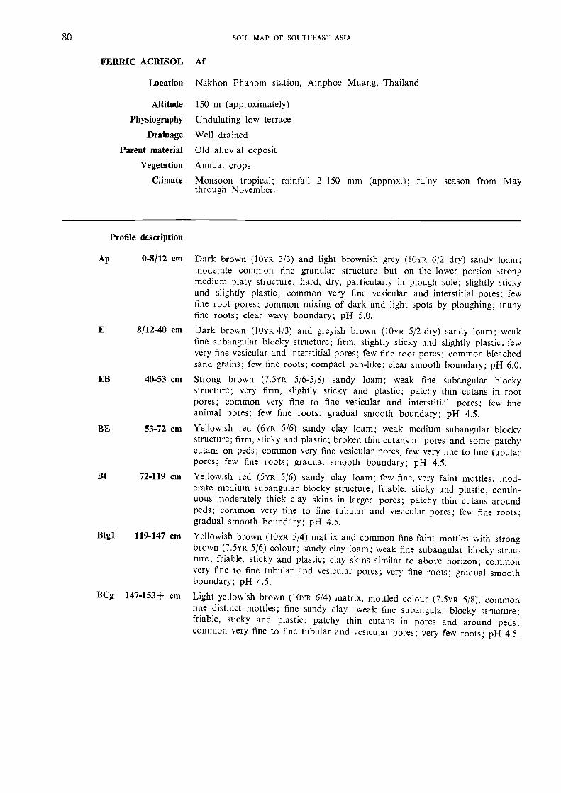
Altitude
Physiography
Drainage
Parent material
Vegetation
Climate
150 m (approximately)
Undulating low terrace
Well drained
Old alluvial deposit
Annual crops
Monsoon tropical; rainfall 2 150 mm (approx.); rainy season from Maythrough November.
Profile description
Dark brown (10YR 3/3) and light brownish grey (10YR 6/2 dry) sandy loam;moderate common fine granular structure but on the lower portion strongmedium platy structure; hard, dry, particularly in plough sole; slightly stickyand slightly plastic; common very fine vesicular and interstitial pores; fewfine root pores; common mixing of dark and light spots by ploughing; manyfine roots; clear wavy boundary; pH 5.0.
Dark brown (I0YR 413) and greyish brown (I0YR 5/2 dry) sandy loam; weakfine subangular blocky structure; firm, slightly sticky and slightly plastic; fewvery fine vesicular and interstitial pores; few fine root pores; common bleachedsand grains; few fine roots; compact pan-like; clear smooth boundary; pH 6.0.
Strong brown (7.5YR 5/6-5/8) sandy loam; weak fine subangular blockystructure; very firm, slightly sticky and plastic; patchy thin cutans in rootpores; common very fine to fine vesicular and interstitial pores; few fineanimal pores; few fine roots; gradual smooth boundary; pH 4.5.Yellowish red (6YR 5/6) sandy clay loam; weak medium subangular blockystructure; firm, sticky and plastic; broken thin cutans in pores and some patchycutans on peds; common very fine vesicular pores, few very fine to fine tubularpores; few fine roots; gradual smooth boundary; pH 4.5.
Yellowish red (5YR 5/6) sandy clay loam; few fine, very faint mottles; mod-erate medium subangular blocky structure; friable, sticky and plastic; contin-uous moderately thick clay skins in larger pores; patchy thin cutans aroundpeds; common very fine to fine tubular and vesicular pores; few fine roots;gradual smooth boundary; pH 4.5.
Yellowish brown (10YR 5/4) matrix and common fine faint mottles with strongbrown (7.5yR 5/6) colour; sandy clay loam; weak fine subangular blocky struc-ture; friable, sticky and plastic; clay skins similar to above horizon; commonvery fine to fine tubular and vesicular pores; very fine roots; gradual smoothboundary; pH 4.5.
Light yellowish brown (10YR 6/4) matrix, mottled colour (7.5YR 5/8), commonfine distinct mottles; fine sandy clay; weak fine subangular blocky structure;friable, sticky and plastic; patchy thin cutans in pores and around peds;common very fine to fine tubular and vesicular pores; very few roots; pH 4.5.
Ap 0-8/12 cm
8/12-40 cm
LB 40-53 cm
BE 53-72 cm
Bt 72-119 cm
Btgl 119-147 cm
BCg 147-153+ cm
80 SOIL MAP OF SOUIHEAST ASIA
FERRIC ACRISOL Af
Location Nakhon Phanom station, Amphoe Muang, Thailand

HorizonDepth
cm
pH Cation exchange meCaCO,
H,01 : 1
KCI1 : 1
CEC TEB % BS Ca Mg K Na Al H
Ap 0-8/12 5.4 4.6 5.7 1.6 28 1.0 0.3 0.1 0.2 4.1E 8/12-40 6.4 5.1 6.4 2.3 36 1 . 7 0.3 0.1 0.2 4.1EB 40-53 5.7 5.0 4.8 1.6 33 1 . 0 0.4 0.04 0.2 3.2BE 53-72 5.2 4.5 5.8 1 . 0 17 0.5 0.2 0.1 0.2 4.8Bt 72-119 5.2 4.7 5.2 0.5 10 0.2 0.1 0.04 0.2 4.7Btg 119-147 5.0 4.7 6.0 0.6 8 0.2 0.1 0.1 0.2 5.4BCg 147-153+
Horizon
Sol. salts Organic matter Particle size analysis %Flocc.
index% C % N C/N % OM Stones C. sand F. sand Silt Clay Texture
Ap 1.07 0.08 13 59.1 28.0 12.9 sl
E 0.63 0.06 10 10.3 45.7 28.0 16.0 sl
EB 0.36 0.05 7 55.0 27.3 17.6 si
BE 0.29 0.04 7 10.6 41.8 25.7 21.9 scl
Bt 0.26 0.03 9 52.7 26.9 20.4 scl
Btg 0.22 0.03 7 10.1 4.0.3 27.4 22.2 scl
BCg
APPENDIX 81
FERRIC ACRISOL
Thailand
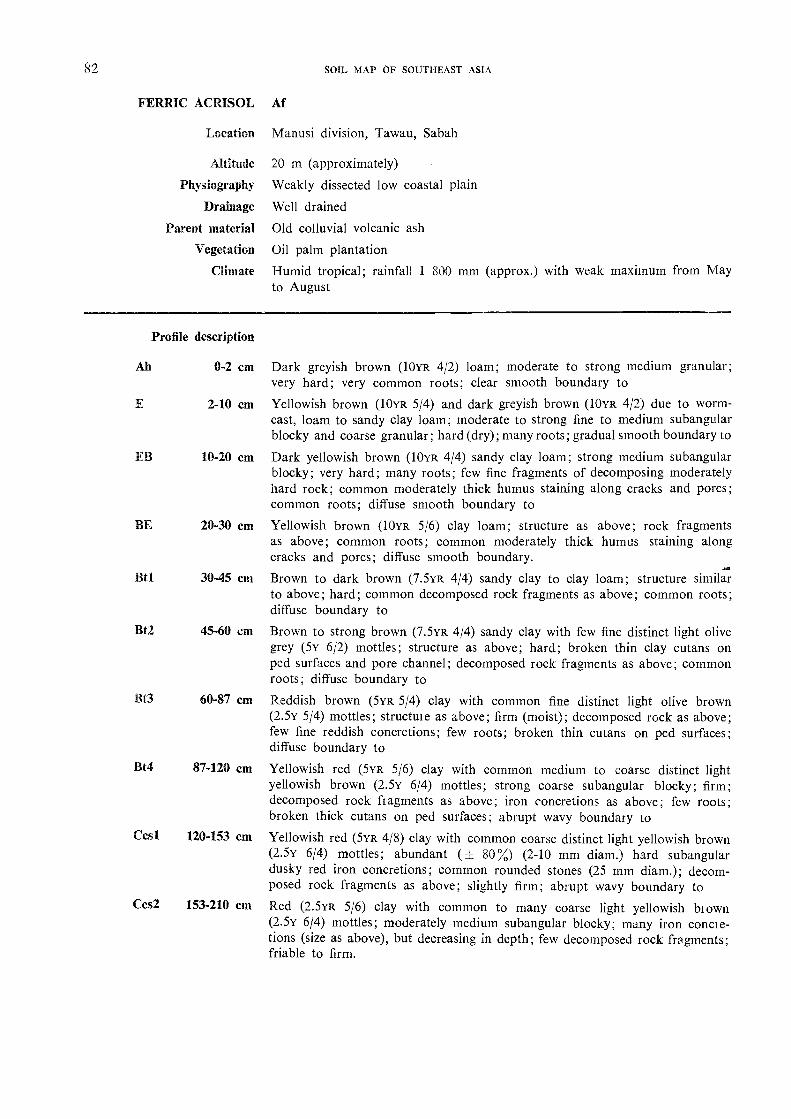
82 SOIL MAP OF SOUTHEAST ASIA
FERRIC ACRISOL M
Ah
Location
Altitude
Physiography
Drainage
Parent material
Vegetation
Climate
Profile description
0-2 cm Dark greyish brown (10YR 4/2) loam; moderate to strong medium granular;very hard; very common roots; clear smooth boundary toYellowish brown (10YR 5/4) and dark greyish brown (10YR 4/2) due to worm-cast, loam to sandy clay loam; moderate to strong fine to medium subangularblocky and coarse granular; hard (dry); many roots; gradual smooth boundary to
EB 10-20 cm Dark yellowish brown (10yR 4/4) sandy clay loam; strong medium subangularblocky; very hard; many roots; few fine fragments of decomposing moderatelyhard rock; common moderately thick humus staining along cracks and pores;common roots; diffuse smooth boundary to
BE Yellowish brown (10yR 5/6) clay loam; structure as above; rock fragments20-30 cmas above; common roots; common moderately thick humus staining alongcracks and pores; diffuse smooth boundary.
Bt1 Brown to dark brown (7.5YR 4/4) sandy clay to clay loam; structure similar30-45 cmto above; hard; common decomposed rock fragments as above; common roots;diffuse boundary to
Bt2 Brown to strong brown (7.5YR 4/4) sandy clay with few fine distinct light olive45-60 cmgrey (5Y 6/2) mottles; structure as above; hard; broken thin clay cutans onped surfaces and pore channel; decomposed rock fragments as above; commonroots; diffuse boundary to
60-87 cm Reddish brown (5YR 5/4) clay with common fine distinct light olive brown(2.5y 5/4) mottles; structuie as above; firm (moist); decomposed rock as above;few fine reddish concretions; few roots; broken thin cutans on ped surfaces;diffuse boundary to
Yellowish red (5YR 5/6) clay with common medium to coarse distinct lightyellowish brown (25Y 6/4) mottles; strong coarse subangular blocky; firm;decomposed rock fragments as above; iron concretions as above; few roots;broken thick cutans on ped surfaces; abrupt wavy boundary to
Ces! 120-153 cm Yellowish red (5YR 4/8) clay with common coarse distinct light yellowish brown(2.5y 6/4) mottles; abundant (+ 80%) (2-10 mm diam.) hard subangulardusky red iron concretions; common rounded stones (25 mm diam.); decom-posed rock fragments as above; slightly firm; abrupt wavy boundary to
Ccs2 153-210 cm Red (2.5YR 5/6) clay with common to many coarse light yellowish brown(2.5Y 6/4) mottles; moderately medium subangular blocky; many iron concre-tions (size as above), but decreasing in depth; few decomposed rock fragments;friable to firm.
Manusi division, Tawau, Sabah
20 m (approximately)
Weakly dissected low coastal plain
Well drained
Old colluvial volcanic ash
Oil palm plantation
Humid tropical; rainfall 1 SOO mm (approx.) with weak maximum from Mayto August
E 2-10 cm
Bt4 87-120 cm
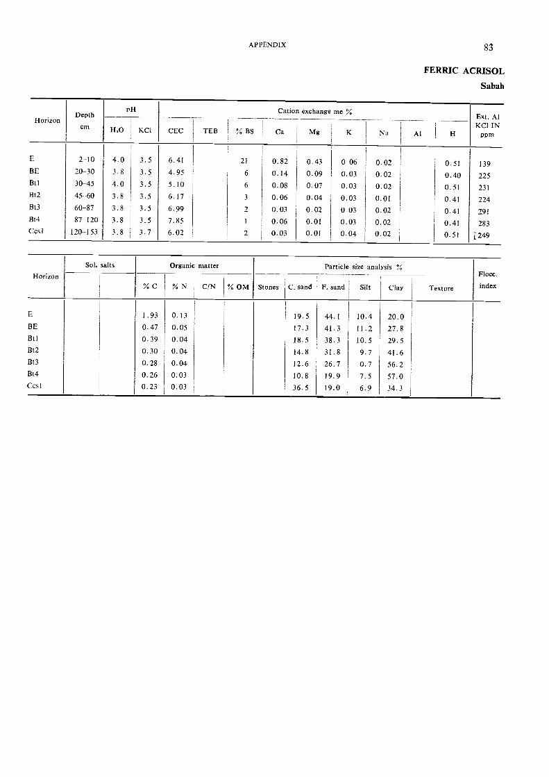
APPENDIX
FERRIC ACRISOL
Sabah
HorizonDepth
cm
PH Cation exchange me %Ext. AlKCI IN
DomH,0 , KCI CEC TEB % BS Ca Mg K Na Al H
E 2-10 4.0 3.5 6.41 21 0.82 0.43 0 06 0.02 0.51 139BE 20-30 3.8 3.5 4.95 6 0.14 0.09 0.03 0.02 0.40 225Btl 30-45 4.0 3.5 5.10 6 0.08 0.07 0.03 0.02 0.51 231Bt2 45-60 3.8 3.5 6.17 3 0.06 0.04 0.03 0.01 0.41 224Bt3 60-87 3.8 3.5 6.99 2 0.03 0.02 0.03 0.02 0.41 291Bt4 87-120 3.8 3.5 7.85 1 0.06 0.01 0.03 0.02 0.41 283Ccsl 120-153 3.8 3.7 6.02 2 0.03 0.01 0.04 0.02 0.51 i' 249
Horizon
Sol. salts Organic matter Particle size analysis %Flocc.
index% C % N C/N % OM Stones C. sand F. sand Silt ClaY Texture
E 1.93 0.13 19.5 44.1 10.4 20.0BE 0.47 0.05 17.3 41.3 11.2 27.8Bt I 0.39 0.04 18.5 38.3 10.5 29.5Bt2 0.30 0.04 14.8 31.8 9.7 41.6Bt3 0.28 0.04 12.6 26.7 0.7 56.2Bt4 0.26 0.03 10.8 19.9 7.5 57.0Ccsl 0.23 0.03 36.5 19.0 6.9 34.3

Location
Altitude
Physiography
Drainage
Parent material
Vegetation
Climate
Amphoe Paktho, Ratchaburi province, Thailand
7 to 10 mFlat low terrace
Poorly drained; flooded four months a year
Old alluvial deposit
Transplanted rice
Monsoon tropical; rainfall 1 200 mm (approx.) from May through October
Profile description
Ap 0-17 cm Light yellowish brown (10YR 6/4 moist) and very pale brown (10YR 8/3 dry)loam with many fine to coarse distinct yellowish brown mottles; weak coarsesubangular blocky; hard dry, firm moist, sticky and plastic wet; common fineand medium vesicular, common very fine interstitial and few fine and very finetubular pores; very few fine subrounded hard iron and manganese concretions;many fine and common very fine roots; clear smooth boundary; pH 5.5.
Light grey (10YR 7/2 moist and 10YR 8/2 dry) loam with many medium distinctstrong brown mottles; weak coarse subangular blocky, breaking to moderatemedium blocky; hard dry, firm moist, sticky and plastic wet; thin broken siltcoatings on ped faces; common fine soft subrounded iron concretions andcommon fine and medium soft manganese concretions; fine interstitial, fewfine tubular and vesicular pores; many fine, common very fine and few mediumroots; gradual smooth boundary; pH 5.0.
Pale brown (10YR 6/3) silty clay with many fine distinct yellowish brownmottles; moderate coarse subangular blocky; hard dry, firm moist, sticky andplastic wet; thin continuous clay coatings in pores, thick broken silt coatingson ped faces; few fine subrounded hard iron and manganese concretions; manyvery fine and fine interstitial, common fine vesicular pores; few fine, very fineand medium roots; clear smooth boundary; pH 5.0.
Yellowish brown (10YR 5/4) silty clay with common very fine strong brownand common medium red mottles; moderate medium and coarse subangularblocky, breaking to moderate fine blocky; firm moist, sticky and plastic wet;thick broken clay coatings on ped faces and thick continuous coatings in pores;few fine subrounded hard iron and manganese concretions; many very fineand fine interstitial, few fine and very fine tubular pores; few very fine roots;clear smooth boundary; pH 4.5.
Btg3 67-90+ cm Light brownish grey (IOYR 6/2) clay with many medium distinct yellowish redand few very fine red mottles; moderate coarse subangular blocky, breakingto strong medium blocky; firm moist, sticky and plastic wet: thick broken claycoatings on ped faces, thick continuous coatings in pores; very few fine sub-rounded hard iron and manganese concretions; many very fine and fine in-terstitial, few fine and very fine tubular pores; no roots; pH 4.5.
AEg 17-26 cm
Btgl 26-51 cm
Btg2 51-67 cm
84 SOIL MAP OF SOUTHEAST ASIA
GLEYIC ACRISOL Ag
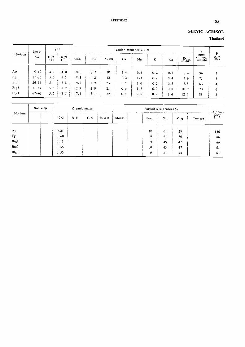
HorizonDepth
cm
pH Cation exchange me %K
Pornammon.acetate
PPomBray
FLOI : I
KCII : I
CEC TEB % BS,
Ca Mg K
,
Na Extr .1 acidityi
1
Ap 0-17 4.7 4.0 8.3 2.7 30 1 . 4 0.8 0.2 0.3 6.4 96 7Eg 17-26 56 4.3 88 4.2 1 42 2.2 1.4 0.2 0.4 5.9 73 5Btgl 26-51 5 6 3 8 9.3 2.9 25 1.2 1.0 0.2 0.5 8.8 64 4
Btg2 51-67 5 6 3 7 12.9 2.9 21 0.6 1. 3 0.2 0 8 10.9 70 6Btg3 67-90 5.5 3.5 17.1 5,1 79 0.9 2.6 0.2 I . 4 12.6 88 5
Horizon
Sol. salts Organic matter Particle size analysis %
Texture
Conduc.tivity1: 5% C % N 1 C/N % OM
i
1
Stones Sand 1 Sdt Clay
Ap 0.81 10 61 29 130Eg 0.60 9 61 30 86Btgl 0.11 9 49 42 66Btg2 0.58 10 43 47 63
Btg3 0.35 9 37 54 63
APPENDIX 85
GLEYIC ACRISOL
Thailand

86 SOIL MAP OF SOUTHEAST ASIA
HUMIC ACRISOL Ah
Location
Altitude
Physiography
Drainage
Parent material
Vegetation
Climate
Profile description
Ap 0-15 cm
A 15-22 cm
Bt2 55-100 cm
Khao Yai National Park, Korat province, Thailand
800 m (approximately)
Rolling high plateau
Well drained
Residual deposit from weathering of granites
Fallow with Imperata cylindrica after shifting cultivationMonsoon tropical; high rainfall, estimated at 3 000 mm from May throughOctober
Very dark greyish brown (10YR 3/2 moist) clay loam; fine and medium crumbstructure; very friable; common very fine tubular and many very fine interstitialpores; many roots; clear smooth boundary; pH 5.5.
Dark brown (8YR 3/3 moist) clay loam; moderate fine subangular blockystructure, fine to medium crumb structure in spots; very friable; common veryfine tubular, many very fine interstitial pores; many roots; clear smoothboundary; pH 5.5.Reddish brown (5YR 4/4 moist) light clay; moderate fine to medium subangularblocky; friable; broken, moderately thick clay cutans; common, very fine tu-bular, many very fine interstitial pores; common roots; gradual smoothboundary; pH 5.0.Yellowish red (4vR 4/6 moist) clay; moderate to strong fine and mediumsubangular blocky structure; friable; broken, moderately thick clay cutans;many very fine tubular, many very fine interstitial pores; common roots; gradualsmooth boundary; p'H 5.0.
Red (2.5YR 4/6 moist) clay; moderate to strong fine and medium subangularblocky; friable; broken, moderately thick clay cutans; many very fine tubular,common very fine interstitial pores; common roots; gradual smooth boundary;pH 5.0.
Red (2.5yR 4/6 moist) and yellowish red (4YR 4/6 moist) clay; moderate tostrong, fine and medium subangular blocky; friable; broken, moderately thickclay cutans; common very fine tubular, common very fine interstitial pores;few fine lateritic concretions; pieces of brownish yellow (10YR 6/8) weatheringgranite; few roots; pH 5.0.
BA 22-36 cm
Btl 36-55 cm
BC 100+ CITI

HorizonDepth
cm
PH Cation exchange meCaCO,
H,0 KCI1: 1 I : 1 CEC TEB % BS Ca Mg K Na Al H
Ap 0-15 4.3 3.9 28.68 2.33 8.1 1.55 0.30 0.48 -A 15-22 4.9 4.1 22.34 0.84 3.8 0.51 0.07 0.26 -BA 22-36 5.1 3.9 15.13 1.79 11.8 1.53 0.10 0.16 -Btl 1 36-55
Bt2 55-1005.0 3.9 13.34 2.33 17.5 2.04 0.13 0.16 -
BC 1004- 5.1 3.9 12.45 1.28 10.3 1.02 0.10 0.16 -
Horizon
Sol. salts Organic matter Particle size analysis %Flocc.
index% C % N C/N ; % OM Stones C. sand F. sand Silt ClaY Texture
Ap 4.6 0.30 15.4 9.0 20.9 23.5 46.6A 3.3 0.24 13.9 7.0 20.7 33.8 48.5BA 1.3 010 12.8 6.3 19.2 22 8 51.7Btl-Bt2
0.6 0.6 10.5 9.2 10.9 26.2 53.7
BC 0.3 0.03 9.3 7.4 16.2 32.2 44.2
APPENDIX 87
HUMIC ACRISOL
Thailand
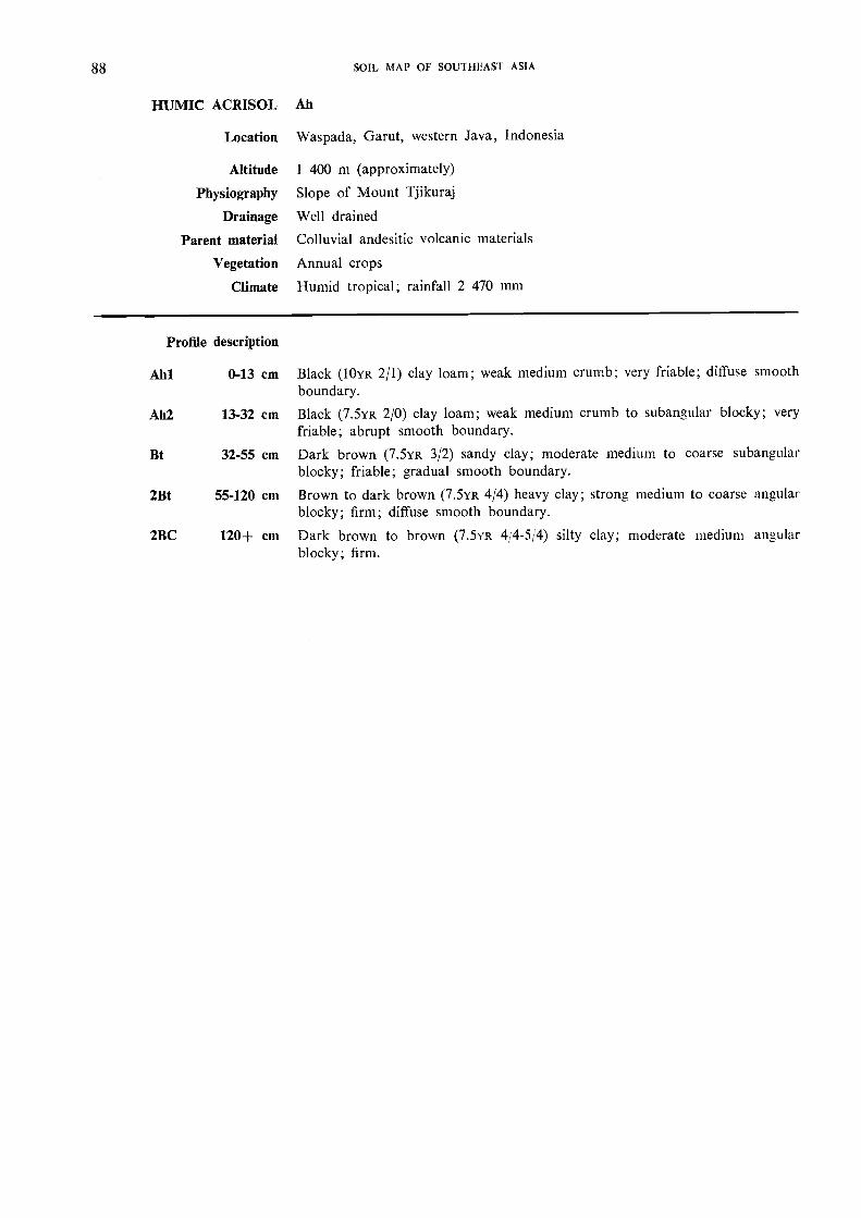
88 SOIL MAP OF SOU1HEAST ASIA
HUMIC ACRISOL Ah
Location Waspada, Garut, western Java, Indonesia
Altitude 1 400 m (approximately)
Physiography Slope of Mount Tjikuraj
Drainage Well drained
Parent material Colluvial andesitic volcanic materials
Vegetation Annual crops
Climate Humid tropical; rainfall 2 470 mm
Profile description
Ahl 0-13 cm Black (10YR 2/1) clay loam; weak medium crumb; very friable; diffuse smoothboundary.
Ah2 13-32 cm Black (7.5YR 2/0) clay loam; weak medium crumb to subanQular blocky; veryfriable; abrupt smooth boundary.
Bt 32-55 cm Dark brown (7.5yR 3/2) sandy clay; moderate medium to coarse subangularblocky; friable; gradual smooth boundary.
2Bt 55-120 cm Brown to dark brown (7.5YR 4/4) heavy clay; strong medium to coarse angularblocky; firm; diffuse smooth boundary.
2BC 120+ cm Dark brown to brown (7.5YR 4/4-5/4) silty clay; moderate medium angularblocky; firm.
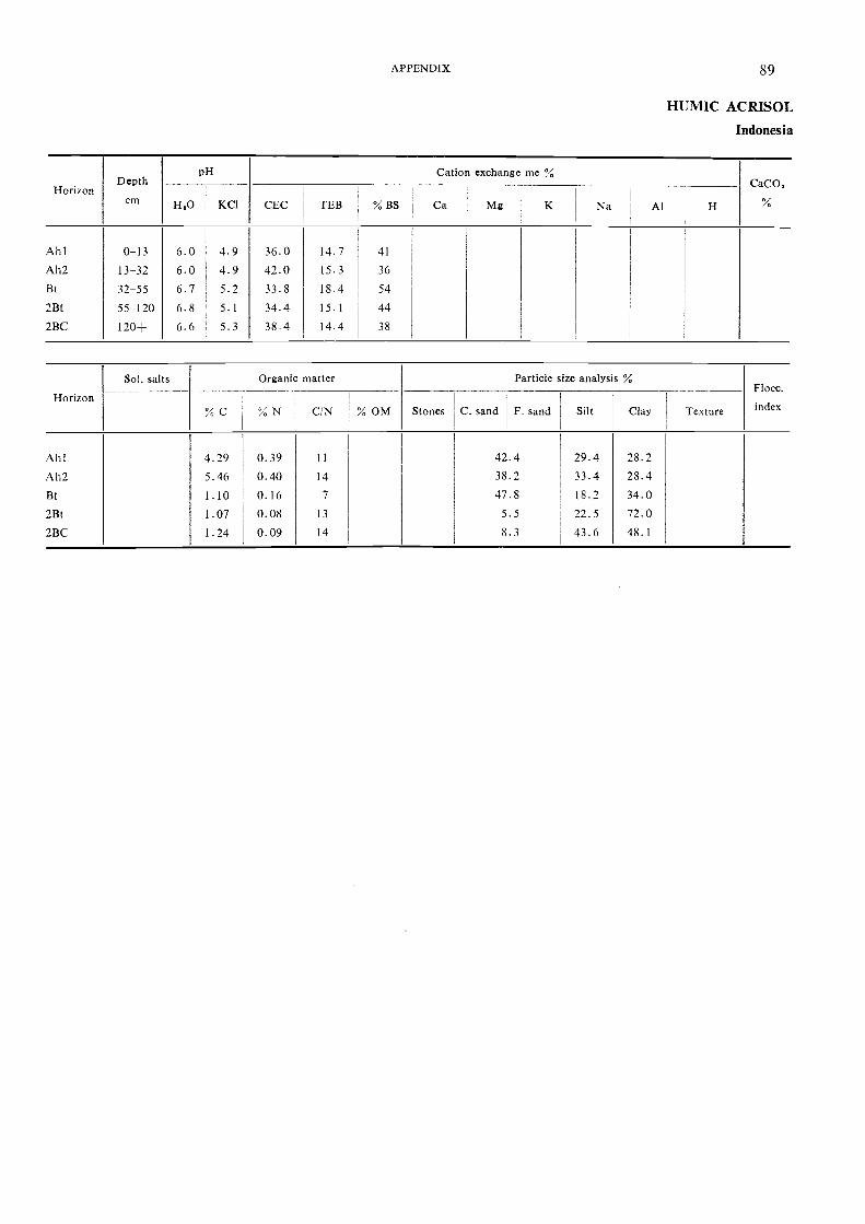
HorizonDepth
cm
pH Cation exchange meCaCO,
H,0 KC1 CEC TEB % BS Ca Mg K Na Al H
A h 1 0-13 6.0 4.9 36.0 14.7 41
Ah2 13-32 6.0 4.9 42.0 15.3 36
Bt 32-55 6.7 5.2 33.8 18.4 54
2Bt 55-120 6.8 5.1 34.4 15.1 44
2BC 120- 6.6 5.3 38.4 14.4 38
Horizon
Sol. salts Organic matter Particle size analysis %Flocc.
% C "/' . N C/N % OM Stones C. sand F. sand Silt Clay Texture index
Ah I 4.29 0.39 11 42.4 29.4 28.2Ah2 5.46 0.40 14 38.2 33.4 28.4Bt 1.10 0.16 7 47.8 18.2 34.02Bt 1.07 0.08 13 5.5 22.5 72.02BC 1.24 0.09 14 8.3 43.6 48.1
APPENDIX 89
HUMIC AC RISOL
Indonesia

90 SOIL MAP OF SOUTHEASF ASIA
ORTHIC ACRISOL Ao
Location Bau district, Sarawak
Altitude 70 m (approximately)
Physiography Strongly dissected hilly; slope 15 percent
Drainage Well drained
Parent material Weathering material from shales
Vegetation Secondary forest
Climate Humid tropical; annual rainfall 3 250 mm (approx.)
Profile description
A 0-5 cm Brown (10YR 5/3) loam; many medium to fine slightly decomposed roots; manyworm holes; moist; friable; clear smooth boundary.
E 5-30 cm Brownish yellow (10YR 6/6) clay loam with few coarse to fine roots; infiltrationof organic matter from above; no mottles; slightly friable; weak angular blockystructure; gradual wavy boundary.
BE 30-55 cm Reddish yellow (7.5YR 7/8) clay with few roots; very weak clayskins developedalong cracks; massive in profile; slightly firm; angular blocky structme; diffusewavy boundary.
Bt 55-87 cm Yellow (lOyR 7/8) clay with common distinct reddish yellow (5YR 7,8) mottles;few fine dead roots; massive in profile; slightly firm; strong angular blockystructure; weak clayskins along cracks; diffuse wavy boundary.
BC 87-135 cm Yellow (10YR 7/8) 50 percent and reddish yellow (7.5YR 7/8) 50 percent clay:common pale yellow (2.5y 8/4) and yellowish red (5YR 5,6) mottles; firm; strongblocky structure; less clayskin development than Bt; clear wavy boundary.
135+ cm Yellow (lOyR 7/8) gritty clay with accumulation of red (2.5yR 4/6) weatheredshale; few white quartz pebbles; prominent strong brown (7.5yR 5/8) iron-coated shale; firm.

HorizonDepth
cm EEO KCI
pH Cation exchange me %
CEC TEB % BS Ca Mg K Na Al
CaCO.:o/
Horizon
Sol. salts Organic matter
% C % N C/N % OM Stones
Particle size analysis
Silt ClaY Texture
Flocc.
indexC. sand F. sand '
1
1
A 3 93 0 31 12 52 2 14 '24 59 I 24 91 40.49E 1.07 0 11 10 00 1.30 I27 96 , 23 13 47.29BE 0 47 0 06 7.34 0 86 26-44 ! 19.49 53.05Bt 0 30 0 06 5.26 0 85 22.25 18.02 58.07BC 0.34 0.04 8 10 0 79 17.51 i 18.62 60 68
I
C 0 29 0 05 5 27 20 33 15.58 1 16.38 47 38
A 0-5 46 27.27 13.57 1.50 1 76 0 36 0 08 12 58 0 23E 5-30 47 21 60 2 78 0.01 0 44 0 11 0 05 13 52 0 08BE 30 55 5.0 20.86 1 92 0 01 0.24 0.09 0.07 12.67 0.05Bt 55---87 49 41.34 0.90 0.01 0.20 0.09 0.08 12.06 0 02BC 87--135 5.0 //..79 2.47 0 15 0.22 0 10 0 08 10.36 0 02
135 - 5.0 18.33 7.91 1.15 0-16 0 09 0 05 9.42 0.03
APPENDIX 91
ORTHIC ACRISOL
Sarawak

92 SOIL MAP OF SOU 111EAST ASIA
ORTHIC ACRISOL Ao
Location Along the track from Fang Min to Huai Lot villages, Nan province, Thailand
Altitude 400 m (approximately)
Physiography Colluvial footslope in hilly landscape
Drainage Well drained
Parent material Mixed colluvial deposit from quartzites and shales; gravel content increaseswith depth
Vegetation Mixed deciduous forest with Dipterocarptis species
Climate Monsoon tropical; rainfall I 400 mm (approx.); rainy season from May throughmid-October
Profile description
A 0-10 cm Very dark greyish brown (I0YR 3/2 moist) and grey (10yR 6/1 dry) loam witha discernible gravel fraction of angular fine quartz fraaments; moderate mediumand fine subangular blocky and some granular structure; slightly sticky andslightly plastic; firm; slightly hard; many fine and veiy fine interstitial pores;few small animal holes; common very fine and medium roots; clear smoothboundary; pH 6.0.
AB 10-22 cm Dark brown to brown (7.5YR 4/4 moist) and light yellowish brown (I0YR 6/4dry) clay loam; moderate coarse breaking to medium and fine subangularblocky; slightly sticky and plastic; firm; hard; many fine and very fine instersti-tial pores; few scattered angular and subangular medium quartz fragments;few large and medium animal holes; many fine and few medium roots; gradualsmooth boundary; pH 5.0.
BA 22-36 cm Brown (7.5YR 4-5/4 moist) and light blown (7.5yR 6/4 dry) clay loam withhigher clay content; moderate coarse breaking to medium and some finesubangular blocky; slightly sticky and plastic; firm; hard; patchy thin claycoatings in pores and on some ped faces; many fine and few medium intersti-tial pores; few fine tubular pores; few medium and large subangular quartzfragments; common fine and medium and few large roots; gradual smoothboundary; pH 5.0.
Bt 36-75 cm Yellowish red (5YR 4/6 moist and 5YR 5/6 dry) clay; moderate coarse breakingto medium and fine subangular blocky; sticky and plastic; slightly firm; hard;broken moderately thick clay coatings on ped faces and in pores; commonfine and medium interstitial pores; few fine tubular pores; few fine and mediumsubangular quartz and shale fragments; few medium animal holes; few fineand large and common medium roots; gradual smooth boundary; pH 5.0.
BC 75-160+ cm Yellowish red (5YR 4/6 moist and 5YR 5/6 dry) very gravelly clay with a.bout50 percent gravel by volume increasing to 70 percent vith depth; massive; stickyand plastic between gravel; slightly firm; slightly hard; broken moderatelythick clay coatings on gravel faces; gravel consists of quartz, phyllite and shalefragments; common fine and few large roots; pH 5.0.

HorizonDepth
cm
pH Cation exchange me %P
rumBraY
Kppm
ammon.acetate
H,01 : 1
KCI1 : I CEC TEB % BS Ca Mg K Na Extr.
acidity
A 0-10 7.1 5.4 18.4 10.3 58 7.1 2.8 0.3 0.1 7.6 7.0 137
AB 10-22 6.2 4.4 12.3 3.9 31 / i 1.5 0.2 0.1 8.8 5.2 79
BA 22-36 5.9 4.1 11.6 1.8 16 0.6 0 9 0.2 0.1 9.4 4.4 88
Bt 36-75 5.5 3.8 11.4 1.5 14 0.5 0.7 0.2 0.1 9.6 i 3 85
BC 75-160-- 5.5 3.6 10.9 2.5 21 1.1 1.1 0.2 0.1 9.6 2.2 82
Horizon
Sol. salts Organic matter Particle size analysis °Al Conduc-tivity1 : 5
EC 10'
Flocc.
index1
% C I % N I C/N % OM,
Stones C. sand 1 F. sand Silt1
Clay
A 2.29 35.0 50.5 14.5 0.02AB 1.13 34.5 44.5 21.0 0.02BA 0.72 31.0 39.5 29.5 0.01
Bt 0.47 27.0 32.0 41.0 0.01
BC 0.62 31.0 29.0 40.0 0.01
APPENDIX 93
0 RTHIC ACRISOL
Thailand
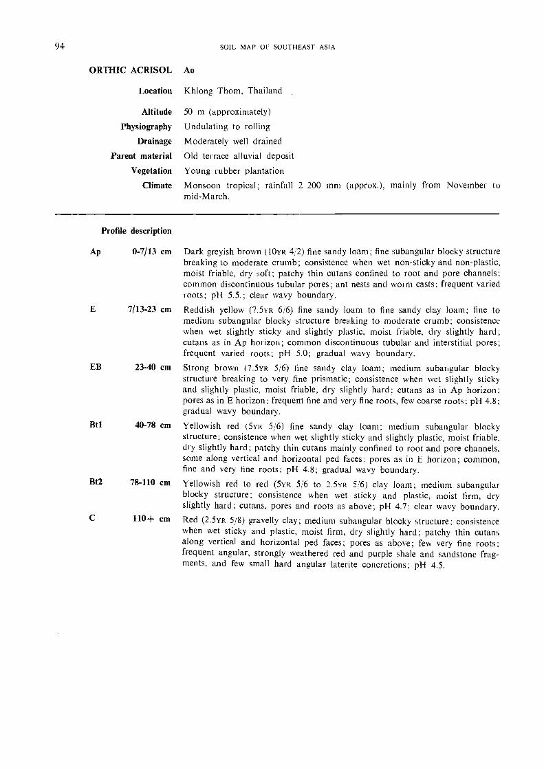
94 SOIL MAI) or SOUTHEAST ASIA
ORTHIC ACRISOL Ao
Location
Altitude
Physiography
Drainage
Parent material
Vegetation
Climate
Khlong Thom, Thailand
50 m (approximately)
Undulating to rolling
Moderately well drained
Old terrace alluvial deposit
Young rubber plantation
Monsoon tropical; rainfall 2 200 mm (approx.), mainly from November tomid-March.
Dark greyish brown (lOYR 4/2) fine sandy loam; fine subangular blocky structurebreaking to moderate crumb; consistence when wet non-sticky a,nd non-plastic,moist friable, dry soft; patchy thin cutans confined to root and pore channels;common discontinuous tubular pores; ant nests and woim casts; frequent variedroots; pH 5.5.; clear wavy boundary.
Reddish yellow (7.5YR 6/6) fine sandy loam to fine sandy clay loam; fine tomedium subangular blocky structure brea.king to moderate crumb; consistencewhen wet slightly sticky and slightly plastic, moist friable, dry slightly hard;cutans as in Ap horizon; common discontinuous tubular and interstitial pores;frequent varied roots; pH 5.0; gradual wavy boundary.Strong brown (7.5YR 5/6) fine sandy clay loam; medium subatigular blockystructure breaking to very fine prismatic; consistence when wet slightly stickyand slightly plastic, moist friable, dry slightly hard; cutans as in Ap horizon;pores as in E horizon; frequent fine and very fine roots, few coarse roots; pH 4.8;gradual wavy boundary.
Yellowish red (5YR 5/6) fine sandy clay loam; medium subangular blockystructure; consistence when wet slightly sticky and slightly plastic, moist friable,dry slightly hard; patchy thin cutans mainly confined to root and pore channels,some along vertical and horizontal ped faces; pores as in E horizon; common,fine and very fine roots; pH 4.8; gradual wavy boundary.
Yellowish red to red (5YR 5/6 to 2.5YR 5/6) clay loam; medium subangularblocky structure; consistence when wet sticky and plastic, moist firm, dryslightly hard; cutans, pores and roots as above; pH 4.7: clear wavy boundary.
Red (2.5YR 5/8) gravelly clay; medium subangular blocky structure; consistencewhen wet sticky and plastic, moist firm, dry slightly hard; patchy thin cutansalong vertical and horizontal ped faces; pores as above; few very fine roots;frequent angular, strongly weathered red and purple shale and sa.ndstone frag-ments, and few small hard angular latente concretions; pH 4.5.
Profile description
Ap 0-7/13 cm
E 7/13-23 cm
EB 23-40 cm
Btl 40-78 cm
Bt2 78-110 cm
110+ cm

HorizonDepth
cm
pH Cation exchange me%CaCO.
H.0 ; KCI CEC ' TEB % BS,
1
Ca Mg K Na Al i H
Ap 0-7/13E 7/13-23EB 23-40Bt I 40-78Bt2 78-100
C 110+
Horizon
Sol. salts Organic matter Particle size analysis %
C. sand F. sand Silt ClaY Texture
Flocc.
index% C % N C/N 1 % OM Stones
Ap 4.0 57.0 18.0 17.0E 3.6 54.4 19.0 20.0EB 3.4 52.8 17.0 23.0Bt I 2.7 49.7 15.0 28.0BO 2.3 44.1 17.0 38.0C 3.0 39.6 16.0 39.0
APPENDIX 95
ORTHIC ACRISOL
Thailand
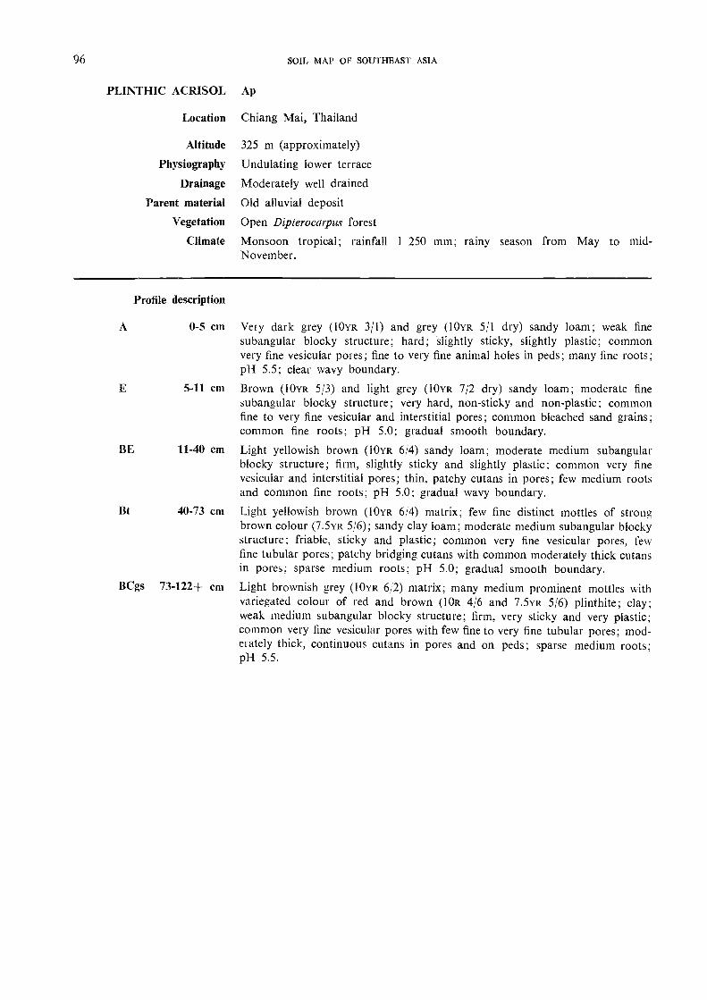
96 SOIL MAP OF SOUTHEAST ASIA
PLINTHIC ACRISOL Ap
Location
Altitude
Physiography
Drainage
Parent material
Vegetation
Climate
Chiang Mai, Thailand
325 m (approximately)
Undulating lower terrace
Moderately well drained
Old alluvial deposit
Open Dipterocarpus forest
Monsoon tropical; rainfall 1 250 mm; rainy season from May to mid-November.
Vely dark grey (10YR 3/1) and grey (10YR 5/1 dry) sandy loam; weak finesubangular blocky structure; hard; slightly sticky, slightly plastic; commonvery fine vesicular poles; fine to very fine animal holes in peds; many fine roots;pH 5.5; clear wavy boundary.
Brown (10YR 5/3) and light grey (10YR 7/2 dry) sandy loam; moderate finesubangular blocky structure; very hard, non-sticky and non-plastic; cominonfine to very fine vesicular and interstitial pores; common bleached sand pains;common fine roots; pH 5.0; gradual smooth boundary.Light yellowish brown (10YR 6/4) sandy loam; moderate medium subangularblocky structure; firm, slightly sticky and slightly plastic; common very finevesicular and interstitial pores; thin, patchy cutans in pores; few medium rootsand common fine roots; pH 5.0; gradual wavy boundary.
Light yellowish brown (10YR 6/4) matrix; few fine distinct mottles of stron2brown colour (7.5YR 5/6); sandy clay loam; moderate medium subangular blockystructure; friable, sticky and plastic; common very fine vesicular pores, fewfine tubular pores; patchy bridging cutans with common moderately thick cutansin pores; sparse medium roots; pH 5.0; gradual smooth boundary.
Light brownish grey (10YR 6:2) matrix; many medium prominent mottles withvariegated colour of red and brown (10R 4/6 and 7.5YR 5/6) plinthite; clay;weak medium subangular blocky structure; firm, very sticky and very plastic;common very fine vesicular pores with few fine to very fine tubular pores; mod-eiately thick, continuous cutans in pores and on peds; sparse medium roots;pH 5.5.
Profile description
A 0-5 cm
5-11 cm
BE 11-40 cm
Bt 40-73 cm
BCgs 73-122+ cm
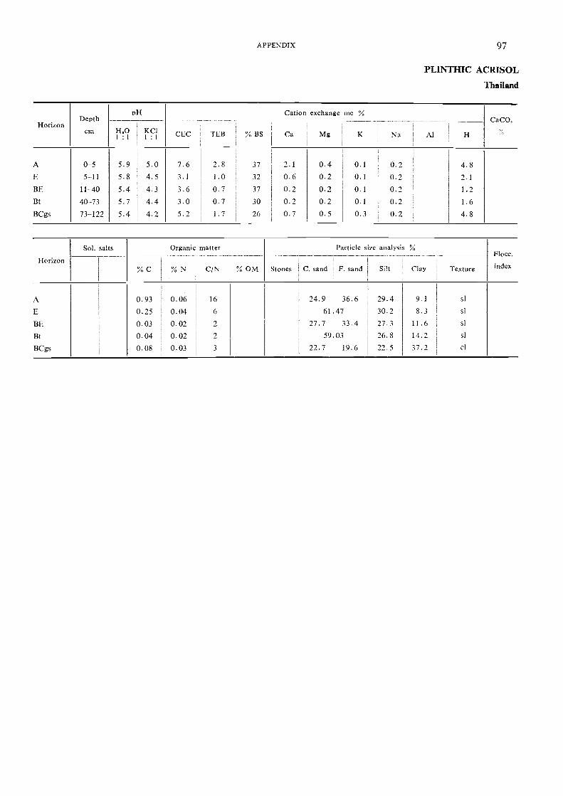
HorizonDepth
cm
pH Cation exchange me %C aCO3
14,0 , KC11 : 1 , 1 : 1
CEC TEB % BS ' Ca Mg K Na Al H
A 0-5 5.9 5.0 7.6 2.8 37 2.1 0.4 0.1 0.2 4.8E 5-11 5.8 4.5 3.1 1.0 32 0.6 0.2 0.1 0.2 2.1
BE 11-40 5.4 4.3 3.6 0.7 37 0.2 0.2 0.1 0.2 1.2Bt 40--73 5.7 4.4 3.0 0.7 30 0.2 0.2 0.1 0.2 1.6BCgs 73-122 5.4 4.2 5.2 1.7 26 0.7 0.5 0.3 0.2 4.8
Horizon
Sol. salts Organic matter
% C % N C/N % OM Stones C. sand
Particle size
F. sand
analysis
Silt
%Flocc.
index
-Clay Texture
A 0.93 0.06 16 24.9 36.6 29.4 9.1 sl
E 0.25 0.04 6 61.47 30.2 8.3 sl
BE 0.03 0.02 / 27.7 33.4 27.3 11.6 sl
Bt 0.04 0.02 / 59.03 26.8 14.2 sl
BCgs 0.08 0.03 3 22.7 19.6 22.5 37.2 cl
APPENDIX 97
PLINTHIC ACRISOL
Thailand

98 SOIL MAP OF SOUTHEAST ASIA
EUTRIC CAMBISOL Be
Location Nam Song village, Sa district, Nan province, Thailand
Altitude 220 m
Physiography Dissected erosion landscape; steep slopes
Drainage Well drained
Parent material Residual deposit and slope colluvium derived from shales and phyllites
Vegetation Shifting cultivation of upland rice and other annual crops
Climate Monsoon tropical; rainfall 1 150 mm (approx.); rainy season from May tomid-October.
Profile description
Ap 0-15 cm Dark brown to brown (10YR 4/3 moist) and pale brown (10yR 6/3 dry) slightlygravelly loam with about 10 percent fine and medium angular weathering shalefragments; weak coarse subangular blocky breaking to moderate fine andmedium granular structure; slightly sticky and slightly plastic; slightly firm;slightly hard; many fine and very fine and common medium interstitial pores;common very fine and few fine roots; abrupt smooth boundary; pH 6.
Bw 15-60 cm Dal k yellowish brown (10YR 3/4 moist) and brown (10YR 5/3 dry) gravelly clayloam with about 30 percent fine and medium angular weathering shale frag-ments; moderate medium breaking to fine subangular blocky; slightly stickyand plastic; friable; slightly hard; patchy thin clay coatings in pores and shin-ing veneers on gravel faces; many very fine and fine and common medium in-terstitial pores; few fine tubular pores; common fine and few medium roots;gradual irregular boundary; pH 6.5.
60+ cm Light olive grey (5Y 6/2), dark brown (7.5YR 4/4) and reddish brown (5YR 4/4)very gravelly clay with about 80 percent olive and olive yellow (5Y 5/6 and5Y 6/6) weathering shale fragments; there is some evidence of clay illuviationbetween the shale fragments; pH 6.5.
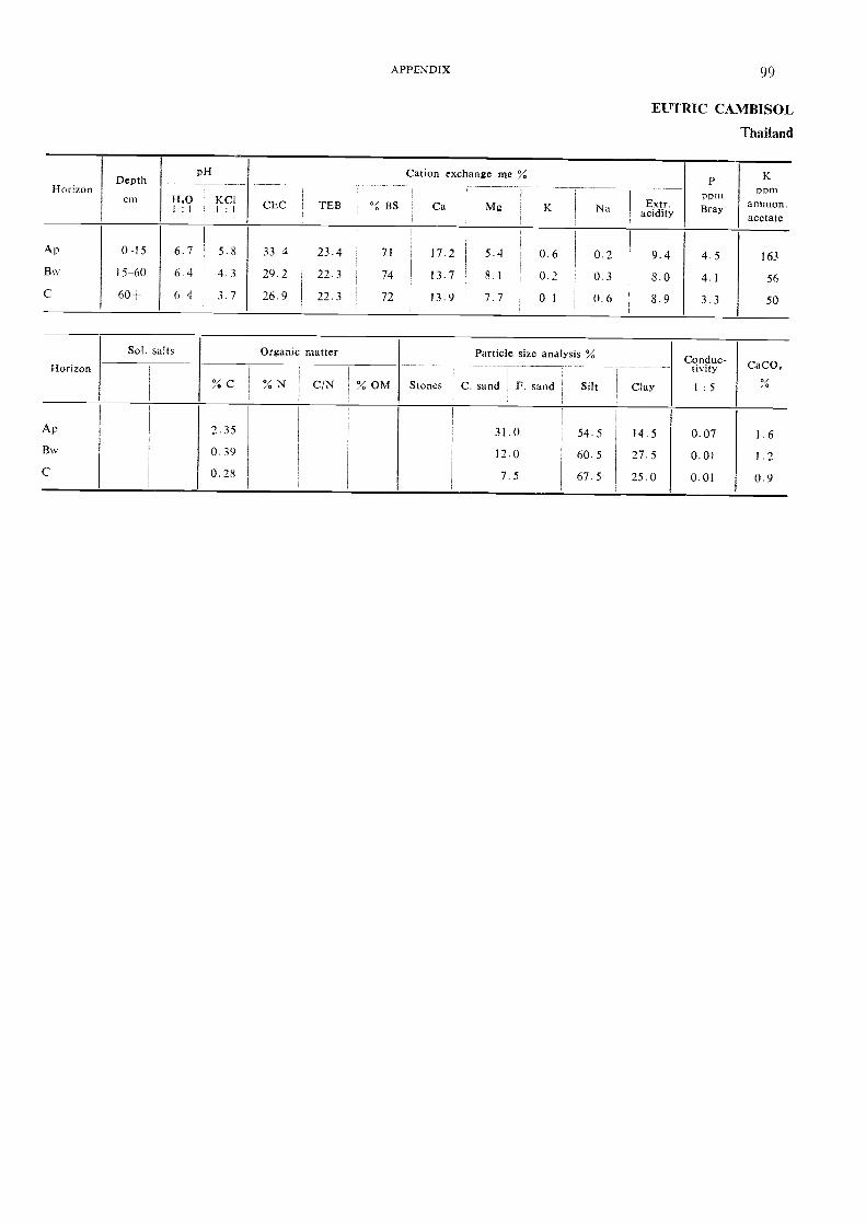
HorizonDepth
cm
pH
H, 0 KCI CEC TEB
Cation exchange me % p
Porn
Kppm
ammon.% BS Ca Mg K Extr.I : 1 1 : 1 Na acidity Bray
acetate
Ap 0-15 6.7 5.8 334 23.4 71 17.2 5.4 0.6 0.2 9.4 45 163Bw 15-60 6 4 4 3 29.2
1
22.3 74 I 13.7 8.1 0. 2 0.3 8.0 4.1 56C 60- 64 3.7 26.9 I 22.3 72
1 13.9 7.7 01 0.6 8.9 3.3 50
Horizon
Sol. salts Organic matter Particle size analysis % Conduc-tivity CaCO,
I
% C % N C/N % OM Stones C. sand I F. sand Silt Clay 1 :51
Ap 2.35 31.0 54.5 14.5 0.07 1.6Bw 0.39 12.0 60.5 27.5 0.01 1.2C 0.28 7.5 67.5 25.0 0.01 0.9
APPENDIX 99
EUTRIC CAMBISOL
Thailand

100 SOIL MAP OF SOUTHEAST ASIA
FERRALIC CAMBISOL Bf
Location Experimental station, Ayer Hitam, Johore, Malaysia
Altitude
Physiography
Drainage
Parent material
Vegetation
Climate
Profile description
Ap 0-15 cm
Bwl 15-45 cm
Bw2 45-63 cm
Bes 63-75 cm
75-138 cm
40 in (approximately)
Undulating coastal plain
Moderately well drained
Argillaceous shale
Secondary jungle
Humid topical; rainfall 2 300 mm (approx.)
Light grey to grey (10YR 6/1) clay; moderately strong medium and few coarsesubangular and angular blocky and few medium crumbs; moist friable; manypores; many roots; clear boundary.
Pale yellow (2.5v 7/4) clay; strong coarse prismatic and few subangular andangular blocky; moist very firm; common pores; fel,v roots; common fine dis-
tinct brownish yellow (10YR 6/8) mottling; few termite channels; diffuse
boundary.
Pale yellow (2.5v 8/4) clay; moderate strong coarse and very coarse prismatic;moist very fine; few pores; no roots; many fine medium prominent dark yellow-ish brown (10YR 4/4) and brownish yellow (10YR 6/8) mottles; clear boundary.
Light grey (10YR 8/2) clay; a band of somewhat compact gravelly iron con-cretions (60-70 percent); many fine medium prominent brownish yellow (I 0YR 613)
mottles; clear boundary.
Light grey (10YR 8/1) clay; weak coarse and very coarse subangular and angularblocky and few coarse prismatic; moist very firm; few pores; no roots; abundantmedium and coarse prominent brownish yellow (10YR 6/8) mottles.
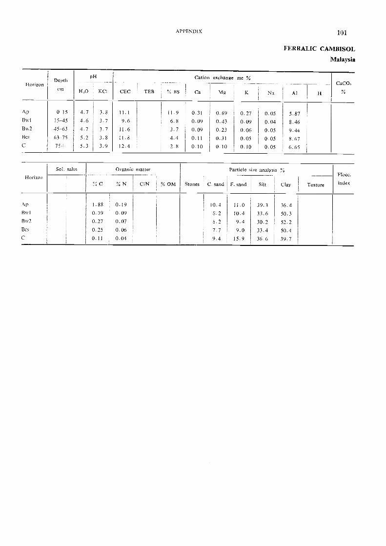
HorizonDepth
pH Cation exchange me %
FERRALIC CAMBISOL
Malaysia
CaCO
1Iorizon
Sol. salts Organic matter
% OM Stones
Particle size analysis %Flocc.
index% C 1 % N C/N C. sand F. sand Silt ' Clay ' Texture
Ap 1.88 0.19 10.4 11.0 39.3 36.4Bwl 0.39 0.09 8.2 10.4 33.6 50.3Bw7 0.27 0.07 8.2 9.4 30.2 52.2Bcs 0.25 0.06 7.7 9.0 33.4 50.4C 0.11 0.04 9.4 15.9 36.6 39.7
CM FLO KCI CEC TEB % BS Ca Mg K Na Al
Ap 0-15 4.7 3.8 11.1 11.9 0.31 0.69 0.27 0.05 5.87Bw I 15-45 4.6 3.7 9.6 6.8 0.09 0.43 0.09 0.04 8.46Bw2 45-63 4.7 3.7 11.6 3.7 0.09 0.23 0.06 0.05 9.44Bcs 63-75 5.7 3.8 11.8 4.4 0.11 0.31 0.05 0.05 8.67
75= 5.3 3.9 12.4 2.8 0.10 0.10 0.10 0.05 6.65
APPENDIX 101

102 SOIL MAP OF SOUTHEAST ASIA
CALCIC CAMBISOL Bk
Location Lam Narain, Chai Badan district, Lop Buri province, Thailand
Altitude 110 m (approximately)
Physiography Undulating to rolling; slope 3 to 6 percent
Drainage Well drained
Parent material Mixed basic rocks (basalts, limestones, andesite)
Vegetation F'ermanent cultivation of upland crops
Climate Monsoon tropical; rainfall 1 450 mm (approx.); rainy season from May throughOctober
Profile description
Ap 0-29 cm Dark brown (7.5vR 3/2) clay; moderate medium subangular blocky; sticky,plastic; slightly firm moist; coinnnon very fine interstitial and few fine tubularpores; few fine (diam. 2 mm) lime concretions; common very fine and fine roots;clear smooth boundary; pH 8.0.
BA 29-49 cm Dark reddish brown (5va 3/4) clay; moderate medium subangular blocky;sticky, plastic; friable moist; few very fine interstitial and tubular pores; fewfine (diam. 2 mm) lime concretions; few very fine roots; gradual wavy boundary;pH 8.0.
Bw 49-82 cm Reddish brown (5YR 4/4) clay; moderate medium subangular blocky; sticky,plastic; slightly firm moist; shiny faces that may be patchy thin cutan or pres-sure faces; few very fine interstitial and tubular pores; few fine (diam. - 2 mm)lime concretions and very few fine angular rock framents; few very line roots;abrupt wavy boundary; pFI 7.5-8.0.
82-150+ cm Layer of weathered rock (basalt) containing more than 80 percent lime con-cretions and some basalt fragments (diam. 15 cm); pH 8.0.
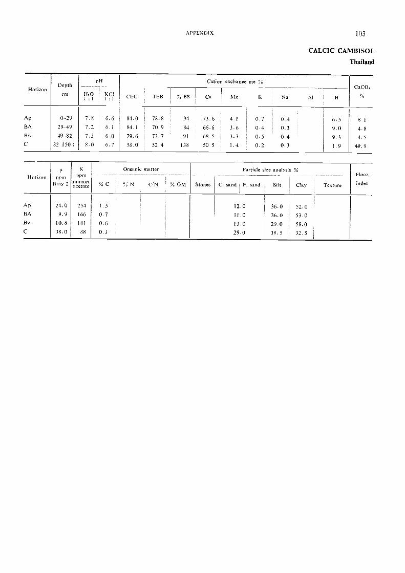
pH Cation exchange meHorizon
Depth
cmCaCO,
%14,0Ka11 : 1 1 :
CEC TEB % BS Ca Mg K
,
Na Al H
A p 0-29 7.8 1 6.6 84.0 78.8 94 73.6 41 0.7 0.4 6.5 81BA 29-49 7.2 I 6.1 4l 70.9 84 66.6 3.6 0.4 0.3 9.0 4.8B. 49-82 7.3 6.0 79.6 ' 72.7 91 68.5 3.3 0.5 0.4 9 3 4.5C 82-150-I- 8.0 6.7 38.0 52.4 138 50.5 1.4 0.2 0.3 I . 9 49.9
HorizonP
own
K
"illOrganic matter Particle size analysis %
Flocc.
BraY 2 aarlicAla7,' % C % N C,NI % OM Stones C. sand F. sand Silt ClaY Texture index
I
A p 24.0 254 1.5 12.0 36.0 52.0BA 9.9 166 0.7 11.0 36.0 53.0Bw 10.8 181 0.6 13.0 29.0 58.0C 38.0 88 0.3 29.0 38.5 32.5
APPENDIX 103
CALCIC CAMBISOL
Thailand

104 SOIL MAP OF SOUTHEAST ASIA
ACRIC FERRALSOL Fa
Location Bukit Goh oil palm scheme, Kuantan district, Pahani2, Malaysia
Altitude
Physiography
Drainage
Parent material
Vegetation
Climate
Profile description
Ap 0-18 cm
Bsl 18-46 cm
Bs2 46-121 cm
Bs3 121-200 cm
30 m (approximately)
Gently undulating coastal plain
Somewhat excessive
Weathering clay from basalt
Oil palm plantationHumid tropical; rainfall 2 800 mm (approx.)
Brown to dark brown (10YR 4/3) clay; weak fine subangular blocky and strongcrumb; friable to firm; few medium roots; few channels; diffuse boundary.Dark yellowish brown (10YR 4/4) clay; weak, medium subangular blocky; veryfriable; few fine roots; few channels; thin coatings on ped faces; diffuse boundary.
Dark yellowish brown (10YR 4/4) clay; weak, medium and coarse subangularblocky; very friable; few fine roots; thin coatings on ped faces; diffuse boundary.
Dark yellowish brown (10YR 4/4) clay; weak, medium and fine subangularblocky; friable; few fine roots; thin coatings on ped faces.
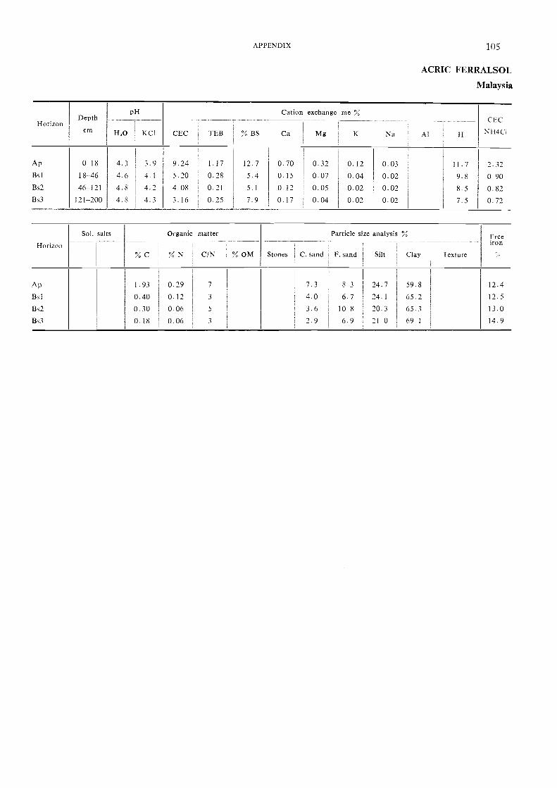
pH Cation exchange meHorizon
Depth CECcm H,0 KC1 CEC TEB % BS Ca Mg K Na Al H NH4C1
A p 0-18 4.3 3.9 9.24 1.17 12.7 0.70 0.32 0.12 0.03 11.7 2.32Bs1 18-46 4.6 4-1 5.20 0.28 5.4 0.15 0.07 0.04 0.02 9.8 090Bs2 46-121 4.8 4.2 4.08 0.21 5.1 0.12 0.05 0.02 0.02 8.5 0.82Bs3 121-200 4.8 4.3 3.16 0.25 7.9 0.17 0.04 0.02 0.02 7.5 0.72
Horizon
Sol. salts Organic matter Particle size analysis % Freeiron
% C % N CiN % OM Stones C. sand F. sand Silt Clay Texture
Ap 1.93 0.29 7 7.3 8 3 24.7 59.8 12.4Bs1 0.40 0.12 3 4.0 6.7 24.1 65.7 12.5
Bs2 0.30 0 06 5 3.6 10 8 20.3 65.3 13.0
Bs3 0.18 0.06 3 2.9 6.9 21 0 69-1 14.9
APPENDIX 105
ACRIC FERRALSOL
Malaysia
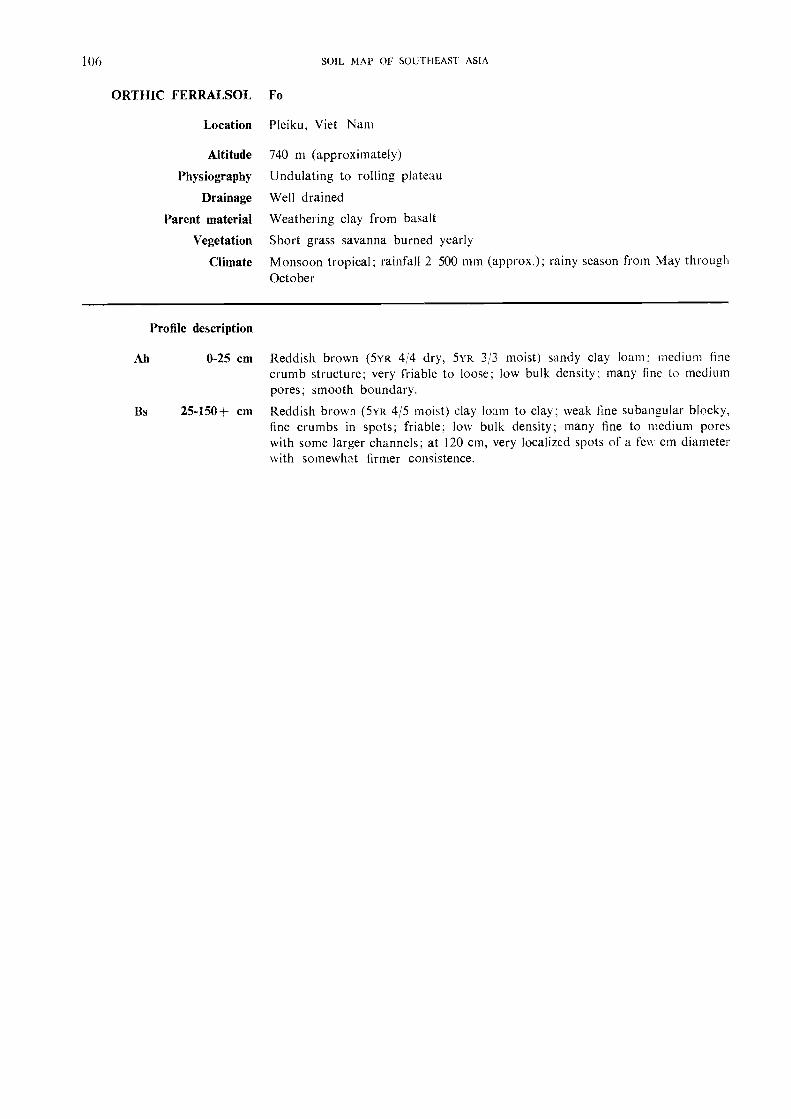
106 SOIL MAP OF SOUTHEAST ASIA
ORTHIC FERRALSOL Fo
Location
Altitude
Physiography
Drainage
Parent material
Vegetation
Climate
Pleiku, Viet Nam
740 m (approximately)
Undulating to rolling plateau
Well drained
Weatheting clay from basalt
Short grass savanna burned yearly
Monsoon tropical; rainfall 2 500 mm (approx.); rainy season from May throughOctober
Reddish brown (5vR 4/4 dry, 5vR 3/3 moist) sandy clay loam; medium linecrumb structure; very friable to loose; low bulk density; many fine to mediumpores; smooth boundary.
Reddish brown (5vR 4/5 moist) clay loam to clay; weak fine subangular blocky,fine crumbs in spots; friable; low bulk density; many fine to medium poreswith some larger channels; at 120 cm, very localized spots of a few cm diameterwith somewhat firmer consistence.
Profile description
Ah 0-25 cm
Bs 25-150+ cm
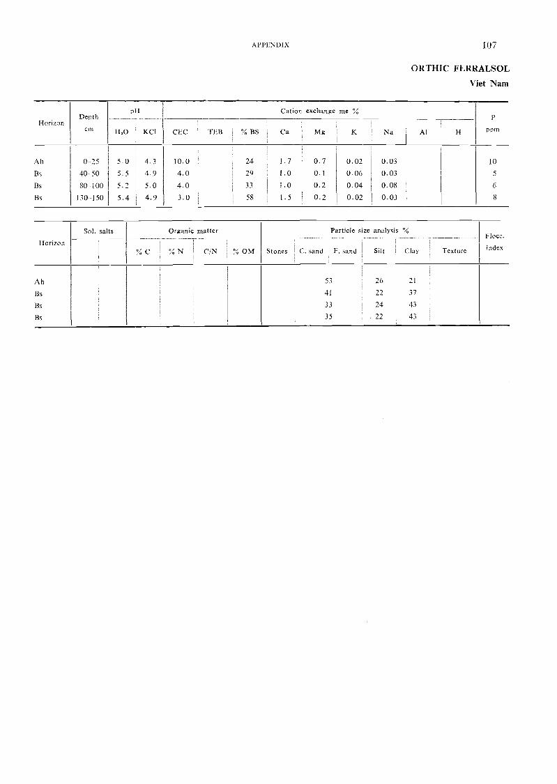
pH Cation exchange me %Depth _ r
Horizoncm FIX) KCI CEC TEB % BS Ca Mg K Na Al H ppm
Ah 0 25 5.0 4.3 10.0 24 1 . 7 0.7 0.02 0.03 10
Bs 40,- 50 5.5 49 4.0 29 1.0 01 0.06 0.03 5
Bs 80 100 5.2 5.0 4. 0 ' 33 1.0 Í 0.2 0.04 0.08 6
Bs 130-150 5.4 4.9 3.0 58 1.5 1 0.2 0.02 0.03 8
Horizon
Sol. salts
% C
Organic matter
,
Í % N C/N Í 'X, OM Stones
Particle size analysis %,
Í
1 C. sand , F. sand I Silt ClayI
Texture
Floce.
index
Ah
Bs
Bs
Bs
53
41
33
35
26
27
24
' 22
21
37
43
43
PPLN DI X 107
OR THIC FERRALSOL
Viet Nam
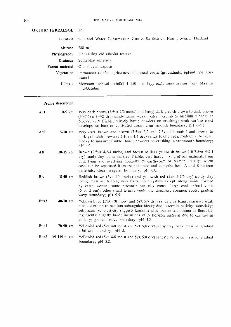
108 SOIL MAP OF SOUTHEAST ASIA
ORTHIC FERRALSOL Fo
Location Soil and Water Conservation Centre. Sa district, Nan province, Thailand
Altitude 280 m
Physiography Undulating old alluvial terrace
Drainage Somewhat excessive
Parent material Old alluvial deposit
Vegetation Permanent rainfed agriculture of annual crops (groundnuts, upland rice, soy-beans)
Climate Monsoon tropical; rainfall I 150 mm (approx.); rainy season from May tomid-October
Profile description
Apl 0-5 cm Very dark brown (7.5YR 2/2 moist) and (very) dark greyish brown to dark brown(10-7.5YR 3-4/2 dry) sandy loam; weak medium crumb to medium subangularblocky; very friable; slightly hard; powders on crushing; weak surface crustdevelops on bare or cultivated areas; clear smooth boundary; pH 6-6.3.
Ap2 5-10 cm Very dark brown and brown (7.5YR 2/2 and 7.5YR 4/4 moist) and brown todark yellowish brown (7.5-I0yR 4:4 dry) sandy loam; weak medium subangularblocky to massive; friable; hard; powders on crushing; clear smooth boundary;pH 6.0.
AB 10-15 cm Brown (7.5YR 4/2-4 moist) and brown to dark yellowish brown (I0-7.5YR 4/3-4dry) sandy clay loam; massive; friable; very hard; mixing of soil materials fromunderlying and overlying horizons by earthworm or termite activity; wormcasts can be separated from the soil mass and comprise both A and B horizonmaterials; clear irregular boundary; pH 6.0.
BA 15-40 cm Reddish brown (5yR 4/4 moist) and yellowish red (5YR 4-5/6 dry) sandy clayloam; massive; friable; very hard; no clayskins except along voids formedby earth worms; some discontinuous clay zones; large oval animal voids(5 x 2 cm); other small termite voids and channels; common roots; gradualwavy boundary; pH 5.5.
Blvsl 40-70 cm Yellowish red (5YR 4/8 moist and 5YR 5/8 dry) sandy clay loam; massive; \veakmedium crumb to medium subangular blocky due to termite activity; nonsticky;subplastic (subplasticity suggests kaolinite plus iron or aluminium as flocculat-ing agent); slightly hard; inclusions of A horizon material due to earthwormactivity; gradual wavy boundary; pH 5.2.
Bws2 70-90 cm Yellowish red (5yR 4/8 moist and 5YR 5/8 dry) sandy clay loam; massive; gradualarbitrary boundary; pH 5.
Bws3 90-140+ cm Yellowish red (5yR 4/8 moist and 5YR 5/8 dry) sandy clay loam; massive; gradualboundary; pH 5.2.

HorizonDepth
cm
pH
H,0I : I
KCII : I
CEC TEB `I, BS
Cation exchange me
Mg
%
K Na Extr.acidity
P
ImmBray
Kppm
ammon.acetate
Ca 1
1
A pl 0-5 5.9 5.4 9.6 6.5 59 4.8 12 0.3 0.2 4 5 34.5 108
Ap2 5-10 4.9 4.7 6.3 4.1 41 2.8 1.0 0 1 0.2 5. 8 16 6 52
AB 10--15 4.7 4.3 6.0 2.3 28 I . 3 0.7 0.1 0.1 6.0 4.7 37
BA 15-40 4.2 4.0 4.9 1.1 14 0.5 0.3 0.1 0. 7 6. 6 2 6 22
Bwsl 40-70 4.2 4.0 4.3 0.7 11 0.4 0.1 0.1 0.2 5.7 22 16
Bws2 70-90 4.7 4.0 3.9 0.7 12 0.4 01 0.1 0.2 51 2.0 16
Bws3 90-140+ 4.7 4.0 4.0 0.8 12 0.4 0.2 0.1 02 5.8 5.3 16
Horizon
Sol. salts Organic matter Particle size analysis % Conduc-tivityI : 5
., "EC 10
Flocc.
index% C % N C/N 'X, OM1
Stones1.
C. sand F. sandl'
Silt Clay
Apl I . 51 0.09 64.0 31.5 4.5 0.05
Ap2 1.05 0.08 61.0 31.0 8.0 0.03
AB 0.70 0.06 64.0 1 28.5 7.5 0.02
BA 0.47 0.05 61.0 !I 22.5 16.5 0.01
Bwsl 0.25 0.06 55.5 22.5 22.0 0.01
Bws2 0.19 0.05 1 52.0 26.0 22.0 0.01
Bws3 0.15 0.05 47.5 26.5 26.0 0.01
APPENDIX 109
ORTHIC FERRALSOL
Thailand

110 SOIL MAI' OF SOUTHEAST ASIA
RHODIC FERRALSOL Fr
Location Ban Methuot, Pleiku road; Km 445, Viet Nam
Altitude 550 m (approximately)
Physiography Incised basalt plateau
Drainage Well drained
Parent material Residual clay from weathering of basaltsVegetation Savanna with scattered trees and Impernia cylitufrica
Climate Monsoon tropical; rainfall 1 800 mm (approx.) from May to October
Profile description
A 0-14 cm Dusky red (10R 3/4) clay; strong fine crumb structure; low bulk density; looseconsistence; many fine pores; smooth gradual boundary.
AB 14-30 cm Dusky red (10R 3/4) clay; moderate fine crumb structure and weak subangularblocky in spots; loose consistence; many fine pores; smooth clear boundary.
Bwsl 30-90 cm Dark red (10R 315) clay; moderate fine subangular blocky structure and spotswith moderate fine crumb; some discontinuous thin clay coatings in some rootchannels; low bulk density; soft; many fine pores; smooth gradual boundary.
Bws2 90+ cm Dark red (10R 3/5) clay; moderately strow._z medium subangular blocky structure;some discontinuous thin clay coatings on peds and in root channels; slightlyhard; many fine pores; no change in profile to be observed at depth ofapproximately 3.50 m.
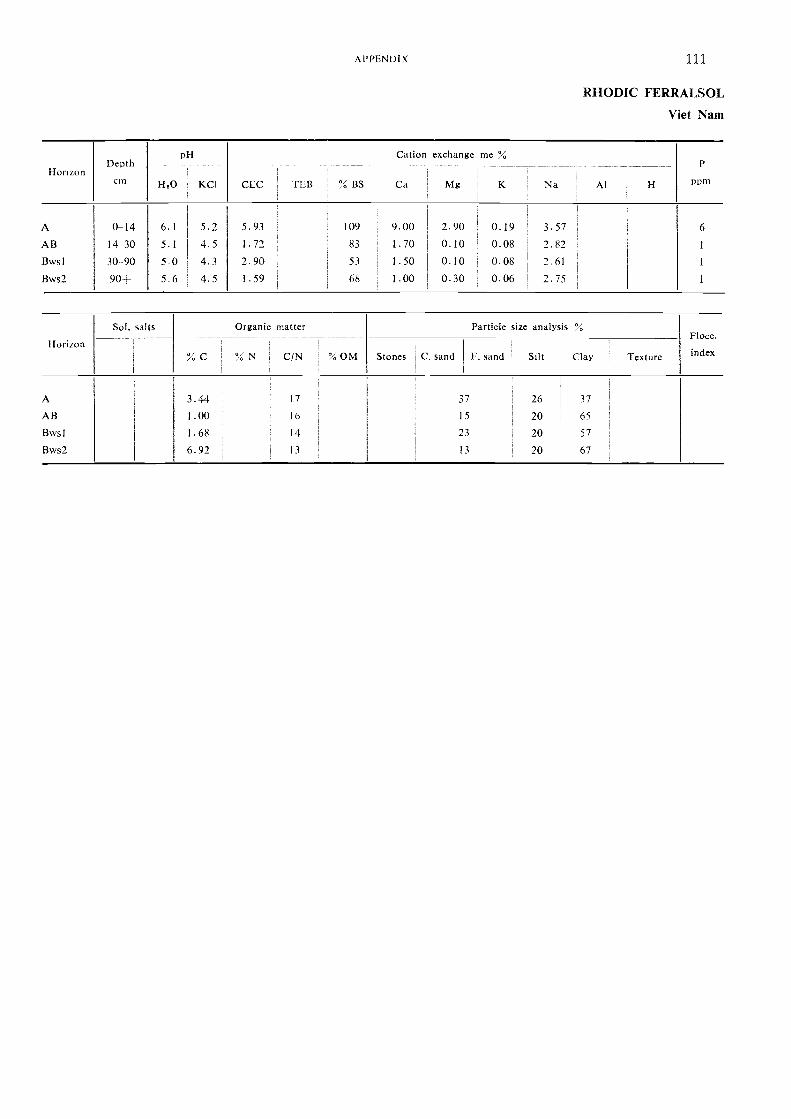
HorizonDepth
cm
nH
CEC TEB ',';, BS
Cation exchange me
K Na Al H
P
nnmY1,0 KC1 Ca Mg
A 0-14 61 5.2 5.93 109 9.00 2.90 0.19 3.57 6
AB 14 30 5.1 4.5 1.72 83 1.70 0.10 0.08 2.82 1
Bvvsl 30 90 5.0 4.3 2.90 53 1.50 0.10 0.08 ; 7.61 1
Bws2 90-- 5.6 4.5 I . 59 68 I . 00 0.30 0.06 2.75 1
Sol. salts Organic matter Particle size analysis %
HorizonFlocc.
i
1
% C % N C/N ' % OM Stones C. sand F. sand ! Silt Clay Texture index
A 3.44 17 37 26 37
AB 1.00 16 15 20 65
Bwsl I . 68 14 23 20 57
Bws2 6.97 13 13 20 67
APPENDIX 111
RHODIC FERRALSOL
Viet Nam
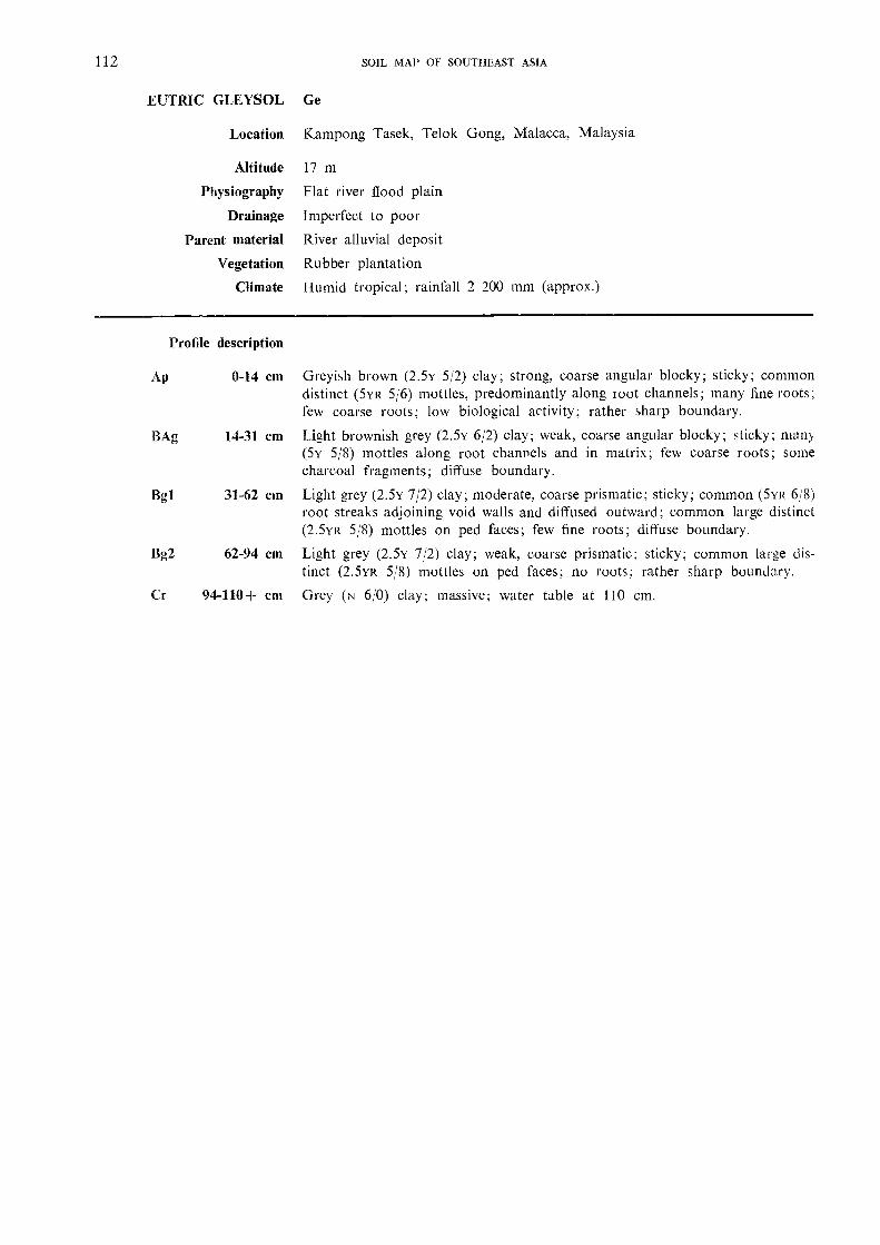
112 SOIL MAP OF SOUTHEAST ASIA
EUTRIC GLEYSOL Ge
Location Kampong Tasek, Telok Gong, Malacca, Malaysia
Altitude 17 m
Physiography Flat river flood plain
Drainage Imperfect to poor
Parent material River alluvial deposit
Vegetation Rubber plantation
Climate Humid tropical; rainfall 2 200 mm (approx.)
Profile description
Ap 0-14 cm Greyish brown (2.5v 5/2) clay; strong, coarse angular blocky; sticky; commondistinct (5yR 5/6) mottles, predominantly along loot channels; many fine roots;few coarse roots; low biological activity; rather sharp boundary.
BAg 14-31 cm Lig,ht brownish grey (2.5v 6/2) clay; weak, coarse angular blocky; sticky; many(5Y 5/8) mottles along root channels and in matrix; few coarse roots; somecharcoal fragments; diffuse boundary.
Bgl 31-62 cm Light grey (2.5Y 7/2) clay; moderate, coarse prismatic; sticky; common (5YR 6/8)root streaks adjoining void walls and diffused outward; common large distinct(2.5YR 5/8) mottles on ped faces; few fine roots; diffuse boundary.
Bg2 62-94 cm Light grey (2.5y 7/2) clay; weak, coarse prismatic; sticky; common large dis-tinct (2.5vR 5/8) mottles on ped faces; no roots; rather sharp boundary.
Cr 94-110+ cm Grey (N 6/0) clay; massive; water table at 110 cm.
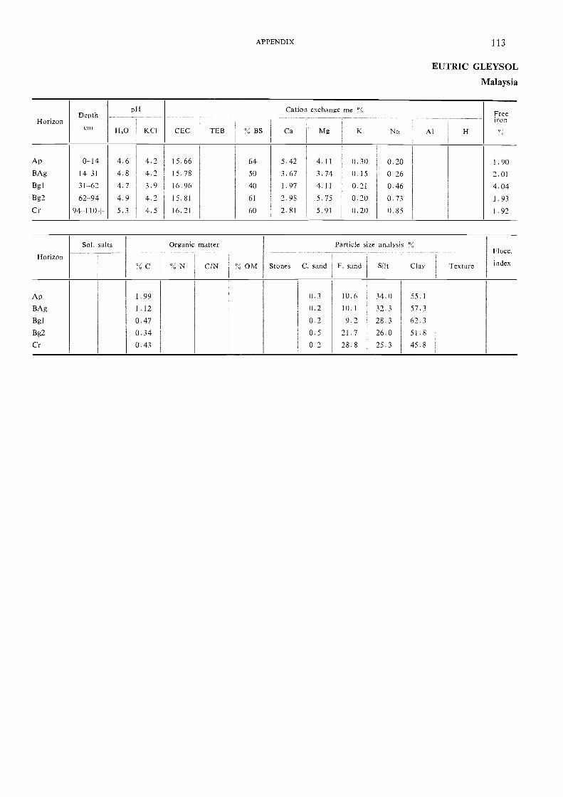
HorizonDepth
cm
pH
H,0 KC1
Cation
CEC TEB % BS Ca
exchange
Mg
me
K Na Al H
Freeiron
Ap 0-14 4.6 4.2 15.66 64 5.42 4.11 0.30 0.20 1.90BAg 14-31 4.8 4.2 15.78 50 3.67 3.74 0.15 0 26 2.01Bgl 31-62 4.7 3.9 16.96 40 1.97 4.11 0.21 0.46 4.04Bg2 62-94 4.9 4.2 15.81 61 2.98 5.75 0.20 0.73 1.93
Cr 94-110- 5.3 4.5 16.21 60 2.81 5.91 0.20 0.85 1.92
Horizon
Sol. salts
`',", C
Organic
% N
matter
% OM Stones
Particle size
C. sand F. sand
analysis %
Silt Clay
Flocc.
indexC/N Texture
Ap 1.99 0.3 10.6 34.0 55.1
BAg 1.12 0.2 10.1 32.3 57.3Bgl 0.47 0.2 9.2 28.3 62.3Bg2 0.34 0.5 21.7 26.0 51.8Cr 0.43 0 2 28.8 25.3 45.8
APPENDIX 113
EUTRIC GLEYSOL
Malaysia
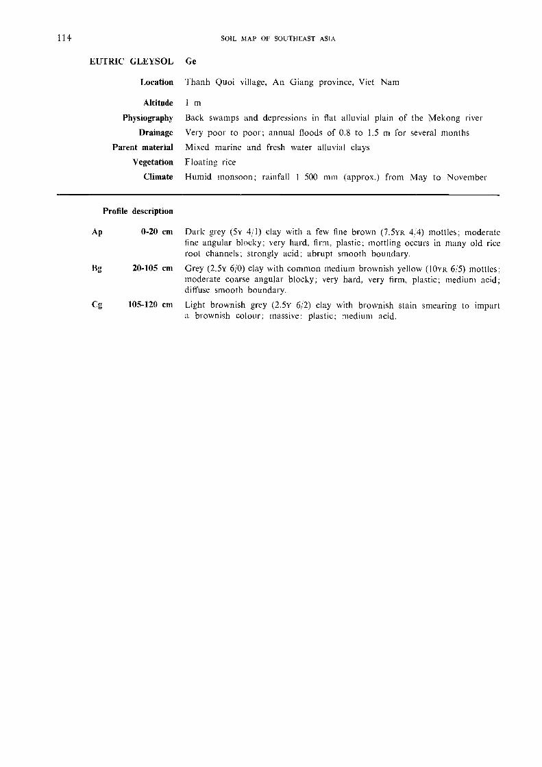
114 SOIL MAP OF SOUTHEAST ASIA
EUTRIC GLEYSOL Ge
Location Thanh Quoi village, An Giang province, Viet Nam
Altitude 1 m
Physiography Back swamps and depressions in flat alluvial plain of the Mekong river
Drainage Very poor to poor; annual floods of 0.8 to 1.5 m for several monthsParent material Mixed marine and fresh water alluvial clays
Vegetation Floating rice
Climate Humid monsoon; rainfall 1 500 mm (approx.) from May to November
Profile description
Ap 0-20 cm Dark grey (5Y 4/1) clay with a few fine brown (7.5YR 4/4) mottles; moderatefine angular blocky; very hard, firm, plastic; mottling occurs in many old riceroot channels; strongly acid; abrupt smooth boundary.
20-105 cm Grey (2.5Y 6/0) clay with common medium brownish yellow (10YR 6/5) mottles;moderate coarse angular blocky; very hard, very firm, plastic; medium acid;diffuse smooth boundary.
Cg 105-120 cm Light brownish grey (2.5Y 6/2) clay with brownish stain smearing, to imparta brownish colour; massive; plastic; medium acid.
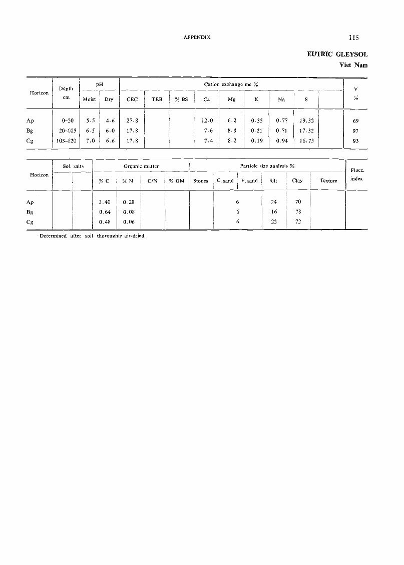
Determined after soil thoroughly air-dried.
pH Cation exchange me %Depth V
Horizoncm Moist Dry CEC TEB % BS Ca Mg K Na S
Ap 0-20 5.5 4.6 27.8 12.0 6.2 0.35 0.77 19.32 69
Bg 20-105 6.5 6.0 17.8 7.6 8.8 0.21 0.71 17.32 97
Cg 105-120 7.0 6.6 17.8 7.4 8.2 0.19 0.94 16.73 93
Sol. salts Organic matter Particle size analysis %Flocc.
Horizon% C % N C/N % OM Stones C. sand F. sand Silt Clay Texture index
Ap 3.40 0.28 6 24 70
Bg 0.64 008 6 16 78
Cg 0.48 0.06 6 22 72
APPENDIX 115
EUTRIC GLEYSOL
Viet Nam
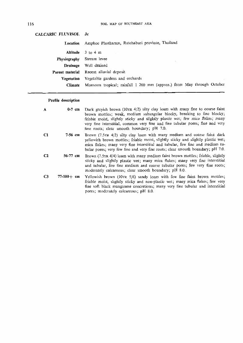
116 SOIL MAP OF SOUTHEAST ASIA
CALCARIC FLLTVISOL Jc
Location Amphoe Photharam, Ratchaburi province, Thailand
Altitude 3 to 4 mPhysiography Stream levee
Drainage Well drained
Parent material Recent alluvial deposit
Vegetation Vegetable gardens and orchards
Climate Monsoon tropical; rainfall 1 200 mm (approx.) from May through October
Profile description
A 0-7 cm Dark greyish brown (10yR 4/2) silty clay loam with many fine to coarse faintbrown mottles; weak, medium subangular blocky, breaking to fine blocky;friable moist, slightly sticky and slightly plastic wet; few mica flakes; manyvery fine interstitial, common very fine and fine tubular pores; fine and veryfine roots; clear smooth boundary; pH 7.0.
Cl 7-56 cm Brown (7.5yR 4/2) silty clay loam with many medium and coarse faint darkyellowish brown mottles; friable moist, slightly sticky and slightly plastic wet;mica flakes; many very fine interstitial and tubular, few fine and medium tu-bular pores; very few fine and very fine roots; clear smooth boundary; pH 7.0.
C2 56-77 cm Brown (7.5yR 4/4) loam with many medium faint brown mottles; friable, slightlysticky and slightly plastic wet; many mica flakes; many very fine interstitialand tubular, few fine medium and coarse tubular pores; few very fine roots;moderately calcareous; clear smooth boundary; pH 8.0.
C3 77-100+ cm Yellowish brown (10YR 5/6) sandy loam with few fine faint brown mottles;friable moist, slightly sticky and non-plastic wet; many mica flakes; few veryfine soft black manganese concretions; many very fine tubular and interstitialpores; moderately calcareous; pH 8.0.
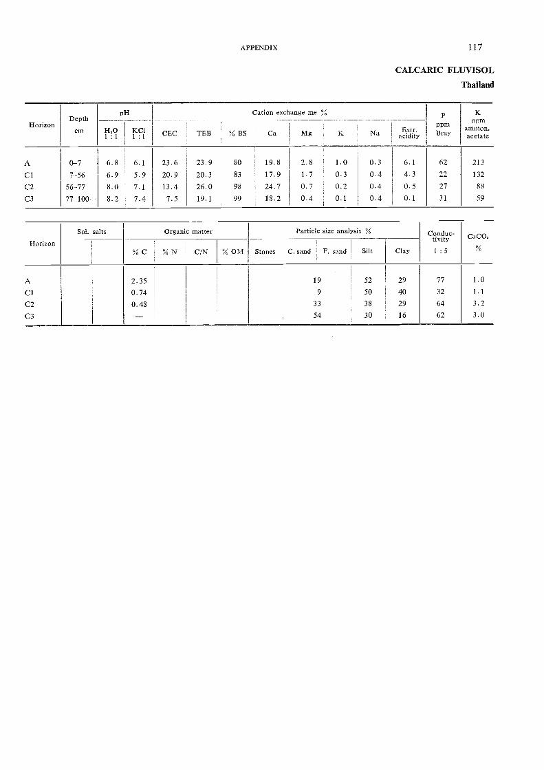
HorizonDepth
cm
pH Cation exchange me % Pppm
KPm
ammon.I-I0 K CI1 : 1 1 : 1
CEC TEB % BS Ca Mg K Na aEcixdtirt.y Bray acetate
A 0-7 6.8 6.1 23.6 23.9 80 19.8 2.8 1.0 0.3 6.1 62 213
Cl 7-56 6.9 5.9 20.9 20.3 83 17.9 1.7 0.3 0.4 4.3 22 132
C2 56-77 8.0 7.1 13.4 26.0 98 24.7 0.7 0.2 0.4 0.5 27 88
C3 77-100+ 8.2 7.4 7.5 19.1 99 18.2 0.4 0.1 0.4 0.1 31 59
Horizon
Sol. salts Organic matter Particle size analysis % Co.nduc-tivitY CaCO.
% C % N C/N % OM Stones C. sand F. sand Silt Clay 1: 5
A 2.35 19 52 29 77 1.0
Cl 0.74 9 50 40 32 1.1
C2 0.48 33 38 29 64 3.2
C3 - 54 30 16 62 3.0
APPENDIX 117
CALCARIC FLUVISOL
Thailand
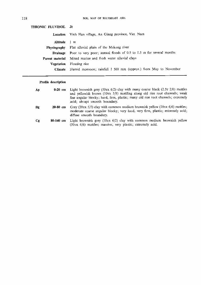
118 SOIL MAP OF SOUTHEAST ASIA
TBIONIC FLUVISOL Jt
Location Vinh Han village, An Giang province, Viet Nam
Altitude 1 m
Physiography Flat alluvial plain of the Mekong river
Drainage Poor to very poor; annual floods of 0.5 to 1.5 m for several months
Parent material Mixed marine and fresh water alluvial clays
Vegetation Floating rice
Climate Humid monsoon; rainfall 1 500 mm (approx.) from May to November
Profile description
Ap 0-20 cm Light brownish grey (10YR 6/2) clay with many coarse black (2.5y 2/0) mottlesand yellowish brown (10YR 5/8) mottling along old rice root channels; weakfine angular blocky; bald, firm, plastic; many old rice root channels; extremelyacid; ablupt smooth boundary.
Bg 20-80 cm Grey (20YR 5/1) clay with common medium brownish yellow (10YR 6/6) mottles;moderate coarse angular blocky; very haid, very firm, plastic; extremely acid;diffuse smooth boundary.
Cg 80-140 cm Light brownish grey (10YR 6/2) clay with common medium brownish yellow(10YR 6/6) mottles; massive; very plastic; extremely acid.

Determined after soil thoroughly air-dried.
pH Cation exchange meDepth V
Horizoncm Moist Dry' CEC TEB % BS Ca Mg K Na S %
Ap 0-20 4.8 3.7 19.1 2.2 1.7 0.19 0.15 4.24 22
Bg 20-80 4.2 3.1 21.2 2.7 1.5 0.13 0.13 4.48 21
Cg 80-140 2.2 28.2 6.0 5.6 0.06 0.06 11.88 42
Sol. salts Organic matter Particle size analysis %Flocc.
Horizon% C % N C/N % OM Stones C. sand F. sand Silt ClaY Texture index
Ap 7.64 0.39 13 24 63
Bg 3.72 0.16 7 28 65
Cg 8.68 0.17 11 72 17
APPENDIX 119
THIONIC FLUVISOL
Viet Nam

120 SOIL MAP OF SOUTHEAST ASIA
THIONIC FUUVISOL Jt
Location Amphoe Nong Sua, Pathum Thani province, Thailand
Altitude 2 to 3 mPhysiography Flat coastal plain
Drainage Poor to very poor; flooded by river water for four to five months every- year
Parent material Clayey brackish water deposits
Vegetation Broadcast rice
Climate Monsoon tropical; rainfall 1 450 mm (approx.) from May through October
Profile description
Apg 0-15 cm Very dark grey to black (10YR 3/1 to 2/1) clay with common fine distinct yellow-ish brown mottles, mainly in pores; moderate coarse subangular blocky, break-ing to medium and fine blocky; firm moist, sticky and plastic wet; few very fineintetstitial and tubular pores; many fine roots; gradual slightly wavy boundary;pH 5.0.
Ag 15-30 cm Very dark grey and black (10YR 3/1 and 2/1) clay with many fine and mediumyellowish brown and few fine red mottles; weak to moderate medium angularblocky breaking to fine blocicy; firm moist, sticky and plastic wet; few slicken-sides; common very fine interstitial and few very fine tubular pores; few veryfine toots; gradual wavy boundary; pH 4.5.
ABg 30-49 cm Greyish brown (10YR 5/2) and very dark greyish brown (10YR 3/2) clay withvery many medium and coarse red and dark red, many fine and mediumyellowish brown mottles; moderate medium and fine angular blocky; firmmoist, sticky and plastic wet; common slickensides and pressure faces; manyvery fine interstitial and few very fine tubular pores; few very fine roots; grad-ual smooth boundary; pH 4.5.
Btgl 49-59 cm Brown (7.5YR 4/2) with few small inclusions of very dark grey clay; manymedium and coarse red and dark red, many fine pale yellow (jarosite) andfew fine yellowish brown mottles; moderate medium and fine angular blocky;firm moist, sticky and plastic wet; common pi essure faces and slickensides;many very fine interstitial, few fine tubular pores; few very fine roots; clearwavy boundary; pH 4.5.
Brown (7.5YR 5/2) clay; many medium and coarse yellow (jarosite) and fewfine yellowish brown mottles, mainly as vertical streaks (fillings of coarse tu-bular pores and cracks); moderate coarse prismatic, breaking to angular blocky;firm moist, sticky and plastic wet; few slickensides; few very fine tubular andfew fine and medium vertical tubular pores; pH 4.5.Brown (7.5yR 5/2) clay; common medium and coarse yellowish brown, fewmedium yellow (jarosite) mottles; half ripe; pH 6.0.
Dark grey to dark greenish grey (5y 4/1 to 5GY 4/1) clay; half ripe; pH 6.0.
Btg2 59-110 cm
Btg3 110-160 cm
BCg 160-190+ cm

HorizonDepth
cm
PH
-Cation exchange me
P
PPrnBraY
,
Kppm
anynon.acetate
H,01 : 1
KCI1 : 1
CEC TEB % BS Ca Mg K Na Extr.acidity
Apg 0-15 4.4 3.3 20.0 11.0 33 4.4 4.8 0.3 1.5 21.9 5 143Ag 15-30 4.2 3.4 20.3 9.7 28 4.0 4.4 0.2 1.1 23.9 5 113ABg 30-49 3.9 3.1 22.8 13.1 39 4.7 6.0 0.3 2.1 20.4 3 149Btgl 49-59 4.2 3.0 24.6 14.7 43 5.3 6.7 0.3 2.4 19.4 3 160Btg2 59-110 4.0 3.1 24.9 15.7 49 5.3 7.7 0.4 2.3 16.6 3 172Btg3 110-160 4.2 3.1 23.2 14.6 46 4.6 7.1 0.5 2.4 17.2 6 190
BCg 160-190+ 3.5 2.9 30.7 19.4 41 5.0 10.7 0.7 3.0 27.6 24 280
Horizon
Sol. salts Organic matter Particle size ana ysis % Conduc-dvfty
1 : 5
Flocc.
index% C % N C/N % OM Stones C. sand F. sand Silt Clay
Apg 1.21 11 48 41 250
Ag 0.91 11 43 46 200
ABg 0.26 7 34 59 250
Btgl 0.21 5 33 62 300
Btg2 0.19 1 36 63 340
Btg3 0.33 19 26 55 450
BCg 2.04 8 43 49 1 300
APPENDIX 121
THIONIC FLUVISOL
Thailand

122 SOIL MAP OF SOUTHEAST ASIA
FERRIC LUVISOL Lf
Location
Altitude
Physiography
Drainage
Parent material
Vegetation
Climate
Profile description
Ah 0-2 cm
AB 2-17 cm
BA 17-55 cm
Btl 55-150 cm
Bt2 150-200 cm
Table estate, Tawau, Sabah
150 m (approximately)
Gently undulating to rolling plateau
Well drained
Residual clay from Quaternary basalt
Industrial crops; cocoa, oil palm
Humid tropical; rainfall 1 800 mm with maximum from May to September
Very dark grey (5YR 3/1) silty clay; strong medium crumb structure; loose;few quartz fragments; very few fragments of decomposing rock (basalt); fewroots; abrupt smooth boundary.Dark brown (7.5YR 3/2) clay; strong medium fine subangular blocky, break-ing into fine crumb structure; few angular fine quartz fragments; many pores;distinct cutans; little gravel; few roots; gradual smooth boundary.Brown to dark brown (7.5YR 4/2) clay; strong fine subangular blocky break-ing into fine crumb structure; very friable; few quartz fragments; many pores;distinct cutans; few roots; gradual smooth boundary.Dark yellowish brown (10YR 3/4) clay; strong fine crumb structure; veryfriable; few quartz fragments; few pores; distinct cutans.
Similar to the above horizon.
HorizonDepth
cm
pH Cation exchange me %CaCO3
1-110 KC1 CEC TEB % BS Ca Mg K Na Al H
Ah 0-2 7.3 6.6 39.74 88 27.81 5.15 1.81 0.28 0.72AB 2-17 6.3 5.6 14.35 69 7.96 1.20 0.60 0.19 1.20BA 17-55 6.2 5.6 10.81 67 6.17 0.69 0.19 0.16 0.88Btl 55-150 6.0 5.5 8.01 61 3.05 1.35 0.40 0.08 3.28Bt2 150-200 5.8 5.5 8.58 52 2.93 0.68 0.77 0.06 1.25
Horizon
Sol. salts Organic matter Particle size analysis %Flocc.
index% C % N C/N % OM Stones C. sand F. sand Silt Clay Texture
Ah 7.18 0.79 7.7 18.7 51.3 22.3
AB 1.16 0.22 6.1 11.5 32.5 49.9BA 0.37 0.13 4.7 8.2 24.3 62.8
Btl 0.30 0.06 3.1 5.5 20.6 70.8
Bt2 0.34 0.06 19.0 13.3 14.6 52.4
APPENDIX 123
IERRIC LUVISOL
Sabah

124 SOIL MAP OF SOUTHEAST ASIA
GLEYIC LUVISOL Lg
Location Amphoe Muang, Nakhon Pathom province, Thailand
Altitude 5 to 7 mPhysiography Low terrace
Drainage Poorly drained
Parent material Semi-recent alluvial deposit
Vegetation Rice field
Climate Monsoon tropical; rainfall 1 300 mm (approx.) from May through October
Profile description
Ap 0-15 cm Very dark greyish brown (10YR 3/2) loam with many fine and medium yellow-ish red mottles; moderate fine subangular blocky; slightly sticky and non-plastic wet, friable moist; many very fine interstitial and common very finetubular pores; many very fine roots; clear smooth boundary; pH 6.0.
Ag 15-31 cm Very dark greyish brown (10YR 3/2) silty clay loam; few fine brown to darkbrown mottles; weak to moderate medium subangular blocky; many very fineinterstitial and tubular pores; few pieces of brick; common very fine roots;gradual smooth boundary; pH 7.0.
BAg 31-50 cm Dark greyish brown (10YR 4/2) silty clay; many fine and medium dark yellow-ish brown mottles; moderate to strong, medium subangular blocky, break-ing to small blocky; sticky and slightly plastic wet, friable moist; patchy thinclay coatings; many very fine interstitial and tubular pores; few small softmanganese concretions; common very fine roots; gradual smooth boundary;pH 7.0.
Btgl 50-85 cm Dark greyish brown (10YR 4/2) to brown (10YR 4/3) silty clay; many fine andmedium dark yellowish brown and yellowish brown mottles; moderate tostrong, medium subangular blocky, breaking to small blocky; sticky and slightlyplastic wet, friable moist; thin broken clay coatings on ped faces and in pores;many very fine interstitial and tubular pores; few small soft manganese con-cretions; common very fine roots; gradual smooth boundary; pH 8.0.
Btg2 85-105 cm Brown (7.5YR 4/2) silty clay loam; very many medium yellowish brown mottles;moderate to strong, medium subangular blocky; sticky and slightly plasticwet; thin broken clay coatings; slightly calcareous; many very fine interstitialand tubular pores; few very small soft manganese nodules; few very fine roots;pH 8.0.
HorizonDepth
Cm
pH Cation exchange me %P
PPMBray
KPPm
aamc ertia°tne
14,0I : 1
KCII : I
CEC TEB % BS Ca Mg K Na Extr.acidity
Ap 0-15 5.8 5.2 17.8 22.7 77 13.1 6.5 0.3 2.8 6.9 42 140Ag 15-31 6.5 5.8 18.6 19.8 79 10.9 6.7 0.3 1.9 5.3 44 117BAg 31-50 6.7 5.9 19.8 22.4 83 10.1 9.1 0.3 2.9 4.6 31 117Btgl 50-85 7.3 6.6 20.0 26.3 85 10.3 10.2 0.2 5.6 4.5 31 93Btg2 85-105 8.0 7.5 19.0 39.3 94 24.1 9.3 0.2 5.7 2.3 32 93
Horizon
Sol. salts Organic matter Particle size analysis % Conduc-tivity
1: 5
CaCO.
% C %, N C/N % OM Stones C. sand F. sand Silt Clay
Ap 1.62 24 50 26 420 0.6Ag 1.02 18 48 34 440 0.4BAg 0.68 10 49 41 410 0.4Btgl 0.36 4 54 42 490 0.9Btg2 0.30 6 56 38 650 4,2
APPENDIX 125
GLEYIC LUVISOL
Thailand
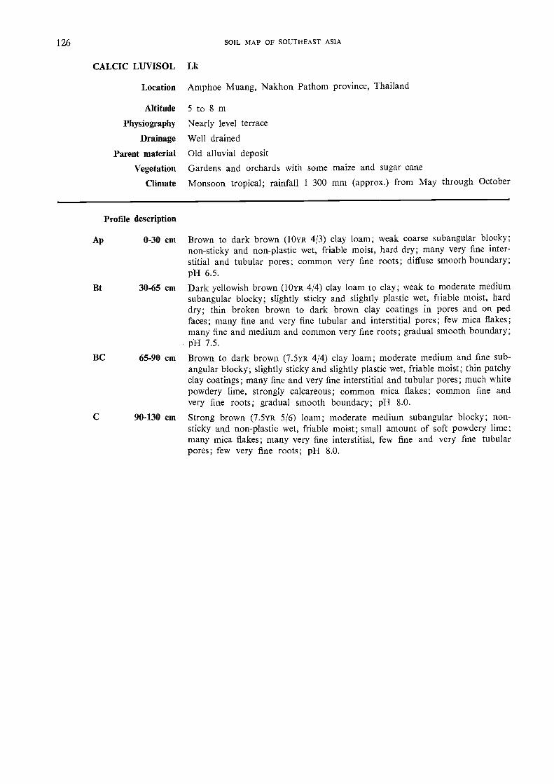
126 SOIL MAP OF SOUTHEAST ASIA
CALCIC LUVISOL Lk
Location
Altitude
Physiography
Drainage
Parent material
Vegetation
Climate
Profile description
Ap 0-30 cm Brown to dark brown (10YR 4/3) clay loam; weak coarse subangular blocicy;non-sticky and non-plastic wet, friable moist, haid dry; many very fine inter-stitial and tubular pores; common very fine roots; diffuse smooth boundary;pH 6.5.
Bt 30-65 cm Dark yellowish brown (10YR 4/4) clay loam to clay; weak to moderate mediumsubangular blocky; slightly sticicy and slightly plastic wet, friable moist, harddry; thin broken brown to dark brown clay coatings in pores and on pedfaces; many fine and very fine tubular and interstitial pores; few mica flakes;many fine and medium and common very fine roots; gradual smooth boundary;pH 7.5.
BC 65-90 cm Brown to dark brown (7.5yR 4/4) clay- loam; moderate medium and fine sub-angular blocky; slightly sticky and slightly plastic wet, friable moist; thin patchyclay coatings; many fine and very fine interstitial and tubular pores; much whitepowdery lime, strongly calcareous; common mica flakes; common fine andvery fine roots; gradual smooth boundary; pH 8.0.
90-130 cm Strong brown (7.5YR 5/6) loam; moderate medium subangular blocky; non-sticky and non-plastic wet, friable rnoist; small amount of soft powdery lime;many mica flakes; many very fine interstitial, few fine and very fine tubularpores; few very fine roots; pH 8.0.
Amphoe Muang, Nakhon Pathom province, Thailand
5 to 8 mNearly level terrace
Well drained
Old alluvial deposit
Gardens and orchards with some maize and sugar cane
Monsoon tropical; rainfall 1 300 mm (approx.) from May through October

HorizonDepth
pH Cation exchange me %P K
mmtcm H,0 KCI CEC TEB % BS Extr.
DomI : I I : I Ca Mg K Na acidity Bray
aamcgiacre.
Ap 0-30 7.1 6.4 15.0 13.4 80 10.6 1.6 0.4 0.8 3.3 48 175Bt 30-65 6.3 5.7 16.1 20.6 85 16.6 2.1 0.2 1.7 3.8 82 70BC 65-90 7.5 7.0 15.1 53.5 99 37.2 5.1 0.2 11.0 0.5 45 88
C 90-130 8.3 7.5 11.5 28.9 99 19.5 2.7 0.1 6.6 0.2 20 47
Horizon
Sol. salts Organic matter Particle size analysis % Conduc-tivity CaCO.
% C % N C/N % OM Stones C. sand F. sand Silt Clay 1 :5
Ap 3.22 40 41 19 10 0.9Bt 2.02 19 48 33 680 0.3BC 1.42 14 59 27 1 800 6.9C 0.82 69 14 17 700 3.0
APPENDI X 127
CALCIC LUVISOL
Thailand

128 SOIL MAP OF SOUTHEAST ASIA
ORTILIC LUVISOL Lo
Location Amphoe Pak Tho, Ratchaburi province, Thailand
Altitude 10 to 14 m
Physiography Mainly flat old river levee
Drainage Well drained
Parent material Old alluvial deposit
Vegetation Vegetable gardens and orchards
Climate Monsoon tropical; rainfall 1 200 mm (approx.) from May through September
Profile description
Ap 0-10 cm Dark yellowish brown (10YR 4/3) sandy loam; weak medium subangular blocky;very friable moist, slightly sticky and slightly plastic wet; many worm Casts;many very fine interstitial, common very fine and few fine tubular pores; manyvery fine and few fine medium roots; pH 8.0.
AB 10-30 cm Dark yellowish brown (10yR 3/4) with many inclusions of brown (7.5YR 4/4)sandy loam; weak to moderate subangular blocky; very friable moist, non-sticky and non-plastic wet; many pieces of charcoal; many very fine interstitial,common very fine and fine tubular pores; few fine, medium and coarse roots;clear wavy boundary; pH 8.0.
BA 30-73 cm Brown (7.5YR 4/4 moist) and yellowish brown (10YR 5/6 dry) sandy clay loam;weak to modetate subangular blocky; slightly hard dry, very friable moist,slightly sticky and slightly plastic wet; thin patchy clay coatings; many veryfine interstitial, many very fine and few fine tubular pores; few very fine, fine,medium and coarse roots; gradual smooth boundary; pH 7.5.
Bt 73-105+ cm Reddish brown (5YR 5/4) sandy clay loam with many medium faint yellowishred mottles; moderate medium subangular blocky; slightly hard dry, friablemoist, sticky and slightly plastic wet; thick continuous clay coatings in poresand on ped faces; many very fine interstitial and tubular pores.

HorizonDepth
cm
pH Cation exchange me %P
Porn
KPont
ammon.1
FLO ' KC1 CEC TEB % BS Ca Mg K Na Ext1 : 1 1 : 1 acidir.ty Bray acetate
Ap 0-10 7.3 6.7 7.1 6.9 82 5.4 0.8 0.5 0.2 1.5 40 204AB 10-30 7.3 6.6 6.7 5.7 77 4.3 0.8 0.4 0.2 1.7 27 181
BA 30-73 7.1 6.2 5.4 4.1 68 2.5 0.8 0.6 0.2 1.9 3 213Bt 73-105 6.6 5.4 6.7 5.4 64 2.7 1.8 0.6 0.3 3.0 3 260
Horizon
Sol. salts Organic matter Particle size analysis % Conduc-MayI : 5
CaCO.I
% C I % N1
C/N % OM Stones C. sand F. sand Silt Clay
Ap
AB
BA
Bt
O. 87 I
0.59O. 78 I
0.17 1
I
73
71
58
49
22
21
34
32
5
8
8
19
10
40
31
34
APPENDIX 129
ORTI11C LUVISOL
Thailand

130 SOIL MAP OF SOUTHEAST ASIA
PLINTHIC LUVISOL Lp
Location
Altitude
Physiography
Drainage
Parent material
Vegetation
Climate
Profile description
Ap 0-24 cm
E 24-37 cm
Btg 37-76 cm
Csq 76-120 cm
Phan Thiet, Viet Nam
40 to 50 mFlat to gently undulating old terrace
Imperfectly drained; slow internal drainage
Heterogeneous old alluvial deposits
Dry short grass savanna with locally rainfed paddy fields
Dry monsoon; rainfall 800 to 1 000 mm from August through December
Dark greyish brown (10YR 4/2) sandy loam with mottling along previous rootchannels; very weak medium subangular blocky to massive structure; locallyslightly platy; very hard consistence; clear smooth boundary.
Yellowish brown (10YR 5/6) sandy loam, fine mottling; very weak subangularblocky structure; hard con.sistence; clear irregular boundary.
Brownish yellow (10YR 6/6) sandy loam, strongly mottled; weak coarse sub-angular blocky structure with weak clay coatings; some fine iron concretions;hard consistence; abrupt irregular boundary.Plinthite with lateritic gravel of 2 to 10 mm diameter.

pH Cation exchange me %Depth
Horizoncm CEC TEB % BS Ca Mg K Na Al H
Ap 0-24 5.9 4.14 104 3.38 0.56 0.31 0.06E 23-37 6.0 4.04 106 3.13 0.75 0.35 0.06Btg 37-76 5.7 3.76 83 2.68 0.13 0.35 0.03Csq 76-120 6.4 4.25 79 2.50 0.13 0.59 0.12
Sol. salts Organic matter Particle size analysis %Flocc.
Horizon% C % N C/N % OC Stones Sand > 0.05 Silt
0.05-0.002Clay
<0.002 Texture index
Ap 12 0.73 71 13.3 15.7E 9 0.36 69 13.3 17.7Btg 9 0.49 65 15.3 19.7Csq 8 0.32 60.5 18.6 20.9
APPENDIX 131
PLINTRIC LUVISOL
Viet Nam

Profile description
Ap 0-5 cm Dark yellowish brown (10YR 3/4 moist) and dark brown (10YR 4/3 dry) sandyclay loam; modetate fine and very fine subangular blocky; sticky, slightly plastic;friable; slightly hard; few fine tubular and common very fine interstitial pores;many fine pieces of charcoal; many very fine roots; clear slightly wavy boundary;pH 6.5.
AB 5-15 cm Dark brown to btown (7.5YR 4/4 moist) and brown (7.5YR 5/4 dry) sandy clayloam; moderate fine subangular blocky; sticky and slightly plastic; friable,slightly hard; few fine tubular and common fine interstitial pores; commonfine charcoal pieces; very few fine subangular quartz fragments; coinmon veryfine and fine roots; gradual smooth boundary; pH 5.5.
Btl 15-31 cm Yellowish red (5YR 4/6 moist) and strong brown (7.5YR 5/6 dry) sandy clayloam; moderate very fine and fine subangular blocky; sticky and sliahtly plastic;firm; slightly hard; patchy thin clay cutans on horizontal and vertical ped faces;few coarse and very coarse tubular pores made by termites; common fine tubularpores; few pieces of charcoal; common very fine angular quartz fragments;common coarse and very coarse and also medium and fine roots; diffuse smoothboundary; pH 4.5.
Bt2 31-63 cm Yellowish red (5yR 4/8 moist and 5YR 4/6 dry) clay loam; moderate fine andmedium subangular blocky; sticky and plastic; firm; hatd; patchy thin claycutans on horizontal and vertical ped faces; few coarse and medium tubularpores; common fine interstitial pores; common medium pieces of charcoal;common very fine and fine subangular quartz fragments; few coarse and verycoarse roots; diffuse smooth boundary; pH 4.5.
Bt3 63-100+ cm Yellowish red (5yR 4/8 moist and 5YR 5/8 dry) clay loam to clay; weak fineand medium subangular blocky; sticky and plastic; firm; hard; broken mod-erately thick clay cutans on horizontal and vertical ped faces; few very finetubular pores; common very fine and fine interstitial pores; many very fineand fine angular and subangular quartz fragments; common fine roots; pH 4.5.
132 SOIL MAP OF SOUTHEAST ASIA
DYSTRIC NITOSOL Nd
Location Near Ban Nam Kaen, Thailand
Altitude 260 m (approximately)
Physiography Undulating old terrace
Drainage Well drained
Parent material Old slope colluvial deposits derived from shales and metamorphic rocks
Vegetation Shifting cultivation of upland rice
Climate Monsoon tropical; rainfall 1 400 mm (approx.) from May to mid-October

HorizonDepth
cm
pH Cation exchange me % p
ripmBraY
KPorn
a mmon.acetate
H,01 : 1
KC11 : 1
CEC TEB % BS Ca Mg K Na Extr.acidity
Ap 0-5 5.8 5.1 12.3 7.1 46 4.1 2.2 0.6 0.2 8.3 8.8 280
AB 5-15 4.9 3.9 9.8 1.7 15 0.3 0.5 0.7 0.2 9.5 4.4 42
Btl 15-31 4.8 3.7 8.1 0.5 5 0.1 0.2 0.1 0.2 5.4 1.9 42
Bt2 31-63 5.0 3.9 9.3 0.8 7 0.4 0.2 0.1 0.2 10.1 1.8 15
Bt3 63-100+ 5.0 3.8 9.6 0.5 4 0.2 0.1 0.1 0.2 10.9 1.8 15
Horizon
Sol. salts Organic matter Particle size analysis % Conduc-tivity
1 :5
Flocc.
index% C % N C/N % OM Stones C. sand F. sand Silt Clay
Ap 1.29 0.16 46.5 42.0 11.5 0.06AB 0.74 0.08 39.5 38.5 22.0 0.01Bt1 0.55 0.08 36.0 38.0 26.0 0.01
Bt2 0.47 0.07 32.5 36.5 31.0 0.01Bt3 0.33 0.06 38.5 29.5 42.0 0.01
APPENDIX 133
DYSTRIC NITOSOL
Thailand

134 SOIL MAP OF SOUTHEAST ASIA
EUTRIC NITOSOL Ne
Location
Altitude
Physiography
Drainage
Parent material
Vegetation
Climate
Phan Rang area, Viet Nam
20 m (approximately)
Flat to gently undulating coastal plain
Well drained
Residual clay from andesitic and granitic rocks
Overgrazed short grass savanna with thorny bushes
Dry monsoon; rainfall 700 mm (approx.) with maximum from September toNovember
Brown (7.5YR 4/4) sandy loam; very weak coarse platy structure; friable; clearwavy boundary.
Reddish brown (5YR 4/5) sandy clay loam; weak fine subangular blocky structure;friable; gradual smooth boundary.
Yellowish red (5YR 4/6) clay loam; strong fine subangular blocky structure;discontinuous clay coatings; slightly hard; gradual smooth boundary.
Yellowish red (5YR 4/7) clay loam; strong subangular blocky structure; discon-tinuous clay coatings; hard; gradual regular boundary.
Yellowish red (4YR 4/7) clay; strong medium subangular blocky structure;prominent continuous clay coatings; hard to very hard gradual regular boundary.
Red (2.5YR 4/7) clay; strong coarse subangular blocky structure; hard to veryhard; continuous coatings.
Profile description
A 0-10 Cln
AB 10-20 cm
Btl 20-33 cm
Bt2 33-49 cm
Bt3 49-73 cm
Bt4 73-150+ cm
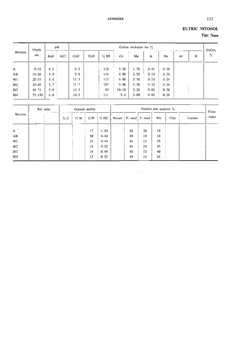
HorizonDepth
cm
pH Cation exchange me %CaCO,
H,0 KCI CEC TEB % BS Ca Mg K Na Al H
A 0-10 6.2 6.5 118 5.20 1.70 0.41 0.38AB 10-20 5.9 9.8 118 8.90 2.20 0.18 0.36BO 20-33 5.8 11.3 113 9.80 2.70 0.10 0.26Bt2 33-49 5.7 11.7 107 9.90 2.30 0.10 0.26Bt3 49-73 5.9 13.5 93 10.10 2.20 0.08 0.26Bt4 73-150 6.0 10.5 111 9.4 2.00 0.08 0.26
Sol. salts Organic matter Particle size analysis %Flocc.
Horizon% C % N C/N % OC Stones C. sand F. sand Silt Clay Texture index
A 17 1.84 62 20 18
AB 20 0.80 48 18 34
Btl 16 0.64 46 18 36
Bt2 13 0.52 46 18 36
Bt3 16 0.48 48 12 40
Bt4 13 0.52 44 14 42
APPENDIX 135
EUTRIC NITOSOL
Viet Nam
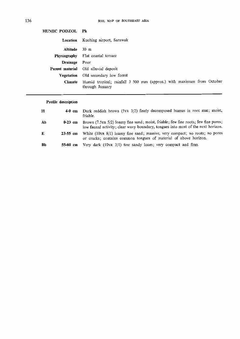
136 SOIL MAP OF SOUTHEAST ASIA
HUMIC PODZOL Ph
Location Kuching airport, Sarawak
Altitude 30 m
Physiography Flat coastal terrace
Drainage Poor
Parent material Old alluvial deposit
Vegetation Old secondary low forest
Climate Humid tropical; rainfall 3 500 mm (approx.) with maximum from Octoberthrough January
Profile description
4-0 cm Dark reddish brown (5va 3/2) finely decomposed humus in root mat; moist,friable.
Ah 0-23 cm Brown (7.5va 5/2) loamy fine sand; moist, friable; few fine roots; few fine pores;low faunal activity; clear wavy boundary, tongues into most of the next horizon.
E 23-55 cm White (10va 8/1) loamy fine sand; massive, very compact; no roots; no poresor cracks; contains common tongues of material of above horizon.
Bh 55-60 cm Very dark (10va 3/1) fine sandy loam; very compact and firm.
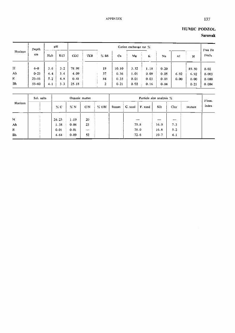
pH Cation exchange me %Horizon
Depth Free Fe
cm H20 KCI CEC TEB % BS Ca Mg K Na Al H Fe202
H 4-0 3.6 3.2 78.98 19 10.10 3.32 1.18 0.20 89.50 0.02Ah 0-23 4.4 3.4 4.09 37 0.36 1.01 0.09 0.05 6.92 6.92 0.003E 23-55 5.2 4.8 0.41 84 0.35 0.01 0.03 0.03 0.00 0.00 0.000Bh 55-60 4.1 3.3 25.18 2 0.21 0.02 0.16 0.04 0.21 0.004
Sol. salts Organic matter Particle size analysis %Flocc.
Horizon% C % N C/N % OM Stones C. sand F. sand Silt Clay texture index
H 24.23 1.19 20 - - -Ah 1.38 0.06 23 75.8 16.9 7.3E 0.01 0.01 - 78.0 16.8 5.2Bh 4.64 0.09 52 72.6 10.7 4.1
APPENDIX 137
HUMIC PODZOL
Sarawak

138 SOIL MAP OF SOUTHEAST ASIA
ORTHIC PODZOL
Location
Altitude
Physiography
Drainage
Parent material
Vegetation
Climate
Profile description
Ap 0-10 cm
El 10-25 cm
E2 25-55 cm
E3 55-94/100 cm
Bh1 94/100-104 cm
Bh2 104-122 cm
Bhsl 122-150 cm
Bhs2 150-200 cm
Po
Mardi experimental station, east coast, Malaysia
10 m (approximately)
Coastal plain, level
Excessively drained
Sandy marine alluvial deposit
Shrub, coconut and cashew
Humid tropical; rainfall 2 600 mm (approx.)
Pale brown (10YR 6/3) sand; structureless; few fine roots; no biological activity;clear boundary.
White (10yR 8/1) sand; structureless; very loose; very few grass roots; no bio-logical activity; diffuse boundary.
White (10YR 8/1) sand; structureless; very loose; roots up to a depth of about35 cm; sand consists almost entirely of quartz; diffuse boundary.
White (10YR 8/1) sand; lower part grey (10YR 6/1); structureless, loose; no roots;no biological activity; sharp wavy boundary.
Black (10yR 2/1) sand; hard cemented humic pan which can be broken withthe fingers; quartz grains are coated; no roots; no biological activity; diffuseboundary.
Very dark grey (10YR 3/1) sand; Neak cemented humic layer, easily brokenbetween fingers; sand grains coated; no roots; no biological activity; diffuseboundary.
Strong brown (7.5YR 5/8) sand; friable coated sand containing a few yellowishred nodules (5YR 5/8) which can be broken by pressure between the fingers;no roots; no biological activity; diffuse boundary.
Yellowish brown (10YR 5/6) sand; friable.
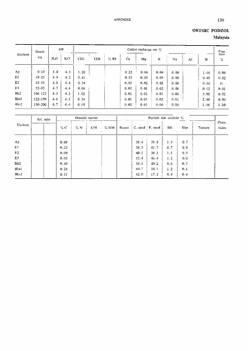
HorizonDepth
cm
PH Cation exchange me Freeiron
ILO KC1 CEC TEB % BS Ca Mg K Na Al H
Ap 0-10 5.0 4.3 1.20 022 0.06 0.04 0.06 1.66 0.09El 10-25 4.9 4.2 0.41 0.55 0.03 0.03 0.06 0.48 0.02E2 25-55 4.8 4.4 0.24 0.02 0.02 0.02 0.06 0.36 tr.E3 55-95 4.7 4.4 0.06 0.01 0.01 0.02 0.06 0.12 0.01Bh2 104-122 4.5 4.2 1.02 0.01 0.01 0.01 0.06 3.98 0.52Bhsl 122-150 4.6 4.5 0.54 0.01 0.01 0.02 0.01 2.48 0.90Bhs2 150-200 4.7 4.4 0.18 0.02 0.01 0.06 0.06 1.56 1.10
Horizon
Sol. salts Organic matter Particle size analysis %Flocc.
index% C % N C/N % OM Stones C. sand F. sand Silt Slay Texture
Ap 0.68 58.6 38.8 1.8 0.7El 0.23 56.5 41.7 0.7 0.9E2 0.09 60.1 38.3 1.1 0.5E3 0.03 52.4 46.4 1.2 0.0Bh2 0.40 58.5 40.2 0.6 0.7Bhsl 0.24 64.7 34.1 1.2 0.1Bhs2 0.11 82.0 17.2 0.4 0.4
APPENDIX 139
ORTHIC PODZOL
Malaysia

140 SOIL MAP OF SOUTHEAST ASIA
CAMBIC ARENOSOL Qc
Location
Altitude
Physiography
Drainage
Parent material
Vegetation
Climate
Amphoe Pak Tho, Ratchaburi province, Thailand
30 m (approximately)
Gently undulating (1-3 percent slope) high terrace
Somewhat excessively drained
Old alluvial sandy deposits
Dipterocarpus forest
Monsoon tropical; rainfall 1 200 mm (approx.); rainy season from May throughOctober
Brown (7YR 4/2 moist) to pinkish grey (7.5YR 6/2 diy) loamy sand; single grain;slightly hard dry, very friable moist, non-sticicy, non-plastic wet; many very fineinterstitial, few fine tubular pores; many charcoal pieces; common very fineand few fine and medium roots; clear smooth boundary; pH 6.0.
Reddish brown (5YR 513 moist) to pinkish grey (5yR 7/2 dry) loamy sand; singlegrain; slightly hard dry, very friable moist; many very fine interstitial, few veryfine tubular pores; few worm casts; common very fine and few fine, mediumand coarse roots; gradual smooth boundary; pH 7.0.
Light reddish brown (5yR 6/4 moist) to pinkish grey (5yR 7/2 dry) loamy sand;single grain; slightly hard dry, very friable moist; many very fine and fine inter-stitial pores, few very fine tubular pores; few very fine roots; pH 7.0.
Profile description
A 0-18 cm
AB 18-50 cm
Bw 50-120+ cm

HorizonDepth
pH Cation exchange me % PPPm
KPPm
cm 1-1,01 : 1
KC1:1 1
CEC TEB % BS Ca Mg K Na Extr.acidii y Bray ammon.
acetate
A 0-18 7.3 4.9 3.5 1.9 48 1.2 0.3 0.2 0.2 2.1 13 79
AB 18-50 7.1 5.2 1.5 0.9 64 0.6 0.1 0.1 0.1 0.5 17 35
Bw 50-120 7.1 5.6 0.9 0.5 83 0.3 0.1 tr. 0.1 0.1 9 21
Horizon
Sol. salts Organic matter Particle size analysis % Conduc-tivity
% C % N C/N % OM Stones C. sand F. sand Silt Clay Texture 1 : 5
A 0,52 86 11 3 20
AB 0.10 83 12 5 10
Bw 0.10 84 11 5 10
APPENDIX 141
CAMBIC ARENOSOL
Thailand

142 SOIL MAP OF SOUTHEAST ASIA
HUMIC ANDOSOL Th
Location Palestina, Pile, Camarines Sur, Philippines
Altitude
Physiography Rolling locally steep slopes
Drainage Well drained
Parent material Fine volcanic ash
Vegetation Annual crops
Climate Monsoon tropical; rainfall 2 000 mm (approx.) from May through December
Profile description
Ah 0-30 cm Black (N2/, moist) loam; very fine granular to weak subangular blocky structure;friable, non-sticky and non-plastic; pH 5.3; gradual boundary.
AB 30-58 cm Very dark brown (10YR 2/2 moist) loam; weak fine to coarse subangular blockystructure; friable, non-sticicy, non-plastic; pH 5.5; gradual boundary.
Bwl 58-88 cm Natural ped dark brown (10yR 3/3 moist) and crushed ped brown (10YR moist)silt loam; fine to coarse subangular blocky structure; slightly compact; friable;pH 5.65.
Bw2 88-120 cm Natural ped dark yellowish brown (10YR 4/3 moist) and crushed ped dark yellowishbrown (10YR 4/4 moist) silt loam; very fine to coarse subangular blocky structure;slightly compact; friable; a few tubular fillings (0.5 cm diameter) with the darksurface soil; 10x grass showed some light-coloured mineral crystal (0.5 mmdiameter) in the brown soil at about 100 cm ; pH 6.0.
BC 120-150 cm Natural ped dark brown (10YR 3/3 moist) and crushed ped brown (10YR 4/3moist) silt loam; fine to coarse subangular blocky structure; slightly compact,friable; pH 5.9.
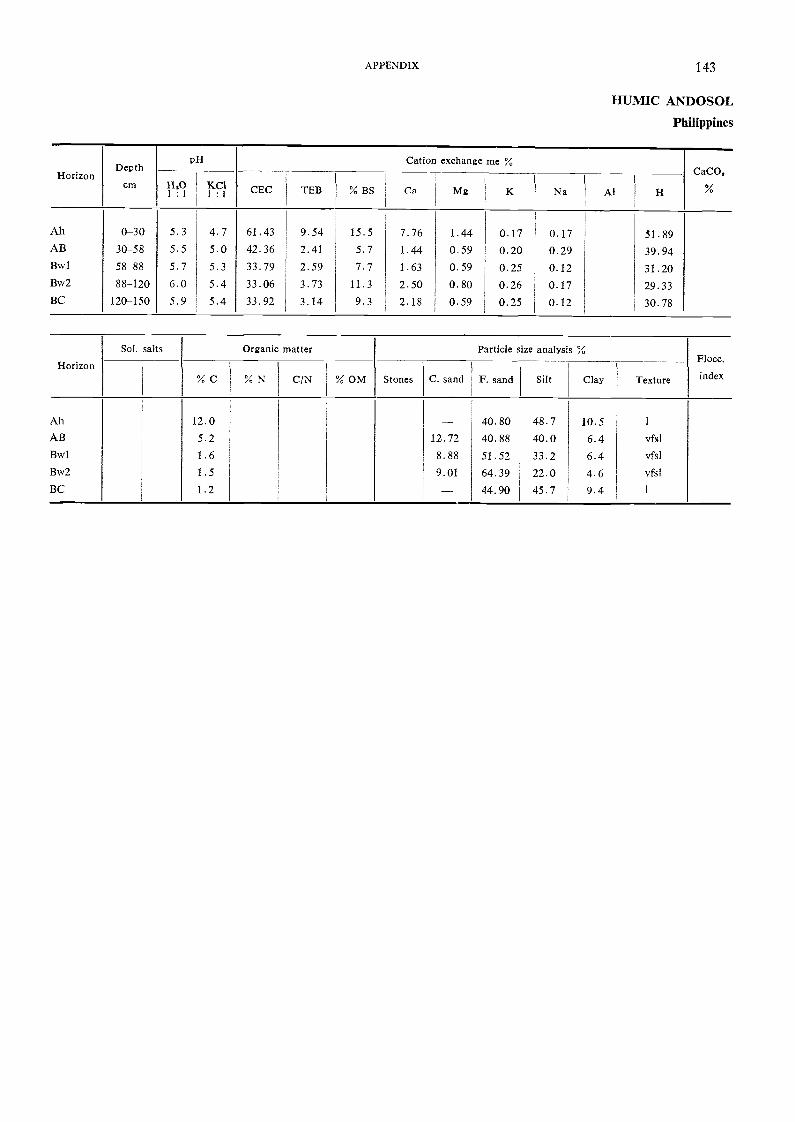
HorizonDepth
cm
pH Cation exchange me %CaCO,
11'°I : I KC'
I : I CEC TED % BS Ca Mg K Na Al H
Ah 0-30 5.3 4.7 61.43 9.54 15.5 7.76 1.44 0.17 0.17 51.89AB 30-58 5.5 5.0 42.36 2.41 5.7 1.44 0.59 0.20 0.29 39.94Bwl 58-88 5.7 5.3 33.79 2.59 7.7 1.63 0.59 0.25 0.12 31.20Bw2 88-120 6.0 5.4 33.06 3.73 11.3 2.50 0.80 0.26 0.17 29.33BC 120-150 5.9 5.4 33.92 3.14 9.3 2.18 0.59 0.25 0.12 30.78
Horizon
Sol. salts Organic matter Particle size analYsis %Flocc.
index% C % N C/N % OM Stones C. sand F. sand Silt Clay Texture
Ah 12.0 - 40.80 48.7 10.5 1
AB 5.2 12.72 40.88 40.0 6.4 vfsl
Ehvl 1.6 8.88 51.52 33.2 6.4 vfsl
Bw2 1.5 9.01 64.39 22.0 4.6 vfM
BC 1.2 -- 44.90 45.7 9.4 1
APPENDIX 143
HUMIC ANDOSOL
Philippines

144 SOIL MAP OF SOUTHEAST ASIA
MOLLIC ANDOSOL
Location
Altitude
Physiography
Drainage
Parent material
Vegetation
Climate
Profile description
Ahl 0-21 cm
Ah2 21-64 cm
Cl 64-83 cm
C2 83-165 cm
C3 165+ cm
Tm
Tjikolo forestry station, Java, Indonesia
1 200 m (approximately)
Undulating to rolling volcanic ridge
Well drained
Volcanic ash
Experimental forest plot
Humid tropical; rainfall 2 200 mm
Dark greyish brown (10YR 3/2) loam; weak very fine crumb; very friable; clearsmooth boundary.
Brown to dark btown (10YR 4/3) sift 1oam; weak very fine crumb to subangu1arblocicy; very friable; clear smooth boundary.Dark brown (10YR 4/3-3/3) clay loam; moderate fine subangular blocky; friableto firm; abrupt smooth boundary.
Black (10YR 2/1) silt loam; weak very fine crumb; friable; clear smooth boundary.
Dark brown (10YR 3/3) clay loam; moderate medium subangular blocky; firm;clay illuviation.

Not determined.
HorizonDepth
cm
PH Cation exchange meCaC0a
H,0 KC1 CEC TEB % BS Ca Mg K Na Al H
All 0-21 5.2 4.7Ah2 21-64 5.7 5.3CI 64-83 5.6 5.302 83-165 5.1 4.703 165+ 5.6 5.3
Horizon
Sol. salts Organic matter Particle size analysis %Flocc.
index% C % N C/N % OM Stones C. sand F. sand Silt Clay Texture
AhlAh2
Cl
C2
C3
10.8
6.2n.d .1
n.d.
n.d.
0.89
0.52n.d.
n.d.
n.d.
12
12
16
20
33
7
7
74
68
59
83
79
10
12
8
10
13
APPENDIX 145
MOLLIC ANDOSOL
Indonesia
146 SOIL MAP OF SOUTHEAST ASIA
CHROMIC 'VERTISOL Vc
Location Nakhon Luang irrigation scheme, Amphoe Tua Rua, Thailand
Altitude
Physiography
Drainage
Parent material
Vegetation
Climate
7mFlat
Somewhat poorly drained
Old clayey alluvial deposit
Transplanted paddy rice
Monsoon tropical; rainfall 1 200 mm (approx.); rainy season from May throughOctober
Dark gleyish brown (10YR 4/2) clay with few coarse sand grains; many finedistinct yellowish red mottles in pores; massive but coarse granular on surface;hard dry, very firm moist, very sticky and very plastic wet; many medium vesic-ular, common very fine and fine tubular and few fine interstitial pores; abruptsmooth boundary.
Dark greyish brown (10YR 4/2) clay with few coarse sand grains; few fine andmedium distinct yellowish red mottles in pores and on ped faces; weak coarseangular blocicy; vety hard dry, very firm moist, very sticky and very plasticwet; few very fine and fine tubular, very few fine vesicular and interstitial pores;clear smooth boundary.
Dark greyish brown (10yR 4/2) clay; very many dark faint yellowish brownand brown mottles; moderate very fine and fine angular blocky; firm moist,very sticky and very plastic wet; many pressure faces; few medium and coarsehard iron-manganese concretions; many fine and very fine tubular and inter-stitial pores; gradual smooth boundary.
Dark yellowish brown (10YR 4/4) clay with few coarse sand grains; commonfine distinct grey mottles; moderate very fine and fine angular blocky; firmmoist, very sticky and very plastic wet; many pressure faces and slickensides;few fine and medium iron-manganese concretions; many fine and very finetubular and interstitial pores.
Profile description
Apl 0-4 cm
Ap2 4-19 cm
Bwl 19-60 cm
Bw2 60-100+ cm

HorizonDepth
pH Cation exchange meCaCO.
cm 1-1201 : 1
KC11 : 1
CEC TEB % BS Ca Mg K Na Al H
Apl 0-4 5.0 3.7 25.4 21.0 64 11.7 8.2 0.3 0.8 11.8 -Ap2 4-19 5.1 4.1 26.1 23.7 70 13.8 8.4 0.4 1.1 10.2 -Bw 1 19-60 5.6 4.5 29.2 24.0 75 13.0 10.2 0.3 1.5 8.2Bw2 60-100 5.5 4.5 28.6 26.8 77 15.8 8.5 0.3 2.2 7.9 -
HorizonConductivity
1 : 5
Organic matter Particle size analysis %Flocc.
EC x 10° % C % N C/N % OM Stones C. sand F. sand Silt Clay Texture index
Apl 25 0.7Ap2 31 0.6Bwl 32 0.2Bw2 26 0.2
APPENDIX 147
CROMIC VERTISOL
Thailand

Ap
AB
Location
AltitudePhysiography
Drainage
Parent materialVegetation
Climate
Profile description
0-18 cm Dark grey (10YR 4/1 moist) and grey (10YR 5/1 dry) heavy clay; many mediumcoarse prominent clear yellowish brown (10YR 5/8) and few fine greenish grey(5G 5/1) mottles concentrated in the lower 10 to 18 cm of the horizon; strongvery coarse prismatic structure breaking under pressure to strong medium andcoarse angular blocky; cracks among the prisms average about 6 cm acrossand increase to a maximum of a.bout 10 cm as the dry season progresses; verysticicy, very plastic, extremely hard; common fine continuous random masstubular simple open pores; few small soft and medium hard spherical blackand very dark brown Mn-Fe concretions; many fine and medium dead riceroots; abrupt smooth boundary; pH 6.5.Dark grey (10YR 4/1 moist) and grey (10YR 5/1 dry) heavy clay; common mediumprominent clear strong brown (7.5YR 5/6) inprism mottles; strong very coarseprismatic structure extending from above and breaking under pressure to weakcoarse blocky cracks extending from above among prisms which are lined withdarker grey mottle-free clay; common coarse oblique slickensides; very sticky;very plastic, hard; few fine discontinuous random inprism tubular simple pores;common small soft spherical black and very dark brown Mn-Fe concretions;few fine dead rice roots concentrated in prism cracks; gradual wavy- boundary;pH 6.8.Light olive grey (5Y 6/2 moist) and light grey (5y 7/2 dry) heavy clay; moderatevery coarse prismatic structure extending from the surface; dark grey clay ma-terial from above coats prism faces along cracks up to 1 cm wide; commoncoarse oblique slickensides; firm, very sticky, very plastic; few fine discontin-uous random inprism open pores; common small hard and soft spherical blackand very dark brown Mn-Fe concretions and films; few fine dead rice roots;gradual smooth boundary; pH 6.8.Olive grey (5y 5/2 moist) and pale olive yellow (5y 7/3 dry) heavy clay; fewmedium faint diffuse light olive brown (2.5y 5/6) mottles; weak coarse andmedium prismatic structure breaking to weak medium and coarse blocky; darkgrey clay exprism coatings; cracks among prisms are essentially closed; commoncoarse and medium oblique slickensides form most of the blocky structure ag-gregate surfaces; sticky, very plastic, firm; very few fine discontinuous randominprism open pores; few fine soft black and dark brown Mn-Fe concretionsand common medium white CaCO3 nodules; very few fine dead mostly exprisinrice roots; gradual wavy boundary; pH 6.8.Light olive grey (5Y 6/2 moist) and light grey (5Y 7/2 dry) heavy clay; weakcoarse prismatic structure breaking to weak coarse and medium blocky diminish-ing to structureless (massive below 150 cm); common coarse and medium obliqueslickensides; very sticky, very plastic, firm; very fine discontinuous randominprism tubular simple pores; few small soft and medium hard spherical blackand very dark brown Mn-Fe concretions and white CaCO3 nodules; very fewfine dead rice roots; pH 7.0.Olive (5y 5/3) heavy clay; few fine faint light grey mottles; very sticky, veryplastic, very firm; few small soft spherical black and dark brown Mn-Fe con-cretions and white irregular CaCO, nodules; pH 7.0.Dark greyish brown (2.5y 4/2) very fine clay; few fine light grey mottles; verysticicy, very plastic, very firm; few small soft spherical black and very dark brownMn-Fe concretions and white irregular CaCO3 nodules; pH 7.0.
18-35 cm
Bwgl 35-57 cm
Bwg2 57-85 cm
BCg 85-150 cm
Cgl 150-170 cm
Cg2 170-220 cm
San Roque, Gapan, Nueva Ecija, Philippines
Slight depression in broad flat alluvial terracePoorly drainedWeakly stratified clayey old alluvial depositRainfed paddy riceMonsoon tropical; rainfall 2 000 mm (approx.) from May through December
148 SOIL MAP OF SOUTHEAST ASIA
PELLIC VERTISOL Vp
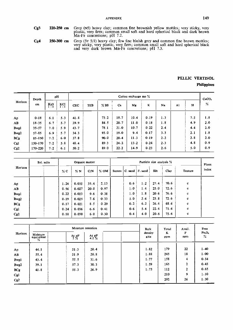
HorizonDepth
cm
pH Cation exchange me %CaCO,
H,01 : I
KC11 : 1
CEC TEB % BS Ca Mg K Na Al H
Ap 0-18 6.1 5.3 41.8 73.2 18.7 10.4 0.19 1.3 7.5 1.8
AB 18-35 6.7 5.7 39.9 84.5 20.7 11.0 0.18 1.8 4.9 2.0Bwg1 35-57 7.0 5.9 43.7 78.1 21.0 10.7 0.22 2.4 4.4 2.0Bwg2 57-85 6.9 5.7 34.3 93.0 19.0 9.4 0.17 3.3 2.1 1.8
BCg 85-150 7.2 6.0 37.8 90.0 20.4 11.3 0.19 2.2 2.8 2.0Cgl 150-170 7.2 5.8 48.4 89.3 24.2 13.2 0.24 2.3 4.8 0.9Cg2 170-220 7.2 6.1 50.2 89.0 22.2 14.9 0.23 2.6 5.0 0.9
Horizon
Sol. salts Organic matter Particle size analysis %Flocc.
index% C % N C/N % OM Stones C. sand F. sand Silt Clay Texture
Ap 1.24 0.035 35.4 2.13 0.6 1.2 27.4 70.6 c
AB 0.56 0.027 20.0 0.97 1.0 I . 4 25.0 72.6 c
Bwgl 0.22 0.023 9.6 0.38 1.0 1.8 20.6 76.6 c
Bwg2 0.19 0.025 7.6 0.33 1.0 2.6 23.8 72.6 c
BCg 0.17 0.021 8.5 0.29 0.2 6.2 26.4 68.6 c
Cgl 0.24 0.036 6.6 0.41 0.6 5.4 22.4 71.6 c
Cg2 0.18 0.030 6.0 0.30 0.4 4.0 20.6 75.6 c
Horizon
Moisture retention Bulkdensityg/cc
TotalK
ppm
Avail.P
ppm
FreeFes%Moisture
equivalent%
At pF2 %
At pF4.2 %
Ap 44.1 51.3 28.4 1.82 179 22 1.40
AB 55.4 51.9 28.8 1.88 245 18 1.00
Bwgl 43.4 55.5 31.6 1.77 158 4 0.54
Bwg2 39.1 57.3 30.3 1.59 165 2 0.45
1342g 41.8 55.3 26.9 1.73 112 2 0.65
Cgl 210 9 1.10
Cg2 292 26 1.30
APPENDIX 149
Cg3 220-250 cm Grey (N5) heavy clay; common fine brownish yellow mottles; very sticky, veryplastic, very firm; common small soft and hard spherical black and dark brownMn-Fe concretions; pH 7.2.
Cg4 250-300 cm Grey (5v 5/1) heavy clay; few fine bluish grey and common fine brown mottles;very sticky, very plastic, very firm; common small soft and hard spherical blackand very dark brown Mn-Fe concretions; pH 7.5.
PELLIC VERTISOL
Philippines

1. CLIMATES
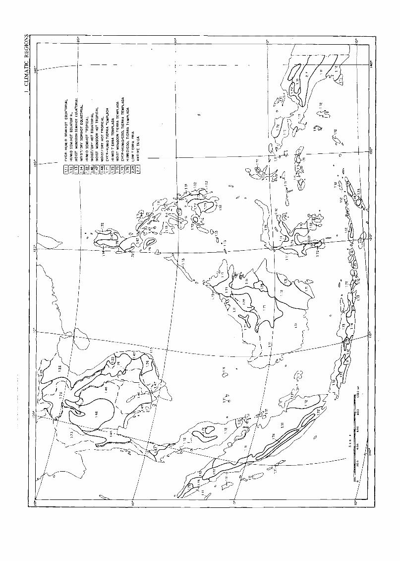
I. C
LIM
AT
IC R
EG
ION
S10
0°
10.
Sca
leA
nsse
ssze
R26
046
060
060
010
00 k
m
GO
°12
0
20.
172
111
1.11
1.12
1.13
1.14
1.22
1.47
1.48
1.71
1.72
1.73
1.75
1.76
2.25 2.
7
EV
ER
-HU
MID
SE
M1H
OT
EQ
UA
TO
RIA
L
HU
MID
SE
MIH
OT
EQ
UA
TO
RIA
L
MO
IST
MO
NS
OO
N S
EM
IHO
T E
OU
AT
OR
IAL
MO
IST
/ DR
Y S
EM
IHO
T E
QU
AT
OR
IAL
HU
MID
SE
MIH
OT
TR
OP
ICA
L
MO
1ST
/DR
Y H
OT
EQ
UA
TO
RIA
L
MO
IST
MO
NS
OO
N H
OT
TR
OP
ICA
L
MO
IST
/DR
Y H
OT
TR
OP
ICA
L
EV
ER
-HU
MID
TIE
RR
A T
EM
PLA
DA
HU
MID
TIE
RR
A T
EM
PLA
DA
MO
IST
MO
NS
OO
N T
IER
RA
TE
MP
LAD
A
EV
ER
-HU
MID
/CO
OL
TIE
RR
A T
EM
PLA
DA
HU
MID
/CO
OL
TIE
RR
A T
EM
PLA
DA
LOW
TIE
RR
A F
RIA
AN
D1N
E T
AIG
A
20°
10°
10°
3014
0°

2. VEGETATION
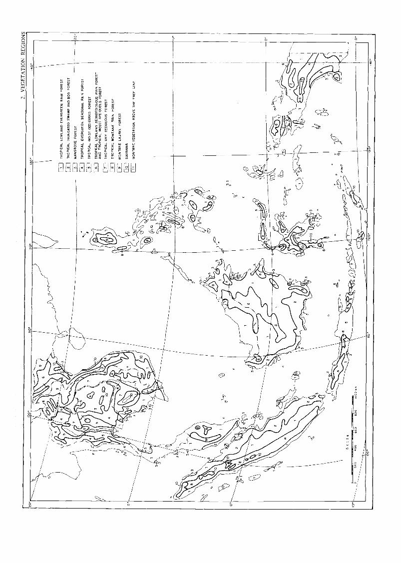
20.
I° o .
OO
.,'..
v Z
UE
1 fk
1 IL
JIN
IIO°
120°
130
I4O
°
nrut
uiN
/
lo
1 7 ,
4
1
D
eo4 / a
3II
10/4
.11!
\ 10
e
Sca
le----
,..
4
30
'
1
O% ililf
9')
7 3
-, 6 \
10g"
-%.
...,. 9 i 0 i
10 \ j 1
10
a
o
' "44
111kiiill"
il il 1
611.
1011
111.
-r1
Ii
IT
RO
PIC
AL
LOW
LAN
D E
VE
RG
RE
EN
RA
IN F
OR
ES
T
12
IT
RO
PIC
AL
INU
ND
AT
ED
SW
AM
P A
ND
BO
G F
OR
ES
T
,.0.
lifI
3I
MA
NG
RO
VE
1-73
-1T
RO
PIC
AL
b1
5/
TR
OP
ICA
L
aft,
16
IT
RO
PIC
AL
./
7I
TR
OP
ICA
L
I8
IT
RO
PIC
AL
I9
IM
ON
TA
NE
1rm
iS
AV
AN
NA
1I
11I
MO
NT
AN
E
1
'
iff
1
AR
O
FO
RE
ST
EV
ER
GR
EE
N S
EA
SO
NA
L R
AIN
FO
RE
ST
MO
IST
DE
CID
UO
US
FO
RE
ST
LOW
LAN
D S
EM
IDE
CID
UO
US
RA
IN F
OR
ES
TT
RO
PIC
AL
MO
IST
DE
CID
UO
US
FO
RE
ST
DR
Y D
EC
IDU
OU
S F
OR
ES
T
MO
NT
AN
E R
AIN
FO
RE
ST
LAU
RE
L F
OR
ES
T
VE
GE
TA
TIO
N A
BO
VE
TH
E T
RE
E L
INE
1
1I ..-
PP 1...2
(30
"4A
llill
gill
00-1
I 8
\166
.
1e3
& 1 G
0-1
' '
/A
OC
=>
1 ..
.../
tlit,
ealla
.te
C D
.f
11. V
I
10
11, i
40 i i
iif
.r I
AP.
Aile
P
o
4111
11ku
/0"i
irje
. 10
lb:.
1711
r--
----
0_A
481b
4PU
I1
e
2
i I
I 1
I!o
" "
" "
Ill1
"."
' 1
.4 :
., ,..
4 3
1 1
I %
% ,.4 i 1
I 1
4 e
A4
1 IL
i a.(
::
kill
11".
,(3si
o,o
200
400
600
00 0
4 00
0r6
100°
110
420.
30.
40°

3. OCEANIC BASINS AND MORPHOSTRUCTURAL REGIONS
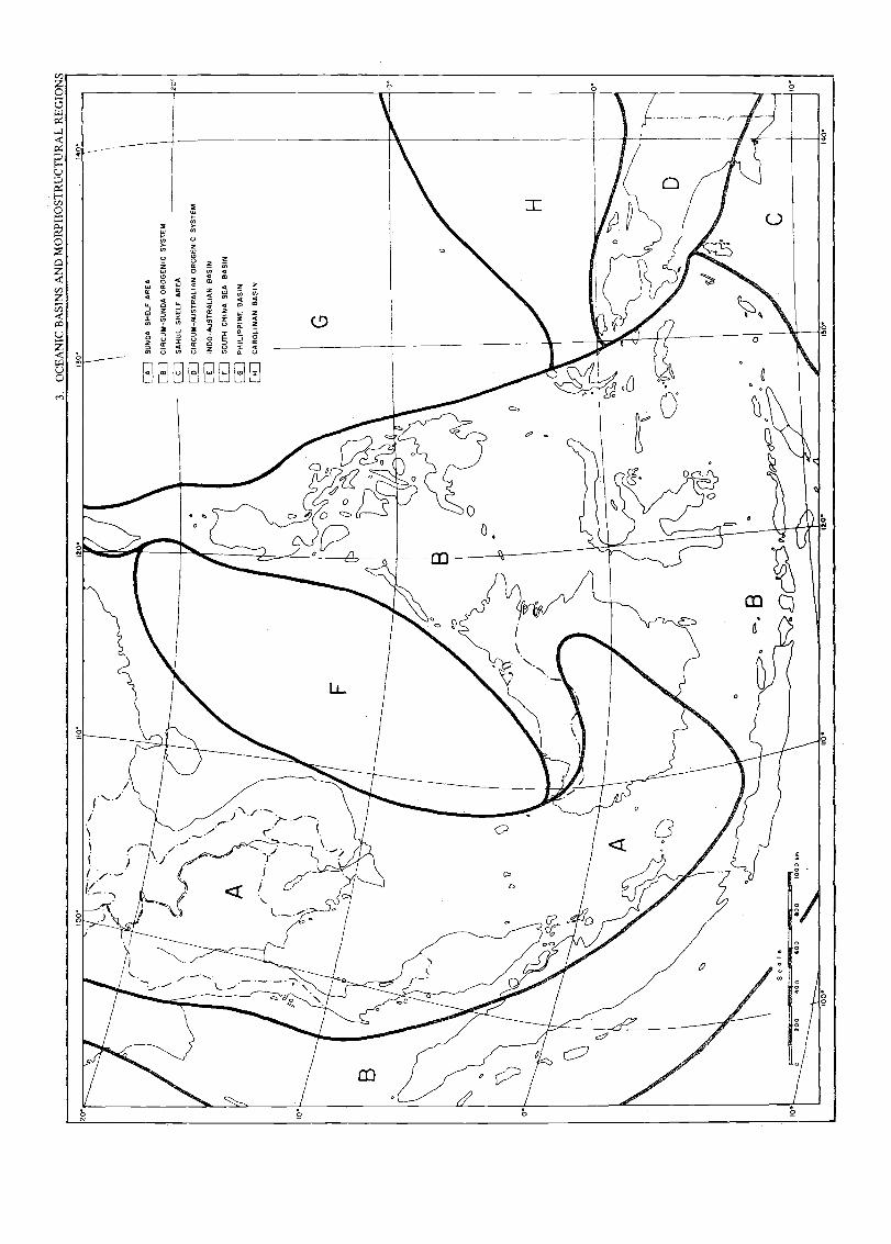
200
400
600
800
1000
%R
N
110
12.0
.1
011
140.
C B
ASI
NS
AN
D M
OR
PHO
STR
UC
TU
RA
L R
EG
100°
110°
120
1306
1406

4. GEOLOGY
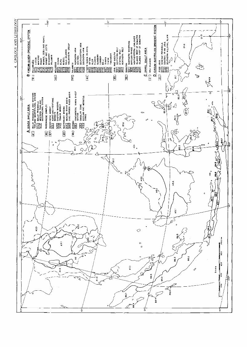
20.
00°
no.
IZO
.1
0.40
....
.... .
AS
ON
DA
SH
ELF
AR
EA
B C
IRC
UM
-SU
ND
A O
RO
GE
NIC
SY
ST
EM
4-1
0
illir
[ Al 1
MA
LAY
PE
NIN
SU
LA A
NO
WE
ST
ER
N[ 8
1 I
PH
ILIP
PIN
tS44
A3.
3T
HA
ILA
ND
GE
OS
YN
CLI
NA
L S
YS
TE
M18
1.1
LUZ
ON
.I
A1,
1M
ALA
Y P
EN
INS
ULA
[81.
2L
1.21
WE
ST
ER
N T
HA
ILA
ND
[131
.3M
IND
OR
Ol
A2
PA
NA
Y
\ .
GE
OS
YN
CL1
NA
L S
YS
TE
M18
141
A2
1IN
DO
CH
INE
SE
CO
MP
LEX
.
181.
5
NE
GR
OS
, CE
BO
AN
O B
OH
OL
SA
MA
R A
NO
LE
YT
E2
a\
er1A
3 1
IND
OC
HIN
ES
E M
AS
SIF
101.
6M
IND
AN
AO
181.
7o
'11
13.1
1K
OR
AT
AN
D V
IEN
TIA
NE
PA
LAW
AN
MA
SS
IFS
152
1M
OLU
CC
AS
IA3.
21 E
AS
TE
RN
MA
SS
IFS
82.1
CE
RA
M(A
1.2
\A
3.1
s...
1A3.
3]T
ON
KIN
MA
SS
IF
( A
4 1
QU
AT
ER
NA
RY
BA
SIN
S
822
82.3
BU
RU
MI 5
00L
I..)
184.
11M
EK
ON
G R
IVE
R B
AS
IN82
.4S
ULA
ISLA
ND
S
'''1A
4.21
CH
AO
PH
RA
YA
RIV
ER
BA
SIN
[6-n
i HA
LMA
HE
RA
GR
OU
P
DA
2.
.1/
N.
1
( A
S 1
BO
RN
EO
(MI C
ON
TIN
EN
TA
L S
UN
DA
SH
ELF
183
1S
ULA
WE
SI
83./
NO
RT
HE
RN
AR
M
00I
A3.
2S
EC
TO
R[1
33.2
]C
EN
TR
AL
10°
\IA
52I E
MB
ALU
H Z
ON
E11
33.3
1S
OU
TH
EA
ST
ER
N A
RM
0 o
--i
[A5.
31K
UC
HIN
G A
NO
ME
RA
TU
S18
341
SO
UT
HE
RN
AR
MN
ZO
NE
S1
841
LES
SE
R S
ON
DA
ISLA
ND
S
0
°
184.
1)W
ET
AR
1842
1A
LOR
Ill
1843
1F
LOR
ES
184.
4]S
UM
8AW
A
1r04
.51
LOM
BO
K18
4.6]
BA
LI
I'}11
1841
1S
UM
BA
o[8
4.8]
TI
MO
R10
a0 o
[134
.9]
TA
NIM
BA
RB
1.7
[BS
)JA
VA
AN
O M
AD
UR
A
0o
185.
11S
OU
TH
ER
N B
ELT
185.
2]C
EN
TR
AL
BE
LT0
Clil
iflo
ililit
il
185.
31N
OR
TH
ER
N B
ELT
al°
I86
.1S
UM
AT
RA
1861
]N
OR
TH
ER
N M
OU
NT
AIN
Sou
r18
6.21
BA
RIS
AN
RA
NG
E13
6.4
l
''N\
0
DV
(3A
5.2
CZ
,18
6.31
NO
RT
HE
AS
TE
RN
LO
WLA
ND
Sa
436.
41IS
LAN
DS
WE
ST
OF
SU
MA
TR
A18
6.5]
ISLA
ND
S E
AS
T O
F S
UM
AT
RA
°. ,
,0
o/
CS
AH
UL
SH
ELF
AR
EA
c..
o0
VO
oPo
../[
CI
]A
RU
ISLA
ND
Sc/
86.4
e
fA
5. 2
DC
IRC
UM
-AU
ST
RA
LIA
N O
RO
GE
NIC
SY
ST
EM
0/
._.
....
Di
1IR
IAN
JA
YA
86.2
C>
,82
.5.
1011
.311
1111
111
101.
1)D
OB
ER
AI P
EN
INS
ULA
[01.
21C
EN
TR
AL
IR
IAN
JA
YA
.01
.31
SO
UT
HE
RN
ALL
UV
IAL
PLA
INB
6.4
62o
SJII
.to
.
6.5
o82
.4(5
.---
",
82.3
allb
01.2
424
E16
.2
(N.Y
1060
40
ed
CI
o0
o01
.3
e
. \o
oc.
eo
4,,
'491B.
a0
1 1
Scal
e.6
6 if
1120
..O
C?<
741:
::52.
10*
200
400
600
600
MO
O %
a10
4./
4111
14,,u
pei
SIP
IE4
100
110°
120°
130°
140°

5. LITHOLOGY
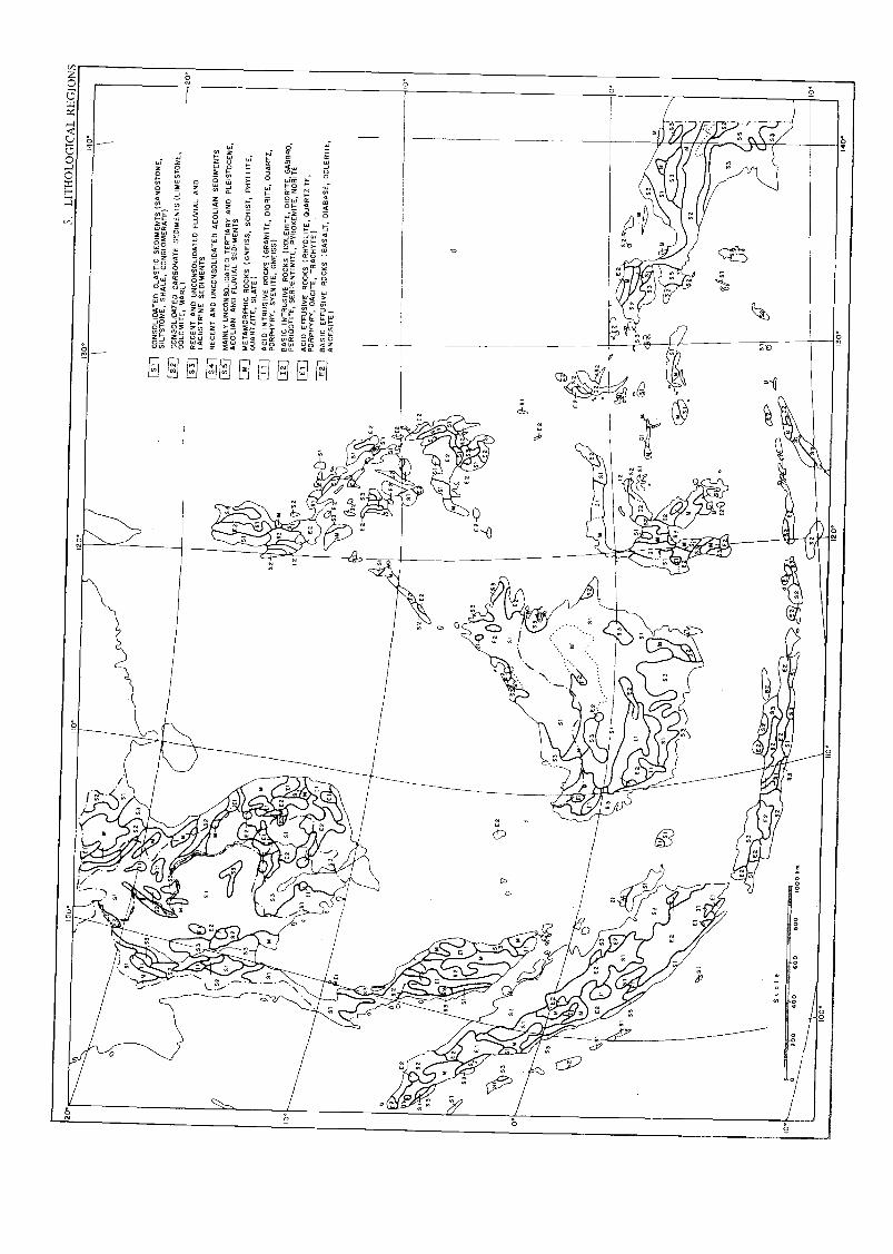
Sca
le
soo
000
1000
em
ED
CO
NS
OLI
DA
TE
D C
LAS
TIC
SE
DIM
EN
TS
(SA
ND
ST
ON
E,
SIL
TS
TO
NE
, SH
ALE
, CO
NG
LOM
ER
AT
E)
52C
ON
SO
LID
AT
ED
CA
RB
ON
AT
E S
EO
IME
NT
S (
LIM
ES
TO
NE
,D
OLO
MIT
E, M
AR
L)
Eli
RE
CE
NT
AN
D U
NC
ON
SO
LID
AT
ED
FLU
VIA
L A
ND
LAC
US
TR
INE
SE
DIM
EN
TS
El R
EC
EN
T A
ND
UN
CO
NS
OLI
DA
TE
DA
EO
LIA
N S
ED
IME
NT
S11
11 M
AIN
LY U
NC
ON
SO
LID
AT
ED
TE
RT
IAR
YA
NO
PLE
IST
OC
EN
E,
AE
OLI
AN
AN
D F
LUV
IAL
SE
DIM
EN
TO
:=1
ME
TA
MO
RP
HIC
RO
CK
S (
GN
EIS
S,
SC
HIS
T, P
HY
LLIT
E,
QU
AR
TZ
ITE
, SLA
TE
)
E: A
CID
INT
RU
SIV
E R
OC
KS
(G
RA
NIT
E,
DIO
RIT
E, Q
UA
RT
Z,
PO
RP
HY
RY
, SY
EN
ITE
, GN
EIS
S)
Elj
BA
SIC
INT
RU
SIV
E R
OC
KS
(D
OLE
RIT
E, D
IOR
ITE
, GA
BB
RO
,P
ER
IDO
TIT
E, S
ER
PE
NT
INIT
E, P
YR
OX
EN
ITE
, NO
RIT
E
[12]
AC
ID E
FF
US
IVE
RO
CK
S(R
HY
OLI
TE
, QU
AR
TZ
ITE
,P
OR
PH
YR
Y, D
AC
ITE
, TR
AC
HY
TE
)
11::
BA
SIC
EF
FU
SIV
E R
OC
KS
(B
AS
ALT
,D
IAB
AS
E, D
OLE
RIT
E,
AN
DE
SIT
E)
5IT
HO
LO
GIC
AL
RE
G O
NS

6. PHYSIOGRAPHY

6. P
HY
SIO
GR
APH
IC R
EG
ION
S
Sea
le
IQ°
020
040
060
060
010
00 k
m
10°
120°
014
0°
IND
OC
HIN
ES
E P
EN
INS
ULA
MA
LAY
PE
NIN
SU
LAIb
WE
ST
ER
N H
IGH
LAN
DS
CE
NT
RA
L H
IGH
LAN
DS
Lid
iK
OR
AT
PL
AT
EA
U
EA
ST
ER
N H
IGH
LAN
DS
NO
RT
HE
RN
HIG
HLA
ND
S
CH
AO
PH
RA
YA
LO
WLA
ND
S
hi M
EK
ON
G L
OW
LAN
DS
BO
RN
EO
PH
ILIP
PIN
ES
MO
LUC
CA
S
SU
LAW
ES
I
LES
SE
R S
UN
DA
ISLA
ND
S
JAV
A A
ND
MA
DU
RA
SU
MA
TR
A
AR
U IS
LAN
DS
IRIA
N J
AY
A
LUZ
ON
MI N
OO
RO
PA
NA
Y
NE
GR
OS
, CE
BU
AN
D B
OH
OL
SA
MA
R A
ND
LE
YT
E
MIN
DA
NA
O
PA
LAW
AN
CE
RA
M
BU
RU
MIS
OO
L08
/S
ULA
ISLA
ND
SH
ALM
AH
ER
A
WE
TA
R
ALO
R
FLO
RE
S
SU
M/E
MM
A
LOM
8OK
BA
LI
SU
MB
A
TIM
OR
TA
N/M
BA
R
110.
120
130.
140°

7. SOILS

7.SO
IL R
EG
ION
S
Sca
le
100°
IIOIZ
O.
I0.
140°
FLU
VIS
OL-
GLE
YS
OL
AS
SO
CLA
TIO
N O
F T
HE
CH
AO
PH
RA
YA
, ME
KO
NG
AN
O R
ED
RIV
ER
DE
LTA
S
FLU
VIS
OL-
GLE
YS
OL
AS
SO
CIA
TIO
N O
F IR
IAN
JA
YA
, TH
E C
1RC
UM
-S
UN
DA
AR
CH
IPE
LAG
OE
S A
ND
TH
E M
ALA
Y P
EN
INS
ULA
GLE
YS
OL-
VE
RT
ISO
L A
SS
OC
IAT
ION
OF
LA
KE
TO
NLE
LIT
HO
SO
LS
AR
EN
OS
OL-
AC
RIS
OL
AS
SO
CIA
TIO
N O
ff B
OR
NE
O
RE
ND
ZIN
AS
AN
DO
SO
LS O
F T
HE
MO
LUC
CA
S A
ND
LE
SS
ER
SU
ND
A IS
LAN
DS
AN
DO
SO
L-W
VIS
OL
AS
SO
CIA
TIO
N O
F J
AV
AV
ER
TIS
OL-
FLU
ViS
OL
AS
SO
CIA
TIO
N O
F J
AV
A A
ND
MA
DU
RA
CA
MB
ISO
LS O
F IR
IAN
JA
YA
CA
MB
ISO
L-A
ND
OS
OL
AS
SO
CIA
TIO
N O
F S
UM
AT
RA
CA
MB
I5O
L-LU
VIS
OL-
N1T
O5O
L A
SS
OC
IAT
ION
OF
TH
E P
HIL
IPP
INE
S
LUV
ISO
LS
PO
DZ
OLS
OF
SU
MA
TR
A A
ND
BO
RN
EO
AC
R1S
OLS A
CR
1SO
LS O
F C
ON
TIN
EN
TA
L S
OU
TH
EA
ST
AS
IA
AC
R1S
OLS
OF
TH
E M
ALA
Y P
EN
INS
ULA
AC
R1S
OLS
OF
SU
MA
TR
A
AC
R1S
OLS
OF
BO
RN
EO
AC
RIS
OLS
OF
SU
LAW
ES
I
AC
RIS
OLS
OF
IRIA
N J
AY
A
AC
RIS
OL-
GLE
YS
OL
AS
SO
CIA
TIO
N O
F T
HE
KO
RA
T P
LAT
EA
U
AC
RIS
OL-
NIT
OS
OL
AS
SO
CIA
TIO
N O
F J
AV
A
lSi
AC
RIS
OL-
CA
MB
ISO
L A
SS
OC
IAT
ION
OF
TH
E M
OLU
CC
AS
AC
RIS
OL-
NIT
OS
OL
AS
SO
CIA
TIO
N O
F T
HE
PH
ILIP
PIN
ES
N1T
OS
OLS
OF
TH
AsL
AN
D A
ND
LA
O
NIT
OS
OL-
AC
RIS
OL
AS
SO
CIA
TIO
N O
F T
HE
PH
ILIP
PIN
ES
FE
RR
ALS
OLS
HI S
TO
SO
LS
100°
110°
120°
130°
140°
ISBN 92-3-101363-7