fall 2013 levee maintenance deficiency summary report · pdf filedwr ucip field study 0.20 ......
TRANSCRIPT
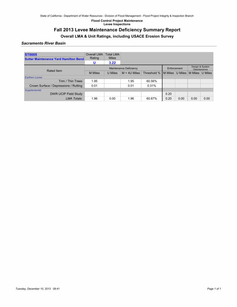
State of California - Department of Water Resources - Division of Flood Management - Flood Project Integrity & Inspection Branch
Flood Control Project MaintenanceLevee Inspections
Fall 2013 Levee Maintenance Deficiency Summary ReportOverall LMA & Unit Ratings, including USACE Erosion Survey
Sacramento River Basin
Overall LMARating
U
Total LMAMiles
3.22Design & System
Obsolescence
M Miles M + 4U Miles Threshold %U Miles M Miles U Miles
Enforcement
Sutter Maintenance Yard Hamilton BendST0005
Rated ItemM Miles U Miles
Maintenance Deficiancy
Earthen Levee
1.95 60.56%1.95Trim / Thin Trees
0.01 0.31%0.01Crown Surface / Depressions / Rutting Supplemental
0.20DWR UCIP Field Study
1.96 60.87%1.96 0.00 0.20 0.00LMA Totals: 0.00 0.00
Tuesday, December 10, 2013 08:41 Page 1 of 1
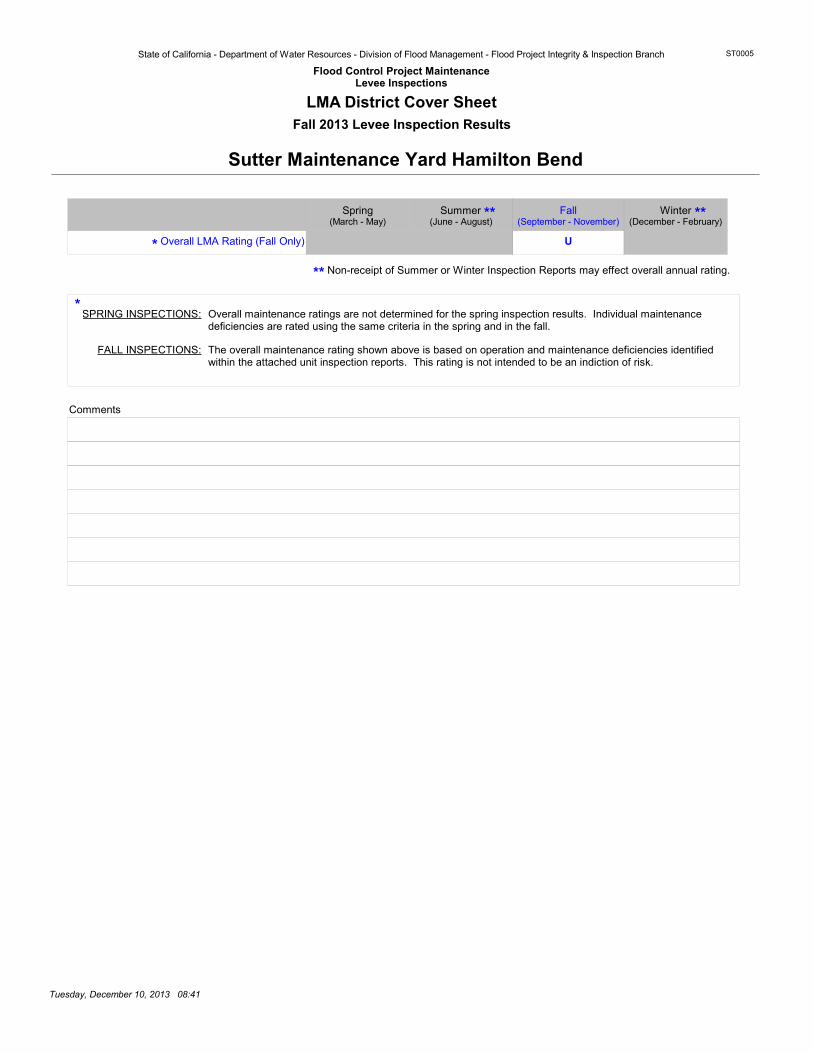
State of California - Department of Water Resources - Division of Flood Management - Flood Project Integrity & Inspection Branch
Flood Control Project MaintenanceLevee Inspections
ST0005
LMA District Cover SheetFall 2013 Levee Inspection Results
Sutter Maintenance Yard Hamilton Bend
Non-receipt of Summer or Winter Inspection Reports may effect overall annual rating.
Overall LMA Rating (Fall Only)
Comments
Overall maintenance ratings are not determined for the spring inspection results. Individual maintenance deficiencies are rated using the same criteria in the spring and in the fall.
SPRING INSPECTIONS:
FALL INSPECTIONS: The overall maintenance rating shown above is based on operation and maintenance deficiencies identified within the attached unit inspection reports. This rating is not intended to be an indiction of risk.
*
*
**
U
Summer Winter(September - November)
Spring Fall(June - August) (December - February)(March - May)
** **
Tuesday, December 10, 2013 08:41

State of California - Department of Water Resources - Division of Flood Management - Flood Project Integrity & Inspection Branch
Flood Control Project MaintenanceLevee Inspections
ST0005
Unit Cover SheetFall 2013 Levee Inspection Results
Sutter Maintenance Yard Hamilton Bend
Waterway
Unit No. 01 Feather River Hamilton Bend
Bank
Right
Unit Miles
3.22
Summer Winter
Date of Inspection
(September - November)
10/21/2013 - 10/21/2013
Unit Maintenance Rating (Fall Only)
SpringFall(June - August) (December - February)(March - May)
U
04/23/2013 - 04/23/2013
DWR Inspector Matthew HoffmanRick Burnett
Sutter Maintenance YardSutter Maintenance YardJason CooperAccompanied By Jason Cooper
If the LMA is unable to submit information on this webpage, please contact DWR for assistance.
The Local Maintaining Agency (LMA) is responsible for summer and winter inspections. The LMA is required to submit a report regarding summer and winter inspections to the California Department of Water Resources (DWR).
DWR must be informed on the: a) completion of the inspection b) any changes other than the results of normal maintenance c) corrections to deficiencies noted in this report
If additional items are noted, further documentation of those items must also be submitted.
The LMA should submit this information to DWR using the LMA web application tool available at:
http://cdec.water.ca.gov/lma.html
The LMA should submit the information and any associated documentation by September 30 for summer inspections and March 31 for winter inspections.
Summer & Winter Inspections
Tuesday, December 10, 2013 08:41
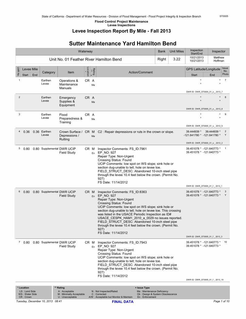
State of California - Department of Water Resources - Division of Flood Management - Flood Project Integrity & Inspection Branch
Flood Control Project MaintenanceLevee Inspections
ST0005
Levee Inspection Report By Mile - Fall 2013
Waterway
Unit No. 01 Feather River Hamilton Bend
Bank
Right
Unit Miles
3.22
InspectionStart/End
10/21/201310/21/2013
Sutter Maintenance Yard Hamilton BendInspector
MatthewHoffman
Issue No.
StartStart EndCategory Item
Loc
atio
n*
Ratin
g ** + Action/Comment
Levee Mile GPS Latitude/Longitude
End Photo
LMR
No
.
Earthen Levee
A °°° °
CR1 Operations & Maintenance Manuals
7
Ma
DWR ID: DWR_ST0005_01_s _ 2013_7
Earthen Levee
A °°° °
CR2 Emergency Supplies & Equipment
8
Ma
DWR ID: DWR_ST0005_01_s _ 2013_8
Earthen Levee
A °°° °
CR3 Flood Preparedness & Training
9
Ma
DWR ID: DWR_ST0005_01_s _ 2013_9
0.36 0.36 Earthen Levee
M C2 : Repair depressions or ruts in the crown or slope. 39.444939 °39.444939-121.641780 -121.641780
°° °
CR4
YCrown Surface / Depressions / Rutting
2
Ma
DWR ID: DWR_ST0005_01_s _ 2013_2
0.80 0.80 Supplemental M Inspector Comments: FS_ID:7961EP_NO: 927Repair Type: Non-UrgentCrossing Status: FoundUCIP Comments: low spot on WS slope; sink hole or section dug-unable to tell; hole on levee toe.FIELD_STRUCT_DESC: Abandoned 10-inch steel pipe through the levee 10.4 feet below the crown. (Permit No. 927)FS Date: 11/14/2012
39.451078 °-121.64077339.451078 -121.640773
°° °
CR5 DWR UCIP Field Study
1
En
DWR ID: DWR_ST0005_01_f _ 2013_1
0.80 0.80 Supplemental M Inspector Comments: FS_ID:8363EP_NO: 927Repair Type: Non-UrgentCrossing Status: FoundUCIP Comments: low spot on WS slope; sink hole or section dug-unable to tell; hole on levee toe. This crossing was listed in the USACE Periodic Inspection as ID# USACE_CESPK_HAM1_2010_a_0029 no issues reported.FIELD_STRUCT_DESC: Abandoned 10-inch steel pipe through the levee 10.4 feet below the crown. (Permit No. 927)FS Date: 11/14/2012
39.451078 °-121.64077339.451078 -121.640773
°° °
CR6
YDWR UCIP Field Study
3
En
DWR ID: DWR_ST0005_01_f _ 2013_3
0.80 0.80 Supplemental M Inspector Comments: FS_ID:7943EP_NO: 927Repair Type: Non-UrgentCrossing Status: FoundUCIP Comments: low spot on WS slope; sink hole or section dug-unable to tell; hole on levee toe.FIELD_STRUCT_DESC: Abandoned 10-inch steel pipe through the levee 10.4 feet below the crown. (Permit No. 927)FS Date: 11/14/2012
39.451078 °-121.64077339.451078 -121.640773
°° °
CR7 DWR UCIP Field Study
10
En
DWR ID: DWR_ST0005_01_f _ 2013_10
Page 1 of 10Tuesday, December 10, 2013 08:41 FINAL DATA
* Location
: Land Side: Water Side: Crown
LSWSCR
: Acceptable: Minimally Acceptable: Unacceptable
AMU
** Rating
NC
A/W
MaObEn
: Not Inspected/Rated: Corrected: Acceptable but Monitor & Maintain
: Maintenance Deficiancy: Design & System Obsolescence: Enforcement
+ Issue Type
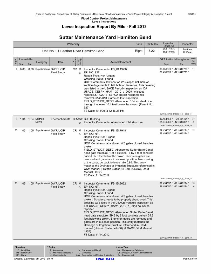
State of California - Department of Water Resources - Division of Flood Management - Flood Project Integrity & Inspection Branch
Flood Control Project MaintenanceLevee Inspections
ST0005
Levee Inspection Report By Mile - Fall 2013
Waterway
Unit No. 01 Feather River Hamilton Bend
Bank
Right
Unit Miles
3.22
InspectionStart/End
10/21/201310/21/2013
Sutter Maintenance Yard Hamilton BendInspector
MatthewHoffman
Issue No.
StartStart EndCategory Item
Loc
atio
n*
Ratin
g ** + Action/Comment
Levee Mile GPS Latitude/Longitude
End Photo
LMR
No
.
0.80 0.80 Supplemental M Inspector Comments: FS_ID:13237EP_NO: 927Repair Type: Non-UrgentCrossing Status: FoundUCIP Comments: low spot on WS slope; sink hole or section dug-unable to tell; hole on levee toe. This crossing was listed in the USACE Periodic Inspection as ID# USACE_CESPK_HAM1_2010_a_0029 no issues reported.5/14/2013 SBFCA project recommends removal.5/14/2013 Same as last inspection.FIELD_STRUCT_DESC: Abandoned 10-inch steel pipe through the levee 10.4 feet below the crown. (Permit No. 927)FS Date: 5/14/2013 12:46:25 PM
39.451078 °-121.64077339.451078 -121.640773
°° °
CR8 DWR UCIP Field Study
11
En
DWR ID: DWR_ST0005_01_f _ 2013_11
1.04 1.04 Earthen Levee
A/W BU : BuildingInspector Comments: Abandoned inlet structure.
39.454464 °39.454464-121.640361 -121.640361
°° °
CR9
YEncroachments 28
EnDWR ID: DWR_ST0005_01_f _ 2013_28
1.05 1.05 Supplemental M Inspector Comments: FS_ID:7948EP_NO: N/ARepair Type: Non-UrgentCrossing Status: FoundUCIP Comments: abandoned WS gates closed; handles brokenFIELD_STRUCT_DESC: Abandoned Sutter Butte Canal head gate structure, 1 of 6 culverts, 6 by 8 foot concrete culvert 35.8 feet below the crown. Stems on gates are removed and gates are in a closed position. No crossing at the canal, go back to levee mile 0.95. This entry matches the Drainage or Irrigation Structure referenced in O&M manual (Historic Station 47+00). (USACE O&M Manual, 1957)FS Date: 11/14/2012
39.454557 °-121.64027439.454557 -121.640274
°° °
CR10 DWR UCIP Field Study
12
En
DWR ID: DWR_ST0005_01_f _ 2013_12
1.05 1.05 Supplemental M Inspector Comments: FS_ID:8662EP_NO: N/ARepair Type: Non-UrgentCrossing Status: FoundUCIP Comments: abandoned WS gates closed; handles broken; Structure needs to be properly abandoned. This crossing was listed in the USACE Periodic Inspection as ID# USACE_CESPK_HAM1_2010_a_0043 no issues reported.FIELD_STRUCT_DESC: Abandoned Sutter Butte Canal head gate structure, Six 6 by 8 foot concrete culvert 35.8 feet below the crown. Stems on gates are removed and gates are in a closed position. This entry matches the Drainage or Irrigation Structure referenced in O&M manual (Historic Station 47+00). (USACE O&M Manual, 1957)FS Date: 11/14/2012
39.454557 °-121.64027439.454557 -121.640274
°° °
CR11
YDWR UCIP Field Study
13
En
DWR ID: DWR_ST0005_01_f _ 2013_13
Page 2 of 10Tuesday, December 10, 2013 08:41 FINAL DATA
* Location
: Land Side: Water Side: Crown
LSWSCR
: Acceptable: Minimally Acceptable: Unacceptable
AMU
** Rating
NC
A/W
MaObEn
: Not Inspected/Rated: Corrected: Acceptable but Monitor & Maintain
: Maintenance Deficiancy: Design & System Obsolescence: Enforcement
+ Issue Type

State of California - Department of Water Resources - Division of Flood Management - Flood Project Integrity & Inspection Branch
Flood Control Project MaintenanceLevee Inspections
ST0005
Levee Inspection Report By Mile - Fall 2013
Waterway
Unit No. 01 Feather River Hamilton Bend
Bank
Right
Unit Miles
3.22
InspectionStart/End
10/21/201310/21/2013
Sutter Maintenance Yard Hamilton BendInspector
MatthewHoffman
Issue No.
StartStart EndCategory Item
Loc
atio
n*
Ratin
g ** + Action/Comment
Levee Mile GPS Latitude/Longitude
End Photo
LMR
No
.
1.05 1.05 Supplemental M Inspector Comments: FS_ID:13240EP_NO: N/ARepair Type: Non-UrgentCrossing Status: FoundUCIP Comments: abandoned WS gates closed; handles broken; Structure needs to be properly abandoned. This crossing was listed in the USACE Periodic Inspection as ID# USACE_CESPK_HAM1_2010_a_0043 no issues reported.5/14/2013 SBFCA project report says the structure will need to be removed and the levee built back up in its place. MHM will include demo plan and levee civil will prepare plans for new levee.5/14/2013 Same as last inspection.FIELD_STRUCT_DESC: Abandoned Sutter Butte Canal head gate structure, Six 6 by 8 foot concrete culvert 35.8 feet below the crown. Stems on gates are removed and gates are in a closed position. This entry matches the Drainage or Irrigation Structure referenced in O&M manual (Historic Station 47+00). (USACE O&M Manual, 1957)FS Date: 5/14/2013 12:51:18 PM
39.454557 °-121.64027439.454557 -121.640274
°° °
CR12 DWR UCIP Field Study
14
En
DWR ID: DWR_ST0005_01_f _ 2013_14
1.05 1.05 Supplemental M Inspector Comments: FS_ID:13241EP_NO: N/ARepair Type: Non-UrgentCrossing Status: FoundUCIP Comments: abandoned WS gates closed; handles broken; Structure needs to be properly abandoned. This crossing was listed in the USACE Periodic Inspection as ID# USACE_CESPK_HAM1_2010_a_0043 no issues reported.5/14/2013 Same as last inspection.FIELD_STRUCT_DESC: Abandoned Sutter Butte Canal head gate structure, Six 6 by 8 foot concrete culvert 35.8 feet below the crown. Stems on gates are removed and gates are in a closed position. This entry matches the Drainage or Irrigation Structure referenced in O&M manual (Historic Station 47+00). (USACE O&M Manual, 1957)FS Date: 5/14/2013 12:56:41 PM
39.454557 °-121.64027439.454557 -121.640274
°° °
CR13 DWR UCIP Field Study
15
En
DWR ID: DWR_ST0005_01_f _ 2013_15
Page 3 of 10Tuesday, December 10, 2013 08:41 FINAL DATA
* Location
: Land Side: Water Side: Crown
LSWSCR
: Acceptable: Minimally Acceptable: Unacceptable
AMU
** Rating
NC
A/W
MaObEn
: Not Inspected/Rated: Corrected: Acceptable but Monitor & Maintain
: Maintenance Deficiancy: Design & System Obsolescence: Enforcement
+ Issue Type
State of California - Department of Water Resources - Division of Flood Management - Flood Project Integrity & Inspection Branch
Flood Control Project MaintenanceLevee Inspections
ST0005
Levee Inspection Report By Mile - Fall 2013
Waterway
Unit No. 01 Feather River Hamilton Bend
Bank
Right
Unit Miles
3.22
InspectionStart/End
10/21/201310/21/2013
Sutter Maintenance Yard Hamilton BendInspector
MatthewHoffman
Issue No.
StartStart EndCategory Item
Loc
atio
n*
Ratin
g ** + Action/Comment
Levee Mile GPS Latitude/Longitude
End Photo
LMR
No
.
1.05 1.05 Supplemental M Inspector Comments: FS_ID:8364EP_NO: N/ARepair Type: Non-UrgentCrossing Status: FoundUCIP Comments: abandoned WS gates closed; handles broken; This crossing was listed in the USACE Periodic Inspection as ID# USACE_CESPK_HAM1_2010_a_0043 no issues reported.FIELD_STRUCT_DESC: Abandoned Sutter Butte Canal head gate structure, 1 of 6 culverts, 6 by 8 foot concrete culvert 35.8 feet below the crown. Stems on gates are removed and gates are in a closed position. No crossing at the canal, go back to levee mile 0.95. This entry matches the Drainage or Irrigation Structure referenced in O&M manual (Historic Station 47+00). (USACE O&M Manual, 1957)FS Date: 11/14/2012
39.454557 °-121.64027439.454557 -121.640274
°° °
CR14 DWR UCIP Field Study
16
En
DWR ID: DWR_ST0005_01_f _ 2013_16
1.15 1.15 Supplemental M Inspector Comments: FS_ID:7950EP_NO: N/ARepair Type: Non-UrgentCrossing Status: Indicator FoundUCIP Comments: top of slide gate visible from levee; slide gate buriedFIELD_STRUCT_DESC: Abandoned 24-inch pipe through the levee 16.5 feet below the crown. Slide gate in CM riser on the waterward slope.FS Date: 11/14/2012
39.455926 °-121.63966039.455926 -121.639660
°° °
CR15 DWR UCIP Field Study
17
En
DWR ID: DWR_ST0005_01_f _ 2013_17
1.17 1.17 Supplemental M Inspector Comments: FS_ID:13238EP_NO: N/ARepair Type: Non-UrgentCrossing Status: Indicator FoundUCIP Comments: Abandoned structure: Structure is non-operational, slide gate is completely buried; top of slide gate barely visible from levee;5/14/2013 Same as last inspection.FIELD_STRUCT_DESC: Abandoned 24-inch pipe through the levee 16.5 feet below the crown. Slide gate in CM riser on the waterward slope. No features of structure were found with the exception of slide gate frame.FS Date: 5/14/2013 12:48:22 PM
39.456287 °-121.63953039.456287 -121.639530
°° °
CR16
YDWR UCIP Field Study
18
En
DWR ID: DWR_ST0005_01_f _ 2013_18
Page 4 of 10Tuesday, December 10, 2013 08:41 FINAL DATA
* Location
: Land Side: Water Side: Crown
LSWSCR
: Acceptable: Minimally Acceptable: Unacceptable
AMU
** Rating
NC
A/W
MaObEn
: Not Inspected/Rated: Corrected: Acceptable but Monitor & Maintain
: Maintenance Deficiancy: Design & System Obsolescence: Enforcement
+ Issue Type
State of California - Department of Water Resources - Division of Flood Management - Flood Project Integrity & Inspection Branch
Flood Control Project MaintenanceLevee Inspections
ST0005
Levee Inspection Report By Mile - Fall 2013
Waterway
Unit No. 01 Feather River Hamilton Bend
Bank
Right
Unit Miles
3.22
InspectionStart/End
10/21/201310/21/2013
Sutter Maintenance Yard Hamilton BendInspector
MatthewHoffman
Issue No.
StartStart EndCategory Item
Loc
atio
n*
Ratin
g ** + Action/Comment
Levee Mile GPS Latitude/Longitude
End Photo
LMR
No
.
1.17 1.17 Supplemental M Inspector Comments: FS_ID:7962EP_NO: N/ARepair Type: Non-UrgentCrossing Status: Indicator FoundUCIP Comments: Abandoned structure: Structure is non-operational, slide gate is completely buried; top of slide gate barely visible from levee;FIELD_STRUCT_DESC: Abandoned 24-inch pipe through the levee 16.5 feet below the crown. Slide gate in CM riser on the waterward slope. No features of structure were found with the exception of slide gate frame.FS Date: 11/14/2012
39.456287 °-121.63953039.456287 -121.639530
°° °
CR17 DWR UCIP Field Study
19
En
DWR ID: DWR_ST0005_01_f _ 2013_19
1.17 1.17 Supplemental M Inspector Comments: FS_ID:7955EP_NO: N/ARepair Type: Non-UrgentCrossing Status: Indicator FoundUCIP Comments: top of slide gate visible from levee; slide gate buriedFIELD_STRUCT_DESC: Abandoned 24-inch pipe through the levee 16.5 feet below the crown. Slide gate in CM riser on the waterward slope.FS Date: 11/14/2012
39.456287 °-121.63953039.456287 -121.639530
°° °
CR18 DWR UCIP Field Study
20
En
DWR ID: DWR_ST0005_01_f _ 2013_20
1.41 3.18 Earthen Levee
M T3 : Trim and thin trees to allow visibility of the ground and room to flood fight.
39.458060 °39.470433-121.636332 -121.609200
°° °
LS19
YTrim / Thin Trees
4
MaDWR ID: DWR_ST0005_01_s _ 2013_4
1.44 1.62 Earthen Levee
M T3 : Trim and thin trees to allow visibility of the ground and room to flood fight.
39.458255 °39.459451-121.635808 -121.633670
°° °
WS20
YTrim / Thin Trees
5
MaDWR ID: DWR_ST0005_01_s _ 2013_5
2.04 2.12 Earthen Levee
C C1 : Add appropriate material and re-grade the levee to bring the crown above the design elevation.
39.462914 °39.463526-121.627650 -121.626435
°° °
CR21 Crown Surface / Depressions / Rutting
6
Ma
DWR ID: DWR_ST0005_01_s _ 2013_6
3.16 3.16 Supplemental M Inspector Comments: FS_ID:7954EP_NO: N/ARepair Type: Non-UrgentCrossing Status: Indicator FoundUCIP Comments: Abandoned Structure: WS- reminince of gates and concrete standpipe; LS-reminince of concrete headwall and pump station.FIELD_STRUCT_DESC: Abandoned western canal head gate inlet structure. One (1) of 2 culverts, 8 by 8-foot concrete culverts through the levee 25.0 feet below the crown. Three slide gates on the waterward end. Concrete stairs on the waterward slope. Concrete headwall at both toes. This entry matches the Drainage or Irrigation Structure referenced in O&M manual (Historic Station 170+00). (USACE O&M Manual, 1957)FS Date: 11/14/2012
39.469686 °-121.61036539.469686 -121.610365
°° °
CR22 DWR UCIP Field Study
21
En
DWR ID: DWR_ST0005_01_f _ 2013_21
Page 5 of 10Tuesday, December 10, 2013 08:41 FINAL DATA
* Location
: Land Side: Water Side: Crown
LSWSCR
: Acceptable: Minimally Acceptable: Unacceptable
AMU
** Rating
NC
A/W
MaObEn
: Not Inspected/Rated: Corrected: Acceptable but Monitor & Maintain
: Maintenance Deficiancy: Design & System Obsolescence: Enforcement
+ Issue Type

State of California - Department of Water Resources - Division of Flood Management - Flood Project Integrity & Inspection Branch
Flood Control Project MaintenanceLevee Inspections
ST0005
Levee Inspection Report By Mile - Fall 2013
Waterway
Unit No. 01 Feather River Hamilton Bend
Bank
Right
Unit Miles
3.22
InspectionStart/End
10/21/201310/21/2013
Sutter Maintenance Yard Hamilton BendInspector
MatthewHoffman
Issue No.
StartStart EndCategory Item
Loc
atio
n*
Ratin
g ** + Action/Comment
Levee Mile GPS Latitude/Longitude
End Photo
LMR
No
.
3.17 3.17 Supplemental M Inspector Comments: FS_ID:7964EP_NO: N/ARepair Type: Non-UrgentCrossing Status: Indicator FoundUCIP Comments: Abandoned Structure: WS- reminince of gates and concrete standpipe; LS-reminince of concrete headwall and pump station.FIELD_STRUCT_DESC: Abandoned western canal head gate inlet structure. Two (2) of 2 culverts, 8 by 8-foot concrete culverts through the levee 25.0 feet below the crown. Three slide gates on the waterward end. Concrete stairs on the waterward slope. Concrete headwall at both toes. This entry matches the Drainage or Irrigation Structure referenced in O&M manual (Historic Station 170+00). (USACE O&M Manual, 1957)FS Date: 11/14/2012
39.470269 °-121.60922939.470269 -121.609229
°° °
CR23 DWR UCIP Field Study
22
En
DWR ID: DWR_ST0005_01_f _ 2013_22
3.17 3.17 Supplemental M Inspector Comments: FS_ID:7963EP_NO: N/ARepair Type: Non-UrgentCrossing Status: Indicator FoundUCIP Comments: Abandoned Structure: WS- reminince of gates and concrete standpipe; LS-reminince of concrete headwall and pump station.FIELD_STRUCT_DESC: Abandoned western canal head gate inlet structure. One (1) of 2 culverts, 8 by 8-foot concrete culverts through the levee 25.0 feet below the crown. Three slide gates on the waterward end. Concrete stairs on the waterward slope. Concrete headwall at both toes. This entry matches the Drainage or Irrigation Structure referenced in O&M manual (Historic Station 170+00). (USACE O&M Manual, 1957)FS Date: 11/14/2012
39.470269 °-121.60922939.470269 -121.609229
°° °
CR24
YDWR UCIP Field Study
23
En
DWR ID: DWR_ST0005_01_f _ 2013_23
3.17 3.17 Supplemental M Inspector Comments: FS_ID:13243EP_NO: N/ARepair Type: Non-UrgentCrossing Status: Indicator FoundUCIP Comments: Abandoned Structure: WS- reminince of gates and concrete standpipe; LS-reminince of concrete headwall and pump station.5/14/2013 Same as last inspection.FIELD_STRUCT_DESC: Abandoned western canal head gate inlet structure. Two (2) of 2 culverts, 8 by 8-foot concrete culverts through the levee 25.0 feet below the crown. Three slide gates on the waterward end. Concrete stairs on the waterward slope. Concrete headwall at both toes. This entry matches the Drainage or Irrigation Structure referenced in O&M manual (Historic Station 170+00). (USACE O&M Manual, 1957)FS Date: 5/14/2013 12:58:44 PM
39.470269 °-121.60922939.470269 -121.609229
°° °
CR25 DWR UCIP Field Study
24
En
DWR ID: DWR_ST0005_01_f _ 2013_24
Page 6 of 10Tuesday, December 10, 2013 08:41 FINAL DATA
* Location
: Land Side: Water Side: Crown
LSWSCR
: Acceptable: Minimally Acceptable: Unacceptable
AMU
** Rating
NC
A/W
MaObEn
: Not Inspected/Rated: Corrected: Acceptable but Monitor & Maintain
: Maintenance Deficiancy: Design & System Obsolescence: Enforcement
+ Issue Type
State of California - Department of Water Resources - Division of Flood Management - Flood Project Integrity & Inspection Branch
Flood Control Project MaintenanceLevee Inspections
ST0005
Levee Inspection Report By Mile - Fall 2013
Waterway
Unit No. 01 Feather River Hamilton Bend
Bank
Right
Unit Miles
3.22
InspectionStart/End
10/21/201310/21/2013
Sutter Maintenance Yard Hamilton BendInspector
MatthewHoffman
Issue No.
StartStart EndCategory Item
Loc
atio
n*
Ratin
g ** + Action/Comment
Levee Mile GPS Latitude/Longitude
End Photo
LMR
No
.
3.17 3.17 Supplemental M Inspector Comments: FS_ID:13242EP_NO: N/ARepair Type: Non-UrgentCrossing Status: Indicator FoundUCIP Comments: Abandoned Structure: WS- reminince of gates and concrete standpipe; LS-reminince of concrete headwall and pump station.5/14/2013 Same as last inpsection.FIELD_STRUCT_DESC: Abandoned western canal head gate inlet structure. One (1) of 2 culverts, 8 by 8-foot concrete culverts through the levee 25.0 feet below the crown. Three slide gates on the waterward end. Concrete stairs on the waterward slope. Concrete headwall at both toes. This entry matches the Drainage or Irrigation Structure referenced in O&M manual (Historic Station 170+00). (USACE O&M Manual, 1957)FS Date: 5/14/2013 12:57:57 PM
39.470269 °-121.60922939.470269 -121.609229
°° °
CR26 DWR UCIP Field Study
25
En
DWR ID: DWR_ST0005_01_f _ 2013_25
3.17 3.17 Supplemental M Inspector Comments: FS_ID:7953EP_NO: N/ARepair Type: Non-UrgentCrossing Status: Indicator FoundUCIP Comments: Abandoned Structure: WS- reminince of gates and concrete standpipe; LS-reminince of concrete headwall and pump station.FIELD_STRUCT_DESC: Abandoned western canal head gate inlet structure. Two (2) of 2 culverts, 8 by 8-foot concrete culverts through the levee 25.0 feet below the crown. Three slide gates on the waterward end. Concrete stairs on the waterward slope. Concrete headwall at both toes. This entry matches the Drainage or Irrigation Structure referenced in O&M manual (Historic Station 170+00). (USACE O&M Manual, 1957)FS Date: 11/14/2012
39.470269 °-121.60922939.470269 -121.609229
°° °
CR27 DWR UCIP Field Study
26
En
DWR ID: DWR_ST0005_01_f _ 2013_26
3.17 3.17 Supplemental M Inspector Comments: FS_ID:7956EP_NO: N/ARepair Type: Non-UrgentCrossing Status: Indicator FoundUCIP Comments: Abandoned Structure: WS- reminince of gates and concrete standpipe; LS-reminince of concrete headwall and pump station.FIELD_STRUCT_DESC: Abandoned western canal head gate inlet structure. One (1) of 2 culverts, 8 by 8-foot concrete culverts through the levee 25.0 feet below the crown. Three slide gates on the waterward end. Concrete stairs on the waterward slope. Concrete headwall at both toes. This entry matches the Drainage or Irrigation Structure referenced in O&M manual (Historic Station 170+00). (USACE O&M Manual, 1957)FS Date: 11/14/2012
39.470269 °-121.60922939.470269 -121.609229
°° °
CR28 DWR UCIP Field Study
27
En
DWR ID: DWR_ST0005_01_f _ 2013_27
Page 7 of 10Tuesday, December 10, 2013 08:41 FINAL DATA
* Location
: Land Side: Water Side: Crown
LSWSCR
: Acceptable: Minimally Acceptable: Unacceptable
AMU
** Rating
NC
A/W
MaObEn
: Not Inspected/Rated: Corrected: Acceptable but Monitor & Maintain
: Maintenance Deficiancy: Design & System Obsolescence: Enforcement
+ Issue Type
State of California - Department of Water Resources - Division of Flood Management - Flood Project Integrity & Inspection Branch
Flood Control Project MaintenanceLevee Inspections
ST0005
Levee Inspection Report By Mile - Fall 2013
Waterway
Unit No. 01 Feather River Hamilton Bend
Bank
Right
Unit Miles
3.22
InspectionStart/End
10/21/201310/21/2013
Sutter Maintenance Yard Hamilton BendInspector
MatthewHoffman
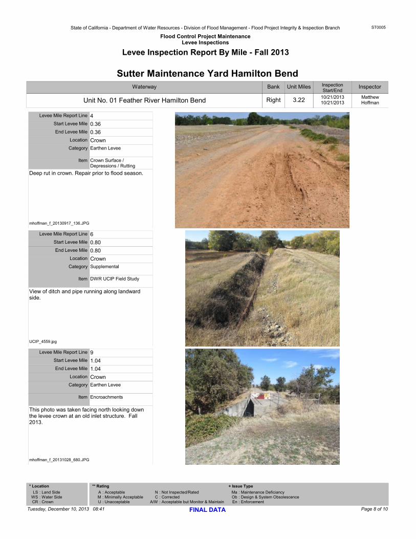
Deep rut in crown. Repair prior to flood season.
Start Levee Mile 0.36End Levee Mile 0.36
Levee Mile Report Line 4
Category Earthen Levee
Item Crown Surface / Depressions / Rutting
Location Crown
mhoffman_f_20130917_136.JPG
View of ditch and pipe running along landward side.
Start Levee Mile 0.80End Levee Mile 0.80
Levee Mile Report Line 6
Category Supplemental
Item DWR UCIP Field Study
Location Crown
UCIP_4559.jpg
This photo was taken facing north looking down the levee crown at an old inlet structure. Fall 2013.
Start Levee Mile 1.04End Levee Mile 1.04
Levee Mile Report Line 9
Category Earthen Levee
Item Encroachments
Location Crown
mhoffman_f_20131028_680.JPG
Page 8 of 10Tuesday, December 10, 2013 08:41 FINAL DATA
* Location
: Land Side: Water Side: Crown
LSWSCR
: Acceptable: Minimally Acceptable: Unacceptable
AMU
** Rating
NC
A/W
MaObEn
: Not Inspected/Rated: Corrected: Acceptable but Monitor & Maintain
: Maintenance Deficiancy: Design & System Obsolescence: Enforcement
+ Issue Type
State of California - Department of Water Resources - Division of Flood Management - Flood Project Integrity & Inspection Branch
Flood Control Project MaintenanceLevee Inspections
ST0005
Levee Inspection Report By Mile - Fall 2013
Waterway
Unit No. 01 Feather River Hamilton Bend
Bank
Right
Unit Miles
3.22
InspectionStart/End
10/21/201310/21/2013
Sutter Maintenance Yard Hamilton BendInspector
MatthewHoffman
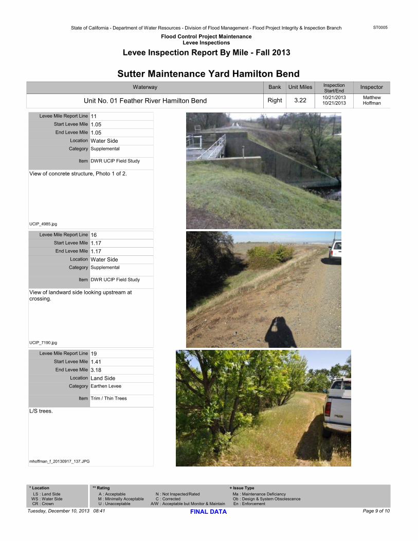
View of concrete structure, Photo 1 of 2.
Start Levee Mile 1.05End Levee Mile 1.05
Levee Mile Report Line 11
Category Supplemental
Item DWR UCIP Field Study
Location Water Side
UCIP_4985.jpg
View of landward side looking upstream at crossing.
Start Levee Mile 1.17End Levee Mile 1.17
Levee Mile Report Line 16
Category Supplemental
Item DWR UCIP Field Study
Location Water Side
UCIP_7190.jpg
L/S trees.
Start Levee Mile 1.41End Levee Mile 3.18
Levee Mile Report Line 19
Category Earthen Levee
Item Trim / Thin Trees
Location Land Side
mhoffman_f_20130917_137.JPG
Page 9 of 10Tuesday, December 10, 2013 08:41 FINAL DATA
* Location
: Land Side: Water Side: Crown
LSWSCR
: Acceptable: Minimally Acceptable: Unacceptable
AMU
** Rating
NC
A/W
MaObEn
: Not Inspected/Rated: Corrected: Acceptable but Monitor & Maintain
: Maintenance Deficiancy: Design & System Obsolescence: Enforcement
+ Issue Type

State of California - Department of Water Resources - Division of Flood Management - Flood Project Integrity & Inspection Branch
Flood Control Project MaintenanceLevee Inspections
ST0005
Levee Inspection Report By Mile - Fall 2013
Waterway
Unit No. 01 Feather River Hamilton Bend
Bank
Right
Unit Miles
3.22
InspectionStart/End
10/21/201310/21/2013
Sutter Maintenance Yard Hamilton BendInspector
MatthewHoffman
W/S trees.
Start Levee Mile 1.44End Levee Mile 1.62
Levee Mile Report Line 20
Category Earthen Levee
Item Trim / Thin Trees
Location Water Side
mhoffman_f_20130917_138.JPG
Pump station located on landward side.
Start Levee Mile 3.17End Levee Mile 3.17
Levee Mile Report Line 24
Category Supplemental
Item DWR UCIP Field Study
Location Water Side
UCIP_3671.jpg
Page 10 of 10Tuesday, December 10, 2013 08:41 FINAL DATA
* Location
: Land Side: Water Side: Crown
LSWSCR
: Acceptable: Minimally Acceptable: Unacceptable
AMU
** Rating
NC
A/W
MaObEn
: Not Inspected/Rated: Corrected: Acceptable but Monitor & Maintain
: Maintenance Deficiancy: Design & System Obsolescence: Enforcement
+ Issue Type