experiences from cultural heritage documentation · pdf fileexperiences from cultural heritage...
TRANSCRIPT
TS06E - Laser Scanning and Photogrammetry, 4992 Orthodoxia Arabatzi, Vassilios Pagounis and Maria Tsakiri Experiences from Cultural Heritage Documentation Using Modern Geodetic Techniques -Monuments at the Acropolis of Athens FIG Working Week 2011 Bridging the Gap between Cultures Marrakech, Morocco, 18-22 May 2011
1/11
Experiences from Cultural Heritage Documentation Using Modern Geodetic Techniques -Monuments at the Acropolis of Athens
Orthodoxia ARABATZI, Vassilios PAGOUNIS and Maria TSAKIRI, Greece
Key words: Terrestrial Laser Scanning; cultural heritage; documentation SUMMARY. The aim of this work is to demonstrate through specific case studies the aspects of documentation and recording of cultural heritage monuments using state-of-the-art geodetic technology. These sites are often under threat from environmental conditions, structural instability, increased tourism and development. Geodetic techniques in combination with other digital documentation techniques, such as state-of-the-art digital imaging total stations and terrestrial laser scanning, provide an extremely useful way to document the spatial characteristics of these sites. The three case studies described in this work involve monuments of significant importance which are located in the area of the Athens Acropolis. The first case study refers to the monument of Klepsydra, the oldest water spring of the Athens Acropolis. A deformation monitoring scheme was required and this is described whilst the results indicated that no statistically significant movement was identified for the measuring period. The second case refers to the monument of Kalliroi, dated circa 6th century BC. For the geometric recording of this monument, a combined use of digital imaging total station surveying and terrestrial laser scanning was implemented to create a 3D model of the main room of the structure. The third case refers to the sanctuary of Pan which comprises a chamber hewn in the rock. Terrestrial laser scanning was implemented in order to create a 3D model of the cave. A discussion based on the different requirements of monument recording is given to address issues posed often by site managers, archaeologists, and conservators who are involved in cultural heritage monument restoration.
TS06E - Laser Scanning and Photogrammetry, 4992 Orthodoxia Arabatzi, Vassilios Pagounis and Maria Tsakiri Experiences from Cultural Heritage Documentation Using Modern Geodetic Techniques -Monuments at the Acropolis of Athens FIG Working Week 2011 Bridging the Gap between Cultures Marrakech, Morocco, 18-22 May 2011
2/11
Experiences from Cultural Heritage Documentation Using Modern Geodetic Techniques -Monuments at the Acropolis of Athens
Orthodoxia ARABATZI, Vassilios PAGOUNIS and Maria TSAKIRI, Greece
1. INTRODUCTION The recording of cultural heritage involves a variety of monuments, buildings, or landscapes of outstanding universal value. These sites are often under threat from a number of reasons such as environmental conditions, structural instability, increased tourism and development. Geodetic techniques in combination with other digital documentation techniques, such as state-of-the-art digital imaging total stations and terrestrial laser scanning, provide an extremely useful way to document the spatial characteristics of these sites. The obtained spatial information forms not only an accurate record of these rapidly deteriorating sites, which can be saved for posterity, but also provides a comprehensive base dataset by which site managers, archaeologists, and conservators can monitor sites and perform necessary restoration work to ensure their physical integrity. In addition, a digital record of these sites also facilitates their accessibility to a broader audience via the Internet. In cultural heritage documentation, the choice for the appropriate technology (sensor, hardware, software), the appropriate procedures, designing the workflow and assuring that the final output is in accordance with the set of technical specifications is always a challenging matter (Patias et al., 2008). The above issues are dependent on the scale of the work including size of objects to be measured and the number of measurements need to be acquired which is related to the complexity of the object. To date there is adequate experience in 3D data acquisition as well as 3D modelling of cultural heritage monuments which can be performed by different approaches, like surveying, laser scanning, photogrammetry, computer vision methods or their combination (Gonzo et al., 2004). Clearly, image-based techniques have simpler data acquisition procedures but with the limitation on capturing continuous surface and give reliable result on smooth surface measurement. In contrast, laser scanning techniques can capture any surface shape with the capability to generate rapidly a very dense 3D point clouds data with a rather good accuracy. Unfortunately, the laser ray cannot identify the colour of the measured surface and the obtained 3D point clouds from the laser scanner are colourless unless a combined model is produced using texture from photographic images. The aim of this work is to demonstrate through specific case studies the aspects of documentation and recording of cultural heritage monuments using state-of-the-art geodetic technology including terrestrial laser scanning and image-based total station technology for different needs regarding the documentation of archaeological monuments. The three case studies involve monuments of significant importance which are located in the area of the Athens Acropolis. The first case study refers to the monument of Klepsydra, the oldest water spring of the Athens Acropolis located at the North Slope. The monument is prone to deformations and the priority of the archaeologists is to establish a permanent monitoring scheme in order to measure movements over time. The monitoring performed through
TS06E - Laser Scanning and Photogrammetry, 4992 Orthodoxia Arabatzi, Vassilios Pagounis and Maria Tsakiri Experiences from Cultural Heritage Documentation Using Modern Geodetic Techniques -Monuments at the Acropolis of Athens FIG Working Week 2011 Bridging the Gap between Cultures Marrakech, Morocco, 18-22 May 2011
3/11
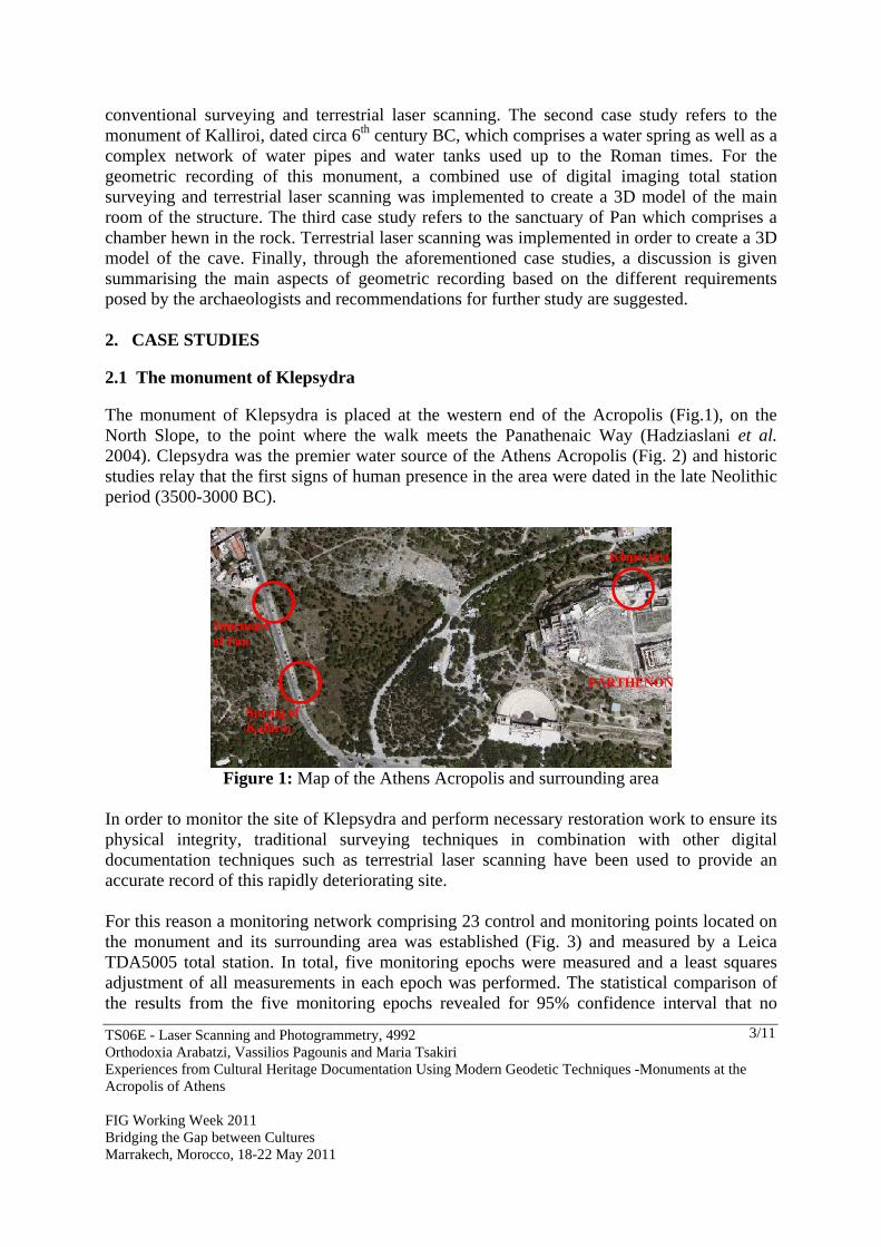
conventional surveying and terrestrial laser scanning. The second case study refers to the monument of Kalliroi, dated circa 6th century BC, which comprises a water spring as well as a complex network of water pipes and water tanks used up to the Roman times. For the geometric recording of this monument, a combined use of digital imaging total station surveying and terrestrial laser scanning was implemented to create a 3D model of the main room of the structure. The third case study refers to the sanctuary of Pan which comprises a chamber hewn in the rock. Terrestrial laser scanning was implemented in order to create a 3D model of the cave. Finally, through the aforementioned case studies, a discussion is given summarising the main aspects of geometric recording based on the different requirements posed by the archaeologists and recommendations for further study are suggested. 2. CASE STUDIES 2.1 The monument of Klepsydra The monument of Klepsydra is placed at the western end of the Acropolis (Fig.1), on the North Slope, to the point where the walk meets the Panathenaic Way (Hadziaslani et al. 2004). Clepsydra was the premier water source of the Athens Acropolis (Fig. 2) and historic studies relay that the first signs of human presence in the area were dated in the late Neolithic period (3500-3000 BC).
Figure 1: Map of the Athens Acropolis and surrounding area
In order to monitor the site of Klepsydra and perform necessary restoration work to ensure its physical integrity, traditional surveying techniques in combination with other digital documentation techniques such as terrestrial laser scanning have been used to provide an accurate record of this rapidly deteriorating site. For this reason a monitoring network comprising 23 control and monitoring points located on the monument and its surrounding area was established (Fig. 3) and measured by a Leica TDA5005 total station. In total, five monitoring epochs were measured and a least squares adjustment of all measurements in each epoch was performed. The statistical comparison of the results from the five monitoring epochs revealed for 95% confidence interval that no
Klepsydra
Sanctuary of Pan
Spring of Kalliroi
PARTHENON
TS06E - Laser Scanning and Photogrammetry, 4992 Orthodoxia Arabatzi, Vassilios Pagounis and Maria Tsakiri Experiences from Cultural Heritage Documentation Using Modern Geodetic Techniques -Monuments at the Acropolis of Athens FIG Working Week 2011 Bridging the Gap between Cultures Marrakech, Morocco, 18-22 May 2011
4/11
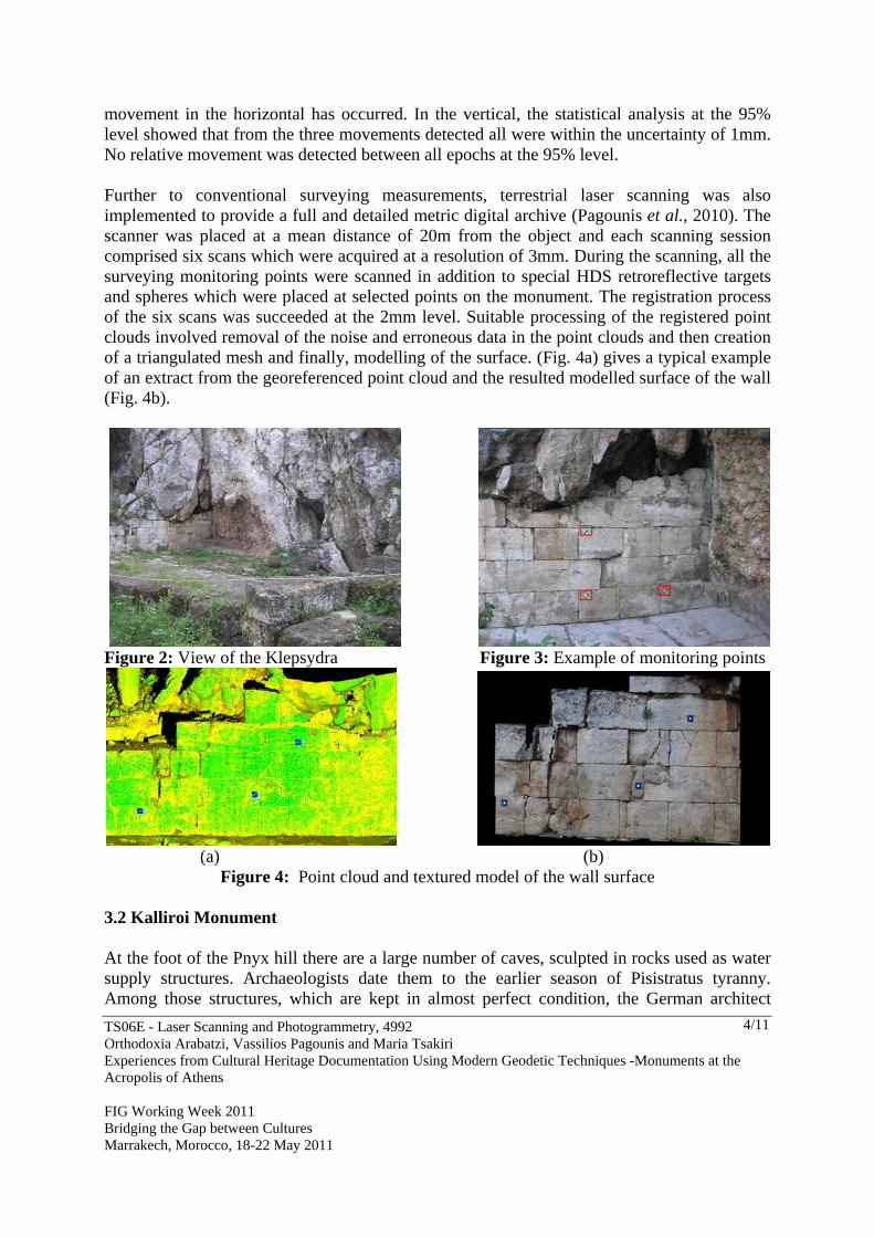
movement in the horizontal has occurred. In the vertical, the statistical analysis at the 95% level showed that from the three movements detected all were within the uncertainty of 1mm. No relative movement was detected between all epochs at the 95% level. Further to conventional surveying measurements, terrestrial laser scanning was also implemented to provide a full and detailed metric digital archive (Pagounis et al., 2010). The scanner was placed at a mean distance of 20m from the object and each scanning session comprised six scans which were acquired at a resolution of 3mm. During the scanning, all the surveying monitoring points were scanned in addition to special HDS retroreflective targets and spheres which were placed at selected points on the monument. The registration process of the six scans was succeeded at the 2mm level. Suitable processing of the registered point clouds involved removal of the noise and erroneous data in the point clouds and then creation of a triangulated mesh and finally, modelling of the surface. (Fig. 4a) gives a typical example of an extract from the georeferenced point cloud and the resulted modelled surface of the wall (Fig. 4b).
Figure 2: View of the Klepsydra Figure 3: Example of monitoring points
(a) (b)
Figure 4: Point cloud and textured model of the wall surface 3.2 Kalliroi Monument At the foot of the Pnyx hill there are a large number of caves, sculpted in rocks used as water supply structures. Archaeologists date them to the earlier season of Pisistratus tyranny. Among those structures, which are kept in almost perfect condition, the German architect
TS06E - Laser Scanning and Photogrammetry, 4992 Orthodoxia Arabatzi, Vassilios Pagounis and Maria Tsakiri Experiences from Cultural Heritage Documentation Using Modern Geodetic Techniques -Monuments at the Acropolis of Athens FIG Working Week 2011 Bridging the Gap between Cultures Marrakech, Morocco, 18-22 May 2011
5/11
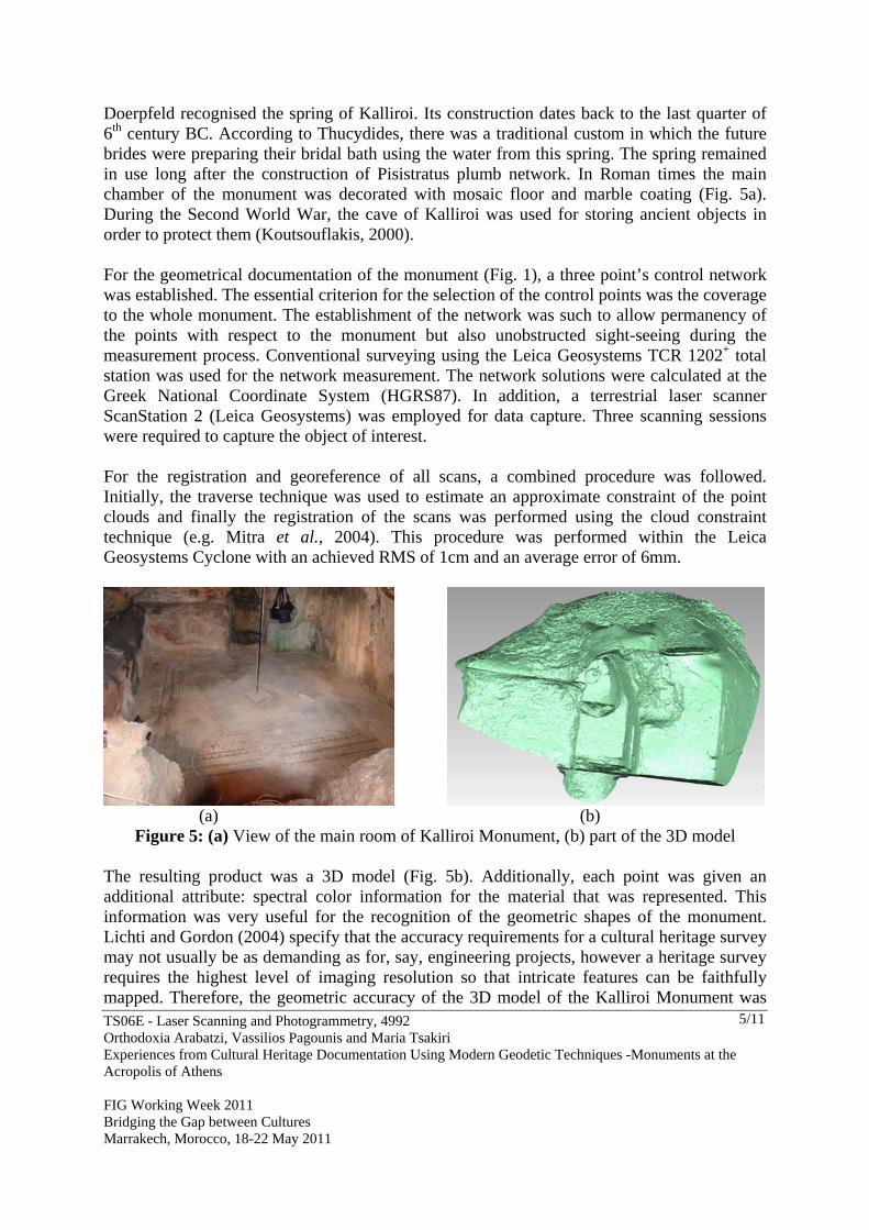
Doerpfeld recognised the spring of Kalliroi. Its construction dates back to the last quarter of 6th century BC. According to Thucydides, there was a traditional custom in which the future brides were preparing their bridal bath using the water from this spring. The spring remained in use long after the construction of Pisistratus plumb network. In Roman times the main chamber of the monument was decorated with mosaic floor and marble coating (Fig. 5a). During the Second World War, the cave of Kalliroi was used for storing ancient objects in order to protect them (Koutsouflakis, 2000). For the geometrical documentation of the monument (Fig. 1), a three point’s control network was established. The essential criterion for the selection of the control points was the coverage to the whole monument. The establishment of the network was such to allow permanency of the points with respect to the monument but also unobstructed sight-seeing during the measurement process. Conventional surveying using the Leica Geosystems TCR 1202+ total station was used for the network measurement. The network solutions were calculated at the Greek National Coordinate System (HGRS87). In addition, a terrestrial laser scanner ScanStation 2 (Leica Geosystems) was employed for data capture. Three scanning sessions were required to capture the object of interest. For the registration and georeference of all scans, a combined procedure was followed. Initially, the traverse technique was used to estimate an approximate constraint of the point clouds and finally the registration of the scans was performed using the cloud constraint technique (e.g. Mitra et al., 2004). This procedure was performed within the Leica Geosystems Cyclone with an achieved RMS of 1cm and an average error of 6mm.
(a) (b)
Figure 5: (a) View of the main room of Kalliroi Monument, (b) part of the 3D model The resulting product was a 3D model (Fig. 5b). Additionally, each point was given an additional attribute: spectral color information for the material that was represented. This information was very useful for the recognition of the geometric shapes of the monument. Lichti and Gordon (2004) specify that the accuracy requirements for a cultural heritage survey may not usually be as demanding as for, say, engineering projects, however a heritage survey requires the highest level of imaging resolution so that intricate features can be faithfully mapped. Therefore, the geometric accuracy of the 3D model of the Kalliroi Monument was

TS06E - Laser Scanning and Photogrammetry, 4992 Orthodoxia Arabatzi, Vassilios Pagounis and Maria Tsakiri Experiences from Cultural Heritage Documentation Using Modern Geodetic Techniques -Monuments at the Acropolis of Athens FIG Working Week 2011 Bridging the Gap between Cultures Marrakech, Morocco, 18-22 May 2011
6/11
verified by a number of control points measured by EDM surveying and the comparison between the laser scanning and the geodetic observations gave differences in x, y, H in the order of 0.8-1.2cm. The archaeologists (from the 1st Prehistoric and Classical Ephorate of Antiquates of Hellenic Ministry of Culture) who are in charge for the conservation of the mosaic in the main room of the monument (Fig. 5a) required spatial information that will facilitate their work. For this reason, an image texture map was produced using the 3D model of the mosaic along with external photographic images (Fig. 6).
(a) (b)
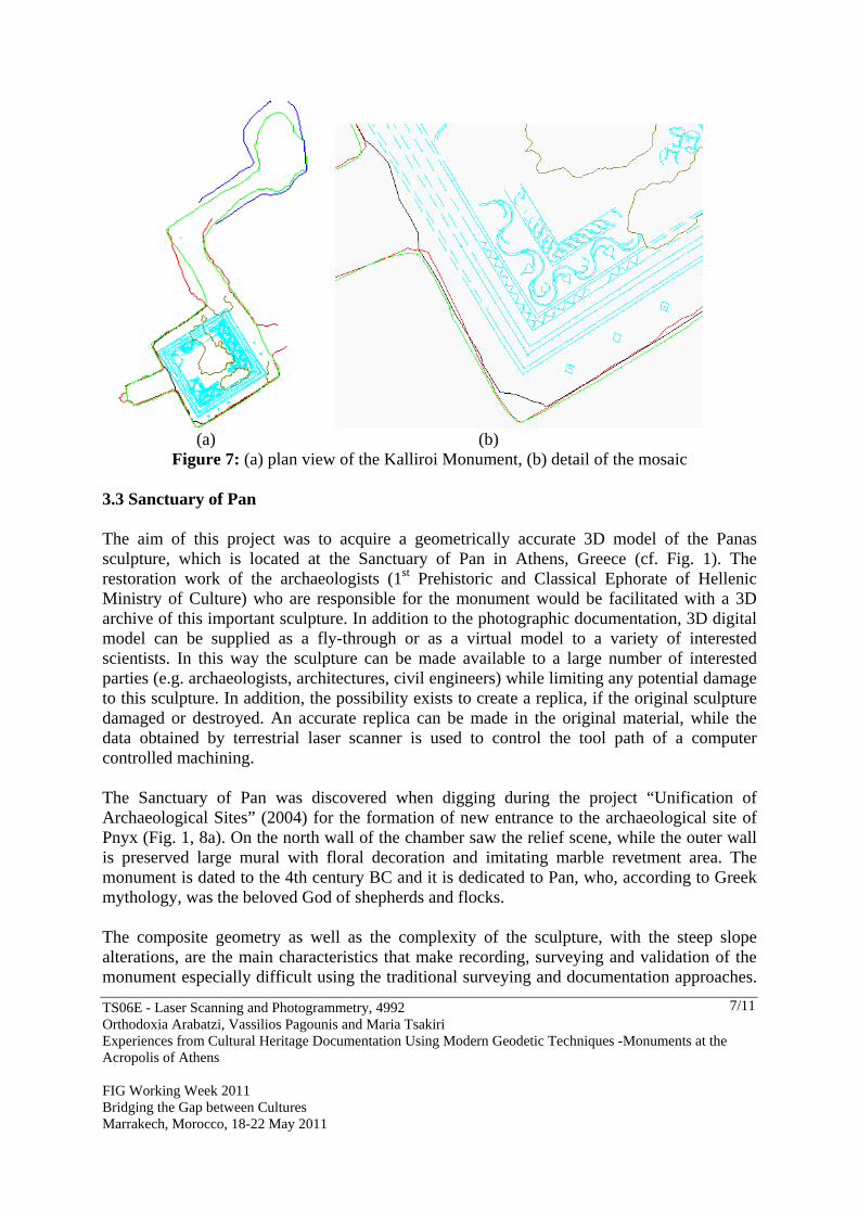
Figure 6: (a) mesh model, (b) image texture map of the mosaic Additionally, from the terrestrial laser scanning data, detailed survey results were obtained in a CAD environment, using CloudWorx (Fig. 7a and 7b):
Plan views in scale 1:50, Sections views in scale 1:50
All the above drawings contain construction details.
TS06E - Laser Scanning and Photogrammetry, 4992 Orthodoxia Arabatzi, Vassilios Pagounis and Maria Tsakiri Experiences from Cultural Heritage Documentation Using Modern Geodetic Techniques -Monuments at the Acropolis of Athens FIG Working Week 2011 Bridging the Gap between Cultures Marrakech, Morocco, 18-22 May 2011
7/11
(a) (b)
Figure 7: (a) plan view of the Kalliroi Monument, (b) detail of the mosaic
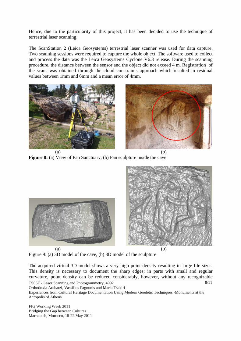
3.3 Sanctuary of Pan The aim of this project was to acquire a geometrically accurate 3D model of the Panas sculpture, which is located at the Sanctuary of Pan in Athens, Greece (cf. Fig. 1). The restoration work of the archaeologists (1st Prehistoric and Classical Ephorate of Hellenic Ministry of Culture) who are responsible for the monument would be facilitated with a 3D archive of this important sculpture. In addition to the photographic documentation, 3D digital model can be supplied as a fly-through or as a virtual model to a variety of interested scientists. In this way the sculpture can be made available to a large number of interested parties (e.g. archaeologists, architectures, civil engineers) while limiting any potential damage to this sculpture. In addition, the possibility exists to create a replica, if the original sculpture damaged or destroyed. An accurate replica can be made in the original material, while the data obtained by terrestrial laser scanner is used to control the tool path of a computer controlled machining. The Sanctuary of Pan was discovered when digging during the project “Unification of Archaeological Sites” (2004) for the formation of new entrance to the archaeological site of Pnyx (Fig. 1, 8a). On the north wall of the chamber saw the relief scene, while the outer wall is preserved large mural with floral decoration and imitating marble revetment area. The monument is dated to the 4th century BC and it is dedicated to Pan, who, according to Greek mythology, was the beloved God of shepherds and flocks. The composite geometry as well as the complexity of the sculpture, with the steep slope alterations, are the main characteristics that make recording, surveying and validation of the monument especially difficult using the traditional surveying and documentation approaches.
TS06E - Laser Scanning and Photogrammetry, 4992 Orthodoxia Arabatzi, Vassilios Pagounis and Maria Tsakiri Experiences from Cultural Heritage Documentation Using Modern Geodetic Techniques -Monuments at the Acropolis of Athens FIG Working Week 2011 Bridging the Gap between Cultures Marrakech, Morocco, 18-22 May 2011
8/11
Hence, due to the particularity of this project, it has been decided to use the technique of terrestrial laser scanning. The ScanStation 2 (Leica Geosystems) terrestrial laser scanner was used for data capture. Two scanning sessions were required to capture the whole object. The software used to collect and process the data was the Leica Geosystems Cyclone V6.3 release. During the scanning procedure, the distance between the sensor and the object did not exceed 4 m. Registration of the scans was obtained through the cloud constraints approach which resulted in residual values between 1mm and 6mm and a mean error of 4mm.
(a) (b)
Figure 8: (a) View of Pan Sanctuary, (b) Pan sculpture inside the cave
(a) (b)
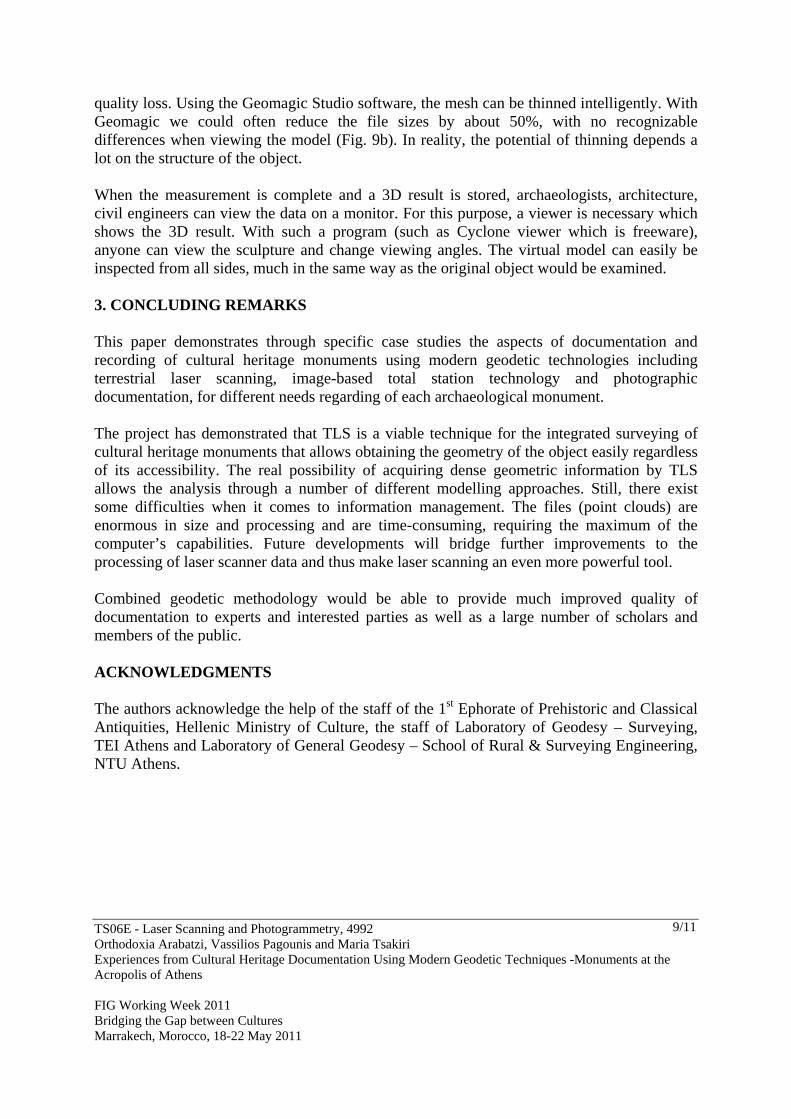
Figure 9: (a) 3D model of the cave, (b) 3D model of the sculpture The acquired virtual 3D model shows a very high point density resulting in large file sizes. This density is necessary to document the sharp edges; in parts with small and regular curvature, point density can be reduced considerably, however, without any recognizable
TS06E - Laser Scanning and Photogrammetry, 4992 Orthodoxia Arabatzi, Vassilios Pagounis and Maria Tsakiri Experiences from Cultural Heritage Documentation Using Modern Geodetic Techniques -Monuments at the Acropolis of Athens FIG Working Week 2011 Bridging the Gap between Cultures Marrakech, Morocco, 18-22 May 2011
9/11
quality loss. Using the Geomagic Studio software, the mesh can be thinned intelligently. With Geomagic we could often reduce the file sizes by about 50%, with no recognizable differences when viewing the model (Fig. 9b). In reality, the potential of thinning depends a lot on the structure of the object. When the measurement is complete and a 3D result is stored, archaeologists, architecture, civil engineers can view the data on a monitor. For this purpose, a viewer is necessary which shows the 3D result. With such a program (such as Cyclone viewer which is freeware), anyone can view the sculpture and change viewing angles. The virtual model can easily be inspected from all sides, much in the same way as the original object would be examined. 3. CONCLUDING REMARKS This paper demonstrates through specific case studies the aspects of documentation and recording of cultural heritage monuments using modern geodetic technologies including terrestrial laser scanning, image-based total station technology and photographic documentation, for different needs regarding of each archaeological monument. The project has demonstrated that TLS is a viable technique for the integrated surveying of cultural heritage monuments that allows obtaining the geometry of the object easily regardless of its accessibility. The real possibility of acquiring dense geometric information by TLS allows the analysis through a number of different modelling approaches. Still, there exist some difficulties when it comes to information management. The files (point clouds) are enormous in size and processing and are time-consuming, requiring the maximum of the computer’s capabilities. Future developments will bridge further improvements to the processing of laser scanner data and thus make laser scanning an even more powerful tool. Combined geodetic methodology would be able to provide much improved quality of documentation to experts and interested parties as well as a large number of scholars and members of the public. ACKNOWLEDGMENTS The authors acknowledge the help of the staff of the 1st Ephorate of Prehistoric and Classical Antiquities, Hellenic Ministry of Culture, the staff of Laboratory of Geodesy – Surveying, TEI Athens and Laboratory of General Geodesy – School of Rural & Surveying Engineering, NTU Athens.
TS06E - Laser Scanning and Photogrammetry, 4992 Orthodoxia Arabatzi, Vassilios Pagounis and Maria Tsakiri Experiences from Cultural Heritage Documentation Using Modern Geodetic Techniques -Monuments at the Acropolis of Athens FIG Working Week 2011 Bridging the Gap between Cultures Marrakech, Morocco, 18-22 May 2011
10/11
REFERENCES Gonzo, L., El-Hakim, S., Picard, M., Girardi, S., Whiting, E., 2004. Photo-Realistic 3-D Reconstruction of Castles with Multiple - Sources Image-Based Techniques. In: The International Archives of the Photogrammetry, Remote Sensing and Spatial Information Sciences, Vol. (35) B5, pp.120-125. Hadziaslani C., Kaimara I., Leondi, A., 2004. The Parthenon Frieze and the Festival of the Panathenaia. The Acropolis Restoration News, Issue 4, Athens, p. 21-23 Koutsouflakis G., 2000. Archaeological and historical documentation of the North and East Pnyx area. Internal Report (in Greek), 1st Ephorate of Prehistoric and Classical Antiquities, Hellenic Ministry of Culture, Athens, Greece. Lichti, D., Gordon, J., 2004. Error Propagation in Directly Georeferenced Terrestrial Laser Scanner Point Clouds for Cultural Heritage Recording. In Proceedings of FIG Working Week, May, Athens, Greece [on CD-ROM] Mitra, J. N., Gelfand, N., Pottmann,H., Guibas,L., 2004. Registration of Point Cloud Data from a Geometric optimization Perspective. In: Eurographics Symposium on Geometry Processing. Pagounis V., Arabatzi, O., Tsakiri, M., Tsini, D., 2010. Geodetic technology for cultural heritage monitoring - the case study of Klepsydra at the Acropolis of Athens. In Proc. Of the 8th International Symposium on the Conservation of Monuments in the Mediterranean Basin, Patra, Greece. Patias, P., Grussenmeyer, P., Hanke, K., 2008. Applications in Cultural Heritage Documentation. Chapter (22 pages) in ISPRS 2008 Congress Book. Ed. CRC Press, Taylor and Francis Group. BIOGRAPHICAL NOTES Dr Orthodoxia Arabatzi is currently a Lecturer at the School of Rural & Surveying Engineering of the NTUA in Greece. She holds a diploma in Rural and Surveying Engineering and a PhD (2007) from the NTUA. Dr Vassilios Pagounis is currently an Associate Professor at the Department of Surveying Engineering of the Technological Educational Institution of Athens in Greece. He obtained his PhD in 2000 from the National Technical University of Athens (NTUA) in Greece.
TS06E - Laser Scanning and Photogrammetry, 4992 Orthodoxia Arabatzi, Vassilios Pagounis and Maria Tsakiri Experiences from Cultural Heritage Documentation Using Modern Geodetic Techniques -Monuments at the Acropolis of Athens FIG Working Week 2011 Bridging the Gap between Cultures Marrakech, Morocco, 18-22 May 2011
11/11
Dr Maria Tsakiri is currently an Assistant Professor at the School of Surveying Engineering of the NTUA in Greece. She obtained her PhD in 1996 from the University of Nottingham in UK. She is chairman of the FIG Task Force 6.1.5 “Terrestrial laser scanning in deformation monitoring”. CONTACTS Associate Professor Vassilios Pagounis Technological Educational Institute of Athens Agiou Spyridonos Str. Aegaleo, Athens GREECE Tel. + 30-210-5385820 Fax + 30-210-5385886 Email: [email protected] [email protected] Web site: www.teiath.gr