environmental project proposal -...
TRANSCRIPT

Submitted to: Saskatchewan Ministry of Environment Environmental Assessment Branch Submitted by: Al Loke, Northern Business Coordinator Ministry of Highways & Infrastructure Northern Region
Environmental Project Proposal Highway No. 914 All Weather Roadway
McArthur River Mine Site to Cigar Lake Mine Site
February 2010

ENVIRONMENTAL PROJECT PROPOSAL
i P:\20094634\00_Hwy_914_Detailed\Engineering\05.00_Design\Enviormental Submission\rpt_final_enviro_submission_20100208.doc
Table of Contents
SECTION PAGE NO. Table of Contents i
1 Introduction 1
2 Project Description 2
2.1 Location 2 2.2 Project 2 2.3 Inputs 3 2.4 Ancillary Projects 4 2.5 By-products 5
3 DESCRIPTION OF THE ENVIRONMENT 6
4 POTENTIAL IMPACTS AND MITIGATIVE MEASURES 7
4.1 Vegetation 8 4.2 Water Crossings 8 4.3 Erosion and Sediment Control 8 4.4 Fire Control 8 4.5 Hazardous Waste Storage 9 4.6 Safety 9
5 DECOMMISSIONING AND RECLAMATION 10
6 PUBLIC CONSULTATION 11
7 SOCIO-ECONOMICS 12
8 CONCLUSION 13

ENVIRONMENTAL PROJECT PROPOSAL
1 P:\20094634\00_Hwy_914_Detailed\Engineering\05.00_Design\Enviormental Submission\rpt_final_enviro_submission_20100208.doc
1 Introduction
The McArthur River and Cigar Lake Uranium Mines are situated in north central Saskatchewan, McArthur River at 57°45’47”, 105°03’9” and Cigar Lake at 58°04’07”, 104°32’27”. Sole ground access consists of an undeveloped winter trail that had been used as access between the two sites in the past; this trail is no longer used for any purpose. A new roadway is proposed to serve as an all weather connector between the two mine sites of McArthur River and Cigar Lake. The proposed roadway location was established considering the need to bypass the existing McArthur and Cigar sites without entering areas currently considered within the mine site limits. Cameco has indicated that they would permit the Ministry to construct roadway through sections within their surfacial lease area if required. The proposed route does not enter into these existing lease areas. The proposed roadway will act as a more efficient route for truck traffic to access mines operated by Cameco and others in northern Saskatchewan. Negotiations are currently underway between the Ministry and Cameco to open the entire section of Hwy 914 as a public roadway after construction of the connector is complete.
2 P:\20094634\00_Hwy_914_Detailed\Engineering\05.00_Design\Enviormental Submission\rpt_final_enviro_submission_20100208.doc
2 Project Description
2.1 Location
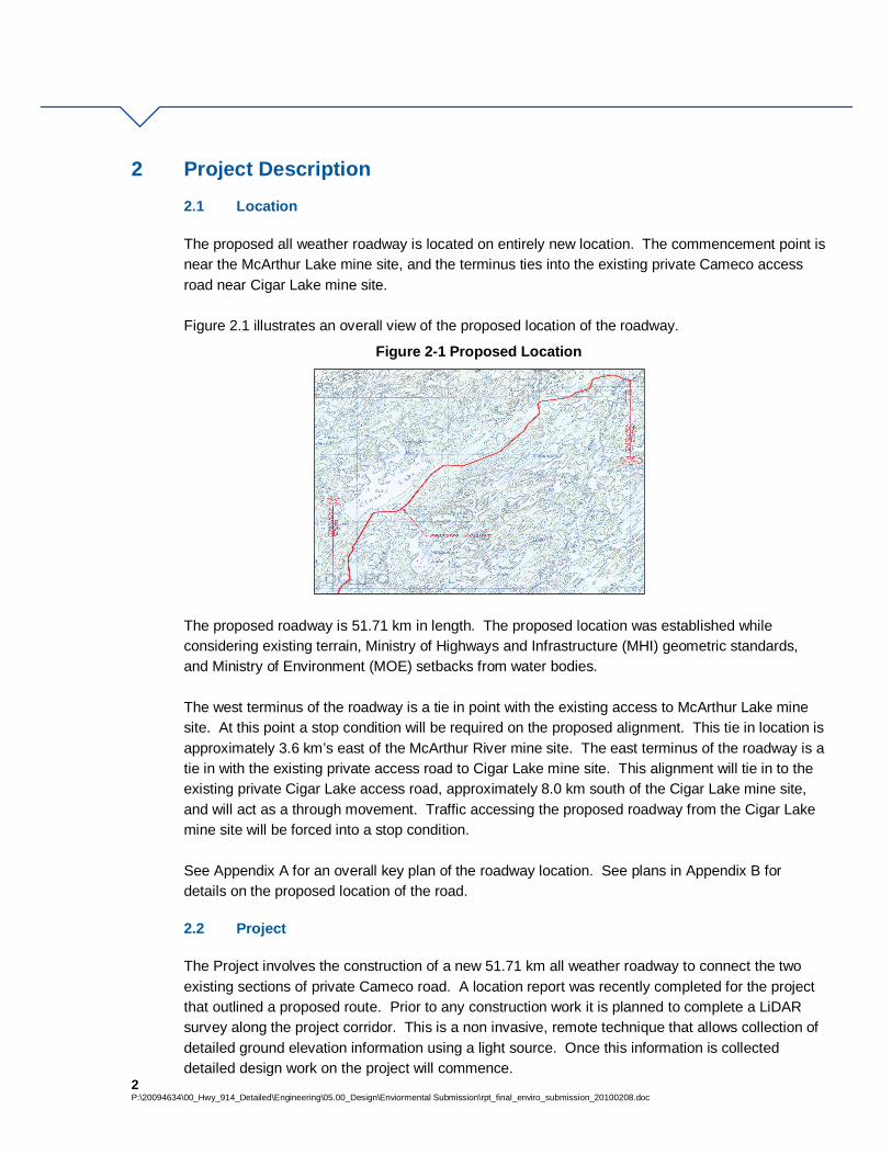
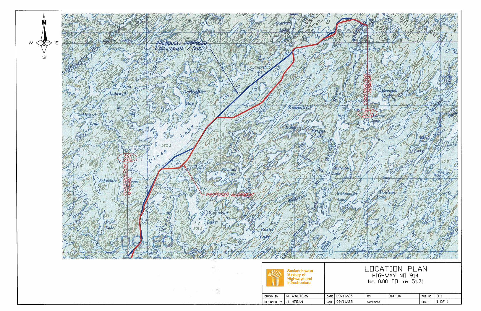
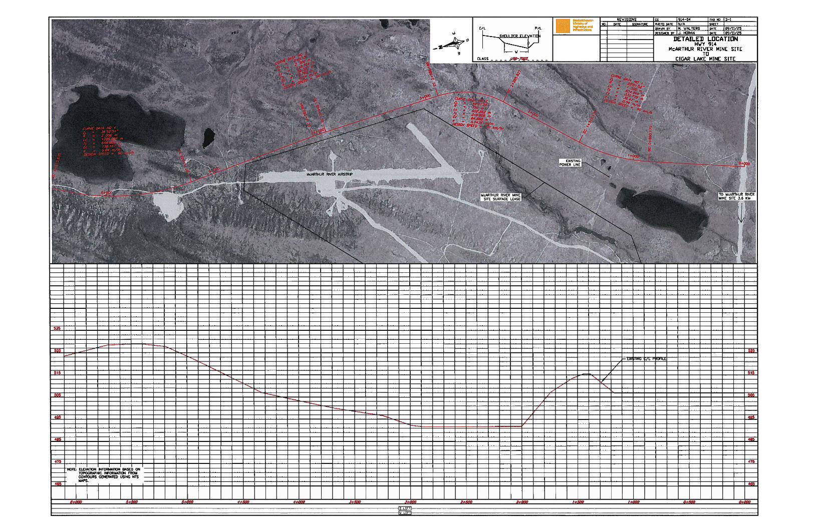
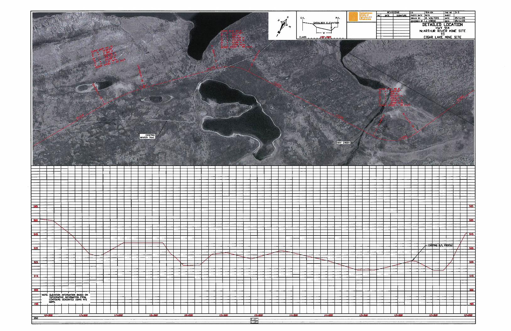
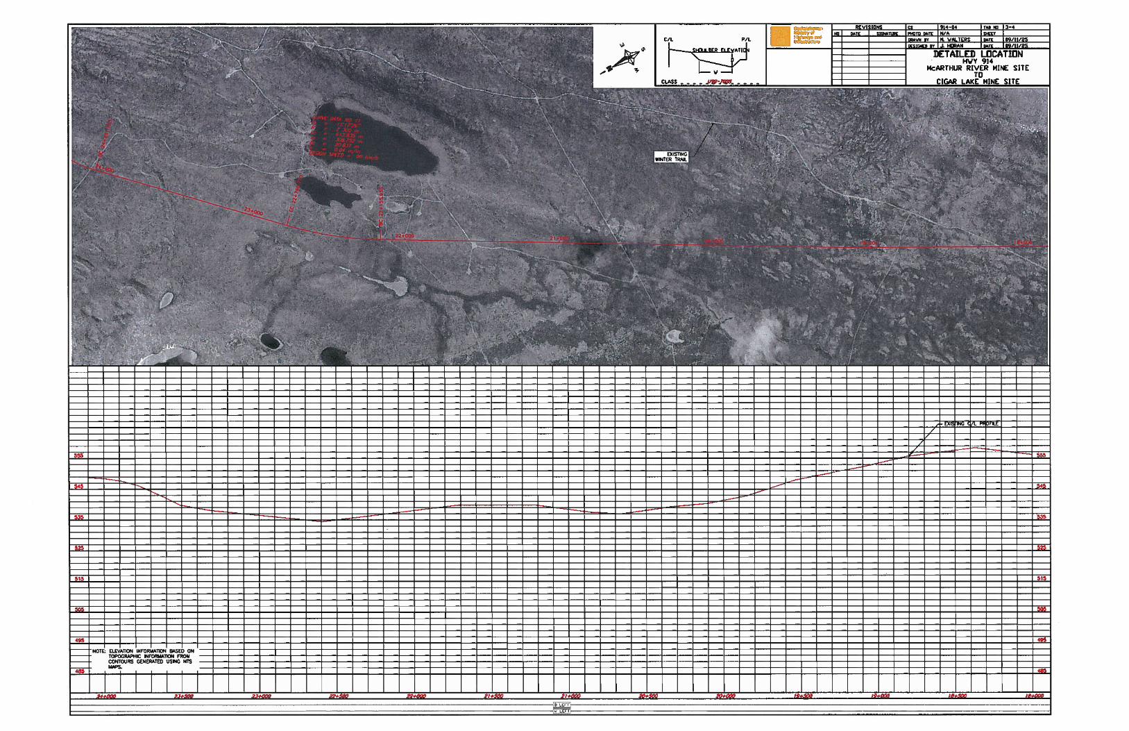
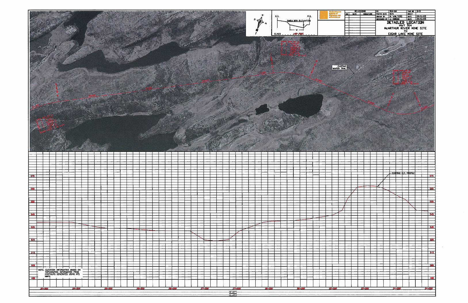
The proposed all weather roadway is located on entirely new location. The commencement point is near the McArthur Lake mine site, and the terminus ties into the existing private Cameco access road near Cigar Lake mine site. Figure 2.1 illustrates an overall view of the proposed location of the roadway.
Figure 2-1 Proposed Location
The proposed roadway is 51.71 km in length. The proposed location was established while considering existing terrain, Ministry of Highways and Infrastructure (MHI) geometric standards, and Ministry of Environment (MOE) setbacks from water bodies. The west terminus of the roadway is a tie in point with the existing access to McArthur Lake mine site. At this point a stop condition will be required on the proposed alignment. This tie in location is approximately 3.6 km’s east of the McArthur River mine site. The east terminus of the roadway is a tie in with the existing private access road to Cigar Lake mine site. This alignment will tie in to the existing private Cigar Lake access road, approximately 8.0 km south of the Cigar Lake mine site, and will act as a through movement. Traffic accessing the proposed roadway from the Cigar Lake mine site will be forced into a stop condition. See Appendix A for an overall key plan of the roadway location. See plans in Appendix B for details on the proposed location of the road. 2.2 Project
The Project involves the construction of a new 51.71 km all weather roadway to connect the two existing sections of private Cameco road. A location report was recently completed for the project that outlined a proposed route. Prior to any construction work it is planned to complete a LiDAR survey along the project corridor. This is a non invasive, remote technique that allows collection of detailed ground elevation information using a light source. Once this information is collected detailed design work on the project will commence.
Environmental Project Proposal Highway No. 914 All Weather Roadway McArthur River Mine Site to Cigar Lake Mine Site
3 P:\20094634\00_Hwy_914_Detailed\Engineering\05.00_Design\Enviormental Submission\rpt_final_enviro_submission_20100208.doc
A functional design standard was chosen by the Ministry for the new roadway. Details are as follows: Road top width = 8.0 m Design speed = 90 km/h Surface type = Gravel Maximum vertical gradient = 8% Sideslope = 4:1 Backslope = 3:1 Ditch bottom = 5.0 m Curve radius (minimum) = 375 m Right of Way width = 46 m
This is a typical Ministry standard that has been proposed on other recent northern low volume roadways. Construction of the all-weather road will involve established methods adapted to the remote and rugged northern environment and the specific terrain as encountered on the route. In general terms, the construction sequence will be performed along the proposed route as follows: Initial location centerline clearing (approx 5 – 8 m wide trail). Right of way clearing and grubbing. Roadway subgrade construction (including excavation of borrow sources). Crushing of granular material for the roadway surface. Installation of required stream crossings including culverts and bridges. Cleanup of Right of Way, borrow sources, and granular sources. Remediation work (As required). Post Construction Activities.
Overall, the process will adhere to the Guidelines for Environmental Protection During Road Development (Saskatchewan Environment, 1981), Environmental Design of Northern Road Developments (Environment Canada, 1978) and Environmental Code of Good Practice for Highways and Railways (Environment Canada, 1979). 2.3 Inputs
The proposed roadway is entirely new construction on new location. It is anticipated that there will be a total of approximately 265 ha of clearing that will be required based on the proposed Right of Way width. In several areas along the proposed alignment there are trees with sufficient size to meet the MOE guidelines for merchantable timber.

4 P:\20094634\00_Hwy_914_Detailed\Engineering\05.00_Design\Enviormental Submission\rpt_final_enviro_submission_20100208.doc
It is estimated that approximately 1,000,000 m3 of earth material will be required to construct the roadway with adequate grade. Existing drumlin formations along the route are expected to contain a large amount of this borrow material, thus a significant portion of the material will come from earth cuts located within the Right of Way limits. There is also expected to be requirements for borrow pits located outside of the right of way along the project limits. These borrow pits will consist of landscape type and deep type pits dependant on terrain in the area. In general deep type pits will be located in flatter areas, and landscape type pits will be located in hilly/undulated areas where it is possible to excavate into hill sideslopes. Locations for these borrow sources will be finalized during the detailed design stage of the project. Permit applications will be sent in for review by Ministry of Environment staff on a case by case basis for these sources. For compaction purposes it is anticipated that approximately 25,000 t of water will be required. It is expected that this water will be obtained from sources near or inside the proposed Right of Way. Water use permits will be required for each site, and will be applied for prior to use. Provisions will be established in the contract to ensure the Contractor adheres to conditions established in the permit. Approximately 35,000 m3 of granular material will be required for stabilization of the subgrade and completion of the roadway driving surface. It is anticipated that there will be several sources obtained near the route for use in manufacturing this material. Permit applications will be sent in for review by Ministry of Environment staff on a case by case basis for these sources. It is anticipated that there will be one bridge required along the route. This crossing will require a 20 m long structure across the May Creek, constructed with a 8.5 m wide pre-cast concrete deck. Details pertaining to this structure will be completed during the detailed design stage. Applications will be sent to applicable agencies prior to completion of design work. Numerous small corrugated steel pipe installations will be required for small drainage crossings along the route. Larger open span arch installations may be used for larger stream crossings where fish passage and habitat issues are present. 2.4 Ancillary Projects
At the time of this proposal preparation the proponent (MHI) is unaware of any ancillary projects that are planned in the immediate area of the planned roadway. Due to the nature of this type of project there would be an increased ability to access the area following construction, and a possibility that other developments may be requested by other proponents at locations along the project limits.
Environmental Project Proposal Highway No. 914 All Weather Roadway McArthur River Mine Site to Cigar Lake Mine Site
5 P:\20094634\00_Hwy_914_Detailed\Engineering\05.00_Design\Enviormental Submission\rpt_final_enviro_submission_20100208.doc
2.5 By-products
By-products resulting from the project consist of items typically found in other linear earthworks projects. It is anticipated that there will be disruption to items such as the soil organic layer and vegetation community within the Right of Way along the project limits during clearing and grubbing operations. There will be need to construct water crossings, and it is anticipated that there are several waterways which will be deemed as having fish significance by DFO. There will be a need for temporary work camps, which will create waste and garbage that will require proper storage and disposal. Items such as air emissions, noise, and socio-economic issues will also occur, but are difficult to quantify prior to work being awarded to a Contractor, and specifics provided.
6 P:\20094634\00_Hwy_914_Detailed\Engineering\05.00_Design\Enviormental Submission\rpt_final_enviro_submission_20100208.doc
3 DESCRIPTION OF THE ENVIRONMENT
The project limits are located in an area which could generally be characterized as un-inhabited. The roadway is to act as a link between two existing mine sites. It is anticipated that this link will be considered the desired haul route between the two mines, as well as for other traffic wishing to link Highway No. 905 with Highway No. 914. According to the geologic section of the Atlas of Saskatchewan the dominant soil texture in the area is a mixture of sandy and loamy (loamy sands, sands, gravel, sandy loams and silty clay loams) and the topography is indicated to be rough rock land complete with bedrock exposures. The Soil Complex for the area is dominantly Podzol (light colored forest soil) with significant occurrence of undifferentiated Regosols (weakly developed soils) and Fibrisol (deep moss peat). Podzol soils are said to have a thin, light grey to white A horizon and a bright brown B horizon. The route traverses past several lakes and waterbodies, characteristic of construction in Northern Saskatchewan. Care was taken during the route selection to ensure the required MOE setbacks from all water bodies along the proposed alignment were met. A bridge crossing will be required at May Creek. Several culverts and possible open span arch structures will be required for other drainage along the route. It is anticipated that several of the waterways crossed along the route will contain fish.
Environmental Project Proposal Highway No. 914 All Weather Roadway McArthur River Mine Site to Cigar Lake Mine Site
7 P:\20094634\00_Hwy_914_Detailed\Engineering\05.00_Design\Enviormental Submission\rpt_final_enviro_submission_20100208.doc
4 POTENTIAL IMPACTS AND MITIGATIVE MEASURES
MHI will be the primary proponent for the project, and as such will be responsible for implementing mitigation measures to minimize environmental disruption during all project phases. MHI is committed to working with MOE to ensure that any environmental impacts can be mitigated, or preferably avoided during this project. MHI follows the Habitat Mitigation Guidelines for Road Construction that were developed jointly by MHI, MOE, Ducks Unlimited, Watershed Authority, and SARM. The proposed route does not pass near any occupied dwellings, residential areas, or other similar land uses. Therefore, the construction activity will have no effect (e.g., noise, dust) on local residents. There are no residents currently living near either proposed roadway terminus. Construction will generally remain within a 46 meter corridor, with the exception of areas where borrow pits and aggregate sources are required. During construction MHI (or consultants representing the Ministry) will have field technicians on site to monitor and document construction progress. These individuals will ensure that the contractor works within the MOE permit requirements. Permits that are anticipated to be required during the project include: Work Authorization Permit – from Saskatchewan Environment (La Ronge office) before any
construction is initiated. Forest Product Permit from Saskatchewan Environment will be required for clearing forest
vegetation. Temporary Work Camp Permit(s) from Saskatchewan Environment (La Ronge office) for
the establishment of any temporary camps for construction. Aquatic Habitat Protection Permits – from Saskatchewan Environment (La Ronge office) for
carrying out any work within or adjacent to aquatic habitats. DFO Letters of Advice and Fisheries Act Authorizations. The crossing details for all streams
will be provided to DFO as part of the permitting and approval process. Temporary water use permits from Saskatchewan Watershed Authority for any surface
water used during construction. Approval from Navigable Waters Protection Program for the May Creek crossing and other
navigable crossings along the route. Gravel Quarry Dispositions from Ministry of Environment Resource Registry in Prince
Albert for all quarry sites. Land Tenure – transfer of the new right-of-way to MHI will be required upon completion of
the road. An as-built survey plan will be submitted to Saskatchewan Environment Resource Registry in Regina.
Hazardous Substances and Spill Control – it is important that employees and contractors are fully trained in the proper handling of hazardous substances and waste dangerous goods and in emergency spill response, and that provincial legislation is followed.
Permits for some aspects of the work camps (e.g. sewage disposal) from Mamawetan Churchill River Health Region in La Ronge.
8 P:\20094634\00_Hwy_914_Detailed\Engineering\05.00_Design\Enviormental Submission\rpt_final_enviro_submission_20100208.doc
4.1 Vegetation
MHI will obtain from MOE the necessary forest use permits for the clearing of the right-of-way. The exact location of the clearing will be provided at the time of application. A contact person responsible for the clearing of forest vegetation will be identified to MOE and will provide reports on progress and issues encountered. All debris will be disposed of in accordance with The Forest Resources Management Act. Boundaries of the work area will be clearly marked using flagging tape or similar methods to prevent excessive clearing of vegetation outside the designated work area. Vegetation clearing will be restricted to the right-of-way and ancillary development areas. Grubbing will take place only on areas to be filled or excavated. Disruption of the organic layer (topsoil) will be minimized as right-of-way clearing will be performed during the winter when the ground is frozen. 4.2 Water Crossings
MHI will consult with Saskatchewan Watershed Authority to obtain flow information, and will provide completed hydraulic reports to MOE, DFO, and other agencies for major water crossings along the route. Stream crossings will be constructed following the Fish Habitat Protection Guidelines: Road Construction and Stream Crossings of Saskatchewan Environment (MOE, 1995). These guidelines deal with fish and fish habitat protection and erosion and sediment control.
Care was taken during route selection to ensure minimum setbacks from all water bodies along the location (Minimum 90 m). Also, as much as possible stream crossings were intersected close to 90 degrees to allow the shortest possible disruption. Hand methods of clearing will be implemented near these crossings during the clearing & grubbing phase of the project.
4.3 Erosion and Sediment Control
MHI will work to ensure that the Contractor minimizes the required environmental footprint during construction. An approved MOE seed mixture will be specified for all areas disturbed during construction. Where necessary, straw matting, or similar, will be used for erosion control on sideslopes and ditch grades. Silt fencing will be used in locations where possible sediment issues could arise. MHI has developed a construction guide for Best Management Practices (BMP) called Erosion and Sediment Control: Best Management Practices – Field Reference Manual. This guide will be used to help determine the BMP’s to use during construction.
4.4 Fire Control
In the contract requirements the successful contractor will be required to have on hand a fire protection plan and the necessary safety equipment. The plan and equipment will meet the requirements of The Prairie and Forest Fires Act, 1982, and the Forest Management Requirements for Independent Forest Operations.
Environmental Project Proposal Highway No. 914 All Weather Roadway McArthur River Mine Site to Cigar Lake Mine Site
9 P:\20094634\00_Hwy_914_Detailed\Engineering\05.00_Design\Enviormental Submission\rpt_final_enviro_submission_20100208.doc
4.5 Hazardous Waste Storage
In the contract requirements the successful contractor will be required to adhere to regulations set out in The Hazardous Substances and Waste Disposal Goods regulations, along with other guidelines set out by MOE such as the Environmental Spill Control Regulations. In the event of a spill MOE will be informed and water quality tests will be undertaken to assess the damage and to develop a remediation plan if required. MHI will identify remediation needs in consultation with MOE. Contingency plans will be in place for operators to consult in the event of a spill. No fuel, oil or other hazardous material will be stored within 100 m of any water body. Additionally, no servicing of equipment will be permitted within this same zone.
4.6 Safety
MHI will require that staff and all contractors adhere to the appropriate Occupational Health and Safety guidelines through all stages (pre-construction, construction, and operation) of this project. The tender documents will clearly state that all contractors shall perform all work in accordance with the rules and regulations of The Occupational Health and Safety Act, 1993 and the Occupational Health and Safety Regulations, 1996. The contractor will also be provided copies of the MHI OH&S Safe Operating Procedures (SOPs). The contractor will also be required to ensure that all workers have access to this information and are aware of all appropriate health and safety procedures relevant to this project. MHI will also reserve the right to have an external safety audit performed at any time during the course of the contract.
10 P:\20094634\00_Hwy_914_Detailed\Engineering\05.00_Design\Enviormental Submission\rpt_final_enviro_submission_20100208.doc
5 DECOMMISSIONING AND RECLAMATION
The project as currently planned is for the construction of an all-weather road. The operating life of the roadway is expected to carry on indefinitely. However, should the roadway cease to be required, decommissioning of the roadway would be undertaken. Decommissioning and abandonment would be carried out in accordance with provincial guidelines (Ministry of Environment, 1981). Reclamation of any areas would be completed in a similar manner. Generally, abandonment would involve the removal of bridges and culverts and allowing the right-of-way and road surface to naturally re-vegetate.

Environmental Project Proposal Highway No. 914 All Weather Roadway McArthur River Mine Site to Cigar Lake Mine Site
11 P:\20094634\00_Hwy_914_Detailed\Engineering\05.00_Design\Enviormental Submission\rpt_final_enviro_submission_20100208.doc
6 PUBLIC CONSULTATION
The Ministry has consulted with Cameco and Areva personnel to indentify the intent to construct a route connecting the two mine access roads. Cameco personnel have stated that no roadways are to be constructed within their current mine sites. They have also indicated that if necessary they would allow construction of the connector roadway through areas currently within their mine lease boundaries. Consultation with local residents has not been conducted, due to the low habitants and no communities in the immediate area of the proposed route.
12 P:\20094634\00_Hwy_914_Detailed\Engineering\05.00_Design\Enviormental Submission\rpt_final_enviro_submission_20100208.doc
7 SOCIO-ECONOMICS
Construction of the all-weather road will be ongoing for approximately 3 years and will include employment opportunity for an estimated 250 FTE (Full Time Employee equivalent) for the construction period including spin-off employment and work at other sites. Initial opportunities will include surveying for clearing operations, and later for earthworks and bridge construction. There will be employment opportunities for surveyors, survey assistants, labourers, heavy equipment operators, truck drivers, camp cooks and camp attendants, mechanics, as well as supervisors. It is anticipated that contractor requirements for survey assistants, labourers, heavy equipment operators, truck drivers, camp cooks and attendants may be met from within northern communities, to the extent that trained people are available. There will also be some employment opportunities during the operation and maintenance phase. MHI encourages local contractors to bid on the various contracts, and they encourage contractors to maximize northern employment. All phases of the project (pre-construction, construction, and operation) could produce potential safety hazards for workers (e.g., use of heavy equipment, blasting of rock, work near water bodies, exposure to dangerous animals, poor weather conditions, etc.). These effects will be avoided through the use of appropriate safety procedures (e.g., adherence to Occupational Health and Safety Guidelines) and through adherence to MHI safety requirements, which will be included in the tender documents and be communicated to all contractors.

Environmental Project Proposal Highway No. 914 All Weather Roadway McArthur River Mine Site to Cigar Lake Mine Site
13 P:\20094634\00_Hwy_914_Detailed\Engineering\05.00_Design\Enviormental Submission\rpt_final_enviro_submission_20100208.doc
8 CONCLUSION
MHI is formally requesting timely feedback from MOE as the efficient delivery of this project is important. MHI appreciates the importance that MOE has put on working with us through these projects to ensure that the people of Saskatchewan get a safe, efficient transportation system that is built in an environmentally sensitive manner. If you require any further clarification or wish to discuss please feel free to contact me at 306-425-4268. Sincerely, Al Loke Northern Business Coordinator Ministry of Highways and Infrastructure Northern Region


ENVIRONMENTAL PROJECT PROPOSAL
A-1 P:\20094634\00_Hwy_914_Detailed\Engineering\05.00_Design\Enviormental Submission\rpt_final_enviro_submission_20100208.doc
Appendix A - Location Plan
, /
9fcii’ + 7!
+
/:f-/ \.— Li / kf -
i
..h . /
Saskatchewan L U C A T I U N P L A NMinistryof HIGHWAY NO 914Highways andInfrastructure km 0.00 TO km 51.71
DRAWN BY M. WALTERS DATE 09/11/25 Cs 914—04 TAB NO 3—1
-.
-2;
w E
O•:
‘-
‘1— ‘:_ /,
---.7p,z”12:/);/
*.
4,;--,
H4,6
ii
DESIGNED BY I J. HORAN DATE I 09/11/25 CONTRACT I SHEET I 1 CF 1


ENVIRONMENTAL PROJECT PROPOSAL
B-1 P:\20094634\00_Hwy_914_Detailed\Engineering\05.00_Design\Enviormental Submission\rpt_final_enviro_submission_20100208.doc
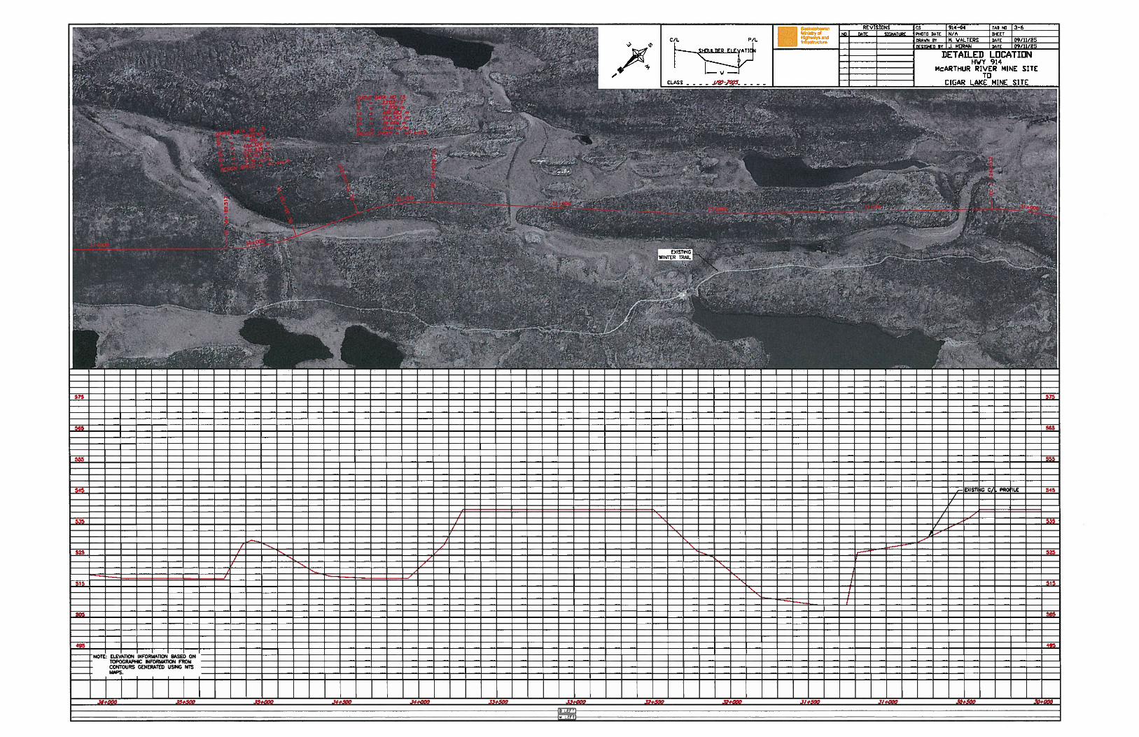
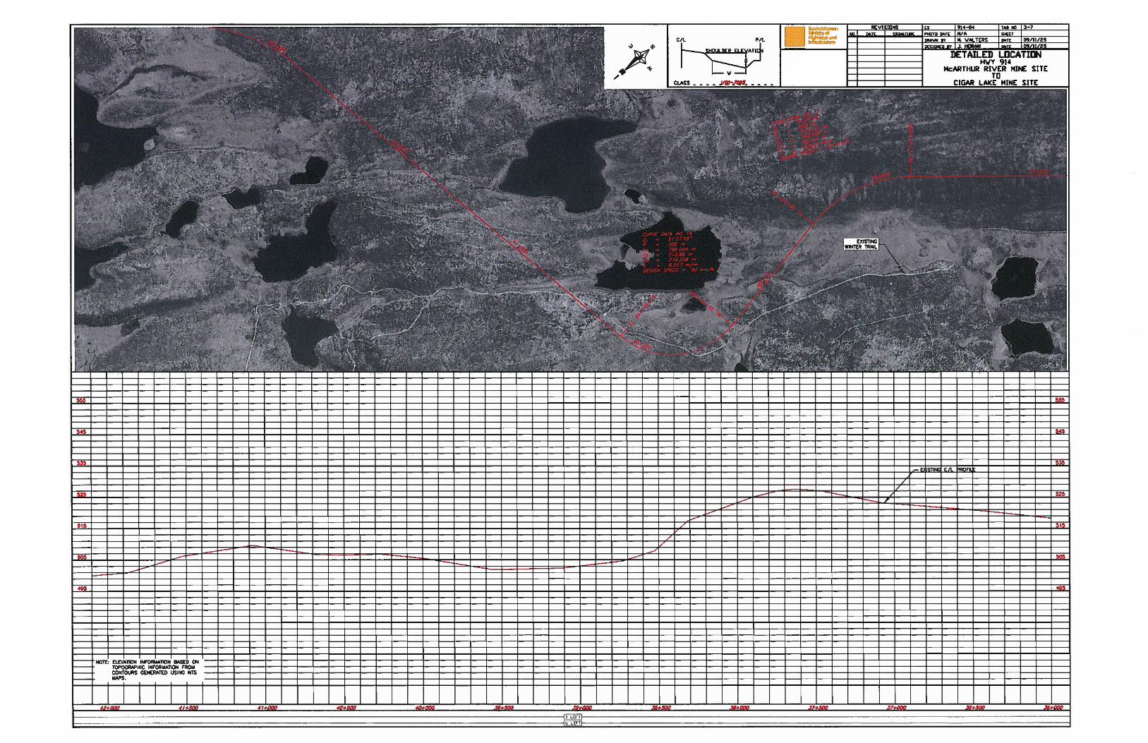
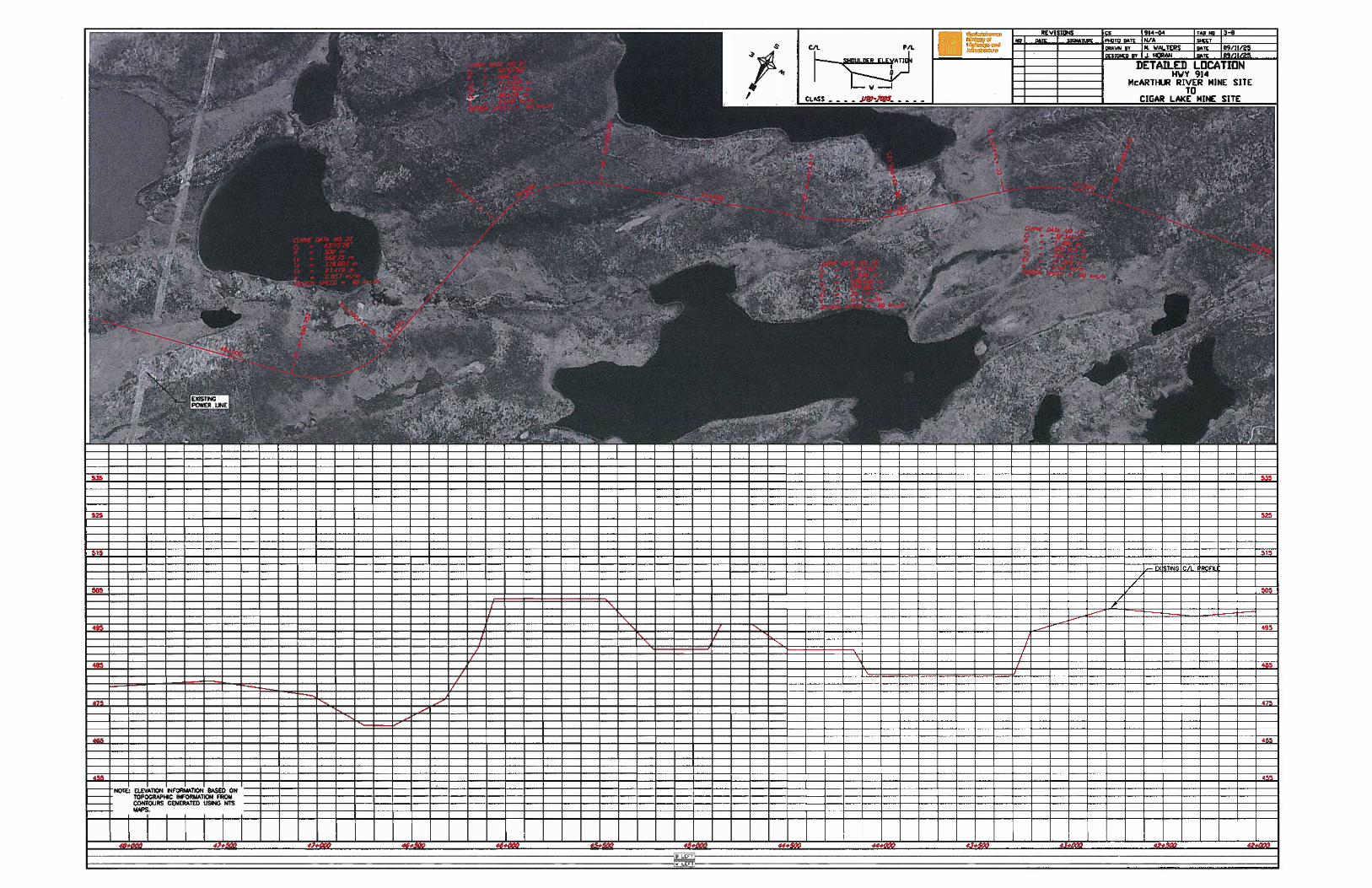
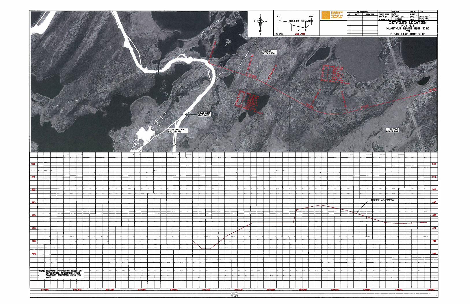
Appendix B - Proposed Alignment Plans
ELEVATION INFORMATION BASED ONTOPOGRAPHIC INFORMATION FROMCONTOURS GENERATED USING NTSMAPS.
DETAILED LOCATIONHWY 914
McARTHUR RIVER MINE SITETO
535
505
NOTE
525
/4S

NOTE ELEVATION INFOR,lATION BASED ONTOPC GRAPHIC INFORMATION FROMCON1 )URS GENERATED USING NTSMAPS
f/
DETAILED LOCATIONHWY 914
McARTHUR RIVER MINE SITETO
I
1_ - - - - - - - - -
\
\
F,
/
EEEE
485
565
/
O#5X p512+0CC
EIATION INFORMA11ON BASED ONTOPOGRAPHIC INFORMATION FROMCONTOURS GENERATED USING NiSMAPS.
DETAILED LOCATIONHWY 914
McARTHUR RIVER MINE SITETO
555
515
505
NOTE
V7-
7-
565
555
—
/F
/ 535I
E________
I
— zz z/
-f
- — — - —
±i - — - - — - -
ELEVA11ON INFORMAflON BASED ONTOPOGRAPHIC INFORMA11ON FROMCONTOURS GENERATED USiNG NTSMAPS.
ILE
525
495
485
,9#s 11.560 18#
555
I
NOTE
NOTE ELEVATION INFORMATION BHSED ONTOPOGRAPHIC INFORMATION FROMCONTOURS GENERATED USING NiSMAPS.
C/L P/L
V
DETAILED LOCATIONHWY 914
MCARTHUR RIVER MINE SITETO
555
545
d
7 N
ZEE1 515
525
515
— NOTE ELE— TOP’— CON
MAP
/
495
DETAILED LOCATIONHWY 914
McARTHUR RIVER MINE SITETO
555
— ———— ——— — ——---——-E’I!Nr,LLQE’ —
— — — ——-4
555
543
ATION INFORMATION BASED ONGRAPHIC INFORMATION FROMOURS GENERATED USING NTS
/,
505
0
PFVT1flN
25
—
-——--—--———--
455
1
NOTE ELEVATION INFORMATION BASEITOPOGRAPHIC INFORMATION FFCONTOURS GENERATED USINGMAPS.
i Z11EzZ/
505
ON
1TS