environmental assessment for the rio...
TRANSCRIPT
ENVIRONMENTAL ASSESSMENT FOR THE RIO GRANDE CORRIDOR AT BUCKMAN RESTORATION AND RECREATION
ENHANCEMENT PROJECT Proposed Action, Alternatives, and Effects Analysis
Prepared for:
ESPAÑOLA RANGER DISTRICT SANTA FE NATIONAL FOREST
1710 N. Riverside Drive Española, NM 87533
(505) 753-7331
and
TAOS FIELD OFFICE BUREAU OF LAND MANAGEMENT
226 Cruz Alta Road Taos, NM 87571-5983
(575) 758-8851
On behalf of:
NEW MEXICO WILDLIFE FEDERATION 121 Cardenas Drive Northeast Albuquerque, NM 87108-1707
(505) 299-5404
Prepared by:
SWCA ENVIRONMENTAL CONSULTANTS 5647 Jefferson Street NE Albuquerque, NM 87109
(505) 254-1115
SWCA Project No. 16673
October 2012
Rio Grande Corridor at Buckman Restoration and Recreation Enhancement Project
SWCA Environmental Consultants ii October 2012
Table of Contents
List of Figures ............................................................................................................................... iii
List of Tables ................................................................................................................................ iii
List of Acronyms and Abbreviations ......................................................................................... iv
1.0 Purpose and Need .............................................................................................................. 5 1.1 Document Structure ........................................................................................................ 5 1.2 Background ..................................................................................................................... 5 1.3 Purpose and Need for Action .......................................................................................... 7 1.4 Proposed Action .............................................................................................................. 8 1.5 Project Location .............................................................................................................. 8 1.6 Decision Framework ....................................................................................................... 8 1.7 Relation to Other Plans Including Land Management Plans .......................................... 9 1.8 Public Involvement ....................................................................................................... 12 1.9 Issues ............................................................................................................................. 12
2.0 Alternatives ....................................................................................................................... 13 2.1 Alternative A – The Proposed Action ........................................................................... 13 2.2 Alternative B – No Action ............................................................................................ 28 2.3 Alternatives Considered But Not Analyzed in Detail ................................................... 29 2.4 Mitigation Measures ..................................................................................................... 30 2.5 Monitoring .................................................................................................................... 32
3.0 Environmental consequences .......................................................................................... 33 3.1 Cultural Resources ........................................................................................................ 33 3.2 Soils and Topography ................................................................................................... 34 3.3 Land Use ....................................................................................................................... 37 3.4 Vegetation ..................................................................................................................... 38 3.5 Wildlife ......................................................................................................................... 43 3.6 Threatened and Endangered Species ............................................................................ 46 3.7 BLM and USFS Sensitive Species ................................................................................ 50 3.8 USFS Management Indicator Species .......................................................................... 56 3.9 Public Health and Safety ............................................................................................... 60 3.10 Recreation ..................................................................................................................... 62 3.11 Visual Resources ........................................................................................................... 65 3.12 Water Quality and Quantity .......................................................................................... 67
4.0 Cumulative Effects Analysis ........................................................................................... 73 4.2 Past and Present Actions ............................................................................................... 73 4.3 Reasonably Foreseeable Actions .................................................................................. 74 4.4 Cumulative Effects ........................................................................................................ 74
5.0 Consultation and Coordination ...................................................................................... 80 5.2 Summary of Consultation and Coordination ................................................................ 80 5.3 Summary of Public Participation to Date ..................................................................... 80 5.4 Public Comment Analysis ............................................................................................. 80
6.0 List of Preparers .............................................................................................................. 81
Rio Grande Corridor at Buckman Restoration and Recreation Enhancement Project
SWCA Environmental Consultants iii October 2012
7.0 Literature Cited ............................................................................................................... 82
List of Figures Figure 1.1. Project location. ...................................................................................................... 11 Figure 2.1. Proposed riparian restoration activities along the Rio Grande. .............................. 16 Figure 2.2. Proposed riparian restoration activities for Diablo Canyon. ................................... 22 Figure 2.3. Example of the cross-vane construction proposed for the Diablo Canyon seep
area. 23 Figure 2.4. Proposed recreation enhancements for the Rio Grande Corridor at Buckman. ...... 25 Figure 2.5. Proposed recreation enhancement activities at Diablo Canyon. ............................. 27 Figure 3.1. Otowi Gage rating curve for the period 1969–2009. .............................................. 69
List of Tables Table 1.1. Core Team for the NMWF Collaborative Planning Process .................................... 6 Table 2.1. BMPs for Herbicide Use ......................................................................................... 17 Table 2.2. Proposed Vegetation Plantings for the Rio Grande Restoration Area .................... 21 Table 3.1. Major Soil Types Found within the Proposed Project Area ................................... 35 Table 3.2. Plant Species Identified During the Field Survey of the Project Area ................... 39 Table 3.3. Birds Observed within the Project Area That Are Protected by the MBTA .......... 44 Table 3.4. Flood Frequency Calculation, Otowi Gage for the Period of Record Water
Years 1972–2008 .............................................................................................................. 69

Rio Grande Corridor at Buckman Restoration and Recreation Enhancement Project
SWCA Environmental Consultants iv October 2012
List of Acronyms and Abbreviations ACEC Area of Environmental Concern ARMS Archaeological Records Management Section AUM animal unit month BDD Buckman Direct Diversion BISON-M Biota Information System of New Mexico BLM Bureau of Land Management BMP best management practice Cfs cubic feet per second Cm centimeter(s) DOE Department of Energy EA Environmental Assessment EIS Environmental Impact Statement EPA U.S. Environmental Protection Agency FEIS Final Environmental Impact Statement GPS global positioning system HPD Historic Preservation Division Kg kilogram(s) Km kilometer(s) LANL Los Alamos National Laboratory Lb pound M meter(s) MBTA Migratory Bird Treaty Act MicroR/hr Micro Rads per hour MIS Management Indicator Species NEPA National Environmental Policy Act NMDA New Mexico Department of Agriculture NMDGF New Mexico Department of Game and Fish NMED New Mexico Environment Department NMRPTC New Mexico Rare Plant Technical Council NMWF New Mexico Wildlife Federation NRHP National Register of Historic Places OHV off-highway vehicle pCI/g picocuries per gram POEA polyoxyethyleneamine RMP Resource Management Plan ROS Recreation Opportunity Spectrum RV recreational vehicle SFNF Santa Fe National Forest SRCP State Register of Cultural Properties SWCA SWCA Environmental Consultants SWPPP Stormwater Pollution Prevention Plan TMDL Total Maximum Daily Load USFS U.S. Forest Service USFS Image Guide U.S. Forest Service Built Environment Image Guide for the National Forests
and Grasslands USFWS U.S. Fish and Wildlife Service UTM Universal Transverse Mercator VQO Visual Quality Objectives VRM Visual Resource Management
Rio Grande Corridor at Buckman Restoration and Recreation Enhancement Project
SWCA Environmental Consultants 5 October 2012
1.0 PURPOSE AND NEED
1.1 DOCUMENT STRUCTURE
The U.S. Forest Service (USFS) Santa Fe National Forest (SFNF) Española Ranger District and the Bureau of Land Management (BLM) Taos Field Office have prepared this Environmental Assessment (EA) in compliance with the National Environmental Policy Act (NEPA) and other relevant federal and state laws and regulations. This EA discloses the direct, indirect, and cumulative environmental impacts that would result from the Proposed Action. The document is organized as follows:
1. Purpose and Need for Action: This section includes the history of the project, the existing and desired conditions, the purpose and need, and a description of the proposed action. It also describes the public scoping process and issue identification.
2. Alternatives: This section provides a more detailed description of the project partners’ Proposed Action and the No Action Alternative. These alternatives were developed based on significant issues raised by the public and other agencies. Also, alternatives considered and not analyzed in detail are described in this section.
3. Environmental Consequences: This section summarizes the physical, biological, social and economic environments of the affected project area and the potential changes to those environments due to implementation of the alternatives. It also presents the scientific and analytical basis for the comparison of alternatives.
4. Cumulative Impacts: This section details the cumulative impacts that would be expected from the Proposed Action when combined with other past, present, and foreseeable actions in and near the project vicinity.
5. Agencies and Persons Consulted: This section provides a list agencies consulted and a summary of public scoping/involvement during the development of the EA.
6. List of Preparers: This section provides a list of preparers of the EA.
1.2 BACKGROUND
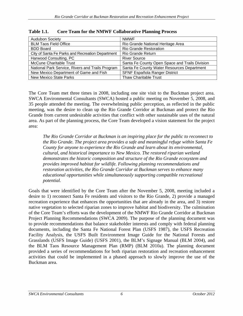
In 2006, the New Mexico Wildlife Federation (NMWF) initiated a collaborative planning process that engaged local stakeholders to develop planning recommendations for the Rio Grande Corridor at Buckman, located on USFS and BLM lands approximately 19 km (12 miles) northwest of Santa Fe near the Buckman Direct Diversion (BDD). A Core Team of decision-makers and stakeholders was convened to inform the planning process (Table 1.1). All members of the Core Team agreed that a collaborative, publically informed process was important to successfully plan and implement sustainable recreation and restoration projects within the Rio Grande Corridor at Buckman and nearby Diablo Canyon.
Table 1.1 lists the represented agencies and organizations on the Buckman Core Team.
Rio Grande Corridor at Buckman Restoration and Recreation Enhancement Project
SWCA Environmental Consultants 6 October 2012
Table 1.1. Core Team for the NMWF Collaborative Planning Process
Audubon Society NMWF BLM Taos Field Office Rio Grande National Heritage Area BDD Board Rio Grande Restoration City of Santa Fe Parks and Recreation Department Rio Grande Return Harwood Consulting, PC River Source McCune Charitable Trust Santa Fe County Open Space and Trails Division National Park Service, Rivers and Trails Program Santa Fe County Water Resources Department New Mexico Department of Game and Fish SFNF Española Ranger District New Mexico State Parks Thaw Charitable Trust
The Core Team met three times in 2008, including one site visit to the Buckman project area. SWCA Environmental Consultants (SWCA) hosted a public meeting on November 5, 2008, and 35 people attended the meeting. The overwhelming public perception, as reflected in the public meeting, was the desire to clean up the Rio Grande Corridor at Buckman and protect the Rio Grande from current undesirable activities that conflict with other sustainable uses of the natural area. As part of the planning process, the Core Team developed a vision statement for the project area:
The Rio Grande Corridor at Buckman is an inspiring place for the public to reconnect to the Rio Grande. The project area provides a safe and meaningful refuge within Santa Fe County for anyone to experience the Rio Grande and learn about its environmental, cultural, and historical importance to New Mexico. The restored riparian wetland demonstrates the historic composition and structure of the Rio Grande ecosystem and provides improved habitat for wildlife. Following planning recommendations and restoration activities, the Rio Grande Corridor at Buckman serves to enhance many educational opportunities while simultaneously supporting compatible recreational potential.
Goals that were identified by the Core Team after the November 5, 2008, meeting included a desire to 1) reconnect Santa Fe residents and visitors to the Rio Grande, 2) provide a managed recreation experience that enhances the opportunities that are already in the area, and 3) restore native vegetation to selected riparian zones to improve habitat and biodiversity. The culmination of the Core Team’s efforts was the development of the NMWF Rio Grande Corridor at Buckman Project Planning Recommendations (SWCA 2009). The purpose of the planning document was to provide recommendations that balance stakeholder interests and comply with federal planning documents, including the Santa Fe National Forest Plan (USFS 1987), the USFS Recreation Facility Analysis, the USFS Built Environment Image Guide for the National Forests and Grasslands (USFS Image Guide) (USFS 2001), the BLM’s Signage Manual (BLM 2004), and the BLM Taos Resource Management Plan (RMP) (BLM 2010a). The planning document provided a series of recommendations for both riparian restoration and recreation enhancement activities that could be implemented in a phased approach to slowly improve the use of the Buckman area.
Rio Grande Corridor at Buckman Restoration and Recreation Enhancement Project
SWCA Environmental Consultants 7 October 2012
1.3 PURPOSE AND NEED FOR ACTION
The Rio Grande Corridor at Buckman and Diablo Canyon are places of significant New Mexican history, inspiring vistas, and exciting recreational opportunities, such as hiking, biking, climbing, and horseback riding. The Rio Grande Corridor at Buckman also contains the BDD facility, which provides drinking water to the residents of Santa Fe County and the City of Santa Fe. Considering the increased, multi-use characteristics of the project area, there is a need to improve the setting of the Buckman and Diablo Canyon areas, both on USFS and BLM lands. During public outreach efforts, the public and other interested stakeholders identified these concerns as important components of improving the existing condition within the Buckman and Diablo Canyon areas.
The purpose of the proposed action is to provide the residents of Santa Fe County with a place to experience the Rio Grande within a context that represents improved riparian ecosystem functionality.
The need for the Project is to restore the riparian ecosystem by:
Enhancing recreational opportunities in the area by addressing unauthorized activities on public lands. The area is used for late night parties, illegal dumping, unauthorized off-highway vehicle (OHV) use, and illegal shooting. These undesirable activities have created conflicts with more traditional recreational users, as well as the newly constructed BDD project.
Restoring the Rio Grande Corridor at Buckman with native vegetation. Recreation opportunities are lessened when dense weed infestations limit access to streams and riparian areas. Weed species such as Russian olive (Elaeagnus angustifolia) with sharp thorns and stiff stems are reducing the quality of recreation sites for picnicking and camping purposes. Some weeds cause allergies or skin irritations. Scenic values also typically decline as weeds reduce the abundance and diversity of native plant communities.
Protecting the abundance and biological diversity of desired native plant communities by reducing non-native plant communities. Non-native vegetation such as saltcedar (Tamarix ramosissima), Russian olive, and Siberian elm (Ulmus pumila) often form monocultures or greatly simplified ecosystems.
Reducing the frequency and intensity of wildland fires by reducing invasive species. Wildland fires are known to burn more intensely and severely in areas where weed species like saltcedar, Siberian elm, and Russian olive have taken over native riparian ecosystems.
Reducing erosion as a result of invasive plant species. Erosion is increased by many weed species. Many non-native thistles and other weeds have a single, deep taproot and drive out native grasses that have better soil-holding root systems.
Improving habitat for wildlife and migratory birds. Wildlife habitat quality decreases when weeds take over native plant communities. Palatable forage for game and non-game species of wildlife decreases as weeds like saltcedar and Siberian elm take over.
Rio Grande Corridor at Buckman Restoration and Recreation Enhancement Project
SWCA Environmental Consultants 8 October 2012
Negative impacts to wildlife magnify in riparian areas because of the important role riparian vegetation plays for a large number of southwestern wildlife species. A large percentage of the known weed infestations occur in or near riparian areas.
1.4 PROPOSED ACTION
The Proposed Action includes two main components: 1) restoration of riparian areas and 2) recreation enhancements within the Rio Grande Corridor at Buckman. There are two areas identified for restoration, one within Diablo Canyon (BLM lands) and one large area along the east bank of the Rio Grande near the BDD facility (USFS and BLM lands). There are two areas identified for recreation enhancements, one area on the west side of Diablo Canyon (BLM lands) and one area along the Rio Grande adjacent to the BDD facility (USFS lands). A detailed description of the proposed action is discussed further within Chapter 2.
1.5 PROJECT LOCATION
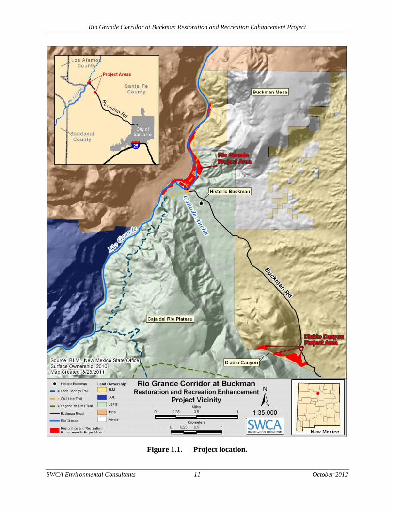
The proposed project area is located approximately 19 km (12 miles) northwest of Santa Fe on BLM and USFS lands that adjoin the community of Las Campanas to the east and White Rock to the west (Figure 1.1). The project area falls within Rio Grande river km 402 and 412 (river miles 250–256). Pueblo de San Ildefonso lands border the project area to the north, and Department of Energy, Los Alamos National Laboratory (LANL) lands are within 6 km (4 miles) of the project area to the west. Private land falls within the northeast section of the project area, with a small strip of private land running between the BLM and USFS lands. The proposed site of the City of Santa Fe BDD project is located within the project area but is entirely separate from this project. The entire project is located on the White Rock, NM (1984) U.S. Geological Survey 7.5-minute quadrangle map.
The project area makes up 41.9 acres. A total of 25.7 acres (61% of project area) falls on lands administered by the SFNF Española Ranger District. The BLM Taos Field Office administers 15 acres (36%) located in the northwest section of the project area, and 1.2 acres (3%) are under private ownership.
The Forest Plan identifies the allotment as being in Management Areas: G (Wildlife-Range-Firewood).
1.6 DECISION FRAMEWORK
The analyses presented in this document will provide the basis for decisions by the joint lead agencies. The District Ranger for the SFNF Española Ranger District and the Taos Field Office Manager for the BLM would decide to authorize or not authorize implementation of the project on lands under their stewardship. The USFS would make decisions about facilities on SFNF-administered lands, as would the BLM make decisions about project components on its lands. Decisions about activities that would involve both the USFS and BLM would be made jointly. A decision, other than the No Action Alternative, would include approval to proceed with implementation of the Proposed Action. Also the decision makers would decide what, if any, mitigation and monitoring measures will be required during the implementation of the alternative
Rio Grande Corridor at Buckman Restoration and Recreation Enhancement Project
SWCA Environmental Consultants 9 October 2012
selected to ensure desired conditions are met or that movement occurs toward those objectives in an acceptable timeframe, or; whether further analysis is needed through the preparation of an Environmental Impact Statement (EIS).
1.7 RELATION TO OTHER PLANS INCLUDING LAND MANAGEMENT
PLANS
The SFNF manages the recreation resources within its jurisdiction to increase opportunities for a wide variety of developed and dispersed experiences, including varied visitor use and handicap access. The SFNF seeks to install visitor information services that act to interpret the resources, uses, and management of the SFNF, while providing and maintaining a variety of trails consistent with planned recreation opportunities, including foot, horse, winter, and motorized trails (USFS 1987). Also, the Recreation Opportunity Spectrum (ROS) system has been integrated into the SFNF’s planning (USFS 2001). The ROS guides management and coordinates recreation with other resources.
The Rio Grande Corridor at Buckman is categorized as Management Area G in the Santa Fe National Forest, Forest Plan (USFS 1987). Management Area G emphasis in this area is on key wildlife habitat protection, habitat improvement, and forage and firewood production. Recreational opportunities are dispersed and consist of firewood and pinyon nut gathering, hunting, and recreational driving. These lands are generally open to OHV travel with some exceptions. The Record of Decision for Travel Management on the Santa Fe National Forest proposes that motorized travel would be changed to the following: “Motorized travel by the public off designated National Forest System roads, trails, and areas shown on the motor vehicle use map (MVUM) would be prohibited except as allowed by permit or other authorization (USFS 2012).
The Santa Fe National Forest Plan states that these lands should be evaluated in order to identify opportunities to contribute to threatened and endangered species recovery objectives and protect known populations of grama-grass cactus (Pediocactus papyracanthus) and manage areas to increase and recover the population (USFS 1987). The SFNF also plans to manage woodland stands to perpetuate species diversity and contribution to non-game species habitat. The plan also states that grazing management should maintain or enhance woody shrubs for wildlife forage or cover (USFS 1987). The SFNF also seeks to manage for perches distributed throughout the area to meet songbird and raptor needs (USFS 1987).
The USFS Image Guide (USFS 2001) is intended to ensure thoughtful design and management of the USFS’s built environment. The USFS Image Guide provides standards for building any size project on USFS lands, from small pit toilets to large visitor centers. The standards are based on a specific project’s geographic location, as well as placement in the ROS.
The USFS Image Guide has been used heavily in the planning process for the Rio Grande Corridor at Buckman Project. As with the other planning documents discussed, it is important to maintain compatibility with both the USFS’s and the BLM’s “branding” policies. All signage and interpretive materials discussed in the EA are intended to follow the USFS Image Guide’s standards, the guidance provided by the BLM’s Signage Manual (BLM 2004), and the BLM Guidelines for a Quality Built Environment (BLM 2010b).
Rio Grande Corridor at Buckman Restoration and Recreation Enhancement Project
SWCA Environmental Consultants 10 October 2012
The Taos RMP (BLM 2012) provides a comprehensive framework for managing public land and allocating resources over a 10 to 20-year period using the principles of multiple use and sustained yield. The RMP establishes areas for limited, restricted, or exclusive uses; levels of production; allowable resource uses; resource condition objectives; program constraints; and general management direction. The latest public version of the Taos RMP is the final version published in May of 2012.
As part of the BLM’s planning process, the area has been determined to have relevant and important values and is under consideration to be designated as an Area of Critical Environmental Concern (ACEC) in the updated plan. The Draft Taos RMP includes the proposed Santa Fe Ranch ACEC, which encompasses the Buckman area. In the draft document, Alternatives A and B would include designating the area as an ACEC. Under Alternatives C and the No Action Alternative, the area would not be designated as an ACEC (BLM 2010a). The ACEC designation could result in closer regulatory oversight of the area and increased patrolling.
In addition to the agency plans and policies listed above, the Final Environmental Impact Statement for the Buckman Water Diversion Project (FEIS) is also relevant to this EA. As part of the FEIS, mitigation measures were identified to avoid and reduce significant direct, indirect, and cumulative impacts caused by project construction and operation activities (USFS and BLM 2006). A portion of the mitigation measures are related to riparian restoration along the Rio Grande, adjacent to the NMWF riparian restoration and recreation enhancement area. This document analyzes the use of herbicides to assist with the riparian restoration on both the NMWF and BDD project areas. In addition, the No Action Alternative analyzed in this document reflects restoration activities that would take place within the BDD project area as mitigation measures, regardless if the Proposed Action analyzed in this EA is carried forward.
Rio Grande Corridor at Buckman Restoration and Recreation Enhancement Project
SWCA Environmental Consultants 11 October 2012
Figure 1.1. Project location.
Rio Grande Corridor at Buckman Restoration and Recreation Enhancement Project
SWCA Environmental Consultants 12 October 2012
1.8 PUBLIC INVOLVEMENT
The following public involvement activities were completed to gather stakeholder and interested party comments and concerns:
The NMWF conducted public scoping for the restoration and recreation planning process in November 2008.
The USFS and BLM have conducted ongoing internal public scoping since the NMWF submitted the Rio Grande Corridor at Buckman Project Planning Recommendations in 2009 (SWCA 2009).
The USFS and BLM mailed the Proposed Action to stakeholders on June 24, 2011, and requested public scoping comments through July 26, 2011.
The USFS posted the project to the SFNF Schedule of Proposed Actions report dated July 1, 2011.
The IDT reviewed all comments received in regards to the Proposed Action. Each comment received was considered and evaluated to determine whether the concern(s) were already resolved through land use designations, implementation of Forest Plan standards and guidelines and Best Management Practices (BMP’s), project-specific design criteria or mitigation measures, through processes or analyses routinely conducted by the IDT, or beyond the scope of the project. All concerns that fell within these categories were considered resolved.
Based on public scoping, as well as the internal scoping efforts, the concerns that would drive (or partially drive) an alternative were considered issues to address further. These issues are used to develop and compare alternatives, prescribe mitigation measures, and analyze the environmental effects.
1.9 ISSUES
Issues brought forward during the scoping process were evaluated and addressed by the Interdisciplinary (ID) Team. The issues were used in the development and refinement of the alternatives. As defined in NEPA, a significant issue is used in environmental analysis to formulate alternatives, prescribe mitigation measures, or analyze environmental effects. Issues are significant because of the extent of their geographic distribution, the duration of their effects, or the intensity of interest or resource conflict. Based on the comments received during scoping, the Forest Service did not identify any significant issues. Although not identified as significant issues requiring development of additional alternatives, several issues merit discussion in the EA.
1.9.1 PUBLIC HEALTH AND SAFETY
Concerns were raised regarding the effect on public health and safety within the project vicinity. Specifically, concerns about impacts from potential LANL legacy contaminants that may occur in the project area on drinking water and potential exposure to the public were received during the scoping process.
Rio Grande Corridor at Buckman Restoration and Recreation Enhancement Project
SWCA Environmental Consultants 13 October 2012
1.9.2 RECREATION
Concerns regarding recreation were directly to parking, vehicle access, and enforcement. For example, improvement of parking at Diablo Canyon was raised including the need to keep people in one spot, limiting vehicle access, encouraging a car-free experience, and the need for more secure parking and security patrols. The need for vault toilets was also raised.
1.9.3 WATER QUALITY AND QUANTITY
Concerns regarding herbicide use for vegetation treatments near the Rio Grande were raised, in addition to concern over water quantity, and potential erosion and resulting suspended sediments. In regard to water quanity, the issue of the evapotranspiration capacities of native cottonwood-willow riparian forests compared to the current non-native community was received during public scoping.
2.0 ALTERNATIVES
This section describes the alternatives that have been considered in the development of this EA. Alternative A is the Proposed Action and Alternative B is the No Action Alternative. An EA addresses one or more “action” alternatives; in this case one action alternative would result in the riparian restoration and recreational enhancement of the project area.
2.1 ALTERNATIVE A – THE PROPOSED ACTION
The Proposed Action includes two main components: 1) restoration of riparian areas and 2) recreation enhancements within the Rio Grande Corridor at Buckman. There are two areas identified for restoration, one within Diablo Canyon (BLM lands) and one large area along the east bank of the Rio Grande near the BDD facility (USFS and BLM lands). There are two areas identified for recreation enhancements, one area on the west side of Diablo Canyon (BLM lands) and one area along the Rio Grande adjacent to the BDD facility (USFS lands).
2.1.1 RIO GRANDE RIPARIAN RESTORATION
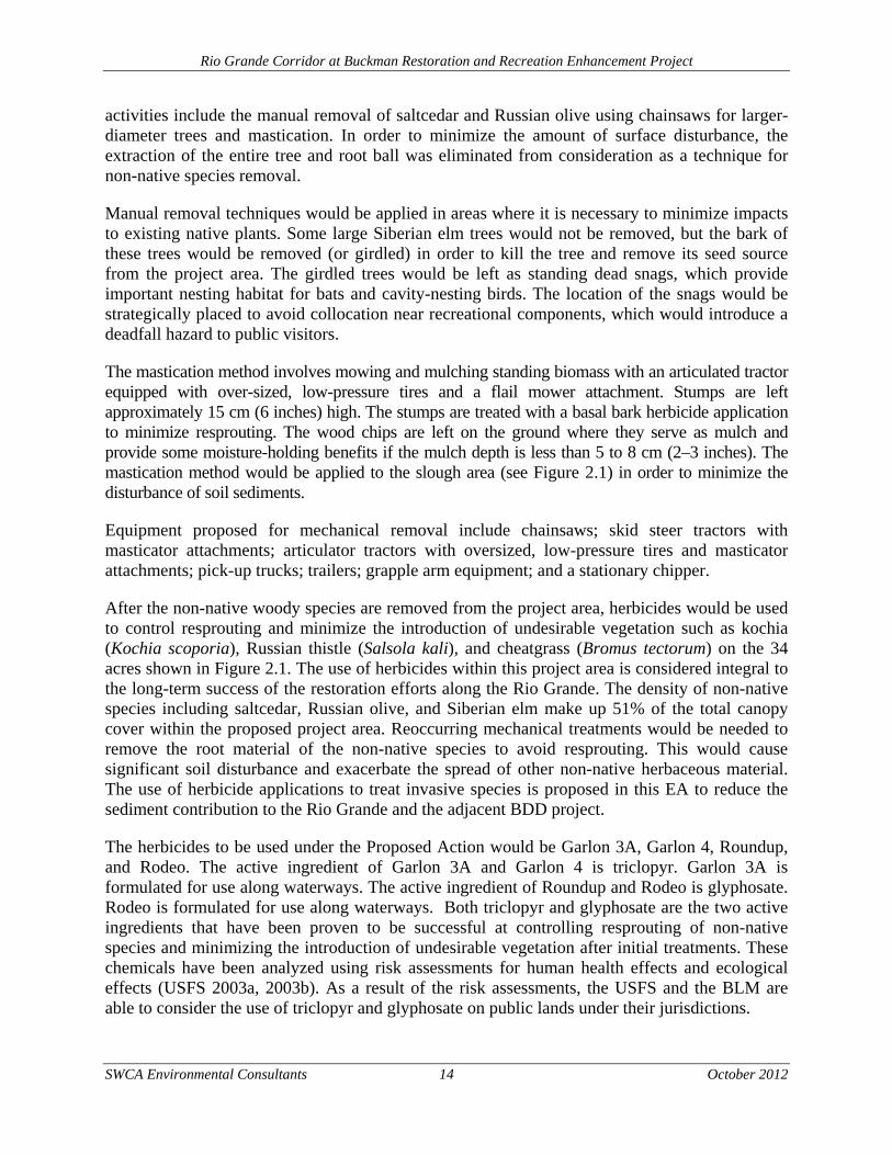
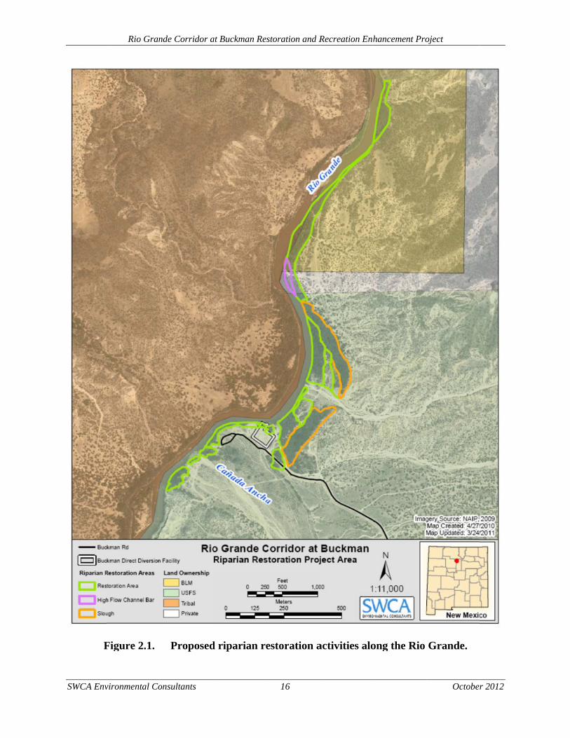
The Proposed Action would restore 34 acres of riparian zone along the east bank of the Rio Grande, both north and south of the existing BDD project (Figure 2.1). Of this total, 26 restoration acres would occur on USFS lands, 7 acres would occur on BLM lands, and 1 acre would occur on private lands. The private landowner involved with the project has provided support to the NMWF for the project and would allow restoration activities to take place on private land. Restoration activities include the removal of saltcedar, Russian olive, Siberian elm, and other non-native, invasive species. Non-native plant removal is followed by revegetation efforts to restore native riparian species and post-restoration maintenance.
Non-native Species Removal A variety of non-native mechanical tree removal techniques may be used, depending on tree density, subsurface conditions, and restoration goals and objectives. Non-native tree removal
Rio Grande Corridor at Buckman Restoration and Recreation Enhancement Project
SWCA Environmental Consultants 14 October 2012
activities include the manual removal of saltcedar and Russian olive using chainsaws for larger-diameter trees and mastication. In order to minimize the amount of surface disturbance, the extraction of the entire tree and root ball was eliminated from consideration as a technique for non-native species removal.
Manual removal techniques would be applied in areas where it is necessary to minimize impacts to existing native plants. Some large Siberian elm trees would not be removed, but the bark of these trees would be removed (or girdled) in order to kill the tree and remove its seed source from the project area. The girdled trees would be left as standing dead snags, which provide important nesting habitat for bats and cavity-nesting birds. The location of the snags would be strategically placed to avoid collocation near recreational components, which would introduce a deadfall hazard to public visitors.
The mastication method involves mowing and mulching standing biomass with an articulated tractor equipped with over-sized, low-pressure tires and a flail mower attachment. Stumps are left approximately 15 cm (6 inches) high. The stumps are treated with a basal bark herbicide application to minimize resprouting. The wood chips are left on the ground where they serve as mulch and provide some moisture-holding benefits if the mulch depth is less than 5 to 8 cm (2–3 inches). The mastication method would be applied to the slough area (see Figure 2.1) in order to minimize the disturbance of soil sediments.
Equipment proposed for mechanical removal include chainsaws; skid steer tractors with masticator attachments; articulator tractors with oversized, low-pressure tires and masticator attachments; pick-up trucks; trailers; grapple arm equipment; and a stationary chipper.
After the non-native woody species are removed from the project area, herbicides would be used to control resprouting and minimize the introduction of undesirable vegetation such as kochia (Kochia scoporia), Russian thistle (Salsola kali), and cheatgrass (Bromus tectorum) on the 34 acres shown in Figure 2.1. The use of herbicides within this project area is considered integral to the long-term success of the restoration efforts along the Rio Grande. The density of non-native species including saltcedar, Russian olive, and Siberian elm make up 51% of the total canopy cover within the proposed project area. Reoccurring mechanical treatments would be needed to remove the root material of the non-native species to avoid resprouting. This would cause significant soil disturbance and exacerbate the spread of other non-native herbaceous material. The use of herbicide applications to treat invasive species is proposed in this EA to reduce the sediment contribution to the Rio Grande and the adjacent BDD project.
The herbicides to be used under the Proposed Action would be Garlon 3A, Garlon 4, Roundup, and Rodeo. The active ingredient of Garlon 3A and Garlon 4 is triclopyr. Garlon 3A is formulated for use along waterways. The active ingredient of Roundup and Rodeo is glyphosate. Rodeo is formulated for use along waterways. Both triclopyr and glyphosate are the two active ingredients that have been proven to be successful at controlling resprouting of non-native species and minimizing the introduction of undesirable vegetation after initial treatments. These chemicals have been analyzed using risk assessments for human health effects and ecological effects (USFS 2003a, 2003b). As a result of the risk assessments, the USFS and the BLM are able to consider the use of triclopyr and glyphosate on public lands under their jurisdictions.
Rio Grande Corridor at Buckman Restoration and Recreation Enhancement Project
SWCA Environmental Consultants 15 October 2012
Herbicide treatments would be applied as directed in the manufacturers’ label standards. In addition, other management direction relevant to this project includes:
BLM Vegetation Treatments Using Herbicides on Bureau of Land Management Lands in 17 Western States Final Programmatic Environmental Impact Statement (EIS) (BLM 2007a)
National Invasive Species Management Plan (National Invasive Species Council 2001)
BLM Manual 9015 (Integrated Weed Management)
Forest Service Manual 2900 Invasive Species Management
BLM Handbook H-9011-1 (Chemical Pest Control)
Forest Service Manual 2109.14 Pesticide-Use Management and Coordination
BLM Manual 1112 (Safety) New Mexico Noxious Weed Management Act of 1978
New Mexico Executive Order 00-22
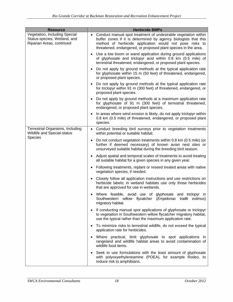
Herbicides would be applied using low-pressure techniques with a backpack sprayer or spray bottle, wick (wiped on), or wand (sprayed on). Herbicides can be applied to a tree’s circumference of the trunk on the intact bark (basal bark application), to cuts in the trunk or stem (frill), to cut stems and stumps (cut stump), or injected into the inner bark. Aerial applications or broadcast applications are not proposed. Herbicides would be applied by individuals with the appropriate certification, as required by USFS and BLM policy, as well as state laws. All herbicide treatments would be performed by licensed applicators trained in best management practices (BMPs) to minimize drift to non-target species and avoid mishandling chemicals (Table 2.1).
SWCA Env
F
Rio Gran
vironmental Co
Figure 2.1.
nde Corridor a
onsultants
Proposed
at Buckman Res
d riparian re
storation and R
16
estoration a
Recreation Enh
activities alo
hancement Pro
ong the Rio
oject
October
Grande.
r 2012

Rio Grande Corridor at Buckman Restoration and Recreation Enhancement Project
SWCA Environmental Consultants 17 October 2012
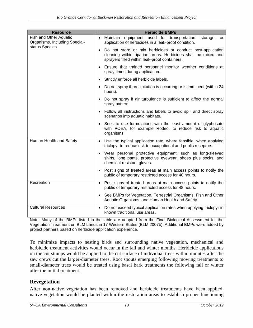
Table 2.1. BMPs for Herbicide Use
Resource Herbicide BMPs Water Resources and Quality Apply Garlon 3A or Rodeo to vegetation adjacent to the Rio
Grande.
Maintain equipment used for transportation, storage, or application of herbicides in a leak-proof condition.
Do not store or mix herbicides or conduct post-application cleaning within riparian areas. Herbicides shall be mixed and sprayers filled within leak-proof containers.
Ensure that trained personnel monitor weather conditions at spray times during application.
Strictly enforce all herbicide labels.
Do not spray if precipitation is occurring or is imminent (within 24 hours).
Do not spray if air turbulence is sufficient to affect the normal spray pattern.
Follow all instructions and standard operating procedures to avoid spill and direct spray scenarios into aquatic habitats.
Vegetation, Including Special-status Species, Wetland, and Riparian Areas
Survey all Proposed Action areas within potential threatened, endangered, or proposed plant habitat to determine presence/absence of the species.
Establish site-specific no activity buffers in areas of occupied habitat within the proposed project area. To protect occupied habitat, treatment activities would not occur within these buffers.
Collect baseline information on the existing condition of threatened, endangered, or proposed plant species and their habitats in the proposed project area.
Establish pre-treatment monitoring programs to track the size and vigor of threatened, endangered, or proposed plant populations and the state of their habitats. These monitoring programs would help anticipate the future effects of vegetation treatments.
Assess the need for site revegetation pre- and post treatment to minimize the opportunity for noxious weed invasion and establishment.
Review, understand, and conform to the “Environmental Hazards” section on herbicide labels.
Establish suitable buffer zones between treatment sites and populations (confirmed or suspected) of plant species to avoid negative effects to threatened, endangered, and proposed plant species from off-site drift, surface runoff, and/or wind erosion, and site-specific precautions should be taken.
Follow all instructions and labels to avoid spill and direct spray scenarios into aquatic habitats.
Rio Grande Corridor at Buckman Restoration and Recreation Enhancement Project
SWCA Environmental Consultants 18 October 2012
Resource Herbicide BMPs Vegetation, Including Special Status-species, Wetland, and Riparian Areas, continued
Conduct manual spot treatment of undesirable vegetation within buffer zones if it is determined by agency biologists that this method of herbicide application would not pose risks to threatened, endangered, or proposed plant species in the area.
Use a low boom or wand application during ground applications of glyphosate and triclopyr acid within 0.8 km (0.5 mile) of terrestrial threatened, endangered, or proposed plant species.
Do not apply by ground methods at the typical application rate for glyphosate within 15 m (50 feet) of threatened, endangered, or proposed plant species.
Do not apply by ground methods at the typical application rate for triclopyr within 91 m (300 feet) of threatened, endangered, or proposed plant species.
Do not apply by ground methods at a maximum application rate for glyphosate of 91 m (300 feet) of terrestrial threatened, endangered, or proposed plant species.
In areas where wind erosion is likely, do not apply triclopyr within 0.8 km (0.5 mile) of threatened, endangered, or proposed plant species.
Terrestrial Organisms, Including Wildlife and Special-status Species
Conduct breeding bird surveys prior to vegetation treatments within potential or suitable habitat.
Do not conduct vegetation treatments within 0.8 km (0.5 mile) (or further if deemed necessary) of known avian nest sites or unsurveyed suitable habitat during the breeding bird season.
Adjust spatial and temporal scales of treatments to avoid treating all suitable habitat for a given species in any given year.
Following treatments, replant or reseed treated areas with native vegetation species, if needed.
Closely follow all application instructions and use restrictions on herbicide labels; in wetland habitats use only those herbicides that are approved for use in wetlands.
Where feasible, avoid use of glyphosate and triclopyr in Southwestern willow flycatcher (Empidonax traillii extimus) migratory habitat.
If conducting manual spot applications of glyphosate or triclopyr to vegetation in Southwestern willow flycatcher migratory habitat, use the typical rather than the maximum application rate.
To minimize risks to terrestrial wildlife, do not exceed the typical application rate for herbicides.
Where practical, limit glyphosate to spot applications in rangeland and wildlife habitat areas to avoid contamination of wildlife food items.
Seek to use formulations with the least amount of glyphosate with polyoxyethyleneamine (POEA), for example Rodeo, to reduce risk to amphibians.
Rio Grande Corridor at Buckman Restoration and Recreation Enhancement Project
SWCA Environmental Consultants 19 October 2012
Resource Herbicide BMPs Fish and Other Aquatic Organisms, Including Special-status Species
Maintain equipment used for transportation, storage, or application of herbicides in a leak-proof condition.
Do not store or mix herbicides or conduct post-application cleaning within riparian areas. Herbicides shall be mixed and sprayers filled within leak-proof containers.
Ensure that trained personnel monitor weather conditions at spray times during application.
Strictly enforce all herbicide labels.
Do not spray if precipitation is occurring or is imminent (within 24 hours).
Do not spray if air turbulence is sufficient to affect the normal spray pattern.
Follow all instructions and labels to avoid spill and direct spray scenarios into aquatic habitats.
Seek to use formulations with the least amount of glyphosate with POEA, for example Rodeo, to reduce risk to aquatic organisms.
Human Health and Safety Use the typical application rate, where feasible, when applying triclopyr to reduce risk to occupational and public receptors.
Wear personal protective equipment, such as long-sleeved shirts, long pants, protective eyewear, shoes plus socks, and chemical-resistant gloves.
Post signs of treated areas at main access points to notify the public of temporary restricted access for 48 hours.
Recreation Post signs of treated areas at main access points to notify the public of temporary restricted access for 48 hours.
See BMPs for Vegetation, Terrestrial Organisms, Fish and Other Aquatic Organisms, and Human Health and Safety
Cultural Resources Do not exceed typical application rates when applying triclopyr in known traditional use areas.
Note: Many of the BMPs listed in the table are adapted from the Final Biological Assessment for the Vegetation Treatment on BLM Lands in 17 Western States (BLM 2007b). Additional BMPs were added by project partners based on herbicide application experience.
To minimize impacts to nesting birds and surrounding native vegetation, mechanical and herbicide treatment activities would occur in the fall and winter months. Herbicide applications on the cut stumps would be applied to the cut surface of individual trees within minutes after the saw crews cut the larger-diameter trees. Root spouts emerging following mowing treatments to small-diameter trees would be treated using basal bark treatments the following fall or winter after the initial treatment.
Revegetation After non-native vegetation has been removed and herbicide treatments have been applied, native vegetation would be planted within the restoration areas to establish proper functioning

Rio Grande Corridor at Buckman Restoration and Recreation Enhancement Project
SWCA Environmental Consultants 20 October 2012
conditions along the Rio Grande riparian area. The revegetation activities would include stabilizing banklines, creating an oxbow wetland, and developing a seasonal backwater zone.
Riparian Woodland The riparian restoration project areas would be revegetated using site-adapted native species approved by the USFS and BLM. Rio Grande cottonwood (Populus deltoides ssp. wislizenii) would be planted in copses to provide patchiness in the canopy structure. Goodding’s willow (Salix gooddingii) and/or peachleaf willow (S. amygdaloides) would then be planted in the understory and along the wet banklines. Both species would be planted at rates ranging from 25 to 85 trees per acre to create a patchy mosaic. Riparian shrubs, including New Mexico olive (Forestiera pubescens), skunkbush sumac (Rhus trilobata), silver buffaloberry (Sheperdia argentea), golden currant (Ribes aureum), and wood rose (Rosa woodsii), would be planted in the understory at planting rates ranging from 100 to 250 plants per acre.
Dormant Rio Grande cottonwood, Goodding’s willow, and peachleaf willow poles would be planted following the techniques developed by the Los Lunas Plant Material Center (U.S. Department of Agriculture, Natural Resources Conservation Service [USDA-NRCS] 2009a). The rootless tree poles would be planted during the plant dormancy season (November–March) using a tractor-mounted or hand power auger. The auger would drill to a depth sufficient to expose alluvial groundwater, not to exceed 2.4 m (8 feet). Once groundwater is exposed in the auger hole, one rootless tree pole would be installed. The hole would be backfilled and lightly compacted. This technique is intended to avoid supplemental watering.
Native riparian shrubs would be planted in clusters between the tree pole plantings using tall-pot containerized nursery stock (USDA-NRCS 2009b). The native shrubs would require watering once every two to four weeks through the first growing season after planting to ensure successful establishment and growth. The plants would be watered using watering tubes installed during planting. Approximately 2,500 to 3,500 gallons of water would be required to support the newly planted shrubs during the first growing season.
Bankline Stabilization Bankline stabilization would be accomplished through management of existing desirable vegetation and active planting in key locations. The project area is on an outside bend of the river channel. As such, the area may be subject to shear stresses, especially at higher flow. Existing coyote willow (Salix exigua) would be left intact. In key areas where there are no coyote willows, these would be planted as stem cuttings (USDA-NRCS 2009c) during the dormant season in two rows along the bank edge. Stem cuttings would be planted by auguring holes to groundwater or excavating trenches with a backhoe or small excavator. Coyote willow would be planted at a rate of 200 plants per acre.
Oxbow Wetlands Oxbow wetlands are areas that have been disconnected from the river channel through fluvial processes and the migration of the river. These linear features may be recreated through taking advantage of existing microtopographic features and some judicious excavation to soil saturation depths. The depressions would then be planted with herbaceous wetland vegetation. Herbaceous wetland plugs would be hand planted at a rate of one plant per 0.2 m² (2 square feet).
Rio Grande Corridor at Buckman Restoration and Recreation Enhancement Project
SWCA Environmental Consultants 21 October 2012
Transition areas to the upland areas, where the groundwater table is too great to support riparian species, would be planted with native shrubs. The goal is to create a natural transition to upland grass/shrublands. Shrubs would be planted at a rate of 100 plants per acre in a patchy mosaic using tall-pot containerized nursery stock.
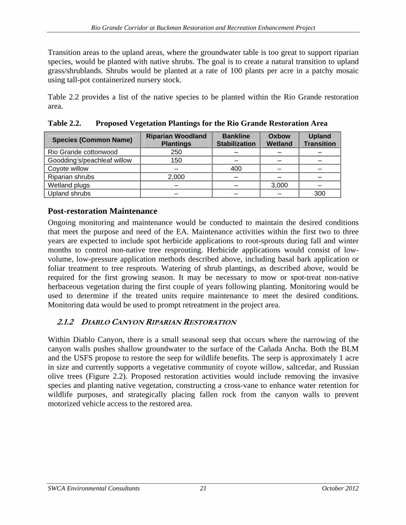
Table 2.2 provides a list of the native species to be planted within the Rio Grande restoration area.
Table 2.2. Proposed Vegetation Plantings for the Rio Grande Restoration Area
Species (Common Name) Riparian Woodland
Plantings Bankline
Stabilization Oxbow Wetland
Upland Transition
Rio Grande cottonwood 250 – – – Goodding’s/peachleaf willow 150 – – – Coyote willow – 400 – – Riparian shrubs 2,000 – – – Wetland plugs – – 3,000 – Upland shrubs – – – 300
Post-restoration Maintenance Ongoing monitoring and maintenance would be conducted to maintain the desired conditions that meet the purpose and need of the EA. Maintenance activities within the first two to three years are expected to include spot herbicide applications to root-sprouts during fall and winter months to control non-native tree resprouting. Herbicide applications would consist of low-volume, low-pressure application methods described above, including basal bark application or foliar treatment to tree resprouts. Watering of shrub plantings, as described above, would be required for the first growing season. It may be necessary to mow or spot-treat non-native herbaceous vegetation during the first couple of years following planting. Monitoring would be used to determine if the treated units require maintenance to meet the desired conditions. Monitoring data would be used to prompt retreatment in the project area.
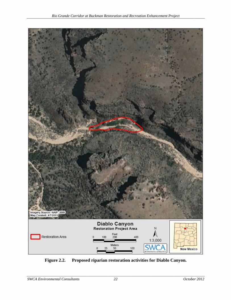
2.1.2 DIABLO CANYON RIPARIAN RESTORATION
Within Diablo Canyon, there is a small seasonal seep that occurs where the narrowing of the canyon walls pushes shallow groundwater to the surface of the Cañada Ancha. Both the BLM and the USFS propose to restore the seep for wildlife benefits. The seep is approximately 1 acre in size and currently supports a vegetative community of coyote willow, saltcedar, and Russian olive trees (Figure 2.2). Proposed restoration activities would include removing the invasive species and planting native vegetation, constructing a cross-vane to enhance water retention for wildlife purposes, and strategically placing fallen rock from the canyon walls to prevent motorized vehicle access to the restored area.
SWCA Env
Rio Gran
vironmental Co
Figure 2.2.
nde Corridor a
onsultants
. Propose
at Buckman Res
ed riparian
storation and R
22
restoration
Recreation Enh
n activities fo
hancement Pro
for Diablo C
oject
October
Canyon.
r 2012
Rio Grande Corridor at Buckman Restoration and Recreation Enhancement Project
SWCA Environmental Consultants 23 October 2012
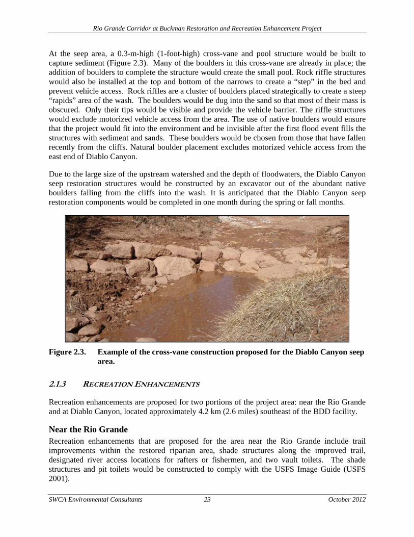
At the seep area, a 0.3-m-high (1-foot-high) cross-vane and pool structure would be built to capture sediment (Figure 2.3). Many of the boulders in this cross-vane are already in place; the addition of boulders to complete the structure would create the small pool. Rock riffle structures would also be installed at the top and bottom of the narrows to create a “step” in the bed and prevent vehicle access. Rock riffles are a cluster of boulders placed strategically to create a steep “rapids” area of the wash. The boulders would be dug into the sand so that most of their mass is obscured. Only their tips would be visible and provide the vehicle barrier. The riffle structures would exclude motorized vehicle access from the area. The use of native boulders would ensure that the project would fit into the environment and be invisible after the first flood event fills the structures with sediment and sands. These boulders would be chosen from those that have fallen recently from the cliffs. Natural boulder placement excludes motorized vehicle access from the east end of Diablo Canyon.
Due to the large size of the upstream watershed and the depth of floodwaters, the Diablo Canyon seep restoration structures would be constructed by an excavator out of the abundant native boulders falling from the cliffs into the wash. It is anticipated that the Diablo Canyon seep restoration components would be completed in one month during the spring or fall months.
Figure 2.3. Example of the cross-vane construction proposed for the Diablo Canyon seep area.
2.1.3 RECREATION ENHANCEMENTS
Recreation enhancements are proposed for two portions of the project area: near the Rio Grande and at Diablo Canyon, located approximately 4.2 km (2.6 miles) southeast of the BDD facility.
Near the Rio Grande Recreation enhancements that are proposed for the area near the Rio Grande include trail improvements within the restored riparian area, shade structures along the improved trail, designated river access locations for rafters or fishermen, and two vault toilets. The shade structures and pit toilets would be constructed to comply with the USFS Image Guide (USFS 2001).
Rio Grande Corridor at Buckman Restoration and Recreation Enhancement Project
SWCA Environmental Consultants 24 October 2012
The USFS proposes to modify the existing Chili Line Trail to include a loop trail, approximately 0.5 km (0.3 mile) long, within the riparian restoration area located northeast of the BDD facility. The trailhead would include a kiosk with information about the area and the trail network. The trail would follow the existing two-track road that follows the Chili Line Trail to an unnamed arroyo and then creates a loop towards the river and back to the Chili Line Trail (Figure 2.4). The trail would be constructed to meet the standards of the Americans with Disability Act of 1990 and would be closed to motorized vehicles. Low profile fencing would also be installed along the loop trail to keep recreational uses from disturbing the riparian restoration areas.
The Chili Line Trail would continue north from the loop trail across the unnamed arroyo and extend approximately 2.25 km (1.4 miles) north to the BLM and Pueblo de San Ildefonso boundary (see Figure 2.4). This portion of the Chili Line Trail would also be improved, where needed, to support pedestrian, equestrian, and mechanical use. The trail would be closed to motorized travel. A sign would be installed at the BLM and Pueblo de San Ildefonso boundary to indicate the end of the trail and that users are not allowed to proceed onto tribal lands.
The existing boat launch area, for river rafting and fishing activities, would be improved northeast of the BDD facility (see Figure 2.4). The boat launch area would consist of a 0.2-acre area on native soils cleared of vegetation. Medium-sized boulders and rocks would be placed on the north and south side of the boat launch area to keep boaters and fishermen from disturbing the adjacent riparian restoration acres.
One restroom facility would be constructed near the parking area adjacent to the BDD facility (see Figure 2.4). The restroom would be large enough to accommodate visitors needing to change clothing and accessible by pathway from a parking area. The restroom would be constructed to meet the standards of the Americans with Disability Act of 1990. The restroom area would also be screened with natural fencing. Three shade structures would be constructed south of the BDD facility to accommodate day use activities (see Figure 2.4).

Rio Grande Corridor at Buckman Restoration and Recreation Enhancement Project
SWCA Environmental Consultants 25 October 2012
Figure 2.4. Proposed recreation enhancements for the Rio Grande Corridor at Buckman.
Rio Grande Corridor at Buckman Restoration and Recreation Enhancement Project
SWCA Environmental Consultants 26 October 2012
Diablo Canyon The main goal for enhancing the recreation components near Diablo Canyon is to establish a management presence within approximately 8 acres of BLM lands on the west side of the canyon. Diablo Canyon is visited by many different user groups, including hikers, climbers, and the film industry. The Cañada Ancha serves as the boundary between BLM and USFS land jurisdictions. Both agencies support activities that would not conflict with the current uses of the area. The most immediate need for the Diablo Canyon area is to stabilize the existing parking area and install low profile vehicle barriers to keep motorized travel off spur roads and trails at the east end of the canyon.
The BLM would grade and reduce the slope of the parking area to reduce soil erosion. In addition, low profile vehicle barriers and fencing would be constructed to keep vehicles off spur roads and trails. The existing barb-wire fence that separates the parking area from the Cañada Ancha would be repaired, according to the BLM fence standards. Six fire rings would replace existing user-created rock campfire rings (Figure 2.5). The spur roads currently used to drive near the informal campsites and to get closer to the Cañada Ancha would be closed. The roads would be blocked with low profile barriers and rehabilitated by scarifying and reseeding the old road beds. Seed mixes used for road rehabilitation would be certified weed-free native seed, approved by the BLM and the USFS.
Parking and traffic flow in the existing disturbed area would be defined by designating parking locations, providing longer spaces for recreational vehicles (RVs) and trailers, providing adequate turning radii, and designing roads with ditches and drainage to BLM standards. The site would change from one big open disturbed area to a site with 25 spaces for passenger vehicles, three parking spaces to accommodate large vehicles with trailers or RVs, a trailhead kiosk, and a site for large group use. The defined site improvements would total approximately 0.7 acre.
The trailhead would include a three-panel information kiosk. The kiosk would contain information describing land use regulations, a map of the area to assist with orientation, and interpretive material about the local area, such as the geology of Diablo Canyon and the history of the Chili Line Railroad. The roadway leading to the recreation area would include a loop around the large group use area. The designated access road would follow existing roads in the area. The BLM may install a vault toilet within the Diablo Canyon parking area in the future if resource issues related to waste management arise.
In addition to the improvements proposed for the Diablo Canyon parking area, the BLM would also improve an existing trail on the northeast side of the canyon to allow safe climber access from the Cañada Ancha arroyo to the base of the north canyon wall (see Figure 2.5). Rock steps would be constructed at the bottom of the trail. Rocks would be moved to provide better trail tread to access the climbing wall.
Rio Grande Corridor at Buckman Restoration and Recreation Enhancement Project
SWCA Environmental Consultants 27 October 2012
Figure 2.5. Proposed recreation enhancement activities at Diablo Canyon.

Rio Grande Corridor at Buckman Restoration and Recreation Enhancement Project
SWCA Environmental Consultants 28 October 2012
2.1.4 POST-RESTORATION MONITORING
In order to control any resprouting of weeds that may occur after implementation of the proposed restoration activities, monitoring for weeds at the restored site will be necessary. For resprouting control post restoration, selective mowing of weeds would be implemented. Selective mowing would consist of hand equipment to cut the weeds before they would set seed, ideally in early spring upon first emergence.
2.2 ALTERNATIVE B – NO ACTION
Under the No Action Alternative, the current level of management by both the USFS and the BLM would continue to guide management of the project area. Lands managed by the USFS would still see some activities as a result of the BDD mitigation measures required by the BDD FEIS and Record of Decision (USFS and BLM 2006). The BLM does not have specific restoration or recreation enhancement activities planned at this time for the lands analyzed in this document.
2.2.1 USFS-ADMINISTERED LAND
Under the BDD FEIS and Record of Decision (USFS and BLM 2006), approximately 8 acres of riparian restoration would be authorized to take place within the project area shown in Figure 2.1, within the restoration areas located south of the BDD facility. No recreation enhancements would occur on USFS lands under the No Action Alternative. Restoration activities would include removing non-native species and planting native species, such as Rio Grande cottonwood, coyote willow, Goodding’s willow, and other riparian plants. Non-native tree removal activities would include 1) manual removal of saltcedar and Russian olive using chainsaws for larger-diameter trees, 2) mastication for smaller diameter trees, and 3) extraction of the entire tree and root ball. Herbicide application would not occur under the No Action Alternative; therefore, restoration activities may be compromised by resprouting of saltcedar, Russian olive, and Siberian elm trees.
After the non-native vegetation has been cleared from the project area, an existing backwater channel would be excavated and lowered by 0.3 to 0.6 m (1–2 feet), to approximately 1,665 m (5,462 feet). Under this condition, surface water and/or groundwater would begin to inundate the backwater channel when flows in the river exceed approximately 1,350 cubic feet per second (cfs). In addition to excavating the existing backwater, a new seasonal wetland would also be excavated. The purpose of these habitat features is to improve habitat support functions for amphibians. The design objectives are to create seasonally inundated habitats that contain appropriate levels of downed wood and native riparian-wetland vegetation to benefit life-cycle requirements for amphibians and secondarily other wildlife species such as bats, raptors, and songbirds. The seasonal wetland is designed to become inundated under average flow conditions during the months of May and June. Inundation of the seasonal wetland would result from the combination of surface water flows moving up the backwater channel and from groundwater levels increasing in response to rising surface water elevations in the river.
In addition to the riparian restoration activities, the following habitat improvements would be installed within the 8 acres of the BDD mitigation project area.
Rio Grande Corridor at Buckman Restoration and Recreation Enhancement Project
SWCA Environmental Consultants 29 October 2012
Bat Habitat Support Bat boxes would be strategically placed within the riparian area in order to enhance the available bat habitat in the area. Other bat habitat, such as snags, would eventually be created by the girdling of the large-diameter Siberian elm trees, as discussed above. In addition to the snags, bat boxes would be installed.
Reptile, Amphibian, and Small Mammal Support Downed trees stockpiled during initial clearing would be strategically placed in the restored riparian areas in order to provide enhanced habitat for reptiles, amphibians, and small mammals. Downed woody material would be placed in various size piles to provide ground cover and refuge areas. Tree boughs from all three exotic species (Siberian elm, Russian olive, and saltcedar) would be placed strategically because each species has a different rate of decay.
Raptor Habitat Support Raptor nesting platforms would be installed to provide roosting habitat within the restored riparian areas. Large nesting platforms typically consist of a long pole with a flat rectangular section on top. Platform designs usually include a 9- to 12-m-tall (30- to 40-foot-tall) pole with a 1.1 × 1.1–m (3.5 × 3.5–foot) nest platform and roosting pole mounted to the top.
2.2.2 BLM-ADMINISTERED LAND
Under the No Action Alternative, the BLM would be able to implement a limited scope of the Proposed Action. Herbicide treatment of the invasive species within the BLM portion of the project area could take place under the Final Vegetation Treatments Using Herbicides on Bureau of Land Management Lands in 17 Western States Programmatic EIS (BLM 2007a). The EIS identifies impacts on the natural and human environment associated with herbicide use, including riparian areas in New Mexico. While management actions may be taken by the BLM under the No Action Alternative, the pace at which they are implemented would likely be slower compared to the Proposed Action. Therefore, existing conditions would likely continue within the project area.
2.3 ALTERNATIVES CONSIDERED BUT NOT ANALYZED IN DETAIL
2.3.1 RIPARIAN RESTORATION WITHOUT THE USE OF HERBICIDES
Restoration of the identified riparian areas without the use of herbicides was considered but dismissed from detailed analysis. The density of non-native species including saltcedar, Russian olive, and Siberian elm make up 51% of the total canopy cover within the proposed project area. Based on the invasive species densities, it is likely that the use of mechanical removal solely would result in extensive resprouting within the project area. Excessive mechanical treatments would be needed to remove the root material of the non-native species to avoid resprouting. This would cause significant soil disturbance and exacerbate the spread of other non-native herbaceous material. This would compromise the USFS’s and the BLM’s ability to reach the
Rio Grande Corridor at Buckman Restoration and Recreation Enhancement Project
SWCA Environmental Consultants 30 October 2012
restoration goals set for the project area and increase the sediment contribution to the Rio Grande and the adjacent BDD project.
Prescribed fire use is another tool that could be used in place of herbicides to remove non-native species and control resprouting. However, due to the proximity of the project area to the BDD project and the existing recreational use of the larger Buckman area, prescribed fire use is not an appropriate tool for the proposed project area. This alternative would not move the Rio Grande riparian area near Buckman towards attainment of proper functioning condition.
2.3.2 RESTORATION OF THE RIO GRANDE RIPARIAN AREA NEAR BUCKMAN WITHOUT THE ASSOCIATED RECREATION ENHANCEMENTS
Completing the only riparian restoration along the Rio Grande Corridor at Buckman was considered during the NEPA process. Implementing the riparian restoration activities would improve the ecological conditions along the Rio Grande; however, restoration alone would not improve the existing use of the greater Buckman area, such as the late night parties, illegal dumping, and illegal shooting. In fact, these activities could continue to occur within the restored areas, thereby reducing the probability of long-term riparian restoration. In addition, solely implementing the riparian restoration components of the NMWF Rio Grande Corridor at Buckman Project Planning Recommendations (SWCA 2009) would not meet the purpose and need of the EA.
2.4 MITIGATION MEASURES
The following list is a summary of the mitigation measures for each of the affected resource areas analyzed within this EA. Only the resource areas that may require mitigation measures are listed below.
2.4.1 CULTURAL RESOURCES
As per the management recommendations provided within the cultural resources report (SWCA 2011): Boundary flags would be placed around sites that have the potential to be disturbed by proposed project activities to ensure complete avoidance by human or vehicular traffic. The BLM would conduct testing of the site within the Diablo Canyon project area prior to implementing the Proposed Action components within and near the site.
2.4.2 SOILS AND TOPOGRAPHY
The non-native removal contractor would prepare a Stormwater Pollution Prevention Plan (SWPPP) prior to construction, which would indicate where the BMPs would be placed to minimize soil erosion and short-term water quality impacts to the Cañada Ancha and the Rio Grande. Once the riparian areas are restored, native understory vegetation would be revegetated with native plants and grasses. In addition, masticated non-native slash material would be spread over the soils to retain soil moisture and encourage native plant establishment.
Rio Grande Corridor at Buckman Restoration and Recreation Enhancement Project
SWCA Environmental Consultants 31 October 2012
2.4.3 VEGETATION
Fencing may be installed along the restoration areas if it is determined that livestock grazing or other activities are impacting newly planted native vegetation along the Rio Grande. Monitoring results would be used to help determine a need for fencing.
All areas of disturbed soil would be reseeded with a certified weed free native seed mix.
Herbicides would be used to control resprouting and minimize the introduction of undesirable vegetation. Herbicides would be applied by a certified applicator, and BMPs would be followed to avoid adverse impacts to non-target plant species. These BMPs include hand wand applications to target specific plants and avoid application of herbicides on native vegetation. Herbicides would also be applied only when weather conditions allow. Trained personnel would not spray if precipitation is expected within 24 hours in order to ensure water contamination does not occur.
2.4.4 WILDLIFE
Construction activities would be conducted outside the migratory bird breeding season (April 15–September 15). If a golden eagle or other bird of prey is observed within 0.4 km (0.25 mile) of active restoration areas in the morning before activity starts, or arrives during any breaks in construction activity, all restoration activities would be suspended until the bird leaves on its own volition. If a golden eagle or other bird of prey arrives during construction activities, or is observed more than 0.4 km (0.25 mile) from the active construction site, restoration activities would not be interrupted.
2.4.5 THREATENED AND ENDANGERED SPECIES/BLM AND USFS SENSITIVE SPECIES/USFS MANAGEMENT INDICATOR SPECIES
Construction activities would be conducted outside the migratory bird breeding season (April 15–September 15). If bald eagles are roosting in the immediate area prior to daily construction activities, construction should not commence until the eagles have left the area.
2.4.6 PUBLIC HEALTH AND SAFETY
Non-native species would be removed through hand cutting and mechanical removal, followed by a cut-stump herbicide treatment. A native seed mix, consisting of upland grasses and forbs would be seeded within the slough area.
The posting of signage notifying the public about the application of herbicides and the use of mechanical equipment, such as chippers, would be implemented during herbicide treatments and mechanical removal.
2.4.7 VISUAL RESOURCES
Weak contrasts to line, color, and texture of the characteristic landscape from the vault toilet could be mitigated to meet Class I objectives. The toilet should be located outside the view of
Rio Grande Corridor at Buckman Restoration and Recreation Enhancement Project
SWCA Environmental Consultants 32 October 2012
the canyon, carefully screened with vegetation and latilla fencing, and the color should be carefully selected to blend with the surrounding environment.
2.4.8 WATER QUALITY AND QUANTITY
BMPs would be required at the construction location to mitigate erosion, which would include the use of silt fences, erosion control fabrics, and revegetation of bare soils. The non-native removal contractor would prepare an SWPPP prior to construction, which would indicate where the BMPs would be placed to minimize the short-term impacts to the Rio Grande and to the Cañada Ancha. In addition, bankline stabilization would be accomplished through management of existing desirable vegetation and active planting in key locations.
2.5 MONITORING
Implementation and effectiveness monitoring will be necessary for the proposed project in order to monitor the implementation of the project during the proposed project activities and the effectiveness of the project after the proposed action has occurred. This will include monitoring for vegetation treatments and for recreational development as well. Recommended methodologies for implementation and effectiveness monitoring are outlined within the Mitigation Plan for the Buckman Water Diversion Project (Parametrix 2011).

Rio Grande Corridor at Buckman Restoration and Recreation Enhancement Project
SWCA Environmental Consultants 33 October 2012
3.0 ENVIRONMENTAL CONSEQUENCES
The topics presented in the following section discuss the impacts, whether adverse or beneficial, from the Proposed Action and No Action alternatives on the human environment. The following resources are not affected by the Proposed Action and No Action alternatives for the reasons stated and therefore are not discussed in the EA:
Air quality and climate change – The project would not affect air quality or climate change trends within the project area nor will this project affect climate change on a global scale. Further, it is unclear what changes in the evapotranspiration rates may occur as a result of the proposed riparian restoration activities.
Prime/Unique farmlands – There are no prime/unique farmlands within the project area.
Hazardous/Solid waste – There are no hazardous/solid wastes used in the project area.
Wilderness – The project is not within or near any designated wilderness areas or wilderness study areas.
Socioeconomics – The project would not impact the socioeconomic resources of the communities near the project area. The proposed riparian restoration activities will only affect natural resources and will not be directly impacting communities in the general vicinity or local/regional economic systems.
Environmental justice – The project would not impact low-income or minority persons in the area. Since the proposed riparian restoration activities will only be impacting natural resources, there is no impact to the surrounding communities. The proposed recreation enhancement activities could have a beneficial impact on the public who use these facilities; however, any potential benefits from recreation improvements to minority populations would be consistent with any benefits to the majority population.
3.1 CULTURAL RESOURCES
Federal regulations require that the USFS, in compliance with Section 106 of the National Historic Preservation Act, consider the effects of the proposed project on historic properties that are included in or are eligible for inclusion in the National Register of Historic Places (NRHP). Prior to the survey fieldwork, SWCA archaeologist Christopher Carlson conducted records searches both at the online Archaeological Records Management Section (ARMS) and Historic Preservation Division (HPD) databases, as well as the NRHP and the State Register of Cultural Properties (SRCP) on February 16, 2011. Paul Williams of the BLM Taos Field Office conducted the BLM check on June 21, 2011. Ryan Brucker of SWCA conducted the USFS records check at the USFS Supervisor’s Office on June 23, 2011. SWCA completed a pedestrian survey with parallel transects spaced no more than 15 m (50 feet) within the proposed project area on February 22 and June 23, 2011.
The cultural resources survey investigated two cultural properties, both on land managed by the BLM. No cultural resources, either isolated manifestations or sites, were found within the USFS portion of the survey. The two cultural properties consist of one segment of the abandoned Chili Line Railroad grade along the Rio Grande and a newly recorded site in the Diablo Canyon
Rio Grande Corridor at Buckman Restoration and Recreation Enhancement Project
SWCA Environmental Consultants 34 October 2012
campground area. The results of the pedestrian survey have been submitted to the BLM and the USFS. The cultural resources report will be submitted to the New Mexico HPD, once approved by the agencies.
3.1.1 ENVIRONMENTAL CONSEQUENCES
Alternative A: Proposed Action The management recommendations contained in the Class III cultural resources report would be followed to avoid any disturbance to cultural/historic resources (SWCA 2011). Boundary flags would be placed around sites that have the potential to be disturbed by proposed project activities to ensure complete avoidance by human or vehicular traffic. The BLM would conduct testing of the site within the Diablo Canyon project area prior to implementing the Proposed Action components within and near the site. By following the management recommendations provided within the cultural resources report (SWCA 2011), the Proposed Action would not impact cultural and heritage resources.
Alternative B: No Action The No Action Alternative would include 8 acres of riparian restoration on USFS lands, completed as mitigation measures under the BDD FEIS. The No Action Alternative project area falls outside the area surveyed by SWCA in 2011 for the NMWF Proposed Action. As a result, a separate cultural resources survey and report would need to be completed for the No Action Alternative. As with the Proposed Action, if cultural or heritage resources are found within the BDD project area, management recommendations would need to be followed in order to avoid impacts to the resources.
3.2 SOILS AND TOPOGRAPHY
Located between the Jemez Mountains to the west and the Sangre de Cristo Mountains to the east, the project area is geologically situated within the Española Basin, part of the U.S. Basin and Range physiographic province (Manley 1979; Hibner 2004). The dominant geologic features in the area include:
Diablo Canyon – Also known as Caja del Rio Canyon, Diablo Canyon is a hard, dark basalt canyon that opens into the Rio Grande at White Rock Canyon. This canyon has dramatic basalt pillars or trap rock (a form of plutonic igneous rock that forms polygonal vertical fractures) walls. The flat sand bottom of the canyon is subject to flash floods in the summer and opens into the Cañada Ancha, a broad sand wash.
White Rock Canyon – Just downstream from the proposed project area is White Rock Canyon, a canyon valued by locals and tribal communities for its rugged vistas, cultural setting, and wildlife viewing. Carving through basalt and tuff geology, both remnants from past eruptions of nearby volcanoes, this canyon is a result of the Rio Grande.
Buckman Mesa – This mesa is a plateau of basalt and pyroclastic rock that runs along the Rio Grande on the north east end of the project area (USFS and BLM 2006). The mesa
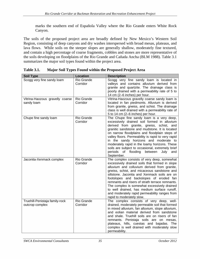
Rio Grande Corridor at Buckman Restoration and Recreation Enhancement Project
SWCA Environmental Consultants 35 October 2012
marks the southern end of Española Valley where the Rio Grande enters White Rock Canyon.
The soils of the proposed project area are broadly defined by New Mexico’s Western Soil Region, consisting of deep canyons and dry washes interspersed with broad mesas, plateaus, and lava flows. While soils on the steeper slopes are generally shallow, moderately fine textured, and contain a high percentage of coarse fragments, cobbles and stones are more representative of the soils developing on floodplains of the Rio Grande and Cañada Ancha (BLM 1988). Table 3.1 summarizes the major soil types found within the project area.
Table 3.1. Major Soil Types Found within the Proposed Project Area
Soil Type Location Description Scogg very fine sandy loam Rio Grande
Corridor Scogg very fine sandy loam is located in valleys and contains alluvium derived from granite and quartzite. The drainage class is poorly drained with a permeability rate of 5 to 14 cm (2–6 inches) per hour.
Vitrina-Haozous gravelly coarse sandy loam
Rio Grande Corridor
Vitrina-Haozous gravelly coarse sandy loam is located in fan piedmonts. Alluvium is derived from granite, gneiss, and schist. The drainage class is well drained with a permeability rate of 5 to 14 cm (2–6 inches) per hour.
Chupe fine sandy loam Rio Grande Corridor
The Chupe fine sandy loam is a very deep, excessively drained soil formed in alluvium derived from granite, gneiss, schist, and granitic sandstone and mudstone. It is located on narrow floodplains and floodplain steps of valley floors. Permeability is rapid to very rapid in the sandy horizons and moderate to moderately rapid in the loamy horizons. These soils are subject to occasional, extremely brief periods of flooding between July and September.
Jaconita-Xenmack complex Rio Grande Corridor
The complex consists of very deep, somewhat excessively drained soils that formed in slope alluvium and colluvium derived from granite, gneiss, schist, and micaceous sandstone and siltstone. Jaconita and Xenmack soils are on footslopes and backslopes of eroded fan remnants and risers of strath terrace remnants. The complex is somewhat excessively drained to well drained, has medium surface runoff, and moderately rapid permeability ranges from rapid to moderately slow.
Truehill-Penistaja family-rock outcrop complex
Rio Grande Corridor
The complex consists of very deep, well-drained, moderately permeable soil that formed in mixed alluvium, fan alluvium, slope alluvium, and eolian material derived from sandstone and shale. Truehill soils are on risers of fan remnants. Penistaja soils are on mesas, plateaus, hills, cuestas and bajadas. The complex is well drained with moderately slow permeability.
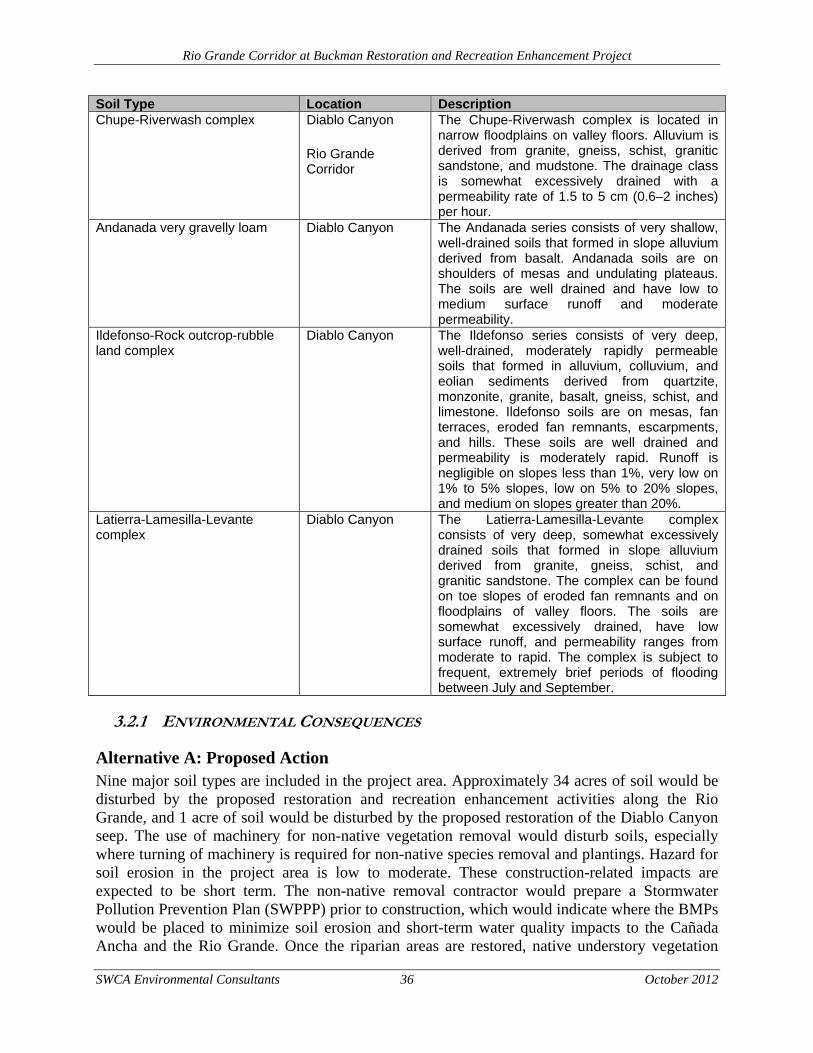
Rio Grande Corridor at Buckman Restoration and Recreation Enhancement Project
SWCA Environmental Consultants 36 October 2012
Soil Type Location Description Chupe-Riverwash complex Diablo Canyon
Rio Grande Corridor
The Chupe-Riverwash complex is located in narrow floodplains on valley floors. Alluvium is derived from granite, gneiss, schist, granitic sandstone, and mudstone. The drainage class is somewhat excessively drained with a permeability rate of 1.5 to 5 cm (0.6–2 inches) per hour.
Andanada very gravelly loam Diablo Canyon The Andanada series consists of very shallow, well-drained soils that formed in slope alluvium derived from basalt. Andanada soils are on shoulders of mesas and undulating plateaus. The soils are well drained and have low to medium surface runoff and moderate permeability.
Ildefonso-Rock outcrop-rubble land complex
Diablo Canyon The Ildefonso series consists of very deep, well-drained, moderately rapidly permeable soils that formed in alluvium, colluvium, and eolian sediments derived from quartzite, monzonite, granite, basalt, gneiss, schist, and limestone. Ildefonso soils are on mesas, fan terraces, eroded fan remnants, escarpments, and hills. These soils are well drained and permeability is moderately rapid. Runoff is negligible on slopes less than 1%, very low on 1% to 5% slopes, low on 5% to 20% slopes, and medium on slopes greater than 20%.
Latierra-Lamesilla-Levante complex
Diablo Canyon The Latierra-Lamesilla-Levante complex consists of very deep, somewhat excessively drained soils that formed in slope alluvium derived from granite, gneiss, schist, and granitic sandstone. The complex can be found on toe slopes of eroded fan remnants and on floodplains of valley floors. The soils are somewhat excessively drained, have low surface runoff, and permeability ranges from moderate to rapid. The complex is subject to frequent, extremely brief periods of flooding between July and September.
3.2.1 ENVIRONMENTAL CONSEQUENCES
Alternative A: Proposed Action Nine major soil types are included in the project area. Approximately 34 acres of soil would be disturbed by the proposed restoration and recreation enhancement activities along the Rio Grande, and 1 acre of soil would be disturbed by the proposed restoration of the Diablo Canyon seep. The use of machinery for non-native vegetation removal would disturb soils, especially where turning of machinery is required for non-native species removal and plantings. Hazard for soil erosion in the project area is low to moderate. These construction-related impacts are expected to be short term. The non-native removal contractor would prepare a Stormwater Pollution Prevention Plan (SWPPP) prior to construction, which would indicate where the BMPs would be placed to minimize soil erosion and short-term water quality impacts to the Cañada Ancha and the Rio Grande. Once the riparian areas are restored, native understory vegetation
Rio Grande Corridor at Buckman Restoration and Recreation Enhancement Project
SWCA Environmental Consultants 37 October 2012
would be revegetated with native plants and grasses. In addition, masticated non-native slash material would be spread over the soils to retain soil moisture and encourage native plant establishment.
The proposed recreation enhancements would also establish a management presence within the project area, which would better direct recreational users along specific trails and roads. As a result, previously disturbed areas would be revegetated, both naturally and through seeding. For example, the BLM plans to grub and reseed the spur road along the Cañada Ancha arroyo at the Diablo Canyon campground. In addition, the unauthorized spur roads both at the Rio Grande and Diablo Canyon would be blocked to prevent motorized access. These areas are expected to naturally revegetate through established seed sources. Compared to the No Action Alternative, the proposed project would reduce the amount of long-term soil erosion because travel along unofficial routes and spur roads would be minimized.
Alternative B: No Action The No Action Alternative would include 8 acres of riparian restoration on USFS lands, completed as mitigation measures under the BDD FEIS. The use of machinery for non-native vegetation removal would disturb soils, especially where turning of machinery is required for non-native species removal and plantings. Hazard for soil erosion in the project area is low to moderate. These impacts are expected to be short term and construction related. Once the riparian areas are restored, native understory vegetation would be revegetated with native plants and grasses. The No Action Alternative would not include the use of herbicides; therefore, the area would likely need to be retreated mechanically in order to manage the resprouting of non-native vegetation. This anticipated retreatment would cause additional impacts to soils if large machinery is used during subsequent vegetation retreatment activities.
3.3 LAND USE
Greater management parameters have been applied to the Rio Grande Corridor at Buckman in the updated Taos RMP (BLM 2012). As part of the BLM’s planning process, the area has been determined to have relevant and important values and has been designated as the Santa Fe Ranch ACEC in the updated plan (BLM 2012). The Santa Fe Ranch ACEC includes contiguous land around the Santa Fe Ranch/Diablo Canyon area in order to protect cultural resources, unique geological features (Diablo Canyon), visual resources (Diablo Canyon), wildlife habitat, and special status species. The Santa Fe Ranch ACEC is a Special Recreation Management Area with prescribed management in the updated Taos RMP (BLM 2012). These designations will result in closer regulatory oversight of the area and increased patrolling.
According to the FEIS for the Buckman Water Diversion Project (USFS and BLM 2006), evidence from SWCA field crews and the Taos RMP (BLM 2010a), existing land uses on or near the proposed project area include the following: ranching, timber harvesting for firewood, utility corridors and easements, water management purposes (wells, pipelines, drainages and flood control, etc.), agricultural purposes, and various recreation activities, including car camping, fishing, shooting, OHV touring, backpacking, horseback riding, nature study, and scenery/nature viewing.
Rio Grande Corridor at Buckman Restoration and Recreation Enhancement Project
SWCA Environmental Consultants 38 October 2012
The Diablo Canyon portion of the project area is located with the Santa Fe grazing allotment managed by the BLM. The grazing allotment is 20,496 acres in size and includes 3,667 animal unit months (AUMs). The allotment falls within public, state, and private lands.
The Rio Grande Corridor portion of the project area is located within the Caja del Rio grazing allotment managed by the USFS. The allotment is approximately 75,000 acres in size, is grazed year-round, and consists of four pastures. The allotment is permitted for grazing 520 cow/calf units annually. The project area is located within the Sagebrush pasture, which has a general season of use from mid-October through the end of December. Unauthorized livestock grazing does occur in the area due to fence vandalism, such as fence cutting, by motorized recreation users.
3.3.1 ENVIRONMENTAL CONSEQUENCES
Alternative A: Proposed Action While continuing to operate under the guidelines of the Santa Fe National Forest Plan and the BLM Taos RMP, the Proposed Action would impact current uses of public land in the Buckman area. Unauthorized activities in the area, including shooting and illegal dumping, would likely diminish while other outdoor recreation activities would benefit from the interpretive signage, parking areas, and bathroom facilities. Livestock grazing would experience minor adverse impacts resulting from the fencing at the Diablo Canyon parking area and trailhead. Approximately 8 acres would be removed from the 20,496 grazing allotment in order to reduce conflicts between recreationists at Diablo Canyon and livestock. The increased management presence both at Diablo Canyon and the Rio Grande Corridor would beneficially impact the area by creating safer and more favorable conditions for recreationists, utility corridors and easements, and BDD water management.
Alternative B: No Action The No Action Alternative would include 8 acres of riparian restoration on USFS lands, completed as mitigation measures under the BDD FEIS. The riparian restoration activities, in conjunction with the established BDD presence in the project vicinity are likely to influence the use of the Buckman area to some extent. The riparian restoration would improve the setting of Rio Grande Corridor and could encourage recreationists to visit the area more frequently. In addition, the presence of BDD maintenance vehicles and workers could discourage some unauthorized activity in the area. However, under the No Action Alternative, the increased management presence by the BLM and the USFS within the project area outside the BDD footprint would not be established. Designated routes and trails would not be identified, the vault toilets would not be built, and 27 less acres of riparian area would be restored. It is likely that unauthorized shooting, late night parties, and illegal dumping would continue to occur in those areas outside the BDD’s management footprint. Livestock grazing would not be impacted under the No Action Alternative because no additional fencing would be erected at Diablo Canyon.
3.4 VEGETATION
The vegetation communities within the project area can be defined as Rio Grande Flood Plain and North Central New Mexico Valleys and Mesas biotic communities (Griffith et al. 2006) or
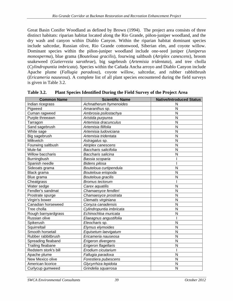
Rio Grande Corridor at Buckman Restoration and Recreation Enhancement Project
SWCA Environmental Consultants 39 October 2012
Great Basin Conifer Woodland as defined by Brown (1994). The project area consists of three distinct habitats: riparian habitat located along the Rio Grande, piñon-juniper woodland, and the dry wash and canyon within Diablo Canyon. Within the riparian habitat dominant species include saltcedar, Russian olive, Rio Grande cottonwood, Siberian elm, and coyote willow. Dominant species within the piñon-juniper woodland include one-seed juniper (Juniperus monosperma), blue grama (Bouteloua gracilis), fourwing saltbush (Atriplex canescens), broom snakeweed (Gutierrezia sarothrae), big sagebrush (Artemisia tridentata), and tree cholla (Cylindropuntia imbricata). Species within the Cañada Ancha arroyo and Diablo Canyon include Apache plume (Fallugia paradoxa), coyote willow, saltcedar, and rubber rabbitbrush (Ericameria nauseosa). A complete list of all plant species encountered during the field surveys is given in Table 3.2.
Table 3.2. Plant Species Identified During the Field Survey of the Project Area
Common Name Scientific Name Native/Introduced StatusIndian ricegrass Achnatherum hymenoides N Pigweed Amaranthus sp. N Cuman ragweed Ambrosia psilostachya N Purple threeawn Aristida purpurea N Tarragon Artemisia dracunculus N Sand sagebrush Artemisia filifolia N White sage Artemisia ludoviciana N Big sagebrush Artemisia tridentata N Milkvetch Astragalus sp. N Fourwing saltbush Atriplex canescens N Mule-fat Baccharis salicifolia N Willow baccharis Baccharis salicina N Burningbush Bassia scoparia I Spanish needle Bidens pilosa I Sideoats grama Bouteloua curtipendula N Black grama Bouteloua eriopoda N Blue grama Bouteloua gracilis N Cheatgrass Bromus tectorum I Water sedge Carex aquatilis N Fendler's sandmat Chamaesyce fendleri N Prostrate spurge Chamaesyce prostrata N Virgin's bower Clematis virginiana N Canadian horseweed Conyza canadensis N Tree cholla Cylindropuntia imbricata N Rough barnyardgrass Echinochloa muricata N Russian olive Elaeagnus angustifolia I Spikerush Eleocharis sp. N Squirreltail Elymus elymoides N Smooth horsetail Equisetum laevigatum N Rubber rabbitbrush Ericameria nauseosa N Spreading fleaband Erigeron divergens N Trailing fleabane Erigeron flagellaris N Redstem stork's bill Erodium cicutarium I Apache plume Fallugia paradoxa N New Mexico olive Forestiera pubescens N American licorice Glycyrrhiza lepidota N Curlycup gumweed Grindelia squarrosa N
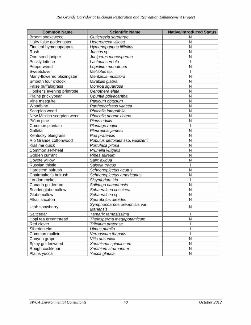
Rio Grande Corridor at Buckman Restoration and Recreation Enhancement Project
SWCA Environmental Consultants 40 October 2012
Common Name Scientific Name Native/Introduced StatusBroom snakeweed Gutierrezia sarothrae N Hairy false goldenaster Heterotheca villosa N Fineleaf hymenopappus Hymenopappus filifolius N Rush Juncus sp. N One-seed juniper Juniperus monosperma N Prickly lettuce Lactuca serriola I Pepperweed Lepidium monatnum N Sweetclover Melilotus sp. I Many-flowered blazingstar Mentzelia multiflora N Smooth four o'clock Mirabilis glabra N False buffalograss Monroa squarrosa N Hooker's evening primrose Oenothera elata N Plains pricklypear Opuntia polyacantha N Vine mesquite Panicum obtusum N Woodbine Parthenocissus vitacea N Scorpion weed Phacelia integrifolia N New Mexico scorpion weed Phacelia neomexicana N Piñon pine Pinus edulis N Common plantain Plantago major I Galleta Pleuraphis jamesii N Kentucky bluegrass Poa pratensis N Rio Grande cottonwood Populus deltoides ssp. wislizenii N Kiss me quick Portulaca pilosa N Common self-heal Prunella vulgaris N Golden currant Ribes aureum N Coyote willow Salix exigua N Russian thistle Salsola tragus I Hardstem bulrush Schoenoplectus acutus N Chairmaker's bulrush Schoenoplectus americanus N London rocket Sisymbrium irio I Canada goldenrod Solidago canadensis N Scarlet globemallow Sphaeralcea coccinea N Globemallow Sphaeralcea sp. N Alkali sacaton Sporobolus airoides N
Utah snowberry Symphoricarpos oreophilus var. utanensis
N
Saltcedar Tamarix ramosissima I Hopi tea greenthread Thelesperma megapotamicum N Red clover Trifolium pratense I Siberian elm Ulmus pumila I Common mullein Verbascum thapsus I Canyon grape Vitis arizonica N Spiny goldenweed Xanthisma spinulosum N Rough cocklebur Xanthium strumarium N Plains yucca Yucca glauca N
Rio Grande Corridor at Buckman Restoration and Recreation Enhancement Project
SWCA Environmental Consultants 41 October 2012
3.4.1 INVASIVE SPECIES
The project area has become degraded and is dominated by non-native invasive species. From vegetation surveys completed by SWCA biologists in October 2010, 25% of the woody species cover was made up of Russian olive and 21% by saltcedar. A further 8% is made up of Siberian elm. These invasive species are outcompeting native vegetation in the area, for example Rio Grande cottonwood, coyote willow, and New Mexico olive combined only make up 32% of the woody species cover. In recent years, the area has been subject to significant piñon die off (SWCA 2003a, 2003b) and is infested with Canadian thistle (Cirsium arvense), cheatgrass (Bromus tectorum), dalmatian toadflax (Linaria genistifolia ssp. dalmatica), and yellow toadflax (L. vulgaris).
Noxious weeds as identified by the State of New Mexico (New Mexico Department of Agriculture [NMDA] 2009) that were observed during the field survey include cheatgrass (Bromus tectorum), saltcedar, Russian olive, and Siberian elm. All noxious weeds observed are considered Class C noxious weeds (NMDA 2009). Class C species are widespread with management decisions determined at the local level based on the feasibility of control and level of infestation. Russian thistle (Salsola tragus) was present in the project area but is not classified as an A, B, or C species in New Mexico. The proposed project may contribute to the spread of these noxious weeds if not properly managed. Noxious weed BMPs should be used based on both BLM and USFS stipulations. Adherence to these stipulations would minimize the spread of noxious weeds in the project area.
3.4.2 ENVIRONMENTAL CONSEQUENCES
Alternative A: Proposed Action The Proposed Action would provide restoration enhancements that would improve the vegetative communities within the project area and would remove invasive species. The species diversity within the restoration area would shift from a primarily non-native species composition to a composition of native species such as Rio Grande cottonwood, Goodding’s willow, and peachleaf willow. The proposed project is also designed to increase structural and forage diversity along the Rio Grande and within Diablo Canyon. The appropriate removal of non-native vegetation and the subsequent reintroduction of native species to the area are likely to beneficially impact 34 acres of riparian zone along the east bank of the Rio Grande and approximately 1 acre within Diablo Canyon. Fencing may be installed along the restoration areas if it is determined that livestock grazing or other activities are impacting newly planted native vegetation along the Rio Grande. Monitoring results would be used to help determine a need for fencing.
The Proposed Action would temporarily impact existing riparian vegetation with the 34-acre Rio Grande project area due to the use of heavy machinery and manpower to remove the non-native trees and masticate the woody material. The machinery used for removal and plantings would maintain a straight line as much as possible; however, the turning of machinery has the potential to disturb and relocate topsoil. All areas of disturbed soil would be reseeded with a certified weed free native seed mix.
Rio Grande Corridor at Buckman Restoration and Recreation Enhancement Project
SWCA Environmental Consultants 42 October 2012
Herbicides would be used to control resprouting and minimize the introduction of undesirable vegetation. Herbicides would be applied by a certified applicator, and BMPs would be followed to avoid adverse impacts to non-target plant species. These BMPs include hand wand applications to target specific plants and avoid application of herbicides on native vegetation. Herbicides would also be applied only when weather conditions allow. Trained personnel would not spray if precipitation is expected within 24 hours in order to ensure water contamination does not occur.
The proposed recreation enhancements would also improve the management presence within the project area, which would better direct recreational users along specific trails and roads. As a result, previously disturbed areas would be revegetated, both naturally and through seeding with certified weed-free native seed approved by the BLM and the USFS. For example, the BLM plans to grub and reseed the spur road along the Cañada Ancha arroyo at the Diablo Canyon campground. In addition, the unauthorized spur roads both at the Rio Grande and at Diablo Canyon would be blocked to prevent motorized access. These areas are expected to naturally revegetate through established seed sources. Compared to the No Action Alternative, the proposed project would improve the vegetative communities within the project area because travel along unofficial routes and spur roads would be minimized, thereby allowing native species to become re-established.
Alternative B: No Action Alternative The No Action Alternative would include 8 acres of riparian restoration on USFS lands, completed as mitigation measures under the BDD FEIS. Similar to the Proposed Action, the species diversity within the restoration area would shift from a primarily non-native species composition to a composition of native species such as Rio Grande cottonwood, Goodding’s willow, and peachleaf willow. The restoration that would occur under the No Action Alternative is also designed to increase structural and forage diversity along the Rio Grande.
The use of machinery for non-native vegetation removal would disturb soils and established vegetation, especially where turning of machinery is required for non-native species removal and plantings. These construction-related impacts are expected to be short term. Once the riparian areas are restored, native understory vegetation would be revegetated with native plants and grasses.
The No Action Alternative would not include the use of herbicides; therefore, the area would likely need to be retreated mechanically in order to manage the resprouting of non-native vegetation. This anticipated retreatment would cause additional impacts to native vegetation if large machinery is used during subsequent vegetation retreatment activities.
The No Action Alternative would not include any riparian restoration activities on BLM lands or within Diablo Canyon and would restore 27 less acres within the project area than the Proposed Action. In addition, the BLM would not be able to establish a management presence established at Diablo Canyon under this alternative. Vegetation would continue to be disturbed and trampled by motorized vehicles using spur roads near the mouth of Diablo Canyon and at the Rio Grande Corridor at Buckman.
Rio Grande Corridor at Buckman Restoration and Recreation Enhancement Project
SWCA Environmental Consultants 43 October 2012
3.5 WILDLIFE
The various vegetation communities found in the project area offer potential habitat to many common and rare wildlife species. Amphibians occur in areas with permanent or semi-permanent1 water sources, such as the cattle tanks, ephemeral channels, and similar habitats that occur in the project area. Amphibians that are known to occur in north-central New Mexico and may occur in the project area include bull frog (Rana catesbeiana), Woodhouse’s toad (Bufo [=Anaxyrus] woodhousii), and red-spotted toad (B. [=Anaxyrus] punctatus) (Degenhardt et al. 1996; Stebbins 2003).
Reptiles are especially adapted to dry conditions and extreme temperatures and are common in the project area and surrounding woodland and riparian habitats. One lizard species, the New Mexican whiptail (Aspidoscelis [Cnemidophorus] neomexicanus), was identified during the field survey. Other common reptiles that may use the habitats within the project area include short horned lizard (Phrynosoma douglasii), prairie lizard (Sceloporus undulatus), tree lizard (Urosaurus ornatus), Chihuahuan spotted whiptail (Aspidoscelis [Cnemidophorus] exsanguis), mountain patchnose snake (Salvadora grahamiae), western terrestrial garter snake (Thamnophis elegans), blackneck garter snake (T. cyrtopsis), western rattlesnake (Crotalus viridis), and bullsnake (Pituophis melanoleucus) (Degenhardt et al. 1996).
Many mammal species are associated with the habitats found in the project area. One mammal, the Colorado chipmunk (Neotamias quadrivittatus), was identified within the project area, and willows with characteristic teeth marks of American beaver (Castor canadensis) were observed. Common small mammals that may use habitats within the project area include black-tailed jackrabbit (Lepus californicus), desert cottontail (Sylvilagus audubonii), and several woodrat (Neotoma sp.) and mouse (Peromyscus sp.) species. Numerous small mammal burrows were seen within the project area and many mammal species could be using the burrows. Larger mammal species that could potentially be within the project area include mule deer, elk (Cervus canadensis), gray fox (Urocyon cinereoargenteus), kit fox (Vulpes macrotis), and coyote (Canis latrans) (Biota Information System of New Mexico [BISON-M] 2011). These larger mammals may use the project area as a travel corridor between the mountainous habitats and water sources.
3.5.1 MIGRATORY BIRDS
The federal Migratory Bird Treaty Act (MBTA) of 1918 prohibits the taking, hunting, killing, selling, purchasing, etc., of migratory birds, parts of migratory birds, or their eggs and nests. Most bird species native to North America are covered by the MBTA. Ten bird species were observed during SWCA’s biological survey on April 22, 2011 (Table 3.3); however, no active nests were observed in the project area.
1 Semi-permanent water sources are meant to include water sources that are maintained human-made structures (e.g., livestock tanks) or are ephemeral or intermittent natural water features that contain surface water for only a portion of the year.
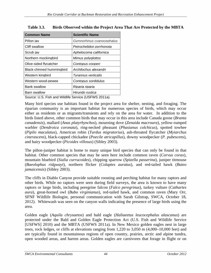
Rio Grande Corridor at Buckman Restoration and Recreation Enhancement Project
SWCA Environmental Consultants 44 October 2012
Table 3.3. Birds Observed within the Project Area That Are Protected by the MBTA
Common Name Scientific Name
Piñon jay Gymnorhinus cyanocephalus
Cliff swallow Petrochelidon pyrrhonota
Scrub jay Aphelocoma californica
Northern mockingbird Mimus polyglottos
Olive-sided flycatcher Contopus cooperi
Black-chinned hummingbird Archilochus alexandri
Western kingbird Tyrannus verticalis
Western wood-pewee Contopus sordidulus
Bank swallow Riparia riparia
Barn swallow Hirundo rusticaSource: U.S. Fish and Wildlife Service (USFWS 2011a).
Many bird species use habitats found in the project area for shelter, nesting, and foraging. The riparian community is an important habitat for numerous species of birds, which may occur either as residents or as migrants/transients and rely on the area for water. In addition to the birds listed above, other common birds that may occur in this area include Canada goose (Branta canadensis), mallard (Anas platyrhynchos), mourning dove (Zenaida macroura), yellow-rumped warbler (Dendroica coronata), ring-necked pheasant (Phasianus colchicus), spotted towhee (Pipilo maculatus), American robin (Turdus migratorius), ash-throated flycatcher (Myiarchus cinerascens), black-capped chickadee (Poecile atricapillus), downy woodpecker (P. pubescens), and hairy woodpecker (Picoides villosus) (Sibley 2003).
The piñon-juniper habitat is home to many unique bird species that can only be found in that habitat. Other common species that may be seen here include common raven (Corvus corax), mountain bluebird (Sialia currucoides), chipping sparrow (Spizella passerina), juniper titmouse (Baeolophus ridgwayi), northern flicker (Colaptes auratus), and red-tailed hawk (Buteo jamaicensis) (Sibley 2003).
The cliffs in Diablo Canyon provide suitable roosting and perching habitat for many raptors and other birds. While no raptors were seen during field surveys, the area is known to have many raptors or large birds, including peregrine falcon (Falco peregrinus), turkey vulture (Cathartes aura), great-horned owl (Bubo virginianus), red-tailed hawk, and common raven (Mary Orr, SFNF Wildlife Biologist, personal communication with Sarah Gilstrap, SWCA, October 18, 2012). Whitewash was seen on the canyon walls indicating the presence of large birds using the area.
Golden eagle (Aquila chrysaetos) and bald eagle (Haliaeetus leucocephalus alascanus) are protected under the Bald and Golden Eagle Protection Act (U.S. Fish and Wildlife Service [USFWS] 2010) and the MBTA (USFWS 2011a). In New Mexico golden eagles nest in large trees, rock ledges, or cliffs at elevations ranging from 1,220 to 3,050 m (4,000–10,000 feet) and are typically found in mountainous regions of open country, prairies, arctic and alpine tundra, open wooded areas, and barren areas. Golden eagles are carnivores that forage in flight or on
Rio Grande Corridor at Buckman Restoration and Recreation Enhancement Project
SWCA Environmental Consultants 45 October 2012
perch, feeding mainly on small mammals, as well as invertebrates, carrion, and other wildlife (BISON-M 2011).
3.5.2 ENVIRONMENTAL CONSEQUENCES
Alternative A: Proposed Action The Proposed Action could result in short-term adverse impacts to wildlife and migratory birds. Wildlife habitat may suffer short-term degradation due to loss of vegetation, which may provide forage and cover. Approximately 34 acres of wildlife habitat along the Rio Grande would be impacted during the construction phase of the project. The 1-acre Diablo Canyon seep would also be impacted by restoration activities, including the use of heavy machinery to construct the cross-vane. The construction activities would occur during the fall and winter months, with replanting of natives species scheduled to occur in the spring and early summer. The restored wildlife habitat is expected to become re-established within one year of the initial disturbance.
Many migratory birds that utilize riparian areas are known to use non-native trees such as saltcedar and Russian olive for nesting when native trees are not available. Removal of those trees during restoration activities would temporarily reduce nesting habitat for those birds and could potentially disturb active nests. Construction activities would be conducted outside the migratory bird breeding season (April 15–September 15). Activities in the project area are not expected to impact the population of golden eagles, and none were observed during field reconnaissance within the project area. However, if a golden eagle or other bird of prey is observed within 0.4 km (0.25 mile) of active restoration areas in the morning before activity starts, or arrives during any breaks in construction activity, all restoration activities would be suspended until the bird leaves on its own volition. If a golden eagle or other bird of prey arrives during construction activities, or is observed more than 0.4 km (0.25 mile) from the active construction site, restoration activities would not be interrupted.
Herbicides would be used to control resprouting and to minimize the introduction of undesirable vegetation. Herbicides would be applied by a certified applicator, and BMPs would be followed to avoid adverse impacts to wildlife. These BMPs include hand wand applications to target specific plants and avoid application of herbicides on established native vegetation. Herbicides would also be applied only when weather conditions allow. Trained personnel would not spray if precipitation is expected within 24 hours. In addition, herbicides would be prepared in a designated area outside the riparian zone to reduce the chance for spills or accidents within sensitive areas.
Long-term beneficial impacts to wildlife and migratory birds are expected to occur as a result of 34 acres of riparian restoration along the Rio Grande Corridor and the restoration of the 1-acre seep in Diablo Canyon. These benefits include overall improvement of biodiversity, including nesting opportunities within the vegetative communities, increased structural diversity, and increased forage diversity.
Alternative B: No Action Alternative The No Action Alternative would include 8 acres of riparian restoration on USFS lands, completed as mitigation requirements under the BDD FEIS. Similar to the Proposed Action, the species diversity within the restoration area would shift from a primarily non-native species
Rio Grande Corridor at Buckman Restoration and Recreation Enhancement Project
SWCA Environmental Consultants 46 October 2012
composition to a composition of native species such as Rio Grande cottonwood, Goodding’s willow, and peachleaf willow. The restoration that would occur under the No Action Alternative is also designed to increase structural and forage diversity along the Rio Grande.
The use of machinery for non-native vegetation removal would disturb wildlife during the short-term construction phase. The long-term beneficial impacts to the BDD restoration area would include improve wildlife habitat and diversity within the vegetative communities.
The No Action Alternative would not include the use of herbicides; therefore, the area would likely need to be retreated mechanically in order to manage the resprouting of non-native vegetation. This anticipated retreatment would cause additional impacts to wildlife during subsequent vegetation retreatment activities.
The No Action Alternative would not include any riparian restoration activities on BLM lands or within Diablo Canyon. The No Action Alternative would restore 27 less acres within the project area than the Proposed Action.
3.6 THREATENED AND ENDANGERED SPECIES
The special-status species evaluated were based on the federally listed threatened, endangered, candidate species and species of concern for Santa Fe County, New Mexico, available at the USFWS website (USFWS 2011b). State-listed threatened and endangered wildlife species were also evaluated for potential to occur within Santa Fe County (New Mexico Department of Game and Fish [NMDGF] 2008), and habitat and range information was reviewed using the BISON-M website (BISON-M 2011). The BLM sensitive species list for Santa Fe County was reviewed, and the Taos Field Office was consulted to evaluate the potential for occurrence of sensitive species in the project area (BLM 1999). The USFS Region 3 sensitive species list for Santa Fe County and the Santa Fe National Forest Management Indicator Species Assessment (USFS 2006) were reviewed, and the Española Ranger District was consulted to evaluate the potential for occurrence of sensitive and MIS (Mary Orr, SFNF Wildlife Biologist, personal communication with Sarah Gilstrap, SWCA, October 18, 2012). The New Mexico Rare Plant Technical Council (NMRPTC 2011) website was reviewed for rare plant information, and the New Mexico Energy, Minerals and Natural Resources Department (New Mexico Administrative Code 19.21.2.8) was also reviewed to determine if any state-protected plants might be present in the area. Plant species listed by the NMRPTC are not afforded legal protection unless they are also federally or state-listed as threatened or endangered.
Six of the 16 species listed by the USFWS and six of the 16 species listed by the State of New Mexico for Santa Fe County have the potential to occur in the project area. For the rest of the listed species, the project area is either clearly beyond the known geographic or elevational range of these species, or it does not contain vegetation or landscape features known to support these species, or both.
Western Burrowing Owl (Athene cunicularia hypugaea) The western burrowing owl is a USFWS species of concern, a BLM sensitive species, and a USFS sensitive species. Burrowing owls inhabit open areas, such as grasslands, pastures, coastal dunes, desert scrub, the edges of agricultural fields, and wherever there is sufficient friable soil

Rio Grande Corridor at Buckman Restoration and Recreation Enhancement Project
SWCA Environmental Consultants 47 October 2012
for a nesting burrow (Haug et al. 1993). The presence of other nesting burrows (such as that of a badger, prairie dog, tortoise, or other animal) seems to be a requirement for the species (Haug et al. 1993); a decline in the population of burrowing mammals may adversely affect owls through a lack of available burrows (Haug et al. 1993). Burrowing owls are primarily crepuscular in foraging habits but have been observed to hunt any time of the day or night. Insects are often taken during daylight and small mammals after dark. Observed causes of mortality include human disturbance through agricultural and construction activities and collisions with vehicles (the owls habitually sit and hunt on roads at night). Scientific research involving digging up burrows and nests causes destruction and abandonment of these sites. Human activities that reduce quality of prey habitat and thus lower food supplies result in poorer reproductive success in females (Haug et al. 1993).
Yellowed-billed Cuckoo (Coccyzus americanus occidentalis) The yellow-billed cuckoo is a USFWS candidate species, a USFS sensitive species, and a BLM sensitive species. This species occurs locally along waterways in lowland deciduous woods and thickets throughout New Mexico (BISON-M 2011). The cuckoo prefers riparian habitat with dense willow (Salix sp.), cottonwood (Populus sp.), saltcedar, and/or mesquite (Prosopis sp.). Food sources include large insects, caterpillars, katydids, cicadas, grasshoppers, crickets, frogs, lizards, bird eggs and young, fruit, and seeds. Suitable breeding habitat consists of large stands of dense willow and cottonwood, but exotics like saltcedar are also used. Although they have not been recently reported along the Rio Grande upstream from Cochiti Reservoir, suitable habitat may exist within White Rock Canyon or along other stretches of the river.
Southwestern Willow Flycatcher (Empidonax traillii extimus) The Southwestern willow flycatcher is a USFWS and State of New Mexico endangered species. USFWS critical habitat has been designated. The Southwestern willow flycatcher occurs in riparian habitats along rivers, streams, or other wetlands where dense growths of willows, baccharis (Baccharis sp.), arrowweed (Pluchea sp.), saltcedar, or other plants are present, often with a scattered overstory of cottonwood. These riparian communities provide nesting and foraging habitat (BISON-M 2011).
American Peregrine Falcon (Falco peregrinus anatum) and Arctic Peregrine Falcon (F. p. tundrius) Both the American and the arctic peregrine falcon are USFWS species of concern and State of New Mexico threatened species. The American peregrine falcon is also a USFS sensitive species. Both are discussed here since habitat requirements are the same for the species in the state, although the Arctic peregrine falcon is a very rare transient. In New Mexico, the breeding territories of peregrine falcons center on cliffs that are in wooded/forested habitats, with large “gulfs” of air nearby in which these predators can forage (BISON-M 2011).
Pale Townsend’s Big-eared Bat (Corynorhinus townsendii pallenses) Pale Townsend’s big-eared bat is a USFWS species of concern, a USFS sensitive species, and a BLM sensitive species. The bats are frequently associated with caves and abandoned mines for day roosts and hibernacula but will also use abandoned buildings and crevices on rock cliffs for refuge. Townsend’s big-eared bats are relatively sedentary; they do not move long distances from hibernacula to summer roosts, nor do they move or forage far from their day roosts (BISON-M 2011).
Rio Grande Corridor at Buckman Restoration and Recreation Enhancement Project
SWCA Environmental Consultants 48 October 2012
3.6.1 ENVIRONMENTAL CONSEQUENCES
Alternative A: Proposed Action The Proposed Action is likely to have long-term positive effects on threatened and endangered species. The removal of non-native species and the reintroduction of native species would create a more natural, long-term habitat for threatened and endangered species. The following sections describe the potential impact to each federally threatened or endangered species that is likely to occur in the project area.
Western Burrowing Owl (Athene cunicularia hypugaea) Western burrowing owl habitat found within the project area includes open areas within the piñon-juniper woodland and riparian habitats and some mammal burrows within the elevational range of the species. No owls were observed during field reconnaissance, nor were any prairie dog towns.
The proposed project may impact individuals of western burrowing owl. Construction activities leading to compacted soils used by burrowing owls or other burrowing mammals would have an adverse impact on the species; additionally, depending on time of day of construction activities, the foraging behavior of the owls could be impacted. Construction activity could also reduce the availability of prey in the area of the water catchments, which would further impact the owls. Construction is not likely to result in a trend toward federal listing or loss of viability as there is very little suitable habitat in the project area and there is ample habitat more suitable for this species outside the project area. Prior to restoration activities, burrows would be surveyed to confirm that the burrow is not occupied by a western burrowing owl. During restoration, surface-disturbing activities would be required to halt until western burrowing owl individuals leave the project area on their own accord.
Yellowed-billed Cuckoo (Coccyzus americanus occidentalis) There is suitable nesting and foraging habitat for the yellow-billed cuckoo in the Rio Grande at Buckman areas of the project. Suitable habitats include saltcedar and willow thickets along the banks of the river. No nests or individuals were observed during field surveys.
The yellow-billed cuckoo’s distribution historically included areas of the Rio Grande bosque within the project area but no recent records exist from the area. The proposed project may impact individuals of yellow-billed cuckoo by removing suitable nesting trees, but it is not likely to result in a trend toward federal listing or loss of viability, as the species has not been recorded from the area recently. Proposed restoration activities, including the removal of invasive saltcedar and Russian olive, may improve habitat for the yellow-billed cuckoo by allowing native willow and cottonwood to become re-established.
Southwestern Willow Flycatcher (Empidonax traillii extimus) Migratory habitat for this species exists in riparian areas found within the project area. No nests or individuals were observed during field surveys. The project area falls outside USFWS-designated Southwestern willow flycatcher critical habitat.
The proposed project may impact the Southwestern willow flycatcher by removing invasive trees suitable for perching and foraging, but it is not likely to result in a trend toward federal listing or
Rio Grande Corridor at Buckman Restoration and Recreation Enhancement Project
SWCA Environmental Consultants 49 October 2012
loss of viability, as the disturbance is temporary. Non-native species removal would occur outside the migratory/breeding season of the Southwestern willow flycatcher. The Proposed Action would have a long-term beneficial impact on the species. The proposed restoration activities would improve vegetation species and structural diversity, as well as nesting habitat for migratory birds, by planting native willow and cottonwood.
American Peregrine Falcon (Falco peregrinus anatum) and Arctic Peregrine Falcon (F. p. tundrius) Suitable nesting habitat exists in the cliffs within Diablo Canyon and suitable foraging habitat exists in the piñon-juniper habitats and surrounding areas. Peregrine falcons have been documented in the canyon (Mary Orr, SFNF Wildlife Biologist, personal communication with Coleman Burnett, SWCA, May 13, 2011). No peregrine falcons were observed during field surveys.
The proposed project would not impact individuals of peregrine falcon by following BMPs, as defined by the USFS peregrine falcon mitigation measures (Mary Orr, SFNF Wildlife Biologist, personal communication with Coleman Burnett, SWCA, October 19, 2011). Restoration activities may have beneficial long-term effects on the species by increasing foraging habitat.
Pale Townsend’s Big-eared Bat (Corynorhinus townsendii pallenses) The piñon-juniper woodlands that occur in the project area may serve as roosting habitat for the species. No bats were observed during the field survey.
The proposed project may impact individual roosting sites of pale Townsend’s big-eared bat if there is abundant tree removal during construction, including dispersal of individuals and avoidance of the project area, but it is not likely to result in a trend toward federal listing or loss of viability because tree removal in the piñon-juniper woodlands would be minimal.
Alternative B: No Action Alternative The No Action Alternative would include 8 acres of riparian restoration on USFS lands, completed as mitigation requirements under the BDD FEIS. Similar to the Proposed Action, the species diversity within the restoration area would shift from a primarily non-native species composition to a composition of native species such as Rio Grande cottonwood, Goodding’s willow, and peachleaf willow. The restoration that would occur under the No Action Alternative is also designed to increase structural and forage diversity along the Rio Grande.
Similar short-term adverse and long-term beneficial impacts to threatened and endangered species are expected to occur under the No Action Alternative. The use of machinery for non-native vegetation removal would disturb species during the short-term construction phase. The long-term beneficial impacts to the BDD restoration area would include improved species habitat and diversity within the vegetative communities. The No Action Alternative would not include the use of herbicides; therefore, the area would likely need to be retreated mechanically in order to manage the resprouting of non-native vegetation. This anticipated retreatment would cause additional impacts to threatened and endangered species during subsequent vegetation retreatment activities.

Rio Grande Corridor at Buckman Restoration and Recreation Enhancement Project
SWCA Environmental Consultants 50 October 2012
The No Action Alternative would not include any riparian restoration activities on BLM lands or within Diablo Canyon. The No Action Alternative would restore 27 less acres within the project area than the Proposed Action.
3.7 BLM AND USFS SENSITIVE SPECIES
The BLM sensitive species list (BLM 1999) was reviewed, and the Taos Field Office was consulted to evaluate the potential for occurrence of sensitive species in the project area. The USFS Region 3 sensitive species list for Santa Fe County (USFS 2006) was reviewed, and the Española Ranger District was consulted to evaluate the potential for occurrence of sensitive species. Fourteen of the 21 species listed as sensitive for the Taos Field Office by the BLM, as well as 13 of the 39 species listed as USFS sensitive, have the potential to be in the project area. For the rest of the listed species, the project area is either clearly beyond the known geographic or elevational range of these species, or it does not contain vegetation or landscape features known to support these species, or both.
Bald Eagle (Haliaeetus leucocephalus alascanus) The bald eagle is a New Mexico threatened, USFS sensitive, and BLM sensitive species. It is also protected by the Bald and Golden Eagle Protection Act (USFWS 2010). Bald eagles are common winter residents along the Rio Grande. They would roost in cliffs and large snags along the water (BISON-M 2011).
Loggerhead Shrike (Lanius ludovicianus) The loggerhead shrike is a USFS and BLM sensitive species. This species ranges altitudinally from agricultural lands on the prairies to montane meadows, nesting in sagebrush areas, desert scrub, piñon-juniper woodlands, deciduous riparian forests, and woodland edges, and habitats may be selected for availability of perching sites such as fences (BISON-M 2011).
White-faced Ibis (Plegadis chihi) The white-faced ibis is a USFS and BLM sensitive species. This species breeds in association with shoreline and marsh habitats that border open water at lower elevations (853–1,676 m [2,800–5,500 feet]). Vegetation within these areas usually consists of cattails and rushes (Juncus sp.), but other plant species (including occasional woody shrub and trees) can be present. This species nests rarely in New Mexico with only two recorded nests in the state (BISON-M 2011) but is common during spring and fall migrations along the Middle Rio Grande, where it occurs in ponds and wetlands, the river channel, and adjacent agricultural fields.
Gray Vireo (Vireo vicinior) The gray vireo is a New Mexico threatened and USFS sensitive species. The breeding habitat of this species is generally open woodlands/shrublands featuring evergreen trees and shrubs of various kinds. The species is often associated with oaks (Quercus sp.) in the southern part of its range and usually in habitat with a well-developed grass component (BISON-M 2011).
Mountain Plover (Charadrius montanus) The mountain plover is a USFS sensitive species and a BLM sensitive species. Mountain plovers utilize shortgrass prairies and dry playas dominated by blue grama and buffalograss (Buchloe dactyloides) and scattered taller vegetation during the breeding season. Other vegetation includes
Rio Grande Corridor at Buckman Restoration and Recreation Enhancement Project
SWCA Environmental Consultants 51 October 2012
western wheatgrass (Agropyron smithii), fourwing saltbush, rabbitbrush (Chrysothamnus sp.), broom snakeweed, cholla (Cylindropuntia sp.), prickly pear (Opuntia polyacantha), yucca (Yucca sp.), and occasionally juniper (Juniperus sp.). The species appears to require some degree of bare ground, which may be provided by livestock grazing, prairie dog towns, disturbed areas around windmills and water tanks, and barren playas. Nests are often located near prominent objects such as woody plants, cow manure, rocks, fence posts, and power poles (BISON-M 2011).
Northern Leopard Frog (Rana pipiens) The northern leopard frog is a USFS sensitive species. This species is generally associated with streams and rivers although lakes, marshes, and irrigation ditches are also occupied. In New Mexico this species is known from about 1,120 to 3,050 m (3,675–10,006 feet) in northern and western New Mexico and along the Rio Grande (Degenhardt et al. 1996).
Spotted Bat (Euderma maculatum) The spotted bat is a New Mexico threatened, USFS sensitive, and BLM sensitive species. The species has been captured in ponderosa pine (Pinus ponderosa) of montane forests, piñon-juniper woodlands, and open semi-desert shrublands. Rocky cliffs are necessary to provide suitable cracks and crevices for roosting, as is access to water. The bat shows apparent seasonal change in habitat, occupying ponderosa pine woodlands in the reproductive season and lower elevations at other times of the year (BISON-M 2011).
Small-footed Myotis Bat (Myotis ciliolabrum) The western small-footed myotis is a BLM sensitive species. The species is widely distributed in many habitats throughout the western United States. In summer the bat has been found roosting in rock crevices, caves, dwellings, burrows, among rocks, under bark, and even beneath rocks scattered on the ground. Along the Rocky Mountains and adjacent plains, the western small-footed myotis is generally found in the broken terrain of canyons and foothills, commonly in places with cover of trees or shrubs (BISON-M 2011).
Long-eared Myotis (Myotis evotis) The long-eared myotis is a BLM sensitive species. This species occurs in coniferous forests at moderate elevations. It is most common in ponderosa pine woodlands and is also found in piñon-juniper woodlands and subalpine forests. The animals use day roosts in tree cavities, under loose bark, and in buildings. These sites as well as caves and mines are used for night roosts. The long-eared myotis feeds over water and along the margins of vegetation. No records of the long-eared myotis exist for the project area.
Fringed Myotis (Myotis thysanodes) The fringed myotis is a BLM sensitive species. This species is found from chaparral to ponderosa pine, but its preferred habitat is probably oak woodland, from which it forages out into a variety of other habitats. The fringed myotis roosts in caves, mines, and buildings transiently during the night (BISON-M 2011).
Rio Grande Corridor at Buckman Restoration and Recreation Enhancement Project
SWCA Environmental Consultants 52 October 2012
Long-legged Myotis Bat (Myotis volans) The long-legged myotis bat is a BLM sensitive species. This species uses desert scrub, oak-woodland, oak-juniper, piñon-juniper, ponderosa pine, spruce-fir, deciduous riparian, and coniferous riparian habitat types (BISON-M 2011).
Yuma Myotis Bat (Myotis yumanensis yumanensis) The Yuma myotis bat is a BLM sensitive species. This bat is usually associated with permanent sources of water such as streams. The species also is known to use tinajas and occur in a variety of habitats, including riparian areas, arid shrublands, deserts, and forests. Yuma myotis bats roost by day in rock crevices, buildings, caves, mines, and swallows’ nests. Night roosts typically are in buildings, under ledges, or similar shelters. Nursery colonies are usually in buildings or caves and may contain a large number of individuals (BISON-M 2011).
Big Free-tailed Bat (Nyctinomops macrotis) The big free-tailed bat is a BLM sensitive species. The species prefers coniferous, mixed woodland or riparian habitats for foraging and depends on rocky cliffs for roosting (BISON-M). This species is not known from Santa Fe County but has the potential to occur in the project area based on habitat and distribution in adjacent areas.
Botta’s Pocket Gopher (Thomomys bottae aureus) Botta’s pocket gopher is a USFS sensitive species. These gophers live in underground burrows in nearly every habitat within the state so long as sufficient tuberous roots and plant material are available and soil is suitable for digging tunnels.
Gunnison’s Prairie Dog (Cynomys gunnisoni) Gunnison’s prairie dog is a USFS sensitive species. The species inhabits grasslands from low valleys to montane meadows. Gunnison’s prairie dog is known to occur not far from the project area in similar habitat types.
3.7.1 ENVIRONMENTAL CONSEQUENCES
Alternative A: Proposed Action The Proposed Action is expected to have a long-term beneficial impact to many of the BLM and USFS sensitive species. The following sections describe the potential impact to each species that is likely to occur in the project area.
Bald Eagle (Haliaeetus leucocephalus alascanus) The bald eagle commonly winters along the Rio Grande between the BDD project and Cochiti Reservoir. Most of the preferred roost sites are in snags and cliffs along the river in the section between Bandelier National Monument and the reservoir delta. Suitable habitat within the project area includes large cottonwood or elm snags and the cliffs along Diablo Canyon.
If present, impacts to this species would be limited to temporary dispersals during construction activities. If bald eagles are roosting in the immediate area prior to daily construction activities, construction should not commence until the eagles have left the area.

Rio Grande Corridor at Buckman Restoration and Recreation Enhancement Project
SWCA Environmental Consultants 53 October 2012
Construction activities would be conducted outside the migratory bird breeding season (April 15–September 15). If a bald eagle is observed within 0.4 km (0.24 mile) of active restoration areas in the morning before activity starts, or arrives during any breaks in construction activity, all restoration activities would be suspended until the bird leaves on its own volition. If a bald eagle arrives during construction activities, or is observed more than 0.4 km (0.24 mile) from the active construction site, restoration activities would not be interrupted.
Loggerhead Shrike (Lanius ludovicianus) There is suitable nesting habitat in the shrubs and trees within the project area and suitable foraging habitat is present throughout the project area. No loggerhead shrike nests or birds were observed during the field survey.
The proposed project may adversely impact the breeding sites of the species if there is abundant tree and shrub removal, but it is not likely to result in a trend toward federal listing or loss of viability as there is abundant habitat in surrounding areas. Additionally, building new fencing in the project area may have a beneficial impact to the species, as it would introduce new perching sites.
White-faced Ibis (Plegadis chihi) Suitable habitat for the white-faced ibis can be found adjacent to the project area in the Rio Grande, and local occurrence of the species within the project area during migration is possible. Construction activities may adversely impact individuals due to noise and disturbance of temporary use sites. In the long-term, the proposed restoration activities along the Rio Grande and in Diablo Canyon should improve habitat for the species.
The proposed project may impact individuals of white-faced ibis during construction, but it is not likely to result in a trend toward federal listing or loss of viability as the impacts would be a temporary annoyance and dispersals due to construction; ample suitable habitat exists in surrounding areas.
Gray Vireo (Vireo vicinior) There is an abundance of scattered juniper trees throughout the project area and some nearby foothills and mesas. However, this habitat is considered marginal at best and not likely to attract many species of gray vireo. No gray vireo nests or birds were observed during the field survey.
The proposed project may impact individual nests of gray vireo during construction, but it is not likely to result in a trend toward federal listing or loss of viability, as there is abundant available habitat and existing suitable habitat in the project area is marginal.
Mountain Plover (Charadrius montanus) Marginal suitable habitat for this species exists in disturbed areas within the piñon-juniper woodland on the project area. Additional suitable habitat exists within disturbed areas adjacent to the habitat.
The proposed project may impact individuals of mountain plover during construction and create temporary species dispersal from the project area, but it is not likely to result in a trend toward federal listing or loss of viability, as the suitable habitat available in the project area is marginal and there is abundant habitat in areas adjacent to the project. In addition, there would be no
Rio Grande Corridor at Buckman Restoration and Recreation Enhancement Project
SWCA Environmental Consultants 54 October 2012
activity allowed on BLM lands if the mountain plover was found to be nesting and disturbance would impact the species. The bird would be allowed to nest undisturbed and, once the individual(s) have left the area, only then would activity be allowed to proceed at that site.
Northern Leopard Frog (Rana pipiens) The edge of the riparian and aquatic areas within the Rio Grande Corridor at Buckman sites have suitable habitat for this species. Recent records from the area are lacking (Degenhardt et al. 1996), but it is possible the species may persist.
The proposed project may adversely impact individuals of northern leopard frog by disturbing existing habitat during construction, but it is not likely to result in a trend toward federal listing or loss of viability. The proposed restoration activities would have long-term beneficial impacts to the species by creating more suitable habitat.
Spotted Bat (Euderma maculatum) The project area contains piñon-juniper woodlands and rocky outcrops that may serve as potential roosting habitat for the species. No bats were observed during the field survey.
There are no records of the spotted bat in Santa Fe County, but the species is expected to be present because it occurs in adjacent areas and suitable habitat exists. The proposed project may impact individual spotted bat roosting sites if there is abundant tree removal during construction including dispersal of individuals and avoidance of the project area, but it is not likely to result in a trend toward federal listing or loss of viability as tree removal in the piñon-juniper woodlands would be minimal.
Small-footed Myotis Bat (Myotis ciliolabrum) The piñon-juniper woodlands and rocky outcrops that occur in the project area may serve as roosting habitat for the species. No bats were observed during the field survey.
Construction activities may adversely impact individuals of small-footed myotis, but they are not likely to result in a trend toward federal listing or loss of viability. Long-term beneficial impacts may occur due to improved foraging habitat as a result of the restoration activities.
Long-eared Myotis (Myotis evotis) Suitable roosting habitat for the long-eared myotis exists within the project area in the piñon-juniper woodland, and suitable foraging habitat exists in riparian areas.
There are no records of the long-eared myotis in Santa Fe County, but the species is expected to occur because it is in adjacent areas and suitable habitat exists. Construction activities may adversely impact individuals of long-eared myotis due to non-native tree removal. Individuals may leave and avoid the project area during the construction phase, but the proposed project is not likely to result in a trend toward federal listing or loss of viability as tree removal in the piñon-juniper woodlands would be minimal and restoration in the riparian areas may improve foraging habitat.
Fringed Myotis (Myotis thysanodes) The piñon-juniper woodlands and available water in the project area may serve as additional foraging habitat for the species. No bats were observed during the field survey.
Rio Grande Corridor at Buckman Restoration and Recreation Enhancement Project
SWCA Environmental Consultants 55 October 2012
Construction activities may adversely impact individuals of fringed myotis due to non-native tree removal. Individuals may leave and avoid the project area during the construction phase, but the project is not likely to result in a trend toward federal listing or loss of viability as tree removal in the piñon-juniper woodlands would be minimal and restoration in the riparian areas may improve foraging habitat.
Long-legged Myotis Bat (Myotis volans) Suitable roosting and foraging habitat is present in piñon-juniper and riparian areas within the project area. No bats were observed during field surveys.
Construction activities may adversely impact individuals of long-legged myotis due to non-native tree removal. Individuals may leave and avoid the project area during the construction phase, but the proposed project is not likely to result in a trend toward federal listing or loss of viability as tree removal in the riparian areas would be short term and restoration in the riparian areas would improve foraging habitat.
Yuma Myotis Bat (Myotis yumanensis yumanensis) Suitable roosting and foraging habitat exists along riparian areas located within the project area. No bats were observed during the field survey.
Construction activities may adversely impact individuals of Yuma myotis bat due to non-native tree removal. Individuals may leave and avoid the project area during the construction phase, but the proposed project is not likely to result in a trend toward federal listing or loss of viability as tree removal in the riparian areas would be short term and restoration in the riparian areas would improve foraging habitat.
Big Free-tailed Bat (Nyctinomops macrotis) Suitable foraging habitat exists in riparian areas and piñon-juniper woodlands. Suitable roosting habitat exists in cliffs within Diablo Canyon. No bats were observed during field surveys.
The proposed project may impact individuals of big free-tailed bat by creating temporary disturbance in foraging habitat during construction and increased recreational use of cliffs where bats may roost in may lead to avoidance of the area by individuals. The proposed project is not likely to result in a trend toward federal listing or loss of viability, as there is abundant available habitat in areas adjacent to the project area.
Botta’s Pocket Gopher (Thomomys bottae aureus) Suitable soils exist both within the riparian and piñon-juniper woodland habitats within the project area. No Botta’s pocket gophers were observed during field surveys; however, potential mounds were observed.
Construction activities such as soil compaction and vegetation removal may negatively impact individuals of Botta’s pocket gopher, but they are not likely to result in a trend toward federal listing or loss of viability as available habitat is abundant within the surrounding area.
Rio Grande Corridor at Buckman Restoration and Recreation Enhancement Project
SWCA Environmental Consultants 56 October 2012
Gunnison’s Prairie Dog (Cynomys gunnisoni) Gunnison’s prairie dog is a USFS sensitive species. The species inhabits grasslands from low valleys to montane meadows. No Gunnison’s prairie dogs were observed during field surveys; however, the species is known to occur not far from the project area in similar habitat types.
Construction activities such as soil compaction and vegetation removal may negatively impact individuals of Gunnison’s prairie dog, but they are not likely to result in a trend toward federal listing or loss of viability, as available habitat is abundant within the surrounding area.
Alternative B: No Action Alternative The No Action Alternative would include 8 acres of riparian restoration on USFS lands, completed as mitigation requirements under the BDD FEIS. Similar to the Proposed Action, the species diversity within the restoration area would shift from a primarily non-native species composition to a composition of native species such as Rio Grande cottonwood, Goodding’s willow, and peachleaf willow. The restoration that would occur under the No Action Alternative is also designed to increase structural and forage diversity along the Rio Grande.
Similar short-term adverse and long-term beneficial impacts to USFS and BLM sensitive species are expected to occur under the No Action Alternative. The use of machinery for non-native vegetation removal would disturb species during the short-term construction phase. The long-term beneficial impacts to the BDD restoration area would include improve species habitat and diversity within the vegetative communities. The No Action Alternative would not include the use of herbicides; therefore, the area would likely need to be retreated mechanically in order to manage the resprouting of non-native vegetation. This anticipated retreatment would cause additional impacts to USFS and BLM sensitive species during subsequent vegetation retreatment activities.
The No Action Alternative would not include any riparian restoration activities on BLM lands or within Diablo Canyon. The No Action Alternative would restore 27 less acres within the project area than the Proposed Action.
3.8 USFS MANAGEMENT INDICATOR SPECIES
The SFNF has designated eight MIS with the objective to select species that would indicate possible effects of changing plant communities and associated seral stages on each species. These species were selected for their association with plant communities or seral stages, which management activities are expected to affect (USFS 2006). Descriptions of MIS species and the habitats they are selected to represent and effects of the proposed project on those species or habitats are discussed below.
Rocky Mountain Bighorn Sheep (Ovis canadensis canadensis) Bighorn sheep serve as a management indicator for alpine meadow habitat. On the SFNF, Rocky Mountain bighorn sheep inhabit the highest alpine areas of the Sangre de Cristo Mountains within the Pecos Wilderness. This includes the cliffs, crags, or other extremely rocky areas around the mountain peaks and open alpine meadow areas down to the edge areas of the spruce-fir type (USFS 2006).
Rio Grande Corridor at Buckman Restoration and Recreation Enhancement Project
SWCA Environmental Consultants 57 October 2012
Rocky Mountain Elk (Cervus elaphus nelsoni) Rocky Mountain elk serve as a management indicator for mid elevation (generally less than 2,743 m [9,000 feet]) grasslands, meadows, and forested areas (USFS 2006). During the summer, elk occupy montane meadows and montane coniferous forests. In winter, they move to lower piñon-juniper woodland, mixed conifer forest, plains grassland, or even desert scrub (BISON-M 2011). Elk populations are managed by the NMDGF by game management units.
Merriam’s Turkey (Meleagris gallopavo) Merriam’s turkey uses a wide range of vegetative communities, but the species was selected to serve as a management indicator of healthy, mature ponderosa pine habitat. Merriam’s turkey utilizes ponderosa pine, a source of mast and its preferred roosting tree. Ponderosa pine is an essential component of its permanent habitat, while surface water is a range requirement. Turkeys prefer to roost in tall mature or over-mature ponderosa pines with relatively open crowns and large horizontal branches starting at 6 to 9 m (20–30 feet) from the ground. Trees with a diameter at breast height of over 36 cm (14 inches) are often used as roosts. Turkeys forage in grasslands, brush communities, deciduous tree-brush, and ponderosa pine (USFS 2006).
Mourning Dove (Zenaida macroura) The mourning dove serves as a management indicator of healthy, mid and low elevation grasslands, woodlands, and ponderosa pine habitats. The species can be found in higher elevation communities but are typically regarded as casual above 2,134 m (7,000 feet). Mourning doves nest in a variety of habitats including shrub lands and forests. Fields used for feeding are often characterized by an abundance of small weed seeds and grain on relatively bare ground. The mourning dove is found across North America in many types of habitat, including most forest types. The species is widespread except in the Arctic and closed forests, and it is abundant and increasing near farms and suburbs and frequents backyard feeders, suburbs, and towns (USFS 2006).
Hairy Woodpecker (Picoides villosus) Hairy woodpeckers serve as a management indicator for mature forest and woodland habitats. They are also found in mature piñon-juniper, but typically, piñon trees are not large enough to provide suitable snags for nesting. They are primarily insectivorous and feed on insects associated with snags and downed logs. Consequently, snags and downed logs are key components of hairy woodpecker habitat (USFS 2006). Hairy woodpeckers are also known to use mature snags of cottonwood and elm (Ulmus sp.) in riparian areas.
Pinyon Jay (Gymnorhinus cyanocephalus) Pinyon jays can be found in a wide variety of vegetative communities, but they were selected to serve as a management indicator of healthy piñon-juniper habitat. Pinyon jays nest mainly in stands of piñon-juniper. The species needs open woodlands for nesting and an adequate supply of seeds, especially nuts. They are gregarious and breed in colonies of up to 150 individuals. They spend the winters in large flocks in search of piñon stands with a successful crop of piñon nuts that are a primary food source along with other seeds, fruits, and insects (USFS 2006).
Rio Grande Corridor at Buckman Restoration and Recreation Enhancement Project
SWCA Environmental Consultants 58 October 2012
Mexican Spotted Owl (Strix occidentalis lucida) Mexican spotted owls serve as a management indicator for late seral stage mixed conifer habitat. The Mexican spotted owl is most common in mature and old-growth forests throughout much of its range. The most highly sought habitat characteristics include high canopy closure, high stand density, a multi-layered canopy, uneven-aged stands, numerous snags, and downed woody matter (USFS 2006).
Rio Grande Cutthroat Trout (Oncorhynchus clarki virginalis) Rio Grande cutthroat trout serves as a management indicator of healthy riparian and stream habitats and good water quality. The trout is found primarily in clear, cold mountain lakes and streams in Colorado and New Mexico within the Rio Grande Basin. In New Mexico, the Rio Grande cutthroat trout exists only in mountain streams primarily within the Sangre de Cristo and Jemez Mountain ranges. Isolated populations persist in southern New Mexico on the Gila National Forest in the Black Range and on the Mescalero Apache Indian Reservation in the Tularosa Basin (USFS 2006).
3.8.1 ENVIRONMENTAL CONSEQUENCES
Alternative A: Proposed Action The Proposed Action is expected to have a long-term beneficial impact to many of the MIS indentified by the USFS for consideration. The following sections describe the potential impact to each MIS.
Rocky Mountain Bighorn Sheep (Ovis canadensis canadensis) The proposed project is well outside the known range of this species and no alpine meadows exist within the project area. This proposed project would have no impact on Rocky mountain bighorn sheep or its habitat.
Rocky Mountain Elk (Cervus elaphus nelsoni) The project area is located in Game Management Unit 6c where elk are known to occur. However, no evidence of elk was seen during surveys and woodland habitat in the area is marginal for this species. No management indicator habitat is present in the project area. It is possible that elk may enter the area in winter and utilize the riparian area for water. Increased recreational usage of the areas may impede elk from utilizing the riparian area; however, there is abundant riparian habitat outside the project area. The proposed project is not expected to have an impact on elk or its habitat.
Merriam’s Turkey (Meleagris gallopavo) The proposed project area has no suitable ponderosa pine habitat for this species. The project would have no impact on Merriam’s turkey or its habitat.
Mourning Dove (Zenaida macroura) The proposed project contains suitable habitat for mourning dove. The species is likely to occur both in the riparian area and in the woodlands. Restoration activities would benefit the mourning dove by providing more foraging area, and recreation activities would have minimal impact on the species due to the abundant habitat in the area.
Rio Grande Corridor at Buckman Restoration and Recreation Enhancement Project
SWCA Environmental Consultants 59 October 2012
Hairy Woodpecker (Picoides villosus) Suitable habitat exists for this species within portions of the project area that fall along the Rio Grande riparian areas. Large cottonwood and elm snags are suitable while saltcedar and Russian olive are unsuitable habitat for this species. Restoration activities used at the Rio Grande at Buckman area would benefit this species by creating new elm snags and additional habitat.
Pinyon Jay (Gymnorhinus cyanocephalus) One pinyon jay was observed within the project area during field surveys. Suitable habitat for this species exists within the project area but it is marginal due to the piñon mortality from bark beetles (Curculionidae). Proposed restoration and recreation activities are not anticipated to have any impact on this species.
Mexican Spotted Owl (Strix occidentalis lucida) No suitable mixed conifer habitat is within the project area. Designated critical habitat for this species is present approximately 8 km (5 miles) southwest of the project area in the Jemez Mountains. The proposed project would have no effect on this species or its habitat.
Rio Grande Cutthroat Trout (Oncorhynchus clarki virginalis) The proposed project area is outside the known range of this species and contains no suitable habitat. The proposed project would have no effect on this species or its habitat.
Alternative B: No Action Alternative The No Action Alternative would include 8 acres of riparian restoration on USFS lands, completed as mitigation requirements under the BDD FEIS. Similar to the Proposed Action, the species diversity within the restoration area would shift from a primarily non-native species composition to a composition of native species such as Rio Grande cottonwood, Goodding’s willow, and peachleaf willow. The restoration that would occur under the No Action Alternative is also designed to increase structural and forage diversity along the Rio Grande.
Similar short-term adverse and long-term beneficial impacts to USFS MIS are expected to occur under the No Action Alternative. The use of machinery for non-native vegetation removal would disturb species during the short-term construction phase. The long-term beneficial impacts to the BDD restoration area would include improve species habitat and diversity within the vegetative communities. The No Action Alternative would not include the use of herbicides; therefore, the area would likely need to be retreated mechanically in order to manage the resprouting of non-native vegetation. This anticipated retreatment would cause additional impacts to MIS during subsequent vegetation retreatment activities.
The No Action Alternative would not include any riparian restoration activities on BLM lands or within Diablo Canyon. The No Action Alternative would restore 27 less acres within the project area than the Proposed Action.
Rio Grande Corridor at Buckman Restoration and Recreation Enhancement Project
SWCA Environmental Consultants 60 October 2012
3.9 PUBLIC HEALTH AND SAFETY
3.9.1 TRAFFIC AND CONSTRUCTION ACTIVITIES
The main access route to the project area is via County Road 77, also known as Buckman Road, and Camino La Tierra. Buckman Road is an unpaved two-lane road which has recently been widened as a result of the BDD project. The unpaved road is approximately 9.2 miles and length and crosses through developed neighborhoods, such as the Las Campanas and La Tierra Nueva developments. Recent traffic counts for Buckman Road indicate that 19 vehicles per weekday and 50 vehicles per weekend visit the Buckman (USFS and BLM 2006). The weekday estimate may now be slightly higher due to the completed BDD project and associated maintenance traffic.
3.9.2 LANL LEGACY CONTAMINATION
Note to reader: Monitoring and evaluation of LANL legacy materials within the Rio Grande have been ongoing since at least the mid-1990s. The sampling events discussed below were specifically designed for the proposed project area discussed in this document and are a small portion of the larger monitoring effort within the Rio Grande watershed.
In 2007, the New Mexico Environment Department (NMED) Department of Energy (DOE) Oversight Bureau released a report identifying LANL legacy materials along the Rio Grande near the Rio Grande Corridor at Buckman (Englert et al. 2007). The report indicates these materials were transported from canyons near LANL in the 1950s and 1960s during flood events. Portions of the slough (see Figure 2.1) may have legacy materials at a minimum of 1.2 m (4 feet) below the soil surface (Englert et al. 2008). As a result of the DOE Oversight Bureau’s findings, and concerns raised during the public scoping, the NMWF ordered additional analysis of the potential restoration area in order to guide specific restoration recommendations and avoid LANL legacy materials. The additional analyses conducted for this project include a Micro-R survey to measure topical gamma radiation and radionuclide analysis on five soil samples and one vegetation sample (ALS Laboratory Group 2009).
Micro-R Survey Results
A Micro-R survey, completed on April 12, 2009, found the amount of radiation detected at the ground surface in the project area and adjacent arroyos was within the normal background range. The Micro-R survey involves reading the Micro-R meters to detect any substantial changes in readings between transect sampling points. If at any point the meters read a value that was higher than baseline, an additional point would be added. No such instances occurred during the survey.
Soil and Vegetation Sampling Results
Results from sediment and vegetation sampling conducted in June 2009 within the riparian area adjacent to the slough, any area of soft and muddy ground adjacent to the Rio Grande, indicate that most radionuclides in most samples were not detected. Radionuclides that were detected were indistinguishable from normal background levels. Samples were taken using a hand auger. A global positioning system (GPS) unit was used to record the sampling locations in Universal Transverse Mercator (UTM) coordinates. Five boreholes were dug for sampling purposes, and
Rio Grande Corridor at Buckman Restoration and Recreation Enhancement Project
SWCA Environmental Consultants 61 October 2012
one tree sample was collected. Two of the boreholes were dug to collect samples at and near the ground surface; the remaining three were dug to a depth at each site where the ground was saturated. These depths ranged from 1.3 to 1.4 m (4.2–4.6 feet).
A 4-kg (9-lb) vegetation sample of saltcedar was taken from an area known to overlie the clay lens that now covers part of the buried former river channel and slough, described in Graf (1994), in order to gain an estimate of the upper boundary of radionuclides in vegetation in the Buckman area. Work by Graf (1993) and the NMED (Englert et al. 2007; Englert et al. 2008) has shown that the clay lens contains low levels of LANL legacy contaminants, while adjacent river bar, river bed, and tributary alluvium sediments, which are the ground surface materials throughout the entire area and envelop the clay lens, contain contaminant levels that are indistinguishable from normal background.
The sediment and vegetation samples were analyzed by Paragon Analytics in Fort Collins, Colorado. Most radionuclides in the majority of samples were not detected. All detections and measurements of radionuclides were at levels that are indistinguishable from normal background levels. More precisely, no radionuclide measurements were higher than the regional reference levels, which represent upper limits for normal background (McLin and Lyons 2002; Englert et al. 2007). According to Englert et al. (2007:18), “These reference values were derived from historical measurements of sediments collected in northern New Mexico beyond potential LANL impacts. If it is less than the reference, we assume it is indistinguishable from background [levels]... Background sediments also contain naturally occurring levels of uranium and most metals.”
All measured detections of cesium, strontium, and uranium in soil and vegetation samples are indistinguishable from normal background levels as defined by the regional reference levels derived from historical measurements of sediments collected in northern New Mexico beyond potential LANL impacts (McLin and Lyons 2002; Englert et al. 2008).
3.9.1 ENVIRONMENTAL CONSEQUENCES
Alternative A: Proposed Action Construction vehicles, such as pickup trucks pulling larger construction equipment (masticators, backhoes, chippers), would be traveling along Buckman Road to access the project area. The improved gravel road is wide enough to accommodate the short-term increase in large vehicular traffic. The long-term impact to traffic in the area would include potential increased visitation due to the improved recreational setting at the Rio Grande Corridor at Buckman and at Diablo Canyon. For example, school groups may choose to visit the area during the week to learn about riparian restoration. The increased travel along Buckman Road is not expected to significantly increase from the current traffic pattern.
The NMWF ordered additional analysis of the potential restoration area in order to guide specific restoration recommendations and avoid LANL legacy materials. The slough, as shown in Figure 2.1, would be treated in such a manner as to avoid deep soil disturbance. Root ball extraction would not be used within the slough area or throughout the rest of the project area in order to limit the amount of surface disturbance. Non-native species would be removed through hand
Rio Grande Corridor at Buckman Restoration and Recreation Enhancement Project
SWCA Environmental Consultants 62 October 2012
cutting and mechanical removal, followed by a cut-stump herbicide treatment. A native seed mix, consisting of upland grasses and forbs would be seeded within the slough area. The posting of signage notifying the public about the application of herbicides and the use of mechanical equipment, such as chippers, would be implemented during herbicide treatments and mechanical removal. The signage for the herbicide treatments would include the label directions as per the manufacturer, for each herbicide used. As a result of the proposed treatment method for the slough and the fact that all measured levels of cesium, strontium, and uranium in soil and vegetation samples are indistinguishable from normal background levels, the Proposed Action would have no impacts to public health and safety in or near the project area.
Alternative B: No Action The No Action Alternative would include 8 acres of riparian restoration on USFS lands, completed as mitigation requirements under the BDD FEIS. Similar to the Proposed Action, increased traffic on Buckman Road would occur during the construction phase of the project. The duration of the increased traffic would be less under the No Action Alternative because the project area would be smaller and the nature of the construction activities would be limited to riparian restoration only. The No Action Alternative would not include any recreation enhancement projects; therefore, the traffic patterns associated with current use of the area would be expected to be maintained.
Activities completed under the No Action Alternative would not occur within the slough area.
3.10 RECREATION
The Buckman area is used by the public for multiple outdoor recreation activities. These uses vary based on location, access, and relative proximity to water resources. The recreation resources in the area are focused around the unique geologic and geographic features that occur on BLM- and USFS-managed lands, including segments of the Rio Grande and the well-known Diablo Canyon. These recreation resources are accessed via Buckman Road.
Within the project area, recreation opportunities have come to include picnicking, camping, hiking, horseback riding, biking, OHV use, spelunking, rock climbing, fishing, target shooting, hunting, wildlife viewing, piñon nut and firewood gathering, recreational driving, photography, and as settings for parties (USFS and BLM 2006). Using Buckman Road as the indicator, it has been estimated that approximately 19 vehicles per weekday visit the Buckman area, with 50% doing so for recreational purposes. On the weekends, approximately 50 vehicles visit the Buckman area, 95% of which do so for recreational purposes (USFS and BLM 2006). Currently, there are no developed recreation sites within the project area. Dispersed camping is allowed to occur on both USFS and BLM lands.
Numerous trails and unauthorized spur trails are prevalent throughout the project vicinity. The Chili Line Trail crosses through USFS land under Management Areas G and L, the latter of which is located within the project area. The trail also crosses through BLM land as it heads north along the Rio Grande to the boundary of the Pueblo de San Ildefonso. The trail system has

Rio Grande Corridor at Buckman Restoration and Recreation Enhancement Project
SWCA Environmental Consultants 63 October 2012
been cited for being used by cyclists, campers, picnickers, birders, rock hounds, horseback riders, hikers, and OHV users (USFS and BLM 2006). OHV use is legal under Management Area G but illegal under Management Area L. The other trials, including Soda Springs Trail, the Caja del Rio Canyon Route, Sagebrush Flats Trail, North Diablo Point Trail, and Cañada Ancha Trail, are likely to provide the setting for similar recreation use and activity.
In terms of infrastructure, one unofficial and unmaintained dirt parking area, located near the mouth of Diablo Canyon, can be accessed via Buckman Road. This staging area provides canyon access and parking for the area’s various recreationists, including hikers, horseback riders, and rock climbers. Because the area currently lacks extensive infrastructure, many recreationists have employed other user-created outlets that deviate from Buckman Road to serve as parking areas during their recreational outings. Rafters and kayakers, both individuals and commercial enterprises, occasionally use the Rio Grande Corridor at Buckman to either launch or terminate float trips along the Rio Grande.
The limited infrastructure paired with the relative proximity to nearby urban centers has likely resulted in unauthorized activity, including non-designated campsites that are located arbitrarily along the Rio Grande with makeshift fire rings and discarded trash, illegal OHV use, the use of firearms, and vandalism.
The ROS is a management tool used by the BLM and the USFS to identify and define various opportunities based on physical, social, and managerial settings. The seven descriptors of those settings are Access, Remoteness, Naturalness, Social Encounters, Visitor Impacts, Visitor Management, and Facilities and Site Management. There are six major ROS settings along the spectrum that range from very developed and convenient (Urban) to very remote and wild (Primitive). Sites with more development are expected to offer comfort, safety, and social contacts, while less developed areas should offer solitude, challenges, and opportunities for self-reliance. The general concept behind the ROS is to help articulate how different settings would provide different experiences for recreational users, addressing both the physical and psychological benefits of outdoor recreation (BLM 1988).
The current management objectives of the ROS within the project area are currently Semi-Primitive Non-Motorized, meaning that OHV use is limited to existing roads. These areas are managed to be largely free from the evidence of people with human-induced restrictions and controls (BLM 1988). The Draft Taos RMP (BLM 2010a) reclassifies the management objectives to meet the standards of the Middle Country setting, closed to both travel and shooting. The Middle Country setting characterizes the natural landscape as being on or near motorized routes, but at least 0.8 km (0.5 mile) from all improved roads. Under this setting, potential visitor facilities include maintained trails, simple trailhead developments, improved signage, and very basic toilets. These areas also have random enforcement presence and personnel that are occasionally present to provide on-site assistance (BLM 2010a).
3.10.1 ENVIRONMENTAL CONSEQUENCES
Alternative A: Proposed Action The Proposed Action would provide restoration and recreation enhancements that would be implemented to address vegetation conditions and public use concerns.
Rio Grande Corridor at Buckman Restoration and Recreation Enhancement Project
SWCA Environmental Consultants 64 October 2012
Under this alternative, a number of recreation enhancements would be implemented, including a parking area adjacent to the BDD facility, trail improvements within the restored riparian area, shade structures along the Rio Grande Corridor, a designated river access location for rafters or fishermen, and vault toilets. A number of additional recreation enhancements would also occur near Diablo Canyon. These enhancements would include stabilizing the existing parking lot and installing low profile vehicle barriers to keep motorized travel off spur roads and trails at the east end of the canyon, providing trailheads with kiosks containing local information, replacing an allotment fence, defining existing walk-in campsites with fire rings, and designating 25 parking spaces for vehicles and three spaces for large RVs and vehicles with trailers. A user-created trail, which provides access to climbing routes on the northeast side of the canyon, would be improved by stabilizing tread and providing rock steps where necessary to improve climber access and safety to the Diablo Canyon walls.
The Proposed Action would benefit recreation users in many ways. It would likely reduce many of the recreational concerns that have become associated with the project area. The Proposed Action would increase the level of management presence and increase infrastructure, including signage, designated parking areas, and restroom facilities. This is expected to reduce the unauthorized camping and illegal dumping along the banks of the Rio Grande, illegal shooting and OHV use, and the continued creation of unauthorized spur trails and roads due to the lack of signage and designated routes. Although the area is already enjoyed routinely by many locals for exercise close to home, an increased sense of security may draw a new set of users.
Short-term adverse impacts to recreation along the river would occur from the proposed riparian restoration activities along the Rio Grande Corridor. Recreationists would not be able to access the river during the non-native species removal and planting activities. These individuals would have to access the Rio Grande by hiking or driving either north of south of the proposed project area. Once construction activities are complete, recreationists would be allowed to access the restoration areas along the designated Chili Line Trail. In addition, access through Diablo Canyon, via the Cañada Ancha, may be limited during construction of the seep restoration project. However, this disturbance would be present for approximately one month and most recreationists would be able to avoid the restoration area during this time. Once complete, the restored seep would not obstruct non-motorized travel through Diablo Canyon.
OHV users would be impacted by the Proposed Action due to the installation of low profile vehicle barriers at the Rio Grande Corridor at Buckman. Boulders would be strategically placed on the west side of the Diablo Canyon seep to prevent motorized access into the canyon. At the Rio Grande Corridor at Buckman, motorized access within the riparian restoration area would be prevented by the installation of low profile barriers. In total, approximately 42 acres with unauthorized routes would be closed to OHV use under the Proposed Action.
Alternative B: No Action Alternative Under the No Action Alternative, 8 acres of riparian area would be restored, as mitigation requirements for the BDD. Similar to the restoration activities under the Proposed Action, the No Action Alternative would also result in short-term adverse impacts to recreation due to restoration activities along the Rio Grande. Recreationist would not be able to access the river during the non-native species removal and planting activities. These individuals would have to access the Rio Grande by hiking or driving either north of south of the proposed project area.

Rio Grande Corridor at Buckman Restoration and Recreation Enhancement Project
SWCA Environmental Consultants 65 October 2012
The No Action Alternative would retain the current level of management in the project area by the USFS and the BLM. No recreation enhancements would be implemented to address public use concerns. The No Action Alternative would likely lead to the continuation of unauthorized activities within the area. This would include camping along the banks of the Rio Grande, unauthorized OHV use, target shooting, and illegal dumping. The No Action Alternative is also likely to promote the continued creation of unauthorized spur trails and roads resulting from the lack of signage and designated routes, as well as continued user conflicts among the numerous recreationists in the area, including OHV users, equestrians, hikers, rock climbers, rafters, and recreational shooters.
3.11 VISUAL RESOURCES
The Buckman Road area includes hills, ridges, and foot slopes around woodlands and shrublands. It is characterized by grassy clearings edged with piñon and juniper leading up to sloping mesas of the Caja del Rio Plateau to the east. Diablo Canyon, with its dramatic vertical tan, rust, and dark brown patina cliffs, leads to the Rio Grande. The snow-capped Sangre de Cristos are visible in the background to the north. The area also includes a utility corridor for power and water with visible intrusions, such as power lines, maintained and two-track dirt roads, fencing, a windmill and corrals, a power substation, water tanks, and well pump buildings.
Viewers of the Buckman area include sightseers and rock climbers from White Rock Overlook, which is a recreation site accessed from the town of White Rock. The range of recreation activity is wide and becoming more popular. Diablo Canyon and the Rio Grande are the most distinctive features that serve as landmarks and a destination for local users. Adjacent residential use is growing.
The USFS and the BLM have established a Visual Resource Management (VRM) and Visual Quality Objectives (VQO) system, respectively, to inventory and manage visual resources on public land. The primary objective of the VRM and VQO systems is to maintain the existing visual quality of public lands and protect unique visual resources. The BLM’s VRM and USFS’s VQO systems use four classes to describe the different degrees of modification allowed to occur within a viewshed. These classes take into account the visual quality, sensitivity of the viewer, and the distance in which a viewer could observe an area.
The project area currently falls under BLM VRM Class II (BLM 1986). Management objectives for VRM Class II include retaining the existing character of the landscape and not attracting casual observer attention to management alterations and activities (BLM 1986). Under Alternatives A and B of the Draft Taos RMP (BLM 2010a), the project area would be reclassified to meet the management objectives of VRM Class I. The BLM VRM Class I management objectives provide a focus for natural ecological changes, but do not preclude very limited management activities. The level of management activity should be very low and should not attract attention (BLM 1986). Under Alternative C of the Draft Taos RMP (BLM 2010a), the project area would remain under VRM Class II. Maintaining the undeveloped, natural setting at Diablo Canyon is important considering the number of film permits that are issued for the area each year.

Rio Grande Corridor at Buckman Restoration and Recreation Enhancement Project
SWCA Environmental Consultants 66 October 2012
The USFS portion of the project area is classified as Retention (USFS and BLM 2006). The primary objective of this designation is to allow deviations from the current landscape, but they must blend in with the landscape character so they are not evident (USFS and BLM 2006).
3.11.1 ENVIRONMENTAL CONSEQUENCES
Alternative A: Proposed Action The Proposed Action would result in short-term impacts to visual resources during the construction phase of the project. Ground disturbance and vegetation removal would be visible from the community of White Rock and by visitors to the area. However, once the construction activities are complete and native vegetation becomes established, there would be no contrasts due to removal of exotic species. The recreation enhancements and riparian restoration at the Rio Grande would be compatible with the USFS classification of Retention because there would be deviations from the landscape, but the changes to the landscape would blend with the character of the area. The replacement of exotic species with native species in the riparian area would meet BLM Class I and II objectives. In the long term, there would be no impacts to form, line, color, or texture of the characteristic landscape.
With the exception of the vault toilet, the recreation enhancements at Diablo Canyon would meet VRM Class I objectives. There would be no contrasts from low key signs, vehicle barriers, fence repair, or trail maintenance to form, line, color, or texture to the existing condition. Weak contrasts to line, color, and texture of the characteristic landscape from the vault toilet could be mitigated to meet Class I objectives. The toilet should be located outside the view of the canyon, carefully screened with vegetation and latilla fencing, and the color should be carefully selected to blend with the surrounding environment.
Alternative B: No Action Alternative The No Action Alternative would also result in short-term adverse impacts to visual resources on USFS lands. A total of 8 acres of riparian area would be restored as mitigation requirements for the BDD. Ground disturbance and vegetation removal would be visible from the community of White Rock and by visitors to the area. However, once the construction activities are complete, the impact to visual resources would be beneficial. The recreation enhancements and riparian restoration at the Rio Grande would be compatible with the USFS classification of Retention because there would be deviations from the landscape, but the changes to the landscape would blend with the character of the area.
The No Action Alternative would not include any riparian restoration activities on BLM lands or within Diablo Canyon. The No Action Alternative would restore 27 less acres within the project area than the Proposed Action.
No recreation enhancements would occur within the project area under the No Action Alternative. As a result, there would be no impacts to the visual resources at Diablo Canyon.
Rio Grande Corridor at Buckman Restoration and Recreation Enhancement Project
SWCA Environmental Consultants 67 October 2012
3.12 WATER QUALITY AND QUANTITY
3.12.1 WATER QUALITY
The proposed project area falls within the Rio Grande – Santa Fe Watershed (Hydrologic Unit Code 13020201) and is located within the Cochiti Reservoir to San Ildefonso segment of the Rio Grande (NMED 2009). This segment of the Rio Grande has five designated uses, as defined by the Standards for Interstate and Intrastate Surface Waters (20.6.4 New Mexico Administrative Code). These uses include irrigation (fully supported), livestock watering (fully supported), marginal coldwater aquatic life (not supported), primary contact (not assessed), warm-water aquatic life (not supported), and wildlife habitat (fully supported) (NMED 2009).
Currently, there are 17 impaired waterways of the Rio Grande – Santa Fe Watershed (U.S. Environmental Protection Agency [EPA] 2011). Since 2000, the EPA has approved six Total Maximum Daily Loads (TMDLs) for the Rio Grande – Santa Fe Watershed (EPA 2011). A TMDL is a calculation of the maximum amount of a pollutant that a waterbody can receive and still safely meet water quality standards. All of the EPA-established TMDLs are located within the Santa Fe River, a tributary of the Rio Grande. The state impairments were cited by the EPA as stream bottom deposits, dissolved oxygen, pH, and chlorine (EPA 2011).
In addition to the water quality issues described above, site-specific water quality issues have also been expressed as a concern by project stakeholders. The current use of the project area, especially at the Rio Grande Corridor at Buckman, includes dispersed camping and picnicking along the river. Evidence of unsanitary human waste disposal has been found during various site visits to the project area. As a result, there are likely localized discharges of fecal coliform and other waste-related pollutants to the Rio Grande during high intensity storms.
3.12.2 WATER QUANTITY
The hydrology of the project area is driven by river flows, and spring runoff is a driving hydrological process for riparian wetlands in the Southwest (Muldavin et al. 2000). Spring flood events create the conditions for cottonwood and willow regeneration, reshape the river to create variability in floodplain wetlands, and provide the moist soil conditions that support diverse wetland communities.
Prior to the closure of Abiquiu Dam, there were nine years when peak flows exceeded 15,000 cfs; since then peak flows have never exceeded 13,000 cfs (Heggen 2001). Graf (1994) and Heggen (2001) suggest that one of the reasons for the current stability of the project area is the attenuation of large flood events since the closure of the Abiquiu Dam in 1963. The Cañada Ancha arroyo flows through Diablo Canyon and meets the Rio Grande just south of the project area. The arroyo is dry most of the year, but discharges during storm events.
There appears to be little evidence that the project area along the Rio Grande experiences overbank inundation at the two-year return period. Site visits during the spring runoff season in 2009 found little evidence of overbank inundation. Discharge during this period approached the two-year return frequency. Given the relative water surface elevation to the bank, it would appear that the site could be inundated at the five-year return interval flows. Hydrological data

Rio Grande Corridor at Buckman Restoration and Recreation Enhancement Project
SWCA Environmental Consultants 68 October 2012
are derived from the Otowi Bridge Gage No. 08313000, located approximately 6 km (4 miles) upstream of the project site. The flood frequency calculation is presented in Table 3.4, and the rating curve is presented in Figure 3.1.
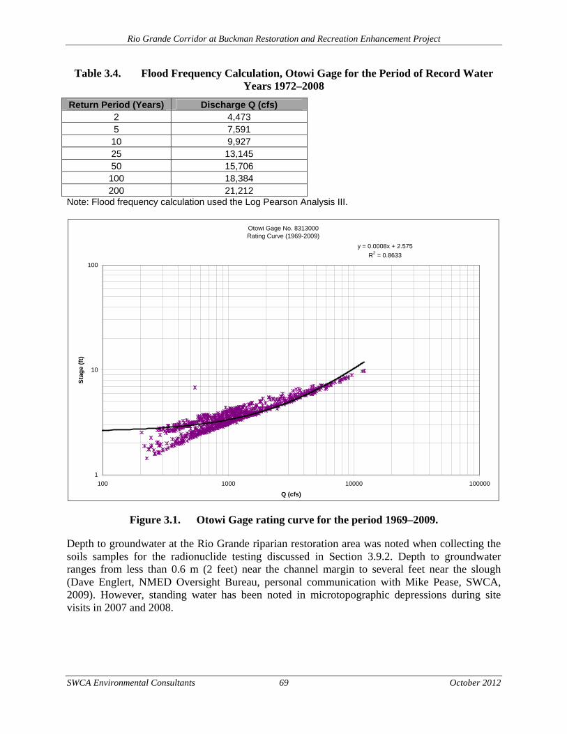
Rio Grande Corridor at Buckman Restoration and Recreation Enhancement Project
SWCA Environmental Consultants 69 October 2012
Table 3.4. Flood Frequency Calculation, Otowi Gage for the Period of Record Water Years 1972–2008
Return Period (Years) Discharge Q (cfs) 2 4,473 5 7,591 10 9,927 25 13,145 50 15,706
100 18,384 200 21,212
Note: Flood frequency calculation used the Log Pearson Analysis III.
Figure 3.1. Otowi Gage rating curve for the period 1969–2009.
Depth to groundwater at the Rio Grande riparian restoration area was noted when collecting the soils samples for the radionuclide testing discussed in Section 3.9.2. Depth to groundwater ranges from less than 0.6 m (2 feet) near the channel margin to several feet near the slough (Dave Englert, NMED Oversight Bureau, personal communication with Mike Pease, SWCA, 2009). However, standing water has been noted in microtopographic depressions during site visits in 2007 and 2008.
Otowi Gage No. 8313000Rating Curve (1969-2009)
y = 0.0008x + 2.575
R2 = 0.8633
1
10
100
100 1000 10000 100000
Q (cfs)
Sta
ge
(ft)
Rio Grande Corridor at Buckman Restoration and Recreation Enhancement Project
SWCA Environmental Consultants 70 October 2012
3.12.3 ENVIRONMENTAL CONSEQUENCES
Alternative A: Proposed Action
Water Quality
The Proposed Action would result in minimal and temporary impacts to the Rio Grande. Short-term water quality impacts may result if high intensity rainstorms occur during construction when soil is exposed and erosion occurs. Up to 34 acres of soil would be exposed during construction and would contribute to increased suspended sediments in water runoff from the project area. BMPs would be required at the construction location to mitigate erosion, which would include the use of silt fences, erosion control fabrics, and revegetation of bare soils. The non-native removal contractor would prepare an SWPPP prior to construction, which would indicate where the BMPs would be placed to minimize the short-term impacts to the Rio Grande. In addition, bankline stabilization would be accomplished through management of existing desirable vegetation and active planting in key locations. A portion of the riparian restoration project area is on an outside bend of the river channel. As such, this area may be subject to shear stresses, especially at higher flow. To avoid erosion of the backline, existing coyote willow would be left intact. In key areas where there are no coyote willows along the backline, stem cuttings would be planted during the dormant season. Dormant coyote willow stem cuttings can be successfully established by planting directly into the water table allowing adventitious roots to develop in the capillary fringe.
Due to the lack of frequent flood inundation within the restoration area, manual watering of the wetland plugs and riparian shrubs would be required for the first year following planting. This water would be brought into the project area from an off-site water source. The wetland plugs would be hand watered with a backpack sprayer (not used for herbicides). Riparian shrubs would be watered using tubes, which require water every two to four weeks. Tall pot or long-stem plantings would require minimal watering because the root ball is planted near the groundwater zone. Pole plantings (e.g., cottonwood and Goodding’s willow) and stem cuttings (e.g., coyote willow) would not require additional watering. The plants would be watered in a manner that would not impact water quality along the Rio Grande.
Long-term impacts from the Proposed Action would result in reduced sediment loads entering the Rio Grande from the project area during high intensity storm events. The shift in the vegetative communities within the restoration area, from high density, non-native species to lower density, native vegetation, would allow grasses and forbs to become established under the gaps in the canopy. As a result, soils would be better protected from water erosion over the long term under the Proposed Action. The proposed vault toilets would also provide long-term beneficial impacts to localized water quality, especially at the Rio Grande Corridor at Buckman, because recreationists would have sanitary waste disposal methods available.
At Diablo Canyon, spur roads and trails would be closed to motorized vehicles. These previously disturbed areas would be allowed to revegetate, either through natural process or by active seeding. As a result, soil erosion from the Diablo Canyon portion of the project area would be reduced over the long term.
Rio Grande Corridor at Buckman Restoration and Recreation Enhancement Project
SWCA Environmental Consultants 71 October 2012
Prior to implementing the restoration of the Diablo Canyon seep, the contractor would prepare an SWPPP to indicate where the BMPs would be placed to minimize the short-term impacts to the Cañada Ancha and the Rio Grande.
Water Quantity
Changes in water quantity due to the Proposed Action are difficult to quantify, both in the short and long term. It is unclear what changes in the evapotranspiration rate may occur as a result of the proposed riparian restoration activities. Evapotranspiration is the process in which roots take up water from the environment, and then the water is released by the leaves in the plant. Rates of evapotranspiration and groundwater use vary widely between plant species depending on factors such as depth to groundwater, rooting depth, leaf area, and the ability to regulate stomatal conductance (Scott et al. 2000; Dahm et al. 2002; Cleverly et al. 2004). Some literature suggests that non-native species, such as saltcedar, consumes more water than native riparian species; however, more recent literature suggests that evapotranspiration rates among native and non-native species are similar. It can be assumed that high densities of riparian plants would result in higher evapotranspiration rates than those areas where vegetation density is low.
Removal of non-native vegetation under the Proposed Action would have a short-term impact to water flows by increasing the amount of groundwater available within the project area. After native species are planted and they mature, the amount of evapotranspiration within the project area would increase in comparison to the timeframe immediately after the non-native species removal. It is likely that the net rate of evapotranspiration within the project area, compared to pre-restoration conditions, would not change in the long term.
The purpose of this restoration project is to increase the amount of available water for wildlife by holding water that originates from the seep for longer periods. The proposed restoration of the 1-acre seep in Diablo Canyon is expected to increase the amount of available, standing water within the arroyo after storm events.
Alternative B: No Action Alternative The No Action Alternative would also result in water quality and quantity impacts along the Rio Grande Corridor. A total of 8 acres of riparian area would be restored as mitigation requirements for the BDD. Similar to the Proposed Action, short-term adverse impacts to water quality would occur as a result of construction activities. These impacts would be mitigated by the use of BMPs outlined in a Stormwater Pollution Prevention Plan. Long-term beneficial impacts to water quality would occur as a result of improved vegetative communities, providing ground cover and preventing soil erosion during storm events.
The No Action Alternative would not include any riparian restoration activities on BLM lands or within Diablo Canyon. The No Action Alternative would restore 27 less acres within the project area than the Proposed Action.
No recreation enhancements would occur within the project area under the No Action Alternative. As a result, the current level of soil erosion and contribution of suspended sediments during storm events would continue to occur from the Diablo Canyon project area. The No Action Alternative would not include the installation of vault toilets within the project area. The

Rio Grande Corridor at Buckman Restoration and Recreation Enhancement Project
SWCA Environmental Consultants 72 October 2012
unsanitary waste disposal issues, especially at the Rio Grande Corridor at Buckman, would continue.

Rio Grande Corridor at Buckman Restoration and Recreation Enhancement Project
SWCA Environmental Consultants 73 October 2012
4.0 CUMULATIVE EFFECTS ANALYSIS
The EA must consider the cumulative effects of the action alternatives in conjunction with other federal and non-federal activities. A cumulative impact to the environment results from the incremental impact of a proposed action when added to other past, present, and reasonably foreseeable future actions, regardless of what agency or person undertakes such other actions. Cumulative impacts can result from individually minor but collectively significant actions taking place over the period of time in which the action alternatives would take place. For this EA, the projects identified for cumulative impact analysis are planned to occur or have occurred within the geographic area as the Proposed Action, including areas upstream and downstream along the Rio Grande and its tributaries.
4.2 PAST AND PRESENT ACTIONS
Buckman Direct Diversion Project
The BDD project is a drinking water supply project for the City and County of Santa Fe. San Juan-Chama water, which is released from storage in upstream reservoirs, and native Rio Grande water is diverted from the Rio Grande at the BDD facility, adjacent to the project area analyzed in this EA. The BDD project includes buildings and pipelines to deliver the water from the Rio Grande to the citizens of Santa Fe and the county. This project also includes mitigation measures on the west side of the Rio Grande, including non-native species removal, across from the project area analyzed in this EA.
Pueblo de San Ildefonso Riparian Restoration The Pueblo de San Ildefonso has completed numerous acres of riparian restoration along the Rio Grande on lands under its jurisdiction. Restoration activities primarily include non-native species removal. The Pueblo de San Ildefonso is located just north of the proposed project area analyzed in this EA.
Caja Del Rio Range Improvement Project
The USFS completed a project intended to increase vegetation on specific rangelands by drawing cattle away from riparian areas with a pipeline, fencing riparian areas, and burning sagebrush to enhance grasses. The USFS authorized the continuation of year-long grazing of 492 head of cow/calf pairs and 28 bulls (8,305 AUMs) by reissuing 12 ten-year grazing permits. The USFS portion of the project is adjacent to the project area.
Pueblo of Kewa Galisteo River Non-native Removal
Kewa Pueblo implemented a project to remove and control non-native species (primarily saltcedar) on the portions of the Galisteo River under its jurisdiction. The confluence of the Galisteo River and Rio Grande is approximately 25 river miles downstream from the Proposed Action.
Santa Fe River Canyon Riparian Forest Restoration Project
The USFS, the BLM, and other collaborators completed a riparian habitat restoration project on the Santa Fe River. The project area encompassed approximately 70 acres along 10.6 km (6.6 miles) of riparian area south of Santa Fe, near La Cienega.
Rio Grande Corridor at Buckman Restoration and Recreation Enhancement Project
SWCA Environmental Consultants 74 October 2012
Headquarters Well Trailhead Improvement Project The USFS has improved the Headquarters Well Trailhead to accommodate both motorized and non-motorized recreational activities. The improvements include a vault toilet, shade structure, and improved road to the trailhead. The Headquarters Well Trailhead is located approximately 13.4 km (8.3 miles) from the southern portion of the Buckman project area.
4.3 REASONABLY FORESEEABLE ACTIONS
U.S. Army Corps of Engineers Ecosystem Restoration along the Rio Grande
The U.S. Army Corps and Engineers and the Pueblos of Santa Clara, Ohkay Owingeh, and San Ildefonso are currently in the planning states for coordinated ecosystem restoration along the Rio Grande north of the Buckman project area. This project is anticipated to include implementation funds for riparian restoration along many miles of the Rio Grande within tribal boundaries.
4.4 CUMULATIVE EFFECTS
4.4.1 CULTURAL RESOURCES
Projects conducted on public or tribal lands are required to comply with Section 106 of the National Historic Preservation Act or equivalent tribal law. Decision makers must consider the effects of the proposed project on historic properties that are included in or are eligible for inclusion in the NRHP. As a result, no cumulative impacts to cultural resources are expected to occur.
4.4.2 SOILS
Projects that involve ground disturbance would have a short-term adverse impact to soil resources. Projects with more than 5 acres of ground disturbance would be required to implement a SWPPP prior to construction. BMPs included in the SWPPP would help to minimize cumulative impacts to soils. In the long-term, restoration projects would lead to improved soil conditions, by increasing ground cover and reducing soil erosion during high-intensity storm events.
4.4.3 LAND USE
There is no cumulative impact to land use expected as a result of the Proposed Action and the past, present, or future projects listed.
4.4.4 VEGETATION
Projects that involve non-native species removal and subsequent native species restoration would result in cumulative impacts similar to the Proposed Action—short-term adverse impacts during construction and long-term beneficial impacts to species diversity, vegetative structure, and improved forage habitat once native species are planted. Projects that only include measures to reduce non-native species would result in long-term decreases in dense vegetative cover and structural diversity.
Rio Grande Corridor at Buckman Restoration and Recreation Enhancement Project
SWCA Environmental Consultants 75 October 2012
4.4.5 WILDLIFE
Projects that include ground disturbance, such as riparian restoration projects and the BDD project, would have short-term adverse impacts to wildlife and migratory birds due to construction activities that result in loss of vegetation, which may provide forage and cover, and noise disturbance. Long-term beneficial impacts would occur as a result of the past, present, and future restoration projects listed. These projects would improve nesting and foraging habitat as well as structural diversity for wildlife and migratory birds.
4.4.6 THREATENED AND ENDANGERED SPECIES
Western Burrowing Owl (Athene cunicularia hypugaea) Projects that include ground disturbance may impact individuals of western burrowing owl. Construction activities leading to compacted soils used by burrowing owls or other burrowing mammals would have an adverse impact to the species; additionally, depending on time of day of construction activities, the foraging behavior of the owls could be impacted. Construction activity could also reduce the availability of prey in the area of the water catchments, which would further impact the owls. Long-term beneficial impacts to the western burrowing owl would occur from those projects that improve foraging and nesting habitats.
Yellowed-billed Cuckoo (Coccyzus americanus occidentalis) The yellow-billed cuckoo’s distribution historically included areas of the Rio Grande bosque. Projects that involve vegetation removal may impact individuals of yellow-billed cuckoo by removing suitable nesting trees. Riparian restoration activities, including the removal of invasive saltcedar and Russian olive, may improve habitat for the yellow-billed cuckoo by allowing native willow and cottonwood to become re-established. Those projects that only remove non-native species without re-establishing native vegetation, would adversely impact the yellow-billed cuckoo because habitat would be permanently removed.
Southwestern Willow Flycatcher (Empidonax traillii extimus) Projects that involve vegetation removal may impact individuals of Southwestern willow flycatcher by removing suitable nesting trees. Riparian restoration activities, including the removal of invasive saltcedar and Russian olive, may improve habitat for the flycatcher by allowing native willow and cottonwood to become re-established. Those projects that only remove non-native species without re-establishing native vegetation, would adversely impact the Southwestern willow flycatcher because habitat would be permanently removed.
American Peregrine Falcon (Falco peregrinus anatum) and Arctic Peregrine Falcon (F. p. tundrius) Projects that involve ground disturbance would impact individuals of peregrine falcon by disturbing roosting or foraging habitat. Restoration activities may have beneficial long-term effects on the species by increasing foraging habitat.
Pale Townsend’s Big-eared Bat (Corynorhinus townsendii pallenses) Projects that involve ground disturbance in piñon-juniper woodlands would impact individuals of pale Townsend’s big-eared bat by disturbing roosting or foraging habitat. Restoration activities may have beneficial long-term effects on the species by increasing foraging habitat.
Rio Grande Corridor at Buckman Restoration and Recreation Enhancement Project
SWCA Environmental Consultants 76 October 2012
4.4.7 BLM AND USFS SENSITIVE SPECIES
Bald Eagle (Haliaeetus leucocephalus alascanus) Projects that involve ground disturbance would have short-term adverse impacts to individuals of bald eagles because presence of humans and construction noise could cause temporary dispersals. Long-term beneficial impacts to bald eagles would occur from riparian restoration projects because foraging habitat would be improved.
Loggerhead Shrike (Lanius ludovicianus) Projects that involve ground disturbance would have short-term adverse impacts to individuals of loggerhead shrike because presence of humans and construction noise could cause temporary dispersals. Long-term beneficial impacts to loggerhead shrikes would occur from restoration projects because nesting and foraging habitat would be improved.
White-faced Ibis (Plegadis chihi) Projects that involve ground disturbance would have short-term adverse impacts to individuals of white-faced ibis because presence of humans and construction noise could cause temporary dispersals. Long-term beneficial impacts to white-faced ibis would occur from restoration projects because migratory nesting and foraging habitat would be improved.
Gray Vireo (Vireo vicinior) Projects that involve ground disturbance and removal of juniper trees would have short-term adverse impacts to individuals of gray vireo because presence of humans and construction noise could cause temporary dispersals. Long-term beneficial impacts to gray vireos would occur from restoration projects because nesting and foraging habitat would be improved.
Mountain Plover (Charadrius montanus) Projects that include ground disturbance within piñon-juniper woodlands may impact individuals of mountain plover. Construction activities could cause individuals to temporarily leave their habitat due to noise and interaction with equipment. Long-term beneficial impacts to the mountain plover would occur from those projects that improve foraging and nesting habitats.
Northern Leopard Frog (Rana pipiens) Projects that involve ground disturbance would have short-term adverse impacts to individuals of northern leopard frog. Riparian restoration activities would have long-term beneficial impacts to the species by creating more suitable habitat.
Spotted Bat (Euderma maculatum) Projects that include ground-disturbing activities in piñon-juniper woodlands would have short-term adverse impacts to the spotted bat by creating temporary disturbance within foraging habitat. Restoration and rangeland improvement activities would have long-term beneficial impacts to the species by improving foraging habitat.
Small-footed Myotis Bat (Myotis ciliolabrum) Projects that include ground-disturbing activities in piñon-juniper woodlands would have short-term adverse impacts to the small-footed myotis bat by creating temporary disturbance in
Rio Grande Corridor at Buckman Restoration and Recreation Enhancement Project
SWCA Environmental Consultants 77 October 2012
foraging habitats. Restoration and rangeland improvement activities would have long-term beneficial impacts to the species by improving foraging habitat.
Long-eared Myotis (Myotis evotis) Projects that include ground-disturbing activities in piñon-juniper woodlands or riparian areas would have short-term adverse impacts to the long-eared myotis bat by creating temporary disturbance in roosting and foraging habitats. Restoration and rangeland improvement activities would have long-term beneficial impacts to the species by improving roosting and foraging habitat.
Fringed Myotis (Myotis thysanodes) Projects that include ground-disturbing activities in piñon-juniper woodlands would have short-term adverse impacts to the fringed myotis bat by creating temporary disturbance in foraging habitats. Restoration and rangeland improvement activities would have long-term beneficial impacts to the species by improving foraging habitat.
Long-legged Myotis Bat (Myotis volans) Projects that include ground-disturbing activities in piñon-juniper woodlands or riparian areas would have short-term adverse impacts to the long-legged myotis bat by creating temporary disturbance in roosting and foraging habitats. Restoration and rangeland improvement activities would have long-term beneficial impacts to the species by improving roosting and foraging habitat.
Yuma Myotis Bat (Myotis yumanensis yumanensis) Projects that include ground-disturbing activities in riparian areas would have short-term adverse impacts to the Yuma myotis bat by creating temporary disturbance in foraging habitats. Restoration activities would have long-term beneficial impacts to the species by improving foraging habitat.
Big Free-tailed Bat (Nyctinomops macrotis) Projects that include ground-disturbing activities in piñon-juniper woodlands or riparian areas would have short-term adverse impacts to the big free-tailed bat by creating temporary disturbance in foraging habitats. Restoration activities would have long-term beneficial impacts to the species by improving foraging habitat.
Botta’s Pocket Gopher (Thomomys bottae aureus) The Caja del Rio Range Improvement Project could lead to an improvement in overall rangeland health of the Caja del Rio allotment, which could improve habitat conditions for the Botta’s pocket gopher. Projects that involve construction activities within rangeland could have long-term adverse impacts to the Botta’s pocket gopher due to habitat loss.
Gunnison’s Prairie Dog (Cynomys gunnisoni) The Caja del Rio Range Improvement Project could lead to an improvement in overall rangeland health of the Caja del Rio allotment, which could improve habitat conditions for the Gunnison’s prairie dog. Projects that involve construction activities within rangeland could have long-term adverse impacts to the Gunnison’s prairie dog due to habitat loss.
Rio Grande Corridor at Buckman Restoration and Recreation Enhancement Project
SWCA Environmental Consultants 78 October 2012
4.4.8 USFS MANAGEMENT INDICATOR SPECIES
Rocky Mountain Bighorn Sheep (Ovis canadensis canadensis) No cumulative impacts to Rocky Mountain bighorn sheep are expected to occur from the Proposed Action and the past, present, or future projects listed.
Rocky Mountain Elk (Cervus elaphus nelsoni) Projects with ground-disturbing activities may have short-term adverse impacts to individuals of Rocky Mountain elk due to disturbance within wintering habitat and watering areas. Restoration activities would benefit the Rocky Mountain elk by providing improved foraging area over the long term.
Merriam’s Turkey (Meleagris gallopavo) No cumulative impacts to Merriam’s turkey are expected to occur from the Proposed Action and the past, present, or future projects listed.
Mourning Dove (Zenaida macroura) Projects with ground-disturbing activities may have short-term adverse impacts to individuals of mourning dove. Restoration activities would benefit the mourning dove by providing more foraging area.
Hairy Woodpecker (Picoides villosus) Projects with ground-disturbing activities, especially within riparian areas, may have short-term adverse impacts to individual hairy woodpeckers. Restoration activities used at the Rio Grande Corridor area would benefit this species by creating new elm snags and additional habitat.
Pinyon Jay (Gymnorhinus cyanocephalus) No cumulative impacts to pinyon jay are expected to occur from the Proposed Action and the past, present, or future projects listed.
Mexican Spotted Owl (Strix occidentalis lucida) No cumulative impacts to Mexican spotted owl are expected to occur from the Proposed Action or the past, present, or future projects listed.
Rio Grande Cutthroat Trout (Oncorhynchus clarki virginalis) No cumulative impacts to Rio Grande cutthroat trout are expected to occur from the Proposed Action and the past, present, or future projects listed.
4.4.9 PUBLIC HEALTH AND SAFETY
No cumulative impacts to public health and safety are expected to occur from the Proposed Action and the past, present, or future projects listed.
4.4.10 RECREATION
Projects that include improvements to trailheads and other recreational facilities would have a long-term beneficial impact to recreation. Increased management presence and improved
Rio Grande Corridor at Buckman Restoration and Recreation Enhancement Project
SWCA Environmental Consultants 79 October 2012
infrastructure could discourage unauthorized activities and lead to an improved recreational setting within the Caja del Rio area.
4.4.11 VISUAL RESOURCES
Projects that include ground disturbance would have short-term adverse impacts to visual resources during the construction phase of the project. Projects that involve permanent infrastructure, such as BDD facility, could permanently impact visual resources due to the presence of buildings within the viewshed. Restoration projects would have long-term beneficial impacts to visual resources because vegetation would be replaced over time as native species become established.
4.4.12 WATER QUALITY AND QUANTITY
Water Quality Past, present, and future projects that increase bank stabilization and ground cover, especially in degraded areas such as overgrazed rangelands and poorly functioning riparian areas, should reduce sediment inputs into the Rio Grande watershed. Projects that include ground disturbance without proper BMPs in place could lead to increase suspended sediments during high intensity storm events and decrease water quality with the Rio Grande watershed.
Water Quantity Past, present, and future projects that increase vegetative cover where non-native removal is not occurring could cause reductions in water quantity due to increase evapotranspiration potential. In addition, those water projects that remove native water from the Rio Grande would have cumulative impacts to the decline in water quantity within the Rio Grande system.
Rio Grande Corridor at Buckman Restoration and Recreation Enhancement Project
SWCA Environmental Consultants 80 October 2012
5.0 CONSULTATION AND COORDINATION
5.2 SUMMARY OF CONSULTATION AND COORDINATION
A biological report and cultural resources report for the project have been submitted to the BLM and the USFS for review. Upon approval by the agencies, the cultural resources report will be forwarded to the New Mexico HPD for review and approval. The biological report may result in a request for concurrence letter to be sent to the USFWS.
5.3 SUMMARY OF PUBLIC PARTICIPATION TO DATE
The Core Team described in Section 1.2 met three times in 2008, including one site visit to the Buckman project area. SWCA hosted a public meeting on November 5, 2008, and 35 people attended the meeting. The public scoping comment period for this project opened on June 24, 2011, and closed on July 26, 2011. Comments received from this effort are included in the Administrative Record.
5.4 PUBLIC COMMENT ANALYSIS
See the attached Public Review Comment Table (Appendix A).
Rio Grande Corridor at Buckman Restoration and Recreation Enhancement Project
SWCA Environmental Consultants 81 October 2012
6.0 LIST OF PREPARERS
Coleman Burnett, Project Manager SWCA Environmental Consultants 5647 Jefferson St. NE Albuquerque, NM 87109 (505) 254-1115 [email protected] Victoria Amato, Natural Resources Planner SWCA Environmental Consultants 5647 Jefferson St. NE Albuquerque, NM 87109 (505) 254-1115 [email protected] Matt Gagnon, Environmental Specialist SWCA Environmental Consultants 5647 Jefferson St. NE Albuquerque, NM 87109 (505) 254-1115 [email protected] Brian Bader, Natural Resources Program Director SWCA Environmental Consultants 5647 Jefferson St. NE Albuquerque, NM 87109 (505) 254-1115 [email protected] Sarah Gilstrap, NEPA Specialist SWCA Environmental Consultants 5647 Jefferson St. NE Albuquerque, NM 87109 (505) 254-1115 [email protected]
Rio Grande Corridor at Buckman Restoration and Recreation Enhancement Project
SWCA Environmental Consultants 82 October 2012
7.0 LITERATURE CITED
ALS Laboratory Group, Analytical Chemistry and Testing Services. 2009. Micro-R Sampling Case Narrative Results and Soil and Vegetation Sampling Results: Strontium-90 pgs 1-146, Isotopic Uranium pgs 1-95, Isotopic Plutonium pgs 1-96, Gamma Spectroscopy (soil) pgs 1-110, Gamma Spectroscopy (vegetation) pgs 1-106 (ALS Work order 09-06-085). Fort Collins: ALS Environmental Division.
Anspaugh, L. 2001. Answer to Question #926 Submitted to “Ask the Experts.” Health Physics Society website. Available at: http://hps.org/publicinformation/ate/q926.html. Accessed May 28, 2009.
Biota Information System of New Mexico (BISON-M). 2011. BISON-M home page. Version: 2011 May 5. Available at: http://www.bison-m.org. Accessed May 5, 2011.
Brown, D.E. (ed.). 1994. Biotic Communities: Southwestern United States and Northwestern Mexico. Salt Lake City: University of Utah Press.
Bureau of Land Management (BLM). 1986. BLM Manual H-8410-1, Visual Resource Inventory. Washington, DC: United States Printing Office.
———. 1988. Taos Resource Management Plan. BLM-NM-PT-88-021-4410. Farmington, New Mexico: U.S. Department of the Interior, Bureau of Land Management.
———. 1992. Manual MS-9015: Integrated Weed Management. Release 9-321. U.S. Department of the Interior, Bureau of Land Management.
———. 1999. BLM Sensitive Species List for New Mexico State Office.
———. 2007a. Vegetation Treatments Using Herbicides on Bureau of Land Management lands in 17 Western States Final Programmatic Environmental Impact Statement. U.S. Department of the Interior, Bureau of Land Management. Available at: http://www.blm.gov/wo/st/en/prog/more/veg_eis.html. Accessed May 5, 2011.
———. 2007b. Vegetation Treatments on Bureau of Land Management Lands in 17 Western States Final Biological Assessment. U.S. Department of the Interior, Bureau of Land Management. Available at: http://www.blm.gov/pgdata/etc/medialib/blm/wo/Planning_and_Renewable_Resources/veis.Par.81642.File.dat/Final%20Biological%20Assessment%20%20%28June%202007%29.pdf. Accessed May 5, 2011.
———.2007. Handbook H-9011-1: Chemical Pest Control. U.S. Department of the Interior, Bureau of Land Management.
———. 2010. Guidelines for a Quality Built Environment. First Edition. U.S. Department of the Interior, Bureau of Land Management.
———.2010. Manual MS-1112: Safety. Release 1-1665. U.S. Department of the Interior, Bureau of Land Management.
Rio Grande Corridor at Buckman Restoration and Recreation Enhancement Project
SWCA Environmental Consultants 83 October 2012
———. 2012. Taos Resource Management Plan. BLM/NM/PL-12-09-1610. Taos, New Mexico: U.S. Department of the Interior, Bureau of Land Management, Taos Field Office.
Cleverly, J.R., C.N. Dahm, and J.R. Thibault. 2004. State-of-the-art Technologies for Evaluating Water use by Riparian Vegetation: UNM Hydrogeology and the Middle Rio Grande. Identifying Technologies to Improve Regional Water Stewardship: North-Middle Rio Grande Corridor. Albuquerque: University of New Mexico, Department of Biology.
Dahm, C., Cleverly, J., Coonrod, J., Thibault, J., McDonnell, D. and D. Gilroy. 2002. Evapotranspiration at the land/water interface in a semi-arid drainage basin. Freshwater Biology 47:831–843.
Degenhardt, W.G., C.W. Painter, and A.H. Price. 1996. The Amphibians and Reptiles of New Mexico. Albuquerque: University of New Mexico Press.
Englert, D., M. Dale, K. Granzow, and R. Mayer. 2007. Distribution of Radionuclides in Northern Rio Grande Fluvial Deposits near Los Alamos National Laboratory, New Mexico. Santa Fe: Department of Energy Oversight Bureau, New Mexico Environment Department.
Englert, D., M. Dale, R. Ford-Schmid, and K. Granzow. 2008. Los Alamos National Laboratory Legacy Contaminant Study at the Buckman Direct Diversion. Santa Fe: Department of Energy Oversight Bureau, New Mexico Environment Department.
Englert, D. 2009. Hydrologist, New Mexico Environment Department Oversight Bureau. Santa Fe, New Mexico. Written communication
Governor of New Mexico. 2000. Executive Order 00-22 Noxious Weeds.
Graf, W. 1993. Geomorphology of Plutonium in the Northern Rio Grande. Los Alamos National Laboratory Report LA-UR-93-1963. Tempe, Arizona: Department of Geography, Arizona State University.
———. 1994. Plutonium and the Rio Grande – Environmental Change in the Nuclear Age. New York: Oxford University Press.
Griffith, G.E., J.M. Omernik, M.M. McGraw, G.Z. Jacobi, C.M. Canavan, T.S. Schrader, D. Mercer, R. Hill, and B.C. Moran, 2006. Ecoregions of New Mexico (color poster with map, descriptive text, summary tables, and photographs). Reston, Virginia: U.S. Geological Survey (map scale 1:1,400,000).
Haug, E.A., B.A. Milsap, and M.S. Martell. 1993. Burrowing owl (Speotyto cunicularia). In The Birds of North America, edited by A. Poole and F. Gill. No. 61. Philadelphia: The Birds of North America.
Heggen, R.J. 2001. Evaluation of Channel Morphology of the Rio Grande near Buckman, NM. Technical Memorandum submitted to CH2M Hill.
Rio Grande Corridor at Buckman Restoration and Recreation Enhancement Project
SWCA Environmental Consultants 84 October 2012
Hibner, C.D. 2004. Soil Survey of Santa Fe County Area, New Mexico. U.S. Department of Agriculture, Soil Conservation Service.
Manley, K. 1979. Stratigraphy and Structure of the Espanola Basin, Rio Grande Rift, New Mexico. In Rio Grande rift: Tectonics and Magmatism, edited by R.E. Riecker, pp. 71–86. Washington, D. C.: American Geophysical Union.
McLin, S.G., and D.W. Lyons. 2002. Background Radioactivity in River and Reservoirs Sediments near Los Alamos, New Mexico. Los Alamos National Laboratory, Report LA-13603-MS.
Muldavin, E., P. Durkin, M. Bradley, M. Stuever and P. Mehlhop. 2000. Handbook of Wetland Vegetation Communities of New Mexico. Volume I: Classification and Community Descriptions. Albuquerque: University of New Mexico, Biology Department, New Mexico Natural Heritage Program.
National Invasive Species Council. 2001. Meeting the Invasive Species Challenge: National Invasive Species Management Plan. Available at: http://www.invasivespecies.gov/main_nav/mn_NISC_ManagementPlan.html. Accessed October 17, 2011.
New Mexico Administrative Code. 1995. Natural Resources and Wildlife – Endangered Plants. New Mexico Administrative Code 19.21.2.8.
New Mexico Administrative Code. 2000. Standards for Interstate and Intrastate Surface Waters. New Mexico Administrative Code 20.6.4.
New Mexico Department of Agriculture (NMDA). 2009. Memorandum: New Mexico Noxious Weed List Update. Dated April 1, 2009.
New Mexico Department of Game and Fish (NMDGF). 2008. Final 2008 Biennial Review of Threatened and Endangered Species of New Mexico.
New Mexico Environment Department (NMED). 2009. 2010-2012 State of New Mexico Clean Water Act section 303 (d)/305(b) Integrated Report. Available at: http://www.nmenv.state.nm.us/swqb/303d-305b/2010-2012/
New Mexico Rare Plant Technical Council (NMRPTC). 2011. New Mexico Rare Plants Website. Available at: http://nmrareplants.unm.edu. Accessed May 4, 2011.
New Mexico Statutes Annotated. 1978. The New Mexico Noxious Weed Control Act. NMSA 76-7-1 to 76-7-22.
Orr, M. 2011. Biologist, Santa Fe National Forest. New Mexico. Email communication providing USFS Mitigation Measures for Peregrine Falcon.
Rio Grande Corridor at Buckman Restoration and Recreation Enhancement Project
SWCA Environmental Consultants 85 October 2012
______. 2012. Biologist, Santa Fe National Forest. Española, New Mexico. Phone communication regarding the Santa Fe National Forest Management Indicator Species Assessment Update, USFS Region 3 Sensitive species list for Santa Fe County and the presence of raptors in Diablo Canyon.
Parametrix. 2011. Mitigation Plan for the Buckman Water Diversion Project. Albuquerque: Parametrix.
Scott, R.L., Shuttleworth, W.J., Goodrich, D.C. and T. Maddock. 2000. The water use of two dominant vegetation communities in a semiarid riparian ecosystem. Agricultural and Forest Meteorology 105:241–256.
Sibley, D.A. 2003. The Sibley Field Guide to Birds of Western North America. New York: Alfred A. Knopf.
Stebbins, R.C. 2003. A Field Guide to Western Reptiles and Amphibians, Third Edition. Boston: Houghton Mifflin.
SWCA Environmental Consultants (SWCA). 2003a. Biological Evaluation – Buckman Water Diversion Project. Report prepared for Tetra Tech, Inc., Albuquerque. Albuquerque: SWCA Environmental Consultants.
———. 2003b. Biological Assessment - Buckman Water Diversion Project. Report prepared for Tetra Tech, Inc., Albuquerque. Albuquerque: SWCA Environmental Consultants.
———. 2009. New Mexico Wildlife Federation Rio Grande Corridor at Buckman Project Planning Recommendations. Prepared for the New Mexico Wildlife Federation and Rio Grande Return. Albuquerque: SWCA Environmental Consultants.
———. 2011. Draft Cultural Resources Report for the New Mexico Wildlife Federation Riparian Restoration and Recreation Enhancement Project. Submitted to the Santa Fe National Forest and Bureau of Land Management Taos Field Office. Albuquerque: SWCA Environmental Consultants.
U.S. Department of Agriculture. 2011. The PLANTS Database. Baton Rouge: National Plant Data Center. Available at: http://plants.usda.gov. Accessed May 5, 2011.
U.S. Department of Agriculture, Natural Resources Conservation Service (USDA-NRCS). 2009a. The Pole Cutting Solution. Available at: http://www.nm.nrcs.usda.gov/news/publications/polecutting.pdf. Accessed September 16, 2009.
———. 2009b. Guidelines for Planting Longstem Transplants for Riparian Restoration in the Southwest. Available at: http://www.nm.nrcs.usda.gov/news/publications/deep-planting.pdf. Accessed September 16, 2009.
———. 2009c. Guidelines for Planting Dormant Whip Cuttings to Revegetate and Stabilize Streambanks. Available at: http://www.nm.nrcs.usda.gov/news/publications/dormant-willow-planting.pdf. Accessed September 16, 2009.
Rio Grande Corridor at Buckman Restoration and Recreation Enhancement Project
SWCA Environmental Consultants 86 October 2012
U.S. Fish and Wildlife Service (USFWS). Bald Eagle Management Guidelines and Conservation Measures: The Bald and Golden Eagle Protection Act. Available at: http://www.fws.gov/midwest/eagle/guidelines/bgepa.html. Accessed May 5, 2011.
———. 2011a. The Migratory Bird Program: Birds Protected by the Migratory Bird Treaty Act; List of Migratory Birds. Available at: http://www.fws.gov/migratorybirds/RegulationsPolicies/mbta/mbtintro.html. Accessed May 5, 2011.
———. 2011b. Endangered, Threatened, Proposed and Candidate Species of Santa Fe County, New Mexico. Southwest Region Ecological Services. Available at: http://www.fws.gov/southwest/es/EndangeredSpecies/lists/ListSpecies.cfm. Accessed May 5, 2011.
U.S. Environmental Protection Agency (EPA). 2011. Section 303(d) List Fact Sheet for Watershed Rio Grande-Santa Fe. Available at: http://iaspub.epa.gov/tmdl_waters10/huc_rept.control?p_huc=13020201&p_huc_desc=RIO%20GRANDE-SANTA%20FE. Accessed February 16, 2011.
USDA Forest Service. 1987. Santa Fe National Forest Plan. USDA Forest Service, Southwestern Region. July 1987.
———. 1994. FSM 2109.14: Pesticide Use-Management and Coordination . Amendment No. 2109.14-94-1. Washington, D.C.: Department of Agriculture, Forest Service.
———. 2001. The Built Environment Image Guide for the National Forests and Grasslands. FS-710. Washington, D.C.: Department of Agriculture, Forest Service.
———. 2003a. Triclopyr- Revised Human Health and Ecological Risk Assessment. Final Report. Prepared by: Syracuse Environmental Research and Associates, Inc. GSA Contract No. GS-10F-0082F.
———. 2003b. Glyphosate- Revised Human Health and Ecological Risk Assessment. Final Report. Prepared by: Syracuse Environmental Research and Associates, Inc. GSA Contract No. GS-10F-0082F.
———. 2006. Santa Fe National Forest Management Indicator Species Assessment. Prepared by William Britton and Sean Ferrell.
———. 2011. FSM 2900: Invasive Species Management. Amendment No. 2900-2011-1. Washington, D.C.: Department of Agriculture, Forest Service.
_____.2012. Record of Decision for Travel Management on the Santa Fe National Forest.
U.S. Forest Service and Bureau of Land Management (USFS and BLM). 2006. Final Environmental Impact Statement for the Buckman Water Diversion Project. Prepared by the U.S. Department of Agriculture, Forest Service and U.S. Department of the Interior, Bureau of Land Management, Santa Fe.

Rio Grande Corridor at Buckman Restoration and Recreation Enhancement Project
SWCA Environmental Consultants 87 October 2012