engineering classification and description of soil · engineering classification and description of...
TRANSCRIPT

Chapter 3
ENGINEERING CLASSIFICATIONAND DESCRIPTION OF SOIL
General
Application
Soil investigations conducted for engineering purposesthat use test pits, trenches, auger and drill holes, or otherexploratory methods and surface sampling and mappingare logged and described according to the Unified SoilClassification System (USCS) as presented in Bureau ofReclamation (Reclamation) standards USBR 5000 [1] and5005 [2]. Also, bedrock materials with the engineeringproperties of soils are described using these standards(chapter 2). The Reclamation standards are consistentwith the American Society for Testing Materials (ASTM)Designation D2487 and 2488 on the USCS system [3,4].Descriptive criteria and terminology presented areprimarily for the visual classification and manual tests.The identification portion of these methods in assigninggroup symbols is limited to soil particles smaller than3 inches (in) (75 millimeters [mm]) and to naturallyoccurring soils. Provisions are also made to estimate thepercentages of cobbles and boulders by volume. Thisdescriptive system may also be applied to shale, shells,crushed rock, and other materials if done according tocriteria established in this section. Chapter 11 addressesthe logging format and criteria for describing soil in testpits, trenches, auger holes, and drill hole logs.
All investigations associated with land classification forirrigation suitability, data collection, analyses of soiland substratum materials related to drainage inves-tigations, and Quaternary stratigraphy (e.g., fault andpaleoflood studies) are logged and described using the

FIELD MANUAL
18
U.S. Department of Agriculture terminology outlined inappendix I to Agriculture Handbook No. 436 (SoilTaxonomy), dated December 1975 [5].
All soil classification descriptions for particle sizes lessthan No. 4 sieve size are to be in metric units.
Performing Tests and Obtaining DescriptiveInformation
The USCS groups soils according to potential engineeringbehavior. The descriptive information assists with esti-mating engineering properties such as shear strength,compressibility, and permeability. These guidelines canbe used not only for identification of soils in the field butalso in the office, laboratory, or wherever soil samples areinspected and described.
Laboratory classification of soils [1] is not alwaysrequired but should be performed as necessary and can beused as a check of visual-manual methods. The descrip-tors obtained from visual-manual inspection providevaluable information not obtainable from laboratorytesting. Visual-manual inspection is always required. The visual-manual method has particular value inidentifying and grouping similar soil samples so that onlya minimum number of laboratory tests are required forpositive soil classification. The ability to identify anddescribe soils correctly is learned more readily under theguidance of experienced personnel, but can be acquired bycomparing laboratory test results for typical soils of eachtype with their visual and manual characteristics. Whenidentifying and describing soil samples from an area orproject, all the procedures need not be followed. Similarsoils may be grouped together; for example, one sampleshould be identified and described completely, with theothers identified as similar based on performing only afew of the identification and descriptive procedures.

SOIL
19
Descriptive information should be evaluated and reportedon every sample.
The sample used for classification must be representativeof the stratum and be obtained by an appropriate ac-cepted or standard procedure. The origin of the materialmust be correctly identified. The origin description maybe a boring number and depth and/or sample number, ageologic stratum, a pedologic horizon, or a locationdescription with respect to a permanent monument, agrid system, or a station number and offset.
Terminology for Soils
Definitions for soil classification and description are inaccordance with USBR 3900 Standard Definitions ofTerms and Symbols Relating to Soil Mechanics [6]:
Cobbles and boulders—particles retained on a 3-inch(75-mm) U.S. Standard sieve. The following terminologydistinguishes between cobbles and boulders:
• Cobbles—particles of rock that will pass a 12-in(300-mm) square opening and be retained on a 3-in(75-mm) sieve.
• Boulders—particles of rock that will not pass a12-in (300-mm) square opening.
Gravel—particles of rock that will pass a 3-in (75-mm)sieve and is retained on a No. 4 (4.75-mm) sieve. Gravelis further subdivided as follows:
• Coarse gravel—passes a 3-in (75-mm) sieve and isretained on 3/4-in (19-mm) sieve.
• Fine gravel—passes a ¾-in (19-mm) sieve and isretained on No. 4 (4.75-mm) sieve.

FIELD MANUAL
20
Sand—particles of rock that will pass a No. 4 (4.75-mm)sieve and is retained on a No. 200 (0.075-mm or 75-micro-meter [µm]) sieve. Sand is further subdivided as follows:
• Coarse sand—passes No. 4 (4.75-mm) sieve and isretained on No. 10 (2.00-mm) sieve.
• Medium sand—passes No. 10 (2.00-mm) sieve andis retained on No. 40 (425-µm) sieve.
• Fine sand—passes No. 40 (425-µm) sieve and isretained on No. 200 (0.075-mm or 75-µm) sieve.
Clay—passes a No. 200 (0.075-mm or 75-µm) sieve. Soilhas plasticity within a range of water contents and hasconsiderable strength when air-dry. For classification,clay is a fine-grained soil, or the fine-grained portion of asoil, with a plasticity index greater than 4 and the plot ofplasticity index versus liquid limit falls on or above the"A"-line (figure 3-5, later in this chapter).
Silt—passes a No. 200 (0.075-mm or 75-µm) sieve. Soilis nonplastic or very slightly plastic and that exhibitslittle or no strength when air-dry is a silt. Forclassification, a silt is a fine-grained soil, or the fine-grained portion of a soil, with a plasticity index less than4 or the plot of plasticity index versus liquid limit fallsbelow the "A"-line (figure 3-5).
Organic clay—clay with sufficient organic content to in-fluence the soil properties is an organic clay. For classifi-cation, an organic clay is a soil that would be classified asa clay except that its liquid limit value after oven-dryingis less than 75 percent of its liquid limit value beforeoven-drying.

SOIL
21
Organic silt—silt with sufficient organic content to in-flu-ence the soil properties. For classification, an organicsilt is a soil that would be classified as a silt except thatits liquid limit value after oven-drying is less than75 percent of its liquid limit value before oven-drying.
Peat—material composed primarily of vegetable tissuesin various stages of decomposition, usually with an or-ganic odor, a dark brown to black color, a spongy con-sistency, and a texture ranging from fibrous to amor-phous. Classification procedures are not applied to peat.
Classifications of Soils
Group Names and Group Symbols
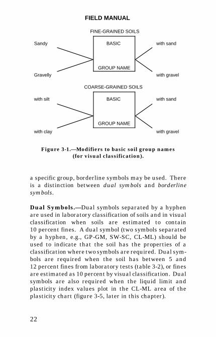
The identification and naming of a soil based on resultsof visual and manual tests is presented in a subsequentsection. Soil is given an identification by assigning agroup symbol(s) and group name. Important informationabout the soil is added to the group name by the term"with" when appropriate (figures 3-1, 3-2, 3-3, 3-4). Thegroup name is modified using “with” to stress othersignificant components in the soil.
Figure 3-2 is a flow chart for assigning typical names andgroup symbols for inorganic fine-grained soils; figure 3-3is a flow chart for organic fine-grained soils; figure 3-4 isa flow chart for coarse-grained soils. Refer to tables 3-1and 3-2 for the basic group names without modifiers. Ifthe soil has properties which do not distinctly place it in
FIELD MANUAL
22
FINE-GRAINED SOILS
Sandy BASIC
GROUP NAME
with sand
Gravelly with gravel
COARSE-GRAINED SOILS
with silt BASIC
GROUP NAME
with sand
with clay with gravel
Figure 3-1.—Modifiers to basic soil group names(for visual classification).
a specific group, borderline symbols may be used. Thereis a distinction between dual symbols and borderlinesymbols.
Dual Symbols.—Dual symbols separated by a hyphenare used in laboratory classification of soils and in visualclassification when soils are estimated to contain10 percent fines. A dual symbol (two symbols separatedby a hyphen, e.g., GP-GM, SW-SC, CL-ML) should beused to indicate that the soil has the properties of aclassification where two symbols are required. Dual sym-bols are required when the soil has between 5 and12 percent fines from laboratory tests (table 3-2), or finesare estimated as 10 percent by visual classification. Dualsymbols are also required when the liquid limit andplasticity index values plot in the CL-ML area of theplasticity chart (figure 3-5, later in this chapter).

SO
IL
23 Figure 3-2.—Flow chart for inorganic fine-grained soils, visual method.

FIE
LD
MA
NU
AL
24
Figure 3-3.—Flow chart for organic soils, visual method.

SO
IL
25 Figure 3-4.—Flow chart for coarse-grained soils, visual method.

FIELD MANUAL
26
Table 3-1.—Basic group names, primary groups
Coarse-grained soils Fine-grained soils
GW - Well graded gravelGP - Poorly graded gravelGM - Silty gravelGC - Clayey gravel sandSW - Well graded sandSP - Poorly graded sandSM - Silty sandSC - Clayey sand
CL - Lean clayML - SiltOL - Organic clay (on or
above A-line- Organic silt (below A-line)
CH - Fat clayMH - Elastic siltOH - Organic clay (on or above
A-line)- Organic silt (below A-line)
Basic group name—hatched area on Plasticity Chart(Laboratory Classification)
CL-ML - Silty clayGC-GM - Silty, clayey gravelSC-SM - Silty, clayey sand
Table 3-2.—Basic group names, 5 to 12 percent fines(Laboratory Classification)
GW-GM - Well graded gravel with siltGW-GC - Well graded gravel with clay (if fines =
CL-ML) Well graded gravel with silty clayGP-GM - Poorly graded gravel with siltGP-GC - Poorly graded gravel with clay (if fines =
CL-ML) Poorly graded gravel with silty claySW-SM - Well graded sand with siltSW-SC - Well graded sand with clay (if fines = CL-ML)
Well graded sand with silty claySP-SM - Poorly graded sand with siltSP-SC - Poorly graded sand with clay (if fines =
CL-ML) Poorly graded sand with silty clay

SOIL
27
Borderline Symbols.—Borderline symbols are usedwhen soil properties indicate the soil is close to anotherclassification group. Two symbols separated by a slash,such as CL/CH, SC/CL, GM/SM, CL/ML, should be usedto indicate that the soil has properties that do notdistinctly place the soil into a specific group. Because thevisual classification of soil is based on estimates ofparticle-size distribution and plasticity characteristics, itmay be difficult to clearly identify the soil as belonging toone category. To indicate that the soil may fall into oneof two possible basic groups, a borderline symbol may beused with the two symbols separated by a slash. Aborderline classification symbol should not be usedindiscriminately. Every effort should be made first toplace the soil into a single group. Borderline symbols canalso be used in laboratory classification, but lessfrequently.
A borderline symbol may be used when the percentage offines is visually estimated to be between 45 and 55 per-cent. One symbol should be for a coarse-grained soil withfines and the other for a fine-grained soil. For example:GM/ML, CL/SC.
A borderline symbol may be used when the percentage ofsand and the percentage of gravel is estimated to beabout the same, for example, GP/SP, SC/GC, GM/SM. Itis practically impossible to have a soil that would have aborderline symbol of GW/SW. However, a borderlinesymbol may be used when the soil could be either wellgraded or poorly graded. For example: GW/GP, SW/SP.
A borderline symbol may be used when the soil could beeither a silt or a clay. For example: CL/ML, CH/MH,SC/SM.

FIELD MANUAL
28
A borderline symbol may be used when a fine-grained soilhas properties at the boundary between a soil of low com-pressibility and a soil of high compressibility. Forexample: CL/CH, MH/ML.
The order of the borderline symbol should reflect simi-larity to surrounding or adjacent soils. For example, soilsin a borrow area have been predominantly identified asCH. One sample has the borderline symbol of CL andCH. To show similarity to the adjacent CH soils, theborderline symbol should be CH/CL.
The group name for a soil with a borderline symbolshould be the group name for the first symbol, except for:
CL/CH - lean to fat clayML/CL - clayey siltCL/ML - silty clay
Preparation for Identification and VisualClassification
A usually dark-brown to black material composedprimarily of vegetable tissue in various stages of decom-position with a fibrous to amorphous texture and organicodor is a highly organic soil and classified as peat, PT.Plant forms may or may not be readily recognized. Ingeneral, the greater the organic content, the greater thewater content, void ratio, and compressibility of peat. Organic soils are often identified by their odor. To checkfor organic content, the soil can be subjected to thelaboratory classification liquid limit test criteria. Organicsoils can also be identified through laboratory loss-on-ignition tests. Materials identified as peat are not sub-jected to the following identification procedures.

SOIL
29
Soil identification procedures are based on the minus 3-in(75-mm) particle sizes. All plus 3-in (75-mm) particlesmust be manually removed from a loose sample, ormentally for an intact sample, before classifying the soil. Estimate and note the percent by volume of the plus 3-in(75-mm) particles, both the percentage of cobbles and thepercentage of boulders.
Note: Because the percentages of the particle-size distribution in laboratory classification(ASTM: D 2487) are by dry weight and theestimates of percentages for gravel, sand, andfines are by dry weight, the description shouldstate that the percentages of cobbles andboulders are by volume, not weight, for visualclassification. Estimation of the volume of cob-bles and boulders is not an easy task. Accurateestimating requires experience. While exper-ienced loggers may be able to successfullyestimate the minus 3-in fraction to within5 percent, the margin of error could be larger foroversize particles. Estimates can be confirmedor calibrated with large scale field gradationtests on critical projects. Given the large pos-sible errors in these estimates, the estimatesshould not be used as the sole basis for design ofprocessing equipment. Large scale gradationsshould be obtained as part of the process plantdesigns.
In most cases, the volume of oversize is estimated inthree size ranges, 3 to 5, 5 to 12, and 12 inches andlarger. Cobbles are often divided into two size ranges,because in roller compacted fill of 6-in compacted liftthickness, the maximum size cobble is 5 inches. If thepurpose of the investigation is not for roller compactedfill, a single size range for cobbles can be estimated.

FIELD MANUAL
30
Estimate and note the percentage by dry weight of thegravel, sand, and fines of the fraction of the soil smallerthan 3 in (75-mm). The percentages are estimated to theclosest 5 percent. The percentages of gravel, sand, andfines must add up to 100 percent, excluding traceamounts. The presence of a component not in sufficientquantity to be considered 5 percent in the minus 3-in(75-mm) portion, is indicated by the term "trace." For ex-ample: trace of fines. A trace is not considered in thetotal of 100 percent for the components.
The first step in the identification procedure is todetermine the percentages of fine-grained and coarse-grained materials in the sample. The soil is fine-grainedif it contains 50 percent or more fines. The soil is coarse-grained if it contains less than 50 percent fines.Procedures for the description and classification of thesetwo preliminary identification groups follow.
Procedures and Criteria for Visual Classificationof Fine-Grained Soils
Select a representative sample of the material forexamination and remove particles larger than theNo. 40 sieve (medium sand and larger) until a specimenequivalent to about a handful of representative materialis available. Use this specimen for performing theidentification tests.
Identification Criteria for Fine-Grained Soils.—Thetests for identifying properties of fines are dry strength,dilatency, toughness, and plasticity.
1. Dry strength.—Select from the specimen enoughmaterial to mold into a ball about 1 in (25 mm) indiameter. Mold or work the material until it has theconsistency of putty, adding water if necessary.

SOIL
31
From the molded material, make at least three testspecimens. Each test specimen should be a ball ofmaterial about ½ in (12 mm) in diameter. Allow thetest specimens to dry in air or sun, or dry by artificialmeans, as long as the temperature does not exceed60 degrees Centigrade (EC). In most cases, it will benecessary to prepare specimens and allow them todry over night. If the test specimen contains naturaldry lumps, those that are about ½ in (12 mm) indiameter may be used in place of molded balls. (Theprocess of molding and drying usually produceshigher strengths than are found in natural dry lumpsof soil). Test the strength of the dry balls or lumps bycrushing them between the fingers and note thestrength as none, low, medium, high, or very highaccording to the criteria in table 3-3. If natural drylumps are used, do not use the results of any of thelumps that are found to contain particles of coarsesand.
Table 3-3.—Criteria for describing dry strength
None The dry specimen crumbles with merepressure of handling.
Low The dry specimen crumbles with somefinger pressure.
Medium The dry specimen breaks into pieces orcrumbles with considerable fingerpressure.
High The dry specimen cannot be broken withfinger pressure. Specimen will break intopieces between thumb and a hard surface.
Very High The dry specimen cannot be brokenbetween thumb and a hard surface.

FIELD MANUAL
32
The presence of high-strength, water-soluble cement-ing materials, such as calcium carbonate, may causeexceptionally high dry strengths. The presence ofcalcium carbonate can usually be detected from theintensity of the reaction with dilute hydrocloric acid(HCl). Criteria for reaction with HCl are presentedin a subsequent paragraph.
2. Dilatancy.—Select enough material from thespecimen to mold into a ball about ½ in (12 mm) indiameter. Mold the material, adding water if neces-sary, until it has a soft, but not sticky, consistency.Smooth the soil ball in the palm of one hand with theblade of a knife or spatula. Shake horizontally (thesoil ball), striking the side of the hand vigorouslyagainst the other hand several times. Note thereaction of the water appearing on the surface of thesoil. Squeeze the sample by closing the hand orpinching the soil between the fingers and notereaction as none, slow, or rapid according to thecriteria in table 3-4. The reaction criteria are thespeeds with which water appears while shaking anddisappears while squeezing.
Table 3-4.—Criteria for describing dilatancy
None No visible change in the specimen.
Slow Water slowly appears on the surface of thespecimen during shaking and does not disap-pear or disappears slowly upon squeezing.
Rapid Water quickly appears on the surface of thespecimen during shaking and disappearsupon squeezing.

SOIL
33
3. Toughness.—Following completion of thedilatancy test, the specimen is shaped into anelongated pat and rolled by hand on a smooth surfaceor between the palms into a thread about c in(3 mm) diameter. (If the sample is too wet to rolleasily, spread the sample out into a thin layer andallow some water loss by evaporation). Fold thesample threads and reroll repeatedly until the threadcrumbles at a diameter of about c in (3 mm) whenthe soil is near the plastic limit. Note the timerequired to reroll the thread to reach the plasticlimit. Note the pressure required to roll the threadnear the plastic limit. Also, note the strength of thethread. After the thread crumbles, the pieces shouldbe lumped together and kneaded until the lumpcrumbles. Note the toughness of the material duringkneading.
Describe the toughness of the thread and lump aslow, medium, or high according to the criteria intable 3-5.
Table 3-5.—Criteria for describing toughness
Low Only slight pressure is required to roll thethread near the plastic limit. The threadand the lump are weak and soft.
Medium Medium pressure is required to roll thethread to near the plastic limit. The threadand the lump have medium stiffness.
High Considerable pressure is required to roll thethread to near the plastic limit. The threadand the lump have very high stiffness.

FIELD MANUAL
34
4. Plasticity.—On the basis of observations madeduring the toughness test, describe the plasticity ofthe material according to the criteria given intable 3-6 (figure 3-5).
Table 3-6.—Criteria for describing plasticity
Nonplastic A 3-mm thread cannot be rolled at anywater content.
Low The thread can barely be rolled, and thelump cannot be formed when drier thanthe plastic limit.
Medium The thread is easy to roll, and not muchtime is required to reach the plastic limit.The thread cannot be rerolled afterreaching the plastic limit. The lumpcrumbles when drier than the plasticlimit.
High It takes considerable time rolling andkneading to reach the plastic limit. Thethread can be rolled several times afterreaching the plastic limit. The lump canbe formed without crumbling when drierthan the plastic limit.
After the dry strength, dilatency, toughness, andplasticity tests have been performed, decide onwhether the soil is an organic or an inorganic fine-grained soil.

SO
IL
35 Figure 3-5.—Plasticity chart.

FIELD MANUAL
36
Identification of Inorganic Fine-Grained Soils.—Classify the soils using the results of the manual testsand the identifying criteria shown in table 3-7. Possibleinorganic soils include lean clay (CL), fat clay (CH), silt(ML), and elastic silt (MH). The properties of an elasticsilt are similar to those for a lean clay. However, the siltwill dry quickly on the hand and have a smooth, silky feelwhen dry. Some soils which classify as MH according tothe field classification criteria are difficult to distinguishfrom lean clays, CL. It may be necessary to performlaboratory testing to ensure proper classification.
Table 3-7.—Identification of inorganic fine-grained soils from manual tests
Group symbol
Dry strength Dilatancy Toughness
ML None to low Slow to rapid
Low or thread cannot be formed
CL Medium to high None to slow Medium
MH Low to medium None to slow Low to medium
CH High to very high
None High
Some soils undergo irreversible changes upon air drying.These irreversible processes may cause changes inatterberg limits and other index tests. Even unsuspectedsoils such as low plasticity silts may have differingatterberg limits due to processes like disaggregation. When tested at natural moisture, clay particles cling tosilt particles resulting in less plasticity. When dried, theclay disaggregates, making a finer and more well gradedmix of particles with increased plasticity.

SOIL
37
For foundation studies of existing or new structures,natural moisture atterberg limits are preferred becausethe in-place material will remain moist. Natural mois-ture atterberg limits are especially important in criticalstudies, such as earthquake liquefaction evaluation ofsilts. On some foundation studies, such as for pumpingplant design, consolidation tests will govern, and naturalmoisture atterbergs are not required. For borrow studies,soils will likely undergo moisture changes, and naturalmoisture atterberg limits are not required unless unusualmineralogy is encountered.
Identification of Organic Fine-Grained Soils.—If thesoil contains enough organic particles to influence the soilproperties, classify the soil as an organic soil, OL or OH.Organic soils usually are dark brown to black and usuallyhave an organic odor. Often organic soils will changecolor, (black to brown) when exposed to air. Organic soilsnormally do not have high toughness or plasticity. Thethread for the toughness test is spongy. In some cases,further identification of organic soils as organic silts ororganic clays, OL or OH is possible. Correlations betweenthe dilatancy, dry strength, and toughness tests withlaboratory tests can be made to classify organic soils insimilar materials.
Modifiers for Fine-Grained Soil Classifications.—Ifbased on visual observation, the soil is estimated to have15 to 25 percent sand and/or gravel, the words "with sandand/or gravel" are added to the group name, for example,LEAN CLAY WITH SAND, (CL); SILT WITH SAND ANDGRAVEL (ML). Refer to figures 3-2 and 3-3. If the soil isvisually estimated to be 30 percent or more sand and/orgravel, the words "sandy" or "gravelly" are added to thegroup name. Add the word "sandy" if there appears to bemore sand than gravel. Add the word "gravelly" if thereappears to be more gravel than sand, for example,SANDY LEAN CLAY (CL); GRAVELLY FAT CLAY (CH);

FIELD MANUAL
38
SANDY SILT (ML). Refer to figures 3-2 and 3-3. Notethat the Laboratory Classification follows differentcriteria.
Procedures and Criteria for Visual Classificationof Coarse-Grained Soils
A representative sample containing less than 50 percentfines is identified as a coarse-grained soil.
The soil is a gravel if the percentage by weight of gravelis estimated to be more than the percentage of sand.
The soil is a sand if the percentage by weight of sand isestimated to be more than the percentage of gravel.
The soil is a clean gravel or clean sand if the percentagesof fines are visually estimated to be 5 percent or less. Aclean gravel or sand is further classified by grain sizedistribution.
The soil is classified as a WELL GRADED GRAVEL(GW), or as a WELL GRADED SAND (SW), if a widerange of particle sizes and substantial amounts of theintermediate particle sizes are present. The soil isclassified as a POORLY GRADED GRAVEL (GP) or as aPOORLY GRADED SAND (SP) if the material ispredominantly one size (uniformly graded) or the soil hasa wide range of sizes with some intermediate sizesobviously missing (gap or skip graded).
The soil is identified as either gravel with fines or sandwith fines if the percentage of fines is visually estimatedto be 15 percent or more.

SOIL
39
Classify the soil as a CLAYEY GRAVEL (GC) or aCLAYEY SAND (SC) if the fines are clayey as determinedby the procedures for fine-grained soil identification.
Identify the soil as a SILTY GRAVEL (GM) or a SILTYSAND (SM) if the fines are silty as determined by the pro-cedures for fine-grained soil identification.
If the soil is visually estimated to contain 10 percentfines, give the soil a dual classification using two groupsymbols. The first group symbol should correspond to aclean gravel or sand (GW, GP, SW, SP), and the secondsymbol should correspond to a gravel or sand with fines(GC, GM, SC, SM). The typical name is the first groupsymbol plus "with clay" or "with silt" to indicate theplasticity characteristics of the fines. For example,WELL GRADED GRAVEL WITH CLAY (GW-GC);POORLY GRADED SAND WITH SILT (SP-SM). Refer tofigure 3-4.
If the specimen is predominantly sand or gravel but con-tains an estimated 15 percent or more of the othercoarse-grained constituent, the words "with gravel" or"with sand" are added to the group name. For example:POORLY GRADED GRAVEL WITH SAND (GP); CLAY-EY SAND WITH GRAVEL (SC). Refer to figure 3-4.
If the field sample contained any cobbles and/or boulders,the words "with cobbles" or "with cobbles and boulders"are added to the group name, for example, SILTY GRA-VEL WITH COBBLES (GM).
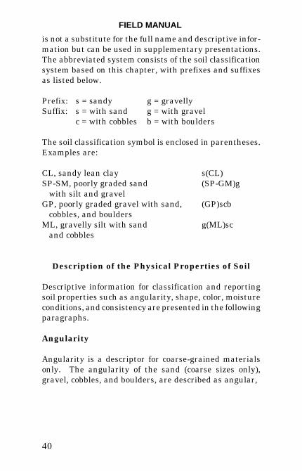
Abbreviated Soil Classification Symbols
If space is limited, an abbreviated system may be used toindicate the soil classification symbol and name such asin logs, data bases, tables, etc. The abbreviated system
FIELD MANUAL
40
is not a substitute for the full name and descriptive infor-mation but can be used in supplementary presentations.The abbreviated system consists of the soil classificationsystem based on this chapter, with prefixes and suffixesas listed below.
Prefix: s = sandy g = gravellySuffix: s = with sand g = with gravel
c = with cobbles b = with boulders
The soil classification symbol is enclosed in parentheses.Examples are:
CL, sandy lean clay s(CL)SP-SM, poorly graded sand (SP-GM)g with silt and gravelGP, poorly graded gravel with sand, (GP)scb cobbles, and bouldersML, gravelly silt with sand g(ML)sc and cobbles
Description of the Physical Properties of Soil
Descriptive information for classification and reportingsoil properties such as angularity, shape, color, moistureconditions, and consistency are presented in the followingparagraphs.
Angularity
Angularity is a descriptor for coarse-grained materialsonly. The angularity of the sand (coarse sizes only),gravel, cobbles, and boulders, are described as angular,

SOIL
41
subangular, subrounded, or rounded as indicated by thecriteria in table 3-8. A range of angularity may be stated,such as: sub-rounded to rounded.
Table 3-8.—Criteria for describing angularity of coarse-grained particles
Angular Particles have sharp edges and relativelyplanar sides with unpolished surfaces.
Subangular Particles are similar to angular descriptionbut have rounded edges.
Subrounded Particles have nearly planar sides but well-rounded corners and edges.
Rounded Particles have smoothly curved sides and noedges.
Shape
Describe the shape of the gravel, cobbles, and boulders as“flat, elongated” or “flat and elongated” if they meet thecriteria in table 3-9. Indicate the fraction of the particlesthat have the shape, such as: one-third of gravel particlesare flat. If the material is to be processed or used asaggregate for concrete, note any unusually shapedparticles.
Color
Color is an especially important property in identifyingorganic soils and is often important in identifying othertypes of soils. Within a given locality, color may also beuseful in identifying materials of similar geologic units.Color should be described for moist samples. Note if color

FIELD MANUAL
42
Table 3-9.—Criteria for describing particle shape
The particle shape is described as follows, where length,width, and thickness refer to the greatest, intermediate, andleast dimensions of a particle, respectively.
Flat Particles with width/thickness >3.
Elongated Particles with length/width >3.
Flat and Particles meet criteria for both flat and elongated elongated.
represents a dry condition. If the sample contains layersor patches of varying colors, this should be noted, andrepresentative colors should be described. The MunselColor System may be used for consistent colordescriptions.
Odor
Describe the odor if organic or unusual. Soils containinga significant amount of organic material usually havea distinctive odor of decaying vegetation. This is espe-cially apparent in fresh samples, but if the samples aredried, the odor often may be revived by heating a moist-ened sample. If the odor is unusual, such as that of apetroleum product or other chemical, the material shouldbe described and identified if known. The material maybe hazardous, and combustion or exposure should beconsidered.
Moisture Conditions
Describe the moisture condition as dry, moist, or wet, asindicated by the criteria in table 3-10.

SOIL
43
Table 3-10.—Criteria for describing moisturecondition
Dry Absence of moisture, dusty, dry to the touch.
Moist Damp but no visible water.
Wet Visible free water, usually soil is below watertable.
Reaction with HCl
Describe the reaction with HCl as none, weak, or strong,as indicated by the criteria in table 3-11. Calciumcarbonate is a common cementing agent. The reactionwith dilute hydrochloric acid is important in determiningthe presence and abundance of calcium carbonate.
Table 3-11.—Criteria for describing reaction with HCl
None No visible reaction.
Weak Some reaction, with bubbles forming slowly.
Strong Violent reaction, with bubbles forming immediately.
Consistency
Describe consistency (degree of firmness) for intact fine-grained soils as very soft, soft, firm, hard, or very hard, asindicated by the criteria in table 3-12. This observationis inappropriate for soils with significant amounts ofgravel. Pocket penetrometer or torvane testing may sup-plement this data.

FIELD MANUAL
44
Table 3-12.—Criteria for describing consistency of in-place orundisturbed fine-grained soils
Very soft Thumb will penetrate soil more than 1 in (25 mm).
Soft Thumb will penetrate soil about 1 in (25 mm).
Firm Thumb will indent soil about 1/4 in (5 mm).
Hard Thumb will not indent soil but readily indented with thumbnail.
Very hard Thumbnail will not indent soil.
Cementation
Describe the cementation of intact soils as weak,moderate, or strong, as indicated by the criteria intable 3-13.
Table 3-13.—Criteria for describing cementation
Weak Crumbles or breaks with handling or littlefinger pressure.
Moderate Crumbles or breaks with considerable fingerpressure.
Strong Will not crumble or break with finger pressure.
Structure (Fabric)
Describe the structure of the soil according to criteriadescribed in table 3-14. The descriptors presented are forsoils only; they are not synonymous with descriptors forrock.

SOIL
45
Table 3-14.—Criteria for describing structure
Stratified Alternating layers of varying material orcolor; note thicknesses.
Laminated1 Alternating layers of varying material orcolor with layers less than 6 mm thick; notethicknesses.
Fissured1 Breaks along definite planes with littleresistance to fracturing.
Slickensided1 Fracture planes appear polished or glossy,sometimes striated.
Blocky1 Cohesive soil that can be broken down intosmall angular lumps which resist furtherbreakdown.
Lenses Inclusion of small pockets of different soils,such as small lenses of sand scatteredthrough a mass of clay; note thicknesses.
Homogeneous Same color and textural or structuralappearance throughout.
1 Do not use for coarse-grained soils with the exception of finesands which can be laminated.
Particle Sizes
For gravel and sand-size components, describe the rangeof particle sizes within each component as defined in theprevious terminology paragraph. Descriptive terms,sizes, and examples of particle sizes are shown intable 3-15.

FIELD MANUAL
46
Table 3-15.—Particle sizes
Descriptiveterm Size
Familiar example withinthe size range
Boulder 300 mm or more Larger than a volleyball
Cobble 300 mm to 75 mm Volleyball - grapefruit -orange
Coarse gravel 75 mm to 20 mm Orange - grape
Fine gravel 20 mm to No. 4sieve (5 mm)
Grape - pea
Coarse sand No. 4 sieve toNo. 10 sieve
Sidewalk salt
Medium sand No. 10 sieve toNo. 40 sieve
Openings in windowscreen
Fine sand No. 40 sieve toNo. 200 sieve
Sugar - table salt, grainsbarely visible
Describe the maximum particle size found in the sample.For reporting maximum particle size, use the followingdescriptors and size increments:
Fine sandMedium sand Coarse sand5-mm increments from 5 mm to 75 mm25-mm increments from 75 mm to 300 mm100-mm increments over 300 mm
For example: "maximum particle size 35 mm""maximum particle size 400 mm"
If the maximum particle size is sand size, describe asfine, medium, or coarse sand; for example, maximum par-ticle size, medium sand.

SOIL
47
If the maximum particle size is gravel size, describe themaximum particle size as the smallest sieve opening thatthe particle would pass.
If the maximum particle size is cobble or boulder size,describe the maximum dimension of the largest particle.
Particle Hardness
Describe the hardness of coarse sand and larger particlesas hard, or state what happens when the particles are hitby a hammer; e.g., gravel-size particles fracture withconsiderable hammer blow, some gravel-size particlescrumble with hammer blow. Hard means particles do notfracture or crumble when struck with a hammer.Remember that the larger the particle, the harder theblow required to fracture it. A good practice is to describethe particle size and the method that was used todetermine the hardness.
Additional Descriptive Information
Additional descriptive information may include unusualconditions, geological interpretation or other classifi-cation methods, such as:
Presence of roots or root holes or other organicmaterial or debris;
Degree of difficulty in drilling or augering hole or ex-cavating a pit; or
Raveling or caving of the trench, hole, pit, or exposure;
or
Presence of mica or other predominant minerals.
A local or commercial name and/or a geologic interpreta-tion should be provided for the soil.

FIELD MANUAL
48
A classification or identification of the soil according toother classification systems may be added.
Narrative Descriptions and Examples
The description should include the information shown intables 3-16 and 3-17, a checklist for the description ofsoils. Example descriptions follow.
Table 3-16.—Checklist for the description of soilclassification and identification
1.2.3.4.
5.
6.
7.8.9.
10.
11.
12.
13.14.15.
16.
Group name and symbolPercent gravel, sand, and/or finesPercent by volume of cobbles and bouldersParticle size
Gravel - fine, coarseSand - fine, medium, coarse
Particle angularity angular subangular subrounded roundedParticle shape flat elongated flat and elongatedMaximum particle size or dimensionHardness of coarse sand and larger particlesPlasticity of fines nonplastic low medium highDry strength none low medium high very highDilatancy none slow rapidToughness low medium highColor (when moist)Odor (if organic or unusual)Moisture dry moist wetReaction with HCL none weak strong

SOIL
49
Table 3-17.—Checklist for the description of in-place conditions
In-place conditions:
1.
2.
3.
4.5.
Consistency (fine-grained soils only) very soft soft firm hard very hardCementation weak moderate strongStructure stratified laminated fissured slickened lensed homogeneousGeologic interpretation and/or local name, if anyAdditional comments and description
Presence of roots or root holesPresence of mica, gypsum, etc.Surface coatingsCaving or sloughing of excavationExcavation difficulty
Example 1: CLAYEY GRAVEL WITH SAND AND COB-BLES (GC)—Approximately 50 percent fine to coarse,sub-rounded to subangular gravel; approximately30 percent fine to coarse, subrounded sand;approximately 20 per-cent fines with medium plasticity,high dry strength, no dilatancy, medium toughness; weakreaction with HCl; original field sample had about5 percent (by volume) subrounded cobbles, maximum size150 mm.
IN-PLACE CONDITIONS: firm, homogeneous, dry,brown.
GEOLOGIC INTERPRETATION: alluvial fan.
Abbreviated symbol is (GC)sc.
Example 2: WELL GRADED GRAVEL WITH SAND(GW)—Approximately 75 percent fine to coarse, hard,sub-angular gravel; approximately 25 percent fine to

FIELD MANUAL
50
coarse, hard, subangular sand; trace of fines; maximumsize 75 mm, brown, dry; no reaction with HCl.
Abbreviated symbol is (GW)s
Example 3: SILTY SAND WITH GRAVEL (SM)—Ap-proximately 60 percent predominantly fine sand; approxi-mately 25 percent silty fines with low plasticity, low drystrength, rapid dilatancy, and low toughness; approxi-mately 15 percent fine, hard, subrounded gravel, a fewgravel-size particles fractured with hammer blow;maximum size 25 mm; no reaction with HCl.
IN-PLACE CONDITIONS: firm, stratified, and containslenses of silt 1- to 2-in thick, moist, brown to gray;in-place density was 106 pounds per cubic foot (lb/ft3), andin-place moisture was 9 percent.
GEOLOGIC INTERPRETATION: ALLUVIUM
Abbreviated symbol is (SM)g.
Example 4: ORGANIC SOIL (OL/OH)—Approximately100 percent fines with low plasticity, slow dilatancy, lowdry strength, and low toughness; wet, dark brown,organic odor, weak reaction with HCl.
Abbreviated symbol is (OL/OH).
Example 5: SILTY SAND WITH ORGANIC FINES(SM)—Approximately 75 percent fine to coarse, hard, sub-angular reddish sand, approximately 25 percent organicand silty dark-brown nonplastic fines with no drystrength and slow dilatancy; wet; maximum size, coarsesand; weak reaction with HCl.
Abbreviated symbol is (SM)

SOIL
51
Example 6: POORLY GRADED GRAVEL WITH SILT,SAND, COBBLES, AND BOULDERS (GP-GM)—Approx-imately 75 percent fine to coarse, hard, subrounded tosubangular gravel; approximately 15 percent fine, hard,subrounded to subangular sand; approximately 10 per-cent silty nonplastic fines; moist, brown; no reaction withHCl; original field sample had approximately 5 percent(by volume) hard, subrounded cobbles and a trace of hard,subrounded boulders with a maximum dimension of500 mm.
Abbreviated symbol is (GP-GM)scb.
Use of Soil Classification as Secondary Identification Method for Materials Other
Than Natural Soils
General
Materials other than natural soils may be classified andtheir properties identified and described using the sameprocedures presented in the preceding subsections. Thefollowing materials are not considered soils and shouldnot be given a primary USCS soil classification:
Partially lithified or poorly cemented materials
Shale ClaystoneSandstone SiltstoneDecomposed granite
Processed, manmade, or other materials
Crushed rock SlagCrushed sandstone ShellsCinders Ashes

FIELD MANUAL
52
Identification criteria may be used for describing thesematerials, especially for describing particle sizes andshapes and identifying those materials which convert tosoils after field or laboratory processing. Description for-mat and classification for these materials are discussedindividually in the following paragraphs.
Partially Lithified or Cemented Materials
Partially lithified or poorly cemented materials may needto be classified because the material will be excavated,processed, or manipulated for use as a constructionmaterial. When the physical properties are to be deter-mined for these materials for classification, the materialmust be processed into a soil by grinding or slaking inwater (shale, siltstone, poorly indurated ash deposits).
The physical properties and resulting classificationdescribe the soil type as created by reworking the originalmaterial. Soil classifications can then be used as asecondary identification. However, the classificationsymbol and group name must be reported in quotationmarks in any 1ogs, tables, figures, and reports. Iflaboratory tests are performed on these materials, theresults must be reported as shown in figure 3-6.
An example of a written narrative for either a test pit orauger hole log based on visual classification is as follows:Symbol Description
Shale Fragments 3.4- to 7.8-foot (ft) Shale Fragments—Retrieved as 2- to 4-in pieces of shalefrom power auger hole, dry, brown,no reaction with HCl. After slakingin water for 24 hours, materialclassified as "SANDY CLAY (CH)"—

SO
IL
53
Figure 3-6.—Sample of test results summary.

FIELD MANUAL
54
Approximately 60 percent fines withhigh plasticity, high dry strength, nodilatancy and high toughness;approximately 35 percent fine tomedium, hard sand; approximately5 percent gravel-size pieces of shale.
Processed or Manmade Materials
Processed, manmade, or other materials are also used asconstruction materials, and classification can be used asa secondary identification. However, for these processedmaterials, the group name and classification symbol areto be within quotation marks. If laboratory tests areperformed on these materials, the results must bereported as shown in table 3-6.
An example of a written narrative for logs for visual clas-sification is as follows:
Symbol Description
CRUSHED ROCK Stockpile No. 3 CRUSHEDROCK— processed gravel and cob-bles from P.T. NO. 7; "POORLY GRADEDGRAVEL (GP)"—approximately90 percent fine, hard, angular,gravel-size particles; approximately10 percent coarse, angular, sand-size particles; dry, tan, no reactionwith HCl.
Special Cases for Classification
Some materials that require a classification and descrip-tion according to USBR 5000 [1] or USBR 5005 [2] shouldnot have a heading that is a classification group name.

SOIL
55
When these materials will be used in, or influence, designand construction, they should be described according tothe criteria for logs of test pits and auger holes and theclassification symbol and typical name placed in quota-tion marks similar to the previous discussion on second-ary identification method for materials other thannatural soils. The heading should be as follows:
TopsoilLandfillRoad surfacing Uncompacted or CompactedFill
For example:
Classification
Symbol Description
TOPSOIL 0.0-0.8 meter (m) TOPSOIL—would beclassified as "ORGANIC SILT (OL)."Approximately 80 percent fines with lowplasticity, slow dilatancy, low drystrength, and low toughness; approxi-mately 20 percent fine to medium sand;wet, dark brown, organic odor, weak reac-tion with HCl; roots present throughout.
Some material should be described but not given a classi-fication symbol or group name, such as landfill (trash,garbage, etc.) or asphalt road. All of the above listedterms are only examples; this is not a complete list. If theabove materials are not to be used and will not influencedesign or construction, only the basic term listed aboveneed be shown on the logs without a complete descriptionor classification.

FIELD MANUAL
56
BIBLIOGRAPHY
[1] Bureau of Reclamation, U.S. Department of theInterior, USBR-5000, “Procedure for DeterminingUnified Soil Classification (Laboratory Method),”Earth Manual, Part II, 3rd edition, 1990.
[2] Bureau of Reclamation, U.S. Department of theInterior, USBR-5005, “Procedure for DeterminingUnified Soil Classification (Visual Method),” EarthManual, Part II, 3rd edition, 1990.
[3] American Society for Testing and Materials, ASTMD-2487, “Standard Classification of Soils forEngineering Purposes,” ASTM Annual Book ofStandards, Volume 04.08 on Soil and Rock,Section 4 - Construction, West Conshohocken, PA,1996.
[4] American Society for Testing and Materials, ASTMD-2488, “Standard Practice for Description andIdentification of soils (Visual-Manual Procedure),”ASTM Annual Book of Standards, Volume 04.08 onSoil and Rock, Section 4 - Construction, West Con-shohocken, PA, 1996.
[5] U.S. Department of Agriculture, Agriculture Hand-book No. 436, Appendix I (Soil Taxonomy), December1975.
[6] Bureau of Reclamation, U.S. Department of theInterior, USBR 3900, “Standard Definitions ofTerms and Symbols Relating to Soil Mechanics,”Earth Manual, Part II, 3rd edition, 1990.