engi 3703 surveying and geomatics - faculty of …sitotaw/site/fall2007_files/lecture20.pdf · engi...
TRANSCRIPT
ENGI 3703Surveying and Geomatics
TopicInstructor: Prof. Ken Snelgrove
Lect 20 - Nov 5/07 Slide 1 of 7Photogrammetry - Basics
Photogrammetry: (Chapter 23) Is defined as the science associated with obtaining reliable information
from photographs. These techniques complement the mapping techniques you have been exploring in
your laboratory sessions. Large amounts of data can be extracted from photographs quickly when
compared to terrestrial measurement. This can result to tremendous cost savings. There are two
general specializations:
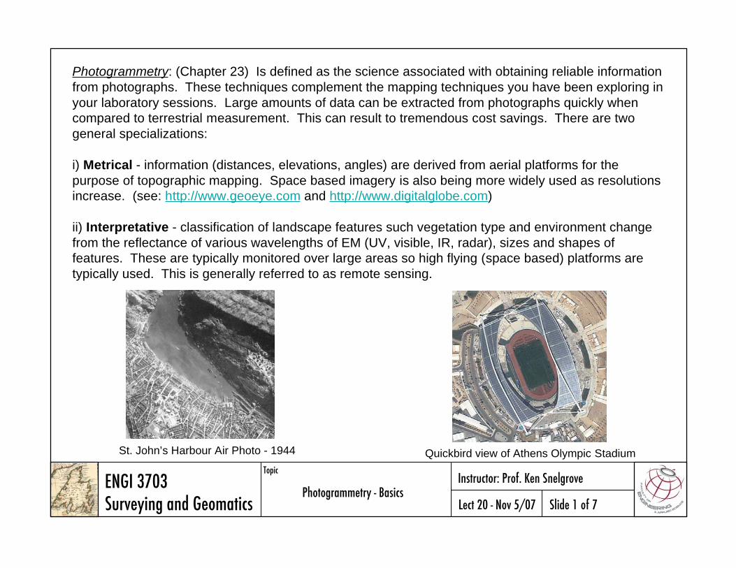
i) Metrical - information (distances, elevations, angles) are derived from aerial platforms for the
purpose of topographic mapping. Space based imagery is also being more widely used as resolutions
increase. (see: http://www.geoeye.com and http://www.digitalglobe.com)
ii) Interpretative - classification of landscape features such vegetation type and environment change
from the reflectance of various wavelengths of EM (UV, visible, IR, radar), sizes and shapes of
features. These are typically monitored over large areas so high flying (space based) platforms are
typically used. This is generally referred to as remote sensing.
Quickbird view of Athens Olympic StadiumSt. John’s Harbour Air Photo - 1944
ENGI 3703Surveying and Geomatics
TopicInstructor: Prof. Ken Snelgrove
Lect 20 - Nov 5/07 Slide 2 of 7Photogrammetry - Basics
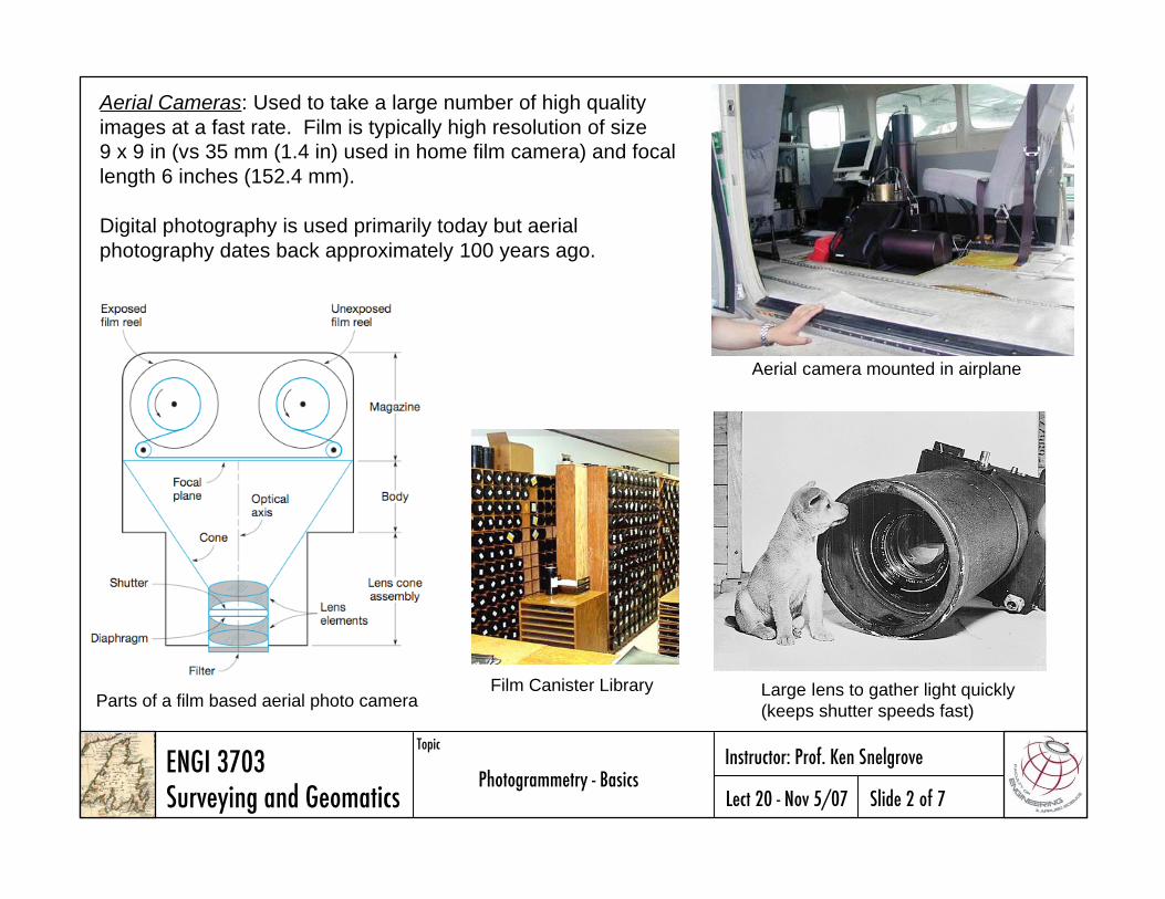
Aerial Cameras: Used to take a large number of high quality
images at a fast rate. Film is typically high resolution of size
9 x 9 in (vs 35 mm (1.4 in) used in home film camera) and focal
length 6 inches (152.4 mm).
Digital photography is used primarily today but aerial
photography dates back approximately 100 years ago.
Parts of a film based aerial photo cameraLarge lens to gather light quickly
(keeps shutter speeds fast)
Aerial camera mounted in airplane
Film Canister Library
ENGI 3703Surveying and Geomatics
TopicInstructor: Prof. Ken Snelgrove
Lect 20 - Nov 5/07 Slide 3 of 7Photogrammetry - Basics
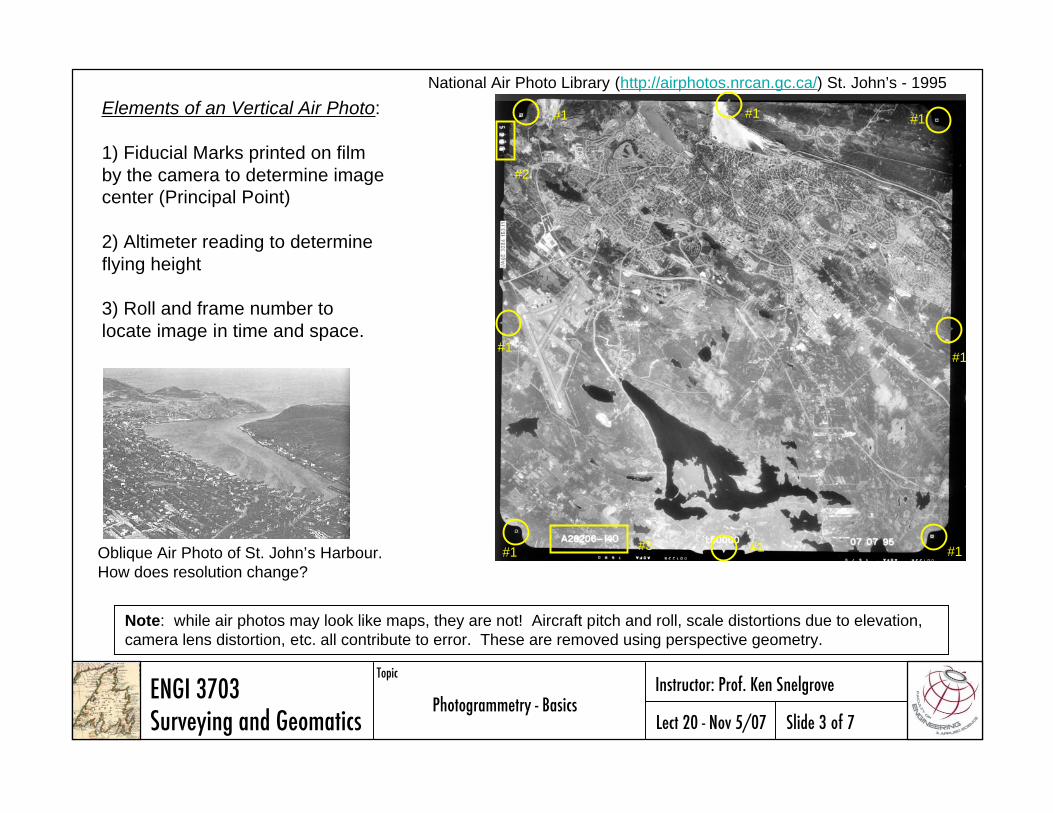
National Air Photo Library (http://airphotos.nrcan.gc.ca/) St. John’s - 1995
#1
#1 #1
#1
#1#1
#1
#2
#3
Elements of an Vertical Air Photo:
1) Fiducial Marks printed on film
by the camera to determine image
center (Principal Point)
2) Altimeter reading to determine
flying height
3) Roll and frame number to
locate image in time and space.
Oblique Air Photo of St. John’s Harbour.
How does resolution change?
#1
Note: while air photos may look like maps, they are not! Aircraft pitch and roll, scale distortions due to elevation,
camera lens distortion, etc. all contribute to error. These are removed using perspective geometry.

ENGI 3703Surveying and Geomatics
TopicInstructor: Prof. Ken Snelgrove
Lect 20 - Nov 5/07 Slide 4 of 7Photogrammetry - Basics
Flight Lines and Index Maps: at the end of a photo mission,
the aerial survey contractor plots the location of the first,
last, and every fifth photo centre, along with its roll and
frame number, on a National Topographic System (NTS)
map. Photo centres are represented by small circles, and
straight lines are drawn connecting the circles to show
photos on the same flight line.
Overlap: is the amount by which one photograph includes the
area covered by another photograph, and is expressed as a
percentage. The photo survey is designed to acquire 60 per
cent forward overlap (between photos along the same flight
line) and 30 per cent lateral overlap (between photos on
adjacent flight lines).
from: National Air Photo Library web site
Vertical Air Photo Geometry: the exposure station is the location of
the camera lens. Light is gather from the scene and focused onto the
backplane of the camera at the focal length (Lo’). A contact print
positive can be constructed in front of the lens that is an exact 180°
reversal of the negative. Here we consider an x-y coordinate system
centered at on the contact print and intersecting the line Ooo’ defined
by the fiducial marks of the camera. Note: the x-axis is parallel to the
direction of flight.
ENGI 3703Surveying and Geomatics
TopicInstructor: Prof. Ken Snelgrove
Lect 20 - Nov 5/07 Slide 5 of 7Photogrammetry - Basics
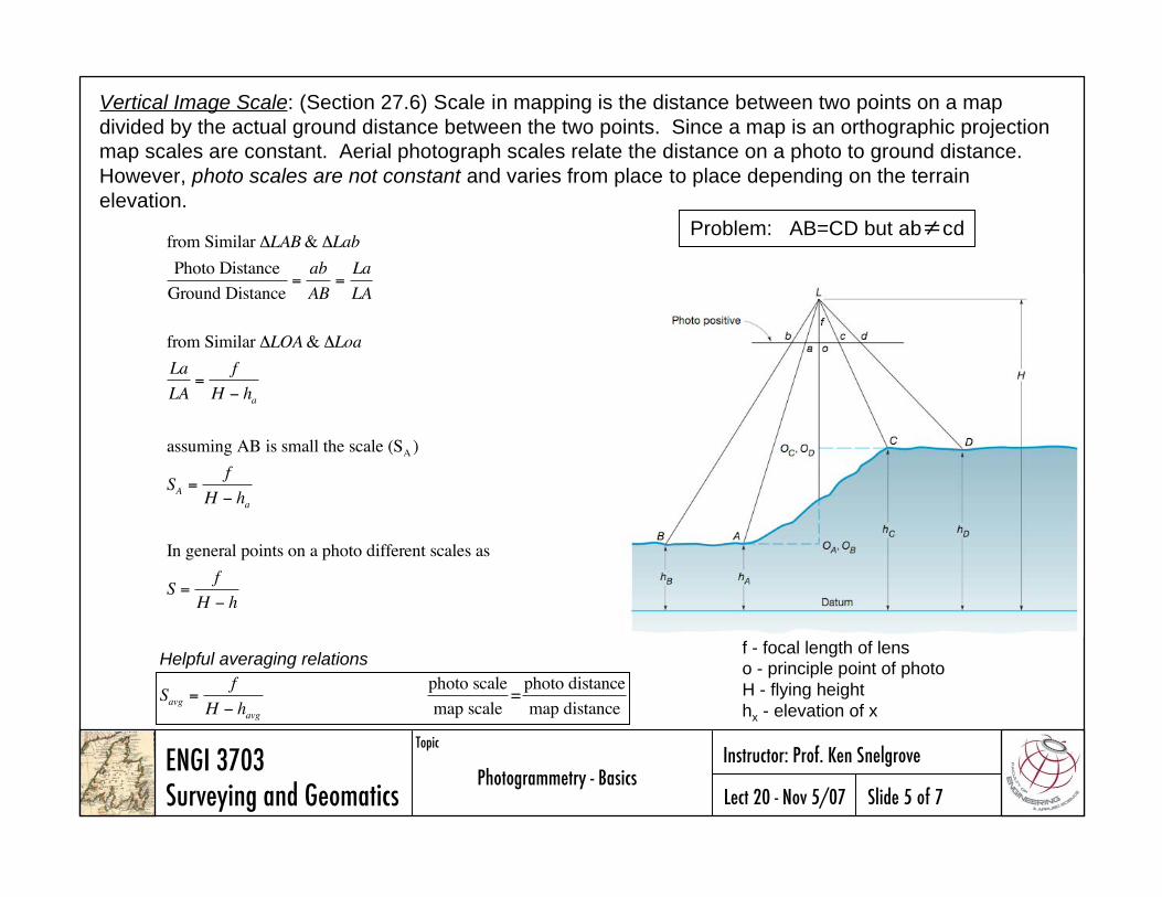
Vertical Image Scale: (Section 27.6) Scale in mapping is the distance between two points on a map
divided by the actual ground distance between the two points. Since a map is an orthographic projection
map scales are constant. Aerial photograph scales relate the distance on a photo to ground distance.
However, photo scales are not constant and varies from place to place depending on the terrain
elevation.
f - focal length of lens
o - principle point of photo
H - flying height
hx - elevation of x
Problem: AB=CD but ab cdfrom Similar LAB& Lab
Photo Distance
Ground Distance=ab
AB=La
LA
from Similar LOA& Loa
La
LA=
f
H ha
assuming AB is small the scale (SA )
SA =f
H ha
In general points on a photo different scales as
S =f
H h
Savg =f
H havg
photo scale
map scale=
photo distance
map distance
Helpful averaging relations
ENGI 3703Surveying and Geomatics
TopicInstructor: Prof. Ken Snelgrove
Lect 20 - Nov 5/07 Slide 6 of 7Photogrammetry - Basics
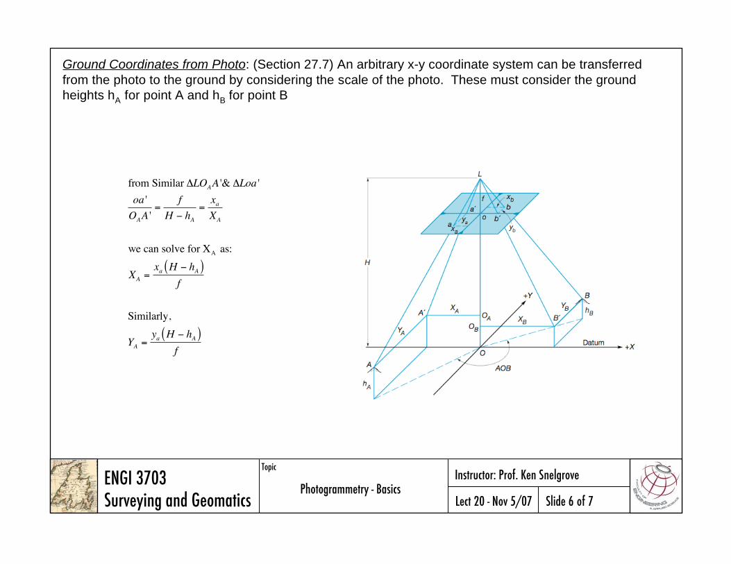
Ground Coordinates from Photo: (Section 27.7) An arbitrary x-y coordinate system can be transferred
from the photo to the ground by considering the scale of the photo. These must consider the ground
heights hA for point A and hB for point B
from Similar LOAA '& Loa '
oa '
OAA '=
f
H hA=xaXA
we can solve for XA as:
XA =xa H hA( )
f
Similarly,
YA =ya H hA( )
f