eis - chapter 10 socio-economic impacts - sa.gov.au · pdf fileproposed adelaide desalination...
TRANSCRIPT
PROPOSED ADELAIDEDESALINATION PLANT
EIS - Chapter 10Socio-Economic
Impacts

Proposed Adelaide Desalination Plant Environmental Impact Statement Chapter 10 – The Socio-Economic Environment
i
Contents
10.1 Introduction 1
10.2 Economic Issues 210.2.1 Economic Sustainability of Desalination Plant 210.2.2 Employment Impacts 310.2.2.1 Direct Construction Employment Impact 310.2.2.2 Direct Operation Employment Impact 310.2.2.3 Indirect Employment Impacts 310.2.2.4 Opportunities for Aboriginal Employment 410.2.2.5 Economic Effects of the Proposed Development 510.2.3 Economic Sectors Positively Impacted by the Desalination Plant 610.2.4 Cost of Desalinated Water 6
10.3 Traffic and Access Issues 810.3.1 Introduction 810.3.1.1 Access to the Subject Site 810.3.2 Existing Traffic and Access Conditions 910.3.2.1 Traffic Volumes and Existing Road Network 910.3.2.2 Existing Intersection Performance 1010.3.3 Traffic Impacts 1110.3.3.1 Construction 1110.3.3.2 Operation 1310.3.3.3 Implications for Road Safety and Capacity 1610.3.3.4 Requirements to Upgrade Road Infrastructure 1610.3.4 Management and Mitigation Strategies 1610.3.4.1 Construction 1610.3.4.2 Operation 17
10.4 Effects on Communities 1810.4.1 Introduction 1810.4.2 Description of Existing Socio-Economic Environment 1810.4.2.1 Affected Communities 1810.4.3 Community and Stakeholder Engagement 1910.4.3.1 Engagement Process 1910.4.4 Review Process to Inform Social Impacts 2510.4.4.1 Relevant Local Projects 2510.4.4.2 National and International Desalination Experience 2510.4.4.3 Issues Identified from Community and Stakeholder Feedback
and Review Process 2610.4.5 Social Impact Assessment 2710.4.5.1 Impacts on Residents 2710.4.5.2 Impacts on Businesses 2810.4.5.3 Impacts on Service Providers 2910.4.5.4 Impacts on Community Activities and Services 3110.4.5.5 Impacts on Sense of Community/Attachment to Place 3110.4.6 Recreation and the Metropolitan Coast Park 3210.4.6.1 Adelaide Metropolitan Coast Park 3210.4.6.2 Council Plans and Local Open Space 33
ii Proposed Adelaide DesalinationPlant Environmental ImpactStatement
Chapter 10 – The Socio-EconomicEnvironment
10.4.6.3 Key Recreational Activities and User Groups 3410.4.6.4 Stakeholder Consultation 3510.4.6.5 Constraints 3510.4.7 Benefits to the Community 3610.4.7.1 Open Space and Trail Linkages 36
10.5 Indigenous Cultural Heritage 3710.5.1 Introduction 3710.5.1.1 Survey Participation 3710.5.2 Relevant Aboriginal Heritage Legislation 3710.5.3 AARD Register Search and Previous Research 3810.5.3.1 AARD Central Archive 3810.5.3.2 Previous Research 3910.5.4 Field Survey Methods 4010.5.4.1 Field Survey 4010.5.4.2 Aboriginal Site Identification and Recording 4110.5.5 Field Survey Results 4110.5.5.1 New Site (ADP01) 4210.5.5.2 Recommendations for Development 4210.5.6 Ethnographic Survey 4210.5.7 Summary 4310.5.7.1 Summary 43
10.6 Native Title 4410.6.1 Introduction 4410.6.2 Consultation 4410.6.3 Native Title Issues 44
10.7 European Cultural Heritage 4510.7.1 Introduction 4510.7.2 Site History 4510.7.2.1 Early European Settlement 4510.7.2.2 Early Land Use 4510.7.2.3 Land Acquisition 4510.7.3 Refinery History 4610.7.4 Heritage Value of Site 4610.7.4.1 Subject Site 4610.7.4.2 Refinery Site in General 4710.7.5 Marine Heritage 4710.7.5.1 Legislative Aspects 4710.7.5.2 Documented Objects 4710.7.5.3 Survey Results 4810.7.5.4 Conclusion 4810.7.6 Management and Mitigation Strategies 48
Proposed Adelaide Desalination Plant Environmental Impact Statement Chapter 10 – The Socio-EconomicEnvironment
1
10.1 IntroductionThis Chapter discusses the potential socio-economic impacts of the proposed AdelaideDesalination Plant. It begins with an assessment of the economic effects of theproposed development with particular emphasis on employment impacts, investmentopportunities and the possible implications of the Desalination Plant on the cost of waterto the South Australian community.
A traffic assessment of the impacts on the local/regional road network of the proposeddevelopment is then presented. This assessment proposes a number of minor changesto existing road infrastructure in order to accommodate the expected increase in trafficarising from the construction of the Desalination Plant.
The impacts of the proposal on the local and regional communities is also considered inlight of the effects of the project on nearby residents, businesses, service providers,community and recreational activities, as well as the community’s sense of place andidentification with the locality. The development and operation of the proposedDesalination Plant is also discussed in the context of Indigenous and European culturalheritage values and Native Title issues, including any legislative requirements.
Throughout the Chapter, consideration has been given to appropriate management andmitigation strategies that seek to address identified socio-economic issues and enhancethe positive impacts of the proposed development. These strategies are considered tobe important means of ‘giving back’ to those communities that are potentially mostaffected by the proposed development.
2 Proposed Adelaide DesalinationPlant Environmental ImpactStatement
Chapter 10 – The Socio-EconomicEnvironment
10.2 Economic IssuesSA Water has prepared the following economic assessment from information suppliedby KPMG.
Various modelling techniques have been employed in this assessment, in particular thequantification of the macroeconomic impact of the proposed development on SouthAustralia’s Gross State Product (GSP) over the period 2008 – 2017 and beyond. Theobjective of this part of the analysis is to forecast the effect of a fresh injection of fundsinto the Construction and Electricity, Gas and Water sectors of the South Australianeconomy on the growth path of total output, measured by GSP.
Total construction costs were provided by Currie and Brown, principal quantity surveyorto SA Water for the ADP. These costs were used to inform the analysis that follows.
Two types of macroeconomic modelling approaches were employed in this analysis,including:
1) Structural time series modelling (STS). This is the primary modellingframework used. The advantage of this approach, as opposed to aconventional econometric model with explanatory variables, is that it is lessdemanding in terms of the data requirements and it also makes ex anteforecasting a simple procedure. The analysis uses the most recentinformation regarding the state of the South Australian economy (publishedby the ABS).
The structural time series modelling framework and associated outputs havebeen reviewed and validated by Professor Moosa from Monash University(Melbourne).
2) The Computable General Equilibrium (CGE) modelling framework. TheSouth Australian economy-wide impacts of recently proposed planningreforms are estimated by MMRF31. MMRF3 is an Australian economy-widemulti-regional, multi-sectoral computable general equilibrium (CGE) modeldeveloped by Centre of Policy Studies, Monash University.
The results of the two modelling frameworks are comparable in terms of the impact ofthe proposed planning reforms on economic activity.
10.2.1 Economic Sustainability of Desalination PlantThe economic impact of the proposed Desalination Plant on the South Australianeconomy is significant. While the cost of the proposal is to be borne by waterconsumers, the impact of the capital expenditure and direct job creation will result in anet benefit to the South Australian GSP. The STS and CGE economic modellingundertaken for the 50 GL per annum Plant demonstrates that South Australia’s GSP isexpected to increase by more than $2.8 billion (or 0.4% of GSP) to 2017. The effectson the economy are outlined in more detail in Section 10.2.3 below.
Accordingly, the proposed Desalination Plant is economically sustainable whencompared to the base case, which is the economy without the investment into theproposed development.
1 A full working version of MMRF 3 is available from the website, http://www.monash.edu.au/policy.
Proposed Adelaide Desalination Plant Environmental Impact Statement Chapter 10 – The Socio-EconomicEnvironment
3
In the event that the inflows to the River Murray remain low or continue to fall in futureyears, the sustainable economic benefits of the proposed development will increasefurther as it provides even greater water security to the metropolitan population andState economy. That is, the proposed development of the Desalination Plant provides alevel of insurance in water security for Adelaide’s water supply that is not climatedependent.
10.2.2 Employment ImpactsA project of the size of the proposed Desalination Plant will have a significant impact onemployment. Whilst there is a modest need for full time equivalent (FTE) workersduring the normal operation of the Desalination Plant, there is a significant need fortrained skilled workers during the construction phase. This will have significant flow oneffects in the economy. The following sections outline the direct construction andoperational employment benefits, and the indirect employment benefits that flow onthrough the economy through the economic multipliers.
10.2.2.1 Direct Construction Employment ImpactThe proposed Desalination Plant is a significant project for South Australia. Theconstruction phase of the ADP is expected to generate approximately 500 FTE jobs inConstruction, Engineering, Transport and related services on site for slightly more thantwo years. This result reflects a calculation based on hours worked in the year, and hasbeen prepared from Currie and Brown estimates. Actual employment numbers on sitewill be higher during some times as not all trades will be employed for the entireduration of the construction phase (for example, excavation plant operators employed atthe beginning of the ADP will be replaced by electrical and mechanical workers towardsthe end of the proposed development). Other employment opportunities are generatedin those industries that supply materials, and through ancillary construction and buildingprocesses (equipment hire for example) which flow through the economy as mentionedbelow. The flow on effect of these activities has been calculated as part of theeconomic modelling analysis.
10.2.2.2 Direct Operation Employment ImpactThe operation of the ADP requires management, operational and maintenancepersonnel to operate and maintain the Desalination Plant. The economic modelling hasassumed a 100% capacity operation, however, in the event that the Desalination Plantoperates at a reduced capacity (at times when there are sufficient alternative sources ofwater) the need for operational staff does not change materially due to the need foroperational standby capability, membrane preservation and maintenance and otherfunctions in order that the Desalination Plant is available when required.
The operation of the Desalination Plant is likely to generate approximately 20 new FTEjobs in operation and management for the Operations and Maintenance Operator.Although minor, other employment opportunities result from ongoing management atSA Water, and the Transport, Energy and Chemical industries that will supply theDesalination Plant with ongoing services. This is covered though the indirectemployment impacts mentioned below.
10.2.2.3 Indirect Employment ImpactsThe stimulus provided in the economy through the direct job creation associated withthe construction and ongoing operation of the Desalination Plant provides further
4 Proposed Adelaide DesalinationPlant Environmental ImpactStatement
Chapter 10 – The Socio-EconomicEnvironment
benefits through indirect job creation. Indirect benefits are created through the ancillaryservices such as Transport, Energy and other goods and services that are supplied tothe proposed Desalination Plant, as well as the economic activity and jobs created byadditional spending in the economy resulting from the development.
-
1.00
2.00
3.00
4.00
5.00
6.00
7.00
8.00
9.00
2008
2009
2010
2011
2012
2013
2014
2015
2016
2017
Chan
ge in
em
ploy
men
t, th
ousa
nds
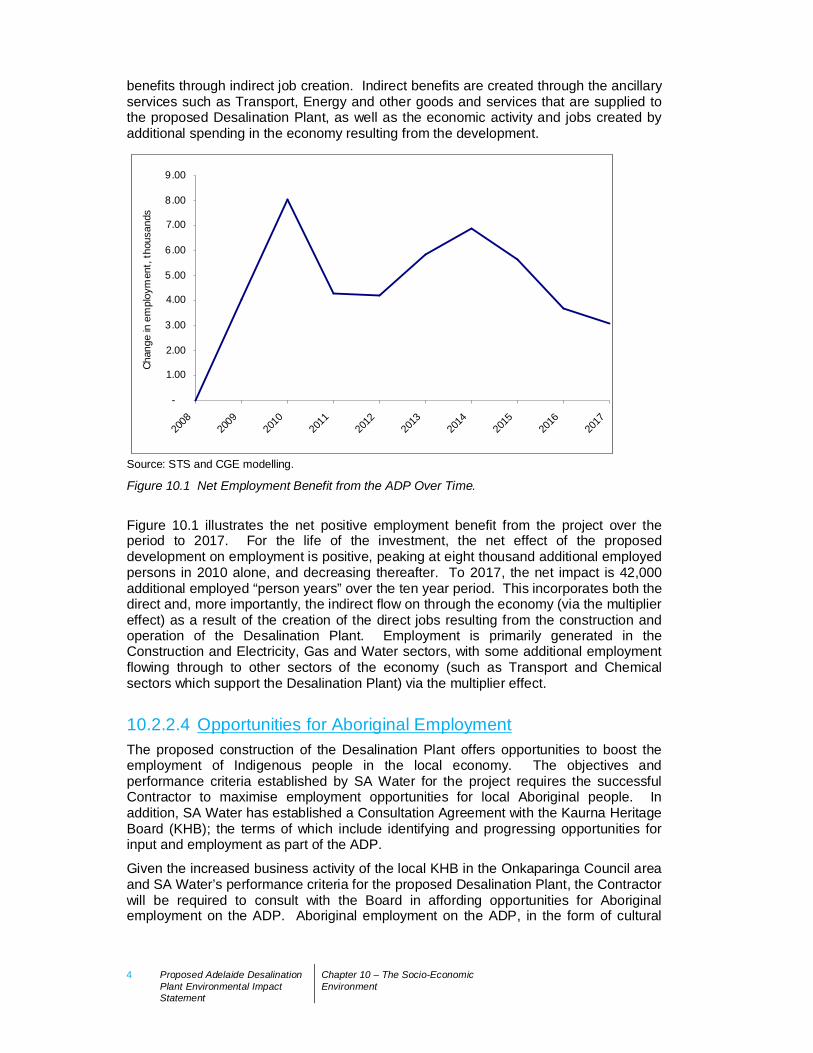
Source: STS and CGE modelling.
Figure 10.1 Net Employment Benefit from the ADP Over Time.
Figure 10.1 illustrates the net positive employment benefit from the project over theperiod to 2017. For the life of the investment, the net effect of the proposeddevelopment on employment is positive, peaking at eight thousand additional employedpersons in 2010 alone, and decreasing thereafter. To 2017, the net impact is 42,000additional employed “person years” over the ten year period. This incorporates both thedirect and, more importantly, the indirect flow on through the economy (via the multipliereffect) as a result of the creation of the direct jobs resulting from the construction andoperation of the Desalination Plant. Employment is primarily generated in theConstruction and Electricity, Gas and Water sectors, with some additional employmentflowing through to other sectors of the economy (such as Transport and Chemicalsectors which support the Desalination Plant) via the multiplier effect.
10.2.2.4 Opportunities for Aboriginal EmploymentThe proposed construction of the Desalination Plant offers opportunities to boost theemployment of Indigenous people in the local economy. The objectives andperformance criteria established by SA Water for the project requires the successfulContractor to maximise employment opportunities for local Aboriginal people. Inaddition, SA Water has established a Consultation Agreement with the Kaurna HeritageBoard (KHB); the terms of which include identifying and progressing opportunities forinput and employment as part of the ADP.
Given the increased business activity of the local KHB in the Onkaparinga Council areaand SA Water’s performance criteria for the proposed Desalination Plant, the Contractorwill be required to consult with the Board in affording opportunities for Aboriginalemployment on the ADP. Aboriginal employment on the ADP, in the form of cultural
Proposed Adelaide Desalination Plant Environmental Impact Statement Chapter 10 – The Socio-EconomicEnvironment
5
heritage services such as monitoring, has been ongoing and will continue throughoutthe duration of the ADP.
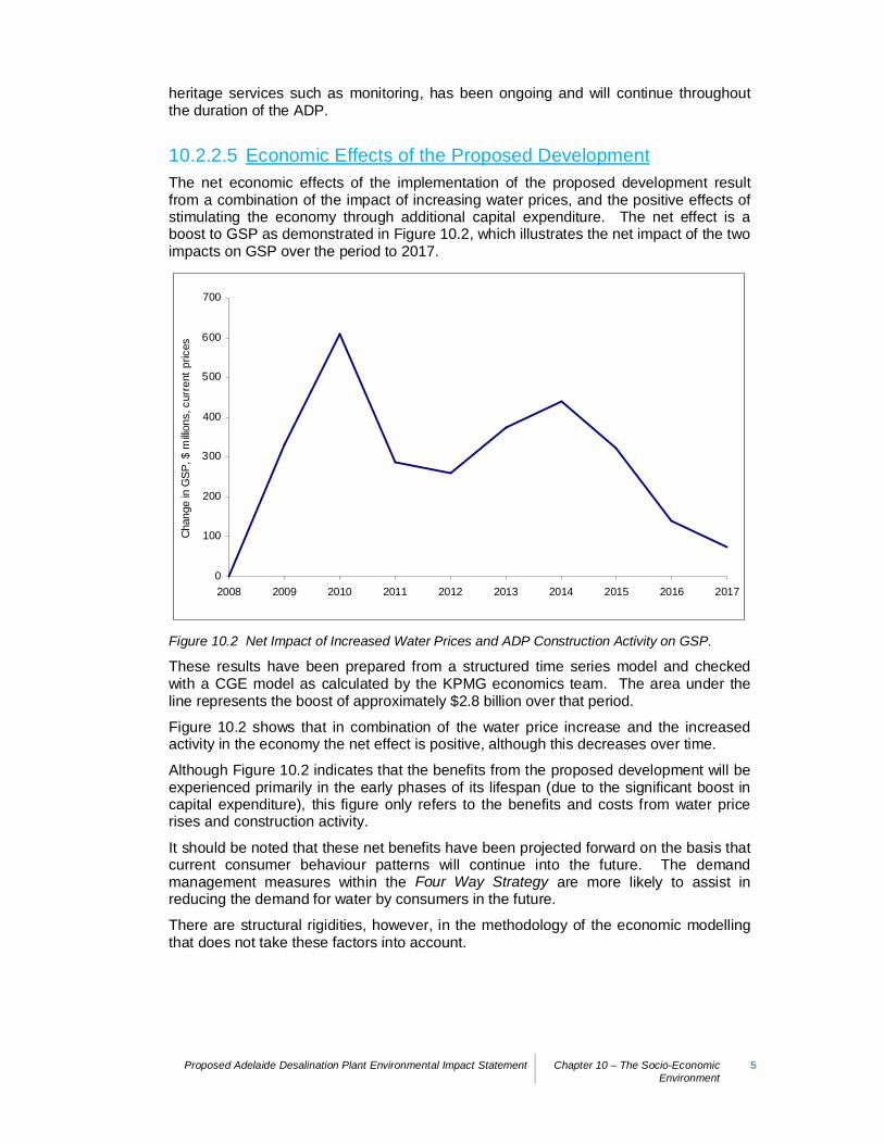
10.2.2.5 Economic Effects of the Proposed DevelopmentThe net economic effects of the implementation of the proposed development resultfrom a combination of the impact of increasing water prices, and the positive effects ofstimulating the economy through additional capital expenditure. The net effect is aboost to GSP as demonstrated in Figure 10.2, which illustrates the net impact of the twoimpacts on GSP over the period to 2017.
0
100
200
300
400
500
600
700
2008 2009 2010 2011 2012 2013 2014 2015 2016 2017
Chan
ge in
GSP
, $ m
illion
s, c
urre
nt p
rices
Figure 10.2 Net Impact of Increased Water Prices and ADP Construction Activity on GSP.
These results have been prepared from a structured time series model and checkedwith a CGE model as calculated by the KPMG economics team. The area under theline represents the boost of approximately $2.8 billion over that period.
Figure 10.2 shows that in combination of the water price increase and the increasedactivity in the economy the net effect is positive, although this decreases over time.
Although Figure 10.2 indicates that the benefits from the proposed development will beexperienced primarily in the early phases of its lifespan (due to the significant boost incapital expenditure), this figure only refers to the benefits and costs from water pricerises and construction activity.
It should be noted that these net benefits have been projected forward on the basis thatcurrent consumer behaviour patterns will continue into the future. The demandmanagement measures within the Four Way Strategy are more likely to assist inreducing the demand for water by consumers in the future.
There are structural rigidities, however, in the methodology of the economic modellingthat does not take these factors into account.

6 Proposed Adelaide DesalinationPlant Environmental ImpactStatement
Chapter 10 – The Socio-EconomicEnvironment
10.2.3 Economic Sectors Positively Impacted by theDesalination Plant
Considering the benefits of the proposed development to the economy as a whole overtime, it is possible to examine the sectors that are forecast to benefit from flow oneconomic activity. These are shown as investment opportunities generated from theproposed Desalination Plant.
Table 10.1 outlines the net impact on the South Australian economy resulting from thedevelopment of the Desalination Plant.
Table 10.1 Impact of the intervention applied to selected sectors in the SA economy throughinjection of the ADP construction and operation. (Note, only GSP in total, and the Electricity GasWater and Construction sectors are detailed).
Forecast Post InterventionSector
2008 2009-13 2014-18 2019-23 2024-28 2029-32
Electricity, Gas and Watersupply 0.00% 3.97% 1.93% 0.80% -0.05% -0.66%
Construction 0.00% 7.01% 6.78% 5.25% 4.22% 3.55%
Gross State Product 0.00% 0.62% 0.57% 0.43% 0.33% 0.26%
Table 10.1 shows the additional activity in the Construction and Electricity, Gas andWater sectors, both initially from the capital injection, but also increased over timebeyond the initial rise as identified in the STS and CGE modelling. The ongoing activityin the construction sector is evident, with higher growth out to 2032 from theDesalination Plant. This is caused by the reinvestment of the profits, staff andexperience from the proposed development into other capital works in following yearsthat would otherwise not have occurred.
Some other sectors of the State’s economy will benefit from spillover effects from theConstruction and Electricity, Gas and Water sectors into services sectors, such as theAccommodation, Cafés and Restaurants and Retail Trade sectors. These benefits arebrought about by the consumption expenditure of additional employees on theDesalination Plant. Some sectors may experience a slight decline in consumption asresources are redistributed in the State’s economy in response to the injection broughtabout by the proposed development. Accordingly, some sectors will not grow as quicklyas they would have otherwise, and the changes in the growth patterns will be achievedthrough redirecting resources between sectors before investment decisions are made,and not through reversing existing investment decisions.
The overall impact of the proposed development on the State’s economy is evident inthe table above. An increase of 0.62% in the period from 2009 to 2013 recognises asignificant improvement in the State economy as compared to the forecasts without theproposed development.
10.2.4 Cost of Desalinated WaterSA Water’s investment in the proposed Desalination Plant will be approximately $1.374billion (2007/08 dollars and subject to final costing), which takes into account the designand construction of the Desalination Plant and associated infrastructure, subject to final
Proposed Adelaide Desalination Plant Environmental Impact Statement Chapter 10 – The Socio-EconomicEnvironment
7
costings of the project. This will provide metropolitan Adelaide with a desalination plantthat has a capacity of 50 GL of drinking water per annum and associated infrastructureto allow for Plant capacity to be expanded, if required, to 100 GL of drinking water perannum.
The final cost of the proposed Desalination Plant is subject to a competitive tenderprocess and will not be known until the contracts are signed in 2009 and any financialcontributions from the Federal Government (through grants available for water projectsannounced before the last Federal election and, more recently, the potential grantsavailable from the Infrastructure Australia Fund) are determined.
The cost of the ADP will result in increases in water prices to customers. In December2007, the Government of South Australia announced that a new water pricing structurewould be introduced.
8 Proposed Adelaide DesalinationPlant Environmental ImpactStatement
Chapter 10 – The Socio-EconomicEnvironment
10.3 Traffic and Access Issues10.3.1 IntroductionThis Section provides an assessment of the traffic and access impacts likely to begenerated as a result of the construction and operation of the proposed DesalinationPlant. It is anticipated that there will be significant increases to traffic movement to andfrom the subject site by construction employees as well as through the supply anddelivery of construction materials. The traffic impact of the ongoing operation of theDesalination Plant is not expected to be as significant.
10.3.1.1 Access to the Subject SiteThe proposed site for the Desalination Plant may be accessed off Lonsdale Road andits extension Dyson Road, one of the major north-south arterial routes in the southernAdelaide region. Lonsdale Road is a four lane, two-way divided arterial road with amedium width of approximately 8.5 metres and posted speed limit of 80 km/hour.Dyson Road is also a four lane, two-way divided arterial road with a median width of 8metres and a posted speed limit of 80 km/hour. Both roads effectively mark the easternedge of the road network surrounding the subject site.
The following route options from Lonsdale Road have been considered in analysing thelikely traffic impacts of the proposal:
Sigma Road (off Meyer Road);
Christie Road (off Meyer Road); and
Sigma Road (off Meyer Road) and St Vincent Road (off Sherriffs Road) or similar link(see Appendix G1 – Traffic Impact Assessment).
Sigma Road is a two lane, two-way undivided road with bitumen edge shoulders,running east-west from Meyer Road to the subject site. Sigma Road is accessed offMeyer Road via a roundabout and provides direct access to the north-east corner of thesubject site.
Meyer Road is accessed off Lonsdale Road and is a two lane, two-way undividedcollector road with a signed speed limit of 60 km/hr. The speed limit reduces to 50km/hr ahead of the Sigma Road roundabout. There is a grade separated intersectionwith the Noarlunga railway line at the northern end of Meyer Road.
Meyer Road currently provides access to industrial areas to the west and south of thesubject site and residential areas to the north. Accordingly, this road carries bothdomestic and heavy vehicles.
Christie Road is accessed off Meyer Road and approaches an existing (but closed)entrance towards the southern end of the proposed site. Christie Road is a two lane,two-way undivided road with a speed limit of 50 km/hr. There is a signalised levelrailway crossing to the immediate east of this southern entrance to the subject site.Christie Road provides access to an industrial area only and carries both domestic andheavy vehicles.
Proposed Adelaide Desalination Plant Environmental Impact Statement Chapter 10 – The Socio-EconomicEnvironment
9
10.3.2 Existing Traffic and Access Conditions
10.3.2.1 Traffic Volumes and Existing Road NetworkTraffic volumes data has been obtained from DTEI and is presented in Appendix G1.
10.3.2.1.1 Lonsdale RoadLonsdale Road currently carries:
Approximately 1430 light vehicles and 90 heavy vehicles during the morning peakhour in the southbound; and
Approximately 1540 light vehicles and 40 heavy vehicles during the evening peakhour in the northbound.
According to the Austroads capacity manual, the allowable one-way mid-block capacityfor a 4-lane divided road is 1900 vehicles/hour. Lonsdale Road is considered to beoperating well at present and has spare capacity to accommodate additional traffic.
10.3.2.1.2 Dyson RoadDyson Road currently carries:
Approximately 1400 light vehicles and 60 heavy vehicles during the morning peakhour in the southbound; and
Approximately 1300 light vehicles and 20 heavy vehicles during the evening peakhour in the northbound.
According to the Austroads capacity manual, the allowable one-way mid-block capacityfor a 4 lane divided road is 1900 vehicles/hour. Dyson Road is also considered to beoperating well at present and has spare capacity to accommodate additional traffic.
10.3.2.1.3 Meyer RoadTraffic volumes for Meyer Road are currently not available from DTEI. It is estimatedthat Meyer Road currently carries:
Approximately 85 light vehicles; and
Approximately 20 heavy vehicles generated from nearby residential and industrialareas during the morning and evening peak hours (in one direction).
Based upon the guidelines outlined in the Roads and Traffic Authority (RTA) ‘Guide toTraffic Generating Developments’, traffic numbers were derived from the assumptionthat 85 vehicle trips are generated from the 100 residential dwellings located north ofSigma Road. This assumption was based on Section 3.3.1 of the RTA Guide whichestimates that weekday peak hour trips are equivalent to 0.85 per dwelling.
According to the Austroads capacity manual, the allowable one-way mid-block capacityfor a 2 lane undivided road is 900 vehicles per hour. Accordingly, Meyer Road isconsidered to be operating well at present and has spare capacity to accommodateadditional traffic.
10 Proposed Adelaide DesalinationPlant Environmental ImpactStatement
Chapter 10 – The Socio-EconomicEnvironment
10.3.2.1.4 Sigma RoadTraffic volumes for Sigma Road are currently not available from DTEI. It is estimatedthat Sigma Road currently carries less than 20 vehicles generated from the nearbyindustrial area during the morning and evening peak hours (in one direction). Accordingto the Austroads capacity manual, the allowable one-way mid-block capacity for a 2lane undivided road is 900 vehicles per hour. Accordingly, Sigma Road is considered tobe operating well at present and has spare capacity to accommodate additional traffic.
10.3.2.2 Existing Intersection Performance
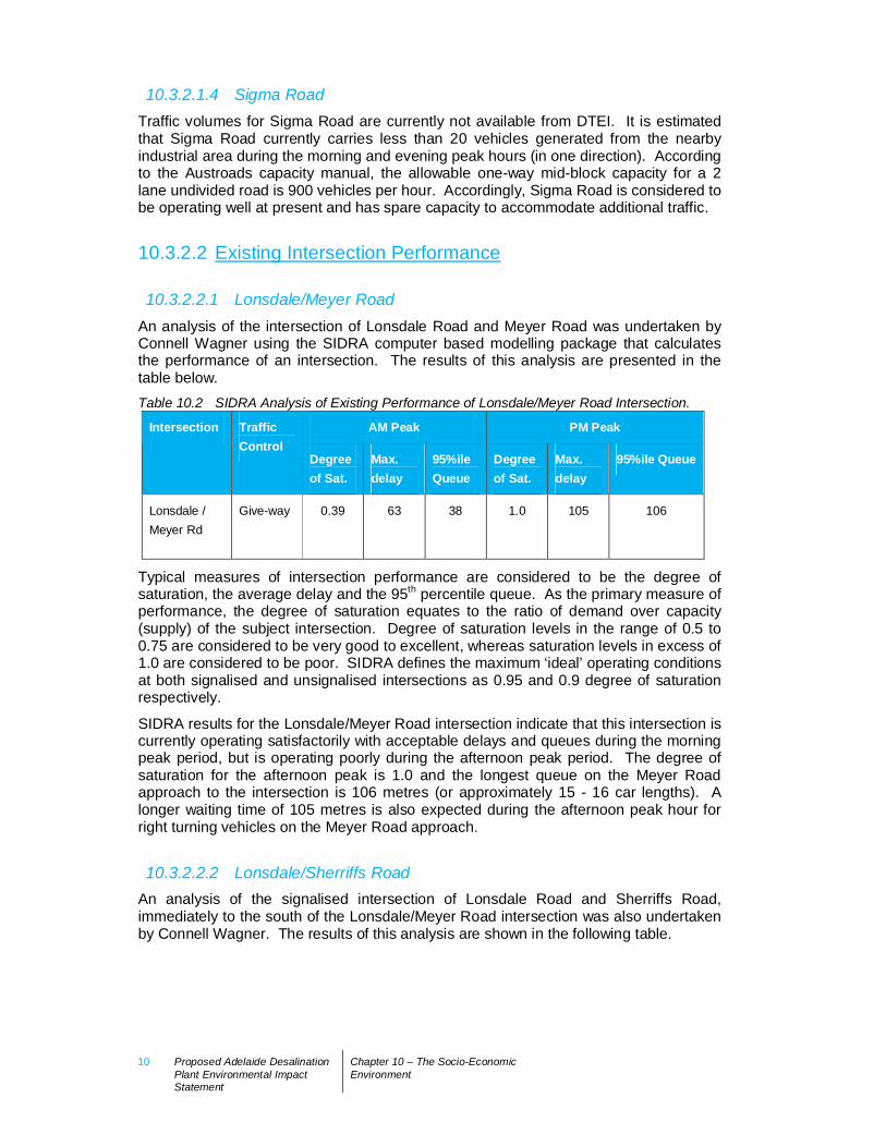
10.3.2.2.1 Lonsdale/Meyer RoadAn analysis of the intersection of Lonsdale Road and Meyer Road was undertaken byConnell Wagner using the SIDRA computer based modelling package that calculatesthe performance of an intersection. The results of this analysis are presented in thetable below.Table 10.2 SIDRA Analysis of Existing Performance of Lonsdale/Meyer Road Intersection.
AM Peak PM PeakIntersection TrafficControl
Degreeof Sat.
Max.delay
95%ileQueue
Degreeof Sat.
Max.delay
95%ile Queue
Lonsdale /Meyer Rd
Give-way 0.39 63 38 1.0 105 106
Typical measures of intersection performance are considered to be the degree ofsaturation, the average delay and the 95th percentile queue. As the primary measure ofperformance, the degree of saturation equates to the ratio of demand over capacity(supply) of the subject intersection. Degree of saturation levels in the range of 0.5 to0.75 are considered to be very good to excellent, whereas saturation levels in excess of1.0 are considered to be poor. SIDRA defines the maximum ‘ideal’ operating conditionsat both signalised and unsignalised intersections as 0.95 and 0.9 degree of saturationrespectively.
SIDRA results for the Lonsdale/Meyer Road intersection indicate that this intersection iscurrently operating satisfactorily with acceptable delays and queues during the morningpeak period, but is operating poorly during the afternoon peak period. The degree ofsaturation for the afternoon peak is 1.0 and the longest queue on the Meyer Roadapproach to the intersection is 106 metres (or approximately 15 - 16 car lengths). Alonger waiting time of 105 metres is also expected during the afternoon peak hour forright turning vehicles on the Meyer Road approach.
10.3.2.2.2 Lonsdale/Sherriffs RoadAn analysis of the signalised intersection of Lonsdale Road and Sherriffs Road,immediately to the south of the Lonsdale/Meyer Road intersection was also undertakenby Connell Wagner. The results of this analysis are shown in the following table.
Proposed Adelaide Desalination Plant Environmental Impact Statement Chapter 10 – The Socio-EconomicEnvironment
11
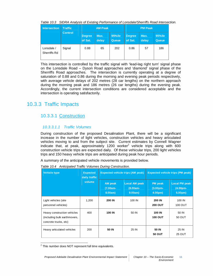
Table 10.3 SIDRA Analysis of Existing Performance of Lonsdale/Sherriffs Road Intersection.
AM Peak PM PeakIntersection TrafficControl
Degreeof Sat.
Max.delay
95%ileQueue
Degreeof Sat.
Max.delay
95%ileQueue
Lonsdale /Sherriffs Rd
Signal 0.88 65 202 0.86 57 186
This intersection is controlled by the traffic signal with ‘lead-lag right turn’ signal phaseon the Lonsdale Road – Dyson Road approaches and ‘diamond’ signal phase of theSherriffs Road approaches. The intersection is currently operating at a degree ofsaturation of 0.88 and 0.86 during the morning and evening peak periods respectively,with average vehicle delays of 202 metres (28 car lengths) on the northern approachduring the morning peak and 186 metres (26 car lengths) during the evening peak.Accordingly, the current intersection conditions are considered acceptable and theintersection is operating satisfactorily.
10.3.3 Traffic Impacts
10.3.3.1 Construction
10.3.3.1.1 Traffic VolumesDuring construction of the proposed Desalination Plant, there will be a significantincrease in the number of light vehicles, construction vehicles and heavy articulatedvehicles moving to and from the subject site. Current estimates by Connell Wagnerindicate that, at peak, approximately 1200 worker2 vehicle trips along with 600construction vehicle trips are expected daily. Of these vehicular trips, 200 light vehiclestrips and 150 heavy vehicle trips are anticipated during peak hour periods.
A summary of the anticipated vehicle movements is provided below.Table 10.4 Anticipated Traffic Volumes During Construction.
Expected vehicle trips (AM peak) Expected vehicle trips (PM peak)Vehicle type Expecteddaily traffic
volume AM peak(7.00am-8.00am)
Local AM peak(8.00am-9.00am)
PM peak(3.00pm-4.00pm)
Local PM peak(4.00pm-5.00pm)
Light vehicles (site
personnel vehicles)
1,200 200 IN 100 IN 200 IN200 OUT
100 IN
100 OUT
Heavy construction vehicles
(including bulk earthmovers,
concrete trucks, etc)
400 100 IN 50 IN 100 IN100 OUT
50 IN
50 OUT
Heavy articulated vehicles 200 50 IN 25 IN 50 IN50 OUT
25 IN
25 OUT
2 This number does NOT represent full time equivalents.
12 Proposed Adelaide DesalinationPlant Environmental ImpactStatement
Chapter 10 – The Socio-EconomicEnvironment
It should be noted that the above traffic numbers are predicted on the basis of theconstruction experiences from desalination plants of similar design capacity acrossAustralia.
These traffic volumes are anticipated for peak or major periods of construction activityonly, with traffic volumes decreasing during other periods. It is envisaged that theconstruction activities may be carried out in two shifts (7 am and 3 pm) and that thepeak hour operation would fall outside the peak hour traffic periods on the local roadnetwork (8.00 am – 9.00 am and 4.00 pm – 5.00 pm).
For the assessment of impacts on local traffic movement patterns, it is expected that themajority of traffic during the construction period (including heavy articulated vehicles)would originate from north of the subject site. While every effort will be made toencourage the contractor to use locally sourced materials for construction of theDesalination Plant, it is anticipated that the great majority of these materials will bedelivered to the subject site from the north. For the purposes of this traffic assessment,a directional split of 90:10 (north:south) has been assumed.
10.3.3.1.2 Impact on the Existing Road NetworkAn analysis of the capacity of the existing road network to cater for the increaseddemands brought about by the construction of the proposed Desalination Plant wasundertaken (refer Appendix G1). This analysis confirmed that the expected peak hourconstruction traffic volumes on the surrounding road network are within the acceptablemid-block capacity as prescribed in the Austroads capacity manual (Roads and TrafficAuthority 2002). Accordingly, it was considered that the roads surrounding the subjectsite would continue to perform satisfactorily with the current number of lanes.
Given this result, it was determined that no road widening or further increases to theexisting capacity of the road network would be required to meet construction trafficdemand.
10.3.3.1.3 Impact on IntersectionsSIDRA intersection analysis was undertaken by Connell Wagner on the LonsdaleRoad/Meyer Road intersection to determine the potential impact of the traffic likely to begenerated by the proposed development according to the entrance route optionsidentified above. This analysis found that the significant increase in traffic volumeslikely to be experienced during the construction of the proposed Desalination Plantwould impact on the operation of this intersection.
The Lonsdale/Meyer Road intersection was analysed with forecasted traffic volumesduring the local peak hour periods. For a worst case approach, it was assumed that50% of the construction traffic would use the road network during the local peak hourperiods. SIDRA analysis of the key Lonsdale Road/Meyer Road intersection ispresented in Table 10.5.
Proposed Adelaide Desalination Plant Environmental Impact Statement Chapter 10 – The Socio-EconomicEnvironment
13
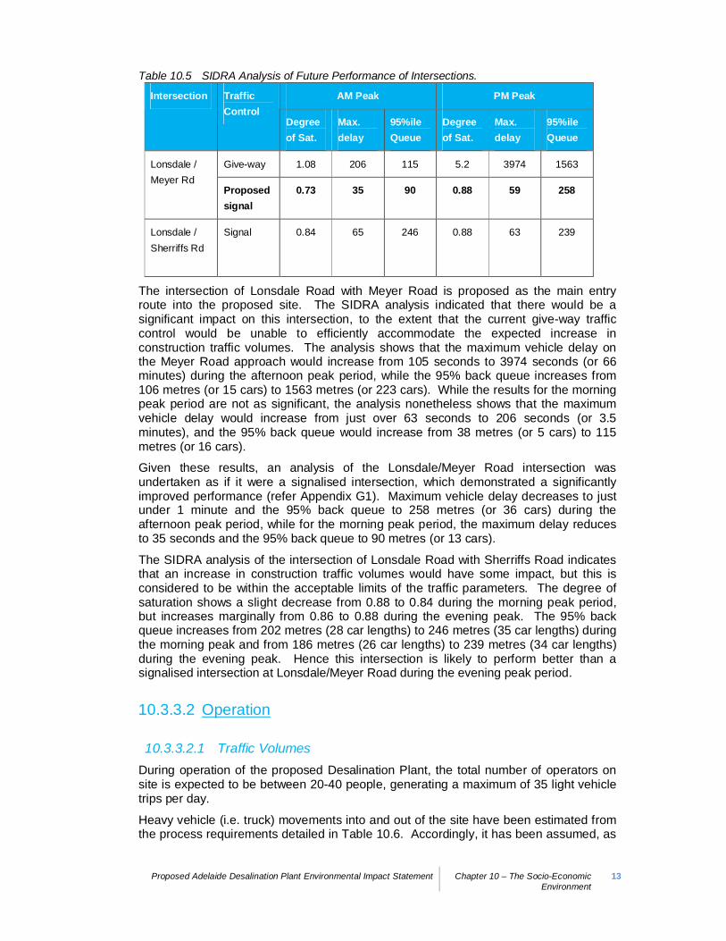
Table 10.5 SIDRA Analysis of Future Performance of Intersections.
AM Peak PM PeakIntersection TrafficControl
Degreeof Sat.
Max.delay
95%ileQueue
Degreeof Sat.
Max.delay
95%ileQueue
Give-way 1.08 206 115 5.2 3974 1563Lonsdale /Meyer Rd
Proposedsignal
0.73 35 90 0.88 59 258
Lonsdale /Sherriffs Rd
Signal 0.84 65 246 0.88 63 239
The intersection of Lonsdale Road with Meyer Road is proposed as the main entryroute into the proposed site. The SIDRA analysis indicated that there would be asignificant impact on this intersection, to the extent that the current give-way trafficcontrol would be unable to efficiently accommodate the expected increase inconstruction traffic volumes. The analysis shows that the maximum vehicle delay onthe Meyer Road approach would increase from 105 seconds to 3974 seconds (or 66minutes) during the afternoon peak period, while the 95% back queue increases from106 metres (or 15 cars) to 1563 metres (or 223 cars). While the results for the morningpeak period are not as significant, the analysis nonetheless shows that the maximumvehicle delay would increase from just over 63 seconds to 206 seconds (or 3.5minutes), and the 95% back queue would increase from 38 metres (or 5 cars) to 115metres (or 16 cars).
Given these results, an analysis of the Lonsdale/Meyer Road intersection wasundertaken as if it were a signalised intersection, which demonstrated a significantlyimproved performance (refer Appendix G1). Maximum vehicle delay decreases to justunder 1 minute and the 95% back queue to 258 metres (or 36 cars) during theafternoon peak period, while for the morning peak period, the maximum delay reducesto 35 seconds and the 95% back queue to 90 metres (or 13 cars).
The SIDRA analysis of the intersection of Lonsdale Road with Sherriffs Road indicatesthat an increase in construction traffic volumes would have some impact, but this isconsidered to be within the acceptable limits of the traffic parameters. The degree ofsaturation shows a slight decrease from 0.88 to 0.84 during the morning peak period,but increases marginally from 0.86 to 0.88 during the evening peak. The 95% backqueue increases from 202 metres (28 car lengths) to 246 metres (35 car lengths) duringthe morning peak and from 186 metres (26 car lengths) to 239 metres (34 car lengths)during the evening peak. Hence this intersection is likely to perform better than asignalised intersection at Lonsdale/Meyer Road during the evening peak period.
10.3.3.2 Operation
10.3.3.2.1 Traffic VolumesDuring operation of the proposed Desalination Plant, the total number of operators onsite is expected to be between 20-40 people, generating a maximum of 35 light vehicletrips per day.
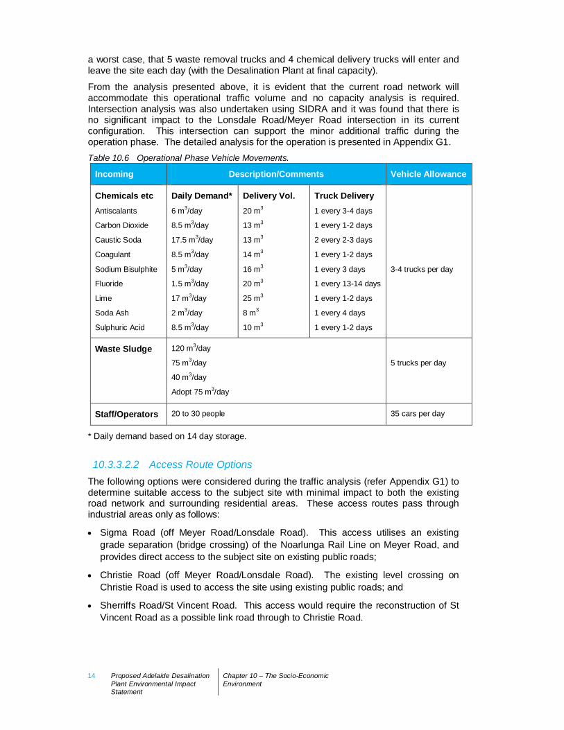
Heavy vehicle (i.e. truck) movements into and out of the site have been estimated fromthe process requirements detailed in Table 10.6. Accordingly, it has been assumed, as
14 Proposed Adelaide DesalinationPlant Environmental ImpactStatement
Chapter 10 – The Socio-EconomicEnvironment
a worst case, that 5 waste removal trucks and 4 chemical delivery trucks will enter andleave the site each day (with the Desalination Plant at final capacity).
From the analysis presented above, it is evident that the current road network willaccommodate this operational traffic volume and no capacity analysis is required.Intersection analysis was also undertaken using SIDRA and it was found that there isno significant impact to the Lonsdale Road/Meyer Road intersection in its currentconfiguration. This intersection can support the minor additional traffic during theoperation phase. The detailed analysis for the operation is presented in Appendix G1.Table 10.6 Operational Phase Vehicle Movements.
Incoming Description/Comments Vehicle Allowance
Chemicals etcAntiscalants
Carbon Dioxide
Caustic Soda
Coagulant
Sodium Bisulphite
Fluoride
Lime
Soda Ash
Sulphuric Acid
Daily Demand*6 m3/day
8.5 m3/day
17.5 m3/day
8.5 m3/day
5 m3/day
1.5 m3/day
17 m3/day
2 m3/day
8.5 m3/day
Delivery Vol.20 m3
13 m3
13 m3
14 m3
16 m3
20 m3
25 m3
8 m3
10 m3
Truck Delivery1 every 3-4 days
1 every 1-2 days
2 every 2-3 days
1 every 1-2 days
1 every 3 days
1 every 13-14 days
1 every 1-2 days
1 every 4 days
1 every 1-2 days
3-4 trucks per day
Waste Sludge 120 m3/day
75 m3/day
40 m3/day
Adopt 75 m3/day
5 trucks per day
Staff/Operators 20 to 30 people 35 cars per day
* Daily demand based on 14 day storage.
10.3.3.2.2 Access Route OptionsThe following options were considered during the traffic analysis (refer Appendix G1) todetermine suitable access to the subject site with minimal impact to both the existingroad network and surrounding residential areas. These access routes pass throughindustrial areas only as follows:
Sigma Road (off Meyer Road/Lonsdale Road). This access utilises an existinggrade separation (bridge crossing) of the Noarlunga Rail Line on Meyer Road, andprovides direct access to the subject site on existing public roads;
Christie Road (off Meyer Road/Lonsdale Road). The existing level crossing onChristie Road is used to access the site using existing public roads; and
Sherriffs Road/St Vincent Road. This access would require the reconstruction of StVincent Road as a possible link road through to Christie Road.
Proposed Adelaide Desalination Plant Environmental Impact Statement Chapter 10 – The Socio-EconomicEnvironment
15
10.3.3.2.3 Preferred Access RoutesThe assessment of traffic impacts during both construction and operation of theproposed development has determined the preferred access routes to the subject siteas follows:
Sigma Road (off Meyer Road/Lonsdale Road). Both Meyer Road and Sigma Roadare within industrial zones where the road network has sufficient capacity to supportthe proposed construction vehicles. An upgrade to the existing roundabout at theintersection of Meyer Road and Sigma Road will be required to support the turningmovements of articulated vehicles proposed to access the site.
Christie Road (off Meyer Road/Lonsdale Road). This access utilises Christie Roadand the existing level crossing of the Noarlunga Rail line to access the southern endof the subject site on existing public roads. Christie Road is located within anindustrial zone and is of sufficient width to accommodate the proposed constructionvehicles.
Given the frequency with which the Noarlunga Rail Line operates, the existing gradeseparated intersection at Meyer Road (i.e. Sigma Road access) is preferred over thelevel crossing on Christie Road. In the interests of safety and risk mitigation, SigmaRoad provides a more appropriate access to the proposed site, noting the requirementto improve the existing roundabout geometry.
In addition, while the existing intersection of Lonsdale and Meyer Roads is currentlyoperating satisfactorily, the traffic analysis indicates that the current give-way trafficcontrol is unlikely to be suitable for the anticipated increase in construction traffic. Thisjunction was, however, found to perform satisfactorily as a signalised intersection.
Accordingly, it is proposed that the proposed site be accessed from Sigma Road, whichis likely to require upgrades to both the geometry of the roundabout at the junction ofMeyer and Sigma Roads, and signalising the intersection of Meyer Road and LonsdaleRoad. This access is considered favourable as it provides grade separation of theNoarlunga Rail line and is through an industrial area. It is noted that following theconstruction period, signalisation at Lonsdale Road may not be warranted.
Alternatively, construction traffic could avoid the intersection of Meyer Road andLonsdale Road by using the link road (St Vincent Road) between Sherriffs Road andMeyer Road. This would require traffic to travel through the existing signalisedintersection of Sherriffs Road and Lonsdale Road. Currently, St Vincent Road is anunsealed road, which is heavily vegetated and not suitable for vehicle access.Accordingly, the reinstatement of St Vincent Road between Sherriffs Road and MeyerRoad would necessitate the clearing of significant vegetation. A further option would beto utilise only the northern portion of St Vincent Road along with a section of EllenseaCourt or the adjacent open paddock (with a dust suppressing temporary access). If theroad were to be upgraded and linked to Sherriffs Road, then signalisation of theintersection of Meyer Road and Lonsdale Road would not be required. Sherriffs Roadis able to accommodate the construction traffic, as the current traffic volume on thewestern approach to the intersection is low during peak hours. It is expected that therewill be no changes required for the traffic signal phasing of the intersection of SherriffsRoad and Lonsdale Road, although phasing times need to be adjusted to absorb theconstruction vehicle demand.
The ability to reinstate part or all of the disused St Vincent Road or create a similartemporary access in the adjacent paddock would need to be explored with both DTEIand the City of Onkaparinga before it could be considered viable.
16 Proposed Adelaide DesalinationPlant Environmental ImpactStatement
Chapter 10 – The Socio-EconomicEnvironment
10.3.3.3 Implications for Road Safety and Capacity
10.3.3.3.1 Crash StatisticsA review of the crash history surrounding the subject site has been sourced from theDTEI ‘Road Crash Register’ database for the last available five-year period.
These crash statistics indicate that on Lonsdale Road near to the intersections with bothSherriffs Road and Meyer Road, there have been no serious or fatal casualty crashesover the past five years, with only one ‘other’ injury recorded. These results indicatethat there are no significant road safety issues associated with the road network leadinginto the subject site.
10.3.3.4 Requirements to Upgrade Road InfrastructureGiven the results of the SIDRA analysis of the Lonsdale/Meyer Road andLonsdale/Sherriffs Road intersections discussed above, it is proposed that the subjectsite be accessed from Sigma Road. The Sigma Road access is considered to presentthe most favourable option (in terms of safety and efficiency) as it:
i) provides grade separation of the Noarlunga Rail Line; and
ii) provides access through an industrial area with little (if any) impact on residentialareas.
This will require upgrades to the geometry of the roundabout at the junction ofMeyer/Sigma Roads and the establishment of traffic signals at the intersection ofLonsdale/Meyer Roads. These traffic signals would not be required, however, afterconstruction of the proposed Desalination Plant.
The alternative proposal to avoid the need for traffic signals at the Lonsdale/MeyerRoad intersection is to direct traffic to use St Vincent Road to connect Sigma Road toSherriffs Road. This would require road upgrades to St Vincent Road (which iscurrently unsealed and comprising remnant vegetation) and adjustment of phasingtimes for the Lonsdale/Sherriffs Road intersection.
10.3.4 Management and Mitigation Strategies
10.3.4.1 ConstructionThere will be a significant increase in vehicles accessing and egressing the subject siteduring the construction phase of the proposed development. The analysis of theexisting road network (both local and regional) and key intersections indicate that thisadditional traffic can be satisfactorily accommodated provided that a number ofimprovements are made to the existing infrastructure as follows:
Upgrade to the geometry of the roundabout at the Meyer/Sigma Road intersection toaccommodate heavy vehicles accessing the site during construction;
Signalisation of the intersection of Lonsdale Road and Meyer Road, although it isacknowledged that this may not be acceptable to DTEI as it may compromise thethrough-flow of traffic on Lonsdale Road; and
Upgrade to St Vincent Road in order to divert traffic away from the Lonsdale/MeyerRoad intersection to the existing signalised intersection of Lonsdale/Sherriffs Road.

Proposed Adelaide Desalination Plant Environmental Impact Statement Chapter 10 – The Socio-EconomicEnvironment
17
This option would also require a slight adjustment to phasing times at thisintersection. This option is compromised by the significant extent of vegetationtowards the northern end of the street, which would need to be cleared. Thesouthern portion of St Vincent Road, along with Ellensea Court, could be utilised toprovide a link between Meyer Road and Sherriffs Road.
10.3.4.2 OperationThere will be a negligible increase in traffic accessing the subject site during theoperation of the proposed Desalination Plant. Analysis of the existing road network andkey intersections indicates that this additional traffic (including trucks deliveringchemicals and removing waste) can easily be accommodated with no furtherimprovements required to road infrastructure.
It should be noted that whilst signalisation of the Lonsdale/Meyer Roads intersection isrecommended during the construction phase, these signals may not be required aftercompletion of construction i.e. during the operation phase.
18 Proposed Adelaide DesalinationPlant Environmental ImpactStatement
Chapter 10 – The Socio-EconomicEnvironment
10.4 Effects on Communities10.4.1 IntroductionThis Section considers the impacts of the Desalination Plant on the local and regionalcommunities located in and around the proposed site. It presents the findings of asocial impact assessment (SIA) undertaken by Janet Gould and Associates for SAWater to determine potential impacts on affected communities with a view to developingappropriate management and mitigation strategies.
10.4.2 Description of Existing Socio-EconomicEnvironment
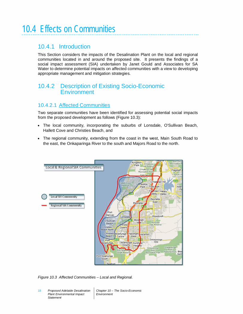
10.4.2.1 Affected CommunitiesTwo separate communities have been identified for assessing potential social impactsfrom the proposed development as follows (Figure 10.3):
The local community, incorporating the suburbs of Lonsdale, O’Sullivan Beach,Hallett Cove and Christies Beach, and
The regional community, extending from the coast in the west, Main South Road tothe east, the Onkaparinga River to the south and Majors Road to the north.
Figure 10.3 Affected Communities – Local and Regional.
Proposed Adelaide Desalination Plant Environmental Impact Statement Chapter 10 – The Socio-EconomicEnvironment
19
A demographic profile and analysis of social characteristics (using the ABS Census ofPopulation and Housing, the Social Atlas of South Australia and various studiesundertaken by the Cities of Onkaparinga and Marion) relevant to both the local andregional communities are presented in Appendix F8.
Key characteristics of these communities arising from this analysis can be summarisedas follows:
In 2006, the local population comprised approximately 40% regional population;
Both the local and regional communities are ageing more rapidly than themetropolitan population as a whole;
The local and regional communities have similar income profiles (which are lowerthan the metropolitan average);
The local and regional communities have similar employment and occupationprofiles to the metropolitan population;
The local and regional communities are generally better educated than themetropolitan population as a whole;
Unemployment in the local community in and around Port Stanvac (at 6.2%) isslightly higher than the metropolitan average (at 5.2%); and
Residents in the Cities of Onkaparinga and Marion demonstrate higher levels ofcommunity wellbeing, happiness, community participation and attachment to placecompared with the State average.
It should be noted that these community characteristics are based on aggregatedfigures for the local and regional communities respectively. Typically, suchcommunities demonstrate socio-economic difference within their ranks and particularsocio-economic differences are evident within the local and regional communitiesaround Port Stanvac (see Appendix F8). These differences have been taken intoaccount when considering appropriate mitigation strategies and proactive measuresaimed at ensuring that both local and regional communities benefit from the proposeddevelopment. These strategies will be an important mechanism in gaining the supportof the surrounding communities and in engendering their sense of stewardship over theproposed development.
10.4.3 Community and Stakeholder EngagementA range of methods have been used to seek feedback from individuals andorganisations throughout the development of the concept for the proposed DesalinationPlant, including government, environment and community organisations, industry,service providers and the general public.
The purpose of the engagement process was to identify stakeholder and communityviews and issues so that these could be addressed during the decision-making anddesign of the proposed development and in the environmental assessment process,where appropriate.
10.4.3.1 Engagement ProcessThe engagement process was developed in accordance with the South AustralianGovernment EIS guideline requirements and the principles of the InternationalAssociation of Impact Assessment (IAIA, 2006).
20 Proposed Adelaide DesalinationPlant Environmental ImpactStatement
Chapter 10 – The Socio-EconomicEnvironment
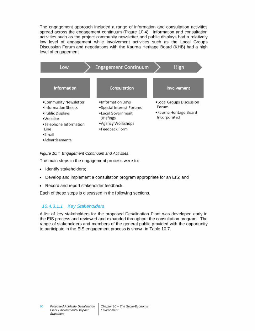
The engagement approach included a range of information and consultation activitiesspread across the engagement continuum (Figure 10.4). Information and consultationactivities such as the project community newsletter and public displays had a relativelylow level of engagement while involvement activities such as the Local GroupsDiscussion Forum and negotiations with the Kaurna Heritage Board (KHB) had a highlevel of engagement.
Figure 10.4 Engagement Continuum and Activities.
The main steps in the engagement process were to:
Identify stakeholders;
Develop and implement a consultation program appropriate for an EIS; and
Record and report stakeholder feedback.
Each of these steps is discussed in the following sections.
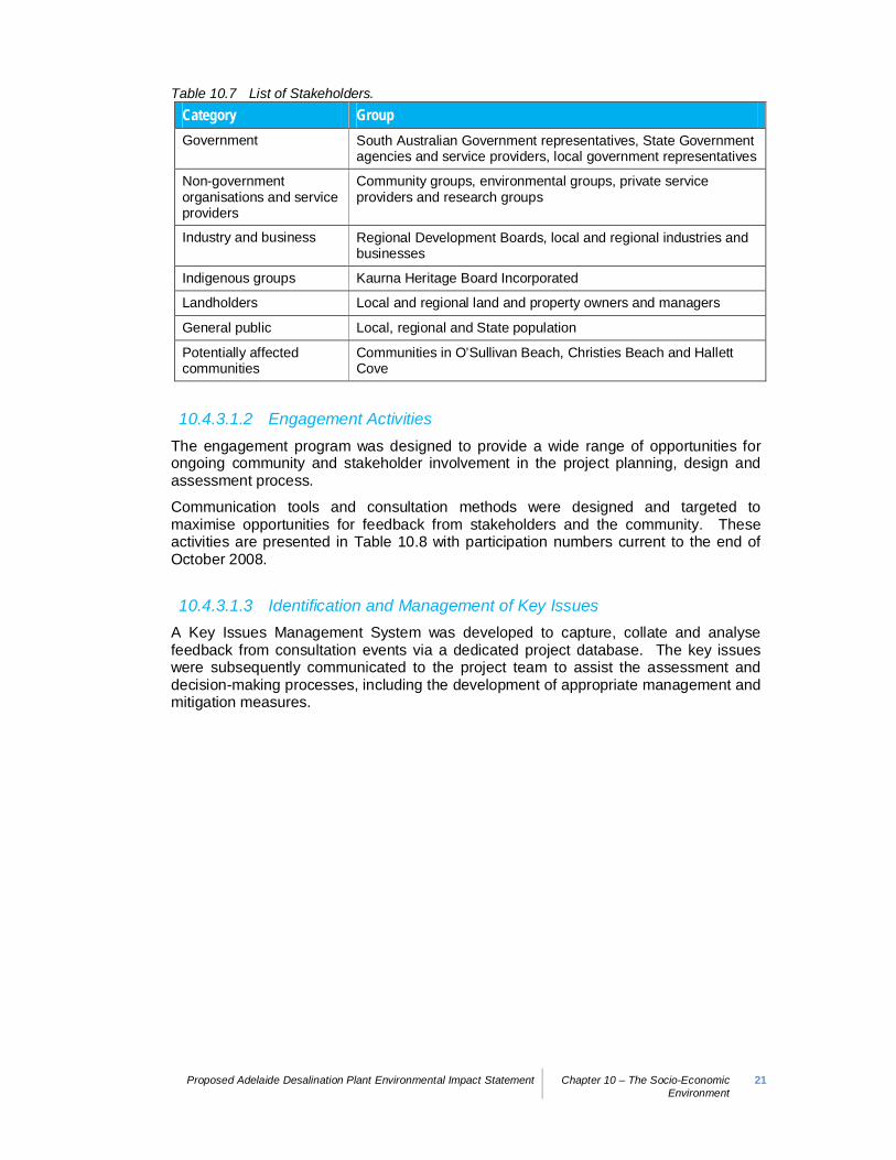
10.4.3.1.1 Key StakeholdersA list of key stakeholders for the proposed Desalination Plant was developed early inthe EIS process and reviewed and expanded throughout the consultation program. Therange of stakeholders and members of the general public provided with the opportunityto participate in the EIS engagement process is shown in Table 10.7.
Proposed Adelaide Desalination Plant Environmental Impact Statement Chapter 10 – The Socio-EconomicEnvironment
21
Table 10.7 List of Stakeholders.Category GroupGovernment South Australian Government representatives, State Government
agencies and service providers, local government representatives
Non-governmentorganisations and serviceproviders
Community groups, environmental groups, private serviceproviders and research groups
Industry and business Regional Development Boards, local and regional industries andbusinesses
Indigenous groups Kaurna Heritage Board Incorporated
Landholders Local and regional land and property owners and managers
General public Local, regional and State population
Potentially affectedcommunities
Communities in O’Sullivan Beach, Christies Beach and HallettCove
10.4.3.1.2 Engagement ActivitiesThe engagement program was designed to provide a wide range of opportunities forongoing community and stakeholder involvement in the project planning, design andassessment process.
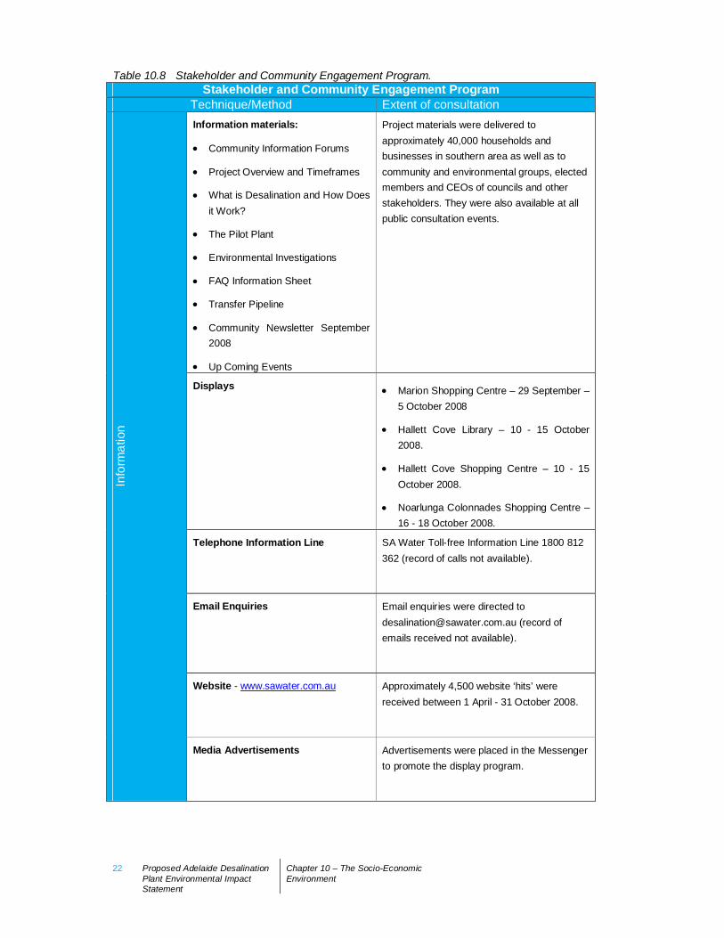
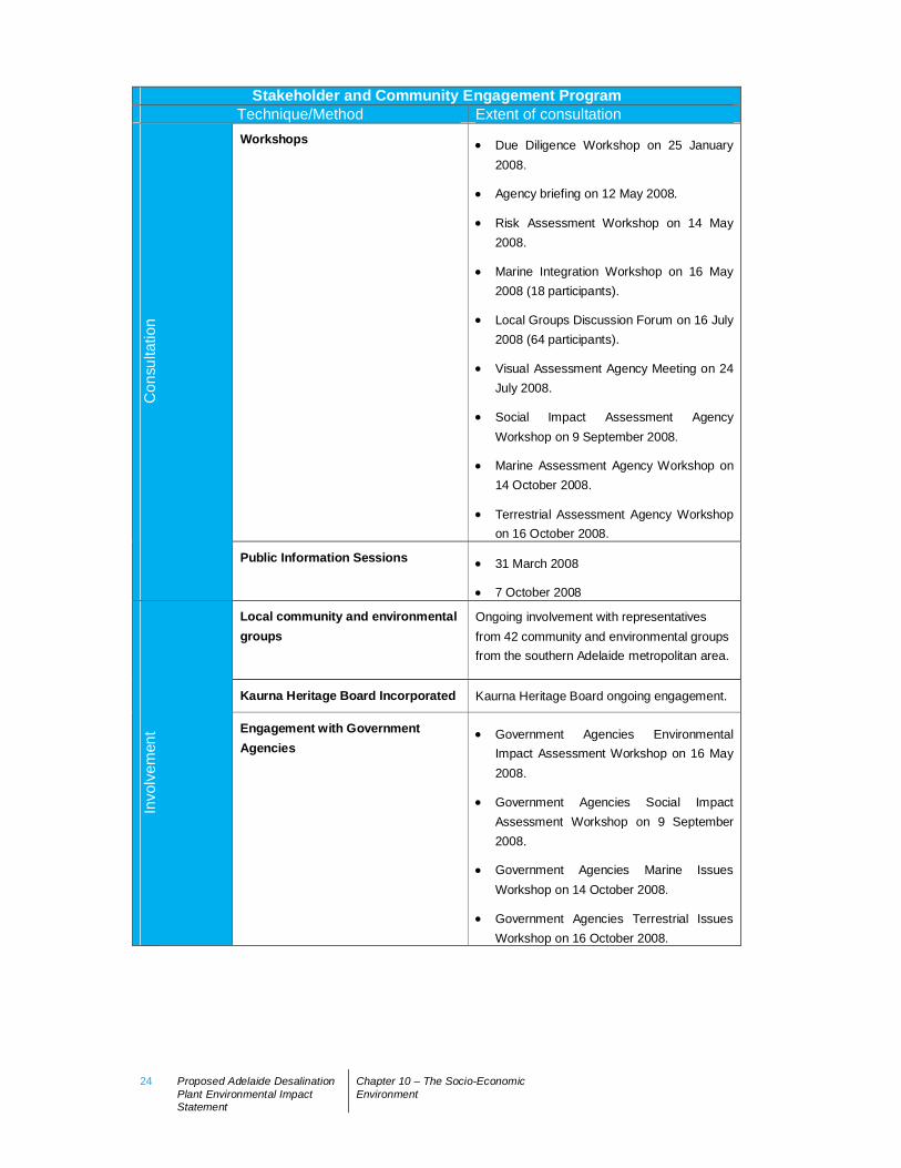
Communication tools and consultation methods were designed and targeted tomaximise opportunities for feedback from stakeholders and the community. Theseactivities are presented in Table 10.8 with participation numbers current to the end ofOctober 2008.
10.4.3.1.3 Identification and Management of Key IssuesA Key Issues Management System was developed to capture, collate and analysefeedback from consultation events via a dedicated project database. The key issueswere subsequently communicated to the project team to assist the assessment anddecision-making processes, including the development of appropriate management andmitigation measures.
22 Proposed Adelaide DesalinationPlant Environmental ImpactStatement
Chapter 10 – The Socio-EconomicEnvironment
Table 10.8 Stakeholder and Community Engagement Program.Stakeholder and Community Engagement Program
Technique/Method Extent of consultationInformation materials:
Community Information Forums
Project Overview and Timeframes
What is Desalination and How Doesit Work?
The Pilot Plant
Environmental Investigations
FAQ Information Sheet
Transfer Pipeline
Community Newsletter September2008
Up Coming Events
Project materials were delivered toapproximately 40,000 households andbusinesses in southern area as well as tocommunity and environmental groups, electedmembers and CEOs of councils and otherstakeholders. They were also available at allpublic consultation events.
Displays Marion Shopping Centre – 29 September –5 October 2008
Hallett Cove Library – 10 - 15 October2008.
Hallett Cove Shopping Centre – 10 - 15October 2008.
Noarlunga Colonnades Shopping Centre –16 - 18 October 2008.
Telephone Information Line SA Water Toll-free Information Line 1800 812362 (record of calls not available).
Email Enquiries Email enquiries were directed [email protected] (record ofemails received not available).
Website - www.sawater.com.au Approximately 4,500 website ‘hits’ werereceived between 1 April - 31 October 2008.
Info
rmat
ion
Media Advertisements Advertisements were placed in the Messengerto promote the display program.
Proposed Adelaide Desalination Plant Environmental Impact Statement Chapter 10 – The Socio-EconomicEnvironment
23
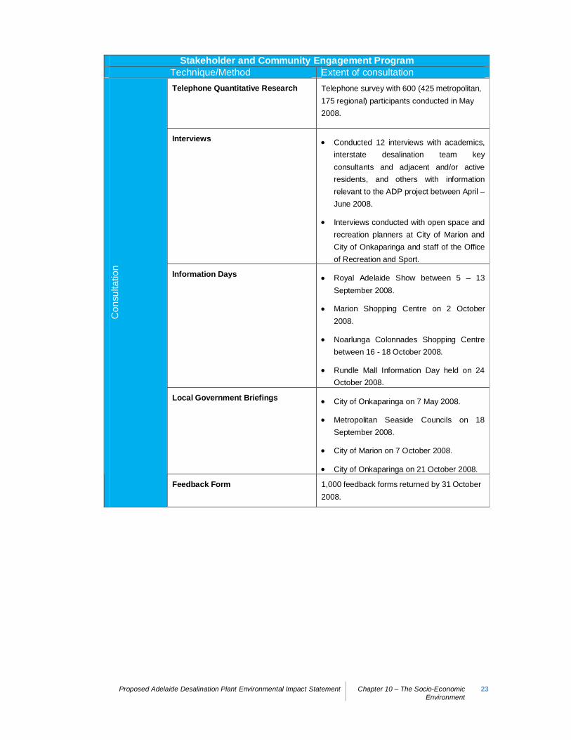
Stakeholder and Community Engagement ProgramTechnique/Method Extent of consultationTelephone Quantitative Research Telephone survey with 600 (425 metropolitan,
175 regional) participants conducted in May2008.
Interviews Conducted 12 interviews with academics,interstate desalination team keyconsultants and adjacent and/or activeresidents, and others with informationrelevant to the ADP project between April –June 2008.
Interviews conducted with open space andrecreation planners at City of Marion andCity of Onkaparinga and staff of the Officeof Recreation and Sport.
Information Days Royal Adelaide Show between 5 – 13September 2008.
Marion Shopping Centre on 2 October2008.
Noarlunga Colonnades Shopping Centrebetween 16 - 18 October 2008.
Rundle Mall Information Day held on 24October 2008.
Local Government Briefings City of Onkaparinga on 7 May 2008.
Metropolitan Seaside Councils on 18September 2008.
City of Marion on 7 October 2008.
City of Onkaparinga on 21 October 2008.
Con
sulta
tion
Feedback Form 1,000 feedback forms returned by 31 October2008.
24 Proposed Adelaide DesalinationPlant Environmental ImpactStatement
Chapter 10 – The Socio-EconomicEnvironment
Stakeholder and Community Engagement ProgramTechnique/Method Extent of consultationWorkshops Due Diligence Workshop on 25 January
2008.
Agency briefing on 12 May 2008.
Risk Assessment Workshop on 14 May2008.
Marine Integration Workshop on 16 May2008 (18 participants).
Local Groups Discussion Forum on 16 July2008 (64 participants).
Visual Assessment Agency Meeting on 24July 2008.
Social Impact Assessment AgencyWorkshop on 9 September 2008.
Marine Assessment Agency Workshop on14 October 2008.
Terrestrial Assessment Agency Workshopon 16 October 2008.
Con
sulta
tion
Public Information Sessions 31 March 2008
7 October 2008
Local community and environmentalgroups
Ongoing involvement with representativesfrom 42 community and environmental groupsfrom the southern Adelaide metropolitan area.
Kaurna Heritage Board Incorporated Kaurna Heritage Board ongoing engagement.
Invo
lvem
ent Engagement with Government
AgenciesGovernment Agencies EnvironmentalImpact Assessment Workshop on 16 May2008.
Government Agencies Social ImpactAssessment Workshop on 9 September2008.
Government Agencies Marine IssuesWorkshop on 14 October 2008.
Government Agencies Terrestrial IssuesWorkshop on 16 October 2008.
Proposed Adelaide Desalination Plant Environmental Impact Statement Chapter 10 – The Socio-EconomicEnvironment
25
10.4.4 Review Process to Inform Social ImpactsIn addition to issues raised during community and stakeholder engagement, socialimpacts have been identified through a review of relevant local and regional projects,and research into Australian and international desalination case studies.
A summary of the outcomes of this research is provided below with a detaileddiscussion attached in Appendix F8.
10.4.4.1 Relevant Local ProjectsA number of local projects have been identified within the local area (Hallett Cove,O’Sullivan Beach, Lonsdale and Christies Beach) that may have some impacts on thelocal community. These projects include:
Christies Beach Wastewater Treatment Plant upgrade;
Hallett Cove Shopping and Civic Centre Redevelopment;
Hallett Cove Surf Lifesaving Club Redevelopment;
Greater Southern Urban Forest Initiative;
Hallett Cove open space projects;
O’Sullivan Beach open space and landscaping projects;
O’Sullivan Sports and Social Club building works;
O’Sullivan Beach boat launching facility;
Bice Oval Upgrade, Christies Beach;
Electrification of the southern (Noarlunga) rail line;
Coast Park and Foreshore Access Plan;
Road Network Plan and road works;
Coast to Vines Trail (2009-2011);
Christies Beach Tourist Park Master Plan (2008-2009);
Beach Road (West) Redevelopment (2009-2010); and
Witton Bluff Base Trail.
The potential impacts on local residents and businesses arising from these projects willneed to be considered during the construction phase of the proposed DesalinationPlant. It should also be noted that the benefits arising from the open space and coastalparks projects noted above are likely to be strengthened during the operational phasesof the proposed development. The successful Contractor will be required to contributeto the development of some community assets listed in the environmental objectivesand performance objectives (see Chapter 3).
10.4.4.2 National and International Desalination ExperienceA review of the experiences of national and international desalination projects has beenundertaken to identify the key issues associated with the development and operation oflarge-scale desalination plants (Janet Gould and Associates 2008).
26 Proposed Adelaide DesalinationPlant Environmental ImpactStatement
Chapter 10 – The Socio-EconomicEnvironment
Australian examples included:
Gold Coast Desalination Plant;
Victorian Desalination Plant;
Perth (Kwinana) Desalination Plant (WA);
Southern Seawater Desalination Plant (WA); and
Sydney Desalination Plant.
International examples were drawn from desalination plants in:
California, USA;
India;
Saudi Arabia;
Algeria; and
London.
The information gained from this review has informed both the Social ImpactAssessment and community engagement program undertaken for the proposeddevelopment (Appendix F8).
10.4.4.3 Issues Identified from Community and StakeholderFeedback and Review Process
Based on the experience of interstate/international desalination projects, the results ofstakeholder and community feedback as well as the demographic and social analysis ofthe affected communities, the key social impacts arising from the proposed DesalinationPlant have been grouped into the following categories:
Impacts on residents;
Impacts on businesses;
Impacts on service providers;
Impacts on community activities and services; and
Impacts on the community’s sense of community and attachment to place.
The following sections discuss each of these categories as they relate to the proposeddevelopment.
Proposed Adelaide Desalination Plant Environmental Impact Statement Chapter 10 – The Socio-EconomicEnvironment
27
10.4.5 Social Impact Assessment
10.4.5.1 Impacts on Residents
10.4.5.1.1 Construction Impacts
Equity
The review process demonstrated that potential issues of equity may arise from a localcommunity feeling that they must bear a greater proportion of a project’s impacts for thebenefit of others. However, the significant benefit of gaining a secure water sourceshould alleviate this concern. Given the level of support for the proposal during theengagement process (i.e. over 70% survey respondents stating they were in favour ofthe proposal) it can be reasonably assumed that appropriate mitigation strategies willallay any feelings of ‘unfairness’ within the local community.
Housing
It is estimated that an additional workforce of approximately 1,200 people3 will berequired during the 18 to 20 month construction phase of the proposed DesalinationPlant. During operation, the workforce requirements will be in the order of 20-30 staff.
Notwithstanding the large workforce required in the short term, potential impacts onlocal housing demand are likely to be manageable given the Desalination Plant’sproposed location in a metropolitan setting and its proximity to a large residentworkforce. While some workers and their families may seek housing within the localcommunity, this additional demand is likely to be dispersed across the regionalcommunity and Southern Adelaide rather than intensified within the local area.
Potential flow on impacts such as increased rents, and decreased housing availabilityand security of tenure is unlikely to be significant beyond normal market conditions.
Physical Health and Safety
During the construction phase, potential impacts could be expected in relation to dust,vibration, odour, noise and vehicle emissions. These impacts are discussed in Chapter9.
The traffic analysis in Section 10.3 also indicates the expected increase in vehiclemovements to and from the site during construction. Given the site’s accessibility viathe existing industrial road network, together with the proposed mitigation strategies toaddress the expected increase in vehicle movement patterns, it is considered that thelocal residential community is unlikely to be adversely affected by the proposeddevelopment.
Mental Health
Noise, dust and vibration impacts associated with the proposed development will needto be carefully managed in accordance with the CEMMP (as approved by the EPA) inorder to alleviate the potential anxiety these impacts may cause to local residents.
3 This number does NOT represent full time equivalents.
28 Proposed Adelaide DesalinationPlant Environmental ImpactStatement
Chapter 10 – The Socio-EconomicEnvironment
Employment and Workforce
Section 10.2 demonstrates that employment opportunities for residents within the localand regional communities will increase substantially during the construction phase ofthe proposed Desalination Plant. Direct employment opportunities will be concentratedin skilled trades and engineering sectors, although there will be opportunities for theemployment of unskilled labourers. Indirect employment generated as a result of theflow on effects through the economy of the increased spending arising from the projectare likely to provide further opportunities for local and regional communities to benefit.
As discussed in Section 10.2, a benefit of the proposed development is the opportunityfor the Contractor to employ local people.
It is noted, however, that the additional workforce requirements of the proposal has thepotential to impact on the local and metropolitan workforce by decreasing the availabilityof skilled and unskilled workers.
10.4.5.1.2 Operational Impacts
Health and Safety
Health and safety impacts resulting from the operation of the proposed DesalinationPlant are expected to be negligible. Studies into ongoing water quality standards, dust,odour and noise (including marine noise) emissions have been undertaken and willcontinue during the development of the final design of the proposed Desalination Plant,and will incorporate a number of management and mitigation strategies that accord withall relevant regulatory and licensing requirements.
Mental Health
The operation of the proposed Desalination Plant is not expected to generate mentalhealth impacts. While it is recognised that mental health issues are an importantconsideration, these will be managed during the construction phase with ongoingmonitoring as required to ensure that residents are properly informed throughout theconstruction and operational phases.
Employment and Workforce
In the long term, ongoing workforce requirements for the proposed Desalination Plantwill be relatively minor (approximately 20-30 staff). The flow on effects of thisemployment impact are discussed in Section 10.2.
10.4.5.2 Impacts on Businesses
10.4.5.2.1 Construction Impacts
Business Development
As noted in Section 10.2, the increased workforce and level of construction activitieslikely to be generated by the proposed Desalination Plant will provide additionalbusiness development and start up opportunities across different sectors of themetropolitan economy. Small servicing businesses in the locality are likely to directlybenefit from the proposed development, particularly in the retail, food, entertainment
Proposed Adelaide Desalination Plant Environmental Impact Statement Chapter 10 – The Socio-EconomicEnvironment
29
and leisure business sectors. These additional business opportunities will have furtherflow on employment benefits to local and regional communities.
Business Disruptions
During the construction phase, some disruption to local businesses could potentiallyoccur as a result of dust, noise, vibration and traffic impacts. As discussed previously,these impacts will be carefully managed in order to minimise and avoid disruption tonormal business operations in the locality of the proposed development.
10.4.5.2.2 Operational Impacts
Water Based Business Impacts
There is some possibility of disruption to recreation-based business (e.g. boating,diving, fishing) as a result of the likely extension of the marine exclusion zone arisingfrom the proposed development. These impacts are expected to be minimal tonegligible due to the existence of the current exclusion zone and the small area thatwould be affected.
10.4.5.3 Impacts on Service Providers
10.4.5.3.1 Construction Impacts
Housing Providers
As indicated above, the proposed Desalination Plant would be expected to source itsconstruction workers from across the wider metropolitan area (and possibly beyond)although some impact on local housing provision is expected. Workers wanting to livein the local area are unlikely to utilise housing providers (e.g. Housing SA, aged carehousing or community housing services) within the area and may seek other housingoptions. It is envisaged that the Contractor will assist workers in obtaining suitablehousing and will consult with the Cities of Onkaparinga and Marion to facilitate thisprocess.
Emergency Service Providers
The construction of the proposed Desalination Plant is unlikely to require changes toexisting emergency services arrangements. The successful Contractor will establishappropriate management strategies within the CEMMP to address any unforeseenemergency event.
In addition, the proposed development will not change existing access arrangements forsurrounding residential and industrial uses during construction. Accordingly, there willbe no impact to emergency services access, levels of service or response times to thelocal or regional communities as a result of the development.
Health Care Providers
Despite the significant increase in workers associated with the proposed DesalinationPlant, local health care services (such as general practice and allied health careservices) are unlikely to be in heavy demand as a result. Should workers on the

30 Proposed Adelaide DesalinationPlant Environmental ImpactStatement
Chapter 10 – The Socio-EconomicEnvironment
Desalination Plant choose to use local health care providers, demand for these servicesmay increase temporarily. This is not expected to unduly constrain, however, theavailability of health services for the local and regional communities.
It should also be noted that the Contractor is required to provide a dedicated first aidfacility on site.
Education Providers
The proposed Desalination Plant is unlikely to impact on existing education providers inthe locality and broader region. Although there may be a slight increase in demand forpre-school, primary and secondary education facilities from family members of theconstruction workforce, according to Department of Education and Children’s Servicesthis additional demand can be accommodated by existing education facilities in theregion.
Local Government Services and Facilities
The Cities of Marion and Onkaparinga provide a wide range of municipal services toresidents in the areas of community and business services, art and culture, recreationand open space, infrastructure, waste management, regulatory services andenvironmental management. Given that the construction workforce for the proposedDesalination Plant is unlikely to impact on population growth in any significant way, it isanticipated that any impacts on these local government services would be minimal.
As indicated above, any dust, noise, vibration and traffic impacts arising from theproposed development will be appropriately managed through the CEMMP and therequirements of the environmental objectives and performance criteria established forthe project.
10.4.5.3.2 Operational Impacts
Emergency Service Providers
During operation of the proposed Desalination Plant, there are unlikely to be anyimpacts on emergency service provision over and above normal circumstances.
As noted above, the proposed development will not change existing accessarrangements for residential and industrial uses in the locality. Accordingly, no impactto emergency services access, levels of service or response times is anticipated as aresult of the operation of the Desalination Plant.
Local Government Services and Facilities
Waste services for the Desalination Plant would be expected to be provided through acontractor and impacts on local government waste management operations would benegligible.
Proposed Adelaide Desalination Plant Environmental Impact Statement Chapter 10 – The Socio-EconomicEnvironment
31
10.4.5.4 Impacts on Community Activities and Services
10.4.5.4.1 Construction Impacts
Entertainment and Leisure Facilities
Given that the proposed Desalination Plant is unlikely to increase populationsignificantly beyond normal projections, the potential impact of the constructionworkforce on community activities and services is expected to be limited to the use ofafter-hours entertainment and leisure facilities.
10.4.5.5 Impacts on Sense of Community/Attachment to Place
10.4.5.5.1 Construction Impacts
Sense of Community
A key reason for locating the proposed Desalination Plant on the northern site was thefact that it provides a significant buffer between the facility and existing residential areasto the north, east and south. For this reason, the development of the Desalination Plantis not considered to affect residents’ strong attachment to the locality and the sense ofcommunity that is characteristic of the resident population in southern Adelaide. Thesecommunities have expressed their identification with the industrial legacy of the PortStanvac area, and given that the proposal will enhance the area’s industrial base.Ongoing community and stakeholder engagement through the construction andoperational phases of the project will be an important mechanism to encouragecommunity ‘ownership’ of the proposed Desalination Plant.
It is also possible that the local community’s sense of safety and fear of crime may beimpacted by the significant increase in workforce activity during the construction phase.The Contractor will be required to address this matter with the local community andimplement positive performance indicators to enhance community perceptions in thisarea.
10.4.5.5.2 Operational Impacts
Sense of Community
It is considered highly unlikely that the operation of the proposed Desalination Plant willadversely affect the community’s sense of place and attachment to the local area. Infact, it could be argued that by increasing the intensity of industrial development in PortStanvac, the community’s identification with the proposed development will beenhanced.
Attachment to Place
As discussed, the affected communities are characterised as having a historicallystrong connection to industrial activity in Lonsdale, which has developed over timethrough employment associations as well as strong visual connections with the PortStanvac oil refinery.

32 Proposed Adelaide DesalinationPlant Environmental ImpactStatement
Chapter 10 – The Socio-EconomicEnvironment
The establishment of the proposed Desalination Plant is likely to reinforce this historicalconnection. Although the connection is not expected to be as strong as that created bythe former Mitsubishi plant or the oil refinery (especially given the plant’s smalloperational workforce), the proposed development will not significantly alter Lonsdale’straditional industrial base and will provide the local community with opportunities toparticipate in new industrial development in the locality. At a time when both State andlocal governments have made a commitment to support industrial diversification, theproposed development is likely to have a positive effect on the community’s attachmentto its local industrial landscape.
Possible changes to the communities’ sense of place and identity from the proposedDesalination Plant may arise from:
The visual impact created by locating the Desalination Plant on land historically usedfor buffering purposes; and
Potential conflicts and intensification of industrial activity along roads used byresidential traffic accessing the residential areas of southern Hallett Cove (alongChristie, Meyer and Sigma Roads).
In relation to the visual impact, the analysis presented in Chapter 8.5 confirms that theproposed development will have a relatively low level of impact owing to the visualdominance of the existing industrial infrastructure (in particular, the oil refinery). Whilethe community’s attachment to the beach and the coast is acknowledged, the visualanalysis demonstrates that the proposed Desalination Plant is unlikely to have anadverse impact. Indeed, the analysis suggests that from a longer term perspective, theproposed development may have a beneficial visual impact given the extent ofproposed landscaping and biodiversity enhancement initiatives.
The strong connections of local Kaurna to the proposed site is acknowledged anddiscussed below in Section 10.5. The proposed development is unlikely to adverselyaffect this sense of connection given the ongoing consultation with the KHB andheritage monitoring work undertaken as part of the environmental assessment process.
In relation to the traffic impacts of the proposed Desalination Plant for residents, thetraffic analysis presented in Section 10.3 demonstrates that the surrounding roadnetwork will operate satisfactorily during the construction and operational phases of theDesalination Plant. While it is acknowledged that construction requirements will lead toa significant increase in vehicular movements in and around the locality, this is unlikelyto impact on residents’ sense of place.
10.4.6 Recreation and the Metropolitan Coast ParkA recreation assessment was undertaken of existing open space within the vicinity ofthe proposed site. This assessment identified key recreational activities, user groupsand community benefits of open space and recreation associated with the proposedDesalination Plant, particularly in relation to integrating the site with the metropolitancoast and the existing open space and trail network.
10.4.6.1 Adelaide Metropolitan Coast ParkPlanning SA’s Coast Park initiative is to develop a continuous coastal park extendingapproximately 70 kilometres along the coast, from Sellicks Beach in the south to NorthHaven in the north. The Coast Park is part of Adelaide’s open space network and it isintended to provide access to the waters of Gulf St Vincent. It includes public landalong the foreshore and offshore features, and links to watercourses and other public
Proposed Adelaide Desalination Plant Environmental Impact Statement Chapter 10 – The Socio-EconomicEnvironment
33
spaces adjacent to the coast. These public spaces in turn link with the Hills Face Zoneand other open space land, forming the basis for Adelaide’s Metropolitan Open SpaceSystem. South Australia is predicted to experience significant demographic changesover the next 20 years and such changes will increase the use of the Coast Park for thelocal and regional communities.
The Coast Park and trail exists in part in the vicinity of the Port Stanvac site. To thenorth the trail runs through the City of Marion from Marino to Headland Reserve and tothe south of Port Stanvac to Christies Beach. Works are underway to complete thesection of trail between Christies Beach and Port Noarlunga.
10.4.6.2 Council Plans and Local Open Space
10.4.6.2.1 Foreshore Access Plan, City of OnkaparingaIn response to Planning SA’s Coast Park Initiative, the City of Onkaparinga producedthe Foreshore Access Plan which addresses the Coast Park objectives, as well astraffic management outcomes for the Esplanade.
One of the nine stages of the Coast Park is the link from Christies Creek to the northernboundary of the Council area. The Port Stanvac (Mobil) and SA Water sites currentlyact as a significant social and physical barrier to this access. Whilst SA Water allowsaccess across its land at the Christies Beach Wastewater Treatment Plant, the PortStanvac site remains closed to public access. The Foreshore Access Plan identifiesoptions for traversing the site or travelling around the site to link the City of Onkaparingato the City of Marion. Council’s preferred link is through the site or along the foreshore.
10.4.6.2.2 Recreational Trails Network Strategy and Action Plan, 2007-2012The Recreational Trails Network Strategy and Action Plan for the City of Onkaparingaaim to develop a diverse network of recreational trails throughout the municipality. Thestrategy recognises the importance of interconnected trails, linking major trails, such asthe Coast to Vines Trail to regional and local trails. The extension of the trail along thecoast through the Port Stanvac site is identified as an important link by the City ofOnkaparinga.
In addition, the Open Space Strategy for the City of Onkaparinga supports thedevelopment of a linear park along the metropolitan coast as outlined in the Coast ParkConcept Plan.
10.4.6.2.3 Local open spaceThere are a number of local or regional open space areas in the vicinity of Port Stanvacwhere opportunities for linkages with the Port Stanvac site exist. These include thefollowing:
Headland Reserve
Headland Reserve is a natural area currently used for informal open space andrecreation by the local community, with a number of informal trails running through thesite. Headland Reserve is a significant reserve as it contains the largest piece ofremnant native vegetation along the City of Marion coastal cliffs. Headland Reserve isadjacent to the northern boundary of the proposed site.
34 Proposed Adelaide DesalinationPlant Environmental ImpactStatement
Chapter 10 – The Socio-EconomicEnvironment
Tingira Reserve
Tingira Reserve is located on the foreshore at Tingira Drive and is a large reservefeaturing picnic areas and shelters. The remainder of the reserve is covered by aNative Vegetation Management Plan and, in 2005, Council purchased three largeresidential properties on the cliff edge to incorporate into the coastal reserve.Significant Aboriginal cultural heritage areas are also located in the Reserve. Thereserve is popular with local residents.
Coast to Vines Trail
The Coast to Vines Trail (formerly the Willunga to Marino trail) follows the disused railline providing a shared use trail and key recreation link. A study was undertaken in2005 to review marketing outcomes and upgrade requirements, including signage, trackconstruction and associated facilities such as shelters and seating. Implementation issubject to funding by the Cities of Marion and Onkaparinga and the State Government.The City of Onkaparinga has allocated $174,000 over the next two years.
10.4.6.3 Key Recreational Activities and User Groups
10.4.6.3.1 Recreational FishingAccording to the Boating Industry Association of SA, in 2004 there were 51,844registered power boats in the State, one of the highest per capita boat ownership ratesin the country. The O'Sullivan's Beach boat ramp is located south of the proposed siteand is one of the major access points for recreational boaters in the southern suburbs,providing a protected boat launching facility for year round access.
Although the waters off this area are popular for recreational boating and fishing, aMarine Restricted Area extends from the high water mark out to Gulf St Vincent forsome distance so there is presently restricted public access along the foreshore and themarine environment directly adjacent to the subject site. The Marine Exclusion Area iscovered under Regulation 14 of the Harbours and Navigation Regulations 1994 (SA).
10.4.6.3.2 DivingThere are several popular diving sites in close proximity to the proposed site (butlocated outside the Marine Exclusion Area) including:
Stanvac Barges (5km west of Port Stanvac);
Stanvac Moorings (2km west of the Port Stanvac Jetty); and
Stanvac Dump (north of the Port Stanvac Jetty).
Although the Stanvac Dump diving site is located outside of the current MarineExclusion Area, it may be affected by the proposed Desalination Plant due to theconstruction of the intake and outfall structures. Although the site is popular with divingenthusiasts, there are numerous other diving opportunities in the region.
10.4.6.3.3 Walking/Cycling TrailsAlthough there is a network of trails within the Cities of Marion and Onkaparinga, thereare only two key trail linkages in close proximity to the proposed site.

Proposed Adelaide Desalination Plant Environmental Impact Statement Chapter 10 – The Socio-EconomicEnvironment
35
To the south of the site, the Christies Creek Trail is located near Christies Beach andthe Coast Park Trail currently exists in part from Port Stanvac to Christies Beach. Tothe north of the site, the Coast Park Trail runs from Headland Reserve along the coastthrough the City of Marion to Marino. The City of Marion has no short-term proposal toextend the trail through Headland Reserve to the Council boundary whilst accessthrough the Port Stanvac site remains closed.
10.4.6.3.4 Tjilbruke DreamingThe Tjilbruke Dreaming is the predominant dreaming of Southern Kaurna country andfollows the creation of numerous sites, including the creation of seven freshwatersprings along the coast of the Fleurieu Peninsula. The trail starts at Kingston Park andcontinues south along the coast to Cape Jervis. The Tjilbruke Dreaming has enormouscultural significance to the Kaurna people and a number of sites along the trail arebelieved to be special sites of deep spiritual significance.
10.4.6.4 Stakeholder ConsultationAs part of the recreation assessment, meetings were held with open space andrecreation planners at the Cities of Marion and Onkaparinga and staff at the Office ofRecreation and Sport.
The Cities of Onkaparinga and Marion both identified a demand for increased trailnetworks, recreation space and marine access from the community. The proposedDesalination Plant will not impinge on any existing trail networks.
10.4.6.5 Constraints
10.4.6.5.1 Access and SecurityThe proposed Desalination Plant will be essential to the supply of drinking water tometropolitan Adelaide’s population and to secure and augment Adelaide’s water supply.Measures will be taken to ensure the security not only of the site, but also the intakeand outfall structures located in the adjacent marine environment.
An extension of the Coast Park trail and open space within the site would need toensure that the security of the site and its structures is not compromised.
10.4.6.5.2 Marine Exclusion AreaA Marine Restricted Area extends from the high water mark out to the Gulf St Vincentso there is presently restricted public access along the foreshore and the marineenvironment directly adjacent to the proposed site. The Marine Exclusion Area iscovered under Regulation 14 of the Harbours and Navigation Regulations 1994 (SA).The marine restricted area will need to be maintained, and possibly extended, to securethe site and associated infrastructure.
36 Proposed Adelaide DesalinationPlant Environmental ImpactStatement
Chapter 10 – The Socio-EconomicEnvironment
10.4.7 Benefits to the Community
10.4.7.1 Open Space and Trail Linkages
10.4.7.1.1 OpportunitiesSA Water will consult with the Cities of Onkaparinga and Marion, Planning SA, localKaurna (through the KHB) and the local community regarding possible communitybenefits associated with the development of the proposed Desalination Plant. The keyopportunities that SA Water will pursue in relation to the proposed Desalination Plantinclude:
An extension of the Tjilbruke Dreaming Trail at the site and an acknowledgement ofits cultural heritage significance;
Opportunities in the creek corridor, including rehabilitation and weed managementstrategies at the site; and
On-site interpretation and education on water conservation and Kaurna connectionwith the site.
Proposed Adelaide Desalination Plant Environmental Impact Statement Chapter 10 – The Socio-EconomicEnvironment
37
10.5 Indigenous Cultural Heritage10.5.1 IntroductionThe following sections report on the findings of the Aboriginal archaeological andanthropological cultural heritage survey conducted as part of the environmental andheritage investigations for the proposed Desalination Plant at Port Stanvac (seeAppendix F4).
The cultural heritage survey was undertaken on four days, between 14 and 27 October2008, and involved representatives of the Kaurna Heritage Board (KHB) and AustralianCultural Heritage Management Pty Ltd (ACHM) in order to ensure that no Aboriginalsites, objects or remains would be impacted by the proposed development.
10.5.1.1 Survey ParticipationConsultation with the Kaurna people of the Southern Adelaide plains, represented bythe KHB, has been ongoing throughout the planning of the proposed development.
The survey involved two archaeologists and two anthropologists from ACHM and sixrepresentatives from the KHB.
10.5.2 Relevant Aboriginal Heritage LegislationThe cultural heritage survey is primarily concerned with recording sites ofarchaeological or anthropological significance in terms of the South AustralianAboriginal Heritage Act 1988 (AHA). The AHA provides the following definition of anAboriginal site in Section 3:
“Aboriginal Site” means an area of land
(a) That is of significance according to Aboriginal tradition; or
(b) That is of significance according to Aboriginal archaeology, anthropology orhistory.
Any Aboriginal site or object, whether it has been previously recorded or is yet to bediscovered, is covered under the blanket protection of the AHA.
It is an offence under Section 23 of the AHA to damage, disturb or interfere withAboriginal sites, objects or remains unless written authorisation from the SouthAustralian Minister for Aboriginal Affairs and Reconciliation has been obtained.
It is an offence under Section 35 of the AHA to divulge information relating to anAboriginal site, object, remains or Aboriginal tradition without authorisation from therelevant Aboriginal group/s or traditional owners.
Indigenous sites are also protected by Commonwealth legislation, namely theAboriginal and Torres Strait Islander Heritage Protection Act 1984. The CommonwealthAct takes preference over the State Act where there is inconsistency.

38 Proposed Adelaide DesalinationPlant Environmental ImpactStatement
Chapter 10 – The Socio-EconomicEnvironment
10.5.3 AARD Register Search and Previous Research
10.5.3.1 AARD Central ArchiveThe Central Archive, including the Register of Aboriginal Sites and Objects, ismaintained by the Aboriginal Affairs and Reconciliation Division (AARD) and is a recordof all previously recorded Aboriginal sites within South Australia. It is a mechanism bywhich a proponent can identify Aboriginal sites on a parcel of land prior to conductingground disturbing activities.
The Central Archive was searched for records of Aboriginal sites within and adjacent tothe proposed site of the Desalination Plant. The search revealed that the followingregistered and recorded sites are located within the searched area (Table 10.9). Allidentified sites were located to the south of the proposed Desalination Plant site withinthe buffer area between the site and the refinery.Table 10.9 Registered Sites Within the Surveyed Area.
AARD Site ID AARD Site Name
8396 Port Stanvac Artefact Site 1 (PSAS1)
8395 Port Stanvac Artefact Site 2 (PSAS2)
8394 Port Stanvac Artefact Site 3 (PSAS3)
8393 Port Stanvac Artefact Site 4 (PSAS4)
8392 Port Stanvac Artefact Site 5 (PSAS5)
8391 Port Stanvac Artefact Site 6 (PSAS6)
8389 Port Stanvac Artefact Site 9 (PSAS9)
There are also a number of sites located in the broader region surrounding theproposed site, as shown in Table 10.10.
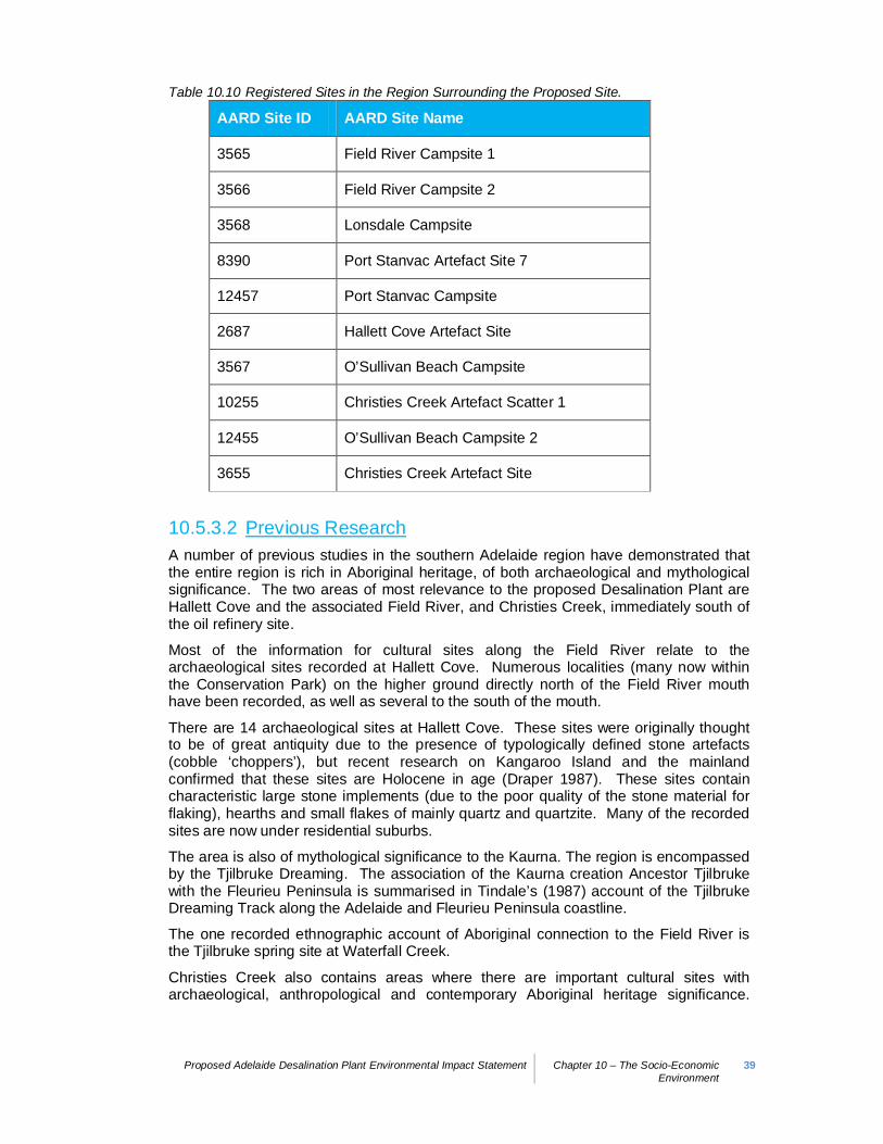
Proposed Adelaide Desalination Plant Environmental Impact Statement Chapter 10 – The Socio-EconomicEnvironment
39
Table 10.10 Registered Sites in the Region Surrounding the Proposed Site.
AARD Site ID AARD Site Name
3565 Field River Campsite 1
3566 Field River Campsite 2
3568 Lonsdale Campsite
8390 Port Stanvac Artefact Site 7
12457 Port Stanvac Campsite
2687 Hallett Cove Artefact Site
3567 O’Sullivan Beach Campsite
10255 Christies Creek Artefact Scatter 1
12455 O’Sullivan Beach Campsite 2
3655 Christies Creek Artefact Site
10.5.3.2 Previous ResearchA number of previous studies in the southern Adelaide region have demonstrated thatthe entire region is rich in Aboriginal heritage, of both archaeological and mythologicalsignificance. The two areas of most relevance to the proposed Desalination Plant areHallett Cove and the associated Field River, and Christies Creek, immediately south ofthe oil refinery site.
Most of the information for cultural sites along the Field River relate to thearchaeological sites recorded at Hallett Cove. Numerous localities (many now withinthe Conservation Park) on the higher ground directly north of the Field River mouthhave been recorded, as well as several to the south of the mouth.
There are 14 archaeological sites at Hallett Cove. These sites were originally thoughtto be of great antiquity due to the presence of typologically defined stone artefacts(cobble ‘choppers’), but recent research on Kangaroo Island and the mainlandconfirmed that these sites are Holocene in age (Draper 1987). These sites containcharacteristic large stone implements (due to the poor quality of the stone material forflaking), hearths and small flakes of mainly quartz and quartzite. Many of the recordedsites are now under residential suburbs.
The area is also of mythological significance to the Kaurna. The region is encompassedby the Tjilbruke Dreaming. The association of the Kaurna creation Ancestor Tjilbrukewith the Fleurieu Peninsula is summarised in Tindale’s (1987) account of the TjilbrukeDreaming Track along the Adelaide and Fleurieu Peninsula coastline.
The one recorded ethnographic account of Aboriginal connection to the Field River isthe Tjilbruke spring site at Waterfall Creek.
Christies Creek also contains areas where there are important cultural sites witharchaeological, anthropological and contemporary Aboriginal heritage significance.
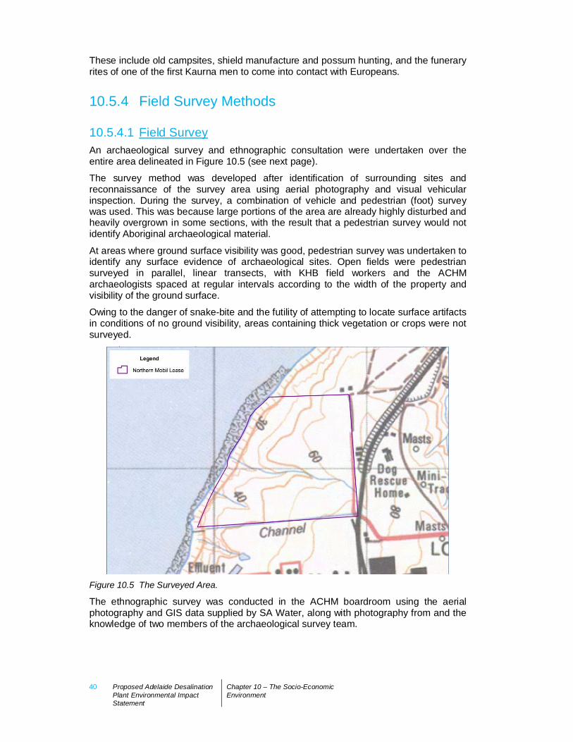
40 Proposed Adelaide DesalinationPlant Environmental ImpactStatement
Chapter 10 – The Socio-EconomicEnvironment
These include old campsites, shield manufacture and possum hunting, and the funeraryrites of one of the first Kaurna men to come into contact with Europeans.
10.5.4 Field Survey Methods
10.5.4.1 Field SurveyAn archaeological survey and ethnographic consultation were undertaken over theentire area delineated in Figure 10.5 (see next page).
The survey method was developed after identification of surrounding sites andreconnaissance of the survey area using aerial photography and visual vehicularinspection. During the survey, a combination of vehicle and pedestrian (foot) surveywas used. This was because large portions of the area are already highly disturbed andheavily overgrown in some sections, with the result that a pedestrian survey would notidentify Aboriginal archaeological material.
At areas where ground surface visibility was good, pedestrian survey was undertaken toidentify any surface evidence of archaeological sites. Open fields were pedestriansurveyed in parallel, linear transects, with KHB field workers and the ACHMarchaeologists spaced at regular intervals according to the width of the property andvisibility of the ground surface.
Owing to the danger of snake-bite and the futility of attempting to locate surface artifactsin conditions of no ground visibility, areas containing thick vegetation or crops were notsurveyed.
Figure 10.5 The Surveyed Area.
The ethnographic survey was conducted in the ACHM boardroom using the aerialphotography and GIS data supplied by SA Water, along with photography from and theknowledge of two members of the archaeological survey team.
Proposed Adelaide Desalination Plant Environmental Impact Statement Chapter 10 – The Socio-EconomicEnvironment
41
10.5.4.2 Aboriginal Site Identification and RecordingAs an archaeological convention, Aboriginal sites were defined as artefactconcentrations with a density of at least five artefacts within a 25 square metre area.Lower densities could be included in the category of site where a spatial relationshipcould be demonstrably the result of intent or activity (e.g. conjoining flake and core;muller and millstone of a seed-grinding pair). Isolated artefacts were defined in relationto sites, with densities and spatial relationships to other artefacts used to verifyisolation.
Sites were described and photographed, with their boundaries spatially documentedusing a hand held Geographical Positioning System (GPS). Isolated artefacts weredescribed, photographed and recorded with a GPS.
A number of sites were known to exist within the boundaries of the Mobil land; part ofthe brief was to locate and provide a condition report on these. The sites were identifiedby reference to geographical coordinates, and the information contained on the Registerof Aboriginal Sites held by AARD and the report in which they were originallydocumented. They were then assessed to determine whether their condition hadchanged and recorded using digital photography.
10.5.5 Field Survey ResultsThe survey area comprised a field, owned by Mobil and leased for commercialagricultural purposes, known colloquially as the ‘northern paddocks’. At the time of thesurvey the field contained a thick, green wheat crop, meaning that visibility was low.Considering the poor visibility, coupled with the heavily disturbed nature of the surface,the paddock was not surveyed in systematic transects. Instead, the tracks and the cliffswere targeted, due to these being areas with the highest visibility and the knownoccurrence of sites along the western boundary.
The northern paddock is home to a number of recorded Aboriginal sites, consisting oflow to high density flaked stone artefact scatters. While the recorded sites areconcentrated along the seaward cliffs, the interior of the paddock is characterised by alower density background scatter of flaked artefacts, which may have originallyconsisted of intact sites that have since been disturbed by intensive ploughing.
The inspection of the cliffs and creek banks identified one new site and relocated theseven sites previously recorded within the survey area.
The newly identified site is a stone artefact scatter on the cliffs. Of the previouslyrecorded sites, only two were found to be in largely original condition (Port StanvacArtefact Site [PSAS] 4 and 9). Geographical coordinate searches located the areaswhere the remaining sites were supposed to be located.
The tracks also yielded a number of isolated artefacts, mainly flakes of quartz andquartzite. These artefacts were dispersed at fairly regular intervals across thelandscape, suggesting that the background concentration of artefacts for the region ishigh.
42 Proposed Adelaide DesalinationPlant Environmental ImpactStatement
Chapter 10 – The Socio-EconomicEnvironment
Table 10.11 Registered Sites in the Region Surrounding the Proposed Site.
Site Name Type of Site
Adelaide Desalination Plant 01 Artefact scatter
Port Stanvac Artefact Site 1 Altered
Port Stanvac Artefact Site 2 Altered
Port Stanvac Artefact Site 3 Altered – recommend archiving
Port Stanvac Artefact Site 4 As described
Port Stanvac Artefact Site 5 Altered – recommend archiving
Port Stanvac Artefact Site 6 Altered – recommend archiving
Port Stanvac Artefact Site 9 As described
10.5.5.1 New Site (ADP01)The single newly identified site (ADP01) is located on sandy ground with sparse grasson the western boundary of the surveyed area, to the south of the site.
The site consists of two small concentrations of flaked stone artefacts, with densities ofapproximately 5 per square metre, each approximately 1.5 metres in diameter andaround 30 metres apart, and a low density flaked stone artefact scatter in between (lessthan or equal to 1 / 5 square metres). Artefacts include at least one large multi-platformpink and grey quartzite core and numerous flakes of pink, yellow and black quartzite.The black quartzite is particularly siliceous and appears to be uncommon in the area.The total population of the site is estimated to be approximately 30 artefacts.
10.5.5.2 Recommendations for DevelopmentThe sites identified within the boundaries of the northern paddock are protected underthe AHA. All of these identified sites are located to the south of the proposedDesalination Plant site. All ground disturbing works will take place well away from theseareas.
10.5.6 Ethnographic SurveyThe proposed Desalination Plant was considered from an ethnographic perspective andwhile there are no specific ethnographic sites within the survey areas, the survey areafalls within an extensive complex of sites and tracks which have ethnographicsignificance.
The significance of this complex relates to the Tjilbruke and Seven Sisters stories, anda number of other Dreaming stories important to Kaurna and neighbouring groups. Thesurvey areas are also within a network of traditional trading routes, camping andceremonial grounds, and areas associated with traditional food and water sources.

Proposed Adelaide Desalination Plant Environmental Impact Statement Chapter 10 – The Socio-EconomicEnvironment
43
10.5.7 Summary
10.5.7.1 SummaryThe Aboriginal cultural heritage survey of the proposed site of the Desalination Plantand surrounds identified one new Aboriginal archaeological site and relocated a numberof previously recorded sites, although it failed to relocate a number more. The new siteis within the boundaries of the northern paddock, located on the cliffs to the west andadjacent to a number of the previously recorded sites. All sites identified were locatedto the south of the proposed Desalination Plant site, in the buffer area between the siteand the Refinery.
There are no specific ethnographic sites within the proposed site, although the entiresurvey area falls within an extensive complex of sites and tracks of ethnographicsignificance. The significance relates to creation ancestors, Dreaming stories, tradingroutes, food and water resources and traditional camping and ceremonial grounds.
In light of the Aboriginal cultural heritage and ethnographic surveys the followingrecommendations were made:
Kaurna field workers should be employed to monitor all ground disturbing activitiesfor the discovery of Aboriginal archaeological materials;
All Aboriginal sites within the boundaries of the surveyed area are protected underthe AHA. Measures will be implemented to ensure that all ground disturbing workstake place well away from these sites;
Isolated artefacts may not constitute Aboriginal sites under the AHA, although it isrecommended that ongoing consultation occurs during the construction phase withKHB to obtain their input regarding the appropriate treatment of any artefactsdiscovered; and
In the event of the discovery of Aboriginal archaeological materials duringearthworks, the site discovery procedures as agreed with the Kaurna are to beenacted.
Kaurna wish to be included in designing appropriate signage to acknowledge theirtraditional connection to this area; and
Kaurna want a keeping place developed for any artefacts salvaged during theconstruction process.
Implementation of these recommendations will be undertaken through the developmentand implementation of the Cultural Heritage Management Plan for the works. This Planwill specify induction requirements, cultural awareness training for all Contractors andall appropriate protocols.
44 Proposed Adelaide DesalinationPlant Environmental ImpactStatement
Chapter 10 – The Socio-EconomicEnvironment
10.6 Native Title10.6.1 IntroductionThis Section reports on the status of the land proposed to accommodate theDesalination Plant in relation to Native Title (see Appendix F6).
10.6.2 ConsultationSA Water sought advice from the Crown Solicitor’s Office of the South AustralianAttorney-General’s Department concerning Native Title claims within the area of theproposed development on 11 March 2008 (for the Pilot Plant) and 13 August 2008 forthe full-scale Desalination Plant.
Advice received from the Native Title Section of the Crown Solicitor’s Office noted thefollowing:
The entirety of the ADP is within the area of the Native Title claim Kaurna peoples(SAD) 6001/2000 which has not been determined.
Native Title has been extinguished on all of the freehold titles comprising the subjectsite (Certificate of Titles 5608/586, 5752/89, 5752/73,5752/84, 5753/580 and5752/88).
Native Title has been extinguished within the Harbour of Port Stanvac, which willentirely accommodate the proposed marine intake and outfall pipelines andstructures.
10.6.3 Native Title IssuesThe Crown Solicitor’s Office has confirmed that any Native Title and rights which mayhave existed over the subject land and adjacent waters (entirely encompassing thegazetted area of the proposed Desalination Plant) have been extinguished.Accordingly, there are no Native Title issues in relation to the proposed DesalinationPlant and works can proceed without any further regard to Native Title provisions of therequirements of the Commonwealth Native Title Act 1993 and the South AustralianNative Title Act 1994.
Proposed Adelaide Desalination Plant Environmental Impact Statement Chapter 10 – The Socio-EconomicEnvironment
45
10.7 European Cultural Heritage10.7.1 IntroductionThis Section discusses the findings of an assessment of European cultural heritage forthe proposed site for the Desalination Plant and associated intake/outfall pipelines andstructures undertaken during July – September 2008 (see Appendix F5). It discussesheritage issues concerning the Port Stanvac site as well as the marine environment tothe west of the Port Stanvac site.
10.7.2 Site History
10.7.2.1 Early European SettlementThe sections comprising the Hundred of Noarlunga are shown in the Arrowsmith Surveyof 1840. No section that is the subject of this study had been taken up by that time.The first sections appear to have been taken up from 1847, primarily as farming land.
The first sections that are the special focus of this assessment – Sections 575 and 577– were acquired on 1 November 1850. The other relevant sections – Sections 587, 602and 603 – were acquired on 1 September 1851.
10.7.2.2 Early Land UseThe subject land for the proposed Desalination Plant was used mainly for farmingpurposes (primarily cropping) with physical development on the land being minimal,aside from fencing. Assessment records indicate few dwellings on any sections that arethe particular focus of the current study.
Section 603 was subdivided into two titles on 18 August 1923 with only the northernportion later being acquired for refinery purposes. The eastern portion of this partsection continued to be used for farming with a small farming complex being built in thesouth-eastern corner. The western portion provided sites for several holiday homes.These are shown on the aerial photograph dated 3 January 1959 (see Appendix F5)that also shows the farms and buildings depicted in the Department of Mines andHousing Trust plans referred to above.
Despite changes of ownership, all the land remained as open farming land except forthe farming complexes noted and the development of holiday shacks at the south-western end of part Section 603 that were accessed via Sullivan Terrace.
10.7.2.3 Land AcquisitionNegotiations concerning the establishment of an oil refinery in South Australia began in1955 between the Playford Government and Standard Vacuum. Premier ThomasPlayford sought to ensure the State’s self-sufficiency in petroleum products and theestablishment of a refinery was a key feature of his plans for industrialisation of theSouth Australian economy.
The bulk of the land for the refinery - Sections 581,581, 586, 587, 588, 602, part Section603 and 604 - were transferred to the Standard Vacuum Refining Company in early1958.
46 Proposed Adelaide DesalinationPlant Environmental ImpactStatement
Chapter 10 – The Socio-EconomicEnvironment
The Oil Refinery (Hundred of Noarlunga) Act passed on 23 October 1958 clearing theway for construction of the refinery.
10.7.3 Refinery HistoryHaving acquired the required land in early 1958 and having had the South AustralianParliament accept the indenture agreement, work began on planning and constructingthe refinery, with site works beginning in August 1961.
Standard Vacuum became Petroleum Refineries (Australia) Pty Ltd in April 1962following restructuring and renaming of the parent companies forming the original jointcompany; thereafter the newly-named parent companies Mobil and Esso owned 74%and 26% respectively of Petroleum Refineries (Australia) Pty Ltd. Successive companyrestructuring had no effect on refinery operations.
The first shipment of crude oil arrived aboard the Mobil Endeavour on 14 December1962 with the refinery starting-up in February 1963. The refinery was officially openedon 10 May 1963.
The following year a 30 kilometre pipeline was built to take gas to the South AustralianGas Company’s plant at Brompton where it was reformed into simulated coal gas. Ayear later, work began on building a pipeline to the fuel storage area at Birkenhead.
Development on the site increased with work beginning in August 1973 on constructionof a lube refinery on 50 acres of land adjacent and to the south of the fuels refinery.This began production in April 1975 and was opened officially on 5 March 1976.
Sections 575 and 577 immediately north of the refinery site were acquired by therefinery in October 1979 for future expansion and to act as a buffer against encroachingurbanisation.
Meanwhile expansion continued on the main site with a de-waxing plant beingcommissioned in 1981. Construction commenced on a light virgin naphthaisomerisation plant in September 1988.
Company restructuring continued when Petroleum Refineries (Australia) Pty Ltdbecame Mobil Refining Australia Pty Ltd in 1992 after Mobil acquired all of Esso’smarketing and refining assets in Australia.
Continuing changes in the oil industry, the development of larger refineries elsewhere,and the small size and ageing of the Port Stanvac refinery meant that continuingoperations became problematic. Mobil Refining Australia Pty Ltd found it increasinglydifficult to make the necessary investment in new plant to ensure the refinery’scontinued viable operation. Consequently, the company announced the indefinitecessation of plant activities on 8 April 2003, with production ceasing at the end of July2003.
Since that time the plant has been maintained on a care and maintenance basis. Theopen areas on which it is proposed to locate the Desalination Plant have been leasedfor cropping and grazing purposes.
10.7.4 Heritage Value of Site
10.7.4.1 Subject SiteThe subject site for the proposed Desalination Plant appears to have been usedexclusively for farming and grazing, even after the land was acquired by the refinery.
Proposed Adelaide Desalination Plant Environmental Impact Statement Chapter 10 – The Socio-EconomicEnvironment
47
The only physical development on the site occurred in the south-east corner of Section577. This is indicated on the South Australian Housing Trust plan (Figure 2 in AppendixF5) and in aerial photographs taken on 3 January 1959 and 9 January 1969. Thecomplex had been removed before aerial photographs were taken on 9 March 1979 andbefore the refinery acquired the site.
The only other development is the planting of a vegetated strip close to the eastern andsouthern boundaries near the corner of the property. This was planted by the refineryoperators and is not considered to be of heritage value.
There are no places or features on this site considered, or likely to be considered, oflocal heritage value by the City of Onkaparinga or considered to be of State heritagevalue by the State Heritage Branch.
10.7.4.2 Refinery Site in GeneralNo consideration has been given to recognising the larger refinery site as a place oflocal heritage value by the City of Onkaparinga nor as a place of State heritage value bythe State Heritage Branch.
For the purposes of this EIS, a detailed heritage assessment of the refinery site is notconsidered necessary.
It is extremely doubtful, given the current history of listing heritage places in theirentirety in South Australia, that the whole of the refinery site would ever be consideredfor heritage listing. It should be noted that in some instances, representative elementsof major complexes have been listed.
In any event, the proposed Desalination Plant would have little adverse effect on theheritage listing of a representative structure were this to occur on the refinery site.
10.7.5 Marine Heritage
10.7.5.1 Legislative AspectsWorks associated with development of the proposed Desalination Plant will extendwestwards into Gulf St Vincent. These works include an intake structure to about 1-1.5kilometres offshore to take seawater from Gulf St Vincent, and an outfall structure at adistance of approximately 1.5-2 kilometres offshore to return seawater discharge to GulfSt Vincent.
The marine environment immediately west of the subject site has already beendisturbed by the building of a jetty, construction of the underground pipeline to permitthe discharging of crude oil, and by dredging to permit the secure anchorage of largevessels. Nevertheless there is the possibility that cultural heritage material could befound off the coast.
Guidelines prepared by the Heritage Branch of DEH indicate procedures to be followedconcerning development near declared shipwrecks. In addition, Schedule 8 of theDevelopment Regulations 2008 outlines the procedures to be followed for developmentin the vicinity of shipwrecks.
10.7.5.2 Documented ObjectsHeritage Branch records indicate two (2) wrecks lying approximately five kilometres tothe west of Port Stanvac in 27 metres of water. These wrecks have been identified as
48 Proposed Adelaide DesalinationPlant Environmental ImpactStatement
Chapter 10 – The Socio-EconomicEnvironment
two iron-hulled barges, including the barge Saurian (wreck 540) and one unnamedTelfor barge (wreck 923). Both barges belonged to the Department of Marine andHarbours and were scuttled on 24 November 1954. Both barges are identified althoughneither is protected under the Historic Shipwrecks Act 1981 (SA).
The shipwreck nearest the subject site at Port Stanvac that is protected under theHistoric Shipwrecks Act 1981 (SA) is the Cutter Glenelg that lies about four (4)kilometres south of Port Stanvac. Maritime heritage officers of the Heritage Branch arenot aware of other cultural heritage material that might lie west of Port Stanvac, as nosystematic surveys have been undertaken in the area.
10.7.5.3 Survey ResultsA side scan sonar survey of the seabed to the west of the subject site was undertakenby 3D-Marine Mapping, which concluded that:
The side scan mosaic clearly shows a variety of features and patterns of differingseabed types. The features shown circled to the west of the wharf may be naturalfeatures, however they are distinct from the surrounding patterns/features. Thefeatures shown circled in the near vicinity of the wharf and those circled to thenorth of the wharf appear to be objects rather than natural features (ConnellWagner 2008, 6).
Subsequent video examination of these objects during dive surveys has shown them tobe concrete pipes that have been dumped offshore. These pipes are clustered closelytogether at a depth of twelve (12) metres, 500 metres north of the Port Stanvac jetty.The pipes are approximately three (3) metres in length and one (1) metre in diameterand are densely covered by macroalgae (e.g. ecklonia radiata) and invertebrates (e.g.ascidicans and sponges). Three pipes are clearly distinct in shape and size, whilst theremaining two are partially buried in the sand. They would not be considered items ofcultural heritage material that need to be brought to the attention of maritime officers ofthe Heritage Branch of DEH except as a matter of courtesy.
Nevertheless, care should be taken to ensure that any development works associatedwith the seabed west of the subject site do not disturb cultural heritage artefacts thatcould potentially be buried, although the likelihood of such artefacts being present isremote.
10.7.5.4 ConclusionResearch into the European cultural heritage of the proposed site for the DesalinationPlant suggest that there are no places or features that are considered, or likely to beconsidered, of local heritage value by the City of Onkaparinga or places or features ofState heritage value by the State Heritage Branch. There are also unlikely to be itemsof cultural heritage material on the seabed west of the subject site.
10.7.6 Management and Mitigation StrategiesGiven that the assessment of the European cultural heritage has found there to be nosites or objects of cultural heritage significance in and around the site of the proposedDesalination Plant, it is considered that no management or mitigation strategy isrequired. Nonetheless, the proponent has resolved to take the following actions:
Inform maritime officers at the Heritage Branch of the Department for Environmentand Heritage of the existence of five (5) cylindrical pipes located at a depth of twelve(12) metres, 500 metres north of the Port Stanvac jetty.

Proposed Adelaide Desalination Plant Environmental Impact Statement Chapter 10 – The Socio-EconomicEnvironment
49
During construction of the proposed intake and outfall pipelines and structures, duecare and regard will be taken to ensure that any works in and around the seabedwest of the subject site will not disturb cultural heritage artefacts that couldpotentially be buried there.