effects on groundwater flow and groundwater quality of a waste disposal site in noordwijk, the...
TRANSCRIPT
The Science of the Total Environment, 21 (1981) 85--92 85 Elsevier Scientific Publishing Company, Amsterdam -- Printed in The Netherlands
EFFECTS ON GROUNDWATER FLOW AND GROUNDWATER QUALITY OF A WASTE DISPOSAL SITE
[N NOORDWIJK, THE NETHERLANDS
W. VAN DUIJVENBOODEN and W.F. KeePER
National Institute for Water Sumply, Voorburg, The Netherl~nds
ABSTRACT
The effects of a waste disposal site in Noordwijk on the groundwater blow Lnd
q~oundwater quality were investigated. Special attention is given to the extensi<)n
off pollutants in the aquifer. Several boreholes were made ~nd groundwater has b{{~n
sampled and analysed. Measurement of electrical resistivity and an electromac~n~ ti(~l]
investigation were carried out. Already beneath the landfill pollution was i<und
on the fre<;h- salt water boundary at about 40 meters -].s. A very ~arg( verti<a]
~]ow componer<t due to density flow could be calculated. L(cal flow patterns indicate
an all-sided migration of pollutants. Short-circuit flow ~aused by th< d~il]ih<: ~ f
bot-eholes can e~fect the quality of gsoundwater seriously.
I NTRODUCT ION
The waste dJsmosal site at Noordwijk is situated in a former sandpit ne%t tri~'
dunes. The average depth of the sandpit is about 13 meter:. In tile centr~] ~11-t <,f
tile sandpit the maximum depth is 16 - 1: meters. The qrouxdwater level l'~es ab,)ut
one meter below surface. From 1960 to 1973 the sandpit ha ~ been used as a w<~st ~
disposal sit~. The w~ste was deposited till about 3 meter: above the [ormer sur[a<!~
level. Some pre]i~llindry research was carried out during t]~e period Ig7b 117(,.
V~=on request: of the Ministery ot Public !lealth and Environmental Protection ~i re<re
intensive research was started in 19"?7 eoncerninq the influence of the w~st< ]isp{:.~,:~]
~ite on the .Iroundwater flow and groundwater quality. ~or this research 22 mor~ito~ inc:
wells haw been dri]led, from which five with a depth of i~0 meters. One borehol~
w~ drilled through the central part of the waste disposal site. Normal and mlni-
screens were placed in the wells. Once or twice a year th~ qroundwate~ around, [(~L<)w
~nd inside the landfill was monitored. Groundwater samr)le'{ were analysed on macro-
aild trace elements, on organic micro-pollutants ~nd triti]m. Moreover, electtie~i]
lesistivity and electromagnetical measurements ]round the landfill were ca~-~-i~.d out
aild tem~gerature measurements were made .
0048-9697 /81 /0000- -0000 /$02 .75 © 1981 Elsevier Scientific Publishing Company

8 6
GEOHYDROLOGY
Based upon the information gathered during the research the qeohydrological
situation around the landfill can be described as follows: (see figure i)
0 - 18 m -l.s. a medium permeable mhreatic aquifer; clayey fine to medium
coarse sand with loam and/or thin clay layers (Holocene) ;
18 - 57 m -l.s. permeable aquifer; coarse sand (Pleistocene) ;
57 - 105 m -l.s. impervious clay layers of the Formation of Kedichem (base of
the a q u i f e r ) .
149 119 1~0m
LANOEILL GW m HOLOCENE
m/year
4~ MIDDLE PLEISTOCENE FORM v TWENTE,EEM URK
F~ESH Vh ~ 15m/year
SALT
IMPERVIOUS LAYER
Figure i. Cross-section of the landfill
and hydrogeological situation
Below about 40 m -1.s. brackish groundwater is found. Generally the groundwater
flow is directed towards the lower situated polderarea South-East of the landfill.
On an average the velocity of the groundwater in the holocene aquifer is about
4 meters a year and in the pleistocene aquifer with a higher nermeability about
10 - ]5 meters per year. The area upstream and directly downstream the landfill
is an infiltration area. Further downstream in the molderarea, there is an upwards
seepage and therefore a raised fresh- salt water boundary. Locally the groundwater
flow in the holocene aquifer is strongly influenced by the landfill, while the
groundwater in the pleistocene aquifer is influenced by effects of density flow.
In the following sections attention will be given to these mhenomena.
DISPLACEMENT OF THE LEACHATE
During the excavation of the former sandpit a silty layer has been deposited.
The resistance of this layer against waterflow mrobably causes the raised ground-
water level inside the landfill (see figure 2). This raised groundwater level result
in an all-sided migration of leachate into the aquifer. This mrevents normal ground-
water flow through the landfill. The outflowing leachate is replenished by precipi-
tation infiltrating in the landfill. The extension of the nollution of the ground-
water in the holocene aquifer can be illustrated by lines of equal resistance
based upon electrical resistancy measurements around the site (see figure 3). In
this survey contamination of groundwater was found in a zone between 4 and 12 meters

87
-i.s. till 30 meters uostream and about 80 meters downstream of the landfill. 'L'h~ ~
~e{ults of the electromagnetical measurements are ver}' similar. According to ~]~'
~sults of analyses of water samples, only a slight J n f ] / x N c e of (iroundwdter N t l ] i t ' ; '
<')111d ~>e fo~md in the deeper part of tile aquifer. On tile otn~r ! l a n d th(" ~,< ]]!lri(u
~lume on the} fresh- and salt water boundary could riot: be :]< t~,ctc'd bv th,, ,.]~ :t ~ i< ~]
resistance measurements, due to the disturbing effect o!7 tl~e brackish wit~ r.
\ i
2 . 0 .__ .... :~. /
"-....
L e g e n d o ~ ,~o ~.~
• o b s e r v a t i o n w e l l ; d e p t h m a x 6 m l s o o b s e r v a t i o n w e l h d e p t h m a x . 1 6 m - I s ~) o b s e r v a t i o n w e l l ; d e p t h m a x 6 0 m l s
s a m p l e d on a ana lys is o f m i c r o p o l l u t a n t s
~ g l o b a l f l o w d i r e c t i o n o f the f rea t i c g r o u n d w a t e r
133
1 4 2 " ~
t"t ~ u r e z . Aequipotential lines of the
.149
~ ° •
• t 4 4 "~
• 141 ( .
• 1 3 8 . 1 3 2
"130
Legend • b o r e h o l e
Figure ~ .
j t ~
. 134
. 1 3 5
.143
.139
•128
Aequj real stance Ii n(s ; t r c ~-lr: ~, ph~eatic groundwater the landfill
're get more insight in the leachate mtqration in the :21ei{teeene ~lui!er ],,2' ~
b(.neath t h e landfill, a borehole through the wast£ ~ disoosa! site was sl:'k ( 1 ' ~ - ' - ' .
In the boreho]e ever}, 11~ meter a mini-screen was p]ac~,d ( ~ total 2,-;) . Likewi:~
I i electrodes and 9 normal, 2 meters ions] wel~s 'a~re ~)lac<.]. From thes~ ~<:r~-,h
~nd electrodes ] were placed in the landfill, divid(,d '.m" artificil]l'/ m, lb. c].v'
lly(rs. During the drillinq, leachate run down t}p boneho],! ~Lte, du( t<: .4hoi:1
ci reuit flow. This resulted locally in ~ contam[n.lti(n of the qroundwalo~ Jr! t I!(.
pleistocene aqaifer. It took near]}, I }'ear before th~ s[t~:~tJon was st~bJ]Jx,,!
as could b( detected by measurements with the electrodes see fiN. .%).
T h e a c t u a l s i t u a t i o n o f t h e d i s p e r s i o n o f t h e l e a ( ' h a t e i n t h e env i r < ; i lN l ( ~ n t ] ;
i l l u s f r a t e d b y f i g u r e 5 , b a s e d u p o n t i l e HCO 3 c o n e e r l t r a t i o n i n t h e q r o u n d w a t e r . V~ , r "
s i m i l a r f i g u r e s a r e f o u n d f o r s e v e r a l o t h e r p a r a m e t e r s ( p . q . 3H ( t r i t i u m ) , I i ' , B ] ~} ,
NH~ +) Exc{!ot for some heavy rletaLs adsorr%tior: seems to be not im~x)rlant i: K ~
this eoars~ sanded aquifer.
Ra}'ed upon figure 5, the followinq remarks can be made:
In aqreement with the conclusion that replenishment of outflowinq l<'achate :)nly
takes place by precipitation, the total dissolved soli{s oF the gronndwater i~,
th{~ ]andfJ ]] fncrease with depth;
According to the results of the electrical resistivity inw~stigation the ool]'~tion
of the groundwater near borehole 145 is comparatively less than near boreh~ I(. I I ),
both at about the same distance from th{ ~ landfill. Probabl!., there is a Iow~,r t](~w

88
10
11
-Z
8
4 5 m I s
11811 1151291131271,012,18 12~15 119 J12 I~°h3 19 18 I1~ 118 I1~ J7 I1~ ho 1~0112 A S O N D J F M A M J J A S N J M M
1 9 7 8 , ~ 9 7 9 1 9 8 0
t i m e I~
Figure 4. Resistance measurements beneath the landfill as a function of time
10 .
2 0 -
30-
4 0 -
144 145 149
/ / / ~ \
! : . . . . . . . .
,jr l:ow: 0 . . . . . . }
~xx 141 * • 144
,\ 140 145 ,~o / i \ 119
Figure 5. HCO~ concentration with depth
date of sampling 18.07.1979
89
velocity of the groundwater near the central part of the landfill.
- From the bottom of the landfill till about 27 meters -l.s., the groundwater i~
heavily polluted with almost pure leachate. At the same deoth the <]roundwlt~ ~
downstream the landfill is only sliqhtly Do]luted.
From 27 meters -l.s. to about 35 meters -l.s. a less ~:ontaminated zone is
oresent in the groundwater beneath the landfill. While, from %5 meter{ -] ...<. t~
about 41 meters -l.s. just above the brackish groundw,tter a pollutior'~ i~lui!ie
appears with about half the concentration of the leachate. This is probably d'u~
to density flow combined with dispersion.
Especially the pollution plume at ~5 - 41 meters -l.s. s very remarkabl< . An
explanation of this phenomenon can be found in density flow. The density nf t:I{~
leachate is 1.0094 kg/l while the density of the ~}olluted ;roundwater ]ust above
the salty groundwater and the non-polluted groundwater is ~esmectively I. )051 tni
].00027 kg/l. It is interesting to point out that the temperature profiles do rot
coincide with the chemical pollution profiles. This stresses the effect of donsitv
f ]ow.
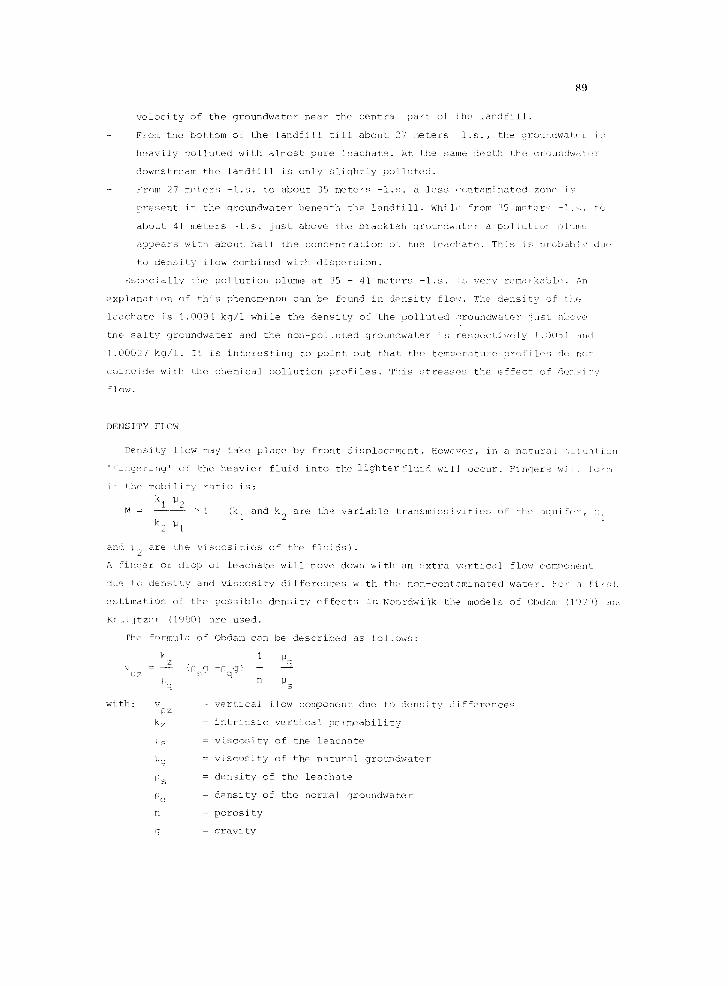
DENSITY FLOW
Density flow may take place by front displacement. However, in a natural situation
'ffingering' ~sf the heavier fluid into the lighter fluid will occur. Fingers w£Ii Iolm
it = the mobility ratio is:
kl ;~2 M = > i (k 1 and k 2 are the variable transmissJvities of the aqui~7~,r,
k2 ]Jl
and %<2 are the viscosities of the fluids).
A finNer or drop of leachate will move down with an extra vertical flow com~}onent
due to density and viscosity differences with the non-contaminated wat{,r. For a first
estimation of the possible density effects in Noordwijk the models of Obdam (I'!7'!) an
Kruijtzer (]980) are used.
The formu] a of
k z
v = -- [psg 0 z P ,q
w £ t h : v[} z =
k z =
NS =
pq =
[) s
Pq =
n
g =
Obdam can be described as follows:
1 ~q
- P q g )
n N s
v e r t i c a l f l o w c o m p o n e n t d u e t o d e n s i t y d i f f e r e n c e s
i n t r i n s i c v e r t i c a l p e r m e a b i l i t y
v i s c o s i t y o f t h e l e a c h a t e
v i s c o s i t y o f t h e n a t u r a l g r o u n d w a t e r
d e n s i t y o f t h e l e a c h a t e
d e n s i t y o f t h e n o r m a l g r o u n d w a t e r
p o r o s i t y
g r a v i t y

9O
The formula of Kruijtzer is similar, but differs a factor 2/3 due to the finite
dimensions of the displaced heavier fluid, with these formulas (with k = 10 meters z
oer day, n = 0.33, Ps (average) : 1.0072 kg/l and pq = 1.0027 kg/l) it can be cal-
culated that Vpz - 50 - 90 meters per year for the situation in Noordwijk. This mean~
that according to the analysis results alreadv beneath the landfill nollution of the
groundwater can be exoected on the fresh- salt water transition zone.
QUALITY OF THE GROUNDWATER
In the above, attention is given to the extension of the mollution based on the
conservative behaviour of the pollutants. In fact the behaviour of many macro para-
meters, even the positive ones, seems to be conservative due to the low adsorption
capacity of the soil (<1 meq/100 gr) in the middle-deep aquifer. On the other hand,
a clear preference adsorption takes place of several heavy metals. Some analysis re-
sults are given in table i.
TABLE i QUALITY OF GROUNDWATER AND LEACHATE
Parameter
Cl- mg/1
2- SO 4 "
HCO 3 +
NH 4
Fe ++
++ Ca
Mg ++
Na +
K + ++
Ba ~g/l
Li
Ni
Zn
benzene
toluene
xylene
ethylbenzene
C9H12 "
phenols "
camphor "
org. chloor
Leachate Grw. 4 m he- Grw. 27 m be- Grw. 30 m be- Grw. bore- Ref. well
neath base neath base of neath base of hole 119 144
of landfill landfill landfill 38 m -l.s. 35 m -l.s
3310 3090 1200 2380 1670 44
37 92 9 52 28 4
5920 5510 1110 3090 3230 312
700 640 114 72 236 1.4
56 53 4.3 2.8 9.3 0.5
280 278 109 252 340 27
232 232 70 382 153 38
2000 1850 680 1500 ii00 42
880 820 170 145 475 22
900 900 I00 500 700 50
500 485 105 110 270 5
100 80 10 30 20
310 270 50 20 20
100 30 I0 i0 --
300 100 3 3 1
600 400 i00 300 I
300 100 30 i00 0.3
300 i00 30 30 3
200 90 20 90 --
1 0 0 0 1 0 0 1 0 0 1 0 0 - -
26 14 4 16 --

9 1
Ox soecial interest are the so-called organic micro-10ollut,:nts which are found lh
relatively hi:Hi concentrations in the leachate. Further dot~nstream there seem f<
~ a clear re~rtion or degradation (see also Zoeteman e ~ ~I., 19 ~1 ) of these <'IL--
} oilent[}.
ConcerilJsG the detelqnination of heavy metals it caT] I> ~ sointed out that J~,l .ri]Jl 1
<<i t<he way ~f sample-handling, destruction and analysis ()f the heavily <:,on-
]:r~i nated ] eachato and groundwater a wide coneentratJ or] ra]~( can be Fo<Nl(i . k' ~t t !1:~ t
! <' loll i l l qni £orm appro{ich seems to be v~.rl! import int.
Very interesting is the tritium concentratior~ beneath Nld around t}le li!n(~!i] I.
J{esides the effects of the nuclear tests in the s[xti(s (v,in Du~jvenbooden, i) [ ,
th,~r-~) Js als< an <Elect o£ the landfill itself. The tritit~ eoncentrati ns ir ~1i<
]~achate clea<ly increased compared to t~le concentration{ ii tile surro\NK]JN~l i]'olN:d
w~t~rs <)~ the same age. This holds true for the ~m)llnted a:< we]] as foF the h n-
i~o]luted groundwater (see table 2).
FABI,E i! TRITIUM CONTENT IN THE LEACHATE AND GROUNDWATER AROUND THE I,~\NDF]I,], I~:
T. ~i f.
t e p t h r e [( f e n c e w e l l s
u-].s, well 14~ wel]144
, 1 o9 88
i{~ .12 7
]% 8 12
] eachate polluted qrouildwat r
well 140 well 14]
143 112
133 116 10 {
158 63 } ~
C( )NCL<IS IONS
B a s e d u p o n t h e r e s e a r c h r e s u l t s t h e £ o l l o w i n ] c o n c l u s i ) n s c a n b e m i l e :
D e I ] s i t y f l o w c a n b e a n i m p o r t a n t p h e n o m e n o n n e a r w l s t e ] i s o o s a ] s i t / ! . . ] . o { ) k i ; l l
. i t t h e p o s s i b l e h i g h v e r t i c a l f l o w c o m p o n e n t , i t w i l l ~.. n e c > ~ s s a r ~ ' , ] l <,:
m o n i t o r i n g , t o s i n k o b s e r v a t i o n w e l l s t o t h e b a s e o f t i ~ a q u i f e r .
When d r i l l [ r l G a b o r e h o l e t h r o u g h a m e ] l u t e d a F e a , i ! o I ' ~ t a m J n a t i o n o f t h e a q l ] ! ( ~
c a n t a k e p l a c e b y s h o r t - c J r c u i t f ] o w . D e p e n d e p ~ t o n th ( ~ o o a l s i s u a t i (n~ i t . i n
t a k e c o n s i J e r a b l ( t i m e b e f o r e t h e o r i g i n a l s i t u a t i o n i ~ ! , s t o r e d . F<}r t h i
t - e a s o n soi i le d e l a y t i m e i s n e c e s s a r y b e f o r e saI~lT] l inq c a t t a k e p ] a < e .
I n c a s e o f ~ l a n d f i l l s i t u a t e d i n ] n d a b o v e tb~! c l r o u l ] d w a t e ~ , a w ~ t ( t - i i v i h
~an b e f o r m e d i n t h e l a n d f i l l r e s u l t i n g i n an a ] ] - s i d e ( i m i g r a t i o n o f ] a n d ~ i ] l
leaehate. This means that no groundwater is f!owin~x th~o~:qh the liln,!£ii[ ~r i
<~iso th]t the groundw%ter upstream can be contaminat(d. Thi s demand~ a <'<<t ~ {'(t
choice :;~ reference wells.
- By m~asL~r~nq electrical resistivity or by eleetromaqn(t Jcal investi,R~tio:i
T.assab]e insight can be obtained in the extersion o< the ~ol]ution in a Ic l-ix<~f:l]
~s well as in a vertical sense. This reduces the noces!ary :]umber- <;£ ob~R,y,)f[<:n
wells. On the other hand it must be kemt in ~iind that in this way no inforTiatic~!l

92
can be obtained about the presence of pollution above a clay base or fresh-
salt water transition zone due to the disturbing effects of this base or the
brackish water.
Electromagnetical investigation seems to give the same results as electrical
resistivity measuring. The electromagnetical method works faster and is much
cheaper than the electro resistivity one.
Tritium seems to be a acceptable tracer to detect polluted groundwater descended
from a waste disposal site.
Temperature profiles in general do not coincide with nrofiles of the chemical
parameters, probably due to density effects. This means that temperature measure-
ments cannot be used for the tracing of chemical pollution.
Depending on the way of sample-handling destruction and analysis, a wide con-
centration range can be found for many trace elements in the leachate and heavy
polluted groundwater. This requires an uniform aoproach for getting comparative
concentrations.
REFERENCES
1 Morra C.F.H., Van Duijvenbooden W. van, Slingerland P. and Piet G.J., 1979.
Ori@nterend onderzoek naar organische microverontreinigingen in het grondwater
bij de vuilstortplaats te Noordwijk. RID-mededel~ng 79-i (in dutch).
2 Obdam A.N.M., 1979. Calculations of the salinity process of partially menetrating
wells in a semi-confined anisotropic aquifer. Proceedings SWIM, Hannover.
3 Kruijtzer G.F.J., 1980. The downward penetration of a spherical foreign fluid
substance in an aquifer. L.G.M.-Mededelingen Dart XXI, no. 2.
4 Duijvenbooden W. van, 1981. Groundwater quality in The Netherlands - collection
and interpretation of data. Proceedings ISOG '81.
5 Zoeteman B.C.J., Brinkmann F.J.J., Greef E. de, 1981. Persistency of organic
contaminants in soils, lessons from soil nollution incidents in The Netherlands.
Proceedings ISOG '81.