ecosystem remediation in radioactively polluted areas: the chernobyl experience
TRANSCRIPT
Ecological Engineering 8 (1997) 325–336
Ecosystem remediation in radioactively pollutedareas: the Chernobyl experience
Vassili Davydchuk *
Institute of Geography, National Academy of Sciences, Volodymyrska 44, Kyi6 252 034, Ukraine
Received 28 November 1995; received in revised form 18 June 1996; accepted 23 June 1996
Abstract
The ecosystems of Chernobyl nuclear accident zone, having been deeply transformed bynormal long-term agricultural and forestry activity, have been damaged by irradiation afterthe nuclear accident of 1986 and then influenced by post-accident countermeasures. Ecosys-tem remediation is being undertaken in this area, including maintenance of the forests,artificial afforestation, and processes of spontaneous self-restoration of the natural coenoses.Both natural and artificial remediation of the landscapes and ecosystems at the abandonedterritory improves their capacity to retain radionuclides and their ability to stabilise theprocesses of redistribution of radionuclides and their spread in the environment. TheChernobyl zone is a territory of great importance for studying ecosystem remediationprocesses and elaborating on ecological engineering technologies to correct serious environ-mental problems arising from radionuclides release. © 1997 Elsevier Science B.V.
Keywords: Nuclear accident; Radiation damage; Countermeasures; Ecosystem remediation;Maintenance; Forestation; Self-restoration; Radionuclides redistribution; Stabilisation; Ra-dioecological situation; Ukraine; Chernobyl; Forest restoration
* Tel.: +7 380 442241451; fax: +7 380 442243230.
0925-8574/97/$17.00 © 1997 Elsevier Science B.V. All rights reserved.
PII S0925 -8574 (97 )00026 -8
V. Da6ydchuk / Ecological Engineering 8 (1997) 325–336326
1. Introduction
The Chernobyl nuclear accident of 1986 occurred at the Northern part ofUkraine, in the Polesie lowland. A structure of the ecosystems adjusted to naturalconditions and to the system of land use has formed in the Polesian region.Agriculture was characterized by intensive farming (rye, potatoes, flax, vegetables).A developed livestock made use of natural forage resources of the river floodmeadows. Before 1986 arable lands accounted for 38% of territory of the accidentzone, 10.5% was occupied by meadows, 36% by forests and 4.5% by settlements.
The Chernobyl nuclear accident caused irreversible radioactive contamination ofthe environment of densely populated territories. According to national regulations,it was impossible to continue life and normal land use in the territories contami-nated with more then 40 Ci/km2 (1480 KBq/m2), so that 90 784 people, including61 614 people from two towns—Prypjat and Chernobyl—and 29 170 of the ruralpopulation of 78 villages from the territory 2100 km2, had to be evacuated.
Some agricultural countermeasures, such as liming, sorbents, special ploughingand over fertilizing of the soils, were carried out after the accident to improve theradiological situation in the inhabited territories, but 1852 km2 of arable lands werelost in the Ukraine due to high contamination or high transfer coefficients ofradionuclides from acid soils to agricultural products. Also 1570 km2 of radioac-tively contaminated forests were lost.
More than 2700 km2 of Ukrainian territory outside the evacuation zone with apopulation of 253 000 and contaminated with 5–40 Ci/km2 of Cs-137, are stillinhabited and cultivated. About 48 500 people were planned to be evacuated in1994–1997 from a further 80 settlements in addition to the ones resettled immedi-ately after the accident.
The territory contaminated is situated just at the entrance of Dnieper River in theUkraine, and the main problems are to avoid its expansion, to localize theradionuclides in the abandoned zone, and to minimize their water migration andwind resuspension.
A relocation of the population caused reduction of the human pressure on theecosystems of the Chernobyl zone and changed the regional land use system. Incombination with the impact of the radionuclides and post-accident countermea-sures it created a new environmental situation, which is analyzed in this paperrelative to the remediation of the ecosystems and its effect on the radiologicalsituation.
2. Geographic conditions and structure of the ecosystems
The region of Polesie is a fluvioglacial sandy plain on the north-eastern slope ofUkrainian Crystalline Shield in the area of Dnieper stage of the quaternaryglaciation, which corresponds to Zaal stage of Western Europe and Wisconsin oneof North America.
V. Da6ydchuk / Ecological Engineering 8 (1997) 325–336 327
Polesie is characterised by a mainly low and plain relief (110–145 m above sealevel) and with a combination of different natural landscapes (Davydchuk et al.,1994). Natural landscape can be defined as a geographical system consisting ofrelief, surface deposits, soils and vegetation. Among typical landscapes of thePolesie region and Chernobyl accident zone are: river floodplains and terraces,extreme-moraine ridges, moraine-fluvioglacial and limno-glasial plains. This part ofUkraine is notable for considerable swampiness. In the accident zone bogs accountfor 22.5% of the territory.
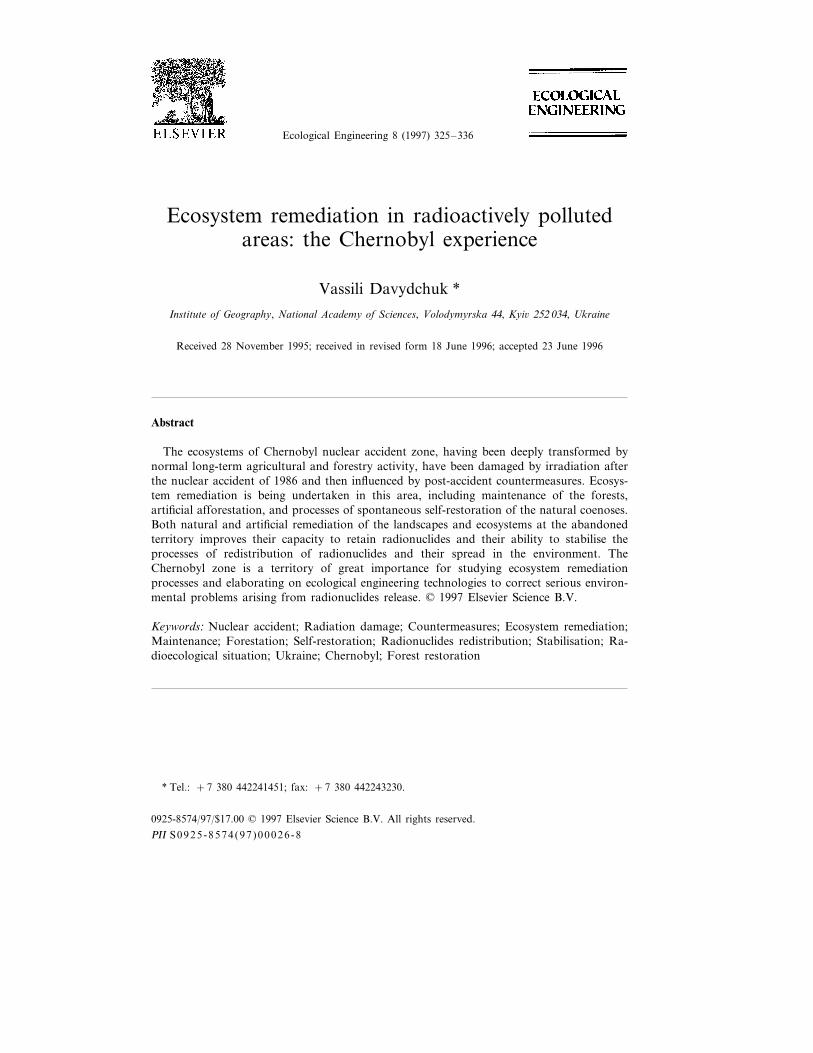
One of the landscapes of the Chernobyl zone—the Chistogalovka extreme-moraine ridge—stretches from the town of Chernobyl WNW to Chistogalovkavillage (Fig. 1). It represents the upper level of relief of the Chernobyl NuclearPower Plant (NPP) 30-km zone. The hills of the ridge reach 260 m above sea level.They are composed by fluvioglacial dusty sand, bedded with shove morainic sandyloam at the depth 0.4—1.0 m and paleogenic clays and sands on the depth 15–30m. Soils are sod-podzolic dusty-sandy ones (pH 4.5–4.9, humus 1–2%). In thepre-agricultural historic period the ridge was covered by forests with predominanceof Quercus robur L., Fraxinus excelsior L., and Carpinus betulus L., which aresubstituted now by stands of Pinus sil6estris L. of artificial origin, and by secondaryforests of Betula pendula Roth. Former arable lands are covered now by long-fallowgrass vegetation.
Another extreme-moraine ridge of small size is situated between villages ofKamenka and Opachichi, on the southern border of the evacuation zone. Itsnorthwestern part presents a landscape of a low, ripple moraine-fluvioglacial plainwhich lies 15–35 m lower the extreme-moraine ridge. This level of the relief iscomposed of fluvioglacial sand, bedded by morainic loam 0.8–1.0 m deep. Theconcentration of the dust particles less 0.05 mm is very low (4-8%). This explainsthe poorness of the soddy-podzolic sandy soil formed here (pH 4.2–4.5, humus0.8–1.5%). The landscape of the low moraine-fluvioglacial plain is covered by pineforests.
A number of isolated depressions of 0.3–0.8 km diameter are scattered on thesurface of the landscape. Most of them are occupied by swamps with alder forestsor sedge-reed bogs.
Landscapes of the terraces of Dnipro and Prypjat are very typical of theChernobyl zone. Flat surfaces of terraces are composed of alluvial sands with adeficiency of clay and dust particles (4–6%). Thus, sod-podzolic sandy soil formedhere is dry and poor (0.4–0.6% of humus). The terraces are covered mainly bydifferent-age pine forests of artificial origin. Lowered parts of the river terraces,which are situated close to terrace joint, are occupied by eutrophic bogs with peatbog soil (peat thickness is about 0.5–2.5 m, pH 5.0–5.5, organic matter up to 75%)and forests of Alnus glutinosa (L.) Gaertn. or by sedge-reed bog coenoses.
The flat surface of the terrace between Dnipro and Prypiat is drained by the riverBraginka and its small tributaries, together with a dense network of drainagechannels and ditches. The small streams mentioned have very wide (1–2 km) floodplains which are composed of 0.5–1.5 m peat, with peat bog soils. Most of thesesoils were drained and cultivated before the Chernobyl accident. Now they are
V. Da6ydchuk / Ecological Engineering 8 (1997) 325–336328
Fig. 1. Ecosystems of the Chernobyl accident zone: 1. P. xerophyto-cladinosum ; 2. P. rhodococco-dicra-nosum ; 3. Q.-pinetum coriloso-graminoso-herbosum ; 4. Q.-carpineto-pinetum euonimo-coriloso-aegopodio-sum ; 5. P. 6accinoso-polytrichosum ; 6. C.-quercetum euonimo-coriloso-aegopodiosum ; 7. C.-quercetumcoriloso-galeobolonoso-aegopodiosum ; 8. F.-carpineto-quercetum coriloso-geumoso-filipendulosum ; 9. P.-betulosum herbosum ; 10. P.-betulosum 6accinoso-polytrichosum ; 11. A. higrophytosum ; 12. S. xerophyto-graminosum ; 13. X.-herboso-graminosum ; 14. G.-leguminoso-hygrophytosum. 15. pioneer grass coenoses;16. G.-xerophytosum ; 17. H.-graminosum ; 18. G.-leguminoso-herbosum ; 19. H.-graminosum in complexwith careoso-hygrophitoso-graminosum ; 20. S. herboso-graminosum in complex with careoso-hygrophi-toso-graminosum ; 21, G.-careosum ; 22. Careoso-phragmitosum ; 23. dry long-fallow grasslands (formerlyploughed); 24. wet, drained long-fallow grasslands; 25. ‘red forest’; 26. ‘red forest’ removed; 27.settlements; 28. industrial areas; 29. isolines of Cs-137 contamination (Ci/km2). NPP=nuclear powerplant location.
V. Da6ydchuk / Ecological Engineering 8 (1997) 325–336 329
covered by the long-fallow grass vegetation. Non-drained, ‘natural’ peat bog soilsare under alder forests and sedge-reed associations.
Many dry sandy islands are situated among the streams, channels and bogs. Soilsof these territories belong to the soddy-podzolic type. They have a very thin (8–12cm) humus horizon. The poorest types of the soddy-podzolic sandy soils, whichhave about 0.5–1.0% of humus in upper horizon, are covered by pine forests.Soddy-podzolic dusty-sandy soils, which are more fertile, are occupied by agricul-tural lands.
The structure of the ecosystems of the Chernobyl zone is shown in Fig. 1. Mosttypical forest ecosystems of the region are Pinetum cladinosum and Pinetumphodococco-dicranosum, with the soil covered by Koeleria glauca (Sorend.) DC,Festuca sulcata (Hack.) Num.p.p., Antennaria dioica (L.) Gaertn., Phodococcum6itis-idaea (L.) Avror., Dicranum scoparium Hedv., Cladonia sil6atica (L.) Hoffm.and C. rangiferina (L.) Webb.
The lowest level of relief of the Chernobyl accident zone is represented by thelandscapes of the floodplains of Dnipro, Prypjat and their tributaries. Flat andsegment-crest surfaces of the frontal and middle parts of the floodplains with anumber of the meander lakes and bypasses are composed of layered alluvial sandsand loams and covered by shrubs of Salix acutifolia Willd. with grassy-xerophytoussoil cover, and forb-grassy and sedge-hygrophytous meadows on alluvial soils. Flat,lowered rear parts of the floodplains are composed of eutrophic peats with alluvialpeat bog soils (pH 5.0–6.0, organic matter 60–70%). They are occupied by Alnusglutinosa (L.) Gaertn. forests or by sedge-reed bogs.
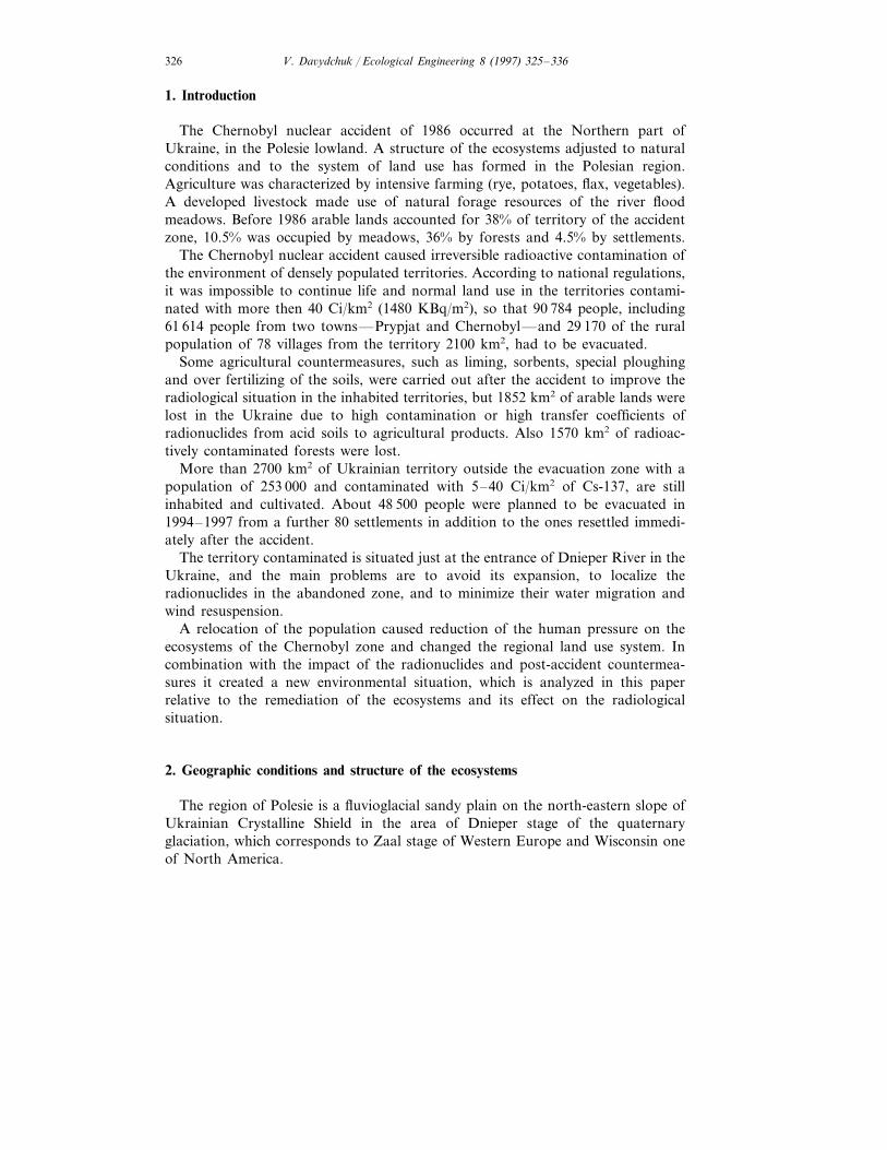
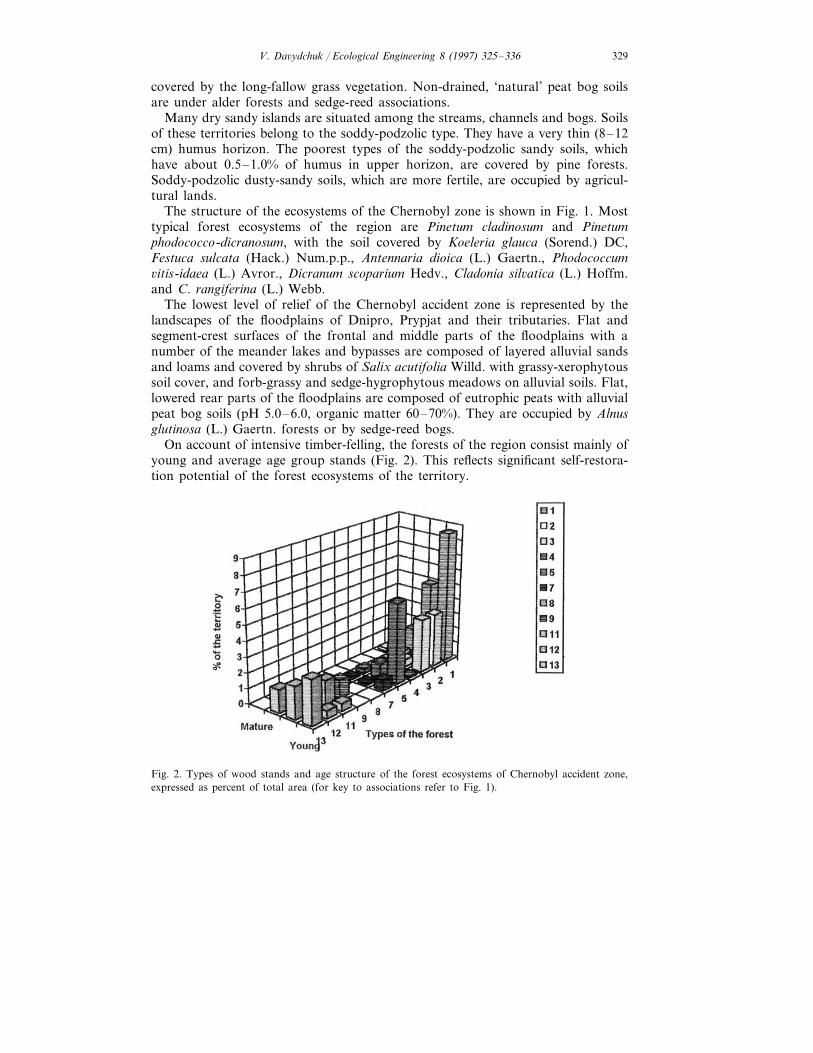
On account of intensive timber-felling, the forests of the region consist mainly ofyoung and average age group stands (Fig. 2). This reflects significant self-restora-tion potential of the forest ecosystems of the territory.
Fig. 2. Types of wood stands and age structure of the forest ecosystems of Chernobyl accident zone,expressed as percent of total area (for key to associations refer to Fig. 1).
V. Da6ydchuk / Ecological Engineering 8 (1997) 325–336330
As Fig. 1 and Fig. 2 show, the forests of the region belong mainly to differenttypes of Pinetum, composed mainly of cultivated tree species. The total area ofPinetum in the accident zone covers more than 30.5% of the territory of theChernobyl zone, or about two-thirds of its forested lands. Part of the pine forestsof artificial origin occupy relatively fertile soils, which correspond to Querceto-Pinetum and Pineto-Carpineto-Quercetum. Their structure is likely to normalizeunder the influence of the self-restoration processes.
Peat bog soils account for 22.5% of the territory of the accident zone. Two-thirdsof the bogs were drained during the last decades before the accident, ploughed andincluded in farmland, accounting for 40% of the arable lands. The structure of thedrained and non-drained former agricultural lands is also shown in Fig. 1.
Thus, the heterogeneity of the landscape of the Chernobyl accident zone causesdiversity of land types and ecosystems and a variety of directions in the intensity ofremediation processes.
3. Post-accident countermeasures and land use changes
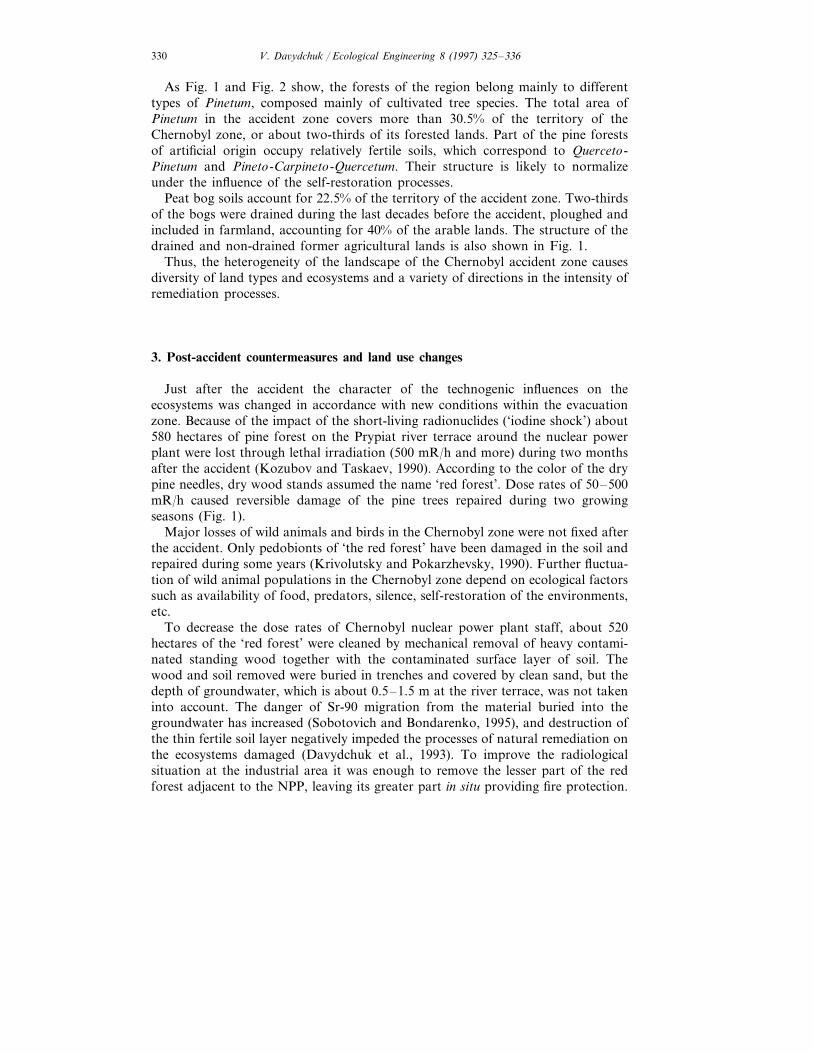
Just after the accident the character of the technogenic influences on theecosystems was changed in accordance with new conditions within the evacuationzone. Because of the impact of the short-living radionuclides (‘iodine shock’) about580 hectares of pine forest on the Prypiat river terrace around the nuclear powerplant were lost through lethal irradiation (500 mR/h and more) during two monthsafter the accident (Kozubov and Taskaev, 1990). According to the color of the drypine needles, dry wood stands assumed the name ‘red forest’. Dose rates of 50–500mR/h caused reversible damage of the pine trees repaired during two growingseasons (Fig. 1).
Major losses of wild animals and birds in the Chernobyl zone were not fixed afterthe accident. Only pedobionts of ‘the red forest’ have been damaged in the soil andrepaired during some years (Krivolutsky and Pokarzhevsky, 1990). Further fluctua-tion of wild animal populations in the Chernobyl zone depend on ecological factorssuch as availability of food, predators, silence, self-restoration of the environments,etc.
To decrease the dose rates of Chernobyl nuclear power plant staff, about 520hectares of the ‘red forest’ were cleaned by mechanical removal of heavy contami-nated standing wood together with the contaminated surface layer of soil. Thewood and soil removed were buried in trenches and covered by clean sand, but thedepth of groundwater, which is about 0.5–1.5 m at the river terrace, was not takeninto account. The danger of Sr-90 migration from the material buried into thegroundwater has increased (Sobotovich and Bondarenko, 1995), and destruction ofthe thin fertile soil layer negatively impeded the processes of natural remediation onthe ecosystems damaged (Davydchuk et al., 1993). To improve the radiologicalsituation at the industrial area it was enough to remove the lesser part of the redforest adjacent to the NPP, leaving its greater part in situ providing fire protection.
V. Da6ydchuk / Ecological Engineering 8 (1997) 325–336 331
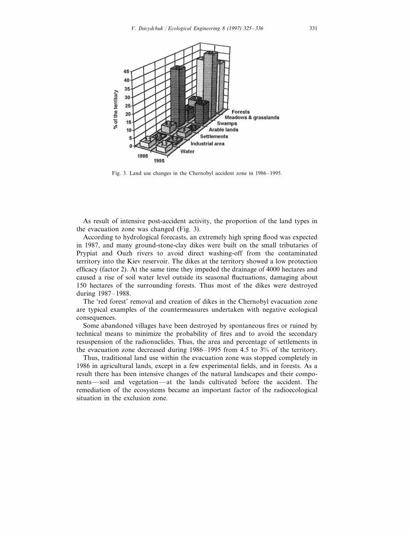
Fig. 3. Land use changes in the Chernobyl accident zone in 1986–1995.
As result of intensive post-accident activity, the proportion of the land types inthe evacuation zone was changed (Fig. 3).
According to hydrological forecasts, an extremely high spring flood was expectedin 1987, and many ground-stone-clay dikes were built on the small tributaries ofPrypiat and Ouzh rivers to avoid direct washing-off from the contaminatedterritory into the Kiev reservoir. The dikes at the territory showed a low protectionefficacy (factor 2). At the same time they impeded the drainage of 4000 hectares andcaused a rise of soil water level outside its seasonal fluctuations, damaging about150 hectares of the surrounding forests. Thus most of the dikes were destroyedduring 1987–1988.
The ‘red forest’ removal and creation of dikes in the Chernobyl evacuation zoneare typical examples of the countermeasures undertaken with negative ecologicalconsequences.
Some abandoned villages have been destroyed by spontaneous fires or ruined bytechnical means to minimize the probability of fires and to avoid the secondaryresuspension of the radionuclides. Thus, the area and percentage of settlements inthe evacuation zone decreased during 1986–1995 from 4.5 to 3% of the territory.
Thus, traditional land use within the evacuation zone was stopped completely in1986 in agricultural lands, except in a few experimental fields, and in forests. As aresult there has been intensive changes of the natural landscapes and their compo-nents—soil and vegetation—at the lands cultivated before the accident. Theremediation of the ecosystems became an important factor of the radioecologicalsituation in the exclusion zone.
V. Da6ydchuk / Ecological Engineering 8 (1997) 325–336332
4. Remediation of ecosystems
Three types of ecosystem remediation processes have taken place in the evacua-tion zone during the ten years after the accident: maintenance of the forests,artificial reforestation and spontaneous self-restoration of the natural coenoses.
Maintenance of the forests of the abandoned territory includes measures to limitforest pests and fires. Such services were established in the evacuation zone;nevertheless 500 hectares of forest were lost because of fires in 1992.
Artificial reforestation was carried out mainly in the areas of the post-accidenttechnical destruction of the soils and vegetation cover (‘red forest’, etc.). Specialbio-chemical methods of reforestation of the poor sandy soils after the removal ofthe humus horizon were applied in these areas. The method consists of the creationof an artificial polymer impermeable layer in the sand, hydroseeding of rye andgrass with fertilizers, and protection of ‘the sandwich’ by a polymer cover (Blagoevet al., 1991). Two years later pine saplings were planted into such a prepared soil.
Self-restoration of the ecosystems included spontaneous restoration of differentnatural vegetation types, depending on the soil conditions, following the chains ofthe different successions. It has occurred in the artificial forests, meadows andformer arable lands of the abandoned territory and has covered both vegetationand other elements of the ecosystems (Davydchuk and Sorokina, 1992).
The evolution of the vegetation cover on the lands which had been ploughedbefore the accident caused renewal of the natural structure and texture of soilhorizons, and chemical parameters of the soils including acidity, and content ofhumus, removal of extra nutrients, including artificial nitrogen, etc. Also a recoveryof the wild animal populations, and an increase of influence of the wild ungulateson the vegetation cover and the soil surface took place in the exclusion zone.
The model of ecosystem succession is based on fundamental deductions of foresttypology, on data of investigations of landscapes and ecosystems of the region, andon data of studies in the Chernobyl zone before and after the accident.
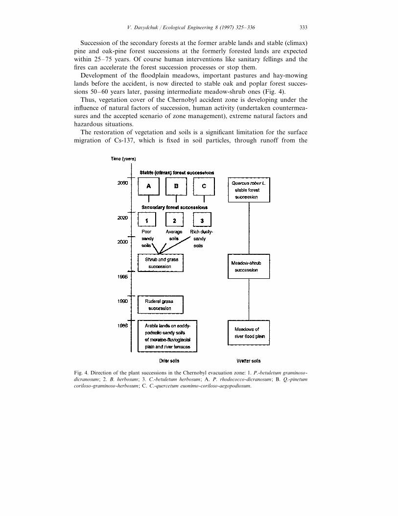
Main succession chains observed in the abandoned zone are at former arablelands with soddy-podzolic sandy soils of the fluvioglacial plains and river terracesand at meadows with alluvial sandy and loamy gleic soils of river floodplains (Fig.4).
The start of long-fallow succession on the former arable lands consisted of asegetal forb association with a predominance of Setaria glauca (L.) Beauv.,Chenopodium album L. and Erigeron canadensis L. This dominated the abandonedlands of the evacuation zone during 4 years after the accident.
Present root-graminea ruderal associations represent the second plant successionon the former arable lands of the Chernobyl zone. Its dominating species areElytrigia repens (L.) Nevski and Oenotera biennis L., with participation of Achilleamillefolium L., Crepis tectorus L., Hypericum perforatum L., Festuca o6ina L. (in dryhabitats), F. rubra L., Potentilla argentea L., etc. Tree species are spreading on thelong-fallow grasslands: pine along the edges of the forests on the dry sandy soils,birch and poplar at the wet soils of the dells and depressions.
V. Da6ydchuk / Ecological Engineering 8 (1997) 325–336 333
Succession of the secondary forests at the former arable lands and stable (climax)pine and oak-pine forest successions at the formerly forested lands are expectedwithin 25–75 years. Of course human interventions like sanitary fellings and thefires can accelerate the forest succession processes or stop them.
Development of the floodplain meadows, important pastures and hay-mowinglands before the accident, is now directed to stable oak and poplar forest succes-sions 50–60 years later, passing intermediate meadow-shrub ones (Fig. 4).
Thus, vegetation cover of the Chernobyl accident zone is developing under theinfluence of natural factors of succession, human activity (undertaken countermea-sures and the accepted scenario of zone management), extreme natural factors andhazardous situations.
The restoration of vegetation and soils is a significant limitation for the surfacemigration of Cs-137, which is fixed in soil particles, through runoff from the
Fig. 4. Direction of the plant successions in the Chernobyl evacuation zone: 1. P.-betuletum graminoso-dicranosum ; 2. B. herbosum ; 3. C.-betuletum herbosum ; A. P. rhodococco-dicranosum ; B. Q.-pinetumcoriloso-graminoso-herbosum ; C. C.-quercetum euonimo-coriloso-aegopodiosum.
V. Da6ydchuk / Ecological Engineering 8 (1997) 325–336334
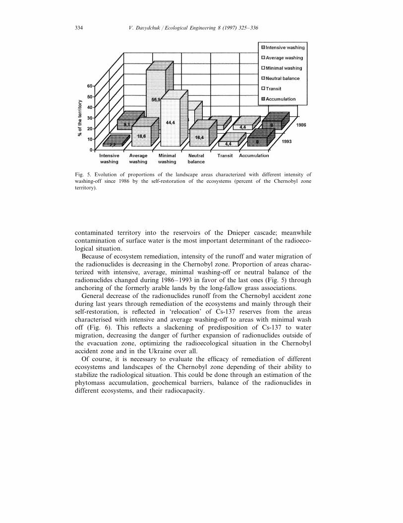
Fig. 5. Evolution of proportions of the landscape areas characterized with different intensity ofwashing-off since 1986 by the self-restoration of the ecosystems (percent of the Chernobyl zoneterritory).
contaminated territory into the reservoirs of the Dnieper cascade; meanwhilecontamination of surface water is the most important determinant of the radioeco-logical situation.
Because of ecosystem remediation, intensity of the runoff and water migration ofthe radionuclides is decreasing in the Chernobyl zone. Proportion of areas charac-terized with intensive, average, minimal washing-off or neutral balance of theradionuclides changed during 1986–1993 in favor of the last ones (Fig. 5) throughanchoring of the formerly arable lands by the long-fallow grass associations.
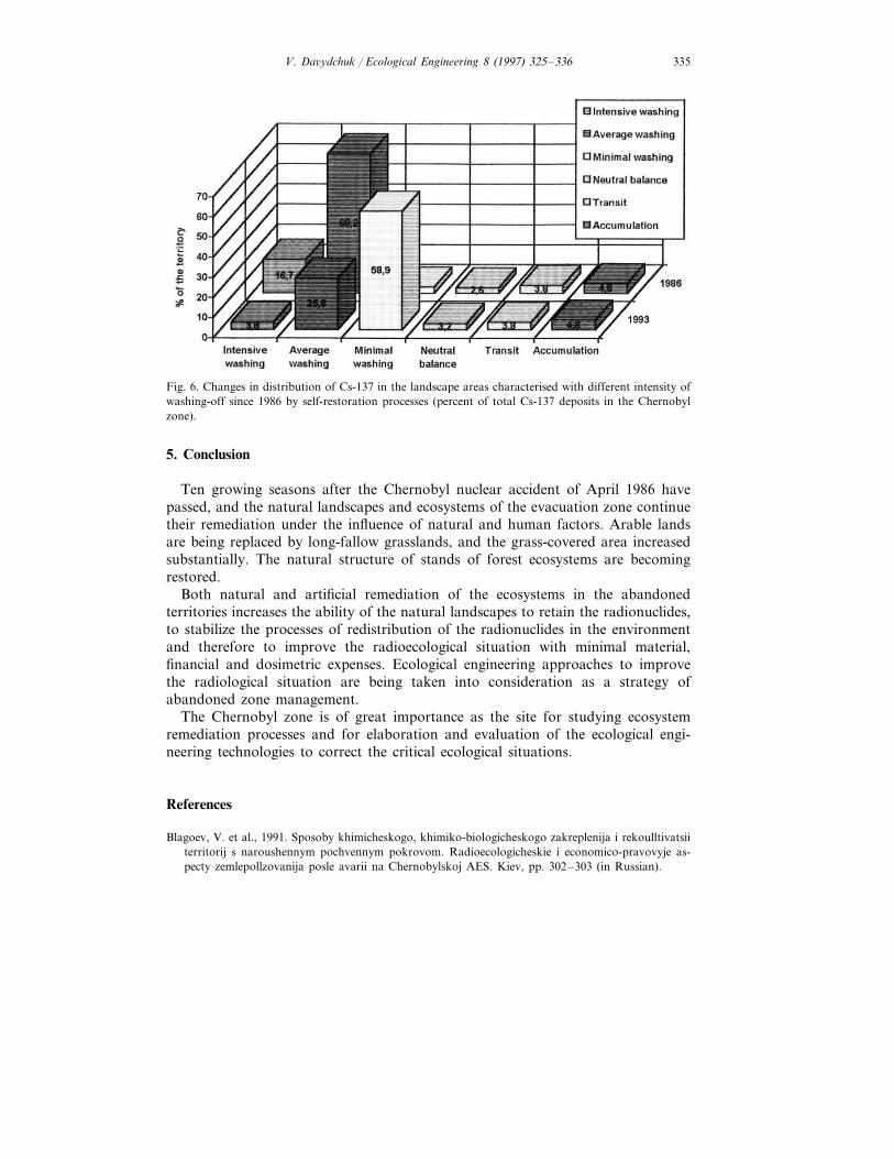
General decrease of the radionuclides runoff from the Chernobyl accident zoneduring last years through remediation of the ecosystems and mainly through theirself-restoration, is reflected in ‘relocation’ of Cs-137 reserves from the areascharacterised with intensive and average washing-off to areas with minimal washoff (Fig. 6). This reflects a slackening of predisposition of Cs-137 to watermigration, decreasing the danger of further expansion of radionuclides outside ofthe evacuation zone, optimizing the radioecological situation in the Chernobylaccident zone and in the Ukraine over all.
Of course, it is necessary to evaluate the efficacy of remediation of differentecosystems and landscapes of the Chernobyl zone depending of their ability tostabilize the radiological situation. This could be done through an estimation of thephytomass accumulation, geochemical barriers, balance of the radionuclides indifferent ecosystems, and their radiocapacity.
V. Da6ydchuk / Ecological Engineering 8 (1997) 325–336 335
Fig. 6. Changes in distribution of Cs-137 in the landscape areas characterised with different intensity ofwashing-off since 1986 by self-restoration processes (percent of total Cs-137 deposits in the Chernobylzone).
5. Conclusion
Ten growing seasons after the Chernobyl nuclear accident of April 1986 havepassed, and the natural landscapes and ecosystems of the evacuation zone continuetheir remediation under the influence of natural and human factors. Arable landsare being replaced by long-fallow grasslands, and the grass-covered area increasedsubstantially. The natural structure of stands of forest ecosystems are becomingrestored.
Both natural and artificial remediation of the ecosystems in the abandonedterritories increases the ability of the natural landscapes to retain the radionuclides,to stabilize the processes of redistribution of the radionuclides in the environmentand therefore to improve the radioecological situation with minimal material,financial and dosimetric expenses. Ecological engineering approaches to improvethe radiological situation are being taken into consideration as a strategy ofabandoned zone management.
The Chernobyl zone is of great importance as the site for studying ecosystemremediation processes and for elaboration and evaluation of the ecological engi-neering technologies to correct the critical ecological situations.
References
Blagoev, V. et al., 1991. Sposoby khimicheskogo, khimiko-biologicheskogo zakreplenija i rekoulltivatsiiterritorij s naroushennym pochvennym pokrovom. Radioecologicheskie i economico-pravovyje as-pecty zemlepollzovanija posle avarii na Chernobylskoj AES. Kiev, pp. 302–303 (in Russian).
V. Da6ydchuk / Ecological Engineering 8 (1997) 325–336336
Davydchuk, V., Sorokina, L.,1992. Land use problems in Chernobyl accident zone. In: Comparisons ofLandscape Pattern Dynamics in European Rural Areas. 1991 Semin., EUROMAB ResearchProgram, pp. 70–73.
Davydchuk, V., Rudenko, L, Fascevskij, N. et al., 1993. Das kernkraftwerksungluck von Tschernobyl.Geographishe aspekte der folgen in der Ukraine. Europa Regional, 1, z.31–37.
Davydchuk, V., Zaroudna, R., Mikheli, S. et al. (Eds.), 1994. Landshafty Chernobylskoj zony i ikhotsenka po uslovijam migracii radionuclidov. Kiev, Naukova Doumka, 112 pp. (in Russian, withEnglish abstract).
Kozubov, G., Taskaev, A. (Eds.), 1990. Radiacionnoye vozdejstvie na khvojnye lesa v zone avarii naChernobylskoj AES. Syktyvkar, 136 pp. (in Russian).
Krivolutsky, D., Pokarzhevsky, A., 1990. Izmenenija v populjazii pochvennoy fauny, vyzvannyje avarieyna Chernobylskoj AES. In: Biologicheskie i Radiobiologicheskie Aspekty Posledstviy Avarii naChAES: I Mezhdunarodnaja Konferenzija, Zeleny Mys, p. 78 (in Russian).
Sobotovich, E., Bondarenko, G., 1995. Analiz effektivnosti prirodookhrannykh meroprijatij. In: Cher-nobylskaja Katastrofa. Kiev, Naukova Doumka, pp. 338–345 (in Russian.)
.