eaves green link road, chorley, lancashire · eaves green link road, chorley, lancashire ... based...
TRANSCRIPT

EAVES GREENLINK ROAD,CHORLEY,Lancashire
Archaeological Post-Excavation Analysis
Oxford Archaeology North
November 2008
Lancashire County Council
Issue No: 2007-8/772OA North Job No: L9936NGR: SD 5864 1584
Document Title: EAVES GREEN LINK ROAD, CHORLEY, LANCASHIRE
Document Type: Post-Excavation Analysis
Client Name: Lancashire County Council
Issue Number: 2007-8/772OA North Job Number: L9936
National Grid Reference: SD 5864 1584
Prepared by: Chris HealeyPosition: Project OfficerDate: November 2008
Checked by: Emily Mercer Signed…………………….Position: Senior Project ManagerDate: November 2008
Approved by: Rachel Newman Signed…………………….Position: DirectorDate: November 2008
Oxford Archaeology North © Oxford Archaeological Unit Ltd (2008)Storey Institute Janus HouseMeeting House Lane Osney MeadLancaster OxfordLA1 1TF OX2 0EAt: (0044) 01524 848666 t: (0044) 01865 263800 f: (0044) 01524 848606 f: (0044) 01865 793496
w: www.oxfordarch.co.uke: [email protected]
Oxford Archaeological Unit Limited is a Registered Charity No: 285627
Disclaimer:This document has been prepared for the titled project or named part thereof and should not be relied upon or used for any otherproject without an independent check being carried out as to its suitability and prior written authority of Oxford Archaeologybeing obtained. Oxford Archaeology accepts no responsibility or liability for the consequences of this document being used for apurpose other than the purposes for which it was commissioned. Any person/party using or relying on the document for suchother purposes agrees, and will by such use or reliance be taken to confirm their agreement to indemnify Oxford Archaeology forall loss or damage resulting therefrom. Oxford Archaeology accepts no responsibility or liability for this document to any partyother than the person/party by whom it was commissioned.
Eaves Green Link Road, Chorley: Post-Excavation Analysis 1
For the use of Lancashire County Council © OA North: November2008
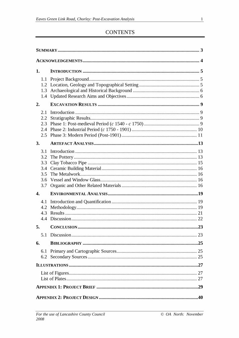
CONTENTS
SUMMARY................................................................................................................. 3
ACKNOWLEDGEMENTS............................................................................................. 4
1. INTRODUCTION ............................................................................................. 5
1.1 Project Background........................................................................................ 51.2 Location, Geology and Topographical Setting ................................................ 51.3 Archaeological and Historical Background ..................................................... 61.4 Updated Research Aims and Objectives .......................................................... 6
2. EXCAVATION RESULTS ................................................................................. 9
2.1 Introduction ................................................................................................... 92.2 Stratigraphic Results....................................................................................... 92.3 Phase 1: Post-medieval Period (c 1540 - c 1750) ............................................ 92.4 Phase 2: Industrial Period (c 1750 - 1901) .................................................... 102.5 Phase 3: Modern Period (Post-1901) ............................................................ 11
3. ARTEFACT ANALYSIS...................................................................................13
3.1 Introduction ................................................................................................. 133.2 The Pottery .................................................................................................. 133.3 Clay Tobacco Pipe ....................................................................................... 153.4 Ceramic Building Material............................................................................ 163.5 The Metalwork............................................................................................. 163.6 Vessel and Window Glass............................................................................. 163.7 Organic and Other Related Materials ............................................................ 16
4. ENVIRONMENTAL ANALYSIS........................................................................19
4.1 Introduction and Quantification .................................................................... 194.2 Methodology................................................................................................ 194.3 Results ......................................................................................................... 214.4 Discussion.................................................................................................... 22
5. CONCLUSION................................................................................................23
5.1 Discussion.................................................................................................... 23
6. BIBLIOGRAPHY ............................................................................................25
6.1 Primary and Cartographic Sources................................................................ 256.2 Secondary Sources ....................................................................................... 25
ILLUSTRATIONS .......................................................................................................27
List of Figures...................................................................................................... 27List of Plates........................................................................................................ 27
APPENDIX 1: PROJECT BRIEF .................................................................................29
APPENDIX 2: PROJECT DESIGN ...............................................................................40
Eaves Green Link Road, Chorley: Post-Excavation Analysis 2
For the use of Lancashire County Council © OA North: November2008
Eaves Green Link Road, Chorley: Post-Excavation Analysis 3
For the use of Lancashire County Council © OA North: November2008
SUMMARY
The line of a proposed new road, known as the Eaves Green Link Road, linking the A6to Lower Burgh Way, on the southern fringe of the town of Chorley, Lancashire(centred on NGR SD 5864 1584), crosses an area to the immediate south of thehistoric town which is known to contain buried archaeological remains of post-medieval date, from the period at which the town underwent rapid industrialexpansion. Whilst Chorley’s industrial heritage is widely acknowledged, thebackground and the more immediate circumstances by which industry came to playsuch a prominent role in the town’s history have remained more elusive. Thearchaeological remains were, therefore, perceived to be of importance in relation to thetown’s history and development.
Planning permission was granted for the development of the Eaves Green Link Road,but with an archaeological condition requiring the implementation of a programme ofarchaeological investigation. The first stage in this process was an archaeological desk-based assessment, undertaken by OA North (then Lancaster University ArchaeologicalUnit) in 1996. This was followed by a geophysical survey, undertaken by GeoquestAssociates (2000), and a programme of archaeological evaluation trenchingundertaken by Earthworks Archaeological Services (2000). The results obtained fromthese assessments identified two areas in particular where significant in situarchaeological remains could potentially survive. In mitigation of the development, itwas recommended that these areas merited further, more detailed, investigation inadvance of construction work.
The two areas outlined were targeted by the excavation programme during Septemberand October 2006. The first area examined the northern end of an earthwork thoughtto be a head-race associated with Duxbury Mill, near to where it was diverted via aweir from the western bank of the River Yarrow. Excavation revealed that the featurehad been obscured beneath significant levels of backfilling dating to the late nineteenthand twentieth centuries, below which waterlogged silt deposits survived. A secondtrench examined the same head-race as it travelled downhill towards the site of themill, in an area where the feature appeared to survive in a condition easily recognisableas an earthwork above ground. Excavation in this area showed that the race had beenconsolidated along its southern side with a low stone wall, and that nineteenth-centuryupcast from maintenance of the race formed a bank on the southern side.
A post-excavation assessment (OA North 2007) examined the results of theexcavations, and assessed the potential for further analysis of each category of data inaccordance with the project’s research aims. The process was designed to correspondto the objectives laid out in the guidance document Management of ArchaeologicalProjects, second edition (MAP 2; English Heritage 1991). The assessmentdemonstrated that the dataset had some potential for further analysis, and thisdocument presents the results of this programme of analysis.
Eaves Green Link Road, Chorley: Post-Excavation Analysis 4
For the use of Lancashire County Council © OA North: November2008
ACKNOWLEDGEMENTS
Oxford Archaeology North (OA North) wishes to thank Wai Kee Leung of LancashireCounty Council for commissioning the work, and Peter Iles of Lancashire CountyArchaeology Service (LCAS) for advice and support during the programme ofarchaeological investigation associated with the Eaves Green Link Road Project.
The specialist work was undertaken in-house by Christine Howard-Davis (findsspecialist) and Sandra Bonsall (environmentalist). This report was prepared by ChrisHealey, and the illustrations were produced by Anne Stewardson. The project wasmanaged by Emily Mercer and Mark Brennand. This report was edited by EmilyMercer.
Eaves Green Link Road, Chorley: Post-Excavation Analysis 5
For the use of Lancashire County Council © OA North: November2008
1. INTRODUCTION
1.1 PROJECT BACKGROUND
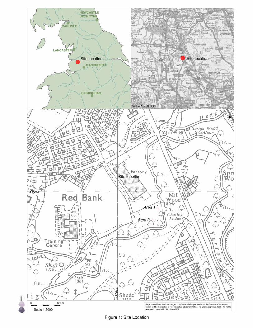
1.1.1 The development of residential areas by Lancashire County Council (LCC), tothe south and south-west of Chorley, Lancashire, necessitated the constructionof a new link road through park- and woodland to join the A6, Bolton Road, toLower Burgh Way (centred on NGR SD 5864 1584; Fig 1). From the results ofearlier archaeological work, it was clear that the construction programme waslikely to have a negative impact on buried remains. Consequently, LCCconsulted with Lancashire County Archaeology Service (LCAS), which advisedthat an archaeological condition be attached to the planning consent for thedevelopment, and a formal brief (Appendix 1) detailing requisite archaeologicalworks was issued.
1.1.2 In the first instance, a desk-based assessment of the development area wasundertaken by the Lancaster University Archaeological Unit (LUAU 1996),now OA North. Subsequent evaluation trenching (Earthworks ArchaeologicalServices 2000) and geophysical survey (Geoquest Associates 2000) concludedthat significant archaeological remains were likely to be present within twoareas of the development (Areas 1 and 2, Fig 1). Therefore, in mitigation of thedevelopment, the areas required archaeological excavation in order to preserveany archaeological remains by record, in accordance with PPG 16 (DoE 1990).The work was intended to allow the recovery of a full record of the depositsidentified within the millrace. However, excavation revealed that archaeologicaldeposits had largely been removed by nineteenth- and twentieth-centuryactivity over much of the site, and although environmental samples potentiallyrepresenting earlier material were recovered, these did not produce any datingevidence (OA North 2007).
1.1.3 Post-excavation assessment of the primary stratigraphic records established arelatively brief and uncomplicated sequence of activity on the site from thepost-medieval period (1540-1750) onwards (ibid). Assessment of theartefactual assemblages recovered from stratified deposits on the site furtherconcluded that these were relatively modern (1900-present) in character. Whilstthe archaeological and historical background to the project is covered in thepost-excavation assessment (OA North 2007), a summary is provided in thisreport (Section 1.3) to contextualise the results of the analytical phase of theproject.
1.2 LOCATION, GEOLOGY AND TOPOGRAPHICAL SETTING
1.2.1 The town of Chorley lies close to the southern boundary of the modern countyof Lancashire, and is situated on the western bank of the River Yarrow, atributary of the River Ribble. The development site, in an area known as EavesGreen, covered a ribbon of land some 1.35km long, on the southern fringe ofthe town (Fig 1). Eaves Green occupies part of the former township ofDuxbury, in the parish of Standish (Farrer and Brownbill 1911, 182-3; 208-13).
Eaves Green Link Road, Chorley: Post-Excavation Analysis 6
For the use of Lancashire County Council © OA North: November2008
In 1911 the township contained no village or hamlet, and a third of the areawas occupied by the parks of Duxbury and Ellerbeck (op cit, 208).
1.2.2 The geology forms part of the Lancashire Coal Measures, with prevalent coalseams in the area exploited by the Duxbury Colliery (LUAU 1996, 7).Overlying drift geology consists predominantly of boulder clay, withglaciofluvial deposits along the course of the River Yarrow (Ordnance SurveyGeological Survey 1971; Countryside Commission 1998, 128).
1.2.3 The environs of the excavation areas are dominated by the River Yarrow,which is enclosed by an ancient deciduous woodland. The course of the riverwas altered by at least the eighteenth century, with the introduction of a sluiceand weir arrangement. Away from the riverside to the west, ground levels mayalso have been altered during the late nineteenth and twentieth centuries byindustrial coal exploitation (Earthworks Archaeological Services 2000, 10).Further to the north and north-west, the ground rises steeply from the formerriver bank, although this natural slope is also suggested to have been alteredsubstantially in places since the Second World War (ibid).
1.3 ARCHAEOLOGICAL AND HISTORICAL BACKGROUND
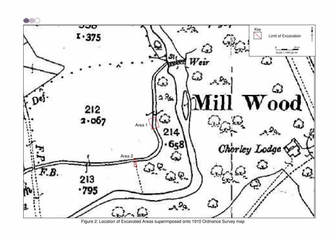
1.3.1 A corn mill in Duxbury is first mentioned in 1354 (op cit, 28), although somesources believe it to have been much earlier (ibid). A cluster of houses shownaround the old Yarrow Bridge on an estate map of 1757 (LRO DDRf 11/1),and then Yates’s map of 1786, were not depicted in 1843 (LRO DRB/1/68).The mill itself appears to be shown on Yates’s map with a water-wheel symbol,and had passed from the Duxbury to the Standish families, the local estateowners, in the early 1700s (Farrer and Brownbill 1911, 209). Management ofthe mill and race was operated by various lessees and owners throughout theeighteenth and nineteenth centuries, until its conversion to steam power early inthe twentieth century, and it continued to be shown on maps throughout thenineteenth century (Fig 2). The mill buildings and race fell into disuse shortlyafterwards, and the mill had become ruinous by 1910 (EarthworksArchaeological Services 2000, 32; Fig 3).
1.4 UPDATED RESEARCH AIMS AND OBJECTIVES
1.4.1 Following the guidance of English Heritage (nd, 2-3), the original project aimswere updated in light of the post-excavation assessment (OA North 2007).Although the majority of the original aims of the fieldwork were still valid, theywere updated, with new aims and objectives derived from the statement ofpotential set out in the post-excavation assessment (ibid). The analysis outlinedin the updated project design (Appendix 2), included as part of the post-excavation assessment, has two primary objectives: to add to the archaeologicalknowledge in the areas prioritised by the original fieldwork aims; and tounderstand how people lived in Lancashire in the past.
1.4.2 The updated research aims considered the following:
• chronological and morphological development of the site;
Eaves Green Link Road, Chorley: Post-Excavation Analysis 7
For the use of Lancashire County Council © OA North: November2008
• daily life on the site in the post-medieval period, including diet, pastimes,costume and personal adornment;
• processes of change, particularly in terms of water-powered industry, andchanges brought about by the advent of new industry into the area;
• the economy of the industrialised later post-medieval period in this part ofChorley, including the development of industries, and especially the useand management of the millrace;
• the character of occupation during industrialisation, particularly thepollution of watercourses.
1.4.3 The data from the excavation were potentially capable of addressing a numberof issues raised by the regional Research Agenda for the post-medieval period,including the urgent need to recover good palaeoenvironmental data fromfeatures of late eighteenth- to nineteenth-century date, in order to studyagricultural advances and contemporary crop cultivation, with particularreference to the type of species (Newman and McNeil 2007a; 2007b). Theexcavation of the silt deposit at the lowest levels of the millrace channel in Area1 allowed this issue to be addressed during the course of the analytical phase ofthe post-excavation programme.
1.4.4 The Research Agenda also highlights the need to retain and analyse collectionsof artefacts from features and deposits of this date (Newman and McNeil2007b). The development of watermill sites, such as that at Duxbury, is alsopoorly understood at present, with mills dating from before the IndustrialRevolution (the late eighteenth century onwards) thus far only having beensubject to documentary and standing building investigation (op cit, 11). Thesequence of deposits and the artefactual and environmental datasets recoveredfrom both excavation areas have the potential to contribute to theunderstanding of the use and development of water power from the eighteenthto the twentieth centuries.

Eaves Green Link Road, Chorley: Post-Excavation Analysis 8
For the use of Lancashire County Council © OA North: November2008
Eaves Green Link Road, Chorley: Post-Excavation Analysis 9
For the use of Lancashire County Council © OA North: November2008
2. EXCAVATION RESULTS
2.1 INTRODUCTION
2.1.1 The stratigraphic data recovered from the excavation were not complex. Thebroad stratigraphic framework identified during the assessment was refined toform a descriptive text which was further refined in the light of the artefactualanalysis (see Section 3). A site database was compiled, and in the course of thisanalysis, the site matrices were redrawn to conform to the amended phasing.Similarly, phase plans and sections were slightly revised in the light of fullanalysis.
2.1.2 The results from the analysis of post-medieval and later features from the siteare discussed and interpreted within their historical and archaeological context.The discussion also incorporates the reports on the various classes of findswithin the stratigraphic analysis.
2.2 STRATIGRAPHIC RESULTS
2.2.1 The earliest strata encountered during excavation were geologically naturaldeposits. These comprised compact glaciofluvial drift deposits of sands of theNewport 1 Association, above scree and bare rock belonging to the BelmontAssociation (Hall and Folland 1970, 44-7).
2.2.2 Archaeological remains from the medieval period (c 1066-c 1540) and earlierwere not represented within either the artefactual assemblage or theenvironmental data (see Sections 3 and 4). Indeed, the remains of the millracerecorded during the excavation appeared to represent activity that was post-medieval (c 1540-c 1750) in date at the earliest. The creation of the millraceseems to have involved the cutting of a channel and construction of revetmentsand banks on either side of that channel. It appears that this activity did notoccur uniformly, and there were as many contrasts as comparisons between thetwo areas excavated. In Area 1, a stony surface and part of an associatedwooden sluice were located at the base of a deeply stratified sequence of siltsand dumped backfill deposits within a wide channel (Fig 4). In Area 2, however,a stone revetment was recorded on one side of a relatively shallow and narrowchannel (Fig 5). The source of much of the dumped and silt deposits appears tohave been an early twentieth-century filter-bed, the effluent channel for whichcut into the side of the millrace in Area 1. The present-day above-groundappearance of a relatively level ground surface concealed the varied naturaltopography beneath a series of dumped deposits, backfill deposits, silting andcollapsed earthwork features.
2.3 PHASE 1: POST-MEDIEVAL PERIOD (C 1540 - C 1750)
2.3.1 The excavation of the extant channel appears to have occurred no later than theearly eighteenth century. However, it was not possible to date either thedeposits or the structural components closely within this phase.
Eaves Green Link Road, Chorley: Post-Excavation Analysis 10
For the use of Lancashire County Council © OA North: November2008
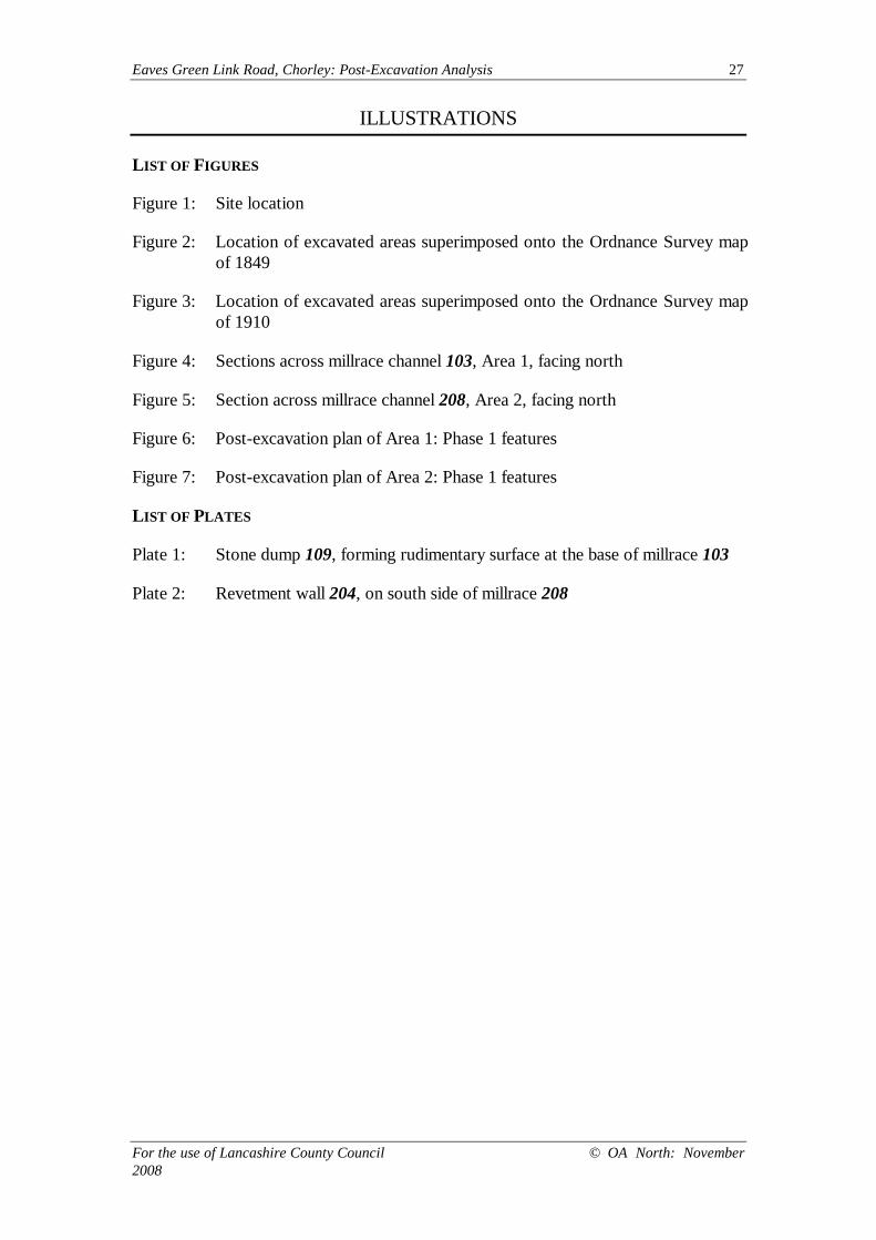
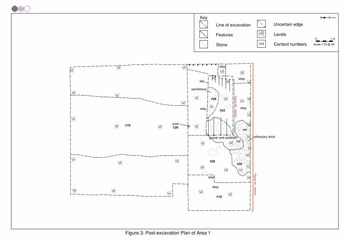
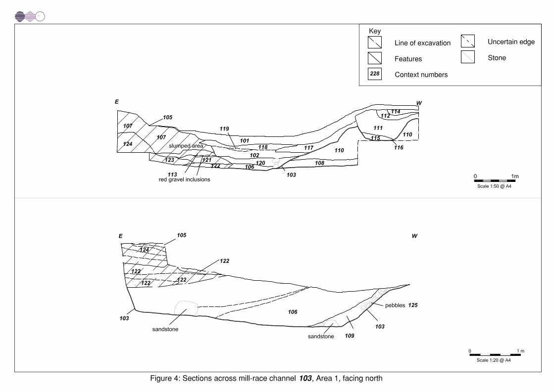
2.3.2 A channel (103), presumably the head-race, was recorded cutting through thenatural geology (110) in Area 1 (Figs 6 and 7). It was aligned approximatelynorth-west/south-east, with an approximate width of 6.25m, an approximatedepth of 2.03m, and a length exceeding 3.5m. Sandstone blocks and pebbles(109), showing no evidence of having been worked, formed a rudimentarysurface across the base of the channel (Plate 1). A single preserved woodenpost (126) on the southern side of the channel may have formed part of a sluiceacross the channel or race, although no further traces of such a structure wererecorded. The primary fill within the channel comprised an 0.45m deep layer ofsilt (106; Fig 4), which did not contain any artefacts.
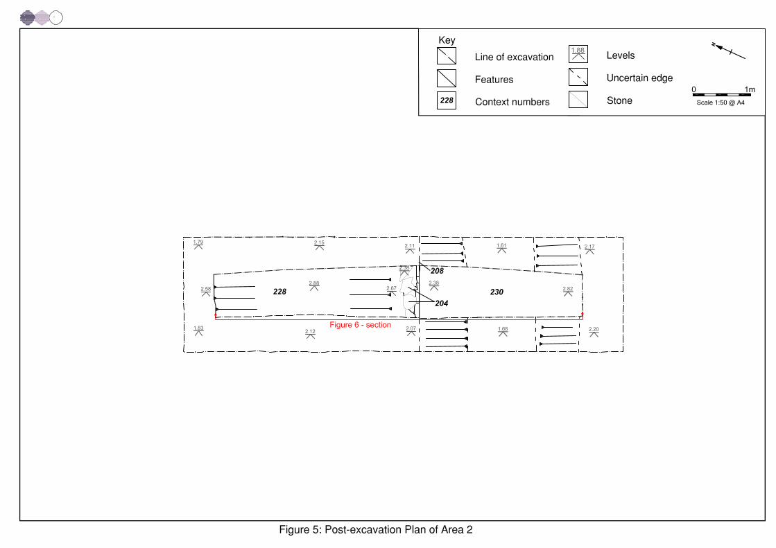
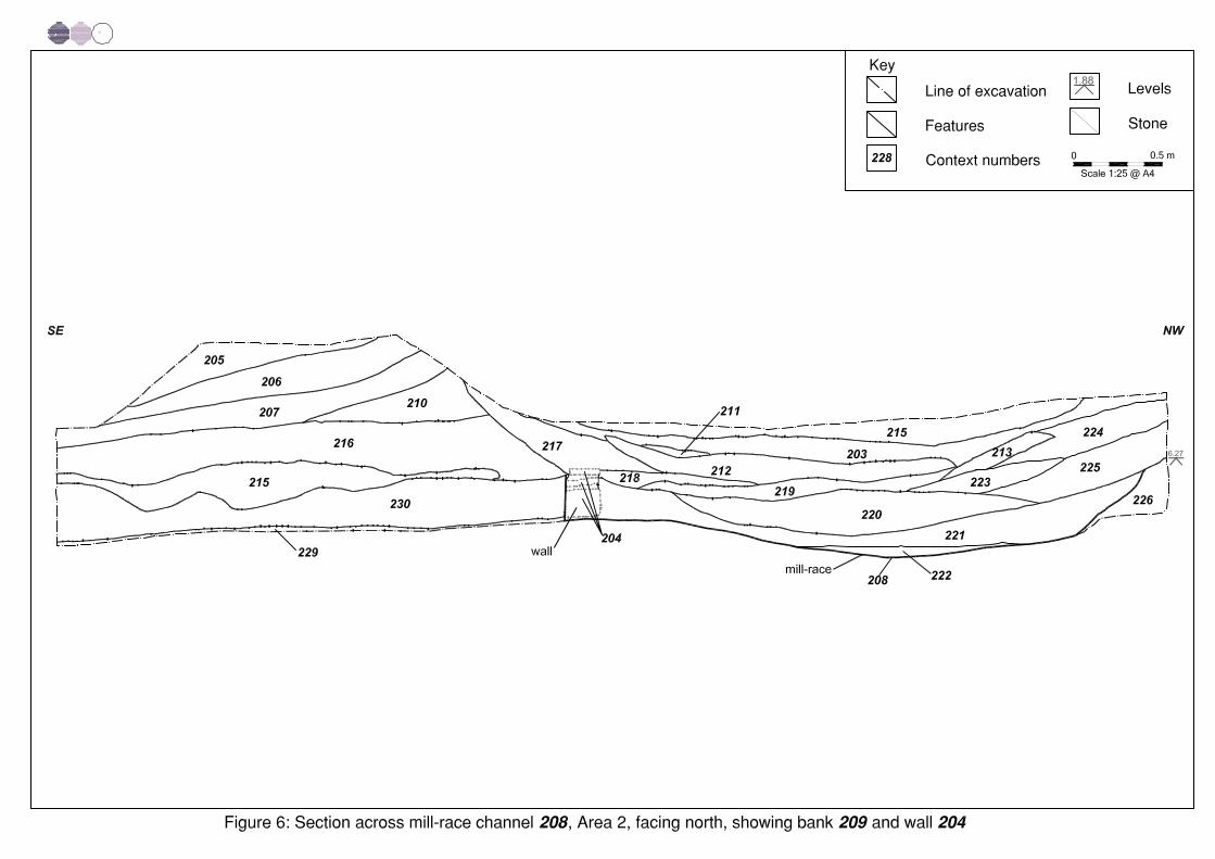
2.3.3 Within Area 2, the millrace was represented by a channel (208) on anapproximate east/west alignment, cut into natural sandy-loam (230; Fig 7).Beneath this was a layer of weathered sands and gravels (229), which in turnoverlay a natural sand and gravel deposit (228). This feature was approximately3.4m wide, approximately 0.21m deep and at least 2m in length, and thusdiffered in dimensions from that found in Area 1. Its correlation withcartographic evidence for the millrace makes this interpretation fairly certain,however.
2.4 PHASE 2: INDUSTRIAL PERIOD (C 1750 - 1901)
2.4.1 In Area 2, a stretch of irregularly coursed, unbonded, stone revetment wall(204) was recorded along the southern side of channel 208 (Fig 5, Plate 2),comprising rough-cut blocks and thin slabs of sandstone. The wall survived to aheight of 0.27m, a width of 0.2m and a minimum length of 1m.
2.4.2 On the southern side of channel 208, a series of deposits (from the top, 205,206, 207, 210, 215 and 216) formed an earthen bank (209), which containednineteenth-century artefacts (Fig 5). A similar earthwork was not visible on thenorthern side of the channel, and it would appear that either there was never abank on this side, or that it had been entirely eroded or deliberately removed.The latter scenario would seem unlikely given the survival of the southern bank(209). The material overlying the base of channel 208 (220, 221 and 222)appeared to be waterborne silt deposits. These were overlain by layers thatappeared to have formed by erosion of the soils from the northern side of thechannel (223 and 225, and then 213 and 224).
2.4.3 Prior to the excavation, along the eastern side of Area 1, an earthen bank (105)could clearly be seen, on an approximate north/south alignment (Fig 4).Excavation revealed that this earthwork comprised a 1.45m deep sequence offive gravel-rich sand deposits (113, 121, 122, 123 and 124), over which was asingle sandy-clay deposit (107). These overlay the silt deposit (106) whichfilled the lower part of the channel (103), and artefactual evidence wouldindicate a mid-nineteenth-century date for the latest of the deposits (107). Thisearthen bank did not appear to have been contemporary with the cut forchannel 103, and it may have represented activity associated with theconstruction, or subsequent decommissioning, of the culvert shown on the1849 Ordnance Survey map (Fig 2). In the centre of the channel (103), a
Eaves Green Link Road, Chorley: Post-Excavation Analysis 11
For the use of Lancashire County Council © OA North: November2008
sequence of brightly coloured gravel-rich deposits (102, 118, 119, and 120)and slumped sandy loam (117) were recorded, overlain by topsoil (101).
2.5 PHASE 3: MODERN PERIOD (POST-1901)
2.5.1 An irregularly shaped channel (116) was recorded in Area 1 (Fig 4), cutting thedeposit of slumped sandy-loam (117). This channel followed an approximatelyeast/west alignment, and was filled with a series of mixed gravel-rich deposits(from the top, 114, 112, 111 and 115). Investigation of the ground surface tothe west of Area 1 revealed a linear depression, lying on an approximatewestward alignment from the point at which this channel entered the Area 1excavation, turning towards the north-west and then disappearing. The positionof this depression seemed to correspond to the surveyed position of a channelleading to ‘filter beds’, or a coal-wash (K Sweeney pers comm), and the basalfill (115) of the channel, a compact coal-rich deposit, also suggests this use.The two deposits (111 and 112) above deposit 115 were likely to representdeliberate backfilling of this channel, whilst the uppermost deposit (114)appeared to be redeposited natural sandy-loam (Fig 4).
2.5.2 In Area 2, a succession of lenses and more substantial fills appeared to haveaccumulated in the uppermost part of channel 208. In order of deposition, therecorded fills were 219, 218, 217, 212, 211, 203 and 202 (Fig 5), and only oneof these (217) appeared to represent a slump of bank material into channel 208,the rest representing gradual sedimentation of the millrace after maintenanceceased.
2.5.3 Layers of topsoil were recorded in both excavation areas (101 in Area 1, and201 in Area 2), sealing the archaeological features and deposits. These topsoillayers appeared to have been laid down in the last 50 years, and while deposit101 was approximately 0.4m thick, in Area 2 the topsoil was only 0.1m thick.
Eaves Green Link Road, Chorley: Post-Excavation Analysis 12
For the use of Lancashire County Council © OA North: November2008
Eaves Green Link Road, Chorley: Post-Excavation Analysis 13
For the use of Lancashire County Council © OA North: November2008
3. ARTEFACT ANALYSIS
3.1 INTRODUCTION
3.1.1 Based on the assessment of the individual groups of artefacts retrieved from theexcavation (OA North 2007), it was possible to analyse each group further inlight of the updated research aims and objectives (see Section 1.4).
3.2 THE POTTERY
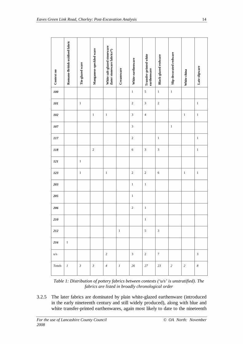
3.2.1 A small assemblage of pottery (100 fragments) was recovered from post-medieval or later deposits, comprising the millrace bank (107, 121, 205, 206,210 and 216), nineteenth- or twentieth-century silt/dump deposits (102, 114,117, 118, 203 and 212), topsoil 101, as well as unstratified material. Thecomplete assemblage was examined (Table 1), being sorted by fabric, and,where possible, vessel-types were identified. Fabrics were defined using theusual terminology for post-medieval and modern pottery (see, for instance,Cotter 2000). As the assemblage was small and, on taphonomic grounds, mostlikely to have been redeposited, the sherds were not weighed, and no estimatewas made of the minimum numbers of vessels represented. None of thematerial was illustrated.
3.2.2 The amounts from each individual context varied from single fragments (121,205 and 216) to 15 sherds (118), and the sherd size varied considerably. Manyof the sherds were small and some were badly abraded, with rounded breaks, orwere spalled, discoloured and, on occasion, heat-affected. This perhapssuggests that they had entered the archaeological record via an ash-midden, orat least as domestic waste dumped from elsewhere. In general terms, thepottery comprises a relatively homogeneous group of nineteenth- andtwentieth-century kitchen and tablewares, with only a few sherds pre-datingthis period.
3.2.3 The earliest vessel, from the millrace bank in Area 2 (216), is part of thenarrow base of a beaker or relatively small jar in a fine oxidised fabric, andappears to be of Roman date, possibly of the second or third century AD. Itsstratigraphic position, in a bank of dumped material, means that it is not onlyresidual, but need not have originated at this site.
3.2.4 The remainder of the pottery is post-medieval in date, with the earliest a smallfragment of late seventeenth- to early eighteenth-century Blackware (probablyfrom a drinking vessel) from Phase 3 fill 212. There were several very small andabraded fragments of typically eighteenth-century fabrics; tin-glazed ware, slip-decorated ware, white salt-glazed stoneware, manganese-speckled ware, andcreamware were all noted. All were from deposits associated either with themillrace bank, or with the late dumps/silts, and thus all could be imported fromelsewhere.
Eaves Green Link Road, Chorley: Post-Excavation Analysis 14
For the use of Lancashire County Council © OA North: November2008
Con
text
no
Rom
ano-
Bri
tish
oxid
ised
fabr
ic
Tin
-gla
zed
war
e
Man
gane
se-s
peck
led
war
e
Whi
te sa
lt-gl
azed
ston
ewar
e(la
ter
ston
ewar
e fa
bric
s*)
Cre
amw
are
Whi
te e
arth
enw
are
Tra
nsfe
r-pr
inte
d w
hite
eart
henw
are
Bla
ck-g
laze
d re
dwar
e
Slip
-dec
orat
ed r
edw
are
Whi
te c
hina
Lat
e sl
ipw
are
100 1 5 1 1
101 1 2 3 2 1
102 1 1 3 4 1 1
107 3 1
117 2 1 1
118 2 6 3 3 1
121 1
123 1 1 2 2 6 1 1
203 1 1
205 1
206 2 1
210 1
212 1 5 3
216 1
u/s 2 3 2 7 3
Totals 1 3 3 4 1 26 27 23 2 2 8
Table 1: Distribution of pottery fabrics between contexts (‘u/s’ is unstratified). Thefabrics are listed in broadly chronological order
3.2.5 The later fabrics are dominated by plain white-glazed earthenware (introducedin the early nineteenth century and still widely produced), along with blue andwhite transfer-printed earthenwares, again most likely to date to the nineteenth
Eaves Green Link Road, Chorley: Post-Excavation Analysis 15
For the use of Lancashire County Council © OA North: November2008
century or later. Together, these accounted for c 60% of the assemblage. Inmost cases the fragments were too small to allow the identification of vesselforms, but transfer-printed teawares were noted, and one large serving platewith a discoloured and crazed glaze suggesting that it had seen considerableuse before discard. The rim of a chamber pot was also noted (from Phase 2deposit 102), its rim painted in imitation of the ‘scratch blue’ decorationpopular in the eighteenth century (Cotter 2000, 252), but itself probably later indate. A miniature china teacup, from Phase 2 backfill deposit 123, ispresumably a toy.
3.2.6 Other fabrics were restricted to a narrow range of kitchenwares, predominantlyblack-glazed redware vessels, including storage jars and large bowls. A flat-rimmed chamber pot in a similar fabric was heavily sooted, suggesting that ithad been put to some other use, or had been included in midden rubbish (fromtopsoil 101). The few fragments of late slip-decorated redwares are also likelyto have been kitchenwares, most probably serving dishes and bowls. Theseredwares are difficult to date with precision, being practical vessels, and thusless susceptible to changing fashion. They were widely made, usually by localpotters, and in many cases production continued into the twentieth century.
3.3 CLAY TOBACCO PIPE
3.3.1 There were 27 fragments of clay tobacco pipe, recovered from topsoil 101,several of the millrace fills (Phase 2: 102, 213, 221; Phase 3: 203, 212), thesouth side of bank 105 (107, 123, 210, 215), and unstratified (100). In all, 15of the fragments were from bowls, and thus datable to some degree. Theremainder were short stem fragments, of which none were stamped, and thusthey are effectively undatable.
3.3.2 The earliest bowl came from a late deposit (Phase 2, 213) within the millrace.Dating probably to the period 1600-40, this bowl is from what is clearly asecondary deposit, and thus cannot be regarded as secure dating for the featureconcerned. Its dating does, however, reflect that of the earliest fragment ofBlackware from the site (from Phase 3, 212), and might point to some activityin the vicinity at this date. Fill 102, also within the millrace, produced laternineteenth-century forms, the latest, a plain pipe without spur, probably datingto c 1880-1900.
3.3.3 Bank 105 (Phase 2, deposit 123) produced eighteenth- and nineteenth-centurybowl forms, again suggesting a mixed deposit, presumably brought in when thebank was under construction, and thus pointing to a nineteenth-century date forits genesis. In the same feature, deposit 210 also produced a late eighteenth-century example, decorated with foliage along the line of the mould seam,although pottery from the same context points to a later date. A single bowlfrom 107, the latest in the sequence of deposits forming bank 105, can be datedto 1810-40, and possibly represents the approximate date of its completion.Unstratified material reflected the same nineteenth-century date-range.
Eaves Green Link Road, Chorley: Post-Excavation Analysis 16
For the use of Lancashire County Council © OA North: November2008
3.4 CERAMIC BUILDING MATERIAL
3.4.1 Of the five fragments of ceramic building material recovered, two fragments,from topsoil 101 and millrace fill 102, were small, abraded and undiagnostic.The remaining three fragments were from handmade bricks, and cannot bedated with precision, except to note that they are likely to be post-medieval ormore recent in date. Two fragments are from bank 209 (deposits 205 and 206)on the south side of the millrace, and are likely to have been deposited duringits construction, possibly having been brought in from elsewhere, as there wasno obvious brick structure associated with the bank. The final fragment ofhandmade brick was from 114, a fill of Phase 3 channel 108, and again is likelyto have been introduced from elsewhere.
3.5 THE METALWORK
3.5.1 Very little metalwork came from the site, and as X-ray radiography was notrecommended for the two ferrous objects recovered, on the grounds that theywere likely to be recent in date (OA North 2007), neither has been furtheridentified. The metal fittings of a bayonet-fitting electric light bulb have beennoted, and are a firm indicator that the millrace was still receiving fills in thetwentieth century.
3.6 VESSEL AND WINDOW GLASS
3.6.1 All of the small assemblage of glass (17 fragments), bar one piece, wasrecovered from the fills of the millrace. In Area 1, fills 102 and 117 (whichtogether produced 14 fragments) were attributed to Phase 2. In Area 2, fill 212(one fragment) was dated to Phase 3, but in terms of the vessels representedthere is little difference in date. There are several fragments from mould-blownembossed mineral water bottles, including an almost complete Codd bottle,bearing the name of a Chorley mineral-water producer (Tanner and Co), and aSt Helen’s manufacturer (Carrington Shaw and Co). Embossed bottles were inwidespread production from the late nineteenth century and, by 1895,approximately 75% of all glass bottles produced were embossed (Hedges 1975,23). The advent of the printed label in the early twentieth century meant thatthe production of ornately embossed vessels soon fell into decline and it isunlikely that any of the fragments is more recent than about 1930. A group ofsmall, very thin, colourless fragments from Phase 2 fill 102 are likely to be froma twentieth-century light bulb, an identification reinforced by the presence of atypical bayonet bulb fitting from the same context (see Section 3.2.11).
3.7 ORGANIC AND OTHER RELATED MATERIALS
3.7.1 In all, 89 fragments of leather were recorded. Most were in excellentcondition, being thick straps and loops, and shoe soles. Uppers, being thinnerleather, possibly tanned using a different process, were less well preserved. Thedistribution of leather is shown in Table 2.
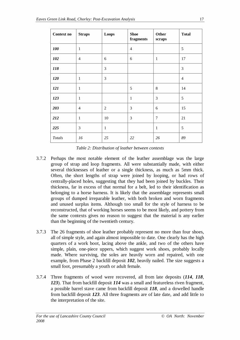
Eaves Green Link Road, Chorley: Post-Excavation Analysis 17
For the use of Lancashire County Council © OA North: November2008
Context no Straps Loops Shoefragments
Otherscraps
Total
100 1 4 5
102 4 6 6 1 17
118 3 3
120 1 3 4
121 1 5 8 14
123 1 1 3 5
203 4 2 3 6 15
212 1 10 3 7 21
225 3 1 1 5
Totals 16 25 22 26 89
Table 2: Distribution of leather between contexts
3.7.2 Perhaps the most notable element of the leather assemblage was the largegroup of strap and loop fragments. All were substantially made, with eitherseveral thicknesses of leather or a single thickness, as much as 5mm thick.Often, the short lengths of strap were joined by looping, or had rows ofcentrally-placed holes, suggesting that they had been joined by buckles. Theirthickness, far in excess of that normal for a belt, led to their identification asbelonging to a horse harness. It is likely that the assemblage represents smallgroups of dumped irreparable leather, with both broken and worn fragmentsand unused surplus items. Although too small for the style of harness to bereconstructed, that of working horses seems to be most likely, and pottery fromthe same contexts gives no reason to suggest that the material is any earlierthan the beginning of the twentieth century.
3.7.3 The 26 fragments of shoe leather probably represent no more than four shoes,all of simple style, and again almost impossible to date. One clearly has the highquarters of a work boot, lacing above the ankle, and two of the others havesimple, plain, one-piece uppers, which suggest work shoes, probably locallymade. Where surviving, the soles are heavily worn and repaired, with oneexample, from Phase 2 backfill deposit 102, heavily nailed. The size suggests asmall foot, presumably a youth or adult female.
3.7.4 Three fragments of wood were recovered, all from late deposits (114, 118,123). That from backfill deposit 114 was a small and featureless riven fragment,a possible barrel stave came from backfill deposit 118, and a dowelled handlefrom backfill deposit 123. All three fragments are of late date, and add little tothe interpretation of the site.
Eaves Green Link Road, Chorley: Post-Excavation Analysis 18
For the use of Lancashire County Council © OA North: November2008
3.7.5 The organic material also included a rubber or composition ball from latesilt/dump deposit 212, which is of twentieth-century date, as were twofragments of textile-backed (tyre) rubber from backfill deposit 120, again a latedeposit.
Eaves Green Link Road, Chorley: Post-Excavation Analysis 19
For the use of Lancashire County Council © OA North: November2008
4. ENVIRONMENTAL ANALYSIS
4.1 INTRODUCTION AND QUANTIFICATION
4.1.1 Following the assessment of a single bulk sample taken from the primary fill(106) of the millrace, it was recommended that further analysis of the plantremains should take place, to investigate the economy of the site and the localenvironment. One ten litre bulk sample from silt deposit 106 was thereforeprocessed for the analysis of waterlogged and charred plant remains.
4.2 METHODOLOGY
4.2.1 The sample was processed by hand-flotation and the flots collected on a 250micron mesh and air-dried. The flots were examined with a Leica MZ6binocular microscope, and charred and waterlogged remains were identifiedand quantified. Identification was aided by Stace (2001), Cappers et al (2006),and by comparison with the modern reference collection held at OA North(some modern seeds were supplied by the Hohenheim Botanic Gardens,Stuttgart). Plant nomenclature follows Stace (2001).
4.2.2 The results of the analysis are shown in Table 3, where the charred plantremains are given as actual counts. Waterlogged and other remains arerecorded on a scale of 1-5, where 1 is rare (less than five items in ten litres ofsample), and 5 is abundant (more than 100 items in one litre of sample). All thewaterlogged and charred plant remains were extracted from the coarse fractionof the flot, with 50% being extracted from the medium and fine fractions, andwhere possible these were identified.
4.2.3 The waterlogged plant remains have been ordered into ecological groupings asfollows:
• cereal grains and chaff;
• arable and cultivated weeds (annual plants found in arable fields, cultivatedand waste ground);
• ruderal communities (plant communities found growing on waste or fallowground, usually perennials or biennials, and inhibit the growth of annuals);
• grassland plants (to be found growing in open grassland or meadows);
• heathland/mire plants (to be found on dry heaths and blanket or raisedmires (bogs));
• wet ground and aquatic plants (found growing on wet marshy ground,water meadows, on river, ditch and pond banks and in water meadows);
• woodland/scrub;
• broad ecological types.
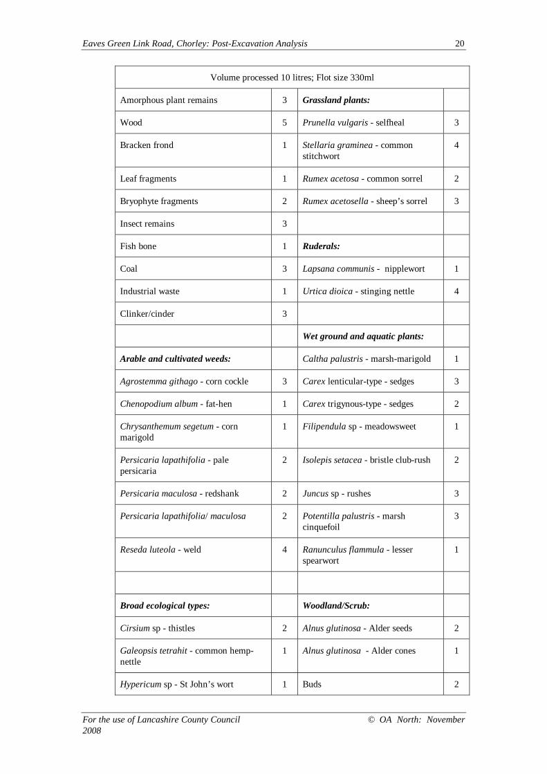
Millrace: Silt deposit 106, Sample <1>
Eaves Green Link Road, Chorley: Post-Excavation Analysis 20
For the use of Lancashire County Council © OA North: November2008
Volume processed 10 litres; Flot size 330ml
Amorphous plant remains 3 Grassland plants:
Wood 5 Prunella vulgaris - selfheal 3
Bracken frond 1 Stellaria graminea - commonstitchwort
4
Leaf fragments 1 Rumex acetosa - common sorrel 2
Bryophyte fragments 2 Rumex acetosella - sheep’s sorrel 3
Insect remains 3
Fish bone 1 Ruderals:
Coal 3 Lapsana communis - nipplewort 1
Industrial waste 1 Urtica dioica - stinging nettle 4
Clinker/cinder 3
Wet ground and aquatic plants:
Arable and cultivated weeds: Caltha palustris - marsh-marigold 1
Agrostemma githago - corn cockle 3 Carex lenticular-type - sedges 3
Chenopodium album - fat-hen 1 Carex trigynous-type - sedges 2
Chrysanthemum segetum - cornmarigold
1 Filipendula sp - meadowsweet 1
Persicaria lapathifolia - palepersicaria
2 Isolepis setacea - bristle club-rush 2
Persicaria maculosa - redshank 2 Juncus sp - rushes 3
Persicaria lapathifolia/ maculosa 2 Potentilla palustris - marshcinquefoil
3
Reseda luteola - weld 4 Ranunculus flammula - lesserspearwort
1
Broad ecological types: Woodland/Scrub:
Cirsium sp - thistles 2 Alnus glutinosa - Alder seeds 2
Galeopsis tetrahit - common hemp-nettle
1 Alnus glutinosa - Alder cones 1
Hypericum sp - St John’s wort 1 Buds 2
Eaves Green Link Road, Chorley: Post-Excavation Analysis 21
For the use of Lancashire County Council © OA North: November2008
Lamium sp - deadnettle sp 1 Luzula sp - wood-rushes 1
Polygonum aviculare - knotgrass 2 Rosaceae - thorns 2
Potentilla erecta -type - tormentil-type 3
Ranunculus repens-type - buttercups 4 Food and economic taxa:
Reseda luteola - weld 4 Prunus cerasifera - cherry 1
Rumex obtusifolius - broad-leaveddock
3 Rubus fruticosus - blackberries 5
Sonchus asper - prickly sow thistle 2
Veronica sp - speedwells 1 Charred Plant Remains:
Viola sp - violets/pansies 2 Avena sativa - oats 2
Indeterminate 3 Poaceae 2-4mm 2
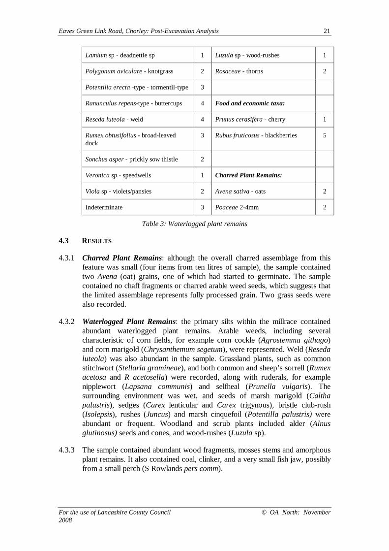
Table 3: Waterlogged plant remains
4.3 RESULTS
4.3.1 Charred Plant Remains: although the overall charred assemblage from thisfeature was small (four items from ten litres of sample), the sample containedtwo Avena (oat) grains, one of which had started to germinate. The samplecontained no chaff fragments or charred arable weed seeds, which suggests thatthe limited assemblage represents fully processed grain. Two grass seeds werealso recorded.
4.3.2 Waterlogged Plant Remains: the primary silts within the millrace containedabundant waterlogged plant remains. Arable weeds, including severalcharacteristic of corn fields, for example corn cockle (Agrostemma githago)and corn marigold (Chrysanthemum segetum), were represented. Weld (Resedaluteola) was also abundant in the sample. Grassland plants, such as commonstitchwort (Stellaria gramineae), and both common and sheep’s sorrell (Rumexacetosa and R acetosella) were recorded, along with ruderals, for examplenipplewort (Lapsana communis) and selfheal (Prunella vulgaris). Thesurrounding environment was wet, and seeds of marsh marigold (Calthapalustris), sedges (Carex lenticular and Carex trigynous), bristle club-rush(Isolepsis), rushes (Juncus) and marsh cinquefoil (Potentilla palustris) wereabundant or frequent. Woodland and scrub plants included alder (Alnusglutinosus) seeds and cones, and wood-rushes (Luzula sp).
4.3.3 The sample contained abundant wood fragments, mosses stems and amorphousplant remains. It also contained coal, clinker, and a very small fish jaw, possiblyfrom a small perch (S Rowlands pers comm).
Eaves Green Link Road, Chorley: Post-Excavation Analysis 22
For the use of Lancashire County Council © OA North: November2008
4.4 DISCUSSION
4.4.1 Charred Plant Remains: these data are very limited. Therefore, no firmconclusions can be drawn, and any interpretation must be tentative. Thecharred plant remains from the millrace consisted of oat and medium (2-4mm)grass seeds. Although there is evidence for the cultivation of oats during earlierperiods, their use appears to have increased during the medieval period inBritain (Greig 1991). One of the oat grains was partially germinated, whichcould suggest either spoilt grain or grain for brewing.
4.4.2 Waterlogged Plant Remains: this very well-preserved group provides evidenceof the local environment in the post-medieval period. The abundance of arableweeds shows that corn was being grown close by, although the grassland plantremains suggest the presence nearby of pastureland or scrub. The appearanceof ruderal species is interesting in that these are the first types to colonisedisturbed ground. The marsh marigold, sedges, rushes and other damp-lovingplant species indicate that the area was wet, although these are all specieswhich would be characteristic of a river bank as well as a millrace.
4.4.3 Arable weeds and plants of cultivated or waste ground: there is little otherthan the occasional oat grain in the charred plant assemblage to suggest thecultivation or processing of crops or other food sources. However, thepresence of seeds from arable weeds and those from cultivated or waste grounddemonstrated that the site had been associated either with nearby cultivation,that areas of waste/cleared ground existed throughout the occupation of thesite, or seeds were taken to the mill with cereals from further afield. Plants suchas corn cockle and corn marigold are characteristic of corn fields, waysideverges or waste ground from the medieval period onwards and are non-specificin their ecological requirements (Greig 1991). Therefore, it is not possible tosurmise the characteristics of the soils being cultivated. Weld was alsoabundant in the sample, which could be significant as it is used as a dye, but itis also common on disturbed ground (Hall and Huntley 2007). Weld seeds havebeen frequently recorded in Northern England from the Roman periodonwards.
4.4.4 Possible wild food plants: the abundant blackberry seeds and the single cherrystone recorded in the waterlogged plant remains may reflect the use of thesefruits in the diet. Alternatively, they may have been growing wild in thehedgerows and field margins, or on the banks of the river or millrace.
4.4.5 Wet ground/woodland/scrub: as would be expected from samples taken nextto a river and millrace, many of the plants recorded are examples of those thatlive in damp conditions, including trees such as alder.
Eaves Green Link Road, Chorley: Post-Excavation Analysis 23
For the use of Lancashire County Council © OA North: November2008
5. CONCLUSION
5.1 DISCUSSION
5.1.1 From the archaeological investigation and subsequent analysis, the millraceearthwork would appear to have been constructed during the post-medievalperiod and, whilst it is postulated that this may have evolved from an earliermedieval arrangement, there was no physical evidence of any medieval activity.The excavation established that the channel had been considerably deeper thanexpected at the weir end, although its alignment was as predicted. The potentialfragmentary sluice was of interest, although there is not enough evidence toreconstruct any form for this putative structure.
5.1.2 The later post-medieval management of the millrace under Sir Thomas Standishand the lessees of Duxbury Mill (LUAU 1996) was confirmed by theconstruction of the stone revetment wall along the southern side of the channel.It is possible that any physical evidence for earlier activity may have beenremoved by rigorous management of the millrace. Maintenance of it seems tohave become progressively less important to the lessees of the mill, perhaps dueto the construction of the reservoir close to the wheel-pit by 1846, shown onthe Ordnance Survey 1849 map, and certainly less so by the time of itsconversion to steam power. The artefactual assemblage from Phase 2 wouldcertainly seem to support abandonment, followed by a protracted period ofsilting and use of the channel for the disposal of rubbish.
5.1.3 The small assemblage of charred plant remains from the millrace perhaps couldhave resulted from a drying accident at the mill or in an associated building. Incontrast to the small size of the assemblage of charred plant remains, thepreservation of waterlogged plant remains in the silted-up millrace is excellent.The assemblage suggests areas of wet ground close to water, with arable landor waste ground close by. Although the chronology of the primary fill of themillrace is uncertain, the plant remains could pre-date the archaeologicalassemblage by a considerable period of time. There are no records of any otherarchaeobotanical records from millrace deposits in the north of England (Halland Huntley 2007). Although corn mills were abundant from the medievalperiod onwards, few early buildings survive, and any related archaeobotanicalevidence in Northern England and Southern Scotland comes from a smallnumber of corn-drying ovens, at Hoddam in Dumfries and Galloway, BishopBurton near Beverley, in North Humberside, and Addingham, in NorthYorkshire (ibid). Evidence of crop cultivation and of farming regimes from theeighteenth century onwards is sparse in north-west England, because of a lackof excavation and bulk sampling (Brennand 2007), and the environmentalsample from the Eaves Green Link Road excavation will help to establish adataset relevant to agricultural research themes.

Eaves Green Link Road, Chorley: Post-Excavation Analysis 24
For the use of Lancashire County Council © OA North: November2008
Eaves Green Link Road, Chorley: Post-Excavation Analysis 25
For the use of Lancashire County Council © OA North: November2008
6. BIBLIOGRAPHY
6.1 PRIMARY AND CARTOGRAPHIC SOURCES
LRO DDRf 11/1 1757 Survey of the lands belonging to Sir Frank Standish, Baronet,by R Lang
LRO DRB/1/68 1843 Plan of Duxbury in the parish of Standish
Ordnance Survey, 1849 1st edition, 6” map; Lancashire Sheet 77 (surveyed 1844-7;contoured 1847)
Ordnance Survey Geological Survey 1971, Preston Sheet 75 Drift
Yates, W, 1786 The County Palatine of Lancaster
6.2 SECONDARY SOURCES
Brennand, M (ed), 2007 Research and Archaeology in North West England: anArchaeological Research Framework for North West England Volume 2, ResearchAgenda and Strategy, Archaeology North West, 9, Manchester
Cappers, RTJ, Bekker, RM, and Jans, JEA, 2006 Digital Seed Atlas of theNetherlands, Groningen
Cotter, J, 2000 Post-Roman Pottery From Excavations in Colchester, 1971-85,Colchester Archaeol Rep, 7, Colchester
Countryside Commission, 1998 Countryside Character Volume 2: North West,Cheltenham
Department of the Environment (DoE), 1990 Planning Policy Guidance Note 16:Archaeology and Planning, London
Earthworks Archaeological Services, 2000 Proposed Construction of the Eaves GreenLink Road, Chorley: A Programme of Archaeological Evaluation, unpubl rep
English Heritage, 1991 Management of Archaeological Projects, 2nd edn, London
English Heritage, nd Minimum Standards for MAP2 Project Designs and Assessments:Supplementary Guidance to MAP2, draft notes, English Heritage CommissionedArchaeology Programme, London
Farrer, W, and Brownhill, J (eds), 1911 The Victoria County History of Lancaster, 6,London
Geoquest Associates, 2000 Geophysical Survey on the Route of the Eaves Green LinkRoad, Chorley, unpubl rep
Greig, JRA, 1991 The British Isles, in W Van Zeist, K Wasylikowa, and F Behre (eds),Progress in Old World Palaeoethnobotany, Rotterdam, 299-332
Eaves Green Link Road, Chorley: Post-Excavation Analysis 26
For the use of Lancashire County Council © OA North: November2008
Hall, BR, and Folland, CJ, 1970 Soils of Lancashire, Soil Survey of England andWales, Bull 5, Harpenden
Hall, AR, and Huntley, JP, 2007 A Review of the Evidence for Macrofossil PlantRemains from Archaeological Deposits in Northern England, Research Dept Rep Ser87/2007, English Heritage, unpubl rep
Hedges, AAC, 1975 Bottles and Bottle Collecting, Princes Risborough
LUAU, 1996 Eaves Green Link Road, Chorley: Archaeological Assessment, unpublrep
Newman, R, and McNeil, R, 2007a The Post-Medieval Period Research Agenda, inBrennand, 2007, 115-32
Newman, R, and McNeil, R, 2007b The Industrial and Modern Period ResearchAgenda, in Brennand, 2007, 133-58
OA North, 2007 Eaves Green Link Road, Chorley: Post-excavation Assessment,unpubl rep
Stace, C, 2001 New Flora of the British Isles, 2nd edn, Cambridge
Eaves Green Link Road, Chorley: Post-Excavation Analysis 27
For the use of Lancashire County Council © OA North: November2008
ILLUSTRATIONS
LIST OF FIGURES
Figure 1: Site location
Figure 2: Location of excavated areas superimposed onto the Ordnance Survey mapof 1849
Figure 3: Location of excavated areas superimposed onto the Ordnance Survey mapof 1910
Figure 4: Sections across millrace channel 103, Area 1, facing north
Figure 5: Section across millrace channel 208, Area 2, facing north
Figure 6: Post-excavation plan of Area 1: Phase 1 features
Figure 7: Post-excavation plan of Area 2: Phase 1 features
LIST OF PLATES
Plate 1: Stone dump 109, forming rudimentary surface at the base of millrace 103
Plate 2: Revetment wall 204, on south side of millrace 208

Eaves Green Link Road, Chorley: Post-Excavation Analysis 28
For the use of Lancashire County Council © OA North: November2008
Plate 1: Stone dump 109, forming rudimentary surface at the base of millrace 103
Plate 2: Revetment wall 204, on south side of millrace 208
Eaves Green Link Road, Chorley: Post-Excavation Analysis 29
For the use of Lancashire County Council © OA North: November2008
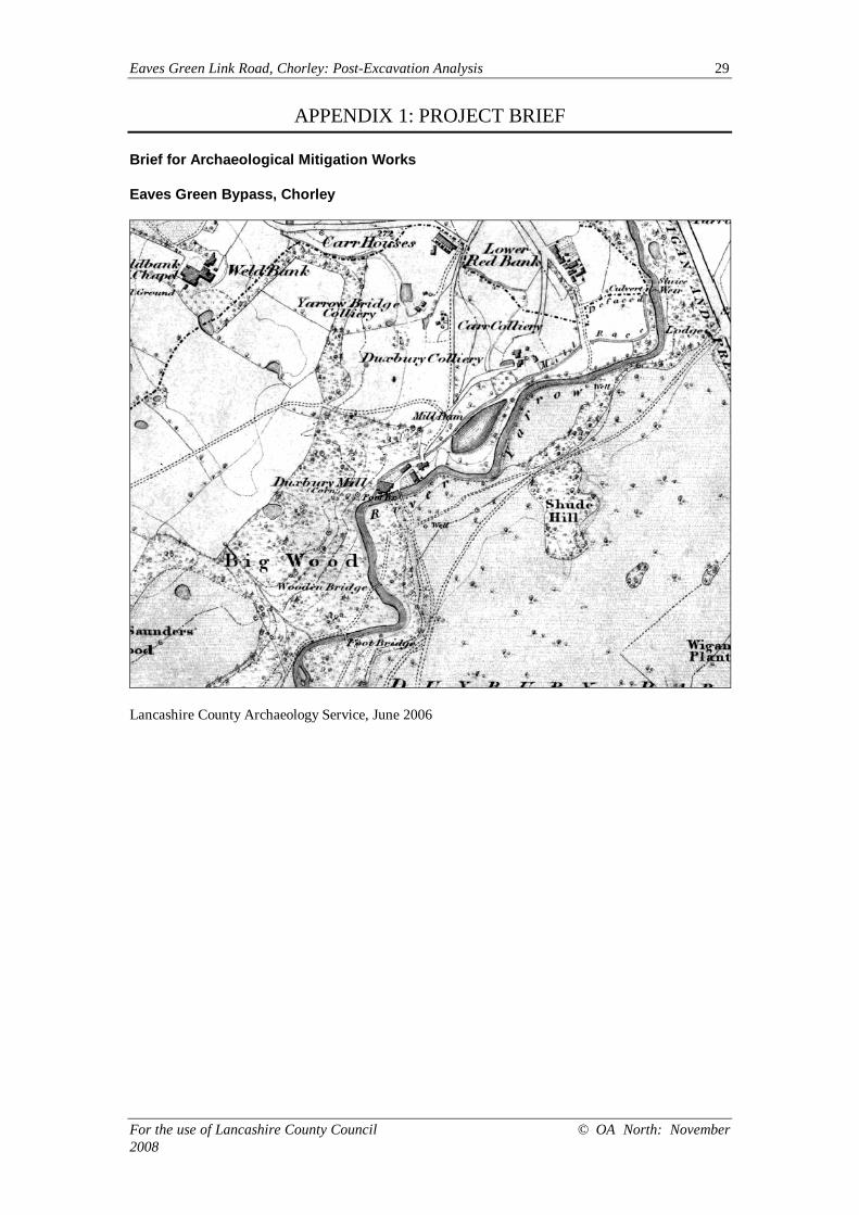
APPENDIX 1: PROJECT BRIEF
Brief for Archaeological Mitigation Works
Eaves Green Bypass, Chorley
Lancashire County Archaeology Service, June 2006

Eaves Green Link Road, Chorley: Post-Excavation Analysis 30
For the use of Lancashire County Council © OA North: November 2008
Brief for archaeological mitigation works required as part of the construction of theEaves Green Link Road, Chorley. Prepared by P D Iles of Lancashire CountyArchaeology Service, June 2006.
INTRODUCTION
As part of the development of the housing areas to the south and west of Chorley, a new linkroad is required from Lower Burgh Way at c. SD 58021568 to the A6 Bolton Road at c. SD59261601. Environmental assessment of the route included archaeological investigationsand a series of reports were commissioned. This includes an assessment by LancasterUniversity Archaeology Unit (LUAU 1996), geophysical survey by Geoquest Associates(Geoquest 2000) and evaluation works by Earthworks Archaeological Services (EAS 2000).Copies of these reports can be made available on request.
Examination of those reports and comparison with the proposed line of the road by theLancashire County Archaeology Service (LCAS) has indicated that only one major site – theformer mill race to Duxbury Corn Mill - is directly impacted and requires formal recording inadvance of construction. The remainder of the sites are either not directly affected or can beadequately dealt with by a formal watching brief. This brief is consequently divided into twosections.
This brief should be read in conjunction with the appropriate drawings and specifications forthe road, as prepared by Lancashire County Council Highways Consultancy.
Queries regarding the archaeological content of this brief may be adressed to Peter Iles,Specialist Advisor (Archaeology), Lancashire County Council Environment Directorate, POBox 9 Guild House, Cross Street, Preston, Lancashire, PR1 8RD. Tel. 01772 531550, fax01772 533423, e. [email protected]
Queries regarding the road scheme or contractual matters should be addressed to theLancashire County Council Highways Consultancy.
PART 1 – EXCAVATION
DUXBURY MILL AND RACE
Duxbury corn mill was, as far as is known, water-powered for all of its life, initially using awater wheel but later being re-equiped with a water turbine. The mill site is generallyregarded as medieval, with the Victoria County History for the County of Lancaster (VCH)noting that the mill is mentioned in 1354 and local historian Mr Jack Smith suggesting anorigin of c.1230. It is known to have been rebuilt in 1727 and was certainly still in use in thesecond half of the 19th century. It was closed and partially demolished at some time between1900 and 1928, but considerable remains are still to be seen on site (Farrer and Brownbill1992 p.208; LUAU 1996, p.9, sites 9,10,13; EAS 2000, pp.28-38).
The site of the mill is, however, not touched by the road proposals and it is the line of themillrace that will be impacted. On the OS first edition 1:10,560 map of 1849 (sheetLancashire 77) the mill stream is taken off at a weir on the River Yarrow at SD 5919115957and leads along the northern side of the river to the mill itself at SD 5872515620. A teardrop-shaped interim pond, probably a balance pond, annotated ‘Mill Dam’, is located at SD5888615714.
Two main sections of the millrace will be affected, the first is where the new road crosses theRiver Yarrow and bridge construction demands mean that the mill stream will be cut across aworking width of some 25m immediately west of the river at about SD 59181592. Thesecond area affected is associated with the construction of two surface water runofftreatment lagoons a little further south and west at about SD 59101587. The elongatedlagoons flank the former race, but will need to be linked across it by a small engineered waterchannel.
A single trench 1.2m by 8.7m was excavated across the line of the race by EAS in the springof 2000 (EAS 2000, pp.34-36, figs. 3, 28-30) at approximately SD 59141587. This showedthat the race comprised a pair of constructed banks, c.3.5m wide on the north and c.2.5mwide on the south side, flanking a channel c.1.5m wide that had formerly been stone-lined.
Eaves Green Link Road, Chorley: Post-Excavation Analysis 31
For the use of Lancashire County Council © OA North: November 2008
Flooding during the excavation meant that a full stratigraphic sequence could not berecovered from the channel - it also serves as a warning to future excavators. Datable findswere limited to a small number of 17th-19th century pottery sherds and clay pipe fragments.
PROPOSED TRENCHES
It is proposed that two sections of the race will be excavated and recorded in advance ofworks commencing. The main excavation will be sited at the proposed new bridge site,where a section of race up to 10m long will be required. A smaller trench, up to 5m long, willsample the proposed lagoon site. Both trenches will need to be wide enough to span theentire race at the sites selected, and a nominal width of 8m should be allocated for planningpurposes. The contractor should bear in mind, however, that the millrace flooded badlyduring the excavation in 2000 and an allowance may need to be made for the excavation ofinterceptor trenches and sumps outside the area being recorded.
The exact locations of the two trenches should be decided on the site in consultation with theroad design staff and LCAS, but as guidance it is expected that the larger trench will be atabout SD 59181592 and the small will be at about SD 59101587. It is important that thislatter trench does not fall within the area already excavated by EAS, although a siteimmediately adjacent could be selected. Both trenches should be sited to avoid otherobvious disturbance or damage, including the presence of significant tree boles.
The trenches should be located and the excavation strategy designed to create a full recordof the mill race and any associated archaeological features and deposits within theexcavation area. The information gained is intended as a full record to mitigate the damagethat will occur during the construction of the new road.
EXCAVATION METHODOLOGY
GENERAL INSTRUCTIONS
HEALTH AND SAFETY
The archaeologists on site will naturally operate with due regard for Health and Safetyregulations, and the contractor must ensure that all relevant requirements are met withregard both to site personnel and to members of the public. This work may require thepreparation of a Risk Assessment of the site, in accordance with the Health and Safety atWork Regulations prior to submission of the tender. The LCAS and its officers cannot be heldresponsible for any accidents that may occur to outside contractors engaged to undertakethis work while attempting to conform to this specification.
CONFIRMATION OF ADHERENCE TO SPECIFICATION
Prior to the commencement of any work, the archaeological contractor must confirmadherence to this specification in writing to the LCAS, or state (with reasons) any proposals tovary the specification. Should the contractor wish to vary the specification, then writtenconfirmation of the agreement of the LCAS to any variations is required prior to workcommencing. Unauthorised variations are made at the sole risk of the contractor (see below).Modifications presented in the form of a re-written project brief will not be considered by theLCAS.
CONFIRMATION OF TIMETABLE AND CONTRACTORS’ QUALIFICATIONS
Prior to the commencement of any work, the archaeological contractor should provide theLCAS in writing with a projected timetable for the site work, and with details regarding staffstructure and numbers. The names and curriculum vitae of key project members (the projectmanager, site supervisor, any proposed specialists etc.), along with details of any specialistsub-contractors, should also be supplied to the LCAS (if C.V.s have not previously beensupplied). All project staff provided by the archaeological contractor must be suitablyqualified and experienced for their roles. The timetable should be adequate to allow the workto be undertaken to the appropriate professional standard, subject to the ultimate judgementof the LCAS.
Eaves Green Link Road, Chorley: Post-Excavation Analysis 32
For the use of Lancashire County Council © OA North: November 2008
DOCUMENTARY RESEARCH
A programme of documentary research has already been undertaken (LUAU 1996; EAS2000) and the project manager or the site supervisor should review this data to gain anoverview of the archaeological/historical background of the site and environs. The results ofthis work may be incorporated into the contractor’s report where they are considered tocontribute to that report, but appropriate acknowledgement should be made and unnecessaryduplication avoided. Further research required to inform the final report should be quantifiedand set out in the post-excavation assessment (below).
TRENCHING METHODOLOGY
METHOD OF EXCAVATION
The trenches may be opened and the topsoil and recent overburden removed down to thefirst significant archaeological horizon in successive level spits of a maximum 0.2m.thickness, by the use of an appropriate machine using a wide toothless ditching blade. Underno circumstances should the machine be used to cut arbitrary trenches down to naturaldeposits. Any machine work must be carried out under direct archaeological supervision andthe machine halted if significant archaeological deposits are encountered. The top of the firstsignificant archaeological horizon (pre-20th century) may be exposed by the machine, butmust then be cleaned by hand and inspected for features and then dug by hand.
METHOD OF RECORDING
The trenches are to be recorded according to the normal principles of stratigraphicexcavation. The stratigraphy of each trench is to be recorded even where no archaeologicaldeposits have been identified. As this is intended as a full record excavation in areas that willbe heavily damaged by construction works, the complete removal of archaeological depositsis likely to be appropriate. Modern artefacts are to be noted but not retained (19th-centurymaterial and earlier should be retained.)
USE OF METAL DETECTORS ON SITE
Spoil heaps are to be scanned for non-ferrous metal artefacts using a metal detector capableof making this discrimination, operated by an experienced metal detector user (if necessary,operating under the supervision of the contracting archaeologist). Modern artefacts are to benoted but not retained (19th-century material and earlier should be retained.)
If a non-professional archaeologist is to be used to carry out the metal detecting, a formalagreement of their position as a sub-contractor working under direction must be agreed inadvance of their use on site. This formal agreement will apply whether they are paid or not.
To avoid financial claims under the Treasure Act a suggested wording for this formalagreement with the metal detectorist is: "In the process of working on the archaeologicalinvestigation at [location of site] between the dates of [insert dates], [name of personcontributing to project] is working under direction or permission of [name of archaeologicalorganisation] and hereby waives all rights to rewards for objects discovered that couldotherwise be payable under the Treasure Act 1996."
ENVIRONMENTAL SAMPLING STRATEGY
Deposits must be sampled for retrieval and assessment of the preservation conditions andpotential for analysis of all bioarchaeological remains. A sampling strategy must be agreedwith a recognised bioarchaeologist, and the sampling methods should follow the proceduresoutlined by the English Heritage’s Centre for Archaeology Guidelines, EnvironmentalArchaeology: A guide to the theory and practice of methods, from sampling and recovery topost-excavation (2002/01). Provision should be also be made for the specialist to visit the siteand discuss the sampling strategy, if necessary.
CONSERVATION STRATEGY
A conservation strategy must be developed in collaboration with a recognised laboratory. Allfinds must be assessed in order to recover information that will contribute to an
Eaves Green Link Road, Chorley: Post-Excavation Analysis 33
For the use of Lancashire County Council © OA North: November 2008
understanding of their deterioration and hence preservation potential, as well as identifyingpotential for further investigation. Furthermore, all finds must be stabilised and packaged inaccordance with the requirements of the receiving museum. As a guiding principle onlyartefacts of a “displayable” quality would warrant full conservation, but metalwork andcoinage from stratified contexts would be expected to be X-rayed if necessary, andconservation costs should also be included as a contingency.
DOCUMENTATION
The actual areas of trenching and any features of possible archaeological concern notedwithin the trenches, should be accurately located on a site plan and recorded by photographs,scale drawings and written descriptions sufficient to form a permanent record of the remains.The site grid is to be accurately tied into the National Grid and located on the largest scalemap available of the area (either 1:2500 or 1:1250).
LOCATION OF SERVICES, ETC.
The archaeological contractors will be responsible for locating any drainage pipes, servicepipes, cables etc. which may cross any of the trench lines, and for taking the necessarymeasures to avoid disturbing such services.
HUMAN REMAINS
Any human remains that are discovered must initially be left in-situ, covered and protected. Ifremoval is necessary, this must comply with the relevant legislation, any Home Office andlocal environmental health regulations and English Heritage’s and The Church of England’sGuidance for best practice for treatment of human remains excavated from Christian burialgrounds in England (2005) where relevant. Ethical guidance for burial grounds of non-Christian faiths should be sought from the appropriate religious authorities.
TREASURE ACT
The terms of the Treasure Act 1996 must be followed with regard to any finds that might fallwithin its purview. Any finds must be removed to a safe place and reported to the localcoroner as required by the procedures as laid down in the DoNH 1996 Code of Practice.Where removal cannot be effected on the same working day as the discovery, suitablesecurity measures must be taken to protect the finds from theft.
COMMENCEMENT OF WORK
NOTIFICATION
The project will be monitored as necessary and practicable by the LCAS, in its role as“curator” of the county’s archaeology. The LCAS should receive as much notice as possibleand certainly one week of the intention to start fieldwork. This notification is to be supplied inwriting, and copied to the relevant Museum (see below). A copy of the contractor’s riskassessment should accompany notification of intention to commence work.
ACCESS/MONITORING METHODOLOGY
The representative of the LCAS will be afforded access to the site at any reasonable time. Itis usual practice that the visit is arranged in advance, but this is not always feasible. TheLCAS’s representative will be provided with a site tour and an overview of the site by thesenior archaeologist present and should be afforded the opportunity to view all trenches; anyfinds made that are still on site, and any records not in immediate use. It is anticipated thatthe records of an exemplar context that has previously been fully recorded will be examined.Any observed deficiencies during the site visit are to be made good to the satisfaction of theLCAS’s representative, by the next agreed site meeting. Access is also to be afforded at anyreasonable time to English Heritage’s Regional Archaeological Scientific Advisor.
EXCAVATION ARCHIVES DEPOSITION
Before commencing any fieldwork, the archaeological contractor must contact the relevantmuseum archaeological curator to determine the museum's requirements for the deposition
Eaves Green Link Road, Chorley: Post-Excavation Analysis 34
For the use of Lancashire County Council © OA North: November 2008
of an excavation archive. In this case the contact is Edmund Southworth, Curator, Museumof Lancashire, Stanley Street, Preston, PR1 4YP; telephone 01772 534075, fax 01772534079. Agreement for deposition should be confirmed in writing by the archaeologicalcontractor; this correspondence is to be copied to the LCAS.
It is the policy of The Museum of Lancashire to accept complete excavation archives,including primary site records and research archives and finds, from all excavations carriedout in Lancashire.
It is the responsibility of the archaeological contractor to endeavour to obtain consent of thelandowner, in writing, to the deposition of finds in The Museum of Lancashire. It is also theresponsibility of the archaeological contractor to meet the requirements of The Museum ofLancashire with regard to the preparation of excavation archives for deposition.
The museums officer named above should be notified in writing of the commencement offieldwork at the same time as the LCAS.
UNEXPECTEDLY SIGNIFICANT OR COMPLEX DISCOVERIES
Should there be unexpectedly significant or complex discoveries made that warrant, in theprofessional judgement of the archaeologist on site, more detailed recording than isappropriate within the terms of this specification or more time that is allowed within theproject design, then the archaeological contractor should urgently contact the LCAS with therelevant information to enable them to resolve the matter with the developer.
POST-EXCAVATION WORK
AFTER COMPLETION OF FIELDWORK
On completion of the fieldwork, any samples taken shall be processed and any finds shall becleaned, identified, assessed, dated (if possible), marked (if appropriate) and properly packedand stored in accordance with the requirements of national guidelines. A fully indexed fieldarchive shall be compiled consisting of all primary written documents, plans, sections,photographic negatives and a complete set of labelled photographic prints. An index to thefield archive is to be deposited with the LCAS (preferably as an appendix in the report). Theoriginal archive is to accompany the deposition of any finds, providing the landowner agreesto the deposition of finds in a publicly accessible archive (see above). In the absence of thisagreement the field archive (less finds) is to be deposited with the LCAS.
POST-EXCAVATION ASSESSMENT
The project design and costings should make it clear that a formal post-excavationassessment and costing of the final stage of the project, in line with the methodology set outin MAP2 (English Heritage 1991), will be undertaken and an appropriate report compiled. Acopy of this report should be passed to LCAS for approval as well as to the developer.
FINAL REPORT
A discussion of the needs of the final report are included in General Considerations below,but it would be sensible to consider the needs of both the excavation work and the watchingbrief below when considering the final report.
A single report covering both exercises would be acceptable, but equally two individualreports with appropriate cross-referencing would be acceptable and may prove clearer.
PART 2 – WATCHING BRIEF
A variety of archaeological sites have been identified in the vicinity of the proposed link road(LUAU 1996; EAS 2000; Geoquest 2000) but with the exception noted above it is notconsidered that formal archaeological recording is required in advance of construction.These range from a medieval pele tower whose site has not been firmly located, to a seriesof 19th century coal mines. It is considered appropriate however for a formal archaeologicalwatching brief to be undertaken during the ground disturbance phase of the development inorder that any other remains encountered can be recorded.
Eaves Green Link Road, Chorley: Post-Excavation Analysis 35
For the use of Lancashire County Council © OA North: November 2008
REQUIREMENTS
An archaeologist should be present on site during the excavation of any area below a depthof 0.15m. (approximately six inches) in the area of development, whether this be forfoundation trenches, service trenches or landscaping. The archaeologist should view the areaas it is being dug and any trench sections after excavation has been completed. Wherearchaeology is judged to be present, the excavated area should be rapidly cleaned and theneed for further work assessed. Where appropriate, any features and finds should then bequickly hand excavated, sampled and recorded, within the confines of the excavated trench.
Excavated soil should be searched as practicable for finds. The presence and nature of 20th
century material should be noted (quantified and summarily described) but finds of this dateneed not be retained for processing. Finds judged to be 19th century in date or earlier shouldbe retained.
The actual areas of ground disturbance, and any features of possible archaeological concernnoted within these areas, should be accurately located on a site plan and recorded byphotographs, scale drawings (including height above O.D.) and written description sufficientto permit the preparation of a report on the site.
The intention of the archaeological watching brief is not to unduly delay the work of othercontractors on site. This work should not, therefore prejudice the progress of the main orsubsidiary contractor’s work, except by prior agreement and on-site co-operation.
The archaeologist on site will naturally operate with due regard for Health and Safetyregulations. In this case, where archaeological work is carried out at the same time as thework of other contractors, regard should also be taken of any reasonable additionalconstraints that these contractors may impose. This work may require the preparation of aRisk Assessment of the site, in accordance with the Health and Safety at Work Regulations.The LCAS and its officers cannot be held responsible for any accidents that may occur tooutside contractors engaged to undertake this survey while attempting to conform to thisspecification.
UNEXPECTEDLY SIGNIFICANT OR COMPLEX DISCOVERIES
Should there be, in the professional judgement of the archaeologist on site, unexpectedlysignificant or complex discoveries made that warrant more detailed recording than possiblewithin the terms of this specification, then the archaeological contractor is to urgently contactthe LCAS with the relevant information to enable the matter to be resolved with thedeveloper.
Any human remains that are discovered must initially be left in-situ, covered and protected. Ifremoval is necessary, this must comply with the relevant Home Office (include ref to recentEH guidelines) and any local environmental health regulations.
The terms of the Treasure Act, 1996 must be followed with regard to any finds, which mightfall within its purview. Any such finds must be removed to a safe place and reported to thelocal coroner as required by the procedures laid down in the “Code of Practice”. Whereremoval cannot be effected on the same working day as the discovery, suitable securitymeasures must be taken to protect the finds from theft.
USE OF METAL DETECTORS ON SITE
Spoil heaps are to be scanned for non-ferrous metal artefacts using a metal detector capableof making this discrimination, operated by an experienced metal detector user (if necessary,operating under the supervision of the contracting archaeologist). Modern artefacts are to benoted but not retained (19th-century material and earlier should be retained.)
If a non-professional archaeologist is to be used to carry out the metal detecting, a formalagreement of their position as a sub-contractor working under direction must be agreed inadvance of their use on site. This formal agreement will apply whether they are paid or not.
To avoid financial claims under the Treasure Act a suggested wording for this formalagreement with the metal detectorist is: "In the process of working on the archaeologicalinvestigation at [location of site] between the dates of [insert dates], [name of personcontributing to project] is working under direction or permission of [name of archaeological
Eaves Green Link Road, Chorley: Post-Excavation Analysis 36
For the use of Lancashire County Council © OA North: November 2008
organisation] and hereby waives all rights to rewards for objects discovered that couldotherwise be payable under the Treasure Act 1996."
FINAL REPORT
A discussion of the needs of the final report are included in General Considerations below,but it would be sensible to consider the needs of both the excavation work (above) and thewatching brief when considering the final report.
A single report covering both exercises would be acceptable, but equally two individualreports with appropriate cross-referencing would be acceptable and may prove clearer.
GENERAL CONSIDERATIONS
FINAL REPORT FORMAT AND CONTENT
When the post-excavation assessment report has been approved by LCAS and theassociated work completed, a final report should be produced, which should includebackground information on the need for the project, a description of the methodologyemployed, and a full description and interpretation of results produced.
It is not envisaged that the report is likely to be published, but it should be produced withsufficient care and attention to detail to be of academic use to future researchers. Locationplans should be produced at a scale which enables easy site identification and which depictsthe full extent of the site investigated (a scale of 1:50,000 is not regarded as appropriateunless accompanied by a more detailed plan or plans).
Site plans should be at an appropriate scale showing trench layout (as dug), features locatedand, where possible, predicted archaeological deposits. Upon completion of each trench allsections containing archaeological features will be drawn. Section drawings (at a minimumscale of 1:20) must include heights O.D. Plans (at a minimum scale of 1:50) must includeO.D. spot heights for all principal strata and any features.
Where no archaeological deposits are encountered at least one long section of each trenchwill be drawn. Artefact analysis is to include the production of a descriptive catalogue withfinds critical for dating and interpretation illustrated. Details of the style and format of thereport are to be determined by the archaeological contractor, but should include a fullbibliography, a quantified index to the site archive, and as an appendix, a copy of thisspecification.
SUMMARY FOR PUBLICATION
A brief summary report of fieldwork, to appear in the Council for British Archaeology NorthWest Archaeology North West should be produced, even when the fieldwork encountered noarchaeological deposits. This should be sent to the editor of Archaeology North West inaccordance with the standard format for summary reporting, and in time for it to appearwithin a calendar year of the completion of fieldwork.
PUBLICITY
If the project is to be publicised in any way (including media releases, publications etc.), thenit is expected that the LCAS will be given the opportunity to consider whether it wishes itscollaborative role to be acknowledged, and if so, the form of words used will be at the LCAS'discretion.
REPORT DEPOSITION
An electronic copy of the report in Adobe Acrobat PDF format on CD-ROM is to be suppliedto the Sites and Monuments Record held by the LCAS within a period of six months followingcompletion of fieldwork unless specialist reports are awaited. In the latter case a revised dateshould be agreed with the LCAS. The report will be supplied on the understanding that it will
Eaves Green Link Road, Chorley: Post-Excavation Analysis 37
For the use of Lancashire County Council © OA North: November 2008
become a public document after an appropriate period of time (generally not exceeding sixmonths, unless otherwise agreed). A copy shall also be supplied to English Heritage’sRegional Science Adviser at the same time (Sue Stallibrass, University of Liverpool, Schoolof Archaeology, Classics and Oriental Studies (SACOS), William Hartley Building, BrownlowStreet, Liverpool, L69 3GS, tel: 0151 794 5046, e-mail: [email protected])
AUTHORISED ALTERATIONS TO SPECIFICATION BY CONTRACTOR
It should be noted that this specification is based upon records available in the County Sitesand Monuments Record and on an examination of the reports already compiled.Archaeological contractors submitting tenders should carry out an inspection of the site priorto submission. If, on first visiting the site or at any time during the course of the recordingexercise, it appears in the archaeologist's professional judgement that
i) a part or the whole of the site is not amenable to recording as detailed above, and/or
ii) an alternative approach may be more appropriate or likely to produce more informativeresults, and/or
iii) any features that should be recorded, as having a bearing on the interpretation of thestructure, have been omitted from the specification,
then it is expected that the archaeologist will contact the LCAS as a matter of urgency. Ifcontractors have not yet been appointed, any variations that the LCAS considers to bejustifiable on archaeological grounds will be incorporated into a revised specification, whichwill then be re-issued to the developer for redistribution to the tendering contractors. If anappointment has already been made and site work is ongoing, the LCAS will resolve thematter in liaison with the developer and the Local Planning Authority.
UNAUTHORISED ALTERATIONS TO SPECIFICATION BY CONTRACTOR
It is the archaeological contractor’s responsibility to ensure that they have obtained theLCAS’s consent in writing to any variation of the specification prior to the commencement ofon-site work or (where applicable) prior to the finalisation of the tender. Unauthorisedvariations may have negative results and are therefore made solely at the risk of thecontractor.
VALID PERIOD OF SPECIFICATION
This specification is valid for a period of one year from date of issue. After that time it mayneed to be revised to take into account new discoveries, changes in policy or the introductionof new working practices or techniques.
References
Earthworks Archaeological Services 2000 Proposed Construction of the Eaves Green LinkRoad, Chorley – A Programme of Archaeological EvaluationEnglish Heritage 1991 The Management of Archaeological ProjectsEnglish Heritage Centre for Archaeology Guidelines 2000/2001 Environmental Archaeology:A guide to the theory and practice of methods, from sampling and recovery to post-excavationEnglish Heritage, The Church of England 2005 Guidance for best practice for treatment ofhuman remains excavated from Christian burial grounds in EnglandFarrer, J, Brownbill, W, eds 1992 (reprint of 1911 edition) The Victoria County History of theCounty of Lancaster Volume 6Geoquest Associates 2000 Geophysical Survey on the Route of the Eaves Green Link Road,ChorleyLancaster University Archaeology Unit 1996 Eaves Green Link Road, Chorley –Archaeological AssessmentDepartment of the Environment 1991 Planning Policy Guidance Note 16 – Archaeology andPlanning
Eaves Green Link Road, Chorley: Post-Excavation Analysis 38
For the use of Lancashire County Council © OA North: November 2008
Department of National Heritage 1996 The Treasure Act 1996 Code of PracticeInstitute of Field Archaeologists 1994 Standard and Guidance for archaeological watchingbriefsInstitute of Field Archaeologists 1995 Standard and Guidance for archaeological excavationInstitute of Field Archaeologists 2002a, Code of ConductInstitute of Field Archaeologists 2002b, Code of approved practice for the regulation ofcontractual arrangements in field archaeology
Eaves Green Link Road, Chorley: Post-Excavation Analysis 39
For the use of Lancashire County Council © OA North: November 2008
Eaves Green Link Road, Chorley: Post-Excavation Analysis 40
For the use of Lancashire County Council © OA North: November 2008
APPENDIX 2: PROJECT DESIGN
7.1 UPDATED RESEARCH AIMS AND OBJECTIVES
7.1.1 This section follows the guidance of English Heritage (nd, 2-3) regarding the formulation ofupdated project aims. This guidance recommends that it is helpful to treat aims as majorthemes or goals to which specific objectives contribute, and to consider these aims andobjectives as questions.
7.1.2 The majority of the original aims of the fieldwork are still valid, but these have now beenupdated, with new aims and objectives derived from the statement of potential set out inSection 6 above. At the present stage of assessment, these necessarily emphasise thepresence, absence and sufficiency of data to support further analysis of components of thearchaeological record. This analysis would have two primary objectives in view: to add to thearchaeological knowledge in the areas prioritised by the original fieldwork aims; and tounderstand how people lived in Lancashire in the past.
7.1.3 The updated research aims will consider the following:
• chronological and morphological development of the site;
• daily life on the site in the post-medieval period, including diet, pastimes, costume andpersonal adornment;
• processes of change, particularly in terms of water-powered industry, and changesbrought about by the advent of new industry into an area;
• the economy of the industrialised later post-medieval period in this part of Chorley,including the development of industries, and especially the use and management of themillrace;
• the character of occupation during industrialisation, particularly the pollution ofwatercourses.
7.1.4 Updated Research Aim 1: What can be learnt of the development of the site in the later post-medieval and modern periods, from the late eighteenth to early twentieth centuries?
• Objective 1: What are the main periods of activity on the site as shown by stratigraphicand artefactual record?
• Objective 2: Is it possible to refine the phasing of the site further through theidentification and dating of stratigraphic sub-phases, and to attribute further contexts tothese periods?
• Objective 3: Which structures of timber and stone, and other features, can be assigned tothese refined phases?
• Objective 4: What is the dating evidence for each of the refined periods and sub-phasesof activity on the site?
7.1.5 Updated Research Aim 2: What can we learn about daily life in the post-medieval and laterperiods?
• Objective 5: What personal possessions have been found and can they tell us anythingabout the everyday life of the local community?
7.1.6 Updated Research Aim 3: What can the Eaves Green site tell us about the transition frompost-medieval to modern activity on the outskirts of Chorley?
Eaves Green Link Road, Chorley: Post-Excavation Analysis 41
For the use of Lancashire County Council © OA North: November 2008
• Objective 6: Is there any evidence for continuity (or discontinuity) in the layout of thesite or in the character and range of features from the late post-medieval period onwards?
• Objective 7: Do the artefactual and ecofactual assemblages recovered from the site shedlight on the nature of the use of the site at this time?
7.1.8 Updated Research Aim 5: What can we learn about the character of occupation andexploitation of Eaves Green during the industrialisation of the later post-medieval period?
• Objective 8: Is there any evidence for industrial activity on or near the site?
• Objective 9: Do the Eaves Green datasets contain any evidence of industrial pollution?
• Objective 10: What evidence is there for exploitation of local resources?
7.2 PRESENTATION OF RESULTS
7.2.1 In accordance with the guidelines provided in MAP2 (English Heritage 1991a), it is proposedthat the results of the project should be presented as follows:
• Report publication text: following the completion of the full analysis and interpretationof all the stratigraphic and artefactual evidence, a text will be prepared for deposition inthe County HER and Record Office. This will be in the format described in Section 9,and will incorporate as necessary any information from comparable excavations. Asynthesised version of the text could also be prepared for inclusion in a journal if anappropriate outlet was available. There is, however, no county archaeological journal inLancashire at the present time, and although a report on these excavations are unlikelyto be accepted by the Industrial Archaeology Review, it is possible that the Council forBritish Archaeology (CBA) North West group might publish some details of the work intheir newsletter.
• Project archive: the completion of the project will result in a single integrated projectarchive with the results of the excavation. The archive will be deposited with the CountyRecord Office, Preston.
7.3 PROGRAMME STRUCTURE
7.3.1 The post-excavation programme will be divided into the following stages:
• project set-up;
• analysis;
• illustration;
• synthesis and production of report;
• QA;
• Archive deposition.