eap-b emergency action plan for class b …division of water bureau of flood protection and dam...
TRANSCRIPT
DIVISION OF WATER
BUREAU OF FLOOD PROTECTION AND DAM SAFETY DAM SAFETY SECTION
DOW 3.1.3 – ATTACHMENT “EAP-B”
EMERGENCY ACTION PLAN FOR
CLASS B - INTERMEDIATE HAZARD DAMS INSTRUCTIONS AND TEMPLATE
December 2012

(this page intentionally left blank)

Table of Contents I. Emergency Notification ........................................................................................................... 1
II. Inundation Maps .................................................................................................................. 2
Class B Dam EAP Template ........................................................................................................... 4
Samples ........................................................................................................................................... 5
Sample Inundation Map .............................................................................................................. 5
Sample Post Incident Report ....................................................................................................... 6
Sample Promulgation and Concurrence Form ........................... Error! Bookmark not defined.
I. Emergency Notification
Emergency Notification Procedures/Notification Flowchart. A pre-planned notification process is one of two critical EAP elements. This is most commonly depicted in a flowchart or flowcharts. For some dams a contact list with calling sequence may be sufficient. This guidance will refer to the depiction of notification procedures as the “Notification Flowchart,” regardless of whether it is actually a flowchart. The EAP Notification Flowchart contains the information necessary for the timely notification of persons responsible for taking emergency actions to protect downstream life, property and the environment. It lists the names and contact information for those individuals to be contacted, by whom and in what order. The Emergency Notification Flowchart should include individual names with office and confirmed 24-hour telephone numbers. The Notification Flowchart for Class B-Intermediate Hazard dams should contain the following: - Dam owner; - Local emergency responders (e.g. fire and police departments) and related organizations; - County Emergency Management Offices (County EMOs); - Residents and property owners that are located immediately downstream of the dam within
the boundary of potential inundation, where available warning time is limited; - Operators of other dams or water-retention facilities which may affect or be affected by an
emergency (e.g.: upstream and downstream dams); - NYSDEC Dam Safety Section (“DSS”); The above list may not be all inclusive or represent an appropriate prioritization of those entities listed. The author of the EAP should understand that notification of the dam owner and local emergency responders are typically given top priority, and this understanding should be reflected in the flowchart. The priority for contacting the Dam Safety Section should generally be after at least all first responders have been notified. Emergency Notification Information Form. In the EAP, an Emergency Notification Information Form should follow the Emergency Notification Flowchart. The Emergency Notification Information Form is to be used whenever an emergency is identified. A list of different emergencies for which the EAP should be activated is on the back of the form. This form is intended to aid the person reporting the emergency condition in relating all pertinent information. During an emergency, callers sometimes forget to convey important details. Updating. A regular review of the adequacy of the EAP should be conducted at intervals not to exceed one year. The review should evaluate the accuracy of the EAP’s notification flow charts, flood inundation area, depictions of downstream development, and the EAP text. The review should determine whether any revisions to the current EAP are necessary. If, as a result of the annual review, no revisions are necessary, a written statement to this effect should be provided to each recipient of the original EAP, including the Department’s DSS. The EAP should be updated and the updates should be distributed promptly when changes are required. EAP personnel or telephone number changes should be recorded and distributed as they occur. Posting of the Notification Flowchart. An up-to-date copy of the Notification Flowchart should be posted in prominent locations at the dam site and local emergency operation centers
Class B Dam EAP Instructions December 2012 B-1

(essential for unattended dams). The flowchart should be posted at each phone and radio transmitter at the dam, powerhouse (if applicable), and at all other desirable locations. II. Inundation Maps
Inundation mapping is the second critical component of an EAP. The level of detail, accuracy of input data, and analysis effort, should be appropriate to the downstream conditions and consequences of dam failure. Inundation maps should be developed by the dam owner and/or his/her engineer, and in coordination with the appropriate local emergency management agencies. The maps must contain the information needed to support emergency response and evacuation efforts. Inundation maps must include those portions of USGS topographic quadrangles and/or aerial photos that will likely be inundated by a “rainy-day” dam break – generally those areas that would be flooded if the dam failed during 150% of the 100-year flood. Features most likely at risk, such as road crossings and low-lying homes, should be clearly shown on the map. If information is available, estimated inundation areas should be drawn on the maps. Flood Insurance Rate Maps (FIRMs) and/or simple calculations are useful for estimating inundation areas. See “Sources of Information when developing inundation analyses” below for a discussion of FEMA FIRM’s. This level of inundation mapping is expected to be sufficient for most Class B-Intermediate Hazard dams. However, in some cases a more sophisticated analysis may be necessary Sources of information when developing inundation analyses. Often FEMA has developed Flood Insurance Studies (FIS) and FIRMS that may be of use in developing inundation mapping. If the Special Flood Hazard Areas (SFHAs) depicted on the FIRM include base flood elevations (BFEs), then the hydrological basis of the study will be available in the FIS (including estimated 10-, 50-, 100- and 500-yr flow rates). If it can be shown that the estimated dam break flows are less than the flows in the FIS/FIRM, then the appropriate SFHA limits (e.g. 100-yr or 500-yr) can be used to estimate or supplement the flood extents for EAP inundation mapping. Presenting the Results of an Inundation Evaluation on the Inundation Map The results of an inundation analysis should be depicted on the Inundation Map. A narrative description should accompany the map, as indicated below, to identify unusual conditions. The inundation map should be presented at a scale sufficient to be used for identifying downstream inhabited areas subject to possible danger. Whenever possible, major streets, railroads, and other well known features should be indicated. Potential inundation impact areas should be clearly identified. The most recent orthophoto coverages of the area that are available, with streets names overlaid, are the preferred base maps as long as they can be produced with sufficient clarity. Orthophotos of small areas are readily available for free on the internet. Orthophotos for the entire state are available through the NYS GIS Clearinghouse at: http://www.nysgis.state.ny.us. Clarity is important. Inundation mapping should extend downstream of the dam to a point where the projected or estimated increase in water level due to dam failure, as derived from an inundation evaluation, would no longer present a danger to life or property. Class B Dam EAP Instructions December 2012 B-2

When plotting inundation limits the lines should reasonably reflect the change in water levels with consideration given to topographic patterns and both natural and manmade features. When inundation lines enter the area of an existing lake or reservoir, they should be drawn to represent an increase in the water level of the lake or reservoir. Often this is a logical place to end the analysis. Should this increased water level overtop a downstream dam, the inundation mapping might need to be continued, and the likelihood of a cascade failure should be accounted for. The inundation evaluation should be extended downstream until flooding no longer poses a threat to life and or property. The accuracy and limitation of the information supplied on the inundation maps and how best to use the maps should be described. Since local officials are likely to use the maps for evacuation purposes, a note should be included on the map to advise of the method, procedures, and assumptions used to develop the inundation areas. The owner should review the inundation maps with the local jurisdictions and resolve any problems. If homes or other critical structures (such as hospitals, communications hubs, etc.) outside of the inundation areas can be isolated by a dam break flood, then these areas should be depicted and special considerations noted. If inundation maps are to be shown on several pages, a map index should be included to orient the reader. A sample inundation map is included in the template.
Class B Dam EAP Instructions December 2012 B-3
EMERGENCY ACTION PLAN TEMPLATE (Class B – Intermediate Hazard Dams)
Class B Dam EAP Instructions December 2012 B-4

EMERGENCY ACTION PLAN For
________________________________________________ Dam
NYSDEC Dam I.D. Number:______________________ Dam location (latitude/ longitude):_________________________
Dam Location: (Nearest road address) ____________________________________________
Town/County: _________________________________________________________________
River: ________________________________________________________________________
Owner/Operator: ___________________________________________________________
Address: _______________________________________________________________
_______________________________________________________________
_______________________________________________________________
Prepared By: _______________________________________________________________
Address: _______________________________________________________________
Date:________________________ Revision Dates:*
1st Revision: _____________________________________________________
2nd Revision: _____________________________________________________
3rd Revision: _____________________________________________________
* THE DAM OWNER/OPERATOR IS RESPONSIBLE FOR THE ANNUAL REVIEW AND UPDATING OF THE EAP.
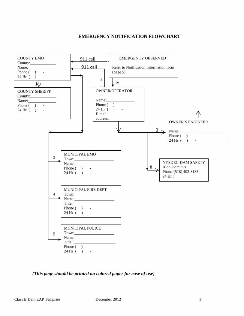
EMERGENCY NOTIFICATION FLOWCHART
1 3 6
OWNER/OPERATOR Name:______________ Phone ( ) - 24 Hr ( ) - E-mail address:
OWNER’S ENGINEER Name:_____________________ Phone ( ) - 24 Hr ( ) -
EMERGENCY OBSERVED Refer to Notification Information form (page 5)
MUNICIPAL EMO Town:____________________ Name:____________________ Phone ( ) - 24 Hr ( ) -
COUNTY EMO County:_____________ Name:______________ Phone ( ) - 24 Hr ( ) -
MUNICIPAL FIRE DEPT Town:____________________ Name:____________________ Title: _____________________ Phone ( ) - 24 Hr ( ) -
COUNTY SHERIFF County:_____________ Name:______________ Phone ( ) - 24 Hr ( ) -
NYSDEC-DAM SAFETY Alon Dominitz Phone (518) 402-8185 24 Hr :
MUNICIPAL POLICE Town:____________________ Name:____________________ Title: _____________________ Phone ( ) - 24 Hr ( ) -
911 call
or 2
911 call
3
4
5
(This page should be printed on colored paper for ease of use)
Class B Dam EAP Template December 2012 1
Notification Information: Dam Emergency Information for the Emergency Name of person reporting the emergency: ____________________________________________
Affiliation: ____________________________________________________________________
Phone Number: _________________________________________________________________
Dam Name & NYS-DEC ID #: ____________________________________________________
Location of dam:
County: ____________________________________________________________________
Municipality: _______________________________________________________________
Stream: ____________________________________________________________________
Road(s): ___________________________________________________________________
Time and Date of Dam Emergency: _____________________________________________ Type of Emergency: (see back of form): _____________________________________________
Phone appropriate parties: [refer to the Emergency Notifications Flow Chart, page #] “This is (your name, title & affiliation). You are being contacted per the Emergency Action Plan for the (name of dam). Please be advised: A Dam (Advisory, Warning, or Emergency) Condition has been identified at (name of dam). Observation was at (time and date). The situation is (explain the condition).” [Refer to Site Description, page #, for directions to the dam]
******** Important !!! If you cannot contact an organization or individual promptly, proceed to the next contact on the Notification Flowchart. Try to re-contact the unavailable or busy number after you have contacted all others.
Class B Dam EAP Template December 2012 2

TYPES OF DAM SAFETY EMERGENCIES THAT MIGHT BE EXERIENCED Advisory/ Non-failure condition (Condition C). An unusual problem or situation has occurred, but failure of the dam is not expected. Examples are:
- Flow conditions are such that flooding is expected to occur downstream and/ or upstream of the dam, including sudden changes due to activation of large release works at the dam.
- Any undocumented or unusual spring or seep. - Any sign of possible piping. - Any sign of slumping. - Any sinkhole. - Any newly detected crack. - Any unusual wet spot or boggy area. - Any seismic event regardless of how slight. - Any significant obstruction in the spillway. - Evidence of damage due to vandalism at any structure(s). - Bomb threat. - A civil disorder near the reservoir structure(s). - Any aircraft accident near the reservoir structure(s).
Warning Condition (Condition B). A potential failure situation is developing, but is still considered controllable. Some amount of time is still available for further analysis and decisions to be made before dam failure is likely. Examples of a Warning Condition are:
- Water level of the lake is at an unsafe level and is rising threatening to overtop the dam. - Water is eroding the auxiliary or emergency spillway. - Any developing erosion, settlement, or upheaval occurring on the downstream slope or at
the toe of the dam that is considered to be controllable. - Any undocumented leakage through any dam structure considered to be controllable.
Emergency Condition (Condition A). Failure is imminent or has occurred. There is no time left to attempt corrective measures to prevent failure. Examples of an Emergency Condition are:
- Water has overtopped or will overtop any dam or dike. - Any uncontrollable erosion, settlement or upheaval occurring on the downstream slope or
at the toe of the dam. - Any uncontrollable leakage through any dam structure. - A dislocation or failure of any structure which allows for an expanding, uncontrollable
discharge of water through the spillway, dam, or dikes indicating a breach is occurring. - Dam is failing, about to fail or has failed.
Class B Dam EAP Template December 2012 3
II. Inundation Maps Description of Inundated Area:
Provide a narrative description of the inundated area, and a brief discussion of the analysis
techniques and any engineering assumptions and methods that were used to generate the
inundation maps.
Inundation Maps: This section will contain detailed map(s) of inundated areas, including dwellings if applicable, and the precise location of the dam. The final inundation map to be included in the EAP should be, whenever possible, no larger than 11 inches by 17 inches, the best available map, and must be a fold out. As such, it may be necessary to reduce the mapping once the inundated areas are identified. If the inundation area is depicted on multiple maps, a map index must be included.
Class B Dam EAP Template December 2012 4

Samples Sample Inundation Map
TOGS 3.1.3 - EMERGENCY ACTION PLANS FOR DAMS - DECEMBER 2012 Appendix A

Sample Post Incident Report
TOGS 3.1.3 - EMERGENCY ACTION PLANS FOR DAMS - DECEMBER 2012 Appendix A

Sample Promulgation and Concurrence Form I, the undersigned, on the date indicated, have reviewed the Emergency Action Plan (EAP) for the Dam, State Dam ID___________. I have received the concurrence of the necessary emergency managers, who are listed below. Name Title Organization Date Director County Emergency Management Chief Fire Department Date of most recent Orientation Meeting (if held): __________________________
Certification of Promulgation and Concurrence: I certify under penalty of law that the answers and information provided in and with this Promulgation and Concurrence Form were prepared by me or under my direction or supervision. The answers and information I submit are, to the best of my knowledge and belief, true, accurate, and complete. This Certification must be signed by an individual who is the EAP coordinator, on his or her own behalf. Name: ______________________________________________________________________________ Title: _______________________________________________________________________________ Company: ___________________________________________________________________________ Signature: Date: _____________________________
TOGS 3.1.3 - EMERGENCY ACTION PLANS FOR DAMS - DECEMBER 2012 Appendix A