eagle conservation plan guidance module 1
TRANSCRIPT
U.S. Fish and Wildlife Service
U.S. Fish and Wildlife Service Division of Migratory Bird Management
April 2013
Eagle Conservation Plan GuidanceModule 1 – Land-based Wind Energy
Version 2
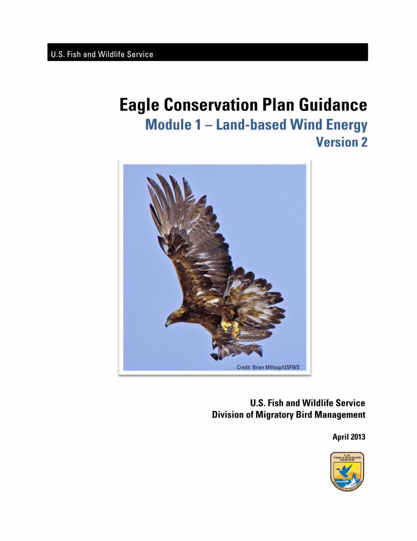
Credit: Brian Millsap/USFWS
i
Disclaimer
ThisEagleConservationPlanGuidanceisnotintendedto,norshallitbeconstruedto,limitorprecludetheServicefromexercisingitsauthorityunderanylaw,statute,orregulation,orfromtakingenforcementactionagainstanyindividual,company,oragency.ThisGuidanceisnotmeanttorelieveanyindividual,company,oragencyofitsobligationstocomplywithanyapplicableFederal,state,tribal,orlocal
laws,statutes,orregulation.ThisGuidancebyitselfdoesnotpreventtheServicefromreferringcasesforprosecution,
whetheracompanyhasfolloweditornot.
ii
EXECUTIVE SUMMARY 1. Overview OfallAmerica’swildlife,eaglesholdperhapsthemostreveredplaceinournationalhistoryandculture.TheUnitedStateshaslongimposedspecialprotectionsforitsbaldandgoldeneaglepopulations.Now,asthenationseekstoincreaseitsproductionofdomesticenergy,windenergydevelopersandwildlifeagencieshaverecognizedaneedforspecificguidancetohelpmakewindenergyfacilitiescompatiblewitheagleconservationandthelawsandregulationsthatprotecteagles.Tomeetthisneed,theU.S.FishandWildlifeService(Service)hasdevelopedtheEagleConservationPlanGuidance(ECPG).Thisdocumentprovidesspecificin‐depthguidanceforconservingbaldandgoldeneaglesinthecourseofsiting,constructing,andoperatingwindenergyfacilities.TheECPGguidancesupplementstheService’sLand‐BasedWindEnergyGuidelines(WEG).WEGprovidesabroadoverviewofwildlifeconsiderationsforsitingandoperatingwindenergyfacilities,butdoesnotaddressthein‐depthguidanceneededforthespecificlegalprotectionsaffordedtobaldandgoldeneagles.TheECPGfillsthisgap.LiketheWEG,theECPGcallsforwindprojectdeveloperstotakeastagedapproachtositingnewprojects.Bothcallforpreliminarylandscape‐levelassessmentstoassesspotentialwildlifeinteractionsandproceedtosite‐specificsurveysandriskassessmentspriortoconstruction.TheyalsocallformonitoringprojectoperationsandreportingeaglefatalitiestotheServiceandstateandtribalwildlifeagencies.CompliancewiththeECPGisvoluntary,buttheServicebelievesthatfollowingtheguidancewillhelpprojectoperatorsincomplyingwithregulatoryrequirementsandavoidingtheunintentional“take”ofeaglesatwindenergyfacilities,andwillalsoassistthewindenergyindustryinprovidingthebiologicaldataneededtosupportpermitapplicationsforfacilitiesthatmayposearisktoeagles.2. The Bald and Golden Eagle Protection Act TheBaldandGoldenEagleProtectionAct(BGEPA)istheprimarylawprotectingeagles.BGEPAprohibits“take”ofeagleswithoutapermit(16USC668‐668c).BGEPAdefines“take”toinclude“pursue,shootat,poison,wound,kill,capture,trap,collect,molestordisturb,”andprohibitstakeofindividualsandtheirparts,nests,oreggs.TheServiceexpandedthisdefinitionbyregulationtoincludetheterm“destroy”toensurethat“take”includesdestructionofeaglenests.Theterm“disturb”isfurtherdefinedbyregulationas“toagitateorbotherabaldorgoldeneagletoadegreethatcauses,orislikelytocause,….injurytoaneagle,adecreaseinproductivity,ornestabandonment”(50CFR22.3).3. Risks to Eagles from Wind Energy FacilitiesWindenergydevelopmentcanaffecteaglesinavarietyofways.First,eaglescanbekilledbycollidingwithstructuressuchaswindturbines.Thisistheprimarythreattoeaglesfromwindfacilities,andtheECPGguidanceisprimarilyaimedatthisthreat.Second,disturbancefrompre‐construction,construction,oroperationandmaintenanceactivitiesmightdisturbeaglesatconcentrationsitesorandresultinlossofproductivityatnearbynests.Third,seriousdisturbanceormortalityeffectscouldresultinthepermanentorlongtermlossofanestingterritory.Additionally,disturbancesnearimportanteagleuseareasormigrationconcentrationsitesmightstresseaglessomuchthattheysufferreproductivefailureormortalityelsewhere,toadegreethat
iii
couldamounttoprohibitedtake.Alloftheseimpacts,unlessproperlypermitted,areviolationsofBGEPA.4. Eagle Take Permits TheServicerecognizesthatwindenergyfacilities,eventhosedevelopedandoperatedwiththeutmostefforttoconservewildlife,mayundersomecircumstancesresultinthe“take”ofeaglesunderBGEPA.However,in2009,theServicepromulgatednewpermitrulesforeaglesthataddressthisissue(50CFR22.26and22.27).UnderthesenewrulestheServicecanissuepermitsthatauthorizeindividualinstancesoftakeofbaldandgoldeneagleswhenthetakeisassociatedwith,butnotthepurposeof,anotherwiselawfulactivity,andcannotpracticablybeavoided.Theregulationsalsoauthorizepermitsfor“programmatic”take,whichmeansthatinstancesof“take”maynotbeisolated,butmayrecur.Theprogrammatictakepermitsarethemostgermanepermitsforwindenergyfacilities.However,undertheseregulations,anyongoingorprogrammatictakemustbeunavoidableevenaftertheimplementationofadvancedconservationpractices(ACPs).TheECPGiswrittentoguidewind‐facilityprojectsstartingfromtheearliestconceptualplanningphase.Forprojectsalreadyinthedevelopmentoroperationalphase,implementationofallstagesoftherecommendedapproachintheECPGmaynotbeapplicableorpossible.Projectdevelopersoroperatorswithoperatingorsoon‐to‐beoperatingfacilitiesandwhoareinterestedinobtainingaprogrammaticeagletakepermitshouldcontacttheService.TheServicewillworkwithprojectdevelopersoroperatorstodetermineiftheprojectmightbeabletomeetthepermitrequirementsin50CFR22.26.TheServicemayrecommendthatthedevelopermonitoreaglefatalitiesanddisturbance,adoptreasonablemeasurestoreduceeaglefatalitiesfromhistoriclevels,andimplementcompensatorymitigation.SectionsoftheECPGthataddressthesetopicsarerelevanttobothplannedandoperatingwindfacilities(AppendicesEandFinparticular).Operatorsofwindprojects(andotheractivities)thatwereinoperationpriorto2009thatposearisktogoldeneaglesmayqualifyforprogrammaticeagletakepermitsthatdonotautomaticallyrequirecompensatorymitigation.Thisisbecausetherequirementsforobtainingprogrammatictakeauthorizationaredesignedtoreducetakefromhistoric,baselinelevels,andthepreambletotheEaglePermitRulespecifiedthatunavoidabletakeremainingafterimplementationofavoidanceandminimizationmeasuresatsuchprojectswouldnotbesubtractedfromregionaleagletakethresholds.5. Voluntary Nature of the ECPG Windprojectoperatorsarenotlegallyrequiredtoseekorobtainaneagletakepermit.However,thetakeofaneaglewithoutapermitisaviolationofBGEPA,andcouldresultinprosecution.ThemethodsandapproachessuggestedintheECPGarenotmandatorytoobtainaneagletakepermit.TheServicewillacceptotherapproachesthatprovidetheinformationanddatarequiredbytheregulations.TheECPcanbeastand‐alonedocument,orpartofalargerbirdandbatstrategyasdescribedintheWEG,solongasitadequatelymeetstheregulatoryrequirementsat50CFR22.26tosupportapermitdecision.However,ServiceemployeeswhoprocesseagletakepermitapplicationsaretrainedinthemethodsandapproachescoveredintheECPG.Usingothermethodologiesmayresultinlongerapplicationprocessingtimes.6. Eagle Take Thresholds EagletakepermitsmaybeissuedonlyincompliancewiththeconservationstandardsofBGEPA.Thismeansthatthetakemustbecompatiblewiththepreservationofeachspecies,defined(inUSFWS2009a)as“consistentwiththegoalofstableorincreasingbreedingpopulations.”
iv
Toensurethatanyauthorized“take”ofeaglesdoesnotexceedthisstandard,theServicehassetregionaltakethresholdsforeachspecies,usingmethodologycontainedintheNationalEnvironmentalPolicyAct(NEPA)FinalEnvironmentalAssessment(FEA)developedfortheneweaglepermitrules(USFWS2009b).TheServicelookedatregionalpopulationsofeaglesandsettakethresholdsforeachspecies(upperlimitsonthenumberofeaglemortalitiesthatcanbeallowedunderpermiteachyearintheseregionalmanagementareas).Theanalysisidentifiedtakethresholdsgreaterthanzeroforbaldeaglesinmostregionalmanagementareas.However,theServicedeterminedthatgoldeneaglepopulationsmightnotbeabletosustainanyadditionalunmitigatedmortalityatthattime,andsetthethresholdsforthisspeciesatzeroforallregionalpopulations.Thismeansthatanynewauthorized“take”ofgoldeneaglesmustbeatleastequallyoffsetbycompensatorymitigation(specificconservationactionstoreplaceoroffsetproject‐inducedlosses).TheServicealsoputinplacemeasurestoensurethatlocaleaglepopulationsarenotdepletedbytakethatwouldbeotherwiseregionallyacceptable.TheServicespecifiedthattakeratesmustbecarefullyassessed,bothforindividualprojectsandforthecumulativeeffectsofotheractivitiescausingtake,atthescaleofthelocal‐areaeaglepopulation(apopulationwithinadistanceof43milesforbaldeaglesand140milesforgoldeneagles).Thisdistanceisbasedonthemediandistancetowhicheaglesdispersefromthenestwheretheyarehatchedtowheretheysettletobreed.TheServiceidentifiedtakeratesofbetween1and5percentofthetotalestimatedlocal‐areaeaglepopulationassignificant,with5percentbeingattheupperendofwhatmightbeappropriateundertheBGEPApreservationstandard,whetheroffsetbycompensatorymitigationornot.AppendixFprovidesafulldescriptionoftakethresholdsandbenchmarks,andprovidessuggestedtoolsforevaluatinghowtheseapplytoindividualprojects.7. An Approach for Developing and Evaluating Eagle ACPs Permitsforeagletakeatwind‐energyfacilitiesareprogrammaticinnatureastheywillauthorizerecurringtakeratherthanisolatedincidencesoftake.Forprogrammatictakepermits,theregulationsrequirethatanyauthorizedtakemustbeunavoidableaftertheimplementationofadvancedconservationpractices(ACPs).ACPsaredefinedas“scientificallysupportablemeasuresthatareapprovedbytheServiceandrepresentthebestavailabletechniquestoreduceeagledisturbanceandongoingmortalitiestoalevelwhereremainingtakeisunavoidable”(50CFR22.3).Becausethebestinformationcurrentlyavailableindicatestherearenoconservationmeasuresthathavebeenscientificallyshowntoreduceeagledisturbanceandblade‐strikemortalityatwindprojects,theServicehasnotcurrentlyapprovedanyACPsforwindenergyprojects.TheprocessofdevelopingACPsforwindenergyfacilitieshasbeenhamperedbythelackofstandardizedscientificstudyofpotentialACPs.TheServicehasdeterminedthatthebestwaytoobtaintheneededscientificinformationistoworkwithindustrytodevelopACPsforwindprojectsaspartofanadaptive‐managementregimeandcomprehensiveresearchprogramtiedtotheprogrammatic‐take‐permitprocess.Inthisscenario,ACPswillbeimplementedatoperatingwindfacilitieswithaneagletakepermitonan“experimental”basis(theACPsareconsideredexperimentalbecausetheywouldnotcurrentlymeetthedefinitionofanACPintheeaglepermitregulation).TheexperimentalACPswouldbescientificallyevaluatedfortheireffectiveness,asdescribedindetailinthisdocument,andbasedontheresultsofthesestudies,couldbemodifiedin
v
anadaptivemanagementregime.ThisapproachwillprovidetheneededscientificinformationforthefutureestablishmentofformalACPs,whileenablingwindenergyfacilitiestomoveforwardintheinterim.DespitethecurrentlackofformallyapprovedACPs,theremaybeotherconservationmeasuresbasedonthebestavailablescientificinformationthatshouldbeappliedasaconditiononprogrammaticeagletakepermitsforwind‐energyfacilities.Aprojectdeveloperoroperatorwillbeexpectedtoimplementanyreasonableavoidanceandminimizationmeasuresthatmayreducetakeofeaglesataproject.Inaddition,theServiceandtheprojectdeveloperoroperatorwillidentifyothersite‐specificandpossiblyturbine‐specificfactorsthatmayposeriskstoeagles,andagreeontheexperimentalACPstoavoidandminimizethoserisks.UnlesstheServicedeterminesthatthereisareasonablescientificbasistoimplementtheexperimentalACPsupfront(oritisotherwiseadvantageoustothedevelopertodoso),werecommendthatsuchmeasuresbedeferreduntilsuchtimeasthereiseagletakeatthefacilityortheServicedeterminesthatthecircumstancesandevidencesurroundingthetakeorriskoftakesuggesttheexperimentalACPsmightbewarranted.TheprogrammaticeagletakepermitwouldspecifytheexperimentalACPs,ifcircumstanceswarrant,andthepermitwouldbeconditionedontheprojectoperator’sagreementtoimplementandmonitortheexperimentalACPs.BecausetheACPswouldbeexperimental,theServicerecommendsthattheybesubjecttoacostcapthattheServiceandtheprojectdeveloperoroperatorwouldestablishaspartoftheinitialagreementbeforeissuanceofaneaglepermit.Thiswouldprovidefinancialcertaintyastowhatmaximumcostsofsuchmeasuresmightbe.Theamountofthecapshouldbeproportionaltooverallrisk.AstheresultsfrommonitoringexperimentalACPsacrossanumberoffacilitiesaccumulateandareanalyzed,scientificinformationinsupportofcertainexperimentalACPsmayaccrue,whereasotherACPsmayshowlittlevalueinreducingtake.IftheServicedeterminesthattheavailablesciencedemonstratesanexperimentalACPiseffectiveinreducingeagletake,theServicewillformallyapprovethatACPandrequireitsimplementationupfrontonnewprojectswhenandwherewarranted.AstheECPGevolves,theServicewillnotexpectprojectdevelopersoroperatorstoretroactivelyredoanalysesorsurveysusingthenewapproaches.TheadaptiveapproachtotheECPGshouldnotdeterprojectdevelopersoroperatorsfromusingtheECPGimmediately.8. Mitigation Actions to Reduce Effects on Eagle Populations Wherewindenergyfacilitiescannotavoidtakingeaglesandeaglepopulationsarenothealthyenoughtosustainadditionalmortality,applicantsmustreducetheunavoidablemortalitytoano‐net‐lossstandardforthedurationofthepermittedactivity.No‐net‐lossmeansthattheseactionseitherreduceanotherongoingformofmortalitytoalevelequaltoorgreaterthantheunavoidablemortality,orleadtoanincreaseincarryingcapacitythatallowstheeaglepopulationtogrowbyanequalorgreateramount.Actionstoreduceeaglemortalityorincreasecarryingcapacitytothisno‐net‐lossstandardareknownas“compensatorymitigation”intheECPG.Examplesofcompensatorymitigationactivitiesmightincluderetrofittingpowerlinestoreduceeagleelectrocutions,removingroad‐killedanimalsalongroadswherevehicleshitandkillscavengingeagles,orincreasingpreyavailability.TheServiceandtheprojectdeveloperoroperatorseekingaprogrammaticeagletakepermitshouldagreeonthenumberofeaglefatalitiestomitigateandwhatactionswillbetakenifactual
vi
eaglefatalitiesdifferfromthepredictednumber.Thecompensatorymitigationrequirementandtriggerforadjustmentshouldbespecifiedinthepermit.IftheproceduresrecommendedintheECPGarefollowed,thereshouldnotbeaneedforadditionalcompensatorymitigation.However,ifother,lessrisk‐aversemodelsareusedtoestimatefatalities,underestimatesmightbeexpectedandthepermitshouldspecifythethreshold(s)oftakethatwouldtriggeradditionalactionsandthespecificmitigationactivitiesthatmightbeimplemented.Additionaltypesofmitigationsuchaspreservinghabitat–actionsthatwouldnotbythemselvesleadtoincreasednumbersofeaglesbutwouldassisteagleconservation–mayalsobeadvisedtooffsetotherdetrimentaleffectsofpermitsoneagles.Compensatorymitigationisfurtherdiscussedbelow(Stage4–AvoidanceandMinimizationofRiskandCompensatoryMitigation).9. Relationship of Eagle Guidelines (ECPG) to the Wind Energy Guidelines (WEG) TheECPGisintendedtobeimplementedinconjunctionwithotheractionsrecommendedintheWEGthatassessimpactstowildlifespeciesandtheirhabitats.TheWEGrecommendsafive‐tierprocessforsuchassessments,andtheECPGfitswithinthatframework.TheECPGfocusesonjusteaglestofacilitatecollectionofinformationthatcouldsupportaneagletakepermitdecision.TheECPGusesafive‐stageapproachliketheWEG;therelationshipbetweentheECPGstagesandtheWEGtiersisshowninFig.1.Tiers1and2oftheWEG(Stage1oftheECPG)couldprovidesufficientevidencetodemonstratethataprojectposesverylowrisktoeagles.Providedthisassessmentisrobust,eaglesmaynotwarrantfurtherconsiderationinsubsequentWEGtiers,andStages2through5oftheECPGandpursuitofaneagletakepermitmightbeunnecessary.AsimilarconclusioncouldbereachedattheendofStage2,3,or4.Insuchcases,ifunpermittedeagletakesubsequentlyoccurs,thewindprojectproponentshouldconsultwiththeU.S.FishandWildlifeServicetodeterminehowtoproceed,possiblybyobtaininganeagletakepermit.Thefollowingsectionsdescribethegeneralapproachenvisionedforassessingwindprojectimpactstoeagles(alsoseetheStageOverviewTableattheendoftheExecutiveSummary).
Tiers 1 and 2 of the WEG, Stage 1 of the ECPG Tier1oftheWEGisthepreliminarysiteevaluation(landscape‐scalescreeningofpossibleprojectsites).Tier2issitecharacterization(broadcharacterizationofoneormorepotentialprojectsites).ThesecorrespondwithStage1oftheECPG,thesite‐assessmentstage.AspartoftheTiers1and2process,projectdevelopersshouldcarryoutStage1oftheECPGandevaluatebroadgeographicareastoassesstherelativeimportanceofvariousareastoresidentbreedingandnon‐breedingeagles,andtomigrantandwinteringeagles.DuringStage1,theprojectdeveloperoroperatorshouldgatherexistinginformationfrompubliclyavailableliterature,databases,andothersources,andusethosedatatojudgetheappropriatenessofvariouspotentialprojectsites,balancingsuitabilityfordevelopmentwithpotentialrisktoeagles.Toincreasetheprobabilityofmeetingtheregulatoryrequirementsforaprogrammatictakepermit,biologicaladvicefromtheServiceandotherjurisdictionalwildlifeagenciesshouldberequestedasearlyaspossibleinthedeveloper'splanningprocessandshouldbeasinclusiveaspossibletoensureallissuesarebeingaddressedatthesametimeandinacoordinatedmanner.Ideally,consultationwiththeService,andstateandtribalwildlife
vii
agenciesisdonebeforewinddevelopersmakeanysubstantialfinancialcommitmentorfinalizeleaseagreements.Tier 3 of the WEG, Stages 2, 3, and 4 of the ECPG DuringTier3oftheWEG,adeveloperconductsfieldstudiestodocumentwildlifeuseandhabitatattheprojectsiteandpredictprojectimpacts.Thesesite‐specificstudiesarecriticaltoevaluatingpotentialimpactstoallwildlifeincludingeagles.ThedeveloperandtheServicewouldusetheinformationcollectedtosupportaneagletakepermitapplication,shouldthedeveloperseekapermit.AspartofTier3,theECPGrecommendsprojectdevelopersoroperatorsimplementthreestagesofassessment:
Stage2‐site‐specificsurveysandassessments; Stage3‐predictingeaglefatalities;and Stage4‐avoidanceandminimizationofriskandcompensatorymitigation.
Stage 2 – Site Specific Surveys and Assessments DuringStage2theServicerecommendstheprojectdevelopercollectquantitativedatathroughscientificallyrigoroussurveysdesignedtoassessthepotentialriskoftheproposedprojecttoeagles.TheServicerecommendscollectinginformationthatwillallowestimationoftheeagleexposurerate(eagle‐minutesflyingwithintheprojectfootprintperhourperkilometer2),aswellassurveyssufficienttodetermineifimportanteagleuseareasormigrationconcentrationsitesarewithinorincloseproximitytotheprojectfootprint(seeAppendixC).Inthecaseofsmallwindprojects(oneutility‐scaleturbineorafewsmallturbines),theprojectdevelopershouldconsidertheproximityofeaglenestingandroostingsitestoaproposedprojectanddiscusstheresultsoftheStage1assessmentwiththeServicetodetermineifStage2surveysarenecessary.InmanycasesthehazardousareaassociatedwithsuchprojectswillbesmallenoughthatStage2surveyswillnotbenecessary.Stage 3 – Predicting Eagle Fatalities InStage3,theServiceandprojectdevelopersoroperatorsusedatafromStage2inmodelstopredicteagleriskexpressedastheaveragenumberoffatalitiesperyearextrapolatedtothetenureofthepermit.Thesemodelscancomparealternativesiting,construction,andoperationalscenarios,ausefulfeatureinconstructinghypothesesregardingpredictedeffectsofconservationmeasuresandexperimentalACPs.TheServiceencouragesprojectdevelopersoroperatorstousetherecommendedpre‐constructionsurveyprotocolinthisECPGinStage2tohelpinformourpredictivemodelsinStage3.IfService‐recommendedsurveyprotocolsareused,thisriskassessmentcanbegreatlyfacilitatedusingmodeltoolsavailablefromtheService.IfprojectdevelopersoroperatorsuseotherformsofinformationfortheStage2assessment,theywillneedtofullydescribethosemethodsandtheanalysisusedfortheeagleriskassessment.TheServicewillrequiremoretimetoevaluateandreviewthedatabecause,forexample,theServicewillneedtocomparetheresultsoftheprojectdeveloperoroperator’seagleriskassessmentwithpredictionsfromourmodels.Iftheresultsdiffer,wewillworkwiththeprojectdevelopersoroperatorstodeterminewhichmodelresultsaremostappropriatefortheService’seventualpermittingdecisions.
viii
TheServiceandprojectdevelopersoroperatorsalsoevaluateStage2datatodeterminewhetherdisturbancetakeislikely,andifso,atwhatlevel.Anylossofproductionthatmaystemfromdisturbanceshouldbeaddedtothefatalityratepredictionfortheproject.TheriskassessmentsatStage2andStage3areconsistentwithdevelopingtheinformationnecessarytoassesstheefficacyofconservationmeasures,andtodevelopthemonitoringrequiredbythepermitregulationsat50CFR22.26(c)(2).Stage 4 - Avoidance and Minimization of Risk and Compensatory Mitigation InStage4theinformationgatheredshouldbeusedbytheprojectdeveloperoroperatorandtheServicetodeterminepotentialconservationmeasuresandACPs(ifavailable)toavoidorminimizepredictedrisksatagivensite(seeAppendixE).TheServicewillcomparetheinitialpredictionsofeaglemortalityanddisturbancefortheprojectwithpredictionsthattakeintoaccountproposedandpotentialconservationmeasuresandACPs,oncedevelopedandapproved,todetermineiftheprojectdeveloperoroperatorhasavoidedandminimizedriskstothemaximumdegreeachievable,therebymeetingtherequirementsforprogrammaticpermitsthatremainingtakeisunavoidable.Additionally,theServicewillusetheinformationprovidedalongwithotherdatatoconductacumulativeeffectsanalysistodetermineiftheproject’simpacts,incombinationwithotherpermittedtakeandotherknownfactors,areatalevelthatexceedtheestablishedthresholdsorbenchmarksforeagletakeattheregionalandlocal‐areascales.ThisfinaleagleriskassessmentiscompletedattheendofStage4afterapplicationofconservationmeasuresandACPs(ifavailable)alongwithaplanforcompensatorymitigationifrequired.Theeaglepermitprocessrequirescompensatorymitigationifconservationmeasuresdonotremovethepotentialfortake,andtheprojectedtakeexceedscalculatedthresholdsfortheeaglemanagementunitinwhichtheprojectislocated.However,theremayalsobeothersituationsinwhichcompensatorymitigationisnecessary.Thefollowingguidanceappliestothosesituationsaswell.Compensatorymitigationcanaddresspre‐existingcausesofeaglemortality(suchaseagleelectrocutionsfrompowerpoles)oritcanaddressincreasingthecarryingcapacityoftheeaglepopulationintheaffectedeaglemanagementunit.However,thereneedstobeacredibleanalysisthatsupportstheconclusionthatimplementingthecompensatorymitigationactionwillachievethedesiredbeneficialoffsetinmortalityorcarryingcapacity.Fornewwinddevelopmentprojects,ifcompensatorymitigationisnecessary,thecompensatorymitigationaction(oraverifiable,legalcommitmenttosuchmitigation)willberequiredupfrontbeforeprojectoperationsbeginbecauseprojectsmustmeetthestatutoryeaglepreservationstandardbeforetheServicemayissueapermit.Foroperatingprojects,compensatorymitigationshouldbeappliedfromthestartofthepermitperiod,notretroactivelyfromthetimetheprojectbegan.Theinitialcompensatorymitigationeffortshouldbesufficienttooffsetthepredictednumberofeaglefatalitiesperyearforfiveyears.Nolaterthanattheendofthefiveyearperiod,theServiceandtheprojectoperatorwillcomparethepredictedannualtakeestimatetotherealizedtakebasedonpost‐constructionmonitoring.Ifthetriggersidentifiedinthepermitforadjustmentofcompensatory
ix
mitigationaremet,thoseadjustmentsshouldbeimplemented.Inthecasewheretheobservedtakewaslessthanestimated,thepermitteewillreceiveacreditfortheexcesscompensation(thedifferencebetweentheactualmeanandthenumbercompensatedfor)thatcanbeappliedtoothertake(eitherbythepermitteeorotherpermittedindividualsathis/herdiscretion)withinthesameeaglemanagementunit.TheService,inconsultationwiththepermittee,willdeterminecompensatorymitigationforfutureyearsfortheprojectatthispoint,takingintoaccounttheobservedlevelsofmortalityandanyreductioninthatmortalitythatisexpectedbasedonimplementationofadditionalexperimentalconservationmeasuresandACPs.Monitoringusingthebestscientificandpracticablemethodsavailableshouldbeincludedtodeterminetheeffectivenessoftheresultingcompensatorymitigationefforts.TheServicewillmodifythecompensatorymitigationprocesstoadapttoanyimprovementsinourknowledgebaseasnewdatabecomeavailable.AttheendofStage4,allthematerialsnecessarytosatisfytheregulatoryrequirementstosupportapermitapplicationshouldbeavailable.Whileaprojectoperatorcansubmitapermitapplicationatanytime,theServicecanonlybegintheformalprocesstodeterminewhetheraprogrammaticeagletakepermitcanbeissuedaftercompletionofStage4.Ideally,NationalEnvironmentalPolicyAct(NEPA)andNationalHistoricPreservationAct(NHPA)analysesandassessmentswillalreadybeunderway,butifnot,Stage4shouldincludenecessaryNEPAanalysis,NHPAcompliance,coordinationwithotherjurisdictionalagencies,andtribalconsultation.
Tier 4 and 5 of the WEG, Stage 5 of the ECPG IftheServiceissuesaneagletakepermitandtheprojectgoesforward,projectoperatorswillconductpost‐constructionsurveystocollectdatathatcanbecomparedwiththepre‐constructionrisk‐assessmentpredictionsforeaglefatalitiesanddisturbance.Themonitoringprotocolshouldincludevalidatedtechniquesforassessingbothmortalityanddisturbanceeffects,andtheymustmeetthepermit‐conditionrequirementsat50CFR22.26(c)(2).Inmostcases,intensivemonitoringwillbeconductedforatleastthefirsttwoyearsafterpermitissuance,followedbylessintensemonitoringforuptothreeyearsaftertheexpirationdateofthepermit.Projectdevelopersoroperatorsshouldusethepost‐constructionsurveyprotocolsincludedorreferencedinthisECPG,butwewillconsiderothermonitoringprotocolsprovidedbypermitapplicantsthoughtheprocesswilllikelytakelongerthaniffamiliarapproacheswereused.TheServicewillusetheinformationfrompost‐constructionmonitoringinameta‐analysisframeworktoweightandimprovepre‐constructionpredictivemodels.AdditionallyinStage5,theServiceandprojectdevelopersoroperatorsshouldusethepost‐constructionmonitoringdatato(1)assesswhethercompensatorymitigationisadequate,excessive,ordeficienttooffsetobservedmortality,andmakeadjustmentsaccordingly;and(2)exploreoperationalchangesthatmightbewarrantedataprojectafterpermittingtoreduceobservedmortalityandmeetpermitrequirements.
10. Site Categorization Based on Mortality Risk to Eagles BeginningattheendofStage1,andcontinuingattheendofStages2,3,and4,werecommendtheapproachoutlinedbelowbeusedtoassessthelikelihoodthatawindprojectwilltakeeagles,andif

x
so,thattheprojectwillmeetstandardsin50CFR22.26forissuanceofaprogrammaticeagletakepermit.
Category 1 – High risk to eagles, potential to avoid or mitigate impacts is low Aprojectisinthiscategoryifit:
(1)hasanimportanteagle‐useareaormigrationconcentrationsitewithintheprojectfootprint;or
(2)hasanannualeaglefatalityestimate(averagenumberofeaglespredictedtobetakenannually)>5%oftheestimatedlocal‐areapopulationsize;or
(3)causesthecumulativeannualtakeforthelocal‐areapopulationtoexceed5%oftheestimatedlocal‐areapopulationsize.
Inaddition,projectsthathaveeaglenestswithin½themeanproject‐areainter‐nestdistanceoftheprojectfootprintshouldbecarefullyevaluated.Ifitislikelyeaglesoccupyingtheseterritoriesuseorpassthroughtheprojectfootprint,category1designationmaybeappropriate.Projectsoralternativesincategory1shouldbesubstantiallyredesignedtoatleastmeetthecategory2criteria.TheServicerecommendsthatprojectdevelopersnotbuildprojectsatsitesincategory1becausetheprojectwouldlikelynotmeettheregulatoryrequirements.Therecommendedapproachforassessingthepercentageofthelocal‐areapopulationpredictedtobetakenisdescribedinAppendixF.Category 2 – High or moderate risk to eagles, opportunity to mitigate impacts Aprojectisinthiscategoryifit:
(1)hasanimportanteagle‐useareaormigrationconcentrationsitewithintheprojectareabutnotintheprojectfootprint;or
(2)hasanannualeaglefatalityestimatebetween0.03eaglesperyearand5%oftheestimatedlocal‐areapopulationsize;or
(3)causescumulativeannualtakeofthelocal‐areapopulationoflessthan5%oftheestimatedlocal‐areapopulationsize.
Projectsinthiscategorywillpotentiallytakeeaglesatarategreaterthanisconsistentwithmaintainingstableorincreasingpopulations,buttheriskmightbereducedtoanacceptablelevelthroughacombinationofconservationmeasuresandreasonablecompensatorymitigation.Theseprojectshaveariskofongoingtakeofeagles,butthisriskcanbeminimized.ForprojectsinthiscategorytheprojectdeveloperoroperatorshouldprepareanEagleConservationPlan(ECP)orsimilarplantodocumentmeetingtheregulatoryrequirementsforaprogrammaticpermit.TheECPorsimilardocumentcanbeastand‐alonedocument,orpartofalargerbirdandbatstrategyasdescribedintheWEG,solongasitadequatelymeetstheregulatoryrequirementsat50CFR22.26tosupportapermitdecision.Foreaglemanagementpopulationswheretakethresholdsaresetatzero,theconservationmeasuresintheECPshouldincludecompensatorymitigationandmustresultinno‐net‐losstothebreedingpopulationtobecompatiblewiththepermitregulations.Thisdoesnotapplytogoldeneagleseastofthe100thmeridian,forwhichnonon‐emergencytakecanpresentlybeauthorized(USFWS2009b).Category 3 – Minimal risk to eagles Aprojectisinthiscategoryifit:
xi
(1)hasnoimportanteagleuseareasormigrationconcentrationsiteswithintheprojectarea;and
(2)hasanannualeaglefatalityrateestimateoflessthan0.03;and(3)causescumulativeannualtakeofthelocal‐areapopulationoflessthan5%ofthe
estimatedlocal‐areapopulationsize.Projectsincategory3poselittlerisktoeaglesandmaynotrequireorwarranteagletakepermits,butthatdecisionshouldbemadeincoordinationwiththeService.Still,aprojectdeveloperoroperatormaywishtocreateanECPorsimilardocumentorstrategythatdocumentstheproject’slowrisktoeagles,andoutlinesmortalitymonitoringforeaglesandaplanofactionifeaglesaretakenduringprojectconstructionoroperation.ThiswouldenabletheServicetoprovideapermittoallowademinimisamountoftakeiftheprojectdeveloperoroperatorwishedtoobtainsuchapermit.
Theriskcategoryofaprojectcanpotentiallychangeasaresultofadditionalsite‐specificanalysesandapplicationofmeasurestoreducetherisk.Forexample,aprojectmayappeartobeincategory2asaresultofStage1analyses,butaftercollectionofsite‐specificinformationinStage2itmightbecomeclearitisacategory1project.Ifaprojectcannotpracticallybeplacedinoneofthesecategories,theprojectdeveloperoroperatorandtheServiceshouldworktogethertodetermineiftheprojectcanmeetprogrammaticeagletakepermittingrequirementsin50CFR22.26and22.27.Projectsshouldbeplacedinthehighestcategory(withcategory1beingthehighest)inwhichoneormoreofthecriteriaaremet.11. Addressing Uncertainty Thereissubstantialuncertaintysurroundingtheriskofwindprojectstoeagles,andofwaystominimizethatrisk.Forthisreason,theServicestressesthatitisveryimportantnottounderestimateeaglefatalityratesatwindfacilities.Overestimates,onceconfirmed,canbeadjusteddownwardbasedonpost‐constructionmonitoringinformationwithnoconsequencetoeaglepopulations.Projectdevelopersoroperatorscantradeorbecreditedforexcesscompensatorymitigation,anddebitstoregionalandlocal‐areaeagle‐takethresholdsandbenchmarkscanbeadjusteddownwardstoreflectactualfatalityrates.However,theoptionsforaddressingunderestimatedfatalityratesareextremelylimited,andposeeitherpotentialhardshipsforwinddevelopersorsignificantriskstoeaglepopulations.Ourlong‐termapproachformovingforwardinthefaceofthisuncertaintyistoimplementeagletakepermittinginaformaladaptivemanagementframework.TheServiceanticipatesfourspecificsetsofadaptivemanagementdecisions:(1)adaptivemanagementofwindprojectsitinganddesignrecommendations;(2)adaptivemanagementofwindprojectoperations;(3)adaptivemanagementofcompensatorymitigation;and(4)adaptivemanagementofpopulation‐leveltakethresholds.ThesearediscussedinmoredetailinAppendixA.Theadaptivemanagementprocesswilldependheavilyonpre‐andpost‐constructiondatafromindividualprojects,butanalyses,assessment,andmodelevaluationwillrelyondatapooledovermanyindividualwindprojects.Learningaccomplishedthroughadaptivemanagementwillberapidlyincorporatedintothepermittingprocesssothattheregulatoryprocessadjustsinproportiontoactualrisk. 12. Interaction with the Service TheServiceencouragesearly,frequentandthoroughcoordinationbetweenprojectdevelopersoroperatorsandServiceandotherjurisdictional‐agencyemployeesastheyimplementthetiersoftheWEG,andtherelatedStagesoftheECPG.Closecoordinationwillaidtherefinementofthe
xii
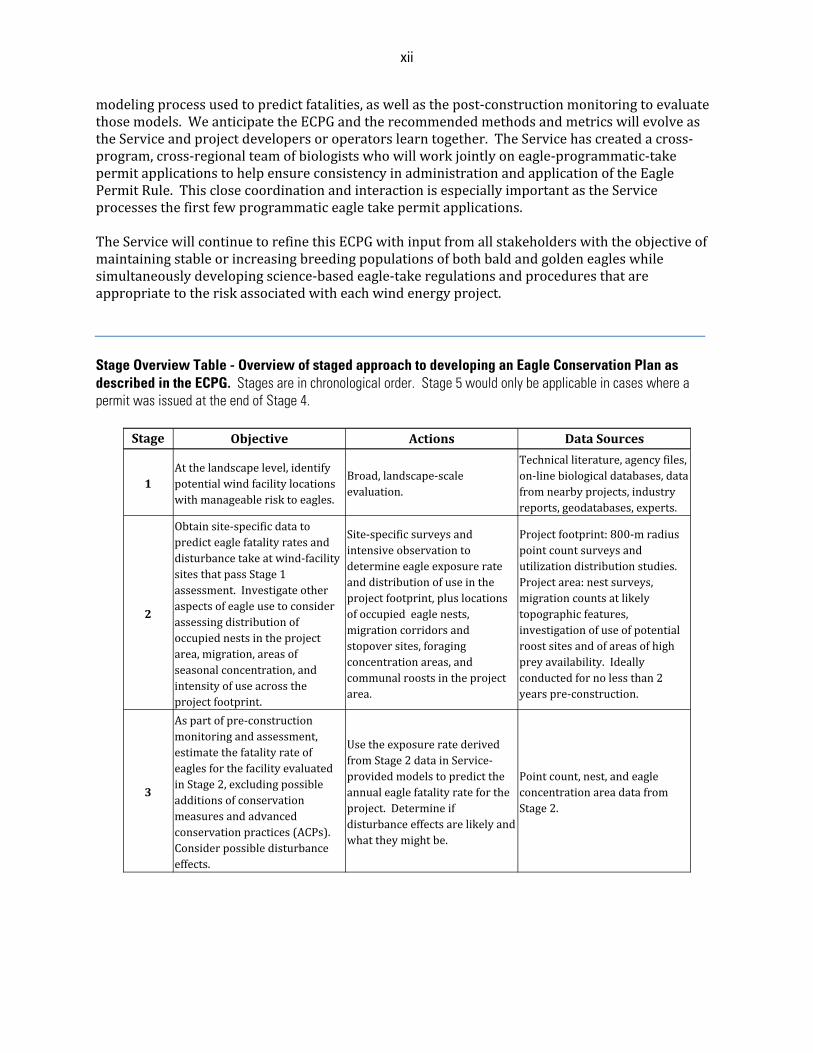
modelingprocessusedtopredictfatalities,aswellasthepost‐constructionmonitoringtoevaluatethosemodels.WeanticipatetheECPGandtherecommendedmethodsandmetricswillevolveastheServiceandprojectdevelopersoroperatorslearntogether.TheServicehascreatedacross‐program,cross‐regionalteamofbiologistswhowillworkjointlyoneagle‐programmatic‐takepermitapplicationstohelpensureconsistencyinadministrationandapplicationoftheEaglePermitRule.ThisclosecoordinationandinteractionisespeciallyimportantastheServiceprocessesthefirstfewprogrammaticeagletakepermitapplications.TheServicewillcontinuetorefinethisECPGwithinputfromallstakeholderswiththeobjectiveofmaintainingstableorincreasingbreedingpopulationsofbothbaldandgoldeneagleswhilesimultaneouslydevelopingscience‐basedeagle‐takeregulationsandproceduresthatareappropriatetotheriskassociatedwitheachwindenergyproject.Stage Overview Table - Overview of staged approach to developing an Eagle Conservation Plan as described in the ECPG. Stages are in chronological order. Stage 5 would only be applicable in cases where a permit was issued at the end of Stage 4.
Stage Objective Actions DataSources
1Atthelandscapelevel,identifypotentialwindfacilitylocationswithmanageablerisktoeagles.
Broad,landscape‐scaleevaluation.
Technicalliterature,agencyfiles,on‐linebiologicaldatabases,datafromnearbyprojects,industryreports,geodatabases,experts.
2
Obtainsite‐specificdatatopredicteaglefatalityratesanddisturbancetakeatwind‐facilitysitesthatpassStage1assessment.Investigateotheraspectsofeagleusetoconsiderassessingdistributionofoccupiednestsintheprojectarea,migration,areasofseasonalconcentration,andintensityofuseacrosstheprojectfootprint.
Site‐specificsurveysandintensiveobservationtodetermineeagleexposurerateanddistributionofuseintheprojectfootprint,pluslocationsofoccupiedeaglenests,migrationcorridorsandstopoversites,foragingconcentrationareas,andcommunalroostsintheprojectarea.
Projectfootprint:800‐mradiuspointcountsurveysandutilizationdistributionstudies.Projectarea:nestsurveys,migrationcountsatlikelytopographicfeatures,investigationofuseofpotentialroostsitesandofareasofhighpreyavailability.Ideallyconductedfornolessthan2yearspre‐construction.
3
Aspartofpre‐constructionmonitoringandassessment,estimatethefatalityrateofeaglesforthefacilityevaluatedinStage2,excludingpossibleadditionsofconservationmeasuresandadvancedconservationpractices(ACPs).Considerpossibledisturbanceeffects.
UsetheexposureratederivedfromStage2datainService‐providedmodelstopredicttheannualeaglefatalityratefortheproject.Determineifdisturbanceeffectsarelikelyandwhattheymightbe.
Pointcount,nest,andeagleconcentrationareadatafromStage2.
xiii
Stage Objective Actions DataSources
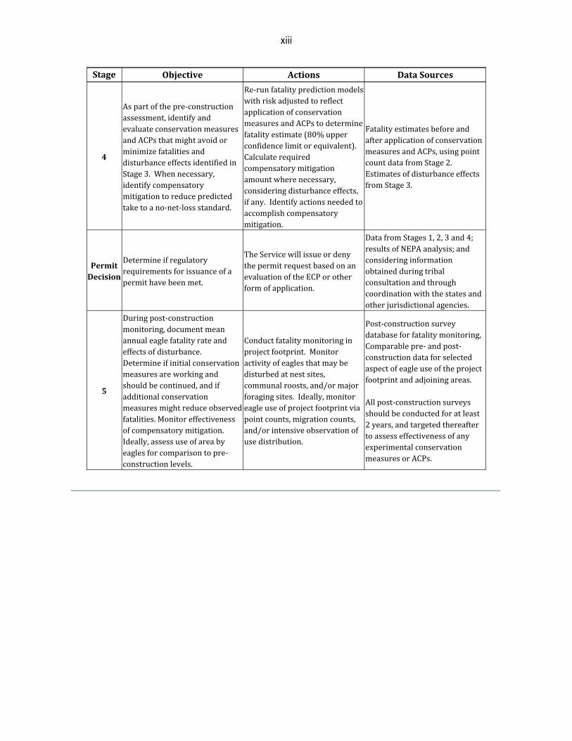
4
Aspartofthepre‐constructionassessment,identifyandevaluateconservationmeasuresandACPsthatmightavoidorminimizefatalitiesanddisturbanceeffectsidentifiedinStage3.Whennecessary,identifycompensatorymitigationtoreducepredictedtaketoano‐net‐lossstandard.
Re‐runfatalitypredictionmodelswithriskadjustedtoreflectapplicationofconservationmeasuresandACPstodeterminefatalityestimate(80%upperconfidencelimitorequivalent).Calculaterequiredcompensatorymitigationamountwherenecessary,consideringdisturbanceeffects,ifany.Identifyactionsneededtoaccomplishcompensatorymitigation.
FatalityestimatesbeforeandafterapplicationofconservationmeasuresandACPs,usingpointcountdatafromStage2.EstimatesofdisturbanceeffectsfromStage3.
PermitDecision
Determineifregulatoryrequirementsforissuanceofapermithavebeenmet.
TheServicewillissueordenythepermitrequestbasedonanevaluationoftheECPorotherformofapplication.
DatafromStages1,2,3and4;resultsofNEPAanalysis;andconsideringinformationobtainedduringtribalconsultationandthroughcoordinationwiththestatesandotherjurisdictionalagencies.
5
Duringpost‐constructionmonitoring,documentmeanannualeaglefatalityrateandeffectsofdisturbance.Determineifinitialconservationmeasuresareworkingandshouldbecontinued,andifadditionalconservationmeasuresmightreduceobservedfatalities.Monitoreffectivenessofcompensatorymitigation.Ideally,assessuseofareabyeaglesforcomparisontopre‐constructionlevels.
Conductfatalitymonitoringinprojectfootprint.Monitoractivityofeaglesthatmaybedisturbedatnestsites,communalroosts,and/ormajorforagingsites.Ideally,monitoreagleuseofprojectfootprintviapointcounts,migrationcounts,and/orintensiveobservationofusedistribution.
Post‐constructionsurveydatabaseforfatalitymonitoring,Comparablepre‐andpost‐constructiondataforselectedaspectofeagleuseoftheprojectfootprintandadjoiningareas.Allpost‐constructionsurveysshouldbeconductedforatleast2years,andtargetedthereaftertoassesseffectivenessofanyexperimentalconservationmeasuresorACPs.
1
Table of Contents Disclaimer .............................................................................................................................................................. i EXECUTIVE SUMMARY ........................................................................................................................................ ii
1. Overview ..................................................................................................................................................... ii 2. The Bald and Golden Eagle Protection Act ................................................................................................ ii 3. Risks to Eagles from Wind Energy Facilities .............................................................................................. ii 4. Eagle Take Permits .................................................................................................................................... iii 5. Voluntary Nature of the ECPG ................................................................................................................... iii 6. Eagle Take Thresholds ............................................................................................................................... iii 7. An Approach for Developing and Evaluating Eagle ACPs ......................................................................... iv 8. Mitigation Actions to Reduce Effects on Eagle Populations ..................................................................... v 9. Relationship of Eagle Guidelines (ECPG) to the Wind Energy Guidelines (WEG) .................................... vi
Tiers 1 and 2 of the WEG, Stage 1 of the ECPG ........................................................................................ vi Tier 3 of the WEG, Stages 2, 3, and 4 of the ECPG .................................................................................. vii Tier 4 and 5 of the WEG, Stage 5 of the ECPG .......................................................................................... ix
10. Site Categorization Based on Mortality Risk to Eagles .......................................................................... ix Category 1 – High risk to eagles, potential to avoid or mitigate impacts is low ...................................... x Category 2 – High or moderate risk to eagles, opportunity to mitigate impacts ...................................... x Category 3 – Minimal risk to eagles ........................................................................................................... x
11. Addressing Uncertainty ........................................................................................................................... xi 12. Interaction with the Service .................................................................................................................... xi
INTRODUCTION AND PURPOSE .......................................................................................................................... 4
1. Purpose ........................................................................................................................................................ 4 2. Legal Authorities and Relationship to Other Statutes and Guidelines ..................................................... 6 3. Background and Overview of Process ........................................................................................................ 8
a. Risks to Eagles ........................................................................................................................................ 9 b. General Approach to Address Risk ......................................................................................................... 9
ASSESSING RISK AND EFFECTS ....................................................................................................................... 12
1. Considerations When Assessing Eagle Use Risk .................................................................................... 12 a. General Background and Rationale for Assessing Project Effects on Eagles ..................................... 12 b. Additional Considerations for Assessing Project Effects: Migration Corridors and Stopover Sites ... 14
2. Eagle Risk Factors ..................................................................................................................................... 15 3. Overview of Process to Assess Risk ......................................................................................................... 16 4. Site Categorization Based on Mortality Risk to Eagles ........................................................................... 25
a. Category 1 – High risk to eagles, potential to avoid or mitigate impacts is low ................................ 25 b. Category 2 – High or moderate risk to eagles, opportunity to mitigate impacts ................................ 25 c. Category 3 – Minimal risk to eagles ..................................................................................................... 26
5. Cumulative Effects Considerations .......................................................................................................... 26 a. Early Planning ........................................................................................................................................ 26 b. Analysis Associated with Permits ........................................................................................................ 27
2
ADAPTIVE MANAGEMENT ................................................................................................................................ 28 EAGLE CONSERVATION PLAN DEVELOPMENT PROCESS ................................................................................ 29
1. Contents of the Eagle Conservation Plan ................................................................................................. 30 a. Stage 1 .................................................................................................................................................. 31 b. Stage 2 .................................................................................................................................................. 31 c. Stage 3 ................................................................................................................................................... 31 d. Stage 4 .................................................................................................................................................. 31 e. Stage 5 – Post-construction Monitoring .............................................................................................. 31
INTERACTION WITH THE SERVICE .................................................................................................................... 32 INFORMATION COLLECTION.............................................................................................................................. 33 GLOSSARY .......................................................................................................................................................... 34 LITERATURE CITED ............................................................................................................................................. 40 APPENDIX A: ADAPTIVE MANAGEMENT ......................................................................................................... 44
1. Adaptive Management as a Tool ............................................................................................................. 45 2. Applying Adaptive Management to Eagle Take Permitting .................................................................... 46
a. Adaptive Management of Wind Project Operations ............................................................................ 46 b. Adaptive Management of Wind Project Siting and Design Recommendations .................................. 47 c. Adaptive Management of Compensatory Mitigation ........................................................................... 47 d. Adaptive Management of Population-Level Take Thresholds ............................................................. 47
Literature Cited .............................................................................................................................................. 48 APPENDIX B: STAGE 1 – SITE ASSESSMENT ................................................................................................... 50
Literature Cited .............................................................................................................................................. 52 APPENDIX C: STAGE 2 – SITE-SPECIFIC SURVEYS AND ASSESSMENT ......................................................... 53
1. Surveys of Eagle Use ................................................................................................................................ 53 a. Point Count Surveys .............................................................................................................................. 53 b. Migration Counts and Concentration Surveys ...................................................................................... 60 c. Utilization Distribution (UD) Assessment ............................................................................................. 62 d. Summary ................................................................................................................................................ 63
2. Survey of the Project-area Nesting Population: Number and Locations of Occupied Nests of Eagles .. 64 Literature Cited .............................................................................................................................................. 66
APPENDIX D: STAGE 3 – PREDICTING EAGLE FATALITIES ............................................................................... 68
1. Exposure .................................................................................................................................................... 69 2. Collision Probability .................................................................................................................................. 71 3. Expansion .................................................................................................................................................. 72
3
4. Fatalities.................................................................................................................................................... 72 5. Putting it all together: an example ........................................................................................................... 72
a. Patuxent Power Company Example ...................................................................................................... 73 b. Exposure ................................................................................................................................................ 74 b. Collision Probability ............................................................................................................................... 75 c. Expansion ............................................................................................................................................... 75 d. Fatalities ................................................................................................................................................ 75
6. Additional Considerations ........................................................................................................................ 76 a. Small-scale projects .............................................................................................................................. 76
Literature Cited .............................................................................................................................................. 77 APPENDIX E: STAGE 4 – AVOIDANCE AND MINIMIZATION OF RISK USING ACPS AND OTHER CONSERVATION MEASURES, AND COMPENSATORY MITIGATION ............................................................... 78
Literature Cited .............................................................................................................................................. 79 APPENDIX F: ASSESSING PROJECT-LEVEL TAKE AND CUMULATIVE EFFECTS ANALYSES .......................... 80
Literature Cited .............................................................................................................................................. 85 APPENDIX G: EXAMPLES USING RESOURCE EQUIVALENCY ANALYSIS TO ESTIMATE THE COMPENSATORY MITIGATION FOR THE TAKE OF GOLDEN AND BALD EAGLES FROM WIND ENERGY DEVELOPMENT ................................................................................................................................................... 86
1. Introduction ............................................................................................................................................... 86 2. REA Inputs ................................................................................................................................................. 86 3. REA Example – WindCoA ......................................................................................................................... 88
a. REA Language and Methods ................................................................................................................. 89 b. REA Results for WindCoA ..................................................................................................................... 91 c. Summary of Bald Eagle REA Results .................................................................................................... 92 d. Discussion on Using REA ...................................................................................................................... 93 e. Additional Compensatory Mitigation Example ..................................................................................... 93 f. Take from Disturbance ........................................................................................................................... 93
Literature Cited .............................................................................................................................................. 94 APPENDIX H: STAGE 5 – CALIBRATING AND UPDATING OF THE FATALITY PREDICTION AND CONTINUED RISK-ASSESSMENT ........................................................................................................................................... 96
1. Fatality Monitoring ................................................................................................................................... 96 2. Disturbance Monitoring ............................................................................................................................ 98 3. Comparison of Post-Construction Eagle Use with Pre-Construction Use ................................................ 99 Literature Cited .............................................................................................................................................. 99
4
INTRODUCTION AND PURPOSE ThemissionoftheServiceisworkingwithotherstoconserve,protectandenhancefish,wildlife,plantsandtheirhabitatsforthecontinuingbenefitoftheAmericanpeople.Aspartofthis,wearechargedwithimplementingstatutesincludingtheBGEPA,MBTA(MigratoryBirdTreatyAct),andESA(EndangeredSpeciesAct).BGEPAprohibitsalltakeofeaglesunlessotherwiseauthorizedbytheService.AgoalofBGEPAistoensurethatanyauthorizedtakeofbaldandgoldeneaglesiscompatiblewiththeirpreservation,whichtheServicehasinterpretedtomeanallowingtakethatisconsistentwiththegoalofstableorincreasingbreedingpopulations.In2009,theServicepromulgatedregulationsauthorizingissuanceofpermitsfornon‐purposefultakeofeagles;theECPGisintendedtopromotecompliancewithBGEPAwithrespecttosuchpermitsbyprovidingrecommendedproceduresfor:
(1) conductingearlypre‐constructionassessmentstoidentifyimportanteagleuseareas;(2) analyzingpre‐constructioninformationtoestimatepotentialimpactsoneagles;(3) avoiding,minimizing,and/orcompensatingforpotentialadverseeffectstoeagles;and(4) monitoringforimpactstoeaglesduringconstructionandoperation.
TheECPGcallsforscientificallyrigoroussurveys,monitoring,riskassessment,andresearchdesignsproportionatetotherisktobothbaldandgoldeneagles.TheECPGdescribesaprocessbywhichwindenergydevelopers,operators,andtheirconsultantscancollectandanalyzeinformationthatcouldleadtoaprogrammaticpermittoauthorizeunintentionaltakeofeaglesatwindenergyfacilities.Theprocessesdescribedhereisnotrequired,butprojectdevelopersoroperatorsshouldcoordinatecloselywiththeServiceiftheyplantouseanalternativeapproachtomeettheregulatoryrequirementsforapermit.1. Purpose TheServicepublishedafinalrule(EaglePermitRule)onSeptember11,2009underBGEPA(50CFR22.26)authorizinglimitedissuanceofpermitstotakebaldeagles(Haliaeetusleucocephalus)andgoldeneagles(Aquilachrysaetos)‘‘fortheprotectionof...otherinterestsinanyparticularlocality’’wherethetakeiscompatiblewiththepreservationofthebaldeagleandthegoldeneagle,isassociatedwithandnotthepurposeofanotherwiselawfulactivity,andcannotpracticablybeavoided(USFWS2009a).TheECPGexplainstheService’sapproachtoissuingprogrammaticeagletakepermitsforwindenergyprojectsunderthisauthority,andprovidesguidancetopermitapplicants(projectdevelopersoroperators),Servicebiologists,andbiologistswithotherjurisdictionalagencies(stateandtribalfishandwildlifeagencies,inparticular)onthedevelopmentofEagleConservationPlans(ECPs)tosupportpermitissuance.SincefinalizationoftheEaglePermitRule,thedevelopmentandplanneddevelopmentofwindfacilities(developmentsforthegenerationofelectricityfromwindturbines)haveincreasedintherangeofthegoldeneagleinthewesternUnitedStates.Goldeneaglesarevulnerabletocollisionswithwindturbines(Hunt2002),andinsomeareassuchcollisionscouldbeamajorsourceofmortality(Huntetal.1999,2002;USFWSunpublisheddata).AlthoughsignificantnumbersofbaldeaglemortalitieshavenotyetbeenreportedatNorthAmericanwindfacilities,deathshaveoccurredatmorethanonelocation(USFWS,unpublisheddata),andthecloselyrelatedandbehaviorallysimilarwhite‐tailedeagle(Haliaeetusalbicilla)hasbeenkilledregularlyatwindfacilitiesinEurope(Krone2003,Cole2009,Nygårdetal.2010).Becauseofthisrisktoeagles,manyofthecurrentandplannedwindfacilitiesrequirepermitsundertheEaglePermitRuletobeincompliancewiththelawifandwhenaneagleistakenatthatfacility.Inadditiontobeinglegally
5
necessarytocomplywithBGEPAand50CFR22.26,theconservationpracticesnecessarytomeetstandardsrequiredforissuanceofthesepermitsshouldoffsettheshort‐andlong‐termnegativeeffectsofwindenergyfacilitiesoneaglepopulations.Becauseoftheurgentneedforguidanceonpermittingeagletakeatwindfacilities,thisinitialmodulefocusesonthisissue.Manyoftheconceptsandapproachesoutlinedinthismodulecanbereadilyexportedtoothersituations(e.g.,solarfacilities,electricpowerlines),andtheServiceexpectstoreleaseothermodulesinthefuturespecificallyaddressingothersourcesofeagletake.TheECPGisintendedtoprovideinterpretiveguidancetoServicebiologistsandothersinapplyingtheregulatorypermitstandardsasspecifiedintherule.Theydonotin‐and‐ofthemselvesimposeadditionalregulatoryorgenerally‐bindingrequirements.AnECPperseisnotrequired,eventoobtainaprogrammaticeagletakepermit.Aslongasthepermitapplicationiscompleteandincludestheinformationnecessarytoevaluateapermitapplicationunder50CFR22.26or22.27,theServicewillreviewtheapplicationandmakeadeterminationifapermitwillbeissued.However,ServicepersonnelwillbetrainedintheapplicationoftheproceduresandapproachesoutlinedintheECPG,anddeveloperswhochoosetouseotherapproachesshouldexpectthereviewtimeonthepartoftheServicetobelonger.TheServicerecommendsthatthebasicformatfortheECPbefollowedtoallowforexpeditiousconsiderationoftheapplicationmaterials.PreparationofanECPandconsultationwiththeServicearevoluntaryactionsonthepartofthedeveloper.Thereisnolegalrequirementthatwinddevelopersapplyfororobtainaneagletakepermit,solongastheprojectdoesnotresultintakeofeagles.However,takeofaneaglewithoutaneagletakepermitisaviolationofBGEPA,sothedeveloperoroperatormustweightherisksinhis/herdecision.TheServiceisavailabletoconsultwiththedeveloperoroperatorashe/shemakesthatdecision.TheECPGiswrittentoguidewind‐facilityprojectsstartingfromtheearliestconceptualplanningphase.Forprojectsalreadyinthedevelopmentoroperationalphase,implementationofallstagesoftherecommendedapproachintheECPGmaynotbeapplicableorpossible.Projectdevelopersoroperatorswithoperatingorsoon‐to‐beoperatingfacilitiesandwhoareinterestedinobtainingaprogrammaticeagletakepermitshouldcontacttheService.TheServicewillworkwithprojectdevelopersoroperatorstodetermineiftheprojectmightbeabletomeetthepermitrequirementsin50CFR22.26.TheServicemayrecommendthatthedevelopermonitoreaglefatalitiesanddisturbance,adoptreasonablemeasurestoreduceeaglefatalitiesfromhistoriclevels,andimplementcompensatorymitigation.SectionsoftheECPGthataddressthesetopicsarerelevanttobothplannedandoperatingwindfacilities(AppendicesEandFinparticular).Operatorsofwindprojects(andotheractivities)thatwereinoperationpriorto2009thatposearisktogoldeneaglesmayqualifyforprogrammaticeagletakepermitsthatdonotautomaticallyrequirecompensatorymitigation.Thisisbecausetherequirementsforobtainingprogrammatictakeauthorizationaredesignedtoreducetakefromhistoric,baselinelevels,andthepreambletotheEaglePermitRulespecifiedthatunavoidabletakeremainingafterimplementationofavoidanceandminimizationmeasuresatsuchprojectswouldnotbesubtractedfromregionaleagletakethresholds(U.S.FishandWildlifeService2009a).TheECPGisdesignedtobecompatiblewiththemoregeneralguidelinesprovidedintheU.S.FishandWildlifeServiceLand‐basedWindEnergyGuidelines(WEG)http://www.fws.gov/habitatconservation/windpower/wind_turbine_advisory_committee.html.However,becausetheECPGdescribesactionswhichhelptocomplywiththeregulatoryrequirementsinBGEPAforaneagletakepermitasdescribedin50CFR22.26and22.27,theyaremorespecific.TheServicewillmakeeveryefforttoensuretheworkandtimelinesforbothprocessesareascongruentaspossible.
6
2. Legal Authorities and Relationship to Other Statutes and GuidelinesThereareseverallawsthatmustbeconsideredforcomplianceduringeagletakepermitapplicationreviewunderthe50CFR22.26and22.27regulations:BGEPA,MBTA,ESA,theNationalEnvironmentalPolicyAct(NEPA)(42U.S.C.4321et.seq.),andtheNationalHistoricPreservationAct(NHPA)(16U.S.C.470etseq.).BGEPAistheprimarylawprotectingeagles.BGEPAdefines“take”toinclude“pursue,shoot,shootat,poison,wound,kill,capture,trap,collect,molestordisturb”andprohibitstakeofindividuals,andtheirparts,nests,oreggs(16USC668&668c).TheServiceexpandedthisdefinitionbyregulationtoincludetheterm“destroy”toensurethat“take”includesdestructionofeaglenests(50CFR22.3).Theterm“disturb”isdefinedbyregulationat50CFR22.3as“toagitateorbotherabaldorgoldeneagletoadegreethatcauses,orislikelytocause,…injurytoaneagle,adecreaseinproductivity,ornestabandonment…”(USFWS2007).AgoalofBGEPAistoensurethatanyauthorizedtakeiscompatiblewitheaglepreservation,whichtheServicehasinterpretedtomeanitcanauthorizetakethatisconsistentwiththegoalofstableorincreasingbreedingpopulationsofbaldandgoldeneagles(USFWS2009b).
In2009,twonewpermitruleswerecreatedforeagles.Under50CFR22.26,theServicecanissuepermitsthatauthorizeindividualinstancesoftakeofbaldandgoldeneagleswhenthetakeisassociatedwith,butnotthepurposeofanotherwiselawfulactivity,andcannotpracticablybeavoided.Theregulationalsoauthorizesongoingorprogrammatictake,butrequiresthatanyauthorizedprogrammatictakebeunavoidableafterimplementationofadvancedconservationpractices.Under50CFR22.27,theServicecanissuepermitsthatallowtheintentionaltakeofeaglenestswherenecessarytoalleviateasafetyemergencytopeopleoreagles,toensurepublichealthandsafety,whereanestpreventsuseofahuman‐engineeredstructure,andtoprotectaninterestinaparticularlocalitywheretheactivityormitigationfortheactivitywillprovideanetbenefittoeagles.Onlyinactivenestsareallowedtobetakenexceptincasesofsafetyemergencies.ThenewEaglePermitRuleprovidesamechanismwheretheServicemaylegallyauthorizethenon‐purposefultakeofeagles.However,BGEPAprovidestheSecretaryoftheInteriorwiththeauthoritytoissueeagletakepermitsonlywhenthetakeiscompatiblewiththepreservationofeachspecies,definedinUSFWS(2009a)as“…consistentwiththegoalofstableorincreasingbreedingpopulations.”TheServiceensuresthatanytakeitauthorizesunder50CFR22.26doesnotexceedthispreservationstandardbysettingregionaltakethresholdsforeachspeciesdeterminedusingthemethodologycontainedintheNEPAFinalEnvironmentalAssessment(FEA)developedforthenewpermitrules(USFWS2009b).ThedetailsandbackgroundoftheprocessusedtocalculatethesetakethresholdsarepresentedintheFEA(USFWS2009b).Itisimportanttonotethatthetakethresholdsforregionaleaglemanagementpopulations(eaglemanagementunits)andtheprocessbywhichtheyaredeterminedarederivedindependentfromthisoranyotherECPGmodule.Manystatesandtribeshaveregulationsthatprotecteagles,andmayrequirepermitsforpurposefulandnon‐purposefultake.Projectdevelopersoroperatorsshouldcontactallpertinentstateandtribalfishandwildlifeagenciesattheearliestpossiblestageofprojectdevelopmenttoensurepropercoordinationandpermitting.TheServicewillcoordinateourprogrammatictakepermitswithallsuchjurisdictionalagencies.Windprojectsthatareexpectedtocausetakeofendangeredorthreatenedwildlifespeciesshouldstillreceiveincidentaltakeauthorizationsundersections7or10ofESAinordertoensurecompliancewithFederallaw.AprojectdeveloperoroperatorseekinganIncidentalTakePermit
7
(ITP)throughtheESAsection10HabitatConservationPlan(HCP)processmaybeissuedanITPonlyifthepermittedactivityisotherwiselawful(section10(a)(1)(B)).IftheprojectandcoveredactivitiesintheHCParelikelytotakebaldorgoldeneagles,theprojectproponentshouldobtainaBGEPApermitorincludethebaldorgoldeneagleasacoveredspeciesintheHCPinorderfortheactivitytobelawfulintheeventthateaglesaretaken.WhenbaldorgoldeneaglesarecoveredinanHCPandITP,thetakeisauthorizedunderBGEPAeveniftheeaglespeciesisnotlistedundertheESA(see50CFR22.11(a)).IfbaldorgoldeneaglesareincludedascoveredspeciesinanHCP,theavoidance,minimization,andothermitigationmeasuresintheHCPmustmeettheBGEPApermitissuancecriteriaof50CFR22.26,andincludeflexibilityforadaptivemanagement.Iftakeofbaldorgoldeneaglesislikelybuttheprojectdeveloperoroperatordoesnotqualifyforeagletakeauthorization(orchoosesnottorequestsuchauthorization),anITPmaybeissuedinassociationwiththeproposedHCP.Theprojectproponentmustbeadvised,inwriting,thatbaldorgoldeneagleswouldnotbeincludedascoveredspeciesandtakeofbaldeaglesorgoldeneagleswouldnot,therefore,beauthorizedundertheincidentaltakepermit.Theprojectdeveloperoroperatormustalsobeadvisedthattheincidentaltakepermitwouldbesubjecttosuspensionorrevocationiftakeofbaldeaglesorgoldeneaglesshouldoccur.InadditiontoESA,windprojectdevelopersoroperatorsneedtoaddresstakeunderMBTA.MBTAprohibitsthetaking,hunting,killing,pursuit,capture,possession,sale,barter,purchase,transport,andexportofmigratorybirds,theireggs,parts,andnests,exceptwhenauthorizedbytheDepartmentoftheInterior.Foreagles,theBGEPAtakeauthorizationservesasauthorizationunderMBTAper50CFR22.11(b).ForotherMBTA‐protectedbirds,becauseneithertheMBTAnoritspermitregulationsat50CFRPart21currentlyprovideaspecificmechanismtopermit“unintentional”take,itisimportantforprojectdevelopersoroperatorstoworkproactivelywiththeServicetoavoidandminimizetakeofmigratorybirds.TheService,withassistancefromaFederalAdvisoryCommittee,developedtheWEGtoprovideastructuredsystemtoevaluateandaddresspotentialnegativeimpactsofwindenergyprojectsonspeciesofconcern.BecausetheServicehastheauthoritytoissueapermitfornon‐purposefultakeofeagles,ourlegalandproceduralobligationsaresignificantlygreater,andthereforetheECPGismorefocusedanddetailedthantheWEG.WehavemodeledasmuchoftheECPGaspossibleaftertheWEG,butthereareimportantandnecessarydifferences.NEPAappliestoissuanceofeagletakepermitsbecauseissuingapermitisafederalaction.WhileprovidingtechnicalassistancetoagenciesconductingNEPAanalyses,theServicewillparticipateintheotheragencies'NEPAtotheextentfeasibleinordertostreamlinesubsequentNEPAanalysesrelatedtoaproject.Foractionsthatmayresultinapplicationsfordevelopmentofprogrammaticpermits,theServicemayparticipateasacooperatingagencytostreamlinethepermittingprocess.Ifnofederalnexusexists,otherthananeaglepermit,oriftheexistingNEPAofanotheragencyisnotadequate,theServicemustcompleteaNEPAanalysisbeforeitcanissueapermit.TheServicewillworkwiththeprojectdeveloperoroperatortoconductacompleteNEPAanalysis,includingassistingwithdataneedsanddeterminingthescopeofanalysis.ProjectdevelopersoroperatorsmayprovideassistancethatcanexpeditetheNEPAprocessinaccordancewith40CFR§1506.5.Additionally,thereareopportunitiesto“batch”NEPAanalysesforproposedprojectsinthesamegeographicarea.Inthesecases,projectdevelopersoroperatorsandtheServicecouldpoolresourcesanddata,likelyincreasingthequalityoftheproductandtheefficiencyoftheprocess.DevelopersshouldcoordinatecloselywiththeServiceforprojectswithnofederalnexusotherthan
8
theeaglepermit.ClosecoordinationbetweenprojectdevelopersoroperatorsandtheServiceregardingthedataneedsandscopeoftheanalysisrequiredforapermitwillreducedelays.Through50CFR22.26andtheassociatedFEA,theServicedefined“mitigation”aspertheServiceMitigationPolicy(46FR7644,Jan.23,1981),andthePresident’sCouncilonEnvironmentalQuality(40CFR1508.20(a‐e)),tosequentiallyincludethefollowing:
(1)Avoidingtheimpactoneaglesaltogetherbynottakingacertainactionorpartsofanaction;(2)Minimizingimpactsbylimitingthedegreeormagnitudeoftheactionandits
implementation;(3)Rectifyingtheimpactbyrepairing,rehabilitating,orrestoringtheaffectedenvironment;(4)Reducingoreliminatingtheimpactovertimebyimplementingpreservationand
maintenanceoperationduringthelifetimeoftheaction;and(5)Compensatingfortheimpactbyreplacingorprovidingsubstituteresourcesor
environments.Throughoutthisdocumentwedifferentiatebetweenmitigation,whichcoversallofthecomponentslistedabove,andcompensatorymitigation,whichisasubsetof(5)aboveanddirectlytargetsoffsettingpermitteddisturbanceandmortalitytoaccomplishano‐net‐lossobjectiveatthescaleoftheeaglemanagementunit.TheServicerequirescompensatorymitigation(potentiallyinadditiontoothermitigation)whereithasnotbeendeterminedthateaglepopulationscansustainadditionalmortality.TheNEPAanalysisonourpermitsandthediscussionofmitigationinthisdocumentfollowthissystem,andinthisECPGwereferto(1)–(4)asconservationmeasurestoavoidandminimizetake,ofwhichACPsareasubset,andto(5)ascompensatorymitigation.EaglesaresignificantspeciesinNativeAmericancultureandreligion(Palmer1988)andmaybeconsideredcontributingelementstoa“traditionalculturalproperty”underSection106oftheNHPA.SomelocationswhereeagleswouldbetakenhavetraditionalreligiousandculturalimportancetoNativeAmericantribesandthushavethepotentialofbeingregardedastraditionalculturalpropertiesunderNHPA.Permittedtakeofoneormoreeaglesfromtheseareas,foranypurpose,couldbeconsideredanadverseeffecttothetraditionalculturalproperty.TheseconsiderationswillbeincorporatedintoanyNEPAanalysisassociatedwithaneagletakepermit.Federally‐recognizedIndiantribesenjoyauniquegovernment‐to‐governmentrelationshipwiththeUnitedStates.TheServicerecognizesIndiantribalgovernmentsastheauthoritativevoiceregardingthemanagementoftriballandsandresourceswithintheframeworkofapplicablelaws.Itisimportanttorecallthatmanytribaltraditionallandsandtribalrightsextendbeyondreservationlands.TheServiceconsultswithIndiantribalgovernmentsundertheauthoritiesofExecutiveOrder13175“ConsultationandCoordinationwithIndianTribalGovernments”andsupportingDOIandServicepolicies.Tothisend,whenitisdeterminedthatfederalactionsandactivitiesmayaffectatribe’sresources(includingculturalresources),lands,rights,orabilitytoprovideservicestoitsmembers,theServicemust,totheextentpracticable,seektoengagetheaffectedtribe(s)inconsultationandcoordination.
3. Background and Overview of Process Increasedenergydemandsandthenationwidegoaltoincreaseenergyproductionfromrenewablesourceshaveintensifiedthedevelopmentofenergyfacilities,includingwindenergy.TheServicesupportsrenewableenergydevelopmentthatiscompatiblewithfishandwildlifeconservation.TheServicecloselycoordinateswithstate,tribal,andotherfederalagenciesinthereviewand
9
permittingofwindenergyprojectstoaddresspotentialresourceeffects,includingeffectstobaldandgoldeneagles.However,ourknowledgeoftheseeffectsandhowtoaddressthematthistimeislimited.GiventhisandtheService’sregulatorymandatetoonlyauthorizeactionsthatare“compatiblewiththegoalofstableorincreasingbreedingpopulations”ofeagleshasledustoadoptanadaptivemanagementframeworkpredicated,inpart,ontheprecautionaryapproachforconsiderationandissuanceofprogrammaticeagletakepermits.Thisframeworkconsistsofcase‐specificconsiderationsappliedwithinanationalframework,andwiththeoutcomescarefullymonitoredsothatwemaximizelearningfromeachcase.Theknowledgegainedthroughmonitoringcanthenbeusedtoupdateandrefinetheprocessformakingfuturepermittingdecisionssuchthatourultimateconservationobjectivesareattained,aswellastoconsideroperationaladjustmentsatindividualprojectsatregularintervalswheredeemednecessaryandappropriate.TheECPGprovidesthebackgroundandinformationnecessaryforwindprojectdevelopersoroperatorstoprepareanECPthatassessestheriskofaprospectiveoroperatingprojecttoeagles,andhowsiting,design,andoperationalmodificationscanmitigatethatrisk.ImplementationofthefinalECPmustreducepredictedeagletake,andthepopulationleveleffectofthattake,toadegreecompatiblewithregulatorystandardstojustifyissuanceofaprogrammatictakepermitbytheService.
a. Risks to Eagles Energydevelopmentcanaffecteaglesinavarietyofways.First,structuressuchaswindturbinescancausedirectmortalitythroughcollision(Hunt2002,Nygårdetal.2010).Thisistheprimarythreattoeaglesfromwindfacilities,andthemonitoringandavoidanceandminimizationmeasuresadvocatedintheECPGprimarilyareaimedatthisthreat.Second,activitiesassociatedwithpre‐construction,construction,oroperationandmaintenanceofaprojectmightcausedisturbanceandresultinlossofproductivityatnearbynestsordisturbancetonearbyconcentrationsofeagles.Third,ifdisturbanceormortalityeffectsarepermanent,theycouldresultinthepermanentorlongtermlossofanestingterritory.Alloftheseimpacts,unlessproperlypermitted,areviolationsofBGEPA(USFWS2009a).Additionally,disturbancesnearimportanteagleuseareasormigrationconcentrationsitesmightstresseaglestoadegreethatleadstoreproductivefailureormortalityelsewhere;theseimpactsareofconcernaswell,andtheycouldamounttoprohibitedtake,thoughsucheffectsaredifficulttopredictandquantify.Thus,theECPGaddressesbothdirectmortalityanddisturbance.Manynewwindprojectsarelocatedinremoteareasthathavefew,ifany,transmissionlines.TheServiceconsidersnewtransmissionlinesandotherinfrastructureassociatedwithrenewableenergyprojectstobepartofaproject.Accordingly,assessmentsofprojectimpactsshouldincludetransmissionlinesandotherfacilities,notmerelywindturbines.b. General Approach to Address Risk Applicantsforpermitsunder50CFR22.26,non‐purposefuleagletake,arerequiredtoavoidandminimizethepotentialfortakeofeaglestotheextentpracticable.Permitsforwind‐energydevelopmentareprogrammaticastheywillauthorizerecurringtake,ratherthanisolatedincidencesoftake.Forprogrammatictakepermits,theregulationsat50CFR22.26requirethatanyauthorizedtakeisunavoidableafterimplementationofACPs.50CFR22.3defines“advancedconservationpractices”as“scientificallysupportablemeasuresthatareapprovedbytheServiceandrepresentthebestavailabletechniquestoreduceeagledisturbanceandongoingmortalitiestoalevelwhereremainingtakeisunavoidable.”
10
Becausethebestinformationindicatesthattherearecurrentlynoavailablescientificallysupportablemeasuresthatwillreduceeagledisturbanceandblade‐strikemortalityatwindprojects,theServicehasnotcurrentlyapprovedanyACPsforwind‐energyprojects.ThepreambletotheEaglePermitRuleenvisionedtheServiceandindustryworkingtogethertoidentifyandevaluatepossibleACPs(USFWS2009a).TheprocessofACPdevelopmentforwind‐energyfacilitieshasbeenhamperedbecausetherehasbeenlittlestandardizedscientificstudyofpotentialACPs,andsuchinformationcanbestbeobtainedthroughexperimentalapplicationofACPsatoperatingfacilitieswitheagletakepermits.Giventhis,andconsideringthepressingneedtodevelopACPsforwind‐energyfacilities,theServicebelievesthatthebestcourseofactionistoworkwithindustrytodevelopACPsforwindprojectsaspartoftheprogrammatictakepermitprocess.Underthisscenario,ACPswouldbeimplementedatoperatingwindfacilitieswithaneagletakepermitonan“experimental”basis(theACPsareconsideredexperimentalbecausetheywouldnotyetmeetthedefinitionofanACPintheeaglepermitregulation).TheexperimentalACPswouldbescientificallyevaluatedfortheireffectiveness,andbasedontheresultsofthesestudies,couldbemodifiedinanadaptivemanagementregime.DespitethecurrentlackofavailableACPs,thebestavailablescientificinformationmaydemonstratethataparticularavoidance,minimization,orothermitigationactionshouldbeappliedasaconditiononaneagleprogrammatictakepermitforwind‐energyfacilities(see50C.F.R.22.6(c)(1)).Aprojectdeveloperoroperatorwillstillbeexpectedtoimplementanyreasonableavoidanceandminimizationmeasuresthatmayreducetakeofeaglesataproject.However,theServiceandtheprojectdeveloperoroperatorwilldiscussandagreeonothersite‐specificandpossiblyturbine‐specificfactorsthatmayposeriskstoeaglesandexperimentalACPsthatmightreduceoreliminatethoserisksiftherisksaresubstantiatedbythebestavailablescience.UnlesstheServicedeterminesthatthereisareasonablescientificbasistoimplementexperimentalACPsupfront,werecommendthatsuchmeasuresbedeferreduntilsuchtimeasthereiseagletakeatthefacilityortheServicedeterminesthatthecircumstancesandevidencesurroundinginstancesoftakeorriskoftakesuggesttheexperimentalACPsmightbewarranted.Thisagreementwouldbespecifiedasaconditionoftheprogrammaticeagletakepermit.BecauseACPswouldbeconsideredexperimentalinthesesituations,werecommendthattheybesubjecttoacostcapthattheServiceandtheprojectdeveloperoroperatorestablishaspartoftheinitialagreementbeforeissuanceofapermit,therebyprovidingfinancialcertaintytotheprojectoperatorordeveloperastowhatmaximumcostsofsuchmeasuresmightbe.Theamountofthecapshouldberelevanttothetheorizedriskfactorsidentifiedfortheproject,andproportionaltooverallrisk.Ifeagletakeisconfirmedthroughpost‐constructionmonitoring,developersoroperatorswouldbeexpectedtoimplementtheexperimentalACP(s)andtomonitorfutureeagletakerelativetotheACP(s)aspartoftheadaptivemanagementprocessspecifiedinAppendixA,butallwithinthelimitsofthepre‐determinedfinancialcap.AstheresultsfrommonitoringexperimentalACPsacrossanumberoffacilitiesaccumulatesandisanalyzedaspartoftheadaptivemanagementprocess,scientificinformationinsupportofcertainACPsmayaccrue,whereasotherACPsmayshowlittlevalueinreducingtake.IftheServicedeterminesthattheavailablesciencedemonstratesanexperimentalACPiseffectiveinreducingeagletake,theServicewillapprovethatACPandrequireitsimplementationupfrontonnewprojectswhenandwherewarranted.
11
Wheretakeisunavoidableandwheneaglepopulationsatthescaleoftheeaglemanagementunit(asdefinedinUSFWS2009b)arenotestimatedtobehealthyenoughtosustainadditionalmortalityoverexistinglevels,applicantsmustreducetheeffectofpermittedunavoidablemortalitytoano‐net‐lossstandardthroughcompensatorymitigationforthedurationofthepermittedactivity.No‐net‐lossmeansthatunavoidablemortalitycausedbythepermittedactivitiesisoffsetbycompensatorymitigationthatreducesanother,ongoingformofmortalitybyanequalorgreateramount,orwhichleadstoanincreaseincarryingcapacitythatallowstheeaglepopulationtogrowbyanequalorgreateramount.Compensatorymitigationmayalsobenecessarytooffsetsubstantialeffectsinothersituations(USFWS2009a),andmitigationdesignedtooffsetotherdetrimentaleffectsofpermitsoneaglesmaybeadvisedinadditiontocompensatorymitigationinsomecases.TheServiceandtheprojectdeveloperoroperatorseekingaprogrammaticeagletakepermitshouldagreeonthenumberofeaglefatalitiestomitigateandwhatactionswillbetakenifactualeaglefatalitiesdifferfromthepredictednumber.Thecompensatorymitigationrequirementandtriggerforadjustmentshouldbespecifiedinthepermit.IftheproceduresrecommendedintheECPGarefollowed,thereshouldnotbeaneedforadditionalcompensatorymitigation.However,ifother,lessrisk‐aversemodelsareusedtoestimatefatalities,underestimatesmightbeexpectedandthepermitshouldspecifythethreshold(s)oftakethatwouldtriggeradditionalactionsandthespecificmitigationactivitiesthatwouldbeimplementediffatalitiesareunderestimated.TheapproachdescribedintheECPGisapplicableforallland‐basedwindenergyprojectswithintherangeofthebaldandgoldeneaglewhereinteractionswithwindprojectinfrastructurehavebeendocumentedorarereasonablyexpectedtooccur.TheECPGisintendedtoprovideanationalframeworkforassessingandmitigatingrisk.Aspartoftheapplicationprocessforaprogrammaticeagletakepermit,theServicerecommendsthatprojectdevelopersoroperatorsprepareanECPthatoutlinestheprojectdevelopmentprocessandincludesconservationandmonitoringplansasrecommendedinthisECPG.TheECPGprovidesexamplesofwaysthatapplicantscanmeettheregulatorystandardsintherule,andwhileotherapproachesmaybeacceptable,theServicewilldeterminetheiradequacyonacase‐by‐casebasis.Asnotedpreviously,anECPisnotrequired,butifoneisdevelopedfollowingtheapproachrecommendedhere,itwillexpediteServicereviewoftheproject.
Thereissubstantialuncertaintysurroundingtheriskofwindprojectstoeagles,andofwaystominimizethatrisk.Forthisreason,theServicestronglyrecommendsthatcarebetakentoprotectagainsttheconsequencesofunderestimatingeaglefatalityratesatwindfacilities.Overestimates,onceconfirmed,canbeadjusteddownwardbasedonpost‐constructionmonitoringinformationwithnoconsequencetoeaglepopulations,andprojectdevelopersoroperatorscantradeorbecreditedforexcesscompensatorymitigation.However,theoptionsforaddressingunderestimatedfatalityratesareextremelylimited,andposeeitherpotentialhardshipsforwinddevelopersorsignificantriskstoeaglepopulations.
12
ASSESSING RISK AND EFFECTS 1. Considerations When Assessing Eagle Use Risk Baldeaglesandgoldeneaglesassociatewithdistinctgeographicareasandlandscapefeaturesthroughouttheirrespectiveranges.TheServicedefinesthese“importanteagle‐useareas”as“aneaglenest,foragingarea,orcommunalroostsitethateaglesrelyonforbreeding,sheltering,orfeeding,andthelandscapefeaturessurroundingsuchnest,foragingarea,orroostsitethatareessentialforthecontinuedviabilityofthesiteforbreeding,feeding,orshelteringeagles”(USFWS2009a;50CFR22.3).Migrationcorridorsandmigrationstopoversitesalsoprovideimportantforagingareasforeaglesduringmigration(e.g.,Restanietal.2001,Mojica2008)andresultinseasonalconcentrationsofeagles.Asaresult,thepresenceofamigrationcorridororstopoversiteonornearaproposedwinddevelopmentprojectcouldincreasetheprobabilityofencountersbetweeneaglesandwindturbines.Althoughthesesitesarenotspecificallyincludedwithintheregulatorydefinitionofanimportanteagle‐useareaat50CFR22.3,thepresenceofsuchasiteonornearaproposedwindprojectcouldincreasethelikelihoodofcollisions.
Windenergyprojectsthatoverlap,orareproximateto,importanteagleuseareasormigrationconcentrationsitesmayposeriskstotheeaglesforreasonsdescribedearlier.Projectdevelopersoroperatorsshouldidentifythelocationandtypeofallimportanteagleuseareasormigrationconcentrationsitesthatmightbeaffectedbyaproposedwindproject(e.g.,withintheprojectarea).Ifrecent(withintheprevious5years)localdataareavailableonthespacingofeaglenestsfortheproject‐areanestingpopulation,thosedatacanbeusedtodetermineanappropriateboundaryforsuchsurveys(asdescribedinAppendixH).Otherwise,forbothspecieswesuggestinitialsurveysbeconductedonandwithin10milesofaproject’sfootprinttoestablishtheproject‐areameaninter‐nestdistance.Theprojectfootprintistheminimumconvexpolygon(e.g.,Mohr1947)thatencompassesthewindprojectareainclusiveofthehazardousareaaroundallturbinesandanyassociatedinfrastructure,includingutilitylines,out‐buildings,roads,etc.Wesuggestasite‐specificapproachbasedonthespacingbetweennearest,simultaneouslyoccupiednestsforthespeciespresentinthearea.Ifdataonnest‐spacingintheprojectareaarelacking,projectproponentsoroperatorsmaywishtosurveyupto10miles,asthisis½thelargestrecordedspacingobservedforgoldeneaglesintheMojave/SonorandesertsofwesternArizona(Millsap1981)..Forsubsequentmonitoring(e.g.,post‐constructionmonitoringofoccupancyandproductivityofpairspotentiallydisturbedbytheproject),theproject‐areameaninter‐nestdistancecanbeusedtodefineamorerelevantproject‐areaboundary.The10‐mileperimetermaybeunnecessaryforbaldeaglesinsomeareas,andtheServiceacknowledgesthereneedstobeflexibilityintheapplicationofthisapproachtoaccommodatespecificsituations.
Evaluatingthespatialareadescribedaboveforeachwindprojectisakeypartoftheprogrammatictakepermittingprocess.Asdescribedlater,surveysshouldbeconductedinitiallytoobtaindatatopredicteffectsofwindprojectsoneagles.Aftertheprojectbeginsoperating,studiesshouldagainbeconductedtodeterminetheactualeffects.Thefollowingsectionsincludedescriptionsandcriteriaforidentifyingimportanteagleuseareasormigrationconcentrationsitesintheseassessments.
a. General Background and Rationale for Assessing Project Effects on Eagles Asynthesisofpubliclyavailabledatabasesandtechnicalliteraturearefundamentaltothepre‐constructionassessmentcomponentofanECP.Insomeinstances,thisworkmayrevealinformationonuseofaproposedprojectareabyeaglesthatisstrongenoughtosupportadecisiononwhethertoproceedwiththeproject.Inmostcases,ifavailable
13
informationwarrantsfurtherconsiderationofapotentialwindprojectsite,on‐sitesurveysshouldbeimplementedtofurtherdocumentuseoftheprojectareabyeagles.Thegoalofsuchsurveysshouldbetoquantifyanddescribeuseoftheprojectareabybreeding(territorial)andnon‐breedingeaglesacrossseasonsandyears.Avarietyofsurveyapproachesmaybeneededtoaccomplishthisgoal.Althoughpotentialforpresenceofalltypesofimportanteagleuseareasormigrationconcentrationsitesshouldbeconsideredwhenbeginningtoassessapotentialprojectsite,specialattentionistypicallygiventonestsandnestingpairs.Aneagleterritoryisdefinedin50CFR22.3asanareathatcontains,orhistoricallycontained,oneormorenestswithinthehomerangeofamatedpairofeagles.Werecognizethatusageconflictswiththetruebiologicalmeaningofthetermterritory,butweuseithereininitsregulatorycontext.Newton(1979)consideredthenestingterritoryofaraptorasthedefendedareaaroundapair’snestsiteanddefinedthehomerangeas“...theareatraveledbytheindividualinitsnormalactivitiesoffoodgathering,mating,andcaringfortheyoung.”Forgoldeneaglesatleast,theextentofthehomerangeandterritoryduringnestingseasongenerallyaresimilar;theeagledefendsitsterritorybyundulatingflightdisplaysnearthehomerangeboundariesandadjoiningterritoriesbarelyoverlap(Harmata1982,CollopyandEdwards1989,Marzluffetal.1997).Avoidancezones,oftendistinguishedbyspecific“buffer”distances,havebeenprescribedtoprotectnestsandothertypesofeagleuseareasfromdisturbance.Recommendationsforthesizeofavoidancezonesfornestsofbaldeaglesandgoldeneagleshavesometimesbeenbasedondocumenteddistancesbetweennestsandterritoryboundaries.Forexample,McGradyetal.(2002)andWatsonandDavies(2009)indicatednestingterritoriesofgoldeneaglesextendtoatleast4milesfromtheirnests.Garrettetal.(1993)foundthatbaldeagleterritoriesextendatleast2milesfromnests,thoughstudiesinareasofdenselypackedbreedingterritoriesofbaldeaglessuggestmuchsmallerdistances(Sherrodetal.1976,HodgesandRobards1982,Anthony2001).Arecommendationforaspatialbuffertoavoiddisturbanceofeaglenestscanhardlybeappliedthroughouttheentirerangeofeitherspeciesduetomarkedvariationinthesizeandconfigurationofnestingterritories.Assuch,theseavoidanceprescriptionshavebeenconservativebecausetherearefewsite‐specificdataonspatialextentofterritoriesinthepublishedandunpublishedliterature.Forbaldeagles,minimum‐distancebuffersareprescribedbytheServicetoprotectnests,foragingareas,andcommunalroostsagainstdisturbancefromavarietyofactivities(USFWS2007b).TheapproachwerecommendintheECPGforevaluatingsitingoptionsandassessingpotentialmortalityanddisturbanceeffectsofwindfacilitiesoneaglesistoconductstandardizedsurveys(e.g.,pointcounts)toestimateeagleexposurewithintheprojectfootprint.Wefurthersuggestaugmentingthesewithsurveystodeterminelocationsofimportanteagleuseareasormigrationconcentrationsitesfortheproject‐areaeaglepopulation.Theproject‐areaeaglepopulationisthepopulationofbreeding,residentnon‐breeding,migrating,andwinteringeagleswithintheprojectarea.AsdescribedpreviouslyandinAppendixH,ifrecentdataonthespacingofeaglenestsintheprojectareaareavailable,itmaybeappropriatetousethemeanspecies‐specificinter‐nestdistance(assumingthereisnoreasontosuspecteagleterritoriesintheprojectareaareconfiguredsuchthatthemeaninter‐nestdistancewouldbemisleading)astheouterboundaryoftheprojectarea.Suchachoice,however,alsoincreasestheimportanceofhavingadequateeagleexposureinformationfromtheprojectfootprintforallseasons.Forexample,awintercommunalnightroostofeaglesfurtherthanonemeaninter‐nestdistancefromtheproject
14
boundarycouldproducealargeinfluxofeaglesintothefootprintinwinter.Inadequatewintereagleexposuresampling(orsamplinginonlyoneyear,ifthenightroostisnotusedannually)incombinationwithselectionofaprojectareabasedonnestspacingalone,couldresultinafailuretodetectthisincreasedrisktoeaglesinwinter.Unpredictedfatalitiesthatresultfromsuchanoversightwillhavetobeaddressedbytheprojectdevelopersoroperatorseventuallythroughincreasedcompensatorymitigation,operationaladjustments,orbothtocontinueoperatingundertheauthorityofavalideaglepermit.Thus,itisimportantthatthecombinationofexposureandproject‐areasurveysadequatelycaptureallriskstoeagles.One‐halfthemeaninter‐nestdistancehasbeenusedasacoarseapproximationfortheterritoryboundaryinanumberofraptorstudies(e.g.,Thorstrom2001,Wichmannetal.2003,Soutulloetal.2006).Eaglepairsatnestswithin½themeanproject‐areainter‐nestdistanceoftheprojectfootprintarepotentiallysusceptibletodisturbancetakeandblade‐strikemortality,asthesepairsandoffspringmayusetheprojectfootprint.Werecommendusingthisdistancetodelineateterritoriesandassociatedbreedingeaglesatriskofmortalityordisturbance.Exposuresurveysshouldadequatelysamplethepartsoftheprojectfootprintpotentiallyusedbytheseeaglepairssotheyarecapturedinthefatalityestimates,andthesenestsshouldbeincludedinpost‐constructionoccupancyandproductivitymonitoring(seeAppendixH).Thisinformationisusefulindecisionsonwhetherawindprojectmightmeetpermitrequirementsat50CFR22.26consideringbothpredictedtakethroughfatalitiesandlikelytakefromdisturbance;forevaluatingvarioussitingandproject‐configurationalternatives;andinmonitoringfordisturbanceeffectsduringthepost‐constructionperiod.Insomesituations,aswherenestsareconcentratedonlinearfeatures(suchascliffsforgoldeneaglesoralongriversforbaldeagles),½themeaninter‐nestdistancemaynotencompassallimportantpartsoftheterritory.Inthesesituationsinferencesbasedonnestspacingshouldbeusedcautiously.Theoveralleffectivenessofthisapproachwillbeevaluatedthroughpost‐constructionmonitoringandtheadaptivemanagementframeworkdescribedlaterinthisECPG.b. Additional Considerations for Assessing Project Effects: Migration Corridors and Stopover Sites Baldeaglesandgoldeneaglestendtomigratealongnorth‐southorientedclifflines,ridges,andescarpments,wheretheyarebuoyedbyupliftfromdeflectedwinds(Kerlinger1989,Mojicaetal.2008).Baldeaglestypicallymigrateduringmiddaybysoaringonthermalupliftoronwindsaloft,theonsetofdallymovementsmigrationbeinginfluencedbyrisingtemperaturesandfavorablewinds(Harmata2002).Bothspecieswillforageduringmigrationflights,thoughforbaldeaglesforagingoftenislimitedtolakes,rivers,streams,andotherwetlandsystems(Mojicaetal.2008).Bothspeciesuseliftfromheatedairfromopenlandscapestomoveefficientlyduringmigrationandseasonalmovements,glidingfromonethermaltothenextandsometimesmovingingroupswithotherraptorspecies.Passageratesandaltitudeofmigranteaglescanbeinfluencedbytemperature,barometricpressure,windsaloft,stormsystems,weatherpatternsatthesiteoforigin,andwindspeed(Yatesetal.2001).Bothspeciesavoidlargewaterbodiesduringmigrationandfunnelalongtheshoreline,oftenbecomingconcentratedatthetipsofpeninsulasorinothersituationswheremovementrequireswatercrossings(Newton1979).Eaglesannuallyusestopoversiteswithpredictablyamplefoodsupplies(e.g.,Restanietal.2000,Mojicaetal.2008),althoughsomestopoversmaybebriefandinfrequent,suchaswhenoptimal
15
migrationconditionssuddenlybecomeunfavorableandeaglesareforcedtolandandseekroosts.Presenceofamigrationcorridororstopoversiteintheprojectareaisbestdocumentedanddelineatedbyusingastandard“hawkwatch”migrationcountasrecommendedinthisECPGaspartofsite‐specificsurveysor,insomecases,bysimplyexpandingpointcountsurveystoaccountformigrationincidenceduringwhatnormallywouldbethepeakmigrationperiod(AppendixC).Mucheaglemortalitycouldoccurifcommunalnightroostsorcommunalforagingareasofeaglesareseparatedbystringsofwindturbinesfromotherareasusedbyeagles.Outsidethebreedingseason,bothbaldeaglesandgoldeneaglescanroostcommunally.Suchroostscanincludeindividualsofallagesandresidencystatus(Platt1976,CraigandCraig1984,Mojicaetal.2008).Duringthebreedingseason,non‐breedingbaldeaglesalsomayroostcommunally.Largeroostsofeaglestendtobeassociatedwithnearbyforagingareas.Conversely,eaglesalsomaycongregatetoforageatsitesofunusuallyhighpreyorcarcassavailability;suchconcentrationsofbaldeaglesmaynumberinthehundreds(Buehler2000).Methodsfordocumentingconcentrationsofeagles,andmovementstoandfromsuchareasinrelationtotheprojectfootprintareprovidedinAppendixC.
2. Eagle Risk Factors Factorsthatinfluencevulnerabilityofeaglestocollisionswithwindturbinesarepoorlyknown.Theoretically,twomajorelementsarelikelyinvolved:(1)eagleabundance,and(2)thepresenceoffeaturesorcircumstancesthatdecreaseaneagle’sabilitytoperceiveandavoidcollision.However,therelativeimportanceofthesefactors,andhowtheyinterrelate,remainspoorlyunderstoodforeaglesandbirdsingeneral(Stricklandetal.2011).Table1listssomeofthefactorsknownorpostulatedtobeassociatedwithturbineblade‐strikeriskinraptors,butevidencefororagainsttheseisequivocal,andmaywellvarybetweensites.Whilesomeofthesefactorsarenotknowntoaffecteagles,becauseofthesimilarityofflightbehaviorbetweeneaglesandsomeothersoaringraptors,weincludethemherebecausetheymayapplytoeagles.Evidenceacrossmultiplestudiessuggeststhatinadditiontoeagleabundance,twomainfactorscontributetoincreasedriskofcollisionbyeagles:(1)theinteractionoftopographicfeatures,season,andwindcurrentsthatcreateconditionsforhigh‐riskflightbehaviornearturbines;and(2)behaviorthatdistractseaglesandpresumablymakesthemlessvigilant(e.g.,activeforagingorinter‐andintra‐specificinteractions).Table 1. Factors potentially associated with wind turbine collision risk in raptors.Not all factors apply to eagles, and the influence of these factors may vary in association with other covariates on a case-by-case basis.
RiskFactor StatusofKnowledgefromLiterature Citations
BirdDensity
Mixedfindings;likelysomerelationshipbutotherfactorshaveoverridinginfluenceacrossarangeofspecies.
BarriosandRodriguez(2004),DeLucasetal.(2008),Hunt(2002),Smallwoodetal.(2009),Ferreretal.(2011)
BirdAge
Mixedfindings.Highernumberoffatalitiesamongsubadultandadultgoldeneaglesinonearea.Higherfatalitiesamongadultwhite‐tailedeaglesinanother.
Hunt(2002),Nygårdetal(2010)
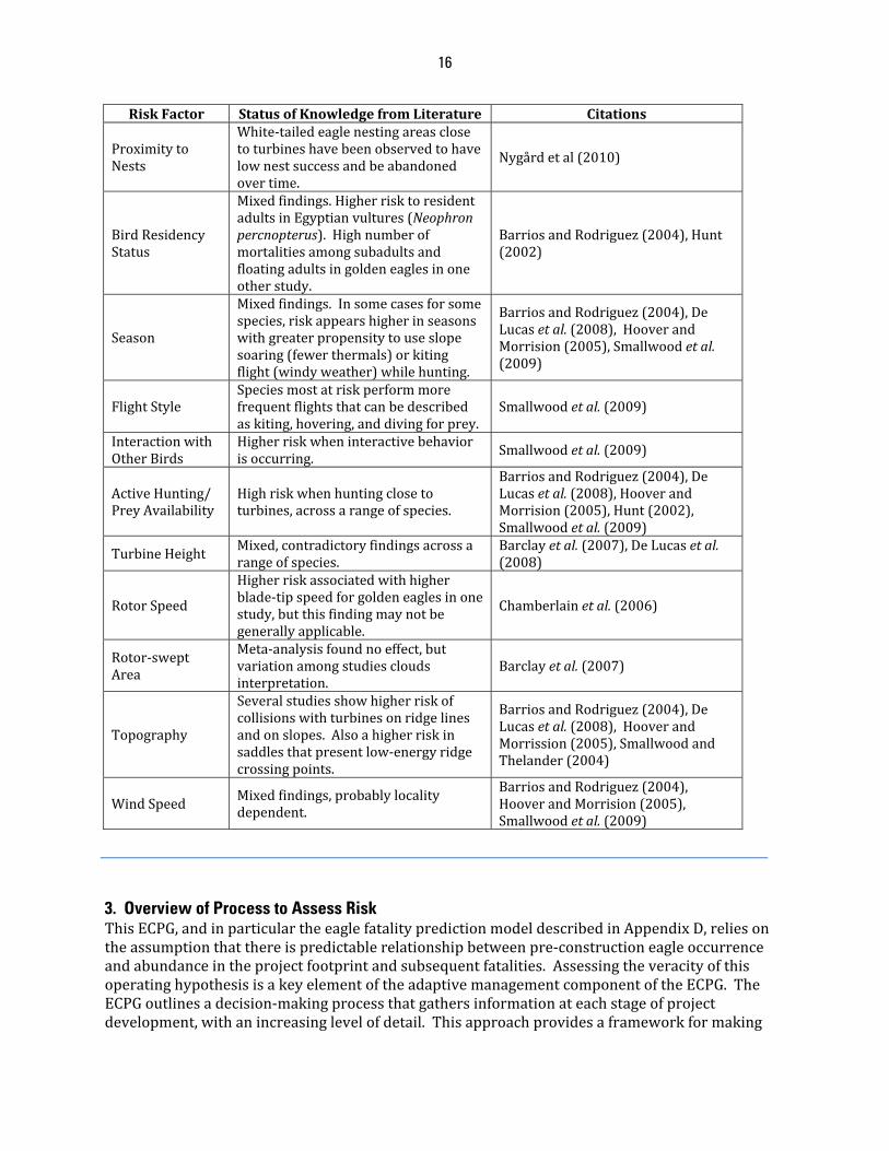
16
RiskFactor StatusofKnowledgefromLiterature Citations
ProximitytoNests
White‐tailedeaglenestingareasclosetoturbineshavebeenobservedtohavelownestsuccessandbeabandonedovertime.
Nygårdetal(2010)
BirdResidencyStatus
Mixedfindings.HigherrisktoresidentadultsinEgyptianvultures(Neophronpercnopterus).Highnumberofmortalitiesamongsubadultsandfloatingadultsingoldeneaglesinoneotherstudy.
BarriosandRodriguez(2004),Hunt(2002)
Season
Mixedfindings.Insomecasesforsomespecies,riskappearshigherinseasonswithgreaterpropensitytouseslopesoaring(fewerthermals)orkitingflight(windyweather)whilehunting.
BarriosandRodriguez(2004),DeLucasetal.(2008),HooverandMorrision(2005),Smallwoodetal.(2009)
FlightStyleSpeciesmostatriskperformmorefrequentflightsthatcanbedescribedaskiting,hovering,anddivingforprey.
Smallwoodetal.(2009)
InteractionwithOtherBirds
Higherriskwheninteractivebehaviorisoccurring.
Smallwoodetal.(2009)
ActiveHunting/PreyAvailability
Highriskwhenhuntingclosetoturbines,acrossarangeofspecies.
BarriosandRodriguez(2004),DeLucasetal.(2008),HooverandMorrision(2005),Hunt(2002),Smallwoodetal.(2009)
TurbineHeight Mixed,contradictoryfindingsacrossarangeofspecies.
Barclayetal. (2007),DeLucasetal.(2008)
RotorSpeed
Higherriskassociatedwithhigherblade‐tipspeedforgoldeneaglesinonestudy,butthisfindingmaynotbegenerallyapplicable.
Chamberlainetal.(2006)
Rotor‐sweptArea
Meta‐analysisfoundnoeffect,butvariationamongstudiescloudsinterpretation.
Barclayetal.(2007)
Topography
Severalstudiesshowhigherriskofcollisionswithturbinesonridgelinesandonslopes.Alsoahigherriskinsaddlesthatpresentlow‐energyridgecrossingpoints.
BarriosandRodriguez(2004),DeLucasetal.(2008),HooverandMorrission(2005),SmallwoodandThelander(2004)
WindSpeedMixedfindings,probablylocalitydependent.
BarriosandRodriguez(2004),HooverandMorrision(2005),Smallwoodetal.(2009)
3. Overview of Process to Assess Risk ThisECPG,andinparticulartheeaglefatalitypredictionmodeldescribedinAppendixD,reliesontheassumptionthatthereispredictablerelationshipbetweenpre‐constructioneagleoccurrenceandabundanceintheprojectfootprintandsubsequentfatalities.AssessingtheveracityofthisoperatinghypothesisisakeyelementoftheadaptivemanagementcomponentoftheECPG.TheECPGoutlinesadecision‐makingprocessthatgathersinformationateachstageofprojectdevelopment,withanincreasinglevelofdetail.Thisapproachprovidesaframeworkformaking

17
decisionssequentiallyatthreecriticalphasesinprojectdevelopment:(1)siting,(2)construction,and(3)operations.Thegreatestpotentialtoavoidandminimizeimpactstoeaglesoccursifeagleriskfactorsaretakenintoaccountattheearliestphaseofprojectdevelopment.Ifsitingandconstructionhaveproceededwithoutconsiderationofriskstoeagles,significantopportunitiestoavoidandminimizeriskmayhavebeenlost.Thiscanpotentiallyresultingreatercompensatorymitigationrequirementsor,intheworstcase,anunacceptablelevelofmortalityforeagles.Therelated,butmoregeneral,WEGadvocatesusingafive‐tieredapproachforiterativedecisionmakingrelativetoassessingandaddressingwildlifeeffectsfromwindfacilities.Elementsofallofthosetiersapplyhere,buttheprocessforeaglesismorespecificallydefinedandfallsintofivebroadlyoverlapping,iterativestagesthatlargelydonotparalleltheWEG’sfivetiers(Figures1and2).Stage1foreagles(AppendixB)combinesTiers1and2fromtheWEG,andconsistsofaninitialsiteassessment.Inthisstageprojectdevelopersoroperatorsevaluatebroadgeographicareastoassesstherelativeimportanceofvariousareastoresidentbreedingandnon‐breedingeagles,andtomigrantandwinteringeagles.TheServiceisavailabletoassistprojectdevelopersoroperatorsinbeginningtoidentifyimportanteagleuseareasormigrationconcentrationsitesandpotentialeaglehabitatatthisstage.Toincreasetheprobabilityofmeetingtheregulatoryrequirementsforaprogrammatictakepermit,biologicaladvicefromtheServiceandotherjurisdictionalwildlifeagenciesshouldberequestedasearlyaspossibleinthedeveloper'splanningprocessandshouldbeasinclusiveaspossibletoensureallissuesarebeingaddressatthesametimeandinacoordinatedmanner.Ideally,consultationwiththeService,andstateandtribalwildlifeagenciesisdonepriortoanysubstantialfinancialcommitmentorfinalizationofleaseagreements.DuringStage1theprojectdeveloperoroperatorshouldgatherexistinginformationfrompubliclyavailableliterature,databases,andothersources,andusethosedatatojudgetheappropriatenessofvariouspotentialprojectsites,balancingsuitabilityfordevelopmentwithpotentialrisktoeagles.Onceasitehasbeenselected,thenextstage,Stage2,issite‐specificsurveysandassessments(thisisthefirstcomponentofTier3intheWEG;AppendixC).DuringStage2theprojectdeveloperoroperatorshouldcollectquantitativedatathroughscientificallyrigoroussurveysdesignedtoassessthepotentialriskoftheproposedprojecttoeagles.Inthecaseofsmallwindprojects(oneorafewsmallturbines),theprojectdeveloperoroperatorshouldapplythepredictivemodeldescribedinStage3(below)todetermineifstage2surveysarenecessary.Inmanycases,thehazardousareaassociatedwithsuchprojectswillbesmallenoughthatStage2surveyswillnotbenecessarytodemonstratethattheprojectwilllikelynottakeeagles.InStage3,thepredictingeaglefatalitiesstage,theServiceandprojectdevelopersoroperatorsusedatafromStage2instandardizedmodelslinkedtotheService’sadaptivemanagementprocesstogeneratepredictionsofeagleriskintheformofaveragenumberoffatalitiesperyearextrapolatedtothetenureofthepermit(seeAppendixD).Thesemodelscanbeusedtocomparativelyevaluatealternativesiting,construction,andoperationalscenarios,ausefulfeatureinconstructinghypothesesregardingpredictedeffectsofconservationmeasuresandACPs.Weencourageprojectdevelopersoroperatorstousetherecommendedpre‐constructionsurveyprotocolinthisECPGinStage2tohelpinformourpredictivemodelsinStage3.IfService‐recommendedsurveyprotocolsareused,thisriskassessmentcanbegreatlyfacilitatedusingmodeltoolsavailablefromtheService.IfprojectdevelopersoroperatorsuseotherformsofinformationfortheStage2assessment,theywillneedtofullydescribethosemethodsandtheanalysisusedfortheeagleriskassessment,andmoretimewillberequiredforServicebiologiststoevaluateand
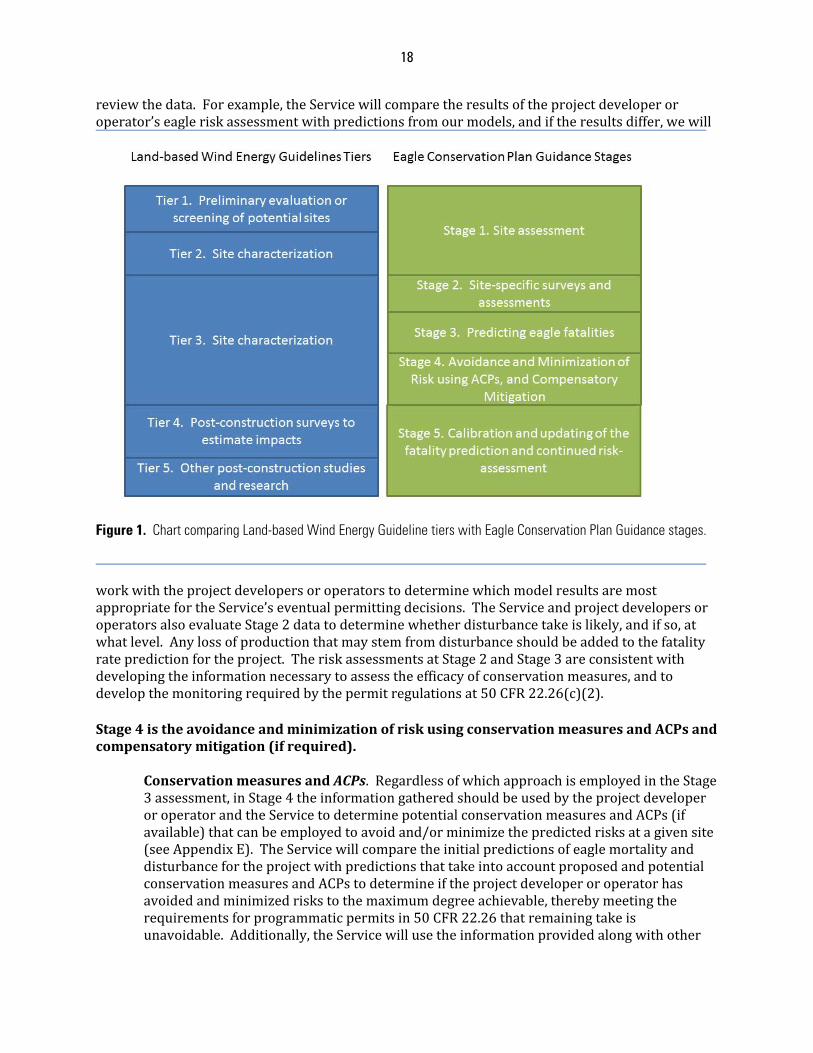
18
reviewthedata.Forexample,theServicewillcomparetheresultsoftheprojectdeveloperoroperator’seagleriskassessmentwithpredictionsfromourmodels,andiftheresultsdiffer,wewill
Figure 1. Chart comparing Land-based Wind Energy Guideline tiers with Eagle Conservation Plan Guidance stages.
workwiththeprojectdevelopersoroperatorstodeterminewhichmodelresultsaremostappropriatefortheService’seventualpermittingdecisions.TheServiceandprojectdevelopersoroperatorsalsoevaluateStage2datatodeterminewhetherdisturbancetakeislikely,andifso,atwhatlevel.Anylossofproductionthatmaystemfromdisturbanceshouldbeaddedtothefatalityratepredictionfortheproject.TheriskassessmentsatStage2andStage3areconsistentwithdevelopingtheinformationnecessarytoassesstheefficacyofconservationmeasures,andtodevelopthemonitoringrequiredbythepermitregulationsat50CFR22.26(c)(2).Stage4istheavoidanceandminimizationofriskusingconservationmeasuresandACPsandcompensatorymitigation(ifrequired).
ConservationmeasuresandACPs.RegardlessofwhichapproachisemployedintheStage3assessment,inStage4theinformationgatheredshouldbeusedbytheprojectdeveloperoroperatorandtheServicetodeterminepotentialconservationmeasuresandACPs(ifavailable)thatcanbeemployedtoavoidand/orminimizethepredictedrisksatagivensite(seeAppendixE).TheServicewillcomparetheinitialpredictionsofeaglemortalityanddisturbancefortheprojectwithpredictionsthattakeintoaccountproposedandpotentialconservationmeasuresandACPstodetermineiftheprojectdeveloperoroperatorhasavoidedandminimizedriskstothemaximumdegreeachievable,therebymeetingtherequirementsforprogrammaticpermitsin50CFR22.26thatremainingtakeisunavoidable.Additionally,theServicewillusetheinformationprovidedalongwithother

19
datatoconductacumulativeeffectsanalysistodetermineiftheproject’simpacts,incombinationwithotherpermittedtakeandotherknownfactorsaffectingthelocal‐areaand
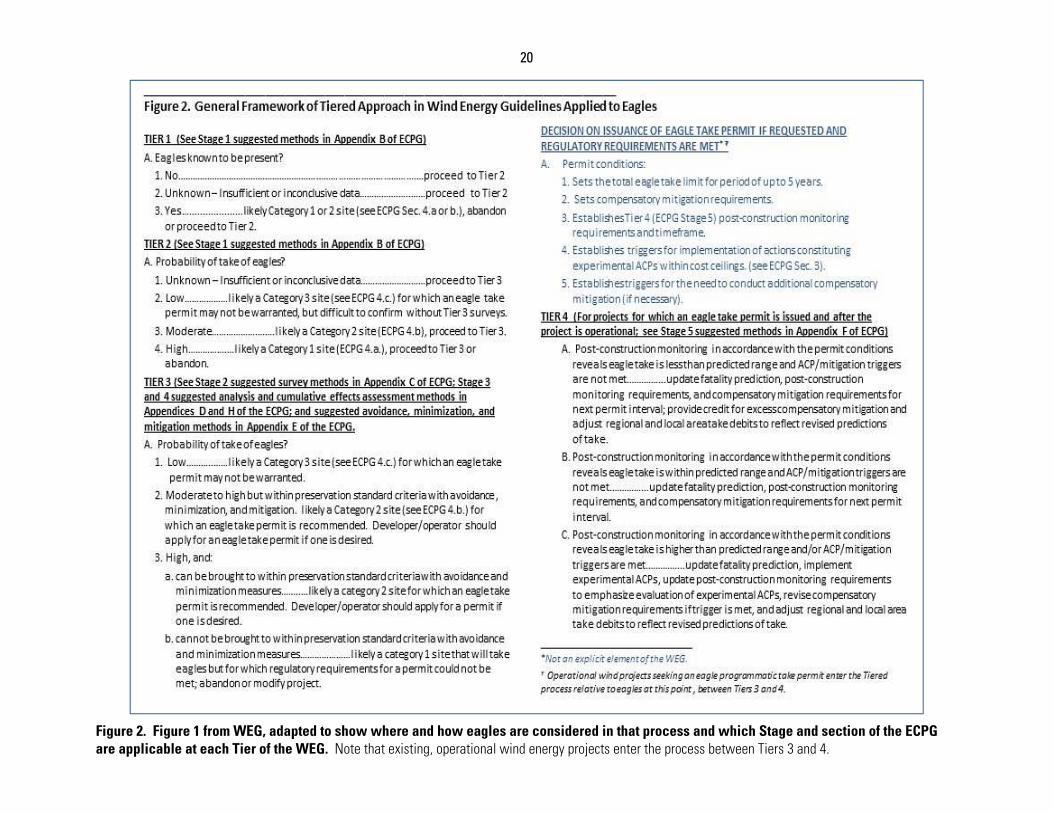
20
Figure 2. Figure 1 from WEG, adapted to show where and how eagles are considered in that process and which Stage and section of the ECPG are applicable at each Tier of the WEG. Note that existing, operational wind energy projects enter the process between Tiers 3 and 4.
21
eaglemanagementunitpopulation(s),areatalevelthatexceedestablishedthresholdsorbenchmarks(seeAppendixF).ThisfinaleagleriskassessmentiscompletedattheendofStage4afterapplicationofconservationmeasuresandACPsalongwithaplanforcompensatorymitigationifrequired.CompensatoryMitigation.CompensatorymitigationoccursintheeaglepermittingprocessifconservationmeasuresandACPsdonotremovethepotentialfortake,andtheprojectedtakeexceedscalculatedthresholdsforthespecies‐specificeaglemanagementunitinwhichtheprojectislocated.Compensatorymitigationmayalsobenecessaryinothersituationsasdescribedinthepreambleto50CFR22.26(USFWS2009a),andthefollowingguidanceappliestothosesituationsaswell.Compensatorymitigationcanaddressanypre‐existingmortalitysourceaffectingthespecies‐specificeaglemanagementunitimpactedbytheproject(e.g.environmentalleadabatement,addressingeagleelectrocutionsduetohighriskpowerpoles,etc.)thatwasineffectatthetimeoftheFEAin2009(USFWS2009b),oritcanaddressincreasingthecarryingcapacityoftheeaglepopulationintheaffectedeaglemanagementunit.However,thereneedstobeacredibleanalysisthatsupportstheconclusionthatimplementingthecompensatorymitigationactionwillachievethedesiredbeneficialoffsetinmortalityorcarryingcapacity.AllcompensatorymitigationprojectswillbesubjectedtorandominspectionsbytheServiceorappointedsubcontractorstoexamineefficacy,accuracy,andreportingrigor.Fornewwinddevelopmentprojects,ifcompensatorymitigationisnecessary,thecompensatorymitigationaction(oraverifiable,legalcommitmenttosuchmitigation)willberequiredupfrontbeforeprojectoperationscommencebecauseprojectsmustmeetthestatutoryandregulatoryeaglepreservationstandardbeforetheServicemayissueapermit.Foroperatingprojectsthatmaymeetpermittingrequirements,compensatorymitigationshouldbeappliedfromthestartofthepermitperiod,notretroactivelyfromtheinitiationofprojectoperations.Theinitialcompensatorymitigationcontributioneffortshouldbesufficienttooffsettakeattheupper80%confidencelimit(orequivalent)ofthepredictednumberofeaglefatalitiesperyearforafive‐yearperiodstartingwiththedatetheprojectbecomesoperational(or,foroperatingprojects,thedatethepermitissigned).Nolaterthanattheendofthefiveyearperiod,thepredictedannualtakeestimatewillbecomparedtotherealizedtakeasestimatedbypost‐constructionmonitoring.Ifthetriggersidentifiedinthepermitforadjustmentofcompensatorymitigationaremet,thoseadjustmentsshouldbeimplemented.Inthecasewheretherealizedtakeislessthanpredicted,thepermitteewillreceiveacreditfortheexcesscompensation(thedifferencebetweentheactualmeanandthenumbercompensatedfor)thatcanbeappliedtoothertake(eitherbythepermitteeorotherpermittedindividualsathis/herdiscretion)withinthesameeaglemanagementunit.Compensatorymitigationforfutureyearsfortheprojectwillbedeterminedatthispoint,takingintoaccounttheobservedlevelsofmortalityandanyreductioninthatmortalitythatisexpectedbasedonimplementationofadditionalexperimentalconservationmeasuresandACPsthatmightreducefatalities.Toillustrateanacceptableprocessforcalculatingcompensatorymitigation,theServicehaspreparedanexampleofastrategyusingResourceEquivalencyAnalysis(REA)toquantifythenumberofpowerpoleretrofitsneededtooffsetthetakeofgoldeneaglesatawindproject(seeAppendixG).TheServiceusedtheexampleofeliminatingelectrocutionsbecause:(1)high‐riskpowerpolescausequantifiableadverseimpactstoeagles;(2)the‘per
22
eagle’effectsofhigh‐riskpowerpoleretrofittingarequantifiableandverifiablethroughacceptedpractices;(3)successofandsubsequentmaintenanceofretrofittingcanbemonitored;and(4)electrocutionfromhigh‐riskpowerpolesisknowntocauseeaglemortalityandthiscanbecorrected.Thepotentialfortakeofeaglesisestimatedusinginformedmodeling,asdescribedinStage3oftheECPG(AppendixD).ThisfatalitypredictionisoneofseveralfundamentalvariablesthatareusedtopopulatetheREA(seeREAInputs,AppendixG).TheREAgeneratesaproject‐areaeagleimpactcalculation(debit),expressedinbird‐years,andanestimateofthequantityofcompensatorymitigation(credit)(e.g.,powerpoleretrofits)necessarytooffsetthisimpact.Compensatorymitigationwouldthenbeimplementedeitherdirectlybytheprojectdeveloperoroperatororthroughaformal,bindingagreementwithathirdpartytoimplementtherequiredactions.Effectivenessmonitoringoftheresultingcompensatorymitigationprojectsshouldbeincludedwithintheaboveoptionsusingthebestscientificandpracticablemethodavailable.TheServicewillmodifythecompensatorymitigationprocesstoadapttoanyimprovementsinourknowledgebaseasnewdatabecomeavailable.
AttheendofStage4,allthematerialsnecessarytosatisfytheregulatoryrequirementstosupportapermitapplicationshouldbeavailable.Whiletheapplicationcanbesubmittedatanytime,itisonlyaftercompletionofStage4thattheServicecanbegintheformalprocesstodeterminewhetheraprogrammaticeagletakepermitcanbeissuedornot.Ideally,NEPAandNHPAanalysesandassessmentswillalreadybeunderway,butifnot,Stage4shouldincludenecessaryNEPAanalysis,NHPAcompliance,coordinationwithotherjurisdictionalagencies,andtribalconsultation.Ifapermitisissuedandtheprojectgoesforward,Stage5oftheprocessiscalibrationandupdatingofthefatalitypredictionandcontinuedriskassessment,equivalenttoTier4and,inpart,Tier5intheWEG.Duringthisstage,post‐constructionsurveysareconductedtogenerateempiricaldataforcomparisonwiththepre‐constructionrisk‐assessmentfatalityanddisturbancepredictions.Themonitoringprotocolshouldincludebothvalidatedtechniquesforassessingmortality,andforestimatingeffectsofdisturbancetoeagles,andtheymustmeetthepermit‐conditionrequirementsat50CFR22.26(c)(2).Weanticipatethatinmostcases,intensivemonitoringtoestimatethetrueannualfatalityrateandtoassesspossibledisturbanceeffectswillbeconductedforatleastthefirsttwoyearsafterpermitissuance,followedbylessintensemonitoringforuptothreeyearsaftertheexpirationdateofthepermit,inaccordancewithmonitoringrequirementsat50CFR22.26(c)(2).Werecommendprojectdevelopersoroperatorsusethepost‐constructionsurveyprotocolsincludedorreferencedinthisECPG,butwewillconsiderothermonitoringprotocolsprovidedbypermitapplicants.Wewillusetheinformationfrompost‐constructionmonitoringinameta‐analysisframeworktoweightandimprovepre‐constructionpredictivemodels.AdditionallyinStage5theServiceandprojectdevelopersoroperatorsshouldusethepost‐constructionmonitoringdatato(1)assesswhethercompensatorymitigationisadequate,excessive,ordeficienttooffsetobservedmortality,andmakeadjustmentsaccordingly;and(2)exploreoperationalchangesthatmightbewarrantedataprojectafterpermittingtoreduceobservedmortalityandensurethatpermitconditionrequirementsat50CFR22.26(c)(7)aremet.Table2providesasummaryoftherolesoftheprojectdeveloperoroperatorandtheService,responsibilities,anddecisionpointsateachstage.
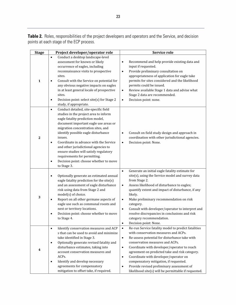
23
Table 2. Roles, responsibilities of the project developers and operators and the Service, and decision points at each stage of the ECP process.
Stage Projectdeveloper/operatorrole Servicerole
1
Conductadesktoplandscape‐levelassessmentforknownorlikelyoccurrenceofeagles,includingreconnaissancevisitstoprospectivesites.
ConsultwiththeServiceonpotentialforanyobviousnegativeimpactsoneaglesinatleastgenerallocaleofprospectivesites.
Decisionpoint:selectsite(s)forStage2study,ifappropriate.
Recommendandhelpprovideexistingdataandinputifrequested.
Providepreliminaryconsultationonappropriatenessofapplicationforeagletakepermitsforsitesconsideredandthelikelihoodpermitscouldbeissued.
ReviewavailableStage1dataandadvisewhatStage2dataarerecommended.
Decisionpoint:none.
2
Conductdetailed,site‐specificfieldstudiesintheprojectareatoinformeaglefatalitypredictionmodel,documentimportanteagleuseareasormigrationconcentrationsites,andidentifypossibleeagledisturbanceissues.
CoordinateinadvancewiththeServiceandotherjurisdictionalagenciestoensurestudieswillsatisfyregulatoryrequirementsforpermitting.
Decisionpoint:choosewhethertomovetoStage3.
Consultonfieldstudydesignandapproachincoordinationwithotherjurisdictionalagencies.
Decisionpoint:None.
3
Optionallygenerateanestimatedannualeaglefatalitypredictionforthesite(s)andanassessmentofeagledisturbanceriskusingdatafromStage2andmodel(s)ofchoice.
Reportonallothergermaneaspectsofeagleusesuchascommunalroostsandnestorterritorylocations.
Decisionpoint:choosewhethertomovetoStage4.
Generateaninitialeaglefatalityestimateforsite(s),usingtheServicemodelandsurveydatafromStage2.
Assesslikelihoodofdisturbancetoeagles;quantifyextentandimpactofdisturbance,ifanylikely.
Makepreliminaryrecommendationonriskcategory.
Consultwithdeveloper/operatortointerpretandresolvediscrepanciesinconclusionsandriskcategoryrecommendation.
Decisionpoint:None.
4
IdentifyconservationmeasuresandACPsthatcanbeusedtoavoidandminimizetakeidentifiedinStage3.
Optionallygeneraterevisedfatalityanddisturbanceestimates,takingintoaccountconservationmeasuresandACPs.
Identifyanddevelopnecessaryagreementsforcompensatorymitigationtooffsettake,ifrequired.
Re‐runServicefatalitymodeltopredictfatalitieswithconservationmeasuresandACPs.
Re‐assesspotentialfordisturbancetakewithconservationmeasuresandACPs.
Coordinatewithdeveloper/operatortoreachagreementonpredictedtakeandriskcategory.
Coordinatewithdeveloper/operatoroncompensatorymitigation,ifrequested.
Providerevisedpreliminaryassessmentoflikelihoodsite(s)willbepermittableifrequested.
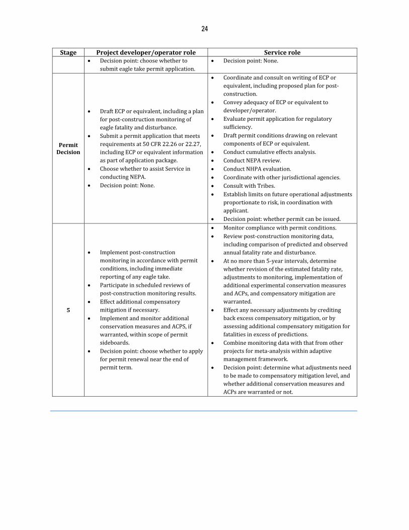
24
Stage Projectdeveloper/operatorrole Servicerole Decisionpoint:choosewhetherto
submiteagletakepermitapplication. Decisionpoint:None.
PermitDecision
DraftECPorequivalent,includingaplanforpost‐constructionmonitoringofeaglefatalityanddisturbance.
Submitapermitapplicationthatmeetsrequirementsat50CFR22.26or22.27,includingECPorequivalentinformationaspartofapplicationpackage.
ChoosewhethertoassistServiceinconductingNEPA.
Decisionpoint:None.
CoordinateandconsultonwritingofECPorequivalent,includingproposedplanforpost‐construction.
ConveyadequacyofECPorequivalenttodeveloper/operator.
Evaluatepermitapplicationforregulatorysufficiency.
DraftpermitconditionsdrawingonrelevantcomponentsofECPorequivalent.
Conductcumulativeeffectsanalysis. ConductNEPAreview. ConductNHPAevaluation. Coordinatewithotherjurisdictionalagencies. ConsultwithTribes. Establishlimitsonfutureoperationaladjustments
proportionatetorisk,incoordinationwithapplicant.
Decisionpoint:whetherpermitcanbeissued.
5
Implementpost‐constructionmonitoringinaccordancewithpermitconditions,includingimmediatereportingofanyeagletake.
Participateinscheduledreviewsofpost‐constructionmonitoringresults.
Effectadditionalcompensatorymitigationifnecessary.
ImplementandmonitoradditionalconservationmeasuresandACPS,ifwarranted,withinscopeofpermitsideboards.
Decisionpoint:choosewhethertoapplyforpermitrenewalneartheendofpermitterm.
Monitorcompliancewithpermitconditions. Reviewpost‐constructionmonitoringdata,
includingcomparisonofpredictedandobservedannualfatalityrateanddisturbance.
Atnomorethan5‐yearintervals,determinewhetherrevisionoftheestimatedfatalityrate,adjustmentstomonitoring,implementationofadditionalexperimentalconservationmeasuresandACPs,andcompensatorymitigationarewarranted.
Effectanynecessaryadjustmentsbycreditingbackexcesscompensatorymitigation,orbyassessingadditionalcompensatorymitigationforfatalitiesinexcessofpredictions.
Combinemonitoringdatawiththatfromotherprojectsformeta‐analysiswithinadaptivemanagementframework.
Decisionpoint:determinewhatadjustmentsneedtobemadetocompensatorymitigationlevel,andwhetheradditionalconservationmeasuresandACPsarewarrantedornot.
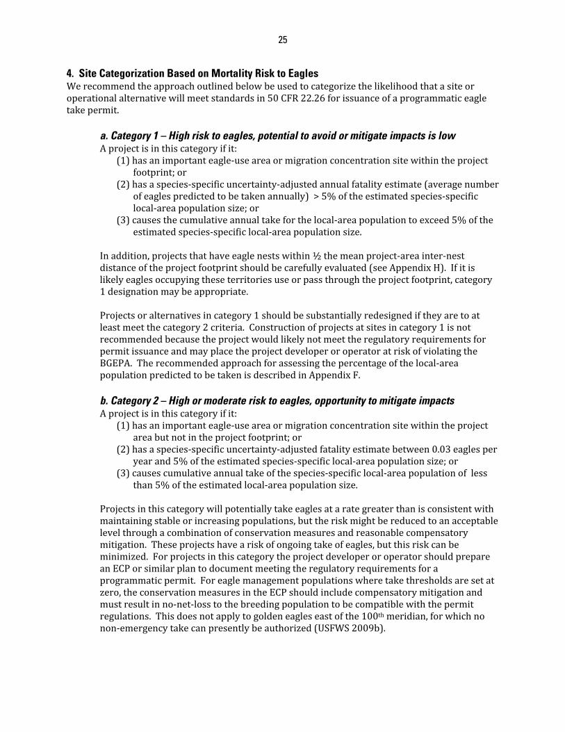
25
4. Site Categorization Based on Mortality Risk to Eagles Werecommendtheapproachoutlinedbelowbeusedtocategorizethelikelihoodthatasiteoroperationalalternativewillmeetstandardsin50CFR22.26forissuanceofaprogrammaticeagletakepermit.
a. Category 1 – High risk to eagles, potential to avoid or mitigate impacts is low Aprojectisinthiscategoryifit:
(1)hasanimportanteagle‐useareaormigrationconcentrationsitewithintheprojectfootprint;or
(2)hasaspecies‐specificuncertainty‐adjustedannualfatalityestimate(averagenumberofeaglespredictedtobetakenannually)>5%oftheestimatedspecies‐specificlocal‐areapopulationsize;or
(3)causesthecumulativeannualtakeforthelocal‐areapopulationtoexceed5%oftheestimatedspecies‐specificlocal‐areapopulationsize.
Inaddition,projectsthathaveeaglenestswithin½themeanproject‐areainter‐nestdistanceoftheprojectfootprintshouldbecarefullyevaluated(seeAppendixH).Ifitislikelyeaglesoccupyingtheseterritoriesuseorpassthroughtheprojectfootprint,category1designationmaybeappropriate.Projectsoralternativesincategory1shouldbesubstantiallyredesignediftheyaretoatleastmeetthecategory2criteria.Constructionofprojectsatsitesincategory1isnotrecommendedbecausetheprojectwouldlikelynotmeettheregulatoryrequirementsforpermitissuanceandmayplacetheprojectdeveloperoroperatoratriskofviolatingtheBGEPA.Therecommendedapproachforassessingthepercentageofthelocal‐areapopulationpredictedtobetakenisdescribedinAppendixF.b. Category 2 – High or moderate risk to eagles, opportunity to mitigate impacts Aprojectisinthiscategoryifit:
(1)hasanimportanteagle‐useareaormigrationconcentrationsitewithintheprojectareabutnotintheprojectfootprint;or
(2)hasaspecies‐specificuncertainty‐adjustedfatalityestimatebetween0.03eaglesperyearand5%oftheestimatedspecies‐specificlocal‐areapopulationsize;or
(3)causescumulativeannualtakeofthespecies‐specificlocal‐areapopulationoflessthan5%oftheestimatedlocal‐areapopulationsize.
Projectsinthiscategorywillpotentiallytakeeaglesatarategreaterthanisconsistentwithmaintainingstableorincreasingpopulations,buttheriskmightbereducedtoanacceptablelevelthroughacombinationofconservationmeasuresandreasonablecompensatorymitigation.Theseprojectshaveariskofongoingtakeofeagles,butthisriskcanbeminimized.ForprojectsinthiscategorytheprojectdeveloperoroperatorshouldprepareanECPorsimilarplantodocumentmeetingtheregulatoryrequirementsforaprogrammaticpermit.Foreaglemanagementpopulationswheretakethresholdsaresetatzero,theconservationmeasuresintheECPshouldincludecompensatorymitigationandmustresultinno‐net‐losstothebreedingpopulationtobecompatiblewiththepermitregulations.Thisdoesnotapplytogoldeneagleseastofthe100thmeridian,forwhichnonon‐emergencytakecanpresentlybeauthorized(USFWS2009b).
26
c. Category 3 – Minimal risk to eagles Aprojectisinthiscategoryifit:
(1)hasnoimportanteagleuseareasormigrationconcentrationsiteswithintheprojectarea;and
(2)hasaspecies‐specificuncertainty‐adjustedannualfatalityrateestimateoflessthan0.03forbothspeciesofeagle;and
(3)causescumulativeannualtakeofthelocal‐areapopulationoflessthan5%oftheestimatedspecies‐specificlocal‐areapopulationsize.
Projectsincategory3poselittlerisktoeaglesandmaynotrequireorwarranteagletakepermits,butthatdecisionshouldbemadeincoordinationwiththeService.Still,aprojectdeveloperoroperatormaywishtocreateanECPthatdocumentstheproject’slowrisktoeagles,andoutlinesmortalitymonitoringforeaglesandaplanofactionifeaglesaretakenduringprojectconstructionoroperation.Iftakeshouldoccur,thedeveloperoroperatorshouldcontacttheServicetodiscusswaystoavoidtakeinthefuture.SuchanECPwouldenabletheServicetoprovideapermittoallowademinimisamountoftakeiftheprojectdeveloperoroperatorwishedtoobtainsuchapermit.
Theriskcategoryofaprojecthasthepotentialtochangefromoneofhigherrisktooneoflowerriskoroneoflowerrisktooneofhigherriskthroughadditionalsite‐specificanalysesandapplicationofmeasurestoreducetherisk.Forexample,aprojectmayappeartobeincategory2asaresultofStage1analyses,butaftercollectionofsite‐specificinformationinStage2itmightbecomeclearitisacategory1project.Ifaprojectcannotpracticallybeplacedinoneofthesecategories,theprojectdeveloperoroperatorandtheServiceshouldworktogethertodetermineiftheprojectcanmeetprogrammaticeagletakepermittingrequirementsin50CFR22.26and22.27.Projectsshouldbeplacedinthehighestcategory(withcategory1beingthehighest)inwhichoneormoreofthecriteriaaremet.5. Cumulative Effects Considerations
a. Early Planning Regulationsat50CFR22.26requiretheServicetoconsiderthecumulativeeffectsofprogrammaticeagletakepermits.Cumulativeeffectsaredefinedas:“theincrementalenvironmentalimpactoreffectoftheproposedaction,togetherwithimpactsofpast,present,andreasonablyforeseeablefutureactions”(50CFR22.3).ThoroughcumulativeeffectsanalysiswilldependoneffectiveanalysisduringtheNEPAprocessassociatedwithaneaglepermit.Scopingandothertypesofpreliminaryanalysescanhelpidentifyimportantcumulative‐effectsfactorsandidentifyapplicablepast,present,andfutureactions.Comprehensiveevaluationduringearlyplanningmayidentifymeasuresthatwouldavoidandminimizetheeffectstothedegreethattakeofeaglesisnotlikelytooccur.Inthatcase,theremaybenopermit,andthusnoneedforNEPAassociatedwithaneagletakepermit.Whenawindprojectdeveloperoroperatorseeksaneagletakepermit,acomprehensivecumulativeeffectsanalysisattheearlyplanningstagewillservetostreamlinesubsequentsteps,includingtheNEPAprocess.TheServicerecommendsthatcumulativeeffectsanalysesbeconsistentwiththeprinciplesofcumulativeeffectsoutlinedintheCouncilonEnvironmentalQuality(CEQ)handbook,"ConsideringCumulativeEffectsundertheNationalEnvironmentalPolicyAct(1997)(CEQhandbook).TheServicerecommendsconsiderationofthefollowingexamplesfromtheCEQ
27
handbookthatmayapplytocumulativeeffectstoeaglesandtheecosystemstheydependupon:
(1)Timecrowding‐frequentandrepetitiveeffectsonanenvironmentalsystem;(2)Timelags‐delayedeffects;(3)Spacecrowding‐Highspatialdensityofeffectsonanenvironmentalsystem;(4)Cross‐boundary‐Effectsoccurawayfromthesource;(5)Fragmentation‐changeinlandscapepattern;(6)Compoundingeffects‐Effectsarisingfrommultiplesourcesorpathways;(7)Indirecteffects‐secondaryeffects;and(8)Triggersandthresholds‐fundamentalchangesinsystembehaviororstructure.
b. Analysis Associated with Permits Thecumulativeeffectsanalysisforawindprojectandapermitauthorizationshouldincludewhethertheanticipatedtakeofeaglesiscompatiblewitheaglepreservationasrequiredat50CFR22.26,includingindirectimpactsassociatedwiththetakethatmayaffecteaglepopulations.Itshouldalsoincludeconsiderationofthecumulativeeffectsofotherpermittedtakeandadditionalfactorsaffectingeaglepopulations.WhetherornotapermitauthorizationiscompatiblewitheaglepreservationwasanalyzedintheFEAthatestablishedthethresholdsfortake(USFWS2009b).ThescaleofthatanalysiswasbaseduponeaglemanagementunitsasdefinedinUSFWS(2009b).However,thescaleforcumulativeeffectsanalysisofwindprojectsandassociatedpermitsshouldincludeconsiderationoftheeffectsatthelocal‐populationscaleaswell.Thecumulativeeffectsanalysesforprogrammaticpermitsshouldcoverthetimeperiodoverwhichthetakewilloccur,notjusttheperiodthepermitwillcover,includingtheeffectoftheproposedaction,otheractionsaffectingeagles,predictedclimatechangeimpacts,andpredictedchangesinnumberanddistributionofaffectedeaglepopulations.Effectsanalysesshouldnotewhethertheprojectislocatedinareaswhereeaglepopulationsareincreasingorpredictedtoincreasebasedonavailabledata,overthelifetimeoftheproject,eveniftakeisnotanticipatedintheimmediatefuture.Inaddition,conditionswherepopulationsaresaturatedshouldbeconsideredincumulativeeffectsanalyses.Numerousrelativelyminordisruptionstoeaglebehaviorfrommultipleactivities,evenifspatiallyortemporallydistributed,mayleadtodisturbancethatwouldnothaveresultedfromfewerormorecarefullysitedactivities(e.g.,Whitfieldetal.2007).AdditionaldetailedguidanceforcumulativeimpactsanalysescanbefoundontheCouncilonEnvironmentalQualitywebsiteathttp://ceq.hss.doe.gov/nepa/ccenepa/ccenepa.htm.SpecificrecommendationsforconductingcumulativeeffectsanalysisoftheauthorizedtakeundereagleprogrammatictakepermitsisprovidedinAppendixF.
28
ADAPTIVE MANAGEMENT Managementofwindfacilitiestominimizeeagletake,throughdecisionsaboutsiting,design,operation,andcompensatorymitigation,isasetofrecurrentdecisionsmadeinthefaceofuncertainty.TheDepartmentoftheInteriorhasalonghistoryofapproachingsuchdecisionsthroughaprocessofadaptivemanagement(Williamsetal.2007).Thepurposeofadaptivemanagementistoimprovelong‐termmanagementoutcomes,byrecognizingwherekeyuncertaintiesimpededecisionmaking,seekingtoreducethoseuncertaintiesovertime,andapplyingthatlearningtosubsequentdecisions(Walters1986).Inthecaseofmanagingeaglepopulationsinthefaceofenergydevelopmentthereisconsiderableuncertaintytobereduced.Forexample,evidenceshowsthatinsomeareasorspecificsituations,largesoaringbirds,specificallyraptors,arevulnerabletocollidingwithwindturbines(BarriosandRodriguez2004,Kuvleskyetal.2007).However,weareuncertainabouttherelativeimportanceoffactorsthatinfluencethatrisk.Wearealsouncertainaboutthebestwaytomitigatetheeffectsofwindturbinedevelopmentsonraptors;wesuspectsomestrategiesmightbeeffective,othersareworthtrying.Wealsosuspectthatafewspecies,includinggoldeneagles(USFWS2009b),maybesusceptibleenoughtocollisionswithwindturbinesthatpopulationsmaybenegativelyaffected.Thus,thereareuncertaintiesatseverallevelsthatchallengeourattemptstomanageeaglepopulations:(1)atthelevelofunderstandingfactorsthataffectcollisionrisk,(2)atthelevelthatinfluencespopulationtrends,and(3)abouttheefficacyofvariousmitigationoptions.TheService,ourconservationpartners,andindustrywillneverhavetheluxuryofperfectinformationbeforeneedingtoacttomanageeagles.Ourgoalistoreducethatuncertaintythroughuseofformaladaptivemanagement,therebyimprovingourpredictivecapabilityovertime.Applyingasystematic,cohesive,nationally‐consistentstrategyofmanagementandmonitoringisnecessarytoaccomplishthisgoal.InthecontextofwindenergydevelopmentandeaglemanagementundertheECPG,therearefourspecificsetsofdecisionsthatwillbeapproachedthroughadaptivemanagement:(1)adaptivemanagementofwindprojectoperations;(2)adaptivemanagementofwindprojectsitinganddesignrecommendations;(3)adaptivemanagementofcompensatorymitigation;and(4)adaptivemanagementofpopulation‐leveltakethresholds.ThesearediscussedinmoredetailinAppendixA.Theadaptivemanagementprocesswilldependheavilyonpre‐andpost‐constructiondatafromindividualprojects,butanalyses,assessment,andmodelevaluationwillrelyondatapooledovermanyindividualwindprojects.Therefore,individualprojectdevelopersoroperatorswillhavelimiteddirectresponsibilitiesforconductingadaptivemanagementanalyses,otherthantoprovidedatathroughpost‐constructionmonitoring.
29
EAGLE CONSERVATION PLAN DEVELOPMENT PROCESS ThefollowingsectionsoftheECPG,includingattachedappendices,provideadescriptiveinstructionaltemplatefordevelopinganECP.Throughoutthissection,weusethetermECPtoincludeanyotherdocumentorcollectionofdocumentsthatcouldbeconsideredequivalenttoanECP.TheECPisanintegralpartofthepermitprocess,andthefollowingchronologicalstep‐by‐stepoutlineshowshowthepiecesfittogether:TheECPGprovidesguidanceandservesasareferenceforprojectdevelopersoroperators,theService,andotherjurisdictionalagencybiologistswhendevelopingandevaluatingECPs.UsingtheECPGasanon‐bindingreference,theServicewillworkwithprojectdevelopersoroperatorstodevelopanECP.TheECPdocumentshowtheprojectdeveloperoroperatorintendstocomplywiththeregulatoryrequirementsforprogrammaticpermitsandtheassociatedNEPAprocessbyavoidingandminimizingtheriskoftakingeaglesup‐front,andformallyevaluatingpossiblealternativesin(ideally)siting,configuration,andoperationofwindprojects.TheService’sabilitytoinfluencesitingandconfigurationfactorsdependsonthestageofdevelopmentoftheprojectatthetimetheprojectdeveloperoroperatorcomestous.TheServicerecommendsthatprojectdevelopersoroperatorsdevelopanECPfollowingthefive‐stagedapproachdescribedearlier.DuringStages1through4,projectsoralternativesshouldbeplacedinoneofthethreeriskcategories,withincreasingcertaintybyStage4.TheECPshouldprovidedetailedinformationonsiting,configuration,andoperationalalternativesthatavoidandminimizeeagletaketothepointanyremainingtakeisunavoidableand,ifrequired,mitigatesthatremainingtaketomeetthestatutorypreservationstandard.TheServicewillusetheECPandotherapplicationmaterialstoeitherdevelopaneagletakepermitfortheproject,ortodeterminethattheprojectcannotbepermittedbecauserisktoeaglesistoohightomeettheregulatorypermitrequirements.Forpermittedprojects,theServicewillusethe80%upperconfidencelimitorsimilarrisk‐averseestimate(e.g.,theupperlimitofthe80%credibleintervalisusedintheService’spredictivemodeldescribedinAppendixD)ofthemeanannualpredictedunavoidableeagletaketodeterminelikelypopulation‐leveleffectsofthepermitandcompensatorymitigationlevels,ifrequired.Forpredictedrecurringeagletakethatisinexcessofcalculatedeaglemanagementunittakethresholds,theServicewilleither(a)approveacompensatorymitigationproposalfromtheprojectdeveloperoroperator;or(b)accept,ifsufficient,acommitmentoffundstoanappropriateindependentthirdpartythatisformallyobligated(viacontractorotheragreementwiththeprojectdeveloperoroperator)toperformtheapprovedmitigationwork.Undereither(a)or(b),thecompensatorymitigationcostandactionswillbecalibratedsoastooffsetthepredictedunavoidabletake,suchthatwebringtheindividualpermit’s(andcumulativelyoverallsuchpermits’)predictedmortalityeffecttoano‐net‐lossstandard.Compensatorymitigationwillinitiallybebasedontheupper80%confidencelimitofthepredictedmeanannualfatalityrate(orsimilarrisk‐averseestimate)overafiveyearperiod,anditwillbeadjustedforfutureyearsbasedontheobservedfatalityrateovertheinitialperiodofintensivepost‐constructionmonitoring(nolessthan2years).Compensatorymitigation,aswellasotherformsofmitigationaimedatreducingotherdetrimentaleffectsofpermitsoneagles,mayalsobenecessaryinothersituationswherepredictedeffectstoeaglepopulationsaresubstantialandnotconsistentwithstableorincreasingbreedingpopulationsofeagles.Post‐constructionmonitoringmayberequiredasaconditionofaneagleprogrammatictakepermitandwillberequiredforwind‐energyprojectsthatmaypotentiallytakeeagles.Thismonitoring
30
shouldbesystematicandstandardizedtobesuitableforuseinaformaladaptivemanagementframeworktoevaluateandimprovethepredictiveaccuracyofourmodels.Inaddition,theinformationwillbeusedbytheServiceandtheprojectdeveloperoroperatortodetermineif,afternomorethanfiveyearsofpost‐constructionmonitoring,the80%upperconfidencelimitonthepredictedmeannumberofannualfatalitiesadequatelycapturedtheobservedestimatedmeannumberoffatalitiesannually.Iftheobservedandpredictedestimatesofannualfatalitiesaredifferent,eitheradditionalcompensatorymitigationwillberequiredretroactivelytooffsethigher‐than‐predictedlevelsoftake(assumingtheactualnumberofeaglestakenwasgreaterthanthenumberactuallycompensatedfor),orthepermitteewillreceiveacreditfortheexcesscompensation(thedifferencebetweentheactualmeanandthenumbercompensatedfor)thatcanbeappliedtoothertake(eitherbythepermitteeorotherpermittedindividualsathis/herdiscretion)withinthesameeaglemanagementunitatanytimeinthefuture.Atnomorethanfive‐yearsfromthedateapermitisissued,thepermitteewillcompileandtheServiceandthepermitteewillreviewfatalityinformationfortheprojecttodetermineifexperimentalACPsshouldbeimplementedtopotentiallyreduceeaglemortalitiesbasedontheobserved,specificsituationateachsite.Asdiscussedpreviously,atthetimeofpermitissuancetheServiceandtheprojectdeveloperoroperatorwillagreetoanupperlimitonthecostofsuchfutureexperimentalACPs,whichwillonlybeimplementedifwarrantedbyeagledisturbanceormortalitydata.IftheseexperimentalACPsarelikelytoreducemortalitiesattheprojectinthefuture,theamountoffuturecompensatorymitigationwillbedecreasedaccordingly(e.g.ifACPsarepredictedtoreducethefatalityratefromthreetotwoeaglesannually,compensatorymitigationwouldonlyberequiredtooffsetthefuturepredictedtakeoftwoeaglesperyear).Insuchcases,additionalpost‐implementationmonitoringshouldbeconductedtodeterminetheeffectivenessoftheexperimentalACPs.Incaseswhereobservedfatalitiesexceedpredictedtothedegreecategory1fatality‐ratecriteriaareconfirmedtohavebeenmetorexceededbyapermittedproject,andforwhateverreasonexperimentalACPsoradditionalconservationmeasurescannotbeimplementedtoreducefatalitiestocategory2levelsorbelow,theServicemayhavetorescindthepermitforthatprojecttoremainincompliancewithregulatorycriteria.ProgrammaticeagletakepermitswillbeconditionedtorequireaccesstotheareaswheretakeispossibleandwherecompensatorymitigationisbeingimplementedbyServicepersonnel,orotherqualifiedpersonsdesignatedbytheService,withinreasonablehoursandwithreasonablenoticefromtheService,forpurposesofmonitoringthesite(s).Theregulationsprovide,andaconditionofanypermitissuedwillrequire,thattheServicemayconductsuchmonitoringwhilethepermitisvalid,andforuptothreeyearsafteritexpires(50CFR22.26(c)(4)).Ingeneral,verifyingcompliancewithpermitconditionsisasecondarypurposeofsitevisits;theprimarypurposeistomonitortheeffectsandeffectivenessofthepermittedactionandmitigationmeasures.ThismaybedoneifaprojectdeveloperoroperatorisunabletoobserveorreporttotheServicetheinformationrequiredbytheannualreport—oritmayserveasa“qualitycontrol”measuretheServicecanusetoverifytheaccuracyofreportedinformationand/oradjustmonitoringandreportingrequirementstoprovidebetterinformationforpurposesofadaptivemanagement.1. Contents of the Eagle Conservation Plan ThissectionprovidesarecommendedoutlineforanECP,withashortdescriptionofwhatshouldbecontainedineachsection.Seeprevioussectionsandreferencedappendicesfordetailsonthestagesandcategories.
31
a. Stage 1 DatafromStage1shouldbepresentedandsummarizedinthissectionoftheECP.TheprojectdeveloperoroperatorshouldworkwiththeServicetoplacepotentialwind–facilitysiteinacategorybasedontheStage1information.FordetailedrecommendationsontheStage1process,seeAppendixB. b. Stage 2 DatafromStage2shouldbepresentedandsummarizedinthissectionoftheECP.FordetailedrecommendationsontheStage2methodsandmetrics,seeAppendixC.Theriskcategorizationshouldbere‐assessedinthissection,takingintoaccountStage2results. c. Stage 3 InthissectionoftheECP,projectdevelopersoroperatorsshouldworkincoordinationwiththeServicetocalculateapredictionoftheannualeaglefatalityrateandconfidenceintervalfortheprojectusingdatageneratedfromtheStage2assessment.TheinitialestimateofthefatalityrateshouldnottakeintoaccountpossibleconservationmeasuresandACPs;thesewillbefactoredinaspartofStage4.FordetailedrecommendationsonStage3methodsandmetrics,seeAppendixD.Theriskcategorizationshouldbere‐assessedinthissection,takingintoaccountStage3results. d. Stage 4 ThissectionoftheECPshoulddescribehowproposedconservationmeasuresandACPsshouldreducethefatalityrategeneratedinstage3,andwhatcompensatorymitigationmeasureswillbeemployedtooffsetunavoidabletake,ifrequired.ThissectionfacilitatesdemonstratinghowconservationmeasuresandACPshavereducedtherawpredictedfatalityratetotheunavoidablestandard.FordetailedrecommendationsonconsiderationsforthedevelopmentofconservationmeasuresandACPsseeAppendixE.Theriskcategorizationshouldbere‐assessedinthissection,takingintoaccountStage4results.Thisshouldbethefinalpre‐constructionriskcategorizationfortheproposedproject.Thissectionshouldalsofullydescribetheproposedcompensatorymitigationapproach(ifrequired).Fordetailedrecommendationsregardingcompensatorymitigation,seeAppendixG. e. Stage 5 – Post-construction Monitoring InthissectionoftheECP,theprojectdeveloperoroperatorshoulddescribetheproposedpost‐constructionsurveymethodologyfortheproject.Detailedrecommendationsforpost‐constructionmonitoringareinAppendixH.TheStage5post‐constructionmonitoringplanisthefinalsectionoftheECP.
32
INTERACTION WITH THE SERVICE AsnotedthroughoutthisECPG,frequentandthoroughcoordinationbetweenprojectdevelopersoroperatorsandServiceandotherjurisdictional‐agencyemployeesiscrucialtothedevelopmentofaneffectiveandsuccessfulECP.Closecoordinationwillalsobenecessaryintherefinementofthemodelingprocessusedtopredictfatalities,aswellasinpost‐constructionmonitoringtoevaluatethosemodels.WeanticipatetheECPGandtherecommendedmethodsandmetricswillevolverapidlyastheServiceandprojectdevelopersoroperatorslearntogether.TheServicehascreatedacross‐program,cross‐regionalteamofbiologistswhowillworkjointlyoneagle‐programmatic‐takepermitapplicationstohelpensureconsistencyinadministrationandapplicationoftheEaglePermitRule.ThisclosecoordinationandinteractionisespeciallyimportantastheServiceprocessesthefirstfewprogrammaticeagletakepermitapplications.TheServicewillcontinuetorefinethisECPGwithinputfromallstakeholderswiththeobjectiveofmaintainingstableorincreasingbreedingpopulationsofbothbaldandgoldeneagleswhilesimultaneouslydevelopingscience‐basedeagle‐takeregulationsandproceduresthatareappropriatetotheriskassociatedwitheachwindenergyproject.AstheECPGevolves,theServicewillnotexpectprojectdevelopersoroperatorstoretroactivelyredoanalysesorsurveysusingthenewapproaches.TheadaptiveapproachtotheECPGshouldnotdeterprojectdevelopersoroperatorsfromusingitimmediately.
33
INFORMATION COLLECTION TheBaldandGoldenEagleProtectionActauthorizesustocollectinformationinordertoissuepermitsforeagletake.TheEagleConservationPlanGuidancedefinesandclarifiestheinformationrequiredforapermitapplication(FWSForm3‐200‐71)andtheassociatedannualreport(FWSForm3‐202‐15).Weusethecollectedinformationtoevaluatewhetherthetakeiscompatiblewiththepreservationoftheeagle;todetermineiftakeislikelyandhowitcanbeavoidedandminimized;todetermineiftheapplicantwilltakereasonablemeasurestominimizethetake;andtoassesshowtheactivityactuallyaffectseaglesinordertoadjustmitigationmeasuresforthatprojectandforfuturepermits.Wemaynotconductorsponsor,norareyourequiredtorespond,toacollectionofinformationunlessitdisplaysacurrentlyvalidOfficeofManagementandBudgetcontrolnumber.TheburdenfortheinformationcollectionassociatedwitheaglepermitsandreportsisapprovedunderOMBControlNo.1018‐0022(FederalFishandWildlifePermitApplicationsandReports‐‐MigratoryBirdsandEagles)andOMBControlNo.1018‐0148(Land‐BasedWindEnergyGuidelines).
34
GLOSSARY Activenest–seeoccupiednest.Adaptiveresourcemanagement–aniterativedecisionprocessthatpromotesflexibledecision‐
makingthatcanbeadjustedinthefaceofuncertaintiesasoutcomesfrommanagementactionsandothereventsbecomebetterunderstood.
Advancedconservationpractices(ACP)–meansscientificallysupportablemeasuresthatareapprovedbytheServiceandrepresentthebestavailabletechniquestoreduceeagledisturbanceandongoingmortalitiestoalevelwhereremainingtakeisunavoidable.ACPsareaspecialsubsetofconservationmeasuresthatmustbeimplementedwheretheyareapplicable.
Adult–aneaglefiveormoreyearsofage.Alternatenests–additionalsiteswithinanestingterritorythatareavailabletobeused.Avoidanceandminimizationmeasures–conservationactionstargetedtoremoveorreduce
specificriskfactors(e.g.,avoidingimportanteagleuseareasandmigrationconcentrationsites,placingturbinesawayfromridgelines).Asubsetofconservationmeasures.
Benchmark–aneagleharvestrateatthelocal‐areapopulationscalethatshouldtriggerheightenedscrutiny.
Breedingterritory–equivalenttoeagleterritory.Calculatedtakethresholds–annualallowableeagletakelimitsestablishedinUSFWS(2009b).Collisionprobability(risk)–theprobabilitythataneaglewillcollidewithaturbinegiven
exposure.Compensatorymitigation–replacementofproject‐inducedlossestofishandwildliferesources.
Substitutionoroffsettingoffishandwildliferesourcelosseswithresourcesconsideredtobeofequivalentbiologicalvalue.InthecaseofantheECPG,anactionintheeaglepermittingprocessthatoffsetsthepredictedtakeofeaglesifACPsandotherconservationmeasuresdonotcompletelyremovethepotentialfortake,andprojectedtakeexceedscalculatedtakethresholdsforthespeciesortheeaglemanagementunitaffected(orinsomecases,underothercircumstancesasdescribedinUSFWS2009a).
Conservationmeasures–actionsthatavoid(thisisbestachievedatthesitingstage),minimize,rectify,reduce,eliminate,ormitigateaneffectovertime.ACPsareconservationmeasuresthathavescientificsupportandwhichmustbeimplementedwheretheyareapplicable.
Discountrate–theinterestrateusedincalculatingthepresentvalueofexpectedyearlybenefitsandcosts.
Disturb‐meanstoagitateorbotherabaldorgoldeneagletoadegreethatcauses,orislikelytocause,basedonthebestscientificinformationavailable,(1)injurytoaneagle,(2)adecreaseinitsproductivity,bysubstantiallyinterferingwithnormalbreeding,feeding,orshelteringbehavior,or(3)nestabandonment,bysubstantiallyinterferingwithnormalbreeding,feeding,orshelteringbehavior.
EagleConservationPlans(ECP)–adocumentproducedbytheprojectdeveloperoroperatorincoordinationwiththeServicethatsupportsissuanceofaneagletakepermitunder50CFR22.26andpotentially22.27(ordemonstratesthatsuchapermitisunnecessary).
EagleManagementUnit–regionaleaglepopulationsdefinedintheFEA(USFWS2009b).Forgoldeneagles,eaglemanagementunitsfollowBirdConservationRegions(Figure2),whereasbaldeaglemanagementunitslargelyfollowServiceregionalboundaries(Figure3).
Eagleexposurerate–Eagle‐minutesflyingwithintheprojectfootprint(inproximitytoturbinehazards)perhour(hr)perkilometer2(km2).
Eaglenest(ornest)–anyreadilyidentifiablestructurebuilt,maintainedorusedbybaldeaglesorgoldeneaglesforthepurposesofreproduction(asdefinedin50CFR22.3).
35
Eagleterritory–anareathatcontains,orhistoricallycontained,oneormorenestswithinthehomerangeofamatedpairofeagles(fromtheregulatorydefinitionof“territory”at50CFR22.3).“Historical”isdefinedhereasatleasttheprevious5years.
ExperimentalACPs–prospectiveconservationmeasuresidentifiedatthestartofaprogrammaticeagletakepermitthatarenotimplementedimmediately,butaredeferredpendingtheresultsofpost‐constructionmonitoring.Ifsuchmonitoringindicatesthemeasuresmightreduceobservedeaglefatalities,theyshouldbeimplementedandmonitoredforasufficientperiodoftimetodeterminetheireffectiveness.
Fatalitymonitoring–searchingforeaglecarcassesbeneathturbinesandotherfacilitiestoestimatethenumberoffatalities.
Fatalityrate–(1)infatalitypredictionmodels,thefatalityrateisthenumberofeaglefatalitiesperhrperkm2;(2)elsewhereintheECPGitisthenumberofeaglestakenorpredictedtobetakenperyear.
Floater(floatingadult)–anadulteaglethathasnotsettledonabreedingterritory.Hazardousarea–Rotor‐sweptareaaroundaturbineorproposedturbine(km2).Homerange–theareatraveledbyandeagleinitsnormalactivitiesoffoodgathering,mating,and
caringforyoung.Breedinghomerangeisthehomerangeduringthebreedingseason,andthenon‐breedinghomerangeisthehomerangeoutsidethebreedingseason.
Importanteagle‐usearea–aneaglenest,foragingarea,orcommunalroostsitethateaglesrelyonforbreeding,sheltering,orfeeding,andthelandscapefeaturessurroundingsuchnest,foragingarea,orroostsitethatareessentialforthecontinuedviabilityofthesiteforbreeding,feeding,orshelteringeagles(asdefinedat50CFR22.26).
Inactivenest–abaldeagleorgoldeneaglenestthatisnotcurrentlybeingusedbyeaglesasdeterminedbythecontinuingabsenceofanyadult,egg,ordependentyoungatthenestforatleast10consecutivedaysimmediatelypriorto,andincluding,atpresent.AninactivenestmaybecomeactiveagainandremainsprotectedundertheEagleAct.
Inventory–systematicobservationsofthenumbers,locations,anddistributionofeaglesandeagleresourcessuchassuitablehabitatandpreyinanarea.
Jurisdictionalagency–agovernmentagencywithjurisdictionalauthoritytoregulateanactivity(e.g.,astateortribalfishandwildlifeagency,astateorfederalnaturalresourceagency,etc.).
Juvenile–aneaglelessthanoneyearold.Kiting–stationaryornear‐stationaryhoveringbyaraptor,usuallywhilesearchingforprey.Local‐areapopulation–isasdefinedinUSFWS(2009b),andreferstotheeaglepopulationwithin
adistancefromtheprojectfootprintequaltothespeciesmediannatal‐dispersaldistance(43milesforbaldeaglesand140milesforgoldeneagles).
Meaninter‐nestdistance–themeannearest‐neighbordistancebetweensimultaneouslyoccupiedeaglenests.
Meteorologicaltowers(mettowers)–towerserectedtomeasuremeteorologicaleventssuchaswindspeed,direction,airtemperature,etc.
Migrationconcentrationsites–placeswheregeographicfeatures(e.g.,north‐southorientedridgelines,peninsulas)funnelmigratingeagles,resultinginconcentrateduseduringmigrationperiods.
Migrationcorridors–theroutesorareaswhereeaglesmayconcentrateduringmigration(e.g.,funnelingareasalongridgetops,attipsofpeninsulas)asaresultoftheinterplaybetweenweathervariablesandtopography.
Migrationcounts–standardizedcountsthatcanbeusedtodeterminerelativenumbersofdiurnalraptorspassingoveranestablishedpointduringfallorspringmigration.
Mitigation–avoidance,minimization,rectification,reductionovertime,andcompensationfornegativeimpactstobaldeaglesandgoldeneaglesfromthepermittedactions.IntheECPG,we
36
usethetermcompensatorymitigationtodescribethesubsetofmitigationactionsdesignedtooffsettaketoachievetheno‐net‐lossstandard.
Monitoring–(1)aprocessofprojectoversightsuchascheckingtoseeifactivitieswereconductedasagreedorrequired;(2)makingmeasurementsofuncontrolledeventsatoneormorepointsinspaceortimewithspaceandtimebeingtheonlyexperimentalvariableortreatment;(3)makingmeasurementsandevaluationsthroughtimethataredoneforaspecificpurpose,suchastocheckstatusand/ortrendsortheprogresstowardsamanagementobjective.
No‐net‐loss–nonetchangeintheoveralleaglepopulationmortalityornatalityrateafterissuanceofapermitthatauthorizestake,becausecompensatorymitigationreducesanotherformofmortality,orincreasesnatality,byacomparableamount.
Occupiednest–anestusedforbreedinginthecurrentyearbyapairofeagles.Presenceofanadult,eggs,oryoung,freshlymoltedfeathersorpluckeddown,orcurrentyear’smutes(whitewash)suggestsiteoccupancy.Inyearswhenfoodresourcesarescarce,itisnotuncommonforapairofeaglestooccupyanestyetneverlayeggs;suchnestsareconsideredoccupied.
Occupiedterritory–anareathatencompassesanestornestsorpotentialnestsitesandisdefendedbyamatedpairofeagles.
Operationaladjustments–modificationsmadetoanexistingwindprojectthatchangeshowthatprojectoperates(e.g.,increasingturbinecutinspeeds,implementingcurtailmentofturbinesduringperiodsofhigheagleuse).
Posteriordistribution(Bayesian)–adistributionthatquantifiestheuncertaintyinthemodelparametersafterincorporatingtheobserveddata.Thedistributionsareusuallysummarizedbyintervalsaroundthemedian.
Presentvalue–withinthecontextofaResourceEquivalencyAnalysis(REA),referstothevalueofdebitsandcreditsbasedonanassumedannualdiscountrate(3%).Thistermiscommonlyusedineconomicsandimpliesthatresourceslostorgainedinthefutureareoflessvaluetoustoday.
Priordistribution(Bayesian)–adistributionthatquantifiestheuncertaintyinthemodelparametersfrompreviousdataorpastknowledge.Anon‐informativepriorcanbeusedtoimplythatlittleornothingisknownabouttheparameters.
Programmatictake–takethatisrecurring,isnotcausedsolelybyindirecteffects,andthatoccursoverthelongtermorinalocationorlocationsthatcannotbespecificallyidentified(asdefinedin50CFR22.3).
Projectarea–theareathatincludestheprojectfootprintaswellascontiguouslandthatsharesrelevantcharacteristics.Foreagle‐takeconsiderations,theServicerecommendstheprojectareabeeitherprojectfootprintandasurroundingperimeterequaltothemeanspecies‐specificinter‐nestdistanceforeagleslocally,ortheprojectfootprintanda10‐mileperimeter.
Project‐areainter‐nestdistance–themeannearest‐neighbordistancebetweensimultaneouslyoccupiedeaglenestsofaspecies(includingoccupiednestsinyearswherenoeggsarelaid).WerecommendcalculatingthismetricfromthenestingterritorysurveyinStage2,usingallnestingterritorieswithintheprojectarea,ideallyovermultipleyears.
Project‐areanestingpopulation–numberofpairsofeaglesnestingwithintheprojectarea.Project‐areaeaglepopulation–thepopulationofeagles,consideringbreeding,migrating,and
winteringeagles,withintheprojectarea.Projectfootprint–theminimum‐convexpolygonthatencompassesthewind‐projectarea
inclusiveofthehazardousareaaroundallturbinesandanyassociatedutilityinfrastructure,roads,etc.
Projectdeveloperoroperator–anydeveloperoroperatorthatproposestoconstructawindproject.
37
Productivity─thenumberofjuveniles ledgedfromanoccupiednest,oftenreportedasameanoverasampleofnests.
Renewableenergy–energyproducedbysolar,wind,geothermaloranyothermethodsthatdonotrequirefossilfuels.
ResourceEquivalencyAnalysis(REA)–inthecontextoftheECPG,amethodologyusedtocomparetheinjurytoorlossofeaglescausedbywindfacilities(debit)tothebenefitsfromprojectsdesignedtoimproveeaglesurvivalorincreaseproductivity(credits).Compensationisevaluatedintermsofeaglesandtheirassociatedservicesinsteadofbymonetaryvaluationmethods.
Retrofit–anyactivitythatresultsinthemodificationofanexistingpowerlinestructuretomakeitbirdsafe.
Risk‐averse–aconservativeestimateinthefaceofconsiderableuncertainty.Forexample,theServicetypicallywillusetheupper80%credibleintervalofthemedianestimatednumberofannualeaglefatalitiesforpermitdecisionsinanefforttoavoidunderestimatingfatalityratesatwindprojects.
Riskvalidation–aspartofStage5assessment,wherepost‐constructionsurveysareconductedtogenerateempiricaldataforcomparisonwiththepre‐constructionriskassessmentpredictionstovalidateiftheinitialassumptionswerecorrect.
Roosting–activitywhereeaglesseekcover,usuallyduringnightorperiodsofsevereweather(e.g.,cold,wind,snow).Roostsareusuallyfoundinprotectedareas,typicallytreerowsortreesalongarivercorridor.
Seasonalconcentrationareas–areasusedbyconcentrationsofeaglesseasonally,usuallyproximatetoarichpreysource.
Sitecategorization–astandardizedapproachtocategorizethelikelihoodthatasiteoroperationalalternativewillmeetstandardsin50CFR22.26forissuanceofaprogrammaticeagletakepermit.
Stopoversites–areastemporarilyusedbyeaglestorest,seekforage,orcoverontheirmigrationroutes.
Subadult–aneaglebetween1and4yearsold,typicallynotofreproductiveage.Survey–combinedinventoryandmonitoring.Takethreshold–anupperlimitontheannualeagleharvestrateforeachspecies‐specificeagle
managementunit.ThresholdsweresetintheFinalEnvironmentalAssessmentontheEaglePermitRule(USFWS2009b).
Territory–areathatcontains,orhistoricallycontained,oneormorenestswithinthehomerangeofamatedpairofeagles(from50CFR22.3).
Unoccupiednest–thosenestsnotselectedbyraptorsforuseinthecurrentnestingseason.Seealsoinactivenest.
U.S.FishandWildlifeServiceDraftLand‐basedWindEnergyGuidelines(WEG)–adocumentthatdescribesamulti‐tieredprocesstosite,construct,operateandmonitorwindfacilitiesinwaysthatavoid,minimize,andmitigateimpactstowildlife.
Windfacilities–developmentsforthegenerationofelectricityfromwindturbines.Windproject–developmentsforthegenerationofelectricityfromwindturbines.Windturbine–amachineforconvertingthekineticenergyinwindintomechanicalenergy,which
isthenconvertedtoelectricity.
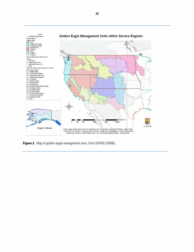
38
Figure 2. Map of golden eagle management units, from USFWS (2009b).
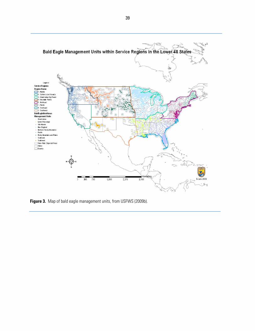
39
Figure 3. Map of bald eagle management units, from USFWS (2009b).
40
LITERATURE CITED Anthony,R.G.2001.LowproductivityofbaldeaglesonPrinceofWalesIsland,SoutheastAlaska.
RaptorResearch35:1‐8.Arnett,E.B.2006.Apreliminaryevaluationontheuseofdogstorecoverbatfatalitiesatwind
energyfacilities.WildlifeSocietyBulletin34(5):1440–1445.Arnett,E.B.,D.B.Inkley,D.H.Johnson,R.P.Larkin,S.Manes,A.M.Manville,R.Mason,M.Morrison,
M.D.Strickland,andR.Thresher.2007.Impactsofwindenergyfacilitiesonwildlifeandwildlifehabitat.TechnicalReview07‐2,TheWildlifeSociety,Bethesda,Maryland,USA.
Barclay,R.M.R.,E.F.Baerwald,andJ.C.Gruver.2007.Variationinbatandbirdfatalitiesatwindenergyfacilities:assessingtheeffectsofrotorsizeandtowerheight.CanadianJournalofZoology85:381–387.
Barrios,L.andA.Rodriguez.2004.Behaviouralandenvironmentalcorrelatesofsoaring‐birdmortalityaton‐shorewindturbines.JournalofAppliedEcology41:72‐81.
Buckland,S.T.,D.R.Anderson,K.P.Burnham,J.L.Laake,D.L.Borchers,andL.Thomas.2001.Introductiontodistancesampling.OxfordUniversityPress,NewYork,NewYork,USA.
Buehler,D.A.2000.Baldeagle(Haliaeetusleucocephalus).TheBirdsofNorthAmericano.506(A.Poole,ed.).TheBirdsofNorthAmericaOnline,CornellLabofOrnithology,Ithaca,NewYork,USA.http://bna.birds.cornell.edu/bna/species/506.
Chamberlain,D.E.,M.R.Rehfisch,A.D.Fox,M.Desholm,andS.J.Anthony.2006.Theeffectofavoidanceratesonbirdmortalitypredictionsmadebywindturbinecollisionriskmodels.Ibis148:198‐202.
Cole,S.2009.Howmuchisenough?Determiningadequatelevelsofenvironmentalcompensationforwindpowerimpactsusingequivalencyanalysis.InEuropeanOffshoreWindConference2009,14‐16September2009,Stockholm,Sweden.
Collopy,M.W.,andT.C.Edwards,Jr.1989.Territorysize,activitybudget,androleofundulatingflightinnestinggoldeneagles.JournalofFieldOrnithology60:43‐51.
Craig,T.H.,andE.H.Craig.1984.AlargeconcentrationofroostinggoldeneaglesinsoutheasternIdaho.Auk101:610‐613.
Craig,T.H.,E.H.Craig,andL.R.Powers.1984.RecentchangesineagleandbuteodensitiesinsoutheasternIdaho.Murrelet65:91‐93.
DeLucas,M.,G.F.E.Janss,D.P.WhitfieldandM.Ferrer.2008.Collisionfatalityofraptorsinwindfarmsdoesnotdependonraptorabundance.JournalofAppliedEcology45:1695–1703.
Ferrer,M.deLucas,G.F.E.Janss,E.Casado,A.R.Munõz,M.J.Bechard,andC.P.Calabuig.2011.Weakrelationshipbetweenriskassessmentstudiesandrecordedmortalityinwindfarms.JournalofAppliedEcologydoi:10.1111/j.1365‐2664.2011.02054.x.
Fuller,M.R.,J.J.Millspaugh,K.Church,andR.Kenward.2005,Wildliferadiotelemetry.Pages377‐417inC.E.Braun(ed.),Techniquesforwildlifeinvestigationsandmanagement,6thedition.TheWildlifeSociety,Bethesda,Maryland,USA.
Garrett,M.G.,J.W.Watson,andR.G.Anthony.1993.BaldeaglehomerangeandhabitatuseintheColumbiaRiverestuary.JournalofWildlifeManagement57:19‐27.
Gregory,M.J.P,A.G.Gordon,andR.Moss.2002.Impactofnest‐trappingandradio‐taggingonbreedinggoldeneaglesAquilachrysaetosinArgyll,Scotland.Ibis145:113‐119.
Harmata,A.R.1982.Whatisthefunctionofundulatingflightdisplayingoldeneagles?RaptorResearch16:103‐109.
Harmata,A.R.2002.VernalmigrationofbaldeaglesfromasouthernColoradowinteringarea.JournalofRaptorResearch36:256‐264.
41
Hodges,J.I.andF.C.Robards.1982.Observationsof3,850baldeaglenestsinsoutheastAlaska.Pages37‐46inAsymposiumandworkshoponraptormanagementandbiologyinAlaskaandwesternCanada.(W.N.LaddandP.F.Schempf,eds.)U.S.FishandWildlifeService,Anchorage,Alaska,USA.
Hoechlin,D.R.1976.DevelopmentofgoldeneaglesinsouthernCalifornia.WesternBirds7:137‐152.
Hoover,S.L.,andM.L.Morrison.2005.Behaviorofred‐tailedhawksinawindturbinedevelopment.JournalofWildlifeManagement69:150‐159.
Hunt,W.G.1998.RaptorfloatersatMoffat’sequilibrium.Oikos82:191‐197.Hunt,W.G.,R.E.Jackman,T.L.Brown,andL.Culp.1999.Apopulationstudyofgoldeneaglesin
theAltamontPassWindResourceArea:populationtrendanalysis1994‐1997.ReporttoNationalRenewableEnergyLaboratory,SubcontractsXAT‐5‐15174‐01,XAT‐6‐16459‐01.PredatoryBirdResearchGroup,UniversityofCalifornia,SantaCruz,California,USA.
Hunt,G.2002.Goldeneaglesinaperilouslandscape:predictingtheeffectsofmitigationforwindturbinebladestrikemortality.CaliforniaEnergyCommissionReportP500‐02‐043F.Sacramento,California,USA.
Huso,M.M.P.2010.Anestimatorofwildlifefatalityfromobservedcarcasses.EnvironmetricsDOI:10.1002/env.1052.
Kenward,R.E.2001.Amanualforwildlifetagging.AcademicPress,London,UK.Kerlinger,P.1989.Flightstrategiesofmigratinghawks.UniversityofChicagoPress,Chicago,
Illinois,USA.Kochert,M.N.1972.Populationstatusandchemicalcontaminationingoldeneaglesin
southwesternIdaho.M.S.Thesis.UniversityofIdaho,Moscow,Idaho,USA.Kochert,M.N.,K.Steenhof,C.L.Mcintyre,andE.H.Craig.2002.Goldeneagle(Aquilachrysaetos).
TheBirdsofNorthAmericaNo.684(A.Poole,Ed.).TheBirdsofNorthAmericaOnline.CornellLabofOrnithology,Ithaca,NewYork,USA.http://bna.birds.cornell.edu/bna/species/684.
Krone,O.2003.Twowhite‐tailedseaeagles(Haliaeetusalbicilla)collidewithwindgeneratorsinnorthernGermany.JournalofRaptorResearch37:174‐176.
Kunz,T.H.,E.B.Arnett,B.M.Cooper,W.P.Erickson,R.P.Larkin,T.Mabee,M.L.Morrison,M.D.Strickland,andJ.M.Szewczak.2007.Assessingimpactsofwind‐energydevelopmentonnocturnallyactivebirdsandbats:aguidancedocument.JournalofWildlifeManagement71:2449‐2486.
Kuvlesky,W.P.Jr.,L.A.Brennan,M.L.Morrison,K.K.Boydston,B.M.Ballard,andF.C.Bryant.2007.Windenergydevelopmentandwildlifeconservation:challengesandopportunities.JournalofWildlifeManagement71:2487‐2498.
Marzluff,J.M.,M.S.Vekasy,M.N.Kochert,andK.Steenhof.1997.Productivityofgoldeneagleswearingbackpackradiotransmitters.JournalofRaptorResearch31:223‐227.
McGrady,M.J.,J.R.Grant,I.P.Bainbridge,andD.R.A.McLeod.2002.Amodelofgoldeneagle(Aquilachrysaetos)rangingbehavior.JournalofRaptorResearch36(1)supplement:62‐69.
McLeod,D.R.A,D.P.Whitfield,andM.J.McGrady.2002.Improvingpredictionofgoldeneagle(Aquilachrysaetos)ranginginwesternScotlandusingGISandterrainmodeling.JournalofRaptorResearch36(1)Supplement:70‐77.
Millsap,B.A.1981.DistributionalstatusandecologyofFalconiformesinwestcentralArizona,withnotesonecology,reproductivesuccess,andmanagement.U.S.BureauofLandManagementTechnicalNote355.
Mohr,C.O.1947.TableofequivalentpopulationsofNorthAmericansmallmammals.AmericanMidlandNaturalist37:223–249.
Mojica,E.K.,J.M.Meyers,B.A.Millsap,andK.T.Haley.2008.Migrationofsub‐adultFloridabaldeagles.WilsonJournalofOrnithology120:304‐310.
42
Moorcroft,P.R.,M.A.Lewis,andR.L.Crabtree.1999.Homerangeanalysisusingamechanistichomerangemodel.Ecology80:1656‐1665.
Newton,I.1979.Populationecologyofraptors.ButeoBooks,Vermillion,SouthDakota,USA.Nygård,T,K.,E.L.Bevanger,Ø.Dahl,A.Flagstad,P.L.Follestad,Hoel,R.May,andO.Reitan.2010.
Astudyofwhite‐tailedeagleHaliaeetusalbicillamovementsandmortalityatawindfarminNorway.inD.Senapathi(ed.),Climatechangeandbirds:adaptation,mitigationandimpactsonavianpopulations.BritishOrnithologists’UnionProceedings,Peterborough,UnitedKingdom.http://www.bou.org.uk/bouproc‐net/ccb/nygard‐etal.pdf(lastvisited9October2011).
Palmer,R.S.1988.GoldeneagleAquilachrysaetos.Pages180‐231inR.S.Palmer(ed.),HandbookofNorthAmericanbirds,volume5,diurnalraptors(part2).YaleUniversityPress,NewHaven,Connecticut,USA.
Platt,J.B.1976.BaldeagleswinteringinaUtahdesert.AmericanBirds30:783‐788.Phillips,R.L.andA.E.Beske.1984.Resolvingconflictsbetweenenergydevelopmentandnesting
goldeneagles.Pages214‐219inR.D.Comer,J.M.Merino,J.W.Monarch,C.Pustmueller,M.Stalmaster,R.Stoecker,J.Todd,andW.Wright(eds.).Proceedingsofasymposium:Issuesandtechnologyinthemanagementofimpactedwesternwildlife.SteamboatSprings,Colorado,November15‐17,1982.ThorneEcologicalInstitute,Boulder,Colorado,USA.
Restani,M.,A.R.Harmata,andE.M.Madden.2000.Numericalandfunctionalresponsesofmigrantbaldeaglesexploitingaseasonallyconcentratedfoodsource.Condor102:561‐568.
Seaman,D.E.,andR.A.Powell.1996.Anevaluationoftheaccuracyofkerneldensityestimatorsforhomerangeanalysis.Ecology77:2075–2085.
Sherrod,S.K.,C.M.White,andF.S.L.Williamson.1976.BiologyofthebaldeagleonAmchitkaIsland,Alaska.LivingBird15:145‐182.
Smallwood,K.S.andC.G.Thelander.2004.DevelopingmethodstoreducebirdfatalitiesintheAltamontWindResourceArea.FinalreportpreparedbyBioResourceConsultantstotheCaliforniaEnergyCommission,PublicInterestEnergyResearch‐EnvironmentalArea,ContractNo.500‐01‐019.
Smallwood,K.S.,L.Rugge,M.L.Morrison.2009.Influenceofbehavioronbirdmortalityinwindenergydevelopments.JournalofWildlifeManagement73:1082–1098.
Soutullo,A.,V.Urios,M.Ferrer,andS.G.Penarrubia.2006.Post‐fledgingbehaviouringoldeneaglesAquilachrysaetos:onsetofjuveniledispersalandprogressivedistancingfromthenest.Ibis148:307‐312.
Strickland,M.D.,E.B.Arnett,W.P.Erickson,D.H.Johnson,G.D.Johnson,M.L.,Morrison,J.A.Shaffer,andW.Warren‐Hicks.2011.ComprehensiveGuidetoStudyingWindEnergy/WildlifeInteractions.PreparedfortheNationalWindCoordinatingCollaborative,Washington,D.C.,USA.
Thorstrom,R.2001.Nest‐sitecharacteristicsandbreedingdensityoftwosympatricforest‐falconsinGuatemala.OrnitologiaNeotropical12:337‐343.
USFWS.1983.Northernstatesbaldeaglerecoveryplan.U.S.FishandWildlifeService,DivisionofMigratoryBirdManagement,WashingtonD.C.,USA.
USFWS.2007.Protectionofeagles;definitionof“Disturb.”FederalRegister72(107):31132‐31140.USFWS.2009a.Eaglepermits;takenecessarytoprotectinterestsinparticularlocalities.Federal
Register74(175):46836‐46879.USFWS.2009b.Finalenvironmentalassessment.ProposaltopermittakeprovidedundertheBald
andGoldenEagleProtectionAct.U.S.FishandWildlifeService,DivisionofMigratoryBirdManagement,WashingtonD.C.,USA.
Walker,D.,M.McGrady,A.McCluskie,M.Madders,andD.R.A.McLeod.2005.ResidentgoldeneaglerangingbehaviourbeforeandafterconstructionofawindfarminArgyll.ScottishBirds25:24‐40.
Watson,J.W.,andR.W.Davies.2009.RangeuseandcontaminantsofgoldeneaglesinWashington.ProgressReport.WashingtonDepartmentofFishandWildlife,Olympia,Washington.
43
Whitfield,D.P.,A.H.Fielding,M.J.P.Gregory,A.G.Gordon,D.R.A.McLeod,andP.F.Haworth.2007.ComplexeffectsofhabitatlossongoldeneaglesAquilachrysaetos.Ibis149:26–36.
Wichmann,M.C.,F.Jeltsch,W.R.J.Dean,K.A.MoloneyandC.Wissel.2003.Implicationofclimatechangeforthepersistenceofraptorsinaridsavanna.Oikos102:186–202.
Williams,B.K.,R.C.Szaro,andC.D.Shapiro.2007.AdaptiveManagement:TheU.S.DepartmentoftheInteriorTechnicalGuide.AdaptiveManagementWorkingGroup,U.S.DepartmentoftheInterior,Washington,DC,USA.
Worton,B.J.1989.Kernelmethodsforestimatingtheutilizationdistributioninhome‐rangestudies.Ecology70:164–168.
Yates,R.E.,B.R.McClelland,P.T.McClelland,C.H.Key,andR.E.Bennetts.2001.TheinfluenceofweatherongoldeneaglemigrationinnorthwesternMontana.JournalofRaptorResearch35:81‐90.
44
APPENDIX A: ADAPTIVE MANAGEMENT Managementofwindfacilitiestominimizeeagletakethroughdecisionsaboutsiting,design,operation,andcompensatorymitigation,isasetofrecurrentdecisionsmadeinthefaceofuncertainty.TheDepartmentoftheInteriorhasalonghistoryofapproachingsuchdecisionsthroughaprocessofadaptivemanagement(Williamsetal.2007).Thepurposeofadaptivemanagementistoimprovelong‐termmanagementoutcomes,byrecognizingwherekeyuncertaintiesimpededecisionmaking,seekingtoreducethoseuncertaintiesovertime,andapplyingthatlearningtosubsequentdecisions(Walters1986).Adaptivemanagementisaspecialcaseofdecisionanalysisappliedtorecurrentdecisions(Lyonsetal.2008).Likeallformaldecisionanalysis,itbeginswiththeidentificationoffundamentalobjectives—thelong‐termendssoughtthroughthedecision(step2,Fig.A‐1).Theseobjectivesaretheprimaryconcern,andalltheotherelementsaredesignedaroundthem.Withtheseobjectivesinmind,alternativeactionsareconsidered,andtheconsequencesofthesealternativesareevaluatedwithregardtohowwelltheymightachievetheobjectives.Butinmanydecisions,thereiscriticaluncertaintythatimpedesthedecision(step6,Fig.A‐1),thatis,thedecision‐makerismissingknowledgethataffectswhichalternativemightbebest.Inrecurrentdecisions,thereexiststheopportunitytoreducethatuncertainty,bymonitoringtheoutcomesofearlyactions,andapplythatlearningtolateractions.Itisvaluabletonotethatlearningisnotpursuedforitsownsake,butonlyinsofarasithelpsimprovelong‐termmanagementbyreducingtheseuncertainties.Therearetwohallmarksofaformalinterpretationofadaptivemanagement,likethatdescribedabove.Thefirsthallmarkistheaprioriidentificationofthecriticaluncertainty.Inthisway,adaptivemanagementisnotablindsearchforsomeunspecifiednewinsights,butafocusedefforttoreducetheuncertaintythatstandsinthewayofbetterdecision‐making.Thesecondhallmarkisthatthemeansofadaptationisclear,thatis,thewayinwhichnewinformationwillbeappliedtosubsequentdecisionsisarticulated.Thereis,however,recognitionthatunanticipatedlearningdoesoccurinanyrealsystem,andthislearningcansometimesleadtovaluableinsights.Inso‐called“double‐looplearning”(ArgyrisandShon1978),thelearningmightevenleadtoare‐framingofthedecision,are‐examinationoftheobjectives,orconsiderationofnewalternatives(thiscouldberepresentedbyaloopfromstep7tostep1inFig.A‐1).Inthecontextofeaglemanagementatwindfacilities,theService’sfocusisontheinner‐looplearning(representedbythefeedbackfromstep7to8to4inFig.A‐1),butunanticipatedlearningwillnotbeignored.Inthecaseofmanagingeaglepopulationsinthefaceofenergydevelopment,thereisconsiderableuncertaintytobereduced.Forexample,webelievethatinsomeareasorspecificsituations,largesoaringbirds,specificallyraptors,mightbeespeciallyvulnerabletocollidingwithwindturbines(BarriosandRodriguez2004,Kuvleskyetal.2007),butweareuncertainabouttherelativeimportanceoffactorsthatinfluencethatrisk.Wearealsouncertainaboutthebestwaytomitigatetheeffectsofwindturbinedevelopmentsonraptors;wesuspectsomestrategiesmightbeeffective,othersareworthtrying.Wealsosuspectthatafewspecies,includinggoldeneagles(USFWS2009),maybesusceptibleenoughtocollisionswithwindturbinesthatpopulationsmaybenegativelyaffected.Thus,thereareuncertaintiesatseverallevelsthatchallengeourattemptstomanageeaglepopulations:(1)atthelevelofunderstandingfactorsthataffectcollisionrisk,(2)atthelevelthatinfluencespopulationtrends,and(3)abouttheefficacyofvariousmitigationoptions.TheService,ourconservationpartners,andindustrywillneverhavetheluxuryofperfectinformationbeforeneedingtoacttomanageeagles.Wearethereforelefttomakemanagementdecisionsbasedonthe
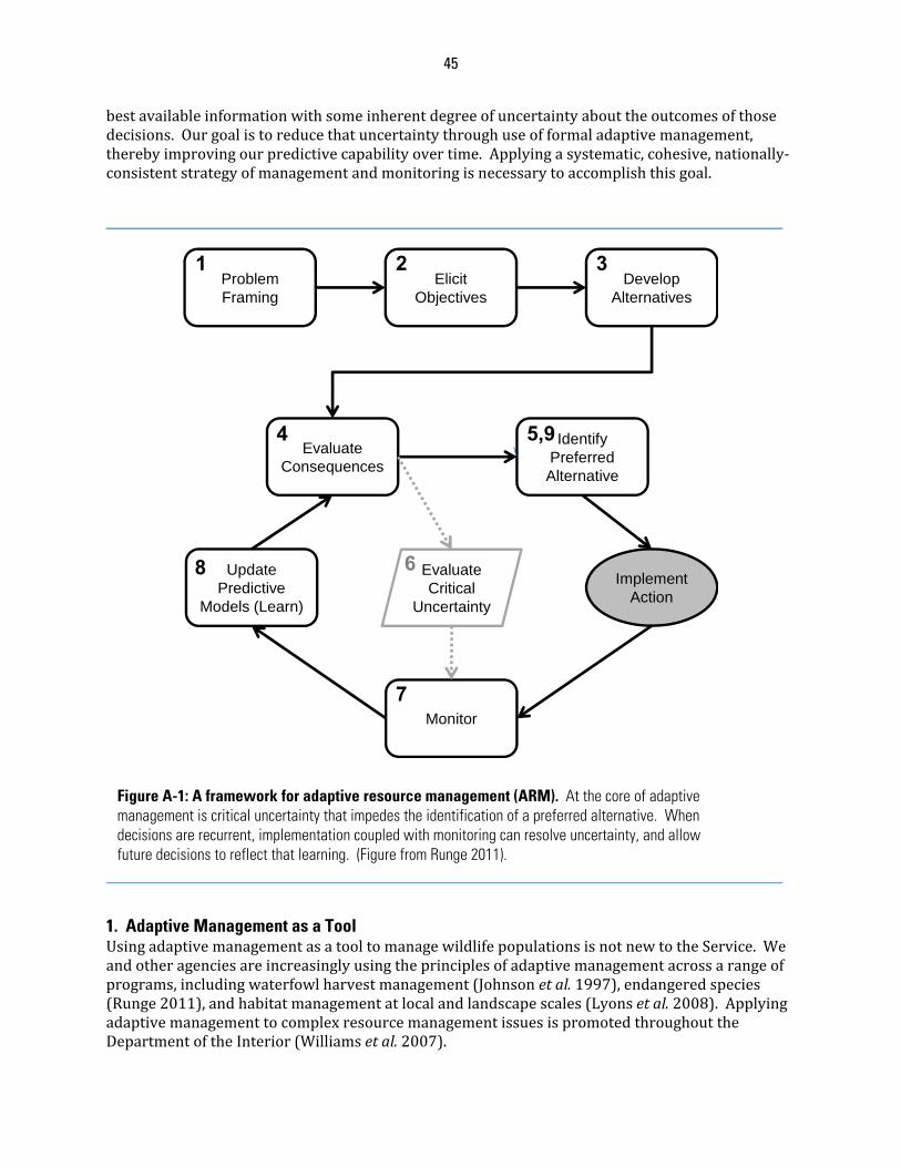
45
bestavailableinformationwithsomeinherentdegreeofuncertaintyabouttheoutcomesofthosedecisions.Ourgoalistoreducethatuncertaintythroughuseofformaladaptivemanagement,therebyimprovingourpredictivecapabilityovertime.Applyingasystematic,cohesive,nationally‐consistentstrategyofmanagementandmonitoringisnecessarytoaccomplishthisgoal.
1. Adaptive Management as a Tool UsingadaptivemanagementasatooltomanagewildlifepopulationsisnotnewtotheService.Weandotheragenciesareincreasinglyusingtheprinciplesofadaptivemanagementacrossarangeofprograms,includingwaterfowlharvestmanagement(Johnsonetal.1997),endangeredspecies(Runge2011),andhabitatmanagementatlocalandlandscapescales(Lyonsetal.2008).ApplyingadaptivemanagementtocomplexresourcemanagementissuesispromotedthroughouttheDepartmentoftheInterior(Williamsetal.2007).
Problem Framing
Elicit Objectives
Develop Alternatives
Evaluate Consequences
Identify Preferred Alternative
1 2 3
4 5,9
Monitor
Update Predictive
Models (Learn)
Implement Action
Evaluate Critical
Uncertainty
6
7
8
Figure A-1: A framework for adaptive resource management (ARM). At the core of adaptive management is critical uncertainty that impedes the identification of a preferred alternative. When decisions are recurrent, implementation coupled with monitoring can resolve uncertainty, and allow future decisions to reflect that learning. (Figure from Runge 2011).
46
Waterfowlharvestmanagementistheclassicexampleofadaptiveresourcemanagement.HuntingregulationsarereseteachyearintheUnitedStatesandCanadathroughtheapplicationofadaptivemanagementprinciples(Johnsonetal.1997).Akeyuncertaintyinwaterfowlmanagementistheextenttowhichharvestmortalityiscompensatedbyreductionsinnon‐harvestmortalityorbyincreasesinproductivity(Williamsetal.1996).Variouspopulationmodelshavebeenbuiltbasedoncompetinghypothesestoanswerthisquestion;thesecompetingmodelsmakedifferentpredictionsabouthowthepopulationwillrespondtohunting.EveryyeartheServiceandtheCanadianWildlifeServicemonitorwaterfowlandenvironmentalconditionstoestimatepopulationsize,survivalrates,productivity,andhuntingrates.Thesedatafeedintothevariouscompetingmodels,andthemodelsareevaluatedannuallybasedonhowwelltheypredictchangesinwaterfowlpopulations.Modelsthatperformbestyear‐after‐yearaccrueincreasingweight(i.e.,evidenceinsupportoftheunderlyinghypothesis).Weightedmodeloutputsdirectlyleadtorecommendedsetsofhuntingregulations(e.g.,baglimitsandseasonlengths)forthesubsequentyear.Overtime,bymonitoringthepopulationeffectsofvariousharvestratesonsurvivorship,andenvironmentalconditionsonproductivity,ouruncertaintyaboutthedegreetowhichharvestiscompensatedbyotherfactorshasbeenreduced,allowingforthesettingofharvestrateswithgreaterconfidenceeveryyear.TheapplicationofadaptivemanagementprinciplestowaterfowlharvestregulationhashelpedtheServiceanditspartnersachieveorexceedpopulationgoalsformostspeciesofwaterfowl(NAWMP2004).AdaptivemanagementisacentralcomponentoftheService’sapproachtocollaborativemanagementatthelandscapescale,throughstrategichabitatconservation(NEAT2006).Theprinciplesofadaptivemanagementarealsoembeddedinendangeredspeciesmanagement(Ruhl2004,Runge2011),includinginrecoveryplanning(Smith2011)andhabitatconservationplanning(Wilhere2002).Indeed,theServicerecognizesthatadaptivemanagementisanormativeconceptinmodernecologicaldecision‐making(Callicottetal.1999),andembracesitasafundamentaltool.2. Applying Adaptive Management to Eagle Take Permitting InthecontextofwindenergydevelopmentandeaglemanagementundertheECPG,therearefourspecificsetsofdecisionsthataresuitableforanadaptivemanagementapproach.
a. Adaptive Management of Wind Project Operations Themostimmediateanddirectopportunityforadaptivemanagementisatthesite‐levelforwindfacilitiesafterconstruction.Therelevantuncertaintyisinthepredictionsofeagletakeattheproject,andtheoperationalfactorsthatinfluencetheleveloftake.TheroleofadaptivemanagementatthisscalewillbeanalyzedandevaluatedintheNEPAassociatedwitheachpermit.UndertheECPG,awindprojectwouldinitiallyworkwiththeServicetogeneratepredictionsoftake,giventhesiting,design,andoperationalparametersoftheproject.Thesepredictionsaremadeunderuncertainty,andtherisktoeaglesassociatedwiththisuncertaintyisfactoredintothecompensatorymitigationtermsofthepermitunderBGEPA.Afterasitebecomesoperational,ongoingsurveysofrealizedtakecanbecomparedtothepredictionsoftake.Atthereviewpointsofthepermit(typically,everyfiveyears),theServiceandtheoperatorwillreviewtheobservedtake.Iftheobservedtakeexceedsthepredictedandpermittedtake,theServicewillworkwiththeoperatortoidentifymeasuresthatcouldbetakentoreducethetakebelowthepermittedthreshold(withinthelimitsjointlyagreedtoattheoutsetofthepermitperiod).Themonitoringdatamayprovidecluesabouthowthiscouldbedone,forexample,byidentifyingwhereandwhenmostofthetakeisoccurring.Ontheotherhand,iftheobservedtakeissignificantly
47
lessthanthepredictedtake,theServicecanworkwiththeoperatortoupdatethepredictionsoftakeforthenextreviewperiod,adjusttheconditionsforcompensatorymitigation,andreturncreditstotheoperatorforanyexcesscompensatorymitigation.Inarelatedmanner,forbothnewandexistingfacilities,ongoingmonitoringcanprovideinformationtoreduceuncertaintyabouttheeffectivenessofconservationmeasuresandACPs.Inparticular,experimentalconservationmeasuresandACPsareactionstakenbytheoperatorthatarethoughttoreducemortalityrisk,butthereisuncertaintyabouthoweffectivesomeofthesemeasurescanbe.Intheend,thepurposeofadaptivemanagementofoperationsistoreducemortalityofeagleswhilealsoreducingtheimpactofconservationmeasuresandACPsonpowergenerationatwindfacilities.b. Adaptive Management of Wind Project Siting and Design Recommendations ThroughtheECPGandthepermitreviewprocess,theServicemakesrecommendationstooperatorsabouthowtositeanddesignwindfacilitiestoreduceeagledisturbanceandmortality.Theserecommendationsarebasedonthebestavailablescience,butacknowledgethatourunderstandingoftheinteractionbetweeneaglesandwindfacilitiesisincomplete.Adaptivemanagementprovidestheopportunitytorespondtoincreasingunderstandingaboutthisinteraction.Theparticularfocusofthislayerofadaptivemanagementisthepredictionsoftakethataremadebyconsideringpre‐constructionsurveysandriskfactors(seeAPPENDIXD).Theproposedmodelsareinitiallyquitecoarseintheirabilitytomakepredictions,buttheService,inpartnershipwiththeU.S.GeologicalSurvey(USGS),planstorefinethesemodels.Thekeyuncertaintiesconcerntheriskfactorsthatareimportantinpredictingeagletake.Forexample,howimportantistheproximitytonestingsites,preyconcentrations,orridgelinesindeterminingtheriskposedbyanywindturbine?Multiplemodelswillbedevelopedtoexpressuncertaintyintheseriskfactors,andthepredictionsfromthesemultiplemodelswillbecomparedtothepatternsofobservedtakeatexistingfacilities.Usingmultiplemodelstoexpressuncertaintyallowsinclusionandevaluationofalternativemodelsfromdifferentsources.Thelearningthatemergeswillbeusedtoimprovethepredictionsfromthemodels,whichinturn,willallowfuturerecommendationsaboutsitinganddesigntobeenhanced.Inthiscase,thebenefitofthemonitoringatindividualsitesaccruestothewindindustryasawhole.c. Adaptive Management of Compensatory Mitigation Thedeterminationofappropriatelevelsofcompensatorymitigation,suchasthrougharesourceequivalencyanalysis(REA,seeAPPENDIXF),isbasedontwopredictions:theleveloftakeexpectedataproject;andtheamountofmitigationrequiredtooffsetthattake.Asnotedabove,site‐levellearning,throughobservationofrealizedtake,canbeusedtoupdatepredictionsoftake,andcompensatorymitigationcanbeadjustedaccordingly.Inaddition,theaccruedexperienceacrosssites,throughmonitoringoftheeffectivenessofcompensatorymitigationprojectsandeaglepopulationresponses,canbeusedtoupdatethemethodsandparametersintheREAmethodsusedtodeterminetheappropriatelevelofcompensatorymitigation.d. Adaptive Management of Population-Level Take Thresholds Healthy,robustpopulationsofanimalscansustainsomedegreeofincidentaltake,withoutlong‐termadverseimpactstothepopulationortheecosystem.Theamountoftakethatis
48
sustainableandthatcanbeauthorizedisafunctionofbothscientificfactors(e.g.,theintrinsicgrowthrateandcarryingcapacityofthepopulation)andpolicyinterpretation(e.g.,theamountofpotentialgrowththatcanbeallocatedtotake,andtherisktoleranceforexcessivetake)(Rungeetal.2009).Thecapacitytosustainincidentaltakearisesfromtheresilienceinpopulationsduetotheabilitytocompensateforthattakebyincreasingsurvivalorreproductiverates.Atthescaleofregionalpopulations(e.g.,birdconservationregionsforgoldeneagles),thecentralquestionforeaglesisnotaltogetherdifferentthanitisforwaterfowl:towhatextentismortalityfromenergydevelopment,oranyotheranthropogenicsource,compensatedbyreductionsinmortalityfromothersources,orbyincreasesinproductivity?Thesequestionsarebestansweredbybuildingpopulationmodelsfoundedoncompetinghypothesesthatincorporateestimatesofmortality,productivity,andthevariationaroundthosevitalrates.Whatisneededisasystematicefforttocollectinformationonmortality,breeding,andpopulationstatustofeedthosemodels.Similartowaterfowlmanagement,reducinguncertaintyinpopulation‐levelmodelsforeaglemanagementwillrequirerollinguptheresultsoflocalmonitoringandresearchacrossthedistributionofeagles.TheresultswillallowtheServicetomakemoreinformedmanagementrecommendationstoreachtheService’spopulationgoalofstableorincreasingbreedingpopulationsforbotheaglespecies.Atpresent,theService’sregulationscallfornoincreaseinnettakeofgoldeneagles,underaprotectiveconcernthatthecurrentleveloftakeexceedsasustainablethreshold.Asourunderstandingofgoldeneaglepopulationsizeandstatusincreases,andourknowledgeofvitalratesandpotentialresilienceimproves,theServiceandUSGSwillreanalyzethepotentialforinstitutingtakethresholdsforgoldeneagles.Takethresholdsforbaldeagleswillalsobere‐assednolessfrequentlythaneveryfiveyears(USFWS2009).Ifthresholdsforeitherspeciesareincreasedandadditionaltakeisauthorized,continuedpopulationmonitoringwillbecriticalinprovidingfeedbackonpopulationresponse(i.e.,step4to8inFig.A‐1).
Literature Cited Argyris,C.,andD.Shon.1978.OrganizationalLearning:aTheoryofActionLearning.Addison‐
Wesley,Reading,Massachusetts.Barrios,L.,andA.Rodriguez.2004.Behaviouralandenvironmentalcorrelatesofsoaring‐bird
mortalityaton‐shorewindturbines.JournalofAppliedEcology41:72‐81.Callicott,J.B.,L.B.Crowder,andK.Mumford.1999.Currentnormativeconceptsinconservation.
ConservationBiology13:22‐35.Johnson,F.A.,C.T.Moore,W.L.Kendall,J.A.Dubovsky,D.F.Caithamer,J.R.Kelley,Jr.,andB.K.
Williams.1997.Uncertaintyandthemanagementofmallardharvests.JournalofWildlifeManagement61:202‐216.
Kuvlesky,W.P.,Jr,L.A.Brennan,M.L.Morrison,K.K.Boydston,B.M.Ballard,andF.C.Bryant.2007.Windenergydevelopmentandwildlifeconservation:challengesandopportunities.TheJournalofwildlifemanagement71:2487‐2498.
Lyons,J.E.,M.C.Runge,H.P.Laskowski,andW.L.Kendall.2008.Monitoringinthecontextofstructureddecision‐makingandadaptivemanagement.JournalofWildlifeManagement72:1683‐1692.
49
NationalEnvironmentalAssessmentTeam[NEAT].2006.StrategicHabitatConservation.U.S.FishandWildlifeService,Arlington,Virginia,USA.
NorthAmericanWaterfowlManagementPlan,PlanCommittee[NAWMP].2004.NorthAmericanWaterfowlManagementPlan2004.StrategicGuidance:StrengtheningtheBiologicalFoundation.CanadianWildlifeService,U.S.FishandWildlifeService,SecretariadeMedioAmbienteyRecursosNaturales.
Ruhl,J.2004.Takingadaptivemanagementseriously:AcasestudyoftheEndangeredSpeciesAct.UniversityofKansasLawReview52:1249‐1284.
Runge,M.C.2011.Adaptivemanagementforthreatenedandendangeredspecies.JournalofFishandWildlifeManagement2.
Runge,M.C.,J.R.Sauer,M.L.Avery,B.F.Blackwell,andM.D.Koneff.2009.Assessingallowabletakeofmigratorybirds.JournalofWildlifeManagement73:556‐565.
Smith,C.B.2011.AdaptivemanagementonthecentralPlatteRiver‐Science,engineering,anddecisionanalysistoassistintherecoveryoffourspecies.JournalofEnvironmentalManagement92:1414‐1419.
USFWS.2009.Finalenvironmentalassessment.ProposaltopermittakeprovidedundertheBaldandGoldenEagleProtectionAct.U.S.FishandWildlifeService,DivisionofMigratoryBirdManagement,WashingtonD.C.,USA.
Walters,C.J.1986.Adaptivemanagementofrenewableresources.Macmillan,NewYork,NewYork,USA.
Wilhere,G.F.2002.Adaptivemanagementinhabitatconservationplans.ConservationBiology16:20‐29.
Williams,B.K.,F.A.Johnson,andK.Wilkins.1996.Uncertaintyandtheadaptivemanagementofwaterfowlharvests.TheJournalofwildlifemanagement60:223‐232.
Williams,B.K.,R.C.Szaro,andC.D.Shapiro.2007.AdaptiveManagement:TheU.S.DepartmentoftheInteriorTechnicalGuide.AdaptiveManagementWorkingGroup,U.S.DepartmentoftheInterior,Washington,DC,USA.
50
APPENDIX B: STAGE 1 – SITE ASSESSMENT Occurrenceofeaglesandtheiruseoflandscapesvaryacrossbroadspatialscales.Thefirststepinprojectdevelopmentistoconductalandscape‐scaleassessment,basedmainlyonpubliclyavailableinformation,toidentifysiteswithinalargegeographicareathathavebothhighpotentialforwindenergyandlowpotentialfornegativeimpactsoneaglesifaprojectisdeveloped.Stage1correspondstoTiers1and2oftheWEGand,alongwithStage2hereinandTier3intheWEG,comprisethepre‐constructionevaluationofwindenergyprojects.DependingontheoutcomeofStage1,developersdecidewhethertoproceedtothenextstage,“...requiringagreaterinvestmentindatacollectiontoanswercertainquestions”(referringtoTier3,intheWEG;seealsoTableB‐1).TheWEGshouldbeexaminedforgeneralconsiderationsrelevanttoStage1;thisappendixandthefollowingAPPENDIXCfocusonconsiderationsspecifictoeagles.TheStage1assessmentshouldevaluatewindenergypotentialwithintheecologicalcontextofeagles,includingconsiderationsfortheeagle’sannuallife‐cycle,i.e.,breeding,dispersal,migration,andwintering.Thegoalatthisstageistodeterminewhetherprospectivewindprojectsitesarewithinareasknownorlikelytobeusedbyeaglesand,ifso,begintodeterminetherelativespatiotemporalextentandtypeofeagleuseofthesites.Areasusedheavilybyeaglesarelikelytofallintocategory1;developmentintheseareasshouldbeavoidedbecausetheServiceprobablycouldnotissueprojectdevelopersoroperatorsaprogrammaticpermitfortakethatcomplieswithallregulatoryrequirements.Stage1assessmentisarelativelystraightforward“desktop”processthatprobablyshouldconductbeforesignificantfinancialresourceshavebeencommittedtodevelopingaparticularproject.Multipledatasourcescanbeconsultedwhenevaluatingaprospectivesite’svaluetoeagles.WildlifebiologistsandothernaturalresourceprofessionalsfromfederalagenciesincludingtheService,andtribal,state,andcountyagenciesshouldbeconsultedearlyintheStage1processtohelpensureallrelevantinformationisbeingconsidered.Informationmainlyencompassesphysiographicandbiologicalfactorsthatcouldaffecteagleriskassociatedwithwindenergydevelopment.Questionsgenerallyfocuson:(1)recentorhistoricalnestingandseasonaloccurrencedataforeaglesattheprospectivearea;(2)migrationorotherregularmovementbyeaglesthroughtheareaorsurroundinglandscape;(3)seasonalconcentrationareassuchasacommunalroostsiteinamatureriparianwoodlandoraprairiedog(Cynomysspp.)townservingasamajorforagebase;and(4)physicalfeaturesofthelandscape,especiallytopography,thatmayattractorconcentrateeagles.“Historical”isdefinedhereas5ormoreyears;asearchforhistoricaldatashouldencompassatleasttheprevious5years.Datafromfarlongertimeperiodsmaybeavailablebutshouldbecautiouslyscrutinizedforconfoundingfactorssuchaslandusechangethatdiminishthedata’srelevance.Preliminarysiteevaluationcouldbeginwithareviewofpublicallyavailableinformation,includingresourcedatabasessuchasNatureServe(http://www.natureserve.org/)andtheAmericanWindWildlifeInstitute’sLandscapeAssessmentTool(LAT;http://www.awwi.org/initiatives/landscape.aspx);informationfromrelevanttribal,state,andfederalagencies,includingtheService;statenaturalheritagedatabases;stateWildlifeActionPlans;raptormigrationdatabasessuchasthoseavailablethroughHawkMigrationAssociationofNorthAmerica(http://www.hmana.org)orHawkWatchInternational(http://www.hawkwatch.org);peer‐reviewedliteratureandpublishedtechnicalreports;andgeodatabasesoflandcover,landuse,andtopography(e.g.,theLATintegratesseveralkeygeodatabases).Additionalinformationonasite’sknownorpotentialvaluetoeaglescanbegarneredbydirectlycontactingpersonswitheagleexpertisefromuniversities,conservationorganizations,andprofessionalorstateornithologicalornaturalhistorysocieties.
51
Someofthiswideassortmentofdesktopinformationandcertainknowledgegapsidentifiedprobablywillnecessitatevalidationthroughsite‐levelreconnaissance,assuggestedintheWEG.Usingtheseandotherdatasources,aseriesofquestionsshouldbeconsideredtohelpplacetheprospectiveprojectsiteoralternatesitesintoanappropriateriskcategory.Relevantquestionsinclude(modifiedfromtheWEG):
1. Doesexistingorhistoricalinformationindicatethateaglesoreaglehabitat(includingbreeding,migration,dispersal,andwinteringhabitats)maybepresentwithinthegeographicregionunderdevelopmentconsideration?
2. Withinaprospectiveprojectsite,arethereareasofhabitatknowntobeorpotentiallyvaluabletoeaglesthatwouldbedestroyedordegradedduetotheproject?
3. Arethereimportanteagleuseareasormigrationconcentrationsitesdocumentedorthoughttooccurintheprojectarea?
4. Doesexistingorhistoricalinformationindicatethathabitatsupportingabundantpreyforeaglesmaybepresentwithinthegeographicregionunderdevelopmentconsideration(acknowledging,whereverappropriate,thatpopulationlevelsofsomepreyspeciessuchasblack‐tailedjackrabbits(Lepuscalifornicus)cycledramatically[Grossetal.1974]suchthattheyareabundantandattracteaglesonlyincertainyears[e.g.,Craigetal.1984])?
5. Foragivenprospectivesite,istherepotentialforsignificantadverseimpactstoeaglesbasedonanswerstoabovequestionsandconsideringthedesignoftheproposedproject?
Werecommenddevelopmentofamapthat,basedonanswerstotheabovequestions,indicatesareasthatfallundersitecategory1,i.e.,areaswherewindenergydevelopmentwouldposeobvious,substantiallyhighriskstoeaglepopulations.Remainingareascouldbetentativelycategorizedaseithermoderatetohighbutmitigableriskorminimalrisktoeaglepopulations(category2orcategory3).Prospectivesitesthatfallintocategory1atthispointareunlikelycandidatesforaprogrammaticpermitfortakeofeagles,althoughclassificationofasiteatStage1mightberegardedastentative(see“AssessingRiskandEffects;4.SiteCategorizationBasedonMortalityRisktoEagles”intheECPG.Ifasiteappearstobeacategory1sitebasedontheoutcomeofStage1,thedevelopercandecidewhetherinformationatthatstageadequatelysupportsacategorydecisionorwhethertoinvestinStage2assessmenttoclarifypreliminaryindicationsofStage1(TableB‐1).Sitesthattentativelyfallintocategories2or3atStage1canmoveontoStage2assessment,butcouldultimatelybeexcludedaspermitcandidatesaftermoresite‐specificdataarecollectedinStage2.Again,thegoalofStage1siteassessmentinthisECPGistodeterminewhetherprospectivewindprojectsitesarewithinareasknownorlikelytobeusedbyeaglesand,ifso,begintoassessthespatiotemporalextentandtypeofeagleusethesitesreceiveorarelikelytoreceive.Thus,theultimategoalofStage1istodeterminewhethersitesexhibitanyobvioussubstantialriskforeagles.Forthosethatdonot,theStage1siteassessmentwillprovidefundamentalsupportforthedesignofdetailedsurveysinStage2,decisionswhichinfluenceoptimalallocationofthefinancialinvestmentinsurveysandqualityofdatacollected.Insomesituations,theStage1siteassessmentmayprovideenoughinformationtoadequatelyestimateimpactsandsupportdecisionsonsitecategorization(and,whererelevant,potentialconservationmeasuresandappropriatelevelsofcompensatorymitigation),renderingStage2assessmentunnecessary(TableB‐1).
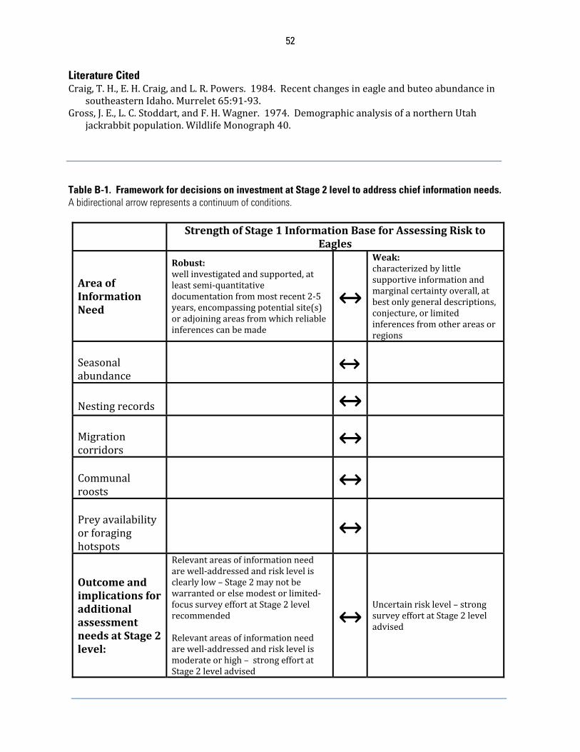
52
Literature Cited Craig,T.H.,E.H.Craig,andL.R.Powers.1984.Recentchangesineagleandbuteoabundancein
southeasternIdaho.Murrelet65:91‐93.Gross,J.E.,L.C.Stoddart,andF.H.Wagner.1974.DemographicanalysisofanorthernUtah
jackrabbitpopulation.WildlifeMonograph40. Table B-1. Framework for decisions on investment at Stage 2 level to address chief information needs. A bidirectional arrow represents a continuum of conditions. StrengthofStage1InformationBaseforAssessingRiskto
Eagles
AreaofInformationNeed
Robust:wellinvestigatedandsupported,atleastsemi‐quantitativedocumentationfrommostrecent2‐5years,encompassingpotentialsite(s)oradjoiningareasfromwhichreliableinferencescanbemade
↔
Weak:characterizedbylittlesupportiveinformationandmarginalcertaintyoverall,atbestonlygeneraldescriptions,conjecture,orlimitedinferencesfromotherareasorregions
Seasonalabundance
↔
Nestingrecords
↔
Migrationcorridors
↔
Communalroosts
↔
Preyavailabilityorforaginghotspots
↔
OutcomeandimplicationsforadditionalassessmentneedsatStage2level:
Relevantareasofinformationneedarewell‐addressedandrisklevelisclearlylow–Stage2maynotbewarrantedorelsemodestorlimited‐focussurveyeffortatStage2levelrecommendedRelevantareasofinformationneedarewell‐addressedandrisklevelismoderateorhigh–strongeffortatStage2leveladvised
↔Uncertainrisklevel–strongsurveyeffortatStage2leveladvised
53
APPENDIX C: STAGE 2 – SITE-SPECIFIC SURVEYS AND ASSESSMENT 1. Surveys of Eagle Use InformationcollectedinStage2isusedmainlytogeneratepredictionsofthemeanannualnumberofeaglefatalitiesforaprospectivewindenergyprojectandtoidentifyimportanteagleuseareasormigrationconcentrationsitesthatcouldbeaffectedbytheproject.InformationfromStage2isalsousedtoassessthelikelihoodofdisturbancetakeofeagles.Anarrayofsurveytypescouldbeusedtoquantifyusebyeaglesofaproposedprojectarea.Thissectionfocusesonfourtypesofsurveysrecommendedforassessingrisktoeaglesatproposedwindprojects.Thefirstthreearesurveysofeagleusewithintheproposedprojectfootprint.Theseinclude:(1)pointcountsurveys,whichmainlygenerateoccurrencedatathatformunderpinningsoftheriskassessmentmodelrecommendedherein;(2)migration(“hawkwatch”)counts,documentinghourlypassageratesofeagles;and(3)utilizationdistribution(UD)assessment,anaccountingoftheintensityofuseofvariouspartsofthehomerangewithintheprojectfootprint;and(4)surveysofnestingterritoryoccupancyintheprojectarea.Whereuncertaintiesexistregardingsurveymethods,ourrecommendationstendtobeconservativesuchthatbiasesinsurveydata,ifany,aremorelikelytofavorgreaterratherthanlowerestimatesofuseandultimatelymoreratherthanlessprotectionforeagles.ThisapproachisconsistentwiththeService’spolicyoftakingarisk‐aversestanceinthefaceofexistinguncertaintywithrespecttoeagleprogrammatictakepermits.Inadditiontofatalityestimationandinformingasitecategorizationdecision,Stage2studiesofeaglesshouldhelpanswerthefollowingquestions(modifiedfromtheWEG):
1. Whatisthedistribution,relativeabundance,behavior,andsiteuseofeaglesandtowhatextentdothesefactorsexposeeaglestoriskfromtheproposedwindenergyproject?
2. Whatarethepotentialrisksofadverseimpactsoftheproposedwindenergyprojecttoindividualandlocalpopulationsofeaglesandtheirhabitats?
3. Howcandevelopersavoid,minimize,andmitigateidentifiedadverseimpacts?4. Aretherestudiesthatshouldbeinitiatedatthisstagethatwouldbecontinuedinpost‐
construction?
a. Point Count Surveys Pointcounts(i.e.,circular‐plotsurveys)oftenareusedtoassessrelativeabundance,populationtrends,andhabitatpreferencesofbirds(Johnson1995).TheServiceadvocatesuseofpointcountsurveysasthemeansofprovidingprimaryinputformodelspredictingfatalityrateofeaglesassociatedwithwindturbines.However,weacknowledgethetermpointcountsurveydoesnotaccuratelydescribetheapproachweadvocateforcollectingdatatosupportfatalityrateestimationatwindenergyprojects.TheService’sapproachinthisregardispoint‐basedrecordingofactivityduration(minutesofflight)withinathree‐dimensionalplot.Incontrast,pointcountsurveys,astypicallyconducted,yieldindicesofrelativeabundanceorfrequencyofoccurrence(inadditiontotrend,densityestimation,andhabitatassociation,dependingonhowdataarecollected;Ralphetal.1993).Withthatsaid,mostrecordsofeagleflightdurationarelikelytobeclassifiedas1minute,pertheapproachrecommendedinthissection,andassuchresemblerecordsofoccurrencefordatafrompointcountsurveys.Althoughabitofamisnomerinthisregard,“pointcountsurvey”isappliedbroadlyhereintoincludebothpoint‐basedrecordsofflighttimeandtraditionalpointcountsurveysbecausesamplingframeworksforeachsocloselyoverlapandbothdatatypescanbegatheredsimultaneously,alongwithotherinformationdescribedinthisappendix.Theremaybeothermeansofgeneratingcountdatatosupportthefatalitymodel
54
describedinthisdocument.Considerationofalternativeapproachesforpredictingfatalityatsuchprojectsmayrequiregreatertimeandadditionalreviews.Thegeneralapproachforconductingafixed‐radiuspointcountsurveyistotraveltoapre‐determinedpointonthelandscapeandrecordindividualbirdsdetected–whetherobserved,onlyheard,orbothobservedandheard–withinacircularplot,theboundaryofwhichisatafixeddistancefromthepointandismarkedinthefieldinseveralplaces(Huttoetal.1986,Ralphetal.1993).Inadditiontoplotradius,thesurveyisstandardizedbycountduration.Sometimesavariable‐radiusplotmethod(Reynoldsetal.1980)isused,yieldingspecies‐by‐speciesdetectabilitycoefficientstoappropriatelyboundtheplotradius(i.e.,samplingarea)foreachspecies.Avarietyofpointcountsurveymethodshavebeenusedspecificallyforraptors(reviewedinAnderson[2007];theNorthAmericanBreedingBirdSurvey[Saueretal.2009]isarandom‐systematic,continent‐widepointcountsurveyofbirdpopulationtrends,includingthoseofmanyraptorspecies).However,afixed‐radiusapproachwithcircularplotsof800‐mradiustypicallyisusedforsurveyingeaglesandotherlarge(greaterthancrow[Corvusspp.]‐size)diurnalspeciesofraptorsatproposedwindenergyprojectsintheUnitedStates(Stricklandetal.2011).Theoptimaldurationofpointcountsurveyforeaglesisafocusofcurrentresearch.Fornow,forpointcountsurveysofeaglesatproposedwindenergyprojects,theServicerecommendscountsof1,2,ormorehoursdurationinsteadof20‐to40‐minutecountstypicallyused(Stricklandetal.2011).Longercountsalsofacilitateintegrationofothersurveytypes(e.g.,developmentofutilizationdistributionprofiles).Manyraptorbiologistshavesuggestedthatthelikelihoodofdetectinganeagleduringa20‐to40‐minutepointcountsurveyisextremelylowinallbutlocalesofgreatesteagleactivityanddatasetsgeneratedbypre‐constructionpointcountsurveysofthisdurationtypicallyarerepletewithcountsofzeroeagles,resultinginunwieldyconfidenceintervalsandmuchuncertainty.Moreover,timespenttravelingtoandaccessingpointsfor20‐minutesurveysmayexceedtimespentconductingtheobservations.Forexample,2501‐hoursurveysconductedannuallyataprojectofaveragesize(e.g.,15samplingpoints,1to3kmapart)andtravelconditionsrequireroughlythesametotalfieldtimeasneededfor50020‐minutesurveys,yetyield50%moreobservationhours(250versus167),withcorrespondinglygreaterprobabilityofdetectingeagles.Anotheradvantageoflongercountsisthattheyreducebiasescreatedifsomeeaglesavoidconspicuousobserversastheyapproachtheirpointsandbeginsurveys,althoughsomeobserversmaybecomefatiguedandoverlookeaglesduringlongercounts.Apotentialtradeoffoffewervisits,ofcourse,isdiminishedaccountingoftemporalvariation(e.g.,variableweatherconditionsoranabruptmigrationevent).Whilecountingatfewerpointsforlongerperiodsmightalsoreducetheabilitytosamplemorearea,weadvocatemaintaintheminimumspatialcoverageofatleast30%oftheprojectfootprint.Untilthereismoreevidencethatshortercountintervalsareadequatetoestimateeagleexposure,webelievethatasamplingstrategyincludingcountsoflongerduration,albeitfewertotalcounts,mayintheendimprovesamplingefficiencyanddataquality.Akeyassumptionoffatalitypredictionmodelsbasedondatafrompointcountsurveysisthatoccurrenceofeaglesataproposedprojectfootprintbeforeconstructionbearsapositiverelationshipwithturbine‐collisionmortalityaftertheprojectbecomesoperational(Stricklandetal.2011).Supportforthisassumptionfrompublishedliteratureislimitedforeaglesandotherdiurnalraptorsatthistime,however.Inarecentstudyofraptorsat20projectsinEurope,nooverallrelationshipwasevidentbetweeneitheroftwopre‐
55
constructionriskindicesandpost‐constructionmortality(Ferreretal.2011).However,theauthorsbasedriskindicesonlyinpartondatafrompre‐constructionpointcounts;factorsincorporatedintoriskindicesincludedasomewhatsubjectivedecisiononspecies‐specificsensitivitytocollisionandconservationstatus.Despitethis,aweakrelationshipbetweenpre‐constructionflightactivityandpost‐constructionmortalitywassuggestedforthemostcommonspecies,griffonvulture(Gypsfulvus)andkestrels(Falcospp.).NeitherAquilanorHaliaeetuseaglesoccurredinthestudy.OncoastalNorway,however,ahighdensity,localpopulationofthewhite‐tailedeagle,aspeciescloselyrelatedandecologicallysimilartothebaldeagle,experiencedsubstantialturbine‐collisionfatalityandlossofnestingterritoriesafterdevelopmentofawindenergyproject(Nygårdetal.2010).Therelationshipbetweenpre‐constructionoccurrenceandpost‐constructionmortalitymightbelessclearifeaglesandotherraptorspeciesavoidedareasafterwindenergyprojectswereconstructed(e.g.,Garvinetal.2011),butingeneralsuchdisplacementseemsnegligible(MaddersandWhitfield2006).Precision,consistency,andutilityofdataderivedfrompointcountsurveysdependgreatlyonthesamplingframeworkandfieldapproachforconductingthecounts,whichinturndependsomewhatonstudyobjectivesandthearrayofspeciesunderconsideration.Precisionandreliabilityofdatafrompointcountsurveysforeaglescanbemuchimprovedupon–andneedforarisk‐averseapproachlessened–byincorporatingsomebasic,common‐sensesideboardsintothesurveydesign.Oneofthese,longercountduration,isdiscussedabove.Belowareexamplesofidealdesignfeaturesforpointcountsurveysofeagleuseofproposedwindenergyprojects,particularlywhenfatalityratepredictionisaprimaryobjective.SomeoftheseextendfromStricklandetal.(2011)andreferencestherein,althoughthefirstisnotinaccordwithcorrespondingguidanceinthatdocument.
Surveysofeaglesandotherlargebirdsareexclusiveofthoseforsmallbirds,toavoidoverlookinglargebirdswhilesearchingatamuchsmallerscaleforamuchdifferentsuiteofbirds.Therelativelybrief(e.g.,10‐minute)pointcountsforsmallbirdscouldbeconductedduringthesamevisit,butbeforeorafterthecountoflargebirds.
Inopenareaswhereobserversmaybeconspicuous,countsareconductedfromaportableblindorfromablindincorporatedintoavehicletoreducethepossibilitythatsomeindividualeaglesavoidobservers,,thusreducinglikelihoodofdetection.Blindsaredesignedtomaskconspicuousobservermovementwhilenotimpedingviewsofsurroundings.
Pointlocationsmaybeshiftedslightlytocapitalizeonwhatevervantagepointsmaybeavailabletoenhancetheobserver’sviewofsurroundings.
Elevatedplatforms(e.g.,blindsonscaffoldingorhighintrees,truck‐mountedlifts)areusedtofacilitateobservationinvistasobstructedbytallvegetation,topographicfeatures,oranthropogenicstructures.
Theobserver’svisualfieldatapointcountplot,iflessthan800m(e.g.,duetoobstructionbyforestcover),ismapped.Thepercentageoftheplotareathatisvisibleisfactoredintothecalculationofareasurveyed.
Observersusethemostefficient,logicalroutetomoveamongpoints,changingthestartingpointwiththebeginningofeachsurveycyclesuchthateachpointissurveyedduringarangeofdaylighthours.
Systematicscansofthepointcountplotusingbinocularsalternatingwithscansviatheunaidedeyetodetectcloseanddistanteagles,andwithoverheadchecksfor
56
eaglesthatmayhavebeenoverlookedduringperipheralscanning(Bildsteinetal.2007).
Observersaretrainedandtheirskillsaretested,includingaccurateidentificationanddistanceestimation(bothhorizontalandvertical;e.g.,eaglesgreaterthan600mhorizontaldistancemaynotbedetectedbysomeobserversandcorrectionfordifferencesamongindividualobserversmaybewarranted).
Theboundaryofeachpointcountplotisidentifiedviadistinctnaturaloranthropogenicfeaturesormarkedconspicuously(e.g.,flaggingonpoles)atseveralpointsfordistancereference.Distanceintervalswithintheplotalsoaremarkedifobservationsaretobecategorizedaccordingly;rangefinderinstrumentsareusefulinthisregard.
Surveysaredistributedacrossdaylighthours(e.g.,morning–sunriseto1100hours;midday–1101‐1600;evening1601tosunset).Inareasorduringseasonswhereeagleflightismorelikelyduringmiddaythaninearlymorningorevening(e.g.,migration[Heintzelman1986]),samplingefficiencycouldbeincreasedbytemporallystratifyingsurveystomoreintensivelycoverthemiddayperiod.
Amap(e.g.,1:24,000scaletopographicquadrangle)oraerialphotographsindicatingtopographicandotherreferencefeaturespluslocationsofpointcountplotsisusedastheprimaryrecordinginstrumentinthefield.AGPSwithGISinterfacemayserveinthisregard.
Timeandpositionofeachindividualeagleisrecordedonthemap,e.g.,atthebeginningofeachminuteofobservation,ifnotmorefrequently.
Thefollowingexamplesofsuggestedsideboardspertainespeciallytopointcountsurveyssupplyingdataforthefatalitypredictionmethodrecommendedinthisdocument:
Followingapointcountsurvey,thedurationofobservationofeacheagleflyingwithintheplotissummarizedinnumberofminutes,roundedtothenexthighestinteger(e.g.,aneagleobservedflyingwithintheplotforabout15secondsis1eagle‐minute,anotherobservedwithinforabout1minute10secondsis2eagle‐minutes,andsoon;mostobservationslikelywillequal1eagle‐minute).
Eaglesaremappedwhenperchedorwhenotherwisenotflying,butthesummaryofeagle‐minutesforacountexcludestheseobservationsandincludesonlyeaglesinflight.
Horizontaldistanceofeacheagle‐minuteisestimatedandrecordedas≤800mor>800m.Verticaldistanceofeacheagle‐minuteisestimatedandrecordedas≤200m(atorbelowconservativeapproximationofmaximumheightofbladetipoftallestturbine)or>200m.Thus,thepointcount“plot”isa200‐mhighcylinderwitharadiusof800m.
Surveysaredoneunderallweatherconditionsexceptthatsurveysarenotconductedwhenvisibilityislessthan800mhorizontallyand200mvertically.
Datafrompointcountsurveysarearchivedintheirrawestformtobeavailablewhenfatalityisestimatedasdetailedinthisdocument(APPENDIXD).
Otherinformationrecordedduringpointcountsmayproveusefulinprojectassessmentandplanning,orinadditionaldataanalyses(somerequiringdatapooledfrommanyprojects),e.g.:
57
Flightpathsofeagles,includingthoseoutsidetheplot,arerecordedonreferencemaps,usingtopographicfeaturesormarkersplacedinthefieldaslocationreferences.Eagleflightpathsarerecordedalsobeforeandafterpointcountsurveysandincidentaltootherfieldwork.Flightpathsaresummarizedonafinalmap,withthoserecordedduringpointcountsurveysdistinguishedfromotherstoroughlyaccountforspatialcoveragebias.Documentationofflightpathscanaidplanningtoavoidareasofhighuse(Stricklandetal.2011).
Behaviorandactivityprevalentduringeach1‐minuteintervalisrecordedas(e.g.)soaringflight(circlingbroadlywithwingsoutstretched);unidirectionalflapping‐gliding;kiting‐hovering;stoopingordivingatprey;stoopingordivinginanagonisticcontextwithothereaglesorotherbirdspecies;undulating/territorialflight;perched;orother(specified).
Ageclassofindividualeaglesisrecorded,e.g.,juvenile(firstyear),immatureorsubadult(secondtofourthyear),adult(fifthyearorgreater),orunknown.
Weatherdataarerecorded,includingwinddirectionandspeed,extentofcloudcover,precipitation(ifany),andtemperature(Stricklandetal.2011).
Distancemeasuresareusedtoestimatedetectabilityforimprovingestimatesfromcounts(Bucklandetal.2001)andcouldbeusedtoassesswhethereaglesavoidobservers.Horizontaldistanceofeacheagle‐minuteisestimatedandcategorized,e.g.,in100‐mintervalsto>800m.
Thekeyconsiderationforplanningpointcountsurveysatproposedwindenergyprojectsissamplingeffort.WeadvisethatprojectdevelopersoroperatorscoordinatecloselywiththeServiceregardingtheappropriateseasonalsamplingeffort,assamplingconsiderationsarecomplexanddependinpartoncase‐specificobjectives.Wealsoreiteratethatthese(andmostother)surveysshouldbeconductedforatleast2yearsbeforeprojectconstructionand,inmostcases,acrossallseasons.Ingeneral,samplingeffortshouldbecommensuratewiththerelativelevelofriskataproposedprojectfootprintifthiscanbesurmisedreliablyfromtheStage1assessment.IfStage1informationcannotsupportreasonablycertainriskcategorization,Stage2surveysshouldbeconductedasdescribedheretoclearlyascertainwhethereaglesareknownorlikelytousethearea.Ifaprojectisdeterminedtobecategory2,productsofpointcountsurveysshouldincludedataforthefatalitymodeldetailedinthisdocument(APPENDIXD).IfthereiscompellingStage1evidenceindicatingnouseinagivenseason,zerousecouldbeassumedandpointcountsurveysinthatseasonmightbeunnecessary.Ingeneral,goalsfortheStage2surveysareeitherto:(1)confirmcategory‐3statusforaproject,or(2)togenerateafatalityrateestimate.Regardlessofwhichofthesesurveygoalsapplytoaparticularproject,werecommendfirstidentifyingpotentialsitesforwindturbines,includingalternatesites,thencalculatingthetotalarea(km2)encompassinga1‐kmbufferaroundallthesites.Wesuggest1kmbecausethisapproximatesoptimalspacingofageneric2.5‐MWturbine(Denholmetal.2009),andtheareaoutsidethismaynotberepresentativeoftopographicfeaturesandvegetationtypesthatcharacterizeturbinestringswithintheprojectfootprint.Thisapproachassurescloseassociationbetweensamplingsitesandlikelyturbinelocations,asrecommendedbyStricklandetal.(2011).Next,werecommendthatatleast30%oftheareawithin1kmofturbinesbeconsideredasthetotalkm2areatobecoveredby800‐mradiuspointcountplots(withasampleareaforeachplotof2km2).Ourrecommended30%minimumisbasedontheactualminimumcoverageateightwindfacilitiesunderreviewbytheServiceatthetimeversion2oftheECPGwasbeingdeveloped.
58
Thefirstcase(i.e.,(1)above)istheuseofpointcountdatatovalidatewhetheraproposedprojectmeetscategory3criteriawhenStage1informationisinadequate.Basedonexperiencewithcurrentparametersofthe“priorterm”inourpredictivemodel(seeAPPENDIXD),wecalculateanaverageof20hoursperturbineasanoptimallevelofannualsamplingviapointcountsurvey(e.g.,equivalentoften4‐hourpointcountsurveysateachof20samplepointsfora40‐turbineproject;our20‐hourrecommendationconsidersthehazardousareacreatedbyageneric2.5‐MWturbinewitharotordiameterofabout100m;sampleeffortforturbineswithsmallerrotordiameterswouldbeless).Assamplingeffortfallsfromthislevel,uncertaintyregardingfatalityriskrisessharply,callingforanincreasinglyriskaversebasisforriskcategorization.Although20samplehoursperturbinemaybenecessaryinitiallyforvalidatingcategory3determinationwherelittleStage1informationexists,weexpectthiswilldecreaseasmoreprojectsareincorporatedintotheadaptivemanagementmeta‐analysesthatwillrefinethepriorterm.Thesecondcase(i.e.,(2)above)iswhereStage1evidenceisstrongenoughtosupportthedecisionthataprojectiscategory2(orcategory3withpotentialforre‐evaluationascategory2).Fatalityrateestimationbecomesthemainobjectiveofpointcountsurveysanddemandsforsamplingeffortcanbereduced.Werecommendaminimumof1hourofobservationperpointcountplotpermonthbutatleast2hoursofobservationperpointcountiswarrantedforaseasonforwhichStage1evidenceisambiguousorsuggestshighuse.TheseideasonminimumobservationhoursstemfromtheService’sinitialexperienceinfatalityestimation(seeAPPENDIXD:Stage3–PredictingEagleFatalities).However,asnotedabove,withmorefieldapplicationsofourfatalitypredictionmodelweshouldbeabletorefineourabilitytocharacterizeuncertaintybasedinpartonsite‐specificcharacteristics,somethingtheService’scurrentmodeldoesnotdo.Again,todevelopareasonable,informedsamplingapproach,weurgeprojectdeveloperstoengageearlywiththeServiceindiscussionsaboutsamplingdesignandstrategies.Theexamplebelowincludesdeterminationofthenumberofpointcountplotsforaproject.
Example Thesitefora100‐MW,40‐turbineprojectproposedinopenfoothillsofcentralNewMexicoencompasses40km2(16mi2).DuringtheStage1assessment,datafromahawkwatchorganizationindicatestheareais25mileseastofanorth‐southmountainridgethatsustainsamoderatelevelofmigrationbygoldeneagleseachfallbutreceiveslittleuseinspring.Accordingtothestateornithologicalsociety,theregionalsoisthoughttoattractgoldeneaglesduringwinter,butthisisbasedonsparseanecdotalaccounts.AerialnestingsurveysbytheService5yearsagoyieldednoevidenceofeaglenestswithin10milesoftheproposedproject,althoughuseoftheareabynon‐breedingresidenteaglesduringspringandsummercannotberuledout.Reconnaissancevisitsandreviewoflandcoverandotherhabitatlayersingeodatabasessupportthegeneralindicationthattheareaisimportanttogoldeneaglesduringatleastpartoftheyear.Stage1Summary:Ofprimaryconcernattheprospectiveprojectsiteispotentialforrisktogoldeneaglesduringfallmigration.EvidenceofthisattheStage1levelissomewhatequivocal,however,becausetheknownmigrationpathwayisoutsidethe
59
projectarea.Furtherexaminationofuseinspring,summer,andespeciallywinteralsoseemswarranted.Questionsincludetemporal(seasonal)andspatial(distributionwithinproject)use.Theoverarchinggoalistoquantifyrisktoeaglesposedbytheproposedproject,mainlybyestimatingfatalityrate.Iffatalityisanticipated,asecondarygoalistodeterminewhetherthepredictedlevelisacceptableand,ifnot,whetherfatalitycanbeavoidedandminimizedthroughspecifiedprojectdesignandoperationfeatures.Theprimarytoolforpredictingfatalityisthepointcountsurvey.However,ifthepre‐constructionassessmentisrobustandoptimallydesigned,pointcountsurveyswillprovideinsightondistributionofusewithintheprojectfootprintespeciallynearproposedturbinesites,andonmigrationtimingandmovementpathways.
Sampling Effort A.Numberofpoints,i.e.,pointcountplots,andspatialallocation:
1. 40turbinesareproposedforproject2. potentialsitesforturbineshavebeenselected3. areawithin1kmofturbinescoverstotalof100km24. 30%oftotalarea=30km25. numberof800‐mradius(areaofeach,2‐km2)pointcountplots
recommended=30/2=15plots6. surveypointsaredistributedamongturbinestringsviarandom‐systematic
allocation,witheachpointnomorethan1kmfromaprospectiveturbinesite
B.Numberofcountsperpointperseasonanddurationofeachpointcountsurvey:
1. BasedonsomeStage1evidenceoflowuseinthisexample,1hourofobservationperpointcountplotpermonthseemsappropriateduringeachofwinter(e.g.,mid‐Decemberthroughmid‐March),spring(mid‐Marchthroughmid‐June),andsummer(mid‐Junethroughmid‐September)seasons.Acountdurationof1hourisselectedtomaximizeefficiencyinthefield
2. Surveyeffortisdoubledduringthemid‐Septemberthroughmid‐Decemberfallmigrationseasonforgoldeneagles,basedonStage1evidenceoffallmigrationnearbyandneedformoredefinitivedataoneagleoccurrence,timing,anddistributionwithinthefootprint.Thiscouldbedonebyusingeithertwo1‐hourcountsora2‐hourcountperpointpermonth;thelatterischosentomaximizefieldefficiencyandbetteremulatemigrationcountmethods.The1‐hourcountsmaylendbetterinsightontemporalvariation,butinthisexampleeachmonthlysessionof152‐hourcountsrequiresanobserver3‐4daystocomplete,affordingsomeaccountingofday‐to‐dayvariation.
3. Thetotalyearlyeffortinthisexampleisnine1‐hourcountsandthree2‐hourcountsateachof15points,yielding225totalobservationhours.
Therawdata,innumberofeagle‐minutes,appearasfollows(e.g.,forthefirstfallseasonsampled,withone2‐hourcountperpointpermonth):
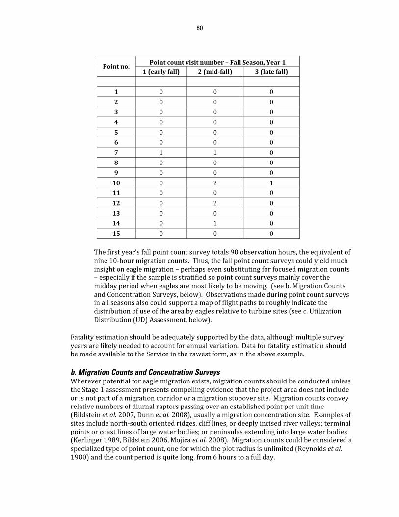
60
Pointno.Pointcountvisitnumber–FallSeason,Year1
1(earlyfall) 2(mid‐fall) 3(latefall)
1 0 0 0
2 0 0 0
3 0 0 0
4 0 0 0
5 0 0 0
6 0 0 0
7 1 1 0
8 0 0 0
9 0 0 0
10 0 2 1
11 0 0 0
12 0 2 0
13 0 0 0
14 0 1 0
15 0 0 0
Thefirstyear’sfallpointcountsurveytotals90observationhours,theequivalentofnine10‐hourmigrationcounts.Thus,thefallpointcountsurveyscouldyieldmuchinsightoneaglemigration–perhapsevensubstitutingforfocusedmigrationcounts–especiallyifthesampleisstratifiedsopointcountsurveysmainlycoverthemiddayperiodwheneaglesaremostlikelytobemoving.(seeb.MigrationCountsandConcentrationSurveys,below).Observationsmadeduringpointcountsurveysinallseasonsalsocouldsupportamapofflightpathstoroughlyindicatethedistributionofuseoftheareabyeaglesrelativetoturbinesites(seec.UtilizationDistribution(UD)Assessment,below).
Fatalityestimationshouldbeadequatelysupportedbythedata,althoughmultiplesurveyyearsarelikelyneededtoaccountforannualvariation.DataforfatalityestimationshouldbemadeavailabletotheServiceintherawestform,asintheaboveexample.
b. Migration Counts and Concentration Surveys Whereverpotentialforeaglemigrationexists,migrationcountsshouldbeconductedunlesstheStage1assessmentpresentscompellingevidencethattheprojectareadoesnotincludeorisnotpartofamigrationcorridororamigrationstopoversite.Migrationcountsconveyrelativenumbersofdiurnalraptorspassingoveranestablishedpointperunittime(Bildsteinetal.2007,Dunnetal.2008),usuallyamigrationconcentrationsite.Examplesofsitesincludenorth‐southorientedridges,clifflines,ordeeplyincisedrivervalleys;terminalpointsorcoastlinesoflargewaterbodies;orpeninsulasextendingintolargewaterbodies(Kerlinger1989,Bildstein2006,Mojicaetal.2008).Migrationcountscouldbeconsideredaspecializedtypeofpointcount,oneforwhichtheplotradiusisunlimited(Reynoldsetal.1980)andthecountperiodisquitelong,from6hourstoafullday.
61
Incontrasttotheallocationofsamplepointsforpointcountsurveysatproposedwindenergyprojects,migrationcountstypicallyareconductedfromonetoafewpointswithinoradjacenttoaproposedprojectfootprint.Pointsarewidelyspaced,locatedprimarilyatplacesthatcollectivelyprovidegreatestvisualcoverageespeciallyoftopographicfeatureslikelytoattractorfunnelmigratingraptors.Atmanyproposedprojects,however,surveypointsformigrationcountscouldbethesameasorasubsetofthoseusedforpointcountsurveys,e.g.,pertheaboveexample(under1a.PointCountSurveys),suchthatmigrationcountsatagivenpointsimultaneouslycontributepointcountdata.Considerationshouldbegiventorestructuringpointcountsurveystothisend,includingtemporalstratificationtomoreeffectivelyaccountforpotentialeaglemigrationandimproveprecisionofexposureestimates.Asanotherexample,duringananticipated6‐weekpeakofeaglemigrationinfall,pointcountdurationcouldbeextendedto6hours.Ifthesurveysweretocovereitherthefirst6hoursorthelast6hoursoftheday,thetwosurveyperiodswouldoverlapbyseveralhoursinmidday,bettercoveringthetimeofdaywheneaglesaremostlikelymoving(Heintzelman1986).Thedatamayhavetobeadjustedslightlywhenusedforfatalityestimation,however.Stricklandetal.(2011)summarizesomeimportantdetailsforconductingraptormigrationcountsatproposedwindenergysites.Countsshouldbeconductedusingstandardtechniques(Bildsteinetal.2007,Dunnetal.2008)duringatleastpeakperiodsofpassage(seetheHawkMigrationAssociationofNorthAmerica’s[HMANA]websiteforinformationonseasonalpassageperiodsforeaglesatvariousmigrationsurveysites:http://www.hmana.org).Migrationcountsmayinvolvestaffingsurveypointsupto75%ofdaysduringpeakpassage(Dunnetal.2008).Ifatleastamodesteaglemigrationisevidenced(i.e.,multipleindividualsobservedpassingunidirectionallyduringeachofmultipledays),surveysshouldbecontinuedforatleast2yearsandintotheoperationalphasetovalidateinitialobservationsandhelpassessevidenceofcollisionandinfluenceofturbinesonmigrationbehavior.MigrationcountdatashouldbeprovidedtotheServiceasanappendixtotheECP,usingareportingformatsimilartothatusedbyHMANA.Aswithpointcountsurveys,trainingofmigrationsurveystaffshouldincludeassessmentofraptoridentificationskillsandofabilityofindividualstodetecteaglesinflightunderabroadrangeofdistancesandweatherconditions.Potentialfornon‐breeding(eitherwinterorsummer)seasonconcentrationsofeaglesinorneartheprojectfootprintshouldbegintobeevaluatedinStage1,includingclosescrutinyofpotentialhabitatviageospatialimageryandfollowupreconnaissancevisits(seeAPPENDIXB).Non‐breedingbaldeaglesoftenusecommunalroostsandforagecommunally(Platt1976,Mojicaetal.2008).Goldeneaglesmaydosoonoccasion,withothergoldeneaglesand/orwithbaldeagles(CraigandCraig1984).Bothspeciescanbecomeconcentratedonspringandfallmigrationunderparticularcombinationsofweatherandtopographicconditions,ormayannuallyusetraditionalstopoversitesduringmigration.TheStage1assessmentmaysuggeststhatseasonalconcentrationsofeaglesregularlyoccurwithintheprojectarea,eitherbecauseoffavorableconditions(e.g.,clustersoflargetreesalongriversofferingpotentialroostsites,stopoverconcentrationsofmigratingwaterfowl)orbecauseofindicationsfromprioranecdotalorsystematicallycollectedrecords.TheStage2assessmentshouldincludesurveysdesignedtofurtherexploreevidenceofanysuchoccurrences.If,basedontheoutcomeofStage1,thereisnocompellingreasontobelieveconcentrationareasarelacking,anefficientwaytobegintoprobeforconcentrationareasissimplytoextendthedurationofpointcountsurveysandperhapsconductthemmorefrequently.Expandedpointcountsurveys,distributedevenlyacrossthedayduringthefirst
62
yearofStage2,shouldprovideatleastapreliminaryindicationofregularmovementstoandfromwhatmayberoostsorpreyhotspotswithinoroutsidetheprojectfootprint.Moreover,expandedpointcountsurveysconductednearpotentialturbinesites(seedesignrecommendationsina.PointCountSurveys,above)canbetterinformturbinesitingdecisionsinrelationtoeagleuseofconcentrationareas,ifsuchareasexist.Theincreasedsurveyeffortalsocouldcontributetowardsamorepreciseindicationofeagleexposureinafatalityestimatefortheproposedproject(APPENDIXD).EarlyinStage2,evidencefromStage1ofconcentrationareasintheprojectareamaybecorroboratedornewevidenceofconcentrationsmaysurface.Ineithercase,focusedsurveys(e.g.,viadirectobservationorbyaircraft)canbeimplementedtodocumenttheirlocationsanddailytimingandspatialpatternsoftheirusebyeaglesinrelationtotheproposedprojectfootprintthroughouttheseason(s).Forexample,surveysforwinteringconcentrationsofbaldeaglescouldbeconducted,followingUSFWS(1983)guidance.Direct,systematicobservationfromvantagepointsinearlymorningandeveningisthemostpracticalmeansofdocumentingroostlocationsandmovementsofeaglestoandfromroostsonalocalscale(Steenhofetal.1980,CrenshawandMcClelland1989).Aerialsurveysmaybeneededforrepeatedsurveysofeaglesatextensiveroosts(Chandleretal.1995).Directobservationcanbeusedtocompareoccurrenceandactivityofeaglesbeforeandafterconstructionandoperationofaproject(Becker2002)andmaybeavalidmeanstoidentifydisturbanceeffectsonroostingconcentrations.c. Utilization Distribution (UD) Assessment UDcanbethoughtofasanimal’sspatialdistributionorintensityofuseofvariouspartsofagivenarea,suchasitshomerange.Abasicthoughperhapslabor‐intensiveapproachfordocumentingspatialdistributionofuseacrossallorpartofaproposedprojectfootprintbyeaglesistosystematicallyobserveandrecordeaglemovementsandactivities(e.g.,territorialdisplay,preydeliveryflight)onmapsinthefieldthenconvertthedataintoGISformatsforstandardanalyses(e.g.,Walkeretal.2005).Forexample,agridofsquarecells,each0.5x0.5km,canbeframedbytheUniversalTransverseMercator(UTM)systemacrossamapoftheareaofinteresttorecordeagleobservationsineach0.25km2cell.Theareaofinterestisdividedintonon‐overlappingobservationsectors,eachwithavantagepointthataffordsunobstructedviewingofgridcellstomorethan1kminalldirections.Observationperiodslastatleast4hoursandincludealldaylighthoursandaccountforroostsites.Ifnecessary,two(ormore)observersworkingfromseparatevantagepointscanpinpointlocationsofeaglesthroughtriangulation.Thedatacanbeanalyzedbysimplycountingthenumberofflightsintersectingeachcell.Aneagle’sdistributionofusecanthenbeestimatedbyusingstandardkernelanalyses(Worton1989,1995,SeamanandPowell1996,Kenward2001)orotherprobabilisticapproaches,comparabletoMoorcroftetal.(1999),McGradyetal.(2002),andMcLeodetal.(2002).Havingconcernoverpotentialautocorrelation,Walkeretal.(2005)randomlyselectedindependentlocationsofgoldeneaglesalongflightpathstoestablishapointdatabaseforstandardUDanalyses.Theydeterminedthatlocationswouldbeindependentifseparatedbyatleast45minutes.McGradyetal.(2002)conservativelyuseda1‐hourminimumtoseparatepoints,eventhoughtheirdataindicateda20‐minuteintervalwouldsuffice.ConcernswithautocorrelationinUDanalyseshaverecentlydiminished,however(Feibergetal.2010).MoststudyofeagleUDhasfocusedonresidentbirdsespeciallybreedingadultsontheirnestingterritories.Sizeandshapeofuseareascanvaryseasonally(Newton
63
1979),sodocumentationofspatialusebyresidenteaglesshouldencompassallseasonsinadditiontoaccountingforannualvariation.Asubstantialadvantageofadirectobservationapproachcomparedtotelemetrytechniques,whichtypicallytargetonlyoneortworesidenteaglesataproposedproject,isthatitdisregardsageandbreedingandresidencystatus.Includedareoverwinteringindividuals;dispersingjuveniles;post‐fledgingyoungfromnearbyterritoriesandjuvenilesdispersingfromotherareasorregions;andadultsfromadjoiningterritoriesplusnon‐breedingadults(i.e.,“floaters,”Hunt1998)andsubadultsthatmayoccuralongboundariesofbreedingterritories.Inmanyinstances,identificationofindividualeaglesmaynotbeimportantandfinalresultsofageneralizedUDanalysismaybebasedondatapooledfrommultiplebirds,someofwhichwereindistinguishablefromeachotherinthefield.AdisadvantageofthisapproachisthatpositionaccuracybasedondirectobservationacrossexpansivelandscapesiscoarsecomparedtousingtelemetrywithGPScapability,andgenerallydeclineswithdistance,increasingtopographicandforestcover,andduringearlymorningandlateeveninghours.Thiscanberesolvedtosomeextentbylimitingthesizeandincreasingthenumberofobservationsectors(inadditiontousingmultipleobservers),butformostpre‐constructioninformationneeds,ahighdegreeofaccuracyisunessentialforUDdata.Last,itisunlikelythatUDneedstobeassessedacrossentireprojectfootprints.Instead,itismorelikelyusedtotargetspecificareasofconcern,suchasareaswhereeaglesnestorfrequentlyforage,andtorefineknowledgeofuseofparticularareastobetterinformturbinesitingdecisions.Themethodobviouslyhaslittleutilityinareasofloweagleoccurrence.Althoughweacknowledgetelemetryofferssomedistinctbenefitsforassessingrisksandimpactsofwindprojects,useofthemethodforeagleshasotherdrawbacks.Specificindividualeaglesmustbetargetedforcaptureandnotalleaglesusingagivenprojectfootprintareequallylikelytobecapturedorprovideusefuldata(e.g.,migrantsmaybereadilycapturedbutleavetheareabeforeprovidingmuchdata).Moreimportantly,capturingandradio‐markingeaglescanhavenegativeeffectsonbehavior,productivity,andre‐useofnestsites(e.g.,Marzluffetal.1997,Gregoryetal.2002),andrecentinformationsuggestsanegativeeffectinsomecasesonsurvival,especiallyofgoldeneaglescapturedasadultsandreleasedwithlarge(70‐to100‐g),solar‐chargedtransmitters(USFWS,unpublishedinformation).Theseeffectsmustbebetterunderstoodbeforeroutineuseoftelemetrytechniquescanberecommendedascomponentsofwind‐facilityassessments.Untilthen,theServicediscouragestheuseoftelemetryinassessmentsofeagleuseassociatedwithwindenergyprojects;surveyapproachessuggestedhereindonotrequiretelemetry.d. Summary TheServiceencouragesdevelopmentofcost‐effectivesamplingdesignsthatsimultaneouslyaddressmultipleaspectsofuseofproposedwindenergyprojectsbyeagles,thoughemphasizesthathigh‐qualitypointcountdatatosupportfatalityrateestimationshouldbeconsideredthehighestpriority.Inmanycases,thesamplingframeworkforpointcountsurveyslikelycanbeextendedtoreasonablyassessmigrationincidence,UD,andotherobjectives.Althoughfield‐baseddatathatdirectlysupportfatalityestimationaremostimportant,developmentofmethodsforaddressingotherobjectivesisencouraged,suchastheuseofdigitaltrailcamerastodocumenteagleoccurrenceatcarcassstations.Regardless,werecommendthatpre‐constructionsurveysatproposedwindenergysites
64
encompassaminimumof2years,includingatleast1yearcharacterizedbyrobustsamplingthatintegratesmultiplesurveytypes.
2. Survey of the Project-area Nesting Population: Number and Locations of Occupied Nests of Eagles Toevaluateprojectsitingoptionsandhelpassesspotentialeffectsofwindenergyprojectsonbreedingeagles,werecommenddetermininglocationsofoccupiednestsofeagleswithintheprojectareafornolessthantwobreedingseasonspriortoconstruction.Theprimaryobjectiveofasurveyoftheproject‐areanestingpopulationistodeterminethenumberandlocationsofoccupiednestsandtheapproximatecentersofoccupiednestingterritoriesofeagleswithintheprojectarea.Ifrecent(i.e.,withinthepast5years)dataareavailableonspacingofoccupiedeaglenestsfortheproject‐areanestingpopulation,thedatacanbeusedtodelineateanappropriateboundaryfortheprojectareaasdescribedinAPPENDIXH.Otherwise,wesuggestthatprojectareabedefinedastheprojectfootprintandallareawithin10miles.InthisECPGdocumentweuseraptorbreedingterminologyoriginallyproposedbyPostupalsky(1974)andlargelyfollowedtoday(SteenhofandNewton2007).Anoccupiednestisaneststructureatwhichanyofthefollowingisobserved:(1)anadulteagleinanincubatingposition,(2)eggs,(3)nestlingsorfledglings,(4)occurrenceofapairofadulteagles(or,sometimessubadults,e.g.,Steenhofetal.[1983])atornearanestthroughatleastthetimeincubationnormallyoccurs,(5)anewlyconstructedorrefurbishedsticknestintheareawhereterritorialbehaviorofaraptorhadbeenobservedearlyinthebreedingseason,or(6)“Arecentlyrepairednestwithfreshsticks(cleanbreaks)orfreshboughsontop,and/ordroppingsand/ormoltedfeathersonitsrimorunderneath”(Postupalsky1974).Anestthatisnotoccupiedistermedunoccupied.Anoccupiednestingterritoryincludesoneoccupiednestandmayincludealternatenests,i.e.,anyofseveralotherneststructureswithinthenestingterritory.Sometimes“activenest”isusedtoencompassoccupiednestsinwhicheggswerelaidplusthoseatwhichnoeggswerelaid.Here,aselsewhereintheECPGandinPostupalsky(1974),anactivenestisconsideredoneinwhichaneggoreggshavebeenlaid.Anestthatisactiveisalso,bydefault,occupied.Anestthatisnotactiveisinactive,andthereisaregulatorydefinitionfortheterminactivenest(50CFR22.3.Notallpairsofbaldeaglesandgoldeneaglesattempttonestornestsuccessfullyeveryyear(Buehler2000,Kochertetal.2002),andnestingterritorieswherepairsarepresentbutdonotattempttonestcouldinsomecasesbemisclassifiedasunoccupied.Accuratecomprehensionofterritorydistributionanddeterminationofoccupancystatusisthecruxofdeterminingtheproject‐areanestingpopulation.Theproject‐areanestingpopulationsurveyshouldincludeallpotentialeaglenestinghabitatwithintheprojectarea.Atleasttwochecksviaaircraftortwoground‐basedobservationsarerecommendedtodesignateanestorterritoryasunoccupied,aslongasallpotentialnestsitesandalternatenestsarevisibleandmonitored(i.e.,alternatenestsmaybewidelyseparatedsuchthatafull‐length,ground‐basedobservationshouldbedevotedtoeach).Ground‐basedobservationsshouldbeconductedforatleast4hourseach(occupancymaybeverifiedinlesstime),aidedbyspottingscopes,fromatleast0.8kmfromthenest(s),duringweatherconducivetoeagleactivityandgoodvisibility.Surveysofoccupancyshouldbeconductedatleast30daysapart,ideallyduringthenormalcourtshipandmid‐incubationperiods,respectively.Surveyslaterinthebreedingseasonarelikelytooverlooksometerritorialpairsthatthatdidnotlayeggsorfailedearlyinthenestingseason.Timingofsurveysshouldbebasedonlocalnestingchronologies;Servicestaffcanproviderecommendations.Ifanoccupiednestorapairofeaglesislocated,theterritoryshould
65
continuetobesearchedforalternatenestsites.Thisinformationcanhelpdeterminetherelativevalueofindividualneststoaterritoryifeverthereareapplicationsforpermitstotakeinactivenests,andwhendeterminingwhetherabandonmentofaparticularnestmayresultinlossofaterritory.Useofaerialsurveysfollowedbyground‐basedsurveysattargetedsitescanbeanidealapproachtodeterminenestandterritoryoccupancy.Helicoptersareanacceptedandefficientmeansforinventoryofextensiveareasofpotentialnestinghabitatforeagles,althoughfixed‐wingaircraftcanbeusedwherepotentialnestsitesarewidelyscatteredandconspicuous.Aerialsurveysforeaglenestsinwoodlandhabitatmayrequiretwotothreetimesasmuchtimeasaerialsurveysfornestsoncliffs.Whensurveyingruggedterrainbyhelicopter,cliffsshouldbeapproachedfromthefront,ratherthanflyingoverfrombehindorsuddenlyappearingfromaroundcornersorbuttresses.Inventoriesbyhelicoptershouldbeflownatslowspeeds,about30to40knots.Allpotentiallysuitablenestsitesshouldbescrutinized;multiplepassesatseveralelevationbandsmaybenecessarytoprovidecompletecoverageofnestsitehabitatonlargecliffcomplexes.Hoveringforupto15secondsnocloserthan50mfromanestmaybenecessarytoverifythenestingspecies,photographthenestsite,and,iflateinthenestingseason,allowtheobservertocountandestimateageofyounginthenest.Aerialsurveysmaynotbeappropriateinsomeareassuchasbighornsheeplambingareas;toavoidsuchsensitiveareas,stateresourceagenciesshouldbeconsultedwhenplanningsurveys.AdditionalguidelinesforaerialsurveysforeaglesandotherraptorsarereviewedinAnderson(2007).Surveysshouldbeconductedonlybybiologistswithextensiveexperienceinsurveysofraptorsandappropriatetraininginaerialsurveys(seereviewinAnderson2007).Whetherinventoriesareconductedonthegroundoraerially,metricsofprimaryinteresttotheServicefortheproject‐areanestingpopulationinclude:
1. numberandlocationsofneststructuresthatareverifiedorlikelytobeeaglenests2. numberandlocationsofeaglenestscurrentlyorrecentlyoccupiedbasedoncriteria
outlinedherein3. estimatednumberandapproximateboundariesandcentersofeaglebreedingterritories,
basedonrecordsofnestsiteoccupancyandclusteringofnests.Additionally,productivity(i.e.,reproductivesuccess,definedhereasthemeannumberofnestlingssurvivingto>56and≥67daysofageperoccupiednestforgoldeneaglesandbaldeagles,respectively)maybeofinterestforassessingdisturbanceeffects,althoughutilityofproductivitydataatagivenprojectlikelywillbelimitedduetosmallsamplesizeandfactorsconfoundingtheinterpretationofresults.Ameta‐analysisapproachbasedonproductivitydatafrommanyprojectsiscontemplatedaspartoftheadaptivemanagementprocessaccompanyingtheECPG,andmaycontributetounderstandingofdisturbanceeffectsonthisaspectofeaglebreedingbiology.Moreover,abandonmentofterritories–thegravestmanifestationandclearestevidenceofdisturbanceeffects–couldbedocumentedthroughtheoccupancysurveysrecommendedherein,ifthesesurveysarerepeatedafterprojectconstruction.Wereiteratethataccuratecomprehensionofterritorydistributionanddeterminationofoccupancystatusshouldbetheprimarygoalofnestingsurveys.
66
Literature Cited Anderson,D.E.2007.Surveytechniques.Pages89‐100inD.M.BirdandK.L.Bildstein(eds.),
Raptorresearchandmanagementtechniques.HancockHouse,Blaine,Washington.Becker,J.M.2002.Responseofwinteringbaldeaglestoindustrialconstructioninsoutheastern
Washington.WildlifeSocietyBulletin30:875‐878.Bildstein,K.L.2006.Migratingraptorsoftheworld,theirecologyandconservation.Cornell
UniversityPress,Ithaca,NewYork.Bildstein,K.L.,J.P.Smith,andR.Yosef.2007.Migrationcountsandmonitoring.Pages102‐115inD.
M.BirdandK.L.Bildstein(eds.),Raptorresearchandmanagementtechniques.HancockHouse,Blaine,Washington.
Buckland,S.T.,D.R.Anderson,K.P.Burnham,J.L.Laake,D.L.Borchers,andL.J.Thomas.2001.Anintroductiontodistancesampling:estimatingabundanceofbiologicalpopulations.OxfordUniversityPress,Oxford,UnitedKingdom.
Buehler,D.A.2000.BaldEagleHaliaeetusleucocephalus.No.506inA.PooleandF.Gill(eds.),TheBirdsofNorthAmerica.TheBirdsofNorthAmerica,Inc.,Philadelphia,Pennsylvania.
Chandler,S.K.,J.D.Fraser,D.A.Buehler,andJ.K.D.Seegar.1995.PerchtreesandshorelinedevelopmentaspredictorsofbaldeagledistributiononChesapeakeBay.JournalofWildlifeManagement59:325‐332.
Craig,T.H.,andE.H.Craig.1984.AlargeconcentrationofroostinggoldeneaglesinsoutheasternIdaho.Auk101:610‐613.
Crenshaw,J.G.,andB.R.McClelland.1989.Baldeagleuseofacommunalroost.WilsonBulletin101:626‐633.
Denholm,P.,M.Hand,M.Jackson,andS.Ong.2009.Land‐userequirementsofmodernwindpowerplantsintheUnitedStates.NationalRenewableEnergyLaboratoryTechnicalReportNREL/TP‐6A2‐45834.www.nrel.gov/docs/fy09osti/45834.pdf(lastvisitedOctober22,2011)
Dunn,E.H.,D.J.T.Hussell,andE.R.Inzunza.2008.Recommendedmethodsforpopulationmonitoringatraptor‐migrationwatchsites.Pages447‐459inK.L.Bildstein,J.P.Smith,E.R.InzunzaandR.R.Veit(eds.).StateofNorthAmerica’sbirdsofprey.SeriesinOrnithologyNo.3.NuttallOrnithologicalClub.Cambridge,MassachusettsandAmericanOrnithologists'Union,Washington,D.C.
Fieberg,J.,J.Matthiopoulos,M.Hebblewhite,M.S.Boyce,andJ.L.Frair.2010.Correlationandstudiesofhabitatselection:problem,redherring,oropportunity?PhilosophicalTransactionsoftheRoyalSocietyBiologicalSciences365:2233‐2244.doi:10.1098/rstb.2010.0079.
Garvin,J.C.,C.S.Jennelle,D.Drake,andS.M.Grodsky.2011.Responseofraptorstoawindfarm.JournalofAppliedEcology48:199‐209.
Heintzelman,D.S.1986.Themigrationsofhawks.IndianaUniversityPress,BloomingtonandIndianapolis,Indiana.
Hutto,R.L.,S.M.Pletschet,andP.Henricks.1986.Afixed‐radiuspointcountfornonbreedingandbreedingseasonuse.Auk103:593‐602.
Johnson,D.H.1995.Pointcountsofbirds:whatareweestimating?Pages117‐123inC.J.RalphandJ.R.Sauer(eds.),Monitoringbirdpopulationsbypointcounts.GeneralTechnicalReportPSW‐GTR‐149,U.S.ForestService,PacificSouthwestResearchStation,Albany,California.
Kerlinger,P.1989.Flightstrategiesofmigratinghawks.UniversityofChicagoPress,Chicago,Illinois.
Kochert,M.N.,K.Steenhof,C.L.McIntyre,andE.H.Craig.2002.GoldenEagleAquilachrysaetos.No.684inA.PooleandF.Gill(eds.),TheBirdsofNorthAmerica.TheBirdsofNorthAmerica,Inc.,Philadelphia,Pennsylvania.
Madders,M.,andD.P.Whitfield.2006.Uplandraptorsandtheassessmentofwindfarmimpacts.Ibis148:43‐56.
67
McGrady,M.J.,J.R.Grant,I.P.Bainbridge,andD.R.A.McLeod.2002.Amodelofgoldeneagle(Aquilachrysaetos)rangingbehavior.JournalofRaptorResearch36(1)supplement:62‐69.
Mojica,E.K.,J.M.Meyers,B.A.Millsap,andK.T.Haley.2008.Migrationofsub‐adultFloridabaldeagles.WilsonJournalofOrnithology120:304‐310.
Nygård,T,K.,E.L.Bevanger,Ø.Dahl,A.Flagstad,P.L.Follestad,Hoel,R.May,andO.Reitan.2010.Astudyofwhite‐tailedeagleHaliaeetusalbicillamovementsandmortalityatawindfarminNorway.inD.Senapathi(ed.),Climatechangeandbirds:adaptation,mitigationandimpactsonavianpopulations.BritishOrnithologists’UnionProceedings,Peterborough,UnitedKingdom.http://www.bou.org.uk/bouproc‐net/ccb/nygard‐etal.pdf(lastvisitedOctober9,2011).
Platt,J.B.1976.BaldeagleswinteringinaUtahdesert.AmericanBirds30:783‐788.Potupalsky,S.1974.Raptorreproductivesuccess:someproblemswithmethods,criteria,and
terminology.RaptorResearchReport2:21‐31.Ralph,C.J.,G.R.Geupel,P.Pyle,T.E.Martin,andD.F.DeSante.1993.Handbookoffieldmethodsfor
monitoringlandbirds.GeneralTechnicalReportPSW‐GTR‐144,U.S.ForestService,PacificSouthwestResearchStation,Albany,California.
Reynolds,R.T.,J.M.Scott,andR.A.Nussbaum.1980.Avariablecircular‐plotmethodforestimatingbirdnumbers.Condor82:309‐313.
Sauer,J.R.,J.E.Hines,J.E.Fallon,K.L.Pardieck,D.J.Ziolkowski,Jr.,andW.A.Link.2011.TheNorthAmericanBreedingBirdSurvey,resultsandanalysis1966‐2009.Version3.23.2011.U.S.GeologicalSurvey,PatuxentWildlifeResearchCenter,Laurel,Maryland,USA.
Steenhof,K.,S.S.Berlinger,andL.H.Fredrickson.1980.HabitatusebywinteringbaldeaglesinSouthDakota.JournalofWildlifeManagement44:798‐805.
Steenhof,K.,M.N.Kochert,andJ.H.Doremus.1983.NestingofsubadultgoldeneaglesinsouthwesternIdaho.Auk100:743‐747.
Steenhof,K.,andI.Newton.2007.Assessingnestingsuccessandproductivity.Pages181‐191inD.M.BirdandK.Bildstein(eds.),RaptorResearchandManagementTechniques.HancockHouse,Blaine,Washington,USA.
Strickland,M.D.,E.B.Arnett,W.P.Erickson,D.H.Johnson,G.D.Johnson,M.L.Morrison,J.A.Shaffer,andW.Warren‐Hicks.2011.Comprehensiveguidetostudyingwindenergy/wildlifeinteractions.PreparedfortheNationalWindCoordinatingCollaborative,Washington,D.C.
USFWS.1983.Northernstatesbaldeaglerecoveryplan.U.S.FishandWildlifeService,DivisionofMigratoryBirdManagement,WashingtonD.C.http://www.fws.gov/midwest/eagle/recovery/be_n_recplan.pdf(lastvisitedOctober9,2011).
Walker,D.,M.McGrady,A.McCluskie,M.Madders,andD.R.A.McLeod.2005.ResidentgoldeneaglerangingbehaviourbeforeandafterconstructionofawindfarminArgyllScottishBirds25:24‐40.
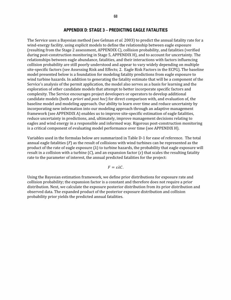
68
APPENDIX D: STAGE 3 – PREDICTING EAGLE FATALITIES TheServiceusesaBayesianmethod(seeGelmanetal.2003)topredicttheannualfatalityrateforawind‐energyfacility,usingexplicitmodelstodefinetherelationshipbetweeneagleexposure(resultingfromtheStage2assessment,APPENDIXC),collisionprobability,andfatalities(verifiedduringpost‐constructionmonitoringinStage5,APPENDIXH),andtoaccountforuncertainty.Therelationshipsbetweeneagleabundance,fatalities,andtheirinteractionswithfactorsinfluencingcollisionprobabilityarestillpoorlyunderstoodandappeartovarywidelydependingonmultiplesite‐specificfactors(seeAssessingRiskandEffects;2.EagleRiskFactorsintheECPG).Thebaselinemodelpresentedbelowisafoundationformodelingfatalitypredictionsfromeagleexposuretowindturbinehazards.InadditiontogeneratingthefatalityestimatethatwillbeacomponentoftheService'sanalysisofthepermitapplication,themodelalsoservesasabasisforlearningandtheexplorationofothercandidatemodelsthatattempttobetterincorporatespecificfactorsandcomplexity.TheServiceencouragesprojectdevelopersoroperatorstodevelopadditionalcandidatemodels(bothaprioriandposthoc)fordirectcomparisonwith,andevaluationof,thebaselinemodelandmodelingapproach.Ourabilitytolearnovertimeandreduceuncertaintybyincorporatingnewinformationintoourmodelingapproachthroughanadaptivemanagementframework(seeAPPENDIXA)enablesustoimprovesite‐specificestimationofeaglefatalities,reduceuncertaintyinpredictions,and,ultimately,improvemanagementdecisionsrelatingtoeaglesandwindenergyinaresponsibleandinformedway.Rigorouspost‐constructionmonitoringisacriticalcomponentofevaluatingmodelperformanceovertime(seeAPPENDIXH).VariablesusedintheformulasbelowaresummarizedinTableD‐1foreaseofreference.Thetotalannualeaglefatalities(F)astheresultofcollisionswithwindturbinescanberepresentedastheproductoftherateofeagleexposure(λ)toturbinehazards,theprobabilitythateagleexposurewillresultinacollisionwithaturbine(C),andanexpansionfactor(ε)thatscalestheresultingfatalityratetotheparameterofinterest,theannualpredictedfatalitiesfortheproject:
.UsingtheBayesianestimationframework,wedefinepriordistributionsforexposurerateandcollisionprobability;theexpansionfactorisaconstantandthereforedoesnotrequireapriordistribution.Next,wecalculatetheexposureposteriordistributionfromitspriordistributionandobserveddata.Theexpandedproductoftheposteriorexposuredistributionandcollisionprobabilityprioryieldsthepredictedannualfatalities.
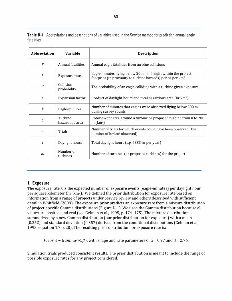
69
Table D-1. Abbreviations and descriptions of variables used in the Service method for predicting annual eagle fatalities.
Abbreviation Variable Description
F Annualfatalities Annualeaglefatalitiesfromturbinecollisions
λ Exposurerate Eagle‐minutesflyingbelow200minheightwithintheprojectfootprint(inproximitytoturbinehazards)perhrperkm2
CCollisionprobability Theprobabilityofaneaglecollidingwithaturbinegivenexposure
ε Expansionfactor Productofdaylighthoursandtotalhazardousarea(hr∙km2)
k Eagle‐minutes Numberofminutesthateagleswereobservedflyingbelow200mduringsurveycounts
δTurbinehazardousarea
Rotor‐sweptareaaroundaturbineorproposedturbinefrom0to200m(km2)
n TrialsNumberoftrialsforwhicheventscouldhavebeenobserved(thenumberofhr∙km2observed)
τ Daylighthours Totaldaylighthours(e.g.4383hrperyear)
ntNumberofturbines Numberofturbines(orproposedturbines)fortheproject
1. ExposureTheexposurerateλistheexpectednumberofexposureevents(eagle‐minutes)perdaylighthourpersquarekilometer(hr∙km2).WedefinedthepriordistributionforexposureratebasedoninformationfromarangeofprojectsunderServicereviewandothersdescribedwithsufficientdetailinWhitfield(2009).Theexposurepriorpredictsanexposureratefromamixturedistributionofproject‐specificGammadistributions(FigureD‐1).WeusedtheGammadistributionbecauseallvaluesarepositiveandreal(seeGelmanetal.,1995,p.474–475).ThemixturedistributionissummarizedbyanewGammadistribution(ourpriordistributionforexposure)withamean(0.352)andstandarddeviation(0.357)derivedfromtheconditionaldistributions(Gelmanetal,1995,equation1.7p.20).Theresultingpriordistributionforexposurerateis:
~ ∝, ,withshapeandrateparametersofα=0.97andβ=2.76.
Simulationtrialsproducedconsistentresults.Thepriordistributionismeanttoincludetherangeofpossibleexposureratesforanyprojectconsidered.
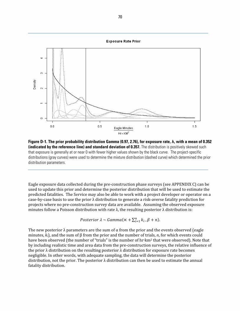
70
Figure D-1. The prior probability distribution Gamma (0.97, 2.76), for exposure rate, λ, with a mean of 0.352 (indicated by the reference line) and standard deviation of 0.357. The distribution is positively skewed such that exposure is generally at or near 0 with fewer higher values shown by the black curve. The project-specific distributions (gray curves) were used to determine the mixture distribution (dashed curve) which determined the prior distribution parameters. Eagleexposuredatacollectedduringthepre‐constructionphasesurveys(seeAPPENDIXC)canbeusedtoupdatethisprioranddeterminetheposteriordistributionthatwillbeusedtoestimatethepredictedfatalities.TheServicemayalsobeabletoworkwithaprojectdeveloperoroperatoronacase‐by‐casebasistousethepriorλdistributiontogeneratearisk‐aversefatalitypredictionforprojectswherenopre‐constructionsurveydataareavailable.AssumingtheobservedexposureminutesfollowaPoissondistributionwithrateλ,theresultingposteriorλdistributionis:
~ ∝ ∑ , .Thenewposteriorλparametersarethesumofαfromthepriorandtheeventsobserved(eagleminutes,ki),andthesumofβfromthepriorandthenumberoftrials,n,forwhicheventscouldhavebeenobserved(thenumberof“trials”isthenumberofhr∙km2thatwereobserved).Notethatbyincludingrealistictimeandareadatafromthepre‐constructionsurveys,therelativeinfluenceofthepriorλdistributionontheresultingposteriorλdistributionforexposureratebecomesnegligible.Inotherwords,withadequatesampling,thedatawilldeterminetheposteriordistribution,nottheprior.Theposteriorλdistributioncanthenbeusedtoestimatetheannualfatalitydistribution.
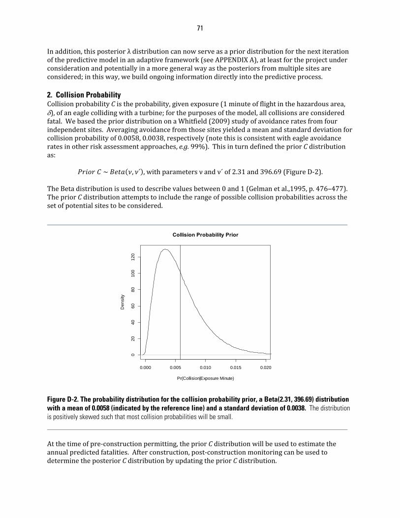
71
Inaddition,thisposteriorλdistributioncannowserveasapriordistributionforthenextiterationofthepredictivemodelinanadaptiveframework(seeAPPENDIXA),atleastfortheprojectunderconsiderationandpotentiallyinamoregeneralwayastheposteriorsfrommultiplesitesareconsidered;inthisway,webuildongoinginformationdirectlyintothepredictiveprocess.2. Collision Probability CollisionprobabilityCistheprobability,givenexposure(1minuteofflightinthehazardousarea,),ofaneaglecollidingwithaturbine;forthepurposesofthemodel,allcollisionsareconsideredfatal.WebasedthepriordistributiononaWhitfield(2009)studyofavoidanceratesfromfourindependentsites.Averagingavoidancefromthosesitesyieldedameanandstandarddeviationforcollisionprobabilityof0.0058,0.0038,respectively(notethisisconsistentwitheagleavoidanceratesinotherriskassessmentapproaches,e.g.99%).ThisinturndefinedthepriorCdistributionas:
~ , ´ ,withparametersνandν´of2.31and396.69(FigureD‐2).TheBetadistributionisusedtodescribevaluesbetween0and1(Gelmanetal.,1995,p.476–477).ThepriorCdistributionattemptstoincludetherangeofpossiblecollisionprobabilitiesacrossthesetofpotentialsitestobeconsidered.
Figure D-2. The probability distribution for the collision probability prior, a Beta(2.31, 396.69) distribution with a mean of 0.0058 (indicated by the reference line) and a standard deviation of 0.0038. The distribution is positively skewed such that most collision probabilities will be small. Atthetimeofpre‐constructionpermitting,thepriorCdistributionwillbeusedtoestimatetheannualpredictedfatalities.Afterconstruction,post‐constructionmonitoringcanbeusedtodeterminetheposteriorCdistributionbyupdatingthepriorCdistribution.
0.000 0.005 0.010 0.015 0.020
020
406
08
010
012
0
Collision Probability Prior
Pr(Collision|Exposure Minute)
Den
sity
72
AssumingtheobservationsoffatalitiesfollowabinomialdistributionwithrateC,theposteriordistributionoftherateCwillbeabetadistribution(thebetadistributionandthebinomialdistributionareaconjugatepair):
~ , ´ ,wherefisthenumberoffatalitiesestimatedfromtheStage5post‐constructionmonitoring,andgistheestimatednumberofexposureeventsthatdidnotresultinafatality.TheposteriordistributionforCcannotbecalculateduntilaprojecthasbeenbuilt,hasstartedoperations,andatleastoneseasonofpost‐constructionmonitoringhasbeencompleted.Oncedetermined,theposteriorCdistributioncanthenbeusedtogenerateapredictionforannualfatalitiesandcanserveasapriorCforthenextiterationofthepredictivemodel(seeAPPENDIXA).3. Expansion Theexpansionfactor(ε)scalestheresultingperunitfatalityrate(fatalitiesperhrperkm2)tothedaylighthours,τ,in1year(orothertimeperiodifcalculatingandcombiningfatalitiesforseasonsorstratifiedareas)andtotalhazardousarea(km2)withintheprojectfootprint:
∑ ,wherentisthenumberofturbines,andδisthecircularareacenteredatthebaseofaturbinewitharadiusequaltotherotor‐sweptradiusoftheturbine;wedefinethisasthehazardousareasurroundingaturbine.Inthismodel,tosimplifydatarequirementsandassumptions,weconsiderbotheagleuseandhazardousareaas2‐dimensionalareas,sincetheheightofthesampledandhazardousareasarethesame(200m)andwillcanceloutinthecalculations.Alternativemodelsthatconsider3‐dimensionalspacecouldalsobeconsidered,thoughtheexpansionfactorshouldbeadjustedaccordingly.Theunitsforεarehr∙km2peryear(ortimeperiodofinterest).4. Fatalities Nowwecangeneratethedistributionofpredictedannualfatalitiesastheexpandedproductoftheposteriorexposurerateandthepriorcollisionprobability(oncepost‐constructiondataisavailable,theposteriorcollisionprobabilitywouldbeusedtoupdateourfatalitydistribution):
∙ ∙ .Wecanthendeterminethemean,median,standarddeviation,and80%quantile(thiswillbetheuppercrediblelimit)directlyfromthedistributionofpredictedfatalities.5. Putting it all together: an example ThePatuxentPowerCompanyexamplebelowillustratesthecalculationofpredictedfatalitiesfromexposuredatafromahypotheticalprojectsite.ThisdatawillnormallycomefromthefieldsurveysinStage2,butforthepurposesofthisexample,wehavegeneratedfabricatedobservationdata.Theadvantageofsimulatingdatainsuchanexerciseisthatwecanmanipulatemodelinputstocriticallyevaluatetheperformanceofthemodel.Additionalexamplesareprovidedattheendofthisdocumenttoillustratethegeneralapproachandclarifyspecificconsiderationsthatmayapplytocertainprojects.
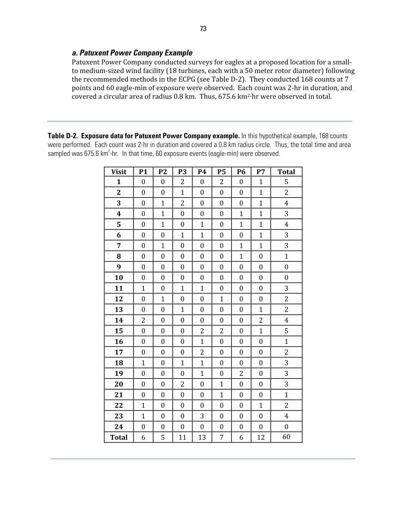
73
a. Patuxent Power Company ExamplePatuxentPowerCompanyconductedsurveysforeaglesataproposedlocationforasmall‐tomedium‐sizedwindfacility(18turbines,eachwitha50meterrotordiameter)followingtherecommendedmethodsintheECPG(seeTableD‐2).Theyconducted168countsat7pointsand60eagle‐minofexposurewereobserved.Eachcountwas2‐hrinduration,andcoveredacircularareaofradius0.8km.Thus,675.6km2∙hrwereobservedintotal.
Table D-2. Exposure data for Patuxent Power Company example. In this hypothetical example, 168 counts were performed. Each count was 2-hr in duration and covered a 0.8 km radius circle. Thus, the total time and area sampled was 675.6 km2·hr. In that time, 60 exposure events (eagle-min) were observed.
Visit P1 P2 P3 P4 P5 P6 P7 Total1 0 0 2 0 2 0 1 52 0 0 1 0 0 0 1 23 0 1 2 0 0 0 1 44 0 1 0 0 0 1 1 35 0 1 0 1 0 1 1 46 0 0 1 1 0 0 1 37 0 1 0 0 0 1 1 38 0 0 0 0 0 1 0 19 0 0 0 0 0 0 0 010 0 0 0 0 0 0 0 011 1 0 1 1 0 0 0 312 0 1 0 0 1 0 0 213 0 0 1 0 0 0 1 214 2 0 0 0 0 0 2 415 0 0 0 2 2 0 1 516 0 0 0 1 0 0 0 117 0 0 0 2 0 0 0 218 1 0 1 1 0 0 0 319 0 0 0 1 0 2 0 320 0 0 2 0 1 0 0 321 0 0 0 0 1 0 0 122 1 0 0 0 0 0 1 223 1 0 0 3 0 0 0 424 0 0 0 0 0 0 0 0Total 6 5 11 13 7 6 12 60
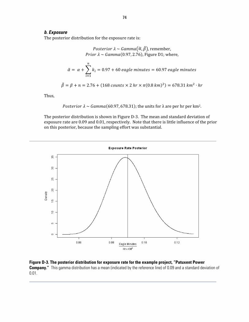
74
b. ExposureTheposteriordistributionfortheexposurerateis:
~ ∝, ,remember, ~ 0.97, 2.76 ,FigureD1;where,
0.97 60 60.97
2.76 168 2 0.8 678.31 ∙
Thus,
~ 60.97, 678.31 ;theunitsforλareperhrperkm2.TheposteriordistributionisshowninFigureD‐3.Themeanandstandarddeviationofexposurerateare0.09and0.01,respectively.Notethatthereislittleinfluenceoftheprioronthisposterior,becausethesamplingeffortwassubstantial.
Figure D-3. The posterior distribution for exposure rate for the example project, “Patuxent Power Company.” This gamma distribution has a mean (indicated by the reference line) of 0.09 and a standard deviation of 0.01.
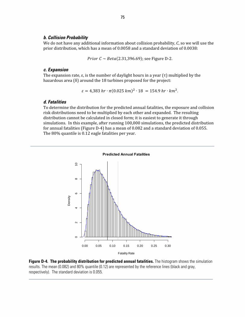
75
b. Collision Probability Wedonothaveanyadditionalinformationaboutcollisionprobability,C,sowewillusethepriordistribution,whichhasameanof0.0058andastandarddeviationof0.0038:
~ 2.31,396.69 ;seeFigureD‐2.c. Expansion Theexpansionrate,ε,isthenumberofdaylighthoursinayear(τ)multipliedbythehazardousarea(δ)aroundthe18turbinesproposedfortheproject:
4,383 ∙ 0.025 ∙ 18 154.9 ∙ .d. Fatalities Todeterminethedistributionforthepredictedannualfatalities,theexposureandcollisionriskdistributionsneedtobemultipliedbyeachotherandexpanded.Theresultingdistributioncannotbecalculatedinclosedform;itiseasiesttogenerateitthroughsimulations.Inthisexample,afterrunning100,000simulations,thepredicteddistributionforannualfatalities(FigureD‐4)hasameanof0.082andastandarddeviationof0.055.The80%quantileis0.12eaglefatalitiesperyear.
Figure D-4. The probability distribution for predicted annual fatalities. The histogram shows the simulation results. The mean (0.082) and 80% quantile (0.12) are represented by the reference lines (black and gray, respectively). The standard deviation is 0.055.
Predicted Annual Fatalities
Fatality Rate
Den
sity
0.00 0.05 0.10 0.15 0.20 0.25 0.30
02
46
81
0
76
TheService’sbaselinemodelfortheproposedPatuxentwindfacilitypredictsthat80%ofthetimethatannualfatalitieswouldbe0.12eaglesorfewer,suggestingthataneaglecollisionfatalitywouldbepredictedtooccurattheprojectsiteevery8‐9yearsonaverage.Thefacilityhadamediumamountofeagleactivityatthesite,butthesmallsizeoftheprojectkeptthepredictedfatalitynumberslowerthantheywouldhavebeenforalargerprojectinthesamelocation.Ideally,wewouldconsiderothercandidatemodelsalongsidethebaselinemodelpresentedhereandcomparetheirrelativeperformanceusingdatacollectedinStage5.
6. Additional Considerations ThisinitialestimateoffatalityrateshouldnottakeintoaccountpossibleconservationmeasuresandACPs(e.g.changesinturbinesitingorseasonalcurtailments);thesewillbefactoredinaspartofStage4(APPENDIXE).Additionally,anylossofproductionthatmaystemfromdisturbanceisnotconsideredinthesecalculations,butshouldbeaddedtotheseestimatesandlateradjustedbasedonpost‐constructionmonitoringasdescribedinStage5.ThisstageandStage5oftheECPwillrequireclosecoordinationbetweentheprojectdeveloperoroperatorandtheService.
a. Small-scale Projects Small‐scaleprojects(generallythesewillberesidentialorsmall‐businessprojects)mayposealowenoughriskthatStage2surveysareunnecessarytodemonstratethattheprojectisnotlikelynottakeeagles.ThispresumesthatStage1surveysareconductedandshownoimportanteagleuseareasormigrationconcentrationsitesintheprojectarea.Insuchcases,thefatalitiespredictedbythecollisionfatalitymodelaretheexpandedproductoftheexposurepriorandthecollisionprobabilityprior;theexposurepriorisnotupdatedtocreateaposteriorasitwouldbeforprojectswithsurveydata(FigureD‐5).Withthepriordistributionscurrentlyusedforexposurerateandcollisionprobability(notethattheparametersforthepriorsdistributionsarepartoftheadaptivemanagementframeworkandwillchangeasnewinformationbecomesavailable),the80percentquantileofthepredictedfatalitydistributionforprojectswithlessthanapproximately2.4x10‐3km2ofhazardousareapredictsfatalitiesataratelessthan1eaglein30years(notlikelytotakeeagles).Thisisequivalenttoasingleturbinewitharotordiameterofapproximately55m,ormorethan45turbineswith8mrotordiameter(eachofwhichhasthecapacitytoexceedtypicalhomeenergyneeds).ThecalculationofhazardousareaispresentedinthisAppendixunder‘Expansion’.Ifthecollisionmodelpredictionbasedontheexposurepriorpredictsthattakeofeagleswilloccur(e.g.,ifthehazardousareaisgreaterthan2.4x10‐3km2),Stage2preconstructionsamplingforeagleuseoftheprojectareaisrecommended(seeAPPENDIXC).ThedatafromStage2surveyswillbeusedtoupdatetheexposurepriordistributionandproduceaproject‐specificfatalityprediction.ProjectsareencouragedtoconsultwiththeServiceearlyintheplanningprocessascomponentsofthefatalitypredictionmodelwillcontinuetoevolveandmaychangeovertime.
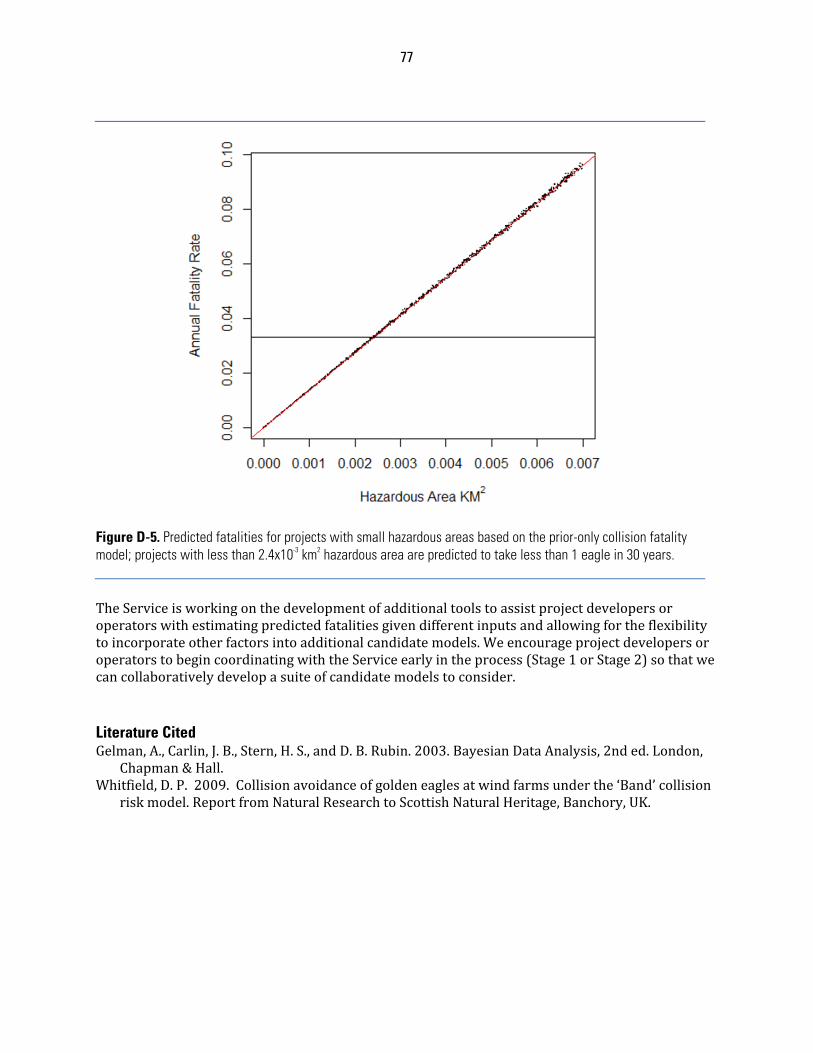
77
Figure D-5. Predicted fatalities for projects with small hazardous areas based on the prior-only collision fatality model; projects with less than 2.4x10⁻³ km2 hazardous area are predicted to take less than 1 eagle in 30 years. TheServiceisworkingonthedevelopmentofadditionaltoolstoassistprojectdevelopersoroperatorswithestimatingpredictedfatalitiesgivendifferentinputsandallowingfortheflexibilitytoincorporateotherfactorsintoadditionalcandidatemodels.WeencourageprojectdevelopersoroperatorstobegincoordinatingwiththeServiceearlyintheprocess(Stage1orStage2)sothatwecancollaborativelydevelopasuiteofcandidatemodelstoconsider.Literature Cited Gelman,A.,Carlin,J.B.,Stern,H.S.,andD.B.Rubin.2003.BayesianDataAnalysis,2nded.London,
Chapman&Hall.Whitfield,D.P.2009.Collisionavoidanceofgoldeneaglesatwindfarmsunderthe‘Band’collision
riskmodel.ReportfromNaturalResearchtoScottishNaturalHeritage,Banchory,UK.
78
APPENDIX E: STAGE 4 – AVOIDANCE AND MINIMIZATION OF RISK USING ACPS AND OTHER CONSERVATION MEASURES, AND COMPENSATORY MITIGATION
Themostimportantfactorwhenconsideringpotentialeffectstoeaglesisthesitingofawindproject.BasedoninformationgatheredinStage2andanalyzedinStage3,theprojectdeveloperoroperatorshouldrevisitthesitecategorizationfromtheStage1assessmenttodetermineifthesite(s)stillfallsintoanacceptablecategoryofrisk(atthisstage,acceptablecategoriesare2and3,andveryrarely1).Wheninformationsuggeststhataproposedwindprojecthasahigheagleexposurerateandpresentsmultipleriskfactors(e.g.,isproximatetoanimportanteagle‐useareaormigrationconcentrationsiteandStage2datasuggesteaglesfrequentlyusetheproposedwind‐projectfootprint),itshouldbeconsideredacategory1site;werecommendrelocatingtheprojecttoanotherareabecausealocationatthatsitewouldbeunlikelytomeettheregulatoryrequirementsforaprogrammaticpermit.Ifthesitefallsintocategories2or3,orrarelysomecategory1siteswherethereispotentialtoadequatelyabaterisk,theECPshouldnextaddressconservationmeasuresandACPsthatmightbeemployedtominimizeor,ideally,avoideaglemortalityanddisturbance.Tomeetregulatoryrequirements,ACPs,ifavailable,mustbeemployedsuchthatanyremainingeagletakeisunavoidable.InthissectionoftheECP,werecommendprojectdevelopersoroperatorsre‐runmodelspredictingeaglefatalityratesafterimplementingconservationmeasuresandavailableACPsforalltheplausiblealternatives.Thisre‐analysisservestwopurposes:(1)itdemonstratesthedegreetowhichminimizationandavoidancemeasuresmightreduceeffectstoeaglepopulationscomparedtothebaselineprojectconfiguration,and(2)itprovidesapredictionofunavoidableeaglemortality.ConservationmeasuresandACPsshouldbetailoredtospecificallyaddresstheriskfactorsidentifiedinStage3oftheECP.ThissectionoftheECPshoulddescribeindetailthemeasuresproposedtobeimplementedandtheirexpectedresults.TheServicedoesnotadvocatetheuseofanyparticularconservationmeasuresandmerelyprovidesthebelowlistasexamples.Moreover,atthistimenoneofthesemeasureshavebeenapprovedasACPsforwindprojects.Ultimately,projectdevelopersoroperatorswillproposeandimplementsitespecificconservationmeasuresandACPs(astheybecomeavailable)incooperationwithlocalServicerepresentativesinordertomeettheregulatorystandardofreducinganyremainingtaketoalevelthatisunavoidable.Examplesofconservationmeasuresthatcouldbeconsideredbeforeandduringprojectconstruction,dependingonthespecificriskfactorsinvolved,include:
1. Minimizetheareaandintensityofdisturbancesduringpre‐constructionandconstructionperiods.
2. Prioritizelocatingdevelopmentonlandsthatprovideminimaleagleusepotentialincludinghighlydevelopedanddegradedsites.
3. Utilizeexistingtransmissioncorridorsandroads.4. Setturbinesbackfromridgeedges.5. Sitestructuresawayfromhigheagleuseareasandtheflightzonesbetweenthem.6. Dismantlenonoperationalmeteorologicaltowers.7. Burypowerlinestoreduceaviancollisionandelectrocution.8. FollowtheAvianPowerLineInteractionCommittee(APLIC)guidanceonpowerline
constructionanddesign(APLIC2006).9. Minimizetheextentoftheroadnetwork.
79
10. Avoidtheuseofstructures,orremoveexistingstructures,thatareattractivetoeaglesforperching.
11. Avoidconstructiondesigns(includingstructuressuchasmeteorologicaltowers)thatincreasetheriskofcollision,suchasguywires.Ifguywiresareused,markthemwithbirdflightdiverters(accordingtothemanufacturer’srecommendation).
12. Avoidsitingturbinesinareaswhereeaglepreyareabundant.13. Avoidareaswithhighconcentrationsofponds,streams,orwetlands.
Examplesofavoidanceandminimizationmeasuresthatcouldbeconsideredduringprojectoperation,dependingonthespecificriskfactorsinvolved,include:
1. Maintainfacilitiesandgroundsinamannerthatminimizesanypotentialimpactstoeagles(e.g.minimizestorageofequipmentnearturbinesthatmayattractprey,avoidseedingforbsbelowturbinesthatmayattractprey,etc.).
2. Avoidpracticesthatattract/enhancepreypopulationsandopportunitiesforscavengingwithintheprojectarea.
3. Takeactionstoreducevehiclecollisionrisktowildlifeandremovecarcassesfromtheprojectarea(e.g.deer,elk,livestock,etc.).
4. Instructprojectpersonnelandvisitorstodriveatlowspeeds(<25mph)andbealertforwildlife,especiallyinlowvisibilityconditions.
Whenpost‐constructionfatalityinformationbecomesavailable,theprojectdeveloperoroperatorandtheServiceshouldconsiderimplementingallorasubsetoftheadditionalconservationmeasuresandexperimentalACPsthatwereconsideredatthetimethepermitwasissued(seeASSESSINGRISKANDEFFECTS,3b.GeneralApproachtoAddressRisksintheECPG).ExamplesofexperimentalACPsthatcouldbeidentifiedinitiallyorafterevaluationofpost‐constructionfatalitymonitoringdata,dependingonthespecificriskfactorsinvolved,include:
1. Seasonal,daily,ormid‐dayshut‐downs(particularlyrelevantinsituationswhereeaglestrikesareseasonalinnatureandlimitedtoafewturbines,oroccurataparticulartimeofday).
2. Turbineremovalorrelocation.3. Adjustingturbinecut‐inspeeds.4. Useofautomateddetectiondevices(e.g.radar,etc.)tocontroltheoperationofturbines.
Literature Cited AvianPowerLineInteractionCommittee(APLIC).2006.Suggestedpracticesforavianprotection
onpowerlines:thestateoftheartin2006.EdisonElectricInstitute,APLIC,andtheCaliforniaEnergyCommission.WashingtonD.C.andSacramento,CA,USA.http://www.aplic.org/SuggestedPractices2006(LR‐2watermark).pdf.
80
APPENDIX F: ASSESSING PROJECT-LEVEL TAKE AND CUMULATIVE EFFECTS ANALYSES TheServiceisrequiredtoevaluateandconsidertheeffectsofprogrammatictakepermitsoneaglesattheeaglemanagementunit,local‐area,andproject‐areapopulationscales,includingcumulativeeffects,aspartofitspermitapplicationreviewprocess(50CFR22.26(f)(1)andUSFWS2009).TheServicewillrelyoninformationadeveloperprovidesfromtheStage1andStage2assessments,aswellasallotheravailableinformationonmortalityandotherpopulation‐limitingeffectsatthevariouspopulationscales,whenpreparingitscumulativeimpactassessment.TheService’sNEPAontheEaglePermitRuleevaluatedandsetsustainabletakelevelsattheeaglemanagementunitscale(USFWS2009).However,thatNEPAanalysisdidnotassessimpactsatotherpopulationscales.Asignificantpartofthecumulativeeffectsevaluationisassessingtheeffectoftheproposedtakeincombinationwithtakecausedbypreviouslyauthorizedactionsandreasonablyforeseeablefutureactionsonthelocal‐areaeaglepopulation(s),anditisthisanalysisthatisthefocusofthisappendix.Thepurposeofthispartofthecumulativeeffectsevaluationistoidentifysituationswheretake,eitherattheindividualprojectlevelorincombinationwithotherauthorizedorforeseeablefutureactionsandotherlimitingfactorsatthelocal‐areapopulationscale,maybeapproachinglevelsthatarebiologicallyproblematicorwhichcannotreasonablybeoffsetthroughcompensatorymitigation.Inpreviousassessmentsoftheeffectoffalconrytakeonraptorpopulations(MillsapandAllen2006),theServiceidentifiedannualtakelevelsof5%ofannualproductiontobesustainableforarangeofhealthyraptorpopulations,andannualtakelevelsof1%ofannualproductionasarelativelybenignharvestrateoveratleastshortintervalswhenpopulationstatuswasuncertain.Thisapproachwasusedtoestablishtakethresholdsattheeaglemanagementunitscale(USFWS2009).TheServiceconsideredseveralalternativesforbenchmarkharvestratesatthelocal‐areapopulationscale,andaftercomparativeevaluationidentifiedtakeratesofbetween1%and5%oftheestimatedtotaleaglepopulationsizeatthisscaleassignificant,with5%beingattheupperendofwhatmightbeappropriateundertheBGEPApreservationstandard,whetheroffsetbycompensatorymitigationornot.Theselocal‐areaharvestratebenchmarksareoverlainbythemoreconservativetakethresholdsfortheeaglemanagementunits,sotheoverallharvestrateattheeaglemanagementunitscaleshouldnotexceedlevelsestablishedintheFinalEnvironmentalAssessment(USFWS2009).TheServicerecommendsatop‐downapproachforthisassessment:(1)identifynumbersofeaglesthatmaybetakensafelyatthenationallevel(i.e.,anational‐levelbenchmarks);(2)allocatetakeopportunitiesamongregionaleaglemanagementunits(USFWS2009)asafunctionoftheproportionofeaglesineachunit(i.e.,regional‐levelbenchmarks);(3)furtherallocatetakeopportunitiestothelocal‐areapopulationscaleasafunctionofinferredeaglepopulationsizeatthatscale(assuming,intheabsenceofbetterdataoneagledistributionatthescaleoftheeaglemanagementunit,auniformdistributionofthatpopulation);and(4)incorporatingbenchmarksthatcanbeusedtoassessthelikelysustainabilityofpredictedlevelsoftakeatthelocal‐areascale.Throughaspatialaccountingsystem,permittedtakeismanagedtoensurethatthebenchmarksalsoconsidercumulativeeffectsatthelocal‐areaeaglepopulationscaleasaguardagainstauthorizingexcessivetakeatthisscale.InTableF‐1,weworkthroughthisapproachusingthehypotheticalexampleofeightindividualyetidenticalprojects,oneineachbaldeaglemanagementunit.Eachoftheseprojectshasa314mi2footprint,andaffectsalocal‐areabaldeaglepopulationover8824squaremile(mi2)area.Forthisexample,weuseatakerateof5%ofthelocal‐areabaldeaglepopulationperyearasthemaximumacceptabletakerate.Inthisexample,the5%benchmarktakerateovertheeightprojectsis150
81
individualbaldeaglesperyear,andtherangeofallowabletakeratesatthisscalevariesacrossmanagementunitsfrom<1baldeagleperyearinthesouthwestto67peryearinAlaska.TableF‐2providespopulationandeaglemanagementunitareastatisticsforgoldeneaglestoaidinperformingthesecalculationsforthatspecies.Asnotedabove,incaseswherethelocal‐areaeaglepopulationsofproximateprojectsoverlap,theoverlapshouldbetakenintoaccountinacumulativeeffectsanalysissothatthecumulativetakeonthelocal‐areapopulationscalecanbeconsideredagainstpopulationbenchmarks.FigureF‐1illustratesonemethodtodothis,andTableF‐3providesthecalculationsforthisexample.Theseexamplesusebaldeagles,butthesameconceptandapproachcanbeusedforgoldeneagles,withBirdConservationRegions(BCRs)definingtheeaglemanagementunits.TheexampleinFigureF‐1involvesbaldeaglesinRegion3.Project1(ingreen)hasafootprintof41miles2(mi2),andaffectsalocal‐areabaldeaglepopulationover6854mi2(lightgreenbufferaroundtheprojectfootprint).FollowingtheapproachinTableF‐1,project1wasissuedaprogrammatictakepermitwithamaximumannualproject‐leveltakeof21baldeaglesperyear(seeTableF‐3).Project2(inred,thesamesizeasproject1)appliedforaprogrammaticeagletakepermit5yearslater.Thecalculatedproject‐levelbaldeagletakeforproject2is20baldeaglesperyear,butunderthe5%benchmark,maximumtakefor1563mi2ofproject2’slocal‐areabaldeaglepopulation(totaling5baldeaglesperyear)wasalreadyallocatedtoproject1(thehatched‐markedareaofoverlapbetweenthelocalareasofproject1andproject2).Therefore,thecalculatedlocal‐areabaldeagletakeforproject2exceedsthe5%benchmark.Thus,thedecision‐makerforthepermitforproject2shouldcarefullyconsiderwhetherthisprojectcanbepermittedasdesignedundertherequirementsofourregulationsat50CFR22.26.Theexamplesassumeacceptablecompensatorymitigationopportunities,whentheyarerequired,arelimitless.Theyarenot,andwherecompensatorymitigationisnecessarytooffsetthepermittedtake,theavailabilityofcompensatorymitigationcanbecometheproximatefactorlimitingtakeopportunities.Acriticalassumptionofthisapproachisthateagledensityisuniformacrosseagleregions.Thepotentialconsequenceofthisassumptionistooverprotecteaglesinareasofhighdensityandunderprotecttheminareasoflowdensity.AstheServiceandothersdevelopmorereliablemodelsforpredictingthedistributionofeagleswithinregionalmanagementpopulationsatfinerscales,theseapproachesshouldbeusedinplaceofanassumptionofuniformdistributionintheanalysessuggestedhere.
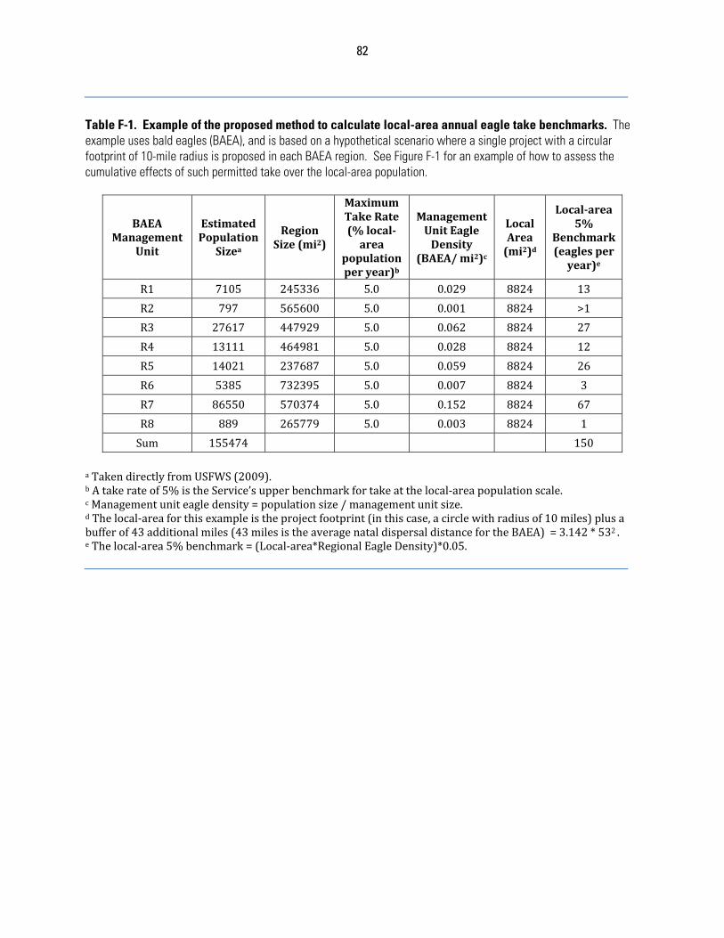
82
Table F-1. Example of the proposed method to calculate local-area annual eagle take benchmarks. The example uses bald eagles (BAEA), and is based on a hypothetical scenario where a single project with a circular footprint of 10-mile radius is proposed in each BAEA region. See Figure F-1 for an example of how to assess the cumulative effects of such permitted take over the local-area population.
BAEAManagement
Unit
EstimatedPopulation
Sizea
RegionSize(mi2)
MaximumTakeRate(%local‐area
populationperyear)b
ManagementUnitEagleDensity
(BAEA/mi2)c
LocalArea(mi2)d
Local‐area5%
Benchmark(eaglesperyear)e
R1 7105 245336 5.0 0.029 8824 13
R2 797 565600 5.0 0.001 8824 >1
R3 27617 447929 5.0 0.062 8824 27
R4 13111 464981 5.0 0.028 8824 12
R5 14021 237687 5.0 0.059 8824 26
R6 5385 732395 5.0 0.007 8824 3
R7 86550 570374 5.0 0.152 8824 67
R8 889 265779 5.0 0.003 8824 1
Sum 155474 150
aTakendirectlyfromUSFWS(2009).bAtakerateof5%istheService’supperbenchmarkfortakeatthelocal‐areapopulationscale.cManagementuniteagledensity=populationsize/managementunitsize.dThelocal‐areaforthisexampleistheprojectfootprint(inthiscase,acirclewithradiusof10miles)plusabufferof43additionalmiles(43milesistheaveragenataldispersaldistancefortheBAEA)=3.142*532.eThelocal‐area5%benchmark=(Local‐area*RegionalEagleDensity)*0.05.
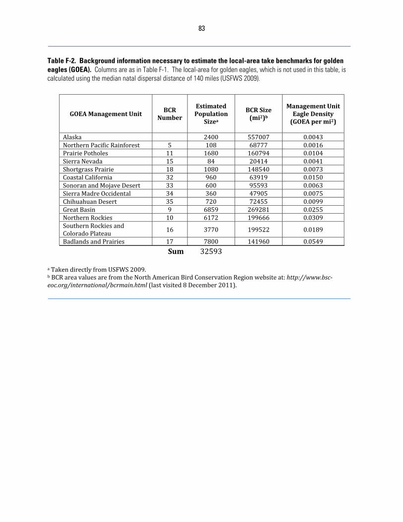
83
Table F-2. Background information necessary to estimate the local-area take benchmarks for golden eagles (GOEA). Columns are as in Table F-1. The local-area for golden eagles, which is not used in this table, is calculated using the median natal dispersal distance of 140 miles (USFWS 2009).
GOEAManagementUnitBCR
Number
EstimatedPopulation
Sizea
BCRSize(mi2)b
ManagementUnitEagleDensity(GOEApermi2)
Alaska 2400 557007 0.0043NorthernPacificRainforest 5 108 68777 0.0016PrairiePotholes 11 1680 160794 0.0104SierraNevada 15 84 20414 0.0041ShortgrassPrairie 18 1080 148540 0.0073CoastalCalifornia 32 960 63919 0.0150SonoranandMojaveDesert 33 600 95593 0.0063SierraMadreOccidental 34 360 47905 0.0075ChihuahuanDesert 35 720 72455 0.0099GreatBasin 9 6859 269281 0.0255NorthernRockies 10 6172 199666 0.0309SouthernRockiesandColoradoPlateau 16 3770 199522 0.0189
BadlandsandPrairies 17 7800 141960 0.0549
Sum 32593
aTakendirectlyfromUSFWS2009.bBCRareavaluesarefromtheNorthAmericanBirdConservationRegionwebsiteat:http://www.bsc‐eoc.org/international/bcrmain.html(lastvisited8December2011).
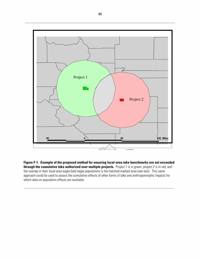
84
Figure F-1. Example of the proposed method for ensuring local-area take benchmarks are not exceeded through the cumulative take authorized over multiple projects. Project 1 is in green, project 2 is in red, and the overlap in their local-area eagle bald eagle populations is the hatched-marked area (see text). This same approach could be used to assess the cumulative effects of other forms of take and anthropomorphic impacts for which data on population effects are available.
60 0 60 120 Miles
Project 1
Project 2
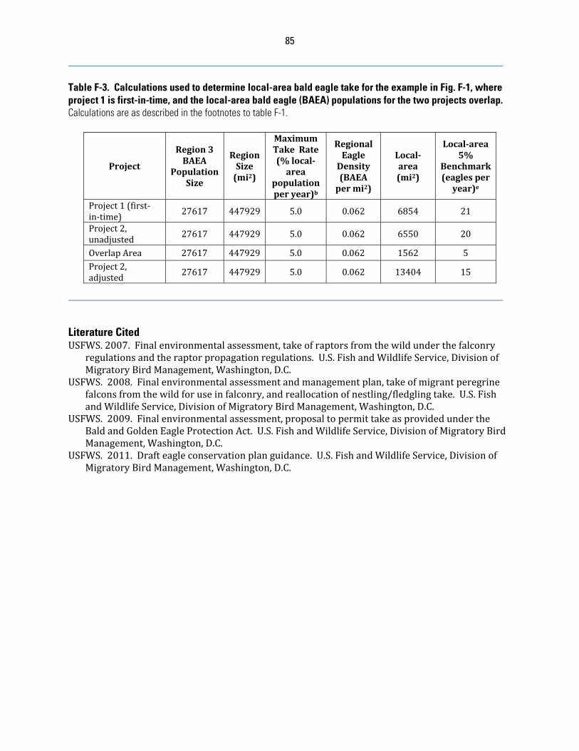
85
Table F-3. Calculations used to determine local-area bald eagle take for the example in Fig. F-1, where project 1 is first-in-time, and the local-area bald eagle (BAEA) populations for the two projects overlap. Calculations are as described in the footnotes to table F-1.
Project
Region3BAEA
PopulationSize
RegionSize(mi2)
MaximumTakeRate(%local‐area
populationperyear)b
RegionalEagleDensity(BAEApermi2)
Local‐area(mi2)
Local‐area5%
Benchmark(eaglesperyear)e
Project1(first‐in‐time)
27617 447929 5.0 0.062 6854 21
Project2,unadjusted
27617 447929 5.0 0.062 6550 20
OverlapArea 27617 447929 5.0 0.062 1562 5Project2,adjusted
27617 447929 5.0 0.062 13404 15
Literature Cited USFWS.2007.Finalenvironmentalassessment,takeofraptorsfromthewildunderthefalconry
regulationsandtheraptorpropagationregulations.U.S.FishandWildlifeService,DivisionofMigratoryBirdManagement,Washington,D.C.
USFWS.2008.Finalenvironmentalassessmentandmanagementplan,takeofmigrantperegrinefalconsfromthewildforuseinfalconry,andreallocationofnestling/fledglingtake.U.S.FishandWildlifeService,DivisionofMigratoryBirdManagement,Washington,D.C.
USFWS.2009.Finalenvironmentalassessment,proposaltopermittakeasprovidedundertheBaldandGoldenEagleProtectionAct.U.S.FishandWildlifeService,DivisionofMigratoryBirdManagement,Washington,D.C.
USFWS.2011.Drafteagleconservationplanguidance.U.S.FishandWildlifeService,DivisionofMigratoryBirdManagement,Washington,D.C.
86
APPENDIX G: EXAMPLES USING RESOURCE EQUIVALENCY ANALYSIS TO ESTIMATE THE COMPENSATORY MITIGATION FOR THE TAKE OF GOLDEN AND BALD EAGLES FROM WIND
ENERGY DEVELOPMENT 1. IntroductionThisappendixprovidesResourceEquivalencyAnalysis(REA)examplesdevelopedbytheServicetoillustratethecalculationofcompensatorymitigationfortheannuallossofgolden(GOEA)eaglesandbald(BAEA)eaglescausedbywindpowerifconservationmeasuresandACPsdonotremovethepotentialfortake,andtheprojectedtakeexceedscalculatedthresholdsforthespeciesormanagementpopulationaffected.Theseexamplesresultinestimatesofthenumberofhigh‐riskelectricpowerpolesthatwouldneedtoberetrofittedpereagletakenbasedontheinputsprovidedbelow.Detailedexplanatorydocumentation,literature,andsupportingREAspreadsheetsarenowlocatedat:www.fws.gov/windenergy/index.htmlAsaframeworkforcompensatorymitigation,itneedstobeclearthattheresultsprovidedbelowareanillustrationofhowREAworksgiventhecurrentunderstandingofGOEAandBAEAlifehistoryinputs,effectivenessofretrofittinghigh‐riskelectricpowerpoles,theexpectedannualtake,andthetimingofboththeeagletakepermitandimplementationofcompensatorymitigation.Aswouldbeexpected,theestimatednumberofeaglefatalitiesandthepermitrenewalperiodaffectthenumberofpolestoberetrofitted.Delaysinretrofittingwouldleadtomoreretrofittedpolesowed.Newinformationonchangesintheleveloftake,understandingoftheeaglelifehistory,oreffectivenessofretrofittingcouldbeusedtochangethenumberofretrofittedpolesneededforcompensation.Finally,whileonlyelectricpoleretrofittingispresentedhereindetail,theREAmetricofbird‐yearslendsitselftoconsiderationofothercompensatorymitigationoptionstoachievetheno‐net‐lossstandardinthefuture.Withenoughreliableinformation,anycompensatorymitigationthatdirectlyleadstoanincreasednumberofGOEAandBAEA(e.g.,habitatrestoration)ortheavoidedlossoftheseeagles(e.g.,reducingvehicle/eaglecollisions,makinglivestockwatertanks‘eagle‐safe’,leadammunitionabatement,etc.)couldbeconsideredforcompensationwithinthecontextoftheREA.2. REA InputsThebestavailablepeer‐reviewed,publisheddataareprovidedinTablesG‐1andG‐2.ItshouldbenotedthatadditionalmodelingworkwithintheREAmaybeneeded,particularlyonissuesrelatedtomigration,adultfemalesurvivorship,nataldispersal,ageatfirstbreeding,andpopulationsexratio.
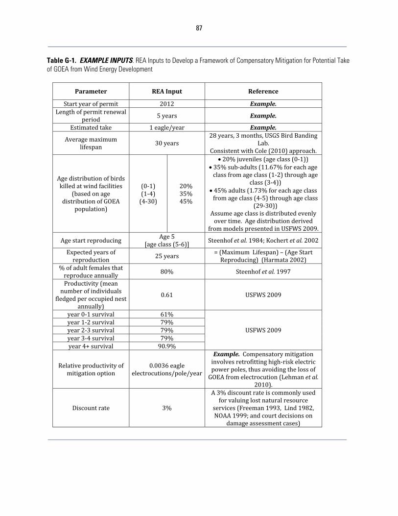
87
Table G-1. EXAMPLE INPUTS. REA Inputs to Develop a Framework of Compensatory Mitigation for Potential Take of GOEA from Wind Energy Development
Parameter REAInput Reference
Startyearofpermit 2012 Example.Lengthofpermitrenewal
period5years Example.
Estimatedtake 1eagle/year Example.
Averagemaximumlifespan
30years28years,3months,USGSBirdBanding
Lab.ConsistentwithCole(2010)approach.
Agedistributionofbirdskilledatwindfacilities
(basedonagedistributionofGOEA
population)
(0‐1)(1‐4)(4‐30)
20%35%45%
20%juveniles(ageclass(0‐1)) 35%sub‐adults(11.67%foreachageclassfromageclass(1‐2)throughage
class(3‐4)) 45%adults(1.73%foreachageclassfromageclass(4‐5)throughageclass
(29‐30))Assumeageclassisdistributedevenlyovertime.Agedistributionderived
frommodelspresentedinUSFWS2009.
AgestartreproducingAge5
[ageclass(5‐6)]Steenhofetal.1984;Kochertetal.2002
Expectedyearsofreproduction
25years =(MaximumLifespan)–(AgeStartReproducing)(Harmata2002)
%ofadultfemalesthatreproduceannually
80% Steenhofetal.1997
Productivity(meannumberofindividuals
fledgedperoccupiednestannually)
0.61 USFWS2009
year0‐1survival 61%
USFWS2009year1‐2survival 79%year2‐3survival 79%year3‐4survival 79%year4+survival 90.9%
Relativeproductivityofmitigationoption
0.0036eagleelectrocutions/pole/year
Example. Compensatorymitigationinvolvesretrofittinghigh‐riskelectricpowerpoles,thusavoidingthelossofGOEAfromelectrocution(Lehmanetal.
2010).
Discountrate 3%
A3%discountrateiscommonlyusedforvaluinglostnaturalresource
services(Freeman1993,Lind1982,NOAA1999;andcourtdecisionson
damageassessmentcases)
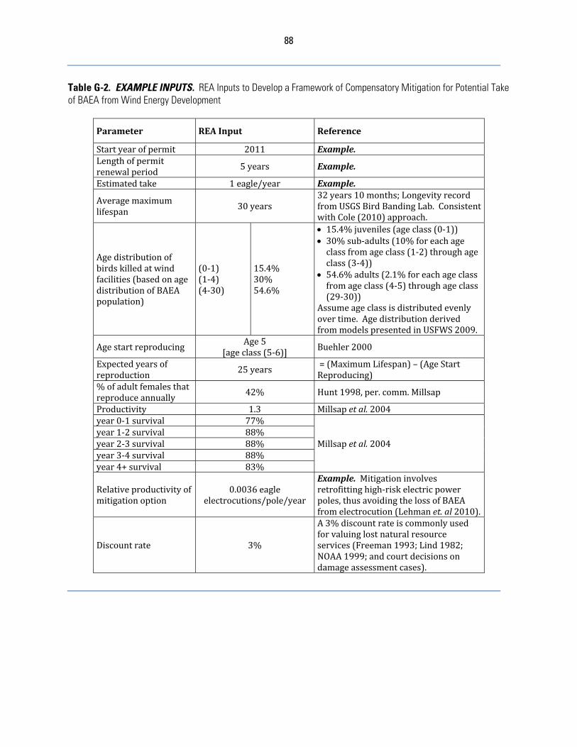
88
Table G-2. EXAMPLE INPUTS. REA Inputs to Develop a Framework of Compensatory Mitigation for Potential Take of BAEA from Wind Energy Development
Parameter REAInput Reference
Startyearofpermit 2011 Example.Lengthofpermitrenewalperiod
5years Example.
Estimatedtake 1eagle/year Example.
Averagemaximumlifespan
30years32years10months;LongevityrecordfromUSGSBirdBandingLab.ConsistentwithCole(2010)approach.
Agedistributionofbirdskilledatwindfacilities(basedonagedistributionofBAEApopulation)
(0‐1)(1‐4)(4‐30)
15.4%30%54.6%
15.4%juveniles(ageclass(0‐1)) 30%sub‐adults(10%foreachageclassfromageclass(1‐2)throughageclass(3‐4))
54.6%adults(2.1%foreachageclassfromageclass(4‐5)throughageclass(29‐30))
Assumeageclassisdistributedevenlyovertime.AgedistributionderivedfrommodelspresentedinUSFWS2009.
AgestartreproducingAge5
[ageclass(5‐6)] Buehler2000
Expectedyearsofreproduction 25years
=(MaximumLifespan)–(AgeStartReproducing)
%ofadultfemalesthatreproduceannually
42% Hunt1998,per.comm.Millsap
Productivity 1.3 Millsapetal. 2004year0‐1survival 77%
Millsapetal.2004year1‐2survival 88%year2‐3survival 88%year3‐4survival 88%year4+survival 83%
Relativeproductivityofmitigationoption
0.0036eagleelectrocutions/pole/year
Example. Mitigationinvolvesretrofittinghigh‐riskelectricpowerpoles,thusavoidingthelossofBAEAfromelectrocution(Lehmanet.al2010).
Discountrate 3%
A3%discountrateiscommonlyusedforvaluinglostnaturalresourceservices(Freeman1993;Lind1982;NOAA1999;andcourtdecisionsondamageassessmentcases).
89
3. REA Example – WindCoA TheServicedevelopedthefollowinghypotheticalscenarioforpermittingandcompensatorymitigationtobeappliedtothetakeofGOEA1fromwindpoweroperations:WindCoAconductedthreeyearsofpre‐constructionsurveystodeterminerelativeabundanceofGOEAattheirproposedwindprojectinTexas.Thesurveydatawasthenusedtopopulateariskassessmentmodeltogenerateaneaglefatalityestimate.TheinitialfatalityestimateoftwoeaglesperyearwasfurtherreducedafterWindCoAimplementedafewmutuallyagreeduponACPs.Thefinalfatalityestimategeneratedfromtheriskassessmentmodel,afterconsiderationoftheadvancedconservationpractices,wasanannualtakeofoneGOEAperyearoverthelifeofthepermitstartingin2012.WindCoAdecidedtoconductanREAtodeterminethenumberofhigh‐riskpowerpolesthatwouldneedtoberetrofittedtogettono‐net‐loss.ThecompanyusedtheService’sGOEAREAinputsandassumedthepowerpoleretrofitwouldoccurincalendaryear2012,thusoffsettingthepotentiallossofeaglesatthenewlyoperatingwindprojectwithavoidanceofelectrocutionofanequalnumberofGOEA.Throughproperoperationandmaintenance(O&M),theretrofittedpolesareassumedtobeeffectiveinavoidingthelossofeaglesfor10years.Theresultsofthemodelareexpressedinthetotalnumberofelectricpowerpolestoberetrofittedtoequatetono‐net‐lossof5eaglesforthe5‐yearpermitrenewalperiod(1eagleannuallyoverfiveyears).Theseresultsareextrapolatedovertheexpectedoperatinglifeofthewindproject,whichisassumedtobe30years,foratotaltakeof30eagles.TheresultsoftheREAindicatedthatWindCoAneededtoretrofitapproximately149powerpolesforthefirst5‐yearpermitperiod(seeTableG‐3).Usinganestimatedcostof$7500/pole,theServiceestimatedthatWindCoAcouldcontribute$1,117,500toathird‐partymitigationaccountorcontracttheretrofitsdirectly.Afterdeterminingthattheycouldfundtheretrofitsdirectlyatalowercost,WindCoAdecidedtopartnerwithUtilityCoBtogettherequirednumberofpolesretrofitted.UtilityCoBhadpreviouslyconductedariskassessmentoftheirequipmentandhadidentifiedhigh‐riskpolesthatwerelikelytotakegoldeneagles.Throughawrittenagreement,WindCoAprovidedfundingtoUtilityCoBtoretrofittherequirednumberofpowerpolesandmaintaintheretrofitsfor10years.Inaddition,WindCoAcontractedwithConsultCoCtoperformeffectivenessmonitoringoftheretrofittedpowerpolesfor2years.ThecontractrequiredthatConsultCoCvisiteachretrofittedpowerpoleevery4months(quarterly)toperformfatalitysearchesandcheckforproperoperationandmaintenanceoftheequipment.TheServicereviewedthecompensatorymitigationprojectproposedbyWindCoAandfoundittobeconsistentwithrequirementsat50CFR22.26.AfterreviewingthesignedcontractbetweenWindCoA,UtilityCoB,andConsultCoC,theServiceissuedaprogrammaticeagletakepermittoWindCoA.
a. REA Language and Methods Asdiscussedingreaterdetailindocumentsonthesupportingwebsite,thisREAincludes:
ThedirectlossofGOEA/BAEAeaglesfromthetake(debitinbird‐years); Therelativeproductivityofretrofittinghigh‐riskpowerpoles,whichisthe
effectivenessinavoidingthelossofGOEA/BAEAbyelectrocutionasamitigationoffset(measuredintotalbird‐yearsperpole);and
1 Using the inputs provided in Table G-2, this scenario may also be applied to BAEA.
90
Themitigationowed,whichisthetotaldebitdividedbytherelativeproductivity(scaling)toidentifythenumberofhigh‐riskpowerpolesthatneedretrofittingtocompletelyoffsetthetakeofGOEA/BAEAeagles(credit).
Thereareupto16stepswhenconductingaREA.Dependingonwhetherforegonefuturereproduction(partofthedebit)isincluded,thereareupto13totalstepsinvolvedincalculatingtheinjuryside(debit)ofaREA,andthreeadditionalstepsinvolvedinestimatingcompensatorymitigationowed(credit).Pleaserefertothetechnicalnote“ScalingDirectlyProportionalAvoidedLossMitigation/RestorationProjects”onthesupportingwebsite(www.fws.gov/windenergy)forfurtherinformationonthedevelopmentofREAinputsandtheinclusionoflostreproduction.Notably,inthecaseofanavoidedlossprojectwheretheestimatedpreventedlossofbird‐years(e.g.,throughmitigation)isdirectlyproportionaltothelossofbird‐years(e.g.,from“take”),thelifehistoryinputs(e.g.,longevity,agedistribution,survivalrates,reproduction)donotaffectthefinalresultsofthecreditowed.Thatis,theretrofittingofhigh‐riskpowerpolesisadirectlyproportionalavoidedloss,soonlytheleveloftake(numberofeaglesannually),theavoidedlossofeaglespermitigatedelectricpole,thenumberofyearsthemitigatedpoleiseffectiveinavoidingthelossofeagles,andthetimingofthemitigationrelativetothetakeaffectthefinalcreditowed.Itshouldalsobenotedthattheannualtakeofoneeagleisusedintheexamplebecausethelostbird‐yearsassociatedwithoneeaglecanbeeasilymultipliedbytheactualtaketoestimatethetotaldebitinbird‐years.ThefollowingisabriefdiscussionofREAvariablesusedintheService’sWindCoAexamplethataffecttheoutcomeofthecompensatorymitigationcalculation:
RelativeProductivityofMitigation(0.0036electrocutions/pole/year)–ThisrateistakendirectlyfrompublishedliteratureoneagleelectrocutionratesinnortheasternUtahandnorthwesternColoradoandisspecifictoeagles(Lehmanetal.2010).Althoughthereferencedstudyalsolistsahigherrate(0.0066)thatincludesallknowneaglemortalities,thisrateincludedeaglesthatmayhavediedfromcausesunrelatedtoelectrocution.
YearsofAvoidedLossPerRetrofittedPole(10Years)–TheServiceusesaperiodof10yearsforcreditingtheprojectdeveloperoroperatorfortheavoidedlossofeaglesfrompowerpoleretrofits.Thisisareasonableamountoftimetoassumethatpowerpoleretrofitswillremaineffective.However,projectdevelopersoroperatorsshouldconsiderenteringintoagreementswithutilitycompaniesorcontractorsforthelong‐termmaintenanceofretrofits.Evidenceofthistypeofagreementcouldincreasetheamountofcreditreceivedbytheprojectdeveloperoroperatorand,asaresult,decreasetheamountofcompensatorymitigationrequired.
PermitRenewalPeriod(5Years)–ThiswillbethereviewperiodthatisusedbytheServiceforadaptivemanagementpurposesandre‐calculationofcompensatorymitigation.TheServicebelievesthatthislengthoftimewillenabletheprojectdeveloperoroperatortocontinuetomeetthestatutoryandregulatoryeaglepreservationstandard.Thispermitreviewtenurewillremainthesameregardlessoftheoveralltenureofthepermit.
RetrofitCost/Payment($7,500/pole)–TheServicereceivedinputdirectlyfromtheindustryregardingtheactualcoststoretrofitpowerpoles.Estimatesrangedfromalowofapproximately$400toover$11,000giventhatcostsvaryaccordingtomanyfactors.TheServicebelievesthat$7,500representsareasonableestimateforthecurrentcosttoretrofitpowerpolesintheUnitedStates.Projectdevelopersor
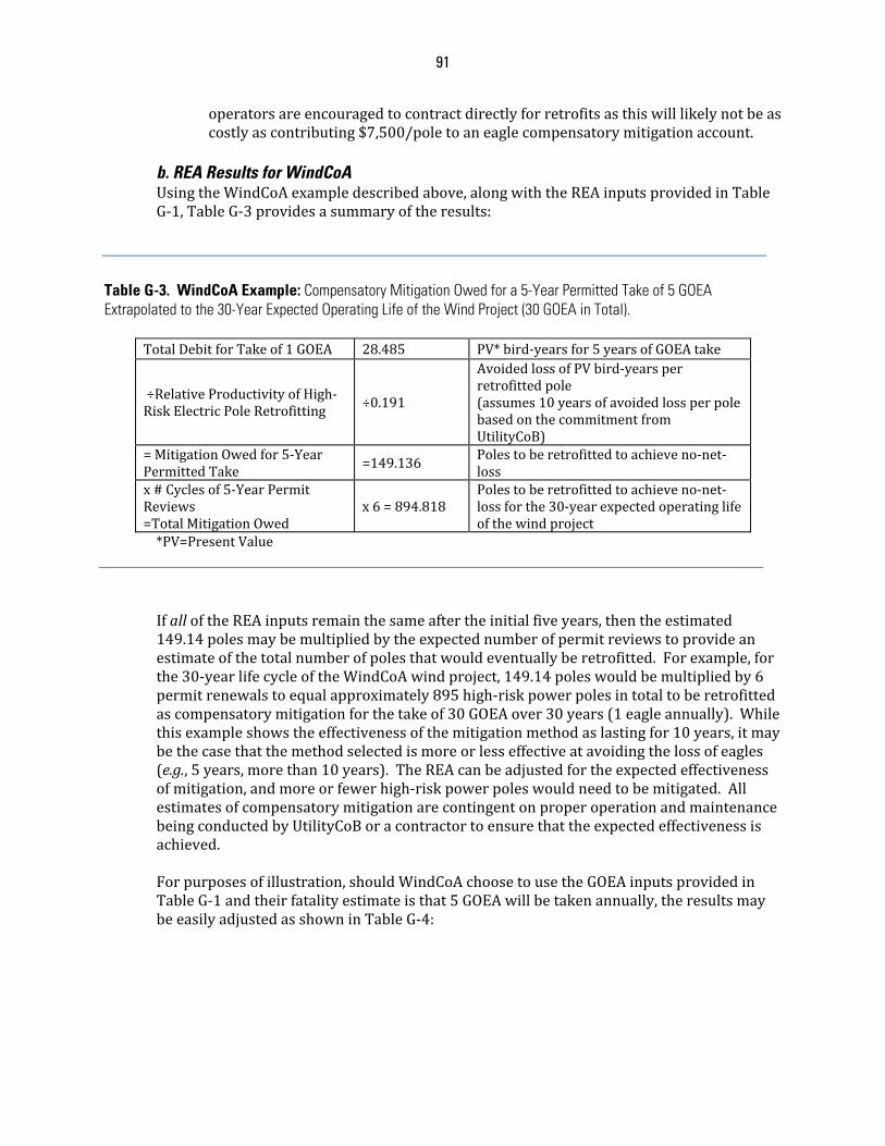
91
operatorsareencouragedtocontractdirectlyforretrofitsasthiswilllikelynotbeascostlyascontributing$7,500/poletoaneaglecompensatorymitigationaccount.
b. REA Results for WindCoA UsingtheWindCoAexampledescribedabove,alongwiththeREAinputsprovidedinTableG‐1,TableG‐3providesasummaryoftheresults:
Table G-3. WindCoA Example: Compensatory Mitigation Owed for a 5-Year Permitted Take of 5 GOEA Extrapolated to the 30-Year Expected Operating Life of the Wind Project (30 GOEA in Total).
TotalDebitforTakeof1GOEA 28.485 PV*bird‐yearsfor5yearsofGOEAtake
÷RelativeProductivityofHigh‐RiskElectricPoleRetrofitting ÷0.191
AvoidedlossofPVbird‐yearsperretrofittedpole(assumes10yearsofavoidedlossperpolebasedonthecommitmentfromUtilityCoB)
=MitigationOwedfor5‐YearPermittedTake
=149.136Polestoberetrofittedtoachieveno‐net‐loss
x#Cyclesof5‐YearPermitReviews=TotalMitigationOwed
x6=894.818Polestoberetrofittedtoachieveno‐net‐lossforthe30‐yearexpectedoperatinglifeofthewindproject
*PV=PresentValueIfalloftheREAinputsremainthesameaftertheinitialfiveyears,thentheestimated149.14polesmaybemultipliedbytheexpectednumberofpermitreviewstoprovideanestimateofthetotalnumberofpolesthatwouldeventuallyberetrofitted.Forexample,forthe30‐yearlifecycleoftheWindCoAwindproject,149.14poleswouldbemultipliedby6permitrenewalstoequalapproximately895high‐riskpowerpolesintotaltoberetrofittedascompensatorymitigationforthetakeof30GOEAover30years(1eagleannually).Whilethisexampleshowstheeffectivenessofthemitigationmethodaslastingfor10years,itmaybethecasethatthemethodselectedismoreorlesseffectiveatavoidingthelossofeagles(e.g.,5years,morethan10years).TheREAcanbeadjustedfortheexpectedeffectivenessofmitigation,andmoreorfewerhigh‐riskpowerpoleswouldneedtobemitigated.AllestimatesofcompensatorymitigationarecontingentonproperoperationandmaintenancebeingconductedbyUtilityCoBoracontractortoensurethattheexpectedeffectivenessisachieved.Forpurposesofillustration,shouldWindCoAchoosetousetheGOEAinputsprovidedinTableG‐1andtheirfatalityestimateisthat5GOEAwillbetakenannually,theresultsmaybeeasilyadjustedasshowninTableG‐4:
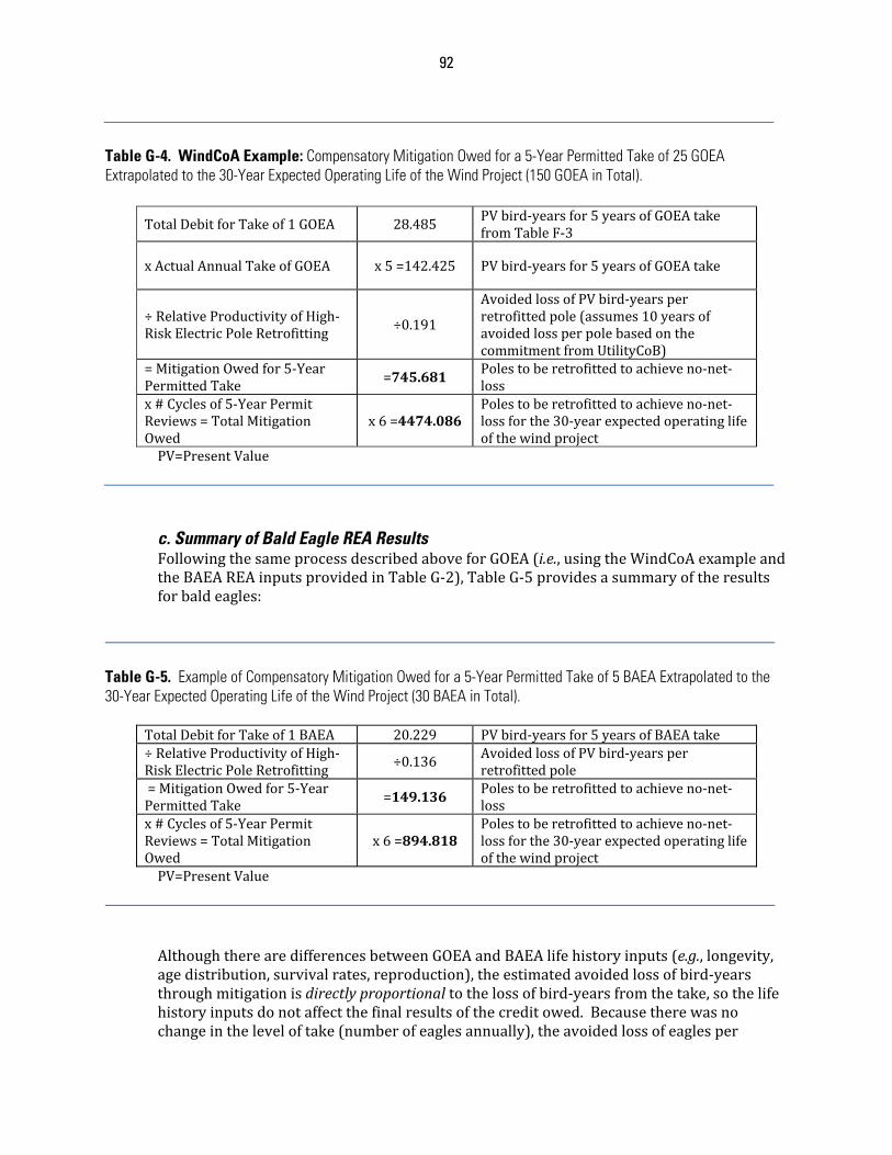
92
Table G-4. WindCoA Example: Compensatory Mitigation Owed for a 5-Year Permitted Take of 25 GOEA Extrapolated to the 30-Year Expected Operating Life of the Wind Project (150 GOEA in Total).
TotalDebitforTakeof1GOEA 28.485PVbird‐yearsfor5yearsofGOEAtakefromTableF‐3
xActualAnnualTakeofGOEA x5=142.425 PVbird‐yearsfor5yearsofGOEAtake
÷RelativeProductivityofHigh‐RiskElectricPoleRetrofitting
÷0.191
AvoidedlossofPVbird‐yearsperretrofittedpole(assumes10yearsofavoidedlossperpolebasedonthecommitmentfromUtilityCoB)
=MitigationOwedfor5‐YearPermittedTake
=745.681Polestoberetrofittedtoachieveno‐net‐loss
x#Cyclesof5‐YearPermitReviews=TotalMitigationOwed
x6=4474.086Polestoberetrofittedtoachieveno‐net‐lossforthe30‐yearexpectedoperatinglifeofthewindproject
PV=PresentValue
c. Summary of Bald Eagle REA Results FollowingthesameprocessdescribedaboveforGOEA(i.e.,usingtheWindCoAexampleandtheBAEAREAinputsprovidedinTableG‐2),TableG‐5providesasummaryoftheresultsforbaldeagles:
Table G-5. Example of Compensatory Mitigation Owed for a 5-Year Permitted Take of 5 BAEA Extrapolated to the 30-Year Expected Operating Life of the Wind Project (30 BAEA in Total).
TotalDebitforTakeof1BAEA 20.229 PVbird‐yearsfor5yearsofBAEAtake÷RelativeProductivityofHigh‐RiskElectricPoleRetrofitting
÷0.136 AvoidedlossofPVbird‐yearsperretrofittedpole
=MitigationOwedfor5‐YearPermittedTake =149.136
Polestoberetrofittedtoachieveno‐net‐loss
x#Cyclesof5‐YearPermitReviews=TotalMitigationOwed
x6=894.818Polestoberetrofittedtoachieveno‐net‐lossforthe30‐yearexpectedoperatinglifeofthewindproject
PV=PresentValue
AlthoughtherearedifferencesbetweenGOEAandBAEAlifehistoryinputs(e.g.,longevity,agedistribution,survivalrates,reproduction),theestimatedavoidedlossofbird‐yearsthroughmitigationisdirectlyproportionaltothelossofbird‐yearsfromthetake,sothelifehistoryinputsdonotaffectthefinalresultsofthecreditowed.Becausetherewasnochangeintheleveloftake(numberofeaglesannually),theavoidedlossofeaglesper
93
mitigatedelectricpole,thenumberofyearsthemitigatedpoleiseffectiveinavoidingthelossofeagles,orthetimingofthemitigationrelativetothetake,thereisnochangeinthecreditowed.Tohelpillustrate,whencomparingtheresultsofBAEAtoGOEA,boththedebit(20.23÷28.49)andtherelativeproductivityofelectricpoleretrofitting(0.14÷0.19)forBAEAareapproximately70%ofGOEA,sotheamountofretrofittingowedisthesame.Thatis,boththenumeratorofthescalingequation(totaldebit)andthedenominator(relativeproductivityofmitigation)werechangedproportionally(approximately70%),sothereisnochangeinthemitigationowed.d. Discussion on Using REA TheECPGdoesnotmandatetheuseofREA.Rather,theServicerecognizedtheneedforareliable,transparent,reproducible,andcost‐effectivetooltoexpeditewindpowerpermits,whileensuringsufficientcompensatorymitigationforthetakeofgoldeneaglesandbaldeaglesfromoperationstomeetregulatorypermittingrequirements.Althoughthereisalearningcurve,REAmeetsthesebasicneeds.Thisappendixandmaterialsonthesupportingwebsiteexplainthemethods,sharethetoolstorunREAs,anddiscusshowchangesinthedifferentinputscanaffecttheresults.Shouldprojectdevelopersoroperators/applicantschoosetousetheprovidedinputs,methods,andtools,theServicewillbeabletoappropriatelyfocusontheexpectedtakeofeagles.Projectdevelopersoroperators/applicantshavethediscretiontoofferalternativeREAinputsorusedifferentcompensatorymitigationmodelingmethods.However,theywillneedtoprovidesufficientevidenceandtools(ifnecessary)toensurethattheServicecanprovideappropriatereviewoftheresults,andshouldexpectthatsuchaneffortwilllikelytakeadditionaltime.e. Additional Compensatory Mitigation Example IntheUnitedStates,anotherknowncauseofmortalitytoeagles,bothbaldandgolden,isvehiclecollisions.Eaglesaresusceptibletobeingstruckbyvehiclesastheyfeedoncarcassesalongroadsides,particularlyinareasoftheUnitedStateswherelargenumbersofungulatesconcentrateseasonally(e.g.winter,breedingseason,etc.).Asacompensatorymitigationstrategy,aprojectdeveloperoroperatormaydecidetocollectdata(oruseexistingdataifitisavailable)ontheannualnumberofeaglemortalitiesthatresultfromvehiclecollisionsinaspecifiedgeographicareaoralongaspecificstretchofroadway.Thisdatacouldthenbeusedtogenerateanestimateofthenumberofeaglemortalitiesthatcouldbepreventedinthesameareabyremovingcarcassesfromroadsides.Iftherewassufficientevidencethatthiswasavalidproject(e.g.quantifiableandverifiable),theprojectdeveloperoroperatorcouldcontracttohavetheseroadsides‘cleaned’ofcarcassesduringthetimeofyearthatungulatesconcentrateandeaglesareknowntobestruck.Thecredibleestimateofeaglemortalitiesthatwouldbeavoidedthroughcarcassremovalwouldbethevalueofthecompensatorymitigationachieved.f. Take from Disturbance ProjectdevelopersoroperatorsshouldworkwiththeServicetodetermineiftakefromdisturbanceislikelytooccur.ThisshouldbepredictedinadvancebasedonStage3data,andverifiedthroughpost‐constructionmonitoringinStage5.ThefollowingarerecommendedtakecalculationsbasedoninformationcontainedwithintheFEA(USFWS2009):Forthestandardbaldeaglepopulation:
94
Takeresultingfromdisturbanceatonenestononlyoneoccasion=takeof1.3individuals
Onenesttakeresultinginthepermanentabandonmentofaterritory=takeof1.3individualsforthefirstyear,thentakeof8individualsannuallyuntildatashowthenumberofbreedingpairshasreturnedtoorexceededtheoriginalestimatednumberfortheeaglemanagementunit.
Forthestandardgoldeneaglepopulation:
Takeresultingfromdisturbanceatonenestononlyoneoccasion=takeof0.8individuals
Onenesttakeresultinginthepermanentabandonmentofaterritory=takeof0.8individualsforthefirstyear,thentakeof4individualsannuallyuntildatashowthenumberofbreedingpairshasreturnedtoorexceededtheoriginalestimatednumberfortheeaglemanagementunit.
UsingthedatapresentedintheaboveWindCoAexample,thecompensatorymitigationrequiredfordisturbanceresultinginthelossofproductivityfromoneGOEAnestforoneyearwouldresultinthefollowing:
1. DisturbancetakeofoneGOEAnestononeoccasion=0.8GOEA,2. FromtheREA,thetakeofoneGOEAforoneyear=6PVbird‐years,3. SixPVbird‐years/GOEA*0.8GOEA=4.8PVbird‐years,and4. FromtheREA,4.8PVbird‐years÷0.191PVbird‐years/poleretrofitted(for10year
maintenanceofpoles)=25.1polesretrofitted.WindCoAwouldberequiredtoretrofitatotalof174.24poles(149.14polesforthelethaltakeof5GOEA(seeTableG‐3)+24.5polesforthedisturbancetakeofoneGOEAnest)tocovertheinitialfiveyearpermittedtake.
Literature Cited Buehler,D.A.2000.BaldEagle(Haliaeetusleucocephalus),TheBirdsofNorthAmericaOnline(A.
Poole,Ed.).Ithaca:CornellLabofOrnithology;RetrievedfromtheBirdsofNorthAmericaOnline:http://bna.birds.cornell.edu/bna/species/506.
Cole,S.2010.Howmuchisenough?Determiningadequatelevelsofenvironmentalcompensationforwindpowerimpactsusingresourceequivalencyanalysis:AnillustrativeandhypotheticalcasestudyofseaeagleimpactsattheSmolaWindFarm,Norway.EpsilonOpenArchivePublishing,SwedishAgriculturalUniversity.
Freeman,A.M.III.1993.TheMeasurementofEnvironmentalandResourceValues:TheoryandMethods.(ResourcesfortheFuture,Washington,DC).
Harmata,A.R.2002.EncountersofGoldenEaglesbandedintheRockyMountainWest.J.FieldOrnithol.73:23‐32.
Hunt,W.G.1998.RaptorfloatersatMoffat’sequilibrium.Oikos81:1‐7.Kochert,M.N.,K.Steenhof,C.L.McintyreandE.H.Craig.2002.GoldenEagle(Aquilachrysaetos),
TheBirdsofNorthAmericaOnline(A.Poole,Ed.).Ithaca:CornellLabofOrnithology;RetrievedfromtheBirdofNorthAmericaOnline:http://bna.birds.cornell.edu/bna/species/684.
Lehman,R.N.,Savidge,J.A.,Kennedy,P.L.andHarness,R.E.(2010),RaptorElectrocutionRatesforaUtilityintheIntermountainWesternUnitedStates.JournalofWildlifeManagement,74:459‐470.
95
Lind,R.1982.APrimerontheMajorIssuesRelatingtotheDiscountRateforEvaluatingNationalEnergyOptionsinDiscountingforTimeandRiskinEnergyPolicy,editedbyR.Lind.Washington:ResourcesfortheFuture.
Millsap,B.A.,T.Breen,E.McConnell,T.Steffer,L.Phillips,N.Douglass,S.Taylor.2004.ComparativefecundityandsurvivalofbaldeaglesfledgedfromsuburbanandruralnatalareasinFlorida.JournalofWildlifeManagement68:1018‐1031.
NOAA.1999.DiscountingandtheTreatmentofUncertaintyinNaturalResourceDamageAssessment.TechnicalPaper99‐1(SilverSpring,MD:NOAA).
Steenhof,K.,M.N.Kochert,andM.Q.Moritsch.1984.DispersalandmigrationofsouthwesternIdahoraptors.J.FieldOrnithol.55:357‐368.
Steenhof,K.,M.N.Kochert,andT.L.McDonald.1997.InteractiveeffectsofpreyandweatheronGoldenEaglereproduction.J.Anim.Ecol.66:350‐362.
USFWS.2009.Finalenvironmentalassessment.ProposaltopermittakeprovidedundertheBaldandGoldenEagleProtectionAct.U.S.FishandWildlifeService,DivisionofMigratoryBirdManagement,WashingtonD.C.,USA.
96
APPENDIX H: STAGE 5 – CALIBRATING AND UPDATING OF THE FATALITY PREDICTION AND CONTINUED RISK-ASSESSMENT
Giventhedegreeofuncertaintythatcurrentlyexistssurroundingtheriskofwindfacilitiestoeaglesandthefactorsthatcontributetothatrisk,post‐constructionmonitoringisoneofthemostsignificantactivitiesthatwillbeundertakenbyeagleprogrammatictakepermitholders.Post‐constructionmonitoringhastwobasiccomponentswhenappliedtoeagletake:(1)estimatingthemeanannualfatalityrate,and(2)assessingpossibledisturbanceeffectsonneighboringnestsandcommunalroosts.ProvidedthatassessmentsconductedduringStages1‐4areconsistent,robust,andreliablyperformedassuggestedinthisECPG,thepre‐constructiondatashouldprovideasolidplatformfordevelopmentoftheStage5monitoringandassessmentstudies.1. Fatality Monitoring Allwindfacilitiesthatarepermittedtotakeeagleswillneedtoconductfatalitymonitoringtoensurecompliancewithregulatoryrequirements.Fatalitymonitoringmustbeconductedatallwindfacilitiesthatarepermittedtotakeeagles.Weanticipatethatinmostcases,intensivemonitoringtoestimatethetrueannualfatalityrateandtoassesspossibledisturbanceeffectswillbeconductedforatleastthefirsttwoyearsafterpermitissuance,followedbylessintensemonitoringforuptothreeyearsaftertheexpirationdateofthepermit,inaccordancewithmonitoringrequirementsat50CFR22.26(c)(2).However,additionalintensive,targetedmonitoringmaybenecessarytodeterminetheeffectivenessofadditionalconservationmeasuresandACPsimplementedtoreduceobservedfatalities.Suchmonitoringshouldberigorousandsufficienttoyieldareasonableestimateofthemeanannualeaglefatalityratefortheproject.GeneralconsiderationsfordesigningfatalitymonitoringprogramscanbefoundinStricklandetal.(2011)andtheWEG,andthesesourcesshouldbeconsultedinthedevelopmentofapost‐constructionstudydesign.Becausethepost‐constructionmonitoringprotocolwillbeincludedasaconditionoftheprogrammatictakepermit,thedesignofsuchmonitoringwillbedeterminedjointlybythepermitteeandtheService.Additionally,theServiceandUSGSareinvestingsignificantresourcesintoresearchtotestandassesspost‐constructionmonitoringapproachesforeagles,thusweexpecttobeabletoofferusefulinputinthedesignofsuchmonitoringprograms.Fatalitymonitoringforeaglescanbecombinedwithmonitoringmortalityofotherwildlifesolongassamplingintensitytakesintoaccounttherelativeinfrequencyofeaglemortalityevents.Fatality‐monitoringeffortsinvolvesearchingforeaglecarcassesbeneathturbinesandotherfacilitiestoestimatethenumberoffatalities.Theprimaryobjectivesoftheseeffortsareto:(1)estimateeaglefatalityratesforcomparisonwiththemodel‐basedpredictionspriortoconstruction,and(2)todeterminewhetherindividualturbinesorstringsofturbinesareresponsibleforthemajorityofeaglefatalities,andifso,thefactorsassociatedwiththoseturbinesthatmightaccountforthefatalitiesandwhichmightbeaddressedviaconservationmeasuresandACPs.Fatalitymonitoringresultsshouldbeofsufficientstatisticalvaliditytoprovideareasonablypreciseestimateoftheeaglemortalityrateataprojecttoallowmeaningfulcomparisonswithpre‐constructionpredictions,andtoprovideasoundbasisfordeterminingif,andifsowhich,conservationmeasuresandACPsmightbeappropriate.Thebasicmethodofmeasuringfatalityratesisthecarcasssearch.Allfatalitymonitoringshouldincludeestimatesofcarcassremovalandcarcassdetectionbias(scavengerremovalandsearcherefficiency)likelytoinfluencethoserates,usingthecurrentlyacceptedmethods.Fatalityandbiascorrectioneffortsshouldoccuracrossallseasonstoassesspotentialtemporalvariation.Whereseasonaleagleconcentrationswere
97
identifiedintheStage2assessment,samplingprotocolsshouldtaketheseperiodicpulsesinabundanceintoaccountinthesampledesign.Carcasssearchesunderestimateactualmortalitiesatwindturbines,butwithappropriatesampling,carcasscountscanbeadjustedtoaccountforbiasesindetection(Kunzetal.2007,Arnettetal.2007,NRC2007,Huso2010).Importantsourcesofbiasanderrorinclude:(1)loworhighlyvariablefatalityrates;(2)carcassremovalbyscavengers;(3)differencesinsearcherefficiency;(4)failuretoaccountfortheinfluenceofsite(e.g.,vegetative)conditionsinrelationtocarcassremovalandsearcherefficiency;and(5)fatalitiesorinjuredbirdsthatmaylandormoveoutsidesearchplots.Stricklandetal(2011)provideaconciseoverviewoffatalitypredictionmodelsandconsiderationsintheselectionofamodel.Inthecaseofeagles,aprimaryconsiderationintheselectionofamodelandinthesamplingdesignistherelativerarityofcollisions,evenatsiteswherefatalityratesarecomparativelyhigh.Regardlessoftheapproachselected,werecommendthefollowingdatabecollectedforeachsearch:
1. Date.2. Starttime.3. Endtime.4. Intervalsincelastsearch.5. Observer.6. Whichturbineareawassearched(includingdecimal‐degreelatitudelongitudeorUTM
coordinatesanddatum).7. Weatherdataforeachsearch,includingtheweatherfortheintervalsincethelastsearch.8. GPStrackofthesearchpath.
Whenadeadeagleisfound,thefollowinginformationshouldberecordedonafatalitydatasheet:
1. Date.2. Species.3. Ageandsex(followingcriteriainPyle2008)whenpossible.4. Bandnumberandnotationifwearingaradio‐transmitterorauxiliarymarker.5. Observername.6. Turbineorpolenumberorotheridentifyingcharacter.7. Distanceofthecarcassfromtheturbineorpole.8. Azimuthofthecarcassfromtheturbineorpole.9. Decimal‐degreelatitudelongitudeorUTMcoordinatesoftheturbineorpoleandcarcass.10. Habitatsurroundingthecarcass.11. Conditionofthecarcass(entire,partial,scavenged).12. Descriptionofthecarcass(e.g.,intact,wingsheared,inmultiplepieces).13. Aroughestimateofthetimesincedeath(e.g.,<1day,>aweek),andhowestimated.14. Adigitalphotographofthecarcass.15. Informationoncarcassdisposition.
Insomecases,eagletakepermitsmayspecifyotherbiologicalmaterialsordatathatshouldbecollectedfromeaglecarcasses(e.g.,feathers,tissuesamples).Rubberglovesshouldbeusedtohandleallcarcassestoeliminatepossiblediseasetransmission.Alleaglefatalities(notjustthosefoundonpost‐constructionsurveys)andassociatedinformationshouldbeimmediatelyreportedtotheService’sOfficeofLawEnforcementandtotheService’smigratorybirdpermitissuingofficeifthefacilityisoperatingunderaneagletakepermit.Eaglecarcassesshouldnotbemoveduntilsuchnotificationoccurs,afterwhichcarcassdispositionshouldbeinaccordancewithpermitconditionsorServicedirection.
98
2. Disturbance Monitoring ProjectdevelopersoroperatorsmayalsoberequiredtomonitormanyoftheeaglenestingterritoriesandcommunalroostsitesidentifiedintheStage2assessmentsasstatedinthepermitregulationsat50CFR22.26(c)(2)foratleasttwoyearsafterprojectconstructionandforuptothreeyearsafterthecessationoftheactivity.Theobjectiveofsuchmonitoringwillbetodeterminepost‐construction(1)territoryorroostoccupancyrates,(2)nestsuccessrates,and(3)productivity.Onaproject‐by‐projectbasis,changesinanyofthesereproductivemeasuresmaynotbeindicativeofdisturbance.However,patternsmaybecomeapparentwhentheServiceandUSGSpooldataappropriatelyandanalyzefindingsfrommanyprojectsinthecontextofameta‐analysiswithintheadaptivemanagementframework.Eaglenestingterritoriesmostlikelytobeaffectedbydisturbancefromawindprojectarethosethathaveuseareaswithinoradjacenttotheprojectfootprint.TheServicewillacceptanassumptionthatalleaglepairsatorwithinthemeanproject‐areainter‐nestdistance(asdeterminedfromtheStage2assessment)oftheprojectboundaryareterritoriesthatmaybeatriskofdisturbance(e.g.,ifthemeannearest‐neighbordistancebetweensimultaneouslyoccupiedeagleterritoriesintheStage2assessmentis2miles,wewouldexpectdisturbancetomostlikelyaffecteagleswithin2milesoftheprojectboundary;FiguresH‐1thoughH‐4).Eaglepairsnestingwithin½theproject‐areameanintern‐nestdistancearethehighestcandidatesfordisturbanceeffects,andshouldreceivespecialattentionandconsideration.Wherenestinghabitatispatchyoreaglenestingdensityislowsuchthatnearest‐neighborsareoutsidea10‐milewideperimeteroftheprojectfootprint,werecommendeither:(1)extendingtheproject‐areasurveyoutwardtoincludethenearest‐neighborsforthepurposesofestimatingthemeaninter‐nestdistancevalue,or(2)undertakingdetailedobservationalstudiesoftheeaglesoccupyingterritorieswithinthetypicalproject‐areatoassessusepatternsandrangingbehaviorrelativetotheprojectfootprint.Werecognizethatselectingoption(1)forgoldeneagleswouldextendtheprojectareabeyondthemaximumof10milesadvocatedintheECPG,butinsomeareasitispossiblegoldeneaglesusingnestsfurtherthan10milesfromtheprojectfootprintmayoccurthere.Regardlessofwhichapproachisused,territoriesthatmeetthisdistancecriterionshouldbere‐sampledannuallyfornolessthantwoyearsaftertheprojectisoperationalfollowingidenticalsurveyandreportingproceduresaswereusedintheStage2assessment.Ifsuchmonitoringshowsstrongevidenceofdirectdisturbancefromaproject,projectdevelopersoroperatorsandtheServicewillconsideradditionalconservationmeasuresandACPsthatmightbeeffectiveinreducingtheeffect.Suchmeasureswouldbewithinthesideboardsestablishedatthetimeofpermitissuance.Alternatively,theprojectdeveloperoroperatormayberequiredtoprovidecompensatorymitigationtooffsettheestimateddecreasesinproductivitytotheextentnecessarytomeetthestatutoryrequirementtopreserveeagles.TheServiceandtheprojectdeveloperoroperatorshouldagreeonasite‐specific,post‐constructionsurveyprotocolforeagleconcentrationareasidentifiedinStage2andmakeanaprioridecisiononhowtointerpretandactonpotentialoutcomes.Mortalitiesofeaglesusingproximatecommunalroostswillbeaccountedforthroughtheprotocolformonitoringpost‐constructionfatalities.However,ifcommunalroostsarenolongerusedbyeaglesbecauseofdisturbance,thateffectshouldbedetermined,evaluated,andwherepopulation‐leveleffectsareindicated,mitigated.
99
3. Comparison of Post-Construction Eagle Use with Pre-Construction Use Asnotedelsewhere,Servicefatalitymodelsassumeeagleuseoftheprojectfootprintdoesnotchangeasaresultofprojectdevelopment.However,thereislittleinformationtosupportthisassumption,andtheabilitytoaccuratelypredictfatalityratescouldbegreatlyimprovedbycomparativeinformationonpost‐constructioneagleuse.TheServiceencouragesprojectdevelopersoroperatorstoconsiderconductingexposuresurveyssimilarindesignandintensitytopre‐constructionsurveyworktotestthisassumptionwhereandwhenfeasible.Literature Cited Arnett,E.B.2006.Apreliminaryevaluationontheuseofdogstorecoverbatfatalitiesatwind
energyfacilities.WildlifeSocietyBulletin34(5):1440–1445.Huso,M.M.P.2010.Anestimatorofwildlifefatalityfromobservedcarcasses.EnvironmetricsDOI:
10.1002/env.1052.Kochert,M.N.,K.Steenhof,C.L.Mcintyre,andE.H.Craig.2002.Goldeneagle(Aquilachrysaetos).
TheBirdsofNorthAmericaNo.684(A.Poole,Ed.).TheBirdsofNorthAmericaOnline.CornellLabofOrnithology,Ithaca,NewYork,USA.http://bna.birds.cornell.edu/bna/species/684.
Kunz,T.H.,E.B.Arnett,B.M.Cooper,W.P.Erickson,R.P.Larkin,T.Mabee,M.L.Morrison,M.D.Strickland,andJ.M.Szewczak.2007.Assessingimpactsofwind‐energydevelopmentonnocturnallyactivebirdsandbats:aguidancedocument.JournalofWildlifeManagement71:2449‐2486.
NationalResearchCouncil(NRC).2007.Environmentalimpactsofwind‐energyprojects.NationalAcademiesPress.Washington,D.C.,USA.www.nap.edu.
Strickland,M.D.,E.B.Arnett,W.P.Erickson,D.H.Johnson,G.D.Johnson,M.L.,Morrison,J.A.Shaffer,andW.Warren‐Hicks.2011.ComprehensiveGuidetoStudyingWindEnergy/WildlifeInteractions.PreparedfortheNationalWindCoordinatingCollaborative,Washington,D.C.,USA.
Figures H-1 to H-4 (following pages). Suggested approach for determining project-area and identifying eagle nesting territories to monitor for disturbance effects during Stage 5.
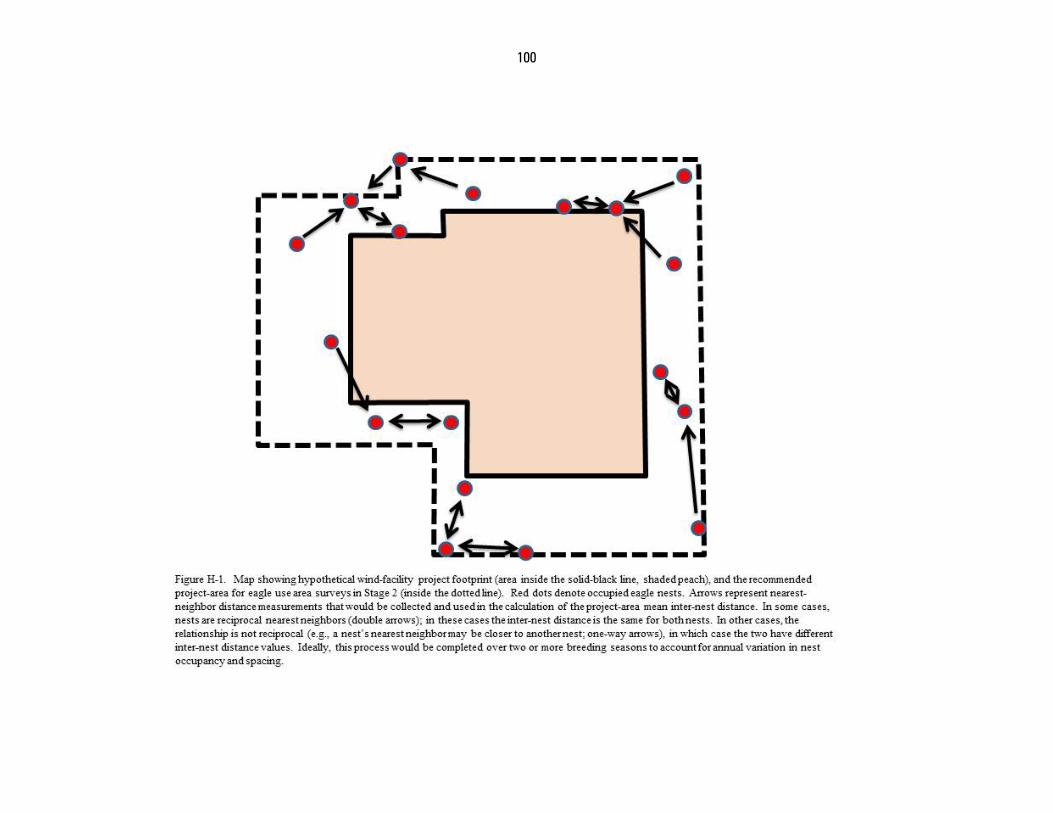
100
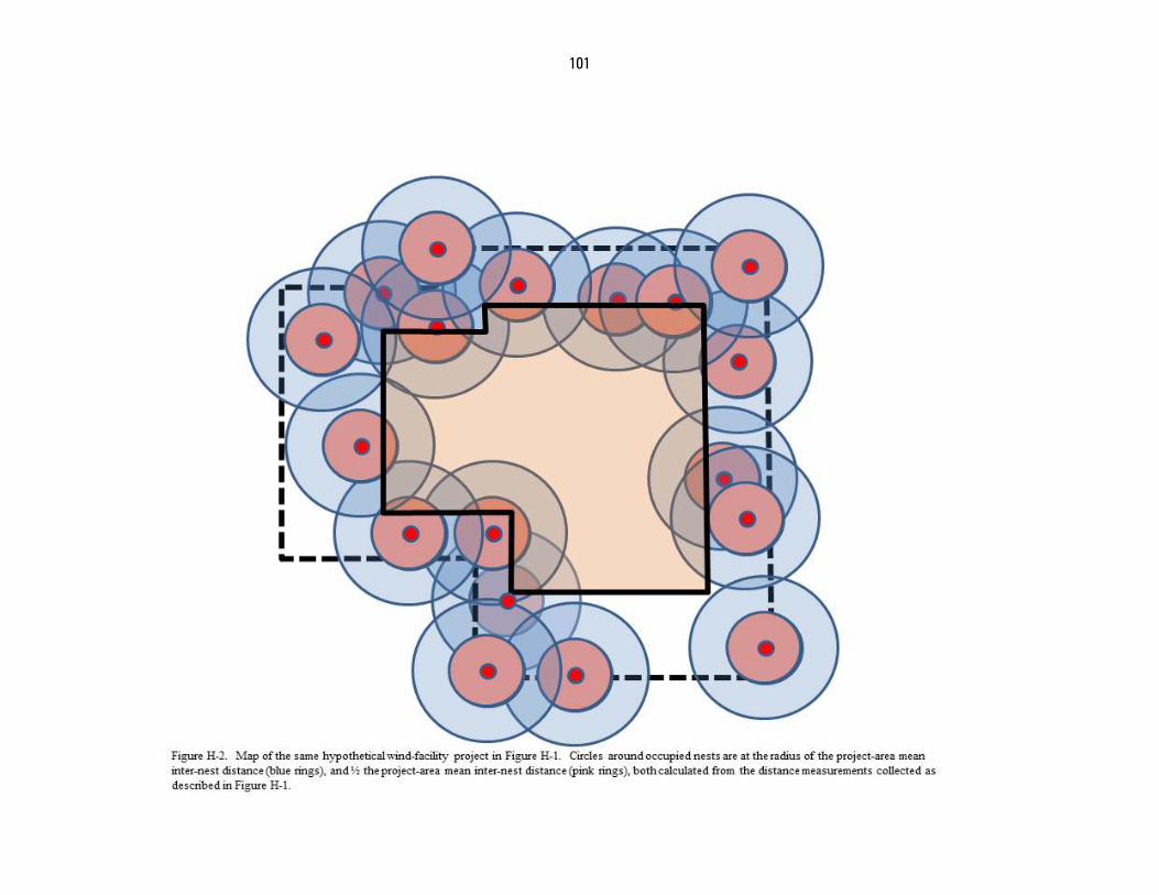
101
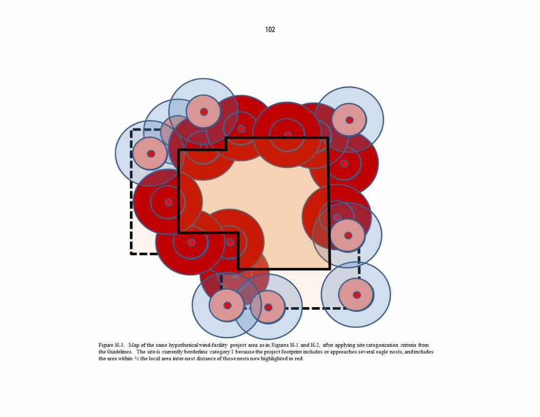
102
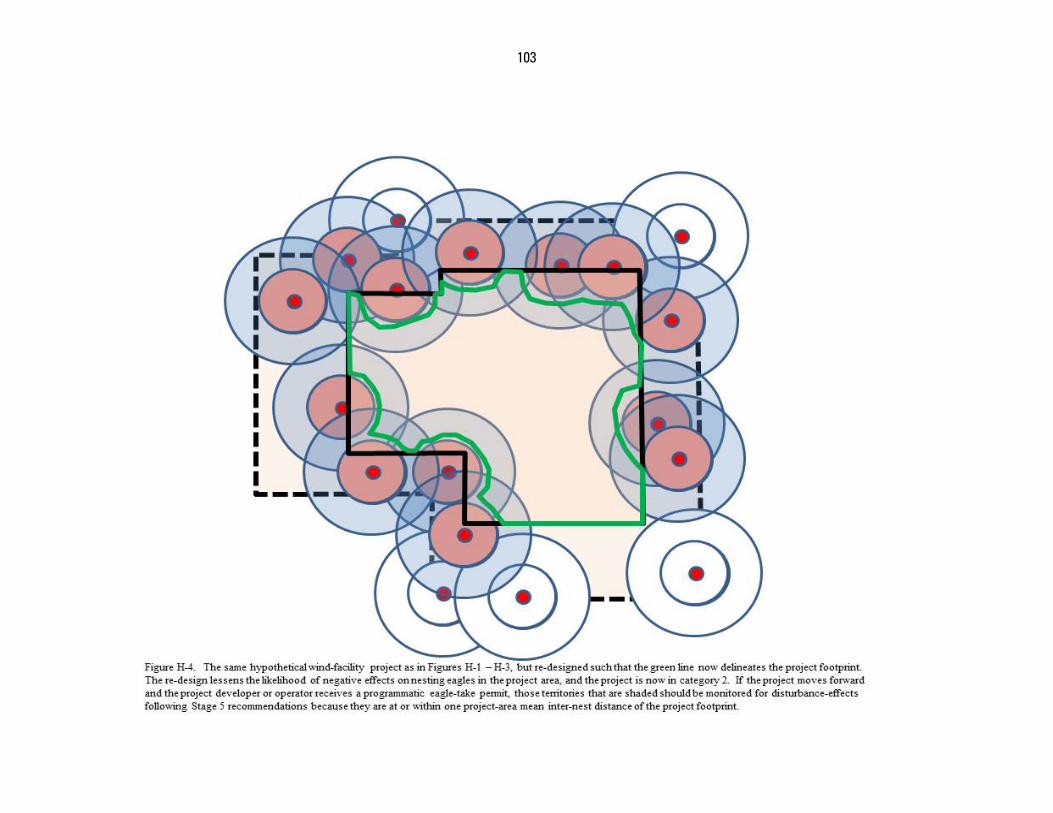
103

U.S. Fish and Wildlife Service Division of Migratory Bird Management
April 2013