drought monitoring with hydrological modelling - … · drought monitoring with hydrological...
TRANSCRIPT
1st Joint EARS/JRC International Drought Workshop, Ljubljana, 21.-25. September 2009 1
Drought Monitoring with Hydrological
Modelling
Stefan Niemeyer
IES - Institute for Environment and Sustainability
Ispra - Italy
http://ies.jrc.ec.europa.eu/
http://www.jrc.ec.europa.eu/
1st Joint EARS/JRC International Drought Workshop, Ljubljana, 21.-25. September 2009 2
Why Modelling?
• (Hydrological) models simulations confirm/reject assumptions
of the (hydrological) system
• if proved to be valuable, the selected aspects of reality can be
reproduced in the chosen spatial and temporal resolution
• information without detailed observation / measurement of the
variables of interest!
• potential for future simulations, forecasting, etc.
• drawback: Calibration & Validation!
1st Joint EARS/JRC International Drought Workshop, Ljubljana, 21.-25. September 2009 3
Hydrological Models
= representation of the hydrological cycle
• precipitation (rain / snow)
• partition on land surface into interception, direct runoff, andinfiltration
• (soil) evaporation, transpiration from vegetation
• soil water balance, soil moisture (vertical flow, lateral?)
• groundwater storage (and flow)
• runoff production (surface runoff, interflow, base flow, …)
• hydraulic routing in the river bed
1st Joint EARS/JRC International Drought Workshop, Ljubljana, 21.-25. September 2009 4
Hydrological Models – spatial scale and resolution
• spatial reference is the river catchment area
• typically regional application (some 1000 km2)
• depending on model type, the region of study is divided into
smaller homogeneous areas
• polygons or regular grids
• grid spatial resolution typically from 100 m to 1-5 km
1st Joint EARS/JRC International Drought Workshop, Ljubljana, 21.-25. September 2009 5
Hydrological Models – temporal scale and resolution
• simulation of days to years and decades
• temporal resolution depending on application:
• hourly to 6-12 hourly for flood modelling
• daily to monthly for water balance estimation
1st Joint EARS/JRC International Drought Workshop, Ljubljana, 21.-25. September 2009 6
Hydrological Models – type of models:
• physically based:
• process oriented, highly parameterized
• statistical models:
• based on statistics rather than physics
• lumped models:
• low spatial differentiation, average values for large areas
• distributed models:
• high spatial differentiation, high resolution input data required
1st Joint EARS/JRC International Drought Workshop, Ljubljana, 21.-25. September 2009 7
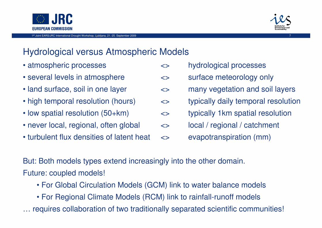
Hydrological versus Atmospheric Models
• atmospheric processes <> hydrological processes
• several levels in atmosphere <> surface meteorology only
• land surface, soil in one layer <> many vegetation and soil layers
• high temporal resolution (hours) <> typically daily temporal resolution
• low spatial resolution (50+km) <> typically 1km spatial resolution
• never local, regional, often global <> local / regional / catchment
• turbulent flux densities of latent heat <> evapotranspiration (mm)
But: Both models types extend increasingly into the other domain.
Future: coupled models!
• For Global Circulation Models (GCM) link to water balance models
• For Regional Climate Models (RCM) link to rainfall-runoff models
… requires collaboration of two traditionally separated scientific communities!
1st Joint EARS/JRC International Drought Workshop, Ljubljana, 21.-25. September 2009 8
Hydrological Model at JRC – LISFLOOD
• a hydrological rainfall-runoff model
• capable of simulating the hydrological processes in a catchment
• developed by the FLOODS Action of IES/JRC
• specific objective to produce a tool for use in large and trans-
national catchments for a variety of applications, including:
• Flood forecasting
• Assessing the effects of river regulation measures
• Assessing the effects of land-use change
• Assessing the effects of climate change
1st Joint EARS/JRC International Drought Workshop, Ljubljana, 21.-25. September 2009 9
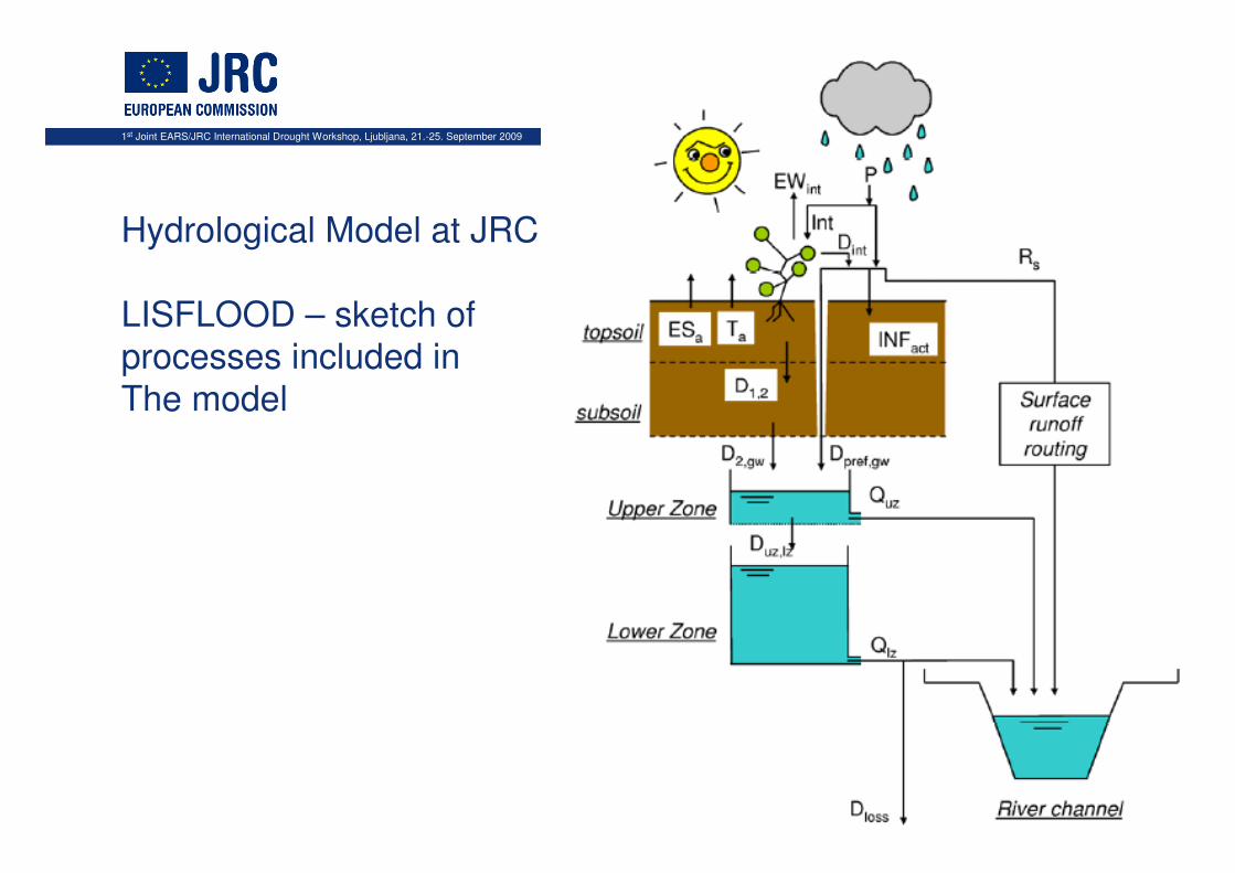
Hydrological Model at JRC:
LISFLOOD – sketch of processes included in
The model
1st Joint EARS/JRC International Drought Workshop, Ljubljana, 21.-25. September 2009 10
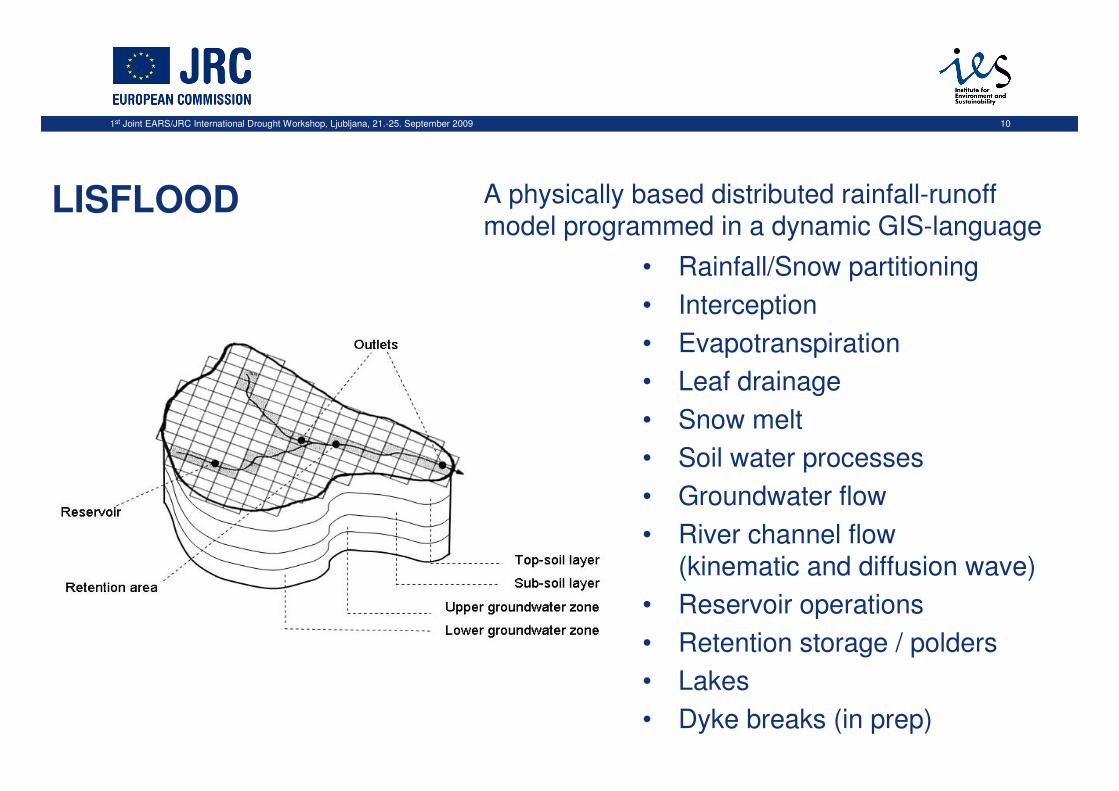
A physically based distributed rainfall-runoff model programmed in a dynamic GIS-language
• Rainfall/Snow partitioning
• Interception
• Evapotranspiration
• Leaf drainage
• Snow melt
• Soil water processes
• Groundwater flow
• River channel flow (kinematic and diffusion wave)
• Reservoir operations
• Retention storage / polders
• Lakes
• Dyke breaks (in prep)
LISFLOOD
1st Joint EARS/JRC International Drought Workshop, Ljubljana, 21.-25. September 2009 11
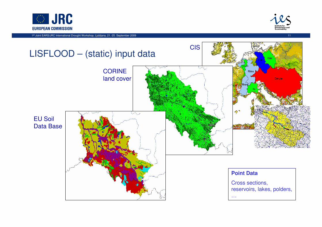
LISFLOOD – (static) input data
CORINE
land cover
EU Soil
Data Base
CIS
Point Data
Cross sections, reservoirs, lakes, polders, …
1st Joint EARS/JRC International Drought Workshop, Ljubljana, 21.-25. September 2009 12
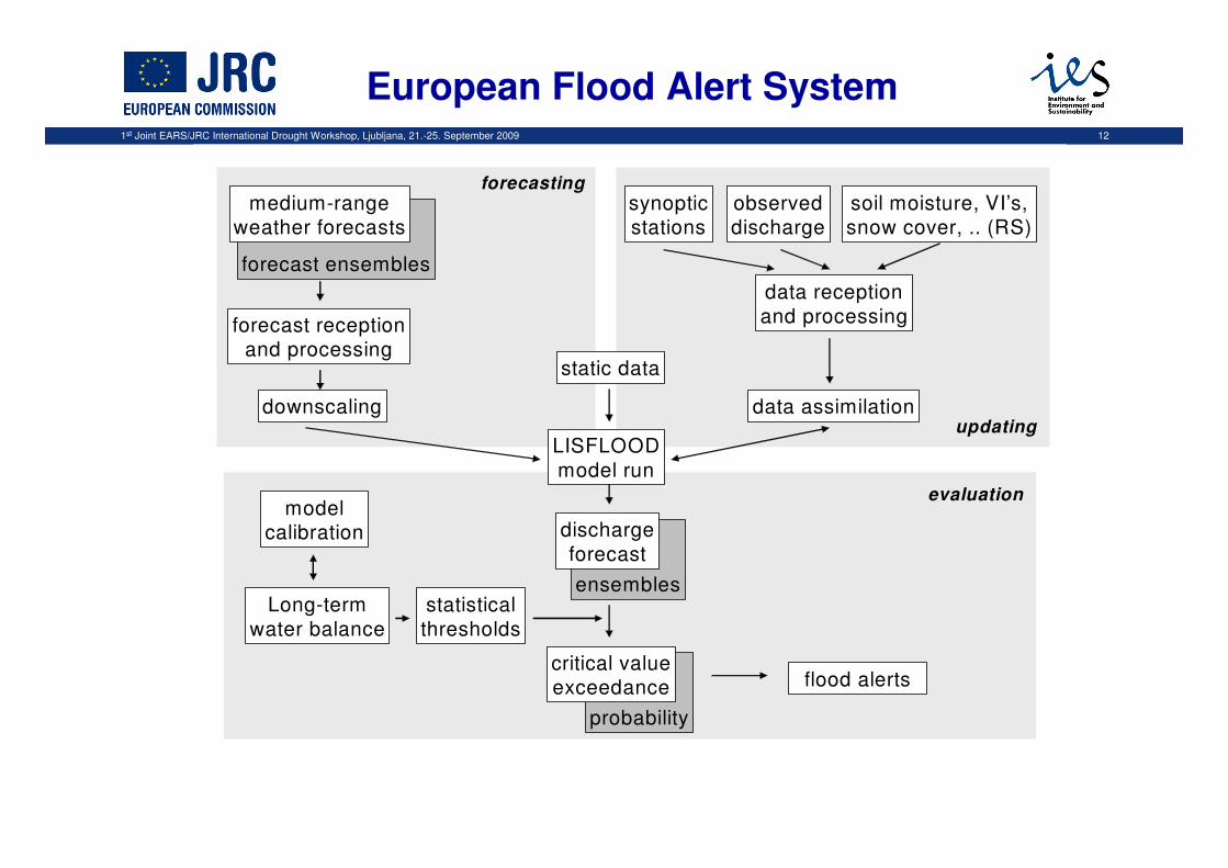
data assimilation
LISFLOOD
model run
static data
Long-term
water balance
forecast ensembles
statistical
thresholds
flood alerts
forecast receptionand processing
ensembles
discharge
forecast
probability
critical valueexceedance
modelcalibration
synopticstations
observeddischarge
soil moisture, VI’s,snow cover, .. (RS)
data reception
and processing
downscalingupdating
forecasting
evaluation
medium-rangeweather forecasts
European Flood Alert System
1st Joint EARS/JRC International Drought Workshop, Ljubljana, 21.-25. September 2009 13
Drought Products from LISFLOOD simulations at JRC
1. low flow estimates• applied to climate change scenarios
2. soil moisture estimates• soil moisture anomaly
• Soil moisture forecasts (medium-range)
Common:• 5 km spatial resolution
• Daily time step
1st Joint EARS/JRC International Drought Workshop, Ljubljana, 21.-25. September 2009 14
Low flow estimates from LISFLOOD
• model driven by high-resolution regional climate simulations
• two periods of each 30 years: end of previous & end of this century
• scenario derived from greenhouse gas emission scenario
A2 of IPCC
• HIRHAM RCM of PRUDENCE project
• 12 km spatial resolution
1st Joint EARS/JRC International Drought Workshop, Ljubljana, 21.-25. September 2009 15
Low flow estimates from LISFLOOD
• simulation of time series of daily discharge
• 7-days moving average, construction of flow duration curve
• derivation of annual minimum flow for 30 years
and both model runs
• block maxima and partial duration series to obtain
minimum flows and flow deficits
scientific publication: Feyen & Dankers (2009) J. Geophys. Res., 114, D17116, 2009
1st Joint EARS/JRC International Drought Workshop, Ljubljana, 21.-25. September 2009 16
LISFLOOD calibration
• 8 parameters controlling:
• infiltration, snowmelt, overland and river flow, residence times in the soil and subsurface reservoirs
• estimated in 231 catchments by calibrating the model against
historical records of river discharge
• at least 4 years between 1995 and 2002
• For catchments without discharge measurements simple regionalization techniques (regional averages)
were applied to obtain the parameters
1st Joint EARS/JRC International Drought Workshop, Ljubljana, 21.-25. September 2009 17
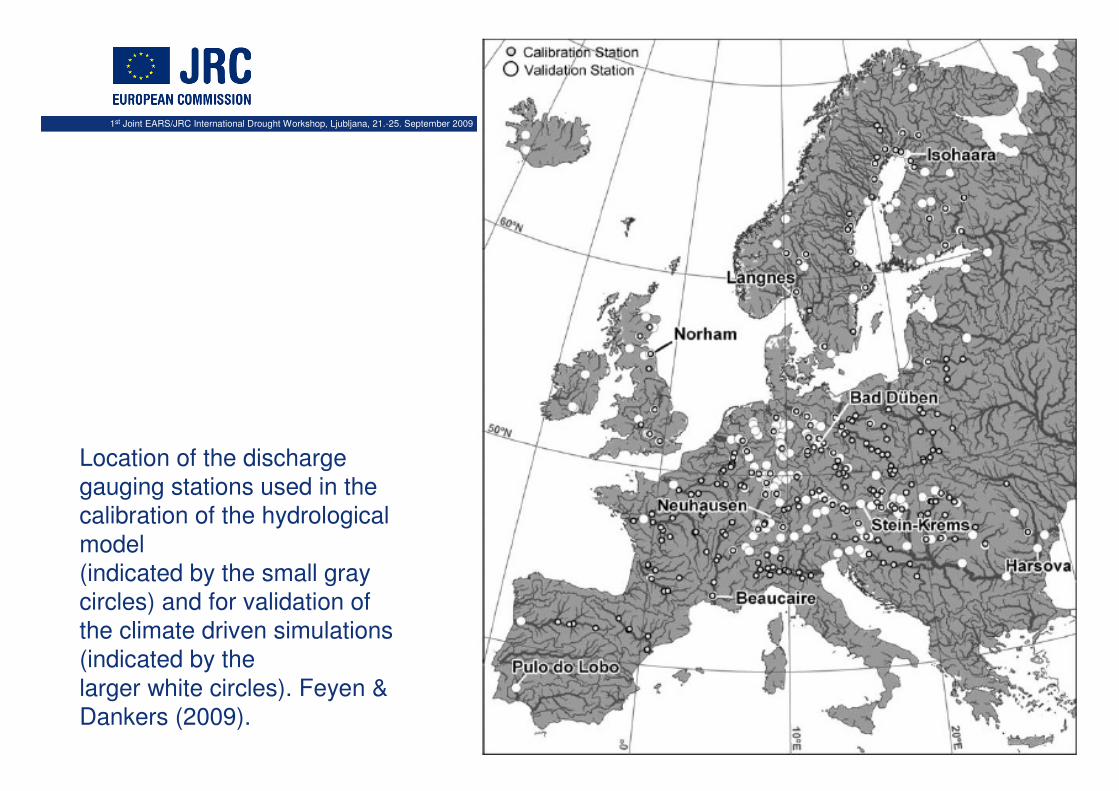
Location of the discharge
gauging stations used in the
calibration of the hydrological
model
(indicated by the small gray
circles) and for validation of
the climate driven simulations
(indicated by the
larger white circles). Feyen &
Dankers (2009).
1st Joint EARS/JRC International Drought Workshop, Ljubljana, 21.-25. September 2009 18
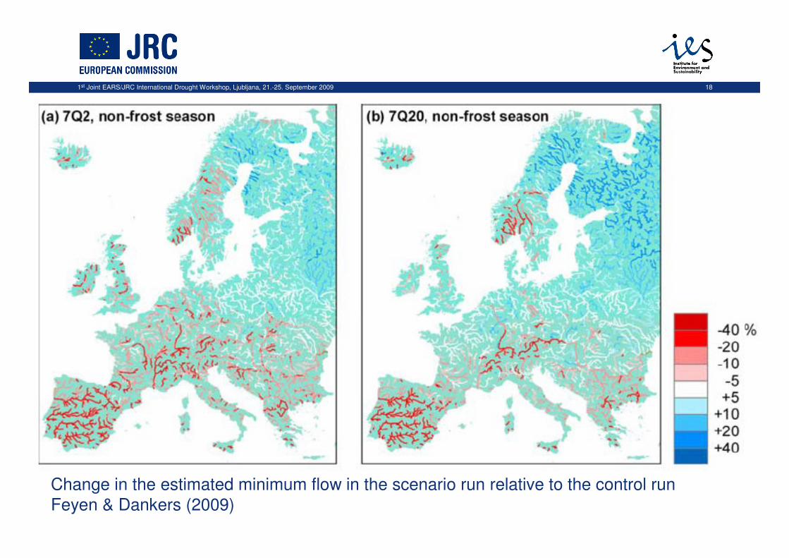
Change in the estimated minimum flow in the scenario run relative to the control run
Feyen & Dankers (2009)
1st Joint EARS/JRC International Drought Workshop, Ljubljana, 21.-25. September 2009 19
Soil moisture estimates from LISFLOOD
• available at EDO
1st Joint EARS/JRC International Drought Workshop, Ljubljana, 21.-25. September 2009 20
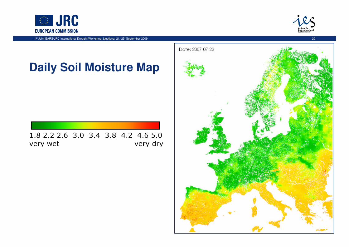
1.8 2.2 2.6 3.0 3.4 3.8 4.2 4.6 5.0
very wet very dry
Daily Soil Moisture Map
1st Joint EARS/JRC International Drought Workshop, Ljubljana, 21.-25. September 2009 21
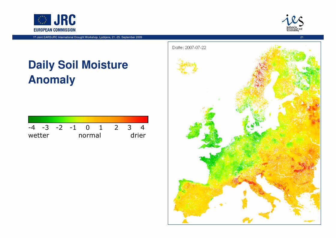
-4 -3 -2 -1 0 1 2 3 4
wetter normal drier
Daily Soil Moisture
Anomaly
1st Joint EARS/JRC International Drought Workshop, Ljubljana, 21.-25. September 2009 22
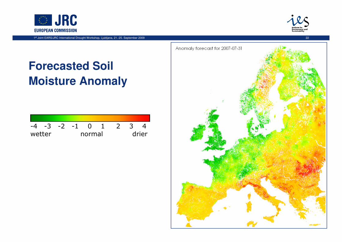
-4 -3 -2 -1 0 1 2 3 4
wetter normal drier
Forecasted Soil
Moisture Anomaly

1st Joint EARS/JRC International Drought Workshop, Ljubljana, 21.-25. September 2009 23
1st Joint EARS/JRC International Drought Workshop, Ljubljana, 21.-25. September 2009 24
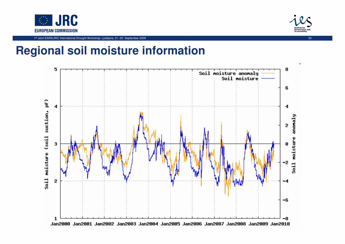
Regional soil moisture information
1st Joint EARS/JRC International Drought Workshop, Ljubljana, 21.-25. September 2009 25
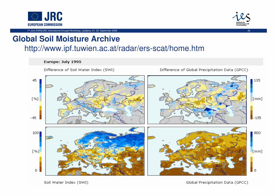
Validation:
• Comparison with independent products on top-soil moisture:• Global Soil Moisture Archive derived from ESA ERS
scatterometer data• Provided by Vienna University of Technology (W. Wagner)
• 1992 – 2000
• daily (Surface wetness) or decadal (Soil Water Index) resolution
• ca. 50 km spatial resolution
1st Joint EARS/JRC International Drought Workshop, Ljubljana, 21.-25. September 2009 26
Global Soil Moisture Archivehttp://www.ipf.tuwien.ac.at/radar/ers-scat/home.htm
1st Joint EARS/JRC International Drought Workshop, Ljubljana, 21.-25. September 2009 27
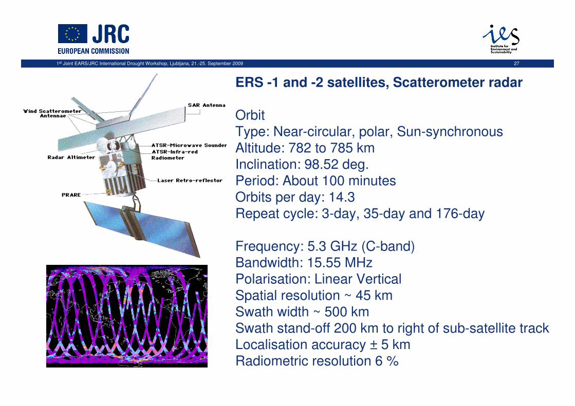
ERS -1 and -2 satellites, Scatterometer radar
OrbitType: Near-circular, polar, Sun-synchronous Altitude: 782 to 785 km Inclination: 98.52 deg. Period: About 100 minutes Orbits per day: 14.3 Repeat cycle: 3-day, 35-day and 176-day
Frequency: 5.3 GHz (C-band) Bandwidth: 15.55 MHz Polarisation: Linear Vertical Spatial resolution ~ 45 kmSwath width ~ 500 kmSwath stand-off 200 km to right of sub-satellite trackLocalisation accuracy ± 5 km Radiometric resolution 6 %
1st Joint EARS/JRC International Drought Workshop, Ljubljana, 21.-25. September 2009 28
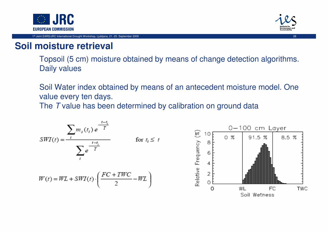
Topsoil (5 cm) moisture obtained by means of change detection algorithms. Daily values
Soil Water index obtained by means of an antecedent moisture model. One value every ten days. The T value has been determined by calibration on ground data
Soil moisture retrieval
1st Joint EARS/JRC International Drought Workshop, Ljubljana, 21.-25. September 2009 29
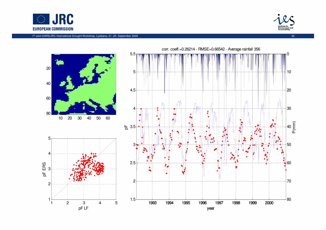
Comparison between LISFLOOD and ERS/SCAT derived soil moisture
estimates:
Correlation and RMSE
Dependency from base information
Variogram analysis
Scaling behaviour
1st Joint EARS/JRC International Drought Workshop, Ljubljana, 21.-25. September 2009 30
10 20 30 40 50 60
20
40
60
80
1 2 3 4 51
2
3
4
5
pF LF
pF
ER
S
1993 1994 1995 1996 1997 1998 1999 2000
0
10
20
30
40
50
60
70
80
year
P(m
m)
1993 1994 1995 1996 1997 1998 1999 20001.5
2
2.5
3
3.5
4
4.5
5
5.5
year
pF
corr. coeff.=0.26214 - RMSE=0.66542 - Average rainfall 356

1st Joint EARS/JRC International Drought Workshop, Ljubljana, 21.-25. September 2009 31
1 2 3 4 51
2
3
4
5month 1
pF ERS
pF
LF
1 2 3 4 51
2
3
4
5month 2
pF ERSpF
LF
1 2 3 4 51
2
3
4
5month 3
pF ERS
pF
LF
1 2 3 4 51
2
3
4
5month 4
pF ERS
pF
LF
1 2 3 4 51
2
3
4
5month 5
pF ERS
pF
LF
1 2 3 4 51
2
3
4
5month 6
pF ERS
pF
LF
1 2 3 4 51
2
3
4
5month 7
pF ERS
pF
LF
1 2 3 4 51
2
3
4
5month 8
pF ERS
pF
LF
1 2 3 4 51
2
3
4
5month 9
pF ERS
pF
LF
1 2 3 4 51
2
3
4
5month 10
pF ERS
pF
LF
1 2 3 4 51
2
3
4
5month 11
pF ERS
pF
LF
1 2 3 4 51
2
3
4
5month 12
pF ERS
pF
LF
1st Joint EARS/JRC International Drought Workshop, Ljubljana, 21.-25. September 2009 32
Legend
rmse
Value
1
0
∑ −=
N
xxN
RMSE2
21 )(1
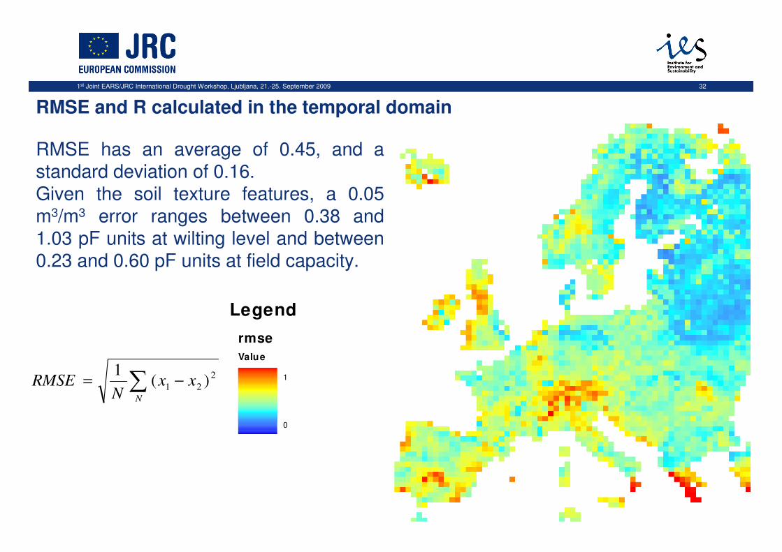
RMSE and R calculated in the temporal domain
RMSE has an average of 0.45, and a standard deviation of 0.16.Given the soil texture features, a 0.05 m3/m3 error ranges between 0.38 and 1.03 pF units at wilting level and between 0.23 and 0.60 pF units at field capacity.
1st Joint EARS/JRC International Drought Workshop, Ljubljana, 21.-25. September 2009 33
Legend
corrcoeff
Value
1
-1
),cov(),cov(
),cov(),(
2211
2121
xxxx
xxxxR
⋅=
∑ −−=
N
xxN
xx ))((1
),cov( 221121 µµ
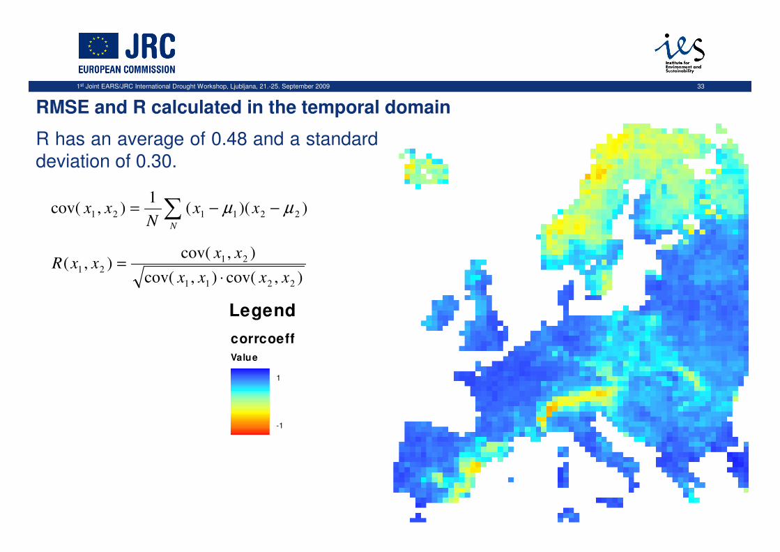
R has an average of 0.48 and a standard deviation of 0.30.
RMSE and R calculated in the temporal domain
1st Joint EARS/JRC International Drought Workshop, Ljubljana, 21.-25. September 2009 34
0 0.5 1 1.5-1
-0.8
-0.6
-0.4
-0.2
0
0.2
0.4
0.6
0.8
1
Corr
el. c
oeff
.
RMSE
1
2
3
4
5
6
Legend
1
2
3
4
5
6
1st Joint EARS/JRC International Drought Workshop, Ljubljana, 21.-25. September 2009 35
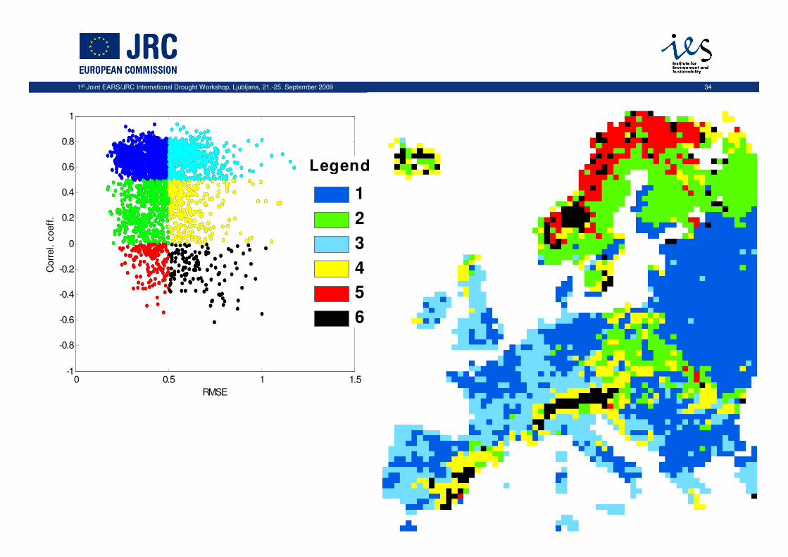
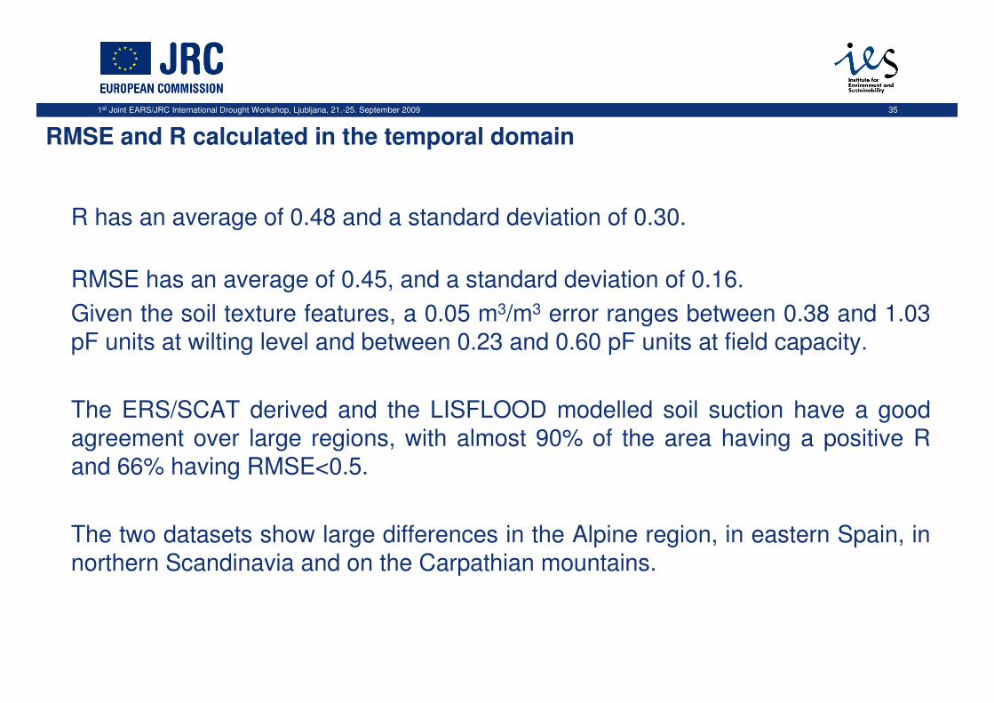
R has an average of 0.48 and a standard deviation of 0.30.
RMSE has an average of 0.45, and a standard deviation of 0.16.
Given the soil texture features, a 0.05 m3/m3 error ranges between 0.38 and 1.03 pF units at wilting level and between 0.23 and 0.60 pF units at field capacity.
The ERS/SCAT derived and the LISFLOOD modelled soil suction have a good agreement over large regions, with almost 90% of the area having a positive R and 66% having RMSE<0.5.
The two datasets show large differences in the Alpine region, in eastern Spain, in northern Scandinavia and on the Carpathian mountains.
RMSE and R calculated in the temporal domain
1st Joint EARS/JRC International Drought Workshop, Ljubljana, 21.-25. September 2009 36
Comparison between LISFLOOD and ERS/SCAT derived soil moisture
estimates:
Correlation and RMSE
Dependency from base information
Variogram analysis
Scaling behaviour
1st Joint EARS/JRC International Drought Workshop, Ljubljana, 21.-25. September 2009 37
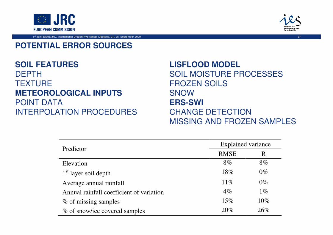
POTENTIAL ERROR SOURCES
SOIL FEATURESDEPTHTEXTUREMETEOROLOGICAL INPUTSPOINT DATAINTERPOLATION PROCEDURES
LISFLOOD MODELSOIL MOISTURE PROCESSESFROZEN SOILSSNOWERS-SWICHANGE DETECTIONMISSING AND FROZEN SAMPLES
Explained variance Predictor
RMSE R
Elevation 8% 8%
1st layer soil depth 18% 0%
Average annual rainfall 11% 0%
Annual rainfall coefficient of variation 4% 1%
% of missing samples 15% 10%
% of snow/ice covered samples 20% 26%
1st Joint EARS/JRC International Drought Workshop, Ljubljana, 21.-25. September 2009 38
Comparison between LISFLOOD and ERS/SCAT derived soil moisture
estimates:
Correlation and RMSE
Dependency from base information
Variogram analysis
Scaling behaviour
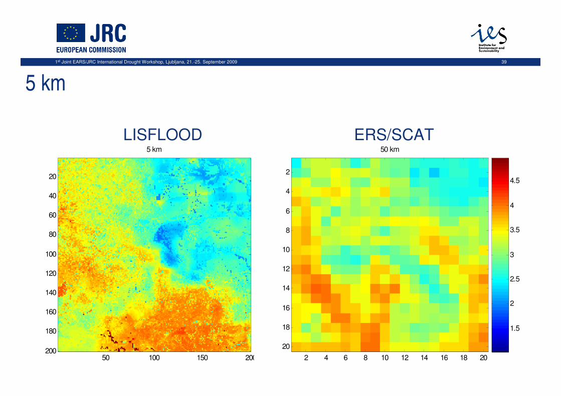
1st Joint EARS/JRC International Drought Workshop, Ljubljana, 21.-25. September 2009 39
5 km
5 km
50 100 150 200
20
40
60
80
100
120
140
160
180
200
1.5
2
2.5
3
3.5
4
4.5
50 km
2 4 6 8 10 12 14 16 18 20
2
4
6
8
10
12
14
16
18
20
1.5
2
2.5
3
3.5
4
4.5
LISFLOOD ERS/SCAT
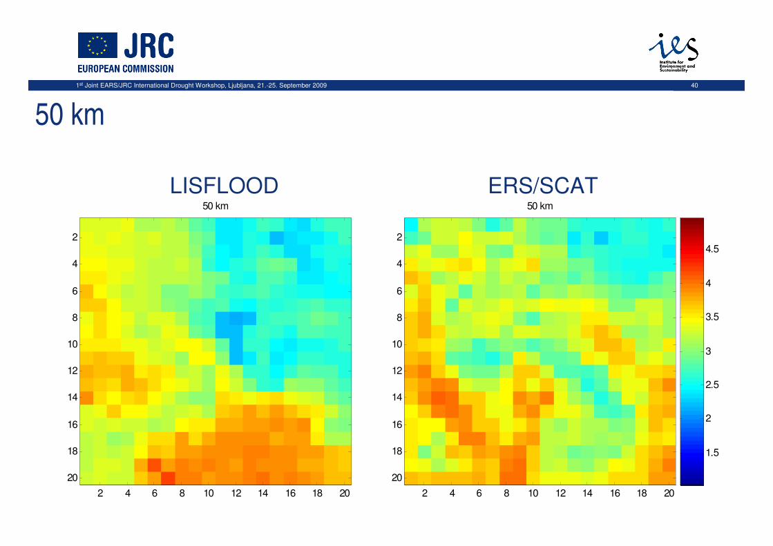
1st Joint EARS/JRC International Drought Workshop, Ljubljana, 21.-25. September 2009 40
50 km
50 km
2 4 6 8 10 12 14 16 18 20
2
4
6
8
10
12
14
16
18
20
1.5
2
2.5
3
3.5
4
4.5
50 km
2 4 6 8 10 12 14 16 18 20
2
4
6
8
10
12
14
16
18
20
1.5
2
2.5
3
3.5
4
4.5
LISFLOOD ERS/SCAT
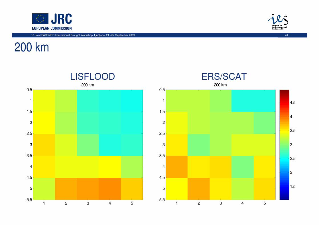
1st Joint EARS/JRC International Drought Workshop, Ljubljana, 21.-25. September 2009 41
200 km
200 km
1 2 3 4 5
0.5
1
1.5
2
2.5
3
3.5
4
4.5
5
5.5
1.5
2
2.5
3
3.5
4
4.5
200 km
1 2 3 4 5
0.5
1
1.5
2
2.5
3
3.5
4
4.5
5
5.5
1.5
2
2.5
3
3.5
4
4.5
LISFLOOD ERS/SCAT
1st Joint EARS/JRC International Drought Workshop, Ljubljana, 21.-25. September 2009 42
The ERS SWI derived and the LISFLOOD modelled soil suction have a good agreement over large regions, with almost 90% of the area having a positive R and 66% having RMSE<0.5.
The two datasets show large differences in the Alpine region, in eastern Spain, in northern Scandinavia and on the Carpathian mountains.
Final remarks
1st Joint EARS/JRC International Drought Workshop, Ljubljana, 21.-25. September 2009 43
Outlook
• implement “best-calibrated” version of LISFLOOD with focus on
soil moisture estimates
• look for alternative land surface schemes that include processes
missing in LISFLOOD, but relevant for droughts (e.g. capillary rise)
• first pilot study on comparison of LS models:
• changing requirements, now also towards global applications
• additional drought information derived e.g. from ET estimates (EF?)
• resulting in the recommendation of the Community Land Model CLM3.0
(http://www.cgd.ucar.edu/tss/clm/)
• increasing availability of RS products on soil moisture
• ERS/Metop (Eumetsat SAF), SMOS (ESA 2009), SMAP (NASA 2014)
• further comparison and verification, data assimilation?

1st Joint EARS/JRC International Drought Workshop, Ljubljana, 21.-25. September 2009 44
… thank you!