drought - by arpit jain
TRANSCRIPT

Drought:“a protracted period of deficient precipitation resulting in extensive damage to crops, resulting in loss of yield”
Hazard profile: slow onset prolonged duration widespread

Drought and aridityThe social and economic costs of
drought are greatest in climates close to the margins of agricultural or
pastoral production (e.g. in subhumid areas* rather than hyperarid or
perhumid areas)

Mean annual water balance (Medicine Hat, Alberta)
Ann. P =327 mm, Ann. PET = 525 mm Aridity Index = 0.61 = "dry subhumid"
0
50
100
150
200
jan feb mar apr may jun jul aug sep oct nov dec
month
mm
P
PET
DEFICIT
Mean annual water balance (Lima, Peru)
Ann. P =13 mm, Ann. PET = 1041 mm Aridity Index = 0.01 = "hyperarid"
0
50
100
150
200
jan feb mar apr may jun jul aug sep oct nov dec
month
mm
P
PET
DEFICIT
Mean annual water balance (Juneau, Alaska)
Ann. P =1480 mm, Ann. PET = 469 mm Aridity Index = 3.15 = "perhumid"
0
50
100
150
200
jan feb mar apr may jun jul aug sep oct nov dec
month
mm P
PET
DEFICIT
hyperarid arid semi-arid dry subhumid humid…………..perhumid 8% 12% 18% 10 % 52%
AI 0.05 0.20 0.50 0.65
Aridity Index: = P/PET [UNEP,
1992] anddrought risk

Drought: some early operational definitions
• Great Britain (1936): 15 consecutive days with daily precipitation totals of less than .25 mm
• United States (1942): less than 2.5 mm of rainfall in 48 hours
• India (1960): actual seasonal rainfall deficient by more than twice the mean deviation
• Bali (1964): a period of six days without rain• Libya (1964): annual rainfall less than 180 mm
Note: locally-specific criteria

Drought indices• Standardized Precipitation Index
(a probabilistic index based on rainfall amount compared to normals for the same period)
• Palmer Drought Severity Index(based principally on antecedent rainfall and temperature)
• Palmer Crop Moisture Index (based on measured soil moisture vs. normal amount)

Current SPI and PDSI maps (North America)

Drought - damages DirectDirect⇒ loss of income⇒ social dislocation⇒ famine/malnutrition/death
IndirectIndirect⇒ loss of rural and urban revenues⇒ fire hazard, loss of water access

Drought climatology⇒ Temperate climates - influence of blocking
highs in zone of westerlies
⇒ Seasonal tropical climates - influence of ITCZ position on monsoon penetration
⇒ Humid tropical climates - influence of El Niño - Southern Oscillation

Storm tracks, blocking highs and drought in the Canadian Prairies
zonal flow:no drought
drought inAlberta
drought inManitoba
droughtthroughout

Aridity Index: Canadian prairie provinces
Medicine Hat
Alberta
Sask.Manitoba
Winnipeg
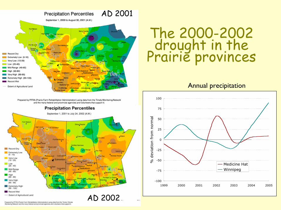
The 2000-2002 drought in the
Prairie provinces
AD 2001
AD 2002
-100
-75
-50
-25
0
25
50
75
100
1999 2000 2001 2002 2003 2004 2005
% d
evia
tion fro
m n
orm
al
Medicine HatWinnipeg
Annual precipitation

Consequences of the 2000 - 2002 drought
� “the persistent dryness, coupled with record high temperatures and grasshopper infestations, means many farmers will be bowing out of the 2002 crop season early” Edmonton Journal, July 26, 2002
� Alberta provincial government announces $324 M in drought aid; Saskatchewan to follow Alberta’s lead;
� Farmers sell off beef herds, accused of dumping beef in BC;
� Federal government arranges to pay for hay shipments from Ontario, then stops shipment because of potential cereal beetle infestation.
Drought loss of farm income

Drought in monsoon climates:the Sahel
Inter-Tropical Front /Inter-Tropical Convergence Zone
Population density(orange >25 people km-2)
Source: www.mapjourney.com/sahel/
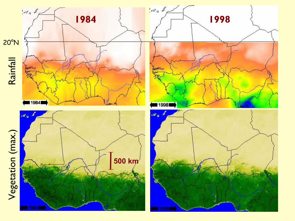
Drought in monsoon climates:the Sahel
Veg
etat
ion
(max
.)
Rai
nfal
l1984 1998
500 km
20°N

Hypotheses to explain Sahelian drought
“Climatological” - northward penetration of ITCZ controlled by variations in atmospheric temperature in northern tropics, due to:
1. SST anomalies in northeastern Atlantic linked to general circulation (especially El Niño/La Niña), or
2. Industrial pollution (particularly SO2 aerosols) from N.America, Europe and Asia (intense drought of 1970-85).
“Anthropogenic” - changes in vegetation and surface albedo caused by varying land-use result in changes in regional climate.
All of these may be influenced by global warming

vegetation
Rapp’s albedo feedback model
rainfall
grazers

SAHEL
DroughtDrought� 5M people affected; >200K died from
malnutrition and associated diseases� Livestock herds decimated (80% died)� Loss of livestock � loss of wealth �
massive social dislocation and emigration to urban areas

Effects of 1997-98 drought in IndonesiaAgricultural production:20 - 30% reduction of rice crop in eastern Indonesia (parts of Kalimantan, Sulawesi and Irian Jaya. Markedly lower yam production in Irian Jaya.In some villages in the latter 20-30% of people died from malnutrition; 95% incidence of malaria reported. Conditions not as severe in western Indonesia (e.g. rice production only dropped 6% in Sumatra)