
UPDATED PHASE I ENVIRONMENTAL SITE ASSESSMENT
RTD PARCELS 1079 AMES STREET,
5375 WEST 10TH AVENUE, AND A PORTION OF 1050 AMES STREET
DENVER, COLORADO, 80214
Prepared For Exclusive Use by: Urban Land Conservancy
305 Park Avenue West Denver, CO 80205
Prepared By: Molen & Associates, LLC 2090 E. 104th Ave., #205
Thornton, CO 80233 303-450-1600
January 2, 2014

COMMON ABBREVIATIONS
ACM Asbestos Containing Material DOT Department of Transportation (Federal) AHERA Asbestos Hazard Emergency Response Act (see TSCA) ECRA Environmental Cleanup Responsibility Act ALARA As Low As Reasonably Achievable EIS Environmental Impact Statement (NEPA) AMSL Above Mean Sea Level EPA Environmental Protection Agency ANSI American National Standards Institute EPA # Generator # for RCRA manifesting (Federal) AOC Area of Concern EPCRA Emergency Planning & Community Right-to-Know Act AOPC Area of Potential Concern EPTOX Extraction Procedure Toxicity Test (RCRA) APC Air Pollution Control ERNS Emergency Response Notification System API American Petroleum Institute ESA Environmental Site Assessment ARAR Applicable, Relevant of Appropriate Requirement ESH Environmental Health & Safety AST Aboveground Storage Tank eV Electron Volts ASTM American Society for Testing & Materials FDA Food & Drug Administration (Federal) ATSDR Agency for Toxic Substances & Disease Registry FEMA Federal Emergency Management Agency AUL Colorado Environmental Real Covenants List FIFRA Federal Insecticide, Fungicide, & Rodenticide Act BACT Best Available Control Technology FINDS Facilities Index System, an EPA database of information BAT Best Available Technology FOIA Freedom of Information Act (Federal) BBL Barrel FR Federal Register BGS Below Ground Surface FS Feasibility Study (CERCLA) BMP Best Management Practice g Gram BOD Biochemical or Biological Oxygen Demand gal Gallon BPT Best Practicable Control Technology Currently Available
(CCAA) GC Gas Chromatography
BTEX Benzene, Toluene, Ethylbenzene & Xylene GC/MS Gas Chromatography/Mass Spectrometry CA Corrective Action GIS Geographical Information System CAA Clear Air Act, 42 USC Section 7401 et seq. (Federal) GW Ground Water CAMU Corrective Action Management Units (RCRA) GWM Ground Water Monitoring CAP Corrective Action Plan HAPs Hazardous Air Pollutants CAS Chemical Abstract Service HAZMAT Hazardous Materials CBI Confidential Business Information HAZWOPER Hazard Waste Operator Training Cd Cadmium HCFCs Hydrochlorofluorocarbons CD Certificate of Designation (Landfill Permit – Colorado) HCS Hazard Communication Standard (OSHA) CDPHE Colorado Department of Public Health and Environment HHW Household Hazardous Waste CDS Compliance Data System HMWMD Hazardous Materials & Waste Management Division CEI Certified Environmental Inspector HOC Halogenated Organic Compounds CERCLA Comprehensive Environmental Response, Compensation
& Liability Act (Superfund) HRS Hazard Ranking System
CERCLIS Comprehensive Environmental Response, Compensation, & Liability Information System
HREC Historic Recognized Environmental Condition
CESQG Conditionally Exempt Small Quality Generators HS Hazardous Substance CFCs Chlorofluorocarbons HSP Health & Safety Plan CFR Code of Federal Regulations HSWA Hazardous & Solid Waste Amendments (RCRA) CESQG Conditionally Exempt Small Quantity Generator (RCRA) HW Hazardous Waste CHEMTREC Chemical Transportation Emergency Center HWIS Hazardous Waste Information System (DTSC) CHMM Certified Hazardous Material Manager IAQ Indoor Air Quality CHRIS Chemical Hazards Response Information System IRIS Integrated Risk Information System CM Corrective Measure ISO International Standards Organization CMS Corrective Measures Study (RCRA Corrective Action) L Liter CO Carbon Monoxide lbs Pounds COD Chemical Oxygen Demand LD50 Lethal Dose Level 50% CORRACTS Corrective Action Report System LEL Lower Explosive Limit CO VCUP Colorado Voluntary Cleanup Program LPG Liquefied Petroleum Gas COPC Chemical of Potential Concern LQG Large Quantity Generator (RCRA) Cr Chromium LT RBSL Lower Than Risk Base Screening Levels (RBSL) CRCPD Conference of Radiation Control Program Directors LUST Leaking Underground Storage Tank CRR Colorado Rules & Regulations Pertaining to Radiation
Control m Milli
CSEV Colorado Soil Evaluation Values – CDPHE MACT Maximum Available Control Technology CTS Certified Testing Specialist MCL Maximum Concentration Limits or Levels (SDWA) Cu Copper MCLGs Maximum Contaminant Level Goals (SDWA) CWA Clean Water Act or FWPCA MEK Methyl Ethyl Ketone (2-butanone) – VOC DCE Dichloroethylene, a VOC ml Milliliter DNR Department of Natural Resources MNA Monitored Natural Attenuation – Remediation Method DNAPL Dense Non-Aqueous Phase Liquid MSDS Material Safety Data Sheets

COMMON ABBREVIATIONS
DOE US Department of Energy MSW Municipal Solid Waste MSWLF Municipal Solid Waste Landfill RCIRS RCRA Information System-Database of Hazardous
Waste Handlers MTBE Methyl (tertiary butyl) Ether REC Recognized Environmental Condition MW Monitoring Well RFI RCRA Facility Investigation NAD No Action Determination RI/FS Remedial Investigation/Feasibility Study NCP National Contingency Plan (CERCLA) ROD Record of Decision (CERCLA) NFA No Further Action RQ Reportable Quantity (DOT, CERCLA & SARA Title III) NE Northeast SAP Sampling & Analysis Plan NEIC National Enforcement Investigations Center EPA SARA Superfund Amendments & Reauthorization Act of 1986
(CERCLA) NEPA National Environmental Policy Act SARA Title
III Emergency Preparedness & Community Right-to-Know Section of SARA, aka EPCR
NESHAPs National Emission Standards for Hazardous Air Pollutants (CAA)
SCR Site Characterization Report
NFRAP No Further Action Planned for CERCLIS sites SCBA Self Contained Breathing Apparatus NFPA National Fire Protection Association SDWA Safe Drinking Water Act NIOSH National Institute for Occupational Safety & Health s.f. Square foot NLR No Longer Reporting, for previous RCRA Generators SGS Soil Gas Survey NORM Naturally Occurring Radioactive Material SIC Standard Industrial Classification NOV Notice and Violation SIP State Implementation Plan (CAA) NPDES National Pollutant Discharge Elimination System SPCC Spill, Prevention, Containment & Counter-measures NPL National Priority List (CERCLA) SQG Small Quantity Generator (less than 100kg/mo) NRC National Response Center (Federal) SW Solid Waste NTIS National Technical Information Service SWMP Stormwater Monitoring Program NW Northwest SVE Soil Vapor Extraction O&M Operation & Maintenance SVOC Semi-Volatile Organic Compounds OPS Office of Public Safety at the Colorado Labor and
Employment TCA 1,1,1-Trichloroethane-VOC
OSHA Occupational Safety & Health Administration TCLP Toxicity Characteristic Leaching Procedure-RCRA OSW Office of Solid Waste (EPA) TCE Trichloroethylene or Trichloroethene OSWER Office of Solid Waste & Emergency Response TCHD Tri-County Health Department PAH Polynuclear Aromatic Hydrocarbons TDS Total Dissolved Solids PA/SI Preliminary Assessment/Site Investigation TENORM Technologically Enhanced Naturally Occurring
Radioactive Materials PCB Polychlorinated Biphenyl TOC Total Organic Carbon PCE Perchloroethylene TOD Total Oxygen Demand pCi Picocurie (a measure of radiation) TPH Total Petroleum Hydrocarbons PCP Pentachlorophenol-SVOC TPQ Threshold Planning Quantity (SARA Title III) PEL Permissible Exposure Limits (OSHA) TRI Toxic Release Inventory PH Petroleum Hydrocarbons TSCA Toxic Substance Control Act PID Photo-ionization Detector TSD Treatment, Storage, & Disposal POE Point of Exposure TSDF Treatment, Storage, Disposal Facility POTW Publicly Owned Treatment Works TSS Total Suspended Solids PPB Parts Per Billion TTO Total Toxic Organics PPM Parts Per Million UBC Uniform Building Code Property Subject Property (Property) UFC Uniform Fire Code PRP Potentially Responsible Party (Superfund) USDW Underground Source of Drinking Water (SDWA) PSA Preliminary Site Assessment US EPA U.S. Environmental Protection Agency QA/QC Quality Assurance/Quality Control USGS U.S. Geological Survey QNCR Quarterly Non Compliance Report UST Underground Storage Tank RA Risk Assessment VCP Voluntary Cleanup Program, State Enforced by CDPHE RAP Remedial Action Plan (Superfund) VCUP Voluntary Cleanup Program, State Enforced by CDPHE RBSL Risk-based Screening Level, corrective action levels for
chemicals of concern for Colorado Department of Oil and Public Safety
VOC Volatile Organic Compound chemical IUPAC names
QA/QC Quality Assurance/Quality Control WQCD Water Quality Control Division QNCR Quarterly Non Compliance Report WWTP Wastewater Treatment Plant RA Risk Assessment y Year RAP Remedial Action Plan (Superfund) RCRA Resource Conservation & Recovery Act

1079 Ames St, 5375 W 10th Ave, and portion of 1050 Ames St Phase I ESA Molen & Associates, LLC - i -
TABLE OF CONTENTS 1.0 Executive Summary ................................................................................................ 3 2.0 Introduction ............................................................................................................. 5
2.1 Purpose ................................................................................................................ 5 2.2 Scope of services................................................................................................. 5 2.3 Significant Assumptions ..................................................................................... 6 2.4 Limitations and Exceptions................................................................................. 6 2.5 Deviations from ASTM Standard ....................................................................... 7 2.6 User Reliance ...................................................................................................... 7
3.0 Subject Property Description .................................................................................. 9 3.1 Location and Legal Description .......................................................................... 9 3.2 Physical Setting ................................................................................................... 9 3.3 Geology and Hydrogeology ................................................................................ 9 3.4 Subject Property and Vicinity Characteristics .................................................. 10 3.5 Current Subject Property Structures and Improvements .................................. 10 3.6 Current Uses of the Subject Property................................................................ 10
4.0 Historical Background .......................................................................................... 11 4.1 Subject Property ................................................................................................ 11 4.2 Historical Topographic Maps ........................................................................... 12 4.3 Historical Aerial Photography .......................................................................... 12 4.4 Adjoining Properties ......................................................................................... 12 4.5 Local Historical Fire Department Information ................................................. 13 4.6 Historically Significant or Environmental Findings ......................................... 13
5.0 Regulatory Database Review ................................................................................ 14 5.1 Summary of Standard Database Listings .......................................................... 14 5.2 Listings on Property and Adjoining Properties ................................................. 15 5.3 Listings within 1/8-mile .................................................................................... 15 5.4 Other Notable Listings ...................................................................................... 16
5.4.1. NPL, RCRAC, NLRRCRAC, and HWSCA Listings ............................... 16 5.4.2. CERCLIS, NFRAP, and VCRA Listings ................................................. 18 5.4.3. Solid Waste Listings ................................................................................. 18 5.4.4. Tank Leak Listings ................................................................................... 20 5.4.5. Tank Listings ............................................................................................ 20 5.4.6. RCRAGR08 and RCRANGR08 Listings ................................................. 21 5.4.7. Brownfields Management System Sites ................................................... 22
5.5 Unlocatable Sites .............................................................................................. 23 6.0 User Provided Information ................................................................................... 24
6.1 Environmental Liens ......................................................................................... 24 6.2 Activity and Use Limitations ............................................................................ 24 6.3 Environmental Reports or Investigations.......................................................... 24 6.4 Experience or Specialized Knowledge of User ................................................ 24 6.5 Relationship of the Purchase Price to the Fair Market Value ........................... 24 6.6 Reasonably Ascertainable Information about the Property .............................. 24 6.7 Obvious Presence or Likely Presence of Contamination .................................. 24
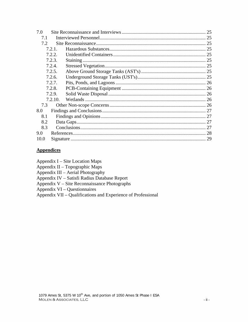
1079 Ames St, 5375 W 10th Ave, and portion of 1050 Ames St Phase I ESA Molen & Associates, LLC - ii -
7.0 Site Reconnaissance and Interviews ..................................................................... 25 7.1 Interviewed Personnel ....................................................................................... 25 7.2 Site Reconnaissance .......................................................................................... 25
7.2.1. Hazardous Substances ............................................................................... 25 7.2.2. Unidentified Containers ............................................................................ 25 7.2.3. Staining ..................................................................................................... 25 7.2.4. Stressed Vegetation ................................................................................... 25 7.2.5. Above Ground Storage Tanks (AST's) ..................................................... 25 7.2.6. Underground Storage Tanks (UST's) ........................................................ 25 7.2.7. Pits, Ponds, and Lagoons .......................................................................... 26 7.2.8. PCB-Containing Equipment ..................................................................... 26 7.2.9. Solid Waste Disposal ................................................................................ 26 7.2.10. Wetlands ................................................................................................... 26
7.3 Other Non-scope Concerns ............................................................................... 26 8.0 Findings and Conclusions ..................................................................................... 27
8.1 Findings and Opinions ...................................................................................... 27 8.2 Data Gaps .......................................................................................................... 27 8.3 Conclusions ....................................................................................................... 27
9.0 References ............................................................................................................. 28 10.0 Signature ............................................................................................................... 29 Appendices Appendix I – Site Location Maps Appendix II – Topographic Maps Appendix III – Aerial Photography Appendix IV – Satisfi Radius Database Report Appendix V – Site Reconnaissance Photographs Appendix VI – Questionnaires Appendix VII – Qualifications and Experience of Professional
1079 Ames St, 5375 W 10th Ave, and portion of 1050 Ames St Phase I ESA Molen & Associates, LLC - 3 -
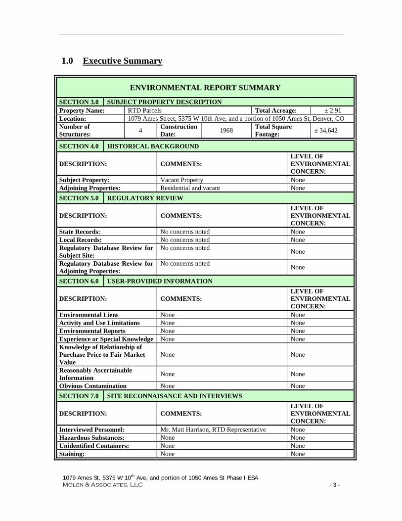
1.0 Executive Summary
ENVIRONMENTAL REPORT SUMMARY
SECTION 3.0 SUBJECT PROPERTY DESCRIPTION Property Name: RTD Parcels Total Acreage: ± 2.91 Location: 1079 Ames Street, 5375 W 10th Ave, and a portion of 1050 Ames St, Denver, CO Number of Structures:
4 Construction Date:
1968 Total Square Footage:
± 34,642
SECTION 4.0 HISTORICAL BACKGROUND
DESCRIPTION: COMMENTS: LEVEL OF ENVIRONMENTAL CONCERN:
Subject Property: Vacant Property None Adjoining Properties: Residential and vacant None SECTION 5.0 REGULATORY REVIEW
DESCRIPTION: COMMENTS: LEVEL OF ENVIRONMENTAL CONCERN:
State Records: No concerns noted None Local Records: No concerns noted None Regulatory Database Review for Subject Site:
No concerns noted None
Regulatory Database Review for Adjoining Properties:
No concerns noted None
SECTION 6.0 USER-PROVIDED INFORMATION
DESCRIPTION: COMMENTS: LEVEL OF ENVIRONMENTAL CONCERN:
Environmental Liens None None Activity and Use Limitations None None Environmental Reports None None Experience or Special Knowledge None None Knowledge of Relationship of Purchase Price to Fair Market Value
None None
Reasonably Ascertainable Information
None None
Obvious Contamination None None SECTION 7.0 SITE RECONNAISANCE AND INTERVIEWS
DESCRIPTION: COMMENTS: LEVEL OF ENVIRONMENTAL CONCERN:
Interviewed Personnel: Mr. Matt Harrison, RTD Representative None Hazardous Substances: None None Unidentified Containers: None None Staining: None None

1079 Ames St, 5375 W 10th Ave, and portion of 1050 Ames St Phase I ESA Molen & Associates, LLC - 4 -
ENVIRONMENTAL REPORT SUMMARY
SECTION 7.0 SITE RECONNAISANCE AND INTERVIEWS (continued)
DESCRIPTION: COMMENTS: LEVEL OF ENVIRONMENTAL CONCERN:
Stressed Vegetation: None None Aboveground Storage Tanks: None None Underground Storage Tanks: None None Pits, Ponds, and Lagoons: None None Floor drains: None None Elevators: None None PCB-Containing Equipment: None None Solid Waste Disposal: None None Other Subject Property Concerns:
No concerns None
Other Adjoining Property Concerns:
No concerns None
Other Vicinity Property Concerns:
No concerns None
SECTION 8.0 FINDINGS AND CONCLUSIONS
Findings:
No recognized environmental conditions were found concerning the Property.
Data Gaps: No data gaps were identified.
Conclusions:
Molen and Associates has performed this Phase I Environmental Site Assessment in conformance with the Scope of Work developed in cooperation with the client and the provisions of ASTM Practice E 1527-05. We have performed this Phase I Environmental Site Assessment in conformance with the scope and limitations of the ASTM Practice E 1527 for 1079 Ames Street, 5375 W 10th Avenue, and portions of 1050 Ames Street, Denver, Colorado, the Property. Any exceptions to, or deletions from this practice are described in Section 2.4 of this report. This assessment has revealed no evidence of recognized environmental conditions in connection with the Property. No exceptions or deletions to this report were noted.

1079 Ames St, 5375 W 10th Ave, and portion of 1050 Ames St Phase I ESA Molen & Associates, LLC - 5 -
2.0 Introduction
2.1 Purpose The following conditions apply to the completion of this updated Phase I Environmental Site Assessment (Phase I ESA): The purpose of this report is to identify recognized environmental conditions of the
Property in conjunction with the ASTM E 1527-05 Standard Practice for Environmental Site Assessments. The new ASTM 1527-05 standard includes the All Appropriate Inquire provisions promulgated by the US Environmental Protection Agency (EPA) in 2005. A recognized environmental condition is defined under the ASTM Standard as “the presence or likely presence of any hazardous substances or petroleum products on a property under conditions that indicate an existing release, a past release, or a material threat of a release of any hazardous substances or petroleum products into structures on the property or into the ground, groundwater, or surface water of the property.”
The ASTM 1527-05 standard practice is designed to “define good commercial and
customary practice in the United States of America for conducting an environmental site assessment of a parcel of commercial real estate with respect to the range of contaminants within the scope of Comprehensive Environmental Response, Compensation and Liability Act (CERCLA) and petroleum products.”
This ASTM standard practice is intended to constitute “all appropriate inquiry into
the previous ownership and uses of the property consistent with good commercial or customary practice” (42 USC § 9601 (35)(B)).
2.2 Scope of services The scope of this Phase I Environmental Site Assessment report is to identify recognized environmental conditions relating to the Property to the extent feasible by the ASTM Practice E 1527-05. Molen & Associates, LLC was engaged by Ms. Debra Bustos and Ms. Cindy Everett of the Urban Land Conservancy to perform an updated Phase I ESA of approximately 2.91 acres of vacant and residential land, the “Property,” located at 1079 Ames Street, 5375 West 10th Avenue, and a portion of 1050 Ames Street, Denver, CO and displayed in the site location maps in Appendix I. The "innocent landowner" defense-driven Phase I scope of services is the preferred approach by the user.

1079 Ames St, 5375 W 10th Ave, and portion of 1050 Ames St Phase I ESA Molen & Associates, LLC - 6 -
The following tasks were performed for this Phase I ESA: 1. Records Review – Reviewing readily available historical sources of information to
determine the Property history and that of environmentally significant properties nearby.
2. Site Reconnaissance – Site visit for a visual assessment of existing conditions and evidence of past potential environmental concerns.
3. Interviews – Interviews with the past owners and the current Property owner and other persons familiar with the Property to obtain information concerning the past and present property uses and adjacent property uses.
4. Report – Report the findings and supporting documentation obtained from the records review, site reconnaissance, and interviews.
2.3 Significant Assumptions Information relied on in this report was obtained from governmental sources, publicly available records submitted by Property owners, consultants or representatives, or supplied by third parties. The information available is generally acceptable from reputable sources without independent verification. The user of this report is assumed to be the purchaser of the Property or financial lender on the Property and the purpose of this report is for the innocent landowner defense to CERCLA liability.
2.4 Limitations and Exceptions The following are Special Terms and Conditions, Limitations, and Exceptions for this report. Any discussion of subsurface conditions or apparent shallow groundwater flow is based on the assumption that shallow groundwater flow generally follows topographic surface gradients. However, actual groundwater flow direction may be affected by local factors including but not limited to: soils, bedrock depth and composition, seasonal precipitation, fractures, solution cavities, confining layers, groundwater wells, and utility trenches. As such, shallow groundwater flow direction can only be determined through physical effort and measurements of groundwater conditions. The maps are taken from publicly available sources and Delorme Mapping software and are useful for location purposes only and are not to be used in place of a land survey of the property. The report did not include or reference any title search except to determine environmental lien information available.

1079 Ames St, 5375 W 10th Ave, and portion of 1050 Ames St Phase I ESA Molen & Associates, LLC - 7 -
2.5 Deviations from ASTM Standard
No significant deviations from the ASTM Standard were used in preparing this report.
2.6 User Reliance
Conclusions presented in this report are professional opinions and based solely upon available historical information, documents reviewed and visual observations of the Property and adjacent properties. The opinions presented herein apply only to the site conditions and regulatory aspects existing at the time of the investigation and those in the reasonably foreseeable future. This report represents services to you as of the report date and constitutes our final document; its text may not be altered after final issuance. Findings in this report are based upon the current utilization of the site, information derived from the most recent reconnaissance and from other activities described herein; such information is subject to change. Certain indicators of the presence of hazardous substances or petroleum products may have been latent, inaccessible, unobservable or not present during the most recent reconnaissance and may subsequently become observable (such as site renovation or development). The services are not to be construed as legal interpretations or advice. This Phase I ESA was performed in accordance with generally accepted practices of this profession undertaken in similar studies at the same time and in the same geographical area. All endeavors to meet this standard of care are used but may be limited by conditions encountered during performance, the client-driven scope of services, or the inability to review information not received by the report date. Phase I Environmental Site Assessments, such as this one performed at this site, are of limited scope, are noninvasive and cannot eliminate the potential that hazardous, toxic or petroleum substances are present or have been released at the site beyond what is identified by the limited scope of this ESA. In conducting the limited scope of services described herein, certain sources of information and public records were not reviewed. It should be recognized that environmental concerns might be documented in public records that were not reviewed. No environmental site assessment can wholly eliminate uncertainty regarding the potential for recognized environmental conditions in connection with a property. Performance of this practice is intended to reduce, but not eliminate, uncertainty regarding the potential for recognized environmental concerns. No warranties, express or implied, are intended or made. The limitations herein must be considered when the user of this report formulates opinions as to risks associated with the site or otherwise uses the report for any other purpose. These risks may be further evaluated, but not eliminated, through additional research or assessment. This Phase I Environmental Site Assessment report has been prepared for the exclusive use and reliance of the Urban Land Conservancy and their agents and representatives. Use or reliance by any other party is prohibited without the written authorization of

1079 Ames St, 5375 W 10th Ave, and portion of 1050 Ames St Phase I ESA Molen & Associates, LLC - 8 -
Molen & Associates, LLC and the users. Reliance on the Phase I ESA by the client and authorized parties will be subject to the terms and conditions and limitations stated in the proposal and this report.

1079 Ames St, 5375 W 10th Ave, and portion of 1050 Ames St Phase I ESA Molen & Associates, LLC - 9 -
3.0 Subject Property Description
3.1 Location and Legal Description Site location maps are found in Appendix I.
SUBJECT PROPERTY DESCRIPTION Property name: RTD Parcels Location: 1079 Ames St, 5375 W 10th Ave, and a portion of 1050 Ames St,
Denver, CO 80214 Total acreage: ±2.91 acres Type of property: Vacant land and
apartments Number of structures: 4 Construction date: 1968 Description: Size: Owner: Tax Parcel No.
5375 W 10th Ave 88,250 square-feet ULC 0401101018000 1079 Ames Street 21,610 square-feet RTD 0401103001000 Portion of 1050 Ames Street
17,025 square-feet RTD 0401104001000
3.2 Physical Setting The Property is located in the west portion of the City and County of Denver. The Property slopes to the north and north-east toward Dry Gulch, from an elevation of approximately 5345 feet above mean sea level (amsl) to an elevation of 5330 feet amsl. Dry Gulch is the closest intermittent body of water and is located approximately 125 feet to the north of the Property.
3.3 Geology and Hydrogeology The Property lies within the Front Range valley known as the Colorado Piedmont which extends from a high point to the South at approximately 7000 feet to its lowest point near Fort Collins at approximately 5000 feet. A Limited Phase II Environmental Site Assessment (LPIIESA) performed by LT Environmental for RTD in May 2011 on the parcel that is now 1050 Ames Street suggests that groundwater flow direction at the Property is to the north-northeast. Shallow groundwater flow generally follows topographic surface gradients which in this area flow in the direction of Dry Gulch. It is assumed for the purposes of this Phase I ESA that groundwater has a general flow direction to the north-northeast.

1079 Ames St, 5375 W 10th Ave, and portion of 1050 Ames St Phase I ESA Molen & Associates, LLC - 10 -
3.4 Subject Property and Vicinity Characteristics The vicinity is primarily residential with some commercial and light industrial facilities located further from the Property along Sheridan Boulevard to the east and along Harlan Street to the west. Other businesses are present along Colfax Street north of Dry Gulch. There has been some in-filling in areas of Dry Gulch with what is recorded as artificial fill. Some of the nearby land uses are listed below: Restaurant Automobile Repair Liquor Store Discount Store Scrap Yard Barber Shop Residential Propane Company Pawn Shop Construction Company Tree Service Company Furniture Rental Company
3.5 Current Subject Property Structures and Improvements There are no structures or improvements on the Property currently. The following utilities are available.
UTILITIES Electric Xcel Drinking Water City & County of Denver Natural Gas Xcel Sewage Service City & County of Denver
3.6 Current Uses of the Subject Property The 1079 Ames Street parcel and 1050 Ames Street parcel portion are currently vacant land. The 5375 West 10th Avenue parcel consists of apartment buildings and vacant land
1079 Ames St, 5375 W 10th Ave, and portion of 1050 Ames St Phase I ESA Molen & Associates, LLC - 11 -
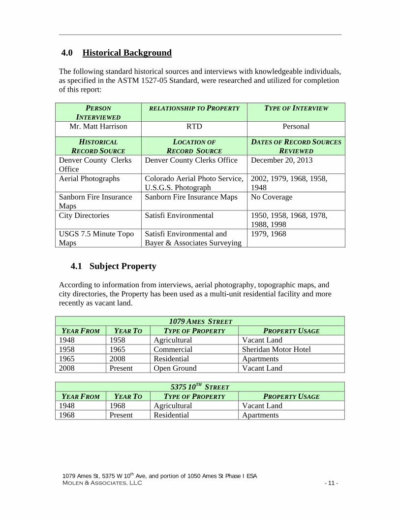
4.0 Historical Background The following standard historical sources and interviews with knowledgeable individuals, as specified in the ASTM 1527-05 Standard, were researched and utilized for completion of this report:
PERSON INTERVIEWED
RELATIONSHIP TO PROPERTY TYPE OF INTERVIEW
Mr. Matt Harrison RTD Personal
HISTORICAL RECORD SOURCE
LOCATION OF RECORD SOURCE
DATES OF RECORD SOURCES
REVIEWED Denver County Clerks Office
Denver County Clerks Office December 20, 2013
Aerial Photographs Colorado Aerial Photo Service, U.S.G.S. Photograph
2002, 1979, 1968, 1958, 1948
Sanborn Fire Insurance Maps
Sanborn Fire Insurance Maps No Coverage
City Directories Satisfi Environmental 1950, 1958, 1968, 1978, 1988, 1998
USGS 7.5 Minute Topo Maps
Satisfi Environmental and Bayer & Associates Surveying
1979, 1968
4.1 Subject Property According to information from interviews, aerial photography, topographic maps, and city directories, the Property has been used as a multi-unit residential facility and more recently as vacant land.
1079 AMES STREET YEAR FROM YEAR TO TYPE OF PROPERTY PROPERTY USAGE
1948 1958 Agricultural Vacant Land 1958 1965 Commercial Sheridan Motor Hotel 1965 2008 Residential Apartments 2008 Present Open Ground Vacant Land
5375 10TH STREET
YEAR FROM YEAR TO TYPE OF PROPERTY PROPERTY USAGE 1948 1968 Agricultural Vacant Land 1968 Present Residential Apartments
1079 Ames St, 5375 W 10th Ave, and portion of 1050 Ames St Phase I ESA Molen & Associates, LLC - 12 -
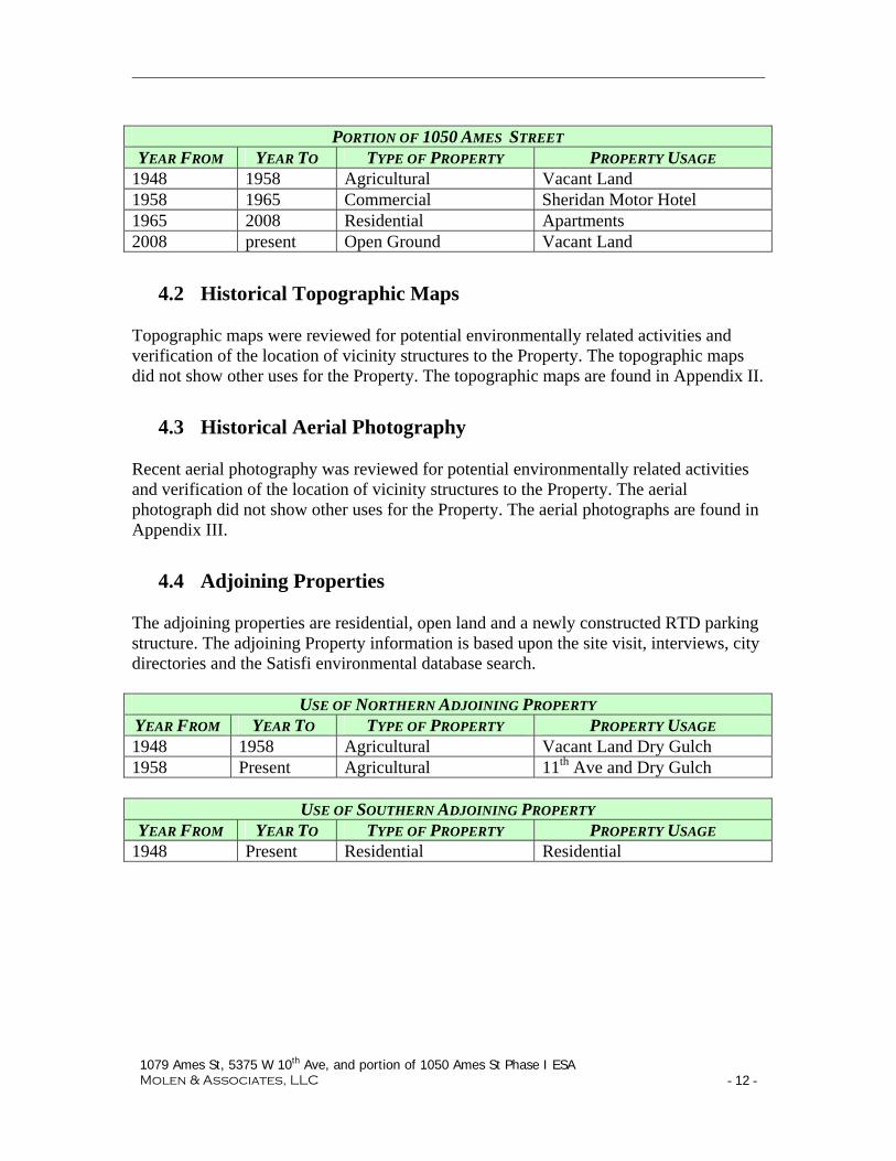
PORTION OF 1050 AMES STREET
YEAR FROM YEAR TO TYPE OF PROPERTY PROPERTY USAGE 1948 1958 Agricultural Vacant Land 1958 1965 Commercial Sheridan Motor Hotel 1965 2008 Residential Apartments 2008 present Open Ground Vacant Land
4.2 Historical Topographic Maps Topographic maps were reviewed for potential environmentally related activities and verification of the location of vicinity structures to the Property. The topographic maps did not show other uses for the Property. The topographic maps are found in Appendix II.
4.3 Historical Aerial Photography Recent aerial photography was reviewed for potential environmentally related activities and verification of the location of vicinity structures to the Property. The aerial photograph did not show other uses for the Property. The aerial photographs are found in Appendix III.
4.4 Adjoining Properties The adjoining properties are residential, open land and a newly constructed RTD parking structure. The adjoining Property information is based upon the site visit, interviews, city directories and the Satisfi environmental database search.
USE OF NORTHERN ADJOINING PROPERTY YEAR FROM YEAR TO TYPE OF PROPERTY PROPERTY USAGE 1948 1958 Agricultural Vacant Land Dry Gulch 1958 Present Agricultural 11th Ave and Dry Gulch
USE OF SOUTHERN ADJOINING PROPERTY YEAR FROM YEAR TO TYPE OF PROPERTY PROPERTY USAGE
1948 Present Residential Residential

1079 Ames St, 5375 W 10th Ave, and portion of 1050 Ames St Phase I ESA Molen & Associates, LLC - 13 -
USE OF EASTERN ADJOINING PROPERTY
YEAR FROM YEAR TO TYPE OF PROPERTY PROPERTY USAGE 1948 1958 Agricultural Vacant Land 1958 1965 Commercial Sheridan Motor Hotel 1965 2008 Residential Apartments 2008 2012 Residential Vacant Land 2012 Present Commercial Parking Structure
USE OF WESTERN ADJOINING PROPERTY YEAR FROM YEAR TO TYPE OF PROPERTY PROPERTY USAGE
1948 1968 Open Land Vacant Land 1968 Present Residential or Vacant
Land Residential, Vacant Land
4.5 Local Historical Fire Department Information The Denver Fire Department was contacted and records requested related to the Property. Records no reported incidents occurred on the Property since 2005. No other findings of environmental concern were noted in the records.
4.6 Historically Significant or Environmental Findings The Property and adjoining properties have been vacant land or residential since 1948. The Sheridan Motor Hotel is listed at 1065 Sheridan in the City Directories from 1960 until 1966. Aerial photography shows the same buildings on the Property from 1958 through 2001; it appears that the Sheridan Motor Hotel rooms were converted into apartments. The apartment buildings were removed in 2008, and the land appears to be re-contoured and slightly lower in the area of 1050 Ames Street. Adjoining properties are vacant land, residential properties, and a newly constructed RTD parking structure. Neighboring properties in the immediate area are fueling operations, a strip mall, commercial enterprises, and residences. The historical information for neighboring and adjoining properties is not considered a recognized environmental condition for the Property.

1079 Ames St, 5375 W 10th Ave, and portion of 1050 Ames St Phase I ESA Molen & Associates, LLC - 14 -
5.0 Regulatory Database Review
5.1 Summary of Standard Database Listings An ASTM-compliant government records radial database report was obtained from Satisfi, Inc. (7700 E Arapahoe Rd, Suite 170, Centennial, CO 80112) for this assessment and is included in Appendix IV. Federal, state and local standard database listings were searched and the results are shown below.
ACRONYM DATABASE
Sear
ch
Rad
ius
(mile
s)
Site
s Fo
und
FEDERAL CDL Clandestine Drug Laboratory Locations 0.25 2 ERNSCO Emergency Response Notification System 0.25 1 HMIRSR08 Hazardous Materials Incident Reporting System 0.25 1
RCRAGR08 Resource Conservation & Recovery Act – Generator Facilities 0.25 1
RCRANGR08 Resource Conservation & Recovery Act – Non-Generator Facilities .25 1
BF Brownfields Management System 0.5 3
CERCLIS Comprehensive Environmental Response, Compensation & Liability Information System 0.5 3
NFRAP No Further Remedial Action Planned Sites 0.5 2
NLRRCRAC No Longer Regulated RCRA Corrective Action Facilities
1.0 1
RCRAC Resource Conservation & Recovery Act – Corrective Action Facilities 1.0 2
STATE (CO) AST Aboveground Storage Tank Facilities 0.25 3 SPILLS Spills Listing 0.25 1 UST Underground Storage Tank Facilities 0.25 4 HISTSWLF Historical Solid Waste Landfills 0.5 8 LST Leaking Storage Tank Facilities 0.5 23
LUSTTRUST Leaking Underground Storage Tanks Trust Fund Sites 0.5 2
METHANESITES Methane Gas Study Sites 0.5 1 SWF Solid Waste Facilities 0.5 2

1079 Ames St, 5375 W 10th Ave, and portion of 1050 Ames St Phase I ESA Molen & Associates, LLC - 15 -
ACRONYM DATABASE
Sear
ch
Rad
ius
(mile
s)
Site
s Fo
und
VCRA Voluntary Cleanup and Redevelopment Program Sites 0.5 5
HWSCA Hazardous Waste Site – Corrective Action 1.0 3 LOCAL DCHISTLF Denver County Historic Landfills 0.5 4 TRIBAL None None 1.00 0
5.2 Listings on Property and Adjoining Properties The Property and adjoining properties were not identified in the Satisfi database report.
5.3 Listings within 1/8-mile The following listings were identified within 1/8-mile of the Property. Further information about the listings can be found in Appendix IV.
Property Listings Assumed Gradient
Status Comments
Dat
abas
e #
Facility Name / Address
~ D
ista
nce
(m
iles
)
Dir
ecti
on
Up
C
ross
D
own
S
ever
ed
Ope
n
Clo
sed/
NA
Un
know
n
RE
C
Database Acronym
1 Artificial Fill Btwn 11th and 12th Ave. .01 NE X X N HISTSWLF,
DCHISTLF
2 12th St and Sheridan Ave. .07 NE X X N ERNSCO
3 Bradley Food Mart 1015 Sheridan Blvd .04 SE X X N SPILLS, UST,
HMIRSR08, LST
4 AMOCO #8605 998 Sheridan Blvd. .08 SE X X N UST, RCRANGR08,
LST
5 5580 West 10th Ave .12 SW X N CDL
Database #1 refers to a historic landfill northeast of the Property. The site is down-gradient from the Property and no domestic refuse, hazardous materials, liquids, construction debris, or industrial waste were found in explorations of the site. This listing

1079 Ames St, 5375 W 10th Ave, and portion of 1050 Ames St Phase I ESA Molen & Associates, LLC - 16 -
is not considered to present a recognized environmental condition for the Property due to its apparent down gradient location. Database #2 is listed as an ERNSCO site due to a 1995 event in which 50 gallons of a wastewater/clean water mixture spilled. The affected soil was excavated and the site is located down-gradient from the Property; it is not considered a recognized environmental condition for the Property. The Bradley Food Mart SPILLS and HMRSIR08 listings refer to an unloading release of 66 gallons of gasoline that occurred in 1999. The affected soil was excavated and disposed of off-site. The LST listing at Bradley Food Mart was reviewed at the Division of Oil and Public Safety (OPS). There was an apparent dispute over tank product accounting records that indicate a suspected release in 2010. An LPIIESA conducted for RTD in May 2011 on what is now the 1050 Ames Street parcel did not detect any constituents from petroleum products; a parking structure for RTD was built on the location in 2012 and 2013. The Bradley facility is under the oversight of OPS and clean-up of any impacts will be their responsibility. Based upon assumed groundwater flow direction, oversight by OPS, and the findings of a LPIIESA on an adjoining property, the Bradley listings are not considered to be a recognized environmental condition for the Property. Database #4 refers to UST, RCRANGR08, and LST listings for Amoco Station #8605. Four USTs were permanently closed on the site. The RCRANGR08 listing refers to the facility’s former status as a generator of hazardous waste. No violations were reported and the facility is no longer generating. The LST event for the site was closed by OPS with lower than risk-based screening levels of contaminants present. The facility is not considered to present a recognized environmental condition for the Property. Database #5 refers to a CDL listing for a clandestine laboratory at the address 5580 West 10th Ave. The site is cross-gradient from the Property and is not believed to present a recognized environmental condition for the Property.
5.4 Other Notable Listings The following listings beyond 1/8-mile from the Property were identified.
5.4.1. NPL, RCRAC, NLRRCRAC, and HWSCA Listings There are no NPL listings, one RCRAC listing, one NLRRCRAC listing, and 2 HWSCA listings within one mile of the Property. Additional information can be found in the Satisfi database report in Appendix IV.

1079 Ames St, 5375 W 10th Ave, and portion of 1050 Ames St Phase I ESA Molen & Associates, LLC - 17 -
NPL, RCRAC, NLRRCRAC, HWSCA Assumed Gradient
Status Direction D
atab
ase
#
Facility Name / Address
~ D
ista
nce
(m
iles
)
Dir
ecti
on
Up
C
ross
D
own
S
ever
ed
Ope
n
Clo
sed/
NA
U
nkn
own
C
lose
T
oo F
ar
Comments
20 1240 Harlan LLC; 1240 Harlan Unit St .37 W X X X X
HWSCA, RCRAC. Drums of hazardous materials were inappropriately stored and handled. Site is located in a cross- or down-gradient location and cleanup is under CDPHE oversight.
27 Mountain High Tree Service 5495 West 6th Ave .47 S X X X X
HWSCA for a former tree farm where clean-up and remediation programs have been completed for pesticide storage and uses
41 Wolfe Miller/JCRSII Shop Ctr; 6469 West Colfax Ave .76 NW X X X
NLRRCRAC, HWSCA. Cleaners operation RCRAC with corrective measures approved in 2002
The 1240 Harlan LLC trucking operation is listed as a HWSCA and RCRAC site after drums of hazardous materials were stored and handled on the site without proper permits. The cleanup is either complete or near complete and CDPHE is overseeing monitoring activities. Due to the active cleanup and monitoring occurring on-site, as well as the distance and implied cross-gradient location from the Property, this listing is not considered to be a recognized environmental condition for the Property. The Mountain High Tree Service is a HWSCA site for use and mishandling of pesticides and herbicides at the tree farm. Cleanup activities have reportedly been performed at the site and its current status appears to be closed. The Mountain High Tree Service site is not considered to present a recognized environmental condition for the Property due to its distance and the severed groundwater gradient location. The Wolfe Miller site is listed as a no longer regulated RCRAC site and HWSCA due to dry cleaning activities that took place in the JCRS Shopping Center. Corrective measures were completed in 2002. Due to the successful termination of corrective action and the severed gradient location of this listing, the site is not considered to present a recognized environmental condition for the Property

1079 Ames St, 5375 W 10th Ave, and portion of 1050 Ames St Phase I ESA Molen & Associates, LLC - 18 -
5.4.2. CERCLIS, NFRAP, and VCRA Listings
Three CERCLIS sites, two NFRAP sites, and three VCRA sites were identified in the Satisfi database report. Additional information can be found in Appendix IV.
CERCLIS, NFRAP, VCRA Assumed Gradient
Status Direction
Dat
abas
e #
Facility Name / Address
~ D
ista
nce
(m
iles
)
Dir
ecti
on
Up
C
ross
D
own
S
ever
ed
Ope
n
Clo
sed/
NA
U
nkn
own
C
lose
T
oo F
ar
Comments
21 Flair Cleaners 714 Sheridan Blvd .37 S X X
VCRA. NAD approved in 2009 for PCE in groundwater and soil
27 Depew And 7th Tree Farm 5495 West 6Th Ave .47 S X X X CERCLIS site terminated in
1998
32 Sheridan PCB Drum Site 680 Sheridan Blvd .45 S X X X CERLIS NFRAP for 20 drums
of PCBs found in storage
34 Lakewood PCE 600 Block of Depew .48 S X X X
CERCLIS NFRAP for PCE in ground water up-gradient of tree farm
36 Casa De Rosal 755 Vrain St .49 SE X X X VCRA. NAD approved in 2009
40 Metro West Housing Solutions6150 W 13Th Ave 0.51 W X X X VCRA. NAD approved in 2012
The CERCLIS and NFRAP listings were all either remedied or terminated and are not considered to present recognized environmental conditions for the Property. Each VCRA listing was granted a No Action Determinations (NAD), and they are all in an apparent down-gradient location from the Property. Based upon the information found and the down or severed gradient location of the listings, the CERCLIS, NFRAP, and VCRA site listings are not considered to present a recognized environmental condition for the Property.
5.4.3. Solid Waste Listings There are 11 solid waste site listings beyond a 1/8-mile radius of the Property that were identified in the Satsifi database report. Additional information can be found in Appendix IV.

1079 Ames St, 5375 W 10th Ave, and portion of 1050 Ames St Phase I ESA Molen & Associates, LLC - 19 -
Solid Waste Assumed Gradient
Status Direction D
atab
ase
#
Facility Name / Address
~ D
ista
nce
(m
iles
)
Dir
ecti
on
Up
C
ross
D
own
S
ever
ed
Ope
n
Clo
sed/
NA
U
nkn
own
C
lose
T
oo F
ar
Comments
7 JDR Tire Service, Inc. 895 Sheridan Blvd .17 SE X X X X SWF. Registered Tire Hauler
11 Mountain High Tree Service 5717 W 11th Ave .23 W X SWF. Registered Tire Hauler
12 Artificial Fill South Between Harlan And Fenton St
.27 NW X X XHISTSWLF, DCHISTLF. Down-gradient and no refuse found in explorations
15 Known Landfill Boundaries Approximate: Ne Of 6Th
.28 SE X X XHISTSWLF, METHANESITES, DCHISTLF. Old turkey farm converted to fill methane found in five of fourteen wells
17 Eighth and Wolff Sites (1 & 2) Located in the City and County of Denver
.31 SE X X XHISTSWLF. Old Landfill site methane study, no refuse determined but methane found
23 10th and Harlan; Address Not Reported .38 SW X X X X
HISTSWLF. Old Landfill site, refuse determined, methane found.
26 Artificial Fill; NWC 6th and Sheridan, Between Depew & Benton
.42 S X X X XHISTSWLF, DCHISTLF. Artificial Fill, no trash, clay, silt, sand, gravel, inert debris
31 Eighth and Wolff Sites (1 & 2); Located in the City and County of Denver
.43 SE X X X XHISTSWLF. Old Landfill site methane study, no refuse determined but methane found.
39 Old Landfill; 6th Ave and Sheridan Blvd .5 S X X X
HISTSWLF. Old Landfill site methane study, no refuse determined but methane found.
75 Known Landfill; Boundaries are Approximate Bounded by 17th
~3600 NE X X XDown gradient and no refuse found in explorations, artificial fill only
81
Known Landfill; Boundaries Approximate: Between Quitman and Tennyson
~4000 SE X X XSevered gradient, known landfill, settlement, filling from 1937-1948 based on aerial photos.
Database #7 and Database #11 have SWF listings due to their designation as registered tire haulers. There are no off-site environmental considerations from these facilities other than the unlikely event of a waste tire fire. The remaining solid waste site listings are in an apparent down-gradient or severed gradient location from the Property. The 10th and Harlan listing is in a potential cross-gradient location; however, it is generally located along the Dry Creek channel. Information on the 10th and Harlan location indicates that there is possible methane and refuse in the area. No additional information is available.

1079 Ames St, 5375 W 10th Ave, and portion of 1050 Ames St Phase I ESA Molen & Associates, LLC - 20 -
Based upon the apparent groundwater flow direction, available information, and age of the solid waste listings, they are not considered to present a recognized environmental condition for the Property.
5.4.4. Tank Leak Listings There are 23 LST, LUSTTRUST, SPILLS, and HMIRSR08 listings identified beyond 1/8-mile of the Property in the Satisfi database report. The five LST listings in an apparent cross- or up-gradient location from the Property are listed below. Additional information about these listings can be found in Appendix IV.
Tank Leaks Assumed Gradient
Status Distance
Dat
abas
e #
Facility Name / Address ~
Dis
tan
ce
(mil
es)
Dir
ecti
on
Up
Cro
ss
Dow
n
Sev
ered
O
pen
C
lose
d/N
A
Un
know
n
Clo
se
Too
Far
Comments
5 Depew Greenhouse; 999 Depew St .15 SW X X X X LST. Records indicate no
impacts. NFA in 1998.
6 Stern Fox Investment; 901 Sheridan Blvd .14 SE X X X LST. Site closed; NFA
in1990
18 RE CO Batteries 748 Sheridan Blvd .33 S X X X LUSTTRUST, LST. NFA in
1998.
20 Raymond Koch Estate; 1240 Harlan St .37 W X X X LST. Site closed; NFA in
1998
28 Circle K #3119 704 Sheridan Blvd .42 S X X X LST. GT RBSL Closure
letter in 2008. All but one of the tank leak listings are in an apparent cross-gradient location from the Property. Four of the five cross- and up-gradient tank leak listings are closed with no further action (NFA) letters issued by OPS. Database listing #28 is closed without an NFA; however, its distance and cross-gradient location do not suggest a likelihood of impacts to the Property. No petroleum products were detected in a LPIIESA report for an adjoining site to the Property.
Based upon the apparent groundwater flow direction, the closure information on the tank leak sites, and the absence of petroleum constituents in a 2011 LPIIESA on an adjoining property, the tank leak listings in the database report are not considered to be a recognized environmental condition for the Property.
5.4.5. Tank Listings There are five tank listings in the Satisfi database report beyond 1/8-mile of the Property. Additional information can be found in Appendix IV.

1079 Ames St, 5375 W 10th Ave, and portion of 1050 Ames St Phase I ESA Molen & Associates, LLC - 21 -
Tanks Assumed Gradient
Status Distance D
atab
ase
#
Facility Name / Address
~ D
ista
nce
(m
iles
)
Dir
ecti
on
Up
Cro
ss
Dow
n
Sev
ered
O
pen
C
lose
d/N
A
Un
know
n
Clo
se
Too
Far
Comments
5 Depew Greenhouse 999 Depew .15 SW X X X X AST. No records to display.
5 Unknown Owner; 999 Depew St .15 SW X X X X AST. No records to display
6 Stern Fox Investment; 901 Sheridan Blvd .14 SE X X X AST. No records to display.
8 Nucon Construction 5490 W 13th Ave .17 NW X X UST. Five tanks
permanently closed.
10 Electro Systems Inc; 1125 Depew Ct .2 NW X X X X
UST. Two tanks permanently closed; last used in 1990.
All of the tank listings are closed and most are in a cross- or down-gradient location from the Property. No petroleum products were detected in a Phase II site assessment on an adjoining property. Based upon the apparent groundwater flow direction and the closure information on the tanks, the tank site listings in the database report are not considered to be a recognized environmental condition for the Property.
5.4.6. RCRAGR08 and RCRANGR08 Listings There is one RCRAGR08 listing and no RCRANGR08 listings beyond a 1/8-mile radius in the Satisfi database.
RCRAGR08 and RCRANGR08 Assumed Gradient
Status Direction
Dat
abas
e #
Facility Name / Address
~ D
ista
nce
(m
iles
)
Dir
ecti
on
Up
C
ross
D
own
S
ever
ed
Ope
n
Clo
sed/
NA
U
nkn
own
C
lose
T
oo F
ar
Comments
8 Centric Jones 5490 W 13th Ave. .17 NW X X X No violations reported
Database #8 refers to a down-gradient RCRAGR08 facility with no violations reported. The site is not considered to be a recognized environmental condition for the Property.

1079 Ames St, 5375 W 10th Ave, and portion of 1050 Ames St Phase I ESA Molen & Associates, LLC - 22 -
5.4.7. Brownfields Management System Sites There are three federal Brownfield sites listed within the Satisfi database report. Additional information can be found in Appendix IV.
Brownfields Management System Sites Assumed Gradient
Status Direction
Dat
abas
e #
Facility Name / Address
~ D
ista
nce
(m
iles
)
Dir
ecti
on
Up
C
ross
D
own
S
ever
ed
Ope
n
Clo
sed/
NA
U
nkn
own
C
lose
T
oo F
ar
Comments
9 Proposed Senior Housing; 4917-19 W 11th Ave .17 E X X X
BF. Contact: Citywide Banks. Institutional controls not required
13 Police Property Storage; 1290 Harlan St .38 W X X X X
BF. Contact: Mr. Cowles lease to Lyntek Company, No institutional controls required. Petroleum found cleanup not required.
40
Lamar Station Crossing 6150 W 13th Ave 0.51 W X X X X
BF. Contact: Lakewood Housing Authority. EPA Brownfield. Institutional controls required.
The Proposed Senior Housing listing refers to Citywide Banks as the current owner. Phase I and Phase II ESAs occurred in 2012. Institutional controls are not required for the site. The site is in a down-gradient location from the Property and is not considered to be a recognized environmental condition for the Property. Database #13 refers to a police property storage site. The purpose of the Brownfields designation was assessment, and Phase I and Phase II ESAs occurred in 2007. Petroleum hydrocarbons were found on the site, and cleanup was not required. The site is located in an apparent down-gradient from the Property and is not considered a recognized environmental condition for the Property. The Lamar Station Crossing listing refers to Lakewood Housing Authority as the current owner. Institutional controls are currently required at the site. The site is located more than half a mile away in a down-gradient location and is not considered a recognized environmental condition for the Property.

1079 Ames St, 5375 W 10th Ave, and portion of 1050 Ames St Phase I ESA Molen & Associates, LLC - 23 -
5.5 Unlocatable Sites No unlocatable sites were identified in the Satisfi database report.

1079 Ames St, 5375 W 10th Ave, and portion of 1050 Ames St Phase I ESA Molen & Associates, LLC - 24 -
6.0 User Provided Information The following information was provided by the user regarding the RTD Parcels at 1079 Ames Street, 5375 W 10th Avenue, and a portion of 1050 Ames Street.
6.1 Environmental Liens No environmental liens were reported for the Property.
6.2 Activity and Use Limitations No activity and use limitations were reported for the Property.
6.3 Environmental Reports or Investigations No previous environmental reports or investigations are known to have occurred on the Property.
6.4 Experience or Specialized Knowledge of User The user did not report any specialized knowledge or experience that suggests an environmental concern or recognized environmental condition related to the subject Property.
6.5 Relationship of the Purchase Price to the Fair Market Value The user did not report that the purchase price for the Property was different than a fair market value.
6.6 Reasonably Ascertainable Information about the Property The user did not report any knowledge about past uses, specific chemicals on-site, releases, or cleanups on the Property.
6.7 Obvious Presence or Likely Presence of Contamination The user did not report an obvious or likely presence of contamination on the Property.

1079 Ames St, 5375 W 10th Ave, and portion of 1050 Ames St Phase I ESA Molen & Associates, LLC - 25 -
7.0 Site Reconnaissance and Interviews
7.1 Interviewed Personnel Mr. Matt Harrison, a representative for the current owner of the Property (RTD), was interviewed on January 2, 2014. Mr. Harrison stated that to his knowledge, no industrial activity has occurred on the Property or adjoining properties. He did point out the existence of a gas station on the corner of 10th Avenue and Sheridan Boulevard, which is separated from the Property by the RTD parking structure. Mr. Harrison was not aware of any stained soils, unknown fill dirt, pits, ponds, or lagoons, storage tanks, or waste disposal activities on the Property. He stated that to his knowledge, no hazardous materials were present on the Property currently or formerly. A completed owner questionnaire can be found in Appendix IV.
7.2 Site Reconnaissance The Property was observed and photographed (Appendix V) for site reconnaissance on December 20, 2013. The day was overcast with some minimal snow cover impeding portions of the ground surface from view. No recognized environmental concerns were identified for the Property during the site reconnaissance.
7.2.1. Hazardous Substances No hazardous substances were observed on the Property.
7.2.2. Unidentified Containers No containers were observed on the Property.
7.2.3. Staining There were no surface stains observed on the Property.
7.2.4. Stressed Vegetation No stressed vegetation was identified.
7.2.5. Above Ground Storage Tanks (AST's) No above ground storage tanks observed on the Property.
7.2.6. Underground Storage Tanks (UST's) There were no vent pipes or underground storage tanks observed on the Property.

1079 Ames St, 5375 W 10th Ave, and portion of 1050 Ames St Phase I ESA Molen & Associates, LLC - 26 -
7.2.7. Pits, Ponds, and Lagoons
No pits, pond or lagoons were observed on the Property.
7.2.8. PCB-Containing Equipment No PCB-containing equipment was observed on the Property.
7.2.9. Solid Waste Disposal No solid waste was observed on the Property.
7.2.10. Wetlands No wetlands were observed on the Property.
7.3 Other Non-scope Concerns No other areas of environmental concern were noted within the scope of this investigation.

1079 Ames St, 5375 W 10th Ave, and portion of 1050 Ames St Phase I ESA Molen & Associates, LLC - 27 -
8.0 Findings and Conclusions
8.1 Findings and Opinions
No recognized environmental conditions were found concerning the Property.
8.2 Data Gaps In conducting this Phase I Environmental Site Assessment there were no "data gaps".
8.3 Conclusions Molen and Associates has performed this Phase I Environmental Site Assessment in conformance with the Scope of Work developed in cooperation with the client and the provisions of ASTM Practice E 1527-05. We have performed this Phase I Environmental Site Assessment in conformance with the scope and limitations of the ASTM Practice E 1527 for 1079 Ames Street, 5375 W 10th Avenue, and portions of 1050 Ames Street, Denver, Colorado, the Property. Any exceptions to, or deletions from this practice are described in Section 2.4 of this report. This assessment has revealed no evidence of recognized environmental conditions in connection with the Property. No exceptions or deletions to this report were noted.

1079 Ames St, 5375 W 10th Ave, and portion of 1050 Ames St Phase I ESA Molen & Associates, LLC - 28 -
9.0 References ASTM Standard E 1527-05, 2005, “Standard Practice for Environmental Site
Assessments: Phase I Environmental Site Assessment Process,” ASTM International, West Conshohocken, PA, DOI 10.1520/E1527-05, July.
CDLE-OPS, Fax Request for File Reviews: Bradley Food Mart #65, Amoco Oil #8605,
Conoco #6333, Depew Greenhouse, January 12, 2012. LT Environmental, Inc., Limited Phase II Environmental Site Assessment, Sheridan
Parking Structure, 1025 Sheridan Boulevard, Denver, Colorado, May 11, 2011. Molen & Associates, LLC, Phase I Environmental Site Assessment, Vacant Property,
Portions of 1075-1079 Ames Street, Portion of Jody Apartments, Denver, Colorado 80214, January 19, 2011.
Satisfi, Inc., Environmental First Search Database Report, “ULC Updated Jody
Apartment,” January 17, 2013. Stateswest Environmental Corporation, Phase I Environmental Site Assessment,
Residential Apartment Units, 5375 W 10th Ave, Denver, Colorado 80214, April 30, 2007.

1079 Ames St, 5375 W 10th Ave, and portion of 1050 Ames St Phase I ESA Molen & Associates, LLC - 29 -
10.0 Signature I declare that, to the best of my professional knowledge and belief, I meet the definition of Environmental Professional as defined in §312.10 of this part [40 CFR Part 312]. I have the specific qualifications based on education, training, and experience to assess a Property of the nature, history, and setting of the subject Property. I have developed and performed the all appropriate inquiries in conformance with the standards and practices set forth in 40 CFR Part 312. I believe this information to be true and correct to the best of my professional ability. The qualifications and experience is found in Appendix VI.
Signed, Date: January 2, 2014
Mark A. Molen, CHMM

Appendix I
SITE LOCATION MAPS

Topo USA® 8
Data use subject to license.
© DeLorme. Topo USA® 8.
www.delorme.com
TN
MN (8.6°E)0 40 80 120 160 200
0 14 28 42 56 70
ftm
Scale 1 : 1,600
1" = 133.3 ft Data Zoom 17-0

Appendix II
TOPOGRAPHIC MAPS

2090 E 104th Avenue, #205Thornton, CO 80233Mark Molen10th & Sheridan
RTD 10th & Sheridan1075 Ames StreetDenver, CO 80214
Fort LoganFort LoganFort Logan
24,000
7.5'
199019781971
24,00024,000
These 7.5' US Geological Survey maps covered most cities by the 1930's, and most remote areas by the 1960's. (Pleasenote that maps are identified here by the year of the survey or aerial photo used to make or revise the map, rather than theyear of publication.) Some maps changed names over time; to find them, a unique geographic index of the entire USGScollection is searched. If the 7.5' maps do not go back to 1940, earlier 15' maps are included. Any adjoining maps within1/8 mile of the Subject Property are also included.
Subject Property
7.5'7.5'
December 27, 2011
Performed For:
Fort Logan
The following maps were found:
Year Map Name
Attn:Ref:
© 2011 Satisfi Inc ~ Centennial CO ~ 720-200-9472
Please note that the accuracy and suitability of public and private records cannotbe guaranteed, nor can this research. No warranty is made or implied. By usingthis report, the reader agrees to assume all related risk and to release Satisfi fromliability for any damages. However, if this report is not 100% satisfactory, a fullrefund will be issued.
7.5'7.5'7.5'
Fort LoganFort Logan
1:Scale
TOPOGRAPHIC MAPS
Molen & Associates, LLC
Page 1 of 1
196419541937
NoteSize
24,00024,000
24,000
Earliest found.

These 7.5' US Geological Survey maps covered most cities by the 1930's, and most remote areas by the 1960's. (Please note that mapsare identified here by the year of the survey or aerial photo used to make or revise the map, rather than the year of publication.) Somemaps changed names over time; to find them, a unique geographic index of the entire USGS collection is searched. If the 7.5' maps donot go back to 1940, earlier 15' maps are included. Any adjoining maps within 1/8 mile of the Subject Property are also included.
For Molen & Associates, LLC
|--------------------------- ~1 mile --------------------------| NORTHSee Symbol Key Original scale = 1:24000
© 2011 Satisfi Inc 720-200-9472 RTD 10th & Sheridan, 1075 Ames Street, Denver, CO
TOPOGRAPHIC MAPS 1990
1990 7.5' Fort Logan Quadrangle

© 2011 Satisfi Inc 720-200-9472 RTD 10th & Sheridan, 1075 Ames Street, Denver, COFor Molen & Associates, LLC
See Symbol Key Original scale = 1:24000 |--------------------------- ~1 mile --------------------------| NORTH
These 7.5' US Geological Survey maps covered most cities by the 1930's, and most remote areas by the 1960's. (Please note that mapsare identified here by the year of the survey or aerial photo used to make or revise the map, rather than the year of publication.) Somemaps changed names over time; to find them, a unique geographic index of the entire USGS collection is searched. If the 7.5' maps donot go back to 1940, earlier 15' maps are included. Any adjoining maps within 1/8 mile of the Subject Property are also included.
TOPOGRAPHIC MAPS 1978
1978 7.5' Fort Logan Quadrangle

© 2011 Satisfi Inc 720-200-9472 RTD 10th & Sheridan, 1075 Ames Street, Denver, COFor Molen & Associates, LLC
See Symbol Key Original scale = 1:24000 |--------------------------- ~1 mile --------------------------| NORTH
These 7.5' US Geological Survey maps covered most cities by the 1930's, and most remote areas by the 1960's. (Please note that mapsare identified here by the year of the survey or aerial photo used to make or revise the map, rather than the year of publication.) Somemaps changed names over time; to find them, a unique geographic index of the entire USGS collection is searched. If the 7.5' maps donot go back to 1940, earlier 15' maps are included. Any adjoining maps within 1/8 mile of the Subject Property are also included.
TOPOGRAPHIC MAPS 1971
1971 7.5' Fort Logan Quadrangle

TOPOGRAPHIC MAPS 1964
1964 7.5' Fort Logan Quadrangle
These 7.5' US Geological Survey maps covered most cities by the 1930's, and most remote areas by the 1960's. (Please note that mapsare identified here by the year of the survey or aerial photo used to make or revise the map, rather than the year of publication.) Somemaps changed names over time; to find them, a unique geographic index of the entire USGS collection is searched. If the 7.5' maps donot go back to 1940, earlier 15' maps are included. Any adjoining maps within 1/8 mile of the Subject Property are also included.
See Symbol Key Original scale = 1:24000 |--------------------------- ~1 mile --------------------------| NORTH
© 2011 Satisfi Inc 720-200-9472 RTD 10th & Sheridan, 1075 Ames Street, Denver, COFor Molen & Associates, LLC
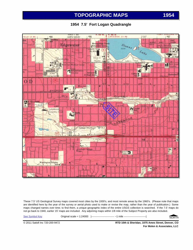
TOPOGRAPHIC MAPS 1954
1954 7.5' Fort Logan Quadrangle
These 7.5' US Geological Survey maps covered most cities by the 1930's, and most remote areas by the 1960's. (Please note that mapsare identified here by the year of the survey or aerial photo used to make or revise the map, rather than the year of publication.) Somemaps changed names over time; to find them, a unique geographic index of the entire USGS collection is searched. If the 7.5' maps donot go back to 1940, earlier 15' maps are included. Any adjoining maps within 1/8 mile of the Subject Property are also included.
See Symbol Key Original scale = 1:24000 |--------------------------- ~1 mile --------------------------| NORTH
© 2011 Satisfi Inc 720-200-9472 RTD 10th & Sheridan, 1075 Ames Street, Denver, COFor Molen & Associates, LLC

TOPOGRAPHIC MAPS 1937
1937 7.5' Fort Logan QuadrangleEarliest found.
These 7.5' US Geological Survey maps covered most cities by the 1930's, and most remote areas by the 1960's. (Please note that mapsare identified here by the year of the survey or aerial photo used to make or revise the map, rather than the year of publication.) Somemaps changed names over time; to find them, a unique geographic index of the entire USGS collection is searched. If the 7.5' maps donot go back to 1940, earlier 15' maps are included. Any adjoining maps within 1/8 mile of the Subject Property are also included.
See Symbol Key Original scale = 1:24000 |--------------------------- ~1 mile --------------------------| NORTH
© 2011 Satisfi Inc 720-200-9472 RTD 10th & Sheridan, 1075 Ames Street, Denver, COFor Molen & Associates, LLC

© 2011 Satisfi Inc ~ Centennial CO ~ 720-200-9472 Page 1 of 2
TOPOGRAPHIC MAPS SYMBOLS
This Key to Symbols is also available at http://mac.usgs.gov/isb/pubs/booklets/symbols/buildings.html

http://mac.usgs.gov/isb/pubs/booklets/symbols/buildings.html
© 2011 Satisfi Inc ~ Centennial CO ~ 720-200-9472 Page 2 of 2
TOPOGRAPHIC MAPS SYMBOLS
This Key to Symbols is also available at

Appendix III
AERIAL PHOTOGRAPHY

1948 Earliest found.
2090 E 104th Avenue, #205Thornton, CO 80233Mark Molen10th & Sheridan
RTD 10th & Sheridan1075 Ames StreetDenver, CO 80214
Molen & Associates, LLC
The Colorado Aerial Photo Service (CAPS) collection covers most developed areas of the Front Range annually from 1948.The originals are enlarged to a scale that is intended to show the Subject Property and the properties that surround it. Theoriginals can be viewed in stereo and under high-power magnification at CAPS, 2757 W. Second Avenue in Denver, for aminimal handling fee. Call CAPS at 303-934-2419 or 800-215-2681 to have prints pulled and waiting.
The following photos were ordered:
Year Note1979
Subject Property
December 27, 2011
Performed For:
19681958
AERIAL PHOTOGRAPHS
Page 1 of 1
Attn:Ref:
© 2011 Satisfi Inc ~ Centennial CO ~ 720-200-9472
Please note that the accuracy and suitability of public and private records cannot beguaranteed, nor can this research. No warranty is made or implied. By using thisreport, the reader agrees to assume all related risk and to release Satisfi fromliability for any damages. However, if this report is not 100% satisfactory, a fullrefund will be issued.

The Colorado Aerial Photo Service (CAPS) collection covers most developed areas of the Front Range annually from 1948. The originalsare enlarged to a scale that is intended to show the Subject Property and the properties that surround it. The originals can be viewed instereo and under high-power magnification at CAPS, 2757 W. Second Avenue in Denver, for a minimal handling fee. Call CAPS at 303-934-2419 or 800-215-2681 to have prints pulled and waiting.
For Molen & Associates, LLC
NORTH
© 2011 Satisfi Inc 720-200-9472 RTD 10th & Sheridan, 1075 Ames Street, Denver, CO
© 2011 Colorado Aerial Photo Service (CAPS). A limited license is granted until 12/27/11 to reproduce this image for reports and internaluse, but not for resale as an aerial photo. Reproduction of the electronic file or printed image for any other use is illegal without prior writtenpermission from CAPS.
AERIAL PHOTOGRAPHS 1979
1979

© 2011 Satisfi Inc 720-200-9472 RTD 10th & Sheridan, 1075 Ames Street, Denver, COFor Molen & Associates, LLC
NORTH
© 2011 Colorado Aerial Photo Service (CAPS). A limited license is granted until 12/27/11 to reproduce this image for reports and internaluse, but not for resale as an aerial photo. Reproduction of the electronic file or printed image for any other use is illegal without prior writtenpermission from CAPS.
The Colorado Aerial Photo Service (CAPS) collection covers most developed areas of the Front Range annually from 1948. The originalsare enlarged to a scale that is intended to show the Subject Property and the properties that surround it. The originals can be viewed instereo and under high-power magnification at CAPS, 2757 W. Second Avenue in Denver, for a minimal handling fee. Call CAPS at 303-934-2419 or 800-215-2681 to have prints pulled and waiting.
AERIAL PHOTOGRAPHS 1968
1968

© 2011 Satisfi Inc 720-200-9472 RTD 10th & Sheridan, 1075 Ames Street, Denver, COFor Molen & Associates, LLC
NORTH
© 2011 Colorado Aerial Photo Service (CAPS). A limited license is granted until 12/27/11 to reproduce this image for reports and internaluse, but not for resale as an aerial photo. Reproduction of the electronic file or printed image for any other use is illegal without prior writtenpermission from CAPS.
The Colorado Aerial Photo Service (CAPS) collection covers most developed areas of the Front Range annually from 1948. The originalsare enlarged to a scale that is intended to show the Subject Property and the properties that surround it. The originals can be viewed instereo and under high-power magnification at CAPS, 2757 W. Second Avenue in Denver, for a minimal handling fee. Call CAPS at 303-934-2419 or 800-215-2681 to have prints pulled and waiting.
AERIAL PHOTOGRAPHS 1958
1958

AERIAL PHOTOGRAPHS 1948
1948Earliest found.
© 2011 Colorado Aerial Photo Service (CAPS). A limited license is granted until 12/27/11 to reproduce this image for reports and internaluse, but not for resale as an aerial photo. Reproduction of the electronic file or printed image for any other use is illegal without prior writtenpermission from CAPS.
The Colorado Aerial Photo Service (CAPS) collection covers most developed areas of the Front Range annually from 1948. The originalsare enlarged to a scale that is intended to show the Subject Property and the properties that surround it. The originals can be viewed instereo and under high-power magnification at CAPS, 2757 W. Second Avenue in Denver, for a minimal handling fee. Call CAPS at 303-934-2419 or 800-215-2681 to have prints pulled and waiting.
NORTH
© 2011 Satisfi Inc 720-200-9472 RTD 10th & Sheridan, 1075 Ames Street, Denver, COFor Molen & Associates, LLC

Appendix IV
SATISFI RADIUS DATABASE REPORT

Radius Report
Satellite view
Target Property:
RTD Parcels
5375 W 10TH AVE, 1050 AND 1075 AMES ST
DENVER, Denver County, Colorado 80214
Prepared For:
Satisfi
Order #: 30499
Job #: 67876
Project #: 13-1212
Date: 11/25/2013
0 of 115Order# 30499 Job# 67876
www.geo-search.com 888-396-0042

Target Property Summary 1
Database Findings Summary 2
Locatable Database Findings 6
Radius Map 1 10
Radius Map 2 11
Ortho Map 12
Topographic Map 13
Report Summary of Locatable Sites 14
Environmental Records Definitions 104
Order# 30499 Job# 67876
www.geo-search.com 888-396-0042
Target Property SummaryDatabase Findings SummaryDatabase Findings SummaryDatabase Findings SummaryDatabase Findings SummaryLocatable Database FindingsLocatable Database FindingsLocatable Database FindingsLocatable Database FindingsReport Summary of Locatable SitesHistorical Solid Waste Landfills (HISTSWLF)Denver County Historic Landfills (DCHISTLF)Emergency Response Notification System (ERNSCO)Spills Listing (SPILLS)Underground Storage Tank Facilities (UST)Hazardous Materials Incident Reporting System (HMIRSR08)Leaking Storage Tank Facilities (LST)Underground Storage Tank Facilities (UST)Resource Conservation & Recovery Act - Non-Generator Facilities(RCRANGR08)Leaking Storage Tank Facilities (LST)Aboveground Storage Tank Facilities (AST)Leaking Storage Tank Facilities (LST)Clandestine Drug Laboratory Locations (CDL)Clandestine Drug Laboratory Locations (CDL)Aboveground Storage Tank Facilities (AST)Leaking Storage Tank Facilities (LST)Aboveground Storage Tank Facilities (AST)Solid Waste Facilities (SWF)Underground Storage Tank Facilities (UST)Resource Conservation & Recovery Act - Generator Facilities(RCRAGR08)Leaking Storage Tank Facilities (LST)Brownfields Management System (BF)Underground Storage Tank Facilities (UST)Solid Waste Facilities (SWF)Historical Solid Waste Landfills (HISTSWLF)Denver County Historic Landfills (DCHISTLF)Brownfields Management System (BF)Leaking Underground Storage Tanks Trust Fund Sites (LUSTTRUST)Leaking Storage Tank Facilities (LST)Historical Solid Waste Landfills (HISTSWLF)Methane Gas Study Sites (METHANESITES)Denver County Historic Landfills (DCHISTLF)Leaking Storage Tank Facilities (LST)Historical Solid Waste Landfills (HISTSWLF)Leaking Underground Storage Tanks Trust Fund Sites (LUSTTRUST)Leaking Storage Tank Facilities (LST)Leaking Storage Tank Facilities (LST)Leaking Storage Tank Facilities (LST)Resource Conservation & Recovery Act - Corrective Action Facilities
(RCRAC)Hazardous Waste Sites- Corrective Action (HWSCA)Voluntary Cleanup and Redevelopment Program Sites (VCRA)Leaking Storage Tank Facilities (LST)Historical Solid Waste Landfills (HISTSWLF)Leaking Storage Tank Facilities (LST)Leaking Storage Tank Facilities (LST)Leaking Storage Tank Facilities (LST)Historical Solid Waste Landfills (HISTSWLF)Denver County Historic Landfills (DCHISTLF)Leaking Storage Tank Facilities (LST)Comprehensive Environmental Response, Compensation & LiabilityInformation System (CERCLIS)Hazardous Waste Sites- Corrective Action (HWSCA)Leaking Storage Tank Facilities (LST)Leaking Storage Tank Facilities (LST)Leaking Storage Tank Facilities (LST)Historical Solid Waste Landfills (HISTSWLF)No Further Remedial Action Planned Sites (NFRAP)Comprehensive Environmental Response, Compensation & LiabilityInformation System (CERCLIS)Leaking Storage Tank Facilities (LST)No Further Remedial Action Planned Sites (NFRAP)Comprehensive Environmental Response, Compensation & LiabilityInformation System (CERCLIS)Leaking Storage Tank Facilities (LST)Voluntary Cleanup and Redevelopment Program Sites (VCRA)Voluntary Cleanup and Redevelopment Program Sites (VCRA)Leaking Storage Tank Facilities (LST)Leaking Storage Tank Facilities (LST)Historical Solid Waste Landfills (HISTSWLF)Voluntary Cleanup and Redevelopment Program Sites (VCRA)Voluntary Cleanup and Redevelopment Program Sites (VCRA)Brownfields Management System (BF)Leaking Storage Tank Facilities (LST)No Longer Regulated RCRA Corrective Action Facilities (NLRRCRAC)Hazardous Waste Sites- Corrective Action (HWSCA)Resource Conservation & Recovery Act - Corrective Action Facilities
(RCRAC)Environmental Records Definitions - FEDERALEnvironmental Records Definitions - STATE (CO)Environmental Records Definitions - LOCALEnvironmental Records Definitions - TRIBALTable of Contents

RTD Parcels5375 W 10TH AVE, 1050 AND 1075 AMES STDENVER, Denver County, Colorado 80214
USGS Quadrangle: Fort Logan, COTarget Property Geometry: Area
Target Property Longitude(s)/Latitude(s):(-105.05561, 39.734380), (-105.05561, 39.734380), (-105.05561, 39.733099), (-105.05498, 39.733099), (-105.05498, 39.733752), (-105.05370, 39.733743), (-105.05370, 39.734493), (-105.05428, 39.734502), (-105.05428, 39.734362), (-105.05561, 39.734380)
County/Parish Covered:Jefferson (CO) , Denver (CO)
Zipcode(s) Covered:Denver CO: 80204, 80212, 80214, 80219, 80226
State(s) Covered:CO
*Target property is located in Radon Zone 1.Zone 1 areas have a predicted average indoor radon screening level greater than 4 pCi/L (picocuries per liter).
This report was designed by GeoSearch to meet or exceed the records search requirements of the All Appropriate Inquires Rule (40 CFR§312.26) and the current version of the ASTM International E1527, Standard Practice for Environmental Site Assessments: Phase IEnvironmental Site Assessment Process or, if applicable, the custom requirements requested by the entity that ordered this report. Therecords and databases of records used to compile this report were collected from various federal,state and local governmental entities. It isthe goal of GeoSearch to meet or exceed the 40 CFR §312.26 and E1527 requirements for updating records by using the best availabletechnology. GeoSearch contacts the appropriate governmental entities on a recurring basis. Depending on the frequency with which arecord source or database of records is updated by the governmental entity, the data used to prepare this report may be updated monthly,quarterly, semi-annually, or annually.
Disclaimer - The information provided in this report was obtained from a variety of public sources. GeoSearch cannot ensure and makes nowarranty or representation as to the accuracy, reliability, quality, errors occurring from data conversion or the customer's interpretation ofthis report. This report was made by GeoSearch for exclusive use by its clients only. Therefore, this report may not contain sufficientinformation for other purposes or parties. GeoSearch and its partners, employees, officers And independent contractors cannot be heldliable For actual, incidental, consequential, special or exemplary damages suffered by a customer resulting directly or indirectly from anyinformation provided by GeoSearch.
1 of 115Order# 30499 Job# 67876
www.geo-search.com 888-396-0042
Target Property Summary

FEDERAL LISTING
Database Acronym Locatable Unlocatable
SearchRadius(miles)
CLANDESTINE DRUG LABORATORY LOCATIONS CDL 2 0 0.2500
FEDERAL ENGINEERING INSTITUTIONAL CONTROL SITES EC 0 0 0.2500
EMERGENCY RESPONSE NOTIFICATION SYSTEM ERNSCO 1 0 0.2500
HISTORICAL GAS STATIONS HISTPST 0 0 0.2500
HAZARDOUS MATERIALS INCIDENT REPORTING SYSTEM HMIRSR08 1 0 0.2500
LAND USE CONTROL INFORMATION SYSTEM LUCIS 0 0 0.2500
NO LONGER REGULATED RCRA GENERATOR FACILITIES NLRRCRAG 0 0 0.2500
RESOURCE CONSERVATION & RECOVERY ACT - GENERATORFACILITIES
RCRAGR08 1 0 0.2500
RESOURCE CONSERVATION & RECOVERY ACT - NON-GENERATOR FACILITIES
RCRANGR08 1 0 0.2500
RCRA SITES WITH CONTROLS RCRASC 0 0 0.2500
TOXICS RELEASE INVENTORY TRI 0 0 0.2500
BROWNFIELDS MANAGEMENT SYSTEM BF 3 0 0.5000
COMPREHENSIVE ENVIRONMENTAL RESPONSE, COMPENSATION& LIABILITY INFORMATION SYSTEM
CERCLIS 3 0 0.5000
NO FURTHER REMEDIAL ACTION PLANNED SITES NFRAP 2 0 0.5000
NO LONGER REGULATED RCRA NON-CORRACTS TSD FACILITIES NLRRCRAT 0 0 0.5000
OPEN DUMP INVENTORY ODI 0 0 0.5000
RESOURCE CONSERVATION & RECOVERY ACT - TREATMENT,STORAGE & DISPOSAL FACILITIES
RCRAT 0 0 0.5000
DELISTED NATIONAL PRIORITIES LIST DNPL 0 0 1.0000
NO LONGER REGULATED RCRA CORRECTIVE ACTION FACILITIES NLRRCRAC 1 0 1.0000
NATIONAL PRIORITIES LIST NPL 0 0 1.0000
PROPOSED NATIONAL PRIORITIES LIST PNPL 0 0 1.0000
RESOURCE CONSERVATION & RECOVERY ACT - CORRECTIVEACTION FACILITIES
RCRAC 2 0 1.0000
RECORD OF DECISION SYSTEM RODS 0 0 1.0000
SUB-TOTAL 17 0
2 of 115Order# 30499 Job# 67876
www.geo-search.com 888-396-0042
Target Property SummaryDatabase Findings Summary

STATE (CO) LISTING
Database Acronym Locatable Unlocatable
SearchRadius(miles)
ABOVEGROUND STORAGE TANK FACILITIES AST 3 0 0.2500
CLANDESTINE DRUG LABORATORY LOCATIONS CDL 0 0 0.2500
ENVIRONMENTAL REAL COVENANTS LIST COVENANTS 0 0 0.2500
HAZARDOUS WASTE SITES- GENERATOR HWSG 0 0 0.2500
SPILLS LISTING SPILLS 1 0 0.2500
UNDERGROUND STORAGE TANK FACILITIES UST 4 0 0.2500
HISTORICAL SOLID WASTE LANDFILLS HISTSWLF 8 0 0.5000
HAZARDOUS WASTE SITES- TREATMENT, STORAGE & DISPOSAL HWSTSD 0 0 0.5000
LEAKING STORAGE TANK FACILITIES LST 23 0 0.5000
LEAKING UNDERGROUND STORAGE TANKS TRUST FUND SITES LUSTTRUST 2 0 0.5000
METHANE GAS STUDY SITES METHANESITES 1 0 0.5000
SOLID WASTE FACILITIES SWF 2 0 0.5000
VOLUNTARY CLEANUP AND REDEVELOPMENT PROGRAM SITES VCRA 5 0 0.5000
HAZARDOUS WASTE SITES- CORRECTIVE ACTION HWSCA 3 0 1.0000
SUPERFUND SITES SF 0 0 1.0000
SUB-TOTAL 52 0
3 of 115Order# 30499 Job# 67876
www.geo-search.com 888-396-0042
Target Property SummaryDatabase Findings SummaryDatabase Findings Summary

LOCAL LISTING
Database Acronym Locatable Unlocatable
SearchRadius(miles)
DENVER COUNTY HISTORIC LANDFILLS DCHISTLF 4 0 0.5000
JEFFERSON COUNTY METHANE GAS SITES JCMETHANE 0 0 0.5000
SUB-TOTAL 4 0
4 of 115Order# 30499 Job# 67876
www.geo-search.com 888-396-0042
Target Property SummaryDatabase Findings SummaryDatabase Findings SummaryDatabase Findings Summary

TRIBAL LISTING
Database Acronym Locatable Unlocatable
SearchRadius(miles)
UNDERGROUND STORAGE TANKS ON TRIBAL LANDS USTR08 0 0 0.2500
LEAKING UNDERGROUND STORAGE TANKS ON TRIBAL LANDS LUSTR08 0 0 0.5000
OPEN DUMP INVENTORY ON TRIBAL LANDS ODINDIAN 0 0 0.5000
INDIAN RESERVATIONS INDIANRES 0 0 1.0000
SUB-TOTAL 0 0
TOTAL 73 0
5 of 115Order# 30499 Job# 67876
www.geo-search.com 888-396-0042
Target Property SummaryDatabase Findings SummaryDatabase Findings SummaryDatabase Findings SummaryDatabase Findings Summary

FEDERAL LISTING
Acronym SearchRadius(miles)
TP/AP(0 - 0.02)
1/8 Mile(> TP/AP)
1/4 Mile(> 1/8)
1/2 Mile(> 1/4)
1 Mile(> 1/2) > 1 Mile
Total
CDL 0.2500 2 0 NS NS NS 2
EC 0.2500 0 0 NS NS NS 0
ERNSCO 0.2500 1 0 NS NS NS 1
HISTPST 0.2500 0 0 NS NS NS 0
HMIRSR08 0.2500 1 0 NS NS NS 1
LUCIS 0.2500 0 0 NS NS NS 0
NLRRCRAG 0.2500 0 0 NS NS NS 0
RCRAGR08 0.2500 0 1 NS NS NS 1
RCRANGR08 0.2500 1 0 NS NS NS 1
RCRASC 0.2500 0 0 NS NS NS 0
TRI 0.2500 0 0 NS NS NS 0
BF 0.5000 0 1 1 NS NS 3
CERCLIS 0.5000 0 0 3 NS NS 3
NFRAP 0.5000 0 0 2 NS NS 2
NLRRCRAT 0.5000 0 0 0 NS NS 0
ODI 0.5000 0 0 0 NS NS 0
RCRAT 0.5000 0 0 0 NS NS 0
DNPL 1.0000 0 0 0 0 NS 0
NLRRCRAC 1.0000 0 0 0 1 NS 1
NPL 1.0000 0 0 0 0 NS 0
PNPL 1.0000 0 0 0 0 NS 0
RCRAC 1.0000 0 0 1 0 NS 2
RODS 1.0000 0 0 0 0 NS 0
SUB-TOTAL 5 2 7 1 0 17
6 of 115Order# 30499 Job# 67876
www.geo-search.com 888-396-0042
Target Property SummaryDatabase Findings SummaryDatabase Findings SummaryDatabase Findings SummaryDatabase Findings SummaryLocatable Database Findings

STATE (CO) LISTING
Acronym SearchRadius(miles)
TP/AP(0 - 0.02)
1/8 Mile(> TP/AP)
1/4 Mile(> 1/8)
1/2 Mile(> 1/4)
1 Mile(> 1/2) > 1 Mile
Total
AST 0.2500 0 3 NS NS NS 3
CDL 0.2500 0 0 NS NS NS 0
COVENANTS 0.2500 0 0 NS NS NS 0
HWSG 0.2500 0 0 NS NS NS 0
SPILLS 0.2500 1 0 NS NS NS 1
UST 0.2500 2 2 NS NS NS 4
HISTSWLF 0.5000 1 0 0 7 NS NS 8
HWSTSD 0.5000 0 0 0 NS NS 0
LST 0.5000 2 3 17 NS NS 23
LUSTTRUST 0.5000 0 0 2 NS NS 2
METHANESITES 0.5000 0 0 1 NS NS 1
SWF 0.5000 0 2 0 NS NS 2
VCRA 0.5000 0 0 3 NS NS 5
HWSCA 1.0000 0 0 2 1 NS 3
SF 1.0000 0 0 0 0 NS 0
SUB-TOTAL 1 5 10 32 1 0 52
7 of 115Order# 30499 Job# 67876
www.geo-search.com 888-396-0042
Target Property SummaryDatabase Findings SummaryDatabase Findings SummaryDatabase Findings SummaryDatabase Findings SummaryLocatable Database FindingsLocatable Database Findings

LOCAL LISTING
Acronym SearchRadius(miles)
TP/AP(0 - 0.02)
1/8 Mile(> TP/AP)
1/4 Mile(> 1/8)
1/2 Mile(> 1/4)
1 Mile(> 1/2) > 1 Mile
Total
DCHISTLF 0.5000 1 0 0 3 NS NS 4
JCMETHANE 0.5000 0 0 0 NS NS 0
SUB-TOTAL 1 0 0 3 0 0 4
8 of 115Order# 30499 Job# 67876
www.geo-search.com 888-396-0042
Target Property SummaryDatabase Findings SummaryDatabase Findings SummaryDatabase Findings SummaryDatabase Findings SummaryLocatable Database FindingsLocatable Database FindingsLocatable Database Findings

TRIBAL LISTING
Acronym SearchRadius(miles)
TP/AP(0 - 0.02)
1/8 Mile(> TP/AP)
1/4 Mile(> 1/8)
1/2 Mile(> 1/4)
1 Mile(> 1/2) > 1 Mile
Total
USTR08 0.2500 0 0 NS NS NS 0
LUSTR08 0.5000 0 0 0 NS NS 0
ODINDIAN 0.5000 0 0 0 NS NS 0
INDIANRES 1.0000 0 0 0 0 NS 0
SUB-TOTAL 0 0 0 0 0 0
TOTAL 2 10 12 42 2 0 73
NOTES:NS = NOT SEARCHEDTP/AP = TARGET PROPERTY/ADJACENT PROPERTY
9 of 115Order# 30499 Job# 67876
www.geo-search.com 888-396-0042
Target Property SummaryDatabase Findings SummaryDatabase Findings SummaryDatabase Findings SummaryDatabase Findings SummaryLocatable Database FindingsLocatable Database FindingsLocatable Database FindingsLocatable Database Findings

.4
Click here to access Satelite view
10 of 115Order# 30499 Job# 67876
www.geo-search.com 888-396-0042
Target Property SummaryDatabase Findings SummaryDatabase Findings SummaryDatabase Findings SummaryDatabase Findings SummaryLocatable Database FindingsLocatable Database FindingsLocatable Database FindingsLocatable Database FindingsRadius Map 1

.5
Click here to access Satelite view
11 of 115Order# 30499 Job# 67876
www.geo-search.com 888-396-0042
Target Property SummaryDatabase Findings SummaryDatabase Findings SummaryDatabase Findings SummaryDatabase Findings SummaryLocatable Database FindingsLocatable Database FindingsLocatable Database FindingsLocatable Database FindingsRadius Map 2

.6
Click here to access Satelite view
12 of 115Order# 30499 Job# 67876
www.geo-search.com 888-396-0042
Target Property SummaryDatabase Findings SummaryDatabase Findings SummaryDatabase Findings SummaryDatabase Findings SummaryLocatable Database FindingsLocatable Database FindingsLocatable Database FindingsLocatable Database FindingsOrtho Map

.7
Click here to access Satelite view
13 of 115Order# 30499 Job# 67876
www.geo-search.com 888-396-0042
Target Property SummaryDatabase Findings SummaryDatabase Findings SummaryDatabase Findings SummaryDatabase Findings SummaryLocatable Database FindingsLocatable Database FindingsLocatable Database FindingsLocatable Database FindingsTopographic Map

Map ID#
Database Name Site ID# DistanceFrom Site
Site Name Address City, Zip Code
1 HISTSWLF 00070-0000657 0.01 NE ARTIFICIAL FILL BETWEEN 11TH & 12THAVENUES; EAST O
DENVER
1 DCHISTLF 112 0.01 NE 4S-68W-06NW
2 ERNSCO 3815423698 0.07 NE 12TH STREET ANDSHERIDAN AVE
DENVER
3 SPILLS CO99-404 0.04 SE 1015 SHERIDAN BLVD DENVER
3 UST 11041 0.04 SE BRADLEY FOOD MART#65
1015 SHERIDAN BLVD DENVER, 80214
3 HMIRSR08 I-1999121398 0.04 SE 1015 SHERIDAN BLVD DENVER
3 LST 11041 0.04 SE BRADLEY 1015 SHERIDAN BLVD DENVER, 80214
4 UST 6650 0.08 SE AMOCO #8605 998 SHERIDAN BLVD DENVER, 80214
4 RCRANGR08 COD983776774 0.08 SE HUMAN'S AMOCO 998 SHERIDAN BLVD DENVER, 80209
4 LST 6650 0.08 SE AMOCO OIL #8605 998 SHERIDAN BLVD DENVER, 80214
5 AST 13033 0.15 SW DEPEW GREENHOUSE 999 DEPEW ST LAKEWOOD, 80232
5 LST 13033 0.15 SW DEPEW GREENHOUSE 999 DEPEW ST LAKEWOOD, 80232
5 CDL 2301573297 0.12 SW 5580 WEST 10TH AVENUE DENVER, 80214
5 CDL 2140849396 0.12 SW 5580 WEST 10TH AVENUE DENVER, 80214
5 AST 6533 0.15 SW UNKNOWN OWNER 999 DEPEW EDGEWATER, 80214
6 LST 14005 0.14 SE STERN FOX INVESTMENT 901 SHERIDAN BLVD LAKEWOOD, 80215
6 AST 14005 0.14 SE STERN FOX INVESTMENT 901 SHERIDAN BLVD LAKEWOOD, 80215
7 SWF 2819021646 0.17 SE JDR TIRE SERVICE, INC 895 SHERIDAN BLVD. LAKEWOOD, 80214
8 UST 10034 0.17 NW NUCON CONSTRUCTIONCORP
5490 W 13TH AVE LAKEWOOD, 80214
8 RCRAGR08 COD983798752 0.17 NW CENTRIC JONESCOMPANY
5490 W 13TH AVENUE LAKEWOOD, 80214
8 LST 10034 0.17 NW NUCON CONSTRUCTIONCORP
5490 W 13TH AVE LAKEWOOD, 80214
9 BF 144621 0.17 E W 11TH AVE PROPOSEDSENIOR HOUSING
4917 W. 11TH AVE 4911 W.11TH AVE
DENVER, 80204
10 UST 2911 0.2 NW ELECTRO SYSTEMS INC 1125 DEPEW CT EDGEWATER, 80214
11 SWF 2223001917 0.23 W MOUNTAIN HIGH TREESERVICE
5717 W 11TH AVE LAKEWOOD, 80214
12 HISTSWLF 00070-0000655 0.27 W ARTIFICIAL FILL BETWEEN HARLAN ST &FENTON ST; SOUT
CITY NOTREPORTED
12 DCHISTLF 110 0.27 W 4S-69W-01NE
13 BF 80999 0.38 W POLICE PROPERTYSTORAGE
1290 HARLAN STREET LAKEWOOD, 80226
14 LUSTTRUST 00023-0000073 0.28 NE 14TH & SHERIDAN 14TH & SHERIDAN DENVER, 80000
14 LST 6377 0.27 NE MONERIZE-IT FAST 1395 SHERIDAN BLVD LAKEWOOD, 80214
15 HISTSWLF 00070-0000665 0.28 SE KNOWN LANDFILL BOUNDARIESAPPROXIMATE: NE OF 6THA
DENVER
14 of 115Order# 30499 Job# 67876
www.geo-search.com 888-396-0042
Target Property SummaryDatabase Findings SummaryDatabase Findings SummaryDatabase Findings SummaryDatabase Findings SummaryLocatable Database FindingsLocatable Database FindingsLocatable Database FindingsLocatable Database FindingsReport Summary of Locatable Sites

15 METHANESITES 143396974 0.29 SE 6TH AVENUE ANDSHERIDAN BOULEVARD
6TH AVE. AND SHERIDIANBLVD.
DENVER, 80204
15 DCHISTLF 121 0.28 SE 4S-68W-06SW
16 LST 9495 0.31 N PESTER #1238 1401 SHERIDAN BLVD LAKEWOOD, 80214
17 HISTSWLF 00070-0000484 0.31 SE EIGHTH AND WOLFFSITES (NOS. 1 AND 2)
LOCATED IN THE CITY ANDCOUNTY OF D
DENVER
18 LUSTTRUST 00023-0000169 0.34 S 7TH & SHERIDAN 7TH & SHERIDAN LAKEWOOD, 80000
18 LST 14641 0.33 S RE CO BATTERIES 748 SHERIDAN BLVD DENVER, 80214
19 LST 14784 0.33 NE JADE CHAN PROPERTY 1440 SHERIDAN BLVD DENVER, 80214
20 LST 14460 0.37 W RAYMOND KOCH ESTATE 1240 HARLAN ST LAKEWOOD, 80232
20 RCRAC COR000010819 0.37 W 1240 HARLAN LLC 1240 HARLAN ST UNIT A LAKEWOOD, 80214
20 HWSCA COR000010819 0.37 W AAD DISPOSAL COMPANY 1240 HARLAN ST UNIT A DENVER, 80232
21 VCRA 75580534 0.37 S FLAIR CLEANERS 714 SHERIDAN BLVD. DENVER, 80214
22 LST 12558 0.38 NW CAR WASH SERVICESTATION
5785 W 14TH ST LAKEWOOD, 80215
23 HISTSWLF 00070-0001590 0.38 W 10TH & HARLAN ADDRESS NOT REPORTED LAKEWOOD
24 LST 12568 0.39 N KANE PROPERTY 5390 W COLFAX AVE LAKEWOOD, 80214
25 LST 1665 0.41 N Q SUPERETTE 5200 W COLFAX AVE LAKEWOOD, 80214
25 LST 3493 0.4 N AMOCO #5480 5180 W COLFAX AVE DENVER, 80204
26 HISTSWLF 00070-0000669 0.42 S ARTIFICIAL FILL NWC 6TH AVE. &SHERIDAN, BETWEEN DE
CITY NOTREPORTED
26 DCHISTLF 125 0.42 S 4S-69W-01SW
27 LST 14651 0.48 S OMNI DEVELOPMENT 5495 W 6TH AVE LAKEWOOD, 80215
27 CERCLIS CO0000357871 0.47 S DEPEW & 7TH TREE FARM 5495 W 6TH AVE LAKEWOOD, 80214
27 HWSCA COD983785726 0.47 S MOUNTAIN HIGH TREESERVICE
5495 WEST 6TH AVE LAKEWOOD, 80215
28 LST 1625 0.42 S CIRCLE K #3119 704 SHERIDAN BLVD DENVER, 80214
29 LST 3984 0.43 N MOBIL 5201 W COLFAX AVE LAKEWOOD, 80215
30 LST 3005 0.43 W BETTER BILT DOOR CO 6000 W 13TH AVE DENVER, 80214
31 HISTSWLF 00070-0000485 0.43 SE EIGHTH AND WOLFFSITES (NOS. 1 AND 2)
LOCATED IN THE CITY ANDCOUNTY OF D
DENVER
32 NFRAP CO0002369841 0.45 S SHERIDAN PCB DRUMSITE
680 SHERIDAN BLVD DENVER, 80214
32 CERCLIS CO0002369841 0.45 S SHERIDAN PCB DRUMSITE
680 SHERIDAN BLVD DENVER, 80214
33 LST 1924 0.45 NW BOB BUNDY MOTORS 5700 W COLFAX LAKEWOOD, 80214
34 NFRAP CO0002369882 0.48 S LAKEWOOD PCE 600 BLOCK OF DEPEW LAKEWOOD, 80214
34 CERCLIS CO0002369882 0.48 S LAKEWOOD PCE 600 BLOCK OF DEPEW LAKEWOOD, 80214
35 LST 9170 0.48 NE 7-ELEVEN 15754 4770 W COLFAX AVE DENVER, 80204
15 of 115Order# 30499 Job# 67876
www.geo-search.com 888-396-0042
Target Property SummaryDatabase Findings SummaryDatabase Findings SummaryDatabase Findings SummaryDatabase Findings SummaryLocatable Database FindingsLocatable Database FindingsLocatable Database FindingsLocatable Database FindingsReport Summary of Locatable Sites

36 VCRA 36844743 0.49 SE CASA DE ROSAL 755 VRAIN STREET DENVER, 80204
36 VCRA 25469248 0.49 SE CASA DE ROSAL II 755 VRAIN STREET DENVER, 80204
37 LST 14732 0.49 S LUST TRUST SITE 5567 6TH AVE SERVICE RD LAKEWOOD, 80214
38 LST 19178 0.5 NE FORMER PIG N WHISTLE 4801 W COLFAX AVE DENVER, 80204
39 HISTSWLF 00070-0000473 0.5 S OLD LANDFILL 6TH AVE AND SHERIDANBLVD
DENVER
40 VCRA 18835961 0.51 W METRO WEST HOUSINGSOLUTIONS II
6150 W. 13TH AVE. LAKEWOOD, 80214
40 VCRA 21211863 0.51 W METRO WEST HOUSINGSOLUTIONS
6150 W. 13TH AVE. LAKEWOOD, 80214
40 BF 160081 0.51 W LAMAR STATIONCROSSING
6150 W. 13TH AVENUE LAKEWOOD, 80214
40 LST 17281 0.51 W THE ESTATE OF DIANE MVIGIL
6150 W 13TH AVE LAKEWOOD, 80215
41 NLRRCRAC COD102536489 0.76 NW WOLFE MILLER/JCRSIISHOP CTR
6469 W COLFAX AVE DENVER, 80214
41 HWSCA COD102536489 0.76 NW WOLFE MILLER/JCRSIISHOP CTR
6469 W COLFAX AVE DENVER, 80214
42 RCRAC COD983778168 1.02 NW YOUR ONE HOURCLEANERS
1515 PIERCE ST LAKEWOOD, 80214
16 of 115Order# 30499 Job# 67876
www.geo-search.com 888-396-0042
Target Property SummaryDatabase Findings SummaryDatabase Findings SummaryDatabase Findings SummaryDatabase Findings SummaryLocatable Database FindingsLocatable Database FindingsLocatable Database FindingsLocatable Database FindingsReport Summary of Locatable Sites

MAP ID# 1 Distance from Property: 0.01 mi. NE
SITE INFORMATIONUNIQUE ID: 00070-0000657
NAME: ARTIFICIAL FILL
ADDRESS: BETWEEN 11TH & 12TH AVENUES; EAST OF SHERIDAN AT DRY GULCH.
DENVER, CO
DIRECTIONS: NOT REPORTED
COUNTY: DENVER
SITE DETAILSAGENCY ID: 112
DETAIL1:
; FILL- DOMESTIC REFUSE: NO. CONSTRUCTION DEBRIS: NO. LIQUIDS: NO. HAZARDOUS WASTE: NO. INDUSTRIAL WASTE:
NO. ARTIFICIAL FILL. UNKNOWN: NO. CLAY, SILT, SAND, GRAVEL AND A VARIETY OF DEBRIS CONSISTING OF WOOD, BRICK,
CONCRETE, METAL, PLASTIC, GLASS,
DETAIL2:
ARTIFICIAL FILL. INCLUDES EMBANKMENTS, DAMS AND OTHER ENGINEERED FILLS; COMPACTED LANDFILLS AND
UNCOMPACTED RUBBISH DUMPS. CONFIDENCE IN THIS INFO: HIGH.; OPENED- CLOSED-
Back to Report Summary
17 of 115Order# 30499 Job# 67876
www.geo-search.com 888-396-0042
Target Property SummaryDatabase Findings SummaryDatabase Findings SummaryDatabase Findings SummaryDatabase Findings SummaryLocatable Database FindingsLocatable Database FindingsLocatable Database FindingsLocatable Database FindingsReport Summary of Locatable SitesHistorical Solid Waste Landfills (HISTSWLF)

MAP ID# 1 Distance from Property: 0.01 mi. NE
SITE INFORMATIONLANDFILL ID: 112
LANDFILL NAME: 4S-68W-06NW
DATE ENTERED: 04/24/1997
TYPE OF LANDFILL: OTHER
DESCRIPTION:
BETWEEN 11TH & 12TH AVENUES; EAST OF SHERIDAN AT DRY GULCH.
TYPE REMARKS:
INCLUDES EMBANKMENTS, DAMS AND OTHER ENGINEERED FILLS; COMPACTED LANDFILLS AND UNCOMPACTED RUBBISH
DUMPS.
DOMESTIC: NO HAZARDOUS: NO
CONSTRUCTION: NO INDUSTRIAL: NO
LIQUIDS: NO UNKNOWN: NO
OTHER: ARTIFICIAL FILL
MATERIAL RECEIVED:
CLAY, SILT, SAND, GRAVEL AND A VARIETY OF DEBRIS CONSISTING OF WOOD, BRICK, CONCRETE, METAL, PLASTIC,
GLASS, VEGETATION, AND OTHER TRASH.
START DATE: NOT REPORTED
END DATE: NOT REPORTED
Back to Report Summary
18 of 115Order# 30499 Job# 67876
www.geo-search.com 888-396-0042
Target Property SummaryDatabase Findings SummaryDatabase Findings SummaryDatabase Findings SummaryDatabase Findings SummaryLocatable Database FindingsLocatable Database FindingsLocatable Database FindingsLocatable Database FindingsReport Summary of Locatable SitesHistorical Solid Waste Landfills (HISTSWLF)Denver County Historic Landfills (DCHISTLF)

MAP ID# 2 Distance from Property: 0.07 mi. NE
INCIDENT INFORMATIONGSID#: 3815423698
NRC ID#: 771937
INCIDENT LOCATION: 12TH STREET AND SHERIDAN AVE
INCIDENT ADDRESS: 12TH STREET AND SHERIDAN AVE
INCIDENT CITY: DENVER
INCIDENT STATE: CO
INCIDENT ZIP: NOT REPORTED
INCIDENT COUNTY: DENVER
RESPONSIBLE PARTYCOMPANY: METRO WASTE WATER RECLAIMATION DISTRICT
ADDRESS: 6450 YORK STREET
CITY: DENVER
STATE: CO
ZIP: NOT REPORTED
INCIDENT DETAILSINCIDENT DATE: 9/9/2005 10:30
INCIDENT CAUSE: OTHER
MATERIAL REACHED WATER: NO
REMEDIAL ACTION: EXCAVATED AFFECTED SOIL
INCIDENT DESCRIPTION: {NO_MEMO_FILE_OPEN}
MATERIAL RELEASED/AMOUNT: WASTE WATER/CLEAN WATER MIXTURE/50 GALLON(S)
OTHER MATERIAL RELEASED/AMOUNT: NOT REPORTED/NOT REPORTED
Back to Report Summary
19 of 115Order# 30499 Job# 67876
www.geo-search.com 888-396-0042
Target Property SummaryDatabase Findings SummaryDatabase Findings SummaryDatabase Findings SummaryDatabase Findings SummaryLocatable Database FindingsLocatable Database FindingsLocatable Database FindingsLocatable Database FindingsReport Summary of Locatable SitesHistorical Solid Waste Landfills (HISTSWLF)Denver County Historic Landfills (DCHISTLF)Emergency Response Notification System (ERNSCO)

MAP ID# 3 Distance from Property: 0.04 mi. SE
INCIDENT INFORMATIONCASE NUMBER: CO99-404 NRC NUMBER: 0
SPILL DATE: 12/5/1999
SPILL LOCATION: 1015 SHERIDAN BLVD
SPILL CITY/STATE/ZIP: DENVER, CO
SPILL COUNTY: DENVER
RESPONSIBLE PARTYNAME: BEST WESTERN INC
ADDRESS: P O BOX 877
ROOSEVELT, UT 84066
COUNTY: NOT REPORTED
CONTACT: LLOYD DEAN
PHONE: 435-722-3378
INCIDENT DETAILSSOURCE: UNDERGROUND STORAGE TANK
SOURCE TYPE: UNDERGROUND STORAGE TANK
MEDIUM: LAND
WATERWAY: NOT REPORTED
CAUSE: E
MATERIAL TYPE: OIL
MATERIAL DESCRIPTION: UNLEADED GASOLINE
MATERIAL QUANTITY: 66 G
WATER QUANTITY: NOT REPORTED
CAUSE INFORMATION:
DELIVERY TRUCK
ACTION:
CONTRACTOR (RMCAT) CALLED FOR CLEANUP.
RESPONSE COMMENTS:
FD BROUGHT IN DIRT AND APPLIED TO FUEL SPILL. DIRT WAS REMOVED FROM LOT AND PUT ON TARP TO ALLOW
GASOLINE TO VOLITIZE OFF PRIOR TO LANDFILLING DIRT.
COMMENTS:
DELIVERY TRUCK OVERFILLED UST AT GAS STATION. APPRX 66 GALLONS OF UNLEADED FUEL SPILLED IN THE PARKI
Back to Report Summary
20 of 115Order# 30499 Job# 67876
www.geo-search.com 888-396-0042
Target Property SummaryDatabase Findings SummaryDatabase Findings SummaryDatabase Findings SummaryDatabase Findings SummaryLocatable Database FindingsLocatable Database FindingsLocatable Database FindingsLocatable Database FindingsReport Summary of Locatable SitesHistorical Solid Waste Landfills (HISTSWLF)Denver County Historic Landfills (DCHISTLF)Emergency Response Notification System (ERNSCO)Spills Listing (SPILLS)

MAP ID# 3 Distance from Property: 0.04 mi. SE
FACILITY INFORMATION OWNER INFORMATION
FACILITY ID: 11041 NAME: 1015 SHERIDAN BOULEVARD LLC
NAME: BRADLEY FOOD MART #65 ADDRESS: 105 S CHEROKEE ST
ADDRESS: 1015 SHERIDAN BLVD DENVER, CO 80223
DENVER, CO 80214
TOTAL TANK: 4
COSTIS LINK: http://costis.cdle.state.co.us/facility.asp?h_id=11041
TANK INFORMATIONTANK ID: TANK TYPE: TANK PRODUCT: TANK CAPACITY: TANK STATUS: INSTALLATION DATE:
11041-1 UST 1 - UNLEADEDREGULAR (RUL)
10000 OPEN 09-MAY-79
11041-2 UST 2 - UNLEADED MID-GRADE (MUL)
10000 OPEN 09-MAY-79
11041-3 UST GASOLINE 3000 CLOSED 09-MAY-79
11041-4 UST 3 - UNLEADEDPREMIUM (PUL)
4000 OPEN 09-MAY-79
Back to Report Summary
21 of 115Order# 30499 Job# 67876
www.geo-search.com 888-396-0042
Target Property SummaryDatabase Findings SummaryDatabase Findings SummaryDatabase Findings SummaryDatabase Findings SummaryLocatable Database FindingsLocatable Database FindingsLocatable Database FindingsLocatable Database FindingsReport Summary of Locatable SitesHistorical Solid Waste Landfills (HISTSWLF)Denver County Historic Landfills (DCHISTLF)Emergency Response Notification System (ERNSCO)Spills Listing (SPILLS)Underground Storage Tank Facilities (UST)

MAP ID# 3 Distance from Property: 0.04 mi. SE
INCIDENT INFORMATIONREPORT #: I-1999121398
DATE: 12/4/1999
INCIDENT LOCATION:
1015 SHERIDAN BLVD
DENVER, CO
DENVER COUNTY
CARRIER INFORMATIONNAME: BASIN WESTERN INC
ADDRESS: PO BOX 877
ROOSEVELT, UT 84066
MODE OF TRANSPORTATION: HIGHWAY
TRANSPORTATION PHASE: UNLOADING
COMMODITY DETAILSIDENTIFICATION NUMBER: UN1203
COMMODITY SHIPPING NAME: GASOLINE
TRADE NAME: PREMIUM UNLEADED GAS
QUANTITY RELEASED: 66 LIQUID - GALLON
PACKAGING: CARGO TANK MOTOR VEHICLE (CTMV)
FAILURE DESCRIPTIONWHAT FAILED: NOT REPORTED NOT REPORTED
HOW FAILED: NOT REPORTED -
FAILURE CAUSE DESCRIPTION:
NOT REPORTED -
DESCRIPTION OF EVENTS:
WHILE UNLOADING DRIVER GAUGED UNDERGROUND STORAGE TANK; THE STATION WAS HOWEVER USING THE WRONG
STRAP CHART. DRIVER THOUGHT ENTIRE CONTENT OF COMPARTMENT WOULD FIT. OUR DRIVER CONNECTED CARGO
TANK TO UST USING LEAK THIGHT FITTINGS AND VAPOR RECOVERY. WHEN THE UST OVERFLOWED THE DOWN TUBE
COLLAR ONTO WHICH CLAMPS THE LEAK TIGHT DOWN SPOUT LEAKED - ALLOWING SPILLAGE OF PRODUCT. UPON
INVESTIGATION IT WAS DISCOVERED THAT THE STATIONS UST WAS NOT PROTECTED BY OVERFILL DEVICES.
RECOMMENDATIONS/ACTIONS TAKEN:
NO ACTION OR RECOMMENDATION REPORTED
Back to Report Summary
22 of 115Order# 30499 Job# 67876
www.geo-search.com 888-396-0042
Target Property SummaryDatabase Findings SummaryDatabase Findings SummaryDatabase Findings SummaryDatabase Findings SummaryLocatable Database FindingsLocatable Database FindingsLocatable Database FindingsLocatable Database FindingsReport Summary of Locatable SitesHistorical Solid Waste Landfills (HISTSWLF)Denver County Historic Landfills (DCHISTLF)Emergency Response Notification System (ERNSCO)Spills Listing (SPILLS)Underground Storage Tank Facilities (UST)Hazardous Materials Incident Reporting System (HMIRSR08)
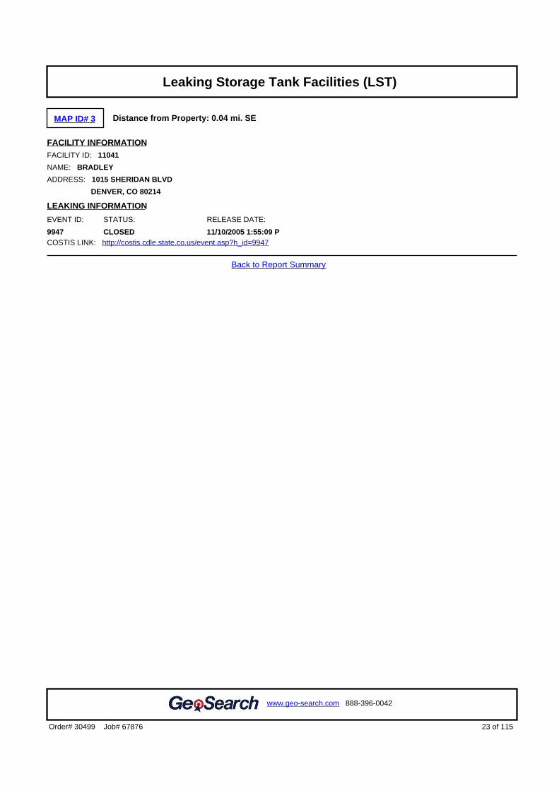
MAP ID# 3 Distance from Property: 0.04 mi. SE
FACILITY INFORMATIONFACILITY ID: 11041
NAME: BRADLEY
ADDRESS: 1015 SHERIDAN BLVD
DENVER, CO 80214
LEAKING INFORMATION
EVENT ID: STATUS: RELEASE DATE:
9947 CLOSED 11/10/2005 1:55:09 PCOSTIS LINK: http://costis.cdle.state.co.us/event.asp?h_id=9947
Back to Report Summary
23 of 115Order# 30499 Job# 67876
www.geo-search.com 888-396-0042
Target Property SummaryDatabase Findings SummaryDatabase Findings SummaryDatabase Findings SummaryDatabase Findings SummaryLocatable Database FindingsLocatable Database FindingsLocatable Database FindingsLocatable Database FindingsReport Summary of Locatable SitesHistorical Solid Waste Landfills (HISTSWLF)Denver County Historic Landfills (DCHISTLF)Emergency Response Notification System (ERNSCO)Spills Listing (SPILLS)Underground Storage Tank Facilities (UST)Hazardous Materials Incident Reporting System (HMIRSR08)Leaking Storage Tank Facilities (LST)

MAP ID# 4 Distance from Property: 0.08 mi. SE
FACILITY INFORMATION OWNER INFORMATION
FACILITY ID: 6650 NAME: BP AMERICA
NAME: AMOCO #8605 ADDRESS: 501 WESTLAKE PARK BLVD STE 20-109C
ADDRESS: 998 SHERIDAN BLVD HOUSTON, TX 77079
DENVER, CO 80214
TOTAL TANK: 4
COSTIS LINK: http://costis.cdle.state.co.us/facility.asp?h_id=6650
TANK INFORMATIONTANK ID: TANK TYPE: TANK PRODUCT: TANK CAPACITY: TANK STATUS: INSTALLATION DATE:
6650-1 UST 6 - USED OIL(WASTE OIL)
500 CLOSED 17-APR-69
6650-2 UST GASOLINE 6000 CLOSED 17-APR-69
6650-3 UST GASOLINE 6000 CLOSED 17-APR-69
6650-4 UST GASOLINE 8000 CLOSED 17-APR-69
Back to Report Summary
24 of 115Order# 30499 Job# 67876
www.geo-search.com 888-396-0042
Target Property SummaryDatabase Findings SummaryDatabase Findings SummaryDatabase Findings SummaryDatabase Findings SummaryLocatable Database FindingsLocatable Database FindingsLocatable Database FindingsLocatable Database FindingsReport Summary of Locatable SitesHistorical Solid Waste Landfills (HISTSWLF)Denver County Historic Landfills (DCHISTLF)Emergency Response Notification System (ERNSCO)Spills Listing (SPILLS)Underground Storage Tank Facilities (UST)Hazardous Materials Incident Reporting System (HMIRSR08)Leaking Storage Tank Facilities (LST)Underground Storage Tank Facilities (UST)

MAP ID# 4 Distance from Property: 0.08 mi. SE
FACILITY INFORMATIONEPA ID#: COD983776774 OWNER TYPE: PRIVATE
NAME: HUMAN'S AMOCO OWNER NAME: AMOCO OIL COMPANY
ADDRESS: 998 SHERIDAN BLVD OPERATOR TYPE: NOT REPORTED
DENVER, CO 80209 OPERATOR NAME: NOT REPORTED
CONTACT NAME: JERRY HUMAN
CONTACT ADDRESS: PO BOX 9630
DENVER, CO 80214
CONTACT PHONE: 3037780361
NON-NOTIFIER: NOT A NON-NOTIFIER
DATE RECEIVED BY AGENCY: 02/10/1994
CERTIFICATION - NO CERTIFICATION REPORTED -
INDUSTRY CLASSIFICATION (NAICS) - NO NAICS INFORMATION REPORTED -
SITE HISTORY (INCLUDES GENERATORS AND NON-GENERATORS)
DATE RECEIVED BY AGENCY: 02/10/1994
NAME: HUMAN'S AMOCO
GENERATOR CLASSIFICATION: NOT A GENERATOR
ACTIVITY INFORMATION
GENERATOR STATUS: NOT A GENERATOR
SUBJECT TO CORRECTIVE ACTION UNIVERSE: NO
TDSFs POTENTIALLY SUBJECT TO CORRECTIVE ACTION UNDER 3004 (u)/(v) UNIVERSE: NO
TDSFs ONLY SUBJECT TO CORRECTIVE ACTION UNDER DISCRETIONARY AUTHORITIES UNIVERSE: NO
NON TSDFs WHERE RCRA CORRECTIVE ACTION HAS BEEN IMPOSED UNIVERSE: NO
CORRECTIVE ACTION WORKLOAD UNIVERSE: NO
IMPORTER: NO UNDERGROUND INJECTION: NO
MIXED WASTE GENERATOR: NO UNIVERSAL WASTE DESTINATION FACILITY: NO
RECYCLER: NO TRANSFER FACILITY: NO
TRANSPORTER: NO USED OIL FUEL BURNER: NO
ONSITE BURNER EXEMPTION: NO USED OIL PROCESSOR: NO
FURNACE EXEMPTION: NO USED OIL FUEL MARKETER TO BURNER: NO
USED OIL REFINER: NO SPECIFICATION USED OIL MARKETER: NO
USED OIL TRANSFER FACILITY: NO USED OIL TRANSPORTER: NO
COMPLIANCE, MONITORING AND ENFORCEMENT INFORMATION
EVALUATIONS - NO EVALUATIONS REPORTED -
VIOLATIONS - NO VIOLATIONS REPORTED -
ENFORCEMENTS - NO ENFORCEMENTS REPORTED -
HAZARDOUS WASTE
D000
D001 IGNITABLE WASTE
D002 CORROSIVE WASTE
D018 BENZENE
UNIVERSAL WASTE - NO UNIVERSAL WASTE REPORTED -
25 of 115Order# 30499 Job# 67876
www.geo-search.com 888-396-0042
Target Property SummaryDatabase Findings SummaryDatabase Findings SummaryDatabase Findings SummaryDatabase Findings SummaryLocatable Database FindingsLocatable Database FindingsLocatable Database FindingsLocatable Database FindingsReport Summary of Locatable SitesHistorical Solid Waste Landfills (HISTSWLF)Denver County Historic Landfills (DCHISTLF)Emergency Response Notification System (ERNSCO)Spills Listing (SPILLS)Underground Storage Tank Facilities (UST)Hazardous Materials Incident Reporting System (HMIRSR08)Leaking Storage Tank Facilities (LST)Underground Storage Tank Facilities (UST)Resource Conservation & Recovery Act - Non-Generator Facilities(RCRANGR08)

CORRECTIVE ACTION AREA - NO CORECTIVE ACTION AREA INFORMATION REPORTED -
CORRECTIVE ACTION EVENT - NO CORECTIVE ACTION EVENT REPORTED -
Back to Report Summary
26 of 115Order# 30499 Job# 67876
www.geo-search.com 888-396-0042
Target Property SummaryDatabase Findings SummaryDatabase Findings SummaryDatabase Findings SummaryDatabase Findings SummaryLocatable Database FindingsLocatable Database FindingsLocatable Database FindingsLocatable Database FindingsReport Summary of Locatable SitesHistorical Solid Waste Landfills (HISTSWLF)Denver County Historic Landfills (DCHISTLF)Emergency Response Notification System (ERNSCO)Spills Listing (SPILLS)Underground Storage Tank Facilities (UST)Hazardous Materials Incident Reporting System (HMIRSR08)Leaking Storage Tank Facilities (LST)Underground Storage Tank Facilities (UST)Resource Conservation & Recovery Act - Non-Generator Facilities(RCRANGR08)

MAP ID# 4 Distance from Property: 0.08 mi. SE
FACILITY INFORMATIONFACILITY ID: 6650
NAME: AMOCO OIL #8605
ADDRESS: 998 SHERIDAN BLVD
DENVER, CO 80214
LEAKING INFORMATION
EVENT ID: STATUS: RELEASE DATE:
4903 CLOSED 11/21/1990COSTIS LINK: http://costis.cdle.state.co.us/event.asp?h_id=4903
Back to Report Summary
27 of 115Order# 30499 Job# 67876
www.geo-search.com 888-396-0042
Target Property SummaryDatabase Findings SummaryDatabase Findings SummaryDatabase Findings SummaryDatabase Findings SummaryLocatable Database FindingsLocatable Database FindingsLocatable Database FindingsLocatable Database FindingsReport Summary of Locatable SitesHistorical Solid Waste Landfills (HISTSWLF)Denver County Historic Landfills (DCHISTLF)Emergency Response Notification System (ERNSCO)Spills Listing (SPILLS)Underground Storage Tank Facilities (UST)Hazardous Materials Incident Reporting System (HMIRSR08)Leaking Storage Tank Facilities (LST)Underground Storage Tank Facilities (UST)Resource Conservation & Recovery Act - Non-Generator Facilities(RCRANGR08)Leaking Storage Tank Facilities (LST)

MAP ID# 5 Distance from Property: 0.15 mi. SW
FACILITY INFORMATION OWNER INFORMATION
FACILITY ID: 13033 NAME: HARRY FARMER
NAME: DEPEW GREENHOUSE ADDRESS: 8865 W 11TH AVE
ADDRESS: 999 DEPEW ST LAKEWOOD, CO 80215
LAKEWOOD, CO 80232
TOTAL TANK: 1
COSTIS LINK: http://costis.cdle.state.co.us/facility.asp?h_id=13033
TANK INFORMATIONTANK ID: TANK TYPE: TANK PRODUCT: TANK CAPACITY: TANK STATUS: INSTALLATION DATE:
NR NOT REPORTED NOT REPORTED NOT REPORTED NOT REPORTED NOT REPORTED
Back to Report Summary
28 of 115Order# 30499 Job# 67876
www.geo-search.com 888-396-0042
Target Property SummaryDatabase Findings SummaryDatabase Findings SummaryDatabase Findings SummaryDatabase Findings SummaryLocatable Database FindingsLocatable Database FindingsLocatable Database FindingsLocatable Database FindingsReport Summary of Locatable SitesHistorical Solid Waste Landfills (HISTSWLF)Denver County Historic Landfills (DCHISTLF)Emergency Response Notification System (ERNSCO)Spills Listing (SPILLS)Underground Storage Tank Facilities (UST)Hazardous Materials Incident Reporting System (HMIRSR08)Leaking Storage Tank Facilities (LST)Underground Storage Tank Facilities (UST)Resource Conservation & Recovery Act - Non-Generator Facilities(RCRANGR08)Leaking Storage Tank Facilities (LST)Aboveground Storage Tank Facilities (AST)

MAP ID# 5 Distance from Property: 0.15 mi. SW
FACILITY INFORMATIONFACILITY ID: 13033
NAME: DEPEW GREENHOUSE
ADDRESS: 999 DEPEW ST
LAKEWOOD, CO 80232
LEAKING INFORMATION
EVENT ID: STATUS: RELEASE DATE:
2610 CLOSED 2/14/1994COSTIS LINK: http://costis.cdle.state.co.us/event.asp?h_id=2610
Back to Report Summary
29 of 115Order# 30499 Job# 67876
www.geo-search.com 888-396-0042
Target Property SummaryDatabase Findings SummaryDatabase Findings SummaryDatabase Findings SummaryDatabase Findings SummaryLocatable Database FindingsLocatable Database FindingsLocatable Database FindingsLocatable Database FindingsReport Summary of Locatable SitesHistorical Solid Waste Landfills (HISTSWLF)Denver County Historic Landfills (DCHISTLF)Emergency Response Notification System (ERNSCO)Spills Listing (SPILLS)Underground Storage Tank Facilities (UST)Hazardous Materials Incident Reporting System (HMIRSR08)Leaking Storage Tank Facilities (LST)Underground Storage Tank Facilities (UST)Resource Conservation & Recovery Act - Non-Generator Facilities(RCRANGR08)Leaking Storage Tank Facilities (LST)Aboveground Storage Tank Facilities (AST)Leaking Storage Tank Facilities (LST)

MAP ID# 5 Distance from Property: 0.12 mi. SW
SITE INFORMATIONID#: 2301573297
ADDRESS: 5580 WEST 10TH AVENUE
CITY: DENVER
STATE: CO
COUNTY: JEFFERSON
SEIZURE DATE: 4/2/2007
Back to Report Summary
30 of 115Order# 30499 Job# 67876
www.geo-search.com 888-396-0042
Target Property SummaryDatabase Findings SummaryDatabase Findings SummaryDatabase Findings SummaryDatabase Findings SummaryLocatable Database FindingsLocatable Database FindingsLocatable Database FindingsLocatable Database FindingsReport Summary of Locatable SitesHistorical Solid Waste Landfills (HISTSWLF)Denver County Historic Landfills (DCHISTLF)Emergency Response Notification System (ERNSCO)Spills Listing (SPILLS)Underground Storage Tank Facilities (UST)Hazardous Materials Incident Reporting System (HMIRSR08)Leaking Storage Tank Facilities (LST)Underground Storage Tank Facilities (UST)Resource Conservation & Recovery Act - Non-Generator Facilities(RCRANGR08)Leaking Storage Tank Facilities (LST)Aboveground Storage Tank Facilities (AST)Leaking Storage Tank Facilities (LST)Clandestine Drug Laboratory Locations (CDL)

MAP ID# 5 Distance from Property: 0.12 mi. SW
SITE INFORMATIONID#: 2140849396
ADDRESS: 5580 WEST 10TH AVENUE??
CITY: DENVER
STATE: CO
COUNTY: JEFFERSON
SEIZURE DATE: 4/2/2007
Back to Report Summary
31 of 115Order# 30499 Job# 67876
www.geo-search.com 888-396-0042
Target Property SummaryDatabase Findings SummaryDatabase Findings SummaryDatabase Findings SummaryDatabase Findings SummaryLocatable Database FindingsLocatable Database FindingsLocatable Database FindingsLocatable Database FindingsReport Summary of Locatable SitesHistorical Solid Waste Landfills (HISTSWLF)Denver County Historic Landfills (DCHISTLF)Emergency Response Notification System (ERNSCO)Spills Listing (SPILLS)Underground Storage Tank Facilities (UST)Hazardous Materials Incident Reporting System (HMIRSR08)Leaking Storage Tank Facilities (LST)Underground Storage Tank Facilities (UST)Resource Conservation & Recovery Act - Non-Generator Facilities(RCRANGR08)Leaking Storage Tank Facilities (LST)Aboveground Storage Tank Facilities (AST)Leaking Storage Tank Facilities (LST)Clandestine Drug Laboratory Locations (CDL)Clandestine Drug Laboratory Locations (CDL)

MAP ID# 5 Distance from Property: 0.15 mi. SW
FACILITY INFORMATION OWNER INFORMATION
FACILITY ID: 6533 NAME: UNKNOWN
NAME: UNKNOWN OWNER ADDRESS: UNKNOWN
ADDRESS: 999 DEPEW ZIPCODE UNKNOWN, XX 99999
EDGEWATER, CO 80214
TOTAL TANK: 1
COSTIS LINK: http://costis.cdle.state.co.us/facility.asp?h_id=6533
TANK INFORMATIONTANK ID: TANK TYPE: TANK PRODUCT: TANK CAPACITY: TANK STATUS: INSTALLATION DATE:
NR NOT REPORTED NOT REPORTED NOT REPORTED NOT REPORTED NOT REPORTED
Back to Report Summary
32 of 115Order# 30499 Job# 67876
www.geo-search.com 888-396-0042
Target Property SummaryDatabase Findings SummaryDatabase Findings SummaryDatabase Findings SummaryDatabase Findings SummaryLocatable Database FindingsLocatable Database FindingsLocatable Database FindingsLocatable Database FindingsReport Summary of Locatable SitesHistorical Solid Waste Landfills (HISTSWLF)Denver County Historic Landfills (DCHISTLF)Emergency Response Notification System (ERNSCO)Spills Listing (SPILLS)Underground Storage Tank Facilities (UST)Hazardous Materials Incident Reporting System (HMIRSR08)Leaking Storage Tank Facilities (LST)Underground Storage Tank Facilities (UST)Resource Conservation & Recovery Act - Non-Generator Facilities(RCRANGR08)Leaking Storage Tank Facilities (LST)Aboveground Storage Tank Facilities (AST)Leaking Storage Tank Facilities (LST)Clandestine Drug Laboratory Locations (CDL)Clandestine Drug Laboratory Locations (CDL)Aboveground Storage Tank Facilities (AST)

MAP ID# 6 Distance from Property: 0.14 mi. SE
FACILITY INFORMATIONFACILITY ID: 14005
NAME: STERN FOX INVESTMENT
ADDRESS: 901 SHERIDAN BLVD
LAKEWOOD, CO 80215
LEAKING INFORMATION
EVENT ID: STATUS: RELEASE DATE:
4148 CLOSED 9/14/1989COSTIS LINK: http://costis.cdle.state.co.us/event.asp?h_id=4148
Back to Report Summary
33 of 115Order# 30499 Job# 67876
www.geo-search.com 888-396-0042
Target Property SummaryDatabase Findings SummaryDatabase Findings SummaryDatabase Findings SummaryDatabase Findings SummaryLocatable Database FindingsLocatable Database FindingsLocatable Database FindingsLocatable Database FindingsReport Summary of Locatable SitesHistorical Solid Waste Landfills (HISTSWLF)Denver County Historic Landfills (DCHISTLF)Emergency Response Notification System (ERNSCO)Spills Listing (SPILLS)Underground Storage Tank Facilities (UST)Hazardous Materials Incident Reporting System (HMIRSR08)Leaking Storage Tank Facilities (LST)Underground Storage Tank Facilities (UST)Resource Conservation & Recovery Act - Non-Generator Facilities(RCRANGR08)Leaking Storage Tank Facilities (LST)Aboveground Storage Tank Facilities (AST)Leaking Storage Tank Facilities (LST)Clandestine Drug Laboratory Locations (CDL)Clandestine Drug Laboratory Locations (CDL)Aboveground Storage Tank Facilities (AST)Leaking Storage Tank Facilities (LST)

MAP ID# 6 Distance from Property: 0.14 mi. SE
FACILITY INFORMATION OWNER INFORMATION
FACILITY ID: 14005 NAME: STERN FOX INVESTMENT
NAME: STERN FOX INVESTMENT ADDRESS: 611 S HARRISON LN
ADDRESS: 901 SHERIDAN BLVD DENVER, CO 80209
LAKEWOOD, CO 80215
TOTAL TANK: 1
COSTIS LINK: http://costis.cdle.state.co.us/facility.asp?h_id=14005
TANK INFORMATIONTANK ID: TANK TYPE: TANK PRODUCT: TANK CAPACITY: TANK STATUS: INSTALLATION DATE:
NR NOT REPORTED NOT REPORTED NOT REPORTED NOT REPORTED NOT REPORTED
Back to Report Summary
34 of 115Order# 30499 Job# 67876
www.geo-search.com 888-396-0042
Target Property SummaryDatabase Findings SummaryDatabase Findings SummaryDatabase Findings SummaryDatabase Findings SummaryLocatable Database FindingsLocatable Database FindingsLocatable Database FindingsLocatable Database FindingsReport Summary of Locatable SitesHistorical Solid Waste Landfills (HISTSWLF)Denver County Historic Landfills (DCHISTLF)Emergency Response Notification System (ERNSCO)Spills Listing (SPILLS)Underground Storage Tank Facilities (UST)Hazardous Materials Incident Reporting System (HMIRSR08)Leaking Storage Tank Facilities (LST)Underground Storage Tank Facilities (UST)Resource Conservation & Recovery Act - Non-Generator Facilities(RCRANGR08)Leaking Storage Tank Facilities (LST)Aboveground Storage Tank Facilities (AST)Leaking Storage Tank Facilities (LST)Clandestine Drug Laboratory Locations (CDL)Clandestine Drug Laboratory Locations (CDL)Aboveground Storage Tank Facilities (AST)Leaking Storage Tank Facilities (LST)Aboveground Storage Tank Facilities (AST)
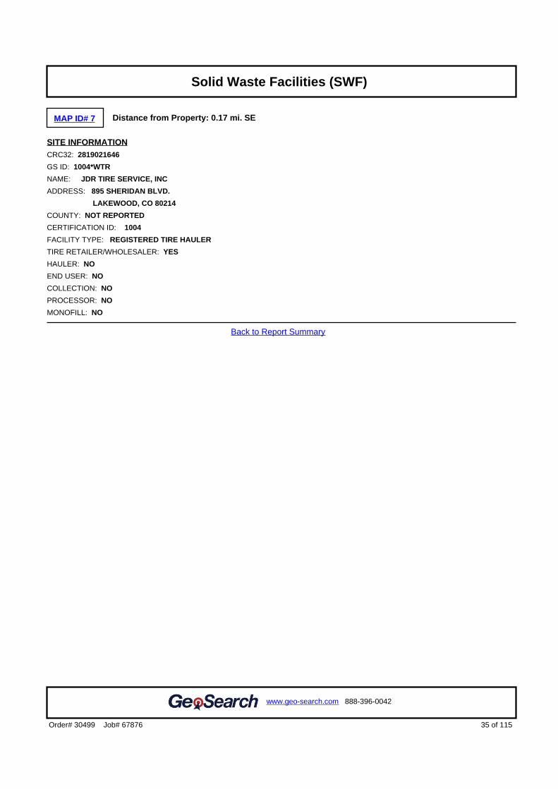
MAP ID# 7 Distance from Property: 0.17 mi. SE
SITE INFORMATIONCRC32: 2819021646
GS ID: 1004*WTR
NAME: JDR TIRE SERVICE, INC
ADDRESS: 895 SHERIDAN BLVD.
LAKEWOOD, CO 80214
COUNTY: NOT REPORTED
CERTIFICATION ID: 1004
FACILITY TYPE: REGISTERED TIRE HAULER
TIRE RETAILER/WHOLESALER: YES
HAULER: NO
END USER: NO
COLLECTION: NO
PROCESSOR: NO
MONOFILL: NO
Back to Report Summary
35 of 115Order# 30499 Job# 67876
www.geo-search.com 888-396-0042
Target Property SummaryDatabase Findings SummaryDatabase Findings SummaryDatabase Findings SummaryDatabase Findings SummaryLocatable Database FindingsLocatable Database FindingsLocatable Database FindingsLocatable Database FindingsReport Summary of Locatable SitesHistorical Solid Waste Landfills (HISTSWLF)Denver County Historic Landfills (DCHISTLF)Emergency Response Notification System (ERNSCO)Spills Listing (SPILLS)Underground Storage Tank Facilities (UST)Hazardous Materials Incident Reporting System (HMIRSR08)Leaking Storage Tank Facilities (LST)Underground Storage Tank Facilities (UST)Resource Conservation & Recovery Act - Non-Generator Facilities(RCRANGR08)Leaking Storage Tank Facilities (LST)Aboveground Storage Tank Facilities (AST)Leaking Storage Tank Facilities (LST)Clandestine Drug Laboratory Locations (CDL)Clandestine Drug Laboratory Locations (CDL)Aboveground Storage Tank Facilities (AST)Leaking Storage Tank Facilities (LST)Aboveground Storage Tank Facilities (AST)Solid Waste Facilities (SWF)

MAP ID# 8 Distance from Property: 0.17 mi. NW
FACILITY INFORMATION OWNER INFORMATION
FACILITY ID: 10034 NAME: NUCON CONSTRUCTION CORP
NAME: NUCON CONSTRUCTION CORP ADDRESS: 5490 W 13TH AVE
ADDRESS: 5490 W 13TH AVE LAKEWOOD, CO 80215
LAKEWOOD, CO 80214
TOTAL TANK: 5
COSTIS LINK: http://costis.cdle.state.co.us/facility.asp?h_id=10034
TANK INFORMATIONTANK ID: TANK TYPE: TANK PRODUCT: TANK CAPACITY: TANK STATUS: INSTALLATION DATE:
10034-1 UST GASOLINE 8000 CLOSED 21-APR-72
10034-2 UST GASOLINE 12000 CLOSED 21-APR-72
10034-3 UST 4 - DIESEL 2000 CLOSED 21-APR-72
10034-4 UST 4 - DIESEL 2000 CLOSED 21-APR-72
10034-5 UST 4 - DIESEL 2000 CLOSED 21-APR-72
Back to Report Summary
36 of 115Order# 30499 Job# 67876
www.geo-search.com 888-396-0042
Target Property SummaryDatabase Findings SummaryDatabase Findings SummaryDatabase Findings SummaryDatabase Findings SummaryLocatable Database FindingsLocatable Database FindingsLocatable Database FindingsLocatable Database FindingsReport Summary of Locatable SitesHistorical Solid Waste Landfills (HISTSWLF)Denver County Historic Landfills (DCHISTLF)Emergency Response Notification System (ERNSCO)Spills Listing (SPILLS)Underground Storage Tank Facilities (UST)Hazardous Materials Incident Reporting System (HMIRSR08)Leaking Storage Tank Facilities (LST)Underground Storage Tank Facilities (UST)Resource Conservation & Recovery Act - Non-Generator Facilities(RCRANGR08)Leaking Storage Tank Facilities (LST)Aboveground Storage Tank Facilities (AST)Leaking Storage Tank Facilities (LST)Clandestine Drug Laboratory Locations (CDL)Clandestine Drug Laboratory Locations (CDL)Aboveground Storage Tank Facilities (AST)Leaking Storage Tank Facilities (LST)Aboveground Storage Tank Facilities (AST)Solid Waste Facilities (SWF)Underground Storage Tank Facilities (UST)

MAP ID# 8 Distance from Property: 0.17 mi. NW
FACILITY INFORMATIONEPA ID#: COD983798752 OWNER TYPE: PRIVATE
NAME: CENTRIC JONES COMPANY OWNER NAME: LIMITED PARTNERSHIP
ADDRESS: 5490 W 13TH AVENUE OPERATOR TYPE: NOT REPORTED
LAKEWOOD, CO 80214 OPERATOR NAME: NOT REPORTED
CONTACT NAME: TONI ZINANTI-SINNER
CONTACT ADDRESS: P.O. BOX 14026
LAKEWOOD, CO 80214
CONTACT PHONE: 3032338440
NON-NOTIFIER: NOT A NON-NOTIFIER
DATE RECEIVED BY AGENCY: 12/14/1992
CERTIFICATION - NO CERTIFICATION REPORTED -
INDUSTRY CLASSIFICATION (NAICS) - NO NAICS INFORMATION REPORTED -
SITE HISTORY (INCLUDES GENERATORS AND NON-GENERATORS)
DATE RECEIVED BY AGENCY: 12/14/1992
NAME: CENTRIC JONES COMPANY
GENERATOR CLASSIFICATION: LARGE QUANTITY GENERATOR
ACTIVITY INFORMATION
GENERATOR STATUS: CONDITIONALLY EXEMPT SMALL QUANTITY GENERATOR
SUBJECT TO CORRECTIVE ACTION UNIVERSE: NO
TDSFs POTENTIALLY SUBJECT TO CORRECTIVE ACTION UNDER 3004 (u)/(v) UNIVERSE: NO
TDSFs ONLY SUBJECT TO CORRECTIVE ACTION UNDER DISCRETIONARY AUTHORITIES UNIVERSE: NO
NON TSDFs WHERE RCRA CORRECTIVE ACTION HAS BEEN IMPOSED UNIVERSE: NO
CORRECTIVE ACTION WORKLOAD UNIVERSE: NO
IMPORTER: NO UNDERGROUND INJECTION: NO
MIXED WASTE GENERATOR: NO UNIVERSAL WASTE DESTINATION FACILITY: NO
RECYCLER: NO TRANSFER FACILITY: NO
TRANSPORTER: NO USED OIL FUEL BURNER: NO
ONSITE BURNER EXEMPTION: NO USED OIL PROCESSOR: NO
FURNACE EXEMPTION: NO USED OIL FUEL MARKETER TO BURNER: NO
USED OIL REFINER: NO SPECIFICATION USED OIL MARKETER: NO
USED OIL TRANSFER FACILITY: NO USED OIL TRANSPORTER: NO
COMPLIANCE, MONITORING AND ENFORCEMENT INFORMATION
EVALUATIONS - NO EVALUATIONS REPORTED -
VIOLATIONS - NO VIOLATIONS REPORTED -
ENFORCEMENTS - NO ENFORCEMENTS REPORTED -
HAZARDOUS WASTE
D001 IGNITABLE WASTE
UNIVERSAL WASTE - NO UNIVERSAL WASTE REPORTED -
CORRECTIVE ACTION AREA - NO CORECTIVE ACTION AREA INFORMATION REPORTED -
CORRECTIVE ACTION EVENT - NO CORECTIVE ACTION EVENT REPORTED -
37 of 115Order# 30499 Job# 67876
www.geo-search.com 888-396-0042
Target Property SummaryDatabase Findings SummaryDatabase Findings SummaryDatabase Findings SummaryDatabase Findings SummaryLocatable Database FindingsLocatable Database FindingsLocatable Database FindingsLocatable Database FindingsReport Summary of Locatable SitesHistorical Solid Waste Landfills (HISTSWLF)Denver County Historic Landfills (DCHISTLF)Emergency Response Notification System (ERNSCO)Spills Listing (SPILLS)Underground Storage Tank Facilities (UST)Hazardous Materials Incident Reporting System (HMIRSR08)Leaking Storage Tank Facilities (LST)Underground Storage Tank Facilities (UST)Resource Conservation & Recovery Act - Non-Generator Facilities(RCRANGR08)Leaking Storage Tank Facilities (LST)Aboveground Storage Tank Facilities (AST)Leaking Storage Tank Facilities (LST)Clandestine Drug Laboratory Locations (CDL)Clandestine Drug Laboratory Locations (CDL)Aboveground Storage Tank Facilities (AST)Leaking Storage Tank Facilities (LST)Aboveground Storage Tank Facilities (AST)Solid Waste Facilities (SWF)Underground Storage Tank Facilities (UST)Resource Conservation & Recovery Act - Generator Facilities(RCRAGR08)

Back to Report Summary
38 of 115Order# 30499 Job# 67876
www.geo-search.com 888-396-0042
Target Property SummaryDatabase Findings SummaryDatabase Findings SummaryDatabase Findings SummaryDatabase Findings SummaryLocatable Database FindingsLocatable Database FindingsLocatable Database FindingsLocatable Database FindingsReport Summary of Locatable SitesHistorical Solid Waste Landfills (HISTSWLF)Denver County Historic Landfills (DCHISTLF)Emergency Response Notification System (ERNSCO)Spills Listing (SPILLS)Underground Storage Tank Facilities (UST)Hazardous Materials Incident Reporting System (HMIRSR08)Leaking Storage Tank Facilities (LST)Underground Storage Tank Facilities (UST)Resource Conservation & Recovery Act - Non-Generator Facilities(RCRANGR08)Leaking Storage Tank Facilities (LST)Aboveground Storage Tank Facilities (AST)Leaking Storage Tank Facilities (LST)Clandestine Drug Laboratory Locations (CDL)Clandestine Drug Laboratory Locations (CDL)Aboveground Storage Tank Facilities (AST)Leaking Storage Tank Facilities (LST)Aboveground Storage Tank Facilities (AST)Solid Waste Facilities (SWF)Underground Storage Tank Facilities (UST)Resource Conservation & Recovery Act - Generator Facilities(RCRAGR08)

MAP ID# 8 Distance from Property: 0.17 mi. NW
FACILITY INFORMATIONFACILITY ID: 10034
NAME: NUCON CONSTRUCTION CORP
ADDRESS: 5490 W 13TH AVE
LAKEWOOD, CO 80214
LEAKING INFORMATION
EVENT ID: STATUS: RELEASE DATE:
221 CLOSED 2/22/1990COSTIS LINK: http://costis.cdle.state.co.us/event.asp?h_id=221
1048 CLOSED 2/22/1990COSTIS LINK: http://costis.cdle.state.co.us/event.asp?h_id=1048
Back to Report Summary
39 of 115Order# 30499 Job# 67876
www.geo-search.com 888-396-0042
Target Property SummaryDatabase Findings SummaryDatabase Findings SummaryDatabase Findings SummaryDatabase Findings SummaryLocatable Database FindingsLocatable Database FindingsLocatable Database FindingsLocatable Database FindingsReport Summary of Locatable SitesHistorical Solid Waste Landfills (HISTSWLF)Denver County Historic Landfills (DCHISTLF)Emergency Response Notification System (ERNSCO)Spills Listing (SPILLS)Underground Storage Tank Facilities (UST)Hazardous Materials Incident Reporting System (HMIRSR08)Leaking Storage Tank Facilities (LST)Underground Storage Tank Facilities (UST)Resource Conservation & Recovery Act - Non-Generator Facilities(RCRANGR08)Leaking Storage Tank Facilities (LST)Aboveground Storage Tank Facilities (AST)Leaking Storage Tank Facilities (LST)Clandestine Drug Laboratory Locations (CDL)Clandestine Drug Laboratory Locations (CDL)Aboveground Storage Tank Facilities (AST)Leaking Storage Tank Facilities (LST)Aboveground Storage Tank Facilities (AST)Solid Waste Facilities (SWF)Underground Storage Tank Facilities (UST)Resource Conservation & Recovery Act - Generator Facilities(RCRAGR08)Leaking Storage Tank Facilities (LST)

MAP ID# 9 Distance from Property: 0.17 mi. E
SITE INFORMATIONID#: 144621
NAME: W 11TH AVE PROPOSED SENIOR HOUSING
ADDRESS: 4917 W. 11TH AVE 4911 W. 11TH AVE & 1001 YATES ST.
DENVER, CO 80204
TYPE OF BROWNFIELD GRANT: TBA
TYPE FUNDING: N/A
PREDOMINANT PAST USE (ACREAGE): GREENSPACE: NOT REPORTED
RESIDENTIAL:NOT REPORTED
COMMERCIAL:NOT REPORTED
INDUSTRIAL:NOT REPORTED
FUTURE USE (ACREAGE): GREENSPACE: NOT REPORTED
RESIDENTIAL:0.83
COMMERCIAL:NOT REPORTED
INDUSTRIAL:NOT REPORTED
PROPERTY HIGHLIGHT:
NOT REPORTED
PROPERTY SIZE (Acres): 0.83
CURRENT OWNER: CITYWIDE BANKS
PROPERTY DESCRIPTION/ FORMER USE:
THE PROPERTY HAS BEEN OWNED BY HARVEY D AND VIRGINIA A RUSCH, RUSCH AND ASSOCIATES, LAFAYETTE STREET
PARTNERS LLC, ANDREW SCHEER,FIRST FAMILY LIMITED AND CITYWIDE BANKS.
ENVIRONMENTAL ASSESSMENT ACTIVITY: PHASE II ENVIRONMENTAL ASSESSMENT
ASSESSMENT START DATE: 5/2/2012
ASSESSMENT COMPLETION DATE: 6/13/2012
CLEANUP REQUIRED: NO
CONTAMINATE(S): NOT REPORTED
CONTAMINATE(S) CLEANED UP: NOT REPORTED
MEDIA(S) AFFECTED: SOIL
MEDIA(S) CLEANED UP: NOT REPORTED
STATE & TRIBAL ENROLLMENT ID: NOT REPORTED
STATE & TRIBAL ENROLLMENT DATE: NOT REPORTED
PROPERTY ENROLLED IN A STATE & TRIBAL PROGRAM?: NOT REPORTED
ARE INSTITUTIONAL CONTROLS REQUIRED?: NO
ENVIRONMENTAL ASSESSMENT ACTIVITY: PHASE I ENVIRONMENTAL ASSESSMENT
ASSESSMENT START DATE: 4/13/2012
ASSESSMENT COMPLETION DATE: 5/2/2012
CLEANUP REQUIRED: NO
CONTAMINATE(S): NOT REPORTED
CONTAMINATE(S) CLEANED UP: NOT REPORTED
MEDIA(S) AFFECTED: SOIL
MEDIA(S) CLEANED UP: NOT REPORTED
STATE & TRIBAL ENROLLMENT ID: NOT REPORTED
STATE & TRIBAL ENROLLMENT DATE: NOT REPORTED
PROPERTY ENROLLED IN A STATE & TRIBAL PROGRAM?: NOT REPORTED
40 of 115Order# 30499 Job# 67876
www.geo-search.com 888-396-0042
Target Property SummaryDatabase Findings SummaryDatabase Findings SummaryDatabase Findings SummaryDatabase Findings SummaryLocatable Database FindingsLocatable Database FindingsLocatable Database FindingsLocatable Database FindingsReport Summary of Locatable SitesHistorical Solid Waste Landfills (HISTSWLF)Denver County Historic Landfills (DCHISTLF)Emergency Response Notification System (ERNSCO)Spills Listing (SPILLS)Underground Storage Tank Facilities (UST)Hazardous Materials Incident Reporting System (HMIRSR08)Leaking Storage Tank Facilities (LST)Underground Storage Tank Facilities (UST)Resource Conservation & Recovery Act - Non-Generator Facilities(RCRANGR08)Leaking Storage Tank Facilities (LST)Aboveground Storage Tank Facilities (AST)Leaking Storage Tank Facilities (LST)Clandestine Drug Laboratory Locations (CDL)Clandestine Drug Laboratory Locations (CDL)Aboveground Storage Tank Facilities (AST)Leaking Storage Tank Facilities (LST)Aboveground Storage Tank Facilities (AST)Solid Waste Facilities (SWF)Underground Storage Tank Facilities (UST)Resource Conservation & Recovery Act - Generator Facilities(RCRAGR08)Leaking Storage Tank Facilities (LST)Brownfields Management System (BF)

ARE INSTITUTIONAL CONTROLS REQUIRED?: NO
Back to Report Summary
41 of 115Order# 30499 Job# 67876
www.geo-search.com 888-396-0042
Target Property SummaryDatabase Findings SummaryDatabase Findings SummaryDatabase Findings SummaryDatabase Findings SummaryLocatable Database FindingsLocatable Database FindingsLocatable Database FindingsLocatable Database FindingsReport Summary of Locatable SitesHistorical Solid Waste Landfills (HISTSWLF)Denver County Historic Landfills (DCHISTLF)Emergency Response Notification System (ERNSCO)Spills Listing (SPILLS)Underground Storage Tank Facilities (UST)Hazardous Materials Incident Reporting System (HMIRSR08)Leaking Storage Tank Facilities (LST)Underground Storage Tank Facilities (UST)Resource Conservation & Recovery Act - Non-Generator Facilities(RCRANGR08)Leaking Storage Tank Facilities (LST)Aboveground Storage Tank Facilities (AST)Leaking Storage Tank Facilities (LST)Clandestine Drug Laboratory Locations (CDL)Clandestine Drug Laboratory Locations (CDL)Aboveground Storage Tank Facilities (AST)Leaking Storage Tank Facilities (LST)Aboveground Storage Tank Facilities (AST)Solid Waste Facilities (SWF)Underground Storage Tank Facilities (UST)Resource Conservation & Recovery Act - Generator Facilities(RCRAGR08)Leaking Storage Tank Facilities (LST)Brownfields Management System (BF)

MAP ID# 10 Distance from Property: 0.20 mi. NW
FACILITY INFORMATION OWNER INFORMATION
FACILITY ID: 2911 NAME: W SHRIDE
NAME: ELECTRO SYSTEMS INC ADDRESS: 12039 W DAKOTA DR
ADDRESS: 1125 DEPEW CT LAKEWOOD, CO 80228
EDGEWATER, CO 80214
TOTAL TANK: 2
COSTIS LINK: http://costis.cdle.state.co.us/facility.asp?h_id=2911
TANK INFORMATIONTANK ID: TANK TYPE: TANK PRODUCT: TANK CAPACITY: TANK STATUS: INSTALLATION DATE:
2911-1 UST GASOLINE 10000 CLOSED 17-APR-76
2911-2 UST 4 - DIESEL 10000 CLOSED 17-APR-76
Back to Report Summary
42 of 115Order# 30499 Job# 67876
www.geo-search.com 888-396-0042
Target Property SummaryDatabase Findings SummaryDatabase Findings SummaryDatabase Findings SummaryDatabase Findings SummaryLocatable Database FindingsLocatable Database FindingsLocatable Database FindingsLocatable Database FindingsReport Summary of Locatable SitesHistorical Solid Waste Landfills (HISTSWLF)Denver County Historic Landfills (DCHISTLF)Emergency Response Notification System (ERNSCO)Spills Listing (SPILLS)Underground Storage Tank Facilities (UST)Hazardous Materials Incident Reporting System (HMIRSR08)Leaking Storage Tank Facilities (LST)Underground Storage Tank Facilities (UST)Resource Conservation & Recovery Act - Non-Generator Facilities(RCRANGR08)Leaking Storage Tank Facilities (LST)Aboveground Storage Tank Facilities (AST)Leaking Storage Tank Facilities (LST)Clandestine Drug Laboratory Locations (CDL)Clandestine Drug Laboratory Locations (CDL)Aboveground Storage Tank Facilities (AST)Leaking Storage Tank Facilities (LST)Aboveground Storage Tank Facilities (AST)Solid Waste Facilities (SWF)Underground Storage Tank Facilities (UST)Resource Conservation & Recovery Act - Generator Facilities(RCRAGR08)Leaking Storage Tank Facilities (LST)Brownfields Management System (BF)Underground Storage Tank Facilities (UST)

MAP ID# 11 Distance from Property: 0.23 mi. W
SITE INFORMATIONCRC32: 2223001917
GS ID: 1247*WTR
NAME: MOUNTAIN HIGH TREE SERVICE
ADDRESS: 5717 W 11TH AVE
LAKEWOOD, CO 80214
COUNTY: NOT REPORTED
CERTIFICATION ID: 1247
FACILITY TYPE: REGISTERED TIRE HAULER
TIRE RETAILER/WHOLESALER: YES
HAULER: NO
END USER: NO
COLLECTION: NO
PROCESSOR: NO
MONOFILL: NO
Back to Report Summary
43 of 115Order# 30499 Job# 67876
www.geo-search.com 888-396-0042
Target Property SummaryDatabase Findings SummaryDatabase Findings SummaryDatabase Findings SummaryDatabase Findings SummaryLocatable Database FindingsLocatable Database FindingsLocatable Database FindingsLocatable Database FindingsReport Summary of Locatable SitesHistorical Solid Waste Landfills (HISTSWLF)Denver County Historic Landfills (DCHISTLF)Emergency Response Notification System (ERNSCO)Spills Listing (SPILLS)Underground Storage Tank Facilities (UST)Hazardous Materials Incident Reporting System (HMIRSR08)Leaking Storage Tank Facilities (LST)Underground Storage Tank Facilities (UST)Resource Conservation & Recovery Act - Non-Generator Facilities(RCRANGR08)Leaking Storage Tank Facilities (LST)Aboveground Storage Tank Facilities (AST)Leaking Storage Tank Facilities (LST)Clandestine Drug Laboratory Locations (CDL)Clandestine Drug Laboratory Locations (CDL)Aboveground Storage Tank Facilities (AST)Leaking Storage Tank Facilities (LST)Aboveground Storage Tank Facilities (AST)Solid Waste Facilities (SWF)Underground Storage Tank Facilities (UST)Resource Conservation & Recovery Act - Generator Facilities(RCRAGR08)Leaking Storage Tank Facilities (LST)Brownfields Management System (BF)Underground Storage Tank Facilities (UST)Solid Waste Facilities (SWF)

MAP ID# 12 Distance from Property: 0.27 mi. W
SITE INFORMATIONUNIQUE ID: 00070-0000655
NAME: ARTIFICIAL FILL
ADDRESS: BETWEEN HARLAN ST & FENTON ST; SOUTH OF 13TH AVE AND C&S RR, HAL
CITY NOT REPORTED, CO
DIRECTIONS: NOT REPORTED
COUNTY: JEFFERSON
SITE DETAILSAGENCY ID: 110
DETAIL1:
; FILL- DOMESTIC REFUSE: NO. CONSTRUCTION DEBRIS: NO. LIQUIDS: NO. HAZARDOUS WASTE: NO. INDUSTRIAL WASTE:
NO. ARTIFICIAL FILL. UNKNOWN: NO. CLAY, SILT, SAND, GRAVEL AND A VARIETY OF DEBRIS CONSISTING OF WOOD, BRICK,
CONCRETE, METAL, PLASTIC, GLASS,
DETAIL2:
ARTIFICIAL FILL. INCLUDES EMBANKMENTS, DAMS, AND OTHER ENGINEERED FILLS; COMPACTED LANDFILLS, AND
UNCOMPACTED RUBBISH DUMPS. CONFIDENCE IN THIS INFO: HIGH.; OPENED- CLOSED-
Back to Report Summary
44 of 115Order# 30499 Job# 67876
www.geo-search.com 888-396-0042
Target Property SummaryDatabase Findings SummaryDatabase Findings SummaryDatabase Findings SummaryDatabase Findings SummaryLocatable Database FindingsLocatable Database FindingsLocatable Database FindingsLocatable Database FindingsReport Summary of Locatable SitesHistorical Solid Waste Landfills (HISTSWLF)Denver County Historic Landfills (DCHISTLF)Emergency Response Notification System (ERNSCO)Spills Listing (SPILLS)Underground Storage Tank Facilities (UST)Hazardous Materials Incident Reporting System (HMIRSR08)Leaking Storage Tank Facilities (LST)Underground Storage Tank Facilities (UST)Resource Conservation & Recovery Act - Non-Generator Facilities(RCRANGR08)Leaking Storage Tank Facilities (LST)Aboveground Storage Tank Facilities (AST)Leaking Storage Tank Facilities (LST)Clandestine Drug Laboratory Locations (CDL)Clandestine Drug Laboratory Locations (CDL)Aboveground Storage Tank Facilities (AST)Leaking Storage Tank Facilities (LST)Aboveground Storage Tank Facilities (AST)Solid Waste Facilities (SWF)Underground Storage Tank Facilities (UST)Resource Conservation & Recovery Act - Generator Facilities(RCRAGR08)Leaking Storage Tank Facilities (LST)Brownfields Management System (BF)Underground Storage Tank Facilities (UST)Solid Waste Facilities (SWF)Historical Solid Waste Landfills (HISTSWLF)

MAP ID# 12 Distance from Property: 0.27 mi. W
SITE INFORMATIONLANDFILL ID: 110
LANDFILL NAME: 4S-69W-01NE
DATE ENTERED: 04/28/1997
TYPE OF LANDFILL: OTHER
DESCRIPTION:
BETWEEN HARLAN ST & FENTON ST; SOUTH OF 13TH AVE AND C&S RR, HALFWAY TO 11TH AVE.
TYPE REMARKS:
INCLUDES EMBANKMENTS, DAMS, AND OTHER ENGINEERED FILLS; COMPACTED LANDFILLS, AND UNCOMPACTED
RUBBISH DUMPS.
DOMESTIC: NO HAZARDOUS: NO
CONSTRUCTION: NO INDUSTRIAL: NO
LIQUIDS: NO UNKNOWN: NO
OTHER: ARTIFICIAL FILL
MATERIAL RECEIVED:
CLAY, SILT, SAND, GRAVEL AND A VARIETY OF DEBRIS CONSISTING OF WOOD, BRICK, CONCRETE, METAL, PLASTIC,
GLASS, VEGETATION, AND OTHER TRASH.
START DATE: NOT REPORTED
END DATE: NOT REPORTED
Back to Report Summary
45 of 115Order# 30499 Job# 67876
www.geo-search.com 888-396-0042
Target Property SummaryDatabase Findings SummaryDatabase Findings SummaryDatabase Findings SummaryDatabase Findings SummaryLocatable Database FindingsLocatable Database FindingsLocatable Database FindingsLocatable Database FindingsReport Summary of Locatable SitesHistorical Solid Waste Landfills (HISTSWLF)Denver County Historic Landfills (DCHISTLF)Emergency Response Notification System (ERNSCO)Spills Listing (SPILLS)Underground Storage Tank Facilities (UST)Hazardous Materials Incident Reporting System (HMIRSR08)Leaking Storage Tank Facilities (LST)Underground Storage Tank Facilities (UST)Resource Conservation & Recovery Act - Non-Generator Facilities(RCRANGR08)Leaking Storage Tank Facilities (LST)Aboveground Storage Tank Facilities (AST)Leaking Storage Tank Facilities (LST)Clandestine Drug Laboratory Locations (CDL)Clandestine Drug Laboratory Locations (CDL)Aboveground Storage Tank Facilities (AST)Leaking Storage Tank Facilities (LST)Aboveground Storage Tank Facilities (AST)Solid Waste Facilities (SWF)Underground Storage Tank Facilities (UST)Resource Conservation & Recovery Act - Generator Facilities(RCRAGR08)Leaking Storage Tank Facilities (LST)Brownfields Management System (BF)Underground Storage Tank Facilities (UST)Solid Waste Facilities (SWF)Historical Solid Waste Landfills (HISTSWLF)Denver County Historic Landfills (DCHISTLF)

MAP ID# 13 Distance from Property: 0.38 mi. W
SITE INFORMATIONID#: 80999
NAME: POLICE PROPERTY STORAGE
ADDRESS: 1290 HARLAN STREET
LAKEWOOD, CO 80226
TYPE OF BROWNFIELD GRANT: ASSESSMENT
TYPE FUNDING: H
PREDOMINANT PAST USE (ACREAGE): GREENSPACE: NOT REPORTED
RESIDENTIAL:NOT REPORTED
COMMERCIAL:NOT REPORTED
INDUSTRIAL:NOT REPORTED
FUTURE USE (ACREAGE): GREENSPACE: NOT REPORTED
RESIDENTIAL:NOT REPORTED
COMMERCIAL:NOT REPORTED
INDUSTRIAL:NOT REPORTED
PROPERTY HIGHLIGHT:
NOT REPORTED
PROPERTY SIZE (Acres): 1.8
CURRENT OWNER: MR.CHAS COWLES AND LEASES TO LYNTEK COMPANY
PROPERTY DESCRIPTION/ FORMER USE:
SITE USED FOR THE FABRICATION OF MINING EQUIPMENT AND STORAGE YERD.
ENVIRONMENTAL ASSESSMENT ACTIVITY: PHASE II ENVIRONMENTAL ASSESSMENT
ASSESSMENT START DATE: 9/6/2007
ASSESSMENT COMPLETION DATE: 12/10/2007
CLEANUP REQUIRED: NO
CONTAMINATE(S): PETROLEUM, PCBS, VOCS, OTHER METALS
CONTAMINATE(S) CLEANED UP: NOT REPORTED
MEDIA(S) AFFECTED: SOIL, SURFACE WATER, GROUND WATER
MEDIA(S) CLEANED UP: NOT REPORTED
STATE & TRIBAL ENROLLMENT ID: NOT REPORTED
STATE & TRIBAL ENROLLMENT DATE: NOT REPORTED
PROPERTY ENROLLED IN A STATE & TRIBAL PROGRAM?: NOT REPORTED
ARE INSTITUTIONAL CONTROLS REQUIRED?: NO
46 of 115Order# 30499 Job# 67876
www.geo-search.com 888-396-0042
Target Property SummaryDatabase Findings SummaryDatabase Findings SummaryDatabase Findings SummaryDatabase Findings SummaryLocatable Database FindingsLocatable Database FindingsLocatable Database FindingsLocatable Database FindingsReport Summary of Locatable SitesHistorical Solid Waste Landfills (HISTSWLF)Denver County Historic Landfills (DCHISTLF)Emergency Response Notification System (ERNSCO)Spills Listing (SPILLS)Underground Storage Tank Facilities (UST)Hazardous Materials Incident Reporting System (HMIRSR08)Leaking Storage Tank Facilities (LST)Underground Storage Tank Facilities (UST)Resource Conservation & Recovery Act - Non-Generator Facilities(RCRANGR08)Leaking Storage Tank Facilities (LST)Aboveground Storage Tank Facilities (AST)Leaking Storage Tank Facilities (LST)Clandestine Drug Laboratory Locations (CDL)Clandestine Drug Laboratory Locations (CDL)Aboveground Storage Tank Facilities (AST)Leaking Storage Tank Facilities (LST)Aboveground Storage Tank Facilities (AST)Solid Waste Facilities (SWF)Underground Storage Tank Facilities (UST)Resource Conservation & Recovery Act - Generator Facilities(RCRAGR08)Leaking Storage Tank Facilities (LST)Brownfields Management System (BF)Underground Storage Tank Facilities (UST)Solid Waste Facilities (SWF)Historical Solid Waste Landfills (HISTSWLF)Denver County Historic Landfills (DCHISTLF)Brownfields Management System (BF)

ENVIRONMENTAL ASSESSMENT ACTIVITY: PHASE I ENVIRONMENTAL ASSESSMENT
ASSESSMENT START DATE: 8/1/2007
ASSESSMENT COMPLETION DATE: 9/6/2007
CLEANUP REQUIRED: NO
CONTAMINATE(S): PETROLEUM, PCBS, VOCS, OTHER METALS
CONTAMINATE(S) CLEANED UP: NOT REPORTED
MEDIA(S) AFFECTED: SOIL, SURFACE WATER, GROUND WATER
MEDIA(S) CLEANED UP: NOT REPORTED
STATE & TRIBAL ENROLLMENT ID: NOT REPORTED
STATE & TRIBAL ENROLLMENT DATE: NOT REPORTED
PROPERTY ENROLLED IN A STATE & TRIBAL PROGRAM?: NOT REPORTED
ARE INSTITUTIONAL CONTROLS REQUIRED?: NO
Back to Report Summary
47 of 115Order# 30499 Job# 67876
www.geo-search.com 888-396-0042
Target Property SummaryDatabase Findings SummaryDatabase Findings SummaryDatabase Findings SummaryDatabase Findings SummaryLocatable Database FindingsLocatable Database FindingsLocatable Database FindingsLocatable Database FindingsReport Summary of Locatable SitesHistorical Solid Waste Landfills (HISTSWLF)Denver County Historic Landfills (DCHISTLF)Emergency Response Notification System (ERNSCO)Spills Listing (SPILLS)Underground Storage Tank Facilities (UST)Hazardous Materials Incident Reporting System (HMIRSR08)Leaking Storage Tank Facilities (LST)Underground Storage Tank Facilities (UST)Resource Conservation & Recovery Act - Non-Generator Facilities(RCRANGR08)Leaking Storage Tank Facilities (LST)Aboveground Storage Tank Facilities (AST)Leaking Storage Tank Facilities (LST)Clandestine Drug Laboratory Locations (CDL)Clandestine Drug Laboratory Locations (CDL)Aboveground Storage Tank Facilities (AST)Leaking Storage Tank Facilities (LST)Aboveground Storage Tank Facilities (AST)Solid Waste Facilities (SWF)Underground Storage Tank Facilities (UST)Resource Conservation & Recovery Act - Generator Facilities(RCRAGR08)Leaking Storage Tank Facilities (LST)Brownfields Management System (BF)Underground Storage Tank Facilities (UST)Solid Waste Facilities (SWF)Historical Solid Waste Landfills (HISTSWLF)Denver County Historic Landfills (DCHISTLF)Brownfields Management System (BF)

MAP ID# 14 Distance from Property: 0.28 mi. NE
FACILITY INFORMATIONUNIQUE ID: 00023-0000073
AGENCY ID: NOT REPORTED
NAME: 14TH & SHERIDAN
ADDRESS: 14TH & SHERIDAN
DENVER, CO 80000
COUNTY: DENVER
COMMENTS: FROM AN OLD CDPHE LIST OF LOCATIONS WHERE TANK LEAKS WERE SUSPECTED AND LUST TRUST
FUNDS WERE USED IN AN EFFORT TO IDENTIFY THE SOURCE. OFTEN, THE SOURCE WAS FOUND NEARBY AND WAS
ENTERED IN THE LUST DATABASE (NOW COSTIS).
THIS LISTING NOT ENTERED INTO COSTIS BACK WHEN CDPHE TRANSFERRED RESPONSIBILITY FOR TANK LEAKS TO OPS.
FEW PEOPLE AT OPS KNOW OF THIS OLD CDPHE LIST, AND ANY ASSOCIATED FILES ARE THOUGHT TO HAVE BEEN
DISPOSED OF OR MISPLACED.
COSTIS LINK: NOT REPORTED
Back to Report Summary
48 of 115Order# 30499 Job# 67876
www.geo-search.com 888-396-0042
Target Property SummaryDatabase Findings SummaryDatabase Findings SummaryDatabase Findings SummaryDatabase Findings SummaryLocatable Database FindingsLocatable Database FindingsLocatable Database FindingsLocatable Database FindingsReport Summary of Locatable SitesHistorical Solid Waste Landfills (HISTSWLF)Denver County Historic Landfills (DCHISTLF)Emergency Response Notification System (ERNSCO)Spills Listing (SPILLS)Underground Storage Tank Facilities (UST)Hazardous Materials Incident Reporting System (HMIRSR08)Leaking Storage Tank Facilities (LST)Underground Storage Tank Facilities (UST)Resource Conservation & Recovery Act - Non-Generator Facilities(RCRANGR08)Leaking Storage Tank Facilities (LST)Aboveground Storage Tank Facilities (AST)Leaking Storage Tank Facilities (LST)Clandestine Drug Laboratory Locations (CDL)Clandestine Drug Laboratory Locations (CDL)Aboveground Storage Tank Facilities (AST)Leaking Storage Tank Facilities (LST)Aboveground Storage Tank Facilities (AST)Solid Waste Facilities (SWF)Underground Storage Tank Facilities (UST)Resource Conservation & Recovery Act - Generator Facilities(RCRAGR08)Leaking Storage Tank Facilities (LST)Brownfields Management System (BF)Underground Storage Tank Facilities (UST)Solid Waste Facilities (SWF)Historical Solid Waste Landfills (HISTSWLF)Denver County Historic Landfills (DCHISTLF)Brownfields Management System (BF)Leaking Underground Storage Tanks Trust Fund Sites (LUSTTRUST)

MAP ID# 14 Distance from Property: 0.27 mi. NE
FACILITY INFORMATIONFACILITY ID: 6377
NAME: MONERIZE-IT FAST
ADDRESS: 1395 SHERIDAN BLVD
LAKEWOOD, CO 80214
LEAKING INFORMATION
EVENT ID: STATUS: RELEASE DATE:
1504 STATE LEAD 8/14/1990COSTIS LINK: http://costis.cdle.state.co.us/event.asp?h_id=1504
Back to Report Summary
49 of 115Order# 30499 Job# 67876
www.geo-search.com 888-396-0042
Target Property SummaryDatabase Findings SummaryDatabase Findings SummaryDatabase Findings SummaryDatabase Findings SummaryLocatable Database FindingsLocatable Database FindingsLocatable Database FindingsLocatable Database FindingsReport Summary of Locatable SitesHistorical Solid Waste Landfills (HISTSWLF)Denver County Historic Landfills (DCHISTLF)Emergency Response Notification System (ERNSCO)Spills Listing (SPILLS)Underground Storage Tank Facilities (UST)Hazardous Materials Incident Reporting System (HMIRSR08)Leaking Storage Tank Facilities (LST)Underground Storage Tank Facilities (UST)Resource Conservation & Recovery Act - Non-Generator Facilities(RCRANGR08)Leaking Storage Tank Facilities (LST)Aboveground Storage Tank Facilities (AST)Leaking Storage Tank Facilities (LST)Clandestine Drug Laboratory Locations (CDL)Clandestine Drug Laboratory Locations (CDL)Aboveground Storage Tank Facilities (AST)Leaking Storage Tank Facilities (LST)Aboveground Storage Tank Facilities (AST)Solid Waste Facilities (SWF)Underground Storage Tank Facilities (UST)Resource Conservation & Recovery Act - Generator Facilities(RCRAGR08)Leaking Storage Tank Facilities (LST)Brownfields Management System (BF)Underground Storage Tank Facilities (UST)Solid Waste Facilities (SWF)Historical Solid Waste Landfills (HISTSWLF)Denver County Historic Landfills (DCHISTLF)Brownfields Management System (BF)Leaking Underground Storage Tanks Trust Fund Sites (LUSTTRUST)Leaking Storage Tank Facilities (LST)

MAP ID# 15 Distance from Property: 0.28 mi. SE
SITE INFORMATIONUNIQUE ID: 00070-0000665
NAME: KNOWN LANDFILL
ADDRESS: BOUNDARIES APPROXIMATE: NE OF 6TH AVE. & SHERIDAN THROUGH LAKEW
DENVER, CO
DIRECTIONS: NOT REPORTED
COUNTY: DENVER
SITE DETAILSAGENCY ID: 121
DETAIL1:
METHANE PRESENT: YES. SETTLING PRESENT: YES. DRILLING CONDUCTED: YES. DURING 1940S, EROSION MEANDER
CONVERTED TO REFUSE FILL; EARLY 1950S TURKEY FARM CONVERTED TO REFUSE FILL. AFTER CLOSED, COVERED WITH
VARIOUS DEPTHS OF FILL DIRT. METHANE IN 5 OF 14
DETAIL2:
KNOWN LANDFILL. ORIGINALLY AN EROSION MEANDER OF LAKEWOOD GULCH, AREA NEAR 8TH & WOLFF WAS A TURKEY
FARM. CONVERTED TO SIDE-HILL LANDFILL IN LATE 1940S. CONFIDENCE IN THIS INFO: HIGH.; OPENED- LATE 1940S
CLOSED- EARLY 1960S
Back to Report Summary
50 of 115Order# 30499 Job# 67876
www.geo-search.com 888-396-0042
Target Property SummaryDatabase Findings SummaryDatabase Findings SummaryDatabase Findings SummaryDatabase Findings SummaryLocatable Database FindingsLocatable Database FindingsLocatable Database FindingsLocatable Database FindingsReport Summary of Locatable SitesHistorical Solid Waste Landfills (HISTSWLF)Denver County Historic Landfills (DCHISTLF)Emergency Response Notification System (ERNSCO)Spills Listing (SPILLS)Underground Storage Tank Facilities (UST)Hazardous Materials Incident Reporting System (HMIRSR08)Leaking Storage Tank Facilities (LST)Underground Storage Tank Facilities (UST)Resource Conservation & Recovery Act - Non-Generator Facilities(RCRANGR08)Leaking Storage Tank Facilities (LST)Aboveground Storage Tank Facilities (AST)Leaking Storage Tank Facilities (LST)Clandestine Drug Laboratory Locations (CDL)Clandestine Drug Laboratory Locations (CDL)Aboveground Storage Tank Facilities (AST)Leaking Storage Tank Facilities (LST)Aboveground Storage Tank Facilities (AST)Solid Waste Facilities (SWF)Underground Storage Tank Facilities (UST)Resource Conservation & Recovery Act - Generator Facilities(RCRAGR08)Leaking Storage Tank Facilities (LST)Brownfields Management System (BF)Underground Storage Tank Facilities (UST)Solid Waste Facilities (SWF)Historical Solid Waste Landfills (HISTSWLF)Denver County Historic Landfills (DCHISTLF)Brownfields Management System (BF)Leaking Underground Storage Tanks Trust Fund Sites (LUSTTRUST)Leaking Storage Tank Facilities (LST)Historical Solid Waste Landfills (HISTSWLF)

MAP ID# 15 Distance from Property: 0.29 mi. SE
SITE INFORMATIONGS ID: 143396974
SITE NAME: 6TH AVENUE AND SHERIDAN BOULEVARD
LOCATION: 6TH AVE. AND SHERIDIAN BLVD.
DENVER, CO 80204
PHYSIOGRAPHY:
THE SITE AREA IS CHARACTERIZED BY GENTLE HILLS WHICH SLOPE SOUTHWARD. THE AREA HAS BEEN DEVELOPED INTO
SINGLE FAMILY DWELLINGS AND APARTMENT HOUSES. MINI-WAREHOUSES WERE DEVELOPED ON THE SOUTHWEST
PORTION OF THE LANDFILL.
LANDFILL HISTORY:
PRIOR TO ITS USE AS A LANDFILL, THE AREA WAS AN EROSION MEANDER OF LAKEWOOD GULCH. THE AREA NEAR 8TH
AVE. AND WOLFF ST. WAS A TURKEY FARM. DURING THE EARLY 1940'S, THE WEST PORTION OF THE EROSION MEANDER
WAS CONVERTED TO A REFUSE FILL, AND IN THE EARLY 1950'S, THE TURKEY FARM WAS CONVERTED TO A REFUSE FILL.
REFUSE WAS USED TO FILL SEVERAL DEPRESSIONS IN THE AREA OF THIS SITE RANGING FROM THREE TO THIRTY FEET.
SOME OF THE DEPRESSIONS WERE IN ALLEYS AND BACK YARDS OF HOMES. THE SITE WAS CONTROLLED BY THE CITY
AND COUNTY OF DENVER AND ALSO USED BY THE PUBLIC. DURING THE OPERATIONS OF THE SITE, THE LANDFILL
ACCEPTED MUNICIPAL AND COMMERCIAL SOLID WASTE AND DEMOLITION DEBRIS. INDUSTRIAL AND HAZARDOUS WASTE
WERE NOT ACCEPTED. SOME OPEN BURNING OF WASTE WAS CONDUCTED ON THE SITE. WHEN BURNING WAS
DISCONTINUED, THE WASTES WERE SPREAD AND COMPACTED. LANDFILLING WAS TERMINATED IN THE EARLY 1960'S.
THE LANDFILL WAS THEN COVERED WITH VARIOUS DEPTHS OF FILL DIRT.
SUBSURFACE CONDITIONS:
FOURTEEN EXPLORATORY BORINGS WERE DRILLED IN THE VICINITY OF THIS LANDFILL. THE SUBSURFACE CONDITIONS
ENCOUNTERED AT THIS SITE ARE VERY ERRATIC. GENERALLY, APPROXIMATELY SIX TO TWENTY-FIVE FEET OF
OVERBURDEN SOILS OVERLAY THE SILTSTONE, CLAYSTONE AND SANDSTONE FORMATIONS OF THE DENVER FORMATION.
THE OVERBURDEN SOILS GENERALLY CONSISTED OF CLAYS AND FINE SILTY SANDS WITH OCCASSIONAL LENSES OF
SANDS AND GRAVELS. REFUSE WAS ENCOUNTERED IN FIVE OF THE EXPLORATORY BORINGS. THE REFUSE VARIED FROM
SEVEN TO FIFTEEN FEET THICK. A GROUNDWATER LEVEL WAS MEASURED AT DEPTHS VARYING FROM TWELVE TO
THIRTY FEET BENEATH THE SURFACE.
METHANE GAS INVESTIGATION:
SIGNIFICANT CONCENTRATIONS OF METHANE GAS WERE MEASURED IN FIVE OF THE FOURTEEN EXPLORATORY BORINGS
DRILLED AT THIS LANDFILL. IN AS MUCH AS PORTIONS OF THIS LANDFILL HAVE BEEN DEVELOPED INTO RESIDENTIAL
HOUSING, A POTENTIAL GAS HAZARD DOES EXIST TO STRUCTURES AND UTILITY CORRIDORS LOCATED OVER THE
LANDFILL. MIGRATION OF GAS FROM THE LANDFILL TO STRUCTURES OUTSIDE THE LANDFILL IS ALSO OF CONCERN AT
THIS SITE DUE TO THE PRESENCE OF UTILITY LINES AND PREVIOUS SOILS WHICH PASS THROUGH THE LANDFILL.
Back to Report Summary
51 of 115Order# 30499 Job# 67876
www.geo-search.com 888-396-0042
Target Property SummaryDatabase Findings SummaryDatabase Findings SummaryDatabase Findings SummaryDatabase Findings SummaryLocatable Database FindingsLocatable Database FindingsLocatable Database FindingsLocatable Database FindingsReport Summary of Locatable SitesHistorical Solid Waste Landfills (HISTSWLF)Denver County Historic Landfills (DCHISTLF)Emergency Response Notification System (ERNSCO)Spills Listing (SPILLS)Underground Storage Tank Facilities (UST)Hazardous Materials Incident Reporting System (HMIRSR08)Leaking Storage Tank Facilities (LST)Underground Storage Tank Facilities (UST)Resource Conservation & Recovery Act - Non-Generator Facilities(RCRANGR08)Leaking Storage Tank Facilities (LST)Aboveground Storage Tank Facilities (AST)Leaking Storage Tank Facilities (LST)Clandestine Drug Laboratory Locations (CDL)Clandestine Drug Laboratory Locations (CDL)Aboveground Storage Tank Facilities (AST)Leaking Storage Tank Facilities (LST)Aboveground Storage Tank Facilities (AST)Solid Waste Facilities (SWF)Underground Storage Tank Facilities (UST)Resource Conservation & Recovery Act - Generator Facilities(RCRAGR08)Leaking Storage Tank Facilities (LST)Brownfields Management System (BF)Underground Storage Tank Facilities (UST)Solid Waste Facilities (SWF)Historical Solid Waste Landfills (HISTSWLF)Denver County Historic Landfills (DCHISTLF)Brownfields Management System (BF)Leaking Underground Storage Tanks Trust Fund Sites (LUSTTRUST)Leaking Storage Tank Facilities (LST)Historical Solid Waste Landfills (HISTSWLF)Methane Gas Study Sites (METHANESITES)

MAP ID# 15 Distance from Property: 0.28 mi. SE
SITE INFORMATIONLANDFILL ID: 121
LANDFILL NAME: 4S-68W-06SW
DATE ENTERED: 02/13/1997
TYPE OF LANDFILL: KNOWN LANDFILL
DESCRIPTION:
BOUNDARIES APPROXIMATE: NE OF 6TH AVE. & SHERIDAN THROUGH LAKEWOOD GULCH.
TYPE REMARKS:
ORIGINALLY AN EROSION MEANDER OF LAKEWOOD GULCH, AREA NEAR 8TH & WOLFF WAS A TURKEY FARM. CONVERTED
TO SIDE-HILL LANDFILL IN LATE 1940S.
DOMESTIC: YES HAZARDOUS: NO
CONSTRUCTION: YES INDUSTRIAL: NO
LIQUIDS: NO UNKNOWN: NO
OTHER: NOT REPORTED
MATERIAL RECEIVED:
REFUSE USED TO FILL SEVERAL DEPRESSIONS RANGING FROM 3 TO 30 FT. DEEPEST IN SOUTHERN PORTION. SOME IN
ALLEYS & BACK YARDS OF HOMES. ALSO ACCEPTED DEMOLITION DEBRIS. INDUSTRIAL & HAZARDOUS WASTE NOT
ACCEPTED. SOME OPEN BURNING. WHEN STOPPED, FILL SPR
START DATE: LATE 1940S
END DATE: EARLY 1960S
Back to Report Summary
52 of 115Order# 30499 Job# 67876
www.geo-search.com 888-396-0042
Target Property SummaryDatabase Findings SummaryDatabase Findings SummaryDatabase Findings SummaryDatabase Findings SummaryLocatable Database FindingsLocatable Database FindingsLocatable Database FindingsLocatable Database FindingsReport Summary of Locatable SitesHistorical Solid Waste Landfills (HISTSWLF)Denver County Historic Landfills (DCHISTLF)Emergency Response Notification System (ERNSCO)Spills Listing (SPILLS)Underground Storage Tank Facilities (UST)Hazardous Materials Incident Reporting System (HMIRSR08)Leaking Storage Tank Facilities (LST)Underground Storage Tank Facilities (UST)Resource Conservation & Recovery Act - Non-Generator Facilities(RCRANGR08)Leaking Storage Tank Facilities (LST)Aboveground Storage Tank Facilities (AST)Leaking Storage Tank Facilities (LST)Clandestine Drug Laboratory Locations (CDL)Clandestine Drug Laboratory Locations (CDL)Aboveground Storage Tank Facilities (AST)Leaking Storage Tank Facilities (LST)Aboveground Storage Tank Facilities (AST)Solid Waste Facilities (SWF)Underground Storage Tank Facilities (UST)Resource Conservation & Recovery Act - Generator Facilities(RCRAGR08)Leaking Storage Tank Facilities (LST)Brownfields Management System (BF)Underground Storage Tank Facilities (UST)Solid Waste Facilities (SWF)Historical Solid Waste Landfills (HISTSWLF)Denver County Historic Landfills (DCHISTLF)Brownfields Management System (BF)Leaking Underground Storage Tanks Trust Fund Sites (LUSTTRUST)Leaking Storage Tank Facilities (LST)Historical Solid Waste Landfills (HISTSWLF)Methane Gas Study Sites (METHANESITES)Denver County Historic Landfills (DCHISTLF)

MAP ID# 16 Distance from Property: 0.31 mi. N
FACILITY INFORMATIONFACILITY ID: 9495
NAME: PESTER #1238
ADDRESS: 1401 SHERIDAN BLVD
LAKEWOOD, CO 80214
LEAKING INFORMATION
EVENT ID: STATUS: RELEASE DATE:
8281 OPEN 7/19/2000COSTIS LINK: http://costis.cdle.state.co.us/event.asp?h_id=8281
Back to Report Summary
53 of 115Order# 30499 Job# 67876
www.geo-search.com 888-396-0042
Target Property SummaryDatabase Findings SummaryDatabase Findings SummaryDatabase Findings SummaryDatabase Findings SummaryLocatable Database FindingsLocatable Database FindingsLocatable Database FindingsLocatable Database FindingsReport Summary of Locatable SitesHistorical Solid Waste Landfills (HISTSWLF)Denver County Historic Landfills (DCHISTLF)Emergency Response Notification System (ERNSCO)Spills Listing (SPILLS)Underground Storage Tank Facilities (UST)Hazardous Materials Incident Reporting System (HMIRSR08)Leaking Storage Tank Facilities (LST)Underground Storage Tank Facilities (UST)Resource Conservation & Recovery Act - Non-Generator Facilities(RCRANGR08)Leaking Storage Tank Facilities (LST)Aboveground Storage Tank Facilities (AST)Leaking Storage Tank Facilities (LST)Clandestine Drug Laboratory Locations (CDL)Clandestine Drug Laboratory Locations (CDL)Aboveground Storage Tank Facilities (AST)Leaking Storage Tank Facilities (LST)Aboveground Storage Tank Facilities (AST)Solid Waste Facilities (SWF)Underground Storage Tank Facilities (UST)Resource Conservation & Recovery Act - Generator Facilities(RCRAGR08)Leaking Storage Tank Facilities (LST)Brownfields Management System (BF)Underground Storage Tank Facilities (UST)Solid Waste Facilities (SWF)Historical Solid Waste Landfills (HISTSWLF)Denver County Historic Landfills (DCHISTLF)Brownfields Management System (BF)Leaking Underground Storage Tanks Trust Fund Sites (LUSTTRUST)Leaking Storage Tank Facilities (LST)Historical Solid Waste Landfills (HISTSWLF)Methane Gas Study Sites (METHANESITES)Denver County Historic Landfills (DCHISTLF)Leaking Storage Tank Facilities (LST)

MAP ID# 17 Distance from Property: 0.31 mi. SE
SITE INFORMATIONUNIQUE ID: 00070-0000484
NAME: EIGHTH AND WOLFF SITES (NOS. 1 AND 2)
ADDRESS: LOCATED IN THE CITY AND COUNTY OF DENVER
DENVER, CO
DIRECTIONS: NOT REPORTED
COUNTY: DENVER
SITE DETAILSAGENCY ID: NOT REPORTED
DETAIL1:
SOIL AND FOUNDATION INVESTIGATIONS PREVIOUSLY CONDUCTED IN THE AREA INDICATE THAT UNCONSOLIDATED
GRANULAR DEPOSITS ADJACENT TO THE STREAM CHANNEL ARE SATURATED AT DEPTHS RANGING FROM TEN TO
TWENTY-FIVE FEET. UNDERLYING DEPOSITS OF CLAY SHALE ARE WELL CONS
DETAIL2:
THE TWO LANDFILL SITES UNDERLYING THESE RESIDENTIAL AREAS ARE PRODUCING SIGNIFICANT QUANTITIES OF
METHANE GAS AND THE METHANE IN TURN, IS MIGRATING INTO FOUNDATION AREAS AND BASEMENTS OF OVERLYING
AND ADJACENT STRUCTURES. METHANE GAS CONCENTRATIONS IN THE
Back to Report Summary
54 of 115Order# 30499 Job# 67876
www.geo-search.com 888-396-0042
Target Property SummaryDatabase Findings SummaryDatabase Findings SummaryDatabase Findings SummaryDatabase Findings SummaryLocatable Database FindingsLocatable Database FindingsLocatable Database FindingsLocatable Database FindingsReport Summary of Locatable SitesHistorical Solid Waste Landfills (HISTSWLF)Denver County Historic Landfills (DCHISTLF)Emergency Response Notification System (ERNSCO)Spills Listing (SPILLS)Underground Storage Tank Facilities (UST)Hazardous Materials Incident Reporting System (HMIRSR08)Leaking Storage Tank Facilities (LST)Underground Storage Tank Facilities (UST)Resource Conservation & Recovery Act - Non-Generator Facilities(RCRANGR08)Leaking Storage Tank Facilities (LST)Aboveground Storage Tank Facilities (AST)Leaking Storage Tank Facilities (LST)Clandestine Drug Laboratory Locations (CDL)Clandestine Drug Laboratory Locations (CDL)Aboveground Storage Tank Facilities (AST)Leaking Storage Tank Facilities (LST)Aboveground Storage Tank Facilities (AST)Solid Waste Facilities (SWF)Underground Storage Tank Facilities (UST)Resource Conservation & Recovery Act - Generator Facilities(RCRAGR08)Leaking Storage Tank Facilities (LST)Brownfields Management System (BF)Underground Storage Tank Facilities (UST)Solid Waste Facilities (SWF)Historical Solid Waste Landfills (HISTSWLF)Denver County Historic Landfills (DCHISTLF)Brownfields Management System (BF)Leaking Underground Storage Tanks Trust Fund Sites (LUSTTRUST)Leaking Storage Tank Facilities (LST)Historical Solid Waste Landfills (HISTSWLF)Methane Gas Study Sites (METHANESITES)Denver County Historic Landfills (DCHISTLF)Leaking Storage Tank Facilities (LST)Historical Solid Waste Landfills (HISTSWLF)

MAP ID# 18 Distance from Property: 0.34 mi. S
FACILITY INFORMATIONUNIQUE ID: 00023-0000169
AGENCY ID: NOT REPORTED
NAME: 7TH & SHERIDAN
ADDRESS: 7TH & SHERIDAN
LAKEWOOD, CO 80000
COUNTY: JEFFERSON
COMMENTS: FROM AN OLD CDPHE LIST OF LOCATIONS WHERE TANK LEAKS WERE SUSPECTED AND LUST TRUST
FUNDS WERE USED IN AN EFFORT TO IDENTIFY THE SOURCE. OFTEN, THE SOURCE WAS FOUND NEARBY AND WAS
ENTERED IN THE LUST DATABASE (NOW COSTIS).
THIS LISTING NOT ENTERED INTO COSTIS BACK WHEN CDPHE TRANSFERRED RESPONSIBILITY FOR TANK LEAKS TO OPS.
FEW PEOPLE AT OPS KNOW OF THIS OLD CDPHE LIST, AND ANY ASSOCIATED FILES ARE THOUGHT TO HAVE BEEN
DISPOSED OF OR MISPLACED.
COSTIS LINK: NOT REPORTED
Back to Report Summary
55 of 115Order# 30499 Job# 67876
www.geo-search.com 888-396-0042
Target Property SummaryDatabase Findings SummaryDatabase Findings SummaryDatabase Findings SummaryDatabase Findings SummaryLocatable Database FindingsLocatable Database FindingsLocatable Database FindingsLocatable Database FindingsReport Summary of Locatable SitesHistorical Solid Waste Landfills (HISTSWLF)Denver County Historic Landfills (DCHISTLF)Emergency Response Notification System (ERNSCO)Spills Listing (SPILLS)Underground Storage Tank Facilities (UST)Hazardous Materials Incident Reporting System (HMIRSR08)Leaking Storage Tank Facilities (LST)Underground Storage Tank Facilities (UST)Resource Conservation & Recovery Act - Non-Generator Facilities(RCRANGR08)Leaking Storage Tank Facilities (LST)Aboveground Storage Tank Facilities (AST)Leaking Storage Tank Facilities (LST)Clandestine Drug Laboratory Locations (CDL)Clandestine Drug Laboratory Locations (CDL)Aboveground Storage Tank Facilities (AST)Leaking Storage Tank Facilities (LST)Aboveground Storage Tank Facilities (AST)Solid Waste Facilities (SWF)Underground Storage Tank Facilities (UST)Resource Conservation & Recovery Act - Generator Facilities(RCRAGR08)Leaking Storage Tank Facilities (LST)Brownfields Management System (BF)Underground Storage Tank Facilities (UST)Solid Waste Facilities (SWF)Historical Solid Waste Landfills (HISTSWLF)Denver County Historic Landfills (DCHISTLF)Brownfields Management System (BF)Leaking Underground Storage Tanks Trust Fund Sites (LUSTTRUST)Leaking Storage Tank Facilities (LST)Historical Solid Waste Landfills (HISTSWLF)Methane Gas Study Sites (METHANESITES)Denver County Historic Landfills (DCHISTLF)Leaking Storage Tank Facilities (LST)Historical Solid Waste Landfills (HISTSWLF)Leaking Underground Storage Tanks Trust Fund Sites (LUSTTRUST)

MAP ID# 18 Distance from Property: 0.33 mi. S
FACILITY INFORMATIONFACILITY ID: 14641
NAME: RE CO BATTERIES
ADDRESS: 748 SHERIDAN BLVD
DENVER, CO 80214
LEAKING INFORMATION
EVENT ID: STATUS: RELEASE DATE:
7123 CLOSED 12/28/1998COSTIS LINK: http://costis.cdle.state.co.us/event.asp?h_id=7123
Back to Report Summary
56 of 115Order# 30499 Job# 67876
www.geo-search.com 888-396-0042
Target Property SummaryDatabase Findings SummaryDatabase Findings SummaryDatabase Findings SummaryDatabase Findings SummaryLocatable Database FindingsLocatable Database FindingsLocatable Database FindingsLocatable Database FindingsReport Summary of Locatable SitesHistorical Solid Waste Landfills (HISTSWLF)Denver County Historic Landfills (DCHISTLF)Emergency Response Notification System (ERNSCO)Spills Listing (SPILLS)Underground Storage Tank Facilities (UST)Hazardous Materials Incident Reporting System (HMIRSR08)Leaking Storage Tank Facilities (LST)Underground Storage Tank Facilities (UST)Resource Conservation & Recovery Act - Non-Generator Facilities(RCRANGR08)Leaking Storage Tank Facilities (LST)Aboveground Storage Tank Facilities (AST)Leaking Storage Tank Facilities (LST)Clandestine Drug Laboratory Locations (CDL)Clandestine Drug Laboratory Locations (CDL)Aboveground Storage Tank Facilities (AST)Leaking Storage Tank Facilities (LST)Aboveground Storage Tank Facilities (AST)Solid Waste Facilities (SWF)Underground Storage Tank Facilities (UST)Resource Conservation & Recovery Act - Generator Facilities(RCRAGR08)Leaking Storage Tank Facilities (LST)Brownfields Management System (BF)Underground Storage Tank Facilities (UST)Solid Waste Facilities (SWF)Historical Solid Waste Landfills (HISTSWLF)Denver County Historic Landfills (DCHISTLF)Brownfields Management System (BF)Leaking Underground Storage Tanks Trust Fund Sites (LUSTTRUST)Leaking Storage Tank Facilities (LST)Historical Solid Waste Landfills (HISTSWLF)Methane Gas Study Sites (METHANESITES)Denver County Historic Landfills (DCHISTLF)Leaking Storage Tank Facilities (LST)Historical Solid Waste Landfills (HISTSWLF)Leaking Underground Storage Tanks Trust Fund Sites (LUSTTRUST)Leaking Storage Tank Facilities (LST)

MAP ID# 19 Distance from Property: 0.33 mi. NE
FACILITY INFORMATIONFACILITY ID: 14784
NAME: JADE CHAN PROPERTY
ADDRESS: 1440 SHERIDAN BLVD
DENVER, CO 80214
LEAKING INFORMATION
EVENT ID: STATUS: RELEASE DATE:
7188 CLOSED 1/12/1999COSTIS LINK: http://costis.cdle.state.co.us/event.asp?h_id=7188
Back to Report Summary
57 of 115Order# 30499 Job# 67876
www.geo-search.com 888-396-0042
Target Property SummaryDatabase Findings SummaryDatabase Findings SummaryDatabase Findings SummaryDatabase Findings SummaryLocatable Database FindingsLocatable Database FindingsLocatable Database FindingsLocatable Database FindingsReport Summary of Locatable SitesHistorical Solid Waste Landfills (HISTSWLF)Denver County Historic Landfills (DCHISTLF)Emergency Response Notification System (ERNSCO)Spills Listing (SPILLS)Underground Storage Tank Facilities (UST)Hazardous Materials Incident Reporting System (HMIRSR08)Leaking Storage Tank Facilities (LST)Underground Storage Tank Facilities (UST)Resource Conservation & Recovery Act - Non-Generator Facilities(RCRANGR08)Leaking Storage Tank Facilities (LST)Aboveground Storage Tank Facilities (AST)Leaking Storage Tank Facilities (LST)Clandestine Drug Laboratory Locations (CDL)Clandestine Drug Laboratory Locations (CDL)Aboveground Storage Tank Facilities (AST)Leaking Storage Tank Facilities (LST)Aboveground Storage Tank Facilities (AST)Solid Waste Facilities (SWF)Underground Storage Tank Facilities (UST)Resource Conservation & Recovery Act - Generator Facilities(RCRAGR08)Leaking Storage Tank Facilities (LST)Brownfields Management System (BF)Underground Storage Tank Facilities (UST)Solid Waste Facilities (SWF)Historical Solid Waste Landfills (HISTSWLF)Denver County Historic Landfills (DCHISTLF)Brownfields Management System (BF)Leaking Underground Storage Tanks Trust Fund Sites (LUSTTRUST)Leaking Storage Tank Facilities (LST)Historical Solid Waste Landfills (HISTSWLF)Methane Gas Study Sites (METHANESITES)Denver County Historic Landfills (DCHISTLF)Leaking Storage Tank Facilities (LST)Historical Solid Waste Landfills (HISTSWLF)Leaking Underground Storage Tanks Trust Fund Sites (LUSTTRUST)Leaking Storage Tank Facilities (LST)Leaking Storage Tank Facilities (LST)

MAP ID# 20 Distance from Property: 0.37 mi. W
FACILITY INFORMATIONFACILITY ID: 14460
NAME: RAYMOND KOCH ESTATE
ADDRESS: 1240 HARLAN ST
LAKEWOOD, CO 80232
LEAKING INFORMATION
EVENT ID: STATUS: RELEASE DATE:
6505 CLOSED 4/30/1998COSTIS LINK: http://costis.cdle.state.co.us/event.asp?h_id=6505
Back to Report Summary
58 of 115Order# 30499 Job# 67876
www.geo-search.com 888-396-0042
Target Property SummaryDatabase Findings SummaryDatabase Findings SummaryDatabase Findings SummaryDatabase Findings SummaryLocatable Database FindingsLocatable Database FindingsLocatable Database FindingsLocatable Database FindingsReport Summary of Locatable SitesHistorical Solid Waste Landfills (HISTSWLF)Denver County Historic Landfills (DCHISTLF)Emergency Response Notification System (ERNSCO)Spills Listing (SPILLS)Underground Storage Tank Facilities (UST)Hazardous Materials Incident Reporting System (HMIRSR08)Leaking Storage Tank Facilities (LST)Underground Storage Tank Facilities (UST)Resource Conservation & Recovery Act - Non-Generator Facilities(RCRANGR08)Leaking Storage Tank Facilities (LST)Aboveground Storage Tank Facilities (AST)Leaking Storage Tank Facilities (LST)Clandestine Drug Laboratory Locations (CDL)Clandestine Drug Laboratory Locations (CDL)Aboveground Storage Tank Facilities (AST)Leaking Storage Tank Facilities (LST)Aboveground Storage Tank Facilities (AST)Solid Waste Facilities (SWF)Underground Storage Tank Facilities (UST)Resource Conservation & Recovery Act - Generator Facilities(RCRAGR08)Leaking Storage Tank Facilities (LST)Brownfields Management System (BF)Underground Storage Tank Facilities (UST)Solid Waste Facilities (SWF)Historical Solid Waste Landfills (HISTSWLF)Denver County Historic Landfills (DCHISTLF)Brownfields Management System (BF)Leaking Underground Storage Tanks Trust Fund Sites (LUSTTRUST)Leaking Storage Tank Facilities (LST)Historical Solid Waste Landfills (HISTSWLF)Methane Gas Study Sites (METHANESITES)Denver County Historic Landfills (DCHISTLF)Leaking Storage Tank Facilities (LST)Historical Solid Waste Landfills (HISTSWLF)Leaking Underground Storage Tanks Trust Fund Sites (LUSTTRUST)Leaking Storage Tank Facilities (LST)Leaking Storage Tank Facilities (LST)Leaking Storage Tank Facilities (LST)
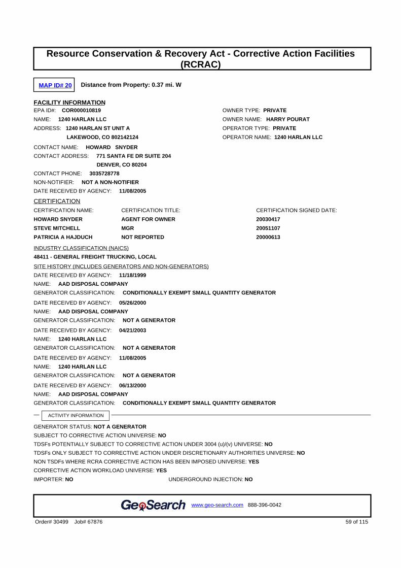
MAP ID# 20 Distance from Property: 0.37 mi. W
FACILITY INFORMATIONEPA ID#: COR000010819 OWNER TYPE: PRIVATE
NAME: 1240 HARLAN LLC OWNER NAME: HARRY POURAT
ADDRESS: 1240 HARLAN ST UNIT A OPERATOR TYPE: PRIVATE
LAKEWOOD, CO 802142124 OPERATOR NAME: 1240 HARLAN LLC
CONTACT NAME: HOWARD SNYDER
CONTACT ADDRESS: 771 SANTA FE DR SUITE 204
DENVER, CO 80204
CONTACT PHONE: 3035728778
NON-NOTIFIER: NOT A NON-NOTIFIER
DATE RECEIVED BY AGENCY: 11/08/2005
CERTIFICATION
CERTIFICATION NAME: CERTIFICATION TITLE: CERTIFICATION SIGNED DATE:
HOWARD SNYDER AGENT FOR OWNER 20030417
STEVE MITCHELL MGR 20051107
PATRICIA A HAJDUCH NOT REPORTED 20000613
INDUSTRY CLASSIFICATION (NAICS)
48411 - GENERAL FREIGHT TRUCKING, LOCAL
SITE HISTORY (INCLUDES GENERATORS AND NON-GENERATORS)
DATE RECEIVED BY AGENCY: 11/18/1999
NAME: AAD DISPOSAL COMPANY
GENERATOR CLASSIFICATION: CONDITIONALLY EXEMPT SMALL QUANTITY GENERATOR
DATE RECEIVED BY AGENCY: 05/26/2000
NAME: AAD DISPOSAL COMPANY
GENERATOR CLASSIFICATION: NOT A GENERATOR
DATE RECEIVED BY AGENCY: 04/21/2003
NAME: 1240 HARLAN LLC
GENERATOR CLASSIFICATION: NOT A GENERATOR
DATE RECEIVED BY AGENCY: 11/08/2005
NAME: 1240 HARLAN LLC
GENERATOR CLASSIFICATION: NOT A GENERATOR
DATE RECEIVED BY AGENCY: 06/13/2000
NAME: AAD DISPOSAL COMPANY
GENERATOR CLASSIFICATION: CONDITIONALLY EXEMPT SMALL QUANTITY GENERATOR
ACTIVITY INFORMATION
GENERATOR STATUS: NOT A GENERATOR
SUBJECT TO CORRECTIVE ACTION UNIVERSE: NO
TDSFs POTENTIALLY SUBJECT TO CORRECTIVE ACTION UNDER 3004 (u)/(v) UNIVERSE: NO
TDSFs ONLY SUBJECT TO CORRECTIVE ACTION UNDER DISCRETIONARY AUTHORITIES UNIVERSE: NO
NON TSDFs WHERE RCRA CORRECTIVE ACTION HAS BEEN IMPOSED UNIVERSE: YES
CORRECTIVE ACTION WORKLOAD UNIVERSE: YES
IMPORTER: NO UNDERGROUND INJECTION: NO
59 of 115Order# 30499 Job# 67876
www.geo-search.com 888-396-0042
Target Property SummaryDatabase Findings SummaryDatabase Findings SummaryDatabase Findings SummaryDatabase Findings SummaryLocatable Database FindingsLocatable Database FindingsLocatable Database FindingsLocatable Database FindingsReport Summary of Locatable SitesHistorical Solid Waste Landfills (HISTSWLF)Denver County Historic Landfills (DCHISTLF)Emergency Response Notification System (ERNSCO)Spills Listing (SPILLS)Underground Storage Tank Facilities (UST)Hazardous Materials Incident Reporting System (HMIRSR08)Leaking Storage Tank Facilities (LST)Underground Storage Tank Facilities (UST)Resource Conservation & Recovery Act - Non-Generator Facilities(RCRANGR08)Leaking Storage Tank Facilities (LST)Aboveground Storage Tank Facilities (AST)Leaking Storage Tank Facilities (LST)Clandestine Drug Laboratory Locations (CDL)Clandestine Drug Laboratory Locations (CDL)Aboveground Storage Tank Facilities (AST)Leaking Storage Tank Facilities (LST)Aboveground Storage Tank Facilities (AST)Solid Waste Facilities (SWF)Underground Storage Tank Facilities (UST)Resource Conservation & Recovery Act - Generator Facilities(RCRAGR08)Leaking Storage Tank Facilities (LST)Brownfields Management System (BF)Underground Storage Tank Facilities (UST)Solid Waste Facilities (SWF)Historical Solid Waste Landfills (HISTSWLF)Denver County Historic Landfills (DCHISTLF)Brownfields Management System (BF)Leaking Underground Storage Tanks Trust Fund Sites (LUSTTRUST)Leaking Storage Tank Facilities (LST)Historical Solid Waste Landfills (HISTSWLF)Methane Gas Study Sites (METHANESITES)Denver County Historic Landfills (DCHISTLF)Leaking Storage Tank Facilities (LST)Historical Solid Waste Landfills (HISTSWLF)Leaking Underground Storage Tanks Trust Fund Sites (LUSTTRUST)Leaking Storage Tank Facilities (LST)Leaking Storage Tank Facilities (LST)Leaking Storage Tank Facilities (LST)Resource Conservation & Recovery Act - Corrective Action Facilities
(RCRAC)

MIXED WASTE GENERATOR: NO UNIVERSAL WASTE DESTINATION FACILITY: NO
RECYCLER: NO TRANSFER FACILITY: NO
TRANSPORTER: NO USED OIL FUEL BURNER: NO
ONSITE BURNER EXEMPTION: NO USED OIL PROCESSOR: NO
FURNACE EXEMPTION: NO USED OIL FUEL MARKETER TO BURNER: NO
USED OIL REFINER: NO SPECIFICATION USED OIL MARKETER: NO
USED OIL TRANSFER FACILITY: NO USED OIL TRANSPORTER: NO
COMPLIANCE, MONITORING AND ENFORCEMENT INFORMATION
EVALUATIONS1998/07/09 CEI COMPLIANCE EVALUATION INSPECTION ON-SITE
1998/07/09 CSE COMPLIANCE SCHEDULE EVALUATION
1999/10/26 CEI COMPLIANCE EVALUATION INSPECTION ON-SITE
2000/05/12 CEI COMPLIANCE EVALUATION INSPECTION ON-SITE
2000/06/02 CSE COMPLIANCE SCHEDULE EVALUATION
2000/08/14 CEI COMPLIANCE EVALUATION INSPECTION ON-SITE
2000/09/05 CEI COMPLIANCE EVALUATION INSPECTION ON-SITE
2000/09/05 CSE COMPLIANCE SCHEDULE EVALUATION
2000/09/13 CEI COMPLIANCE EVALUATION INSPECTION ON-SITE
2000/10/17 CEI COMPLIANCE EVALUATION INSPECTION ON-SITE
2000/10/18 CEI COMPLIANCE EVALUATION INSPECTION ON-SITE
2001/02/21 CEI COMPLIANCE EVALUATION INSPECTION ON-SITE
2001/03/19 CEI COMPLIANCE EVALUATION INSPECTION ON-SITE
2003/08/05 FUI FOLLOW-UP INSPECTION
2003/09/23 FUI FOLLOW-UP INSPECTION
2005/01/04 FCI FOCUSED COMPLIANCE INSPECTION
2006/05/05 FCI FOCUSED COMPLIANCE INSPECTION
VIOLATIONS1998/07/13 263.A TRANSPORTERS - GENERAL
1999/10/14 263.A TRANSPORTERS - GENERAL
1999/10/26 263.A TRANSPORTERS - GENERAL
1999/10/26 263.B TRANSPORTERS - MANIFEST AND RECORDKEEPING
1999/10/26 263.C TRANSPORTERS - HW DISCHARGES
2000/05/12 262.B GENERATORS - MANIFEST
2000/05/12 262.D GENERATORS - RECORDS/REPORTING
2000/08/14 262.B GENERATORS - MANIFEST
2000/08/14 263.A TRANSPORTERS - GENERAL
2000/09/05 263.A TRANSPORTERS - GENERAL
2000/09/13 263.A TRANSPORTERS - GENERAL
2000/10/17 XXS STATE STATUTE OR REGULATION
2000/10/18 XXS STATE STATUTE OR REGULATION
2001/02/21 262.A GENERATORS - GENERAL
2001/03/19 262.A GENERATORS - GENERAL
ENFORCEMENTS
1998/07/13 127 V3 CONVERSION COMPLIANCE ADVISORY
60 of 115Order# 30499 Job# 67876
www.geo-search.com 888-396-0042
Target Property SummaryDatabase Findings SummaryDatabase Findings SummaryDatabase Findings SummaryDatabase Findings SummaryLocatable Database FindingsLocatable Database FindingsLocatable Database FindingsLocatable Database FindingsReport Summary of Locatable SitesHistorical Solid Waste Landfills (HISTSWLF)Denver County Historic Landfills (DCHISTLF)Emergency Response Notification System (ERNSCO)Spills Listing (SPILLS)Underground Storage Tank Facilities (UST)Hazardous Materials Incident Reporting System (HMIRSR08)Leaking Storage Tank Facilities (LST)Underground Storage Tank Facilities (UST)Resource Conservation & Recovery Act - Non-Generator Facilities(RCRANGR08)Leaking Storage Tank Facilities (LST)Aboveground Storage Tank Facilities (AST)Leaking Storage Tank Facilities (LST)Clandestine Drug Laboratory Locations (CDL)Clandestine Drug Laboratory Locations (CDL)Aboveground Storage Tank Facilities (AST)Leaking Storage Tank Facilities (LST)Aboveground Storage Tank Facilities (AST)Solid Waste Facilities (SWF)Underground Storage Tank Facilities (UST)Resource Conservation & Recovery Act - Generator Facilities(RCRAGR08)Leaking Storage Tank Facilities (LST)Brownfields Management System (BF)Underground Storage Tank Facilities (UST)Solid Waste Facilities (SWF)Historical Solid Waste Landfills (HISTSWLF)Denver County Historic Landfills (DCHISTLF)Brownfields Management System (BF)Leaking Underground Storage Tanks Trust Fund Sites (LUSTTRUST)Leaking Storage Tank Facilities (LST)Historical Solid Waste Landfills (HISTSWLF)Methane Gas Study Sites (METHANESITES)Denver County Historic Landfills (DCHISTLF)Leaking Storage Tank Facilities (LST)Historical Solid Waste Landfills (HISTSWLF)Leaking Underground Storage Tanks Trust Fund Sites (LUSTTRUST)Leaking Storage Tank Facilities (LST)Leaking Storage Tank Facilities (LST)Leaking Storage Tank Facilities (LST)Resource Conservation & Recovery Act - Corrective Action Facilities
(RCRAC)

1999/10/14 210 INITIAL 3008(A) COMPLIANCE
1999/10/14 240 INIT. 3008(H) I.S. CA ORDER
1999/10/26 127 V3 CONVERSION COMPLIANCE ADVISORY
2000/05/12 127 V3 CONVERSION COMPLIANCE ADVISORY
2000/08/14 127 V3 CONVERSION COMPLIANCE ADVISORY
2000/08/25 210 INITIAL 3008(A) COMPLIANCE
2000/09/07 210 INITIAL 3008(A) COMPLIANCE
2000/09/14 510 INITIAL CIVIL JUDICIAL ACTION FOR COMPLIANCE AND/OR MONETARY PENALTY
2000/09/20 510 INITIAL CIVIL JUDICIAL ACTION FOR COMPLIANCE AND/OR MONETARY PENALTY
2000/10/14 310 FINAL 3008(A) COMPLIANCE ORDER
2000/10/19 310 FINAL 3008(A) COMPLIANCE ORDER
2001/07/10 620 FINAL CIVIL JUDICIAL ACTION FOR IMMINENT AND SUBSTANTIAL ENDANGERMENT
2002/10/07 310 FINAL 3008(A) COMPLIANCE ORDER
HAZARDOUS WASTE
D001 IGNITABLE WASTE
D007 CHROMIUM
D008 LEAD
D039 TETRACHLOROETHYLENE
F001 THE FOLLOWING SPENT HALOGENATED SOLVENTS USED IN DEGREASING:TETRACHLOROETHYLENE,TRICHLORETHYLENE, METHYLENE CHLORIDE, 1,1,1-TRICHLOROETHANE, CARBONTETRACHLORIDE ANDCHLORINATED FLUOROCARBONS; ALL SPENT SOLVENT MIXTURES/BLENDS USED INDEGREASING CONTAINING, BEFORE USE, A TOTAL OF TEN PERCENT OR MORE (BY VOLUME) OF ONE OR MOREOF THE ABOVE HALOGENATED SOLVENTS OR THOSE SOLVENTS LISTED IN F002, F004, AND F005; AND STILLBOTTOMS FROM THE RECOVERY OF THESE SPENT SOLVENTS AND SPENT SOLVENT MIXTURES.
F002 THE FOLLOWING SPENT HALOGENATED SOLVENTS: TETRACHLOROETHYLENE, METHYLENECHLORIDE,TRICHLOROETHYLENE, 1,1,1-TRICHLOROETHANE,CHLOROBENZENE, 1,1,2-TRICHLORO-1,2,2-TRIFLUOROETHANE, ORTHO-DICHLOROBENZENE, TRICHLOROFLUOROMETHANE, AND 1,1,2,TRICHLOROETHANE; ALL SPENT SOLVENT MIXTURES/BLENDS CONTAINING, BEFORE USE, A TOTAL OF TENPERCENT OR MORE (BY VOLUME) OF ONE OR MORE OF THE ABOVE HALOGENATED SOLVENTS OR THOSESOLVENTS LISTED IN F001,F004, AND F005; AND STILL BOTTOMS FROM THE RECOVERY OF THESE SPENTSOLVENTS AND SPENT SOLVENT MIXTURES.
UNIVERSAL WASTE - NO UNIVERSAL WASTE REPORTED -
CORRECTIVE ACTION AREA (RELEASE)
AREA NAME: AIR: GROUNDWATER: SOIL: SURFACE WASTE:
ENTIRE FACILITY ----- Y Y -----
CORRECTIVE ACTION EVENT
CA EVENT: DATE: EVENT DESCRIPTION:
CA050RF 20010508 RFA COMPLETED-ASSESSMENT WAS A RFA
CA060 20010516 NOTICE OF CONTAMINATION
CA070YE 20010524 DETERMINATION OF NEED FOR AN INVESTIGATION-INVESTIGATION ISNECESSARY
CA100 20010524 INVESTIGATION IMPOSITION
CA160 20060329 INVESTIGATION SUPPLEMENTAL INFORMATION RECEIVED
CA170 20060505 INVESTIGATION SUPPLEMENTAL INFO DEEMED SATISFACT
CA811IM 20060329 OTHER WORKPLAN RECEIVED
CA814IM 20060505 OTHER WORKPLAN APPROVED
CA817OM 20041222 OTHER SUPPLEMENTAL INFORMATION RECEIVED
61 of 115Order# 30499 Job# 67876
www.geo-search.com 888-396-0042
Target Property SummaryDatabase Findings SummaryDatabase Findings SummaryDatabase Findings SummaryDatabase Findings SummaryLocatable Database FindingsLocatable Database FindingsLocatable Database FindingsLocatable Database FindingsReport Summary of Locatable SitesHistorical Solid Waste Landfills (HISTSWLF)Denver County Historic Landfills (DCHISTLF)Emergency Response Notification System (ERNSCO)Spills Listing (SPILLS)Underground Storage Tank Facilities (UST)Hazardous Materials Incident Reporting System (HMIRSR08)Leaking Storage Tank Facilities (LST)Underground Storage Tank Facilities (UST)Resource Conservation & Recovery Act - Non-Generator Facilities(RCRANGR08)Leaking Storage Tank Facilities (LST)Aboveground Storage Tank Facilities (AST)Leaking Storage Tank Facilities (LST)Clandestine Drug Laboratory Locations (CDL)Clandestine Drug Laboratory Locations (CDL)Aboveground Storage Tank Facilities (AST)Leaking Storage Tank Facilities (LST)Aboveground Storage Tank Facilities (AST)Solid Waste Facilities (SWF)Underground Storage Tank Facilities (UST)Resource Conservation & Recovery Act - Generator Facilities(RCRAGR08)Leaking Storage Tank Facilities (LST)Brownfields Management System (BF)Underground Storage Tank Facilities (UST)Solid Waste Facilities (SWF)Historical Solid Waste Landfills (HISTSWLF)Denver County Historic Landfills (DCHISTLF)Brownfields Management System (BF)Leaking Underground Storage Tanks Trust Fund Sites (LUSTTRUST)Leaking Storage Tank Facilities (LST)Historical Solid Waste Landfills (HISTSWLF)Methane Gas Study Sites (METHANESITES)Denver County Historic Landfills (DCHISTLF)Leaking Storage Tank Facilities (LST)Historical Solid Waste Landfills (HISTSWLF)Leaking Underground Storage Tanks Trust Fund Sites (LUSTTRUST)Leaking Storage Tank Facilities (LST)Leaking Storage Tank Facilities (LST)Leaking Storage Tank Facilities (LST)Resource Conservation & Recovery Act - Corrective Action Facilities
(RCRAC)

CA818OM 20050104 OTHER SUPPLEMENTAL INFORMATION ADEQUATE - OPERATION AND MAINTENANCE
CA831OM 20041201 OTHER REPORT RECEIVED
CA831OM 20060329 OTHER REPORT RECEIVED
CA831OM 20091209 OTHER REPORT RECEIVED
CA831OM 20101221 OTHER REPORT RECEIVED
CA831OM 20111125 OTHER REPORT RECEIVED
CA831OM 20130228 OTHER REPORT RECEIVED
CA834OM 20050104 OTHER REPORT APPROVED
CA834OM 20060505 OTHER REPORT APPROVED
CA834OM 20091221 OTHER REPORT APPROVED
CA834OM 20110210 OTHER REPORT APPROVED
CA834OM 20111206 OTHER REPORT APPROVED
CA834OM 20130307 OTHER REPORT APPROVED
Back to Report Summary
62 of 115Order# 30499 Job# 67876
www.geo-search.com 888-396-0042
Target Property SummaryDatabase Findings SummaryDatabase Findings SummaryDatabase Findings SummaryDatabase Findings SummaryLocatable Database FindingsLocatable Database FindingsLocatable Database FindingsLocatable Database FindingsReport Summary of Locatable SitesHistorical Solid Waste Landfills (HISTSWLF)Denver County Historic Landfills (DCHISTLF)Emergency Response Notification System (ERNSCO)Spills Listing (SPILLS)Underground Storage Tank Facilities (UST)Hazardous Materials Incident Reporting System (HMIRSR08)Leaking Storage Tank Facilities (LST)Underground Storage Tank Facilities (UST)Resource Conservation & Recovery Act - Non-Generator Facilities(RCRANGR08)Leaking Storage Tank Facilities (LST)Aboveground Storage Tank Facilities (AST)Leaking Storage Tank Facilities (LST)Clandestine Drug Laboratory Locations (CDL)Clandestine Drug Laboratory Locations (CDL)Aboveground Storage Tank Facilities (AST)Leaking Storage Tank Facilities (LST)Aboveground Storage Tank Facilities (AST)Solid Waste Facilities (SWF)Underground Storage Tank Facilities (UST)Resource Conservation & Recovery Act - Generator Facilities(RCRAGR08)Leaking Storage Tank Facilities (LST)Brownfields Management System (BF)Underground Storage Tank Facilities (UST)Solid Waste Facilities (SWF)Historical Solid Waste Landfills (HISTSWLF)Denver County Historic Landfills (DCHISTLF)Brownfields Management System (BF)Leaking Underground Storage Tanks Trust Fund Sites (LUSTTRUST)Leaking Storage Tank Facilities (LST)Historical Solid Waste Landfills (HISTSWLF)Methane Gas Study Sites (METHANESITES)Denver County Historic Landfills (DCHISTLF)Leaking Storage Tank Facilities (LST)Historical Solid Waste Landfills (HISTSWLF)Leaking Underground Storage Tanks Trust Fund Sites (LUSTTRUST)Leaking Storage Tank Facilities (LST)Leaking Storage Tank Facilities (LST)Leaking Storage Tank Facilities (LST)Resource Conservation & Recovery Act - Corrective Action Facilities
(RCRAC)

MAP ID# 20 Distance from Property: 0.37 mi. W
SITE INFORMATIONEPA ID: COR000010819
SITE NAME: AAD DISPOSAL COMPANY
SITE ADDRESS: 1240 HARLAN ST UNIT A
DENVER, CO 802325721
SITE COUNTY: JEFFERSON
FACILITY TYPE: CA
STATUS: ACTIVE
LINKS: http://www.epa.gov/cgi-bin/get1cReport.cgi?tool=echo&IDNumber=COR000010819
Back to Report Summary
63 of 115Order# 30499 Job# 67876
www.geo-search.com 888-396-0042
Target Property SummaryDatabase Findings SummaryDatabase Findings SummaryDatabase Findings SummaryDatabase Findings SummaryLocatable Database FindingsLocatable Database FindingsLocatable Database FindingsLocatable Database FindingsReport Summary of Locatable SitesHistorical Solid Waste Landfills (HISTSWLF)Denver County Historic Landfills (DCHISTLF)Emergency Response Notification System (ERNSCO)Spills Listing (SPILLS)Underground Storage Tank Facilities (UST)Hazardous Materials Incident Reporting System (HMIRSR08)Leaking Storage Tank Facilities (LST)Underground Storage Tank Facilities (UST)Resource Conservation & Recovery Act - Non-Generator Facilities(RCRANGR08)Leaking Storage Tank Facilities (LST)Aboveground Storage Tank Facilities (AST)Leaking Storage Tank Facilities (LST)Clandestine Drug Laboratory Locations (CDL)Clandestine Drug Laboratory Locations (CDL)Aboveground Storage Tank Facilities (AST)Leaking Storage Tank Facilities (LST)Aboveground Storage Tank Facilities (AST)Solid Waste Facilities (SWF)Underground Storage Tank Facilities (UST)Resource Conservation & Recovery Act - Generator Facilities(RCRAGR08)Leaking Storage Tank Facilities (LST)Brownfields Management System (BF)Underground Storage Tank Facilities (UST)Solid Waste Facilities (SWF)Historical Solid Waste Landfills (HISTSWLF)Denver County Historic Landfills (DCHISTLF)Brownfields Management System (BF)Leaking Underground Storage Tanks Trust Fund Sites (LUSTTRUST)Leaking Storage Tank Facilities (LST)Historical Solid Waste Landfills (HISTSWLF)Methane Gas Study Sites (METHANESITES)Denver County Historic Landfills (DCHISTLF)Leaking Storage Tank Facilities (LST)Historical Solid Waste Landfills (HISTSWLF)Leaking Underground Storage Tanks Trust Fund Sites (LUSTTRUST)Leaking Storage Tank Facilities (LST)Leaking Storage Tank Facilities (LST)Leaking Storage Tank Facilities (LST)Resource Conservation & Recovery Act - Corrective Action Facilities
(RCRAC)Hazardous Waste Sites- Corrective Action (HWSCA)

MAP ID# 21 Distance from Property: 0.37 mi. S
SITE INFORMATIONUNIQUE ID: 75580534
NAME: FLAIR CLEANERS
ADDRESS: 714 SHERIDAN BLVD.
DENVER, CO 80214
COUNTY: DENVER
SITE DETAILSAPPLICATION TYPE: NO ACTION DETERMINATION
FILE NUMBER: 091105-1
REVIEW DATE DUE: 12/20/2009
DECISION: APPROVAL
REMEDY START DATE: NOT REPORTED REMEDY END DATE: NOT REPORTED
ACTUAL COST: 765 CLEANUP ACRES: 2
OTHER ISSUES: DRY CLEANER;#8
LAND USE RESTRICTIONS: COMMERCIAL
PROJECT MANAGER: APOSTOLOPOULOS
INDOOR AIR: VOC'S;#6
MEDIA SEDIMENT: NOT REPORTED
MEDIA GROUND WATER: PCE;#12
MEDIA SURFACE WATER: NOT REPORTED
MEDIA SOIL: PCE;#12
Back to Report Summary
64 of 115Order# 30499 Job# 67876
www.geo-search.com 888-396-0042
Target Property SummaryDatabase Findings SummaryDatabase Findings SummaryDatabase Findings SummaryDatabase Findings SummaryLocatable Database FindingsLocatable Database FindingsLocatable Database FindingsLocatable Database FindingsReport Summary of Locatable SitesHistorical Solid Waste Landfills (HISTSWLF)Denver County Historic Landfills (DCHISTLF)Emergency Response Notification System (ERNSCO)Spills Listing (SPILLS)Underground Storage Tank Facilities (UST)Hazardous Materials Incident Reporting System (HMIRSR08)Leaking Storage Tank Facilities (LST)Underground Storage Tank Facilities (UST)Resource Conservation & Recovery Act - Non-Generator Facilities(RCRANGR08)Leaking Storage Tank Facilities (LST)Aboveground Storage Tank Facilities (AST)Leaking Storage Tank Facilities (LST)Clandestine Drug Laboratory Locations (CDL)Clandestine Drug Laboratory Locations (CDL)Aboveground Storage Tank Facilities (AST)Leaking Storage Tank Facilities (LST)Aboveground Storage Tank Facilities (AST)Solid Waste Facilities (SWF)Underground Storage Tank Facilities (UST)Resource Conservation & Recovery Act - Generator Facilities(RCRAGR08)Leaking Storage Tank Facilities (LST)Brownfields Management System (BF)Underground Storage Tank Facilities (UST)Solid Waste Facilities (SWF)Historical Solid Waste Landfills (HISTSWLF)Denver County Historic Landfills (DCHISTLF)Brownfields Management System (BF)Leaking Underground Storage Tanks Trust Fund Sites (LUSTTRUST)Leaking Storage Tank Facilities (LST)Historical Solid Waste Landfills (HISTSWLF)Methane Gas Study Sites (METHANESITES)Denver County Historic Landfills (DCHISTLF)Leaking Storage Tank Facilities (LST)Historical Solid Waste Landfills (HISTSWLF)Leaking Underground Storage Tanks Trust Fund Sites (LUSTTRUST)Leaking Storage Tank Facilities (LST)Leaking Storage Tank Facilities (LST)Leaking Storage Tank Facilities (LST)Resource Conservation & Recovery Act - Corrective Action Facilities
(RCRAC)Hazardous Waste Sites- Corrective Action (HWSCA)Voluntary Cleanup and Redevelopment Program Sites (VCRA)

MAP ID# 22 Distance from Property: 0.38 mi. NW
FACILITY INFORMATIONFACILITY ID: 12558
NAME: CAR WASH SERVICE STATION
ADDRESS: 5785 W 14TH ST
LAKEWOOD, CO 80215
LEAKING INFORMATION
EVENT ID: STATUS: RELEASE DATE:
5314 CLOSED 11/26/1991COSTIS LINK: http://costis.cdle.state.co.us/event.asp?h_id=5314
Back to Report Summary
65 of 115Order# 30499 Job# 67876
www.geo-search.com 888-396-0042
Target Property SummaryDatabase Findings SummaryDatabase Findings SummaryDatabase Findings SummaryDatabase Findings SummaryLocatable Database FindingsLocatable Database FindingsLocatable Database FindingsLocatable Database FindingsReport Summary of Locatable SitesHistorical Solid Waste Landfills (HISTSWLF)Denver County Historic Landfills (DCHISTLF)Emergency Response Notification System (ERNSCO)Spills Listing (SPILLS)Underground Storage Tank Facilities (UST)Hazardous Materials Incident Reporting System (HMIRSR08)Leaking Storage Tank Facilities (LST)Underground Storage Tank Facilities (UST)Resource Conservation & Recovery Act - Non-Generator Facilities(RCRANGR08)Leaking Storage Tank Facilities (LST)Aboveground Storage Tank Facilities (AST)Leaking Storage Tank Facilities (LST)Clandestine Drug Laboratory Locations (CDL)Clandestine Drug Laboratory Locations (CDL)Aboveground Storage Tank Facilities (AST)Leaking Storage Tank Facilities (LST)Aboveground Storage Tank Facilities (AST)Solid Waste Facilities (SWF)Underground Storage Tank Facilities (UST)Resource Conservation & Recovery Act - Generator Facilities(RCRAGR08)Leaking Storage Tank Facilities (LST)Brownfields Management System (BF)Underground Storage Tank Facilities (UST)Solid Waste Facilities (SWF)Historical Solid Waste Landfills (HISTSWLF)Denver County Historic Landfills (DCHISTLF)Brownfields Management System (BF)Leaking Underground Storage Tanks Trust Fund Sites (LUSTTRUST)Leaking Storage Tank Facilities (LST)Historical Solid Waste Landfills (HISTSWLF)Methane Gas Study Sites (METHANESITES)Denver County Historic Landfills (DCHISTLF)Leaking Storage Tank Facilities (LST)Historical Solid Waste Landfills (HISTSWLF)Leaking Underground Storage Tanks Trust Fund Sites (LUSTTRUST)Leaking Storage Tank Facilities (LST)Leaking Storage Tank Facilities (LST)Leaking Storage Tank Facilities (LST)Resource Conservation & Recovery Act - Corrective Action Facilities
(RCRAC)Hazardous Waste Sites- Corrective Action (HWSCA)Voluntary Cleanup and Redevelopment Program Sites (VCRA)Leaking Storage Tank Facilities (LST)

MAP ID# 23 Distance from Property: 0.38 mi. W
SITE INFORMATIONUNIQUE ID: 00070-0001590
NAME: 10TH & HARLAN
ADDRESS: ADDRESS NOT REPORTED
LAKEWOOD, CO
DIRECTIONS: NOT REPORTED
COUNTY: JEFFERSON
SITE DETAILSAGENCY ID: NOT REPORTED
DETAIL1:
POSSIBLE METHANE PROBLEM.
DETAIL2:
TYPE- LANDFILL; FILL- REFUSE. ; OPER/OWNR/OTHR- , ,
Back to Report Summary
66 of 115Order# 30499 Job# 67876
www.geo-search.com 888-396-0042
Target Property SummaryDatabase Findings SummaryDatabase Findings SummaryDatabase Findings SummaryDatabase Findings SummaryLocatable Database FindingsLocatable Database FindingsLocatable Database FindingsLocatable Database FindingsReport Summary of Locatable SitesHistorical Solid Waste Landfills (HISTSWLF)Denver County Historic Landfills (DCHISTLF)Emergency Response Notification System (ERNSCO)Spills Listing (SPILLS)Underground Storage Tank Facilities (UST)Hazardous Materials Incident Reporting System (HMIRSR08)Leaking Storage Tank Facilities (LST)Underground Storage Tank Facilities (UST)Resource Conservation & Recovery Act - Non-Generator Facilities(RCRANGR08)Leaking Storage Tank Facilities (LST)Aboveground Storage Tank Facilities (AST)Leaking Storage Tank Facilities (LST)Clandestine Drug Laboratory Locations (CDL)Clandestine Drug Laboratory Locations (CDL)Aboveground Storage Tank Facilities (AST)Leaking Storage Tank Facilities (LST)Aboveground Storage Tank Facilities (AST)Solid Waste Facilities (SWF)Underground Storage Tank Facilities (UST)Resource Conservation & Recovery Act - Generator Facilities(RCRAGR08)Leaking Storage Tank Facilities (LST)Brownfields Management System (BF)Underground Storage Tank Facilities (UST)Solid Waste Facilities (SWF)Historical Solid Waste Landfills (HISTSWLF)Denver County Historic Landfills (DCHISTLF)Brownfields Management System (BF)Leaking Underground Storage Tanks Trust Fund Sites (LUSTTRUST)Leaking Storage Tank Facilities (LST)Historical Solid Waste Landfills (HISTSWLF)Methane Gas Study Sites (METHANESITES)Denver County Historic Landfills (DCHISTLF)Leaking Storage Tank Facilities (LST)Historical Solid Waste Landfills (HISTSWLF)Leaking Underground Storage Tanks Trust Fund Sites (LUSTTRUST)Leaking Storage Tank Facilities (LST)Leaking Storage Tank Facilities (LST)Leaking Storage Tank Facilities (LST)Resource Conservation & Recovery Act - Corrective Action Facilities
(RCRAC)Hazardous Waste Sites- Corrective Action (HWSCA)Voluntary Cleanup and Redevelopment Program Sites (VCRA)Leaking Storage Tank Facilities (LST)Historical Solid Waste Landfills (HISTSWLF)

MAP ID# 24 Distance from Property: 0.39 mi. N
FACILITY INFORMATIONFACILITY ID: 12568
NAME: KANE PROPERTY
ADDRESS: 5390 W COLFAX AVE
LAKEWOOD, CO 80214
LEAKING INFORMATION
EVENT ID: STATUS: RELEASE DATE:
1578 CLOSED 4/29/1993COSTIS LINK: http://costis.cdle.state.co.us/event.asp?h_id=1578
Back to Report Summary
67 of 115Order# 30499 Job# 67876
www.geo-search.com 888-396-0042
Target Property SummaryDatabase Findings SummaryDatabase Findings SummaryDatabase Findings SummaryDatabase Findings SummaryLocatable Database FindingsLocatable Database FindingsLocatable Database FindingsLocatable Database FindingsReport Summary of Locatable SitesHistorical Solid Waste Landfills (HISTSWLF)Denver County Historic Landfills (DCHISTLF)Emergency Response Notification System (ERNSCO)Spills Listing (SPILLS)Underground Storage Tank Facilities (UST)Hazardous Materials Incident Reporting System (HMIRSR08)Leaking Storage Tank Facilities (LST)Underground Storage Tank Facilities (UST)Resource Conservation & Recovery Act - Non-Generator Facilities(RCRANGR08)Leaking Storage Tank Facilities (LST)Aboveground Storage Tank Facilities (AST)Leaking Storage Tank Facilities (LST)Clandestine Drug Laboratory Locations (CDL)Clandestine Drug Laboratory Locations (CDL)Aboveground Storage Tank Facilities (AST)Leaking Storage Tank Facilities (LST)Aboveground Storage Tank Facilities (AST)Solid Waste Facilities (SWF)Underground Storage Tank Facilities (UST)Resource Conservation & Recovery Act - Generator Facilities(RCRAGR08)Leaking Storage Tank Facilities (LST)Brownfields Management System (BF)Underground Storage Tank Facilities (UST)Solid Waste Facilities (SWF)Historical Solid Waste Landfills (HISTSWLF)Denver County Historic Landfills (DCHISTLF)Brownfields Management System (BF)Leaking Underground Storage Tanks Trust Fund Sites (LUSTTRUST)Leaking Storage Tank Facilities (LST)Historical Solid Waste Landfills (HISTSWLF)Methane Gas Study Sites (METHANESITES)Denver County Historic Landfills (DCHISTLF)Leaking Storage Tank Facilities (LST)Historical Solid Waste Landfills (HISTSWLF)Leaking Underground Storage Tanks Trust Fund Sites (LUSTTRUST)Leaking Storage Tank Facilities (LST)Leaking Storage Tank Facilities (LST)Leaking Storage Tank Facilities (LST)Resource Conservation & Recovery Act - Corrective Action Facilities
(RCRAC)Hazardous Waste Sites- Corrective Action (HWSCA)Voluntary Cleanup and Redevelopment Program Sites (VCRA)Leaking Storage Tank Facilities (LST)Historical Solid Waste Landfills (HISTSWLF)Leaking Storage Tank Facilities (LST)

MAP ID# 25 Distance from Property: 0.41 mi. N
FACILITY INFORMATIONFACILITY ID: 1665
NAME: Q SUPERETTE
ADDRESS: 5200 W COLFAX AVE
LAKEWOOD, CO 80214
LEAKING INFORMATION
EVENT ID: STATUS: RELEASE DATE:
10574 CLOSED 2/4/2008 10:54:47 AMCOSTIS LINK: http://costis.cdle.state.co.us/event.asp?h_id=10574
Back to Report Summary
68 of 115Order# 30499 Job# 67876
www.geo-search.com 888-396-0042
Target Property SummaryDatabase Findings SummaryDatabase Findings SummaryDatabase Findings SummaryDatabase Findings SummaryLocatable Database FindingsLocatable Database FindingsLocatable Database FindingsLocatable Database FindingsReport Summary of Locatable SitesHistorical Solid Waste Landfills (HISTSWLF)Denver County Historic Landfills (DCHISTLF)Emergency Response Notification System (ERNSCO)Spills Listing (SPILLS)Underground Storage Tank Facilities (UST)Hazardous Materials Incident Reporting System (HMIRSR08)Leaking Storage Tank Facilities (LST)Underground Storage Tank Facilities (UST)Resource Conservation & Recovery Act - Non-Generator Facilities(RCRANGR08)Leaking Storage Tank Facilities (LST)Aboveground Storage Tank Facilities (AST)Leaking Storage Tank Facilities (LST)Clandestine Drug Laboratory Locations (CDL)Clandestine Drug Laboratory Locations (CDL)Aboveground Storage Tank Facilities (AST)Leaking Storage Tank Facilities (LST)Aboveground Storage Tank Facilities (AST)Solid Waste Facilities (SWF)Underground Storage Tank Facilities (UST)Resource Conservation & Recovery Act - Generator Facilities(RCRAGR08)Leaking Storage Tank Facilities (LST)Brownfields Management System (BF)Underground Storage Tank Facilities (UST)Solid Waste Facilities (SWF)Historical Solid Waste Landfills (HISTSWLF)Denver County Historic Landfills (DCHISTLF)Brownfields Management System (BF)Leaking Underground Storage Tanks Trust Fund Sites (LUSTTRUST)Leaking Storage Tank Facilities (LST)Historical Solid Waste Landfills (HISTSWLF)Methane Gas Study Sites (METHANESITES)Denver County Historic Landfills (DCHISTLF)Leaking Storage Tank Facilities (LST)Historical Solid Waste Landfills (HISTSWLF)Leaking Underground Storage Tanks Trust Fund Sites (LUSTTRUST)Leaking Storage Tank Facilities (LST)Leaking Storage Tank Facilities (LST)Leaking Storage Tank Facilities (LST)Resource Conservation & Recovery Act - Corrective Action Facilities
(RCRAC)Hazardous Waste Sites- Corrective Action (HWSCA)Voluntary Cleanup and Redevelopment Program Sites (VCRA)Leaking Storage Tank Facilities (LST)Historical Solid Waste Landfills (HISTSWLF)Leaking Storage Tank Facilities (LST)Leaking Storage Tank Facilities (LST)

MAP ID# 25 Distance from Property: 0.40 mi. N
FACILITY INFORMATIONFACILITY ID: 3493
NAME: AMOCO #5480
ADDRESS: 5180 W COLFAX AVE
DENVER, CO 80204
LEAKING INFORMATION
EVENT ID: STATUS: RELEASE DATE:
6623 CLOSED 6/18/1998COSTIS LINK: http://costis.cdle.state.co.us/event.asp?h_id=6623
Back to Report Summary
69 of 115Order# 30499 Job# 67876
www.geo-search.com 888-396-0042
Target Property SummaryDatabase Findings SummaryDatabase Findings SummaryDatabase Findings SummaryDatabase Findings SummaryLocatable Database FindingsLocatable Database FindingsLocatable Database FindingsLocatable Database FindingsReport Summary of Locatable SitesHistorical Solid Waste Landfills (HISTSWLF)Denver County Historic Landfills (DCHISTLF)Emergency Response Notification System (ERNSCO)Spills Listing (SPILLS)Underground Storage Tank Facilities (UST)Hazardous Materials Incident Reporting System (HMIRSR08)Leaking Storage Tank Facilities (LST)Underground Storage Tank Facilities (UST)Resource Conservation & Recovery Act - Non-Generator Facilities(RCRANGR08)Leaking Storage Tank Facilities (LST)Aboveground Storage Tank Facilities (AST)Leaking Storage Tank Facilities (LST)Clandestine Drug Laboratory Locations (CDL)Clandestine Drug Laboratory Locations (CDL)Aboveground Storage Tank Facilities (AST)Leaking Storage Tank Facilities (LST)Aboveground Storage Tank Facilities (AST)Solid Waste Facilities (SWF)Underground Storage Tank Facilities (UST)Resource Conservation & Recovery Act - Generator Facilities(RCRAGR08)Leaking Storage Tank Facilities (LST)Brownfields Management System (BF)Underground Storage Tank Facilities (UST)Solid Waste Facilities (SWF)Historical Solid Waste Landfills (HISTSWLF)Denver County Historic Landfills (DCHISTLF)Brownfields Management System (BF)Leaking Underground Storage Tanks Trust Fund Sites (LUSTTRUST)Leaking Storage Tank Facilities (LST)Historical Solid Waste Landfills (HISTSWLF)Methane Gas Study Sites (METHANESITES)Denver County Historic Landfills (DCHISTLF)Leaking Storage Tank Facilities (LST)Historical Solid Waste Landfills (HISTSWLF)Leaking Underground Storage Tanks Trust Fund Sites (LUSTTRUST)Leaking Storage Tank Facilities (LST)Leaking Storage Tank Facilities (LST)Leaking Storage Tank Facilities (LST)Resource Conservation & Recovery Act - Corrective Action Facilities
(RCRAC)Hazardous Waste Sites- Corrective Action (HWSCA)Voluntary Cleanup and Redevelopment Program Sites (VCRA)Leaking Storage Tank Facilities (LST)Historical Solid Waste Landfills (HISTSWLF)Leaking Storage Tank Facilities (LST)Leaking Storage Tank Facilities (LST)Leaking Storage Tank Facilities (LST)

MAP ID# 26 Distance from Property: 0.42 mi. S
SITE INFORMATIONUNIQUE ID: 00070-0000669
NAME: ARTIFICIAL FILL
ADDRESS: NWC 6TH AVE. & SHERIDAN, BETWEEN DEPEW & WHERE BENTON WOULD EXTE
CITY NOT REPORTED, CO
DIRECTIONS: NOT REPORTED
COUNTY: JEFFERSON
SITE DETAILSAGENCY ID: 125
DETAIL1:
; FILL- DOMESTIC REFUSE: NO. CONSTRUCTION DEBRIS: NO. LIQUIDS: NO. HAZARDOUS WASTE: NO. INDUSTRIAL WASTE:
NO. ARTIFICIAL FILL. UNKNOWN: NO. CLAY, SILT, SAND, GRAVEL AND A VARIETY OF DEBRIS CONSISTING OF WOOD, BRICK,
CONCRETE, METAL, PLASTIC, GLASS,
DETAIL2:
ARTIFICIAL FILL. INCLUDES EMBANKMENTS, DAMS, AND OTHER ENGINEERED FILLS; COMPACTED LANDFILLS, AND
UNCOMPACTED RUBBISH DUMPS. CONFIDENCE IN THIS INFO: HIGH.; OPENED- CLOSED-
Back to Report Summary
70 of 115Order# 30499 Job# 67876
www.geo-search.com 888-396-0042
Target Property SummaryDatabase Findings SummaryDatabase Findings SummaryDatabase Findings SummaryDatabase Findings SummaryLocatable Database FindingsLocatable Database FindingsLocatable Database FindingsLocatable Database FindingsReport Summary of Locatable SitesHistorical Solid Waste Landfills (HISTSWLF)Denver County Historic Landfills (DCHISTLF)Emergency Response Notification System (ERNSCO)Spills Listing (SPILLS)Underground Storage Tank Facilities (UST)Hazardous Materials Incident Reporting System (HMIRSR08)Leaking Storage Tank Facilities (LST)Underground Storage Tank Facilities (UST)Resource Conservation & Recovery Act - Non-Generator Facilities(RCRANGR08)Leaking Storage Tank Facilities (LST)Aboveground Storage Tank Facilities (AST)Leaking Storage Tank Facilities (LST)Clandestine Drug Laboratory Locations (CDL)Clandestine Drug Laboratory Locations (CDL)Aboveground Storage Tank Facilities (AST)Leaking Storage Tank Facilities (LST)Aboveground Storage Tank Facilities (AST)Solid Waste Facilities (SWF)Underground Storage Tank Facilities (UST)Resource Conservation & Recovery Act - Generator Facilities(RCRAGR08)Leaking Storage Tank Facilities (LST)Brownfields Management System (BF)Underground Storage Tank Facilities (UST)Solid Waste Facilities (SWF)Historical Solid Waste Landfills (HISTSWLF)Denver County Historic Landfills (DCHISTLF)Brownfields Management System (BF)Leaking Underground Storage Tanks Trust Fund Sites (LUSTTRUST)Leaking Storage Tank Facilities (LST)Historical Solid Waste Landfills (HISTSWLF)Methane Gas Study Sites (METHANESITES)Denver County Historic Landfills (DCHISTLF)Leaking Storage Tank Facilities (LST)Historical Solid Waste Landfills (HISTSWLF)Leaking Underground Storage Tanks Trust Fund Sites (LUSTTRUST)Leaking Storage Tank Facilities (LST)Leaking Storage Tank Facilities (LST)Leaking Storage Tank Facilities (LST)Resource Conservation & Recovery Act - Corrective Action Facilities
(RCRAC)Hazardous Waste Sites- Corrective Action (HWSCA)Voluntary Cleanup and Redevelopment Program Sites (VCRA)Leaking Storage Tank Facilities (LST)Historical Solid Waste Landfills (HISTSWLF)Leaking Storage Tank Facilities (LST)Leaking Storage Tank Facilities (LST)Leaking Storage Tank Facilities (LST)Historical Solid Waste Landfills (HISTSWLF)

MAP ID# 26 Distance from Property: 0.42 mi. S
SITE INFORMATIONLANDFILL ID: 125
LANDFILL NAME: 4S-69W-01SW
DATE ENTERED: 04/28/1997
TYPE OF LANDFILL: OTHER
DESCRIPTION:
NWC 6TH AVE. & SHERIDAN, BETWEEN DEPEW & WHERE BENTON WOULD EXTEND.
TYPE REMARKS:
INCLUDES EMBANKMENTS, DAMS, AND OTHER ENGINEERED FILLS; COMPACTED LANDFILLS, AND UNCOMPACTED
RUBBISH DUMPS.
DOMESTIC: NO HAZARDOUS: NO
CONSTRUCTION: NO INDUSTRIAL: NO
LIQUIDS: NO UNKNOWN: NO
OTHER: ARTIFICIAL FILL
MATERIAL RECEIVED:
CLAY, SILT, SAND, GRAVEL AND A VARIETY OF DEBRIS CONSISTING OF WOOD, BRICK, CONCRETE, METAL, PLASTIC,
GLASS, VEGETATION, AND OTHER TRASH.
START DATE: NOT REPORTED
END DATE: NOT REPORTED
Back to Report Summary
71 of 115Order# 30499 Job# 67876
www.geo-search.com 888-396-0042
Target Property SummaryDatabase Findings SummaryDatabase Findings SummaryDatabase Findings SummaryDatabase Findings SummaryLocatable Database FindingsLocatable Database FindingsLocatable Database FindingsLocatable Database FindingsReport Summary of Locatable SitesHistorical Solid Waste Landfills (HISTSWLF)Denver County Historic Landfills (DCHISTLF)Emergency Response Notification System (ERNSCO)Spills Listing (SPILLS)Underground Storage Tank Facilities (UST)Hazardous Materials Incident Reporting System (HMIRSR08)Leaking Storage Tank Facilities (LST)Underground Storage Tank Facilities (UST)Resource Conservation & Recovery Act - Non-Generator Facilities(RCRANGR08)Leaking Storage Tank Facilities (LST)Aboveground Storage Tank Facilities (AST)Leaking Storage Tank Facilities (LST)Clandestine Drug Laboratory Locations (CDL)Clandestine Drug Laboratory Locations (CDL)Aboveground Storage Tank Facilities (AST)Leaking Storage Tank Facilities (LST)Aboveground Storage Tank Facilities (AST)Solid Waste Facilities (SWF)Underground Storage Tank Facilities (UST)Resource Conservation & Recovery Act - Generator Facilities(RCRAGR08)Leaking Storage Tank Facilities (LST)Brownfields Management System (BF)Underground Storage Tank Facilities (UST)Solid Waste Facilities (SWF)Historical Solid Waste Landfills (HISTSWLF)Denver County Historic Landfills (DCHISTLF)Brownfields Management System (BF)Leaking Underground Storage Tanks Trust Fund Sites (LUSTTRUST)Leaking Storage Tank Facilities (LST)Historical Solid Waste Landfills (HISTSWLF)Methane Gas Study Sites (METHANESITES)Denver County Historic Landfills (DCHISTLF)Leaking Storage Tank Facilities (LST)Historical Solid Waste Landfills (HISTSWLF)Leaking Underground Storage Tanks Trust Fund Sites (LUSTTRUST)Leaking Storage Tank Facilities (LST)Leaking Storage Tank Facilities (LST)Leaking Storage Tank Facilities (LST)Resource Conservation & Recovery Act - Corrective Action Facilities
(RCRAC)Hazardous Waste Sites- Corrective Action (HWSCA)Voluntary Cleanup and Redevelopment Program Sites (VCRA)Leaking Storage Tank Facilities (LST)Historical Solid Waste Landfills (HISTSWLF)Leaking Storage Tank Facilities (LST)Leaking Storage Tank Facilities (LST)Leaking Storage Tank Facilities (LST)Historical Solid Waste Landfills (HISTSWLF)Denver County Historic Landfills (DCHISTLF)

MAP ID# 27 Distance from Property: 0.48 mi. S
FACILITY INFORMATIONFACILITY ID: 14651
NAME: OMNI DEVELOPMENT
ADDRESS: 5495 W 6TH AVE
LAKEWOOD, CO 80215
LEAKING INFORMATION
EVENT ID: STATUS: RELEASE DATE:
11845 CLOSED 5/2/2013 8:48:57 AMCOSTIS LINK: http://costis.cdle.state.co.us/event.asp?h_id=11845
Back to Report Summary
72 of 115Order# 30499 Job# 67876
www.geo-search.com 888-396-0042
Target Property SummaryDatabase Findings SummaryDatabase Findings SummaryDatabase Findings SummaryDatabase Findings SummaryLocatable Database FindingsLocatable Database FindingsLocatable Database FindingsLocatable Database FindingsReport Summary of Locatable SitesHistorical Solid Waste Landfills (HISTSWLF)Denver County Historic Landfills (DCHISTLF)Emergency Response Notification System (ERNSCO)Spills Listing (SPILLS)Underground Storage Tank Facilities (UST)Hazardous Materials Incident Reporting System (HMIRSR08)Leaking Storage Tank Facilities (LST)Underground Storage Tank Facilities (UST)Resource Conservation & Recovery Act - Non-Generator Facilities(RCRANGR08)Leaking Storage Tank Facilities (LST)Aboveground Storage Tank Facilities (AST)Leaking Storage Tank Facilities (LST)Clandestine Drug Laboratory Locations (CDL)Clandestine Drug Laboratory Locations (CDL)Aboveground Storage Tank Facilities (AST)Leaking Storage Tank Facilities (LST)Aboveground Storage Tank Facilities (AST)Solid Waste Facilities (SWF)Underground Storage Tank Facilities (UST)Resource Conservation & Recovery Act - Generator Facilities(RCRAGR08)Leaking Storage Tank Facilities (LST)Brownfields Management System (BF)Underground Storage Tank Facilities (UST)Solid Waste Facilities (SWF)Historical Solid Waste Landfills (HISTSWLF)Denver County Historic Landfills (DCHISTLF)Brownfields Management System (BF)Leaking Underground Storage Tanks Trust Fund Sites (LUSTTRUST)Leaking Storage Tank Facilities (LST)Historical Solid Waste Landfills (HISTSWLF)Methane Gas Study Sites (METHANESITES)Denver County Historic Landfills (DCHISTLF)Leaking Storage Tank Facilities (LST)Historical Solid Waste Landfills (HISTSWLF)Leaking Underground Storage Tanks Trust Fund Sites (LUSTTRUST)Leaking Storage Tank Facilities (LST)Leaking Storage Tank Facilities (LST)Leaking Storage Tank Facilities (LST)Resource Conservation & Recovery Act - Corrective Action Facilities
(RCRAC)Hazardous Waste Sites- Corrective Action (HWSCA)Voluntary Cleanup and Redevelopment Program Sites (VCRA)Leaking Storage Tank Facilities (LST)Historical Solid Waste Landfills (HISTSWLF)Leaking Storage Tank Facilities (LST)Leaking Storage Tank Facilities (LST)Leaking Storage Tank Facilities (LST)Historical Solid Waste Landfills (HISTSWLF)Denver County Historic Landfills (DCHISTLF)Leaking Storage Tank Facilities (LST)

MAP ID# 27 Distance from Property: 0.47 mi. S
FACILITY INFORMATIONEPA ID#: CO0000357871
SITE ID#: 0801450
NAME: DEPEW & 7TH TREE FARM
ADDRESS: 5495 W 6TH AVE
LAKEWOOD, CO 0214
COUNTY: JEFFERSON
NATIONAL PRIORITY LISTING: N - NOT ON THE NPL
FEDERAL FACILITY CLASSIFICATION: N - NOT A FEDERAL FACILITY
NON-NPL STATUS: AC - ASSESSMENT COMPLETE - DECISION NEEDED
NON-NPL STATUS DATE: 12/24/08
PHYSICAL CLASSIFICATION OF SITE / INCIDENT: NO INFORMATION AVAILABLE
SITE DESCRIPTION - NO SITE DESCRIPTION INFORMATION AVAILABLE -
SITE HISTORY - NO SITE HISTORY INFORMATION AVAILABLE -
ACTIONS
TYPE: DS - DISCOVERY
START DATE: NR
COMPLETION DATE: 01/04/1994
ACTION TYPE DEFINITION:
THE PROCESS BY WHICH A POTENTIAL HAZARDOUS WASTE SITE IS BROUGHT TO THE ATTENTION OF THE EPA. THE
PROCESS CAN OCCUR THROUGH THE USE OF SEVERAL MECHANISMS SUCH AS A PHONE CALL OR REFERRAL BY
ANOTHER GOVERNMENT AGENCY.
TYPE: ES - EXPANDED SITE INSPECTION
START DATE: 10/17/1997
COMPLETION DATE: 04/24/1998
ACTION TYPE DEFINITION:
FUNCTIONS PERFORMED TO COLLECT ADDITIONAL DATA, BEYOND THAT REQUIRED FOR HAZARD RANKING SYSTEM
SCORING, IN ORDER TO EXPEDITE THE REMEDIAL INVESTIGATION/FEASIBILITY STUDY (RI/FS) PROJECT PLANNING PHASE
FOR NATIONAL PRIORITY LIST (NPL) SITES. THE PRESENT SITE INSPECTION FOCUS ON PATHWAYS AND RECEPTORS HAS
BEEN EXPANDED TO INCLUDE SITE AND SOURCE CHARACTERIZATION. THE INFORMATION FACILITATES THE
DEVELOPMENT OF RI/FS WORKPLAN AND SAMPLING AND ANALYSIS PLAN.
TYPE: PA - PRELIMINARY ASSESSMENT
START DATE: NR
COMPLETION DATE: 05/05/1995
ACTION TYPE DEFINITION:
COLLECTION OF DIVERSE EXISTING INFORMATION ABOUT THE SOURCE AND NATURE OF THE SITE HAZARD. IT IS EPA
POLICY TO COMPLETE THE PRELIMINARY ASSESSMENT WITHIN ONE YEAR OF SITE DISCOVERY.
TYPE: SI - SITE INSPECTION
START DATE: 11/19/1996
COMPLETION DATE: 09/05/1997
ACTION TYPE DEFINITION:
THE PROCESS OF COLLECTING SITE DATA AND SAMPLES TO CHARACTERIZE THE SEVERITY OF THE HAZARD FOR THE
HAZARD RANKING SCORE AND/OR ENFORCEMENT SUPPORT.
73 of 115Order# 30499 Job# 67876
www.geo-search.com 888-396-0042
Target Property SummaryDatabase Findings SummaryDatabase Findings SummaryDatabase Findings SummaryDatabase Findings SummaryLocatable Database FindingsLocatable Database FindingsLocatable Database FindingsLocatable Database FindingsReport Summary of Locatable SitesHistorical Solid Waste Landfills (HISTSWLF)Denver County Historic Landfills (DCHISTLF)Emergency Response Notification System (ERNSCO)Spills Listing (SPILLS)Underground Storage Tank Facilities (UST)Hazardous Materials Incident Reporting System (HMIRSR08)Leaking Storage Tank Facilities (LST)Underground Storage Tank Facilities (UST)Resource Conservation & Recovery Act - Non-Generator Facilities(RCRANGR08)Leaking Storage Tank Facilities (LST)Aboveground Storage Tank Facilities (AST)Leaking Storage Tank Facilities (LST)Clandestine Drug Laboratory Locations (CDL)Clandestine Drug Laboratory Locations (CDL)Aboveground Storage Tank Facilities (AST)Leaking Storage Tank Facilities (LST)Aboveground Storage Tank Facilities (AST)Solid Waste Facilities (SWF)Underground Storage Tank Facilities (UST)Resource Conservation & Recovery Act - Generator Facilities(RCRAGR08)Leaking Storage Tank Facilities (LST)Brownfields Management System (BF)Underground Storage Tank Facilities (UST)Solid Waste Facilities (SWF)Historical Solid Waste Landfills (HISTSWLF)Denver County Historic Landfills (DCHISTLF)Brownfields Management System (BF)Leaking Underground Storage Tanks Trust Fund Sites (LUSTTRUST)Leaking Storage Tank Facilities (LST)Historical Solid Waste Landfills (HISTSWLF)Methane Gas Study Sites (METHANESITES)Denver County Historic Landfills (DCHISTLF)Leaking Storage Tank Facilities (LST)Historical Solid Waste Landfills (HISTSWLF)Leaking Underground Storage Tanks Trust Fund Sites (LUSTTRUST)Leaking Storage Tank Facilities (LST)Leaking Storage Tank Facilities (LST)Leaking Storage Tank Facilities (LST)Resource Conservation & Recovery Act - Corrective Action Facilities
(RCRAC)Hazardous Waste Sites- Corrective Action (HWSCA)Voluntary Cleanup and Redevelopment Program Sites (VCRA)Leaking Storage Tank Facilities (LST)Historical Solid Waste Landfills (HISTSWLF)Leaking Storage Tank Facilities (LST)Leaking Storage Tank Facilities (LST)Leaking Storage Tank Facilities (LST)Historical Solid Waste Landfills (HISTSWLF)Denver County Historic Landfills (DCHISTLF)Leaking Storage Tank Facilities (LST)Comprehensive Environmental Response, Compensation & LiabilityInformation System (CERCLIS)

CONTAMINANTS - NO CONTAMINATION INFORMATION AVAILABLE -
LISTING OF PUBLISHED INSTITUTIONAL CONTROL SITE REPORT - NOT AN INSTITUTIONAL CONTROL SITE -
Back to Report Summary
74 of 115Order# 30499 Job# 67876
www.geo-search.com 888-396-0042
Target Property SummaryDatabase Findings SummaryDatabase Findings SummaryDatabase Findings SummaryDatabase Findings SummaryLocatable Database FindingsLocatable Database FindingsLocatable Database FindingsLocatable Database FindingsReport Summary of Locatable SitesHistorical Solid Waste Landfills (HISTSWLF)Denver County Historic Landfills (DCHISTLF)Emergency Response Notification System (ERNSCO)Spills Listing (SPILLS)Underground Storage Tank Facilities (UST)Hazardous Materials Incident Reporting System (HMIRSR08)Leaking Storage Tank Facilities (LST)Underground Storage Tank Facilities (UST)Resource Conservation & Recovery Act - Non-Generator Facilities(RCRANGR08)Leaking Storage Tank Facilities (LST)Aboveground Storage Tank Facilities (AST)Leaking Storage Tank Facilities (LST)Clandestine Drug Laboratory Locations (CDL)Clandestine Drug Laboratory Locations (CDL)Aboveground Storage Tank Facilities (AST)Leaking Storage Tank Facilities (LST)Aboveground Storage Tank Facilities (AST)Solid Waste Facilities (SWF)Underground Storage Tank Facilities (UST)Resource Conservation & Recovery Act - Generator Facilities(RCRAGR08)Leaking Storage Tank Facilities (LST)Brownfields Management System (BF)Underground Storage Tank Facilities (UST)Solid Waste Facilities (SWF)Historical Solid Waste Landfills (HISTSWLF)Denver County Historic Landfills (DCHISTLF)Brownfields Management System (BF)Leaking Underground Storage Tanks Trust Fund Sites (LUSTTRUST)Leaking Storage Tank Facilities (LST)Historical Solid Waste Landfills (HISTSWLF)Methane Gas Study Sites (METHANESITES)Denver County Historic Landfills (DCHISTLF)Leaking Storage Tank Facilities (LST)Historical Solid Waste Landfills (HISTSWLF)Leaking Underground Storage Tanks Trust Fund Sites (LUSTTRUST)Leaking Storage Tank Facilities (LST)Leaking Storage Tank Facilities (LST)Leaking Storage Tank Facilities (LST)Resource Conservation & Recovery Act - Corrective Action Facilities
(RCRAC)Hazardous Waste Sites- Corrective Action (HWSCA)Voluntary Cleanup and Redevelopment Program Sites (VCRA)Leaking Storage Tank Facilities (LST)Historical Solid Waste Landfills (HISTSWLF)Leaking Storage Tank Facilities (LST)Leaking Storage Tank Facilities (LST)Leaking Storage Tank Facilities (LST)Historical Solid Waste Landfills (HISTSWLF)Denver County Historic Landfills (DCHISTLF)Leaking Storage Tank Facilities (LST)Comprehensive Environmental Response, Compensation & LiabilityInformation System (CERCLIS)

MAP ID# 27 Distance from Property: 0.47 mi. S
SITE INFORMATIONEPA ID: COD983785726
SITE NAME: MOUNTAIN HIGH TREE SERVICE
SITE ADDRESS: 5495 WEST 6TH AVE
LAKEWOOD, CO 80215
SITE COUNTY: JEFFERSON
FACILITY TYPE: CA
STATUS: HISTORIC
LINKS: http://www.epa.gov/cgi-bin/get1cReport.cgi?tool=echo&IDNumber=COD983785726
Back to Report Summary
75 of 115Order# 30499 Job# 67876
www.geo-search.com 888-396-0042
Target Property SummaryDatabase Findings SummaryDatabase Findings SummaryDatabase Findings SummaryDatabase Findings SummaryLocatable Database FindingsLocatable Database FindingsLocatable Database FindingsLocatable Database FindingsReport Summary of Locatable SitesHistorical Solid Waste Landfills (HISTSWLF)Denver County Historic Landfills (DCHISTLF)Emergency Response Notification System (ERNSCO)Spills Listing (SPILLS)Underground Storage Tank Facilities (UST)Hazardous Materials Incident Reporting System (HMIRSR08)Leaking Storage Tank Facilities (LST)Underground Storage Tank Facilities (UST)Resource Conservation & Recovery Act - Non-Generator Facilities(RCRANGR08)Leaking Storage Tank Facilities (LST)Aboveground Storage Tank Facilities (AST)Leaking Storage Tank Facilities (LST)Clandestine Drug Laboratory Locations (CDL)Clandestine Drug Laboratory Locations (CDL)Aboveground Storage Tank Facilities (AST)Leaking Storage Tank Facilities (LST)Aboveground Storage Tank Facilities (AST)Solid Waste Facilities (SWF)Underground Storage Tank Facilities (UST)Resource Conservation & Recovery Act - Generator Facilities(RCRAGR08)Leaking Storage Tank Facilities (LST)Brownfields Management System (BF)Underground Storage Tank Facilities (UST)Solid Waste Facilities (SWF)Historical Solid Waste Landfills (HISTSWLF)Denver County Historic Landfills (DCHISTLF)Brownfields Management System (BF)Leaking Underground Storage Tanks Trust Fund Sites (LUSTTRUST)Leaking Storage Tank Facilities (LST)Historical Solid Waste Landfills (HISTSWLF)Methane Gas Study Sites (METHANESITES)Denver County Historic Landfills (DCHISTLF)Leaking Storage Tank Facilities (LST)Historical Solid Waste Landfills (HISTSWLF)Leaking Underground Storage Tanks Trust Fund Sites (LUSTTRUST)Leaking Storage Tank Facilities (LST)Leaking Storage Tank Facilities (LST)Leaking Storage Tank Facilities (LST)Resource Conservation & Recovery Act - Corrective Action Facilities
(RCRAC)Hazardous Waste Sites- Corrective Action (HWSCA)Voluntary Cleanup and Redevelopment Program Sites (VCRA)Leaking Storage Tank Facilities (LST)Historical Solid Waste Landfills (HISTSWLF)Leaking Storage Tank Facilities (LST)Leaking Storage Tank Facilities (LST)Leaking Storage Tank Facilities (LST)Historical Solid Waste Landfills (HISTSWLF)Denver County Historic Landfills (DCHISTLF)Leaking Storage Tank Facilities (LST)Comprehensive Environmental Response, Compensation & LiabilityInformation System (CERCLIS)Hazardous Waste Sites- Corrective Action (HWSCA)

MAP ID# 28 Distance from Property: 0.42 mi. S
FACILITY INFORMATIONFACILITY ID: 1625
NAME: CIRCLE K #3119
ADDRESS: 704 SHERIDAN BLVD
DENVER, CO 80214
LEAKING INFORMATION
EVENT ID: STATUS: RELEASE DATE:
5964 CLOSED 9/10/1997COSTIS LINK: http://costis.cdle.state.co.us/event.asp?h_id=5964
Back to Report Summary
76 of 115Order# 30499 Job# 67876
www.geo-search.com 888-396-0042
Target Property SummaryDatabase Findings SummaryDatabase Findings SummaryDatabase Findings SummaryDatabase Findings SummaryLocatable Database FindingsLocatable Database FindingsLocatable Database FindingsLocatable Database FindingsReport Summary of Locatable SitesHistorical Solid Waste Landfills (HISTSWLF)Denver County Historic Landfills (DCHISTLF)Emergency Response Notification System (ERNSCO)Spills Listing (SPILLS)Underground Storage Tank Facilities (UST)Hazardous Materials Incident Reporting System (HMIRSR08)Leaking Storage Tank Facilities (LST)Underground Storage Tank Facilities (UST)Resource Conservation & Recovery Act - Non-Generator Facilities(RCRANGR08)Leaking Storage Tank Facilities (LST)Aboveground Storage Tank Facilities (AST)Leaking Storage Tank Facilities (LST)Clandestine Drug Laboratory Locations (CDL)Clandestine Drug Laboratory Locations (CDL)Aboveground Storage Tank Facilities (AST)Leaking Storage Tank Facilities (LST)Aboveground Storage Tank Facilities (AST)Solid Waste Facilities (SWF)Underground Storage Tank Facilities (UST)Resource Conservation & Recovery Act - Generator Facilities(RCRAGR08)Leaking Storage Tank Facilities (LST)Brownfields Management System (BF)Underground Storage Tank Facilities (UST)Solid Waste Facilities (SWF)Historical Solid Waste Landfills (HISTSWLF)Denver County Historic Landfills (DCHISTLF)Brownfields Management System (BF)Leaking Underground Storage Tanks Trust Fund Sites (LUSTTRUST)Leaking Storage Tank Facilities (LST)Historical Solid Waste Landfills (HISTSWLF)Methane Gas Study Sites (METHANESITES)Denver County Historic Landfills (DCHISTLF)Leaking Storage Tank Facilities (LST)Historical Solid Waste Landfills (HISTSWLF)Leaking Underground Storage Tanks Trust Fund Sites (LUSTTRUST)Leaking Storage Tank Facilities (LST)Leaking Storage Tank Facilities (LST)Leaking Storage Tank Facilities (LST)Resource Conservation & Recovery Act - Corrective Action Facilities
(RCRAC)Hazardous Waste Sites- Corrective Action (HWSCA)Voluntary Cleanup and Redevelopment Program Sites (VCRA)Leaking Storage Tank Facilities (LST)Historical Solid Waste Landfills (HISTSWLF)Leaking Storage Tank Facilities (LST)Leaking Storage Tank Facilities (LST)Leaking Storage Tank Facilities (LST)Historical Solid Waste Landfills (HISTSWLF)Denver County Historic Landfills (DCHISTLF)Leaking Storage Tank Facilities (LST)Comprehensive Environmental Response, Compensation & LiabilityInformation System (CERCLIS)Hazardous Waste Sites- Corrective Action (HWSCA)Leaking Storage Tank Facilities (LST)

MAP ID# 29 Distance from Property: 0.43 mi. N
FACILITY INFORMATIONFACILITY ID: 3984
NAME: MOBIL
ADDRESS: 5201 W COLFAX AVE
LAKEWOOD, CO 80215
LEAKING INFORMATION
EVENT ID: STATUS: RELEASE DATE:
2986 CLOSED 01-JUN-89COSTIS LINK: http://costis.cdle.state.co.us/event.asp?h_id=2986
Back to Report Summary
77 of 115Order# 30499 Job# 67876
www.geo-search.com 888-396-0042
Target Property SummaryDatabase Findings SummaryDatabase Findings SummaryDatabase Findings SummaryDatabase Findings SummaryLocatable Database FindingsLocatable Database FindingsLocatable Database FindingsLocatable Database FindingsReport Summary of Locatable SitesHistorical Solid Waste Landfills (HISTSWLF)Denver County Historic Landfills (DCHISTLF)Emergency Response Notification System (ERNSCO)Spills Listing (SPILLS)Underground Storage Tank Facilities (UST)Hazardous Materials Incident Reporting System (HMIRSR08)Leaking Storage Tank Facilities (LST)Underground Storage Tank Facilities (UST)Resource Conservation & Recovery Act - Non-Generator Facilities(RCRANGR08)Leaking Storage Tank Facilities (LST)Aboveground Storage Tank Facilities (AST)Leaking Storage Tank Facilities (LST)Clandestine Drug Laboratory Locations (CDL)Clandestine Drug Laboratory Locations (CDL)Aboveground Storage Tank Facilities (AST)Leaking Storage Tank Facilities (LST)Aboveground Storage Tank Facilities (AST)Solid Waste Facilities (SWF)Underground Storage Tank Facilities (UST)Resource Conservation & Recovery Act - Generator Facilities(RCRAGR08)Leaking Storage Tank Facilities (LST)Brownfields Management System (BF)Underground Storage Tank Facilities (UST)Solid Waste Facilities (SWF)Historical Solid Waste Landfills (HISTSWLF)Denver County Historic Landfills (DCHISTLF)Brownfields Management System (BF)Leaking Underground Storage Tanks Trust Fund Sites (LUSTTRUST)Leaking Storage Tank Facilities (LST)Historical Solid Waste Landfills (HISTSWLF)Methane Gas Study Sites (METHANESITES)Denver County Historic Landfills (DCHISTLF)Leaking Storage Tank Facilities (LST)Historical Solid Waste Landfills (HISTSWLF)Leaking Underground Storage Tanks Trust Fund Sites (LUSTTRUST)Leaking Storage Tank Facilities (LST)Leaking Storage Tank Facilities (LST)Leaking Storage Tank Facilities (LST)Resource Conservation & Recovery Act - Corrective Action Facilities
(RCRAC)Hazardous Waste Sites- Corrective Action (HWSCA)Voluntary Cleanup and Redevelopment Program Sites (VCRA)Leaking Storage Tank Facilities (LST)Historical Solid Waste Landfills (HISTSWLF)Leaking Storage Tank Facilities (LST)Leaking Storage Tank Facilities (LST)Leaking Storage Tank Facilities (LST)Historical Solid Waste Landfills (HISTSWLF)Denver County Historic Landfills (DCHISTLF)Leaking Storage Tank Facilities (LST)Comprehensive Environmental Response, Compensation & LiabilityInformation System (CERCLIS)Hazardous Waste Sites- Corrective Action (HWSCA)Leaking Storage Tank Facilities (LST)Leaking Storage Tank Facilities (LST)

MAP ID# 30 Distance from Property: 0.43 mi. W
FACILITY INFORMATIONFACILITY ID: 3005
NAME: BETTER BILT DOOR CO
ADDRESS: 6000 W 13TH AVE
DENVER, CO 80214
LEAKING INFORMATION
EVENT ID: STATUS: RELEASE DATE:
595 CLOSED 1/17/1990COSTIS LINK: http://costis.cdle.state.co.us/event.asp?h_id=595
Back to Report Summary
78 of 115Order# 30499 Job# 67876
www.geo-search.com 888-396-0042
Target Property SummaryDatabase Findings SummaryDatabase Findings SummaryDatabase Findings SummaryDatabase Findings SummaryLocatable Database FindingsLocatable Database FindingsLocatable Database FindingsLocatable Database FindingsReport Summary of Locatable SitesHistorical Solid Waste Landfills (HISTSWLF)Denver County Historic Landfills (DCHISTLF)Emergency Response Notification System (ERNSCO)Spills Listing (SPILLS)Underground Storage Tank Facilities (UST)Hazardous Materials Incident Reporting System (HMIRSR08)Leaking Storage Tank Facilities (LST)Underground Storage Tank Facilities (UST)Resource Conservation & Recovery Act - Non-Generator Facilities(RCRANGR08)Leaking Storage Tank Facilities (LST)Aboveground Storage Tank Facilities (AST)Leaking Storage Tank Facilities (LST)Clandestine Drug Laboratory Locations (CDL)Clandestine Drug Laboratory Locations (CDL)Aboveground Storage Tank Facilities (AST)Leaking Storage Tank Facilities (LST)Aboveground Storage Tank Facilities (AST)Solid Waste Facilities (SWF)Underground Storage Tank Facilities (UST)Resource Conservation & Recovery Act - Generator Facilities(RCRAGR08)Leaking Storage Tank Facilities (LST)Brownfields Management System (BF)Underground Storage Tank Facilities (UST)Solid Waste Facilities (SWF)Historical Solid Waste Landfills (HISTSWLF)Denver County Historic Landfills (DCHISTLF)Brownfields Management System (BF)Leaking Underground Storage Tanks Trust Fund Sites (LUSTTRUST)Leaking Storage Tank Facilities (LST)Historical Solid Waste Landfills (HISTSWLF)Methane Gas Study Sites (METHANESITES)Denver County Historic Landfills (DCHISTLF)Leaking Storage Tank Facilities (LST)Historical Solid Waste Landfills (HISTSWLF)Leaking Underground Storage Tanks Trust Fund Sites (LUSTTRUST)Leaking Storage Tank Facilities (LST)Leaking Storage Tank Facilities (LST)Leaking Storage Tank Facilities (LST)Resource Conservation & Recovery Act - Corrective Action Facilities
(RCRAC)Hazardous Waste Sites- Corrective Action (HWSCA)Voluntary Cleanup and Redevelopment Program Sites (VCRA)Leaking Storage Tank Facilities (LST)Historical Solid Waste Landfills (HISTSWLF)Leaking Storage Tank Facilities (LST)Leaking Storage Tank Facilities (LST)Leaking Storage Tank Facilities (LST)Historical Solid Waste Landfills (HISTSWLF)Denver County Historic Landfills (DCHISTLF)Leaking Storage Tank Facilities (LST)Comprehensive Environmental Response, Compensation & LiabilityInformation System (CERCLIS)Hazardous Waste Sites- Corrective Action (HWSCA)Leaking Storage Tank Facilities (LST)Leaking Storage Tank Facilities (LST)Leaking Storage Tank Facilities (LST)

MAP ID# 31 Distance from Property: 0.43 mi. SE
SITE INFORMATIONUNIQUE ID: 00070-0000485
NAME: EIGHTH AND WOLFF SITES (NOS. 1 AND 2)
ADDRESS: LOCATED IN THE CITY AND COUNTY OF DENVER
DENVER, CO
DIRECTIONS: NOT REPORTED
COUNTY: DENVER
SITE DETAILSAGENCY ID: NOT REPORTED
DETAIL1:
SOIL AND FOUNDATION INVESTIGATIONS PREVIOUSLY CONDUCTED IN THE AREA INDICATE THAT UNCONSOLIDATED
GRANULAR DEPOSITS ADJACENT TO THE STREAM CHANNEL ARE SATURATED AT DEPTHS RANGING FROM TEN TO
TWENTY-FIVE FEET. UNDERLYING DEPOSITS OF CLAY SHALE ARE WELL CONS
DETAIL2:
THE TWO LANDFILL SITES UNDERLYING THESE RESIDENTIAL AREAS ARE PRODUCING SIGNIFICANT QUANTITIES OF
METHANE GAS AND THE METHANE IN TURN, IS MIGRATING INTO FOUNDATION AREAS AND BASEMENTS OF OVERLYING
AND ADJACENT STRUCTURES. METHANE GAS CONCENTRATIONS IN THE
Back to Report Summary
79 of 115Order# 30499 Job# 67876
www.geo-search.com 888-396-0042
Target Property SummaryDatabase Findings SummaryDatabase Findings SummaryDatabase Findings SummaryDatabase Findings SummaryLocatable Database FindingsLocatable Database FindingsLocatable Database FindingsLocatable Database FindingsReport Summary of Locatable SitesHistorical Solid Waste Landfills (HISTSWLF)Denver County Historic Landfills (DCHISTLF)Emergency Response Notification System (ERNSCO)Spills Listing (SPILLS)Underground Storage Tank Facilities (UST)Hazardous Materials Incident Reporting System (HMIRSR08)Leaking Storage Tank Facilities (LST)Underground Storage Tank Facilities (UST)Resource Conservation & Recovery Act - Non-Generator Facilities(RCRANGR08)Leaking Storage Tank Facilities (LST)Aboveground Storage Tank Facilities (AST)Leaking Storage Tank Facilities (LST)Clandestine Drug Laboratory Locations (CDL)Clandestine Drug Laboratory Locations (CDL)Aboveground Storage Tank Facilities (AST)Leaking Storage Tank Facilities (LST)Aboveground Storage Tank Facilities (AST)Solid Waste Facilities (SWF)Underground Storage Tank Facilities (UST)Resource Conservation & Recovery Act - Generator Facilities(RCRAGR08)Leaking Storage Tank Facilities (LST)Brownfields Management System (BF)Underground Storage Tank Facilities (UST)Solid Waste Facilities (SWF)Historical Solid Waste Landfills (HISTSWLF)Denver County Historic Landfills (DCHISTLF)Brownfields Management System (BF)Leaking Underground Storage Tanks Trust Fund Sites (LUSTTRUST)Leaking Storage Tank Facilities (LST)Historical Solid Waste Landfills (HISTSWLF)Methane Gas Study Sites (METHANESITES)Denver County Historic Landfills (DCHISTLF)Leaking Storage Tank Facilities (LST)Historical Solid Waste Landfills (HISTSWLF)Leaking Underground Storage Tanks Trust Fund Sites (LUSTTRUST)Leaking Storage Tank Facilities (LST)Leaking Storage Tank Facilities (LST)Leaking Storage Tank Facilities (LST)Resource Conservation & Recovery Act - Corrective Action Facilities
(RCRAC)Hazardous Waste Sites- Corrective Action (HWSCA)Voluntary Cleanup and Redevelopment Program Sites (VCRA)Leaking Storage Tank Facilities (LST)Historical Solid Waste Landfills (HISTSWLF)Leaking Storage Tank Facilities (LST)Leaking Storage Tank Facilities (LST)Leaking Storage Tank Facilities (LST)Historical Solid Waste Landfills (HISTSWLF)Denver County Historic Landfills (DCHISTLF)Leaking Storage Tank Facilities (LST)Comprehensive Environmental Response, Compensation & LiabilityInformation System (CERCLIS)Hazardous Waste Sites- Corrective Action (HWSCA)Leaking Storage Tank Facilities (LST)Leaking Storage Tank Facilities (LST)Leaking Storage Tank Facilities (LST)Historical Solid Waste Landfills (HISTSWLF)

MAP ID# 32 Distance from Property: 0.45 mi. S
FACILITY INFORMATIONEPA ID#: CO0002369841
SITE ID#: 0801663
NAME: SHERIDAN PCB DRUM SITE
ADDRESS: 680 SHERIDAN BLVD
DENVER, CO 80214
COUNTY: DENVER
ACTION START DATE COMPLETION DATE RESPONSIBILITY
RV - REMOVAL 5/22/1998 11/13/1998 EPA FUND
VS - ARCHIVE SITE NOT REPORTED 5/21/2003 EPA IN-HOUSE
ACTION DESCRIPTIONS
RV - (REMOVAL) - RESPONSE ACTION THAT REQUIRES EXPEDITIOUS ATTENTION TO REDUCE IMMINENT AND
SUBSTANTIAL DANGERS TO HUMAN HEALTH, WELFARE, OR THE ENVIRONMENT OR AN EMERGENCY RESPONSE REQUIRED
WITHIN HOURS OR DAYS TO ADDRESS ACUTE SITUATIONS INVOLVING ACTUAL OR POTENTIAL THREAT TO HUMAN
HEALTH, THE ENVIRONMENT, OR REAL OR PERSONAL PROPERTY DUE TO THE RELEASE OF A HAZARDOUS SUBSTANCE.
CHARACTERIZATION OF A REMOVAL ACTION AS REMOVAL, NOT IMMEDIATE REMOVAL OR PLANNED REMOVAL, STARTED
AT THE BEGINNING OF FY 1987. THIS CODE NOW TAKES THE PLACE OF IMMEDIATE REMOVAL (IR) AND PLANNED REMOVAL
(PR).
VS - (ARCHIVE SITE) - THE DECISION IS MADE THAT NO FURTHER ACTIVITY IS PLANNED AT THE SITE.
Back to Report Summary
80 of 115Order# 30499 Job# 67876
www.geo-search.com 888-396-0042
Target Property SummaryDatabase Findings SummaryDatabase Findings SummaryDatabase Findings SummaryDatabase Findings SummaryLocatable Database FindingsLocatable Database FindingsLocatable Database FindingsLocatable Database FindingsReport Summary of Locatable SitesHistorical Solid Waste Landfills (HISTSWLF)Denver County Historic Landfills (DCHISTLF)Emergency Response Notification System (ERNSCO)Spills Listing (SPILLS)Underground Storage Tank Facilities (UST)Hazardous Materials Incident Reporting System (HMIRSR08)Leaking Storage Tank Facilities (LST)Underground Storage Tank Facilities (UST)Resource Conservation & Recovery Act - Non-Generator Facilities(RCRANGR08)Leaking Storage Tank Facilities (LST)Aboveground Storage Tank Facilities (AST)Leaking Storage Tank Facilities (LST)Clandestine Drug Laboratory Locations (CDL)Clandestine Drug Laboratory Locations (CDL)Aboveground Storage Tank Facilities (AST)Leaking Storage Tank Facilities (LST)Aboveground Storage Tank Facilities (AST)Solid Waste Facilities (SWF)Underground Storage Tank Facilities (UST)Resource Conservation & Recovery Act - Generator Facilities(RCRAGR08)Leaking Storage Tank Facilities (LST)Brownfields Management System (BF)Underground Storage Tank Facilities (UST)Solid Waste Facilities (SWF)Historical Solid Waste Landfills (HISTSWLF)Denver County Historic Landfills (DCHISTLF)Brownfields Management System (BF)Leaking Underground Storage Tanks Trust Fund Sites (LUSTTRUST)Leaking Storage Tank Facilities (LST)Historical Solid Waste Landfills (HISTSWLF)Methane Gas Study Sites (METHANESITES)Denver County Historic Landfills (DCHISTLF)Leaking Storage Tank Facilities (LST)Historical Solid Waste Landfills (HISTSWLF)Leaking Underground Storage Tanks Trust Fund Sites (LUSTTRUST)Leaking Storage Tank Facilities (LST)Leaking Storage Tank Facilities (LST)Leaking Storage Tank Facilities (LST)Resource Conservation & Recovery Act - Corrective Action Facilities
(RCRAC)Hazardous Waste Sites- Corrective Action (HWSCA)Voluntary Cleanup and Redevelopment Program Sites (VCRA)Leaking Storage Tank Facilities (LST)Historical Solid Waste Landfills (HISTSWLF)Leaking Storage Tank Facilities (LST)Leaking Storage Tank Facilities (LST)Leaking Storage Tank Facilities (LST)Historical Solid Waste Landfills (HISTSWLF)Denver County Historic Landfills (DCHISTLF)Leaking Storage Tank Facilities (LST)Comprehensive Environmental Response, Compensation & LiabilityInformation System (CERCLIS)Hazardous Waste Sites- Corrective Action (HWSCA)Leaking Storage Tank Facilities (LST)Leaking Storage Tank Facilities (LST)Leaking Storage Tank Facilities (LST)Historical Solid Waste Landfills (HISTSWLF)No Further Remedial Action Planned Sites (NFRAP)

MAP ID# 32 Distance from Property: 0.45 mi. S
FACILITY INFORMATIONEPA ID#: CO0002369841
SITE ID#: 0801663
NAME: SHERIDAN PCB DRUM SITE
ADDRESS: 680 SHERIDAN BLVD
DENVER, CO 0214
COUNTY: DENVER
NATIONAL PRIORITY LISTING: N - NOT ON THE NPL
FEDERAL FACILITY CLASSIFICATION: N - NOT A FEDERAL FACILITY
NON-NPL STATUS: RO - REMOVAL ONLY SITE (NO SITE ASSESSMENT WORK NEEDED)
NON-NPL STATUS DATE: NOT REPORTED
PHYSICAL CLASSIFICATION OF SITE / INCIDENT: NO INFORMATION AVAILABLE
SITE DESCRIPTION - NO SITE DESCRIPTION INFORMATION AVAILABLE -
SITE HISTORY - NO SITE HISTORY INFORMATION AVAILABLE -
ACTIONS
TYPE: RV - REMOVAL - EMERGENCY
START DATE: 05/22/1998
COMPLETION DATE: 11/13/1998
ACTION TYPE DEFINITION:
RESPONSE ACTION THAT REQUIRES EXPEDITIOUS ATTENTION TO REDUCE IMMINENT AND SUBSTANTIAL DANGERS TO
HUMAN HEALTH, WELFARE, OR THE ENVIRONMENT OR AN EMERGENCY RESPONSE REQUIRED WITHIN HOURS OR DAYS TO
ADDRESS ACUTE SITUATIONS INVOLVING ACTUAL OR POTENTIAL THREAT TO HUMAN HEALTH, THE ENVIRONMENT, OR
REAL OR PERSONAL PROPERTY DUE TO THE RELEASE OF A HAZARDOUS SUBSTANCE. CHARACTERIZATION OF A
REMOVAL ACTION AS REMOVAL, NOT IMMEDIATE REMOVAL OR PLANNED REMOVAL, STARTED AT THE BEGINNING OF FY
1987. THIS CODE NOW TAKES THE PLACE OF IMMEDIATE REMOVAL (IR) AND PLANNED REMOVAL (PR).
TYPE: VS - ARCHIVE SITE
START DATE: NR
COMPLETION DATE: 05/21/2003
ACTION TYPE DEFINITION:
THE DECISION IS MADE THAT NO FURTHER ACTIVITY IS PLANNED AT THE SITE.
CONTAMINANTS - NO CONTAMINATION INFORMATION AVAILABLE -
LISTING OF PUBLISHED INSTITUTIONAL CONTROL SITE REPORT - NOT AN INSTITUTIONAL CONTROL SITE -
Back to Report Summary
81 of 115Order# 30499 Job# 67876
www.geo-search.com 888-396-0042
Target Property SummaryDatabase Findings SummaryDatabase Findings SummaryDatabase Findings SummaryDatabase Findings SummaryLocatable Database FindingsLocatable Database FindingsLocatable Database FindingsLocatable Database FindingsReport Summary of Locatable SitesHistorical Solid Waste Landfills (HISTSWLF)Denver County Historic Landfills (DCHISTLF)Emergency Response Notification System (ERNSCO)Spills Listing (SPILLS)Underground Storage Tank Facilities (UST)Hazardous Materials Incident Reporting System (HMIRSR08)Leaking Storage Tank Facilities (LST)Underground Storage Tank Facilities (UST)Resource Conservation & Recovery Act - Non-Generator Facilities(RCRANGR08)Leaking Storage Tank Facilities (LST)Aboveground Storage Tank Facilities (AST)Leaking Storage Tank Facilities (LST)Clandestine Drug Laboratory Locations (CDL)Clandestine Drug Laboratory Locations (CDL)Aboveground Storage Tank Facilities (AST)Leaking Storage Tank Facilities (LST)Aboveground Storage Tank Facilities (AST)Solid Waste Facilities (SWF)Underground Storage Tank Facilities (UST)Resource Conservation & Recovery Act - Generator Facilities(RCRAGR08)Leaking Storage Tank Facilities (LST)Brownfields Management System (BF)Underground Storage Tank Facilities (UST)Solid Waste Facilities (SWF)Historical Solid Waste Landfills (HISTSWLF)Denver County Historic Landfills (DCHISTLF)Brownfields Management System (BF)Leaking Underground Storage Tanks Trust Fund Sites (LUSTTRUST)Leaking Storage Tank Facilities (LST)Historical Solid Waste Landfills (HISTSWLF)Methane Gas Study Sites (METHANESITES)Denver County Historic Landfills (DCHISTLF)Leaking Storage Tank Facilities (LST)Historical Solid Waste Landfills (HISTSWLF)Leaking Underground Storage Tanks Trust Fund Sites (LUSTTRUST)Leaking Storage Tank Facilities (LST)Leaking Storage Tank Facilities (LST)Leaking Storage Tank Facilities (LST)Resource Conservation & Recovery Act - Corrective Action Facilities
(RCRAC)Hazardous Waste Sites- Corrective Action (HWSCA)Voluntary Cleanup and Redevelopment Program Sites (VCRA)Leaking Storage Tank Facilities (LST)Historical Solid Waste Landfills (HISTSWLF)Leaking Storage Tank Facilities (LST)Leaking Storage Tank Facilities (LST)Leaking Storage Tank Facilities (LST)Historical Solid Waste Landfills (HISTSWLF)Denver County Historic Landfills (DCHISTLF)Leaking Storage Tank Facilities (LST)Comprehensive Environmental Response, Compensation & LiabilityInformation System (CERCLIS)Hazardous Waste Sites- Corrective Action (HWSCA)Leaking Storage Tank Facilities (LST)Leaking Storage Tank Facilities (LST)Leaking Storage Tank Facilities (LST)Historical Solid Waste Landfills (HISTSWLF)No Further Remedial Action Planned Sites (NFRAP)Comprehensive Environmental Response, Compensation & LiabilityInformation System (CERCLIS)

MAP ID# 33 Distance from Property: 0.45 mi. NW
FACILITY INFORMATIONFACILITY ID: 1924
NAME: BOB BUNDY MOTORS
ADDRESS: 5700 W COLFAX
LAKEWOOD, CO 80214
LEAKING INFORMATION
EVENT ID: STATUS: RELEASE DATE:
7186 CLOSED 15-JAN-99COSTIS LINK: http://costis.cdle.state.co.us/event.asp?h_id=7186
Back to Report Summary
82 of 115Order# 30499 Job# 67876
www.geo-search.com 888-396-0042
Target Property SummaryDatabase Findings SummaryDatabase Findings SummaryDatabase Findings SummaryDatabase Findings SummaryLocatable Database FindingsLocatable Database FindingsLocatable Database FindingsLocatable Database FindingsReport Summary of Locatable SitesHistorical Solid Waste Landfills (HISTSWLF)Denver County Historic Landfills (DCHISTLF)Emergency Response Notification System (ERNSCO)Spills Listing (SPILLS)Underground Storage Tank Facilities (UST)Hazardous Materials Incident Reporting System (HMIRSR08)Leaking Storage Tank Facilities (LST)Underground Storage Tank Facilities (UST)Resource Conservation & Recovery Act - Non-Generator Facilities(RCRANGR08)Leaking Storage Tank Facilities (LST)Aboveground Storage Tank Facilities (AST)Leaking Storage Tank Facilities (LST)Clandestine Drug Laboratory Locations (CDL)Clandestine Drug Laboratory Locations (CDL)Aboveground Storage Tank Facilities (AST)Leaking Storage Tank Facilities (LST)Aboveground Storage Tank Facilities (AST)Solid Waste Facilities (SWF)Underground Storage Tank Facilities (UST)Resource Conservation & Recovery Act - Generator Facilities(RCRAGR08)Leaking Storage Tank Facilities (LST)Brownfields Management System (BF)Underground Storage Tank Facilities (UST)Solid Waste Facilities (SWF)Historical Solid Waste Landfills (HISTSWLF)Denver County Historic Landfills (DCHISTLF)Brownfields Management System (BF)Leaking Underground Storage Tanks Trust Fund Sites (LUSTTRUST)Leaking Storage Tank Facilities (LST)Historical Solid Waste Landfills (HISTSWLF)Methane Gas Study Sites (METHANESITES)Denver County Historic Landfills (DCHISTLF)Leaking Storage Tank Facilities (LST)Historical Solid Waste Landfills (HISTSWLF)Leaking Underground Storage Tanks Trust Fund Sites (LUSTTRUST)Leaking Storage Tank Facilities (LST)Leaking Storage Tank Facilities (LST)Leaking Storage Tank Facilities (LST)Resource Conservation & Recovery Act - Corrective Action Facilities
(RCRAC)Hazardous Waste Sites- Corrective Action (HWSCA)Voluntary Cleanup and Redevelopment Program Sites (VCRA)Leaking Storage Tank Facilities (LST)Historical Solid Waste Landfills (HISTSWLF)Leaking Storage Tank Facilities (LST)Leaking Storage Tank Facilities (LST)Leaking Storage Tank Facilities (LST)Historical Solid Waste Landfills (HISTSWLF)Denver County Historic Landfills (DCHISTLF)Leaking Storage Tank Facilities (LST)Comprehensive Environmental Response, Compensation & LiabilityInformation System (CERCLIS)Hazardous Waste Sites- Corrective Action (HWSCA)Leaking Storage Tank Facilities (LST)Leaking Storage Tank Facilities (LST)Leaking Storage Tank Facilities (LST)Historical Solid Waste Landfills (HISTSWLF)No Further Remedial Action Planned Sites (NFRAP)Comprehensive Environmental Response, Compensation & LiabilityInformation System (CERCLIS)Leaking Storage Tank Facilities (LST)
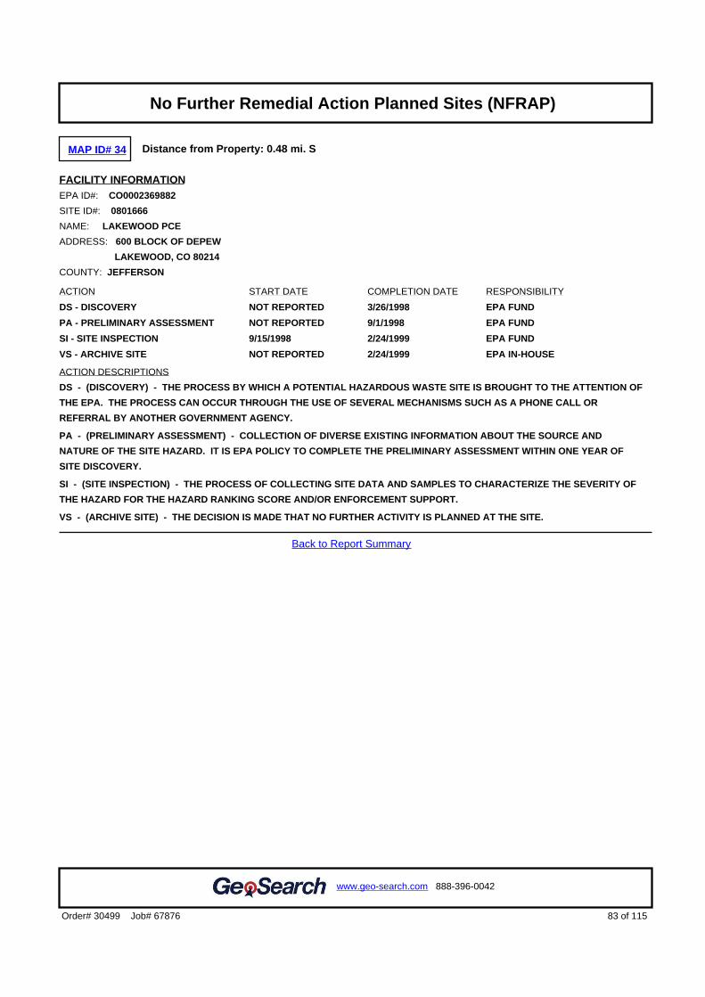
MAP ID# 34 Distance from Property: 0.48 mi. S
FACILITY INFORMATIONEPA ID#: CO0002369882
SITE ID#: 0801666
NAME: LAKEWOOD PCE
ADDRESS: 600 BLOCK OF DEPEW
LAKEWOOD, CO 80214
COUNTY: JEFFERSON
ACTION START DATE COMPLETION DATE RESPONSIBILITY
DS - DISCOVERY NOT REPORTED 3/26/1998 EPA FUND
PA - PRELIMINARY ASSESSMENT NOT REPORTED 9/1/1998 EPA FUND
SI - SITE INSPECTION 9/15/1998 2/24/1999 EPA FUND
VS - ARCHIVE SITE NOT REPORTED 2/24/1999 EPA IN-HOUSE
ACTION DESCRIPTIONS
DS - (DISCOVERY) - THE PROCESS BY WHICH A POTENTIAL HAZARDOUS WASTE SITE IS BROUGHT TO THE ATTENTION OF
THE EPA. THE PROCESS CAN OCCUR THROUGH THE USE OF SEVERAL MECHANISMS SUCH AS A PHONE CALL OR
REFERRAL BY ANOTHER GOVERNMENT AGENCY.
PA - (PRELIMINARY ASSESSMENT) - COLLECTION OF DIVERSE EXISTING INFORMATION ABOUT THE SOURCE AND
NATURE OF THE SITE HAZARD. IT IS EPA POLICY TO COMPLETE THE PRELIMINARY ASSESSMENT WITHIN ONE YEAR OF
SITE DISCOVERY.
SI - (SITE INSPECTION) - THE PROCESS OF COLLECTING SITE DATA AND SAMPLES TO CHARACTERIZE THE SEVERITY OF
THE HAZARD FOR THE HAZARD RANKING SCORE AND/OR ENFORCEMENT SUPPORT.
VS - (ARCHIVE SITE) - THE DECISION IS MADE THAT NO FURTHER ACTIVITY IS PLANNED AT THE SITE.
Back to Report Summary
83 of 115Order# 30499 Job# 67876
www.geo-search.com 888-396-0042
Target Property SummaryDatabase Findings SummaryDatabase Findings SummaryDatabase Findings SummaryDatabase Findings SummaryLocatable Database FindingsLocatable Database FindingsLocatable Database FindingsLocatable Database FindingsReport Summary of Locatable SitesHistorical Solid Waste Landfills (HISTSWLF)Denver County Historic Landfills (DCHISTLF)Emergency Response Notification System (ERNSCO)Spills Listing (SPILLS)Underground Storage Tank Facilities (UST)Hazardous Materials Incident Reporting System (HMIRSR08)Leaking Storage Tank Facilities (LST)Underground Storage Tank Facilities (UST)Resource Conservation & Recovery Act - Non-Generator Facilities(RCRANGR08)Leaking Storage Tank Facilities (LST)Aboveground Storage Tank Facilities (AST)Leaking Storage Tank Facilities (LST)Clandestine Drug Laboratory Locations (CDL)Clandestine Drug Laboratory Locations (CDL)Aboveground Storage Tank Facilities (AST)Leaking Storage Tank Facilities (LST)Aboveground Storage Tank Facilities (AST)Solid Waste Facilities (SWF)Underground Storage Tank Facilities (UST)Resource Conservation & Recovery Act - Generator Facilities(RCRAGR08)Leaking Storage Tank Facilities (LST)Brownfields Management System (BF)Underground Storage Tank Facilities (UST)Solid Waste Facilities (SWF)Historical Solid Waste Landfills (HISTSWLF)Denver County Historic Landfills (DCHISTLF)Brownfields Management System (BF)Leaking Underground Storage Tanks Trust Fund Sites (LUSTTRUST)Leaking Storage Tank Facilities (LST)Historical Solid Waste Landfills (HISTSWLF)Methane Gas Study Sites (METHANESITES)Denver County Historic Landfills (DCHISTLF)Leaking Storage Tank Facilities (LST)Historical Solid Waste Landfills (HISTSWLF)Leaking Underground Storage Tanks Trust Fund Sites (LUSTTRUST)Leaking Storage Tank Facilities (LST)Leaking Storage Tank Facilities (LST)Leaking Storage Tank Facilities (LST)Resource Conservation & Recovery Act - Corrective Action Facilities
(RCRAC)Hazardous Waste Sites- Corrective Action (HWSCA)Voluntary Cleanup and Redevelopment Program Sites (VCRA)Leaking Storage Tank Facilities (LST)Historical Solid Waste Landfills (HISTSWLF)Leaking Storage Tank Facilities (LST)Leaking Storage Tank Facilities (LST)Leaking Storage Tank Facilities (LST)Historical Solid Waste Landfills (HISTSWLF)Denver County Historic Landfills (DCHISTLF)Leaking Storage Tank Facilities (LST)Comprehensive Environmental Response, Compensation & LiabilityInformation System (CERCLIS)Hazardous Waste Sites- Corrective Action (HWSCA)Leaking Storage Tank Facilities (LST)Leaking Storage Tank Facilities (LST)Leaking Storage Tank Facilities (LST)Historical Solid Waste Landfills (HISTSWLF)No Further Remedial Action Planned Sites (NFRAP)Comprehensive Environmental Response, Compensation & LiabilityInformation System (CERCLIS)Leaking Storage Tank Facilities (LST)No Further Remedial Action Planned Sites (NFRAP)

MAP ID# 34 Distance from Property: 0.48 mi. S
FACILITY INFORMATIONEPA ID#: CO0002369882
SITE ID#: 0801666
NAME: LAKEWOOD PCE
ADDRESS: 600 BLOCK OF DEPEW
LAKEWOOD, CO 0214
COUNTY: JEFFERSON
NATIONAL PRIORITY LISTING: N - NOT ON THE NPL
FEDERAL FACILITY CLASSIFICATION: N - NOT A FEDERAL FACILITY
NON-NPL STATUS: NF - NFRAP
NON-NPL STATUS DATE: NOT REPORTED
PHYSICAL CLASSIFICATION OF SITE / INCIDENT: GROUNDWATER
SITE DESCRIPTION - NO SITE DESCRIPTION INFORMATION AVAILABLE -
SITE HISTORY - NO SITE HISTORY INFORMATION AVAILABLE -
ACTIONS
TYPE: SI - SITE INSPECTION
START DATE: 09/15/1998
COMPLETION DATE: 02/24/1999
ACTION TYPE DEFINITION:
THE PROCESS OF COLLECTING SITE DATA AND SAMPLES TO CHARACTERIZE THE SEVERITY OF THE HAZARD FOR THE
HAZARD RANKING SCORE AND/OR ENFORCEMENT SUPPORT.
TYPE: DS - DISCOVERY
START DATE: NR
COMPLETION DATE: 03/26/1998
ACTION TYPE DEFINITION:
THE PROCESS BY WHICH A POTENTIAL HAZARDOUS WASTE SITE IS BROUGHT TO THE ATTENTION OF THE EPA. THE
PROCESS CAN OCCUR THROUGH THE USE OF SEVERAL MECHANISMS SUCH AS A PHONE CALL OR REFERRAL BY
ANOTHER GOVERNMENT AGENCY.
TYPE: PA - PRELIMINARY ASSESSMENT
START DATE: NR
COMPLETION DATE: 09/01/1998
ACTION TYPE DEFINITION:
COLLECTION OF DIVERSE EXISTING INFORMATION ABOUT THE SOURCE AND NATURE OF THE SITE HAZARD. IT IS EPA
POLICY TO COMPLETE THE PRELIMINARY ASSESSMENT WITHIN ONE YEAR OF SITE DISCOVERY.
TYPE: VS - ARCHIVE SITE
START DATE: NR
COMPLETION DATE: 02/24/1999
ACTION TYPE DEFINITION:
THE DECISION IS MADE THAT NO FURTHER ACTIVITY IS PLANNED AT THE SITE.
CONTAMINANTS - NO CONTAMINATION INFORMATION AVAILABLE -
LISTING OF PUBLISHED INSTITUTIONAL CONTROL SITE REPORT - NOT AN INSTITUTIONAL CONTROL SITE -
Back to Report Summary
84 of 115Order# 30499 Job# 67876
www.geo-search.com 888-396-0042
Target Property SummaryDatabase Findings SummaryDatabase Findings SummaryDatabase Findings SummaryDatabase Findings SummaryLocatable Database FindingsLocatable Database FindingsLocatable Database FindingsLocatable Database FindingsReport Summary of Locatable SitesHistorical Solid Waste Landfills (HISTSWLF)Denver County Historic Landfills (DCHISTLF)Emergency Response Notification System (ERNSCO)Spills Listing (SPILLS)Underground Storage Tank Facilities (UST)Hazardous Materials Incident Reporting System (HMIRSR08)Leaking Storage Tank Facilities (LST)Underground Storage Tank Facilities (UST)Resource Conservation & Recovery Act - Non-Generator Facilities(RCRANGR08)Leaking Storage Tank Facilities (LST)Aboveground Storage Tank Facilities (AST)Leaking Storage Tank Facilities (LST)Clandestine Drug Laboratory Locations (CDL)Clandestine Drug Laboratory Locations (CDL)Aboveground Storage Tank Facilities (AST)Leaking Storage Tank Facilities (LST)Aboveground Storage Tank Facilities (AST)Solid Waste Facilities (SWF)Underground Storage Tank Facilities (UST)Resource Conservation & Recovery Act - Generator Facilities(RCRAGR08)Leaking Storage Tank Facilities (LST)Brownfields Management System (BF)Underground Storage Tank Facilities (UST)Solid Waste Facilities (SWF)Historical Solid Waste Landfills (HISTSWLF)Denver County Historic Landfills (DCHISTLF)Brownfields Management System (BF)Leaking Underground Storage Tanks Trust Fund Sites (LUSTTRUST)Leaking Storage Tank Facilities (LST)Historical Solid Waste Landfills (HISTSWLF)Methane Gas Study Sites (METHANESITES)Denver County Historic Landfills (DCHISTLF)Leaking Storage Tank Facilities (LST)Historical Solid Waste Landfills (HISTSWLF)Leaking Underground Storage Tanks Trust Fund Sites (LUSTTRUST)Leaking Storage Tank Facilities (LST)Leaking Storage Tank Facilities (LST)Leaking Storage Tank Facilities (LST)Resource Conservation & Recovery Act - Corrective Action Facilities
(RCRAC)Hazardous Waste Sites- Corrective Action (HWSCA)Voluntary Cleanup and Redevelopment Program Sites (VCRA)Leaking Storage Tank Facilities (LST)Historical Solid Waste Landfills (HISTSWLF)Leaking Storage Tank Facilities (LST)Leaking Storage Tank Facilities (LST)Leaking Storage Tank Facilities (LST)Historical Solid Waste Landfills (HISTSWLF)Denver County Historic Landfills (DCHISTLF)Leaking Storage Tank Facilities (LST)Comprehensive Environmental Response, Compensation & LiabilityInformation System (CERCLIS)Hazardous Waste Sites- Corrective Action (HWSCA)Leaking Storage Tank Facilities (LST)Leaking Storage Tank Facilities (LST)Leaking Storage Tank Facilities (LST)Historical Solid Waste Landfills (HISTSWLF)No Further Remedial Action Planned Sites (NFRAP)Comprehensive Environmental Response, Compensation & LiabilityInformation System (CERCLIS)Leaking Storage Tank Facilities (LST)No Further Remedial Action Planned Sites (NFRAP)Comprehensive Environmental Response, Compensation & LiabilityInformation System (CERCLIS)

MAP ID# 35 Distance from Property: 0.48 mi. NE
FACILITY INFORMATIONFACILITY ID: 9170
NAME: 7-ELEVEN 15754
ADDRESS: 4770 W COLFAX AVE
DENVER, CO 80204
LEAKING INFORMATION
EVENT ID: STATUS: RELEASE DATE:
487 CLOSED 10/23/1989COSTIS LINK: http://costis.cdle.state.co.us/event.asp?h_id=487
11863 CLOSED 5/29/2013 9:57:52 AMCOSTIS LINK: http://costis.cdle.state.co.us/event.asp?h_id=11863
7651 OPEN 8/19/1999COSTIS LINK: http://costis.cdle.state.co.us/event.asp?h_id=7651
Back to Report Summary
85 of 115Order# 30499 Job# 67876
www.geo-search.com 888-396-0042
Target Property SummaryDatabase Findings SummaryDatabase Findings SummaryDatabase Findings SummaryDatabase Findings SummaryLocatable Database FindingsLocatable Database FindingsLocatable Database FindingsLocatable Database FindingsReport Summary of Locatable SitesHistorical Solid Waste Landfills (HISTSWLF)Denver County Historic Landfills (DCHISTLF)Emergency Response Notification System (ERNSCO)Spills Listing (SPILLS)Underground Storage Tank Facilities (UST)Hazardous Materials Incident Reporting System (HMIRSR08)Leaking Storage Tank Facilities (LST)Underground Storage Tank Facilities (UST)Resource Conservation & Recovery Act - Non-Generator Facilities(RCRANGR08)Leaking Storage Tank Facilities (LST)Aboveground Storage Tank Facilities (AST)Leaking Storage Tank Facilities (LST)Clandestine Drug Laboratory Locations (CDL)Clandestine Drug Laboratory Locations (CDL)Aboveground Storage Tank Facilities (AST)Leaking Storage Tank Facilities (LST)Aboveground Storage Tank Facilities (AST)Solid Waste Facilities (SWF)Underground Storage Tank Facilities (UST)Resource Conservation & Recovery Act - Generator Facilities(RCRAGR08)Leaking Storage Tank Facilities (LST)Brownfields Management System (BF)Underground Storage Tank Facilities (UST)Solid Waste Facilities (SWF)Historical Solid Waste Landfills (HISTSWLF)Denver County Historic Landfills (DCHISTLF)Brownfields Management System (BF)Leaking Underground Storage Tanks Trust Fund Sites (LUSTTRUST)Leaking Storage Tank Facilities (LST)Historical Solid Waste Landfills (HISTSWLF)Methane Gas Study Sites (METHANESITES)Denver County Historic Landfills (DCHISTLF)Leaking Storage Tank Facilities (LST)Historical Solid Waste Landfills (HISTSWLF)Leaking Underground Storage Tanks Trust Fund Sites (LUSTTRUST)Leaking Storage Tank Facilities (LST)Leaking Storage Tank Facilities (LST)Leaking Storage Tank Facilities (LST)Resource Conservation & Recovery Act - Corrective Action Facilities
(RCRAC)Hazardous Waste Sites- Corrective Action (HWSCA)Voluntary Cleanup and Redevelopment Program Sites (VCRA)Leaking Storage Tank Facilities (LST)Historical Solid Waste Landfills (HISTSWLF)Leaking Storage Tank Facilities (LST)Leaking Storage Tank Facilities (LST)Leaking Storage Tank Facilities (LST)Historical Solid Waste Landfills (HISTSWLF)Denver County Historic Landfills (DCHISTLF)Leaking Storage Tank Facilities (LST)Comprehensive Environmental Response, Compensation & LiabilityInformation System (CERCLIS)Hazardous Waste Sites- Corrective Action (HWSCA)Leaking Storage Tank Facilities (LST)Leaking Storage Tank Facilities (LST)Leaking Storage Tank Facilities (LST)Historical Solid Waste Landfills (HISTSWLF)No Further Remedial Action Planned Sites (NFRAP)Comprehensive Environmental Response, Compensation & LiabilityInformation System (CERCLIS)Leaking Storage Tank Facilities (LST)No Further Remedial Action Planned Sites (NFRAP)Comprehensive Environmental Response, Compensation & LiabilityInformation System (CERCLIS)Leaking Storage Tank Facilities (LST)

MAP ID# 36 Distance from Property: 0.49 mi. SE
SITE INFORMATIONUNIQUE ID: 36844743
NAME: CASA DE ROSAL
ADDRESS: 755 VRAIN STREET
DENVER, CO 80204
COUNTY: DENVER
SITE DETAILSAPPLICATION TYPE: VOLUNTARY CLEANUP PROGRAM
FILE NUMBER: 080924-1
REVIEW DATE DUE: 11/8/2008
DECISION: APPROVAL
REMEDY START DATE: 10/31/2008 REMEDY END DATE: 10/31/2010
ACTUAL COST: 680 CLEANUP ACRES: 2.75
OTHER ISSUES: LANDFILL;#9
LAND USE RESTRICTIONS: NOT REPORTED
PROJECT MANAGER: APOSTOLOPOULOS
INDOOR AIR: NOT REPORTED
MEDIA SEDIMENT: NOT REPORTED
MEDIA GROUND WATER: NOT REPORTED
MEDIA SURFACE WATER: NOT REPORTED
MEDIA SOIL: NOT REPORTED
Back to Report Summary
86 of 115Order# 30499 Job# 67876
www.geo-search.com 888-396-0042
Target Property SummaryDatabase Findings SummaryDatabase Findings SummaryDatabase Findings SummaryDatabase Findings SummaryLocatable Database FindingsLocatable Database FindingsLocatable Database FindingsLocatable Database FindingsReport Summary of Locatable SitesHistorical Solid Waste Landfills (HISTSWLF)Denver County Historic Landfills (DCHISTLF)Emergency Response Notification System (ERNSCO)Spills Listing (SPILLS)Underground Storage Tank Facilities (UST)Hazardous Materials Incident Reporting System (HMIRSR08)Leaking Storage Tank Facilities (LST)Underground Storage Tank Facilities (UST)Resource Conservation & Recovery Act - Non-Generator Facilities(RCRANGR08)Leaking Storage Tank Facilities (LST)Aboveground Storage Tank Facilities (AST)Leaking Storage Tank Facilities (LST)Clandestine Drug Laboratory Locations (CDL)Clandestine Drug Laboratory Locations (CDL)Aboveground Storage Tank Facilities (AST)Leaking Storage Tank Facilities (LST)Aboveground Storage Tank Facilities (AST)Solid Waste Facilities (SWF)Underground Storage Tank Facilities (UST)Resource Conservation & Recovery Act - Generator Facilities(RCRAGR08)Leaking Storage Tank Facilities (LST)Brownfields Management System (BF)Underground Storage Tank Facilities (UST)Solid Waste Facilities (SWF)Historical Solid Waste Landfills (HISTSWLF)Denver County Historic Landfills (DCHISTLF)Brownfields Management System (BF)Leaking Underground Storage Tanks Trust Fund Sites (LUSTTRUST)Leaking Storage Tank Facilities (LST)Historical Solid Waste Landfills (HISTSWLF)Methane Gas Study Sites (METHANESITES)Denver County Historic Landfills (DCHISTLF)Leaking Storage Tank Facilities (LST)Historical Solid Waste Landfills (HISTSWLF)Leaking Underground Storage Tanks Trust Fund Sites (LUSTTRUST)Leaking Storage Tank Facilities (LST)Leaking Storage Tank Facilities (LST)Leaking Storage Tank Facilities (LST)Resource Conservation & Recovery Act - Corrective Action Facilities
(RCRAC)Hazardous Waste Sites- Corrective Action (HWSCA)Voluntary Cleanup and Redevelopment Program Sites (VCRA)Leaking Storage Tank Facilities (LST)Historical Solid Waste Landfills (HISTSWLF)Leaking Storage Tank Facilities (LST)Leaking Storage Tank Facilities (LST)Leaking Storage Tank Facilities (LST)Historical Solid Waste Landfills (HISTSWLF)Denver County Historic Landfills (DCHISTLF)Leaking Storage Tank Facilities (LST)Comprehensive Environmental Response, Compensation & LiabilityInformation System (CERCLIS)Hazardous Waste Sites- Corrective Action (HWSCA)Leaking Storage Tank Facilities (LST)Leaking Storage Tank Facilities (LST)Leaking Storage Tank Facilities (LST)Historical Solid Waste Landfills (HISTSWLF)No Further Remedial Action Planned Sites (NFRAP)Comprehensive Environmental Response, Compensation & LiabilityInformation System (CERCLIS)Leaking Storage Tank Facilities (LST)No Further Remedial Action Planned Sites (NFRAP)Comprehensive Environmental Response, Compensation & LiabilityInformation System (CERCLIS)Leaking Storage Tank Facilities (LST)Voluntary Cleanup and Redevelopment Program Sites (VCRA)

MAP ID# 36 Distance from Property: 0.49 mi. SE
SITE INFORMATIONUNIQUE ID: 25469248
NAME: CASA DE ROSAL II
ADDRESS: 755 VRAIN STREET
DENVER, CO 80204
COUNTY: DENVER
SITE DETAILSAPPLICATION TYPE: NO ACTION DETERMINATION
FILE NUMBER: 090414-1
REVIEW DATE DUE: 5/29/2009
DECISION: APPROVAL
REMEDY START DATE: NOT REPORTED REMEDY END DATE: NOT REPORTED
ACTUAL COST: 765 CLEANUP ACRES: NOT REPORTED
OTHER ISSUES: LANDFILL;#9
LAND USE RESTRICTIONS: NOT REPORTED
PROJECT MANAGER: APOSTOLOPOULOS
INDOOR AIR: NOT REPORTED
MEDIA SEDIMENT: NOT REPORTED
MEDIA GROUND WATER: NOT REPORTED
MEDIA SURFACE WATER: NOT REPORTED
MEDIA SOIL: NOT REPORTED
Back to Report Summary
87 of 115Order# 30499 Job# 67876
www.geo-search.com 888-396-0042
Target Property SummaryDatabase Findings SummaryDatabase Findings SummaryDatabase Findings SummaryDatabase Findings SummaryLocatable Database FindingsLocatable Database FindingsLocatable Database FindingsLocatable Database FindingsReport Summary of Locatable SitesHistorical Solid Waste Landfills (HISTSWLF)Denver County Historic Landfills (DCHISTLF)Emergency Response Notification System (ERNSCO)Spills Listing (SPILLS)Underground Storage Tank Facilities (UST)Hazardous Materials Incident Reporting System (HMIRSR08)Leaking Storage Tank Facilities (LST)Underground Storage Tank Facilities (UST)Resource Conservation & Recovery Act - Non-Generator Facilities(RCRANGR08)Leaking Storage Tank Facilities (LST)Aboveground Storage Tank Facilities (AST)Leaking Storage Tank Facilities (LST)Clandestine Drug Laboratory Locations (CDL)Clandestine Drug Laboratory Locations (CDL)Aboveground Storage Tank Facilities (AST)Leaking Storage Tank Facilities (LST)Aboveground Storage Tank Facilities (AST)Solid Waste Facilities (SWF)Underground Storage Tank Facilities (UST)Resource Conservation & Recovery Act - Generator Facilities(RCRAGR08)Leaking Storage Tank Facilities (LST)Brownfields Management System (BF)Underground Storage Tank Facilities (UST)Solid Waste Facilities (SWF)Historical Solid Waste Landfills (HISTSWLF)Denver County Historic Landfills (DCHISTLF)Brownfields Management System (BF)Leaking Underground Storage Tanks Trust Fund Sites (LUSTTRUST)Leaking Storage Tank Facilities (LST)Historical Solid Waste Landfills (HISTSWLF)Methane Gas Study Sites (METHANESITES)Denver County Historic Landfills (DCHISTLF)Leaking Storage Tank Facilities (LST)Historical Solid Waste Landfills (HISTSWLF)Leaking Underground Storage Tanks Trust Fund Sites (LUSTTRUST)Leaking Storage Tank Facilities (LST)Leaking Storage Tank Facilities (LST)Leaking Storage Tank Facilities (LST)Resource Conservation & Recovery Act - Corrective Action Facilities
(RCRAC)Hazardous Waste Sites- Corrective Action (HWSCA)Voluntary Cleanup and Redevelopment Program Sites (VCRA)Leaking Storage Tank Facilities (LST)Historical Solid Waste Landfills (HISTSWLF)Leaking Storage Tank Facilities (LST)Leaking Storage Tank Facilities (LST)Leaking Storage Tank Facilities (LST)Historical Solid Waste Landfills (HISTSWLF)Denver County Historic Landfills (DCHISTLF)Leaking Storage Tank Facilities (LST)Comprehensive Environmental Response, Compensation & LiabilityInformation System (CERCLIS)Hazardous Waste Sites- Corrective Action (HWSCA)Leaking Storage Tank Facilities (LST)Leaking Storage Tank Facilities (LST)Leaking Storage Tank Facilities (LST)Historical Solid Waste Landfills (HISTSWLF)No Further Remedial Action Planned Sites (NFRAP)Comprehensive Environmental Response, Compensation & LiabilityInformation System (CERCLIS)Leaking Storage Tank Facilities (LST)No Further Remedial Action Planned Sites (NFRAP)Comprehensive Environmental Response, Compensation & LiabilityInformation System (CERCLIS)Leaking Storage Tank Facilities (LST)Voluntary Cleanup and Redevelopment Program Sites (VCRA)Voluntary Cleanup and Redevelopment Program Sites (VCRA)

MAP ID# 37 Distance from Property: 0.49 mi. S
FACILITY INFORMATIONFACILITY ID: 14732
NAME: LUST TRUST SITE
ADDRESS: 5567 6TH AVE SERVICE RD
LAKEWOOD, CO 80214
LEAKING INFORMATION
EVENT ID: STATUS: RELEASE DATE:
7078 CLOSED 12/3/1998COSTIS LINK: http://costis.cdle.state.co.us/event.asp?h_id=7078
Back to Report Summary
88 of 115Order# 30499 Job# 67876
www.geo-search.com 888-396-0042
Target Property SummaryDatabase Findings SummaryDatabase Findings SummaryDatabase Findings SummaryDatabase Findings SummaryLocatable Database FindingsLocatable Database FindingsLocatable Database FindingsLocatable Database FindingsReport Summary of Locatable SitesHistorical Solid Waste Landfills (HISTSWLF)Denver County Historic Landfills (DCHISTLF)Emergency Response Notification System (ERNSCO)Spills Listing (SPILLS)Underground Storage Tank Facilities (UST)Hazardous Materials Incident Reporting System (HMIRSR08)Leaking Storage Tank Facilities (LST)Underground Storage Tank Facilities (UST)Resource Conservation & Recovery Act - Non-Generator Facilities(RCRANGR08)Leaking Storage Tank Facilities (LST)Aboveground Storage Tank Facilities (AST)Leaking Storage Tank Facilities (LST)Clandestine Drug Laboratory Locations (CDL)Clandestine Drug Laboratory Locations (CDL)Aboveground Storage Tank Facilities (AST)Leaking Storage Tank Facilities (LST)Aboveground Storage Tank Facilities (AST)Solid Waste Facilities (SWF)Underground Storage Tank Facilities (UST)Resource Conservation & Recovery Act - Generator Facilities(RCRAGR08)Leaking Storage Tank Facilities (LST)Brownfields Management System (BF)Underground Storage Tank Facilities (UST)Solid Waste Facilities (SWF)Historical Solid Waste Landfills (HISTSWLF)Denver County Historic Landfills (DCHISTLF)Brownfields Management System (BF)Leaking Underground Storage Tanks Trust Fund Sites (LUSTTRUST)Leaking Storage Tank Facilities (LST)Historical Solid Waste Landfills (HISTSWLF)Methane Gas Study Sites (METHANESITES)Denver County Historic Landfills (DCHISTLF)Leaking Storage Tank Facilities (LST)Historical Solid Waste Landfills (HISTSWLF)Leaking Underground Storage Tanks Trust Fund Sites (LUSTTRUST)Leaking Storage Tank Facilities (LST)Leaking Storage Tank Facilities (LST)Leaking Storage Tank Facilities (LST)Resource Conservation & Recovery Act - Corrective Action Facilities
(RCRAC)Hazardous Waste Sites- Corrective Action (HWSCA)Voluntary Cleanup and Redevelopment Program Sites (VCRA)Leaking Storage Tank Facilities (LST)Historical Solid Waste Landfills (HISTSWLF)Leaking Storage Tank Facilities (LST)Leaking Storage Tank Facilities (LST)Leaking Storage Tank Facilities (LST)Historical Solid Waste Landfills (HISTSWLF)Denver County Historic Landfills (DCHISTLF)Leaking Storage Tank Facilities (LST)Comprehensive Environmental Response, Compensation & LiabilityInformation System (CERCLIS)Hazardous Waste Sites- Corrective Action (HWSCA)Leaking Storage Tank Facilities (LST)Leaking Storage Tank Facilities (LST)Leaking Storage Tank Facilities (LST)Historical Solid Waste Landfills (HISTSWLF)No Further Remedial Action Planned Sites (NFRAP)Comprehensive Environmental Response, Compensation & LiabilityInformation System (CERCLIS)Leaking Storage Tank Facilities (LST)No Further Remedial Action Planned Sites (NFRAP)Comprehensive Environmental Response, Compensation & LiabilityInformation System (CERCLIS)Leaking Storage Tank Facilities (LST)Voluntary Cleanup and Redevelopment Program Sites (VCRA)Voluntary Cleanup and Redevelopment Program Sites (VCRA)Leaking Storage Tank Facilities (LST)

MAP ID# 38 Distance from Property: 0.50 mi. NE
FACILITY INFORMATIONFACILITY ID: 19178
NAME: FORMER PIG N WHISTLE
ADDRESS: 4801 W COLFAX AVE
DENVER, CO 80204
LEAKING INFORMATION
EVENT ID: STATUS: RELEASE DATE:
11569 OPEN 12/19/2011 9:37:31 ACOSTIS LINK: http://costis.cdle.state.co.us/event.asp?h_id=11569
Back to Report Summary
89 of 115Order# 30499 Job# 67876
www.geo-search.com 888-396-0042
Target Property SummaryDatabase Findings SummaryDatabase Findings SummaryDatabase Findings SummaryDatabase Findings SummaryLocatable Database FindingsLocatable Database FindingsLocatable Database FindingsLocatable Database FindingsReport Summary of Locatable SitesHistorical Solid Waste Landfills (HISTSWLF)Denver County Historic Landfills (DCHISTLF)Emergency Response Notification System (ERNSCO)Spills Listing (SPILLS)Underground Storage Tank Facilities (UST)Hazardous Materials Incident Reporting System (HMIRSR08)Leaking Storage Tank Facilities (LST)Underground Storage Tank Facilities (UST)Resource Conservation & Recovery Act - Non-Generator Facilities(RCRANGR08)Leaking Storage Tank Facilities (LST)Aboveground Storage Tank Facilities (AST)Leaking Storage Tank Facilities (LST)Clandestine Drug Laboratory Locations (CDL)Clandestine Drug Laboratory Locations (CDL)Aboveground Storage Tank Facilities (AST)Leaking Storage Tank Facilities (LST)Aboveground Storage Tank Facilities (AST)Solid Waste Facilities (SWF)Underground Storage Tank Facilities (UST)Resource Conservation & Recovery Act - Generator Facilities(RCRAGR08)Leaking Storage Tank Facilities (LST)Brownfields Management System (BF)Underground Storage Tank Facilities (UST)Solid Waste Facilities (SWF)Historical Solid Waste Landfills (HISTSWLF)Denver County Historic Landfills (DCHISTLF)Brownfields Management System (BF)Leaking Underground Storage Tanks Trust Fund Sites (LUSTTRUST)Leaking Storage Tank Facilities (LST)Historical Solid Waste Landfills (HISTSWLF)Methane Gas Study Sites (METHANESITES)Denver County Historic Landfills (DCHISTLF)Leaking Storage Tank Facilities (LST)Historical Solid Waste Landfills (HISTSWLF)Leaking Underground Storage Tanks Trust Fund Sites (LUSTTRUST)Leaking Storage Tank Facilities (LST)Leaking Storage Tank Facilities (LST)Leaking Storage Tank Facilities (LST)Resource Conservation & Recovery Act - Corrective Action Facilities
(RCRAC)Hazardous Waste Sites- Corrective Action (HWSCA)Voluntary Cleanup and Redevelopment Program Sites (VCRA)Leaking Storage Tank Facilities (LST)Historical Solid Waste Landfills (HISTSWLF)Leaking Storage Tank Facilities (LST)Leaking Storage Tank Facilities (LST)Leaking Storage Tank Facilities (LST)Historical Solid Waste Landfills (HISTSWLF)Denver County Historic Landfills (DCHISTLF)Leaking Storage Tank Facilities (LST)Comprehensive Environmental Response, Compensation & LiabilityInformation System (CERCLIS)Hazardous Waste Sites- Corrective Action (HWSCA)Leaking Storage Tank Facilities (LST)Leaking Storage Tank Facilities (LST)Leaking Storage Tank Facilities (LST)Historical Solid Waste Landfills (HISTSWLF)No Further Remedial Action Planned Sites (NFRAP)Comprehensive Environmental Response, Compensation & LiabilityInformation System (CERCLIS)Leaking Storage Tank Facilities (LST)No Further Remedial Action Planned Sites (NFRAP)Comprehensive Environmental Response, Compensation & LiabilityInformation System (CERCLIS)Leaking Storage Tank Facilities (LST)Voluntary Cleanup and Redevelopment Program Sites (VCRA)Voluntary Cleanup and Redevelopment Program Sites (VCRA)Leaking Storage Tank Facilities (LST)Leaking Storage Tank Facilities (LST)

MAP ID# 39 Distance from Property: 0.50 mi. S
SITE INFORMATIONUNIQUE ID: 00070-0000473
NAME: OLD LANDFILL
ADDRESS: 6TH AVE AND SHERIDAN BLVD
DENVER, CO
DIRECTIONS: NOT REPORTED
COUNTY: DENVER
SITE DETAILSAGENCY ID: NOT REPORTED
DETAIL1:
SIGNIFICANT CONCENTRATIONS OF METHANE GAS WERE MEASURED IN FIVE OF THE FOURTEEN EXPLOTATORY BORINGS
DRILLED AT THIS LANDFILL. IN AS MUCH AS PORTIONS OF THIS LANDFILL HAVE BEEN DEVELOPED INTO RESIDENTIAL
HOUSING, A POTENTIAL GAS HAZARD DOES EXIST TO STRUC
DETAIL2:
GRNDWTR- A GROUNDWATER LEVEL WAS MEASURED AT DEPTHS VARYING FROM TWELVE TO THIRTY FEET BENEATH THE
SURFACE.; HISTORY- PRIOR TO ITS USE AS A LANDFILL, THE AREA WAS AN EROSION MEANDER OF LAKEWOOD GULCH.
THE AREA NEAR 8TH AVE. AND WOLFF ST. WAS A TURKEY FAR
Back to Report Summary
90 of 115Order# 30499 Job# 67876
www.geo-search.com 888-396-0042
Target Property SummaryDatabase Findings SummaryDatabase Findings SummaryDatabase Findings SummaryDatabase Findings SummaryLocatable Database FindingsLocatable Database FindingsLocatable Database FindingsLocatable Database FindingsReport Summary of Locatable SitesHistorical Solid Waste Landfills (HISTSWLF)Denver County Historic Landfills (DCHISTLF)Emergency Response Notification System (ERNSCO)Spills Listing (SPILLS)Underground Storage Tank Facilities (UST)Hazardous Materials Incident Reporting System (HMIRSR08)Leaking Storage Tank Facilities (LST)Underground Storage Tank Facilities (UST)Resource Conservation & Recovery Act - Non-Generator Facilities(RCRANGR08)Leaking Storage Tank Facilities (LST)Aboveground Storage Tank Facilities (AST)Leaking Storage Tank Facilities (LST)Clandestine Drug Laboratory Locations (CDL)Clandestine Drug Laboratory Locations (CDL)Aboveground Storage Tank Facilities (AST)Leaking Storage Tank Facilities (LST)Aboveground Storage Tank Facilities (AST)Solid Waste Facilities (SWF)Underground Storage Tank Facilities (UST)Resource Conservation & Recovery Act - Generator Facilities(RCRAGR08)Leaking Storage Tank Facilities (LST)Brownfields Management System (BF)Underground Storage Tank Facilities (UST)Solid Waste Facilities (SWF)Historical Solid Waste Landfills (HISTSWLF)Denver County Historic Landfills (DCHISTLF)Brownfields Management System (BF)Leaking Underground Storage Tanks Trust Fund Sites (LUSTTRUST)Leaking Storage Tank Facilities (LST)Historical Solid Waste Landfills (HISTSWLF)Methane Gas Study Sites (METHANESITES)Denver County Historic Landfills (DCHISTLF)Leaking Storage Tank Facilities (LST)Historical Solid Waste Landfills (HISTSWLF)Leaking Underground Storage Tanks Trust Fund Sites (LUSTTRUST)Leaking Storage Tank Facilities (LST)Leaking Storage Tank Facilities (LST)Leaking Storage Tank Facilities (LST)Resource Conservation & Recovery Act - Corrective Action Facilities
(RCRAC)Hazardous Waste Sites- Corrective Action (HWSCA)Voluntary Cleanup and Redevelopment Program Sites (VCRA)Leaking Storage Tank Facilities (LST)Historical Solid Waste Landfills (HISTSWLF)Leaking Storage Tank Facilities (LST)Leaking Storage Tank Facilities (LST)Leaking Storage Tank Facilities (LST)Historical Solid Waste Landfills (HISTSWLF)Denver County Historic Landfills (DCHISTLF)Leaking Storage Tank Facilities (LST)Comprehensive Environmental Response, Compensation & LiabilityInformation System (CERCLIS)Hazardous Waste Sites- Corrective Action (HWSCA)Leaking Storage Tank Facilities (LST)Leaking Storage Tank Facilities (LST)Leaking Storage Tank Facilities (LST)Historical Solid Waste Landfills (HISTSWLF)No Further Remedial Action Planned Sites (NFRAP)Comprehensive Environmental Response, Compensation & LiabilityInformation System (CERCLIS)Leaking Storage Tank Facilities (LST)No Further Remedial Action Planned Sites (NFRAP)Comprehensive Environmental Response, Compensation & LiabilityInformation System (CERCLIS)Leaking Storage Tank Facilities (LST)Voluntary Cleanup and Redevelopment Program Sites (VCRA)Voluntary Cleanup and Redevelopment Program Sites (VCRA)Leaking Storage Tank Facilities (LST)Leaking Storage Tank Facilities (LST)Historical Solid Waste Landfills (HISTSWLF)

MAP ID# 40 Distance from Property: 0.51 mi. W
SITE INFORMATIONUNIQUE ID: 18835961
NAME: METRO WEST HOUSING SOLUTIONS II
ADDRESS: 6150 W. 13TH AVE.
LAKEWOOD, CO 80214
COUNTY: JEFFERSON
SITE DETAILSAPPLICATION TYPE: NO ACTION DETERMINATION
FILE NUMBER: 121023-1
REVIEW DATE DUE: 12/7/2012
DECISION: APPROVAL
REMEDY START DATE: NOT REPORTED REMEDY END DATE: NOT REPORTED
ACTUAL COST: 935 CLEANUP ACRES: NOT REPORTED
OTHER ISSUES: NOT REPORTED
LAND USE RESTRICTIONS: RESIDENTIAL
PROJECT MANAGER: APOSTOLOPOULOS
INDOOR AIR: NOT REPORTED
MEDIA SEDIMENT: NOT REPORTED
MEDIA GROUND WATER: NOT REPORTED
MEDIA SURFACE WATER: NOT REPORTED
MEDIA SOIL: COAL FILL;#23;#ASBESTOS CONTAMINATED MATERIALS;#25
Back to Report Summary
91 of 115Order# 30499 Job# 67876
www.geo-search.com 888-396-0042
Target Property SummaryDatabase Findings SummaryDatabase Findings SummaryDatabase Findings SummaryDatabase Findings SummaryLocatable Database FindingsLocatable Database FindingsLocatable Database FindingsLocatable Database FindingsReport Summary of Locatable SitesHistorical Solid Waste Landfills (HISTSWLF)Denver County Historic Landfills (DCHISTLF)Emergency Response Notification System (ERNSCO)Spills Listing (SPILLS)Underground Storage Tank Facilities (UST)Hazardous Materials Incident Reporting System (HMIRSR08)Leaking Storage Tank Facilities (LST)Underground Storage Tank Facilities (UST)Resource Conservation & Recovery Act - Non-Generator Facilities(RCRANGR08)Leaking Storage Tank Facilities (LST)Aboveground Storage Tank Facilities (AST)Leaking Storage Tank Facilities (LST)Clandestine Drug Laboratory Locations (CDL)Clandestine Drug Laboratory Locations (CDL)Aboveground Storage Tank Facilities (AST)Leaking Storage Tank Facilities (LST)Aboveground Storage Tank Facilities (AST)Solid Waste Facilities (SWF)Underground Storage Tank Facilities (UST)Resource Conservation & Recovery Act - Generator Facilities(RCRAGR08)Leaking Storage Tank Facilities (LST)Brownfields Management System (BF)Underground Storage Tank Facilities (UST)Solid Waste Facilities (SWF)Historical Solid Waste Landfills (HISTSWLF)Denver County Historic Landfills (DCHISTLF)Brownfields Management System (BF)Leaking Underground Storage Tanks Trust Fund Sites (LUSTTRUST)Leaking Storage Tank Facilities (LST)Historical Solid Waste Landfills (HISTSWLF)Methane Gas Study Sites (METHANESITES)Denver County Historic Landfills (DCHISTLF)Leaking Storage Tank Facilities (LST)Historical Solid Waste Landfills (HISTSWLF)Leaking Underground Storage Tanks Trust Fund Sites (LUSTTRUST)Leaking Storage Tank Facilities (LST)Leaking Storage Tank Facilities (LST)Leaking Storage Tank Facilities (LST)Resource Conservation & Recovery Act - Corrective Action Facilities
(RCRAC)Hazardous Waste Sites- Corrective Action (HWSCA)Voluntary Cleanup and Redevelopment Program Sites (VCRA)Leaking Storage Tank Facilities (LST)Historical Solid Waste Landfills (HISTSWLF)Leaking Storage Tank Facilities (LST)Leaking Storage Tank Facilities (LST)Leaking Storage Tank Facilities (LST)Historical Solid Waste Landfills (HISTSWLF)Denver County Historic Landfills (DCHISTLF)Leaking Storage Tank Facilities (LST)Comprehensive Environmental Response, Compensation & LiabilityInformation System (CERCLIS)Hazardous Waste Sites- Corrective Action (HWSCA)Leaking Storage Tank Facilities (LST)Leaking Storage Tank Facilities (LST)Leaking Storage Tank Facilities (LST)Historical Solid Waste Landfills (HISTSWLF)No Further Remedial Action Planned Sites (NFRAP)Comprehensive Environmental Response, Compensation & LiabilityInformation System (CERCLIS)Leaking Storage Tank Facilities (LST)No Further Remedial Action Planned Sites (NFRAP)Comprehensive Environmental Response, Compensation & LiabilityInformation System (CERCLIS)Leaking Storage Tank Facilities (LST)Voluntary Cleanup and Redevelopment Program Sites (VCRA)Voluntary Cleanup and Redevelopment Program Sites (VCRA)Leaking Storage Tank Facilities (LST)Leaking Storage Tank Facilities (LST)Historical Solid Waste Landfills (HISTSWLF)Voluntary Cleanup and Redevelopment Program Sites (VCRA)

MAP ID# 40 Distance from Property: 0.51 mi. W
SITE INFORMATIONUNIQUE ID: 21211863
NAME: METRO WEST HOUSING SOLUTIONS
ADDRESS: 6150 W. 13TH AVE.
LAKEWOOD, CO 80214
COUNTY: JEFFERSON
SITE DETAILSAPPLICATION TYPE: VOLUNTARY CLEANUP PROGRAM
FILE NUMBER: 120529-1
REVIEW DATE DUE: 7/13/2012
DECISION: APPROVAL
REMEDY START DATE: 8/24/2012 REMEDY END DATE: 8/24/2014
ACTUAL COST: 1402.5 CLEANUP ACRES: 5.5
OTHER ISSUES: NOT REPORTED
LAND USE RESTRICTIONS: RESIDENTIAL
PROJECT MANAGER: APOSTOLOPOULOS
INDOOR AIR: NOT REPORTED
MEDIA SEDIMENT: NOT REPORTED
MEDIA GROUND WATER: NOT REPORTED
MEDIA SURFACE WATER: NOT REPORTED
MEDIA SOIL: HEAVY METALS;#9;#PAH'S;#13;#ASBESTOS;#2
Back to Report Summary
92 of 115Order# 30499 Job# 67876
www.geo-search.com 888-396-0042
Target Property SummaryDatabase Findings SummaryDatabase Findings SummaryDatabase Findings SummaryDatabase Findings SummaryLocatable Database FindingsLocatable Database FindingsLocatable Database FindingsLocatable Database FindingsReport Summary of Locatable SitesHistorical Solid Waste Landfills (HISTSWLF)Denver County Historic Landfills (DCHISTLF)Emergency Response Notification System (ERNSCO)Spills Listing (SPILLS)Underground Storage Tank Facilities (UST)Hazardous Materials Incident Reporting System (HMIRSR08)Leaking Storage Tank Facilities (LST)Underground Storage Tank Facilities (UST)Resource Conservation & Recovery Act - Non-Generator Facilities(RCRANGR08)Leaking Storage Tank Facilities (LST)Aboveground Storage Tank Facilities (AST)Leaking Storage Tank Facilities (LST)Clandestine Drug Laboratory Locations (CDL)Clandestine Drug Laboratory Locations (CDL)Aboveground Storage Tank Facilities (AST)Leaking Storage Tank Facilities (LST)Aboveground Storage Tank Facilities (AST)Solid Waste Facilities (SWF)Underground Storage Tank Facilities (UST)Resource Conservation & Recovery Act - Generator Facilities(RCRAGR08)Leaking Storage Tank Facilities (LST)Brownfields Management System (BF)Underground Storage Tank Facilities (UST)Solid Waste Facilities (SWF)Historical Solid Waste Landfills (HISTSWLF)Denver County Historic Landfills (DCHISTLF)Brownfields Management System (BF)Leaking Underground Storage Tanks Trust Fund Sites (LUSTTRUST)Leaking Storage Tank Facilities (LST)Historical Solid Waste Landfills (HISTSWLF)Methane Gas Study Sites (METHANESITES)Denver County Historic Landfills (DCHISTLF)Leaking Storage Tank Facilities (LST)Historical Solid Waste Landfills (HISTSWLF)Leaking Underground Storage Tanks Trust Fund Sites (LUSTTRUST)Leaking Storage Tank Facilities (LST)Leaking Storage Tank Facilities (LST)Leaking Storage Tank Facilities (LST)Resource Conservation & Recovery Act - Corrective Action Facilities
(RCRAC)Hazardous Waste Sites- Corrective Action (HWSCA)Voluntary Cleanup and Redevelopment Program Sites (VCRA)Leaking Storage Tank Facilities (LST)Historical Solid Waste Landfills (HISTSWLF)Leaking Storage Tank Facilities (LST)Leaking Storage Tank Facilities (LST)Leaking Storage Tank Facilities (LST)Historical Solid Waste Landfills (HISTSWLF)Denver County Historic Landfills (DCHISTLF)Leaking Storage Tank Facilities (LST)Comprehensive Environmental Response, Compensation & LiabilityInformation System (CERCLIS)Hazardous Waste Sites- Corrective Action (HWSCA)Leaking Storage Tank Facilities (LST)Leaking Storage Tank Facilities (LST)Leaking Storage Tank Facilities (LST)Historical Solid Waste Landfills (HISTSWLF)No Further Remedial Action Planned Sites (NFRAP)Comprehensive Environmental Response, Compensation & LiabilityInformation System (CERCLIS)Leaking Storage Tank Facilities (LST)No Further Remedial Action Planned Sites (NFRAP)Comprehensive Environmental Response, Compensation & LiabilityInformation System (CERCLIS)Leaking Storage Tank Facilities (LST)Voluntary Cleanup and Redevelopment Program Sites (VCRA)Voluntary Cleanup and Redevelopment Program Sites (VCRA)Leaking Storage Tank Facilities (LST)Leaking Storage Tank Facilities (LST)Historical Solid Waste Landfills (HISTSWLF)Voluntary Cleanup and Redevelopment Program Sites (VCRA)Voluntary Cleanup and Redevelopment Program Sites (VCRA)

MAP ID# 40 Distance from Property: 0.51 mi. W
SITE INFORMATIONID#: 160081
NAME: LAMAR STATION CROSSING
ADDRESS: 6150 W. 13TH AVENUE
LAKEWOOD, CO 80214
TYPE OF BROWNFIELD GRANT: CLEANUP
TYPE FUNDING: P
PREDOMINANT PAST USE (ACREAGE): GREENSPACE: NOT REPORTED
RESIDENTIAL:0.84
COMMERCIAL:1
INDUSTRIAL:3.5
FUTURE USE (ACREAGE): GREENSPACE: NOT REPORTED
RESIDENTIAL:NOT REPORTED
COMMERCIAL:NOT REPORTED
INDUSTRIAL:NOT REPORTED
PROPERTY HIGHLIGHT:
NOT REPORTED
PROPERTY SIZE (Acres): 5.34
CURRENT OWNER: LAKEWOOD HOUSING AUTHORITY
PROPERTY DESCRIPTION/ FORMER USE:
ARRAY OF USES - AUTO REPAIR AND IMPOUND, LIGHT MANUFACTORING, HOUSING, RETAIL. CONTAMINATED WITH
ASBESTOS/PAHS. PURCHASED BY MWHS IN 2006. MWHS DEMOLISHED BUILDINGS IN 2007.
ENVIRONMENTAL ASSESSMENT ACTIVITY: NOT REPORTED
ASSESSMENT START DATE: NOT REPORTED
ASSESSMENT COMPLETION DATE: NOT REPORTED
CLEANUP REQUIRED: YES
CONTAMINATE(S): ASBESTOS
CONTAMINATE(S) CLEANED UP: PETROLEUM, ASBESTOS, PAHS
MEDIA(S) AFFECTED: SOIL
MEDIA(S) CLEANED UP: SOIL
STATE & TRIBAL ENROLLMENT ID: NOT REPORTED
STATE & TRIBAL ENROLLMENT DATE: NOT REPORTED
PROPERTY ENROLLED IN A STATE & TRIBAL PROGRAM?: 8/24/2012
ARE INSTITUTIONAL CONTROLS REQUIRED?: YES
ENVIRONMENTAL ASSESSMENT ACTIVITY: NOT REPORTED
ASSESSMENT START DATE: NOT REPORTED
ASSESSMENT COMPLETION DATE: NOT REPORTED
CLEANUP REQUIRED: YES
CONTAMINATE(S): ASBESTOS
CONTAMINATE(S) CLEANED UP: PETROLEUM, ASBESTOS, PAHS
MEDIA(S) AFFECTED: SOIL
MEDIA(S) CLEANED UP: SOIL
STATE & TRIBAL ENROLLMENT ID: NOT REPORTED
STATE & TRIBAL ENROLLMENT DATE: NOT REPORTED
PROPERTY ENROLLED IN A STATE & TRIBAL PROGRAM?: 8/24/2012
93 of 115Order# 30499 Job# 67876
www.geo-search.com 888-396-0042
Target Property SummaryDatabase Findings SummaryDatabase Findings SummaryDatabase Findings SummaryDatabase Findings SummaryLocatable Database FindingsLocatable Database FindingsLocatable Database FindingsLocatable Database FindingsReport Summary of Locatable SitesHistorical Solid Waste Landfills (HISTSWLF)Denver County Historic Landfills (DCHISTLF)Emergency Response Notification System (ERNSCO)Spills Listing (SPILLS)Underground Storage Tank Facilities (UST)Hazardous Materials Incident Reporting System (HMIRSR08)Leaking Storage Tank Facilities (LST)Underground Storage Tank Facilities (UST)Resource Conservation & Recovery Act - Non-Generator Facilities(RCRANGR08)Leaking Storage Tank Facilities (LST)Aboveground Storage Tank Facilities (AST)Leaking Storage Tank Facilities (LST)Clandestine Drug Laboratory Locations (CDL)Clandestine Drug Laboratory Locations (CDL)Aboveground Storage Tank Facilities (AST)Leaking Storage Tank Facilities (LST)Aboveground Storage Tank Facilities (AST)Solid Waste Facilities (SWF)Underground Storage Tank Facilities (UST)Resource Conservation & Recovery Act - Generator Facilities(RCRAGR08)Leaking Storage Tank Facilities (LST)Brownfields Management System (BF)Underground Storage Tank Facilities (UST)Solid Waste Facilities (SWF)Historical Solid Waste Landfills (HISTSWLF)Denver County Historic Landfills (DCHISTLF)Brownfields Management System (BF)Leaking Underground Storage Tanks Trust Fund Sites (LUSTTRUST)Leaking Storage Tank Facilities (LST)Historical Solid Waste Landfills (HISTSWLF)Methane Gas Study Sites (METHANESITES)Denver County Historic Landfills (DCHISTLF)Leaking Storage Tank Facilities (LST)Historical Solid Waste Landfills (HISTSWLF)Leaking Underground Storage Tanks Trust Fund Sites (LUSTTRUST)Leaking Storage Tank Facilities (LST)Leaking Storage Tank Facilities (LST)Leaking Storage Tank Facilities (LST)Resource Conservation & Recovery Act - Corrective Action Facilities
(RCRAC)Hazardous Waste Sites- Corrective Action (HWSCA)Voluntary Cleanup and Redevelopment Program Sites (VCRA)Leaking Storage Tank Facilities (LST)Historical Solid Waste Landfills (HISTSWLF)Leaking Storage Tank Facilities (LST)Leaking Storage Tank Facilities (LST)Leaking Storage Tank Facilities (LST)Historical Solid Waste Landfills (HISTSWLF)Denver County Historic Landfills (DCHISTLF)Leaking Storage Tank Facilities (LST)Comprehensive Environmental Response, Compensation & LiabilityInformation System (CERCLIS)Hazardous Waste Sites- Corrective Action (HWSCA)Leaking Storage Tank Facilities (LST)Leaking Storage Tank Facilities (LST)Leaking Storage Tank Facilities (LST)Historical Solid Waste Landfills (HISTSWLF)No Further Remedial Action Planned Sites (NFRAP)Comprehensive Environmental Response, Compensation & LiabilityInformation System (CERCLIS)Leaking Storage Tank Facilities (LST)No Further Remedial Action Planned Sites (NFRAP)Comprehensive Environmental Response, Compensation & LiabilityInformation System (CERCLIS)Leaking Storage Tank Facilities (LST)Voluntary Cleanup and Redevelopment Program Sites (VCRA)Voluntary Cleanup and Redevelopment Program Sites (VCRA)Leaking Storage Tank Facilities (LST)Leaking Storage Tank Facilities (LST)Historical Solid Waste Landfills (HISTSWLF)Voluntary Cleanup and Redevelopment Program Sites (VCRA)Voluntary Cleanup and Redevelopment Program Sites (VCRA)Brownfields Management System (BF)

ARE INSTITUTIONAL CONTROLS REQUIRED?: YES
ENVIRONMENTAL ASSESSMENT ACTIVITY: NOT REPORTED
ASSESSMENT START DATE: NOT REPORTED
ASSESSMENT COMPLETION DATE: NOT REPORTED
CLEANUP REQUIRED: YES
CONTAMINATE(S): ASBESTOS
CONTAMINATE(S) CLEANED UP: PETROLEUM, ASBESTOS, PAHS
MEDIA(S) AFFECTED: SOIL
MEDIA(S) CLEANED UP: SOIL
STATE & TRIBAL ENROLLMENT ID: NOT REPORTED
STATE & TRIBAL ENROLLMENT DATE: NOT REPORTED
PROPERTY ENROLLED IN A STATE & TRIBAL PROGRAM?: 8/24/2012
ARE INSTITUTIONAL CONTROLS REQUIRED?: YES
ENVIRONMENTAL ASSESSMENT ACTIVITY: NOT REPORTED
ASSESSMENT START DATE: NOT REPORTED
ASSESSMENT COMPLETION DATE: NOT REPORTED
CLEANUP REQUIRED: YES
CONTAMINATE(S): ASBESTOS
CONTAMINATE(S) CLEANED UP: PETROLEUM, ASBESTOS, PAHS
94 of 115Order# 30499 Job# 67876
www.geo-search.com 888-396-0042
Target Property SummaryDatabase Findings SummaryDatabase Findings SummaryDatabase Findings SummaryDatabase Findings SummaryLocatable Database FindingsLocatable Database FindingsLocatable Database FindingsLocatable Database FindingsReport Summary of Locatable SitesHistorical Solid Waste Landfills (HISTSWLF)Denver County Historic Landfills (DCHISTLF)Emergency Response Notification System (ERNSCO)Spills Listing (SPILLS)Underground Storage Tank Facilities (UST)Hazardous Materials Incident Reporting System (HMIRSR08)Leaking Storage Tank Facilities (LST)Underground Storage Tank Facilities (UST)Resource Conservation & Recovery Act - Non-Generator Facilities(RCRANGR08)Leaking Storage Tank Facilities (LST)Aboveground Storage Tank Facilities (AST)Leaking Storage Tank Facilities (LST)Clandestine Drug Laboratory Locations (CDL)Clandestine Drug Laboratory Locations (CDL)Aboveground Storage Tank Facilities (AST)Leaking Storage Tank Facilities (LST)Aboveground Storage Tank Facilities (AST)Solid Waste Facilities (SWF)Underground Storage Tank Facilities (UST)Resource Conservation & Recovery Act - Generator Facilities(RCRAGR08)Leaking Storage Tank Facilities (LST)Brownfields Management System (BF)Underground Storage Tank Facilities (UST)Solid Waste Facilities (SWF)Historical Solid Waste Landfills (HISTSWLF)Denver County Historic Landfills (DCHISTLF)Brownfields Management System (BF)Leaking Underground Storage Tanks Trust Fund Sites (LUSTTRUST)Leaking Storage Tank Facilities (LST)Historical Solid Waste Landfills (HISTSWLF)Methane Gas Study Sites (METHANESITES)Denver County Historic Landfills (DCHISTLF)Leaking Storage Tank Facilities (LST)Historical Solid Waste Landfills (HISTSWLF)Leaking Underground Storage Tanks Trust Fund Sites (LUSTTRUST)Leaking Storage Tank Facilities (LST)Leaking Storage Tank Facilities (LST)Leaking Storage Tank Facilities (LST)Resource Conservation & Recovery Act - Corrective Action Facilities
(RCRAC)Hazardous Waste Sites- Corrective Action (HWSCA)Voluntary Cleanup and Redevelopment Program Sites (VCRA)Leaking Storage Tank Facilities (LST)Historical Solid Waste Landfills (HISTSWLF)Leaking Storage Tank Facilities (LST)Leaking Storage Tank Facilities (LST)Leaking Storage Tank Facilities (LST)Historical Solid Waste Landfills (HISTSWLF)Denver County Historic Landfills (DCHISTLF)Leaking Storage Tank Facilities (LST)Comprehensive Environmental Response, Compensation & LiabilityInformation System (CERCLIS)Hazardous Waste Sites- Corrective Action (HWSCA)Leaking Storage Tank Facilities (LST)Leaking Storage Tank Facilities (LST)Leaking Storage Tank Facilities (LST)Historical Solid Waste Landfills (HISTSWLF)No Further Remedial Action Planned Sites (NFRAP)Comprehensive Environmental Response, Compensation & LiabilityInformation System (CERCLIS)Leaking Storage Tank Facilities (LST)No Further Remedial Action Planned Sites (NFRAP)Comprehensive Environmental Response, Compensation & LiabilityInformation System (CERCLIS)Leaking Storage Tank Facilities (LST)Voluntary Cleanup and Redevelopment Program Sites (VCRA)Voluntary Cleanup and Redevelopment Program Sites (VCRA)Leaking Storage Tank Facilities (LST)Leaking Storage Tank Facilities (LST)Historical Solid Waste Landfills (HISTSWLF)Voluntary Cleanup and Redevelopment Program Sites (VCRA)Voluntary Cleanup and Redevelopment Program Sites (VCRA)Brownfields Management System (BF)

MEDIA(S) AFFECTED: SOIL
MEDIA(S) CLEANED UP: SOIL
STATE & TRIBAL ENROLLMENT ID: NOT REPORTED
STATE & TRIBAL ENROLLMENT DATE: NOT REPORTED
PROPERTY ENROLLED IN A STATE & TRIBAL PROGRAM?: 8/24/2012
ARE INSTITUTIONAL CONTROLS REQUIRED?: YES
ENVIRONMENTAL ASSESSMENT ACTIVITY: NOT REPORTED
ASSESSMENT START DATE: NOT REPORTED
ASSESSMENT COMPLETION DATE: NOT REPORTED
CLEANUP REQUIRED: YES
CONTAMINATE(S): ASBESTOS
CONTAMINATE(S) CLEANED UP: PETROLEUM, ASBESTOS, PAHS
MEDIA(S) AFFECTED: SOIL
MEDIA(S) CLEANED UP: SOIL
STATE & TRIBAL ENROLLMENT ID: NOT REPORTED
STATE & TRIBAL ENROLLMENT DATE: NOT REPORTED
PROPERTY ENROLLED IN A STATE & TRIBAL PROGRAM?: 8/24/2012
ARE INSTITUTIONAL CONTROLS REQUIRED?: YES
ENVIRONMENTAL ASSESSMENT ACTIVITY: NOT REPORTED
95 of 115Order# 30499 Job# 67876
www.geo-search.com 888-396-0042
Target Property SummaryDatabase Findings SummaryDatabase Findings SummaryDatabase Findings SummaryDatabase Findings SummaryLocatable Database FindingsLocatable Database FindingsLocatable Database FindingsLocatable Database FindingsReport Summary of Locatable SitesHistorical Solid Waste Landfills (HISTSWLF)Denver County Historic Landfills (DCHISTLF)Emergency Response Notification System (ERNSCO)Spills Listing (SPILLS)Underground Storage Tank Facilities (UST)Hazardous Materials Incident Reporting System (HMIRSR08)Leaking Storage Tank Facilities (LST)Underground Storage Tank Facilities (UST)Resource Conservation & Recovery Act - Non-Generator Facilities(RCRANGR08)Leaking Storage Tank Facilities (LST)Aboveground Storage Tank Facilities (AST)Leaking Storage Tank Facilities (LST)Clandestine Drug Laboratory Locations (CDL)Clandestine Drug Laboratory Locations (CDL)Aboveground Storage Tank Facilities (AST)Leaking Storage Tank Facilities (LST)Aboveground Storage Tank Facilities (AST)Solid Waste Facilities (SWF)Underground Storage Tank Facilities (UST)Resource Conservation & Recovery Act - Generator Facilities(RCRAGR08)Leaking Storage Tank Facilities (LST)Brownfields Management System (BF)Underground Storage Tank Facilities (UST)Solid Waste Facilities (SWF)Historical Solid Waste Landfills (HISTSWLF)Denver County Historic Landfills (DCHISTLF)Brownfields Management System (BF)Leaking Underground Storage Tanks Trust Fund Sites (LUSTTRUST)Leaking Storage Tank Facilities (LST)Historical Solid Waste Landfills (HISTSWLF)Methane Gas Study Sites (METHANESITES)Denver County Historic Landfills (DCHISTLF)Leaking Storage Tank Facilities (LST)Historical Solid Waste Landfills (HISTSWLF)Leaking Underground Storage Tanks Trust Fund Sites (LUSTTRUST)Leaking Storage Tank Facilities (LST)Leaking Storage Tank Facilities (LST)Leaking Storage Tank Facilities (LST)Resource Conservation & Recovery Act - Corrective Action Facilities
(RCRAC)Hazardous Waste Sites- Corrective Action (HWSCA)Voluntary Cleanup and Redevelopment Program Sites (VCRA)Leaking Storage Tank Facilities (LST)Historical Solid Waste Landfills (HISTSWLF)Leaking Storage Tank Facilities (LST)Leaking Storage Tank Facilities (LST)Leaking Storage Tank Facilities (LST)Historical Solid Waste Landfills (HISTSWLF)Denver County Historic Landfills (DCHISTLF)Leaking Storage Tank Facilities (LST)Comprehensive Environmental Response, Compensation & LiabilityInformation System (CERCLIS)Hazardous Waste Sites- Corrective Action (HWSCA)Leaking Storage Tank Facilities (LST)Leaking Storage Tank Facilities (LST)Leaking Storage Tank Facilities (LST)Historical Solid Waste Landfills (HISTSWLF)No Further Remedial Action Planned Sites (NFRAP)Comprehensive Environmental Response, Compensation & LiabilityInformation System (CERCLIS)Leaking Storage Tank Facilities (LST)No Further Remedial Action Planned Sites (NFRAP)Comprehensive Environmental Response, Compensation & LiabilityInformation System (CERCLIS)Leaking Storage Tank Facilities (LST)Voluntary Cleanup and Redevelopment Program Sites (VCRA)Voluntary Cleanup and Redevelopment Program Sites (VCRA)Leaking Storage Tank Facilities (LST)Leaking Storage Tank Facilities (LST)Historical Solid Waste Landfills (HISTSWLF)Voluntary Cleanup and Redevelopment Program Sites (VCRA)Voluntary Cleanup and Redevelopment Program Sites (VCRA)Brownfields Management System (BF)

ASSESSMENT START DATE: NOT REPORTED
ASSESSMENT COMPLETION DATE: NOT REPORTED
CLEANUP REQUIRED: YES
CONTAMINATE(S): ASBESTOS
CONTAMINATE(S) CLEANED UP: PETROLEUM, ASBESTOS, PAHS
MEDIA(S) AFFECTED: SOIL
MEDIA(S) CLEANED UP: SOIL
STATE & TRIBAL ENROLLMENT ID: NOT REPORTED
STATE & TRIBAL ENROLLMENT DATE: NOT REPORTED
PROPERTY ENROLLED IN A STATE & TRIBAL PROGRAM?: 8/24/2012
ARE INSTITUTIONAL CONTROLS REQUIRED?: YES
Back to Report Summary
96 of 115Order# 30499 Job# 67876
www.geo-search.com 888-396-0042
Target Property SummaryDatabase Findings SummaryDatabase Findings SummaryDatabase Findings SummaryDatabase Findings SummaryLocatable Database FindingsLocatable Database FindingsLocatable Database FindingsLocatable Database FindingsReport Summary of Locatable SitesHistorical Solid Waste Landfills (HISTSWLF)Denver County Historic Landfills (DCHISTLF)Emergency Response Notification System (ERNSCO)Spills Listing (SPILLS)Underground Storage Tank Facilities (UST)Hazardous Materials Incident Reporting System (HMIRSR08)Leaking Storage Tank Facilities (LST)Underground Storage Tank Facilities (UST)Resource Conservation & Recovery Act - Non-Generator Facilities(RCRANGR08)Leaking Storage Tank Facilities (LST)Aboveground Storage Tank Facilities (AST)Leaking Storage Tank Facilities (LST)Clandestine Drug Laboratory Locations (CDL)Clandestine Drug Laboratory Locations (CDL)Aboveground Storage Tank Facilities (AST)Leaking Storage Tank Facilities (LST)Aboveground Storage Tank Facilities (AST)Solid Waste Facilities (SWF)Underground Storage Tank Facilities (UST)Resource Conservation & Recovery Act - Generator Facilities(RCRAGR08)Leaking Storage Tank Facilities (LST)Brownfields Management System (BF)Underground Storage Tank Facilities (UST)Solid Waste Facilities (SWF)Historical Solid Waste Landfills (HISTSWLF)Denver County Historic Landfills (DCHISTLF)Brownfields Management System (BF)Leaking Underground Storage Tanks Trust Fund Sites (LUSTTRUST)Leaking Storage Tank Facilities (LST)Historical Solid Waste Landfills (HISTSWLF)Methane Gas Study Sites (METHANESITES)Denver County Historic Landfills (DCHISTLF)Leaking Storage Tank Facilities (LST)Historical Solid Waste Landfills (HISTSWLF)Leaking Underground Storage Tanks Trust Fund Sites (LUSTTRUST)Leaking Storage Tank Facilities (LST)Leaking Storage Tank Facilities (LST)Leaking Storage Tank Facilities (LST)Resource Conservation & Recovery Act - Corrective Action Facilities
(RCRAC)Hazardous Waste Sites- Corrective Action (HWSCA)Voluntary Cleanup and Redevelopment Program Sites (VCRA)Leaking Storage Tank Facilities (LST)Historical Solid Waste Landfills (HISTSWLF)Leaking Storage Tank Facilities (LST)Leaking Storage Tank Facilities (LST)Leaking Storage Tank Facilities (LST)Historical Solid Waste Landfills (HISTSWLF)Denver County Historic Landfills (DCHISTLF)Leaking Storage Tank Facilities (LST)Comprehensive Environmental Response, Compensation & LiabilityInformation System (CERCLIS)Hazardous Waste Sites- Corrective Action (HWSCA)Leaking Storage Tank Facilities (LST)Leaking Storage Tank Facilities (LST)Leaking Storage Tank Facilities (LST)Historical Solid Waste Landfills (HISTSWLF)No Further Remedial Action Planned Sites (NFRAP)Comprehensive Environmental Response, Compensation & LiabilityInformation System (CERCLIS)Leaking Storage Tank Facilities (LST)No Further Remedial Action Planned Sites (NFRAP)Comprehensive Environmental Response, Compensation & LiabilityInformation System (CERCLIS)Leaking Storage Tank Facilities (LST)Voluntary Cleanup and Redevelopment Program Sites (VCRA)Voluntary Cleanup and Redevelopment Program Sites (VCRA)Leaking Storage Tank Facilities (LST)Leaking Storage Tank Facilities (LST)Historical Solid Waste Landfills (HISTSWLF)Voluntary Cleanup and Redevelopment Program Sites (VCRA)Voluntary Cleanup and Redevelopment Program Sites (VCRA)Brownfields Management System (BF)

MAP ID# 40 Distance from Property: 0.51 mi. W
FACILITY INFORMATIONFACILITY ID: 17281
NAME: THE ESTATE OF DIANE M VIGIL
ADDRESS: 6150 W 13TH AVE
LAKEWOOD, CO 80215
LEAKING INFORMATION
EVENT ID: STATUS: RELEASE DATE:
9601 CLOSED 9/10/2004 9:41:39 AMCOSTIS LINK: http://costis.cdle.state.co.us/event.asp?h_id=9601
Back to Report Summary
97 of 115Order# 30499 Job# 67876
www.geo-search.com 888-396-0042
Target Property SummaryDatabase Findings SummaryDatabase Findings SummaryDatabase Findings SummaryDatabase Findings SummaryLocatable Database FindingsLocatable Database FindingsLocatable Database FindingsLocatable Database FindingsReport Summary of Locatable SitesHistorical Solid Waste Landfills (HISTSWLF)Denver County Historic Landfills (DCHISTLF)Emergency Response Notification System (ERNSCO)Spills Listing (SPILLS)Underground Storage Tank Facilities (UST)Hazardous Materials Incident Reporting System (HMIRSR08)Leaking Storage Tank Facilities (LST)Underground Storage Tank Facilities (UST)Resource Conservation & Recovery Act - Non-Generator Facilities(RCRANGR08)Leaking Storage Tank Facilities (LST)Aboveground Storage Tank Facilities (AST)Leaking Storage Tank Facilities (LST)Clandestine Drug Laboratory Locations (CDL)Clandestine Drug Laboratory Locations (CDL)Aboveground Storage Tank Facilities (AST)Leaking Storage Tank Facilities (LST)Aboveground Storage Tank Facilities (AST)Solid Waste Facilities (SWF)Underground Storage Tank Facilities (UST)Resource Conservation & Recovery Act - Generator Facilities(RCRAGR08)Leaking Storage Tank Facilities (LST)Brownfields Management System (BF)Underground Storage Tank Facilities (UST)Solid Waste Facilities (SWF)Historical Solid Waste Landfills (HISTSWLF)Denver County Historic Landfills (DCHISTLF)Brownfields Management System (BF)Leaking Underground Storage Tanks Trust Fund Sites (LUSTTRUST)Leaking Storage Tank Facilities (LST)Historical Solid Waste Landfills (HISTSWLF)Methane Gas Study Sites (METHANESITES)Denver County Historic Landfills (DCHISTLF)Leaking Storage Tank Facilities (LST)Historical Solid Waste Landfills (HISTSWLF)Leaking Underground Storage Tanks Trust Fund Sites (LUSTTRUST)Leaking Storage Tank Facilities (LST)Leaking Storage Tank Facilities (LST)Leaking Storage Tank Facilities (LST)Resource Conservation & Recovery Act - Corrective Action Facilities
(RCRAC)Hazardous Waste Sites- Corrective Action (HWSCA)Voluntary Cleanup and Redevelopment Program Sites (VCRA)Leaking Storage Tank Facilities (LST)Historical Solid Waste Landfills (HISTSWLF)Leaking Storage Tank Facilities (LST)Leaking Storage Tank Facilities (LST)Leaking Storage Tank Facilities (LST)Historical Solid Waste Landfills (HISTSWLF)Denver County Historic Landfills (DCHISTLF)Leaking Storage Tank Facilities (LST)Comprehensive Environmental Response, Compensation & LiabilityInformation System (CERCLIS)Hazardous Waste Sites- Corrective Action (HWSCA)Leaking Storage Tank Facilities (LST)Leaking Storage Tank Facilities (LST)Leaking Storage Tank Facilities (LST)Historical Solid Waste Landfills (HISTSWLF)No Further Remedial Action Planned Sites (NFRAP)Comprehensive Environmental Response, Compensation & LiabilityInformation System (CERCLIS)Leaking Storage Tank Facilities (LST)No Further Remedial Action Planned Sites (NFRAP)Comprehensive Environmental Response, Compensation & LiabilityInformation System (CERCLIS)Leaking Storage Tank Facilities (LST)Voluntary Cleanup and Redevelopment Program Sites (VCRA)Voluntary Cleanup and Redevelopment Program Sites (VCRA)Leaking Storage Tank Facilities (LST)Leaking Storage Tank Facilities (LST)Historical Solid Waste Landfills (HISTSWLF)Voluntary Cleanup and Redevelopment Program Sites (VCRA)Voluntary Cleanup and Redevelopment Program Sites (VCRA)Brownfields Management System (BF)Leaking Storage Tank Facilities (LST)

MAP ID# 41 Distance from Property: 0.76 mi. NW
FACILITY INFORMATIONEPA ID#: COD102536489 OWNER TYPE: PRIVATE
NAME: WOLFE MILLER/JCRSII SHOP CTR OWNER NAME: WOLFE MILLER
ADDRESS: 6469 W COLFAX AVE OPERATOR TYPE: PRIVATE
DENVER, CO 80214 OPERATOR NAME: ROSE CLEANERS
CONTACT NAME: MARTY AMBLE
CONTACT ADDRESS: 1777 S HARRISON ST #P2
DENVER, CO 80210
CONTACT PHONE: 3038308301
NON-NOTIFIER: NOT A NON-NOTIFIER
DATE RECEIVED BY AGENCY: 07/26/2001
CERTIFICATION - NO CERTIFICATION REPORTED -
INDUSTRY CLASSIFICATION (NAICS) - NO NAICS INFORMATION REPORTED -
SITE HISTORY (INCLUDES GENERATORS AND NON-GENERATORS)
DATE RECEIVED BY AGENCY: 02/23/1995
NAME: WOLFE MILLER/JCRSII SHOP CTR
GENERATOR CLASSIFICATION: SMALL QUANTITY GENERATOR
DATE RECEIVED BY AGENCY: 04/19/2001
NAME: WOLFE MILLER/JCRSII SHOP CTR
GENERATOR CLASSIFICATION: NOT A GENERATOR
DATE RECEIVED BY AGENCY: 07/26/2001
NAME: WOLFE MILLER/JCRSII SHOP CTR
GENERATOR CLASSIFICATION: NOT A GENERATOR
ACTIVITY INFORMATION
GENERATOR STATUS: NOT A GENERATOR
SUBJECT TO CORRECTIVE ACTION UNIVERSE: YES
TDSFs POTENTIALLY SUBJECT TO CORRECTIVE ACTION UNDER 3004 (u)/(v) UNIVERSE: NO
TDSFs ONLY SUBJECT TO CORRECTIVE ACTION UNDER DISCRETIONARY AUTHORITIES UNIVERSE: NO
NON TSDFs WHERE RCRA CORRECTIVE ACTION HAS BEEN IMPOSED UNIVERSE: YES
CORRECTIVE ACTION WORKLOAD UNIVERSE: YES
IMPORTER: NO UNDERGROUND INJECTION: NO
MIXED WASTE GENERATOR: NO UNIVERSAL WASTE DESTINATION FACILITY: NO
RECYCLER: NO TRANSFER FACILITY: NO
TRANSPORTER: NO USED OIL FUEL BURNER: NO
ONSITE BURNER EXEMPTION: NO USED OIL PROCESSOR: NO
FURNACE EXEMPTION: NO USED OIL FUEL MARKETER TO BURNER: NO
USED OIL REFINER: NO SPECIFICATION USED OIL MARKETER: NO
USED OIL TRANSFER FACILITY: NO USED OIL TRANSPORTER: NO
COMPLIANCE, MONITORING AND ENFORCEMENT INFORMATION
EVALUATIONS2001/04/19 FCI FOCUSED COMPLIANCE INSPECTION
2002/05/09 FCI FOCUSED COMPLIANCE INSPECTION
98 of 115Order# 30499 Job# 67876
www.geo-search.com 888-396-0042
Target Property SummaryDatabase Findings SummaryDatabase Findings SummaryDatabase Findings SummaryDatabase Findings SummaryLocatable Database FindingsLocatable Database FindingsLocatable Database FindingsLocatable Database FindingsReport Summary of Locatable SitesHistorical Solid Waste Landfills (HISTSWLF)Denver County Historic Landfills (DCHISTLF)Emergency Response Notification System (ERNSCO)Spills Listing (SPILLS)Underground Storage Tank Facilities (UST)Hazardous Materials Incident Reporting System (HMIRSR08)Leaking Storage Tank Facilities (LST)Underground Storage Tank Facilities (UST)Resource Conservation & Recovery Act - Non-Generator Facilities(RCRANGR08)Leaking Storage Tank Facilities (LST)Aboveground Storage Tank Facilities (AST)Leaking Storage Tank Facilities (LST)Clandestine Drug Laboratory Locations (CDL)Clandestine Drug Laboratory Locations (CDL)Aboveground Storage Tank Facilities (AST)Leaking Storage Tank Facilities (LST)Aboveground Storage Tank Facilities (AST)Solid Waste Facilities (SWF)Underground Storage Tank Facilities (UST)Resource Conservation & Recovery Act - Generator Facilities(RCRAGR08)Leaking Storage Tank Facilities (LST)Brownfields Management System (BF)Underground Storage Tank Facilities (UST)Solid Waste Facilities (SWF)Historical Solid Waste Landfills (HISTSWLF)Denver County Historic Landfills (DCHISTLF)Brownfields Management System (BF)Leaking Underground Storage Tanks Trust Fund Sites (LUSTTRUST)Leaking Storage Tank Facilities (LST)Historical Solid Waste Landfills (HISTSWLF)Methane Gas Study Sites (METHANESITES)Denver County Historic Landfills (DCHISTLF)Leaking Storage Tank Facilities (LST)Historical Solid Waste Landfills (HISTSWLF)Leaking Underground Storage Tanks Trust Fund Sites (LUSTTRUST)Leaking Storage Tank Facilities (LST)Leaking Storage Tank Facilities (LST)Leaking Storage Tank Facilities (LST)Resource Conservation & Recovery Act - Corrective Action Facilities
(RCRAC)Hazardous Waste Sites- Corrective Action (HWSCA)Voluntary Cleanup and Redevelopment Program Sites (VCRA)Leaking Storage Tank Facilities (LST)Historical Solid Waste Landfills (HISTSWLF)Leaking Storage Tank Facilities (LST)Leaking Storage Tank Facilities (LST)Leaking Storage Tank Facilities (LST)Historical Solid Waste Landfills (HISTSWLF)Denver County Historic Landfills (DCHISTLF)Leaking Storage Tank Facilities (LST)Comprehensive Environmental Response, Compensation & LiabilityInformation System (CERCLIS)Hazardous Waste Sites- Corrective Action (HWSCA)Leaking Storage Tank Facilities (LST)Leaking Storage Tank Facilities (LST)Leaking Storage Tank Facilities (LST)Historical Solid Waste Landfills (HISTSWLF)No Further Remedial Action Planned Sites (NFRAP)Comprehensive Environmental Response, Compensation & LiabilityInformation System (CERCLIS)Leaking Storage Tank Facilities (LST)No Further Remedial Action Planned Sites (NFRAP)Comprehensive Environmental Response, Compensation & LiabilityInformation System (CERCLIS)Leaking Storage Tank Facilities (LST)Voluntary Cleanup and Redevelopment Program Sites (VCRA)Voluntary Cleanup and Redevelopment Program Sites (VCRA)Leaking Storage Tank Facilities (LST)Leaking Storage Tank Facilities (LST)Historical Solid Waste Landfills (HISTSWLF)Voluntary Cleanup and Redevelopment Program Sites (VCRA)Voluntary Cleanup and Redevelopment Program Sites (VCRA)Brownfields Management System (BF)Leaking Storage Tank Facilities (LST)No Longer Regulated RCRA Corrective Action Facilities (NLRRCRAC)

VIOLATIONS - NO VIOLATIONS REPORTED -
ENFORCEMENTS - NO ENFORCEMENTS REPORTED -
HAZARDOUS WASTE
F002 THE FOLLOWING SPENT HALOGENATED SOLVENTS: TETRACHLOROETHYLENE, METHYLENECHLORIDE,TRICHLOROETHYLENE, 1,1,1-TRICHLOROETHANE,CHLOROBENZENE, 1,1,2-TRICHLORO-1,2,2-TRIFLUOROETHANE, ORTHO-DICHLOROBENZENE, TRICHLOROFLUOROMETHANE, AND 1,1,2,TRICHLOROETHANE; ALL SPENT SOLVENT MIXTURES/BLENDS CONTAINING, BEFORE USE, A TOTAL OF TENPERCENT OR MORE (BY VOLUME) OF ONE OR MORE OF THE ABOVE HALOGENATED SOLVENTS OR THOSESOLVENTS LISTED IN F001,F004, AND F005; AND STILL BOTTOMS FROM THE RECOVERY OF THESE SPENTSOLVENTS AND SPENT SOLVENT MIXTURES.
UNIVERSAL WASTE - NO UNIVERSAL WASTE REPORTED -
CORRECTIVE ACTION AREA (RELEASE)
AREA NAME: AIR: GROUNDWATER: SOIL: SURFACE WASTE:
SOIL N N Y N
CORRECTIVE ACTION EVENT
CA EVENT: DATE: EVENT DESCRIPTION:
CA100 20020312 INVESTIGATION IMPOSITION
CA100 20020509 INVESTIGATION IMPOSITION
CA150 20020509 INVESTIGATION WORKPLAN APPROVED
CA180 20020509 INVESTIGATION IMPLEMENTATION BEGUN
CA200 20020509 INVESTIGATION COMPLETE
CA250 20020509 CMS IMPOSITION
CA300 20020509 CMS WORKPLAN APPROVED
CA400 20020509 REMEDY DECISION
CA450 20020509 CORRECTIVE MEASURES DESIGN APPROVED
CA500 20020509 CMI WORKPLAN APPROVED-IMPLEMENTED FOLLOWING AN RFI
CA999RM 20020509 CA PROCESS IS TERMINATED-REMEDIAL ACTIVITIES COMPLETE
Back to Report Summary
99 of 115Order# 30499 Job# 67876
www.geo-search.com 888-396-0042
Target Property SummaryDatabase Findings SummaryDatabase Findings SummaryDatabase Findings SummaryDatabase Findings SummaryLocatable Database FindingsLocatable Database FindingsLocatable Database FindingsLocatable Database FindingsReport Summary of Locatable SitesHistorical Solid Waste Landfills (HISTSWLF)Denver County Historic Landfills (DCHISTLF)Emergency Response Notification System (ERNSCO)Spills Listing (SPILLS)Underground Storage Tank Facilities (UST)Hazardous Materials Incident Reporting System (HMIRSR08)Leaking Storage Tank Facilities (LST)Underground Storage Tank Facilities (UST)Resource Conservation & Recovery Act - Non-Generator Facilities(RCRANGR08)Leaking Storage Tank Facilities (LST)Aboveground Storage Tank Facilities (AST)Leaking Storage Tank Facilities (LST)Clandestine Drug Laboratory Locations (CDL)Clandestine Drug Laboratory Locations (CDL)Aboveground Storage Tank Facilities (AST)Leaking Storage Tank Facilities (LST)Aboveground Storage Tank Facilities (AST)Solid Waste Facilities (SWF)Underground Storage Tank Facilities (UST)Resource Conservation & Recovery Act - Generator Facilities(RCRAGR08)Leaking Storage Tank Facilities (LST)Brownfields Management System (BF)Underground Storage Tank Facilities (UST)Solid Waste Facilities (SWF)Historical Solid Waste Landfills (HISTSWLF)Denver County Historic Landfills (DCHISTLF)Brownfields Management System (BF)Leaking Underground Storage Tanks Trust Fund Sites (LUSTTRUST)Leaking Storage Tank Facilities (LST)Historical Solid Waste Landfills (HISTSWLF)Methane Gas Study Sites (METHANESITES)Denver County Historic Landfills (DCHISTLF)Leaking Storage Tank Facilities (LST)Historical Solid Waste Landfills (HISTSWLF)Leaking Underground Storage Tanks Trust Fund Sites (LUSTTRUST)Leaking Storage Tank Facilities (LST)Leaking Storage Tank Facilities (LST)Leaking Storage Tank Facilities (LST)Resource Conservation & Recovery Act - Corrective Action Facilities
(RCRAC)Hazardous Waste Sites- Corrective Action (HWSCA)Voluntary Cleanup and Redevelopment Program Sites (VCRA)Leaking Storage Tank Facilities (LST)Historical Solid Waste Landfills (HISTSWLF)Leaking Storage Tank Facilities (LST)Leaking Storage Tank Facilities (LST)Leaking Storage Tank Facilities (LST)Historical Solid Waste Landfills (HISTSWLF)Denver County Historic Landfills (DCHISTLF)Leaking Storage Tank Facilities (LST)Comprehensive Environmental Response, Compensation & LiabilityInformation System (CERCLIS)Hazardous Waste Sites- Corrective Action (HWSCA)Leaking Storage Tank Facilities (LST)Leaking Storage Tank Facilities (LST)Leaking Storage Tank Facilities (LST)Historical Solid Waste Landfills (HISTSWLF)No Further Remedial Action Planned Sites (NFRAP)Comprehensive Environmental Response, Compensation & LiabilityInformation System (CERCLIS)Leaking Storage Tank Facilities (LST)No Further Remedial Action Planned Sites (NFRAP)Comprehensive Environmental Response, Compensation & LiabilityInformation System (CERCLIS)Leaking Storage Tank Facilities (LST)Voluntary Cleanup and Redevelopment Program Sites (VCRA)Voluntary Cleanup and Redevelopment Program Sites (VCRA)Leaking Storage Tank Facilities (LST)Leaking Storage Tank Facilities (LST)Historical Solid Waste Landfills (HISTSWLF)Voluntary Cleanup and Redevelopment Program Sites (VCRA)Voluntary Cleanup and Redevelopment Program Sites (VCRA)Brownfields Management System (BF)Leaking Storage Tank Facilities (LST)No Longer Regulated RCRA Corrective Action Facilities (NLRRCRAC)

MAP ID# 41 Distance from Property: 0.76 mi. NW
SITE INFORMATIONEPA ID: COD102536489
SITE NAME: WOLFE MILLER/JCRSII SHOP CTR
SITE ADDRESS: 6469 W COLFAX AVE
DENVER, CO 80214
SITE COUNTY: JEFFERSON
FACILITY TYPE: CA
STATUS: HISTORIC
LINKS: http://www.epa.gov/cgi-bin/get1cReport.cgi?tool=echo&IDNumber=COD102536489
Back to Report Summary
100 of 115Order# 30499 Job# 67876
www.geo-search.com 888-396-0042
Target Property SummaryDatabase Findings SummaryDatabase Findings SummaryDatabase Findings SummaryDatabase Findings SummaryLocatable Database FindingsLocatable Database FindingsLocatable Database FindingsLocatable Database FindingsReport Summary of Locatable SitesHistorical Solid Waste Landfills (HISTSWLF)Denver County Historic Landfills (DCHISTLF)Emergency Response Notification System (ERNSCO)Spills Listing (SPILLS)Underground Storage Tank Facilities (UST)Hazardous Materials Incident Reporting System (HMIRSR08)Leaking Storage Tank Facilities (LST)Underground Storage Tank Facilities (UST)Resource Conservation & Recovery Act - Non-Generator Facilities(RCRANGR08)Leaking Storage Tank Facilities (LST)Aboveground Storage Tank Facilities (AST)Leaking Storage Tank Facilities (LST)Clandestine Drug Laboratory Locations (CDL)Clandestine Drug Laboratory Locations (CDL)Aboveground Storage Tank Facilities (AST)Leaking Storage Tank Facilities (LST)Aboveground Storage Tank Facilities (AST)Solid Waste Facilities (SWF)Underground Storage Tank Facilities (UST)Resource Conservation & Recovery Act - Generator Facilities(RCRAGR08)Leaking Storage Tank Facilities (LST)Brownfields Management System (BF)Underground Storage Tank Facilities (UST)Solid Waste Facilities (SWF)Historical Solid Waste Landfills (HISTSWLF)Denver County Historic Landfills (DCHISTLF)Brownfields Management System (BF)Leaking Underground Storage Tanks Trust Fund Sites (LUSTTRUST)Leaking Storage Tank Facilities (LST)Historical Solid Waste Landfills (HISTSWLF)Methane Gas Study Sites (METHANESITES)Denver County Historic Landfills (DCHISTLF)Leaking Storage Tank Facilities (LST)Historical Solid Waste Landfills (HISTSWLF)Leaking Underground Storage Tanks Trust Fund Sites (LUSTTRUST)Leaking Storage Tank Facilities (LST)Leaking Storage Tank Facilities (LST)Leaking Storage Tank Facilities (LST)Resource Conservation & Recovery Act - Corrective Action Facilities
(RCRAC)Hazardous Waste Sites- Corrective Action (HWSCA)Voluntary Cleanup and Redevelopment Program Sites (VCRA)Leaking Storage Tank Facilities (LST)Historical Solid Waste Landfills (HISTSWLF)Leaking Storage Tank Facilities (LST)Leaking Storage Tank Facilities (LST)Leaking Storage Tank Facilities (LST)Historical Solid Waste Landfills (HISTSWLF)Denver County Historic Landfills (DCHISTLF)Leaking Storage Tank Facilities (LST)Comprehensive Environmental Response, Compensation & LiabilityInformation System (CERCLIS)Hazardous Waste Sites- Corrective Action (HWSCA)Leaking Storage Tank Facilities (LST)Leaking Storage Tank Facilities (LST)Leaking Storage Tank Facilities (LST)Historical Solid Waste Landfills (HISTSWLF)No Further Remedial Action Planned Sites (NFRAP)Comprehensive Environmental Response, Compensation & LiabilityInformation System (CERCLIS)Leaking Storage Tank Facilities (LST)No Further Remedial Action Planned Sites (NFRAP)Comprehensive Environmental Response, Compensation & LiabilityInformation System (CERCLIS)Leaking Storage Tank Facilities (LST)Voluntary Cleanup and Redevelopment Program Sites (VCRA)Voluntary Cleanup and Redevelopment Program Sites (VCRA)Leaking Storage Tank Facilities (LST)Leaking Storage Tank Facilities (LST)Historical Solid Waste Landfills (HISTSWLF)Voluntary Cleanup and Redevelopment Program Sites (VCRA)Voluntary Cleanup and Redevelopment Program Sites (VCRA)Brownfields Management System (BF)Leaking Storage Tank Facilities (LST)No Longer Regulated RCRA Corrective Action Facilities (NLRRCRAC)Hazardous Waste Sites- Corrective Action (HWSCA)

MAP ID# 42 Distance from Property: 1.02 mi. NW
FACILITY INFORMATIONEPA ID#: COD983778168 OWNER TYPE: PRIVATE
NAME: YOUR ONE HOUR CLEANERS OWNER NAME: CHARLES KIM
ADDRESS: 1515 PIERCE ST OPERATOR TYPE: PRIVATE
LAKEWOOD, CO 802141405 OPERATOR NAME: YOUR ONE HOUR CLEANERS
CONTACT NAME: CHARLES KIM
CONTACT ADDRESS: 1515 PIERCE ST
LAKEWOOD, CO 80214
CONTACT PHONE: 3032332555
NON-NOTIFIER: NOT A NON-NOTIFIER
DATE RECEIVED BY AGENCY: 06/20/2012
CERTIFICATION
CERTIFICATION NAME: CERTIFICATION TITLE: CERTIFICATION SIGNED DATE:
CHARLES KIM PRES 20080801
ELIZABETH KIM PRES 20120504
INDUSTRY CLASSIFICATION (NAICS)
81232 - DRYCLEANING AND LAUNDRY SERVICES (EXCEPT COIN-OPE
SITE HISTORY (INCLUDES GENERATORS AND NON-GENERATORS)
DATE RECEIVED BY AGENCY: 01/29/1993
NAME: YOUR ONE HOUR CLEANERS
GENERATOR CLASSIFICATION: SMALL QUANTITY GENERATOR
DATE RECEIVED BY AGENCY: 12/20/2000
NAME: YOUR ONE HOUR CLEANERS
GENERATOR CLASSIFICATION: LARGE QUANTITY GENERATOR
DATE RECEIVED BY AGENCY: 08/07/2008
NAME: YOUR ONE HOUR CLEANERS
GENERATOR CLASSIFICATION: LARGE QUANTITY GENERATOR
DATE RECEIVED BY AGENCY: 06/20/2012
NAME: YOUR ONE HOUR CLEANERS
GENERATOR CLASSIFICATION: NOT A GENERATOR
ACTIVITY INFORMATION
GENERATOR STATUS: NOT A GENERATOR
SUBJECT TO CORRECTIVE ACTION UNIVERSE: NO
TDSFs POTENTIALLY SUBJECT TO CORRECTIVE ACTION UNDER 3004 (u)/(v) UNIVERSE: NO
TDSFs ONLY SUBJECT TO CORRECTIVE ACTION UNDER DISCRETIONARY AUTHORITIES UNIVERSE: NO
NON TSDFs WHERE RCRA CORRECTIVE ACTION HAS BEEN IMPOSED UNIVERSE: YES
CORRECTIVE ACTION WORKLOAD UNIVERSE: YES
IMPORTER: NO UNDERGROUND INJECTION: NO
MIXED WASTE GENERATOR: NO UNIVERSAL WASTE DESTINATION FACILITY: NO
RECYCLER: NO TRANSFER FACILITY: NO
TRANSPORTER: NO USED OIL FUEL BURNER: NO
ONSITE BURNER EXEMPTION: NO USED OIL PROCESSOR: NO
101 of 115Order# 30499 Job# 67876
www.geo-search.com 888-396-0042
Target Property SummaryDatabase Findings SummaryDatabase Findings SummaryDatabase Findings SummaryDatabase Findings SummaryLocatable Database FindingsLocatable Database FindingsLocatable Database FindingsLocatable Database FindingsReport Summary of Locatable SitesHistorical Solid Waste Landfills (HISTSWLF)Denver County Historic Landfills (DCHISTLF)Emergency Response Notification System (ERNSCO)Spills Listing (SPILLS)Underground Storage Tank Facilities (UST)Hazardous Materials Incident Reporting System (HMIRSR08)Leaking Storage Tank Facilities (LST)Underground Storage Tank Facilities (UST)Resource Conservation & Recovery Act - Non-Generator Facilities(RCRANGR08)Leaking Storage Tank Facilities (LST)Aboveground Storage Tank Facilities (AST)Leaking Storage Tank Facilities (LST)Clandestine Drug Laboratory Locations (CDL)Clandestine Drug Laboratory Locations (CDL)Aboveground Storage Tank Facilities (AST)Leaking Storage Tank Facilities (LST)Aboveground Storage Tank Facilities (AST)Solid Waste Facilities (SWF)Underground Storage Tank Facilities (UST)Resource Conservation & Recovery Act - Generator Facilities(RCRAGR08)Leaking Storage Tank Facilities (LST)Brownfields Management System (BF)Underground Storage Tank Facilities (UST)Solid Waste Facilities (SWF)Historical Solid Waste Landfills (HISTSWLF)Denver County Historic Landfills (DCHISTLF)Brownfields Management System (BF)Leaking Underground Storage Tanks Trust Fund Sites (LUSTTRUST)Leaking Storage Tank Facilities (LST)Historical Solid Waste Landfills (HISTSWLF)Methane Gas Study Sites (METHANESITES)Denver County Historic Landfills (DCHISTLF)Leaking Storage Tank Facilities (LST)Historical Solid Waste Landfills (HISTSWLF)Leaking Underground Storage Tanks Trust Fund Sites (LUSTTRUST)Leaking Storage Tank Facilities (LST)Leaking Storage Tank Facilities (LST)Leaking Storage Tank Facilities (LST)Resource Conservation & Recovery Act - Corrective Action Facilities
(RCRAC)Hazardous Waste Sites- Corrective Action (HWSCA)Voluntary Cleanup and Redevelopment Program Sites (VCRA)Leaking Storage Tank Facilities (LST)Historical Solid Waste Landfills (HISTSWLF)Leaking Storage Tank Facilities (LST)Leaking Storage Tank Facilities (LST)Leaking Storage Tank Facilities (LST)Historical Solid Waste Landfills (HISTSWLF)Denver County Historic Landfills (DCHISTLF)Leaking Storage Tank Facilities (LST)Comprehensive Environmental Response, Compensation & LiabilityInformation System (CERCLIS)Hazardous Waste Sites- Corrective Action (HWSCA)Leaking Storage Tank Facilities (LST)Leaking Storage Tank Facilities (LST)Leaking Storage Tank Facilities (LST)Historical Solid Waste Landfills (HISTSWLF)No Further Remedial Action Planned Sites (NFRAP)Comprehensive Environmental Response, Compensation & LiabilityInformation System (CERCLIS)Leaking Storage Tank Facilities (LST)No Further Remedial Action Planned Sites (NFRAP)Comprehensive Environmental Response, Compensation & LiabilityInformation System (CERCLIS)Leaking Storage Tank Facilities (LST)Voluntary Cleanup and Redevelopment Program Sites (VCRA)Voluntary Cleanup and Redevelopment Program Sites (VCRA)Leaking Storage Tank Facilities (LST)Leaking Storage Tank Facilities (LST)Historical Solid Waste Landfills (HISTSWLF)Voluntary Cleanup and Redevelopment Program Sites (VCRA)Voluntary Cleanup and Redevelopment Program Sites (VCRA)Brownfields Management System (BF)Leaking Storage Tank Facilities (LST)No Longer Regulated RCRA Corrective Action Facilities (NLRRCRAC)Hazardous Waste Sites- Corrective Action (HWSCA)Resource Conservation & Recovery Act - Corrective Action Facilities
(RCRAC)

FURNACE EXEMPTION: NO USED OIL FUEL MARKETER TO BURNER: NO
USED OIL REFINER: NO SPECIFICATION USED OIL MARKETER: NO
USED OIL TRANSFER FACILITY: NO USED OIL TRANSPORTER: NO
COMPLIANCE, MONITORING AND ENFORCEMENT INFORMATION
EVALUATIONS1991/04/19 CEI COMPLIANCE EVALUATION INSPECTION ON-SITE
2004/03/30 CAV COMPLIANCE ASSISTANCE VISIT
2007/03/17 FSD FACILITY SELF DISCLOSURE
2009/11/04 CEI COMPLIANCE EVALUATION INSPECTION ON-SITE
2010/02/08 FSD FACILITY SELF DISCLOSURE
2011/03/02 FSD FACILITY SELF DISCLOSURE
2011/08/04 CEI COMPLIANCE EVALUATION INSPECTION ON-SITE
2013/04/24 CEI COMPLIANCE EVALUATION INSPECTION ON-SITE
VIOLATIONS - NO VIOLATIONS REPORTED -
ENFORCEMENTS - NO ENFORCEMENTS REPORTED -
HAZARDOUS WASTE
F002 THE FOLLOWING SPENT HALOGENATED SOLVENTS: TETRACHLOROETHYLENE, METHYLENECHLORIDE,TRICHLOROETHYLENE, 1,1,1-TRICHLOROETHANE,CHLOROBENZENE, 1,1,2-TRICHLORO-1,2,2-TRIFLUOROETHANE, ORTHO-DICHLOROBENZENE, TRICHLOROFLUOROMETHANE, AND 1,1,2,TRICHLOROETHANE; ALL SPENT SOLVENT MIXTURES/BLENDS CONTAINING, BEFORE USE, A TOTAL OF TENPERCENT OR MORE (BY VOLUME) OF ONE OR MORE OF THE ABOVE HALOGENATED SOLVENTS OR THOSESOLVENTS LISTED IN F001,F004, AND F005; AND STILL BOTTOMS FROM THE RECOVERY OF THESE SPENTSOLVENTS AND SPENT SOLVENT MIXTURES.
UNIVERSAL WASTE
WASTE TYPE: ACCUMULATEDWASTE ON-SITE:
GENERATEDWASTE ON-SITE:
SOURCE TYPE:
NOT REPORTED NO NO NOTIFICATION
BATTERIES NO NOT REPORTED NOTIFICATION
OTHER NO NO NOTIFICATION
LAMPS NO NOT REPORTED NOTIFICATION
MERCURY-CONTAININGDEVICES
NO NO NOTIFICATION
PESTICIDES NO NOT REPORTED NOTIFICATION
MERCURY CONTAININGEQUIPMENT
NO NOT REPORTED NOTIFICATION
CORRECTIVE ACTION AREA (RELEASE)
AREA NAME: AIR: GROUNDWATER: SOIL: SURFACE WASTE:
SOIL ----- ----- Y -----
GROUNDWATER ----- Y ----- -----
CORRECTIVE ACTION EVENT
CA EVENT: DATE: EVENT DESCRIPTION:
CA060 20130327 NOTICE OF CONTAMINATION
CA100 20130327 INVESTIGATION IMPOSITION
CA190 20130724 INVESTIGATION REPORT RECEIVED
CA200 20130806 INVESTIGATION COMPLETE
102 of 115Order# 30499 Job# 67876
www.geo-search.com 888-396-0042
Target Property SummaryDatabase Findings SummaryDatabase Findings SummaryDatabase Findings SummaryDatabase Findings SummaryLocatable Database FindingsLocatable Database FindingsLocatable Database FindingsLocatable Database FindingsReport Summary of Locatable SitesHistorical Solid Waste Landfills (HISTSWLF)Denver County Historic Landfills (DCHISTLF)Emergency Response Notification System (ERNSCO)Spills Listing (SPILLS)Underground Storage Tank Facilities (UST)Hazardous Materials Incident Reporting System (HMIRSR08)Leaking Storage Tank Facilities (LST)Underground Storage Tank Facilities (UST)Resource Conservation & Recovery Act - Non-Generator Facilities(RCRANGR08)Leaking Storage Tank Facilities (LST)Aboveground Storage Tank Facilities (AST)Leaking Storage Tank Facilities (LST)Clandestine Drug Laboratory Locations (CDL)Clandestine Drug Laboratory Locations (CDL)Aboveground Storage Tank Facilities (AST)Leaking Storage Tank Facilities (LST)Aboveground Storage Tank Facilities (AST)Solid Waste Facilities (SWF)Underground Storage Tank Facilities (UST)Resource Conservation & Recovery Act - Generator Facilities(RCRAGR08)Leaking Storage Tank Facilities (LST)Brownfields Management System (BF)Underground Storage Tank Facilities (UST)Solid Waste Facilities (SWF)Historical Solid Waste Landfills (HISTSWLF)Denver County Historic Landfills (DCHISTLF)Brownfields Management System (BF)Leaking Underground Storage Tanks Trust Fund Sites (LUSTTRUST)Leaking Storage Tank Facilities (LST)Historical Solid Waste Landfills (HISTSWLF)Methane Gas Study Sites (METHANESITES)Denver County Historic Landfills (DCHISTLF)Leaking Storage Tank Facilities (LST)Historical Solid Waste Landfills (HISTSWLF)Leaking Underground Storage Tanks Trust Fund Sites (LUSTTRUST)Leaking Storage Tank Facilities (LST)Leaking Storage Tank Facilities (LST)Leaking Storage Tank Facilities (LST)Resource Conservation & Recovery Act - Corrective Action Facilities
(RCRAC)Hazardous Waste Sites- Corrective Action (HWSCA)Voluntary Cleanup and Redevelopment Program Sites (VCRA)Leaking Storage Tank Facilities (LST)Historical Solid Waste Landfills (HISTSWLF)Leaking Storage Tank Facilities (LST)Leaking Storage Tank Facilities (LST)Leaking Storage Tank Facilities (LST)Historical Solid Waste Landfills (HISTSWLF)Denver County Historic Landfills (DCHISTLF)Leaking Storage Tank Facilities (LST)Comprehensive Environmental Response, Compensation & LiabilityInformation System (CERCLIS)Hazardous Waste Sites- Corrective Action (HWSCA)Leaking Storage Tank Facilities (LST)Leaking Storage Tank Facilities (LST)Leaking Storage Tank Facilities (LST)Historical Solid Waste Landfills (HISTSWLF)No Further Remedial Action Planned Sites (NFRAP)Comprehensive Environmental Response, Compensation & LiabilityInformation System (CERCLIS)Leaking Storage Tank Facilities (LST)No Further Remedial Action Planned Sites (NFRAP)Comprehensive Environmental Response, Compensation & LiabilityInformation System (CERCLIS)Leaking Storage Tank Facilities (LST)Voluntary Cleanup and Redevelopment Program Sites (VCRA)Voluntary Cleanup and Redevelopment Program Sites (VCRA)Leaking Storage Tank Facilities (LST)Leaking Storage Tank Facilities (LST)Historical Solid Waste Landfills (HISTSWLF)Voluntary Cleanup and Redevelopment Program Sites (VCRA)Voluntary Cleanup and Redevelopment Program Sites (VCRA)Brownfields Management System (BF)Leaking Storage Tank Facilities (LST)No Longer Regulated RCRA Corrective Action Facilities (NLRRCRAC)Hazardous Waste Sites- Corrective Action (HWSCA)Resource Conservation & Recovery Act - Corrective Action Facilities
(RCRAC)

Back to Report Summary
103 of 115Order# 30499 Job# 67876
www.geo-search.com 888-396-0042
Target Property SummaryDatabase Findings SummaryDatabase Findings SummaryDatabase Findings SummaryDatabase Findings SummaryLocatable Database FindingsLocatable Database FindingsLocatable Database FindingsLocatable Database FindingsReport Summary of Locatable SitesHistorical Solid Waste Landfills (HISTSWLF)Denver County Historic Landfills (DCHISTLF)Emergency Response Notification System (ERNSCO)Spills Listing (SPILLS)Underground Storage Tank Facilities (UST)Hazardous Materials Incident Reporting System (HMIRSR08)Leaking Storage Tank Facilities (LST)Underground Storage Tank Facilities (UST)Resource Conservation & Recovery Act - Non-Generator Facilities(RCRANGR08)Leaking Storage Tank Facilities (LST)Aboveground Storage Tank Facilities (AST)Leaking Storage Tank Facilities (LST)Clandestine Drug Laboratory Locations (CDL)Clandestine Drug Laboratory Locations (CDL)Aboveground Storage Tank Facilities (AST)Leaking Storage Tank Facilities (LST)Aboveground Storage Tank Facilities (AST)Solid Waste Facilities (SWF)Underground Storage Tank Facilities (UST)Resource Conservation & Recovery Act - Generator Facilities(RCRAGR08)Leaking Storage Tank Facilities (LST)Brownfields Management System (BF)Underground Storage Tank Facilities (UST)Solid Waste Facilities (SWF)Historical Solid Waste Landfills (HISTSWLF)Denver County Historic Landfills (DCHISTLF)Brownfields Management System (BF)Leaking Underground Storage Tanks Trust Fund Sites (LUSTTRUST)Leaking Storage Tank Facilities (LST)Historical Solid Waste Landfills (HISTSWLF)Methane Gas Study Sites (METHANESITES)Denver County Historic Landfills (DCHISTLF)Leaking Storage Tank Facilities (LST)Historical Solid Waste Landfills (HISTSWLF)Leaking Underground Storage Tanks Trust Fund Sites (LUSTTRUST)Leaking Storage Tank Facilities (LST)Leaking Storage Tank Facilities (LST)Leaking Storage Tank Facilities (LST)Resource Conservation & Recovery Act - Corrective Action Facilities
(RCRAC)Hazardous Waste Sites- Corrective Action (HWSCA)Voluntary Cleanup and Redevelopment Program Sites (VCRA)Leaking Storage Tank Facilities (LST)Historical Solid Waste Landfills (HISTSWLF)Leaking Storage Tank Facilities (LST)Leaking Storage Tank Facilities (LST)Leaking Storage Tank Facilities (LST)Historical Solid Waste Landfills (HISTSWLF)Denver County Historic Landfills (DCHISTLF)Leaking Storage Tank Facilities (LST)Comprehensive Environmental Response, Compensation & LiabilityInformation System (CERCLIS)Hazardous Waste Sites- Corrective Action (HWSCA)Leaking Storage Tank Facilities (LST)Leaking Storage Tank Facilities (LST)Leaking Storage Tank Facilities (LST)Historical Solid Waste Landfills (HISTSWLF)No Further Remedial Action Planned Sites (NFRAP)Comprehensive Environmental Response, Compensation & LiabilityInformation System (CERCLIS)Leaking Storage Tank Facilities (LST)No Further Remedial Action Planned Sites (NFRAP)Comprehensive Environmental Response, Compensation & LiabilityInformation System (CERCLIS)Leaking Storage Tank Facilities (LST)Voluntary Cleanup and Redevelopment Program Sites (VCRA)Voluntary Cleanup and Redevelopment Program Sites (VCRA)Leaking Storage Tank Facilities (LST)Leaking Storage Tank Facilities (LST)Historical Solid Waste Landfills (HISTSWLF)Voluntary Cleanup and Redevelopment Program Sites (VCRA)Voluntary Cleanup and Redevelopment Program Sites (VCRA)Brownfields Management System (BF)Leaking Storage Tank Facilities (LST)No Longer Regulated RCRA Corrective Action Facilities (NLRRCRAC)Hazardous Waste Sites- Corrective Action (HWSCA)Resource Conservation & Recovery Act - Corrective Action Facilities
(RCRAC)

CDL Clandestine Drug Laboratory Locations
VERSION DATE: 09/06/13
The U.S. Department of Justice ("the Department") provides this information as a public service. It contains
addresses of some locations where law enforcement agencies reported they found chemicals or other items that
indicated the presence of either clandestine drug laboratories or dumpsites. In most cases, the source of the
entries is not the Department, and the Department has not verified the entry and does not guarantee its accuracy.
Members of the public must verify the accuracy of all entries by, for example, contacting local law enforcement
and local health departments. The Department does not establish, implement, enforce, or certify compliance with
clean-up or remediation standards for contaminated sites; the public should contact a state or local health
department or environmental protection agency for that information.
EC Federal Engineering Institutional Control Sites
VERSION DATE: 08/22/13
This database includes site locations where Engineering and/or Institutional Controls have been identified as part
of a selected remedy for the site as defined by United States Environmental Protection Agency official remedy
decision documents. A site listing does not indicate that the institutional and engineering controls are currently in
place nor will be in place once the remedy is complete; it only indicates that the decision to include either of them
in the remedy is documented as of the completed date of the document. Institutional controls are actions, such
as legal controls, that help minimize the potential for human exposure to contamination by ensuring appropriate
land or resource use. Engineering controls include caps, barriers, or other device engineering to prevent access,
exposure, or continued migration of contamination.
ERNSCO Emergency Response Notification System
VERSION DATE: 12/31/12
This National Response Center database contains data on reported releases of oil, chemical, radiological,
biological, and/or etiological discharges into the environment anywhere in the United States and its territories. The
data comes from spill reports made to the U.S. Environmental Protection Agency, U.S. Coast Guard, the National
Response Center and/or the U.S. Department of Transportation.
HISTPST Historical Gas Stations
VERSION DATE: 07/01/30
This historic directory of service stations is provided by the Cities Service Company. The directory includes Cities
Service filling stations that were located throughout the United States in 1930.
HMIRSR08 Hazardous Materials Incident Reporting System
VERSION DATE: 07/08/13
The HMIRS database contains unintentional hazardous materials release information reported to the U.S.
104 of 115Order# 30499 Job# 67876
www.geo-search.com 888-396-0042
Target Property SummaryDatabase Findings SummaryDatabase Findings SummaryDatabase Findings SummaryDatabase Findings SummaryLocatable Database FindingsLocatable Database FindingsLocatable Database FindingsLocatable Database FindingsReport Summary of Locatable SitesHistorical Solid Waste Landfills (HISTSWLF)Denver County Historic Landfills (DCHISTLF)Emergency Response Notification System (ERNSCO)Spills Listing (SPILLS)Underground Storage Tank Facilities (UST)Hazardous Materials Incident Reporting System (HMIRSR08)Leaking Storage Tank Facilities (LST)Underground Storage Tank Facilities (UST)Resource Conservation & Recovery Act - Non-Generator Facilities(RCRANGR08)Leaking Storage Tank Facilities (LST)Aboveground Storage Tank Facilities (AST)Leaking Storage Tank Facilities (LST)Clandestine Drug Laboratory Locations (CDL)Clandestine Drug Laboratory Locations (CDL)Aboveground Storage Tank Facilities (AST)Leaking Storage Tank Facilities (LST)Aboveground Storage Tank Facilities (AST)Solid Waste Facilities (SWF)Underground Storage Tank Facilities (UST)Resource Conservation & Recovery Act - Generator Facilities(RCRAGR08)Leaking Storage Tank Facilities (LST)Brownfields Management System (BF)Underground Storage Tank Facilities (UST)Solid Waste Facilities (SWF)Historical Solid Waste Landfills (HISTSWLF)Denver County Historic Landfills (DCHISTLF)Brownfields Management System (BF)Leaking Underground Storage Tanks Trust Fund Sites (LUSTTRUST)Leaking Storage Tank Facilities (LST)Historical Solid Waste Landfills (HISTSWLF)Methane Gas Study Sites (METHANESITES)Denver County Historic Landfills (DCHISTLF)Leaking Storage Tank Facilities (LST)Historical Solid Waste Landfills (HISTSWLF)Leaking Underground Storage Tanks Trust Fund Sites (LUSTTRUST)Leaking Storage Tank Facilities (LST)Leaking Storage Tank Facilities (LST)Leaking Storage Tank Facilities (LST)Resource Conservation & Recovery Act - Corrective Action Facilities
(RCRAC)Hazardous Waste Sites- Corrective Action (HWSCA)Voluntary Cleanup and Redevelopment Program Sites (VCRA)Leaking Storage Tank Facilities (LST)Historical Solid Waste Landfills (HISTSWLF)Leaking Storage Tank Facilities (LST)Leaking Storage Tank Facilities (LST)Leaking Storage Tank Facilities (LST)Historical Solid Waste Landfills (HISTSWLF)Denver County Historic Landfills (DCHISTLF)Leaking Storage Tank Facilities (LST)Comprehensive Environmental Response, Compensation & LiabilityInformation System (CERCLIS)Hazardous Waste Sites- Corrective Action (HWSCA)Leaking Storage Tank Facilities (LST)Leaking Storage Tank Facilities (LST)Leaking Storage Tank Facilities (LST)Historical Solid Waste Landfills (HISTSWLF)No Further Remedial Action Planned Sites (NFRAP)Comprehensive Environmental Response, Compensation & LiabilityInformation System (CERCLIS)Leaking Storage Tank Facilities (LST)No Further Remedial Action Planned Sites (NFRAP)Comprehensive Environmental Response, Compensation & LiabilityInformation System (CERCLIS)Leaking Storage Tank Facilities (LST)Voluntary Cleanup and Redevelopment Program Sites (VCRA)Voluntary Cleanup and Redevelopment Program Sites (VCRA)Leaking Storage Tank Facilities (LST)Leaking Storage Tank Facilities (LST)Historical Solid Waste Landfills (HISTSWLF)Voluntary Cleanup and Redevelopment Program Sites (VCRA)Voluntary Cleanup and Redevelopment Program Sites (VCRA)Brownfields Management System (BF)Leaking Storage Tank Facilities (LST)No Longer Regulated RCRA Corrective Action Facilities (NLRRCRAC)Hazardous Waste Sites- Corrective Action (HWSCA)Resource Conservation & Recovery Act - Corrective Action Facilities
(RCRAC)Environmental Records Definitions - FEDERAL

Department of Transportation located in EPA Region 8. This region includes the following states: Colorado,
Montana, North Dakota, South Dakota, Utah, and Wyoming.
LUCIS Land Use Control Information System
VERSION DATE: 09/01/06
The LUCIS database is maintained by the U.S. Navy and contains information for former Base Realignment and
Closure (BRAC) properties across the United States.
NLRRCRAG No Longer Regulated RCRA Generator Facilities
VERSION DATE: 09/10/13
This database includes RCRA Generator facilities that are no longer regulated by the United States
Environmental Protection Agency or do not meet other RCRA reporting requirements. This listing includes
facilities that formerly generated hazardous waste.
Large Quantity Generators: Generate 1,000 kg or more of hazardous waste during any calendar month; or
Generate more than 1 kg of acutely hazardous waste during any calendar month; or Generate more than 100 kg
of any residue or contaminated soil, waste or other debris resulting from the cleanup of a spill, into or on any land
or water, or acutely hazardous waste during any calendar month; or Generate 1 kg or less of acutely hazardous
waste during any calendar month, and accumulate more than 1kg of acutely hazardous waste at any time; or
Generate 100 kg or less of any residue or contaminated soil, waste or other debris resulting from the cleanup of a
spill, into or on any land or water, of acutely hazardous waste during any calendar month, and accumulated more
than 100 kg of that material at any time.
Small Quantity Generators: Generate more than 100 and less than 1000 kilograms of hazardous waste during
any calendar month and accumulate less than 6000 kg of hazardous waste at any time; or Generate 100 kg or
less of hazardous waste during any calendar month, and accumulate more than 1000 kg of hazardous waste at
any time.
Conditionally Exempt Small Quantity Generators: Generate 100 kilograms or less of hazardous waste per
calendar month, and accumulate 1000 kg or less of hazardous waste at any time; or Generate one kilogram or
less of acutely hazardous waste per calendar month, and accumulate at any time: 1 kg or less of acutely
hazardous waste; or 100 kg or less of any residue or contaminated soil, waste or other debris resulting from the
cleanup of a spill, into or on any land or water, or acutely hazardous waste; or Generate 100 kg or less of any
residue or contaminated soil, waste or other debris resulting from the cleanup of a spill, into or on any land or
water, or acutely hazardous waste during any calendar month, and accumulate at any time: 1 kg or less of acutely
hazardous waste; or 100 kg or less of any residue or contaminated soil, waste or other debris resulting from the
cleanup of a spill, into or on any land or water, of acutely hazardous waste.
RCRAGR08 Resource Conservation & Recovery Act - Generator Facilities
VERSION DATE: 09/10/13
This database includes sites listed as generators of hazardous waste (large, small, and exempt) in the RCRAInfo
system. The United States Environmental Protection Agency defines RCRAInfo as the comprehensive
information system which provides access to data supporting the Resource Conservation and Recovery Act
105 of 115Order# 30499 Job# 67876
www.geo-search.com 888-396-0042
Target Property SummaryDatabase Findings SummaryDatabase Findings SummaryDatabase Findings SummaryDatabase Findings SummaryLocatable Database FindingsLocatable Database FindingsLocatable Database FindingsLocatable Database FindingsReport Summary of Locatable SitesHistorical Solid Waste Landfills (HISTSWLF)Denver County Historic Landfills (DCHISTLF)Emergency Response Notification System (ERNSCO)Spills Listing (SPILLS)Underground Storage Tank Facilities (UST)Hazardous Materials Incident Reporting System (HMIRSR08)Leaking Storage Tank Facilities (LST)Underground Storage Tank Facilities (UST)Resource Conservation & Recovery Act - Non-Generator Facilities(RCRANGR08)Leaking Storage Tank Facilities (LST)Aboveground Storage Tank Facilities (AST)Leaking Storage Tank Facilities (LST)Clandestine Drug Laboratory Locations (CDL)Clandestine Drug Laboratory Locations (CDL)Aboveground Storage Tank Facilities (AST)Leaking Storage Tank Facilities (LST)Aboveground Storage Tank Facilities (AST)Solid Waste Facilities (SWF)Underground Storage Tank Facilities (UST)Resource Conservation & Recovery Act - Generator Facilities(RCRAGR08)Leaking Storage Tank Facilities (LST)Brownfields Management System (BF)Underground Storage Tank Facilities (UST)Solid Waste Facilities (SWF)Historical Solid Waste Landfills (HISTSWLF)Denver County Historic Landfills (DCHISTLF)Brownfields Management System (BF)Leaking Underground Storage Tanks Trust Fund Sites (LUSTTRUST)Leaking Storage Tank Facilities (LST)Historical Solid Waste Landfills (HISTSWLF)Methane Gas Study Sites (METHANESITES)Denver County Historic Landfills (DCHISTLF)Leaking Storage Tank Facilities (LST)Historical Solid Waste Landfills (HISTSWLF)Leaking Underground Storage Tanks Trust Fund Sites (LUSTTRUST)Leaking Storage Tank Facilities (LST)Leaking Storage Tank Facilities (LST)Leaking Storage Tank Facilities (LST)Resource Conservation & Recovery Act - Corrective Action Facilities
(RCRAC)Hazardous Waste Sites- Corrective Action (HWSCA)Voluntary Cleanup and Redevelopment Program Sites (VCRA)Leaking Storage Tank Facilities (LST)Historical Solid Waste Landfills (HISTSWLF)Leaking Storage Tank Facilities (LST)Leaking Storage Tank Facilities (LST)Leaking Storage Tank Facilities (LST)Historical Solid Waste Landfills (HISTSWLF)Denver County Historic Landfills (DCHISTLF)Leaking Storage Tank Facilities (LST)Comprehensive Environmental Response, Compensation & LiabilityInformation System (CERCLIS)Hazardous Waste Sites- Corrective Action (HWSCA)Leaking Storage Tank Facilities (LST)Leaking Storage Tank Facilities (LST)Leaking Storage Tank Facilities (LST)Historical Solid Waste Landfills (HISTSWLF)No Further Remedial Action Planned Sites (NFRAP)Comprehensive Environmental Response, Compensation & LiabilityInformation System (CERCLIS)Leaking Storage Tank Facilities (LST)No Further Remedial Action Planned Sites (NFRAP)Comprehensive Environmental Response, Compensation & LiabilityInformation System (CERCLIS)Leaking Storage Tank Facilities (LST)Voluntary Cleanup and Redevelopment Program Sites (VCRA)Voluntary Cleanup and Redevelopment Program Sites (VCRA)Leaking Storage Tank Facilities (LST)Leaking Storage Tank Facilities (LST)Historical Solid Waste Landfills (HISTSWLF)Voluntary Cleanup and Redevelopment Program Sites (VCRA)Voluntary Cleanup and Redevelopment Program Sites (VCRA)Brownfields Management System (BF)Leaking Storage Tank Facilities (LST)No Longer Regulated RCRA Corrective Action Facilities (NLRRCRAC)Hazardous Waste Sites- Corrective Action (HWSCA)Resource Conservation & Recovery Act - Corrective Action Facilities
(RCRAC)Environmental Records Definitions - FEDERAL

(RCRA) of 1976 and the Hazardous and Solid Waste Amendments (HSWA) of 1984. RCRAInfo replaces the
data recording and reporting abilities of the Resource Conservation and Recovery Information System (RCRIS)
and the Biennial Reporting System (BRS). This database includes sites located in EPA Region 8. This region
includes the following states: Colorado, Montana, North Dakota, South Dakota, Utah, and Wyoming.
Large Quantity Generators: Generate 1,000 kg or more of hazardous waste during any calendar month; or
Generate more than 1 kg of acutely hazardous waste during any calendar month; or Generate more than 100 kg
of any residue or contaminated soil, waste or other debris resulting from the cleanup of a spill, into or on any land
or water, or acutely hazardous waste during any calendar month; or Generate 1 kg or less of acutely hazardous
waste during any calendar month, and accumulate more than 1kg of acutely hazardous waste at any time; or
Generate 100 kg or less of any residue or contaminated soil, waste or other debris resulting from the cleanup of a
spill, into or on any land or water, of acutely hazardous waste during any calendar month, and accumulated more
than 100 kg of that material at any time.
Small Quantity Generators: Generate more than 100 and less than 1000 kilograms of hazardous waste during
any calendar month and accumulate less than 6000 kg of hazardous waste at any time; or Generate 100 kg or
less of hazardous waste during any calendar month, and accumulate more than 1000 kg of hazardous waste at
any time.
Conditionally Exempt Small Quantity Generators: Generate 100 kilograms or less of hazardous waste per
calendar month, and accumulate 1000 kg or less of hazardous waste at any time; or Generate one kilogram or
less of acutely hazardous waste per calendar month, and accumulate at any time: 1 kg or less of acutely
hazardous waste; or 100 kg or less of any residue or contaminated soil, waste or other debris resulting from the
cleanup of a spill, into or on any land or water, or acutely hazardous waste; or Generate 100 kg or less of any
residue or contaminated soil, waste or other debris resulting from the cleanup of a spill, into or on any land or
water, or acutely hazardous waste during any calendar month, and accumulate at any time: 1 kg or less of acutely
hazardous waste; or 100 kg or less of any residue or contaminated soil, waste or other debris resulting from the
cleanup of a spill, into or on any land or water, of acutely hazardous waste.
RCRANGR08 Resource Conservation & Recovery Act - Non-Generator Facilities
VERSION DATE: 09/10/13
This database identifies RCRAInfo system sites that only handle hazardous waste without generating any amount
hazardous waste. The United States Environmental Protection Agency defines RCRAInfo as the comprehensive
information system which provides access to data supporting the Resource Conservation and Recovery Act
(RCRA) of 1976 and the Hazardous and Solid Waste Amendments (HSWA) of 1984. RCRAInfo replaces the
data recording and reporting abilities of the Resource Conservation and Recovery Information System (RCRIS)
and the Biennial Reporting System (BRS). This database includes sites located in EPA Region 8. This region
includes the following states: Colorado, Montana, North Dakota, South Dakota, Utah, and Wyoming.
RCRASC RCRA Sites with Controls
VERSION DATE: 09/16/13
This list of Resource Conservation and Recovery Act sites with institutional controls in place is provided by the
U.S. Environmental Protection Agency.
106 of 115Order# 30499 Job# 67876
www.geo-search.com 888-396-0042
Target Property SummaryDatabase Findings SummaryDatabase Findings SummaryDatabase Findings SummaryDatabase Findings SummaryLocatable Database FindingsLocatable Database FindingsLocatable Database FindingsLocatable Database FindingsReport Summary of Locatable SitesHistorical Solid Waste Landfills (HISTSWLF)Denver County Historic Landfills (DCHISTLF)Emergency Response Notification System (ERNSCO)Spills Listing (SPILLS)Underground Storage Tank Facilities (UST)Hazardous Materials Incident Reporting System (HMIRSR08)Leaking Storage Tank Facilities (LST)Underground Storage Tank Facilities (UST)Resource Conservation & Recovery Act - Non-Generator Facilities(RCRANGR08)Leaking Storage Tank Facilities (LST)Aboveground Storage Tank Facilities (AST)Leaking Storage Tank Facilities (LST)Clandestine Drug Laboratory Locations (CDL)Clandestine Drug Laboratory Locations (CDL)Aboveground Storage Tank Facilities (AST)Leaking Storage Tank Facilities (LST)Aboveground Storage Tank Facilities (AST)Solid Waste Facilities (SWF)Underground Storage Tank Facilities (UST)Resource Conservation & Recovery Act - Generator Facilities(RCRAGR08)Leaking Storage Tank Facilities (LST)Brownfields Management System (BF)Underground Storage Tank Facilities (UST)Solid Waste Facilities (SWF)Historical Solid Waste Landfills (HISTSWLF)Denver County Historic Landfills (DCHISTLF)Brownfields Management System (BF)Leaking Underground Storage Tanks Trust Fund Sites (LUSTTRUST)Leaking Storage Tank Facilities (LST)Historical Solid Waste Landfills (HISTSWLF)Methane Gas Study Sites (METHANESITES)Denver County Historic Landfills (DCHISTLF)Leaking Storage Tank Facilities (LST)Historical Solid Waste Landfills (HISTSWLF)Leaking Underground Storage Tanks Trust Fund Sites (LUSTTRUST)Leaking Storage Tank Facilities (LST)Leaking Storage Tank Facilities (LST)Leaking Storage Tank Facilities (LST)Resource Conservation & Recovery Act - Corrective Action Facilities
(RCRAC)Hazardous Waste Sites- Corrective Action (HWSCA)Voluntary Cleanup and Redevelopment Program Sites (VCRA)Leaking Storage Tank Facilities (LST)Historical Solid Waste Landfills (HISTSWLF)Leaking Storage Tank Facilities (LST)Leaking Storage Tank Facilities (LST)Leaking Storage Tank Facilities (LST)Historical Solid Waste Landfills (HISTSWLF)Denver County Historic Landfills (DCHISTLF)Leaking Storage Tank Facilities (LST)Comprehensive Environmental Response, Compensation & LiabilityInformation System (CERCLIS)Hazardous Waste Sites- Corrective Action (HWSCA)Leaking Storage Tank Facilities (LST)Leaking Storage Tank Facilities (LST)Leaking Storage Tank Facilities (LST)Historical Solid Waste Landfills (HISTSWLF)No Further Remedial Action Planned Sites (NFRAP)Comprehensive Environmental Response, Compensation & LiabilityInformation System (CERCLIS)Leaking Storage Tank Facilities (LST)No Further Remedial Action Planned Sites (NFRAP)Comprehensive Environmental Response, Compensation & LiabilityInformation System (CERCLIS)Leaking Storage Tank Facilities (LST)Voluntary Cleanup and Redevelopment Program Sites (VCRA)Voluntary Cleanup and Redevelopment Program Sites (VCRA)Leaking Storage Tank Facilities (LST)Leaking Storage Tank Facilities (LST)Historical Solid Waste Landfills (HISTSWLF)Voluntary Cleanup and Redevelopment Program Sites (VCRA)Voluntary Cleanup and Redevelopment Program Sites (VCRA)Brownfields Management System (BF)Leaking Storage Tank Facilities (LST)No Longer Regulated RCRA Corrective Action Facilities (NLRRCRAC)Hazardous Waste Sites- Corrective Action (HWSCA)Resource Conservation & Recovery Act - Corrective Action Facilities
(RCRAC)Environmental Records Definitions - FEDERAL

TRI Toxics Release Inventory
VERSION DATE: 12/31/12
The Toxics Release Inventory, provided by the United States Environmental Protection Agency, includes data on
toxic chemical releases and waste management activities from certain industries as well as federal facilities. This
inventory contains information about the types and amounts of toxic chemicals that are released each year to the
air, water, and land as well as information on the quantities of toxic chemicals sent to other facilities for further
waste management.
BF Brownfields Management System
VERSION DATE: 10/18/13
Brownfields are real property, the expansion, redevelopment, or reuse of which may be complicated by the
presence or potential presence of a hazardous substance, pollutant, or contaminant. Cleaning up and reinvesting
in these properties takes development pressures off of undeveloped, open land, and both improves and protects
the environment. The United States Environmental Protection Agency maintains this database to track activities
in the various brown field grant programs including grantee assessment, site cleanup and site redevelopment.
CERCLIS Comprehensive Environmental Response, Compensation & Liability Information System
VERSION DATE: 10/25/13
CERCLIS is the repository for site and non-site specific Superfund information in support of the Comprehensive
Environmental Response, Compensation and Liability Act (CERCLA). This United States Environmental
Protection Agency database contains an extract of sites that have been investigated or are in the process of
being investigated for potential environmental risk.
NFRAP No Further Remedial Action Planned Sites
VERSION DATE: 10/25/13
This database includes sites which have been determined by the United States Environmental Protection Agency,
following preliminary assessment, to no longer pose a significant risk or require further activity under CERCLA.
After initial investigation, no contamination was found, contamination was quickly removed or contamination was
not serious enough to require Federal Superfund action or NPL consideration.
NLRRCRAT No Longer Regulated RCRA Non-CORRACTS TSD Facilities
VERSION DATE: 09/10/13
This database includes RCRA Non-Corrective Action TSD facilities that are no longer regulated by the United
States Environmental Protection Agency or do not meet other RCRA reporting requirements. This listing includes
facilities that formerly treated, stored or disposed of hazardous waste.
107 of 115Order# 30499 Job# 67876
www.geo-search.com 888-396-0042
Target Property SummaryDatabase Findings SummaryDatabase Findings SummaryDatabase Findings SummaryDatabase Findings SummaryLocatable Database FindingsLocatable Database FindingsLocatable Database FindingsLocatable Database FindingsReport Summary of Locatable SitesHistorical Solid Waste Landfills (HISTSWLF)Denver County Historic Landfills (DCHISTLF)Emergency Response Notification System (ERNSCO)Spills Listing (SPILLS)Underground Storage Tank Facilities (UST)Hazardous Materials Incident Reporting System (HMIRSR08)Leaking Storage Tank Facilities (LST)Underground Storage Tank Facilities (UST)Resource Conservation & Recovery Act - Non-Generator Facilities(RCRANGR08)Leaking Storage Tank Facilities (LST)Aboveground Storage Tank Facilities (AST)Leaking Storage Tank Facilities (LST)Clandestine Drug Laboratory Locations (CDL)Clandestine Drug Laboratory Locations (CDL)Aboveground Storage Tank Facilities (AST)Leaking Storage Tank Facilities (LST)Aboveground Storage Tank Facilities (AST)Solid Waste Facilities (SWF)Underground Storage Tank Facilities (UST)Resource Conservation & Recovery Act - Generator Facilities(RCRAGR08)Leaking Storage Tank Facilities (LST)Brownfields Management System (BF)Underground Storage Tank Facilities (UST)Solid Waste Facilities (SWF)Historical Solid Waste Landfills (HISTSWLF)Denver County Historic Landfills (DCHISTLF)Brownfields Management System (BF)Leaking Underground Storage Tanks Trust Fund Sites (LUSTTRUST)Leaking Storage Tank Facilities (LST)Historical Solid Waste Landfills (HISTSWLF)Methane Gas Study Sites (METHANESITES)Denver County Historic Landfills (DCHISTLF)Leaking Storage Tank Facilities (LST)Historical Solid Waste Landfills (HISTSWLF)Leaking Underground Storage Tanks Trust Fund Sites (LUSTTRUST)Leaking Storage Tank Facilities (LST)Leaking Storage Tank Facilities (LST)Leaking Storage Tank Facilities (LST)Resource Conservation & Recovery Act - Corrective Action Facilities
(RCRAC)Hazardous Waste Sites- Corrective Action (HWSCA)Voluntary Cleanup and Redevelopment Program Sites (VCRA)Leaking Storage Tank Facilities (LST)Historical Solid Waste Landfills (HISTSWLF)Leaking Storage Tank Facilities (LST)Leaking Storage Tank Facilities (LST)Leaking Storage Tank Facilities (LST)Historical Solid Waste Landfills (HISTSWLF)Denver County Historic Landfills (DCHISTLF)Leaking Storage Tank Facilities (LST)Comprehensive Environmental Response, Compensation & LiabilityInformation System (CERCLIS)Hazardous Waste Sites- Corrective Action (HWSCA)Leaking Storage Tank Facilities (LST)Leaking Storage Tank Facilities (LST)Leaking Storage Tank Facilities (LST)Historical Solid Waste Landfills (HISTSWLF)No Further Remedial Action Planned Sites (NFRAP)Comprehensive Environmental Response, Compensation & LiabilityInformation System (CERCLIS)Leaking Storage Tank Facilities (LST)No Further Remedial Action Planned Sites (NFRAP)Comprehensive Environmental Response, Compensation & LiabilityInformation System (CERCLIS)Leaking Storage Tank Facilities (LST)Voluntary Cleanup and Redevelopment Program Sites (VCRA)Voluntary Cleanup and Redevelopment Program Sites (VCRA)Leaking Storage Tank Facilities (LST)Leaking Storage Tank Facilities (LST)Historical Solid Waste Landfills (HISTSWLF)Voluntary Cleanup and Redevelopment Program Sites (VCRA)Voluntary Cleanup and Redevelopment Program Sites (VCRA)Brownfields Management System (BF)Leaking Storage Tank Facilities (LST)No Longer Regulated RCRA Corrective Action Facilities (NLRRCRAC)Hazardous Waste Sites- Corrective Action (HWSCA)Resource Conservation & Recovery Act - Corrective Action Facilities
(RCRAC)Environmental Records Definitions - FEDERAL

ODI Open Dump Inventory
VERSION DATE: 06/01/85
The open dump inventory was published by the United States Environmental Protection Agency. An “open dump”
is defined as a facility or site where solid waste is disposed of which is not a sanitary landfill which meets the
criteria promulgated under section 4004 of the Solid Waste Disposal Act (42 U.S.C. 6944) and which is not a
facility for disposal of hazardous waste. This inventory has not been updated since June 1985.
RCRAT Resource Conservation & Recovery Act - Treatment, Storage & Disposal Facilities
VERSION DATE: 09/10/13
This database includes Non-Corrective Action sites listed as treatment, storage and/or disposal facilities of
hazardous waste in the RCRAInfo system. The United States Environmental Protection Agency defines
RCRAInfo as the comprehensive information system which provides access to data supporting the Resource
Conservation and Recovery Act (RCRA) of 1976 and the Hazardous and Solid Waste Amendments (HSWA) of
1984. RCRAInfo replaces the data recording and reporting abilities of the Resource Conservation and Recovery
Information System (RCRIS) and the Biennial Reporting System (BRS).
DNPL Delisted National Priorities List
VERSION DATE: 10/25/13
This database includes sites from the United States Environmental Protection Agency’s Final National Priorties
List (NPL) where remedies have proven to be satisfactory or sites where the original analyses were inaccurate,
and the site is no longer appropriate for inclusion on the NPL, and final publication in the Federal Register has
occurred.
NLRRCRAC No Longer Regulated RCRA Corrective Action Facilities
VERSION DATE: 09/10/13
This database includes RCRA Corrective Action facilities that are no longer regulated by the United States
Environmental Protection Agency or do not meet other RCRA reporting requirements.
NPL National Priorities List
VERSION DATE: 10/25/13
This database includes United States Environmental Protection Agency (EPA) National Priorities List sites that fall
under the EPA's Superfund program, established to fund the cleanup of the most serious uncontrolled or
abandoned hazardous waste sites identified for possible long-term remedial action.
PNPL Proposed National Priorities List
VERSION DATE: 10/25/13
108 of 115Order# 30499 Job# 67876
www.geo-search.com 888-396-0042
Target Property SummaryDatabase Findings SummaryDatabase Findings SummaryDatabase Findings SummaryDatabase Findings SummaryLocatable Database FindingsLocatable Database FindingsLocatable Database FindingsLocatable Database FindingsReport Summary of Locatable SitesHistorical Solid Waste Landfills (HISTSWLF)Denver County Historic Landfills (DCHISTLF)Emergency Response Notification System (ERNSCO)Spills Listing (SPILLS)Underground Storage Tank Facilities (UST)Hazardous Materials Incident Reporting System (HMIRSR08)Leaking Storage Tank Facilities (LST)Underground Storage Tank Facilities (UST)Resource Conservation & Recovery Act - Non-Generator Facilities(RCRANGR08)Leaking Storage Tank Facilities (LST)Aboveground Storage Tank Facilities (AST)Leaking Storage Tank Facilities (LST)Clandestine Drug Laboratory Locations (CDL)Clandestine Drug Laboratory Locations (CDL)Aboveground Storage Tank Facilities (AST)Leaking Storage Tank Facilities (LST)Aboveground Storage Tank Facilities (AST)Solid Waste Facilities (SWF)Underground Storage Tank Facilities (UST)Resource Conservation & Recovery Act - Generator Facilities(RCRAGR08)Leaking Storage Tank Facilities (LST)Brownfields Management System (BF)Underground Storage Tank Facilities (UST)Solid Waste Facilities (SWF)Historical Solid Waste Landfills (HISTSWLF)Denver County Historic Landfills (DCHISTLF)Brownfields Management System (BF)Leaking Underground Storage Tanks Trust Fund Sites (LUSTTRUST)Leaking Storage Tank Facilities (LST)Historical Solid Waste Landfills (HISTSWLF)Methane Gas Study Sites (METHANESITES)Denver County Historic Landfills (DCHISTLF)Leaking Storage Tank Facilities (LST)Historical Solid Waste Landfills (HISTSWLF)Leaking Underground Storage Tanks Trust Fund Sites (LUSTTRUST)Leaking Storage Tank Facilities (LST)Leaking Storage Tank Facilities (LST)Leaking Storage Tank Facilities (LST)Resource Conservation & Recovery Act - Corrective Action Facilities
(RCRAC)Hazardous Waste Sites- Corrective Action (HWSCA)Voluntary Cleanup and Redevelopment Program Sites (VCRA)Leaking Storage Tank Facilities (LST)Historical Solid Waste Landfills (HISTSWLF)Leaking Storage Tank Facilities (LST)Leaking Storage Tank Facilities (LST)Leaking Storage Tank Facilities (LST)Historical Solid Waste Landfills (HISTSWLF)Denver County Historic Landfills (DCHISTLF)Leaking Storage Tank Facilities (LST)Comprehensive Environmental Response, Compensation & LiabilityInformation System (CERCLIS)Hazardous Waste Sites- Corrective Action (HWSCA)Leaking Storage Tank Facilities (LST)Leaking Storage Tank Facilities (LST)Leaking Storage Tank Facilities (LST)Historical Solid Waste Landfills (HISTSWLF)No Further Remedial Action Planned Sites (NFRAP)Comprehensive Environmental Response, Compensation & LiabilityInformation System (CERCLIS)Leaking Storage Tank Facilities (LST)No Further Remedial Action Planned Sites (NFRAP)Comprehensive Environmental Response, Compensation & LiabilityInformation System (CERCLIS)Leaking Storage Tank Facilities (LST)Voluntary Cleanup and Redevelopment Program Sites (VCRA)Voluntary Cleanup and Redevelopment Program Sites (VCRA)Leaking Storage Tank Facilities (LST)Leaking Storage Tank Facilities (LST)Historical Solid Waste Landfills (HISTSWLF)Voluntary Cleanup and Redevelopment Program Sites (VCRA)Voluntary Cleanup and Redevelopment Program Sites (VCRA)Brownfields Management System (BF)Leaking Storage Tank Facilities (LST)No Longer Regulated RCRA Corrective Action Facilities (NLRRCRAC)Hazardous Waste Sites- Corrective Action (HWSCA)Resource Conservation & Recovery Act - Corrective Action Facilities
(RCRAC)Environmental Records Definitions - FEDERAL

This database contains sites proposed to be included on the National Priorities List (NPL) in the Federal Register.
The United States Environmental Protection Agency investigates these sites to determine if they may present
long-term threats to public health or the environment.
RCRAC Resource Conservation & Recovery Act - Corrective Action Facilities
VERSION DATE: 09/10/13
This database includes hazardous waste sites listed with corrective action activity in the RCRAInfo system. The
Corrective Action Program requires owners or operators of RCRA facilities (or treatment, storage, and disposal
facilities) to investigate and cleanup contamination in order to protect human health and the environment. The
United States Environmental Protection Agency defines RCRAInfo as the comprehensive information system
which provides access to data supporting the Resource Conservation and Recovery Act (RCRA) of 1976 and the
Hazardous and Solid Waste Amendments (HSWA) of 1984. RCRAInfo replaces the data recording and reporting
abilities of the Resource Conservation and Recovery Information System (RCRIS) and the Biennial Reporting
System (BRS).
RODS Record of Decision System
VERSION DATE: 10/31/13
These decision documents maintained by the United States Environmental Protection Agency describe the
chosen remedy for NPL (Superfund) site remediation. They also include site history, site description, site
characteristics, community participation, enforcement activities, past and present activities, contaminated media,
the contaminants present, and scope and role of response action.
109 of 115Order# 30499 Job# 67876
www.geo-search.com 888-396-0042
Target Property SummaryDatabase Findings SummaryDatabase Findings SummaryDatabase Findings SummaryDatabase Findings SummaryLocatable Database FindingsLocatable Database FindingsLocatable Database FindingsLocatable Database FindingsReport Summary of Locatable SitesHistorical Solid Waste Landfills (HISTSWLF)Denver County Historic Landfills (DCHISTLF)Emergency Response Notification System (ERNSCO)Spills Listing (SPILLS)Underground Storage Tank Facilities (UST)Hazardous Materials Incident Reporting System (HMIRSR08)Leaking Storage Tank Facilities (LST)Underground Storage Tank Facilities (UST)Resource Conservation & Recovery Act - Non-Generator Facilities(RCRANGR08)Leaking Storage Tank Facilities (LST)Aboveground Storage Tank Facilities (AST)Leaking Storage Tank Facilities (LST)Clandestine Drug Laboratory Locations (CDL)Clandestine Drug Laboratory Locations (CDL)Aboveground Storage Tank Facilities (AST)Leaking Storage Tank Facilities (LST)Aboveground Storage Tank Facilities (AST)Solid Waste Facilities (SWF)Underground Storage Tank Facilities (UST)Resource Conservation & Recovery Act - Generator Facilities(RCRAGR08)Leaking Storage Tank Facilities (LST)Brownfields Management System (BF)Underground Storage Tank Facilities (UST)Solid Waste Facilities (SWF)Historical Solid Waste Landfills (HISTSWLF)Denver County Historic Landfills (DCHISTLF)Brownfields Management System (BF)Leaking Underground Storage Tanks Trust Fund Sites (LUSTTRUST)Leaking Storage Tank Facilities (LST)Historical Solid Waste Landfills (HISTSWLF)Methane Gas Study Sites (METHANESITES)Denver County Historic Landfills (DCHISTLF)Leaking Storage Tank Facilities (LST)Historical Solid Waste Landfills (HISTSWLF)Leaking Underground Storage Tanks Trust Fund Sites (LUSTTRUST)Leaking Storage Tank Facilities (LST)Leaking Storage Tank Facilities (LST)Leaking Storage Tank Facilities (LST)Resource Conservation & Recovery Act - Corrective Action Facilities
(RCRAC)Hazardous Waste Sites- Corrective Action (HWSCA)Voluntary Cleanup and Redevelopment Program Sites (VCRA)Leaking Storage Tank Facilities (LST)Historical Solid Waste Landfills (HISTSWLF)Leaking Storage Tank Facilities (LST)Leaking Storage Tank Facilities (LST)Leaking Storage Tank Facilities (LST)Historical Solid Waste Landfills (HISTSWLF)Denver County Historic Landfills (DCHISTLF)Leaking Storage Tank Facilities (LST)Comprehensive Environmental Response, Compensation & LiabilityInformation System (CERCLIS)Hazardous Waste Sites- Corrective Action (HWSCA)Leaking Storage Tank Facilities (LST)Leaking Storage Tank Facilities (LST)Leaking Storage Tank Facilities (LST)Historical Solid Waste Landfills (HISTSWLF)No Further Remedial Action Planned Sites (NFRAP)Comprehensive Environmental Response, Compensation & LiabilityInformation System (CERCLIS)Leaking Storage Tank Facilities (LST)No Further Remedial Action Planned Sites (NFRAP)Comprehensive Environmental Response, Compensation & LiabilityInformation System (CERCLIS)Leaking Storage Tank Facilities (LST)Voluntary Cleanup and Redevelopment Program Sites (VCRA)Voluntary Cleanup and Redevelopment Program Sites (VCRA)Leaking Storage Tank Facilities (LST)Leaking Storage Tank Facilities (LST)Historical Solid Waste Landfills (HISTSWLF)Voluntary Cleanup and Redevelopment Program Sites (VCRA)Voluntary Cleanup and Redevelopment Program Sites (VCRA)Brownfields Management System (BF)Leaking Storage Tank Facilities (LST)No Longer Regulated RCRA Corrective Action Facilities (NLRRCRAC)Hazardous Waste Sites- Corrective Action (HWSCA)Resource Conservation & Recovery Act - Corrective Action Facilities
(RCRAC)Environmental Records Definitions - FEDERAL

AST Aboveground Storage Tank Facilities
VERSION DATE: 10/15/13
The Oil and Public Safety Division of the Colorado Department of Labor and Employment maintains this list of
aboveground storage tank facilities.
CDL Clandestine Drug Laboratory Locations
VERSION DATE: 12/31/10
The North Metro Task Force provides this list of Methamphetamine labs seized between 2001 and 2010. The
North Metro area includes the following Cities and Counties of Colorado: Adams County, Broomfield, Brighton,
Commerce City, Federal Heights, Northglenn, Thornton, and Westminster. According to Section 2 of Colorado
Revised Statutes: "25-18.5-103. Discovery of an illegal drug laboratory - property owner - clean-up - liability. (1)
(a) Upon notification from a peace officer that chemicals, equipment, or supplies indicative of an illegal drug
laboratory are located on a property, or when an illegal drug laboratory used to manufacture methamphetamine is
otherwise discovered and the property owner has received notice, the owner of any contaminated property shall
meet the cleanup standards for property established by the board in section 25-18.5-102".
COVENANTS Environmental Real Covenants List
VERSION DATE: 04/01/13
Senate Bill 01-145 gave authority to the Colorado Department of Public Health and Environment to approve
requests to restrict the future use of a property using an enforceable agreement called an environmental
covenant. These covenants, which are recorded with the deed and run with the land, provide a mechanism to
ensure that institutional controls that are part of environmental remediation projects are properly implemented and
that engineered structures are protected and maintained, so that implemented remedies continue to be protective
of human health and the environment for as long as any residual contamination remains a risk.
HWSG Hazardous Waste Sites- Generator
VERSION DATE: 06/30/03
The Resource Conservation and Recovery Act (RCRA) was enacted by congress in 1976, followed by the
promulgation of implementing regulations in 1980. In 1984, the State was authorized by EPA to implement the
RCRA program in Colorado on their behalf. This facility listing includes RCRA sites listed as generators of
hazardous waste (Small Quantity Generators and Large Quantity Generators) and was provided by the Colorado
Department of Public Health and Environment.
Small Quantity Generators (SQG) generate, in any calendar month, more than 100 kg (220 lbs.) but less than
1,000 kg (2,200 lbs.) of RCRA hazardous waste; and generate, in any calendar month, or accumulate at any time,
no more than 1 kg (2.2 lbs.) of acute hazardous waste and no more than 100 kg (220 lbs.) of material from the
cleanup of a spill of acute hazardous waste; and accumulate on-site no more than 6000 kg (13,200 lbs) of
hazardous waste at any one time; or, the site is a Small Quantity Generator if the site met all other criteria for a
Conditionally Exempt Small Quantity Generator, but accumulated, at any time, more than 1,000 kg (2,200 lbs.) of
RCRA hazardous waste.
110 of 115Order# 30499 Job# 67876
www.geo-search.com 888-396-0042
Target Property SummaryDatabase Findings SummaryDatabase Findings SummaryDatabase Findings SummaryDatabase Findings SummaryLocatable Database FindingsLocatable Database FindingsLocatable Database FindingsLocatable Database FindingsReport Summary of Locatable SitesHistorical Solid Waste Landfills (HISTSWLF)Denver County Historic Landfills (DCHISTLF)Emergency Response Notification System (ERNSCO)Spills Listing (SPILLS)Underground Storage Tank Facilities (UST)Hazardous Materials Incident Reporting System (HMIRSR08)Leaking Storage Tank Facilities (LST)Underground Storage Tank Facilities (UST)Resource Conservation & Recovery Act - Non-Generator Facilities(RCRANGR08)Leaking Storage Tank Facilities (LST)Aboveground Storage Tank Facilities (AST)Leaking Storage Tank Facilities (LST)Clandestine Drug Laboratory Locations (CDL)Clandestine Drug Laboratory Locations (CDL)Aboveground Storage Tank Facilities (AST)Leaking Storage Tank Facilities (LST)Aboveground Storage Tank Facilities (AST)Solid Waste Facilities (SWF)Underground Storage Tank Facilities (UST)Resource Conservation & Recovery Act - Generator Facilities(RCRAGR08)Leaking Storage Tank Facilities (LST)Brownfields Management System (BF)Underground Storage Tank Facilities (UST)Solid Waste Facilities (SWF)Historical Solid Waste Landfills (HISTSWLF)Denver County Historic Landfills (DCHISTLF)Brownfields Management System (BF)Leaking Underground Storage Tanks Trust Fund Sites (LUSTTRUST)Leaking Storage Tank Facilities (LST)Historical Solid Waste Landfills (HISTSWLF)Methane Gas Study Sites (METHANESITES)Denver County Historic Landfills (DCHISTLF)Leaking Storage Tank Facilities (LST)Historical Solid Waste Landfills (HISTSWLF)Leaking Underground Storage Tanks Trust Fund Sites (LUSTTRUST)Leaking Storage Tank Facilities (LST)Leaking Storage Tank Facilities (LST)Leaking Storage Tank Facilities (LST)Resource Conservation & Recovery Act - Corrective Action Facilities
(RCRAC)Hazardous Waste Sites- Corrective Action (HWSCA)Voluntary Cleanup and Redevelopment Program Sites (VCRA)Leaking Storage Tank Facilities (LST)Historical Solid Waste Landfills (HISTSWLF)Leaking Storage Tank Facilities (LST)Leaking Storage Tank Facilities (LST)Leaking Storage Tank Facilities (LST)Historical Solid Waste Landfills (HISTSWLF)Denver County Historic Landfills (DCHISTLF)Leaking Storage Tank Facilities (LST)Comprehensive Environmental Response, Compensation & LiabilityInformation System (CERCLIS)Hazardous Waste Sites- Corrective Action (HWSCA)Leaking Storage Tank Facilities (LST)Leaking Storage Tank Facilities (LST)Leaking Storage Tank Facilities (LST)Historical Solid Waste Landfills (HISTSWLF)No Further Remedial Action Planned Sites (NFRAP)Comprehensive Environmental Response, Compensation & LiabilityInformation System (CERCLIS)Leaking Storage Tank Facilities (LST)No Further Remedial Action Planned Sites (NFRAP)Comprehensive Environmental Response, Compensation & LiabilityInformation System (CERCLIS)Leaking Storage Tank Facilities (LST)Voluntary Cleanup and Redevelopment Program Sites (VCRA)Voluntary Cleanup and Redevelopment Program Sites (VCRA)Leaking Storage Tank Facilities (LST)Leaking Storage Tank Facilities (LST)Historical Solid Waste Landfills (HISTSWLF)Voluntary Cleanup and Redevelopment Program Sites (VCRA)Voluntary Cleanup and Redevelopment Program Sites (VCRA)Brownfields Management System (BF)Leaking Storage Tank Facilities (LST)No Longer Regulated RCRA Corrective Action Facilities (NLRRCRAC)Hazardous Waste Sites- Corrective Action (HWSCA)Resource Conservation & Recovery Act - Corrective Action Facilities
(RCRAC)Environmental Records Definitions - FEDERALEnvironmental Records Definitions - STATE (CO)

Large Quantity Generators (LQG) generate, in any calendar month, 1,000 kg (2,200 lbs.) or more of RCRA
hazardous waste; or generate, in any calendar month, or accumulated at any time, more than 1 kg (2.2 lbs.) of
RCRA acute hazardous waste; or generate, in any calendar month, or accumulated at any time, more than 100
kg (220 lbs.) of spill cleanup material contaminated with RCRA acute hazardous waste.
SPILLS Spills Listing
VERSION DATE: 07/15/13
The Colorado Department of Public Health and Environment's Division of Emergency Preparedness and
Response maintains this listing of chemical spills and/or releases.
UST Underground Storage Tank Facilities
VERSION DATE: 10/15/13
The Oil and Public Safety Division of the Colorado Department of Labor and Employment maintains this list of
underground storage tank facilities.
HISTSWLF Historical Solid Waste Landfills
VERSION DATE: NR
This historical solid waste landfills database contains data from the Hazardous Materials Waste Management
Division (HMWMD) of the Colorado Department of Public Health and other various state and local agencies. In
the early 1980s, the HMWMD conducted a survey of staff members and local agencies to compile this listing of
sites that were known or thought to have waste issues. This Solid Waste Historical Data is not considered
complete or verifiable and has not been maintained since the late 1980s. The HMWMD is not responsible and
shall not be liable to the used for damages of any kind arising out of the use of this data or information.
HWSTSD Hazardous Waste Sites- Treatment, Storage & Disposal
VERSION DATE: 06/30/03
The Resource Conservation and Recovery Act (RCRA) was enacted by congress in 1976, followed by the
promulgation of implementing regulations in 1980. In 1984, the State was authorized by EPA to implement the
RCRA program in Colorado on their behalf. TSD facilities treat, store, dispose, or recycle hazardous waste on
site in units and therefore are subject to RCRA permitting requirements. Historic TSDs are facilities that have
completed closure and/or post-closure of the RCRA Subtitle C Regulated Unit(s) or the
Treatment/Storage/Disposal Unit is no longer regulated. This database was provided by the Colorado
Department of Public Health and Environment.
LST Leaking Storage Tank Facilities
VERSION DATE: 10/15/13
The Oil and Public Safety Division of the Colorado Department of Labor and Employment maintains this list of
111 of 115Order# 30499 Job# 67876
www.geo-search.com 888-396-0042
Target Property SummaryDatabase Findings SummaryDatabase Findings SummaryDatabase Findings SummaryDatabase Findings SummaryLocatable Database FindingsLocatable Database FindingsLocatable Database FindingsLocatable Database FindingsReport Summary of Locatable SitesHistorical Solid Waste Landfills (HISTSWLF)Denver County Historic Landfills (DCHISTLF)Emergency Response Notification System (ERNSCO)Spills Listing (SPILLS)Underground Storage Tank Facilities (UST)Hazardous Materials Incident Reporting System (HMIRSR08)Leaking Storage Tank Facilities (LST)Underground Storage Tank Facilities (UST)Resource Conservation & Recovery Act - Non-Generator Facilities(RCRANGR08)Leaking Storage Tank Facilities (LST)Aboveground Storage Tank Facilities (AST)Leaking Storage Tank Facilities (LST)Clandestine Drug Laboratory Locations (CDL)Clandestine Drug Laboratory Locations (CDL)Aboveground Storage Tank Facilities (AST)Leaking Storage Tank Facilities (LST)Aboveground Storage Tank Facilities (AST)Solid Waste Facilities (SWF)Underground Storage Tank Facilities (UST)Resource Conservation & Recovery Act - Generator Facilities(RCRAGR08)Leaking Storage Tank Facilities (LST)Brownfields Management System (BF)Underground Storage Tank Facilities (UST)Solid Waste Facilities (SWF)Historical Solid Waste Landfills (HISTSWLF)Denver County Historic Landfills (DCHISTLF)Brownfields Management System (BF)Leaking Underground Storage Tanks Trust Fund Sites (LUSTTRUST)Leaking Storage Tank Facilities (LST)Historical Solid Waste Landfills (HISTSWLF)Methane Gas Study Sites (METHANESITES)Denver County Historic Landfills (DCHISTLF)Leaking Storage Tank Facilities (LST)Historical Solid Waste Landfills (HISTSWLF)Leaking Underground Storage Tanks Trust Fund Sites (LUSTTRUST)Leaking Storage Tank Facilities (LST)Leaking Storage Tank Facilities (LST)Leaking Storage Tank Facilities (LST)Resource Conservation & Recovery Act - Corrective Action Facilities
(RCRAC)Hazardous Waste Sites- Corrective Action (HWSCA)Voluntary Cleanup and Redevelopment Program Sites (VCRA)Leaking Storage Tank Facilities (LST)Historical Solid Waste Landfills (HISTSWLF)Leaking Storage Tank Facilities (LST)Leaking Storage Tank Facilities (LST)Leaking Storage Tank Facilities (LST)Historical Solid Waste Landfills (HISTSWLF)Denver County Historic Landfills (DCHISTLF)Leaking Storage Tank Facilities (LST)Comprehensive Environmental Response, Compensation & LiabilityInformation System (CERCLIS)Hazardous Waste Sites- Corrective Action (HWSCA)Leaking Storage Tank Facilities (LST)Leaking Storage Tank Facilities (LST)Leaking Storage Tank Facilities (LST)Historical Solid Waste Landfills (HISTSWLF)No Further Remedial Action Planned Sites (NFRAP)Comprehensive Environmental Response, Compensation & LiabilityInformation System (CERCLIS)Leaking Storage Tank Facilities (LST)No Further Remedial Action Planned Sites (NFRAP)Comprehensive Environmental Response, Compensation & LiabilityInformation System (CERCLIS)Leaking Storage Tank Facilities (LST)Voluntary Cleanup and Redevelopment Program Sites (VCRA)Voluntary Cleanup and Redevelopment Program Sites (VCRA)Leaking Storage Tank Facilities (LST)Leaking Storage Tank Facilities (LST)Historical Solid Waste Landfills (HISTSWLF)Voluntary Cleanup and Redevelopment Program Sites (VCRA)Voluntary Cleanup and Redevelopment Program Sites (VCRA)Brownfields Management System (BF)Leaking Storage Tank Facilities (LST)No Longer Regulated RCRA Corrective Action Facilities (NLRRCRAC)Hazardous Waste Sites- Corrective Action (HWSCA)Resource Conservation & Recovery Act - Corrective Action Facilities
(RCRAC)Environmental Records Definitions - FEDERALEnvironmental Records Definitions - STATE (CO)

leaking aboveground and underground storage tank facilities.
LUSTTRUST Leaking Underground Storage Tanks Trust Fund Sites
VERSION DATE: 01/01/00
Suspected tank leaks have been discovered at the sites included in this database, but the facility responsible for
the leak has not been identified. The state's investigtion and search for responsible parties is paid for out of the
state's Leaking Underground Storage Tank (LUST) Trust Fund. This database was provided by the Colorado
Department of Labor & Employment, Division of Oil and Public Safety, State Fund Section and is no longer
updated.
METHANESITES Methane Gas Study Sites
VERSION DATE: 01/01/81
This Investigation of Methane Gas Hazards report was prepared by the Denver Office of Emergency
Preparedness in 1981. The purpose of this study was to assess the actual and potential generation, migration,
explosive and related problems associated with specified landfills, and to identify existing and potential problems,
suggested strategies to prevent, abate, and control such problems and recommend investigative and monitoring
functions as may be deemed necessary. The Colorado Department of Health selected eight landfills as priorities
due to population density and potential hazards to population and property.
SWF Solid Waste Facilities
VERSION DATE: 12/31/12
The Colorado Department of Public Health and Environment maintains this database of active solid waste
disposal facilities, transfer stations, recyclers, waste tire registrants, and waste grease registrants.
VCRA Voluntary Cleanup and Redevelopment Program Sites
VERSION DATE: 09/12/13
This site listing is provided by the Colorado Department of Public Health and Environment (CDPHE) and includes
both voluntary cleanup and brownfield properties. The Voluntary Cleanup and Redevelopment program was
created in 1994. The objective of the program is to facilitate the redevelopment and transfer of contaminated
properties. Properties that sit untouched because of their real or perceived contamination can be rehabilitated
using the CDPHE's Brownfields Program in conjunction with the Voluntary Cleanup Program. Cleanup decisions
are based on existing standards and the proposed use of the property. The actual cleanup and verification is the
owner's responsibility.
HWSCA Hazardous Waste Sites- Corrective Action
VERSION DATE: 06/30/03
The Resource Conservation and Recovery Act (RCRA) was enacted by congress in 1976, followed by the
112 of 115Order# 30499 Job# 67876
www.geo-search.com 888-396-0042
Target Property SummaryDatabase Findings SummaryDatabase Findings SummaryDatabase Findings SummaryDatabase Findings SummaryLocatable Database FindingsLocatable Database FindingsLocatable Database FindingsLocatable Database FindingsReport Summary of Locatable SitesHistorical Solid Waste Landfills (HISTSWLF)Denver County Historic Landfills (DCHISTLF)Emergency Response Notification System (ERNSCO)Spills Listing (SPILLS)Underground Storage Tank Facilities (UST)Hazardous Materials Incident Reporting System (HMIRSR08)Leaking Storage Tank Facilities (LST)Underground Storage Tank Facilities (UST)Resource Conservation & Recovery Act - Non-Generator Facilities(RCRANGR08)Leaking Storage Tank Facilities (LST)Aboveground Storage Tank Facilities (AST)Leaking Storage Tank Facilities (LST)Clandestine Drug Laboratory Locations (CDL)Clandestine Drug Laboratory Locations (CDL)Aboveground Storage Tank Facilities (AST)Leaking Storage Tank Facilities (LST)Aboveground Storage Tank Facilities (AST)Solid Waste Facilities (SWF)Underground Storage Tank Facilities (UST)Resource Conservation & Recovery Act - Generator Facilities(RCRAGR08)Leaking Storage Tank Facilities (LST)Brownfields Management System (BF)Underground Storage Tank Facilities (UST)Solid Waste Facilities (SWF)Historical Solid Waste Landfills (HISTSWLF)Denver County Historic Landfills (DCHISTLF)Brownfields Management System (BF)Leaking Underground Storage Tanks Trust Fund Sites (LUSTTRUST)Leaking Storage Tank Facilities (LST)Historical Solid Waste Landfills (HISTSWLF)Methane Gas Study Sites (METHANESITES)Denver County Historic Landfills (DCHISTLF)Leaking Storage Tank Facilities (LST)Historical Solid Waste Landfills (HISTSWLF)Leaking Underground Storage Tanks Trust Fund Sites (LUSTTRUST)Leaking Storage Tank Facilities (LST)Leaking Storage Tank Facilities (LST)Leaking Storage Tank Facilities (LST)Resource Conservation & Recovery Act - Corrective Action Facilities
(RCRAC)Hazardous Waste Sites- Corrective Action (HWSCA)Voluntary Cleanup and Redevelopment Program Sites (VCRA)Leaking Storage Tank Facilities (LST)Historical Solid Waste Landfills (HISTSWLF)Leaking Storage Tank Facilities (LST)Leaking Storage Tank Facilities (LST)Leaking Storage Tank Facilities (LST)Historical Solid Waste Landfills (HISTSWLF)Denver County Historic Landfills (DCHISTLF)Leaking Storage Tank Facilities (LST)Comprehensive Environmental Response, Compensation & LiabilityInformation System (CERCLIS)Hazardous Waste Sites- Corrective Action (HWSCA)Leaking Storage Tank Facilities (LST)Leaking Storage Tank Facilities (LST)Leaking Storage Tank Facilities (LST)Historical Solid Waste Landfills (HISTSWLF)No Further Remedial Action Planned Sites (NFRAP)Comprehensive Environmental Response, Compensation & LiabilityInformation System (CERCLIS)Leaking Storage Tank Facilities (LST)No Further Remedial Action Planned Sites (NFRAP)Comprehensive Environmental Response, Compensation & LiabilityInformation System (CERCLIS)Leaking Storage Tank Facilities (LST)Voluntary Cleanup and Redevelopment Program Sites (VCRA)Voluntary Cleanup and Redevelopment Program Sites (VCRA)Leaking Storage Tank Facilities (LST)Leaking Storage Tank Facilities (LST)Historical Solid Waste Landfills (HISTSWLF)Voluntary Cleanup and Redevelopment Program Sites (VCRA)Voluntary Cleanup and Redevelopment Program Sites (VCRA)Brownfields Management System (BF)Leaking Storage Tank Facilities (LST)No Longer Regulated RCRA Corrective Action Facilities (NLRRCRAC)Hazardous Waste Sites- Corrective Action (HWSCA)Resource Conservation & Recovery Act - Corrective Action Facilities
(RCRAC)Environmental Records Definitions - FEDERALEnvironmental Records Definitions - STATE (CO)

promulgation of implementing regulations in 1980. In 1984, the Hazardous and Solid Waste Amendments
(HSWA) were added to RCRA providing for corrective action at facilities subject to RCRA. That same year, the
State was authorized by EPA to implement the RCRA program in Colorado on their behalf. Corrective action may
be implemented as part of a RCRA Hazardous Waste Permit, an Order, or a Corrective Action Plan pursuant to
the Colorado Hazardous Waste Regulations. Corrective action is the process by which regulated facilities
investigate and remediate, as necessary, all contamination (soil, ground water, surface water, air) associated with
their releases into the environment. Historic Corrective Action Sites are facilities that have completed the RCRA
Subtitle C corrective Action process. This database was provided by the Colorado Department of Public Health
and Environment.
SF Superfund Sites
VERSION DATE: 06/01/03
This listing contains active, deleted and proposed "Superfund" hazardous waste sites, as well as those sites
identified through the Natural Resource Damages section of Superfund legislation and one Private Non-
Superfund Cleanup site. A site qualifies for the National Priorities List (NPL or Superfund list) when the U.S.
Environmental Protection Agency (EPA) determines there is a release or threatened release of hazardous
substances that may endanger public health, welfare or the environment. In Colorado, the lead agency for
Superfund remediation may be either the EPA or the Colorado Department of Public Health and Environment.
113 of 115Order# 30499 Job# 67876
www.geo-search.com 888-396-0042
Target Property SummaryDatabase Findings SummaryDatabase Findings SummaryDatabase Findings SummaryDatabase Findings SummaryLocatable Database FindingsLocatable Database FindingsLocatable Database FindingsLocatable Database FindingsReport Summary of Locatable SitesHistorical Solid Waste Landfills (HISTSWLF)Denver County Historic Landfills (DCHISTLF)Emergency Response Notification System (ERNSCO)Spills Listing (SPILLS)Underground Storage Tank Facilities (UST)Hazardous Materials Incident Reporting System (HMIRSR08)Leaking Storage Tank Facilities (LST)Underground Storage Tank Facilities (UST)Resource Conservation & Recovery Act - Non-Generator Facilities(RCRANGR08)Leaking Storage Tank Facilities (LST)Aboveground Storage Tank Facilities (AST)Leaking Storage Tank Facilities (LST)Clandestine Drug Laboratory Locations (CDL)Clandestine Drug Laboratory Locations (CDL)Aboveground Storage Tank Facilities (AST)Leaking Storage Tank Facilities (LST)Aboveground Storage Tank Facilities (AST)Solid Waste Facilities (SWF)Underground Storage Tank Facilities (UST)Resource Conservation & Recovery Act - Generator Facilities(RCRAGR08)Leaking Storage Tank Facilities (LST)Brownfields Management System (BF)Underground Storage Tank Facilities (UST)Solid Waste Facilities (SWF)Historical Solid Waste Landfills (HISTSWLF)Denver County Historic Landfills (DCHISTLF)Brownfields Management System (BF)Leaking Underground Storage Tanks Trust Fund Sites (LUSTTRUST)Leaking Storage Tank Facilities (LST)Historical Solid Waste Landfills (HISTSWLF)Methane Gas Study Sites (METHANESITES)Denver County Historic Landfills (DCHISTLF)Leaking Storage Tank Facilities (LST)Historical Solid Waste Landfills (HISTSWLF)Leaking Underground Storage Tanks Trust Fund Sites (LUSTTRUST)Leaking Storage Tank Facilities (LST)Leaking Storage Tank Facilities (LST)Leaking Storage Tank Facilities (LST)Resource Conservation & Recovery Act - Corrective Action Facilities
(RCRAC)Hazardous Waste Sites- Corrective Action (HWSCA)Voluntary Cleanup and Redevelopment Program Sites (VCRA)Leaking Storage Tank Facilities (LST)Historical Solid Waste Landfills (HISTSWLF)Leaking Storage Tank Facilities (LST)Leaking Storage Tank Facilities (LST)Leaking Storage Tank Facilities (LST)Historical Solid Waste Landfills (HISTSWLF)Denver County Historic Landfills (DCHISTLF)Leaking Storage Tank Facilities (LST)Comprehensive Environmental Response, Compensation & LiabilityInformation System (CERCLIS)Hazardous Waste Sites- Corrective Action (HWSCA)Leaking Storage Tank Facilities (LST)Leaking Storage Tank Facilities (LST)Leaking Storage Tank Facilities (LST)Historical Solid Waste Landfills (HISTSWLF)No Further Remedial Action Planned Sites (NFRAP)Comprehensive Environmental Response, Compensation & LiabilityInformation System (CERCLIS)Leaking Storage Tank Facilities (LST)No Further Remedial Action Planned Sites (NFRAP)Comprehensive Environmental Response, Compensation & LiabilityInformation System (CERCLIS)Leaking Storage Tank Facilities (LST)Voluntary Cleanup and Redevelopment Program Sites (VCRA)Voluntary Cleanup and Redevelopment Program Sites (VCRA)Leaking Storage Tank Facilities (LST)Leaking Storage Tank Facilities (LST)Historical Solid Waste Landfills (HISTSWLF)Voluntary Cleanup and Redevelopment Program Sites (VCRA)Voluntary Cleanup and Redevelopment Program Sites (VCRA)Brownfields Management System (BF)Leaking Storage Tank Facilities (LST)No Longer Regulated RCRA Corrective Action Facilities (NLRRCRAC)Hazardous Waste Sites- Corrective Action (HWSCA)Resource Conservation & Recovery Act - Corrective Action Facilities
(RCRAC)Environmental Records Definitions - FEDERALEnvironmental Records Definitions - STATE (CO)

DCHISTLF Denver County Historic Landfills
VERSION DATE: NR
This historic landfill database was provided by the City and County of Denver GIS Department. The database
contains the approximate boundaries of historic landfills which were located in the City and County of Denver
(CCoD) based on a study conducted between 1997—2000 by Pinyon Environmental Engineering Resources, Inc.
The data is of a general nature and obtained from historic and current documents that may not be accurate or
precise. Data is not to be relied upon for engineering, construction, or precision analysis but as a general guide
to where landfill material may exist based upon anecdote, historic records, and reports of various agencies. The
City and County of Denver is not responsible and shall not be liable to the user for damages of any kind arising
out of the use of data or information provided by the City and County of Denver, including the installation of the
data or information, its use, or the results obtained from its use.
JCMETHANE Jefferson County Methane Gas Sites
VERSION DATE: 06/01/80
This listing of Methane Gas Sites was provided by the Jefferson County Health Department. The study was
funded, in part, by a grant from the Colorado Department of Health, Radiation and Hazardous Waste Section, in
June 1980. In this study, solid waste landfills were investigated for methane gas hazards. The fills have been
categorized according the relative degree of risks they may pose to people or property.
114 of 115Order# 30499 Job# 67876
www.geo-search.com 888-396-0042
Target Property SummaryDatabase Findings SummaryDatabase Findings SummaryDatabase Findings SummaryDatabase Findings SummaryLocatable Database FindingsLocatable Database FindingsLocatable Database FindingsLocatable Database FindingsReport Summary of Locatable SitesHistorical Solid Waste Landfills (HISTSWLF)Denver County Historic Landfills (DCHISTLF)Emergency Response Notification System (ERNSCO)Spills Listing (SPILLS)Underground Storage Tank Facilities (UST)Hazardous Materials Incident Reporting System (HMIRSR08)Leaking Storage Tank Facilities (LST)Underground Storage Tank Facilities (UST)Resource Conservation & Recovery Act - Non-Generator Facilities(RCRANGR08)Leaking Storage Tank Facilities (LST)Aboveground Storage Tank Facilities (AST)Leaking Storage Tank Facilities (LST)Clandestine Drug Laboratory Locations (CDL)Clandestine Drug Laboratory Locations (CDL)Aboveground Storage Tank Facilities (AST)Leaking Storage Tank Facilities (LST)Aboveground Storage Tank Facilities (AST)Solid Waste Facilities (SWF)Underground Storage Tank Facilities (UST)Resource Conservation & Recovery Act - Generator Facilities(RCRAGR08)Leaking Storage Tank Facilities (LST)Brownfields Management System (BF)Underground Storage Tank Facilities (UST)Solid Waste Facilities (SWF)Historical Solid Waste Landfills (HISTSWLF)Denver County Historic Landfills (DCHISTLF)Brownfields Management System (BF)Leaking Underground Storage Tanks Trust Fund Sites (LUSTTRUST)Leaking Storage Tank Facilities (LST)Historical Solid Waste Landfills (HISTSWLF)Methane Gas Study Sites (METHANESITES)Denver County Historic Landfills (DCHISTLF)Leaking Storage Tank Facilities (LST)Historical Solid Waste Landfills (HISTSWLF)Leaking Underground Storage Tanks Trust Fund Sites (LUSTTRUST)Leaking Storage Tank Facilities (LST)Leaking Storage Tank Facilities (LST)Leaking Storage Tank Facilities (LST)Resource Conservation & Recovery Act - Corrective Action Facilities
(RCRAC)Hazardous Waste Sites- Corrective Action (HWSCA)Voluntary Cleanup and Redevelopment Program Sites (VCRA)Leaking Storage Tank Facilities (LST)Historical Solid Waste Landfills (HISTSWLF)Leaking Storage Tank Facilities (LST)Leaking Storage Tank Facilities (LST)Leaking Storage Tank Facilities (LST)Historical Solid Waste Landfills (HISTSWLF)Denver County Historic Landfills (DCHISTLF)Leaking Storage Tank Facilities (LST)Comprehensive Environmental Response, Compensation & LiabilityInformation System (CERCLIS)Hazardous Waste Sites- Corrective Action (HWSCA)Leaking Storage Tank Facilities (LST)Leaking Storage Tank Facilities (LST)Leaking Storage Tank Facilities (LST)Historical Solid Waste Landfills (HISTSWLF)No Further Remedial Action Planned Sites (NFRAP)Comprehensive Environmental Response, Compensation & LiabilityInformation System (CERCLIS)Leaking Storage Tank Facilities (LST)No Further Remedial Action Planned Sites (NFRAP)Comprehensive Environmental Response, Compensation & LiabilityInformation System (CERCLIS)Leaking Storage Tank Facilities (LST)Voluntary Cleanup and Redevelopment Program Sites (VCRA)Voluntary Cleanup and Redevelopment Program Sites (VCRA)Leaking Storage Tank Facilities (LST)Leaking Storage Tank Facilities (LST)Historical Solid Waste Landfills (HISTSWLF)Voluntary Cleanup and Redevelopment Program Sites (VCRA)Voluntary Cleanup and Redevelopment Program Sites (VCRA)Brownfields Management System (BF)Leaking Storage Tank Facilities (LST)No Longer Regulated RCRA Corrective Action Facilities (NLRRCRAC)Hazardous Waste Sites- Corrective Action (HWSCA)Resource Conservation & Recovery Act - Corrective Action Facilities
(RCRAC)Environmental Records Definitions - FEDERALEnvironmental Records Definitions - STATE (CO)Environmental Records Definitions - LOCAL

USTR08 Underground Storage Tanks On Tribal Lands
VERSION DATE: 02/01/13
This database, provided by the United States Environmental Protection Agency (EPA), contains underground
storage tanks on Tribal lands located in EPA Region 8. This region includes the following states: Colorado,
Montana, North Dakota, South Dakota, Utah, and Wyoming.
LUSTR08 Leaking Underground Storage Tanks On Tribal Lands
VERSION DATE: 02/01/13
This database, provided by the United States Environmental Protection Agency (EPA), contains leaking
underground storage tanks on Tribal lands located in EPA Region 8. This region includes the following states:
Colorado, Montana, North Dakota, South Dakota, Utah, and Wyoming.
ODINDIAN Open Dump Inventory on Tribal Lands
VERSION DATE: 11/08/06
This Indian Health Service database contains information about facilities and sites on tribal lands where solid
waste is disposed of, which are not sanitary landfills or hazardous waste disposal facilities, and which meet the
criteria promulgated under section 4004 of the Solid Waste Disposal Act (42 U.S.C. 6944).
INDIANRES Indian Reservations
VERSION DATE: 01/01/00
The Department of Interior and Bureau of Indian Affairs maintains this database that includes American Indian
Reservations, off-reservation trust lands, public domain allotments, Alaska Native Regional Corporations and
Recognized State Reservations.
115 of 115Order# 30499 Job# 67876
www.geo-search.com 888-396-0042
Target Property SummaryDatabase Findings SummaryDatabase Findings SummaryDatabase Findings SummaryDatabase Findings SummaryLocatable Database FindingsLocatable Database FindingsLocatable Database FindingsLocatable Database FindingsReport Summary of Locatable SitesHistorical Solid Waste Landfills (HISTSWLF)Denver County Historic Landfills (DCHISTLF)Emergency Response Notification System (ERNSCO)Spills Listing (SPILLS)Underground Storage Tank Facilities (UST)Hazardous Materials Incident Reporting System (HMIRSR08)Leaking Storage Tank Facilities (LST)Underground Storage Tank Facilities (UST)Resource Conservation & Recovery Act - Non-Generator Facilities(RCRANGR08)Leaking Storage Tank Facilities (LST)Aboveground Storage Tank Facilities (AST)Leaking Storage Tank Facilities (LST)Clandestine Drug Laboratory Locations (CDL)Clandestine Drug Laboratory Locations (CDL)Aboveground Storage Tank Facilities (AST)Leaking Storage Tank Facilities (LST)Aboveground Storage Tank Facilities (AST)Solid Waste Facilities (SWF)Underground Storage Tank Facilities (UST)Resource Conservation & Recovery Act - Generator Facilities(RCRAGR08)Leaking Storage Tank Facilities (LST)Brownfields Management System (BF)Underground Storage Tank Facilities (UST)Solid Waste Facilities (SWF)Historical Solid Waste Landfills (HISTSWLF)Denver County Historic Landfills (DCHISTLF)Brownfields Management System (BF)Leaking Underground Storage Tanks Trust Fund Sites (LUSTTRUST)Leaking Storage Tank Facilities (LST)Historical Solid Waste Landfills (HISTSWLF)Methane Gas Study Sites (METHANESITES)Denver County Historic Landfills (DCHISTLF)Leaking Storage Tank Facilities (LST)Historical Solid Waste Landfills (HISTSWLF)Leaking Underground Storage Tanks Trust Fund Sites (LUSTTRUST)Leaking Storage Tank Facilities (LST)Leaking Storage Tank Facilities (LST)Leaking Storage Tank Facilities (LST)Resource Conservation & Recovery Act - Corrective Action Facilities
(RCRAC)Hazardous Waste Sites- Corrective Action (HWSCA)Voluntary Cleanup and Redevelopment Program Sites (VCRA)Leaking Storage Tank Facilities (LST)Historical Solid Waste Landfills (HISTSWLF)Leaking Storage Tank Facilities (LST)Leaking Storage Tank Facilities (LST)Leaking Storage Tank Facilities (LST)Historical Solid Waste Landfills (HISTSWLF)Denver County Historic Landfills (DCHISTLF)Leaking Storage Tank Facilities (LST)Comprehensive Environmental Response, Compensation & LiabilityInformation System (CERCLIS)Hazardous Waste Sites- Corrective Action (HWSCA)Leaking Storage Tank Facilities (LST)Leaking Storage Tank Facilities (LST)Leaking Storage Tank Facilities (LST)Historical Solid Waste Landfills (HISTSWLF)No Further Remedial Action Planned Sites (NFRAP)Comprehensive Environmental Response, Compensation & LiabilityInformation System (CERCLIS)Leaking Storage Tank Facilities (LST)No Further Remedial Action Planned Sites (NFRAP)Comprehensive Environmental Response, Compensation & LiabilityInformation System (CERCLIS)Leaking Storage Tank Facilities (LST)Voluntary Cleanup and Redevelopment Program Sites (VCRA)Voluntary Cleanup and Redevelopment Program Sites (VCRA)Leaking Storage Tank Facilities (LST)Leaking Storage Tank Facilities (LST)Historical Solid Waste Landfills (HISTSWLF)Voluntary Cleanup and Redevelopment Program Sites (VCRA)Voluntary Cleanup and Redevelopment Program Sites (VCRA)Brownfields Management System (BF)Leaking Storage Tank Facilities (LST)No Longer Regulated RCRA Corrective Action Facilities (NLRRCRAC)Hazardous Waste Sites- Corrective Action (HWSCA)Resource Conservation & Recovery Act - Corrective Action Facilities
(RCRAC)Environmental Records Definitions - FEDERALEnvironmental Records Definitions - STATE (CO)Environmental Records Definitions - LOCALEnvironmental Records Definitions - TRIBAL

Appendix V
SITE RECONNAISSANCE PHOTOGRAPHS

1079 Ames Street, 5375 W 10th Ave, and Portion of 1050 Ames Street, Denver, CO — Phase I ESA — Photos 1 of 3
December 20, 2013
Photo No.1: Entrance to RTD Park-n-Ride at 10th Avenue and Sheridan Avenue
Photo No. 2: 930 RTD parking garage, facing northeast
Photo No. 3: 1079 Ames Street parcel with erosion control berms, facing north
Photo No. 4: 1079 Ames Street parcel, facing south

1079 Ames Street, 5375 W 10th Ave, and Portion of 1050 Ames Street, Denver, CO — Phase I ESA — Photos 2 of 3
December 20, 2013
Photo No. 5: 1079 Ames Street parcel, facing northwest
Photo No. 6: Portion of 1050 Ames Street parcel, facing south
Photo No. 7: Stormwater detention drain on 1050 Ames Street parcel
Photo No. 8: RTD parking garage, facing southwest
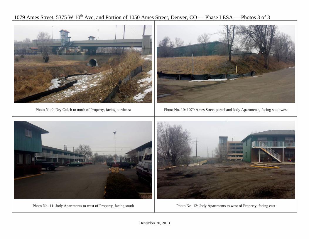
1079 Ames Street, 5375 W 10th Ave, and Portion of 1050 Ames Street, Denver, CO — Phase I ESA — Photos 3 of 3
December 20, 2013
Photo No.9: Dry Gulch to north of Property, facing northeast
Photo No. 10: 1079 Ames Street parcel and Jody Apartments, facing southwest
Photo No. 11: Jody Apartments to west of Property, facing south
.
Photo No. 12: Jody Apartments to west of Property, facing east

Appendix VI
QUESTIONNAIRES


Appendix VII
QUALIFICATIONS AND EXPERIENCE OF PROFESSIONAL

Qualifications and Experience
Mark A. Molen Molen & Associates, LLC has provided quality environmental consulting to clients since 1998. As the principal consultant, Mr. Molen has assisted customers with Phase I Environmental Site Assessments, environmental evaluations, permitting and compliance concerns, and waste disposal questions. Having spent over 27 years in the environmental business and dealing with regulators, environmental attorneys, environmental scientists and engineers, Mr. Molen has a good understanding of environmental issues and how they can be managed today. Mr. Molen has supervised a variety of environmental clean-up projects both large and small. He has supervised and performed groundwater monitoring, waste solidification, stormwater sampling, clay and synthetic liner construction and site development. He has performed numerous Phase I and Phase II Environmental Site Assessments for clients. Education Certifications B.S., Chemistry, Lewis & Clark College, Portland, OR Certified Hazardous Material Manager, #1148 OSHA 40-Hour Hazardous Waste Site Activity Training Certified Manager of Landfill Operations McCoy & Associates Haz Waste Regulations Training Certified Radiation Safety Officer Certified Residential Mold Inspector Certified Testing Specialist, #15122 Recent Relevant Job Experience Phase I Environmental Site Assessments TOD low income housing in Denver, CO Mountain property in Clear Creek County, CO Cable machinery company in North Denver, CO Magazine company building in Boulder, CO Nutrient agar company in Englewood, CO Manufacturing building in Boulder, CO Organic farm in Boulder, CO Offices in Boulder, CO Downtown restaurant in Denver, CO Copier Company in central Denver, CO Garden Center in Denver, CO Window Company display office in Denver, CO Comic Warehouse in North Denver, CO Industrial Warehouse in North Denver, CO Warehouse/office building in Centennial, CO Event Center in Commerce City, CO Gravel quarry – inert fill in Henderson, CO Aggregate Supply Company in Windsor, CO Water Supply Company in Denver, CO Quick serve restaurant in Salida, CO Waste Collection Company in Commerce City, CO Construction and gravel operations in Adams County, CO Milling operator property in Denver, CO Portfolio of flower company properties in Denver, CO

Waste Recycling and Transfer Station in Denver, CO Property evaluation for the sale of the CU Health Science Center Salvage yard, 10 acres of property slated for redevelopment in Denver, CO Auto service business in Lakewood, CO Heavy industrial property near refineries in Commerce City, CO Undeveloped 5 acre property on previous inert landfill off Federal Blvd, Denver, CO Commercial building on East Colfax in Denver, CO Two commercial buildings in Boulder, CO Commercial building on Brighton Blvd, in central Denver, CO Undeveloped permitted landfill property in Bennett, CO Commercial building with 15 acres of property in Lamar, CO Undeveloped 5 acre former inert fill property near Longmont, CO Commercial-industrial property in Brighton, CO Quick serve restaurant on East Colfax in Aurora, CO Vacant 35 acre parcel in Brighton, CO near an industrial park Nightclub, 27000 sq. ft. on 10 acres on a historic landfill in Denver, CO near a Superfund site Bio-fuel Company on 1 acre parcel in Denver, CO Commercial retail 3100 sq. ft. building in downtown Longmont, CO Redeveloped 60-acre parcel on a vacant but improved property above a historic landfill in Denver, CO Sod farm, 490-acre property NE of Denver, CO being prepared for development Radio tower in eastern Adams County, CO Radio tower property in Boulder, CO Vacant parcel, 17 acres in North Boulder, CO Homestead 30 acre parcel between Boulder and Louisville, CO Expansion properties to a building supply company in Colorado Springs in Pueblo, CO Phase II Environmental Site Assessments Cable machinery rental and services in Denver, CO TOD property for low income residential in Denver, CO Window manufacturing company in Denver, CO Tank removal and cleanup in Greenwood Village, CO Pesticide soil removal VCUP for mushroom farm in Westminster, CO Heavy industrial property near refineries in Commerce City, CO Undeveloped 5 acre property on previous inert landfill off Federal Blvd, Denver, CO Commercial building with 15 acres of property in Lamar, CO Undeveloped 5 acre former inert fill property near Longmont, CO Commercial-industrial property in Brighton, CO Radio tower in eastern Adams County, CO Commercial property with former drycleaners in Lafayette, CO Former drilling operations building on 5 acres of property in Lafayette, CO


