P a g e | 1
Candelaria Mining Corporation Caballo Blanco Project April 2017
TECHNICAL REPORT - CABALLO BLANCO PROJECT
RESOURCE UPDATE - LA PAILA ZONE
Veracruz State
MEXICO
(Longitude 96° 27' 30" W, Latitude 19° 40' 44" N)
Prepared for:
CANDELARIA MINING CORPORATION. Suite 1502, 1166 Alberni Street
Vancouver, B.C., V6E 3Z3
Prepared by:
Jim Cuttle, B.Sc., P.Geo. 86 Cloudburst Road
Whistler, B.C. CANADA
and
Gary Giroux, MASc., P.Eng. Giroux Consultants Ltd.
892 Broadway Drive North Vancouver, B.C. CANADA
Date: April 20, 2017
Effective Date of Report: March 20, 2017
P a g e | 2
Candelaria Mining Corporation Caballo Blanco Project April 2017
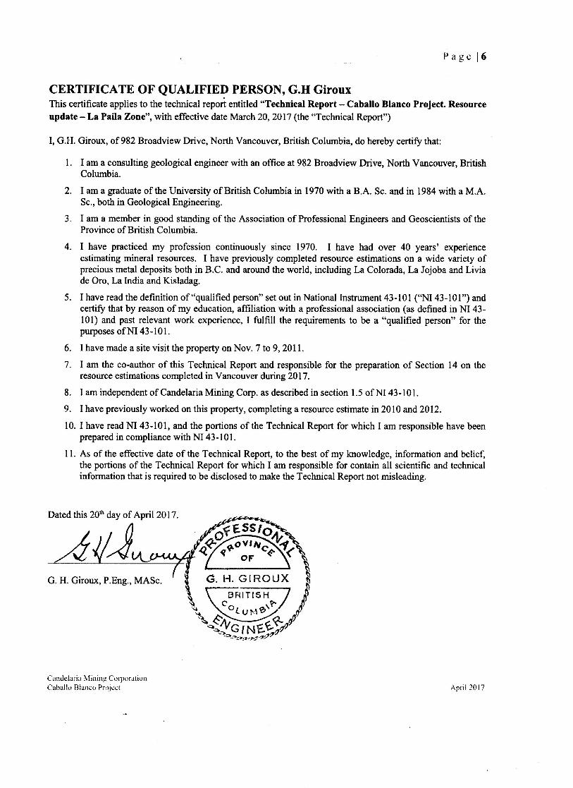
Contents CERTIFICATE OF QUALIFIED PERSON, G.H Giroux ...................................................................... 6
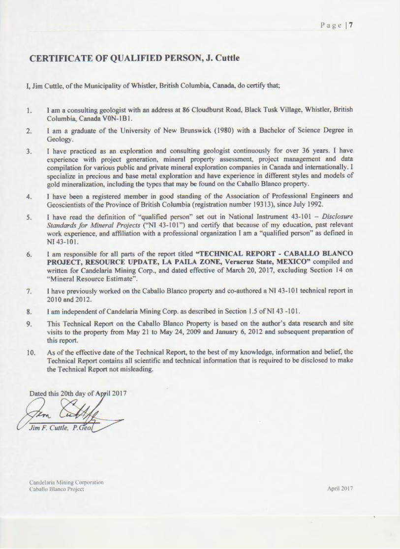
CERTIFICATE OF QUALIFIED PERSON, J. Cuttle ............................................................................ 7
1.SUMMARY .......................................................................................................................................... 8
1.1 Property Location and Description .......................................................................................... 8
1.2 Geology and Mineralization .................................................................................................... 8
1.3 Exploration ............................................................................................................................... 9
1.4 Mineral Resources ................................................................................................................... 9
1.5 Conclusions and Recommendations ........................................................................................ 9
2 INTRODUCTION and SCOPE OF REPORT ............................................................................... 11
2.1 Personal Inspection and Terms of Reference ......................................................................... 11
3. RELIANCE ON OTHER EXPERTS ............................................................................................ 12
4. PROPERTY DESCRIPTION AND LOCATION ......................................................................... 12
5. ACCESSIBILITY, CLIMATE, LOCAL RESOURCES, INFRASTRUCTURE, AND PHYSIOGRAPHY ................................................................................................................................. 17
6. HISTORY ...................................................................................................................................... 17
6.1 Resource History .................................................................................................................... 18
7. GEOLOGICAL SETTING AND MINERALIZATION ............................................................... 20
7.1 Regional Geology .................................................................................................................. 20
7.2 Property Geology ................................................................................................................... 22
7.2.1 Northern Zone – High Sulphidation Epithermal Gold Targets with massive silica ledges 23
7.2.2 Highway Zone – Low and High Sulphidation Epithermal Gold Targets .......................... 24
7.3 Alteration and Property Mineralization ................................................................................. 25
8. DEPOSIT TYPES .......................................................................................................................... 29
9. RECENT EXPLORATION ........................................................................................................... 31
10 DRILLING ..................................................................................................................................... 34
10.1 Pre-2010 Drilling – La Paila ...................................................................................................... 34
10.2 Goldgroup Drilling – 2010 to 2012 ........................................................................................... 35
10.3 New diamond drill holes completed after January 2012 .......................................................... 36
11 SAMPLE PREPARATION, ANALYSIS, AND SECURITY ...................................................... 39
11.1 Sample Preparation and Analysis – Canadian Gold Hunter, 2007 to 2009 .............................. 39
P a g e | 3
Candelaria Mining Corporation Caballo Blanco Project April 2017
11.2 Quality Assurance / Quality Control (QA/QC) – Canadian Gold Hunter, 2007 to 2009 ......... 39
11.3 Sample Security – Canadian Gold Hunter, 2007 to 2009 ......................................................... 40
11.4 Sample Preparation and Analysis – Goldgroup Mining, 2010 to 2012 .................................... 40
11.5 Quality Assurance / Quality Control (QA/QC) – Goldgroup Mining, 2010 to 2012 ............... 40
11.6 Sample Security – Goldgroup Mining, 2010 to 2012 ............................................................... 41
11.7 Opinion ..................................................................................................................................... 41
12 DATA VERIFICATION ............................................................................................................... 42
12.1 Site Visit – 2009........................................................................................................................ 42
12.2 Site Visit – January 2012 .......................................................................................................... 43
13 MINERAL PROCESSING AND METALLURGICAL TESTING ............................................. 45
13.1 Metallurgical ‘Bottle Roll’ Testing by Goldgroup - 2009 ......................................................... 45
13.2 Column Test work in 2010 thru 2012 – Goldgroup .................................................................. 46
14 MINERAL RESOURCE ESTIMATE ........................................................................................... 48
14.1 Data Analysis ......................................................................................................................... 48
14.2 Composites ............................................................................................................................. 50
14.3 Variography ........................................................................................................................... 51
14.4 Bulk Density .......................................................................................................................... 51
14.5 Block Model........................................................................................................................... 52
14.6 Grade Interpretation ............................................................................................................... 53
14.8 Model Verification ................................................................................................................. 58
15 ADJACENT PROPERTIES .......................................................................................................... 61
16 OTHER RELEVANT DATA AND INFORMATION ................................................................. 61
17 CONCLUSIONS............................................................................................................................ 62
18 RECOMMENDATIONS ............................................................................................................... 64
19 REFERENCES .............................................................................................................................. 65
APPENDIX I All diamond drill and reverse circulation collar locations, Caballo Blanco (Northern and Highway Zones) .............................................................................................................................. 67
APPENDIX II Mineralized intervals from 55 new holes drilled during first half of 2012. Holes 11CBN-179 to 181, 11CBN-183, 11CDN-185 to 12CDN-190 to 12CBN-235 (Composited with 0.2 g/t Au cut-off, 0.2 metre minimum sample, and 4 metre maximum barren interval) ............................ 74

P a g e | 4
Candelaria Mining Corporation Caballo Blanco Project April 2017
Figures
Figure 1 Country Location Map ........................................................................................................... 14 Figure 2 Veracruz State Location Map ................................................................................................. 15 Figure 3 Claim Tenure Map .................................................................................................................. 16 Figure 4 Regional Geology Map (Modified after L. Ferrair, 2005) ..................................................... 22 Figure 5 Property Geology Map (modified after the Geological Survey of Mexico, SGM) ................. 26 Figure 6 Northern Zone Geology Map (after Goldgroup, 2010) ......................................................... 27 Figure 7 La Paila Geology Map (after Goldgroup, 2012) ................................................................... 28 Figure 8 Long section showing selected prospects at Caballo Blanco, looking east (Corbett 2011) ... 30 Figure 9 Mineralization Model (Corbett, 2013) ................................................................................... 30 Figure 10 Isometric View Looking North Showing Mineralized Solid, Drill Traces and Surface Topo La Paila .................................................................................................................................................. 49 Figure 11 Isometric View Looking North Showing the Mineralized Solid, Drill Traces at La Paila (holes completed since the 2012 Estimate are shown in blue) .............................................................. 49 Figure 12 Scatter Plot Showing Gold versus Specific Gravity ............................................................. 52 Figure 13 Isometric View Looking Northwest Showing Classified Blocks (Blue-inferred, Green-indicated, Magenta-Drill Hole composites) ........................................................................................... 56 Figure 14 Isometric View Looking North Showing the Conceptual Pit and drill hole traces .............. 58 Figure 15 Swath Plot for Gold by Northing. Slices of 40 metres ......................................................... 59 Figure 16 Swath Plot for Gold by Easting. Slices of 40 metres ........................................................... 59 Figure 17 Swath Plot for Gold by Elevation. Slices of 10 metres ........................................................ 60
Tables
Table 1 Mineral Claim Details ............................................................................................................... 12 Table 2 Historical Drilling on the Northern and Highway Zones at Caballo Blanco .......................... 34 Table 3 All drilling by Goldgroup at Caballo Blanco.......................................................................... 35 Table 4 Assay Comparison - Reverse Circulation vs Diamond drill core from twinned holes - La Paila........................................................................................................................................................ 36 Table 5 New diamond drill holes completed since the last NI-43-101 report dated, January 2012 ..... 37 Table 6 Check Assays by Author, 2009................................................................................................ 43 Table 7 Caballo Blanco (La Paila Zone). Preliminary 'in-house' Bottle Roll tests by Goldgroup - 2009................................................................................................................................................................ 45 Table 8 Preliminary 'in house' Column Tests, Caballo Blanco (La Paila Zone) - Goldgroup 2010/2011................................................................................................................................................................ 46 Table 9 Assay statistics for Au and Ag inside and outside Mineralized Solid - La Paila ..................... 50 Table 10 Cap levels for Gold and Silver - La Paila .............................................................................. 50 Table 11 Assay Statistics for Capped Gold and Silver Inside and Outside Mineralized Solid - La Paila................................................................................................................................................................ 50
P a g e | 5
Candelaria Mining Corporation Caballo Blanco Project April 2017
Table 12 Statistics for Gold and Silver - 5 metre Composites .............................................................. 51 Table 13 Summary of Semivariograms for Gold and Silver ................................................................ 51 Table 14 Indicated Resource within Total Blocks inside the conceptual pit ........................................ 56 Table 15 Inferred Resource within Total Blocks inside the conceptual pit .......................................... 57 Table 16 Cost estimate .......................................................................................................................... 64
Photos
Photo 1 Looking west at La Paila and the approximate location of broad alteration haloes, Northern Zone area (Almaden Minerals) .............................................................................................................. 23 Photo 2 Typical 'vuggy silica' with associated gold mineralization - La Paila area (from Cuttle, 2010)................................................................................................................................................................ 24 Photo 3 Core storage facilities near Arroyo Agrio, Caballo Blanco Project (Cuttle, 2009) ................. 42 Photo 4 Canadian Hunter cement carne used to identify drill hole collar 08CBN-008 (Cuttle, 2009) 42 Photo 5 Goldgroup cement carne used to identify drill hole collar 11CBN-151 (Cuttle, 2012) ......... 44 Photo 6 Goldgroup's onsite 'Column leach' laboratory at Arroyo Agrio - Caballo Blanco Project - 2012 (photo- Cuttle) ............................................................................................................................... 46
P age 17
CERTIFICATE OF QUALIFIED PERSON, J. Cuttle
I, Jim Cuttle, of the Municipality of Whistler, British Columbia, Canada, do certify that;
1. I am a consulting geologist with an address at 86 Cloudburst Road, Black Tusk Village, Whistler, British Columbia, Canada VON-lBl.
2. l am a graduate of the University of New Brunswick (1980) with a Bachelor of Science Degree in Geology.
3. I have practiced as an exploration and consulting geologist continuously for over 36 years. I have experience with project generation, mineral property assessment, project management and data compilation for various public and private mineral exploration companies in Canada and internationally. I specialize in precious and base metal exploration and have experience in different styles and models of gold mineralization, including the types that may be found on the Caballo Blanco property.
4. I have been a registered member in good standing of the Association of Professional Engineers and Geoscientists of the Province of British Columbia (registration number 19313), since July 1992.
5. I have read the definition of "qualified person" set out in National Instrument 43-10 l - Disclosure Standards for Mineral Projects (''NJ 43- l 01 ") and certify that because of my education, past relevant work experience, and affiliation with a professional organization I am a "qualified person" as defined in NI 43-101.
6. I am responsible for all parts of the report titled "TECHNICAL REPORT - CABALLO BLANCO PROJECT, RESOURCE UPDATE, LA PAILA ZONE, Veracruz State, MEXICO" compiled and written for Candelaria Mining Corp., and dated effective of March 20, 2017, excluding Section 14 on "Mineral Resource Estimate".
7. I have previously worked on the Caballo Blanco property and co-authored a NI 43-10 l technical report in 2010 and 2012.
8. I am independent of Candelaria Mining Corp. as described in Section 1.5 ofNI 43 -101.
9. This Technical Report on the Caballo Blanco Property is based on the author's data research and site visits to the property from May 21 to May 24, 2009 and January 6, 2012 and subsequent preparation of this report.
10. As of the effective date of the Technical Report, to the best of my knowledge, information and belief, the Technical Report contains all scientific and technical information that is required to be disclosed to make the Technical Report not misleading.
Dated this 20th day of AP. ii 2017
&Cuttle, P. eo
Candclana '\ 1 mmg l "orporation Cahallo Blanco Project April 2017
P a g e | 8
Candelaria Mining Corporation Caballo Blanco Project April 2017
1.SUMMARY
This technical report was prepared for Candelaria Mining Corp. (“Candelaria” or CMC) to document an updated NI 43-101 compliant mineral resource estimate on the La Paila zone located in the north portion of the Candelaria’s Caballo Blanco property (“the Property”), Veracruz, Mexico. This update includes information collected from 55 new drill holes since the last technical report dated February 10, 2012.
1.1 Property Location and Description The Caballo Blanco property is located next to the Gulf of Mexico approximately sixty-five kilometres by paved road north northwest of the city of Veracruz in the state of Veracruz, Mexico. The property consists of thirteen mineral claims covering an area of 19,923 hectares centered at Longitude 96˚ 27’ 30” West and Latitude 19˚ 40’ 44” North.
In July 2016 Timmins Gold through its subsidiary Molimentales Del Noroeste SA de CV sold 100 percent interest in the Caballo Blanco project to Minera Caballo Blanco S.A. de C.V., a100% wholly-owned Mexican subsidiary of Candelaria for a total cash consideration US$17.5 million. There has been no work completed on the property since the acquisition by CMC.
1.2 Geology and Mineralization The Caballo Blanco property lies at the eastern end of the Trans Mexican Volcanic Belt and is underlain by sub-aerial basalts, andesites and diorite dykes of Miocene age covered by a sequence of felsic quartz tuffs, andesitic ‘dome’ complexes, volcaniclastics and younger intrusive dacitic plugs. Capping this volcanic package are Pliocene alkaline basalt flows that are commonly well preserved as small flat highland plateaus.
Two large areas of epithermal gold mineralization have been discovered within the current Caballo Blanco property, referred to as the Northern Zone and Highway Zone. Both are prominent epithermal gold prospects that occur within extensive areas of clay and silica alteration. A third area known as the Central Grid Zone (El Porvenir) is off the property directly to the south and is considered a porphyry copper-gold target.
The discovery of gold mineralization at La Paila in the Northern Zone is relatively new for this region of Mexico. The gold is very fine and occurs within a vuggy and brecciated silica alteration of an original andesite host rock in the upper levels of the surrounding epithermal system. The elongate and silicified gold rich mineralization at La Paila likely formed from fluid rising along a north trending fault structure well above a deeper intrusive ‘heat source’. Similar silica and clay alteration zones have been recognized at La Cruz, Las Cuevas and the Highway Zone that lie along a north-south linear trend greater than nine kilometres. La Paila, located on the north end of this trend, contains significant gold mineralization with drill intercepts of 2.194 grams per tonne gold over 89.91 metres (08CDN-04) and 0.584 grams per tonne gold over 216.41 metres (07CBN-02).
P a g e | 9
Candelaria Mining Corporation Caballo Blanco Project April 2017
1.3 Exploration A variety of geophysical, geochemical, and geological surveys have been useful in identifying drill targets throughout the property; most importantly, airborne magnetics, induced polarization resistivity anomalies, clay alteration haloes identified by TerraSpec® spectrometry, mineralized surface rock geochemistry and detailed geological and structural mapping. These surveys remain an integral part of any future exploration program at Caballo Blanco.
At the date of this report a total of two hundred and thirty-three core holes and thirty-six reverse circulation holes have been drilled since the discovery of gold at Caballo Blanco including the neighbouring Central Grid Zone now owned 100% by Almaden Minerals. This report documents 55 diamond drill results since the completion of last NI 43-101 by Cuttle and Giroux, February 2012.
1.4 Mineral Resources This study documents information from an additional 55 drill holes since the last mineral resource estimate contained in the NI 43-101 Technical Report compiled by Cuttle and Giroux in February 2012. The resource estimate is based on the constraints of a geological solid surrounding the mineralized sections of a silica breccia. It follows up initial estimates completed by Cuttle and Giroux, March 2010, and February 2012.
The resource estimate is based on 200 diamond drill holes completed since the discovery of the La Paila mineralized zone. The drill hole density is not sufficient to establish any blocks in the measured category and all blocks are considered either indicated or inferred. Below is the resource available for blocks contained within a conceptual open pit using metal prices of $1150 US / oz gold and $21 US / oz silver. Estimations using a cut-off of 0.11 grams per tonne (g/t) gold can be separated into the following categories for La Paila:
Indicated – 31,220,000 tonnes, 0.52 g/t gold, 2.16 g/t silver or 521,000 ounces gold and 2,170,000 ounces silver within the conceptual pit.
Inferred – 8,630,000 tonnes, 0.34 g/t gold, 2.14 g/t silver or 95,000 ounces gold and 590,000 ounces silver within the conceptual pit.
1.5 Conclusions and Recommendations Geological field work since 1995 has identified at least three large areas of epithermal precious metal and porphyry style copper gold mineralization on and beside the Caballo Blanco Project. In the north and central part of the property, two large areas of epithermal alteration have been discovered, locally named the Northern Zone (La Paila, las Cuevas, La Cruz, Bandera Red Valley) and the Highway Zone (Highway N, S and La Luz areas). In the south and southwest of the property and currently not part of the Candelaria claim holdings, the Central Grid area hosts what is believed to be at least two porphyry copper-gold prospects.
P a g e | 10
Candelaria Mining Corporation Caballo Blanco Project April 2017
The elongate and silicified gold rich mineralization at La Paila, in the Northern Zone, and its associated alteration patterns likely formed from fluid rising along a north trending fault structure well above a deeper intrusive ‘heat source’ (Sillitoe, 2008). Similar geochemical and geophysical anomalies and silica/clay alteration patterns have been recognized at La Cruz, Red Valley, and Highway Zone, all of which lie along a north-south trend for over nine kilometres. This corridor represents an important exploration target for the future.
Geophysical, geochemical, and geological surveys continue to be extremely useful to identify drill targets in and around the Northern and Highway zones; most importantly airborne magnetic, IP resistivity high anomalies, clay alteration haloes identified by a TerraSpec® spectrometer, location of mineralized surface rock geochemistry and detailed geological and structural mapping. These surveys have not only been used to outline a classic zonation of clay minerals representative of a large epithermal system but they have more importantly been useful in defining zones of silica flooding and associated gold mineralization. These surveys should remain principle exploration tools for future work at Caballo Blanco.
An additional 55 diamond drill holes were completed at La Paila since the last resource update, namely holes 11CBN-179-181, 183,185-187 and 12CBN-188 to 197, 197A, 12CBN-198 to CBN-235. This 2012 drill program continued to test the extents of the low-grade bulk mineable gold at La Paila in the Northern Zone. Assay results from selected holes in the north, central and southern portions of La Paila suggest that areas remain open to be tested with tighter infill and definition drilling.
Previous metallurgical work on mineralized core and surface samples from La Paila has been favourable. Initial bottle roll testing indicates that the gold mineralization is highly amenable to leaching. The mineralization is totally oxidised to at least 300 metres depth and is benign in leaching since there appears to be no other minerals or deleterious materials present. This indicates low reagent consumption in the commercial heap leach process. CMC should continue metallurgical testing to confirm extraction results, reagent consumption, leach time and ideal particle size.
The authors do not see any risks and uncertainties that could affect future exploration information, resource estimates or economic projections by Candelaria.
A recommended budget of $US 6 million is proposed for further exploration at the Caballo Blanco. This test work would consist of 40,000 metres of core drilling, focusing primarily on infill and definition drilling at La Paila, including the drill testing or investigation of less developed gold targets outside La, Paila such as Bandera, Las Cuevas, La Cruz and Red Valley in the Northern Zone, and Highway N and S, La Luz areas of the Highway Zone.

P a g e | 11
Candelaria Mining Corporation Caballo Blanco Project April 2017
2 INTRODUCTION and SCOPE OF REPORT This technical report has been prepared by Jim Cuttle, P. Geo. (Qualified Person) and Gary Giroux, P. Eng. (Qualified Person) of Giroux Consultants Ltd. for Candelaria Mining Corp (Candelaria or CMC) of Vancouver, B.C. It presents an updated resource estimation that includes 55 new drill holes at the La Paila zone on the Caballo Blanco Project in Veracruz State, Mexico.
2.1 Personal Inspection and Terms of Reference Two ‘on-site’ field visits to the Caballo Blanco Project area were completed by Cuttle on November 1st to November 3rd, 2009 and January 6, 2012, as a guest of Goldgroup Mining, the previous owner of the Caballo Blanco project. Giroux also visited Caballo Blanco November 7th to November 9th, 2011 with Goldgroup. The authors have not visited the property with representatives of CMC.
During the initial field visits Cuttle collected several rock and drill core samples from La Paila (Northern Zone), verified drill hole collar locations, visit the core logging and storage buildings, column leach facilities and inspected the geological field offices at the coastal community of Villa Rica. The Highway Zone, in the south of the property was not visited during either of these field trips.
Technical data for this report at Caballo Blanco is based on information provided by CMC and by previous project operators and consultants as well as government agencies including the Mexican Geological Survey or SGM (Servicio Geológico Mexicano).
Electronic data from CMC databases contained the bulk of the geological, geophysical, geochemical and drilling information generated since the beginning of the project. All regional and local property maps, figures and diagrams in this report were generated by the authors, using a UTM NAD27 US (Zone 14N) projection or NAD27 Longitude / Latitude (Mex) where the scale dictates.
The authors have drawn their own conclusions for this report and have prepared it based on information believed accurate at the time of completion.
P a g e | 12
Candelaria Mining Corporation Caballo Blanco Project April 2017
3. RELIANCE ON OTHER EXPERTS The authors of this report have not relied on other experts concerning the Caballo Blanco Project.
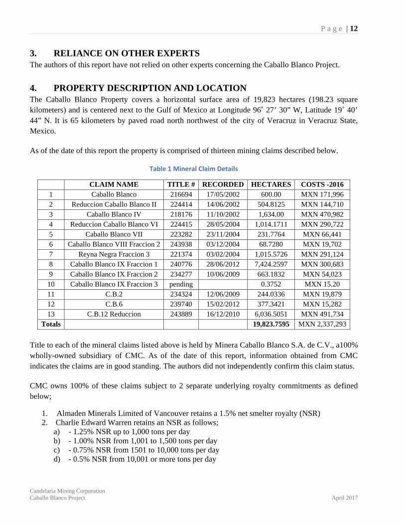
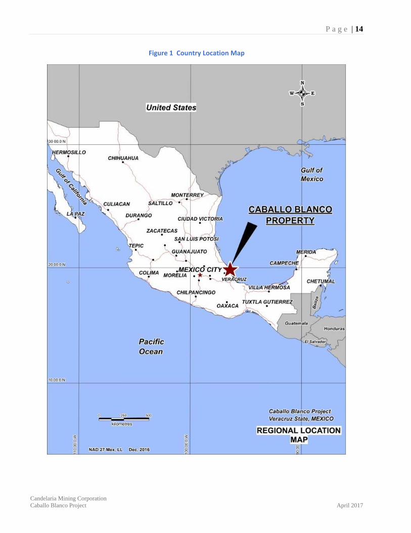
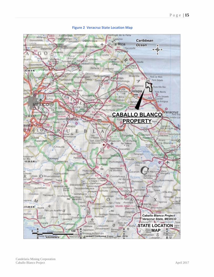
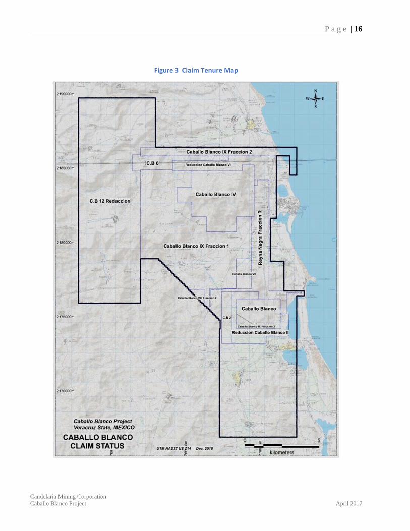
4. PROPERTY DESCRIPTION AND LOCATION The Caballo Blanco Property covers a horizontal surface area of 19,823 hectares (198.23 square kilometers) and is centered next to the Gulf of Mexico at Longitude 96˚ 27’ 30” W, Latitude 19˚ 40’ 44” N. It is 65 kilometers by paved road north northwest of the city of Veracruz in Veracruz State, Mexico. As of the date of this report the property is comprised of thirteen mining claims described below.
Table 1 Mineral Claim Details
CLAIM NAME TITLE # RECORDED HECTARES COSTS -2016 1 Caballo Blanco 216694 17/05/2002 600.00 MXN 171,996 2 Reduccion Caballo Blanco II 224414 14/06/2002 504.8125 MXN 144,710 3 Caballo Blanco IV 218176 11/10/2002 1,634.00 MXN 470,982 4 Reduccion Caballo Blanco VI 224415 28/05/2004 1,014.1711 MXN 290,722 5 Caballo Blanco VII 223282 23/11/2004 231.7764 MXN 66,441 6 Caballo Blanco VIII Fraccion 2 243938 03/12/2004 68.7280 MXN 19,702 7 Reyna Negra Fraccion 3 221374 03/02/2004 1,015.5726 MXN 291,124 8 Caballo Blanco IX Fraccion 1 240776 28/06/2012 7,424.2597 MXN 300,683 9 Caballo Blanco IX Fraccion 2 234277 10/06/2009 663.1832 MXN 54,023 10 Caballo Blanco IX Fraccion 3 pending 0.3752 MXN 15.20 11 C.B.2 234324 12/06/2009 244.0336 MXN 19,879 12 C.B.6 239740 15/02/2012 377.3421 MXN 15,282 13 C.B.12 Reduccion 243889 16/12/2010 6,036.5051 MXN 491,734
Totals 19,823.7595 MXN 2,337,293
Title to each of the mineral claims listed above is held by Minera Caballo Blanco S.A. de C.V., a100% wholly-owned subsidiary of CMC. As of the date of this report, information obtained from CMC indicates the claims are in good standing. The authors did not independently confirm this claim status. CMC owns 100% of these claims subject to 2 separate underlying royalty commitments as defined below;
1. Almaden Minerals Limited of Vancouver retains a 1.5% net smelter royalty (NSR) 2. Charlie Edward Warren retains an NSR as follows;
a) - 1.25% NSR up to 1,000 tons per day b) - 1.00% NSR from 1,001 to 1,500 tons per day c) - 0.75% NSR from 1501 to 10,000 tons per day d) - 0.5% NSR from 10,001 or more tons per day
P a g e | 13
Candelaria Mining Corporation Caballo Blanco Project April 2017
In the case of access to surface lands in the Northern Zone area including La Paila, Minera Caballo Blanco is the current owner of nine land parcels with no rental agreements or leases of land. As of the date of this report Minera Caballo Blanco is negotiating the lease and/or acquisition of thirteen more parcels of land as well as the access rights for a conveyor belt on an additional eight parcels of land. The lease agreements include a yearly payment for access to their lands as well as additional compensation for any disturbance the company may cause from geological surveying, road building and/or drilling activity. Legal rights to these lands have not been verified by the authors however it is understood these agreements are in good standing for exploration and development work during and beyond 2017. As of the date of this report the authors are not aware if drilling, road building, water use or any other necessary federal, state or municipal permits have been applied for or granted to CMC. There are no environmental liabilities known to the authors on the Caballo Blanco property.
P a g e | 14
Candelaria Mining Corporation Caballo Blanco Project April 2017
Figure 1 Country Location Map
P a g e | 15
Candelaria Mining Corporation Caballo Blanco Project April 2017
Figure 2 Veracruz State Location Map
P a g e | 16
Candelaria Mining Corporation Caballo Blanco Project April 2017
Figure 3 Claim Tenure Map
P a g e | 17
Candelaria Mining Corporation Caballo Blanco Project April 2017
5. ACCESSIBILITY, CLIMATE, LOCAL RESOURCES, INFRASTRUCTURE, AND PHYSIOGRAPHY Veracruz is a major port and is well connected with daily flights to Mexico City and other national and international destinations. The property is reached by driving 65 kilometres north from Veracruz to Villa Rica, using the Pan American Highway which transects the eastern portion of the claim block. From here a network of dirt roads access most of the current areas of interest. New drill roads have been constructed to support the most recent drill campaigns, particularly in the Northern Zone areas. The nearest supply center is Cardel, a town of 20,000 residents located approximately 30 kilometers south of the Caballo Blanco claim block. The town offers an abundant supply of mining personnel. On the northeastern edge of the property sits Mexico’s only nuclear power plant at Laguna Verde. Its location allows easy access to the Mexican electrical power grid. Water is relatively abundant in small creeks at elevations below 200 meters, throughout most of the year. A well-organized field office and villa style houses are available for a small crew at the coastal community of Villa Rica. Many other villas are currently empty and likely available for rent. The topography is semi-rugged with elevations from sea level up to 700 meters on the higher mountain tops. The climate is semi-tropical with a distinct rain season from June to November.
6. HISTORY The first record of gold in the Caballo Blanco claim area dates to 1995 when Charlie Warren of Whitehorse, Yukon sampled a small quartz vein outcrop in a road cut along the Pan American Highway. Through his Mexican wife, he staked several mineral claims to cover what is known today as the Highway Zone.
The property was subsequently optioned to Almaden Minerals Ltd. in 1997 (through Minera Gavilán S.A. de C.V.) who staked additional claims to cover two other areas known as the Central Grid Zone (El Povenir) and the Northern Zone. Almaden completed a variety of geophysical, geochemical, and geological surveys and drilled 17 reverse circulation drill holes in the Central Grid Zone ‘porphyry’ target.
In 2001, Almaden optioned the property to Noranda who drilled nine core holes in the Highway and Central Grid zones and returned the property to Almaden later that year. Results were not encouraging. In December 2002, Almaden signed a joint-venture agreement with Comaplex Minerals Corp. proposing to spend US$ 2 million over four years to explore the Caballo Blanco claims. Comaplex carried out a variety of geological work throughout the property, targeting the Central Grid Zone, the Highway Zone, and the Northern Zone. From 2004 through 2006 Comaplex drilled ten core holes, and in 2005 discovered wide low grade gold mineralization in drill hole CB05-03 at La Paila in the
P a g e | 18
Candelaria Mining Corporation Caballo Blanco Project April 2017
Northern Zone. Comaplex completed the required expenditures of the joint venture agreement and went on to earn a 60 percent interest in the property. In February 2007, Almaden purchased Comaplex Minerals Corp’s 60 percent interest for a cash payment of US$ 1.25 million. In April 2007 Almaden optioned Caballo Blanco to Canadian Gold Hunter Corp. of Vancouver, B.C who in turn completed a variety of surveys and additional drilling in the Northern Zone and Central Grid areas under its Mexican subsidiary, Mineral Cardel S.A de C.V. From 2007 to 2009, 42 core holes were drilled, with at least 30 holes targeting the new gold area at La Paila, discovered by Comaplex in 2005. In September 2009, Canadian Gold Hunter Corp changed its name to NGEx Resources Inc. and later in November signed a ‘share purchase agreement’ allowing Goldgroup Resources to earn a 70 percent interest in the Caballo Blanco Project.
From 2010 to mid-2012 Goldgroup completed 193 drill holes during several drill campaigns in seven areas within the Northern Zone of the Caballo Blanco Property, including La Paila, Red Valley, Las Cuevas SW, Las Cuevas, Bandera S and N, and Cerro Blanco (holes 10CBRC-43 to 67, 10CBN-68 to 12CBN235). Much of this drilling targeted the La Paila zone. In October 2011 Goldgroup completed the acquisition of the remaining 30 percent interest in the Caballo Blanco project held by Almaden Minerals Ltd. (Almaden) and became 100 percent owner of the Caballo Blanco project. Goldgroup commissioned K.D Engineering of Tucson, Arizona to complete a Preliminary Economic Assessment (PEA) report dated May 7, 2012. Goldgroup did not do any work after mid-2012. In December 2014 Goldgroup Mining Inc. sold 100 percent of the Caballo Blanco project to Timmins Gold Corp for US$10 million in cash and 16 million shares and the PEA was subsequently re-addressed to Timmins. No additional work was completed on the Caballo Blanco property by Timmins. In July 2016 Timmins Gold through its subsidiary Molimentales Del Noroeste SA de CV sold 100 percent interest in the Caballo Blanco project to Candelaria for a total cash consideration US$17.5 million. Since that time there has been no work completed on the property.
6.1 Resource History Two resource estimates have been completed on the Caballo Blanco Property for Goldgroup Resources, detailed in 43-101 Technical Reports by Cuttle and Giroux, and dated March 2010 and February 2012. For the March 2010 report, Gary Giroux of Giroux Consultants was retained to estimate a resource for the La Paila zone in the Northern Zone. The estimate is based on the constraints of a geological solid surrounding the mineralized sections of a mineralized silica breccia. The drill hole density was not sufficient to establish any blocks in the measured category and all blocks were considered either
P a g e | 19
Candelaria Mining Corporation Caballo Blanco Project April 2017
Indicated or Inferred. Estimates used a cut-off of 0.2 grams per tonne gold to identify 139,000 ounces gold in the indicated category and 517,000 ounces gold in the inferred category:
Indicated - 6,710,000 tonnes, 0.645 g/t gold, or 139,000 ozs gold Inferred - 27,600,000 tonnes, 0.583 g/t gold, or 517,000 ozs gold
For the February 2012 report, Gary Giroux of Giroux Consultants was retained to estimate an updated resource for La Paila, based on the constraints of a geological solid surrounding the mineralized sections of a silica breccia. The update is based on an additional 112 drill holes completed since the last 2010 estimate. The drill hole density was not sufficient to establish any blocks in the measured category and all blocks are considered either Indicated or Inferred.
Below is the resource available if one could mine to the limits of the mineralized solid. It includes no edge dilution. Estimations in this report using a cut-off of 0.2 grams per tonne gold are separated into the following categories for La Paila:
Indicated – 28,890,000 tonnes, 0.62 g/t Au, 2.32 g/t Ag or 575,000 ozs Au and 2,150,000 ozs Ag Inferred – 24,020,000 tonnes, 0.54 g/t Au, 2.50 g/t Ag or 419,000 ozs Au and 1,930,000 ozs Ag
Both estimates were completed in accordance with industry standards and were reliable at the time. They were both estimated using similar procedures as outlined in Section 14 of this report. The categories and classification parameters were in accordance with Section 1.2 and 1.3 of NI 43-101. With the additional drilling, they have been replaced by the resource estimate presented in Section 14 of this report. Candelaria is not treating these two historic resources as current.
P a g e | 20
Candelaria Mining Corporation Caballo Blanco Project April 2017
7. GEOLOGICAL SETTING AND MINERALIZATION
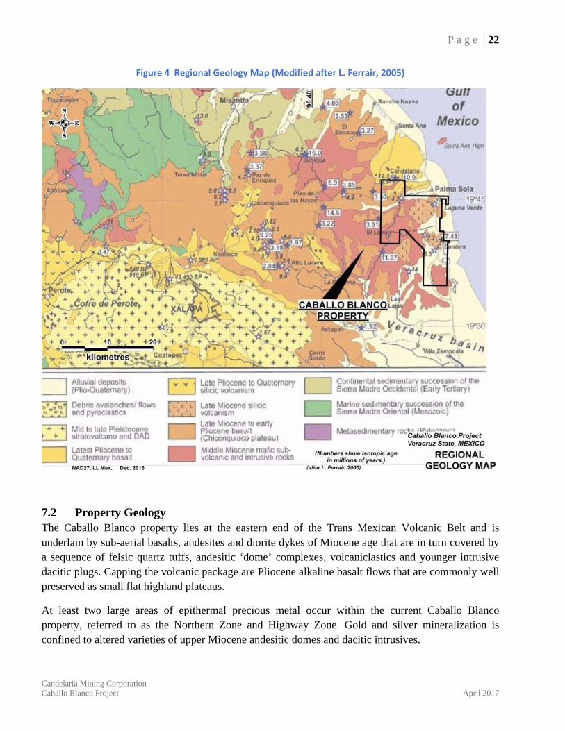
7.1 Regional Geology During the visits to the Caballo Blanco property the author was time constrained to become familiar with geological interpretations of the regional and local geology. For this report, he has relied on regional reports from other sources, specifically summaries and descriptions by Richard Sillitoe (Sillitoe, R.H. 2008) and geologists for Canadian Gold Hunter (internal report by, Téliz, F., Hernandez, H., Mehner, D., and Christoffersen, J., 2008). Geological descriptions from the latter follow: “The Caballo Blanco project is located at the intersection of the Trans-Mexican Volcanic Belt (at its eastern extremity) and the NNW-SSE trending Eastern Alkaline Province. Regionally the area is located over a tectonic high known as the Teziutlan Massif, which has a Paleozoic (metamorphic-intrusive-metasedimentary) basement. This massif divides the Tampico-Misantla Basin and the Veracruz Basin, respectively to the north and south. Such basement underlies marine Mesozoic rocks (Gómez-Tuena, et al., 2003). The Trans-Mexican Volcanic Belt (TMVB) has been defined as a continental magmatic arc formed by more than 8,000 volcanic edifices and a few intrusive bodies that extends from the Pacific to the Gulf coast in Central Mexico (1,000 km long and up to 230 km wide), with a general E-W orientation. The TMVB is controlled by a complex extensional tectonic regime, whose volcanic products are underlain by basements with widely different ages, compositions, and thicknesses. Calc-alkaline and alkaline rocks are distributed all along the TMVB; however alkaline rocks (Na-K) tend to be more abundant at both the west and east ends of the TMVB (Orozco-Esquivel, et al., 2007). The evolution of the TMVB is related to the re-orientation of the magmatic arc and directly associated with the change in the general composition from felsic (Sierra Madre Occidental) to intermediate and mafic. This change has been considered as being related to the re-organization of the subduction system associated with large-scale tectonism during the early Miocene. In the middle Miocene (17-12 Ma), the volcanic arc extended to the east, to the coast of the Gulf of México (Ferrari, et al., 1999). The Eastern Alkaline Province (EAP) was considered as an independent Cenozoic magmatic province with alkaline rocks, related to extensional faulting parallel to the Gulf of México coast, extending from the state of Tamaulipas in the north southward to the Los Tuxtlas Range in the State of Veracruz (Demant and Robin, 1975 in Orozco-Esquivel, et al., 2007). Originally, the EAP was interpreted as a progressively southward migration of alkaline volcanism from the Oligocene-Eocene in Tamaulipas to the Quaternary in Los Tuxtlas. However, based on recent data (dating and geochemistry), such kind of migration model is not likely nor is the mafic volcanism in Tamaulipas considered to be directly linked to magmatism in the Caballo Blanco area. Based on new data (Orozco-Esquivel, et al., 2007), the volcanism near the Caballo Blanco project area is linked to the evolution of the TMVB and not really to intra-plate tectonism of the EAP. Several geological episodes have been distinguished during the time evolution of the TMV B (Orozco Esquivel, et al., 2007 and Ferrari, et al., 2005). These episodes are well represented around the Caballo Blanco property:
P a g e | 21
Candelaria Mining Corporation Caballo Blanco Project April 2017
▪ Middle to late Miocene episode: This stage is defined by the emplacement of plutonic and sub-volcanic bodies of gabbroic to dioritic, calc-alkaline composition (15-11 Ma), with an adakitic geochemical signature (implying partial fusion of a subducted slab during a period of sub-horizontal to shallow-dipping subduction) (Gomez-Tuena, et al., 2003). In this way, the earliest magmatic activity around the Caballo Blanco project was strongly influenced by melting of the subducted oceanic crust. At the end of the adakitic period, there followed a regional uplift, correlated to an episode of sub-volcanic and intrusion emplacement (Gomez-Tuena, et al., 2003).
The intrusive rocks are described as micro-porphyritic to microcrystalline (hypabyssal), found with sulphides, propyllitic alteration and normally cut by mafic dikes. These rocks have been dated as 17 Ma (Laguna Verde microdiorite, NE corner of the property), 14.6 Ma (Plan de las Hayas, north of the project) and 13-11 Ma (El Limón, western edge of the property) for some gabbros. This initial phase of magmatism in the area resulted in some products being emplaced to the east within the present Gulf of Mexico (Ferrari, et al., 2005).
▪ Late Miocene episode: Mafic volcanic rocks were emplaced as fissure basaltic flows,
commonly forming plateaus or mesas, with ages reported in the area between 7.5 to 6.5 Ma (López-Infanzón, 1991; Ferrair et al., 2005). Intermediate, sub-alkaline, subduction-related volcanism changed at about 7.5 Ma to mafic alkaline volcanism in the area (Chiconquiaco– Palma Sola volcanic fields to the north of Caballo Blanco). Such an abrupt change in the nature of the volcanism has been ascribed to a sudden change in the magma source (Orozco-Esquivel, et al., 2007).
An unconformity, associated with several tens of meters of volcaniclastic rocks is reported between the Middle to late Miocene intrusions and late Miocene lava flows. Dating done by Cantagrel and Robin (1979) (in Gómez-Tuena, 2007) has reported ages of 6.5 Ma and 7.5 Ma for dacite domes in Cerro Metates (eastern part of the property) and Cerro Cantera (SE zone of the claim block). A dioritic intrusion has been dated as 7.3 Ma (Zempoala, 20 km to the south of the property). This intrusion is considered as hypabyssal magmatism, the time equivalent to the basaltic plateau volcanism in the area (Ferrari, et al., 2005).
Early–Late Pliocene bimodal volcanism episode: The magmatic products around the
Caballo Blanco area derive from the partial fusion of a relatively deeper mantle with the geochemical signature of an enriched mantle wedge (Orozco-Esquivel, et al., 2007). Ages of 4.0 and 3.1 Ma were obtained for plateau basalt to the north of the property (Plan de Hayas). A few kilometers to the south of the property (Actopan and Alto Lucero), highly potassic younger volcanic rocks overlying the plateau succession have been dated at 2.24 to 1.97 Ma. d) Late Pliocene to Quaternary episode: Basaltic to andesitic volcanic products of alkaline composition occur in the Palma Sola region (north edge of the Caballo Blanco property). The most recent volcanic rocks do not show signs of the subducted oceanic crust but have been influenced by contamination with the local continental crust (Orozco-Esquivel, et al., 2007). Quaternary volcanic rocks reach a thickness of up to 800 meters (to the west of the property area), abruptly thinning to the east to tens of meters in the coastal zone (Ferrari, et al., 2005)”.
P a g e | 22
Candelaria Mining Corporation Caballo Blanco Project April 2017
Figure 4 Regional Geology Map (Modified after L. Ferrair, 2005)
7.2 Property Geology The Caballo Blanco property lies at the eastern end of the Trans Mexican Volcanic Belt and is underlain by sub-aerial basalts, andesites and diorite dykes of Miocene age that are in turn covered by a sequence of felsic quartz tuffs, andesitic ‘dome’ complexes, volcaniclastics and younger intrusive dacitic plugs. Capping the volcanic package are Pliocene alkaline basalt flows that are commonly well preserved as small flat highland plateaus.
At least two large areas of epithermal precious metal occur within the current Caballo Blanco property, referred to as the Northern Zone and Highway Zone. Gold and silver mineralization is confined to altered varieties of upper Miocene andesitic domes and dacitic intrusives.
P a g e | 23
Candelaria Mining Corporation Caballo Blanco Project April 2017
7.2.1 Northern Zone – High Sulphidation Epithermal Gold Targets with massive silica ledges Geological mapping, rock chip sampling, geophysical surveying and core drilling have identified a large area of silica and associated silica clay alteration within an andesitic dome complex along the northern portion of the property. Altered feldspar andesite that hosts gold mineralization is spread over an area of 5 by 4 kilometres and occurs in close association to a prominent magnetic ring structure with at least five prominent silica caps forming distinct 600-meter-high hilltops.
Rock exposures in these areas include mixtures and overprints of classic vuggy, brecciated and or massive silica with associated and flanking haloes of advanced argillic to argillic alteration. These diverse clay alteration zones have been identified and mapped in part using a TerraSpec® spectrometer. Drill testing at three of these ‘silica cap’ features, La Paila, Bandera, and La Cruz, suggest that acid leaching from hydrothermal fluids extend to depths of over 300 meters. The Red Valley target lies at lower elevations on the outside fringe of the circular ring feature and has been identified with soil geochemistry.
Corbett (2011) describes targets within this Northern Zone area as follows; “La Cruz - Las Cuevas - La Bandera zones of advanced argillic alteration are dominated by barren silicification classed as barren shoulders. La Paila zoned advanced argillic alteration is typical of high sulphidation Au mineralisation, in which Au is preferentially localised within the core silica zone. While much of the massive silica is barren, pseudomorphous pervasive vuggy silica displays low Au grades in the order of 0.1-0.2 g/t Au, progressively rising within brecciated vuggy silica, to 1 g/t Au, especially where proximal to fluid plumbing systems.”
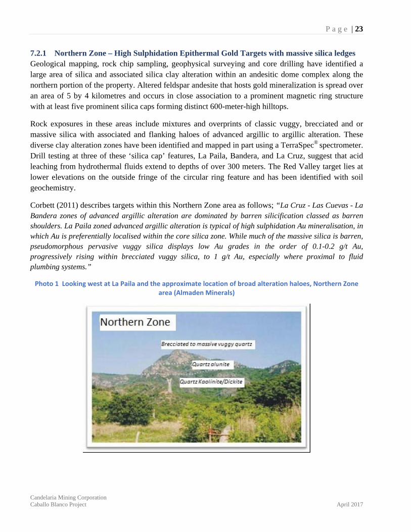
Photo 1 Looking west at La Paila and the approximate location of broad alteration haloes, Northern Zone area (Almaden Minerals)
P a g e | 24
Candelaria Mining Corporation Caballo Blanco Project April 2017
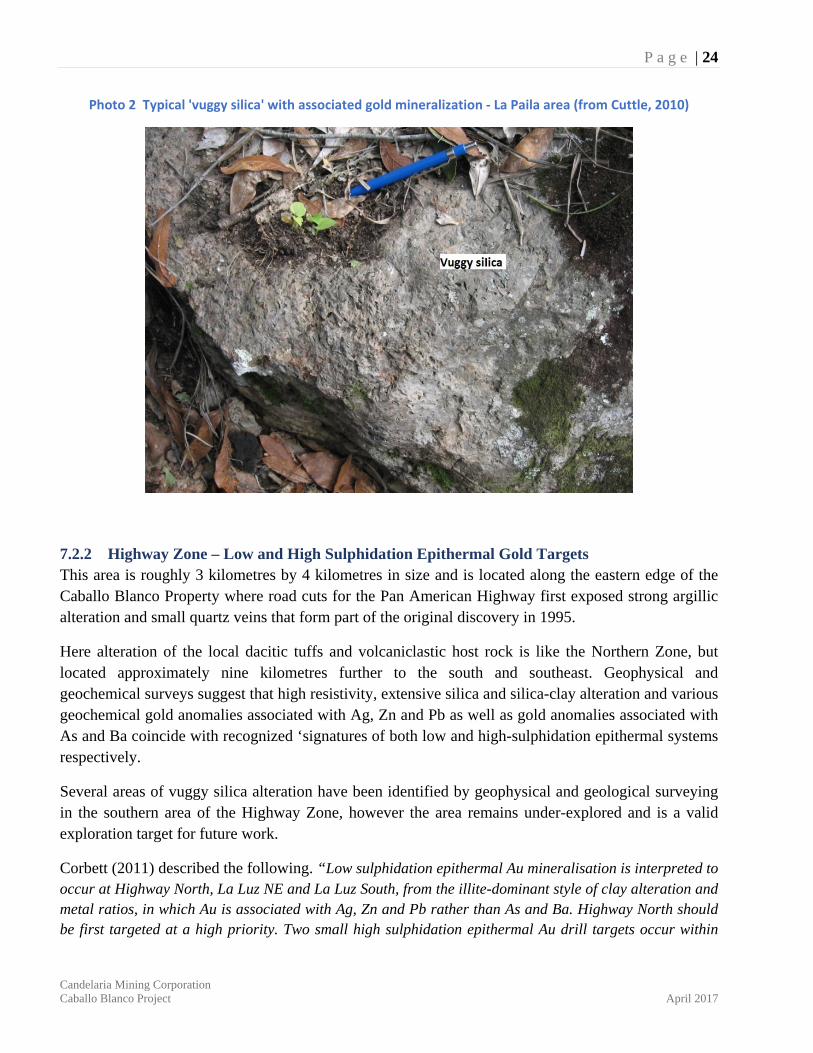
Photo 2 Typical 'vuggy silica' with associated gold mineralization ‐ La Paila area (from Cuttle, 2010)
7.2.2 Highway Zone – Low and High Sulphidation Epithermal Gold Targets This area is roughly 3 kilometres by 4 kilometres in size and is located along the eastern edge of the Caballo Blanco Property where road cuts for the Pan American Highway first exposed strong argillic alteration and small quartz veins that form part of the original discovery in 1995.
Here alteration of the local dacitic tuffs and volcaniclastic host rock is like the Northern Zone, but located approximately nine kilometres further to the south and southeast. Geophysical and geochemical surveys suggest that high resistivity, extensive silica and silica-clay alteration and various geochemical gold anomalies associated with Ag, Zn and Pb as well as gold anomalies associated with As and Ba coincide with recognized ‘signatures of both low and high-sulphidation epithermal systems respectively.
Several areas of vuggy silica alteration have been identified by geophysical and geological surveying in the southern area of the Highway Zone, however the area remains under-explored and is a valid exploration target for future work.
Corbett (2011) described the following. “Low sulphidation epithermal Au mineralisation is interpreted to occur at Highway North, La Luz NE and La Luz South, from the illite-dominant style of clay alteration and metal ratios, in which Au is associated with Ag, Zn and Pb rather than As and Ba. Highway North should be first targeted at a high priority. Two small high sulphidation epithermal Au drill targets occur within
P a g e | 25
Candelaria Mining Corporation Caballo Blanco Project April 2017
the Highway South advanced argillic alteration.”
Encouraging drill core assays from hole CB02-7 drilled by Noranda in 2002 and collared in ‘flanking’ clay alteration and vuggy silica intersected a gold bearing zone grading up to 2.52 g/t gold over 3 meters close to the bottom of the hole. Other isolated resistivity anomalies approximately two kilometres to the north of this drilling suggest significant potential remains open for additional work.
7.3 Alteration and Property Mineralization In the Northern Zone and Highway Zone, epithermal gold mineralization is associated with vuggy silica breccia surrounded by large and distinct haloes of various mixtures of clay alteration including alunite, dickite, pyrophylite, kaolin and illite. These diverse clay alteration zones have been identified and mapped in part using a TerraSpec® spectrometer.
The elongate and silicified gold rich mineralization at La Paila in the Northern Zone likely formed from hydrothermal fluids rising along a north trending fault structure well above a deeper differentiated intrusive ‘heat source’. Gold at La Paila is interpreted as ‘high sulphidation’ epithermal gold mineralization. The gold here is very fine and occurs within vuggy and brecciated silica alteration of the original andesitic flows and domes. The mineralization is clean and has little if any mercury or arsenic signatures. Drill core intervals contain significant gold mineralization with assays up to 2.19 g/t gold over 89.91 meters (08CDN-04).
Areas within the Highway Zone exhibit both illite dominated clay alteration and gold associated metal geochemistry with silver, zinc, and lead, in addition to other areas of advanced argillic alteration. These ‘overprints’ represent examples of both low sulphidation and high sulphidation epithermal mineralization respectively.
It is interesting that similar silica and clay alteration zones and/or associated gold in soil anomalies have been recognized at La Cruz, Las Cuevas, and Red Valley of the Northern Zone as well as the several target areas within the Highway Zone, all of which lie along a north-south linear trend greater than nine kilometres in length. This corridor represents an attractive target for exploration.

P a g e | 26
Candelaria Mining Corporation Caballo Blanco Project April 2017
Figure 5 Property Geology Map (modified after the Geological Survey of Mexico, SGM)
P a g e | 27
Candelaria Mining Corporation Caballo Blanco Project April 2017
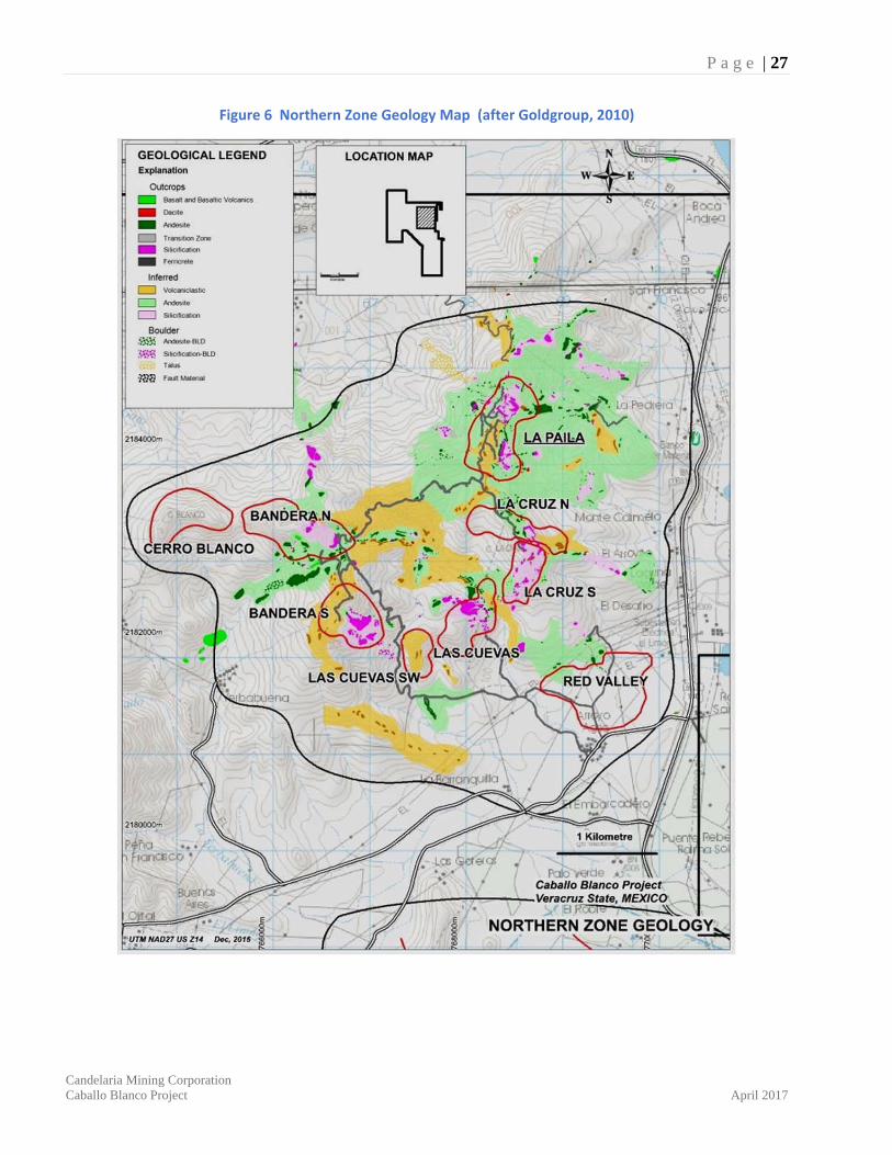
Figure 6 Northern Zone Geology Map (after Goldgroup, 2010)
P a g e | 28
Candelaria Mining Corporation Caballo Blanco Project April 2017
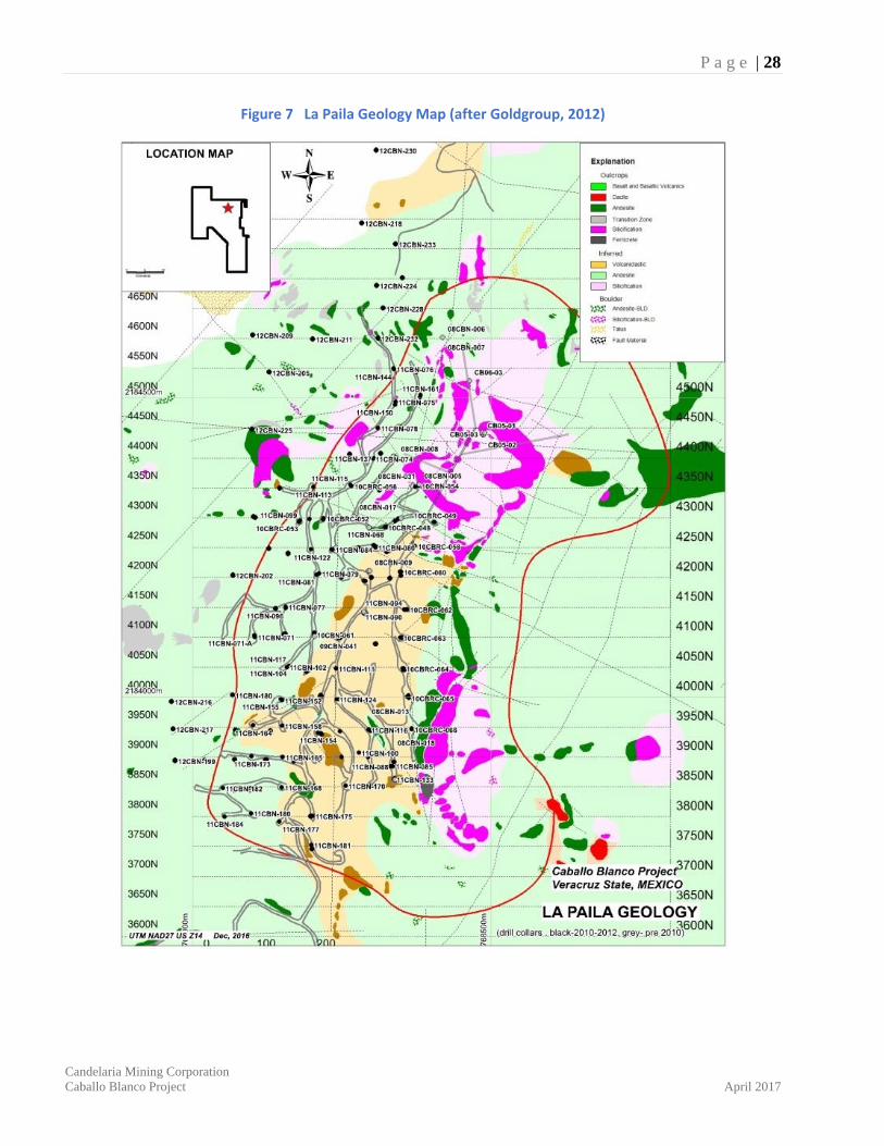
Figure 7 La Paila Geology Map (after Goldgroup, 2012)

P a g e | 29
Candelaria Mining Corporation Caballo Blanco Project April 2017
8. DEPOSIT TYPES The Caballo Blanco property and the neighboring El Cobre (El Porvenir) property of Almaden includes at least two deposit types, defined as epithermal gold and porphyry copper gold respectively. The Central Grid Zone (part of the El Porvenir target) is located to the south of the Caballo Blanco Property and was part of the El-Cobre Joint Venture between Almaden Minerals and Goldgroup in 2010.
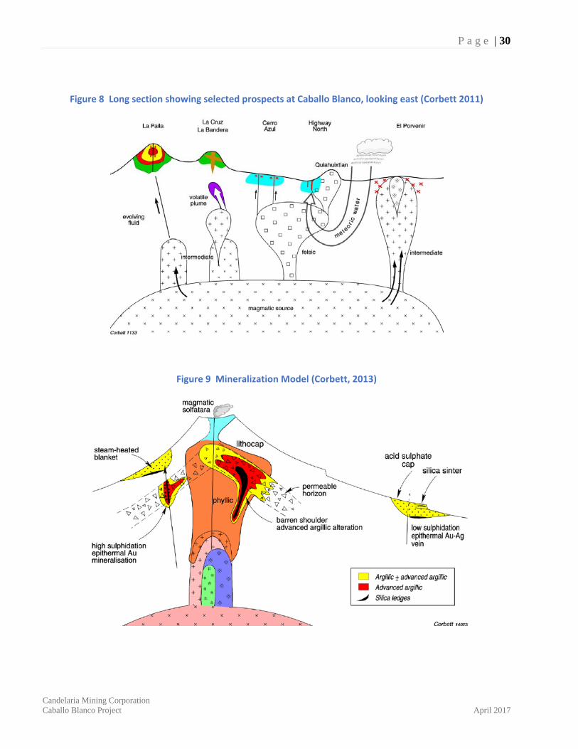
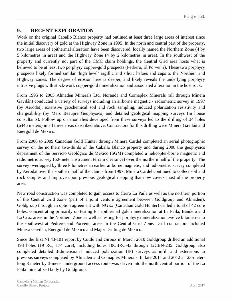
Here it is suggested the porphyry Cu-Au mineralization seen in drill core at El Porvenir represents the deepest level of mineralization exposed by erosion. Moving northward onto the Caballo Blanco property Corbett (2011) best describes the following observations and interpreted model types.
“Low sulphidation epithermal gold mineralisation is interpreted to occur at Highway North, La Luz NE and La Luz South, from the illite-dominant style of clay alteration and metal ratios, in which Au is associated with Ag, Zn and Pb rather than As and Ba.”
“La Cruz-Las Cuevas-La Bandera zones of advanced argillic alteration are dominated by barren silicification classed as barren shoulders (Corbett and Leach, 1998). The form of silica ledges is indicative of a steep dipping structural control at La Cruz interpreted as a feeder structure for the flat dipping lithologically controlled alteration at Las Cuevas, discernible as a shallow east dipping silica ledge. This style of alteration is interpreted to have developed by reaction with wall rocks of volatile rich magmatic fluids venting early in the cooling history of porphyry intrusions. By contrast, hydrothermal fluids responsible for the development of high sulphidation epithermal Au occurrences vent later from more evolved intrusions and contain mineralisation within a liquid-rich phase of the magmatic hydrothermal fluid.”
“La Paila zoned advanced argillic alteration is typical of high sulphidation epithermal gold mineralisation, in which gold is preferentially localised within the core silica zone. Much of the coarse grained vuggy silica has developed by the pseudomorphous leaching of coarse porphyritic andesite. By contrast massive silica dominates within fine grained protore rock types. While much of the massive silica is barren, pseudomorphous pervasive vuggy silica displays low Au grades in the order of 0.1-0.2 g/t Au, progressively rising within brecciated vuggy silica, to 1 g/t Au, especially where proximal to fluid plumbing systems.”
P a g e | 30
Candelaria Mining Corporation Caballo Blanco Project April 2017
Figure 8 Long section showing selected prospects at Caballo Blanco, looking east (Corbett 2011)
Figure 9 Mineralization Model (Corbett, 2013)
P a g e | 31
Candelaria Mining Corporation Caballo Blanco Project April 2017
9. RECENT EXPLORATION Work on the original Caballo Blanco property had outlined at least three large areas of interest since the initial discovery of gold at the Highway Zone in 1995. In the north and central part of the property, two large areas of epithermal alteration have been discovered, locally named the Northern Zone (4 by 5 kilometres in area) and the Highway Zone (4 by 2 kilometres in area). In the southwest of the property and currently not part of the CMC claim holdings, the Central Grid area hosts what is believed to be at least two porphyry copper-gold prospects (Pedrero, El Porvenir). These two porphyry prospects likely formed similar ‘high level’ argillic and silicic haloes and caps to the Northern and Highway zones. The degree of erosion here is deeper, and likely reveals the underlying porphyry intrusive plugs with stock-work copper-gold mineralization and associated alteration in the host rock.
From 1995 to 2005 Almaden Minerals Ltd, Noranda and Comaplex Minerals (all through Minera Gavilán) conducted a variety of surveys including an airborne magnetic / radiometric survey in 1997 (by Aerodat), extensive geochemical soil and rock sampling, induced polarization resistivity and chargeability (by Marc Beaupre Geophysics) and detailed geological mapping surveys (in house consultants). Follow up on anomalies developed from these surveys led to the drilling of 34 holes (6446 meters) in all three areas described above. Contractors for this drilling were Minera Gavilán and Energold de Mexico.
From 2006 to 2009 Canadian Gold Hunter through Minera Cardel completed an aerial photographic survey on the northern two-thirds of the Caballo Blanco property and during 2008 the geophysics department of the Servicio Geológico de Mexico (SGM) completed a helicopter-borne magnetic and radiometric survey (60-meter instrument terrain clearance) over the northern half of the property. The survey overlapped by three kilometres an earlier airborne magnetic, and radiometric survey completed by Aerodat over the southern half of the claims from 1997. Minera Cardel continued to collect soil and rock samples and improve upon previous geological mapping that now covers most of the property area.
New road construction was completed to gain access to Cerro La Paila as well as the northern portion of the Central Grid Zone (part of a joint venture agreement between Goldgroup and Almaden). Goldgroup through an option agreement with NGEx (Canadian Gold Hunter) drilled a total of 42 core holes, concentrating primarily on testing for epithermal gold mineralization at La Paila, Bandera and La Cruz areas in the Northern Zone as well as testing for porphyry mineralization twelve kilometres to the southwest at Pedrero and Porvenir areas in the Central Grid Zone. Drill contractors included Minera Gavilán, Energold de Mexico and Major Drilling de Mexico.
Since the first NI 43-101 report by Cuttle and Giroux in March 2010 Goldgroup drilled an additional 193 holes (19 RC, 174 core), including holes 10CBRC-43 through 12CBN-235. Goldgroup also completed detailed 3-dimensional induced polarization (IP) surveys as infill and extensions to previous surveys completed by Almaden and Comaplex Minerals. In late 2011 and 2012 a 123-meter-long 3 meter by 3-meter underground access route was driven into the north central portion of the La Paila mineralized body by Goldgroup.
P a g e | 32
Candelaria Mining Corporation Caballo Blanco Project April 2017
The complete database since 1995 is summarized in point form below:
▪ Stream Sediments - 308 stream sediment samples have been collected sporadically on the property and each analysed for gold by fire assay and 41 additional elements by ICP methods. Results show 66 samples are above the 80-percentile threshold of 8 ppb gold with a range up to a high of 205 ppb gold. The anomalous zones are generally confined to the three areas (Northern, Highway, and Central Grid Zones) but also include two other areas, one 4 kilometres southwest of Bandera (Northern Zone) and 2.3 kilometres west of Pedrero (Central Grid Zone) as seen in Fig. 17 in Cuttle and Giroux, 2010.
▪ Rocks - 2441 rock grab samples have been taken from many surface locations throughout the property, however most come from the Northern, Highway and Central Grid Zones. Approximately 492 samples (20 percent) are above the 80 percentile of 88 ppb gold and many of these general areas; particularly along east trending ridges at La Paila that are indicative of low grade epithermal mineralization (0.5 to 1.5 g/t gold) have yet to be drill tested. Other isolated and higher grade gold samples (up to 14.6 g/t gold) occur outside the three main areas of interest and are located two and four kilometres southwest of Bandera and four kilometres south of the Highway Zone (refer to Fig. 17 and Fig. 21 in Cuttle and Giroux, 2010).
▪ Soil Geochemistry - 8578 soil samples have been collected over 3 general areas in the Northern Zone, Highway Zone, and the Central Grid Zone, covering a total of over 52 square kilometres. All samples were analysed by fire assay for gold and 41 additional elements by ICP methods. The grid spacing is dominantly 200m by 50m however local infill sampling has improved grid density in specific interest areas to 100m by 50m and 50m by 50m spacing. Geochemically positive correlation from soils over the high epithermal prospects in the Northern and Highway Zones includes Ag, As, Bi, Sb, Pb and lesser Mo, Sn. In the porphyry environment of the Central Grid Zone, Au, Cu, Mo, Pb, Zn, and Sn. Results for gold in soils identify several anomalous areas that have in some but not all cases been followed up by drill testing. Several local anomalies above an 80-percentile threshold of 22 ppb gold remain valid exploration targets. Strong acid soil pH anomalies are located one kilometre west of La Paila and may be indicative of acid leaching from an undiscovered or blind epithermal system (refer to Fig. 16 in Cuttle and Giroux, 2010).
▪ Geophysics - Ninety percent of the property has been covered with two stages of airborne magnetics, and radiometrics with flight line spacing of 200 meters. On the ground, approximately 34 square kilometres of area (Northern Zone, Highway Zone, and Central Grid Zone) has been surveyed with IP resistivity and chargeability on a grid line spacing of generally 200 meters. Local step outs on 400 meter spaced lines and infill spaced lines at 100 meters isolate some areas of interest or known gold mineralization. It is reasonable to suggest with the large volumes of silica alteration and associated gold mineralization in a deeply oxidized environment such as La Paila in the Northern Zone, high resistivity anomalies have been instrumental in defining specific drill targets. Deeper un-oxidized
P a g e | 33
Candelaria Mining Corporation Caballo Blanco Project April 2017
rocks that contain primary sulphide and possible higher grade gold feeder zones may be represented by chargeability high anomalies underlying resistivity high anomalies found closer to surface (refer to Fig. 18 in Cuttle and Giroux, 2010). In 2010, Goldgroup contracted SJ Geophysics to complete approximately 100 line kilometres of 3D IP over the Northern Zone and Highway Zone at Caballo Blanco. The surveys were completed on 100 meter and 200-meter line separation. Modelling of the resistivity and chargeability data has since helped refine new and improved targets for further drill testing.
▪ Lithogeochemistry - 1065 surface rock specimens have been collected and analysed for clay alteration products using a company owned Terra Spec® spectrometer. These data are critical in defining distinct alteration haloes around mineralization and will help to vector exploration targets in the future.
▪ Drilling – Two hundred and thirty-three core holes and thirty-six reverse circulation holes have been drilled since the discovery of gold at Caballo Blanco (Northern Zone and Highway Zone) including the neighbouring Central Grid Zone which, as of October 2011, was owned 100 percent by Almaden Minerals. Due to small open cavities and intense alteration and oxidation to at least 300 meters, reverse circulation (RC) drilling and diamond drilling at Caballo Blanco was at times problematic and consequently several holes were either lost, had poor recovery, or never attained their projected depths. When comparing the two drilling methods, diamond drill core recoveries were consistently higher.
▪ Underground Development - As of 4 January 2012, Goldgroup had driven a 123-meter-long 3-meter by 3-meter underground access drift into the north central portion of the La Paila mineralized body. This is a portion of the planned underground development which is designed to give more detailed geological information on mineralization controls and to provide more material for large ongoing column leach tests. At the time of Cuttle's visit in 2012, the walls of this new underground access had been chip sampled, however assay results for these samples and corresponding geological mapping and maps showing additional development were not available to the author for this report.
Since the completion of this work described above no additional work has been completed by subsequent owners or by Candelaria Mining.
P a g e | 34
Candelaria Mining Corporation Caballo Blanco Project April 2017
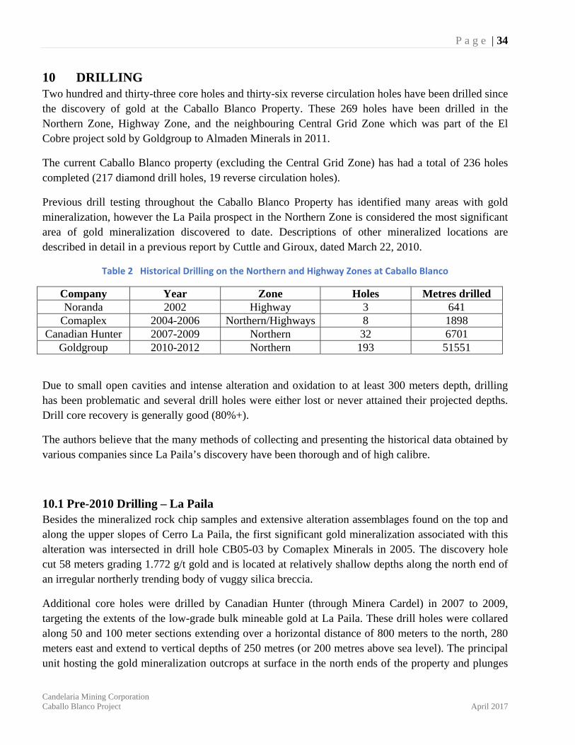
10 DRILLING Two hundred and thirty-three core holes and thirty-six reverse circulation holes have been drilled since the discovery of gold at the Caballo Blanco Property. These 269 holes have been drilled in the Northern Zone, Highway Zone, and the neighbouring Central Grid Zone which was part of the El Cobre project sold by Goldgroup to Almaden Minerals in 2011.
The current Caballo Blanco property (excluding the Central Grid Zone) has had a total of 236 holes completed (217 diamond drill holes, 19 reverse circulation holes).
Previous drill testing throughout the Caballo Blanco Property has identified many areas with gold mineralization, however the La Paila prospect in the Northern Zone is considered the most significant area of gold mineralization discovered to date. Descriptions of other mineralized locations are described in detail in a previous report by Cuttle and Giroux, dated March 22, 2010.
Table 2 Historical Drilling on the Northern and Highway Zones at Caballo Blanco
Company Year Zone Holes Metres drilled Noranda 2002 Highway 3 641
Comaplex 2004-2006 Northern/Highways 8 1898 Canadian Hunter 2007-2009 Northern 32 6701
Goldgroup 2010-2012 Northern 193 51551
Due to small open cavities and intense alteration and oxidation to at least 300 meters depth, drilling has been problematic and several drill holes were either lost or never attained their projected depths. Drill core recovery is generally good (80%+).
The authors believe that the many methods of collecting and presenting the historical data obtained by various companies since La Paila’s discovery have been thorough and of high calibre.
10.1 Pre-2010 Drilling – La Paila Besides the mineralized rock chip samples and extensive alteration assemblages found on the top and along the upper slopes of Cerro La Paila, the first significant gold mineralization associated with this alteration was intersected in drill hole CB05-03 by Comaplex Minerals in 2005. The discovery hole cut 58 meters grading 1.772 g/t gold and is located at relatively shallow depths along the north end of an irregular northerly trending body of vuggy silica breccia.
Additional core holes were drilled by Canadian Hunter (through Minera Cardel) in 2007 to 2009, targeting the extents of the low-grade bulk mineable gold at La Paila. These drill holes were collared along 50 and 100 meter sections extending over a horizontal distance of 800 meters to the north, 280 meters east and extend to vertical depths of 250 metres (or 200 metres above sea level). The principal unit hosting the gold mineralization outcrops at surface in the north ends of the property and plunges
P a g e | 35
Candelaria Mining Corporation Caballo Blanco Project April 2017
gently to the south. It is not clear however if this perceived plunge of the gold zone at La Paila is the direct result of local block faulting or the result of insufficient drill data.
Earlier in 2002, Noranda drilled three widely spaced exploration diamond drill holes in the Highway zone where hole CB02-7 intersected 2.52 g/t gold over 3 metres towards the bottom of the hole at a vertical depth of 192 to 195 metres.
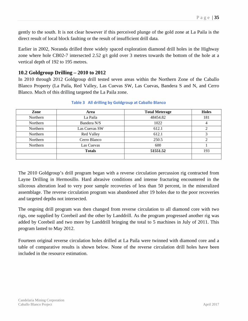
10.2 Goldgroup Drilling – 2010 to 2012 In 2010 through 2012 Goldgroup drill tested seven areas within the Northern Zone of the Caballo Blanco Property (La Paila, Red Valley, Las Cuevas SW, Las Cuevas, Bandera S and N, and Cerro Blanco. Much of this drilling targeted the La Paila zone.
Table 3 All drilling by Goldgroup at Caballo Blanco
Zone Area Total Meterage Holes Northern La Paila 48454.82 181 Northern Bandera N/S 1022 4 Northern Las Cuevas SW 612.1 2 Northern Red Valley 612.1 3 Northern Cerro Blanco 250.5 2 Northern Las Cuevas 600 1
Totals 51551.52 193
The 2010 Goldgroup’s drill program began with a reverse circulation percussion rig contracted from Layne Drilling in Hermosillo. Hard abrasive conditions and intense fracturing encountered in the siliceous alteration lead to very poor sample recoveries of less than 50 percent, in the mineralized assemblage. The reverse circulation program was abandoned after 19 holes due to the poor recoveries and targeted depths not intersected.
The ongoing drill program was then changed from reverse circulation to all diamond core with two rigs, one supplied by Corebeil and the other by Landdrill. As the program progressed another rig was added by Corebeil and two more by Landdrill bringing the total to 5 machines in July of 2011. This program lasted to May 2012.
Fourteen original reverse circulation holes drilled at La Paila were twinned with diamond core and a table of comparative results is shown below. None of the reverse circulation drill holes have been included in the resource estimation.
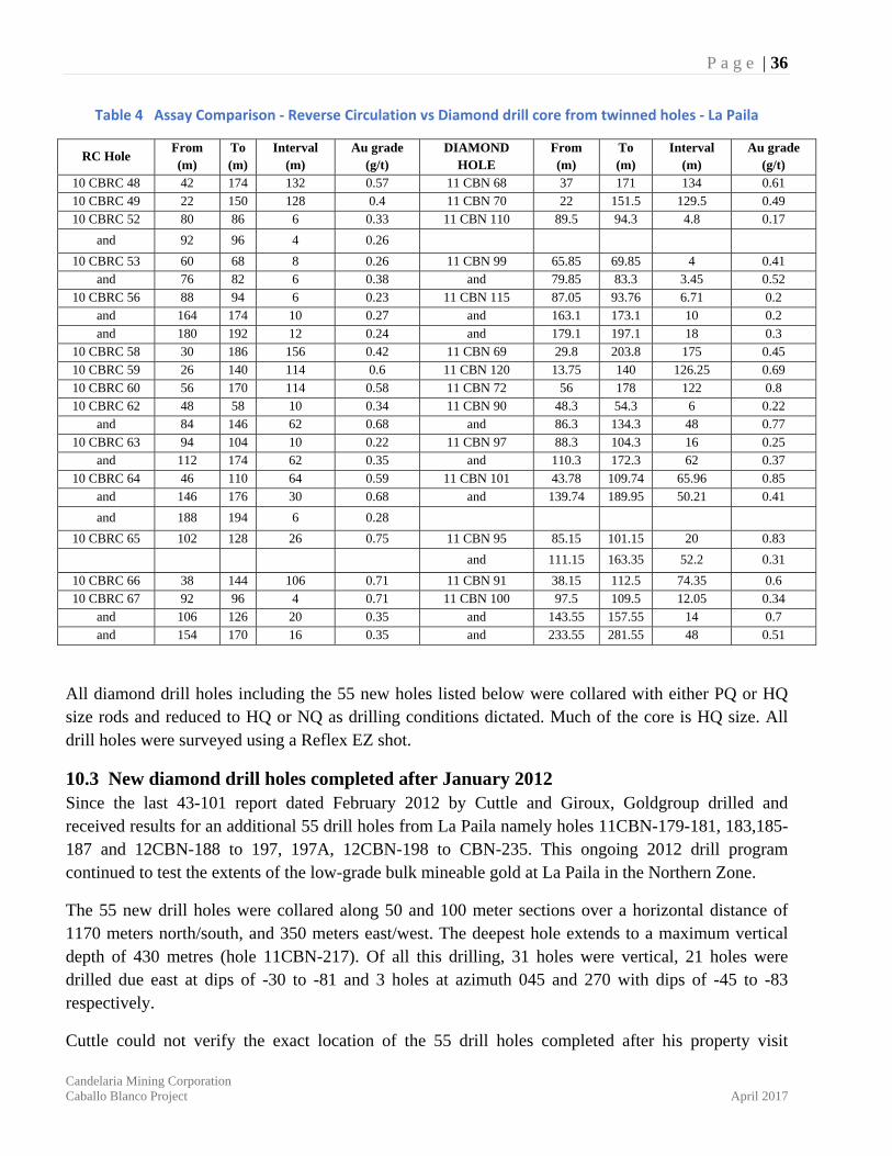
P a g e | 36
Candelaria Mining Corporation Caballo Blanco Project April 2017
Table 4 Assay Comparison ‐ Reverse Circulation vs Diamond drill core from twinned holes ‐ La Paila
RC Hole From (m)
To (m)
Interval (m)
Au grade (g/t)
DIAMOND HOLE
From (m)
To (m)
Interval (m)
Au grade (g/t)
10 CBRC 48 42 174 132 0.57 11 CBN 68 37 171 134 0.6110 CBRC 49 22 150 128 0.4 11 CBN 70 22 151.5 129.5 0.4910 CBRC 52 80 86 6 0.33 11 CBN 110 89.5 94.3 4.8 0.17
and 92 96 4 0.26 10 CBRC 53 60 68 8 0.26 11 CBN 99 65.85 69.85 4 0.41
and 76 82 6 0.38 and 79.85 83.3 3.45 0.5210 CBRC 56 88 94 6 0.23 11 CBN 115 87.05 93.76 6.71 0.2
and 164 174 10 0.27 and 163.1 173.1 10 0.2and 180 192 12 0.24 and 179.1 197.1 18 0.3
10 CBRC 58 30 186 156 0.42 11 CBN 69 29.8 203.8 175 0.4510 CBRC 59 26 140 114 0.6 11 CBN 120 13.75 140 126.25 0.6910 CBRC 60 56 170 114 0.58 11 CBN 72 56 178 122 0.810 CBRC 62 48 58 10 0.34 11 CBN 90 48.3 54.3 6 0.22
and 84 146 62 0.68 and 86.3 134.3 48 0.7710 CBRC 63 94 104 10 0.22 11 CBN 97 88.3 104.3 16 0.25
and 112 174 62 0.35 and 110.3 172.3 62 0.3710 CBRC 64 46 110 64 0.59 11 CBN 101 43.78 109.74 65.96 0.85
and 146 176 30 0.68 and 139.74 189.95 50.21 0.41
and 188 194 6 0.28 10 CBRC 65 102 128 26 0.75 11 CBN 95 85.15 101.15 20 0.83
and 111.15 163.35 52.2 0.31
10 CBRC 66 38 144 106 0.71 11 CBN 91 38.15 112.5 74.35 0.610 CBRC 67 92 96 4 0.71 11 CBN 100 97.5 109.5 12.05 0.34
and 106 126 20 0.35 and 143.55 157.55 14 0.7and 154 170 16 0.35 and 233.55 281.55 48 0.51
All diamond drill holes including the 55 new holes listed below were collared with either PQ or HQ size rods and reduced to HQ or NQ as drilling conditions dictated. Much of the core is HQ size. All drill holes were surveyed using a Reflex EZ shot.
10.3 New diamond drill holes completed after January 2012 Since the last 43-101 report dated February 2012 by Cuttle and Giroux, Goldgroup drilled and received results for an additional 55 drill holes from La Paila namely holes 11CBN-179-181, 183,185-187 and 12CBN-188 to 197, 197A, 12CBN-198 to CBN-235. This ongoing 2012 drill program continued to test the extents of the low-grade bulk mineable gold at La Paila in the Northern Zone.
The 55 new drill holes were collared along 50 and 100 meter sections over a horizontal distance of 1170 meters north/south, and 350 meters east/west. The deepest hole extends to a maximum vertical depth of 430 metres (hole 11CBN-217). Of all this drilling, 31 holes were vertical, 21 holes were drilled due east at dips of -30 to -81 and 3 holes at azimuth 045 and 270 with dips of -45 to -83 respectively.
Cuttle could not verify the exact location of the 55 drill holes completed after his property visit
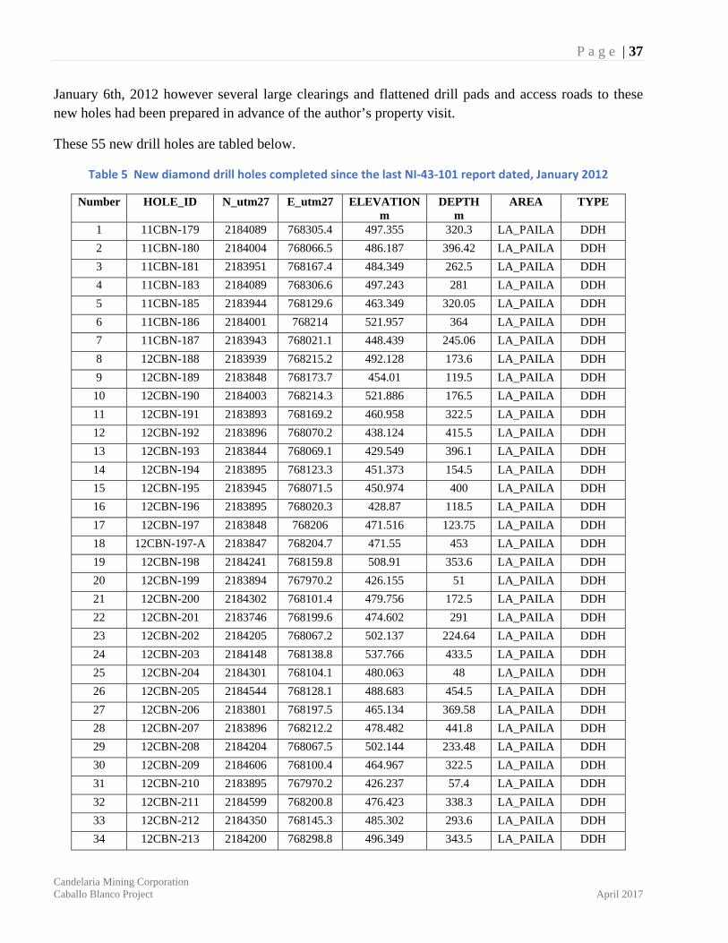
P a g e | 37
Candelaria Mining Corporation Caballo Blanco Project April 2017
January 6th, 2012 however several large clearings and flattened drill pads and access roads to these new holes had been prepared in advance of the author’s property visit.
These 55 new drill holes are tabled below.
Table 5 New diamond drill holes completed since the last NI‐43‐101 report dated, January 2012
Number HOLE_ID N_utm27 E_utm27 ELEVATION m
DEPTH m
AREA TYPE
1 11CBN-179 2184089 768305.4 497.355 320.3 LA_PAILA DDH
2 11CBN-180 2184004 768066.5 486.187 396.42 LA_PAILA DDH
3 11CBN-181 2183951 768167.4 484.349 262.5 LA_PAILA DDH
4 11CBN-183 2184089 768306.6 497.243 281 LA_PAILA DDH
5 11CBN-185 2183944 768129.6 463.349 320.05 LA_PAILA DDH
6 11CBN-186 2184001 768214 521.957 364 LA_PAILA DDH
7 11CBN-187 2183943 768021.1 448.439 245.06 LA_PAILA DDH
8 12CBN-188 2183939 768215.2 492.128 173.6 LA_PAILA DDH
9 12CBN-189 2183848 768173.7 454.01 119.5 LA_PAILA DDH
10 12CBN-190 2184003 768214.3 521.886 176.5 LA_PAILA DDH
11 12CBN-191 2183893 768169.2 460.958 322.5 LA_PAILA DDH
12 12CBN-192 2183896 768070.2 438.124 415.5 LA_PAILA DDH
13 12CBN-193 2183844 768069.1 429.549 396.1 LA_PAILA DDH
14 12CBN-194 2183895 768123.3 451.373 154.5 LA_PAILA DDH
15 12CBN-195 2183945 768071.5 450.974 400 LA_PAILA DDH
16 12CBN-196 2183895 768020.3 428.87 118.5 LA_PAILA DDH
17 12CBN-197 2183848 768206 471.516 123.75 LA_PAILA DDH
18 12CBN-197-A 2183847 768204.7 471.55 453 LA_PAILA DDH
19 12CBN-198 2184241 768159.8 508.91 353.6 LA_PAILA DDH
20 12CBN-199 2183894 767970.2 426.155 51 LA_PAILA DDH
21 12CBN-200 2184302 768101.4 479.756 172.5 LA_PAILA DDH
22 12CBN-201 2183746 768199.6 474.602 291 LA_PAILA DDH
23 12CBN-202 2184205 768067.2 502.137 224.64 LA_PAILA DDH
24 12CBN-203 2184148 768138.8 537.766 433.5 LA_PAILA DDH
25 12CBN-204 2184301 768104.1 480.063 48 LA_PAILA DDH
26 12CBN-205 2184544 768128.1 488.683 454.5 LA_PAILA DDH
27 12CBN-206 2183801 768197.5 465.134 369.58 LA_PAILA DDH
28 12CBN-207 2183896 768212.2 478.482 441.8 LA_PAILA DDH
29 12CBN-208 2184204 768067.5 502.144 233.48 LA_PAILA DDH
30 12CBN-209 2184606 768100.4 464.967 322.5 LA_PAILA DDH
31 12CBN-210 2183895 767970.2 426.237 57.4 LA_PAILA DDH
32 12CBN-211 2184599 768200.8 476.423 338.3 LA_PAILA DDH
33 12CBN-212 2184350 768145.3 485.302 293.6 LA_PAILA DDH
34 12CBN-213 2184200 768298.8 496.349 343.5 LA_PAILA DDH
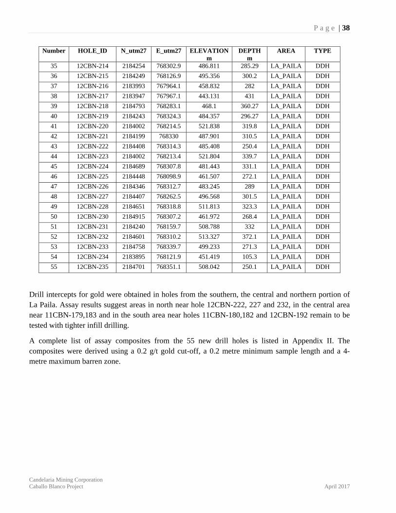
P a g e | 38
Candelaria Mining Corporation Caballo Blanco Project April 2017
Number HOLE_ID N_utm27 E_utm27 ELEVATION m
DEPTH m
AREA TYPE
35 12CBN-214 2184254 768302.9 486.811 285.29 LA_PAILA DDH
36 12CBN-215 2184249 768126.9 495.356 300.2 LA_PAILA DDH
37 12CBN-216 2183993 767964.1 458.832 282 LA_PAILA DDH
38 12CBN-217 2183947 767967.1 443.131 431 LA_PAILA DDH
39 12CBN-218 2184793 768283.1 468.1 360.27 LA_PAILA DDH
40 12CBN-219 2184243 768324.3 484.357 296.27 LA_PAILA DDH
41 12CBN-220 2184002 768214.5 521.838 319.8 LA_PAILA DDH
42 12CBN-221 2184199 768330 487.901 310.5 LA_PAILA DDH
43 12CBN-222 2184408 768314.3 485.408 250.4 LA_PAILA DDH
44 12CBN-223 2184002 768213.4 521.804 339.7 LA_PAILA DDH
45 12CBN-224 2184689 768307.8 481.443 331.1 LA_PAILA DDH
46 12CBN-225 2184448 768098.9 461.507 272.1 LA_PAILA DDH
47 12CBN-226 2184346 768312.7 483.245 289 LA_PAILA DDH
48 12CBN-227 2184407 768262.5 496.568 301.5 LA_PAILA DDH
49 12CBN-228 2184651 768318.8 511.813 323.3 LA_PAILA DDH
50 12CBN-230 2184915 768307.2 461.972 268.4 LA_PAILA DDH
51 12CBN-231 2184240 768159.7 508.788 332 LA_PAILA DDH
52 12CBN-232 2184601 768310.2 513.327 372.1 LA_PAILA DDH
53 12CBN-233 2184758 768339.7 499.233 271.3 LA_PAILA DDH
54 12CBN-234 2183895 768121.9 451.419 105.3 LA_PAILA DDH
55 12CBN-235 2184701 768351.1 508.042 250.1 LA_PAILA DDH
Drill intercepts for gold were obtained in holes from the southern, the central and northern portion of La Paila. Assay results suggest areas in north near hole 12CBN-222, 227 and 232, in the central area near 11CBN-179,183 and in the south area near holes 11CBN-180,182 and 12CBN-192 remain to be tested with tighter infill drilling.
A complete list of assay composites from the 55 new drill holes is listed in Appendix II. The composites were derived using a 0.2 g/t gold cut-off, a 0.2 metre minimum sample length and a 4-metre maximum barren zone.
P a g e | 39
Candelaria Mining Corporation Caballo Blanco Project April 2017
11 SAMPLE PREPARATION, ANALYSIS, AND SECURITY Sampling methods used by Canadian Gold Hunter geologists between 2007 and 2009 on 32 of the 38 drill holes in the Northern Zone are described in the following paragraphs in addition to sampling methods used by Goldgroup during their drill campaigns from 2010 to 2012.
Sampling methods used by Comaplex during 2004 to 2006 core drilling in the Northern Zone are unknown to the author; however according to Candelaria, check assays on split core samples collected on mineralized core intercepts from three Comaplex core holes during their due-diligence suggest no significant differences in assay results. The author cannot verify these results.
11.1 Sample Preparation and Analysis – Canadian Gold Hunter, 2007 to 2009 Canadian Gold Hunter sent the drill core samples to ALS Chemex preparation Lab in Guadalajara, Mexico where they were dried and crushed to minus 150 mesh and the pulps were then air couriered to ALS Chemex Laboratories in North Vancouver, BC, Canada (ISO 17025 accredited). Each were then dissolved in an aqua regia leach and analyzed for gold by fire assay methods and 35 other trace elements by ICP - MS methods (inductively coupled plasma with mass spectroscopy).
11.2 Quality Assurance / Quality Control (QA/QC) – Canadian Gold Hunter, 2007 to 2009 The three different standard reference materials used in this drilling campaign were purchased from CDN Resource Laboratories Ltd. in Vancouver, Canada by Canadian Gold Hunter (Minera Cardel). Control charts suggest most all the assay data on these three different standards fall within two standard deviation of the norm. Specific outliers exist just outside 2SD; however, these are not considered influential to the overall data package.
▪ Standard P1 - 6% or 3 samples out of 49 - above / below 2SD ▪ Standard 3C - 4% or 2 samples out of 48 - above / below 2SD ▪ Standard P7A - 4% or 2 samples out of 46 - above / below 2SD
Source material for the 48 blanks inserted into the assays in the Northern Zone comes from two locations. Inserts into assay shipments for drill holes CB06-01 to CB-06-03 and 07CBN-01 to 08CBN-05 used local blank gravel and inserts for holes 08CBN-06 to 09CBN-042 used previously drilled core from barren andesite in the Northern Zone. Exact location and the average reference analysis of the barren andesite inserts and local gravels are unknown; however, assay data on the blanks generally vary from minimum detection of less than 5 parts per billion (ppb) of gold to 44 ppb gold with 3 samples above two standard deviation of 31 ppb gold. The authors do not consider these outliers to be problematic.
Although three outlier samples from 141 duplicates show abnormal results, the duplicate assaying program reflects an acceptable degree of correlation. The author believes sample preparation, security,
P a g e | 40
Candelaria Mining Corporation Caballo Blanco Project April 2017
and general analytical procedures to be adequate for the core drilling at Caballo Blanco.
11.3 Sample Security – Canadian Gold Hunter, 2007 to 2009 A variety of HQ, NQ and / or BQ size drill core was delivered daily from the drill rig to the Company’s on-site core logging and storage facility near the small community of Arroyo Agrio in the north-eastern part of the claim block. Company geologists then recorded geotechnical and geological data, including recovery, specific gravity, rock quality designation (RQD), alteration defined by spectrometer readings and specific geological rock type.
Core samples were selected and marked by the same geologists, with company technicians later using a diamond saw to half the core and secure each half sample with self-locking clips. Sample lengths varied generally from 1 to 3 meters long and up to 6 meters in length and were chosen primarily along on recognized alteration or lithological boundaries.
Three different standard reference samples, as well as locally derived ‘blank’ material and core duplicates were inserted into each lab shipment in regular frequency; generally, a different standard reference material every 20 samples, a blank every 80 samples and core duplicates every 20 to 30 samples. A complete library of split core remains protected inside a fenced compound near the small village of Arroyo Agrio.
11.4 Sample Preparation and Analysis – Goldgroup Mining, 2010 to 2012 During the 2010/2012 drilling campaign conducted by Goldgroup samples of half core and riffle split reverse circulation percussion chips from drill holes 10CBRC43 to 11CBN113 were collected from site by Inspectorate and taken to their Durango preparation facility where they were dried, crushed and a 250g split was pulverized to -75 microns. The rejects were returned to site while the pulps were air couriered to Inspectorate’s Richmond, BC, Canada facility and analyzed for gold by fire assay with Atomic Absorption (AA) finish. In addition, a 30 element Inductively Coupled Plasma (ICP) analysis (aqua regia digest) was conducted on all samples.
Samples of half core from drill holes 11CBN114 to 12CBN235 were collected from site by ALS Global and taken to their Guadalajara preparation facility where they were dried, crushed and a 250-gram split was pulverized to minus 75 microns. The rejects were returned to site while the pulps were air couriered to their Vancouver facility and analyzed for gold by fire assay with AAS finish. In addition, a 35 element ICP analysis was conducted on all samples.
11.5 Quality Assurance / Quality Control (QA/QC) – Goldgroup Mining, 2010 to 2012 The three different standard reference materials used in this drilling campaign were prepared by CDN Resource Laboratories Ltd. in Vancouver, Canada from mineralized material from the La Paila deposit supplied by Goldgroup. Control charts suggest most all the assay data on these three different standards fall within two standard deviation of the norm. Specific outliers exist outside 2SD; however, these are not considered influential to the overall data package.
▪ Standard GS-1E -2% or 4 samples out of 222 - above / below 2SD

P a g e | 41
Candelaria Mining Corporation Caballo Blanco Project April 2017
▪ Standard GS-P8 – 1.5% or 3 samples out of 217 - above / below 2SD ▪ Standard CGH-1 -1% or 2 samples out of 228 - above / below 2SD
One standard, one blank or one duplicate was inserted per group of 10 samples sent to the
laboratory.
11.6 Sample Security – Goldgroup Mining, 2010 to 2012 A variety of HQ and/or NQ size drill core was delivered daily from the drill rig to the Company’s on-site core logging and core storage facility near the small community of Arroyo Agrio in the north-eastern part of the claim block. Company geologists recorded geotechnical and geological data, including recovery, specific gravity, rock quality designation (RQD), alteration defined by spectrometer readings and specific geological rock type.
Core samples were selected and marked by the same geologists, with company technicians later using a diamond saw to halve the core and secure each half sample with self-locking clips. Sample lengths varied generally from 1 to 3 meters long and up to 6 meters in length and were chosen primarily along on recognized alteration or lithological boundaries. The samples were sealed and shipped via ALS Global to ALS Chemex Preparation Laboratories in Guadalajara (holes 11CBN114 to 12CBN235) or picked up by Inspectorate Labs and driven to their preparation laboratories in Durango State (holes 10CBRC43 to 11CBN113).
11.7 Opinion The author reviewed all lab certificates for the 55 new drill holes completed in 2012 and found no changes to the standard insert names, sample preparation, sample analysis codes or the laboratory used for the sample analysis from the previous. Certificate records match records in the database given to the authors.
It is the author's opinion that sample preparation, sample security and analytical procedures used by Canadian Gold Hunter and Goldgroup Mining during their 2009 to 2012 drill campaigns are adequate and have been completed to industry standard.
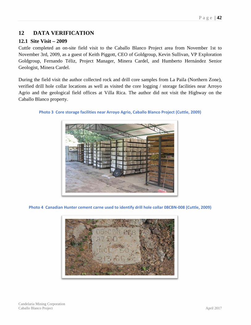
P a g e | 42
Candelaria Mining Corporation Caballo Blanco Project April 2017
12 DATA VERIFICATION
12.1 Site Visit – 2009 Cuttle completed an on-site field visit to the Caballo Blanco Project area from November 1st to November 3rd, 2009, as a guest of Keith Piggott, CEO of Goldgroup, Kevin Sullivan, VP Exploration Goldgroup, Fernando Téliz, Project Manager, Minera Cardel, and Humberto Hernández Senior Geologist, Minera Cardel.
During the field visit the author collected rock and drill core samples from La Paila (Northern Zone), verified drill hole collar locations as well as visited the core logging / storage facilities near Arroyo Agrio and the geological field offices at Villa Rica. The author did not visit the Highway on the Caballo Blanco property.
Photo 3 Core storage facilities near Arroyo Agrio, Caballo Blanco Project (Cuttle, 2009)
Photo 4 Canadian Hunter cement carne used to identify drill hole collar 08CBN‐008 (Cuttle, 2009)
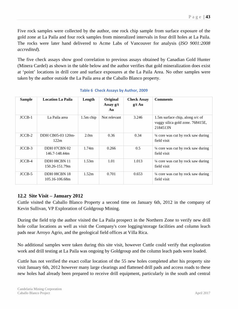
P a g e | 43
Candelaria Mining Corporation Caballo Blanco Project April 2017
Five rock samples were collected by the author, one rock chip sample from surface exposure of the gold zone at La Paila and four rock samples from mineralized intervals in four drill holes at La Paila. The rocks were later hand delivered to Acme Labs of Vancouver for analysis (ISO 9001:2008 accredited).
The five check assays show good correlation to previous assays obtained by Canadian Gold Hunter (Minera Cardel) as shown in the table below and the author verifies that gold mineralization does exist at ‘point’ locations in drill core and surface exposures at the La Paila Area. No other samples were taken by the author outside the La Paila area at the Caballo Blanco property.
Table 6 Check Assays by Author, 2009
Sample Location La Paila Length Original Assay g/t
Au
Check Assay g/t Au
Comments
JCCB-1 La Paila area 1.5m chip Not relevant 3.246 1.5m surface chip, along o/c of vuggy silica gold zone. 768415E, 2184513N
JCCB-2 DDH CB05-03 120m-122m
2.0m 0.36 0.34 ¼ core was cut by rock saw during field visit
JCCB-3 DDH 07CBN 02 146.7-148.44m
1.74m 0.266 0.5 ¼ core was cut by rock saw during field visit
JCCB-4 DDH 08CBN 11 150.26-151.79m
1.53m 1.01 1.013 ¼ core was cut by rock saw during field visit
JCCB-5 DDH 08CBN 18 105.16-106.68m
1.52m 0.701 0.653 ¼ core was cut by rock saw during field visit
12.2 Site Visit – January 2012 Cuttle visited the Caballo Blanco Property a second time on January 6th, 2012 in the company of Kevin Sullivan, VP Exploration of Goldgroup Mining. During the field trip the author visited the La Paila prospect in the Northern Zone to verify new drill hole collar locations as well as visit the Company's core logging/storage facilities and column leach pads near Arroyo Agrio, and the geological field offices at Villa Rica. No additional samples were taken during this site visit, however Cuttle could verify that exploration work and drill testing at La Paila was ongoing by Goldgroup and the column leach pads were loaded.
Cuttle has not verified the exact collar location of the 55 new holes completed after his property site visit January 6th, 2012 however many large clearings and flattened drill pads and access roads to these new holes had already been prepared to receive drill equipment, particularly in the south and central
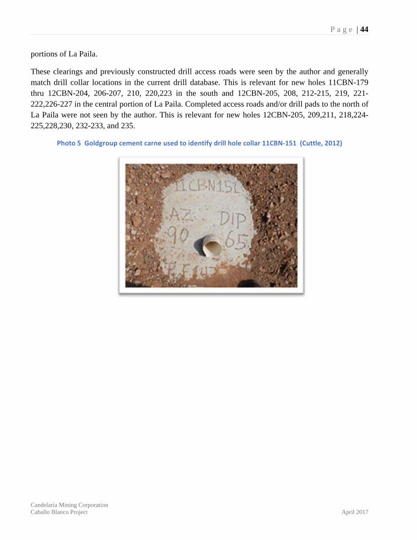
P a g e | 44
Candelaria Mining Corporation Caballo Blanco Project April 2017
portions of La Paila.
These clearings and previously constructed drill access roads were seen by the author and generally match drill collar locations in the current drill database. This is relevant for new holes 11CBN-179 thru 12CBN-204, 206-207, 210, 220,223 in the south and 12CBN-205, 208, 212-215, 219, 221-222,226-227 in the central portion of La Paila. Completed access roads and/or drill pads to the north of La Paila were not seen by the author. This is relevant for new holes 12CBN-205, 209,211, 218,224-225,228,230, 232-233, and 235.
Photo 5 Goldgroup cement carne used to identify drill hole collar 11CBN‐151 (Cuttle, 2012)
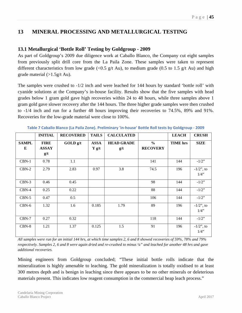
P a g e | 45
Candelaria Mining Corporation Caballo Blanco Project April 2017
13 MINERAL PROCESSING AND METALLURGICAL TESTING
13.1 Metallurgical ‘Bottle Roll’ Testing by Goldgroup - 2009 As part of Goldgroup’s 2009 due diligence work at Caballo Blanco, the Company cut eight samples from previously split drill core from the La Paila Zone. These samples were taken to represent different characteristics from low grade (<0.5 g/t Au), to medium grade (0.5 to 1.5 g/t Au) and high grade material (>1.5g/t Au).
The samples were crushed to -1/2 inch and were leached for 144 hours by standard ‘bottle roll’ with cyanide solutions at the Company’s in-house facility. Results show that the five samples with head grades below 1 gram gold gave high recoveries within 24 to 48 hours, while three samples above 1 gram gold gave slower recovery after the 144 hours. The three higher grade samples were then crushed to -1/4 inch and run for a further 48 hours improving their recoveries to 74.5%, 89% and 91%. Recoveries for the low-grade material were close to 100%.
Table 7 Caballo Blanco (La Paila Zone). Preliminary 'in‐house' Bottle Roll tests by Goldgroup ‐ 2009
INITIAL RECOVERED TAILS CALCULATED LEACH CRUSH
SAMPLE
FIRE ASSAY
g/t
GOLD g/t ASSAY g/t
HEAD GRADE g/t
% RECOVERY
TIME hrs SIZE
CBN-1 0.78 1.1 141 144 -1/2”
CBN-2 2.79 2.83 0.97 3.8 74.5 196 -1/2”, to 1/4”
CBN-3 0.46 0.45 98 144 -1/2”
CBN-4 0.25 0.22 88 144 -1/2”
CBN-5 0.47 0.5 106 144 -1/2”
CBN-6 1.32 1.6 0.185 1.79 89 196 -1/2”, to 1/4”
CBN-7 0.27 0.32 118 144 -1/2”
CBN-8 1.21 1.37 0.125 1.5 91 196 -1/2”, to 1/4”
All samples were run for an initial 144 hrs, at which time samples 2, 6 and 8 showed recoveries of 59%, 78% and 79% respectively. Samples 2, 6 and 8 were again dried and re-crushed to minus ¼” and leached for another 48 hrs and gave additional recoveries.
Mining engineers from Goldgroup concluded; “These initial bottle rolls indicate that the mineralization is highly amenable to leaching. The gold mineralization is totally oxidised to at least 300 metres depth and is benign in leaching since there appears to be no other minerals or deleterious materials present. This indicates low reagent consumption in the commercial heap leach process.”
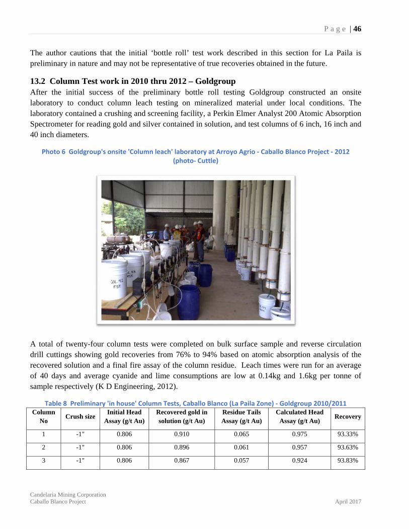
P a g e | 46
Candelaria Mining Corporation Caballo Blanco Project April 2017
The author cautions that the initial ‘bottle roll’ test work described in this section for La Paila is preliminary in nature and may not be representative of true recoveries obtained in the future.
13.2 Column Test work in 2010 thru 2012 – Goldgroup After the initial success of the preliminary bottle roll testing Goldgroup constructed an onsite laboratory to conduct column leach testing on mineralized material under local conditions. The laboratory contained a crushing and screening facility, a Perkin Elmer Analyst 200 Atomic Absorption Spectrometer for reading gold and silver contained in solution, and test columns of 6 inch, 16 inch and 40 inch diameters.
Photo 6 Goldgroup's onsite 'Column leach' laboratory at Arroyo Agrio ‐ Caballo Blanco Project ‐ 2012 (photo‐ Cuttle)
A total of twenty-four column tests were completed on bulk surface sample and reverse circulation drill cuttings showing gold recoveries from 76% to 94% based on atomic absorption analysis of the recovered solution and a final fire assay of the column residue. Leach times were run for an average of 40 days and average cyanide and lime consumptions are low at 0.14kg and 1.6kg per tonne of sample respectively (K D Engineering, 2012).
Table 8 Preliminary 'in house' Column Tests, Caballo Blanco (La Paila Zone) ‐ Goldgroup 2010/2011 Column
No Crush size
Initial Head Assay (g/t Au)
Recovered gold in solution (g/t Au)
Residue Tails Assay (g/t Au)
Calculated Head Assay (g/t Au)
Recovery
1 -1" 0.806 0.910 0.065 0.975 93.33%
2 -1" 0.806 0.896 0.061 0.957 93.63%
3 -1" 0.806 0.867 0.057 0.924 93.83%
P a g e | 47
Candelaria Mining Corporation Caballo Blanco Project April 2017
Column No
Crush size Initial Head
Assay (g/t Au) Recovered gold in solution (g/t Au)
Residue Tails Assay (g/t Au)
Calculated Head Assay (g/t Au)
Recovery
4 -1/2" 0.546 0.618 0.050 0.668 92.51%
5 -1/2" 3.528 2.888 0.365 3.253 88.78%
6 -1/2" 0.681 0.728 0.104 0.832 87.50%
7 -1 1/4" 0.628 0.789 0.051 0.840 93.93%
8 -1 1/4" 0.628 0.747 0.060 0.807 92.57%
9 -4" + 1 1/4" 0.683 0.777 0.065 0.842 92.28%
10 -1/2" 0.670 0.666 0.113 0.779 85.49%
11 -3/4" 0.265 0.285 0.063 0.348 81.90%
12 -3/4" 0.283 0.278 0.068 0.346 80.35%
13 -3/4" 0.261 0.289 0.055 0.344 84.01%
14 -3/4" 0.613 0.709 0.100 0.809 87.64%
15 -3/4" 0.859 0.723 0.088 0.811 89.15%
16 -3/4" 0.823 0.664 0.084 0.748 88.77%
17 -3/4" 1.760 1.666 0.290 1.956 85.17%
18 -3/4" 1.634 1.656 0.247 1.903 87.02%
19 -3/4" 1.547 1.730 0.204 1.934 89.45%
20 -8" 0.271 0.262 0.081 0.343 76.38%
21 -3/4" 0.698 0.696 0.154 0.850 81.88%
22 -3/4" 0.672 0.744 0.142 0.886 83.97%
23 -3/4" 0.682 0.704 0.074 0.778 90.49%
24 -3/4" 0.637 0.753 0.088 0.841 89.54%
All fire assays have been conducted by Inspectorate or ALS Global.
In late 2011 METCON Research Inc. had been supporting this test work with analysis, test programs and other metallurgical procedures. The column test samples used reverse circulation drill cuttings, coarse rejects, surface rock chip samples and bulk sampling from tunneling.
By June 2012, a total of 50 column-leach tests had either been completed or were in progress of completion by Goldgroup. Of the 24 tests described above, the authors did not obtain any information on the additional 26 column testing by Goldgroup (K D Engineering 2012).
The author cautions that these are “in house” column tests conducted by Goldgroup’s metallurgical staff and have yet to be verified by an independent outside consultant.
P a g e | 48
Candelaria Mining Corporation Caballo Blanco Project April 2017
14 MINERAL RESOURCE ESTIMATE At the request of Candelaria Mining Corp. a resource estimate for the La Paila zone was completed on the Caballo Blanco property in Mexico by Giroux Consultants Ltd. This follows up initial estimates completed by Cuttle and Giroux, March 2010, and February 2012. This update is based on an additional 55 drill holes completed since the 2012 estimate with an effective date for this update of March 20, 2017.
G.H. Giroux is the qualified person responsible for the resource estimate. Mr. Giroux is a qualified person by virtue of education, experience, and membership in a professional association. He is independent of both the issuer and the vendor applying all the tests in Section 1.5 of National Instrument 43-101. Mr. Giroux visited the Caballo Blanco property on 7 to 9 November 2011.
The authors are not aware of any environmental, permitting, legal, title, taxation, socio-economic, marketing or political factors that could materially affect this mineral resource estimate.
14.1 Data Analysis For this updated mineral resource, a total of 200 drill holes were available for analysis with 1,193 downhole surveys and 18,504 assays for gold and silver.
Two hundred and sixty-one assays with values reported as -1.0 or NS were set to 0.001 g/t gold and 0.05 g/t silver. Two gaps in the assay record were found and values of 0.001 g/t gold and 0.1 g/t silver were inserted.
Hector Mendivil-Quijada, Geo, RS/GIS, M.Sc. from GEO Digital Imaging de Mexico, S.A. de C.V., has updated the three-dimensional solid model based on the mineralized silica breccia as identified in drill logging and a 0.1 g/t Au cut-off. La Paila is considered a high sulphidation epithermal system with fine gold hosted within a massive silica breccia alteration of an andesitic host. The solid is shown below in Figure 10 and Figure 11.
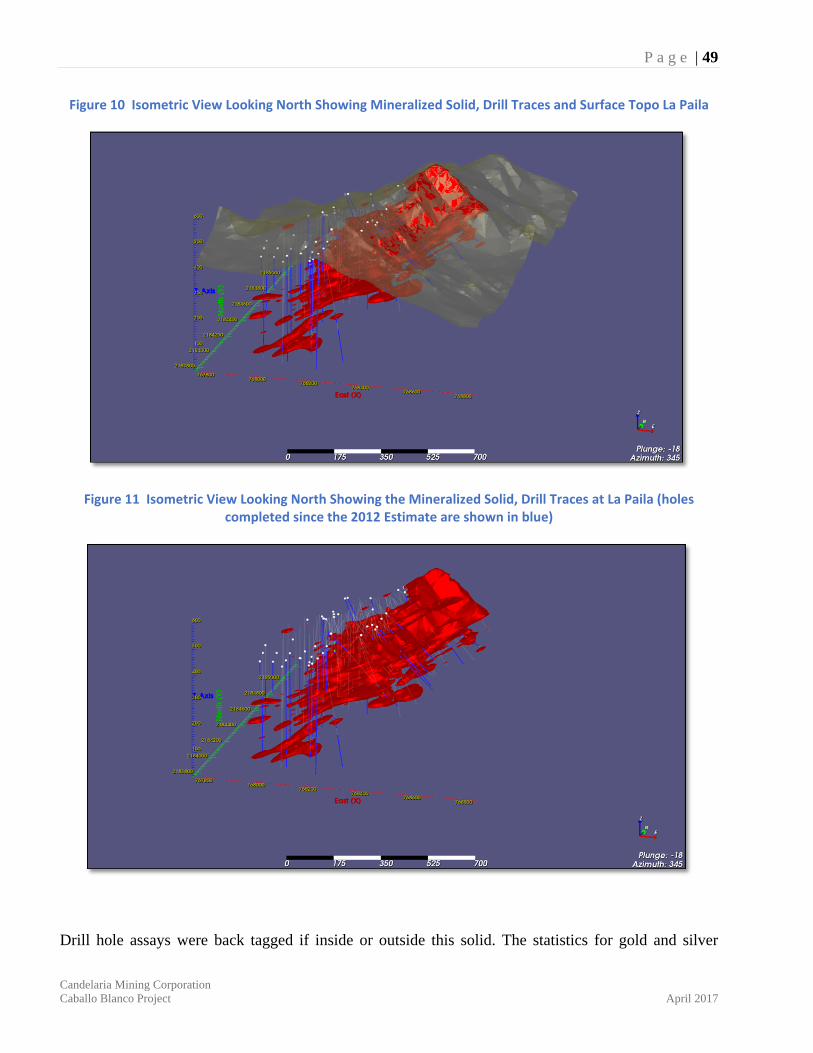
P a g e | 49
Candelaria Mining Corporation Caballo Blanco Project April 2017
Figure 10 Isometric View Looking North Showing Mineralized Solid, Drill Traces and Surface Topo La Paila
Figure 11 Isometric View Looking North Showing the Mineralized Solid, Drill Traces at La Paila (holes completed since the 2012 Estimate are shown in blue)
Drill hole assays were back tagged if inside or outside this solid. The statistics for gold and silver
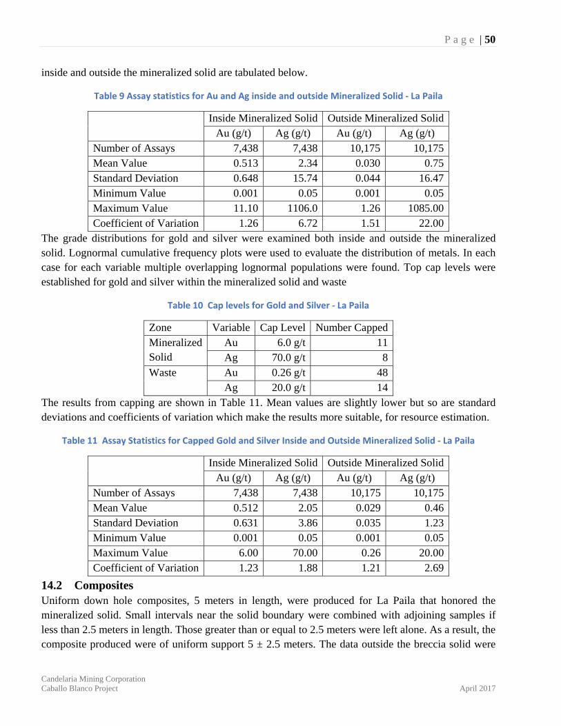
P a g e | 50
Candelaria Mining Corporation Caballo Blanco Project April 2017
inside and outside the mineralized solid are tabulated below.
Table 9 Assay statistics for Au and Ag inside and outside Mineralized Solid ‐ La Paila
Inside Mineralized Solid Outside Mineralized Solid Au (g/t) Ag (g/t) Au (g/t) Ag (g/t)
Number of Assays 7,438 7,438 10,175 10,175 Mean Value 0.513 2.34 0.030 0.75 Standard Deviation 0.648 15.74 0.044 16.47 Minimum Value 0.001 0.05 0.001 0.05 Maximum Value 11.10 1106.0 1.26 1085.00 Coefficient of Variation 1.26 6.72 1.51 22.00
The grade distributions for gold and silver were examined both inside and outside the mineralized solid. Lognormal cumulative frequency plots were used to evaluate the distribution of metals. In each case for each variable multiple overlapping lognormal populations were found. Top cap levels were established for gold and silver within the mineralized solid and waste
Table 10 Cap levels for Gold and Silver ‐ La Paila
Zone Variable Cap Level Number CappedMineralized Solid
Au 6.0 g/t 11Ag 70.0 g/t 8
Waste Au 0.26 g/t 48Ag 20.0 g/t 14
The results from capping are shown in Table 11. Mean values are slightly lower but so are standard deviations and coefficients of variation which make the results more suitable, for resource estimation.
Table 11 Assay Statistics for Capped Gold and Silver Inside and Outside Mineralized Solid ‐ La Paila
Inside Mineralized Solid Outside Mineralized Solid Au (g/t) Ag (g/t) Au (g/t) Ag (g/t)
Number of Assays 7,438 7,438 10,175 10,175 Mean Value 0.512 2.05 0.029 0.46 Standard Deviation 0.631 3.86 0.035 1.23 Minimum Value 0.001 0.05 0.001 0.05 Maximum Value 6.00 70.00 0.26 20.00 Coefficient of Variation 1.23 1.88 1.21 2.69
14.2 Composites Uniform down hole composites, 5 meters in length, were produced for La Paila that honored the mineralized solid. Small intervals near the solid boundary were combined with adjoining samples if less than 2.5 meters in length. Those greater than or equal to 2.5 meters were left alone. As a result, the composite produced were of uniform support 5 ± 2.5 meters. The data outside the breccia solid were
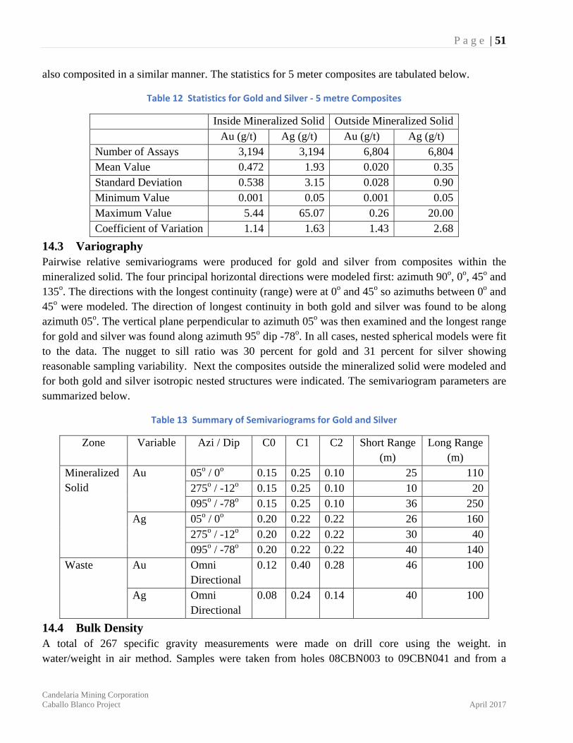
P a g e | 51
Candelaria Mining Corporation Caballo Blanco Project April 2017
also composited in a similar manner. The statistics for 5 meter composites are tabulated below.
Table 12 Statistics for Gold and Silver ‐ 5 metre Composites
Inside Mineralized Solid Outside Mineralized Solid Au (g/t) Ag (g/t) Au (g/t) Ag (g/t) Number of Assays 3,194 3,194 6,804 6,804 Mean Value 0.472 1.93 0.020 0.35 Standard Deviation 0.538 3.15 0.028 0.90 Minimum Value 0.001 0.05 0.001 0.05 Maximum Value 5.44 65.07 0.26 20.00 Coefficient of Variation 1.14 1.63 1.43 2.68
14.3 Variography Pairwise relative semivariograms were produced for gold and silver from composites within the mineralized solid. The four principal horizontal directions were modeled first: azimuth 90o, 0o, 45o and 135o. The directions with the longest continuity (range) were at 0o and 45o so azimuths between 0o and 45o were modeled. The direction of longest continuity in both gold and silver was found to be along azimuth 05o. The vertical plane perpendicular to azimuth 05o was then examined and the longest range for gold and silver was found along azimuth 95o dip -78o. In all cases, nested spherical models were fit to the data. The nugget to sill ratio was 30 percent for gold and 31 percent for silver showing reasonable sampling variability. Next the composites outside the mineralized solid were modeled and for both gold and silver isotropic nested structures were indicated. The semivariogram parameters are summarized below.
Table 13 Summary of Semivariograms for Gold and Silver
Zone Variable Azi / Dip C0 C1 C2 Short Range (m)
Long Range (m)
Mineralized Solid
Au 05o / 0o 0.15 0.25 0.10 25 110275o / -12o 0.15 0.25 0.10 10 20095o / -78o 0.15 0.25 0.10 36 250
Ag 05o / 0o 0.20 0.22 0.22 26 160275o / -12o 0.20 0.22 0.22 30 40095o / -78o 0.20 0.22 0.22 40 140
Waste Au Omni Directional
0.12 0.40 0.28 46 100
Ag Omni Directional
0.08 0.24 0.14 40 100
14.4 Bulk Density A total of 267 specific gravity measurements were made on drill core using the weight. in water/weight in air method. Samples were taken from holes 08CBN003 to 09CBN041 and from a
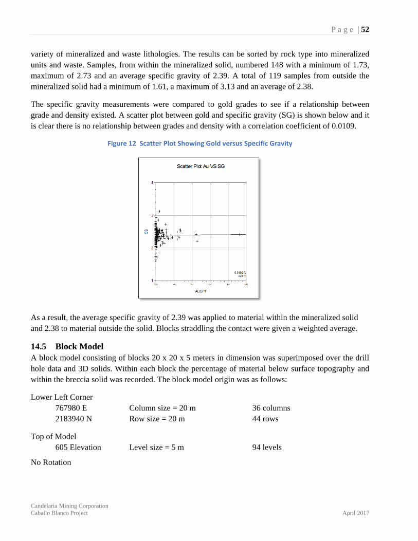
P a g e | 52
Candelaria Mining Corporation Caballo Blanco Project April 2017
variety of mineralized and waste lithologies. The results can be sorted by rock type into mineralized units and waste. Samples, from within the mineralized solid, numbered 148 with a minimum of 1.73, maximum of 2.73 and an average specific gravity of 2.39. A total of 119 samples from outside the mineralized solid had a minimum of 1.61, a maximum of 3.13 and an average of 2.38.
The specific gravity measurements were compared to gold grades to see if a relationship between grade and density existed. A scatter plot between gold and specific gravity (SG) is shown below and it is clear there is no relationship between grades and density with a correlation coefficient of 0.0109.
Figure 12 Scatter Plot Showing Gold versus Specific Gravity
As a result, the average specific gravity of 2.39 was applied to material within the mineralized solid and 2.38 to material outside the solid. Blocks straddling the contact were given a weighted average.
14.5 Block Model A block model consisting of blocks 20 x 20 x 5 meters in dimension was superimposed over the drill hole data and 3D solids. Within each block the percentage of material below surface topography and within the breccia solid was recorded. The block model origin was as follows:
Lower Left Corner 767980 E Column size = 20 m 36 columns 2183940 N Row size = 20 m 44 rows
Top of Model 605 Elevation Level size = 5 m 94 levels
No Rotation
P a g e | 53
Candelaria Mining Corporation Caballo Blanco Project April 2017
14.6 Grade Interpretation Grades for Au and Ag were interpolated into all blocks with some percentage within the mineralized solid by ordinary kriging. Kriging within the mineralized solid was completed in 4 passes with the search ellipse for each pass oriented in the principal directions of continuity as defined by the semivariograms and the ellipse dimensions a function of the semivariogram range. For the first pass a minimum of 4 composites were required from within a search ellipse with dimensions equal to 1/4 of the semivariogram range. For blocks not estimated in Pass 1, a second pass with the search ellipse expanded to 1/2 the semivariogram range was completed. A third pass using the full range and a fourth pass using twice the range completed the kriging exercise. Only composite within the mineralized zone were used for this estimate. In all passes a maximum of 12 composites were allowed and if more than 12 were found the closest 12 were used. In all passes a maximum of 3 composites from any one hole were allowed thereby assuring that a minimum of 2 drill holes were always used.
For blocks estimated within the mineralized zone but containing some percentage of waste a second kriging run was made using only composites outside the mineralized solid. These blocks were estimated in a similar manner using the semivariograms for gold and silver in waste. Blocks containing both a mineralized grade and waste grade were given the weighted average.
The kriging parameters are summarized below, with the search direction and distances as well as the number of blocks estimated, given for each pass.
Based on the study herein reported, delineated mineralization at La Paila Deposit is classified as a resource according to the following definitions from National Instrument 43-101 and from CIM (2014):
“In this Instrument, the terms "Mineral Resource", "Inferred Mineral Resource", "Indicated Mineral Resource" and "Measured Mineral Resource" have the meanings ascribed to those terms by the Canadian Institute of Mining, Metallurgy, and Petroleum, as the CIM Definition Standards (May 2014) on Mineral Resources and Mineral Reserves adopted by CIM Council, as those definitions may be amended.”
The terms Measured, Indicated, and Inferred are defined by CIM (2014) as follows:
“A Mineral Resource is a concentration or occurrence of solid material of economic interest in or on the Earth’s crust in such form, grade or quality and quantity that there are reasonable prospects for eventual economic extraction. The location, quantity, grade or quality, continuity and other geological characteristics of a Mineral Resource are known, estimated or interpreted from specific geological evidence and knowledge, including sampling.”
“The term Mineral Resource covers mineralization and natural material of intrinsic economic interest which has been identified and estimated through exploration and sampling and within which Mineral Reserves may subsequently be defined by the consideration and application of Modifying Factors. The phrase ‘reasonable prospects for economic extraction’ implies a
P a g e | 54
Candelaria Mining Corporation Caballo Blanco Project April 2017
judgement by the Qualified Person in respect of the technical and economic factors likely to influence the prospect of economic extraction. The Qualified Person should consider and clearly state the basis for determining that the material has reasonable prospects for eventual economic extraction. Assumptions should include estimates of cut-off grade and geological continuity at the selected cut-off, metallurgical recovery, smelter payments, commodity price or product value, mining and processing method and mining, processing, and general and administrative costs. The Qualified Person should state if the assessment is based on any direct evidence and testing. Interpretation of the word ‘eventual’ in this context may vary depending on the commodity or mineral involved. For example, for some coal, iron, potash deposits and other bulk minerals or commodities, it may be reasonable to envisage ‘eventual economic extraction’ as covering time periods in excess of 50 years. However, for many gold deposits, application of the concept would normally be restricted to perhaps 10 to 15 years, and frequently to much shorter periods of time.”
Inferred Mineral Resource
“An ‘Inferred Mineral Resource’ is that part of a Mineral Resource for which quantity and grade or quality are estimated on the basis of limited geological evidence and sampling. Geological evidence is sufficient to imply but not verify geological and grade or quality continuity. An Inferred Mineral Resource has a lower level of confidence than that applying to an Indicated Mineral Resource and must not be converted to a Mineral Reserve. It is reasonably expected that the majority of Inferred Mineral Resources could be upgraded to Indicated Mineral Resources with continued exploration.”
“An ‘Inferred Mineral Resource’ is based on limited information and sampling gathered through appropriate sampling techniques from locations such as outcrops, trenches, pits, workings and drill holes. Inferred Mineral Resources must not be included in the economic analysis, production schedules, or estimated mine life in publicly disclosed Pre-Feasibility or Feasibility Studies, or in the Life of Mine plans and cash flow models of developed mines. Inferred Mineral Resources can only be used in economic studies as provided under NI 43-101.”
“There may be circumstances, where appropriate sampling, testing, and other measurements are sufficient to demonstrate data integrity, geological and grade/quality continuity of a Measured or Indicated Mineral Resource, however, quality assurance and quality control, or other information may not meet all industry norms for the disclosure of an Indicated or Measured Mineral Resource. Under these circumstances, it may be reasonable for the Qualified Person to report an Inferred Mineral Resource if the Qualified Person has taken steps to verify the information meets the requirements of an Inferred Mineral Resource.”
Indicated Mineral Resource
“An ‘Indicated Mineral Resource’ is that part of a Mineral Resource for which quantity, grade or quality, densities, shape and physical characteristics are estimated with sufficient confidence
P a g e | 55
Candelaria Mining Corporation Caballo Blanco Project April 2017
to allow the application of Modifying Factors in sufficient detail to support mine planning and evaluation of the economic viability of the deposit. Geological evidence is derived from adequately detailed and reliable exploration, sampling and testing and is sufficient to assume geological and grade or quality continuity between points of observation. An Indicated Mineral Resource has a lower level of confidence than that applying to a Measured Mineral Resource and may only be converted to a Probable Mineral Reserve.”
“Mineralization may be classified as an Indicated Mineral Resource by the Qualified Person when the nature, quality, quantity and distribution of data are such as to allow confident interpretation of the geological framework and to reasonably assume the continuity of mineralization. The Qualified Person must recognize the importance of the Indicated Mineral Resource category to the advancement of the feasibility of the project. An Indicated Mineral Resource estimate is of sufficient quality to support a Preliminary Feasibility Study which can serve as the basis for major development decisions.”
Measured Mineral Resource
“A Measured Mineral Resource is that part of a Mineral Resource for which quantity, grade or quality, densities, shape, and physical characteristics are estimated with confidence sufficient to allow the application of Modifying Factors to support detailed mine planning and final evaluation of the economic viability of the deposit. Geological evidence is derived from detailed and reliable exploration, sampling and testing and is sufficient to confirm geological and grade or quality continuity between points of observation. A Measured Mineral Resource has a higher level of confidence than that applying to either an Indicated Mineral Resource or an Inferred Mineral Resource. It may be converted to a Proven Mineral Reserve or to a Probable Mineral Reserve.”
“Mineralization or other natural material of economic interest may be classified as a Measured Mineral Resource by the Qualified Person when the nature, quality, quantity and distribution of data are such that the tonnage and grade or quality of the mineralization can be estimated to within close limits and that variation from the estimate would not significantly affect potential economic viability of the deposit. This category requires a high level of confidence in, and understanding of, the geology and controls of the mineral deposit.”
Modifying Factors
“Modifying Factors are considerations used to convert Mineral Resources to Mineral Reserves. These include, but are not restricted to, mining, processing, metallurgical, infrastructure, economic, marketing, legal, environmental, social and governmental factors.”
Geologic continuity has been established through drill core logging and geologic mapping both on surface and underground. The geologic solid is used to constrain the resource estimate. Grade continuity can be quantified by the semivariogram for each variable. By tying the search ellipse to the
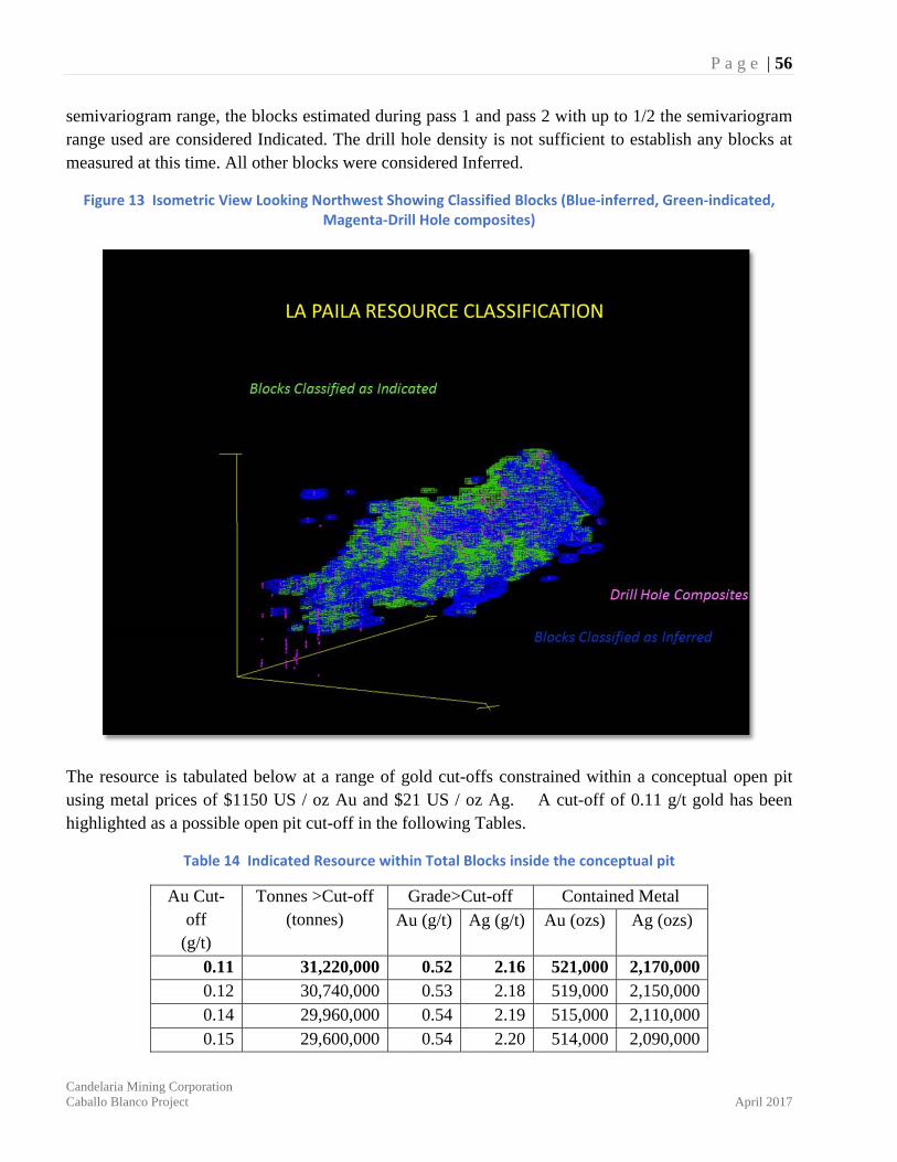
P a g e | 56
Candelaria Mining Corporation Caballo Blanco Project April 2017
semivariogram range, the blocks estimated during pass 1 and pass 2 with up to 1/2 the semivariogram range used are considered Indicated. The drill hole density is not sufficient to establish any blocks at measured at this time. All other blocks were considered Inferred.
Figure 13 Isometric View Looking Northwest Showing Classified Blocks (Blue‐inferred, Green‐indicated, Magenta‐Drill Hole composites)
The resource is tabulated below at a range of gold cut-offs constrained within a conceptual open pit using metal prices of $1150 US / oz Au and $21 US / oz Ag. A cut-off of 0.11 g/t gold has been highlighted as a possible open pit cut-off in the following Tables.
Table 14 Indicated Resource within Total Blocks inside the conceptual pit
Au Cut-off
(g/t)
Tonnes >Cut-off (tonnes)
Grade>Cut-off Contained Metal Au (g/t) Ag (g/t) Au (ozs) Ag (ozs)
0.11 31,220,000 0.52 2.16 521,000 2,170,000 0.12 30,740,000 0.53 2.18 519,000 2,150,000 0.14 29,960,000 0.54 2.19 515,000 2,110,000 0.15 29,600,000 0.54 2.20 514,000 2,090,000
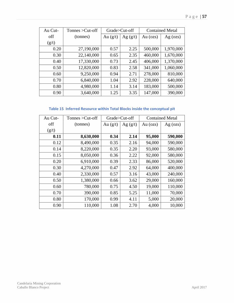
P a g e | 57
Candelaria Mining Corporation Caballo Blanco Project April 2017
Au Cut-off
(g/t)
Tonnes >Cut-off (tonnes)
Grade>Cut-off Contained Metal Au (g/t) Ag (g/t) Au (ozs) Ag (ozs)
0.20 27,190,000 0.57 2.25 500,000 1,970,000 0.30 22,140,000 0.65 2.35 460,000 1,670,000 0.40 17,330,000 0.73 2.45 406,000 1,370,000 0.50 12,820,000 0.83 2.58 341,000 1,060,000 0.60 9,250,000 0.94 2.71 278,000 810,000 0.70 6,840,000 1.04 2.92 228,000 640,000 0.80 4,980,000 1.14 3.14 183,000 500,000 0.90 3,640,000 1.25 3.35 147,000 390,000
Table 15 Inferred Resource within Total Blocks inside the conceptual pit
Au Cut-off
(g/t)
Tonnes >Cut-off (tonnes)
Grade>Cut-off Contained Metal Au (g/t) Ag (g/t) Au (ozs) Ag (ozs)
0.11 8,630,000 0.34 2.14 95,000 590,000 0.12 8,490,000 0.35 2.16 94,000 590,000 0.14 8,220,000 0.35 2.20 93,000 580,000 0.15 8,050,000 0.36 2.22 92,000 580,000 0.20 6,910,000 0.39 2.33 86,000 520,000 0.30 4,270,000 0.47 2.92 64,000 400,000 0.40 2,330,000 0.57 3.16 43,000 240,000 0.50 1,380,000 0.66 3.62 29,000 160,000 0.60 780,000 0.75 4.50 19,000 110,000 0.70 390,000 0.85 5.25 11,000 70,000 0.80 170,000 0.99 4.11 5,000 20,000 0.90 110,000 1.08 2.70 4,000 10,000
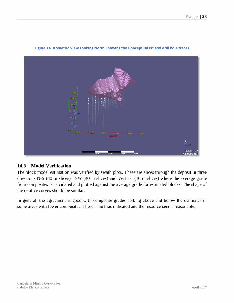
P a g e | 58
Candelaria Mining Corporation Caballo Blanco Project April 2017
Figure 14 Isometric View Looking North Showing the Conceptual Pit and drill hole traces
14.8 Model Verification The block model estimation was verified by swath plots. These are slices through the deposit in three directions N-S (40 m slices), E-W (40 m slices) and Vertical (10 m slices) where the average grade from composites is calculated and plotted against the average grade for estimated blocks. The shape of the relative curves should be similar.
In general, the agreement is good with composite grades spiking above and below the estimates in some areas with fewer composites. There is no bias indicated and the resource seems reasonable.
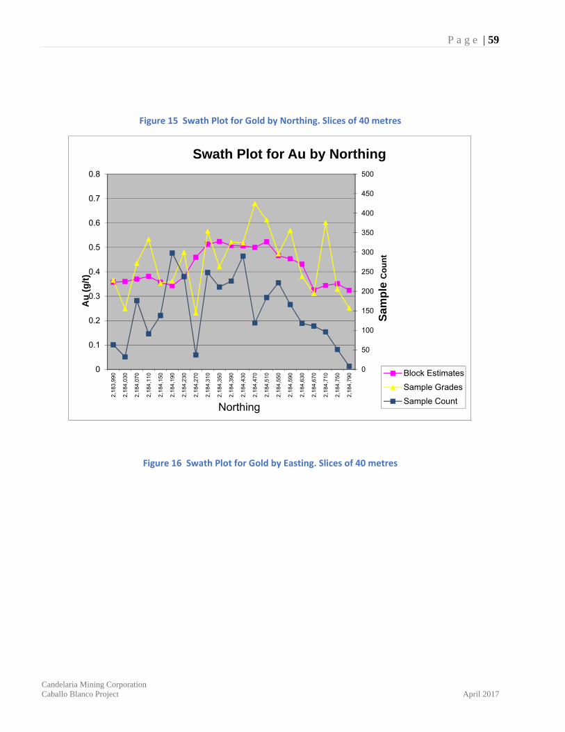
P a g e | 59
Candelaria Mining Corporation Caballo Blanco Project April 2017
Figure 15 Swath Plot for Gold by Northing. Slices of 40 metres
Figure 16 Swath Plot for Gold by Easting. Slices of 40 metres
0
50
100
150
200
250
300
350
400
450
500
0
0.1
0.2
0.3
0.4
0.5
0.6
0.7
0.8
2,1
83,
990
2,1
84,
030
2,1
84,
070
2,1
84,
110
2,1
84,
150
2,1
84,
190
2,1
84,
230
2,1
84,
270
2,1
84,
310
2,1
84,
350
2,1
84,
390
2,1
84,
430
2,1
84,
470
2,1
84,
510
2,1
84,
550
2,1
84,
590
2,1
84,
630
2,1
84,
670
2,1
84,
710
2,1
84,
750
2,1
84,
790
Sam
ple
Co
un
t
Au
(g
/t)
Northing
Swath Plot for Au by Northing
Block Estimates
Sample Grades
Sample Count

P a g e | 60
Candelaria Mining Corporation Caballo Blanco Project April 2017
Figure 17 Swath Plot for Gold by Elevation. Slices of 10 metres
0
100
200
300
400
500
600
700
800
0
0.2
0.4
0.6
0.8
1
1.2
1.4
1.6
1.8
2
768
070
768
110
768
150
768
190
768
230
768
270
768
310
768
350
768
390
768
430
768
470
Sam
ple
Co
un
t
Au
(g
/t)
Easting
Swath Plot for Au by Easting
BlockEstimates
0
20
40
60
80
100
120
140
160
180
200
0
0.2
0.4
0.6
0.8
1
1.2
1.4
1.6
1.8
2
105
115
125
135
145
155
165
175
185
195
205
215
225
235
245
255
265
275
285
295
305
315
325
335
345
355
365
375
385
395
405
415
425
435
445
455
465
475
485
495
505
515
525
535
545
Sam
ple
Co
un
t
Ag
(g
/t)
Elevation
Swath plot for Au by Elevation
Block Estimates
Sample Grades
Sample Count
P a g e | 61
Candelaria Mining Corporation Caballo Blanco Project April 2017
15 ADJACENT PROPERTIES There are no current records of any other neighbouring mineral properties of merit in the Caballo Blanco Project area, however the author was not able to verify this fact. If mineralization is known adjacent to the property it is not necessarily indicative of mineralization found on the Caballo Blanco property.
16 OTHER RELEVANT DATA AND INFORMATION There is no other relevant data.
P a g e | 62
Candelaria Mining Corporation Caballo Blanco Project April 2017
17 CONCLUSIONS 1) Geological field work since 1995 has identified at least three large areas of epithermal precious
metal and porphyry style copper gold mineralization on and beside the Caballo Blanco Project. These areas are known as the Northern Zone, Highway Zone as well as the Central Grid Zone which is located immediately south of the current Caballo Blanco claim boundary.
2) In the north and central part of the property, two large areas of epithermal alteration have been discovered, locally named the Northern Zone (4 by 5 kilometres in area) and the Highway Zone (4 by 2 kilometres in area). In the south and southwest of the property and currently not part of the Candelaria claim holdings, the Central Grid area hosts what is believed to be at least two porphyry copper-gold prospects (Pedrero, El Porvenir). These two porphyry prospects likely formed similar ‘high level’ argillic and silicic alteration haloes and topographic ‘caps’ similar to the Northern and Highway zones. The degree of erosion in the Central Grid area is deeper, and likely reveals the underlying porphyry intrusive plugs with stock-work copper-gold mineralization and associated alteration in the host rock.
3) The elongate and silicified gold rich mineralization at La Paila, in the Northern Zone, and its associated alteration patterns likely formed from fluid rising along a north trending fault structure well above a deeper intrusive ‘heat source’ (Sillitoe, 2008). Similar geochemical and geophysical anomalies and silica/clay alteration patterns have been recognized at La Cruz, Las Cuevas, Red Valley, and Highway Zone, all of which lie along a north-south trend for over nine kilometres. This corridor represents an important exploration target for the future.
4) Since 1998, four different companies have drilled 236 drill holes (217 diamond holes and 19 reverse circulation holes) on the CMC property described in this report. Much of this drilling was completed by Goldgroup Mining from 2010 to 2012 in the Northern Zone at La Paila. The RC holes proved very problematic with low sample recoveries and slow rates of advance particularly within the mineralized siliceous zones. The RC technique was abandoned in favour of large diameter diamond drill core. All fourteen RC holes at La Paila were twinned with diamond drill core and recoveries improved significantly.
5) In December 2014 Goldgroup Mining Inc. sold 100 percent of the Caballo Blanco project to Timmins Gold Corp for US$10 million in cash and 16 million shares No additional work was completed on the Caballo Blanco property by Timmins. In July 2016 Timmins Gold through its subsidiary Molimentales Del Noroeste SA de CV sold 100 percent interest in the Caballo Blanco project to CMC for a total cash consideration US$17.5 million. There has been no work completed on the property since.
6) A variety of geophysical, geochemical, and geological surveys continue to be extremely useful in identifying drill targets in and around the Northern Zone; most importantly airborne magnetic, IP resistivity high anomalies, clay alteration haloes identified by a TerraSpec®
spectrometer, location of mineralized surface rock geochemistry and detailed geological and structural mapping. These surveys have not only been used to outline a classic zonation of clay minerals representative of a large epithermal system but they have more importantly been useful in defining zones of silica flooding and associated gold mineralization. These surveys
P a g e | 63
Candelaria Mining Corporation Caballo Blanco Project April 2017
should remain principle exploration tools for future work at Caballo Blanco. 7) Rock exposures in these areas include mixtures and overprints of classic vuggy, brecciated and
or massive silica with associated and flanking haloes of advanced argillic to argillic alteration. These diverse clay alteration zones have been identified and mapped in part using a TerraSpec® spectrometer. Drill testing at three of these ‘silica cap’ features in the Northern Zone at La Paila, Bandera and La Cruz, suggest that acid leaching from hydrothermal fluids extend to depths of over 300 meters. The Red Valley target lies at lower elevations on the outside fringe of the circular ring feature and has been identified with soil geochemistry.
8) Mining engineers from Goldgroup working with mineralized samples from La Paila concluded; “These initial bottle rolls indicate that the mineralization is highly amenable to leaching. The gold mineralization is totally oxidised to at least 300 metres depth and is benign in leaching since there appears to be no other minerals or deleterious materials present. This indicates low reagent consumption in the commercial heap leach process.
9) Candelaria Mining should continue metallurgical testing during the next phase of work to confirm extraction results, reagent consumption, leach time and ideal particle size on mineral resource samples. Previous bottle-roll test-work by Goldgroup suggest variations of gold extraction from different particle size and should be investigated.
10) After January 2012, an additional 55 diamond drill holes were completed La Paila namely holes 11CBN-179-181, 183,185-187 and 12CBN-188 to 197, 197A, 12CBN-198 to CBN-235. This ongoing 2012 drill program continued to test the extents of the low-grade bulk mineable gold at La Paila in the Northern Zone. Assay results suggest areas in north near hole 12CBN-222, 227 and 232, in the central area near 11CBN-179,183 and in the south area near holes 11CBN-180,182 and 12CBN-192 remain to be tested with tighter infill drilling.
11) In 2017 Giroux Consultants was retained by CMC to complete an updated mineral resource at La Paila. The resource estimate is based on 200 diamond drill holes completed since the discovery of the La Paila mineralized zone, including some of the new holes described above. The drill hole density is not sufficient to establish any blocks in the measured category and all blocks are considered either indicated or inferred. Below is the resource available for blocks contained within a conceptual open pit using metal prices of $1150 US / oz Au and $21 US / oz Ag. Estimations using a cut-off of 0.11 grams per tonne (g/t) gold can be separated into the following categories for La Paila: Indicated – 31,220,000 tonnes, 0.52 g/t gold, 2.16 g/t silver or 521,000 ounces gold and 2,170,000 ounces silver within conceptual pit 36. Inferred – 8,630,000 tonnes, 0.34 g/t gold, 2.14 g/t silver or 95,000 ounces gold and 590,000 ounces silver within the conceptual pit.
12) At least eleven other areas outside of the La Paila zone justify further geological work at Caballo Blanco. These areas include; four large IP resistivity high anomalies on the inner flanks of a 3 kilometre round magnetic high ‘ring structure’ in the Northern Zone; strong ‘acid’ PH anomalies 1.5 kilometres west of La Paila in the Northern Zone; three separate areas where isolated rock chip samples assay up to 14.6 grams per tonne gold along the northwest and south portions of the Caballo Blanco property; and three other separate areas with encouraging ‘new’
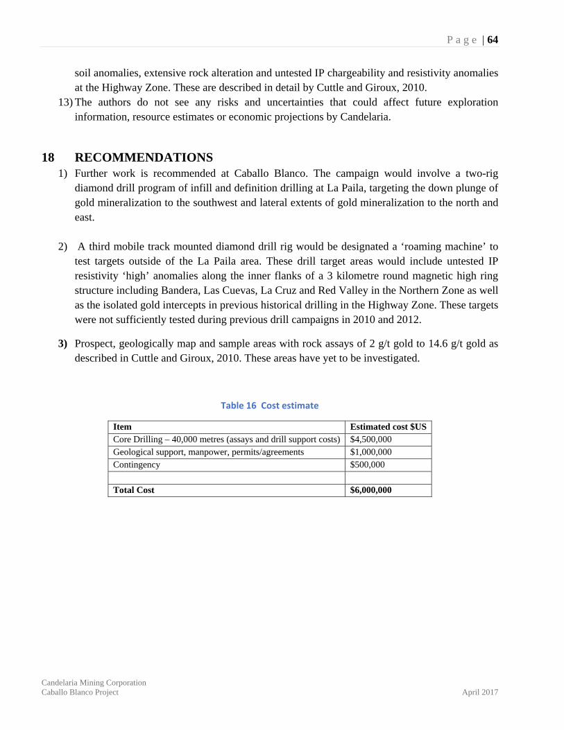
P a g e | 64
Candelaria Mining Corporation Caballo Blanco Project April 2017
soil anomalies, extensive rock alteration and untested IP chargeability and resistivity anomalies at the Highway Zone. These are described in detail by Cuttle and Giroux, 2010.
13) The authors do not see any risks and uncertainties that could affect future exploration information, resource estimates or economic projections by Candelaria.
18 RECOMMENDATIONS 1) Further work is recommended at Caballo Blanco. The campaign would involve a two-rig
diamond drill program of infill and definition drilling at La Paila, targeting the down plunge of gold mineralization to the southwest and lateral extents of gold mineralization to the north and east.
2) A third mobile track mounted diamond drill rig would be designated a ‘roaming machine’ to test targets outside of the La Paila area. These drill target areas would include untested IP resistivity ‘high’ anomalies along the inner flanks of a 3 kilometre round magnetic high ring structure including Bandera, Las Cuevas, La Cruz and Red Valley in the Northern Zone as well as the isolated gold intercepts in previous historical drilling in the Highway Zone. These targets were not sufficiently tested during previous drill campaigns in 2010 and 2012.
3) Prospect, geologically map and sample areas with rock assays of 2 g/t gold to 14.6 g/t gold as described in Cuttle and Giroux, 2010. These areas have yet to be investigated.
Table 16 Cost estimate
Item Estimated cost $US Core Drilling – 40,000 metres (assays and drill support costs) $4,500,000 Geological support, manpower, permits/agreements $1,000,000 Contingency $500,000 Total Cost $6,000,000
P a g e | 65
Candelaria Mining Corporation Caballo Blanco Project April 2017
19 REFERENCES Carrillo-Rosua, F.J., Morales-Ruano, S., et al., 2001. Chilean “Manto-Type” Cu-(Ag) Deposits in the coastal Range of Central Chile. CSIC-Universidad de Chile Project CSIC / 2001/02/08.
Corbett, Greg, July 2011. Comments on the geology and Exploration Potential of the Caballo Blanco Project, Veracruz, Mexico. Internal report for Goldgroup Mining.
Corbett, Greg, September 2013. Tasmanides Arc-Style Au-Cu Mineralization, in a Pacific Rim Context. Australian Institute of Geoscientists, Bulletin 55, pages 23-32.
Cross, George, 1999. Almaden Drilling at Caballo Blanco, George Cross News Letter, GCN #53, Mar 17, 1999.
Cuttle, J., Giroux, G., March 2010. NI 43-101 Technical Report - Caballo Blanco Project and a Resource Estimate at the La Paila Zone, Veracruz State, Mexico. For Goldgroup Resources Inc. and Sierra Minerals Inc.
Cuttle, J., Giroux, G., February 2012. NI 43-101 Technical Report - Caballo Blanco Project Resource Update at the La Paila Zone, Veracruz State, Mexico. For Goldgroup Mining Inc.
Ferrair, L., López, Martínez, M., Aguirre-Díaz, G., Carrasco-Nuñez, G., 1999. Space-time patterns of Cenozoic arc volcanism in central México: From the Sierra Madre Occidental to the Mexican Volcanic Belt. Geology, v.27, No. 4, p. 303-306.
Ferrair, L., Tagami, T., Eguchi, M., Orozco-Esquivel M., Petrone, C., Jacobo-Albarrán, J., López-Martínez, M., 2005. Geology, geochronology and tectonic setting of late Cenozoic volcanism along the southwestern Gulf of Mexico: The Eastern Alkaline Province revisited. Journal of Volcanology and Geothermal Research 146, p. 284-306.
Gómez-Tuena, A., LaGatta, A., Langmuir, C., Goldstein, S., Ortega-Gutierrez, F., Carraco-Nuñez, G., 2003. Temporal control of subduction magmatism in the Eastern Trans-Mexican volcanic belt: mantle sources, slab contributions and crystal contamination. Geochem. Geophys. Geosyst. 4.
Gómez-Tuena, A., Orozco-Esquivel, M., Ferrari, L., 2007. Igneous petrogenesis of the Trans-MexicanVolcanic Belt. Geological Society of America, Special Paper 422, p. 129-181.
Martinez, R. D., 2008. Visit Report – Caballo Blanco Project. Internal report for Canadian Gold Hunter, Vancouver, B.C., Canada.
Orozco-Esquivel, T., Petrone C.M.,Ferrari, L., Tagami, T., Manetti, P; 2007. Geochemical and isotopic variability in lavas from the eastern Trans-Mexican Volcanic Belt: Slab detachment in a subduction zone with varying dip. Lithos 93, p. 149-174.
Poliquin, M., 2001 High-Sulphidation Epithermal Quartz-Alunite Gold Silver Deposits and The Caballo Blanco Project, Mexico. Internal report for Almaden Mineral Ltd., Vancouver, Canada.
P a g e | 66
Candelaria Mining Corporation Caballo Blanco Project April 2017
Sillitoe, R.H. 2004, “Styles of High-Sulphidation Gold, Silver and Copper Mineralization in Porphyry and Epithermal Environments” in Proceedings of the Pacific Rim 2004 Conference.
Sillitoe, R.H. 2008, Comments on the Caballo Blanco Gold and Copper Prospects, Veracruz, Mexico. Internal Report for Almaden Minerals Ltd., Vancouver, Canada.
Smee, B. W., October 2007. A Review of Soil Geochemistry over Three Grids, Caballo Blanco Project, Veracruz, Mexico: Internal report for Minera Cardel S.A. de C V.
Téliz, F., Hernandez, H., Mehner, D., and Christoffersen, J., 2008 Exploration Report on the Caballo Blanco Project, Veracruz, Mexico. June 1, 2007 to September 30, 2008. Internal report for Canadian Gold Hunter Corp., Vancouver, Canada.
P a g e | 67
Candelaria Mining Corporation Caballo Blanco Project April 2017
APPENDIX I All diamond drill and reverse circulation collar locations, Caballo Blanco (Northern and Highway Zones)
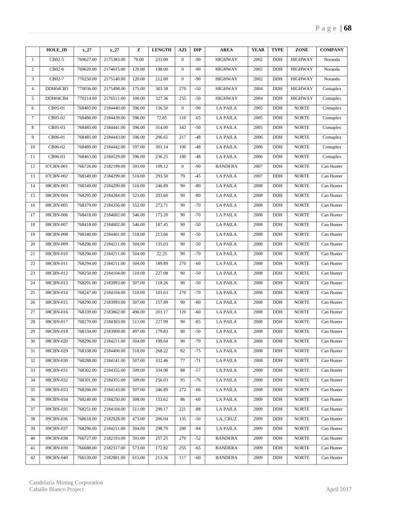
P a g e | 68
Candelaria Mining Corporation Caballo Blanco Project April 2017
HOLE_ID x_27 y_27 Z LENGTH AZI DIP AREA YEAR TYPE ZONE COMPANY
1 CB02-5 769627.00 2175383.00 70.00 231.00 0 -90 HIGHWAY 2002 DDH HIGHWAY Noranda
2 CB02-6 769620.00 2174615.00 120.00 198.00 0 -90 HIGHWAY 2002 DDH HIGHWAY Noranda
3 CB02-7 770250.00 2175140.00 120.00 212.00 0 -90 HIGHWAY 2002 DDH HIGHWAY Noranda
4 DDH04CB3 770036.00 2175498.00 175.00 303.58 270 -50 HIGHWAY 2004 DDH HIGHWAY Comaplex
5 DDH04CB4 770214.00 2176511.00 100.00 327.36 255 -50 HIGHWAY 2004 DDH HIGHWAY Comaplex
6 CB05-01 768485.00 2184440.00 596.00 136.50 0 -90 LA PAILA 2005 DDH NORTE Comaplex
7 CB05-02 768486.00 2184439.00 596.00 72.85 110 -65 LA PAILA 2005 DDH NORTE Comaplex
8 CB05-03 768485.00 2184441.00 596.00 314.00 342 -50 LA PAILA 2005 DDH NORTE Comaplex
9 CB06-01 768485.00 2184443.00 596.00 206.65 217 -48 LA PAILA 2006 DDH NORTE Comaplex
10 CB06-02 768489.00 2184442.00 597.00 301.14 100 -48 LA PAILA 2006 DDH NORTE Comaplex
11 CB06-03 768463.00 2184529.00 596.00 236.25 180 -48 LA PAILA 2006 DDH NORTE Comaplex
12 07CBN-001 766726.00 2182199.00 591.00 109.12 0 -90 BANDERA 2007 DDH NORTE Can Hunter
13 07CBN-002 768349.00 2184299.00 516.00 293.50 79 -45 LA PAILA 2007 DDH NORTE Can Hunter
14 08CBN-003 768349.00 2184299.00 516.00 246.89 90 -80 LA PAILA 2008 DDH NORTE Can Hunter
15 08CBN-004 768295.00 2184284.00 521.00 203.60 90 -80 LA PAILA 2008 DDH NORTE Can Hunter
16 08CBN-005 768379.00 2184356.00 552.00 273.71 90 -70 LA PAILA 2008 DDH NORTE Can Hunter
17 08CBN-006 768418.00 2184602.00 546.00 173.20 90 -70 LA PAILA 2008 DDH NORTE Can Hunter
18 08CBN-007 768418.00 2184602.00 546.00 187.45 90 -50 LA PAILA 2008 DDH NORTE Can Hunter
19 08CBN-008 768340.00 2184401.00 518.00 213.66 90 -50 LA PAILA 2008 DDH NORTE Can Hunter
20 08CBN-009 768296.00 2184211.00 504.00 135.03 90 -50 LA PAILA 2008 DDH NORTE Can Hunter
21 08CBN-010 768296.00 2184211.00 504.00 22.25 90 -70 LA PAILA 2008 DDH NORTE Can Hunter
22 08CBN-011 768294.00 2184211.00 504.00 189.89 270 -60 LA PAILA 2008 DDH NORTE Can Hunter
23 08CBN-012 768250.00 2184104.00 510.00 227.08 90 -50 LA PAILA 2008 DDH NORTE Can Hunter
24 08CBN-013 768291.00 2183993.00 507.00 118.26 90 -50 LA PAILA 2008 DDH NORTE Can Hunter
25 08CBN-014 768247.00 2184104.00 510.00 103.63 270 -70 LA PAILA 2008 DDH NORTE Can Hunter
26 08CBN-015 768290.00 2183993.00 507.00 157.89 90 -80 LA PAILA 2008 DDH NORTE Can Hunter
27 08CBN-016 768339.00 2183862.00 496.00 201.17 120 -60 LA PAILA 2008 DDH NORTE Can Hunter
28 08CBN-017 768270.00 2184303.00 511.00 227.99 90 -85 LA PAILA 2008 DDH NORTE Can Hunter
29 08CBN-018 768334.00 2183909.00 497.00 179.83 90 -50 LA PAILA 2008 DDH NORTE Can Hunter
30 08CBN-020 768296.00 2184211.00 504.00 199.64 90 -70 LA PAILA 2008 DDH NORTE Can Hunter
31 08CBN-029 768338.00 2184400.00 518.00 268.22 82 -75 LA PAILA 2008 DDH NORTE Can Hunter
32 08CBN-030 768288.00 2184141.00 507.00 332.46 77 -71 LA PAILA 2008 DDH NORTE Can Hunter
33 08CBN-031 768302.00 2184355.00 509.00 334.98 88 -57 LA PAILA 2008 DDH NORTE Can Hunter
34 08CBN-032 768301.00 2184355.00 509.00 256.03 95 -76 LA PAILA 2008 DDH NORTE Can Hunter
35 08CBN-033 768286.00 2184143.00 507.00 246.89 272 -66 LA PAILA 2008 DDH NORTE Can Hunter
36 09CBN-034 768240.00 2184250.00 508.00 153.62 86 -60 LA PAILA 2009 DDH NORTE Can Hunter
37 09CBN-035 768251.00 2184104.00 511.00 299.17 221 -88 LA PAILA 2009 DDH NORTE Can Hunter
38 09CBN-036 768618.00 2182928.00 473.00 206.04 135 -50 LA_CRUZ 2009 DDH NORTE Can Hunter
39 09CBN-037 768296.00 2184211.00 504.00 298.70 280 -84 LA PAILA 2009 DDH NORTE Can Hunter
40 09CBN-038 766727.00 2182193.00 591.00 257.25 270 -52 BANDERA 2009 DDH NORTE Can Hunter
41 09CBN-039 766688.00 2182317.00 573.00 172.82 255 -65 BANDERA 2009 DDH NORTE Can Hunter
42 09CBN-040 766539.00 2182881.00 615.00 213.36 117 -60 BANDERA 2009 DDH NORTE Can Hunter
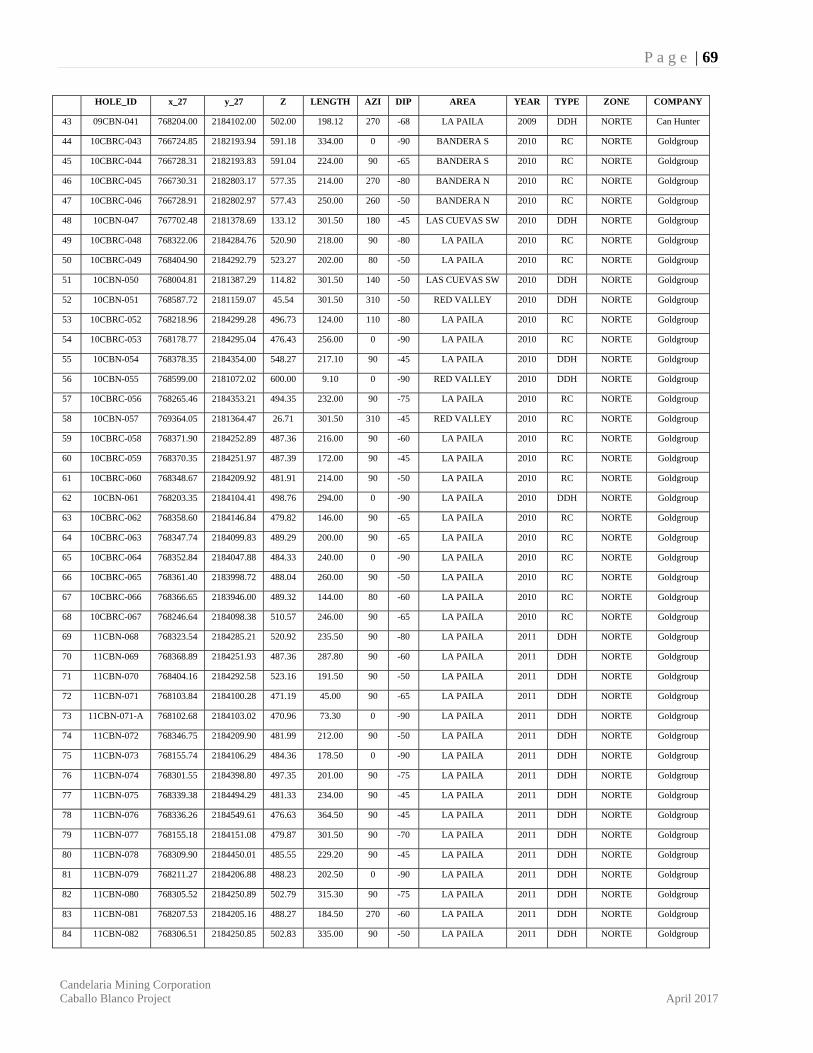
P a g e | 69
Candelaria Mining Corporation Caballo Blanco Project April 2017
HOLE_ID x_27 y_27 Z LENGTH AZI DIP AREA YEAR TYPE ZONE COMPANY
43 09CBN-041 768204.00 2184102.00 502.00 198.12 270 -68 LA PAILA 2009 DDH NORTE Can Hunter
44 10CBRC-043 766724.85 2182193.94 591.18 334.00 0 -90 BANDERA S 2010 RC NORTE Goldgroup
45 10CBRC-044 766728.31 2182193.83 591.04 224.00 90 -65 BANDERA S 2010 RC NORTE Goldgroup
46 10CBRC-045 766730.31 2182803.17 577.35 214.00 270 -80 BANDERA N 2010 RC NORTE Goldgroup
47 10CBRC-046 766728.91 2182802.97 577.43 250.00 260 -50 BANDERA N 2010 RC NORTE Goldgroup
48 10CBN-047 767702.48 2181378.69 133.12 301.50 180 -45 LAS CUEVAS SW 2010 DDH NORTE Goldgroup
49 10CBRC-048 768322.06 2184284.76 520.90 218.00 90 -80 LA PAILA 2010 RC NORTE Goldgroup
50 10CBRC-049 768404.90 2184292.79 523.27 202.00 80 -50 LA PAILA 2010 RC NORTE Goldgroup
51 10CBN-050 768004.81 2181387.29 114.82 301.50 140 -50 LAS CUEVAS SW 2010 DDH NORTE Goldgroup
52 10CBN-051 768587.72 2181159.07 45.54 301.50 310 -50 RED VALLEY 2010 DDH NORTE Goldgroup
53 10CBRC-052 768218.96 2184299.28 496.73 124.00 110 -80 LA PAILA 2010 RC NORTE Goldgroup
54 10CBRC-053 768178.77 2184295.04 476.43 256.00 0 -90 LA PAILA 2010 RC NORTE Goldgroup
55 10CBN-054 768378.35 2184354.00 548.27 217.10 90 -45 LA PAILA 2010 DDH NORTE Goldgroup
56 10CBN-055 768599.00 2181072.02 600.00 9.10 0 -90 RED VALLEY 2010 DDH NORTE Goldgroup
57 10CBRC-056 768265.46 2184353.21 494.35 232.00 90 -75 LA PAILA 2010 RC NORTE Goldgroup
58 10CBN-057 769364.05 2181364.47 26.71 301.50 310 -45 RED VALLEY 2010 RC NORTE Goldgroup
59 10CBRC-058 768371.90 2184252.89 487.36 216.00 90 -60 LA PAILA 2010 RC NORTE Goldgroup
60 10CBRC-059 768370.35 2184251.97 487.39 172.00 90 -45 LA PAILA 2010 RC NORTE Goldgroup
61 10CBRC-060 768348.67 2184209.92 481.91 214.00 90 -50 LA PAILA 2010 RC NORTE Goldgroup
62 10CBN-061 768203.35 2184104.41 498.76 294.00 0 -90 LA PAILA 2010 DDH NORTE Goldgroup
63 10CBRC-062 768358.60 2184146.84 479.82 146.00 90 -65 LA PAILA 2010 RC NORTE Goldgroup
64 10CBRC-063 768347.74 2184099.83 489.29 200.00 90 -65 LA PAILA 2010 RC NORTE Goldgroup
65 10CBRC-064 768352.84 2184047.88 484.33 240.00 0 -90 LA PAILA 2010 RC NORTE Goldgroup
66 10CBRC-065 768361.40 2183998.72 488.04 260.00 90 -50 LA PAILA 2010 RC NORTE Goldgroup
67 10CBRC-066 768366.65 2183946.00 489.32 144.00 80 -60 LA PAILA 2010 RC NORTE Goldgroup
68 10CBRC-067 768246.64 2184098.38 510.57 246.00 90 -65 LA PAILA 2010 RC NORTE Goldgroup
69 11CBN-068 768323.54 2184285.21 520.92 235.50 90 -80 LA PAILA 2011 DDH NORTE Goldgroup
70 11CBN-069 768368.89 2184251.93 487.36 287.80 90 -60 LA PAILA 2011 DDH NORTE Goldgroup
71 11CBN-070 768404.16 2184292.58 523.16 191.50 90 -50 LA PAILA 2011 DDH NORTE Goldgroup
72 11CBN-071 768103.84 2184100.28 471.19 45.00 90 -65 LA PAILA 2011 DDH NORTE Goldgroup
73 11CBN-071-A 768102.68 2184103.02 470.96 73.30 0 -90 LA PAILA 2011 DDH NORTE Goldgroup
74 11CBN-072 768346.75 2184209.90 481.99 212.00 90 -50 LA PAILA 2011 DDH NORTE Goldgroup
75 11CBN-073 768155.74 2184106.29 484.36 178.50 0 -90 LA PAILA 2011 DDH NORTE Goldgroup
76 11CBN-074 768301.55 2184398.80 497.35 201.00 90 -75 LA PAILA 2011 DDH NORTE Goldgroup
77 11CBN-075 768339.38 2184494.29 481.33 234.00 90 -45 LA PAILA 2011 DDH NORTE Goldgroup
78 11CBN-076 768336.26 2184549.61 476.63 364.50 90 -45 LA PAILA 2011 DDH NORTE Goldgroup
79 11CBN-077 768155.18 2184151.08 479.87 301.50 90 -70 LA PAILA 2011 DDH NORTE Goldgroup
80 11CBN-078 768309.90 2184450.01 485.55 229.20 90 -45 LA PAILA 2011 DDH NORTE Goldgroup
81 11CBN-079 768211.27 2184206.88 488.23 202.50 0 -90 LA PAILA 2011 DDH NORTE Goldgroup
82 11CBN-080 768305.52 2184250.89 502.79 315.30 90 -75 LA PAILA 2011 DDH NORTE Goldgroup
83 11CBN-081 768207.53 2184205.16 488.27 184.50 270 -60 LA PAILA 2011 DDH NORTE Goldgroup
84 11CBN-082 768306.51 2184250.85 502.83 335.00 90 -50 LA PAILA 2011 DDH NORTE Goldgroup
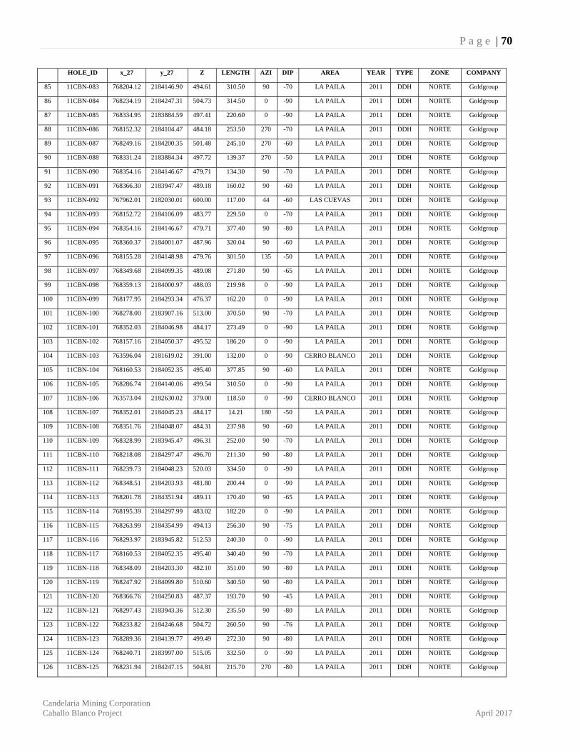
P a g e | 70
Candelaria Mining Corporation Caballo Blanco Project April 2017
HOLE_ID x_27 y_27 Z LENGTH AZI DIP AREA YEAR TYPE ZONE COMPANY
85 11CBN-083 768204.12 2184146.90 494.61 310.50 90 -70 LA PAILA 2011 DDH NORTE Goldgroup
86 11CBN-084 768234.19 2184247.31 504.73 314.50 0 -90 LA PAILA 2011 DDH NORTE Goldgroup
87 11CBN-085 768334.95 2183884.59 497.41 220.60 0 -90 LA PAILA 2011 DDH NORTE Goldgroup
88 11CBN-086 768152.32 2184104.47 484.18 253.50 270 -70 LA PAILA 2011 DDH NORTE Goldgroup
89 11CBN-087 768249.16 2184200.35 501.48 245.10 270 -60 LA PAILA 2011 DDH NORTE Goldgroup
90 11CBN-088 768331.24 2183884.34 497.72 139.37 270 -50 LA PAILA 2011 DDH NORTE Goldgroup
91 11CBN-090 768354.16 2184146.67 479.71 134.30 90 -70 LA PAILA 2011 DDH NORTE Goldgroup
92 11CBN-091 768366.30 2183947.47 489.18 160.02 90 -60 LA PAILA 2011 DDH NORTE Goldgroup
93 11CBN-092 767962.01 2182030.01 600.00 117.00 44 -60 LAS CUEVAS 2011 DDH NORTE Goldgroup
94 11CBN-093 768152.72 2184106.09 483.77 229.50 0 -70 LA PAILA 2011 DDH NORTE Goldgroup
95 11CBN-094 768354.16 2184146.67 479.71 377.40 90 -80 LA PAILA 2011 DDH NORTE Goldgroup
96 11CBN-095 768360.37 2184001.07 487.96 320.04 90 -60 LA PAILA 2011 DDH NORTE Goldgroup
97 11CBN-096 768155.28 2184148.98 479.76 301.50 135 -50 LA PAILA 2011 DDH NORTE Goldgroup
98 11CBN-097 768349.68 2184099.35 489.08 271.80 90 -65 LA PAILA 2011 DDH NORTE Goldgroup
99 11CBN-098 768359.13 2184000.97 488.03 219.98 0 -90 LA PAILA 2011 DDH NORTE Goldgroup
100 11CBN-099 768177.95 2184293.34 476.37 162.20 0 -90 LA PAILA 2011 DDH NORTE Goldgroup
101 11CBN-100 768278.00 2183907.16 513.00 370.50 90 -70 LA PAILA 2011 DDH NORTE Goldgroup
102 11CBN-101 768352.03 2184046.98 484.17 273.49 0 -90 LA PAILA 2011 DDH NORTE Goldgroup
103 11CBN-102 768157.16 2184050.37 495.52 186.20 0 -90 LA PAILA 2011 DDH NORTE Goldgroup
104 11CBN-103 763596.04 2181619.02 391.00 132.00 0 -90 CERRO BLANCO 2011 DDH NORTE Goldgroup
105 11CBN-104 768160.53 2184052.35 495.40 377.85 90 -60 LA PAILA 2011 DDH NORTE Goldgroup
106 11CBN-105 768286.74 2184140.06 499.54 310.50 0 -90 LA PAILA 2011 DDH NORTE Goldgroup
107 11CBN-106 763573.04 2182630.02 379.00 118.50 0 -90 CERRO BLANCO 2011 DDH NORTE Goldgroup
108 11CBN-107 768352.01 2184045.23 484.17 14.21 180 -50 LA PAILA 2011 DDH NORTE Goldgroup
109 11CBN-108 768351.76 2184048.07 484.31 237.98 90 -60 LA PAILA 2011 DDH NORTE Goldgroup
110 11CBN-109 768328.99 2183945.47 496.31 252.00 90 -70 LA PAILA 2011 DDH NORTE Goldgroup
111 11CBN-110 768218.08 2184297.47 496.70 211.30 90 -80 LA PAILA 2011 DDH NORTE Goldgroup
112 11CBN-111 768239.73 2184048.23 520.03 334.50 0 -90 LA PAILA 2011 DDH NORTE Goldgroup
113 11CBN-112 768348.51 2184203.93 481.80 200.44 0 -90 LA PAILA 2011 DDH NORTE Goldgroup
114 11CBN-113 768201.78 2184351.94 489.11 170.40 90 -65 LA PAILA 2011 DDH NORTE Goldgroup
115 11CBN-114 768195.39 2184297.99 483.02 182.20 0 -90 LA PAILA 2011 DDH NORTE Goldgroup
116 11CBN-115 768263.99 2184354.99 494.13 256.30 90 -75 LA PAILA 2011 DDH NORTE Goldgroup
117 11CBN-116 768293.97 2183945.82 512.53 240.30 0 -90 LA PAILA 2011 DDH NORTE Goldgroup
118 11CBN-117 768160.53 2184052.35 495.40 340.40 90 -70 LA PAILA 2011 DDH NORTE Goldgroup
119 11CBN-118 768348.09 2184203.30 482.10 351.00 90 -80 LA PAILA 2011 DDH NORTE Goldgroup
120 11CBN-119 768247.92 2184099.80 510.60 340.50 90 -80 LA PAILA 2011 DDH NORTE Goldgroup
121 11CBN-120 768366.76 2184250.83 487.37 193.70 90 -45 LA PAILA 2011 DDH NORTE Goldgroup
122 11CBN-121 768297.43 2183943.36 512.30 235.50 90 -80 LA PAILA 2011 DDH NORTE Goldgroup
123 11CBN-122 768233.82 2184246.68 504.72 260.50 90 -76 LA PAILA 2011 DDH NORTE Goldgroup
124 11CBN-123 768289.36 2184139.77 499.49 272.30 90 -80 LA PAILA 2011 DDH NORTE Goldgroup
125 11CBN-124 768240.71 2183997.00 515.05 332.50 0 -90 LA PAILA 2011 DDH NORTE Goldgroup
126 11CBN-125 768231.94 2184247.15 504.81 215.70 270 -80 LA PAILA 2011 DDH NORTE Goldgroup
P a g e | 71
Candelaria Mining Corporation Caballo Blanco Project April 2017
HOLE_ID x_27 y_27 Z LENGTH AZI DIP AREA YEAR TYPE ZONE COMPANY
127 11CBN-126 768293.30 2183899.95 517.86 214.50 0 -90 LA PAILA 2011 DDH NORTE Goldgroup
128 11CBN-127 768344.22 2184298.87 519.82 299.60 90 -63 LA PAILA 2011 DDH NORTE Goldgroup
129 11CBN-128 768302.50 2184045.44 496.25 310.50 0 -90 LA PAILA 2011 DDH NORTE Goldgroup
130 11CBN-129 768373.67 2184544.52 499.36 3.20 0 -90 LA PAILA 2011 DDH NORTE Goldgroup
131 11CBN-130 768348.69 2184451.73 511.96 290.17 90 -45 LA PAILA 2011 DDH NORTE Goldgroup
132 11CBN-131 768286.04 2184194.84 496.47 251.40 270 -72 LA PAILA 2011 DDH NORTE Goldgroup
133 11CBN-132 768338.67 2184294.80 519.99 373.80 180 -50 LA PAILA 2011 DDH NORTE Goldgroup
134 11CBN-133 768336.51 2183862.75 496.98 247.50 0 -90 LA PAILA 2011 DDH NORTE Goldgroup
135 11CBN-134 768302.62 2184044.89 496.43 274.50 180 -70 LA PAILA 2011 DDH NORTE Goldgroup
136 11CBN-135 768288.91 2184194.32 496.34 284.60 90 -85 LA PAILA 2011 DDH NORTE Goldgroup
137 11CBN-136 768246.71 2183942.81 530.46 308.20 0 -90 LA PAILA 2011 DDH NORTE Goldgroup
138 11CBN-137 768302.87 2184399.52 497.49 305.71 90 -50 LA PAILA 2011 DDH NORTE Goldgroup
139 11CBN-138 768354.13 2184045.59 484.22 224.00 90 -75 LA PAILA 2011 DDH NORTE Goldgroup
140 11CBN-139 768203.49 2184108.01 497.92 291.50 270 -80 LA PAILA 2011 DDH NORTE Goldgroup
141 11CBN-140 768336.04 2183891.47 497.39 241.50 90 -70 LA PAILA 2011 DDH NORTE Goldgroup
142 11CBN-141 768197.91 2183994.79 536.32 338.00 0 -90 LA PAILA 2011 DDH NORTE Goldgroup
143 11CBN-142 768360.88 2184003.05 487.88 256.50 90 -75 LA PAILA 2011 DDH NORTE Goldgroup
144 11CBN-143 768349.98 2184100.10 489.17 250.50 90 -45 LA PAILA 2011 DDH NORTE Goldgroup
145 11CBN-144 768336.71 2184548.49 476.64 284.68 90 -60 LA PAILA 2011 DDH NORTE Goldgroup
146 11CBN-145 768243.36 2183997.14 514.83 268.50 90 -75 LA PAILA 2011 DDH NORTE Goldgroup
147 11CBN-146 768248.79 2183899.76 543.00 319.50 0 -90 LA PAILA 2011 DDH NORTE Goldgroup
148 11CBN-147 768243.92 2184098.83 510.75 290.50 90 -60 LA PAILA 2011 DDH NORTE Goldgroup
149 11CBN-148 768301.38 2184351.18 504.89 314.50 90 -65 LA PAILA 2011 DDH NORTE Goldgroup
150 11CBN-149 768338.05 2183862.59 497.49 253.50 90 -60 LA PAILA 2011 DDH NORTE Goldgroup
151 11CBN-150 768338.84 2184489.21 481.33 318.21 90 -60 LA PAILA 2011 DDH NORTE Goldgroup
152 11CBN-151-A 768305.01 2184251.30 503.03 347.50 90 -60 LA PAILA 2011 DDH NORTE Goldgroup
153 11CBN-152 768149.28 2183994.62 527.44 277.50 0 -90 LA PAILA 2011 DDH NORTE Goldgroup
154 11CBN-153 768372.47 2184351.80 544.08 257.00 90 -57 LA PAILA 2011 DDH NORTE Goldgroup
155 11CBN-154 768209.08 2183940.55 536.22 321.00 0 -90 LA PAILA 2011 DDH NORTE Goldgroup
156 11CBN-155 768147.51 2183996.87 527.50 201.50 270 -80 LA PAILA 2011 DDH NORTE Goldgroup
157 11CBN-156 768374.18 2184544.12 499.47 300.42 135 -45 LA PAILA 2011 DDH NORTE Goldgroup
158 11CBN-157 768190.49 2184042.65 508.87 308.40 270 -84 LA PAILA 2011 DDH NORTE Goldgroup
159 11CBN-158 768149.29 2183952.45 535.73 274.00 0 -90 LA PAILA 2011 DDH NORTE Goldgroup
160 11CBN-159 768277.68 2184249.94 503.50 311.00 90 -80 LA PAILA 2011 DDH NORTE Goldgroup
161 11CBN-160 768202.58 2183898.75 522.22 233.00 0 -90 LA PAILA 2011 DDH NORTE Goldgroup
162 11CBN-161 768380.93 2184505.20 508.26 302.67 90 -45 LA PAILA 2011 DDH NORTE Goldgroup
163 11CBN-162 768197.76 2184247.63 484.84 305.40 270 -80 LA PAILA 2011 DDH NORTE Goldgroup
164 11CBN-163 768252.55 2184205.32 501.31 356.40 180 -50 LA PAILA 2011 DDH NORTE Goldgroup
165 11CBN-164 768100.73 2183952.85 527.40 299.00 0 -90 LA PAILA 2011 DDH NORTE Goldgroup
166 11CBN-165 768150.35 2183900.01 510.35 367.00 0 -90 LA PAILA 2011 DDH NORTE Goldgroup
167 11CBN-166 768241.29 2184294.79 505.94 317.35 90 -75 LA PAILA 2011 DDH NORTE Goldgroup
168 11CBN-167 768380.73 2184502.20 508.54 281.33 130 -45 LA PAILA 2011 DDH NORTE Goldgroup
P a g e | 72
Candelaria Mining Corporation Caballo Blanco Project April 2017
HOLE_ID x_27 y_27 Z LENGTH AZI DIP AREA YEAR TYPE ZONE COMPANY
169 11CBN-168 768148.90 2183849.20 499.98 363.70 0 -90 LA PAILA 2011 DDH NORTE Goldgroup
170 11CBN-169 768296.61 2183853.24 514.52 299.78 0 -90 LA PAILA 2011 DDH NORTE Goldgroup
171 11CBN-170 768255.53 2183852.07 536.48 299.62 0 -90 LA PAILA 2011 DDH NORTE Goldgroup
172 11CBN-171 768203.11 2183851.32 505.58 322.50 0 -90 LA PAILA 2011 DDH NORTE Goldgroup
173 11CBN-172 768338.05 2183863.96 497.48 278.70 90 -75 LA PAILA 2011 DDH NORTE Goldgroup
174 11CBN-173 768098.43 2183900.87 511.38 358.00 0 -90 LA PAILA 2011 DDH NORTE Goldgroup
175 11CBN-174 768097.82 2183848.11 502.10 361.49 0 -90 LA PAILA 2011 DDH NORTE Goldgroup
176 11CBN-175 768200.51 2183801.55 495.94 301.50 0 -90 LA PAILA 2011 DDH NORTE Goldgroup
177 11CBN-176 768339.00 2183863.16 497.46 249.90 90 -50 LA PAILA 2011 DDH NORTE Goldgroup
178 11CBN-177 768144.85 2183791.83 484.93 388.00 0 -90 LA PAILA 2011 DDH NORTE Goldgroup
179 11CBN-178 768336.42 2183891.45 497.36 301.50 0 -90 LA PAILA 2011 DDH NORTE Goldgroup
180 11CBN-179 768337.60 2183891.54 497.24 320.30 90 -81 LA PAILA 2011 DDH NORTE Goldgroup
181 11CBN-180 768097.50 2183805.69 486.19 396.42 0 -90 LA PAILA 2011 DDH NORTE Goldgroup
182 11CBN-181 768198.41 2183752.88 484.35 262.50 0 -90 LA PAILA 2011 DDH NORTE Goldgroup
183 11CBN-182 768050.13 2183847.97 501.99 298.50 0 -90 LA PAILA 2011 DDH NORTE Goldgroup
184 11CBN-183 768337.60 2183891.54 497.24 281.00 90 -50 LA PAILA 2011 DDH NORTE Goldgroup
185 11CBN-184 768053.00 2183800.16 487.00 200.00 0 -90 LA PAILA 2011 DDH NORTE Goldgroup
186 11CBN-185 768129.56 2183943.8 463.35 320.05 0 -90 LA PAILA 2011 DDH NORTE Goldgroup
187 11CBN-186 768214.05 2184000.9 521.96 364.00 0 -90 LA PAILA 2011 DDH NORTE Goldgroup
188 11CBN-187 768021.08 2183943.1 448.44 245.06 0 -90 LA PAILA 2011 DDH NORTE Goldgroup
189 12CBN-188 768215.18 2183938.5 492.13 173.60 0 -90 LA PAILA 2012 DDH NORTE Goldgroup
190 12CBN-189 768173.71 2183847.8 454.01 119.50 0 -90 LA PAILA 2012 DDH NORTE Goldgroup
191 12CBN-190 768214.28 2184002.7 521.89 176.50 90 -75 LA PAILA 2012 DDH NORTE Goldgroup
192 12CBN-191 768169.18 2183893.3 460.96 322.50 0 -90 LA PAILA 2012 DDH NORTE Goldgroup
193 12CBN-192 768070.2 2183895.7 438.12 415.50 0 -90 LA PAILA 2012 DDH NORTE Goldgroup
194 12CBN-193 768069.14 2183844.5 429.55 396.10 0 -90 LA PAILA 2012 DDH NORTE Goldgroup
195 12CBN-194 768123.25 2183895.3 451.37 154.50 0 -90 LA PAILA 2012 DDH NORTE Goldgroup
196 12CBN-195 768071.46 2183944.9 450.97 400.00 0 -90 LA PAILA 2012 DDH NORTE Goldgroup
197 12CBN-196 768020.27 2183894.5 428.87 118.50 0 -90 LA PAILA 2012 DDH NORTE Goldgroup
198 12CBN-197 768205.97 2183848.3 471.52 123.75 0 -90 LA PAILA 2012 DDH NORTE Goldgroup
199 12CBN-197-A 768204.69 2183846.7 471.55 453.00 0 -90 LA PAILA 2012 DDH NORTE Goldgroup
200 12CBN-198 768159.78 2184240.8 508.91 353.60 90 -84 LA PAILA 2012 DDH NORTE Goldgroup
201 12CBN-199 767970.23 2183893.6 426.15 51.00 0 -90 LA PAILA 2012 DDH NORTE Goldgroup
202 12CBN-200 768101.37 2184302 479.76 172.50 0 -90 LA PAILA 2012 DDH NORTE Goldgroup
203 12CBN-201 768199.55 2183746.1 474.6 291.00 0 -90 LA PAILA 2012 DDH NORTE Goldgroup
204 12CBN-202 768067.16 2184204.6 502.14 224.64 0 -90 LA PAILA 2012 DDH NORTE Goldgroup
205 12CBN-203 768138.79 2184148.2 537.77 433.50 0 -90 LA PAILA 2012 DDH NORTE Goldgroup
206 12CBN-204 768104.14 2184300.7 480.06 48.00 0 -90 LA PAILA 2012 DDH NORTE Goldgroup
207 12CBN-205 768128.1 2184543.6 488.68 454.50 90 -65 LA PAILA 2012 DDH NORTE Goldgroup
208 12CBN-206 768197.48 2183800.6 465.13 369.58 0 -90 LA PAILA 2012 DDH NORTE Goldgroup
209 12CBN-207 768212.15 2183895.9 478.48 441.80 90 -80 LA PAILA 2012 DDH NORTE Goldgroup
210 12CBN-208 768067.52 2184203.5 502.14 233.48 0 -90 LA PAILA 2012 DDH NORTE Goldgroup
P a g e | 73
Candelaria Mining Corporation Caballo Blanco Project April 2017
HOLE_ID x_27 y_27 Z LENGTH AZI DIP AREA YEAR TYPE ZONE COMPANY
211 12CBN-209 768100.44 2184605.7 464.97 322.50 90 -70 LA PAILA 2012 DDH NORTE Goldgroup
212 12CBN-210 767970.16 2183894.8 426.24 57.40 0 -90 LA PAILA 2012 DDH NORTE Goldgroup
213 12CBN-211 768200.82 2184599.4 476.42 338.30 90 -70 LA PAILA 2012 DDH NORTE Goldgroup
214 12CBN-212 768145.32 2184350.1 485.3 293.60 0 -90 LA PAILA 2012 DDH NORTE Goldgroup
215 12CBN-213 768298.84 2184200.3 496.35 343.50 0 -90 LA PAILA 2012 DDH NORTE Goldgroup
216 12CBN-214 768302.93 2184253.7 486.81 285.29 0 -90 LA PAILA 2012 DDH NORTE Goldgroup
217 12CBN-215 768126.88 2184249.1 495.36 300.20 270 -83 LA PAILA 2012 DDH NORTE Goldgroup
218 12CBN-216 767964.13 2183993 458.83 282.00 0 -90 LA PAILA 2012 DDH NORTE Goldgroup
219 12CBN-217 767967.07 2183946.7 443.13 431.00 0 -90 LA PAILA 2012 DDH NORTE Goldgroup
220 12CBN-218 768283.1 2184793.4 468.1 360.27 90 -50 LA PAILA 2012 DDH NORTE Goldgroup
221 12CBN-219 768324.33 2184243.5 484.36 296.27 90 -45 LA PAILA 2012 DDH NORTE Goldgroup
222 12CBN-220 768214.55 2184001.6 521.84 319.80 90 -45 LA PAILA 2012 DDH NORTE Goldgroup
223 12CBN-221 768329.97 2184198.8 487.9 310.50 90 -45 LA PAILA 2012 DDH NORTE Goldgroup
224 12CBN-222 768314.32 2184407.9 485.41 250.40 90 -40 LA PAILA 2012 DDH NORTE Goldgroup
225 12CBN-223 768213.35 2184001.6 521.8 339.70 90 -75 LA PAILA 2012 DDH NORTE Goldgroup
226 12CBN-224 768307.83 2184688.6 481.44 331.10 90 -75 LA PAILA 2012 DDH NORTE Goldgroup
227 12CBN-225 768098.9 2184447.9 461.51 272.10 270 -79 LA PAILA 2012 DDH NORTE Goldgroup
228 12CBN-226 768312.75 2184346.5 483.25 289.00 90 -49 LA PAILA 2012 DDH NORTE Goldgroup
229 12CBN-227 768262.52 2184406.6 496.57 301.50 90 -77 LA PAILA 2012 DDH NORTE Goldgroup
230 12CBN-228 768318.8 2184650.7 511.81 323.30 90 -30 LA PAILA 2012 DDH NORTE Goldgroup
231 12CBN-230 768307.21 2184915.2 461.97 268.40 90 -45 LA PAILA 2012 DDH NORTE Goldgroup
232 12CBN-231 768159.68 2184240.3 508.79 332.00 0 -90 LA PAILA 2012 DDH NORTE Goldgroup
233 12CBN-232 768310.19 2184600.6 513.33 372.10 90 -30 LA PAILA 2012 DDH NORTE Goldgroup
234 12CBN-233 768339.67 2184758.2 499.23 271.30 45 -45 LA PAILA 2012 DDH NORTE Goldgroup
235 12CBN-234 768121.94 2183895.2 451.42 105.30 0 -90 LA PAILA 2012 DDH NORTE Goldgroup
236 12CBN-235 768351.07 2184701.5 508.04 250.10 90 -30 LA PAILA 2012 DDH NORTE Goldgroup
P a g e | 74
Candelaria Mining Corporation Caballo Blanco Project April 2017
APPENDIX II Mineralized intervals from 55 new holes drilled during first half of 2012. Holes 11CBN-179 to 181, 11CBN-183, 11CDN-185 to 12CDN-190 to 12CBN-235 (Composited with 0.2 g/t Au cut-off, 0.2 metre minimum sample, and 4 metre maximum barren interval)
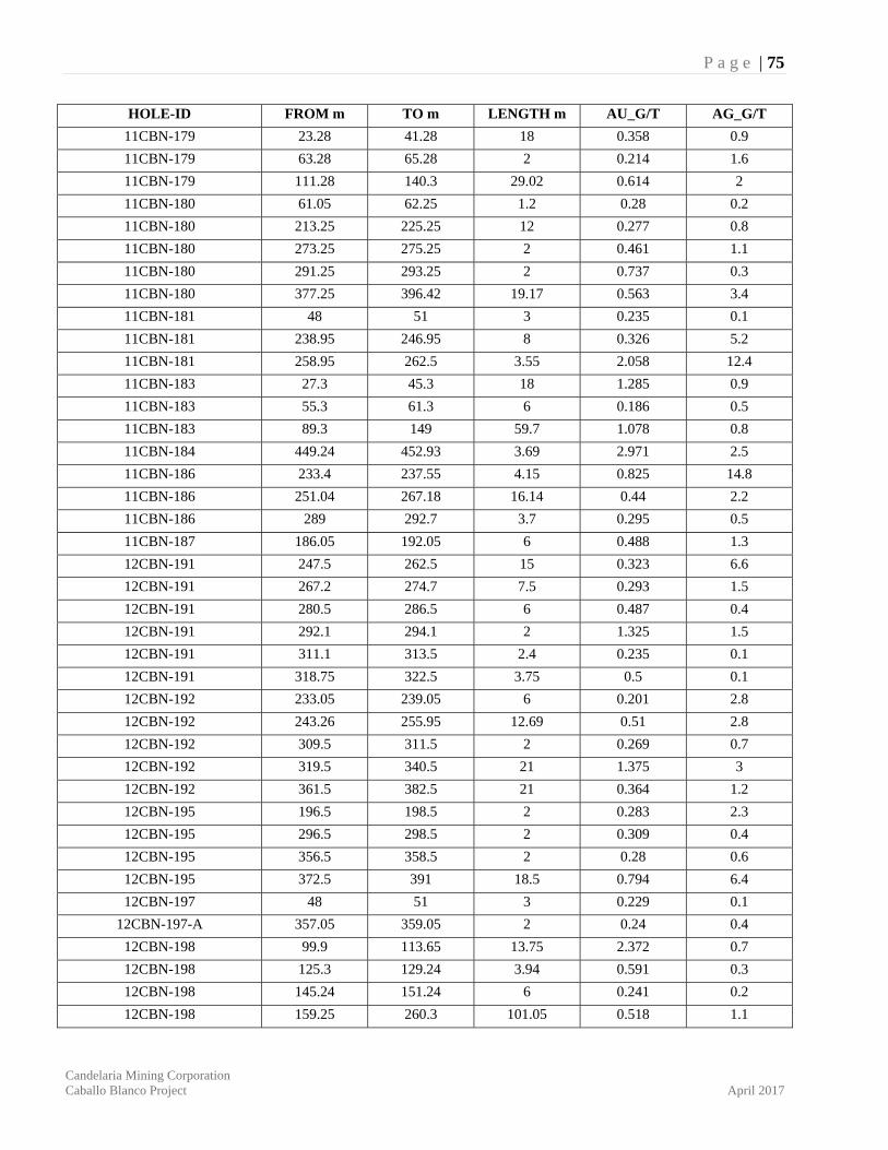
P a g e | 75
Candelaria Mining Corporation Caballo Blanco Project April 2017
HOLE-ID FROM m TO m LENGTH m AU_G/T AG_G/T
11CBN-179 23.28 41.28 18 0.358 0.9
11CBN-179 63.28 65.28 2 0.214 1.6
11CBN-179 111.28 140.3 29.02 0.614 2
11CBN-180 61.05 62.25 1.2 0.28 0.2
11CBN-180 213.25 225.25 12 0.277 0.8
11CBN-180 273.25 275.25 2 0.461 1.1
11CBN-180 291.25 293.25 2 0.737 0.3
11CBN-180 377.25 396.42 19.17 0.563 3.4
11CBN-181 48 51 3 0.235 0.1
11CBN-181 238.95 246.95 8 0.326 5.2
11CBN-181 258.95 262.5 3.55 2.058 12.4
11CBN-183 27.3 45.3 18 1.285 0.9
11CBN-183 55.3 61.3 6 0.186 0.5
11CBN-183 89.3 149 59.7 1.078 0.8
11CBN-184 449.24 452.93 3.69 2.971 2.5
11CBN-186 233.4 237.55 4.15 0.825 14.8
11CBN-186 251.04 267.18 16.14 0.44 2.2
11CBN-186 289 292.7 3.7 0.295 0.5
11CBN-187 186.05 192.05 6 0.488 1.3
12CBN-191 247.5 262.5 15 0.323 6.6
12CBN-191 267.2 274.7 7.5 0.293 1.5
12CBN-191 280.5 286.5 6 0.487 0.4
12CBN-191 292.1 294.1 2 1.325 1.5
12CBN-191 311.1 313.5 2.4 0.235 0.1
12CBN-191 318.75 322.5 3.75 0.5 0.1
12CBN-192 233.05 239.05 6 0.201 2.8
12CBN-192 243.26 255.95 12.69 0.51 2.8
12CBN-192 309.5 311.5 2 0.269 0.7
12CBN-192 319.5 340.5 21 1.375 3
12CBN-192 361.5 382.5 21 0.364 1.2
12CBN-195 196.5 198.5 2 0.283 2.3
12CBN-195 296.5 298.5 2 0.309 0.4
12CBN-195 356.5 358.5 2 0.28 0.6
12CBN-195 372.5 391 18.5 0.794 6.4
12CBN-197 48 51 3 0.229 0.1
12CBN-197-A 357.05 359.05 2 0.24 0.4
12CBN-198 99.9 113.65 13.75 2.372 0.7
12CBN-198 125.3 129.24 3.94 0.591 0.3
12CBN-198 145.24 151.24 6 0.241 0.2
12CBN-198 159.25 260.3 101.05 0.518 1.1
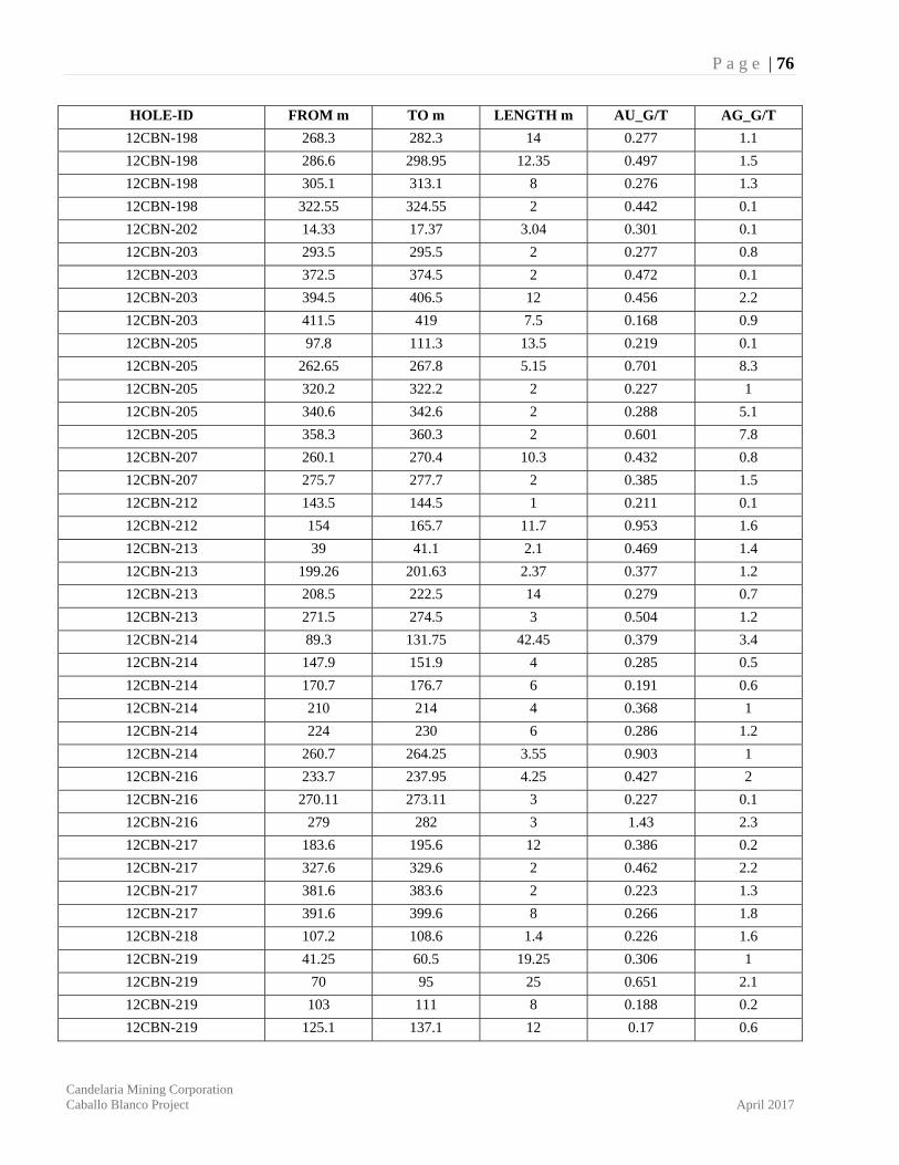
P a g e | 76
Candelaria Mining Corporation Caballo Blanco Project April 2017
HOLE-ID FROM m TO m LENGTH m AU_G/T AG_G/T
12CBN-198 268.3 282.3 14 0.277 1.1
12CBN-198 286.6 298.95 12.35 0.497 1.5
12CBN-198 305.1 313.1 8 0.276 1.3
12CBN-198 322.55 324.55 2 0.442 0.1
12CBN-202 14.33 17.37 3.04 0.301 0.1
12CBN-203 293.5 295.5 2 0.277 0.8
12CBN-203 372.5 374.5 2 0.472 0.1
12CBN-203 394.5 406.5 12 0.456 2.2
12CBN-203 411.5 419 7.5 0.168 0.9
12CBN-205 97.8 111.3 13.5 0.219 0.1
12CBN-205 262.65 267.8 5.15 0.701 8.3
12CBN-205 320.2 322.2 2 0.227 1
12CBN-205 340.6 342.6 2 0.288 5.1
12CBN-205 358.3 360.3 2 0.601 7.8
12CBN-207 260.1 270.4 10.3 0.432 0.8
12CBN-207 275.7 277.7 2 0.385 1.5
12CBN-212 143.5 144.5 1 0.211 0.1
12CBN-212 154 165.7 11.7 0.953 1.6
12CBN-213 39 41.1 2.1 0.469 1.4
12CBN-213 199.26 201.63 2.37 0.377 1.2
12CBN-213 208.5 222.5 14 0.279 0.7
12CBN-213 271.5 274.5 3 0.504 1.2
12CBN-214 89.3 131.75 42.45 0.379 3.4
12CBN-214 147.9 151.9 4 0.285 0.5
12CBN-214 170.7 176.7 6 0.191 0.6
12CBN-214 210 214 4 0.368 1
12CBN-214 224 230 6 0.286 1.2
12CBN-214 260.7 264.25 3.55 0.903 1
12CBN-216 233.7 237.95 4.25 0.427 2
12CBN-216 270.11 273.11 3 0.227 0.1
12CBN-216 279 282 3 1.43 2.3
12CBN-217 183.6 195.6 12 0.386 0.2
12CBN-217 327.6 329.6 2 0.462 2.2
12CBN-217 381.6 383.6 2 0.223 1.3
12CBN-217 391.6 399.6 8 0.266 1.8
12CBN-218 107.2 108.6 1.4 0.226 1.6
12CBN-219 41.25 60.5 19.25 0.306 1
12CBN-219 70 95 25 0.651 2.1
12CBN-219 103 111 8 0.188 0.2
12CBN-219 125.1 137.1 12 0.17 0.6

P a g e | 77
Candelaria Mining Corporation Caballo Blanco Project April 2017
HOLE-ID FROM m TO m LENGTH m AU_G/T AG_G/T
12CBN-220 264.6 291.6 27 0.682 1.4
12CBN-221 70.8 106.5 35.7 0.763 0.9
12CBN-221 120.5 129 8.5 1.196 0.7
12CBN-221 133.3 135.3 2 0.237 1.6
12CBN-221 145.95 157.95 12 0.262 0.5
12CBN-221 169.95 171.95 2 0.286 0.5
12CBN-222 82.6 176.6 94 1.24 3.3
12CBN-226 67.3 214.6 147.3 0.572 3.6
12CBN-227 102.8 166.8 64 0.482 0.8
12CBN-227 174.8 180.8 6 0.227 0.7
12CBN-227 198.8 200.8 2 0.321 2.4
12CBN-227 208.8 226.8 18 0.289 1.1
12CBN-227 232.8 236.8 4 0.28 0.8
12CBN-227 244.8 252.8 8 0.204 1.9
12CBN-227 290.8 292.8 2 0.305 1.8
12CBN-228 118.16 157.16 39 0.518 4.5
12CBN-228 167.16 169.16 2 0.279 0.1
12CBN-228 191.16 193.16 2 0.403 0.2
12CBN-228 211.16 213.16 2 0.23 0.4
12CBN-228 227.7 237.7 10 0.279 0.2
12CBN-228 251 256.2 5.2 1.152 0.1
12CBN-228 278 282.9 4.9 0.327 0.3
12CBN-230 145.8 146.75 0.95 0.205 0.1
12CBN-231 106.35 122.44 16.09 0.417 0.4
12CBN-231 139.8 145.8 6 0.651 0.2
12CBN-231 176.25 255.92 79.67 0.758 1
12CBN-231 269.92 273.8 3.88 0.232 0.8
12CBN-231 280 284 4 0.539 0.9
12CBN-231 290 292 2 0.204 0.7
12CBN-231 313.1 319 5.9 0.251 0.2
12CBN-232 42.55 133.1 90.55 1.082 1.9
12CBN-232 147.1 149.1 2 0.411 0.9
12CBN-232 155.6 183.6 28 0.746 2.8
12CBN-232 189.6 191.6 2 0.204 1.3
12CBN-232 199.6 204.12 4.52 0.475 0.8
12CBN-232 254.12 256.12 2 0.206 0.3
12CBN-232 269.7 280.55 10.85 0.366 0.6
12CBN-232 305 314.15 9.15 1.15 0.3
12CBN-232 320.25 328.35 8.1 0.302 0.2
12CBN-232 334.35 336.35 2 0.596 0.3
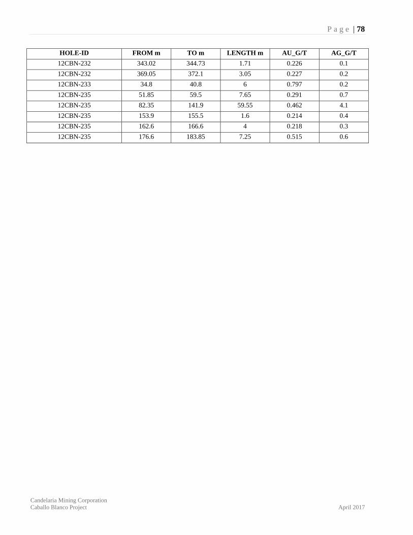
P a g e | 78
Candelaria Mining Corporation Caballo Blanco Project April 2017
HOLE-ID FROM m TO m LENGTH m AU_G/T AG_G/T
12CBN-232 343.02 344.73 1.71 0.226 0.1
12CBN-232 369.05 372.1 3.05 0.227 0.2
12CBN-233 34.8 40.8 6 0.797 0.2
12CBN-235 51.85 59.5 7.65 0.291 0.7
12CBN-235 82.35 141.9 59.55 0.462 4.1
12CBN-235 153.9 155.5 1.6 0.214 0.4
12CBN-235 162.6 166.6 4 0.218 0.3
12CBN-235 176.6 183.85 7.25 0.515 0.6


