Status of soil information and
soil management in Syria
by
Ali Abdulla
Amman-1-5 April -2012
Introduction
The agricultural sector in Syria plays a key role in agricultural development and in rural area its effects are clearly reflected on the overall economic development, it is one of the most important sources for generating income and achieve food security and providing employment opportunities and providing the requirements of the manufacturing sector of food. Also, contributes to the stability of the rural population and provide a balance between the provinces
The land resources are the most important natural resources that have been depend on them for food security, thus our duty are to take care of it, and orient its use and improve its management in proper way, So to reach to those aims all the conditions regarding to it must be identified with control to the ways and means of its investment ,as well as identifying different changes of land uses, with the
times and reasons, also, identifying current land uses and determine the best uses.
Syria faces number of challenges. These challenges include: drought, climate change, population growth, migration from country side to main cities, degraded water quality, decline in per capita share of fresh water, decline in fossil fuels sources of energy, depletion of natural vegetation, particularly what happened in steppe land by overgrazing and excessive depletion due to the increasing load of pastoral, and problems related to economic, social and environmental.
Encroachment on arable land at an unsustainable rate, and the potential threats of climate change
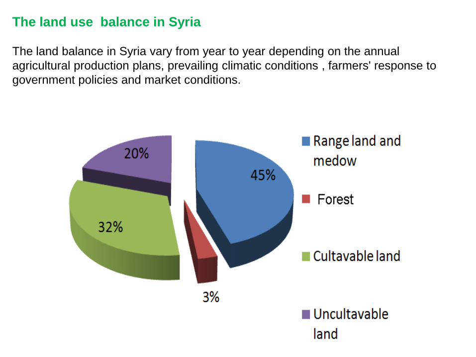
The land use balance in Syria The land balance in Syria vary from year to year depending on the annual agricultural production plans, prevailing climatic conditions , farmers' response to government policies and market conditions.
Major ecosystems>> Syria can be divided geographically into four areas: A-The coastal region: The area bounded between the coastal mountain series and the Mediterranean sea B-Mountainous region: The mountains and highlands stretching from north to south parallel to the shore of the Mediterranean sea and of two series mountains almost parallel to each other and between them Akkar and Ghab plains.
C- Interior region: It is located east of the series mountains, and has Aleppo ,Hassakeah, Homs and Hama plains.
D- steppe region: It includes steppe plains.
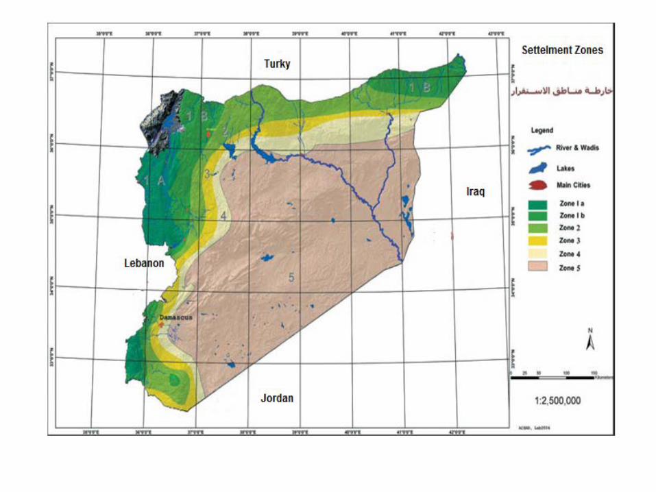
-Syria has five settlements zones according to annual rain fall and the relation between land and climate factors: A-The first settlement zone: the average rainfall is 350 to 600 mm per year not less than 300 mm in two thirds of the year ,and can ensure any observed two seasons every three years, the most important crops, wheat, legumes, summer crops.
B-The second settlement zone: The average of annual rainfall is 350-250 mm per year and not less than the figure for half the observed years, which may ensure the seasonal barley every three years, also beside the barley, wheat, legumes and summer crops can be grown. >>>
-C- The third settlement zone: The average of annual rainfall over 250 mm per
year and not less than the figure for half the observed years, which may ensure one to tow seasons for each of three years and the main crop is barley and beans.
D- Fourth settlement zone (marginal zone): The average of annual rainfall is 200-250 mm per year and not less than 200 mm in half of the observed years, suitable only for barley or permanent pastures.
E- The fifth settlement zone (steppe land): The rest of the land area is pasture and not suitable for agriculture rain fed. The following figure shows the distribution the settlement zones of Syria.
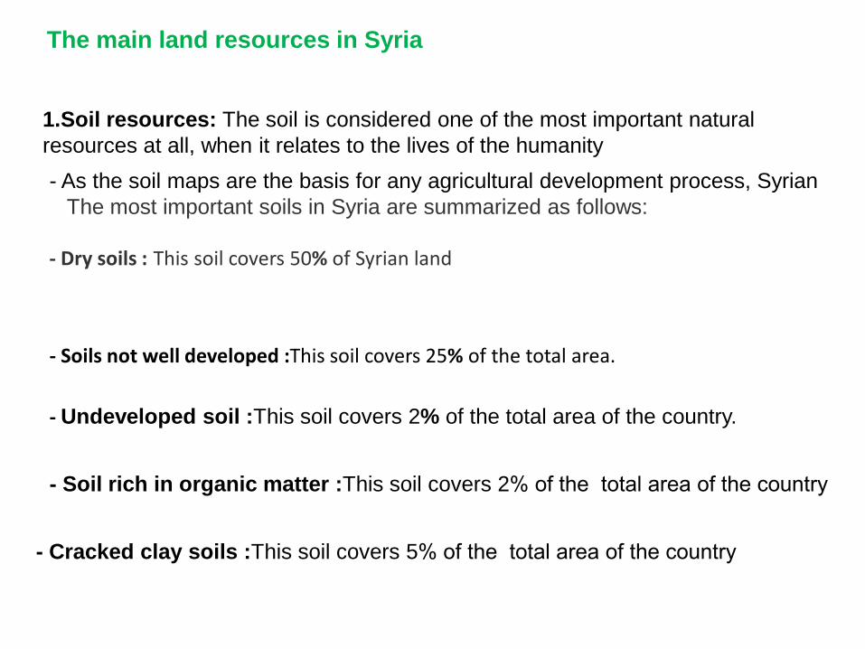
The main land resources in Syria
1.Soil resources: The soil is considered one of the most important natural resources at all, when it relates to the lives of the humanity - As the soil maps are the basis for any agricultural development process, Syrian The most important soils in Syria are summarized as follows:- ----------------------- - Dry soils ::This soil covers 50% of Syrian land
- Soils not well developed :This soil covers 25% of the total area.
- Soil rich in organic matter :This soil covers 2% of the total area of the country
- Undeveloped soil :This soil covers 2% of the total area of the country.
- Cracked clay soils :This soil covers 5% of the total area of the country
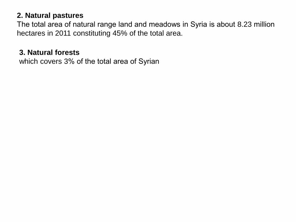
2. Natural pastures The total area of natural range land and meadows in Syria is about 8.23 million hectares in 2011 constituting 45% of the total area.
3. Natural forests which covers 3% of the total area of Syrian
land use and management practices
-To identify the successful (optimal) land uses and management practices it must be collect and analyze the required information of the soil, water, vegetation, climate, the current land uses and the current socio-economic situation, and these data, statistics information and thematic maps are usually required extractions of all information by experts ,and to take decision, development of policies and proposals that lead to the successful land use .To achieve that, it must be use the modern techniques ,such as GIS and remote sensing ,data processing and information and conduct the comparison and classification and develop different models
For example: - coastal area which famous in citrus and vegetables(good management ). In north east of Aleppo as well as in south west of Damascus, famous for fruit trees(medium management).
There are different types of land In Syria ,It is spreading from humid areas and half wet areas to dry and very dry areas, and the land management and land uses are great different ,for example , the land management is different from gypsum soil to land management of saline soil ,clay soils or dry soil etc..
Land management issues, constrains and opportunity
The main constrains are
- The fragmentation and dispersions of land tenures .
- Laws and legislation to develop agricultural production ,land management and land use planning.
- The migration of the labor force from the countryside to the city.
- The activities of marketing, manufacturing, export and investment do not fit with the increasing in agricultural production.
- Un rational management of natural resources, for example random grazing, trees cutting and un conserving the forest land etc…
- Spreading the traditional irrigation methods in most cultivations areas in Syria, as well as the lack of laws and regulations for organizing the use of water irrigation.
A - Develop and apply the land use planning system in Syria (SYLWIS),for example adding some factors, and applying it at Syrian provinces level.
The opportunity
B - Important procedures for protection ,conservation, rehabilitation and management the natural resources
to reduce the degradation of natural resources in Syria, most of these procedures have reduced the negative impacts of different activities for example:
-The projects: The project of steppe development for rehabilitate and re-vegetation - Natural protections areas pastoral protection
Forest protections water reserves
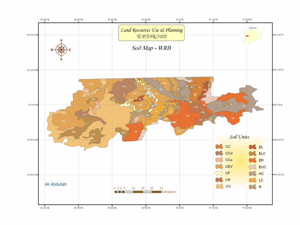
In Syria the most data and information relating to land resources (physics and chemical soil analysis, maps, climate data etc…) are still in hard copies forms. For example the Syria soils were classified at scale 1 / 25 000 for first, second and third (SZ), and all reports, soil analysis and maps still in hard forms, as well as the information and data of water, vegetation and climate are also available in hard forms. These data and maps are needed to convert it into digital form, harmonized and processing by (GIS), and link it to land resources information and based on the successful land use can be suggested.
Land resources information system
Thank you
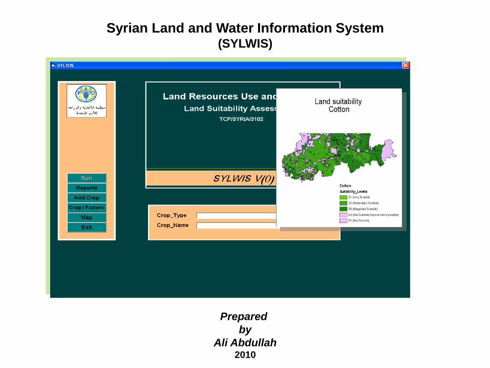
Syrian Land and Water Information System (SYLWIS)
Prepared by
Ali Abdullah 2010
The Syria Land and Water Information system(SYLWIS) was designed through the land resources use and planning project (TCP/SYR/3102) for a pilot area which covers 100x 40 Km, representative to Syrian soils and has five settlement zones.
it is a kind of geodata base and attribute data base it contains tables
,inquiry and processes, which includes all spatial and descriptive of the study area, and the results of running the system.
The SYLWIS system based on the data resulting from the geographic sheets intersection of the soil, water, climate factors and crop requirement with administration sheet of the study area and comparing these data with crop requirements.
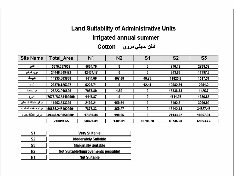
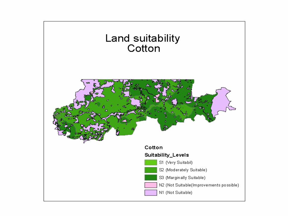
The SYLWIS gives report of land suitability for crops on the basis of administrative units, also land suitability map, climate factors and water factors for each crop can be driven by system running, So the SYLWIS is a kind of DSS to identify land suitability for agricultural planning.
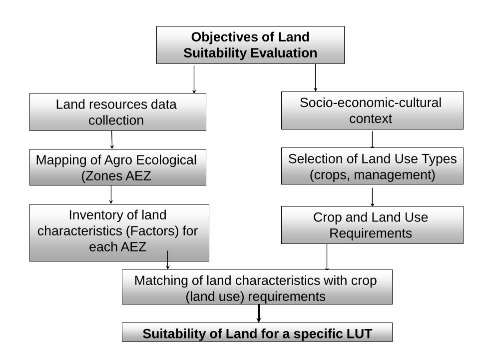
Objectives of Land Suitability Evaluation
Land resources data collection
Mapping of Agro Ecological Zones AEZ(
Inventory of land characteristics (Factors) for
each AEZ
Socio-economic-cultural context
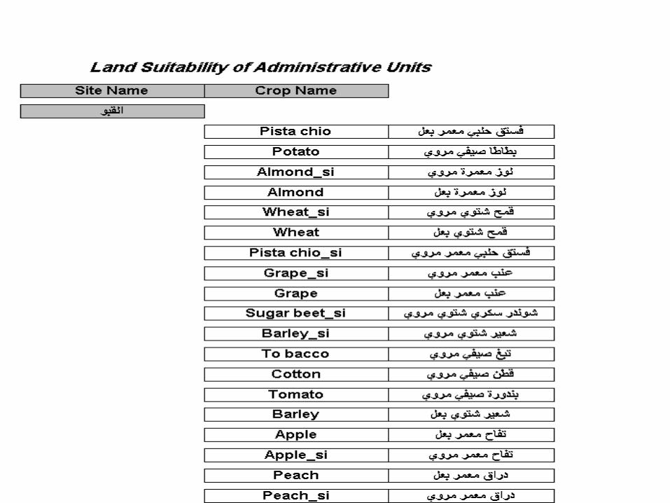
Selection of Land Use Types )(crops, management
Crop and Land Use Requirements
Matching of land characteristics with crop (land use) requirements
Suitability of Land for a specific LUT
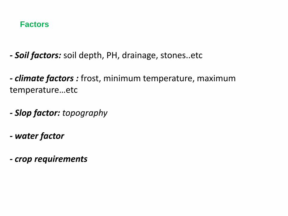
- Soil factors: soil depth, PH, drainage, stones..etc
- climate factors : frost, minimum temperature, maximum temperature…etc
- Slop factor: topography
- water factor
- crop requirements
Factors
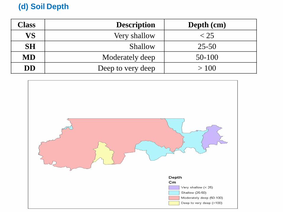
Class Description Depth (cm) VS Very shallow < 25 SH Shallow 25-50
MD Moderately deep 50-100 DD Deep to very deep > 100
Soil Depth )d(
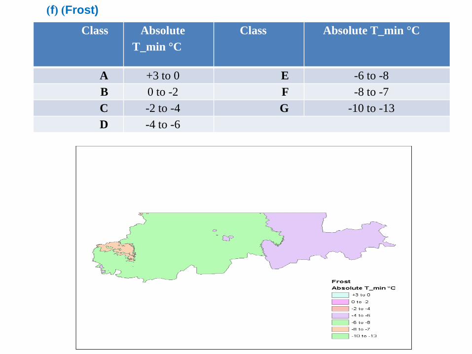
Class Absolute T_min °C
Class Absolute T_min °C
A +3 to 0 E -6 to -8 B 0 to -2 F -8 to -7 C -2 to -4 G -10 to -13 D -4 to -6
)Frost) (f(
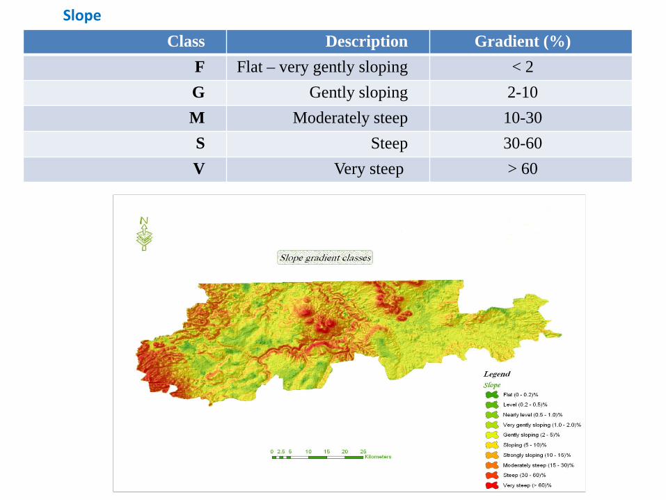
Class Description Gradient (%)
F Flat – very gently sloping < 2
G Gently sloping 2-10
M Moderately steep 10-30
S Steep 30-60
V Very steep > 60
Slope
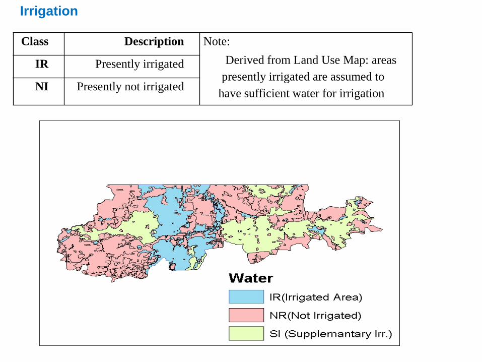
Class Description Note:
Derived from Land Use Map: areas presently irrigated are assumed to
have sufficient water for irrigation
IR Presently irrigated
NI Presently not irrigated
Irrigation
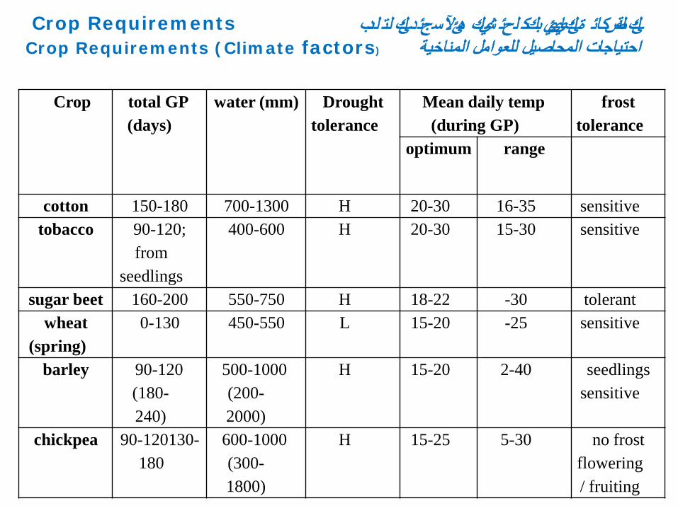
Crop total GP (days)
water (mm) Drought tolerance
Mean daily temp (during GP)
frost tolerance
optimum range
cotton 150-180 700-1300 H 20-30 16-35 sensitive tobacco 90-120;
from seedlings
400-600 H 20-30 15-30 sensitive
sugar beet 160-200 550-750 H 18-22 -30 tolerant wheat
(spring) 0-130 450-550 L 15-20 -25 sensitive
barley 90-120 (180-240)
500-1000 (200-2000)
H 15-20 2-40 seedlings sensitive
chickpea 90-120130-180
600-1000 (300-1800)
H 15-25 5-30 no frost flowering/ fruiting
شيكئ لحئ ب كك ة ئكايئي لةضكائ لدبهئآل ك لت د ئك Crop Requirements سجئ Crop Requirements (Climate factors)احتياجات المحاصيل للعوامل المناخية
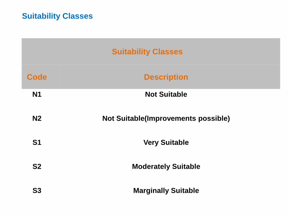
Suitability Classes
Code Description
N1 Not Suitable
N2 Not Suitable(Improvements possible)
S1 Very Suitable
S2 Moderately Suitable
S3 Marginally Suitable
Suitability Classes
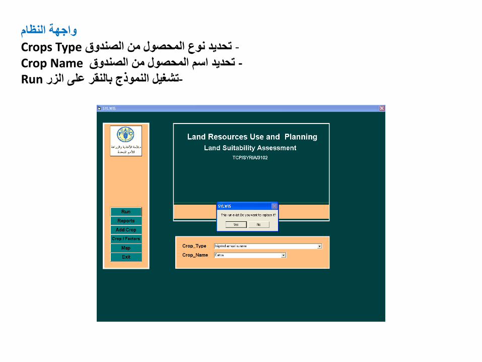
واجهة النظام Crops Typeتحديد نوع المحصول من الصندوق - Crop Nameتحديد اسم المحصول من الصندوق -
Runتشغيل النموذج بالنقر على الزر -
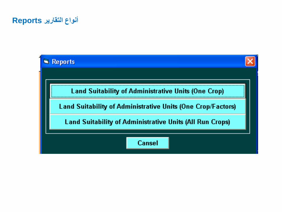
Reportsأنواع التقارير

Priorities
a. The priorities of actions in the field of land management - To keep of the agricultural land and reduce its degradation by identifying erosion and degradation areas and the establish necessary projects to stop the degradation. - Identify the hot spots areas and the promising areas for conservation and investment. - Identify areas that its fertility has deteriorated and set up programs for rehabilitate it. - Increase the irrigation area and rain fed by using modern techniques through the projects of land reclamation.
- Expand the arable land and increase its productivity
b-The priorities of actions in the field of management of protected areas - Increased budget for the development of nature protected areas within the budget of investment projects. - Training national staff for each protected area and manage it with the participation of the local people -Update the national policy of protected areas, according to modern techniques with a full account of the role of local society.
c. The priorities of actions In the field of the management of natural pastures protection
- Expansion in the implementation of water harvesting techniques.
-The use of renewable energy sources such as wind and solar energy.
- Activation of the sustainable management of rangelands and water that form the backbone to keep the steppe land and its development in suitable conditions.
- Support alternatives and rural industries and traditional handicrafts in the steppe lands to increase employment and combat poverty and protect the environment.
- Allocation marginal areas adjacent to steppe land to be an area for the sheep industry and, encourage investment projects, raising sheep and dairy production.
Recommendation
- Establishment agro-ecological zoning map for Syria, and identifying the optimal areas for the production of crops and fruit trees ,which commensurate with the soil classification and land uses, according to comparative advantage and using geographic information system.
- Identify hot spot areas which exposed to erosion and pollution, and adopt plans and measures to stop its degradation and to implement conservation and rehabilitation.
-Establishment maps of environmental land uses in all provinces and apply it in order to achieve sustainable development.
- Activating and developing the necessary legal framework to implement and enforce environmental land use plans with the development of environmental laws and existing legislation and the development of mechanisms.
- Developing data and land information system for land planning and land use .

Thank you


