
Spring 2016
Map and Guide
The official newspaper of Zion National Park
Plan Your VisitWelcome to Zion National Park. Steep cliffs, narrow canyons, and unpredictable weather add to the challenge and adventure of a visit. It is important to plan carefully for your stay. Park rangers at the visitor centers can provide planning information and weather forecasts, but your safety depends on your own good judgment,
adequate preparation, and constant awareness.
National Park Service U.S. Department of the InteriorZion National Park
NPS/MARC NEIDIG
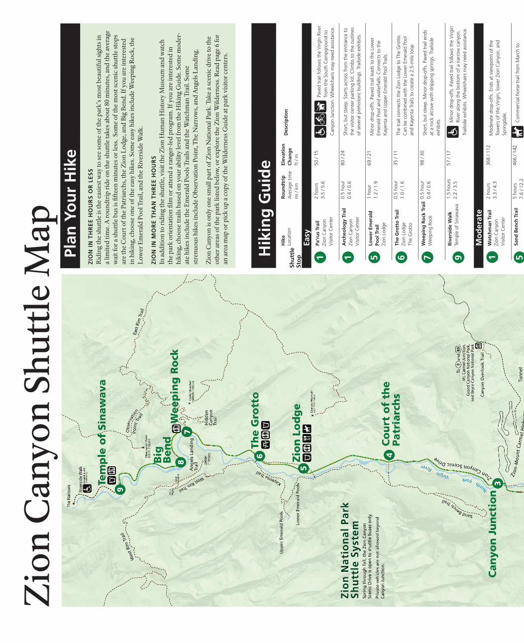
ZIoN caNyoN ShUTTle
The Zion Canyon ScenicDrive is accessible by shuttle bus only through November 13 and on
weekends in November. The buses are accessible and have room for backpacks, climbing gear, and at least two bicycles. The shuttles are free and you may get on and off as often as you like. Pets are not permitted.
SPrINgDale ShUTTle
In coordination with the Zion Canyon Shuttle, the Springdale Shuttle will pick up and drop off passengers in the town of Springdale. The closest stop to the Zion Canyon Visitor Center is located near the pedestrian entrance to the park.To avoid parking hassles, park in Springdale and ride the free shuttle to the pedestrian entrance of the park.
ParkINg
Parking areas in Zion are usually full from 10:00 amto 3:00 pm. To avoid delaysat the entrance station
and limited available parking, park in Springdale and ride the free shuttle to the park. Street parking is available in many locations in Springdale.
Improper parking is unsafe and damages park resources. Please park in designated spaces only and turn off your engine when your vehicle is stopped.
aUTomobIleS
Only the Zion Canyon Scenic Drive is closed to private vehicles. The Zion-Mt. Carmel Highway,
Kolob Canyons Road, and Kolob Terrace Road are open to vehicles.
Zion canyon Shuttle
First busfrom Zion Canyon Visitor Center
last bus to Springdale Shuttlefrom Temple of Sinawava from Zion Lodge
last busfrom Zion Canyon Visitor Centerfrom Temple of Sinawava Springdale Shuttle
First busfrom Majestic View Lodgefrom Zion Canyon Theatre
last bus to Zion canyon Shuttlefrom Majestic View Lodge
last busfrom Zion Canyon Theatre from Majestic View Lodge
Shuttle Schedule
The average wait for a shuttle bus is fifteen minutes or less. The wait is longer in the morning and evening, but shorter during peak hours. Shuttles will also operate on weekends in November, with additional service on Thanksgiving Day and Friday. The Shuttle Schedule is subject to change. Please check at the shuttle stops for current information.
Fall9/25 to 10/29
7:00 am 6:48 pm7:03 pm
6:45 pm 7:30 pm
8:10 am8:30 am
6:15 pm
7:30 pm 7:45 pm
Spring3/12 to 5/21
7:00 am 7:50 pm8:10 pm
7:45 pm 8:30 pm
8:10 am8:30 am
7:25 pm
8:30 pm 8:45 pm
Summer5/22 to 9/24
6:00 am 8:50 pm9:10 pm
8:30 pm 9:15 pm
7:10 am7:30 am
8:05 pm
9:30 pm 9:45 pm
late Fall10/30 to 11/13
7:00 am Not in service
6:00 pm 6:44 pm
Not in service
Not in service
Not in service
2 Map and Guide
Zion National Park SuperintendentJeff Bradybaugh
mailing addressZion National ParkSpringdale, UT 84767
Park Information435 772-3256
Wilderness Information435 772-0170
Websitewww.nps.gov/zion
lost and FoundReport at any visitor center
emergencies911 or 435 772-3322
National Park ServiceU.S. Department of the Interior
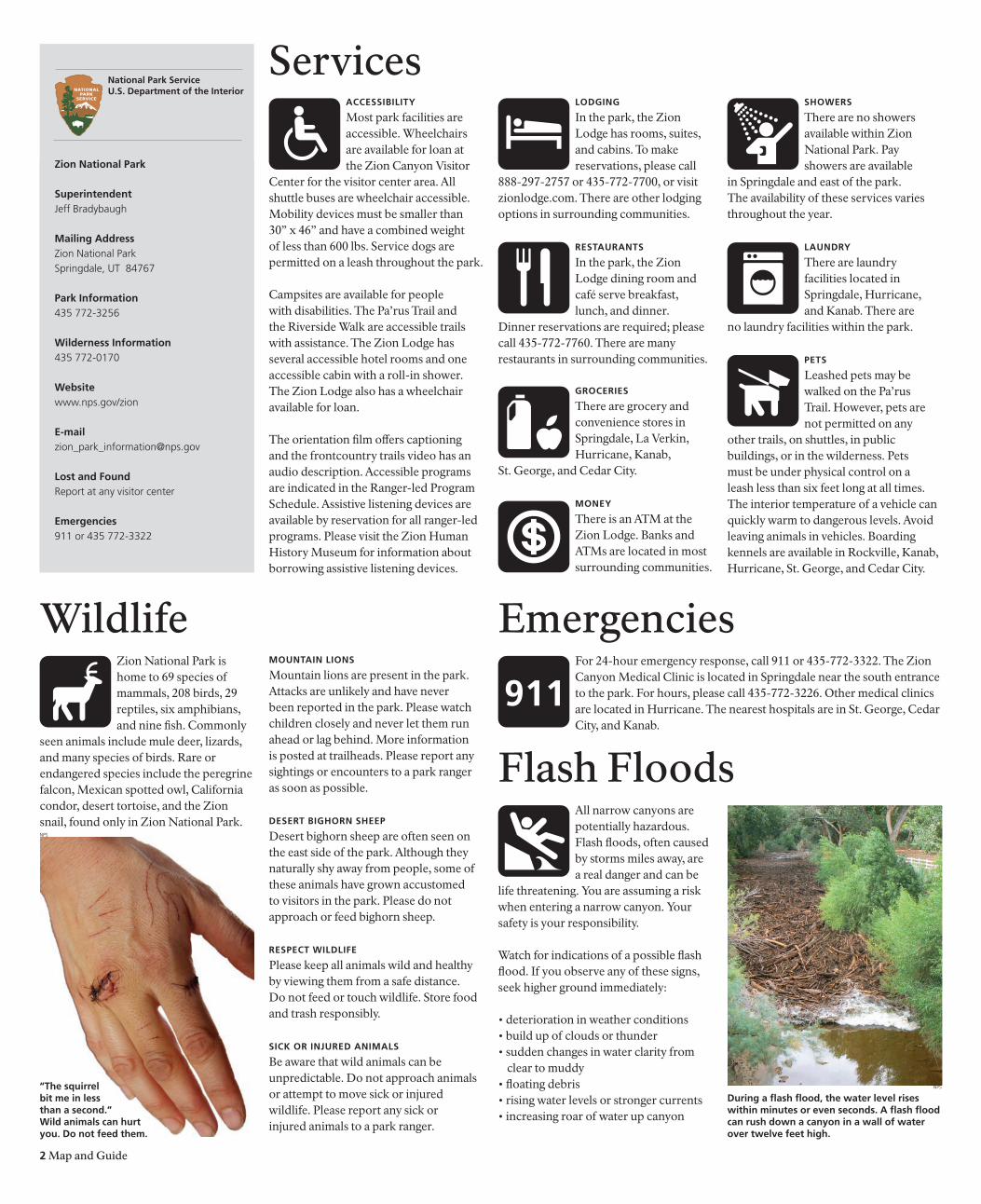
During a flash flood, the water level rises within minutes or even seconds. a flash flood can rush down a canyon in a wall of water over twelve feet high.
Wildlife EmergenciesFor 24-hour emergency response, call 911 or 435-772-3322. The Zion Canyon Medical Clinic is located in Springdale near the south entrance to the park. For hours, please call 435-772-3226. Other medical clinics are located in Hurricane. The nearest hospitals are in St. George, Cedar City, and Kanab.
ServicesacceSSIbIlITy
Most park facilities are accessible. Wheelchairs are available for loan at the Zion Canyon Visitor
Center for the visitor center area. All shuttle buses are wheelchair accessible. Mobility devices must be smaller than 30” x 46” and have a combined weight of less than 600 lbs. Service dogs are permitted on a leash throughout the park.
Campsites are available for people with disabilities. The Pa’rus Trail and the Riverside Walk are accessible trails with assistance. The Zion Lodge has several accessible hotel rooms and one accessible cabin with a roll-in shower. The Zion Lodge also has a wheelchair available for loan.
The orientation film offers captioning and the frontcountry trails video has an audio description. Accessible programs are indicated in the Ranger-led Program Schedule. Assistive listening devices are available by reservation for all ranger-led programs. Please visit the Zion Human History Museum for information about borrowing assistive listening devices.
loDgINg
In the park, the Zion Lodge has rooms, suites, and cabins. To make reservations, please call
888-297-2757 or 435-772-7700, or visit zionlodge.com. There are other lodging options in surrounding communities.
reSTaUraNTS
In the park, the Zion Lodge dining room and café serve breakfast, lunch, and dinner.
Dinner reservations are required; please call 435-772-7760. There are many restaurants in surrounding communities.
grocerIeS
There are grocery and convenience stores in Springdale, La Verkin, Hurricane, Kanab,
St. George, and Cedar City.
moNey
There is an ATM at the Zion Lodge. Banks and ATMs are located in most surrounding communities.
ShoWerS
There are no showers available within Zion National Park. Pay showers are available
in Springdale and east of the park. The availability of these services varies throughout the year.
laUNDry
There are laundry facilities located in Springdale, Hurricane, and Kanab. There are
no laundry facilities within the park.
PeTS
Leashed pets may be walked on the Pa’rus Trail. However, pets are not permitted on any
other trails, on shuttles, in public buildings, or in the wilderness. Pets must be under physical control on a leash less than six feet long at all times. The interior temperature of a vehicle can quickly warm to dangerous levels. Avoid leaving animals in vehicles. Boarding kennels are available in Rockville, Kanab, Hurricane, St. George, and Cedar City.
Zion National Park is home to 69 species of mammals, 208 birds, 29 reptiles, six amphibians, and nine fish. Commonly
seen animals include mule deer, lizards, and many species of birds. Rare or endangered species include the peregrine falcon, Mexican spotted owl, California condor, desert tortoise, and the Zion snail, found only in Zion National Park.
moUNTaIN lIoNS
Mountain lions are present in the park. Attacks are unlikely and have never been reported in the park. Please watch children closely and never let them run ahead or lag behind. More information is posted at trailheads. Please report any sightings or encounters to a park ranger as soon as possible.
DeSerT bIghorN SheeP
Desert bighorn sheep are often seen on the east side of the park. Although they naturally shy away from people, some of these animals have grown accustomed to visitors in the park. Please do not approach or feed bighorn sheep.
reSPecT WIlDlIFe
Please keep all animals wild and healthy by viewing them from a safe distance. Do not feed or touch wildlife. Store food and trash responsibly.
SIck or INjUreD aNImalS
Be aware that wild animals can be unpredictable. Do not approach animals or attempt to move sick or injured wildlife. Please report any sick or injured animals to a park ranger.
Flash FloodsAll narrow canyons are potentially hazardous. Flash floods, often caused by storms miles away, are a real danger and can be
life threatening. You are assuming a risk when entering a narrow canyon. Your safety is your responsibility.
Watch for indications of a possible flash flood. If you observe any of these signs, seek higher ground immediately:
• deterioration in weather conditions• build up of clouds or thunder• sudden changes in water clarity from
clear to muddy• floating debris• rising water levels or stronger currents• increasing roar of water up canyon
“The squirrel bit me in less than a second.” Wild animals can hurt you. Do not feed them.
NPS
NPS
hyPoThermIa
Hypothermia occurs when the body is cooled to dangerous levels. It is responsible for the greatest number of deaths
among people engaging in outdooractivities. It is a hazard in narrow canyons because immersion in water is thequickest way to lose body heat.To prevent hypothermia, avoid cotton clothing, it provides no insulation when wet, and eat high energy food before you are chilled. The signs of hypothermia in-clude uncontrollable shivering, stumbling and poor coordination, fatigue and weak-ness, and confusion or slurred speech. If you recognize any of these signs, stop hiking and immediately replace wet clothing with dry clothing. Warm the
heaT exhaUSTIoN
Heat exhaustion occurs when the body loses more fluid than is taken in. Signs of heat exhaustion include nausea, vomiting, fatigue,
headaches, pale appearance, stomach cramps, and cool clammy skin. If a mem-ber of your party begins to experience any of these symptoms, stop your hike immediately. Find a cool, shady area and rest with your feet up to distribute fluids throughout your body. It is important to drink fluids, but it is also important to eat. While suffering from heat exhaustion, drinking fluids without eating can lead to a potentially dangerous condition of low blood salt. Seek medical help if heat exhaustion symptoms persist for more than two hours.
Map and Guide 3
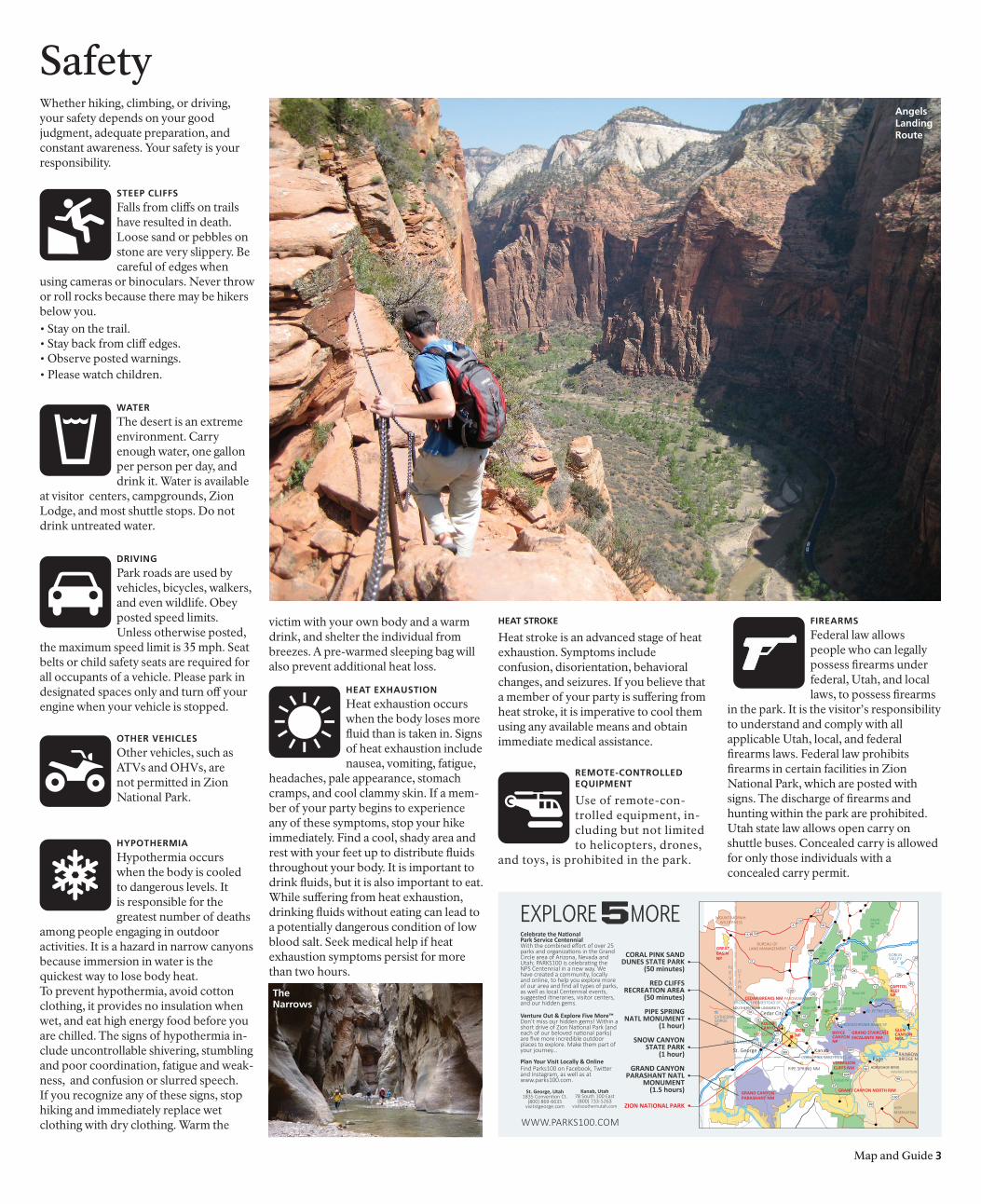
SafetyWhether hiking, climbing, or driving,your safety depends on your good judgment, adequate preparation, and constant awareness. Your safety is your responsibility.
STeeP clIFFS
Falls from cliffs on trails have resulted in death. Loose sand or pebbles on stone are very slippery. Be careful of edges when
using cameras or binoculars. Never throw or roll rocks because there may be hikers below you.• Stay on the trail.• Stay back from cliff edges.• Observe posted warnings.• Please watch children.
WaTer
The desert is an extreme environment. Carry enough water, one gallon per person per day, and drink it. Water is available
at visitor centers, campgrounds, Zion Lodge, and most shuttle stops. Do not drink untreated water.
DrIvINg
Park roads are used by vehicles, bicycles, walkers, and even wildlife. Obey posted speed limits. Unless otherwise posted,
the maximum speed limit is 35 mph. Seat belts or child safety seats are required for all occupants of a vehicle. Please park in designated spaces only and turn off your engine when your vehicle is stopped.
oTher vehIcleS
Other vehicles, such as ATVs and OHVs, are not permitted in Zion National Park.
remoTe-coNTrolleDeqUIPmeNT
Use of remote-con-trolled equipment, in-cluding but not limited to helicopters, drones,
and toys, is prohibited in the park.
angelslandingroute
victim with your own body and a warm drink, and shelter the individual from breezes. A pre-warmed sleeping bag will also prevent additional heat loss.
heaT STroke
Heat stroke is an advanced stage of heat exhaustion. Symptoms includeconfusion, disorientation, behavioral changes, and seizures. If you believe that a member of your party is suffering from heat stroke, it is imperative to cool them using any available means and obtain immediate medical assistance.
The Narrows
FIrearmS
Federal law allows people who can legally possess firearms under federal, Utah, and local laws, to possess firearms
in the park. It is the visitor’s responsibility to understand and comply with allapplicable Utah, local, and federalfirearms laws. Federal law prohibitsfirearms in certain facilities in ZionNational Park, which are posted with signs. The discharge of firearms and hunting within the park are prohibited. Utah state law allows open carry onshuttle buses. Concealed carry is allowed for only those individuals with aconcealed carry permit.
EXPLORE MORE
WWW.PARKS100.COM
28
5612
12
6 50
21
257
70
15
15
50
89
89
89
89
14
143
389
1718
18
13020
24
2424
24
62
62
22
89A
89
67
160
98
95
276
Dixie NF
Dixie NF
Dixie NFDixie NF
Kaibab NF
RED CANYON
FishLakeNF
FishLakeNF
KODACHROME BASIN SP
GRAND STAIRCASEESCALANTE NM
GRAND CANYONPARASHANT NM
VERMILIONCLIFFS NM
BRYCECANYONNP
GREAT BASINNP
PIPE SPRING NM
CEDAR BREAKS NMFRONTIER HOMESTEAD SP
ZIONNP
GRAND CANYON NORTH RIM
RAINBOWBRIDGE NM
SNOW CANYON SP
CORAL PINK SAND DUNES SP
NAVAJO NATION
HOPI RESERVATION
ANASAZI SP
FREMONTINDIANSP
PETRIFIED FOREST SPCATHEDRALGORGESP KOLOB
CANYONS GLENCANYONNRA
SOUTHERN UTAH UNIVERSITY
HORSESHOE BEND
RED CLIFFS
Cedar City
St. George Kanab
Page
La SalNF
PAROWAN GAP
650
50
6
10
BUREAU OF LAND MANAGEMENT
MOUNT MORIAH WILDERNESS
GOBLINVALLEY
SP
CAPITOLREEFNP
St. George, Utah1835 Convention Ct.
(800) 869-6635visitstgeorge.com
Kanab, Utah78 South 100 East
(800) 733-5263visitsouthernutah.com
CORAL PINK SANDDUNES STATE PARK
(50 minutes)
RED CLIFFSRECREATION AREA
(50 minutes)
PIPE SPRINGNATL MONUMENT
(1 hour)
SNOW CANYONSTATE PARK
(1 hour)
GRAND CANYON PARASHANT NATL
MONUMENT(1.5 hours)
ZION NATIONAL PARK
•
•
•
•
•
•
Celebrate the National Park Service Centennial With the combined effort of over 25 parks and organizations in the Grand Circle area of Arizona, Nevada and Utah; PARKS100 is celebrating the NPS Centennial in a new way. We have created a community, locally and online, to help you explore more of our area and find all types of parks, as well as local Centennial events, suggested itineraries, visitor centers, and our hidden gems.
Venture Out & Explore Five More™Don’t miss our hidden gems! Within a short drive of Zion National Park (and each of our beloved national parks) are five more incredible outdoor places to explore. Make them part of your journey...
Plan Your Visit Locally & OnlineFind Parks100 on Facebook, Twitter and Instagram, as well as at www.parks100.com.
4 Map and Guide
camPINg
Campgrounds in Zion Canyon have restrooms, drinking water, picnic tables, fire grates, dump
stations, and recycling. All sites are half price for holders of Interagency Senior and Access Passes. There are no showers available within Zion National Park. Pay showers are available in Springdale and east of the park. The availability of these services varies throughout the year.
FIreS
When fire danger is high, all campfires may be prohibited. When permitted, fires are only
allowed in fire grates in the campgrounds. Bring or buy firewood. Collecting any type of wood in the park is prohibited.
bIcyclINg
Bicycling is permitted on all park roadways and on the Pa’rus Trail. All other park trails, off-trail routes,
and the Zion-Mt. Carmel Tunnel are closed to bicycles. Bicyclists attempting to travel though the Zion-Mt. Carmel Tunnel must obtain a ride through the tunnel. Hitchhiking is permitted.Rangers are not allowed to provide, or arrange for, transport through the tunnel. Bicyclists must ride single file and stop to let shuttle buses pass. Do not pass a moving shuttle bus. Each shuttle bus has a rack for at least two bicycles.
clImbINg
The sandstone cliffs of Zion National Park are famous for big wall climbs. Zion is not a place for
inexperienced climbers. Climbing in the park requires appropriate hardware and advanced technical skills. There are few top roping areas and no sport climbs. Permits are not required for day climbs, but they are required for all overnight bivouacs. Climbing information and route descriptions are available at the Zion Canyon Wilderness Desk in the Zion Canyon Visitor Center.
Some areas and routes are closed each year to climbing from early March through August to protect nesting peregrine falcons. Some areas that are routinely closed to climbing include The Great White Throne, Cable Mountain, Court of the Patriarchs, and Angels Landing. Check at visitor centers or visit www.nps.gov/zion for current closure information.
Watchmancampground
Southcampground
lava Pointcampgroundno water; pit toilets
group campsitesorganized groupsof 9 to 40 people
Fees
$20 per night$30 per night for electric hookups
$20 per night
No fee
$3 per person per night
Sites
178
121
6
6
campgrounds
Private campgrounds with showers and hookups are available outside the park. South campground is closed from December 1 through February 26. Watchman campground is first-come, first-served from December 1 through February 26. The number of available campsites may vary throughout the year.
reservations
www.recreation.gov877-444-6777Up to six months in advance
First-come, first-served
First-come, first-served
www.recreation.gov877-444-6777
Recreation
horSeback rIDINg
Horses traditionally have been used to explore the terrain of Zion National Park. Guided trips are
available starting at the corral near the Emerald Pools Trailhead. For private stock use, see the Wilderness Guide or inquire at visitor centers.
WaTercraFT
All watercraft use in Zion National Park requires a wilderness permit. Permits are issued only
when the river is flowing in excess of 150 cubic feet per second. Inner tubes are not permitted at any time on any watercourse in the park.
hIkINg aNDcaNyoNeerINg
Hiking in canyons, even short hikes, requires advance planning. Some
hikes involve walking in water. Rivers and washes are subject to flash flooding. Know the weather and flash flood potential forecasts before starting your trip. Daily forecasts are posted in park visitor centers. Many canyons require ropes, hardware, and advanced technical skills for rappelling and ascending.
backPackINg
Permits are required for all wilderness camping. There is a fee. Permits and hiking information
are available at visitor centers. The maximum group size is 12 people. Please read the Wilderness Guide for more information.
WIlDerNeSS PermITS
Permits are required for overnight trips, through-hikes of The Narrows and its tributaries, Left
Fork (The Subway), Kolob Creek, and all canyons requiring the use of technical equipment. Reservations are available online for many permits at www.nps.gov/zion. Permits must be obtained at the visitor centers before your trip.
Wilderness permit fees are based on the size of your group: • $15 for 1-2 people• $20 for 3-7 people• $25 for 8-12 people
The maximum group size is 12 people of the same affiliation on the same trail or in the same drainage on the same day. The limit for some canyons is six people.
The NarroWS
The Virgin River has carved a spectacular gorge in the upper reaches of Zion Canyon—16 miles
long, up to 2,000-feet deep, and at times only 20 to 30-feet wide. The Narrows, with its soaring walls, sandstone grottos, natural springs, and hanging gardens can be an unforgettable experience. It is not, however, a trip to be underestimated. Hiking The Narrows means hiking in the Virgin River. At least 60 percent of the hike is spent wading, walking, and sometimes swimming in the river. There is no maintained trail because the route is the river. The current is swift, the water may be cold and deep, and the
rocks underfoot are slippery. Flash flooding and hypothermia are constant dangers. Good planning, proper equipment, and sound judgment are essential for a safe and successful trip. Your safety is your responsibility.
There are three ways to hike The Narrows, weather and water conditions permitting.
Day hIke From The boTTom aND back
To experience The Narrows, start at the Temple of Sinawava and hike one mile to the end of the Riverside Walk and wade into the river. In less than a mile, you will be hiking in one of the narrowest sections of the canyon. There is not a formal destination, and you will return the same way you came. Some hikers try to reach Orderville Canyon, a tributary roughly two hours upstream from the end of the trail. Travel upstream into Orderville Canyon or beyond Big Spring is prohibited. No permit is required for this day hike. Groups size limits apply beyond the junction with Orderville Canyon.
Day hIke From ToP To boTTom
This strenuous 16-mile all-day hike requires a permit and a private shuttle to the trailhead. Please see the Wilderness Guide or inquire at the Zion Canyon Wilderness Desk for more information.
overNIghT hIke From ToP To boTTom
This two-day hike requires a permit and a private shuttle to the trailhead. Maximum stay is one night. Please see the Wilderness Guide or inquire at the Zion Canyon Wilderness Desk for more information.
The NarroWS checklIST
• Obtain weather and flash flood potential forecasts before your trip.
• Wear closed-toe shoes or sturdy boots with ankle support, not sandals or water shoes.
• Take a walking stick. Do not cut tree branches for sticks.
• Children should not hike in the river due to strong currents and deep pools.
• Carry out all trash, including food wrappers, apple cores, fruit peels, and toilet paper.
• Carry one gallon of drinking water per person per day, food, sunglasses, sunscreen, and first aid kit.
• Take a fleece or windbreaker, The Narrows is much cooler than other areas in Zion Canyon.
• Pack your gear in waterproof bags.• Use the restroom at the Riverside Walk
trailhead before hiking. There are no toilets in The Narrows.
15
9
9 9
9
17
59
15
Rockville
Springdale
VirginLa Verkin
Toquerville
Hurricane
To Cedar City, Utah,Cedar Breaks NM, and
Salt Lake City, Utah
To St. George,Utah and LasVegas, Nevada
To at Mt. CarmelJunction, Utah, BryceCanyon NP, GrandCanyon NP, Kanab,Utah and Page, Arizona
89
To at Exit 16,St. George, Utah and Las Vegas,Nevada
15
To Pipe Spring National Monument andGrand Canyon National Park
Exit40
Exit27
Exit42
Kolob Canyons Road
Kol
ob
Ter
race
Roa
d
West Rim Rd
Zion
Can
yon
Scen
ic D
rive
Zion - Mount Carmel Highway
TunnelKolo
b Te
rrac
e R
oad
Smith
sonian Butte Scenic Backway
Grafton Road BridgeRoad
Lava Point Rd
Beyond this point, the roadis not plowed in winter.
Unpaved roads are impassable when wet.
Unpaved roads are impassable when wet.Smithsonian ButteScenic Backway maybe closed in winter.
Vehicles pulling trailers are not recommended. Narrow winding roadwith steep grades. The upper section is not plowed in winter.
Through October 25 and on weekends in November, the Zion Canyon Scenic Drive is open to shuttle buses only. Private vehicles are not permitted beyond Canyon Junction.
Vehicles longer than 19 feet/5.8 meters are
not allowed on Lava Point Road. Unpaved roads are impassable
when wet.
TunnelNo pedestrians or bikes allowed.Large vehiclerestrictions onpage 12.
Anasazi Way
ChinleTrailhead
Left ForkTrailhead
Right ForkTrailhead
GrapevineTrailhead
Hop ValleyTrailhead
WildcatCanyonTrailhead
Lee PassTrailhead
West RimTrailhead
La V
erki
n Cr
eek
Trai
l
Hop Valley Trail
Taylor Creek Trail
Wildca
t Ca
nyon
Trail
Northgate Peaks
Trail
Connector Trail
West R
im Trail
West Rim Trail
East Rim Trail
Chinle Trail KolobArchTrail
RiversideWalk
Kolob Arch
AngelsLanding
Z I ON
C
AN
YO
N
K O L O B C A N Y O N S
HU
RR
IC
AN
E
C
LI
FF
S
UPP
ER
K
OLO
B
PLA
TE
AU
HO
RS
E P
AS
TU
RE
PL
AT
EA
U
SMITH MESA
LO
WER K
OLO
B PLATEAU
HU
RR
ICA
NE
M
ESA
PA R U N U W E A P C A N Y O N
ORDERVILLE CANYON
TH
E N
AR
RO
WS
N
ort
h Fo
rk Virg
in
Riv
er
North Fork Virgin River
Virgin River
La V
erki
n
Cre
ek
Taylor Creek
KolobReservoir
East Fork Virgin River
8118ft2475m
5mi8km
6mi10km
14mi23km
5mi8km
20mi33km
10mi16km
3.6mi5.8km
1.4mi2.2km
6.2mi10km
10mi16km
KolobCanyons
Viewpoint
Taylor Creek Trail
Timber CreekOverlook Trail
Kolob Arch via
La Verkin Creek Trail
Lava PointLava Point
Overlook
Temple ofSinawava
Emerald PoolsTrails
Canyon Junction
The Grotto
WeepingRock
Zion Lodge
Coalpits Wash
Springdale / Zion Canyon Shuttleand Zion-Mount Carmel Highway
and Tunnel information
SouthCampground
WatchmanCampground
EastEntrance
SouthEntrance
Court of thePatriarchs
Zion Canyon detail opposite
Kolob CanyonsVisitor Center
Zion Canyon Visitor Center
Zion Human History Museum
Z I O N
N A T I O N A L
P A R K
Picnic area
Restrooms
Drinking water
Campground
Primitivecampground
Ranger station
Trail Trailhead
Unpaved road(impassable when wet)
Overlook / Parking
Paved road open toprivate vehicles
Zion Canyon Shuttleand shuttle stops
Springdale ShuttleShuttle Information Other Visitor Information
Through October 25 and on weekends in November, the Zion Canyon Scenic Drive is open to shuttles only. Private vehicles are not permitted beyond Canyon Junction.
Electric VehicleCharging Station
Orientation film
0 1 2 3 4
0
5 Miles
5 Kilometers1 2 3 4North
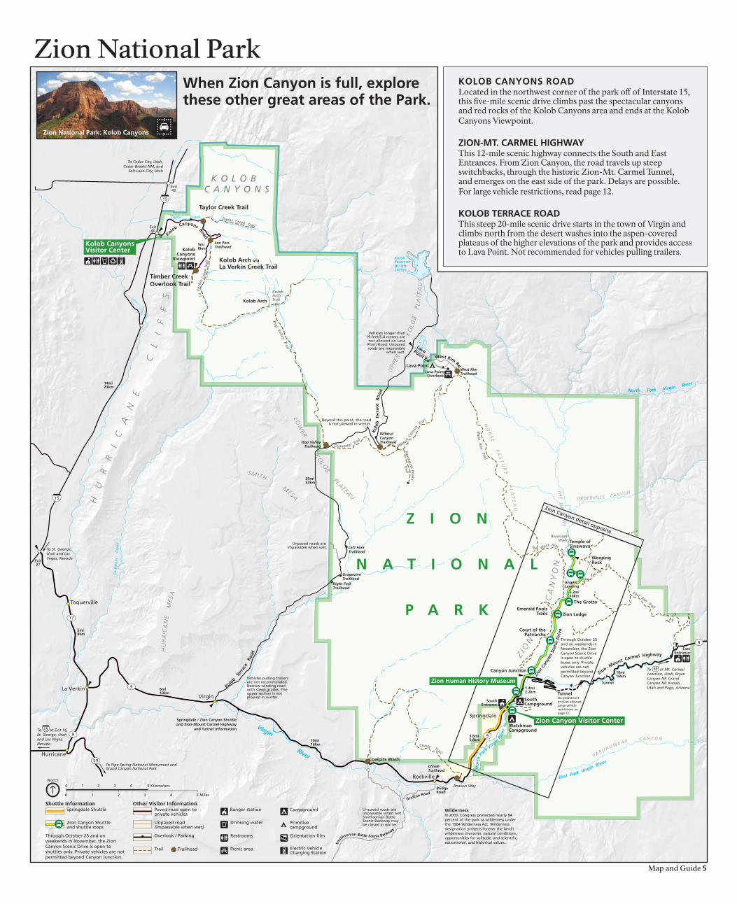
WildernessIn 2009, Congress protected nearly 84 percent of the park as wilderness under the 1964 Wilderness Act. Wilderness designation protects forever the land’s wilderness character, natural conditions, opportunities for solitude, and scientific, educational, and historical values.
Map and Guide 5
kolob caNyoNS roaDLocated in the northwest corner of the park off of Interstate 15, this five-mile scenic drive climbs past the spectacular canyons and red rocks of the Kolob Canyons area and ends at the KolobCanyons Viewpoint.
ZIoN-mT. carmel hIghWayThis 12-mile scenic highway connects the South and EastEntrances. From Zion Canyon, the road travels up steepswitchbacks, through the historic Zion-Mt. Carmel Tunnel,and emerges on the east side of the park. Delays are possible.For large vehicle restrictions, read page 12.
kolob Terrace roaDThis steep 20-mile scenic drive starts in the town of Virgin and climbs north from the desert washes into the aspen-coveredplateaus of the higher elevations of the park and provides access to Lava Point. Not recommended for vehicles pulling trailers.
Zion National Park
Zion National Park: kolob canyons
When Zion canyon is full, explore these other great areas of the Park.
Zio
n C
anyo
n Sh
uttle
Map
hik
ing
gu
ide
hik
eLo
catio
n
Pa’r
us
Trai
lZi
on C
anyo
nV
isito
r C
ente
r
arc
heo
log
y Tr
ail
Zion
Can
yon
Vis
itor
Cen
ter
low
er e
mer
ald
Po
ol T
rail
Zion
Lod
ge
The
gro
tto
Tra
ilZi
on L
odge
The
Gro
tto
Wee
pin
g r
ock
Tra
ilW
eepi
ng R
ock
riv
ersi
de
Wal
kTe
mpl
e of
Sin
awav
a
Wat
chm
an T
rail
Zion
Can
yon
Vis
itor
Cen
ter
San
d b
ench
Tra
il
Zion
Lod
ge
Up
per
em
eral
d
Poo
l Tra
ilZi
on L
odge
kay
enta
Tra
ilTh
e G
rott
o
can
yon
ove
rlo
ok
Trai
lZi
on-M
t. C
arm
el H
wy
Tayl
or
cre
ek T
rail
Kol
ob C
anyo
ns R
oad
Tim
ber
cre
ek
ove
rlo
ok
Trai
lK
olob
Can
yons
Roa
d
an
gel
s la
nd
ing
via
Wes
t r
im T
rail
The
Gro
tto
hid
den
can
yon
Tr
ail
Wee
ping
Roc
k
ob
serv
atio
n P
oin
t vi
a ea
st r
im T
rail
Wee
ping
Roc
k
The
Nar
row
svi
a r
iver
sid
e W
alk
Tem
ple
of S
inaw
ava
ko
lob
arc
h v
ia
la v
erki
n c
reek
Tr
ail
Kol
ob C
anyo
ns R
oad
Des
crip
tio
n
Pav
ed t
rail
follo
ws
the
Virg
in R
iver
f
rom
the
Sou
th C
ampg
roun
d to
C
anyo
n Ju
nctio
n. W
heel
chai
rs m
ay n
eed
assi
stan
ce.
Shor
t, b
ut s
teep
. Sta
rts
acro
ss f
rom
the
ent
ranc
e to
th
e vi
sito
r ce
nter
par
king
lot.
Clim
bs t
o th
e ou
tline
s of
sev
eral
pre
hist
oric
bui
ldin
gs. T
rails
ide
exhi
bits
.
Min
or d
rop-
offs
. Pav
ed t
rail
lead
s to
the
Low
er
Emer
ald
Pool
and
wat
erfa
lls. C
onne
cts
to t
he
Kay
enta
and
Upp
er E
mer
ald
Pool
Tra
ils.
The
trai
l con
nect
s th
e Zi
on L
odge
to
The
Gro
tto.
C
an b
e co
mbi
ned
with
the
Low
er E
mer
ald
Pool
an
d K
ayen
ta T
rails
to
crea
te a
2.5
-mile
loop
.
Shor
t, b
ut s
teep
. Min
or d
rop-
offs
. Pav
ed t
rail
ends
at
a ro
ck a
lcov
e w
ith d
rippi
ng s
prin
gs. T
rails
ide
exhi
bits
.
M
inor
dro
p-of
fs. P
aved
tra
il fo
llow
s th
e V
irgin
Riv
er a
long
the
bot
tom
of
a na
rrow
can
yon.
Tr
ails
ide
exhi
bits
. Whe
elch
airs
may
nee
d as
sist
ance
.
Mod
erat
e dr
op-o
ffs.
End
s at
vie
wpo
int
of t
he
Tow
ers
of t
he V
irgin
, low
er Z
ion
Can
yon,
and
Sp
ringd
ale.
C
omm
erci
al h
orse
tra
il fr
om M
arch
to
O
ctob
er. H
ike
atop
a m
assi
ve la
ndsl
ide
unde
r Th
e Se
ntin
el. D
eep
sand
and
litt
le s
hade
.M
inor
dro
p-of
fs. A
san
dy a
nd ro
cky
trai
l tha
t cl
imbs
to
the
Upp
er E
mer
ald
Pool
at
the
base
of
a cl
iff.
M
oder
ate
drop
-off
s. A
n un
pave
d cl
imb
to
t
he E
mer
ald
Pool
s. C
onne
cts
The
Gro
tto
to t
he E
mer
ald
Pool
s Tr
ails
.
Long
dro
p-of
fs, m
ostly
fen
ced.
Roc
ky a
nd u
neve
n tr
ail e
nds
at v
iew
poin
t of
Pin
e C
reek
Can
yon
and
low
er Z
ion
Can
yon.
Par
king
lot
is r
ight
-tur
n on
ly.
Lim
ited
to 1
2 pe
ople
per
gro
up. F
ollo
ws
the
Mid
dle
Fork
of
Tayl
or C
reek
pas
t tw
o ho
mes
tead
cab
ins
to
Dou
ble
Arc
h A
lcov
e.
Follo
ws
a rid
ge t
o a
smal
l pea
k w
ith v
iew
s of
Tim
ber
Cre
ek, K
olob
Ter
race
, and
Pin
e Va
lley
Mou
ntai
ns.
L
ong
drop
-off
s. N
ot f
or y
oung
chi
ldre
n or
any
one
fear
ful o
f he
ight
s. L
ast
sect
ion
is a
ro
ute
alon
g a
stee
p, n
arro
w r
idge
to
the
sum
mit.
L
ong
drop
-off
s. N
ot f
or a
nyon
e fe
arfu
l of
h
eigh
ts. F
ollo
ws
alon
g a
cliff
fac
e to
the
m
outh
of
a na
rrow
can
yon.
L
ong
drop
-off
s. C
limbs
thr
ough
Ech
o C
anyo
n
to
view
poin
t of
Zio
n C
anyo
n. A
cces
s to
Cab
le
Mou
ntai
n, D
eert
rap
Mou
ntai
n, a
nd E
ast
Mes
a Tr
ails
.
Read
pag
e 5
and
chec
k co
nditi
ons
at t
he v
isito
r ce
nter
bef
ore
atte
mpt
ing.
Hig
h w
ater
leve
ls c
an
prev
ent
acce
ss t
o Th
e N
arro
ws.
Lim
ited
to 1
2 pe
ople
per
gro
up. F
ollo
ws
Tim
ber
and
La V
erki
n C
reek
s. A
sid
e tr
ail l
eads
to
Kol
ob
Arc
h, o
ne o
f th
e w
orld
’s la
rges
t fr
eest
andi
ng a
rche
s.
ro
un
dtr
ipA
vera
ge t
ime
mi /
km
2 ho
urs
3.5
/ 5.6
0.5
hour
0.4
/ 0.6
1 ho
ur1.
2 / 1
.9
0.5
hour
1.0
/ 1.6
0.5
hour
0.4
/ 0.6
1.5
hour
s2.
2 / 3
.5
2 ho
urs
3.3
/ 4.3
5 ho
urs
7.6
/ 12.
2
1 ho
ur1.
0 / 1
.6
1.5
hour
s2.
0 / 3
.2
1 ho
ur1.
0 / 1
.6
3.5
hour
s5.
0 / 8
.0
0.5
hour
1.0
/ 1.6
4 ho
urs
5.4
/ 8.7
2.5
hour
s2.
4 / 3
.9
6 ho
urs
8.0
/ 12.
9
8 ho
urs
9.4
/ 15.
1
up t
o 8
hour
s14
.0 /
22.5
elev
atio
n
ch
ang
eft
/ m
50 /
15
80 /
24
69 /
21
35 /
11
98 /
30
57 /
17
368
/ 112
466
/ 142
200
/ 61
150
/ 46
163
/ 50
450
/ 137
100
/ 30
1488
/ 45
3
850
/ 259
2148
/ 65
5
334
/ 102
1037
/ 31
6
easy
mo
der
ate
Shu
ttle
St
op 1 1 5 6 7 9 1 5
ZIo
N I
N T
hr
ee
ho
Ur
S o
r l
eS
SR
idin
g th
e sh
uttle
is th
e ea
sies
t way
to s
ee s
ome
of th
e pa
rk’s
mos
t bea
utifu
l sig
hts
in
a lim
ited
time.
A ro
undt
rip
ride
on
the
shut
tle ta
kes
abou
t 80
min
utes
, and
the
aver
age
wai
t for
a sh
uttle
bus
is fi
ftee
n m
inut
es o
r les
s. S
ome
of th
e m
ost s
ceni
c sh
uttle
stop
s ar
e th
e C
ourt
of t
he P
atri
arch
s, th
e Z
ion
Lod
ge, a
nd B
ig B
end.
If y
ou a
re in
tere
sted
in
hik
ing,
cho
ose
one
of th
e ea
sy h
ikes
. Som
e ea
sy h
ikes
incl
ude
Wee
ping
Roc
k, th
e L
ower
Em
eral
d Po
ol T
rail,
and
the
Riv
ersi
de W
alk.
ZIo
N I
N m
or
e T
ha
N T
hr
ee
ho
Ur
SIn
add
ition
to ri
ding
the
shut
tle, v
isit
the
Zio
n H
uman
His
tory
Mus
eum
and
wat
ch
the
park
ori
enta
tion
film
or a
tten
d a
rang
er-l
ed p
rogr
am. I
f you
are
inte
rest
ed in
hi
king
, cho
ose
trai
ls b
ased
on
your
abi
lity
leve
l fro
m th
e H
ikin
g G
uide
. Som
e m
oder
-at
e hi
kes
incl
ude
the
Em
eral
d Po
ols T
rails
and
the
Wat
chm
an T
rail.
Som
e
stre
nuou
s hi
kes
incl
ude
Obs
erva
tion
Poin
t, T
he N
arro
ws,
and
Ang
els
Lan
ding
.
Zio
n C
anyo
n is
onl
y on
e sm
all p
art o
f Zio
n N
atio
nal P
ark.
Tak
e a
scen
ic d
rive
to th
e ot
her a
reas
of t
he p
ark
liste
d be
low
, or e
xplo
re th
e Z
ion
Wild
erne
ss. R
ead
page
6 fo
r an
are
a m
ap o
r pic
k up
a c
opy
of th
e W
ilder
ness
Gui
de a
t par
k vi
sito
r cen
ters
.
Plan
yo
ur
hik
e
Map and Guide 7
Stay
on
est
ablis
hed
tra
ils a
nd
wat
ch y
ou
r fo
oti
ng
, esp
ecia
lly a
t o
verl
oo
ks a
nd
nea
r d
rop
-off
s.
avo
id c
liff
edg
es. W
atch
ch
ildre
n c
lose
ly. P
eop
le u
nce
rtai
n a
bo
ut
hei
gh
ts s
ho
uld
sto
p if
th
ey
bec
om
e u
nco
mfo
rtab
le. N
ever
th
row
or
roll
rock
s b
ecau
se t
her
e m
ay b
e h
iker
s b
elo
w.
hik
eLo
catio
n
Pa’r
us
Trai
lZi
on C
anyo
nV
isito
r C
ente
r
arc
heo
log
y Tr
ail
Zion
Can
yon
Vis
itor
Cen
ter
low
er e
mer
ald
Po
ol T
rail
Zion
Lod
ge
The
gro
tto
Tra
ilZi
on L
odge
The
Gro
tto
Wee
pin
g r
ock
Tra
ilW
eepi
ng R
ock
riv
ersi
de
Wal
kTe
mpl
e of
Sin
awav
a
Wat
chm
an T
rail
Zion
Can
yon
Vis
itor
Cen
ter
San
d b
ench
Tra
il
Zion
Lod
ge
Up
per
em
eral
d
Poo
l Tra
ilZi
on L
odge
kay
enta
Tra
ilTh
e G
rott
o
can
yon
ove
rlo
ok
Trai
lZi
on-M
t. C
arm
el H
wy
Tayl
or
cre
ek T
rail
Kol
ob C
anyo
ns R
oad
Tim
ber
cre
ek
ove
rlo
ok
Trai
lK
olob
Can
yons
Roa
d
an
gel
s la
nd
ing
via
Wes
t r
im T
rail
The
Gro
tto
hid
den
can
yon
Tr
ail
Wee
ping
Roc
k
ob
serv
atio
n P
oin
t vi
a ea
st r
im T
rail
Wee
ping
Roc
k
The
Nar
row
svi
a r
iver
sid
e W
alk
Tem
ple
of S
inaw
ava
ko
lob
arc
h v
ia
la v
erki
n c
reek
Tr
ail
Kol
ob C
anyo
ns R
oad
Des
crip
tio
n
Pav
ed t
rail
follo
ws
the
Virg
in R
iver
f
rom
the
Sou
th C
ampg
roun
d to
C
anyo
n Ju
nctio
n. W
heel
chai
rs m
ay n
eed
assi
stan
ce.
Shor
t, b
ut s
teep
. Sta
rts
acro
ss f
rom
the
ent
ranc
e to
th
e vi
sito
r ce
nter
par
king
lot.
Clim
bs t
o th
e ou
tline
s of
sev
eral
pre
hist
oric
bui
ldin
gs. T
rails
ide
exhi
bits
.
Min
or d
rop-
offs
. Pav
ed t
rail
lead
s to
the
Low
er
Emer
ald
Pool
and
wat
erfa
lls. C
onne
cts
to t
he
Kay
enta
and
Upp
er E
mer
ald
Pool
Tra
ils.
The
trai
l con
nect
s th
e Zi
on L
odge
to
The
Gro
tto.
C
an b
e co
mbi
ned
with
the
Low
er E
mer
ald
Pool
an
d K
ayen
ta T
rails
to
crea
te a
2.5
-mile
loop
.
Shor
t, b
ut s
teep
. Min
or d
rop-
offs
. Pav
ed t
rail
ends
at
a ro
ck a
lcov
e w
ith d
rippi
ng s
prin
gs. T
rails
ide
exhi
bits
.
M
inor
dro
p-of
fs. P
aved
tra
il fo
llow
s th
e V
irgin
Riv
er a
long
the
bot
tom
of
a na
rrow
can
yon.
Tr
ails
ide
exhi
bits
. Whe
elch
airs
may
nee
d as
sist
ance
.
Mod
erat
e dr
op-o
ffs.
End
s at
vie
wpo
int
of t
he
Tow
ers
of t
he V
irgin
, low
er Z
ion
Can
yon,
and
Sp
ringd
ale.
C
omm
erci
al h
orse
tra
il fr
om M
arch
to
O
ctob
er. H
ike
atop
a m
assi
ve la
ndsl
ide
unde
r Th
e Se
ntin
el. D
eep
sand
and
litt
le s
hade
.M
inor
dro
p-of
fs. A
san
dy a
nd ro
cky
trai
l tha
t cl
imbs
to
the
Upp
er E
mer
ald
Pool
at
the
base
of
a cl
iff.
M
oder
ate
drop
-off
s. A
n un
pave
d cl
imb
to
t
he E
mer
ald
Pool
s. C
onne
cts
The
Gro
tto
to t
he E
mer
ald
Pool
s Tr
ails
.
Long
dro
p-of
fs, m
ostly
fen
ced.
Roc
ky a
nd u
neve
n tr
ail e
nds
at v
iew
poin
t of
Pin
e C
reek
Can
yon
and
low
er Z
ion
Can
yon.
Par
king
lot
is r
ight
-tur
n on
ly.
Lim
ited
to 1
2 pe
ople
per
gro
up. F
ollo
ws
the
Mid
dle
Fork
of
Tayl
or C
reek
pas
t tw
o ho
mes
tead
cab
ins
to
Dou
ble
Arc
h A
lcov
e.
Follo
ws
a rid
ge t
o a
smal
l pea
k w
ith v
iew
s of
Tim
ber
Cre
ek, K
olob
Ter
race
, and
Pin
e Va
lley
Mou
ntai
ns.
L
ong
drop
-off
s. N
ot f
or y
oung
chi
ldre
n or
any
one
fear
ful o
f he
ight
s. L
ast
sect
ion
is a
ro
ute
alon
g a
stee
p, n
arro
w r
idge
to
the
sum
mit.
L
ong
drop
-off
s. N
ot f
or a
nyon
e fe
arfu
l of
h
eigh
ts. F
ollo
ws
alon
g a
cliff
fac
e to
the
m
outh
of
a na
rrow
can
yon.
L
ong
drop
-off
s. C
limbs
thr
ough
Ech
o C
anyo
n
to
view
poin
t of
Zio
n C
anyo
n. A
cces
s to
Cab
le
Mou
ntai
n, D
eert
rap
Mou
ntai
n, a
nd E
ast
Mes
a Tr
ails
.
Read
pag
e 5
and
chec
k co
nditi
ons
at t
he v
isito
r ce
nter
bef
ore
atte
mpt
ing.
Hig
h w
ater
leve
ls c
an
prev
ent
acce
ss t
o Th
e N
arro
ws.
Lim
ited
to 1
2 pe
ople
per
gro
up. F
ollo
ws
Tim
ber
and
La V
erki
n C
reek
s. A
sid
e tr
ail l
eads
to
Kol
ob
Arc
h, o
ne o
f th
e w
orld
’s la
rges
t fr
eest
andi
ng a
rche
s.
ro
un
dtr
ipA
vera
ge t
ime
mi /
km
2 ho
urs
3.5
/ 5.6
0.5
hour
0.4
/ 0.6
1 ho
ur1.
2 / 1
.9
0.5
hour
1.0
/ 1.6
0.5
hour
0.4
/ 0.6
1.5
hour
s2.
2 / 3
.5
2 ho
urs
3.3
/ 4.3
5 ho
urs
7.6
/ 12.
2
1 ho
ur1.
0 / 1
.6
1.5
hour
s2.
0 / 3
.2
1 ho
ur1.
0 / 1
.6
3.5
hour
s5.
0 / 8
.0
0.5
hour
1.0
/ 1.6
4 ho
urs
5.4
/ 8.7
2.5
hour
s2.
4 / 3
.9
6 ho
urs
8.0
/ 12.
9
8 ho
urs
9.4
/ 15.
1
up t
o 8
hour
s14
.0 /
22.5
elev
atio
n
ch
ang
eft
/ m
50 /
15
80 /
24
69 /
21
35 /
11
98 /
30
57 /
17
368
/ 112
466
/ 142
200
/ 61
150
/ 46
163
/ 50
450
/ 137
100
/ 30
1488
/ 45
3
850
/ 259
2148
/ 65
5
334
/ 102
1037
/ 31
6
Stre
nu
ou
s
5 5 66 7 7 9
Eas
t Si
deTu
nnel
Page
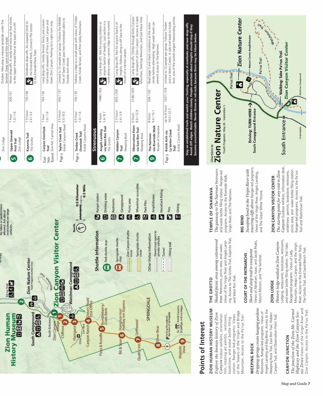
5
Page
5
Page
5
Te
mP
le o
F S
INa
Wa
va
The
gat
eway
to T
he N
arro
ws R
estr
oom
s an
d w
ater
bot
tle fi
lling
sta
tion.
Ran
ger-
led
prog
ram
s. A
cces
s to
the
Riv
ersi
de W
alk,
V
irgin
Riv
er, a
nd T
he N
arro
ws.
bIg
beN
DSw
eepi
ng b
end
in th
e V
irgi
n R
iver
with
to
wer
ing
cliff
s abo
ve R
ange
r-le
d pr
ogra
ms.
V
iew
s of
the
Virg
in R
iver
, Ang
els
Land
ing,
an
d Th
e G
reat
Whi
te T
hron
e.
ZIo
N c
aN
yo
N v
ISIT
or
ceN
Ter
The
star
ting
poin
t for
any
vis
it to
Zio
n C
anyo
n O
utdo
or e
xhib
its, i
nfor
mat
ion
desk
, w
ilder
ness
per
mits
, boo
ksto
re, r
estr
oom
s,
picn
ic a
rea,
and
wat
er b
ottle
filli
ng s
tatio
n.
Rang
er-le
d pr
ogra
ms.
Acc
ess
to t
he P
a’ru
s Tr
ail a
nd W
atch
man
Tra
il.
Th
e g
ro
TT
oSh
aded
pic
nic
area
am
ong
cott
onw
ood
tree
s Re
stro
oms,
pic
nic
area
, and
wat
er.
Vie
ws
of t
he V
irgin
Riv
er a
nd A
ngel
s La
nd-
ing.
Acc
ess
to T
he G
rott
o Tr
ail,
Kay
enta
Tra
il,
and
Wes
t Ri
m T
rail.
co
Ur
T o
F Th
e Pa
TrIa
rc
hS
Shor
t and
stee
p tr
ail t
o vi
ewpo
int
Vie
ws
of A
brah
am, I
saac
, and
Jac
ob P
eaks
, M
ount
Mor
oni,
and
The
Sent
inel
.
ZIo
N l
oD
ge
His
tori
c lo
dge
nest
led
in Z
ion
Can
yon
Lodg
ing,
rest
aura
nts,
boo
ksto
re, r
estr
oom
s,
and
wat
er b
ottle
filli
ng s
tatio
n. T
rail
rides
. Ra
nger
-led
prog
ram
s. V
iew
s of
Lad
yM
ount
ain,
Hea
ps C
anyo
n, a
nd t
he V
irgin
Ri
ver.
Acc
ess
to t
he E
mer
ald
Pool
s Tr
ails
,Th
e G
rott
o Tr
ail,
and
Sand
Ben
ch T
rail.
Poin
ts o
f In
tere
stZ
IoN
hU
ma
N h
IST
or
y m
US
eU
mE
xplo
re th
e hu
ma
n h
isto
ry o
f Z
ion
Ca
nyo
n In
do
or
exh
ibit
s, o
rien
tati
on
film
, ro
tati
ng
art
exh
ibit
, r
estr
oo
ms,
b
oo
ksto
re,
and
wat
er b
ott
le f
illin
gst
atio
n.
Ran
ger
-led
pro
gra
ms.
Vie
ws
of
the
Tow
ers
of
the
Vir
gin
an
d B
rid
ge
Mo
un
tain
. A
cces
s to
th
e Pa
’ru
s Tr
ail.
We
eP
INg
ro
ck
Dri
ppin
g sp
ring
s cre
ate
hang
ing
gard
ens
Rest
room
s. R
ange
r-le
d pr
ogra
ms.
Vie
ws
of
Ang
els
Land
ing
and
Big
Bend
. Acc
ess
to t
he
Wee
ping
Roc
k Tr
ail,
East
Rim
Tra
il, H
idde
n C
anyo
n Tr
ail,
and
Obs
erva
tion
Poin
t Tr
ail.
ca
Ny
oN
jU
Nc
TIo
NT
he ju
nct
ion
of
the
Zio
n-M
t. C
arm
el
Hig
hwa
y a
nd
the
Zio
n C
an
yon
Sce
-n
ic D
rive
Vie
ws
of
the
Vir
gin
Riv
er a
nd
Zio
n C
anyo
n.
Acc
ess
to t
he
Pa’r
us
Trai
l.

8 Map and Guide
Ranger-led Programs
Talks
more Programs as Staffing allows
All talks in Zion Canyon are presented on the patio behind the Zion Human HistoryMuseum. Talks are 20 to 30 minutes long.
aNImalS oF ZIoNExplore the fascinating world of Zion’s wildlife and learn the secrets of their survival.
SNaPShoTS oF hISToryDiscover the stories of the people who lived in and shaped Zion Canyon.
WaTer, rockS, aND TImeUncover how this striking scenery came to be and the stories recorded in the rocks.
ShUTTle ToUr - rIDe WITh a raNger2 hours, easyZion Canyon Visitor CenterSeating is limited—make free reservations, in person, up to three days in advance at the Zion Canyon Visitor Center. Please arrive 15 minutes prior to departure.
eveNINg ProgramSDiscover what makes Zion such a special place. 45-minute evening programs address a myriad of park-related topics. Check bulletin boards for times and locations.
a varIeTy oF raNger-leD hIkeS ThroUgh The SeaSoNCheck bulletin boards for times and locations.
WhaT’S FlyIN’ IN ZIoN2 hours, easy 1-mile bird walkIdentify and discuss Zion’s winged wonders. Make free reservations, in person, up to 3 days in advance at the Zion Canyon Visitor Center. Binoculars and field guides are recommended. Ask about accessibility options.
Enhance your understanding and enjoyment of Zion National Park by taking part in a ranger-led program. Programs are offered in Zion Can-yon and Kolob Canyons from April to Novem-
ber. There are few programs offered in early spring, with more offered by late May. Check the schedules posted at park information centers and bulletin boards throughout the park for times, places, and subjects.
SouthEntrance
ZionNatureCenter South
CampgroundAmphitheater
SouthCampground
Zion HumanHistory Museum
Pa’rusTrail
Zion CanyonVisitor Center
WatchmanCampground
WatchmanCampgroundAmphitheater
PedestrianEntrance
WatchmanTrail
ArcheologyTrail
0
0
0.3 Kilometer
0.3 Mile
North
Program locations
ranger-led Programs also meet at shuttle stops along the Zion canyon Scenic Drive.
An Activity Guide for Ages 4 and Older
Zion National Park National Park ServiceU.S. Department of the Interior
Youth programs are designed specifically for families and children. Children must be accompanied by an adult while attending the programs. Stay for just a minute or stay for over an hour for these drop-in programs. Programs are offered from April to August. There are few programs offered in early spring, with more offered by late May. Check at park information centers for times, places, and subjects.
Pool PoNDerINgEmerald Pools TrailheadDiscover Zion’s amazing animals and explore the secrets of Heaps Canyon and the Emerald Pools.
WeePINg rock WoNDerSWeeping Rock TrailheadExplore the forces of water and geology, and enjoy stories of early explorers.
WIlD WaTerSTemple of Sinawava Shuttle StopLearn about the wonderful ways that water affects animals and shapes Zion Canyon.
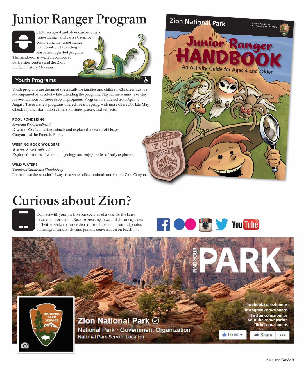
youth Programs
Junior Ranger ProgramChildren ages 4 and older can become a Junior Ranger and earn a badge by completing the Junior Ranger Handbook and attending at least one ranger-led program.
The handbook is available for free at park visitor centers and the Zion Human History Museum.
Curious about Zion?Connect with your park on our social media sites for the latest news and information. Receive breaking news and closure updates on Twitter, watch nature videos on YouTube, find beautiful photos on Instagram and Flickr, and join the conversation on Facebook.
flickr.com/zionnps
facebook.com/zionnps
twitter.com/zionnpsyoutube.com/npszion
instagram.com/zionnps
Map and Guide 9
10 Map and Guide
Environmental ImpactZion National Park is much more than just a recreational destination. It is a sanctuary of natural and cultural resources.
Conserving this heritage is a task that the National Park Service cannot accomplish alone. All of us serve a critical role in maintaining Zion’s sanctuary for the future. Please respect your national park and the experiences of others.
recyclINg aND TraSh
Please do not litter. Carry out or recycle all of your trash, including toilet paper. The park recycling program provides disposal for plastic, aluminum, glass, paper, and other materials. Zion National Park works closely with the community
to provide many recycling options for visitors. With help from you, Zion kept nearly 200,000 lbs of waste out of landfills last year. Participate in recycling efforts by using the available recycling bins inside the park and in local communities.
hIkINg
Please stay on marked trails. Hiking off trails can lead to loss of vegetation, soil compaction, erosion, and unsightly scars on the landscape.
WIlDlIFe
Feeding, harming, or capturing wild animals is illegal and can cause injury or death to the animal. Animals can become aggressive beggars when fed.
reSoUrce Damage
It is illegal to remove anything from Zion National Park, including flowers, rocks, or anything else that you might find. Do not write or carve on natural surfaces.
SoUNDScaPeS
Soundscapes, or sound environments, are an important natural feature of the park. Be aware of the noise that you make so that others may enjoy the peace and solitude of the park. Please travel quietly and limit the size of your group.
WaTer boTTle FIllINg STaTIoNS
There are several water bottle filling stations located throughout the park. To reduce waste, the sale of disposable plastic water bottles is prohibited in Zion Canyon. Support this initiative by bringing a reusable water bottle with you and using it after you leave. Water bottle
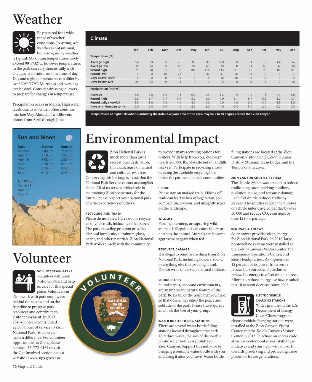
jan Feb mar apr may jun jul aug Sep oct Nov Dec
Temperature (°F)
average high 54 59 66 75 86 95 100 99 91 79 64 54average low 30 34 39 45 54 63 70 68 61 48 37 30record high 73 90 91 95 106 114 115 111 110 99 86 81record low –15 0 10 21 19 36 41 36 33 18 6 –5Days above 100°F 0 0 0 0 0 6 16 10 2 0 0 0 Days below 32°F 20 13 9 3 0 0 0 0 0 1 10 18
Precipitation (inches)
average 1.8 2.0 2.0 1.3 0.7 0.3 1.2 1.5 1.0 1.3 1.4 1.6 record high 9.3 6.7 7.1 5.4 3.0 4.0 4.9 5.1 6.7 5.5 4.0 4.7 record daily snowfall 12.5 8.0 7.2 4.0 4.0 1.0 0.0 0.0 0.0 3.0 4.5 8.0 Days with thunderstorms 0.0 0.0 0.0 1.0 4.0 5.0 14.0 15.0 5.0 2.0 0.0 0.0
climate
Temperatures at higher elevations, including the kolob canyons area of the park, may be 5 to 10 degrees cooler than Zion canyon.
filling stations are located at the Zion Canyon Visitor Center, Zion Human History Museum, Zion Lodge, and the Temple of Sinawava.
ZIoN caNyoN ShUTTle SySTem
The shuttle system was created to reduce traffic congestion, parking conflicts, pollution, noise, and resource damage. Each full shuttle reduces traffic by 28 cars. The shuttles reduce the number of vehicle miles traveled per day by over 50,000 and reduce CO2 emissions by over 12 tons per day.
reNeWable eNergy
Solar power provides clean energy for Zion National Park. In 2010, large photovoltaic systems were installed at the Kolob Canyons Visitor Center, the Emergency Operations Center, and Zion Headquarters. Zion generates 12 percent of its power from onsite renewable sources and purchases renewable energy to offset other sources. Efforts to reduce energy use have resulted in a 10 percent decrease since 2008.
elecTrIc vehIcle
chargINg STaTIoNS
With a grant from the U.S. Department of Energy Clean Cities program,
electric vehicle charging stations were installed at the Zion Canyon Visitor Center and the Kolob Canyons Visitor Center in 2015. Purchase an access code at visitor center bookstores. With these initiatives and your help, we can work towards preserving and protecting these places for future generations.
VolunteervolUNTeerS-IN-ParkS
Volunteer with Zion National Park and help us care for this special place. Volunteers at
Zion work with park employees behind the scenes and on the frontline to preserve park resources and contribute to visitor enjoyment. In 2015, 284 volunteers contributed 22,000 hours of service to Zion National Park. You too can make a difference. For volunteer opportunities at Zion, please contact 435-772-0184 or visit the Get Involved section on our website at www.nps.gov/zion.
WeatherBe prepared for a wide range of weather conditions. In spring, wet weather is not unusual, but warm, sunny weather
is typical. Maximum temperatures rarely exceed 90°F/32°C, however temperatures in the park can vary dramatically with changes in elevation and the time of day. Day and night temperatures can differ by over 30°F/17°C. Mornings and evenings can be cool. Consider dressing in layers to prepare for changes in temperature.
Precipitation peaks in March. High water levels due to snowmelt often continue into late May. Abundant wildflowers bloom from April through June.
Sun and moon Date Sunrise SunsetMarch 15 7:43 am 7:39 pmApril 1 7:18 am 7:54 pmApril 15 6:58 am 8:07 pmMay 1 6:38 am 8:21 pmMay 15 6:24 am 8:33 pmJune 1 6:13 am 8:47 pm
Full moonMarch 23April 21May 21
NPS
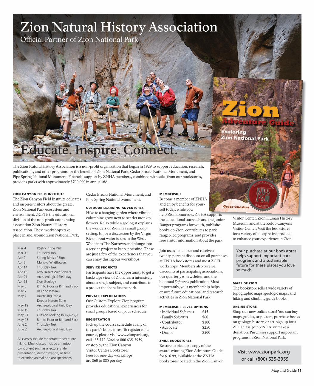
Zion Natural History Association
Educate. Inspire. Connect.
Map and Guide 11
Zion Canyon Field institute
The Zion Canyon Field Institute educates and inspires visitors about the greater Zion National Park ecosystem and environment. ZCFI is the educational division of the non-profit cooperating association Zion Natural History Association. These workshops take place in and around Zion National Park,
Cedar Breaks National Monument, and Pipe Spring National Monument.
outdoor learning adventures
Hike to a hanging garden where vibrant columbine grow next to scarlet monkey flowers. Relax while a geologist explains the wonders of Zion in a small group setting. Enjoy a discussion by the Virgin River about water issues in the West. Wade into The Narrows and plunge into a service project to keep it pristine. These are just a few of the experiences that you can enjoy during our workshops.
serviCe ProjeCts
Participants have the opportunity to get a backstage view of Zion, learn intensively about a single subject, and contribute to a project that benefits the park.
Private exPlorations
Our Custom Explore Zion program provides educational experiences for small groups based on your schedule.
registration
Pick up the course schedule at any of the park’s bookstores. To register for a course, please visit www.zionpark.org, call 435 772-3264 or 800 635-3959, or stop by the Zion Canyon Visitor Center Bookstore. Fees for one-day workshops are $60 to $85 per day.
MeMbershiP
Become a member of ZNHA and enjoy benefits for your-self today, while you help Zion tomorrow. ZNHA supports the educational outreach and the Junior Ranger programs for youth, publishes books on Zion, contributes to park ranger-led programs, and provides free visitor information about the park.
Join us as a member and receive a twenty-percent discount on all purchases at ZNHA bookstores and most ZCFI workshops. Members also receive discounts at participating associations, our quarterly e-newsletter, and the biannual Sojourns publication. Most importantly, your membership helps ensure future educational and research activities in Zion National Park.
MeMbershiP level oPtions
• Individual Sojourns $45• Family Sojourns $60• Contributor $100• Advocate $250• Donor $500
Znha bookstores
Be sure to pick up a copy of the award-winning Zion Adventure Guide for $16.99, available at the ZNHA bookstores located in the Zion Canyon
Visitor Center, Zion Human History Museum, and at the Kolob Canyons Visitor Center. Visit the bookstores for a variety of interpretive products to enhance your experience in Zion.
MaPs oF Zion
The bookstore sells a wide variety of topographic maps, geologic maps, and hiking and climbing guide books.
online store
Shop our new online store! You can buy maps, guides, or posters, purchase books on geology, history, or art, sign up for a ZCFI class, join ZNHA, or make a donation. Purchases support important programs in Zion National Park.
Visit www.zionpark.org
or call (800) 635-3959
Mar 4 Poetry in the ParkMar 31 Thursday TrekApr 2 Spring Birds of ZionApr 9 Mohave WildflowersApr 14 Thursday TrekApr 16 Low Desert WildflowersApr 21 Archaeological Field dayApr 23 Zion GeologyMay 6 Rim to Floor or Rim and Back May 7 Basin to Plateau May 7 Journaling into a Deeper Nature ZoneMay 19 Archaeological Field DayMay 19 Thursday TrekMay 21 Outside Looking In (Eagle Crags)
May 23 Rim to Floor or Rim and Back June 2 Thursday Trek June 2 Archaeological Field Day
All classes include moderate to strenuous hiking. Most classes include an indoor component such as a lecture, slide presentation, demonstration, or time to examine animal or plant specimens.
The Zion Natural History Association is a non-profit organization that began in 1929 to support education, research, publications, and other programs for the benefit of Zion National Park, Cedar Breaks National Monument, andPipe Spring National Monument. Financial support by ZNHA members, combined with sales from our bookstores, provides parks with approximately $700,000 in annual aid.
Official Partner of Zion National Park
Your purchase at our bookstores helps support important parkprograms and a sustainable future for these places you love so much.
The entrance fees at Zion National Park are $30 per vehicle, and $15 per person for bicyclists, pedestrians, motorcycles, and organized groups. All entrance fees are valid for seven days. Eighty percent of fees collected remain in the park forrepair, maintenance, and facility enhancement directly related to visitorenjoyment, health, and safety.
12 Map and Guide
North
0 10
0 10
50 Miles
50 Kilometers
15
15
000
143
389
169
169
168
00
64
67
59
14
56
18
63
1212
0000
ALT89
ALT89
00
89
89
89
93
93
95
000
180
0
9
9
U T A H
A R I Z O N A
NE
VA
DA
UT
AH
NE
VA
DA
AR
IZO
NA
Lake Powell
Colorado Rive
r
Virgin
River
Lake Mead
CedarBreaksNM
BryceCanyon
NationalPark
Glen CanyonNational
Recreation Area
Grand Staircase-Escalante
National Monument
Lake MeadNational
Recreation AreaLake MeadNationalRecreation Area
Grand Canyon-ParashantNational
Monument
Pipe SpringNational
Monument
Grand Canyon
National Park
VermilionCliffs
NationalMonument
Dirt roads maybe impassable
when wet
Road closed in winter
KaibabNational
Forest
KaibabNational Forest
St.George
Mesquite
Hurricane
Fredonia
Tuweep
Page
JacobLake
To SaltLake City
Time zones
Nevada is in thePacific Time Zone.
Utah is in theMountain Time Zone.Arizona is in theMountain Time Zone(daylight-saving timeis not observed).
Kanab
CedarCity
Panguitch
Long ValleyJunction
Mt. CarmelJunction
Snow CanyonState Park
Coral PinkSand Dunes
State Park
Valleyof Fire
StatePark
KOLOBCANYONS
ZIONCANYON
NORTH RIM
Henderson
LasVegas
To LosAngelesand SanDiego
TusayanCameron
Grand CanyonVillage
Desert View
La Verkin
Zion National Park
Large VehiclesThe Zion-Mt. Carmel Tunnel connects Zion Canyon to the east side of the park. It was built in the 1920s when large
vehicles were less common. Vehicles 11’4” tall or taller, or 7’10” wide or wider, require one-lane traffic control through the tunnel. Large vehicles cannot travel in a single lane through the tunnel. Nearly all RVs, buses, trailers, fifth-wheels, dual-wheel trucks, campers, and boats require traffic control.
TUNNel TraFFIc coNTrol
Visitors requiring traffic control through the tunnel must pay a $15 fee per vehicle in addition
to the entrance fee. Pay this fee at the park entrance station before driving to the tunnel. The fee is valid for two trips through the tunnel for the same vehicle
during a seven-day period. Rangers will stop oncoming traffic so that you may drive down the center of the road in the tunnel. We apologize for any delays associated with this safety precaution.
Large vehicles may only travel through the tunnel from:
• March 8 to May 2 from 8:00 am to 7:00 pm
• May 3 to September 5 from 8:00 am to 8:00 pm
ProhIbITeD vehIcleS
Vehicles not permitted in the tunnel include the following:
• vehicles over 13’1” tall• semi-trucks and commercial vehicles• vehicles carrying hazardous materials• vehicles weighing more than 50,000 lbs• combined vehicles or buses over 50’
Bicycles and pedestrians are also not permitted in the tunnel and must obtain a ride. Hitchhiking is permitted. Rangers are not allowed to provide, or arrange for, transport through the tunnel.
7’10”2.4 m
vehicles over 11’4” (3.4 m) tall or 7’10” (2.4 m) wide, including mirrors, awnings, and jacks, will require traffic control in the tunnel. Single-axle vehicles may not exceed 40’ in length.
11’4”3.4 m
The printing of this newspaper was made possible by the Zion Natural History Association.
Printed with
SOY INKPrinted on recycled paper. Please recycle again.
40’15.2 m
Zion canyonvisitor center
Zion canyonWilderness Desk
Zion humanhistory museum
kolob canyonsvisitor center
Zion Nature center
april 17 to may 27
8:00 am to 6:00 pm
7:00 am to 6:00 pm
10:00 am to 6:00 pm
8:00 am to 5:00 pm
Closed
march 12 to april 16
8:00 am to 5:00 pm
8:00 am to 5:00 pm
10:00 am to 5:00 pm
8:00 am to 5:00 pm
Closed
hours of operation
Utah is in the mountain Time Zone. california and Nevada are in the Pacific Time Zone, one hour earlier than Utah. arizona is in the mountain Time Zone, but does not observe daylight-saving time. Zion National Park is open all year, 24 hours a day.
may 28 to September 5
8:00 am to 7:30 pm
7:00 am to 7:30 pm
9:00 am to 7:00 pm
8:00 am to 6:00 pm
1:00 pm to 6:00 pm Closes September 5
ZIoN caNyoN vISITor ceNTer
Located near the South Entrance of the park, the Zion Canyon Visitor Center is an excellent place to begin your exploration of Zion Canyon. Park rangers and outdoor exhibits will help you plan your visit and make the most of your time. Inquire at the Zion Canyon Wilderness
Desk about permits for backpacking, canyoneering, and other trips into the wilderness. Visit the bookstore for maps, books, and gifts.
ZIoN hUmaN hISTory mUSeUm
Indoor exhibits focus on the human history of Zion National Park. A 22-minute orientation film highlights the dramatic landscapes of the park and examines the history of the canyon. Rotating art exhibits feature regional artists. Visit the bookstore for maps, books, and gifts.
There are dramatic views of the Towers of the Virgin and Bridge Mountain outside.
kolob caNyoNS vISITor ceNTer
This is the entry point to the Kolob Canyons area of the park. It is located 45 miles north of Springdale and 17 miles south of Cedar City at Exit 40 on Interstate 15. Park rangers are available to answer questions and issue wilderness permits. Exhibits explore the geology, vegetation, and wildlife of this unique landscape.
Information Centers
Entrance FeesZIoN aNNUal PaSS $50Admission to Zion National Park for one year from date of purchase.
aNNUal PaSS$80Admission to all federal fee areas for one year from date of purchase.
4Th graDe PaSS -FreeAdmission to allfederal fee areas through Aug forU.S. 4th Graders withvalid paper pass.
mIlITary aNNUal PaSS - FreeActive duty militaryadmission to allfederal fee areasfor one year.
PaSSeS are available at park entrance stations. Information about interagency passes andparticipating agencies (NPS, blm, FWS, FS, and bor) is available online at store.usgs.gov/pass.
SeNIor PaSS$10Admission to all federal fee areas for life, U.S. citizens 62 years or older.
acceSS PaSS -FreeAdmission to all federal fee areas for life, permanently disabled U.S. citizens.


