0102.9546
RECONNAISSANCE GEOPHYSICAL SURVEYS VINCENT TOWNSHIP-CLAIMS #8^5986-84-5990 CAYUGA SYNDICATE
-1-
I INTRODUCTION; The following pages are a concise attempt to
present the results of Geophysical surveys completed on Claims
#845986 to #845990 inclusive,within Vincent Township. Included
here is the location and present holders of the property,instruments
used,with a brief explaination of field procedures,previous surveys
done on the property,and finally an interpretation of the results.
Also enclosed with this report are seperate profiles of each
line,as well as a complete map of each survey.
-2-
HOLDERS of CLAIMS; The, report presented here was written by
the technical personal of the Cayuga Syndicate,which is
headquartered at 360 Main St. ,V/innipeg,Manitoba. This organization
are the present holders of this property.
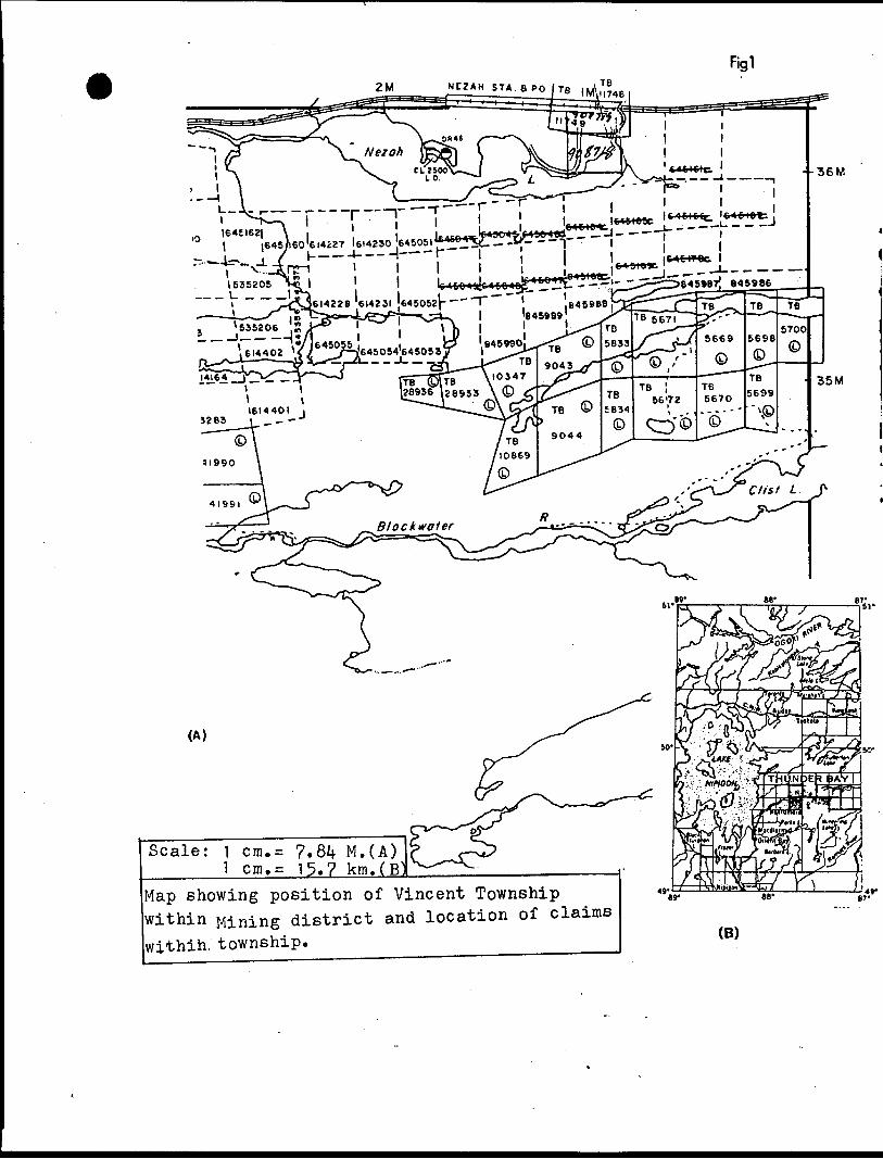
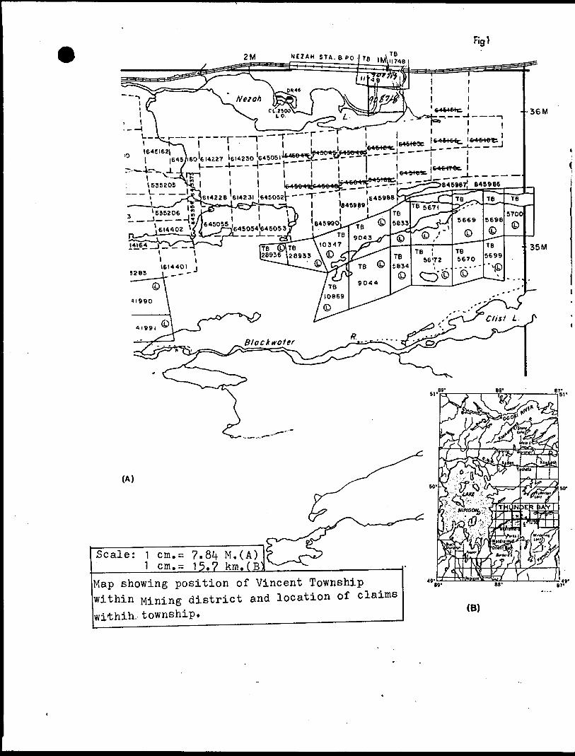
LOCATION: The claims surveyed are located in the north-east
sector of Vincent Township(NTS Map 42E12) and are registered as
#8/15986 to #845990 respectively,within the Thunder Bay Mining
District(Fig.l). The claims are accessible by way of Highway #11 and
various foot trails.
EQUIPMENT and PROCEDURE; The geophysical methods used on
these claims were of the reconnaissance type,that is ground based
magnetometer and VLF-EM. The surveys were conducted between June
and August 1986.
The instruments used were a Geometrics portable proton
magnetometer,model G-8l6 and a Geonics EM16 VLF-EM system.
Specifications for both instruments are given in figures 2 and 3.
A Geometrics G-856B portable magnetometer was used as a magnetic
base station.
As this report is concerned basically with recording data
for assessment purposes,no attempt will be made to probe the
theoretical aspects of the Magnetic or Electromagnetic methodology
or equipment design. A list of suitable references is supplied to
the reader wishing to pursue this line of thought.
A brief procedure used in these surveys is as follows.
For the magnetic survey,the first step is to get the base station
functioning. The base station is necessary to correct for diurnal
and micropulsation time variations. The base station is tuned in
order to acquire the best magnetic signal. This magnetic base was
-3-
found to be 60300 Gammas. The sychronization of the base clock
with the operators field clock and a time interval for readings
is then established. This interval was 60 seconds. Finally the
Auto switch is activated and the diurnal station monitor is
operational. The operator then proceeds down the line,takes and
records a reading at the station to the nearest minute. The
stations are at 25 meter intervals along north-south trending
lines,which are 100 meters apart. The total number of stations
for all five claims is 331.
The VLF-EM survey is performed by first orientating the
instrument perpendicular to the survey line in order to establish
a transmitting station for the best coupling effect. In this case
the transmitter is NAA originating from Cutler,Maine at a
frequency of 2^.0 kHz. The transmitter direction is determined
when the sound intensity is at a minimum. The next move is to
orientate the reference coil along magnetic lines,by slowly
moving the instrument back and forth until minimum sound intensity
and adjust the Out of Phase(Quadrature) component dial to further
minimize the sound. Read and record the number on the inclinometer
and the Out of Phase component dial. The operator must always face
north or in the case of north-south trending strike,one must face
west. This is necessary in order for the polarities to remain
constant through every line.
PREVIOUS WORK: As far as can be ascertained no published
evidence is available of prior work executed on these particular
claims. In the field however,there is evidence that some trenching
was done some time ago.
-i).-
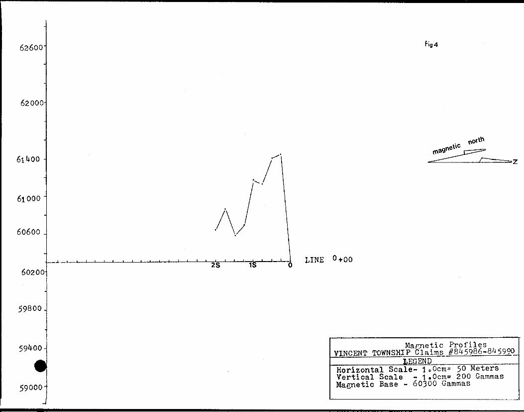
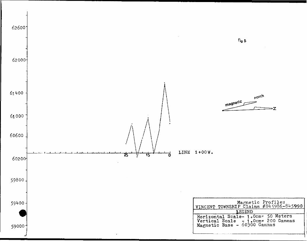
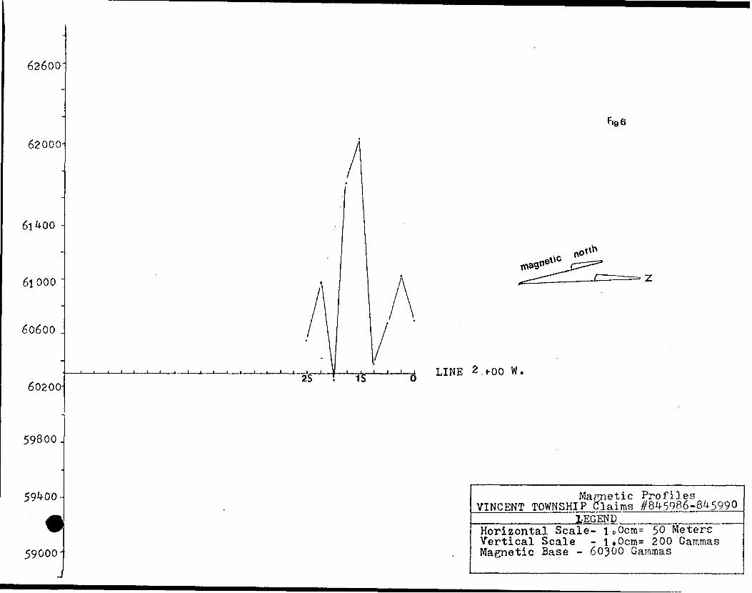
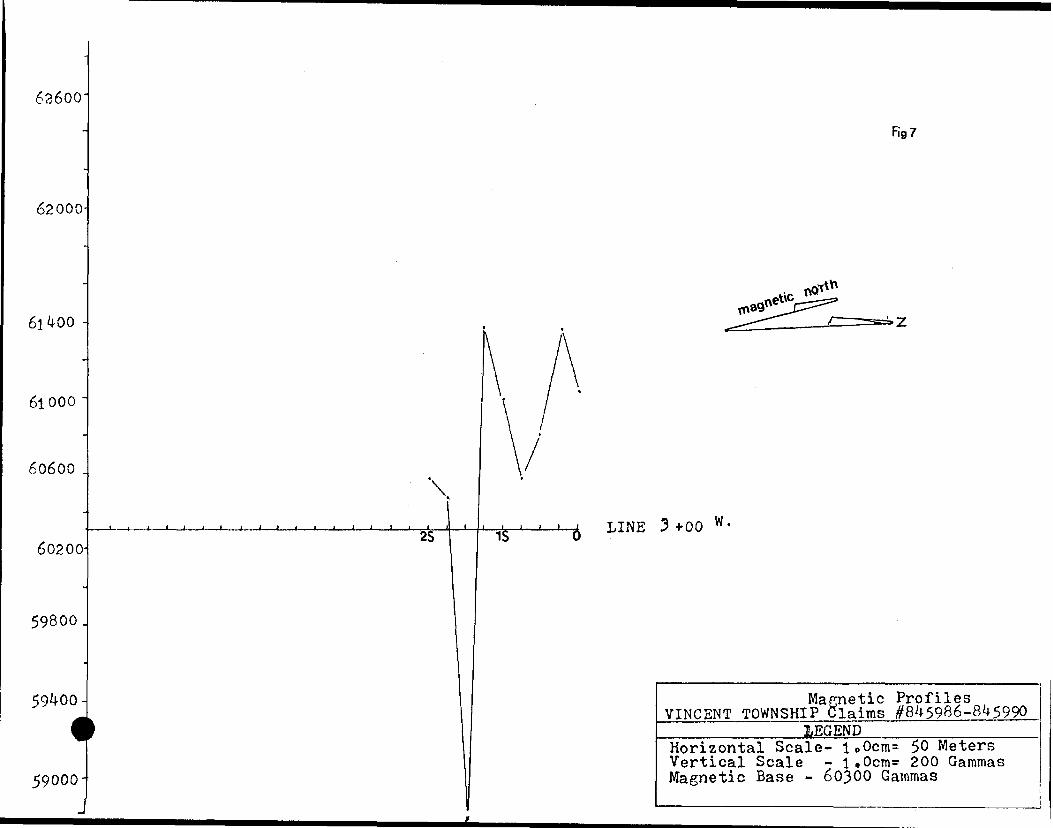
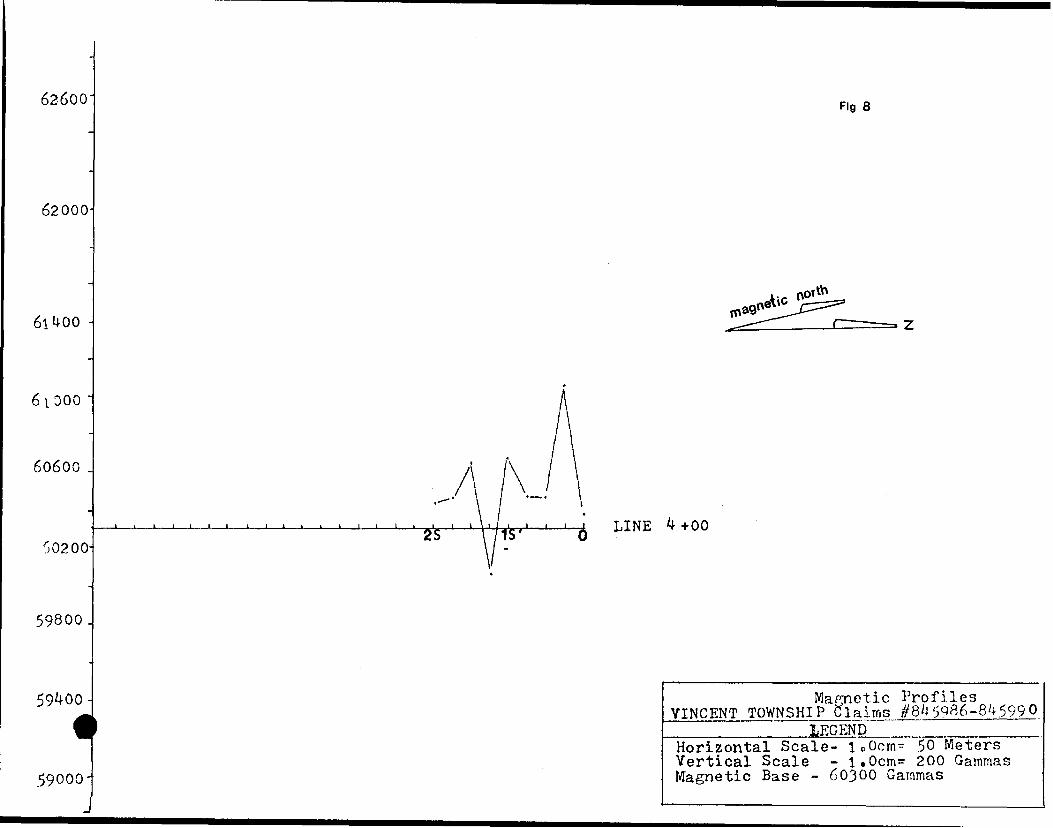
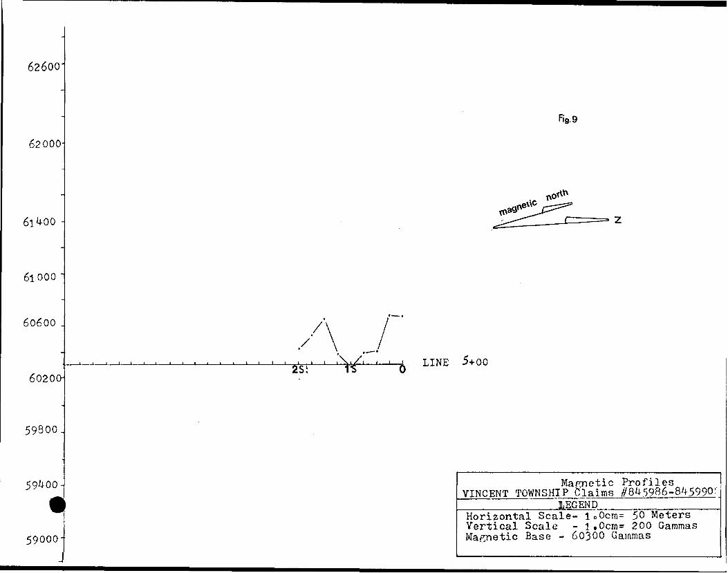
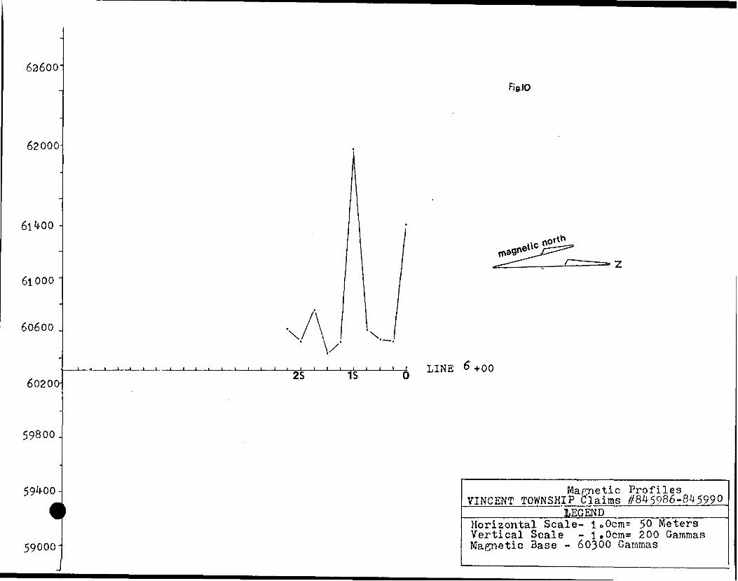
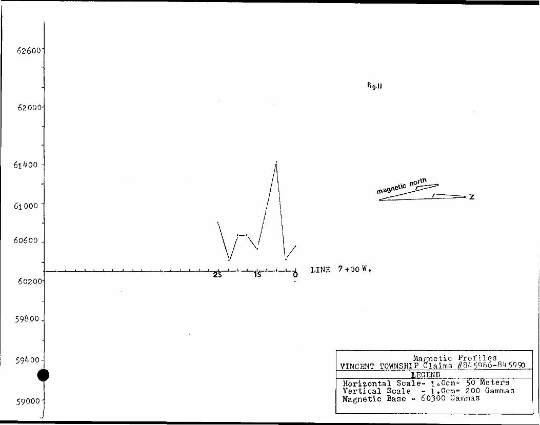
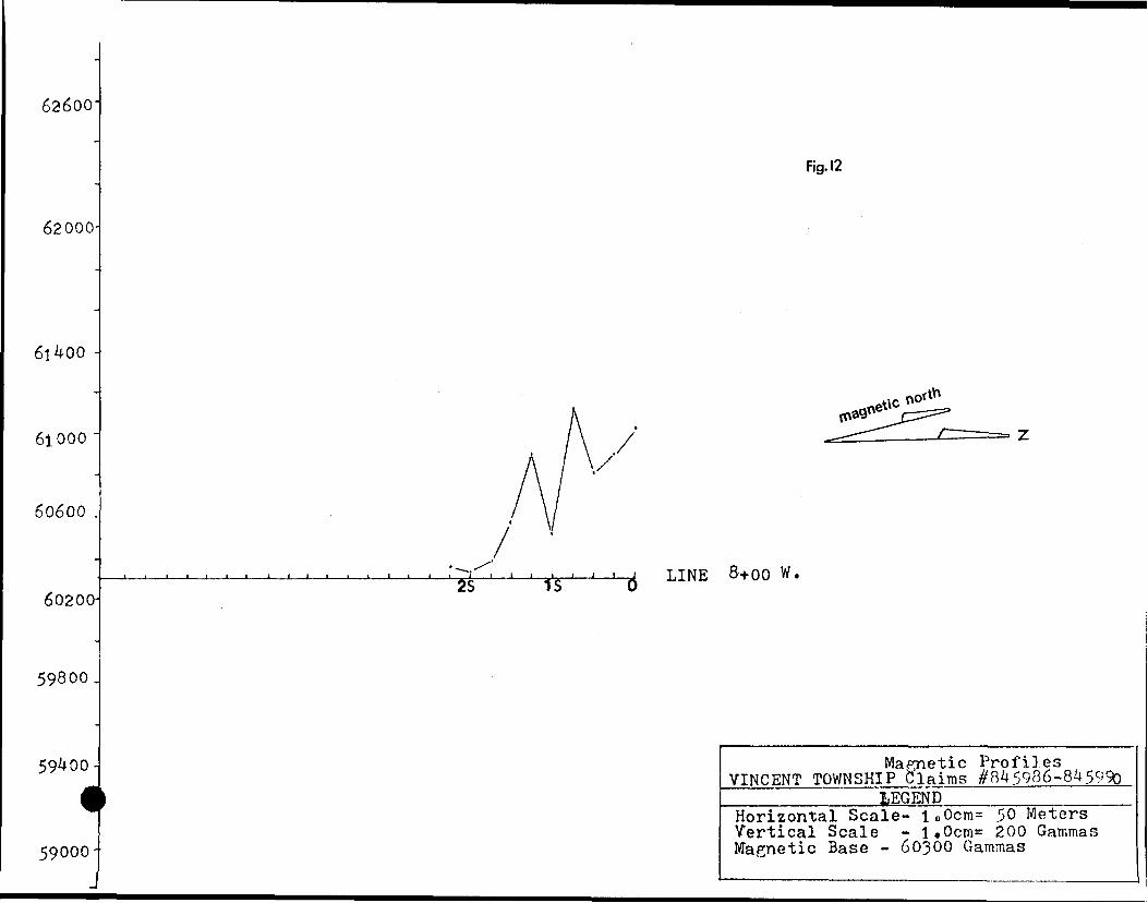
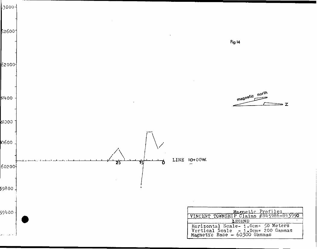
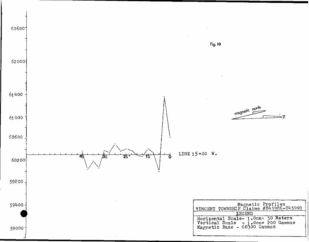
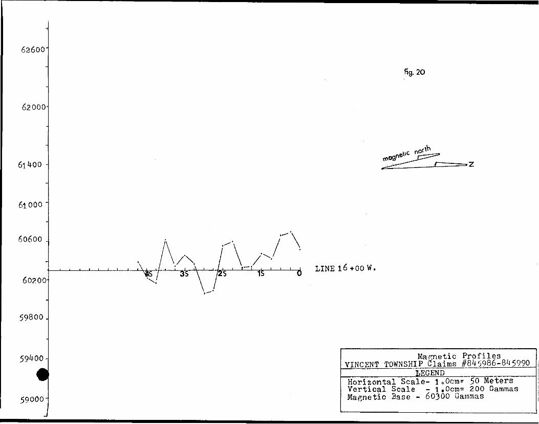
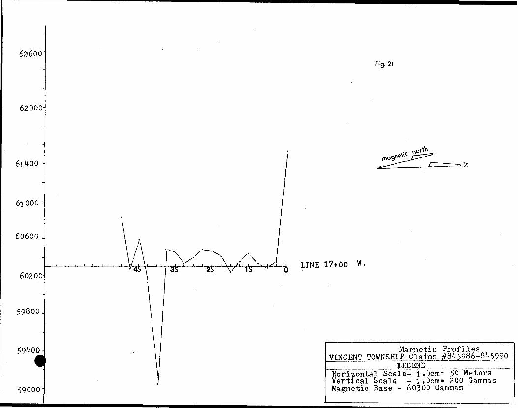
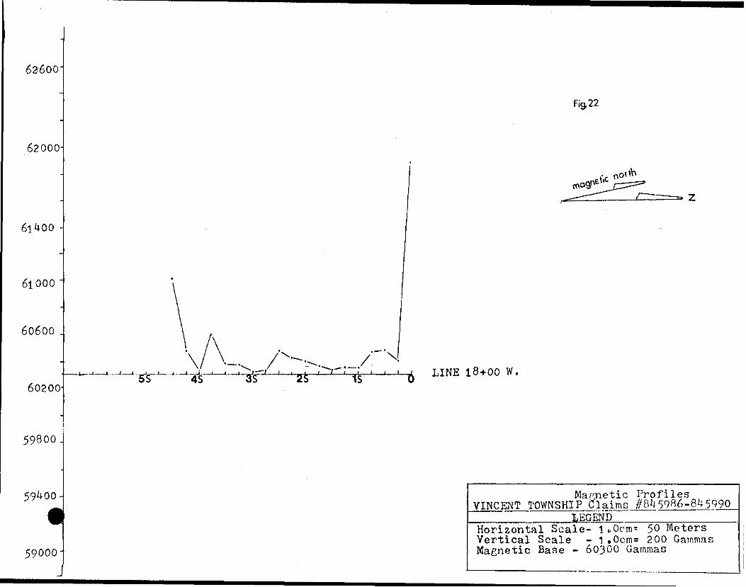
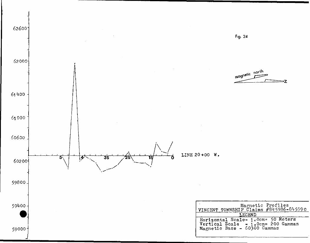
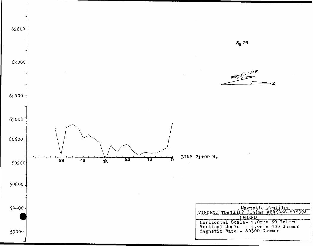
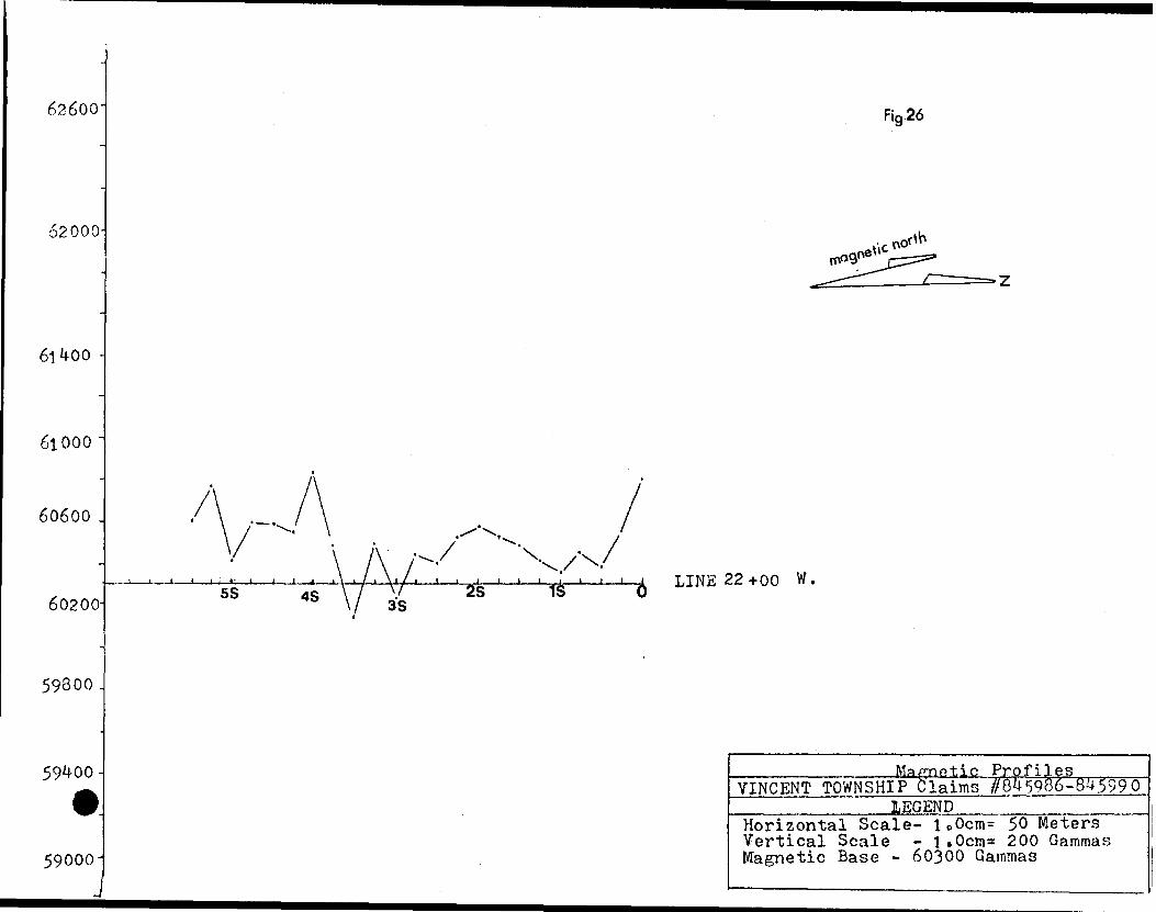
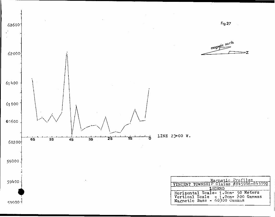
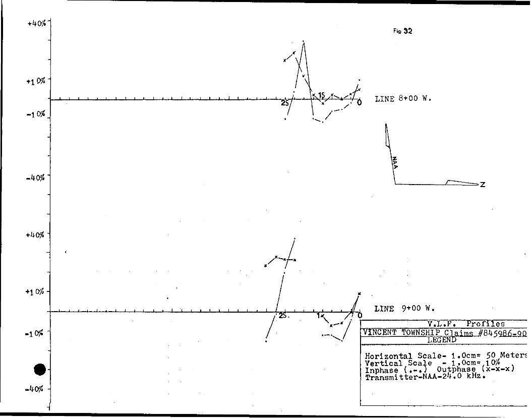
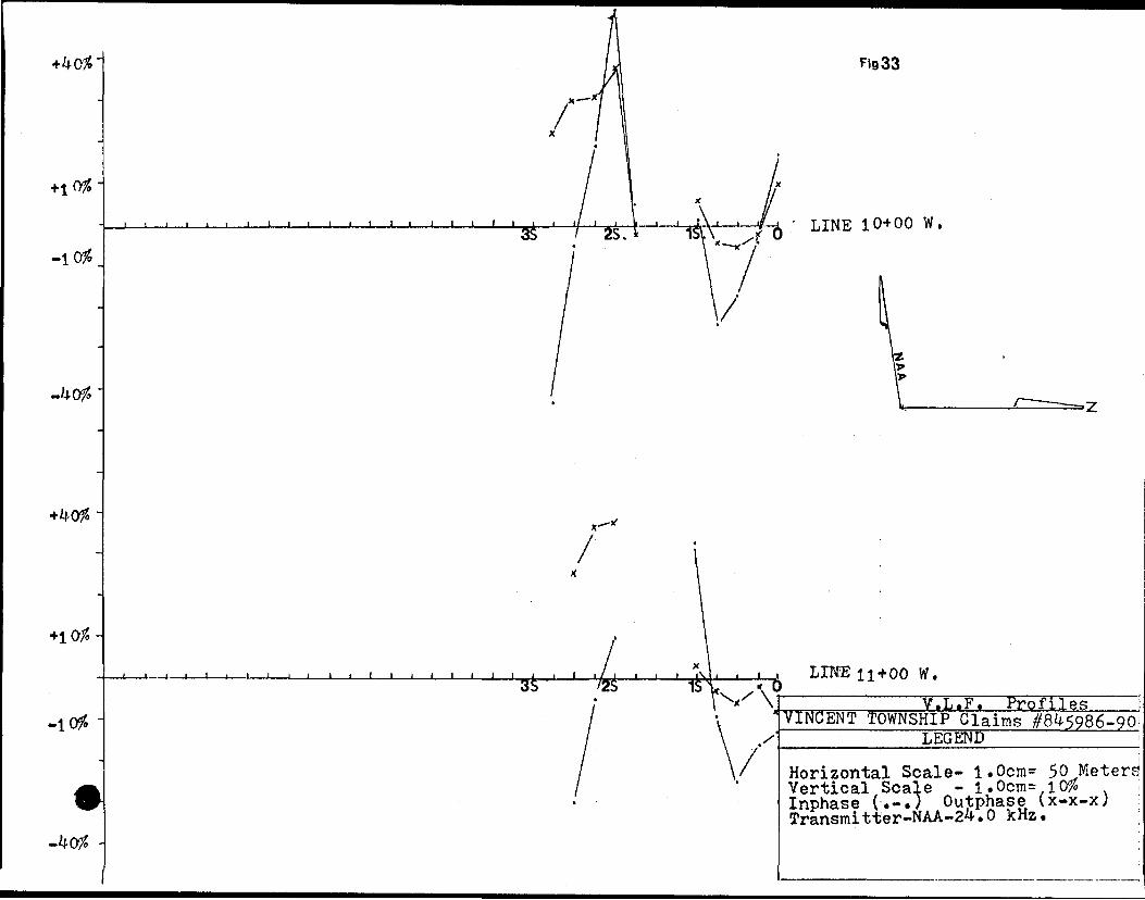
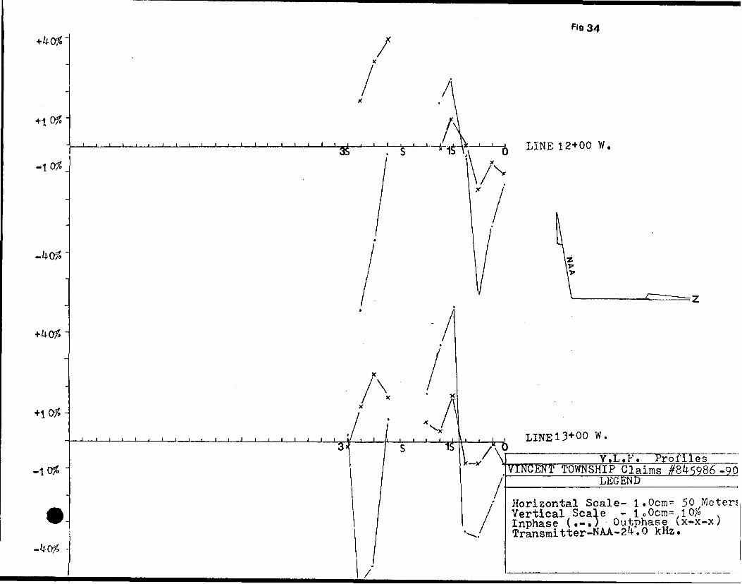
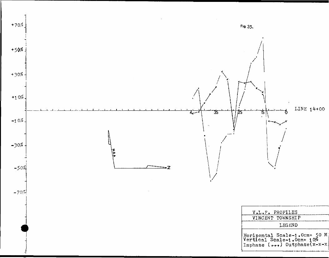
I INTERPRETATION; The magnetic profiles (Fig. 4-2?) indicate
in general,a low magnetic response. There are points which show
major peaks both high and low. The magnetic anomalies that are
present imply that the structure causing them,is narrow and steeply
dipping. The structure seems to trend along strike,that is in a
east-west direction and is located,in general between lines 0+00
and 18+00 West,covering a width of 100 meters,from stations 0+00
to 1+00 South. There is a southern magnetic anomaly located between
stations 4+00 and 5+00 South,along lines 18+00 to 23+00 West. The
magnetic anomalies do not correspond exactly to the VLF conductors
noted below,but they are adjacent and thus they are most likly the
result of the same geological structure.
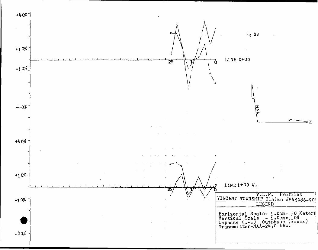
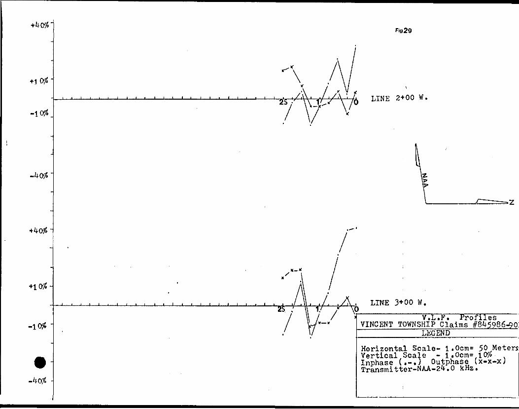
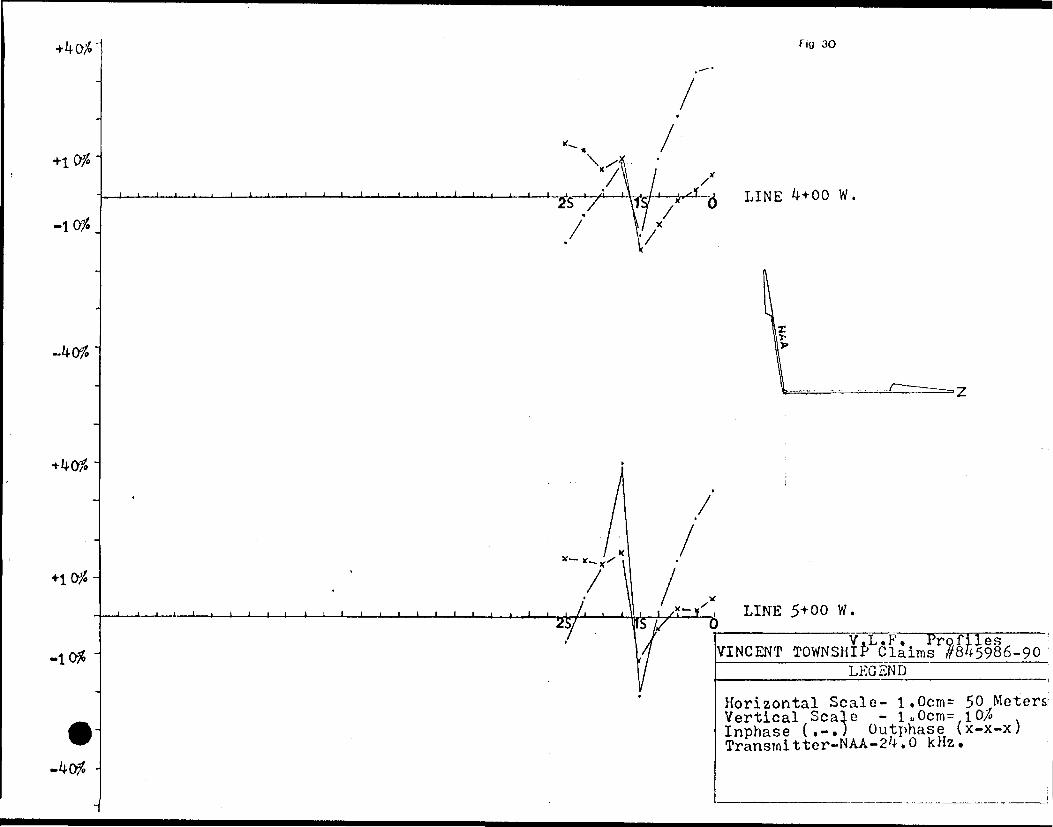
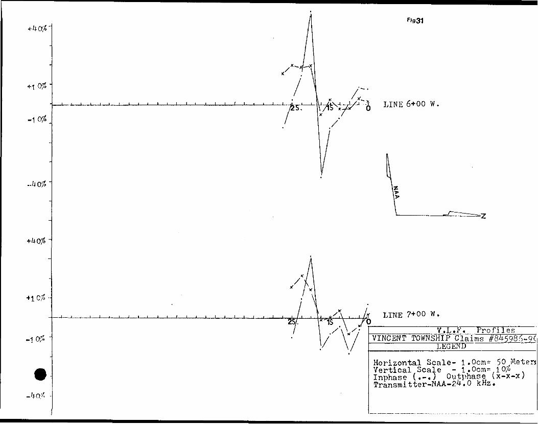
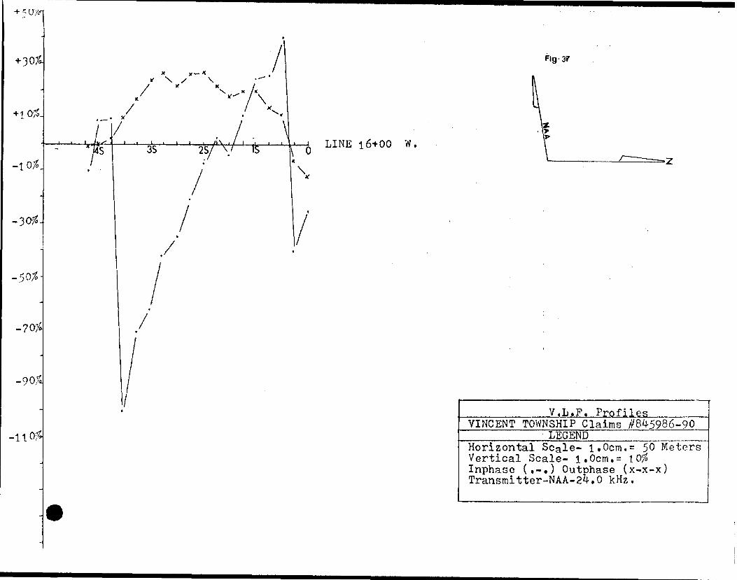
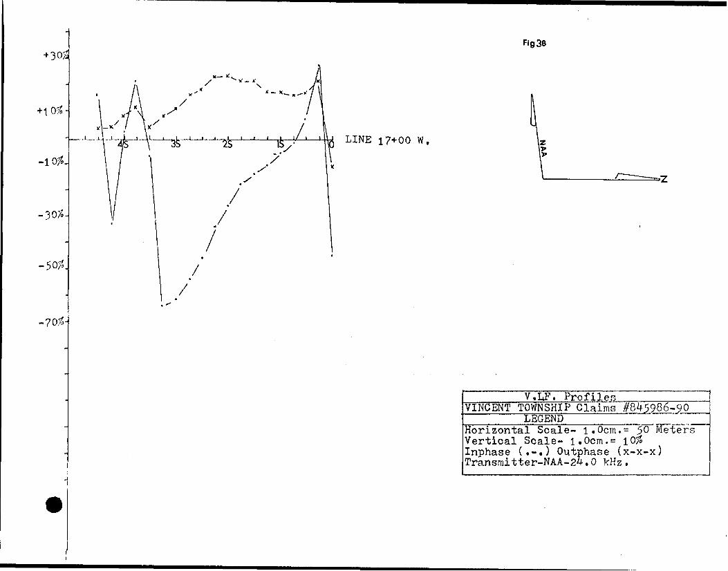
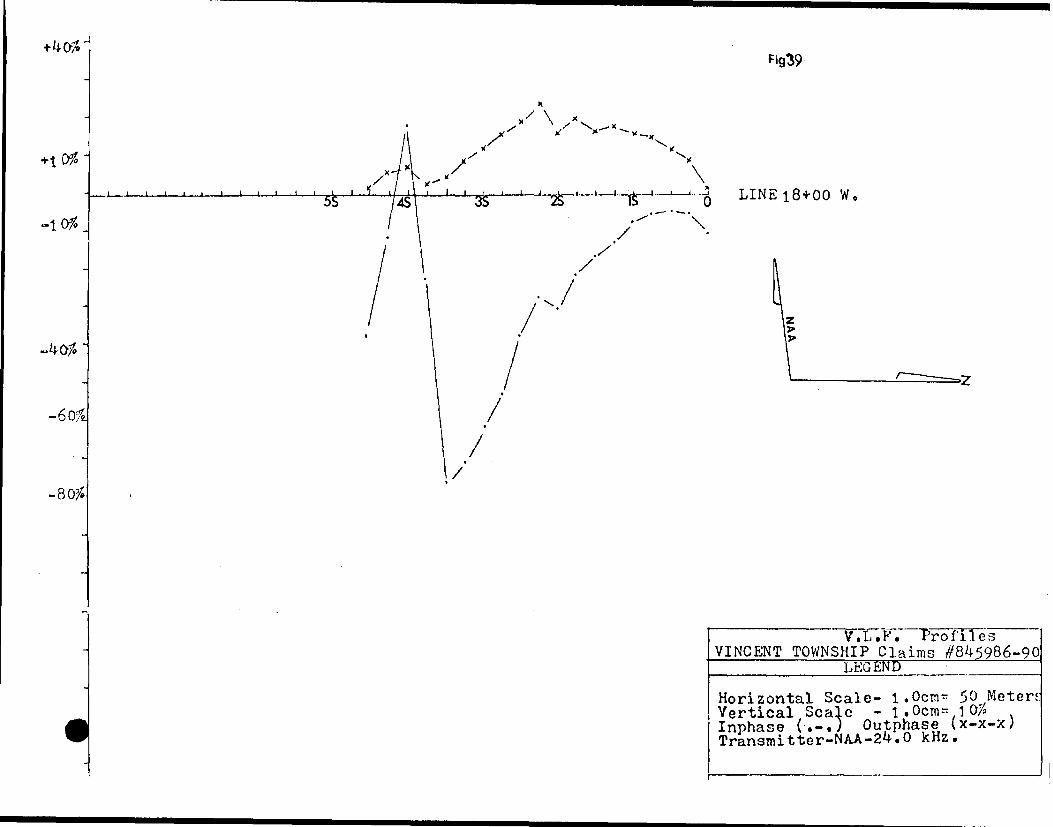
The VLF survey shows two conductive bodies trending
roughly in a east-west direction. The northern response is found
from line 0+00 and trends north-westerly to line 18+00 West and
probably continues further beyond the boundary of these claims in
the same general direction. This conductor seems to weaken toward
the eastern portion of the property.
The southern conductor is found between lines 14+00
and 23+00 West (Fig.28-43). It trends in a east-west direction and
most likly continues further east. The two conductors are
approximately 200 meters apart. These conductors are very similar
in response,in that both the Inphase and Out Phase components show
in general,a complementary repetative pattern through all lines. The
profiles also suggest that the dip of the southern conducting
structure is relatively steep and to the north. The response
signal is in general of moderate strength and sharp,hinting at a
shallow structure in depth. The northern conductor has relatively
-5-
physical characteristics as the southern response,implying
that both conductors are the result of parallel geologic features.
From the geological evidence,there seems to be,contained
within the volcanic flows a thin belt of Iron Formation. This zone
is observable at random locations on surface between line 10+00 and
17+00 West and approximatly between stations 50 to 100 South. This
formation contains some sulphides but its magnetic susceptibility
is low. A few meters south of these exposures is found,again at
random shear zones containing up to 53d pyrite. These shear zones
are in line with an apparent topographic lineament. Both of these
structures may account for the geophysical responses encountered
on the northern portion of these claims. Therefore a possible fault
structure trending in general in a east-west direction maybe
contained within this property.
The southern conductor is not quite as obvious. Some
Carbonized Iron rich rock was observed near station J++00 South on
line 16+00 West. This may have some strike length to it. There are
also many intrusive rocks within this southern region,and the
anomaly may be a result of a lithological change.
CONCLUSIONS; The anomalous zones within these claims
will be explored in more detail in up coming field seasons. This
v/ill involve trenching and X-ray drilling. It seems however that
a major concentration of economic minerals is not likly in this
type of environment,as the large discoveries seem to occur in
general near volcanic-sedimentary contacts. This property is near
some major showings and it is for this reason that it v/ill also be
examined in future exploration programs.
Respectively Submitted
2M
4w4^^^^ * G^V^VmS' i
Scale: l cm. s 7.84 M.(A) .s 13.7 km.,___________ ^"'^ J1 fX * j.......*""* \ J-^J1 ri r ___ __ __ JBJ.
showing position of Vincent Township J ~ Mining district and location of claims
[within, township. ^^—^^—————
Map within
(B)
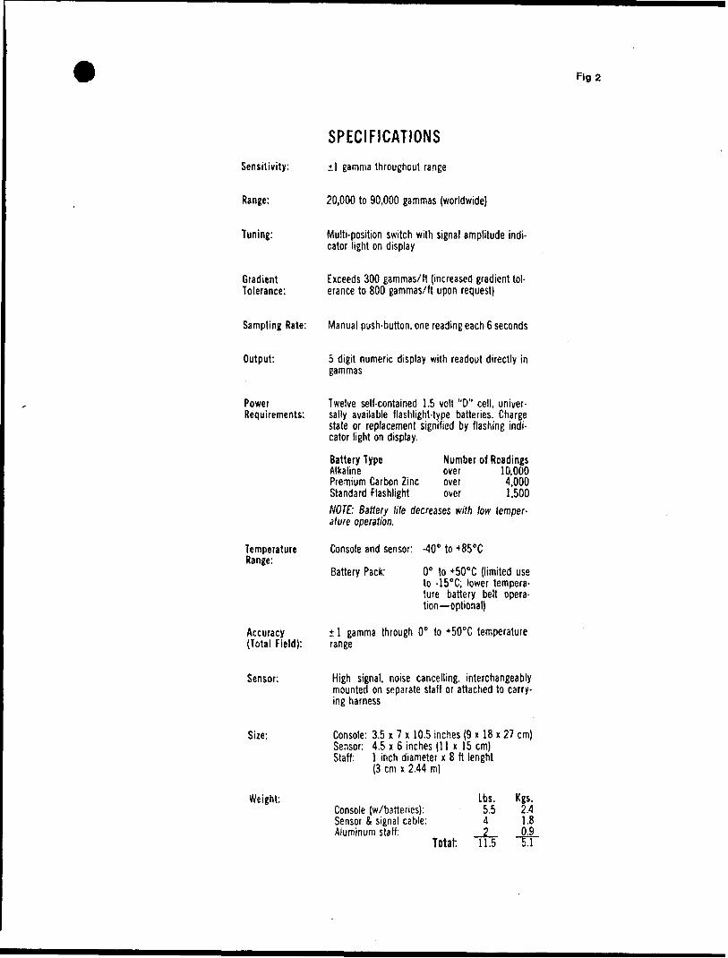
Fig 2
SPECIFICATIONS
Sensitivity: 1 gamma throughout range
Range: 20,000 to 90,000 gammas (worldwide)
Tuning: Multi-position switch with signal amplitude indi cator light on display
Gradient Exceeds 300 gammas/ft (increased gradient to!- Tolerance: erance to 800 gammas/ft upon request)
Sampling Rate: Manual push-button, one reading each 6 seconds
Output: 5 digit numeric display with readout directly in gammas
Power Requirements:
Temperature Range:
Accuracy (Total Field):
Twelve self-contained 1.5 volt "O" cell, univer sally available flashlight-type batteries. Charge state or replacement signified by flashing indi cator light on display.
Battery TypeAlkalinePremium Carbon ZincStandard Flashlight
Number of Readings over 10,000 over 4,000 over 1,500
NOTE: Battery life decreases with low temper ature operation.
Console and sensor: -40" to *850 C
Battery Pack: O" to *50"C (limited use to -15 0 C; lower tempera ture battery belt opera tion optional)
l gamma through O0 to *50"C temperature range
Sensor: High signal, noise cancelling, interchangeably mounted on separate staff or attached to carry ing harness
Size: Console: 3.5 x 7 x 10.5 inches (9 x 18 x 27 cm) Sensor: 4.5 x 6 inches (11 x 15 cm) Staff: l inch diameter x 8 tt lenght
(3 cm x 2.44 m)
Weight:Console (w/barteries): Sensor A signal cable: Aluminum staff:.
Lbs. 5,5 4
Total: 11.5
Kgs.2.41.80.9
TT

Fig 3
EM16 SPECIFICATIONS
MEASURED QUANTITY
SENSITIVITY
RESOLUTION
OUTPUT
OPERATING FREQUENCY
OPERATOR CONTROLS
POWER SUPPLY
DIMENSIONS
WEIGHT
In-phase and quad-phase components of vertical magnetic field as a percentage of horizontal primary field, (i.e. tangent of the tilt angle and ellipticity) .
In-phase : 150S; Quad-phase : 4(H
Nulling by audio tone. In-phase indication from mechanical inclino meter and quad-phase from a graduated dial.
15-25 kHz VLF Radio Band. Station selection done by means of plug-in units .
On/Off switch, battery test push button, station selector switch, audio volume control, quadrature dial, inclinometer.
6 disposable 'AA 1 cells.
42 x 14 x 9cm
Instrument: 1.6 kg Shipping : 4 . 5 kg
636001 Fig 4
6200CH
61^00 ]
61000
60600 J
6020CH
LINE 0 +00
59800 J
59400
59000
Marjietic Profiles VINCENT TOWNSHIP Claims #845986-8^5990 l
LEGENDHorizontal Scale- loOcn^ 50 Meters Vertical Scale - l.Ocm^ 200 Gammas Magnetic Base - 60300 Gammas
62600-
62000-
fig 5
61400 A
61000
60600 J
60200^LINE 1+OOW.
59800 J
59400-1
59000
Maf^netic ProfilesVINCENT TOWNSHIP Claims #845986-845990 ____________1EGENDHorizontal Scale- loOcm^ 50 Meters Vertical Scale - \ ,0c^ 2 00 Gammas Magnetic Base - 60300 Gammas
62600-
62000-
61400 -
61000
60600 .
60200-
Fig6
^ i i___AM—j
,et'Cnott*
2S 5 ISLINE 2, f QO W.
59800.
59^00-
59000-
Magnetic Profiles VINCENT TOWNSHIP tflaims #845986-845990
1EGENDHorizontal Scale- I 0 0cm^ 50 Meters Vertical Scale - l.Ocms 200 Gammas Magnetic Base - 60300 Gammas
63600-
62000-
Fig?
6l 400 -
61000
60600 .
60200-
59800.
59400
59000
1 ifc ' ' ' 6 LINE 3+00 W'
Magnetic Profiles VINCENT TOWNSHIP Claims #845986-845990
LEGENDHorizontal Scale- loOcn^ 50 Meters Vertical Scale - l.0cm= 200 Gammas Magnetic Base - 60300 Gammas
62600-
62000-
6 i ooo -
60600 .
'02 O OH
59800.
59^00
59000
Fig 8
-J———l———l———l——l———l——l———l———l——l——l———l———l———U LINE 4+00
Magnetic Profiles VINCENT TOWNSHIP Claims
LEGENDHorizontal Scale- loOcm* 50 Meters Vertical Scale - ItOcm^ 200 Gammas Magnetic Base - 60300 Gammas
62600-
62000-
Fig.9
6l400 -
61000
60600 .
60200-
/2S!
l i l LINE 5+00
59800.
59400-
59000-
Magnetic Profiles VINCENT TOWNSHIP Claims #845986-845990:______ 'LEGENDHorizontal Scale- loOcm^ 50 Meters Vertical Scale - l.Ocn^ 200 Gammas Magnetic Base - 60300 Gammas
636001
6200CH
61*100 ]
61000
60600 J
602004
59800 J
59000
t l l t
Rg.lO
i i i i i i i i—i—i2S 1 S O
LINE 6+00
not*
Magnetic Profiles VINCENT TOWNSHIP Claims #845986-845990
LEGENDHorizontal Scale- l 0 0cn^ 50 Meters Vertical Scale - l.Ocms 200 Gammas Magnetic Base - 60300 Gammas
62600-
62000-
61^00 -
61000
60600 .
60200-\ ...i.,
2S.,T5
LINE 7 +00 W.
59800.
59^00
59000-
Marmotic Profiles VINCENT TOWNSHIP Claims'
LEGENDHorizontal Scale- loOcrn^ 50 Meters Vertical Scale - l t Ocm= 2 00 Gammas Magnetic Base - 60300 Gammas
62600
62000-
61000
60600-.
60200-
59800.
59^00
59000
Fig. 12
2S IS—i i A LINE 8+00 W.
Profiles VINCENT TOWNSHIP Glaims ^845986-8-^5990
1EGENDHorizontal Scale- loOcm^ 50 Meters Vertical Scale - l.Ocms 200 Gammas Magnetic Base - 60300 Gammas

62800-
62400-
62000-
Fig.13
6UOO-
61000-
60600- '\
60200-s 25 LINE 9 00
59800^
___________Magnetic Profiles VINCENT TOWNSHIP Claims //843986-90
LEGENDHorizontal Scale- 1.0cm.^ 50 Meters Vertical Scale- 1.0cm - 200 Gammas Magnetic Base - 60300 Gammas
S1000
Fig 14
i/ i i LINE 1 0+OOW.
Magnetic Prof 53 enVINCENT TOWNSHIP Claims
LEGENDHorizontal Scale- loO Vertical Scale - l .0 Magnetic Base ~ 60300
#845986-845990-
cm^ 50 Meters crn^ 200 Gammas Gammas
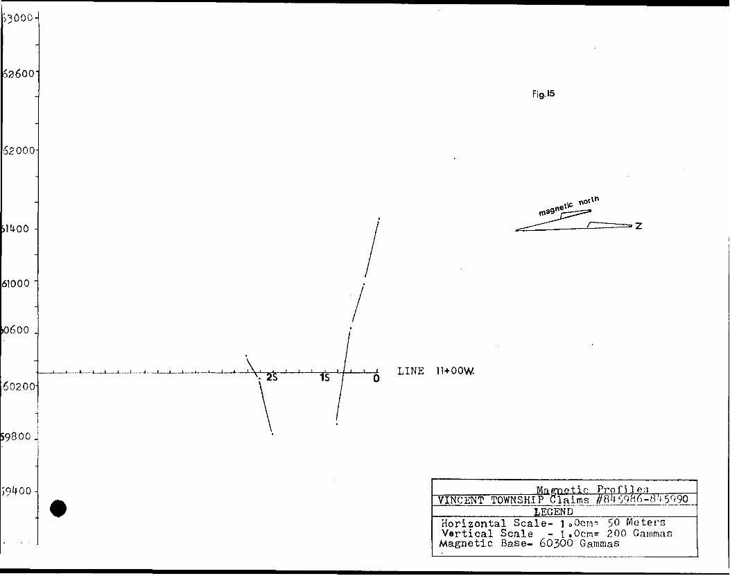
Fig. 15
LINE 1 1+OOW
etic ProfilesVINCENT TOWNSHIP Claims //B459B6-8') 5990
LEGENDHorizontal Scale- l 0 0cm^ 50 Meters Vertical Scale - l .Ocrn^ 200 Gammas Magnetic Base- 60300 Gammas
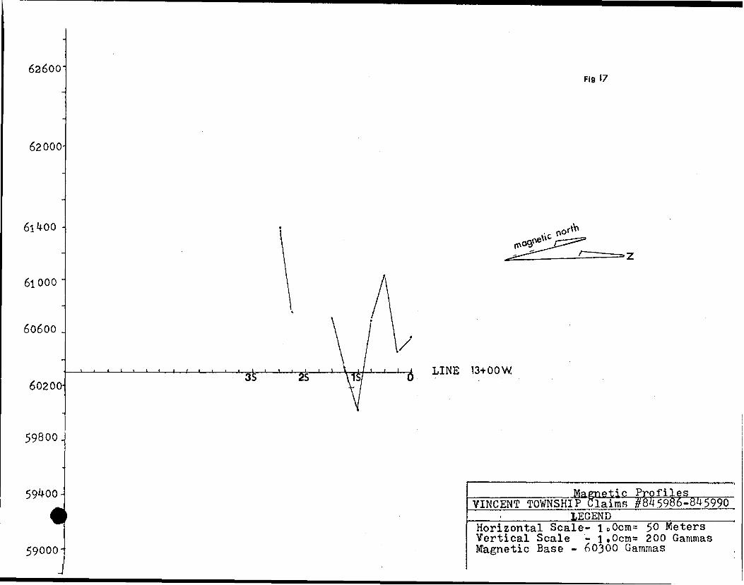
6a6oo-Fig 17
62000-
61400 -
61000
60600 .
60200-^L—l——l——t.. -J3S 2S
LINE 13+OOW
59800.
59400
59000
Magnetic ProfilesVINCENT TOWNSHIPTlaiins ^845986-845990_____________LEGENDHorizontal Scale- loOcMt^ 50 Meters Vertical Scale - l.Ocm^ 200 Gammas Magnetic Base - 60300 Gammas

63600-Fig. 18
59800.
59400
59000
LINE 1 *H-00 W.
Magnetic ProfilesVINCENT TOWNSHIP Claims #845986-845990
LEGENDHorizontal Scale- loOcm= 50 Meters Vertical Scale - 1.Ocm* 200 Gammas Magnetic Base - 60300 Gammas
62600-
62000-
Fig. 19
61^00
61000
60600 .
60200-
y N.---v /x.is' ' '2S- '-'"Ife LINE 15+00 W.
59800.
59^00
59000
Maraietic Profiles VINCENT TOWNSHIP Claims #845986-8^5990
LEGENDHorizontal Scale- lcOcrr^ 50 Meters Vertical Scale - l.Ocms 200 Gammas Magnetic Base - 60300 Gammas
63600-
62000-
fig.20
61^00 -
61000
60600 .
60200-LINE 16+00 w.
59800.
59^00
59000
Magnetic ProfilesVINCENT TOWNSHIP Claims #845986-8*15990
LEGENDHorizontal Scale- l.Ocm* 50 Meters Vertical Scale - l.Ocm^ 200 Gammas Magnetic Base - 60300 Gammas
62600-
62000
61*100 -
61000
60600 .
60200-
59800.
LINE 17+00
59000
Fig. 21
Maroetic ProfilesVINCENT TOWNSHIP claims #84598J^845990, ____________JEGENDHorizontal Scale- loOcn^ 50 Meters Vertical Scale - l.Ocm* 200 Gammas Magnetic Base - 60300 Gammas
62600-
62000-
61^00 -
61000
60600 .
60200-
74S is LINE 18-HOO
59800.
59^00
59000
VINCENT TOWNSHIP Claim 1EGEND
Profiles//84 5986-8^5990
Horizontal Scale- loOc!n= 50 Meters Vertical Scale - 1.0cm= 200 Gammas Magnetic Base - 60300 Gammas

63600
62000
61000
60600 .
60200-
59800.
5S3S
i t i25*
\ X 1 15
Fig. 23
i9*-oo w.
59^00
59000
Magnetic Profiles VINCENT TOWNSHIP Claims ^8^5986-8^5990
LEGENDHorizontal Scale- loOcrr^ 50 Meters Vertical Scale - l.Ocms 200 Gammas Magnetic Base - 60300 Gammas
63600
62000
61000
60600 .
60200
59800.
59^00-
59000-
Fig. 24
nor
LINE 20+00 W.
Mafmetic Profiles VINCENT TOWNSHIP Claims #845986-8^5990
LEGENDHorizontal Scale- l oOcms 50 Nloters Vertical Scale - l.Ocm* 200 Gammas Magnetic Base - 60300 Gammas
62600
62000-
61000
60600 .
60200-
59800.
59^00
59000
LINE 21*00 W.
Rg. 25
Mametic ProfilesVINCENT TOWNSHIP ClaimsrffBfr 5986-8^5990 _________ LEGEND^—-—————^—Horizontal Scale- IcOcm^ 50 Meters Vertical Scale - l .0crn= 200 Gammas Magnetic Base - 60300 Gammas
62600 Fig.26
62000
61*4.00
61000
60600 .
60200LINE 22+00 W,
59800.
59400-
59000
tic ProfilesVINCENT TOWNSHIP Claims #845986-845990____________LEGEND____________ Horizontal Scale- I 0 0cm^ 50 Meters Vertical Scale - l*0cms 200 Gamma: Magnetic Base - 60300 Gammas
62600
62000-
61*4-00 -
61000
60600 .
60200-
59000 .
59^00
Fig 27
LINE 23+00 W
VINCENT TOWNSHIP____________- .———.-———— Horizontal Scale- loOcm^ 50 Meters Vertical Scale - l.Ocn^ 200 Gammas Magnetic Base - 60300 Gammas
•1-1
-10*.
+100-
-100
Fig 28
LINE 0+00
ir-X
77
,/. .\\. ./A-/'^ LINE 1 + 00 W2V \\ )/ \- v Q^-----——.-———^——-——^—
. V/ \/ . _ . V.L.F\ ProfilesVINCENT TOWNSHIP Claims ^845986-90 ! LEGETI15————
Horizontal Scale- l.Ocm* 50 Meted Vertical Scale - 1.0cm* 10# . Inphase (.-.) Outphase (x-x-x) Transmitter-NAA-2^.O kHz.
-1098
-w -
2'S /'\' 1//V/6 LINE 2* 00 W l
j y
1
4 . .7. . A .V
LIKE 3+00 W.
V.L.P.Profiles VINCENT TOWNSHIP Claims
LEGEND
Horizontal Scale- 1.0cm* 50 Meter* Vertical Scale - l t Ocm*AV/* Inphase (.-.) Outphase (x-x-x) Transmitter-NAA-24.O kHz.
.4 Of.
Fig 3O
l\ /*-A i •^r/^H1^ L INE
/ /;/
/
VTITFT Profiles VINCENT TOWNSHIP Claims W5986-90
W.
LINE 5+00 W.
LEGEND
Horizontal Scale- l.Ocm* 50 Meters! Vertical Scale - luOcn^ lO/S Inphase (.-.J Outphase (x-x-x) Transmitter-NAA-2^.0 kHz.
n
41
FI931
-J———i . l l l l l l l L ] l -l——Ju.
LINE 6+00 W.
Ix LINE 7+00 W,
V.L.F";ProfilesVINCENT TOWNSHIP Claims #8^5986-9(
LEGEND
Horizontal Scale- 1.0cm* 50 Meters Vertical Scale - l.Ocm* 107& Inphase (.-.) Outphase (x-x-xj Transmitter~NAA-2^-.0 kHz.
-100 '
-J——l——J——l——l——l——l——l——l——L
l x
Fig 32
8+00 W.
LINE 9*00 W.
Y.L.F. ProfilesVINCENT TOWNSHIP Claims .#8*15986-90
LEGEND
Horizontal Scale- 1.0cm- 50 Meters Vertical Scale - l.Ocm* 100 . Inphase (.-.) Outphase (x-x-x) Transmitter-NAA-24.0 kHz.
-l Of.
fJ———l———L. -l——l——L J——l——l——i 3S ' 7 is.
^
l i i j j i _ j j j j l
Fig 33
' LINE 10+00 W,
LINE 11 + 00 W.
Y.L.F. ProfilesVINCENT TOWNSHIP Claims #8^5986-90^ ___________LEGEND___________Horizontal Scale- 1.Ocm* 50 Meters! Vertical Scale - l.Ocm* 10# . Inphase (.-.) Outphase (x-x-x) Transmitter-NAA-2^.O kHz.
7
3S . S 7k LINE 12+00 W.
j\ /YJ Y. L. F. Profiles
VINCENT TOWNSHIP Claims #8^5986 -90LEGEND
Horizontal Scale- l.Ocm^ 50 Meters Vertical Scale - loOcm^ W Inphase (.-.7 Outphase (x-x-x) Transmitter-NAA-2^.0 kHz.
70/S
-70/
35,
4,- fLINE 14+00
Y.L.F. PROFILESVINCENT TOWNSHIP
LEGEND
Horizontal Scale-l.Ocrr^ 50 M Vertical Scale-1.Ocm* l 07? Inphase { .-.-.) Outphase(x-x-x
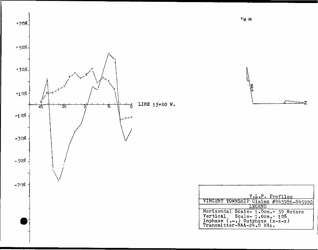
Fig 36
LINE 15+00 W,
_____________V.L.F. Profiles.....^ TIKGENT TOWNSHIP Claims #845986-845990
LEGENDHorizontal Scale- ^ 50 MetersVertical Scale- l.Ocm.- Inphase (.-.) Outphase (x-x-x) Transmitter-NAA-24.0 kHz.
o
-10/J
-50/H
-70#
V \ X \ /y K
/3S
—.j. -.^iis?"
\
r* J. LINE 1 6+00 W.
\
Fig-37
V.L.F. ProfilesVINCENT TOWNSHIP Claims #8^5986-90
__________LEGENDHorizontal Scale- l.Ocm.s 50 Meters Vertical Scale- l.Ocm.s 10^ Inphase (.-,) Outphase (x-x-x) Transmitter-NAA-24-.O kHz.
-l Ofo.
-30/S-
-507*.
Fig 38
V.LF. ProfilesVINCENT TOWNSHIP Claims #845986-90"—————LEGEND ———————Horizontal Scale- 1 1 Ocm. s 50 MetersVertical Scale- i. Ocm. s Inphase (.-.) Outphase (x-x-x) Transmitter-NAA-2Z|-.0 kHz.
\LINE 18 + 00 W,
V.L.F. ProfilesVINCENT TOWNSHIP Claims #845986-90 LEGEND——————————
Horizontal Scale- l.Ocm* 50 Meters Vertical Scale - l. Ocm s l 0?5 Inphase {.-.) Outphase (x-x-xj Transmitter-NAA-24.0 kHz.
n oft.
-30ft.
-50ft-
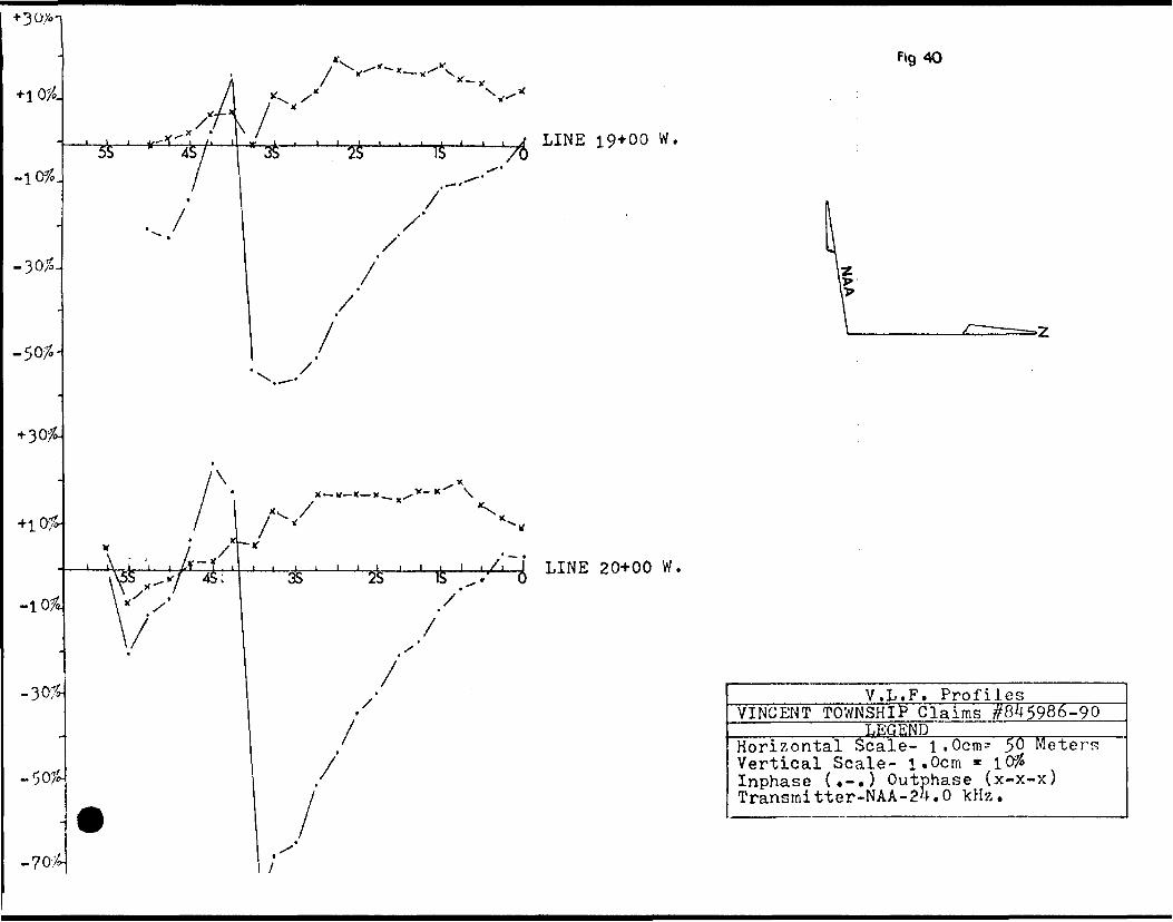
LINE 19+00 W,
LINE 20+00 W,
Fig 40
V.L.F. Profiles__________VINCENT TOWNSHIP Claims W5986-90__________ LEGEND ————————^——Horizontal Scale- l.Ocm^ 50 Meters Vertical Scale- l.Ocm * 10^ Inphase {.-.) Outphase (x-x-x) Transmitter-NAA-24.0 kHz.
-704-
-5095-
-700-
-901
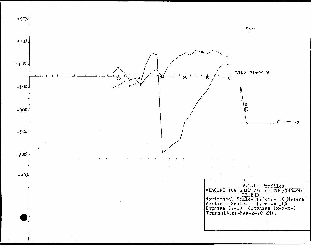
Fig 41
5S i 3* i i j i i \25 IS
i i LINE 21+00 W.
f
/'
/'
V.L.F. ProfilesVINCENT TOWNSHIP Claims #845986-90
LBGENDHorizontal Scale- l.Ocm.s 50 Meters Vertical Scale- 1.0cm.s lO?S Inphase (.-.) Outphase (x-x-x-) Transmitter-NAA-24.0 kHz.
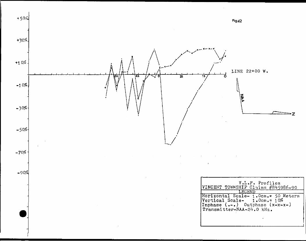
/;
^g 42
LINE 22+00 W .
V.L.P. Profiles VINCENT TOWNSHIP Claims //845986-90
LEGENDHorizontal Scale- l.Ocm.s 50 Meters Vertical Scale- l.Ocm.s l 0# Inphase (t-.) Outphase (x-x-x-) Transmitter-NAA-24.0 kHz.
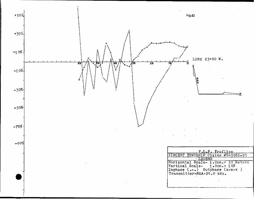
Fig 43
LINE 23+00 W.
, V.L.F. ProfilerVINCENT TOWNSHIP Claims #8^5986-90
LEGENDHorizontal Scale- l.Ociru* 50 Meters Vertical Scale- l.Ocm^ l Of* Inphase (.-.) Outphase (x-x-x ) Transmitter-NAA-2^.0 kHz.
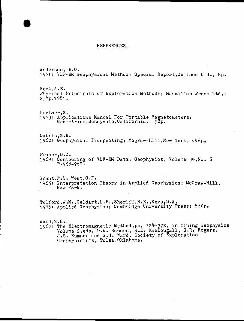
REFERENCES
Anderson, E.O.I9?li VLF-EM Geophysical Method; Special Report.Cominco Ltd., 8p.
Beck,A.E.Physical Principals of Exploration Methods i Macmillan Press Ltd.}23&P.1981.
Breiner,S.I973i Applications Manual For Portable Magnetometers i
Geometrics,Sunnyvale,California. 58p.
Dobrin.M.B.I960i Geophysical Prospecting} Mcgraw-Hill ,New York, i(46p.
Fraser,D.C.19691 Contouring of VLF-EM Data? Geophysics, Volume 34,No. 6
P.958-967.
Grant,F.S..West,G.F.1965' Interpretation Theory in Applied Geophysics; McGraw-Hill,
New York.
Telford,W.M.,Geldart,L.P..Sheriff,R.E..Keys,D.A.1976i Applied Geophysics; Cambridge University Press; 860p.
Ward,S.H.,1967t The Electromagnetic Method,pp. 22^-372, in Mining Geophysics
Volume 2,eds. D.A. Hansen, R.E. MacDougall, G.R. Rogers, J.S. Sumner and S.H. Ward, Society of Exploration Geophysicists, Tulsa,Oklahoma.
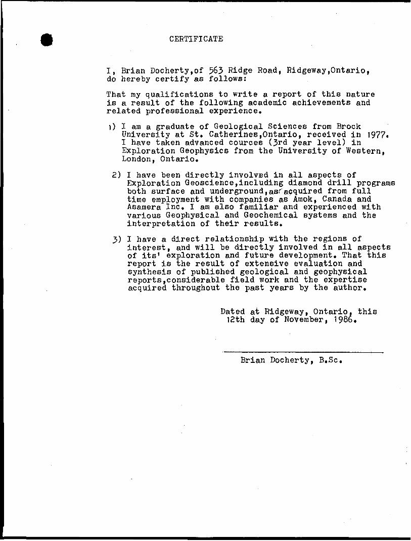
CERTIFICATE
I, Brian Docherty.of 563 Ridge Road, Ridgeway,Ontario, do hereby certify as follows:
That my qualifications to write a report of this nature is a result of the following academic achievements and related professional experience.
1) I am a graduate of Geological Sciences from BrockUniversity at St. Catherines,Ontario, received in 1977. I have taken advanced cources (3rd year level) in Exploration Geophysics from the University of Western, London, Ontario*
2) I have been directly involvsd in all aspects ofExploration Geoscience,including diamond drill programs both surface and underground,as." acquired from full time employment with companies as Amok, Canada and Asamera Inc. I am also familiar and experienced with various Geophysical and Geochemical systems and the interpretation of their results.
3) I have a direct relationship with the regions ofinterest, and will be directly involved in all aspects of its' exploration and future development. That this report is the result of extensive evaluation and synthesis of published geological and geophysical reports,considerable field work and the expertise acquired throughout the past years by the author.
Dated at Ridgeway, Ontario, this 12th day of November, 198b.
Brian Docherty, B.Se.
\
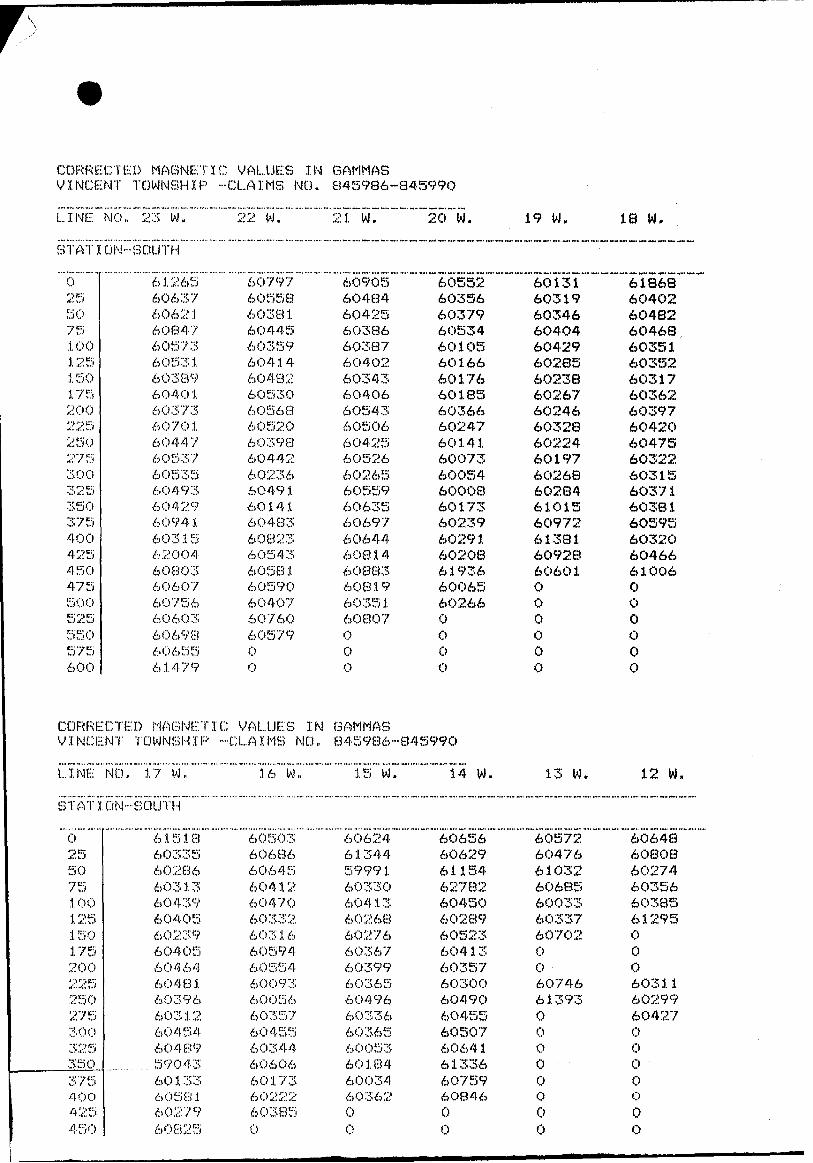
CORRECTED MAGNETIC VALUES IN GAMMAS VINCENT TOWNSHIP -CLAIMS NO. 845986-845990
LINE NO. 23 W.
STATION-SOUTH
0255075j. 001251 50.1. 7520022525027530032535037540042545047550 C'525550575600
61265606376062160847605736053160389604 0 1603736070160447605376053560493604296094 i603156200460803606076075660603606986065561479
CORRECTED MAGNETVINCENT TOWNSHIP
LINE NO. 1 7 w.
22 W.
6079760558603816O4456035960414604826053060568605206039860442602366049160141604836082360543605816059060407607606057900
1C VALUES IN-CLAIMS MO.
16 W.
21 W.
6090560484604256O386603876040260343604066054360506604256052660265605596063560697606446O81460883608196035160807000
GAMMAS845986
15 W
"""""""20" w.
6055260356603796053460105601666017660185603666024760141600736005460008601736023960291602086193660065602660000
-845990
14 W.
19 W.
"~~6Ql31~~"~~
603196034660404604296028560238602676024660328602246019760268602846101560972613816092860601000000
13 W.
STATION-SOUTH
025507510012515017520022525027530032535O375400425450
6 1 5 1 860335602866031360439604056023960405604646048160396603126045460489
......... 5904360133605816027960825
6050360686606456041260470603326031660594605546009360056603576045560344606066017360222603850
606246134459991603306041360268602766036760399603656049660336603656005360184600346036200
60656606296115462782604506028960523604 1 3603576030O6049060455605076064161336607596O84600
6057260476610326068560033603376070200607466139300O00o00
IS
618686040260482604686035160352603176036260397604206O475603226O315603716038160595603206046661006OOOOOO
12 W.
606486080860274603566038561295OOO603116029960427OOOOo o o
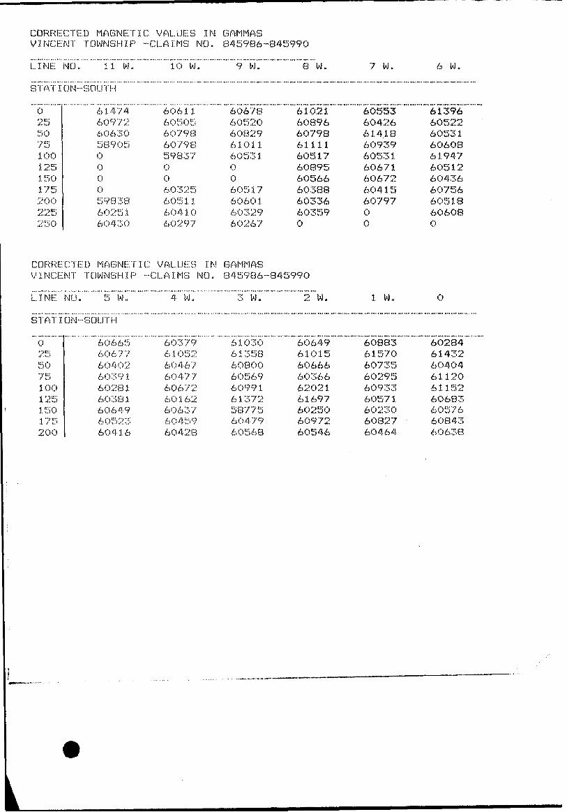
CORRECTED MAGNETIC VALUES IN GAMMAS VINCENT TOWNSHIP1 -CLAIMS NO. 845986--845990
LINE; NO,, 1 1 w. 10 W. 9 W.""""""""""i ""w.
7 W. 6 W.
STATION-SOUTH
02550751 001251 50175200225250
614746097260630589050000598386025160430
CORRECTED MAGNETVINCENT TOWNSHIP
LINE NO,, 5 W.
606.1.1605056079860798598370060325605 1 16041060297
1C VALUES IN•••••CLAIMS NO.
4 W.
606786052060829610116053100605176060 16032960267
GAMMAS
610216089660798611116051760895605666038860336603590
60553604266141860939605316067160672604 1 56079700
613966052260531606086.1.94760512604366075660518606080
845986-845990
3 W. 2 W. 1 W. 0
STATION-SOUTH
02550751 001251 50175200
6066560677604026039160281603816064960523604.1.6
603796105260467604776067260162606376045960428
610306135860800605696099.1.61372587756047960568
606496101560666603666202161697602506097260546
60883615706073560295609336057160230608276O464
60284614326040461120611526O68360576608436O638
BOIL SAMPLE LOCATIONS VINCENT TOWNSHIP-CLAIMS NO. 845986-845990
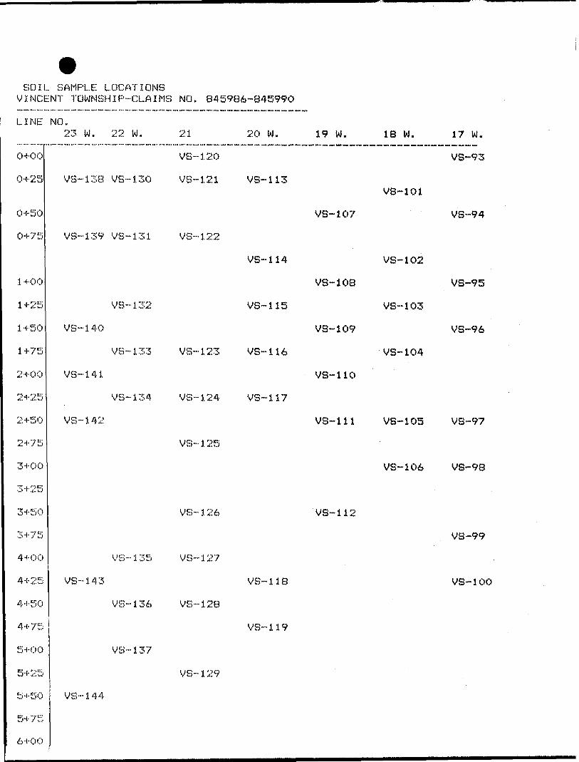
LINE NO.23 W. 22 W. 21 20 W. 19 W. 18 W. 17 W.
0+00
04-25
0-1-50
0+75
l 4-00
1+25
1+50
1+75
2+00
2+25
2+50
2+75
3+00
3+25
3+50
3+75
4+00
4+25
4+50
4+75
5+00
5+25
5+50
6+OO
VS-120 VB-93
VS-138 VS-130 VS-121 VS-113VS-101
VS-139 VS--131 VS-122
VS-107 VS--94
VS-114 VS-102
V8-10B VS-95
VS--132 VS-115 VS-103
VS--14Q VS-109 VS-96
VS-133 VS-123 VS--H6 VS-104
VS-141 VS-110
VS--134 VS--124 VS-117
V8-111 VS-105 VS-97
VB-137
VS-144
VS--125
VS-106 VS-98
VS-126 VS-112
VS-135 VS-127
VS-136 VS-128
VS-119
VS-129
VS-99
VS-i43 VS-118 VS-100
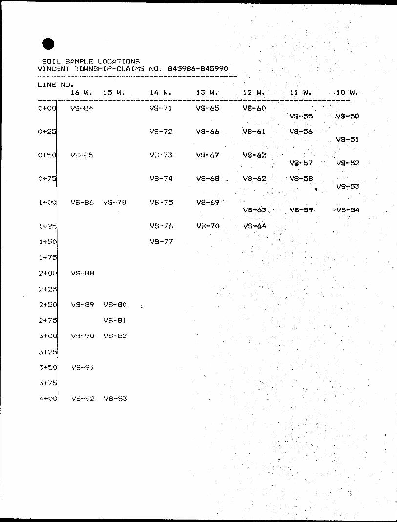
SOIL SAMPLE LOCATIONS VINCENT TOWNSHIP-CLAIMS NO. 845986-845990
LINE NO.16 W. 15 W. 14 W. 13 W. 12 W, 11 W. 10 W.
0+00
0+25VS-51
0+50
0+75v VS-53
1+00 VS~8
14-2!
1+50
1+75
2+OC
2+25
2+5C
2+75
3+OC
3+25
3+5C
3+7!
4+OC
VS-84 VS-71 VS-65 VS-60VS-55 VS-50
VS-72 VS-66 VS-61 VS-S6
VS-85 VS-73 VS-67 VS-62VS-57 VS-52
VS-74 VS-68 VS-62 VS-S8
VS-78 VS-75 V8-69VS-63 VS-59 VS-54
VS-76 VS-70 VS-64
VS-77
VS-88
VB-89 VS-80
VS-81
VS-90 VS-B2
MS-91
VS-92 VS-83
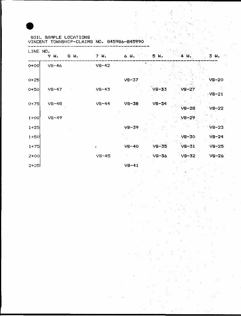
SOIL SAMPLE LOCATIONS VINCENT TOWNSHIP-CLAIMS NO. B45986-84599Q
LINE NO.
o+oo
0+25
0+50
0+75
1+00
1+25
1 +50
1+75
2+00
2+25
9 W. 8 W. 7 W. 6 W. S W. 4 W.
VS--46 VS-42
VS-37
VS-47 VB-43 VS-33 V8-27
VS-48 VS-44 VS-38 VS-34VB-28
VS-49 V8-29
VS-39
VS-30
VS-40 VS-35 VS-31
VS-45 VS-36 VS-32
VS-41
3 W.
VS-20
VS-21
VS-22
VS-23
V8-24
VS-25
VS-26
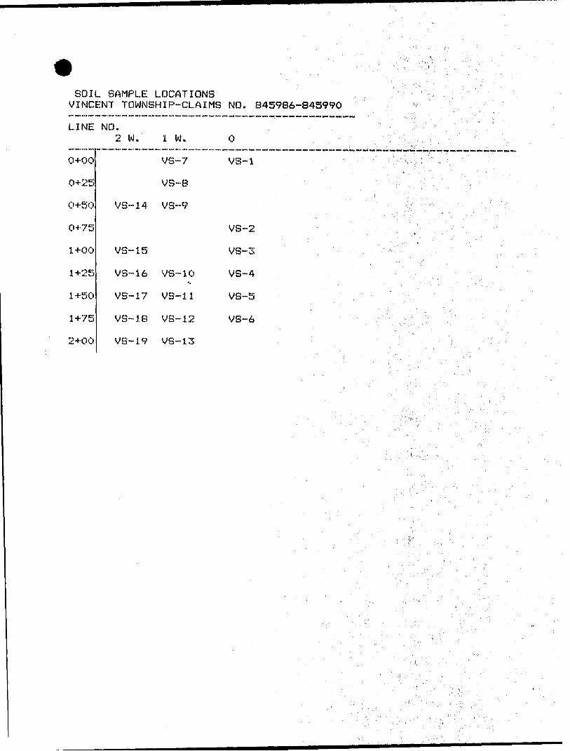
SOIL SAMPLE LOCATIONS VINCENT TOWNSHIP-CLAIMS NO. 845986-845990
LINE NO.2 W
0+00
0+25
0+50
0+75
1 +00
1+25
1 +50
1+75
2+00
VS-
VS-
VS--
VS-
VS-
VS-
m
14
15
16
17
18
19
1 W.
VS-7
VS-8
VS-9
VS-10
VS--11
VS-12
VS--13
0
VS-1
VS-2
VS-3
VS-4
VS--5
VS-6
42E12NEei87 2.9546 V INCENT 020
GEOLOGICAL SURVEY
Vincent Township Claim # TB 845986 - TB845990
inclusive Cayuga Syndicate
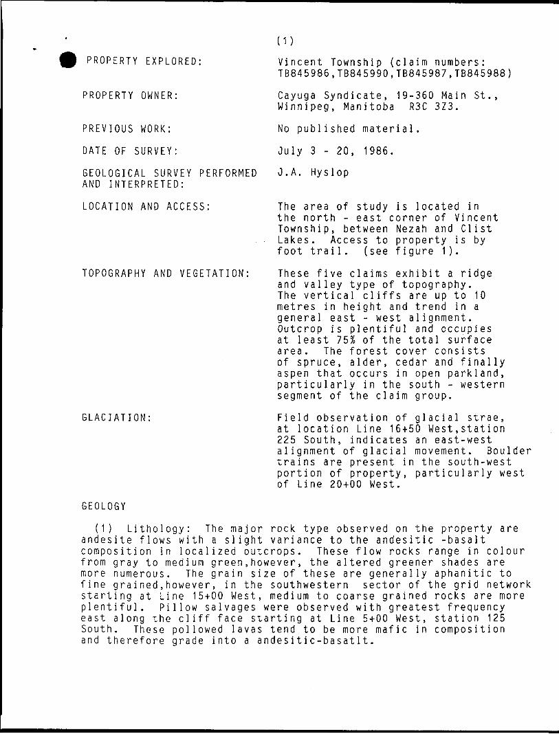
(1)PROPERTY EXPLORED:
PROPERTY OWNER:
PREVIOUS WORK:
DATE OF SURVEY:
GEOLOGICAL SURVEY PERFORMED AND INTERPRETED:
LOCATION AND ACCESS:
TOPOGRAPHY AND VEGETATION:
GLACIATION:
GEOLOGY
Vincent Township (claim numbers: TB845986,TB845990,TB845987,TB845988)
Cayuga Syndicate, 19-360 Main St., Winnipeg, Manitoba R3C 3Z3.
No publi shed material.
July 3 - 20, 1986.
J.A. Hyslop
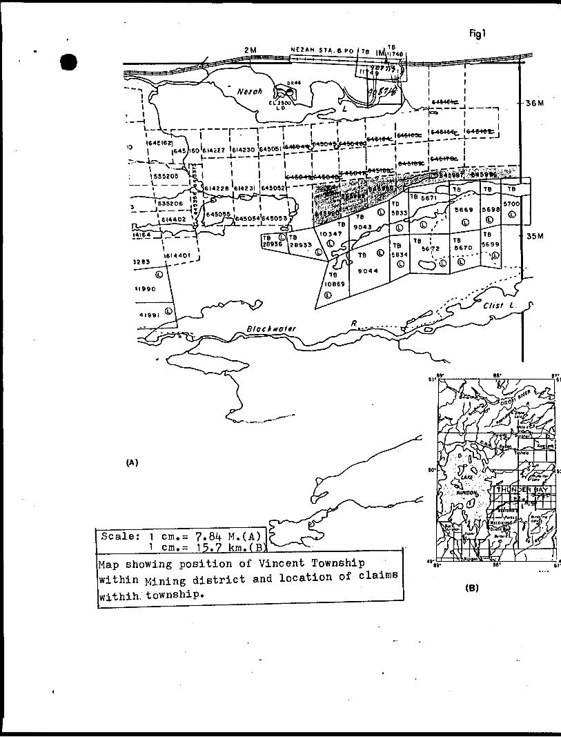
The area of study is located in the north - east corner of Vincent Township, between Nezah and Clist Lakes. Access to property is by foot trail, (see figure 1).
These five and valley The vertic metres in general ea Outcrop is at least 7 area. The of spruce, aspen that particular segment of
claims exhibit a ridge type of topography,
al cliffs are up to 10 height and trend in a st - west alignment.plentiful and occupies
SI o f the total surface forest cover consists alder, cedar and final ly occurs in open parkland,
ly in the south - western the claim group.
Field observation of glacial strae, at location Line 16+50 West,station 225 South, indicates an east-west alignment of glacial movement. Boulder trains are present in the south-west portion of property, particularly west of Line 20+00 West.
(1) Lithology: The major rock type observed on the property are andesite flows with a slight variance to the andesitic -basalt composition in localized outcrops. These flow rocks range in colour from gray to medium green,however, the altered greener shades are more numerous. The grain size of these are generally aphanitic to fine grained.however, in the southwestern sector of the grid network starting at Line 15+00 West, medium to coarse grained rocks are more plentiful. Pillow salvages were observed with greatest frequency east along the cliff face starting at Line 5+00 West, station 125 South. These pollowed lavas tend to be more mafic in composition and therefore grade into a andesitic-basatlt.
2M
Scale:
—""
(A)
^ 7.8^ M.(A) ^ 15.7 km.(B
Map showing position of Vincent Township within Mining district and location of claims withih. township.
Bf
(B)
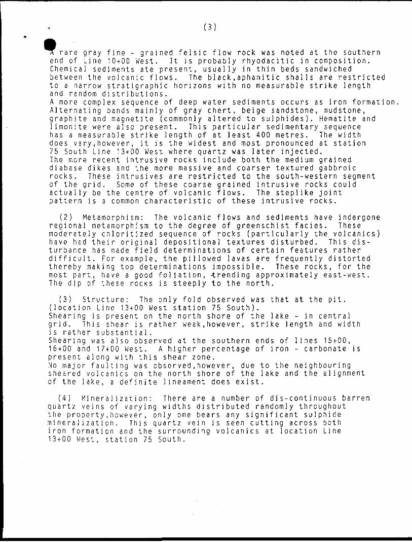
(3)
rare gray fine - grained felsic flow rock was noted at the southern end of Line 10+00 West. It is probably rhyodacitic in composition. Chemical sediments ate present, usually in thin beds sandwiched between the volcanic flows. The black.aphanitic shalls are restricted to a narrow stratigraphic horizons with no measurable strike length and random distributions.A more complex sequence of deep water sediments occurs as iron formation Alternating bands mainly of gray chert, beige sandstone, mudstone, graphite and magnetite {commonly altered to sulphides). Hematite and limonite were also present. This particular sedimentary sequence has a measurable strike length of at least 400 metres. The width does vary,however, it is the widest and most pronounced at station 75 South Line 13+00 West where quartz was later injected. The more recent intrusive rocks include both the medium grained diabase dikes and the more massive and coarser textured gabbroic rocks. These intrusives are restricted to the south-western segment of the grid. Some of these coarse grained intrusive rocks could actually be the centre of volcanic flows. The steplike joint pattern is a common characteristic of these intrusive rocks.
(2) Metamorphism: The volcanic flows and sediments have indergone regional metamorphism to the degree of greenschist facies. These moderately chloritized sequence of rocks (particularly the volcanics) have had their original depositional textures disturbed. This dis turbance has made field determinations of certain features rather difficult. For example, the pillowed lavas are frequently distorted thereby making top determinations impossible. These rocks, for the most part, have a good foliation, -trending approximately east-west. The dip of these rocks is steeply to the north.
{3) Structure: The only fold observed was that at the pit. {location Line 13+00 West station 75 South).Shearing is present on the north shore of the lake - in central grid. This shear is rather weak,however, strike length and width i s rather substanti al.Shearing was also observed at the southern ends of lines 15+00, 16+00 and 17+00 West. A higher percentage of iron - carbonate is present along with this shear zone.No major faulting was observed,however, due to the neighbouring sheared volcanics on the north shore of the lake and the alignment of the lake, a definite lineament does exist.
(4) Mineralization: There are a number of dis-continuous barren quartz veins of varying widths distributed randomly throughout the property,however, only one bears any significant sulphide mineralization. This quartz vein is seen cutting across both iron formation and the surrounding volcanics at location Line 13+00 West, station 75 South.
CERTIFICATE
I, John A. Hyslop, residing at R.R.#1 Cayuga, Ontario NOA 1EO do hereby certify that:
1. I am a graduate geologist, with a honours B.SC. degree from Brock University, St. Catherines, Ontario, received in 1977.
2. I have praticed my profession as an exploration geologist continuously for eight years.
3. This report is based on my personal field examination of the area .
Dated at Cayuga, Ontario, this 5th day of November, 1986.
42E12NE8187 2 .9546 V INCENT 030
RECONNAISSANCE GEOCHEMICAL SURVEY VINCENT TOWNSHIP- CLAIMS #8^5986-8^5990 CAYUGA SYNDICATE
-1-
INTRODUCTION; The following pages are a consise attempt
to present the results of Geochemical surveys completed on
Claims #8^5986 to #8if5990 inclusive within Vincent Township.
Included here is the location and present ownership of the
property,a brief explaination of field procedures,previous surveys
performed on the property,and finally an interpretation of the
results. Also enclosed with this report are seperate maps of
particular elements of interest as well as a copy of the
certificate of analysis.
-2-
HOLDERS of CLAIMS; The report presented here was conceived
by the technical personal of the Cayuga Syndicate,which is
headquartered at 360 Main St. Winnipeg,Manitoba. This organization
are the present holders of this property,
LOCATION; The claims surveyed are located in the north-east
sector of Vincent Township(NTS Map if2Ei2) and are registered as
#845986 to #8*1-5990 respectively,within the Thunder Bay Mining
District(Fig,i). The claims are accessible by way of Highway #11
and various foot trails.
PRO C IMPURE; A brief procedure used in this survey is as follows.
Soil samples were acquired from the B-Horizon by means of a
aluminium trowel,at 25 meter stations,along north-south trending
lines which are 100 meters apart. The total number of samples
gathered was 1^4. If the B-Horizon was not present samples were not
taken,except where a possible transition zone might -exist,for
example an intermediately positioned soil situated below the A-Horizon
would be sampled if the B-Horizon was absent. All characteristics
of the sample site were copiously recordered,including thickness,
colour and texture of each horizon,amount of organic material etc.
Each sample was placed in a thick paper bag,numbered(VS1-VS1it4) and
dried naturally. When these preparations were completed the samples
were sent to a commercial laboratory for analysis. In this case the
laboratory is Chemex Labs Limited of Vancouver B.C. At the laboratory
the samples were dried then sieved through -80 mesh screen,then put
through Nitric-Aqua-Regia digestion,followed by Inductively Coupled
Plasma analysis. Since this method of digestion is considered incomplete
16 of the 30 elements analysed for,the values can only be sited as
semi-quantitative.
-3-
PREVIOUS WORK; As far as can be ascertained,no published evidence is available of prior geochemical work being executed on these particular claims. In the field,however,there is evidence that some trenching was done some time ago. There is no recording of any analysis results from this trenching.
INTERPRETATION; The soil horizons within these claims is in general quite well developed. There are 3 major zonings with some sub-zones. The A,-horizon found in this area is a peat type of overburden containing moss,lichens and similar types of vegetable cover,it is black in colour and has a fibrous feel due to the abundance of root material. The A^horizon is a fine pale white silt containing some root materiaK10^). This zone was not always found, and when located it varied in thickness from 0.5-12,0 cm. The thicker zones of this horizon were found in flat lying Birch groves,rarely was it found in other regions (ie) near swamps,outcrops etc. The B-horizon was reasonablely consistent throughout the grid. It was observed to be a yellow-brown to red coloured silt material. It frequently contained glacial erratics of variable diameters, (0.1-5.0 cm.) or fragments from the under lying bedrock. As in the case of the Arhorizon the B-horizon is best developed in flat lying Birch groves. Its' colour is more red-brown within the eastern part of the property,where it was mixed with much organic material from the Arhorizon. Soil in general was not well developed between lines 0+00 to 9+00 W. The s&il here,due to the presence of outcrop would most likely be a juvenile type soil rather than the more common mature type of soil. No samples were taken from line 8+00 W. as this particular line was immersed within a thick ceder swamp. The C-horizon was very rarely observed due to the fact that it was not the target horizon. When it was observed,it is found to be a pale yellow to brown silt to sand type of material,usually containing boulders or basement rock fragments. There were occasions where a light brown(beige) coloured,sandy textured material was found. It was always located in low lying regions and was usually moist,with many small rounded pebbles imbedded within it. This soil type could be a C-horizon or possibly,it is glaciofluvial material from a old river system.
-li
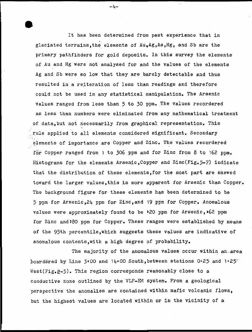
lt has been determined from past experience that in
glaciated terrains,the elements of Au,Ag,As,Hg, and Sb are the
primary pathfinders for gold deposits. In this survey the elements
of Au and Hg were riot analysed for and the values of the elements
Ag and Sb were so low that they are barely detectable and thus
resulted in a reiteration of less than readings and therefore
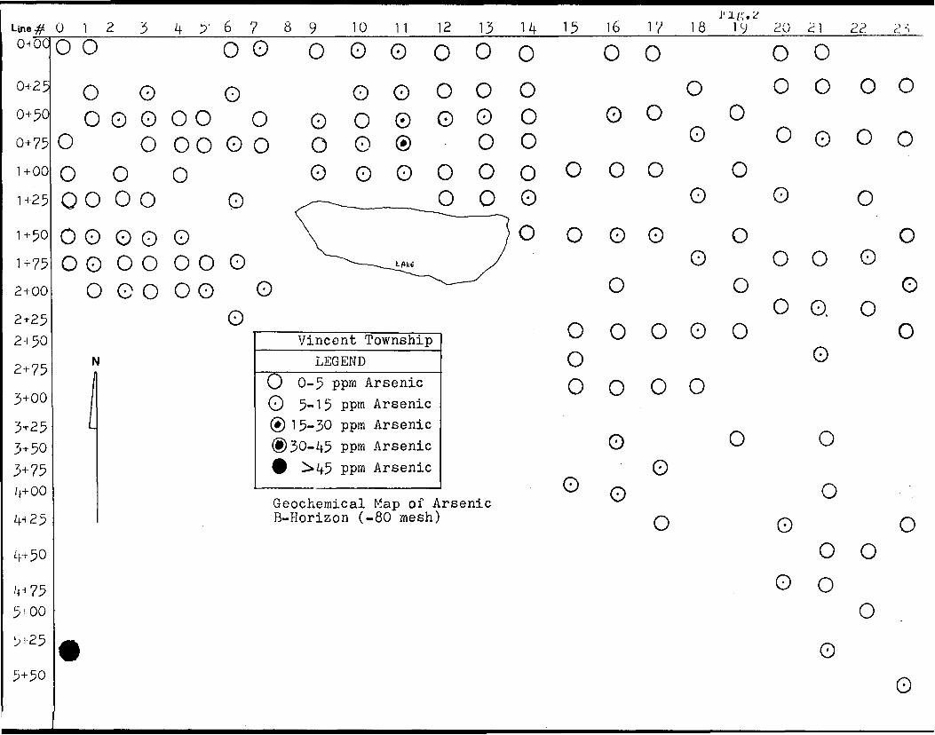
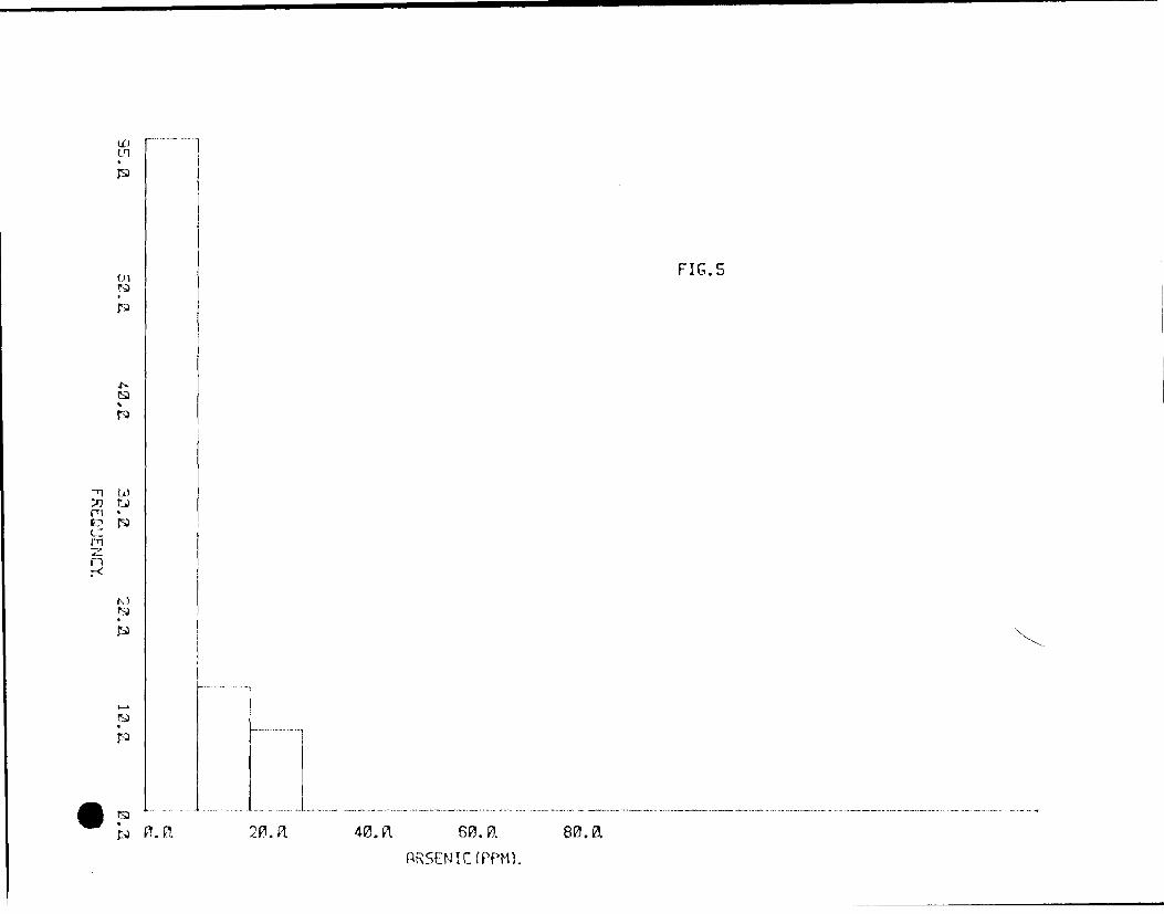
could not be used in any statistical manipulation. The Arsenic
values ranged from less than 5 to 30 ppm. The values recordered
as less than numbers were eliminated from any mathematical treatment
of data,but not necessarily from graphical representation. This
, rule applied to all elements considered significant. Secondary
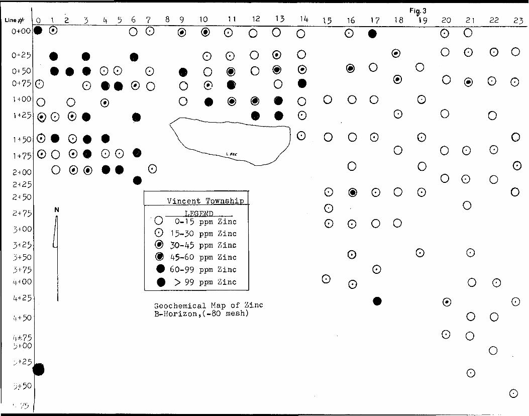
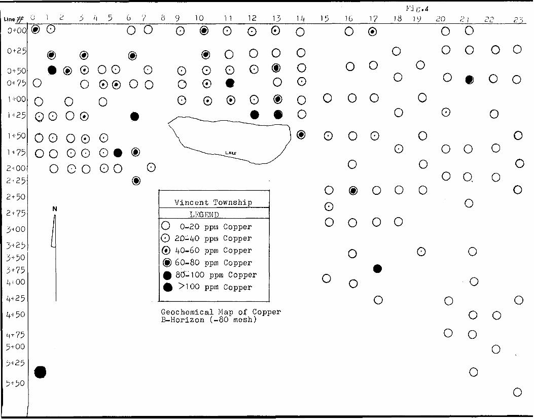
elements of importance are Copper and Zinc. The values recordered
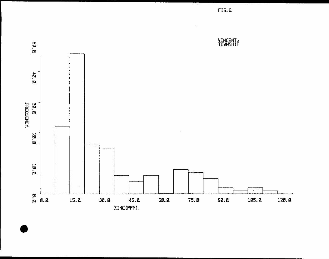
for Copper ranged from 1 to 306 ppm and for Zinc from 8 to 162 ppm.
Histograms for the elements Arsenic,Copper and Zinc(Fig.5-7) indicate
that the distribution of these elements,for the most part are skewed
toward the larger values,this is more apparent for Arsenic than Copper.
The background figure for these elements has been determined to be
5 ppm for Arsenic,2/1 ppm for Zinc,and 19 ppro for Copper. Anomalous
values were approximately found to be ^0 ppm for Arsenic,)62 ppm
for Zinc and)80 ppm for Copper. These ranges were established by means
of the 95th percentile,which suggests these values are indicative of
anomalous contents,with a high degree of probability.
The majority of the anomalous values occur within an.area
boarde'red by Line 3+00 and 1^+00 South,between stations 0+25 and 1+25"
West(Fig.2J-5). This region corresponds reasonably close to a
conductive zone outlined by the VLF-EM system. From a geological
perspective the anomalies are contained within mafic volcanic flows,
but the highest values are located within or in the vicinity of a
-5-
weakly banded Iron Formation. It seems reasonable to conclude
that there is a relationship between the observed Iron Formation
and the higher readings of Arsenic,Copper and Zinc sampled from the
B-Horizon. It is interesting to note,as where the interpreted
conductor travels,so goes these particular elements,as therev
are few high metal values in the western portion of the property,
as well as no conductive material present. The Iron Formation was not
visibily traced beyond line 11+00 South,but high element values
were found as far east as line 0+00. This poses the question,does
the Iron Formation continue further east,or are the anomalous metal
results dependent on another factor?. From the geology it is known
that there is a band of sheared schistose rock,that is prevalent
across line 1+00 West,where it is visible intermittently for 300
meters between lines 9+00 and 12+00 South, This shear zone is
adjacent to a interpreted topographic lineament. This leads to the
possibility of a small weak fault structure being in this sector.
If this hypothesis is true,it may be the reason for the interpreted
conductor and the presence of these elements.
CONCLUSIONS; The existence of a fault structure on
this property is conjectered on the basis of visible parallel shear -
zones and interpreted conductive zones. The relatively high values
of the various elements maybe related to this structure or may in
fact have more of a connection to the Iron Formation,as the largest
readings for all these elements are situated very close to this
lithologic unit. Therefore this alleged fault must be furthered
defined by means of a close spaced pedogeocheraical survey as well
as actual rock analysis. This may prove to be logisticly difficult,
as the interpreted lineament is obscured by lakes and swampland.Respectively Submitted
"li 1 ! Uriinr i***** ! M***^--lf!f!r^jIjij-rji-'r irn tp-| l — — —*~ "" "" ~~ i, Usosi^rsd-i-^^1-"-"—i jt-r~ i ij_i—rrl.—
l le uo talc*cclojf4!?^ - -^^J^^SMMBTJ *y w
Scale: 1 cm.s 7.8^ M.(A) cm.s 13.7
Map showing position of Vincent Township within Mining district and location of claims withih. township. ___________ (B)
Mtf.i?Une# 012 3 4 5' 6 7 89 10 11 12 13 14 15 16 17 18 19o^oc
0+25
0+500+75
1+00
1+25
1+501+752+00
2+25 2 + 50
2+75
3+003+253+503+754+00
4+25
4+50
4^755-00
5-25
5+50
oo oooooooo oooo o ooooo oOOOOO O OO00OO OO^O
o o oo o o o o ® 00 u
20 21 22
0 0o o oo o o
2 S
oo
oo o ooooooooo ooooo o /~^^^—^jooooo \o o o o o o o ^--^i^
ooooo oo
Vincent TownshipN LEGEND1 O 0-5 ppm Arsenic
1 O 5-15 ppm ArseniclL (?) 1 5-30 ppm Arsenic
(8)30-45 ppm ArsenicQ i*45 ppm Arsenic
D O O 0^ _
}o o o o oy o0 0
oooooooooo
o ooo n
Geochemical Map of Arsenic ^B-Horizon (-80 mesh)
t
o
0 0
o o oo o o
0
o0
o0 0
0 00
o
o0
o
o
o
Line^0+00
0+25
0+500+75
1+00
1+25
1+501+752+002+252 + 50
2 + 75
3+00
3+253+503+754+00
4+25
4+50
4*752 f 00
012 3 4567 89 10 11• ® O O ® ® O C
Fig. 312 13 14 15 16 17 18 19 20 21 22 23
) O O O0 O O• * 0 00O®O ® 0000• ••00 o •ooo®® ® o ^ o .
0 0 ** ® O O ® *O O 0 O 0 ® C®000 O ^-— -^^J00 0 0 t \0 O 0 0 0 0 0 ^^---^f
O ® ® 0 0 06
Vincent TownshipN LEGENDl 'O 0-15 ppm Zinc
l O 15-30 ppm ZincL ® 30-45 ppm Zinc
(P 45-60 ppm Zinc0 60-99 ppm Zinc0 > 99 ppm Zinc
00 ® o ® o og) 0 O O O O Oi * o . o o o
.0.000 o oy o o o o— o o o
o o oo ® o o o o o o0 O O O
o o o0
0 0 00A rz\ /oGeochemical Map of Zinc w v^ v^-
B-Horizon,(-80 mesh) 0 00 0
oo
^50 o
Une# 012 3 i, 5 6V 89 10 11 12
0+00
0+25
0+50 0+75
1+00
H25
1+50H752nOO2.25
2+502+75
3+00
3+25 3+503+75Vi 00
4+25
4+50
4+755+00
5+25
5+50
® o o o o ® o o® ® (i) ® O O* ® 0 O O O O GOO
O O 0® O O O © *O O O O 0 0 OQO O0 ft y ——— -^——^^s — — ~. — ^
O O O 0 0 \O O 0 G 0 ^ ® ^ — ,
0 G 0 00 G ^-^d)
Vincent TownshipH LEGEND1 O 0-20 ppm Copper
1 O 20-40 pprn Copper0 40-60 pprn Copper @) 60-80 ppm Copper0 8d-100 pprn Copper ^ >100 ppm Copper
13 14 15 160 O OO O(DO O 0 0(D O O Oe o
}® G 0
^ oO (Do0 0
o0 0
Geochemical Map of Copper B-Horizon (-80 mesh)
9
J''iLr .4 17 1819 20 2 i 22
® o o0 000
0 0 0 0^0
0 O0 G O
G OG GOO
OO O. O
GOOO
O 0
0 00
O0 0
0 00 0
0
o
2 ~-5
oo
ooo
o
o
l
LD*
lil——
l
U-
sODtaCD
a. o.UJ
ir,o:d
tafi(S
95.040,
"2 2.•V
Jt-
M
*~
^20. a
eic:
0.0
FREQUENCY.
03*
UJ
l~*
li.
C3 CNea* inea o*ea**inea*
to"LJ
ea encd
4
mst*ea
50.fi
40.3
0.a
20.
FREQUENCY.
10.00.0
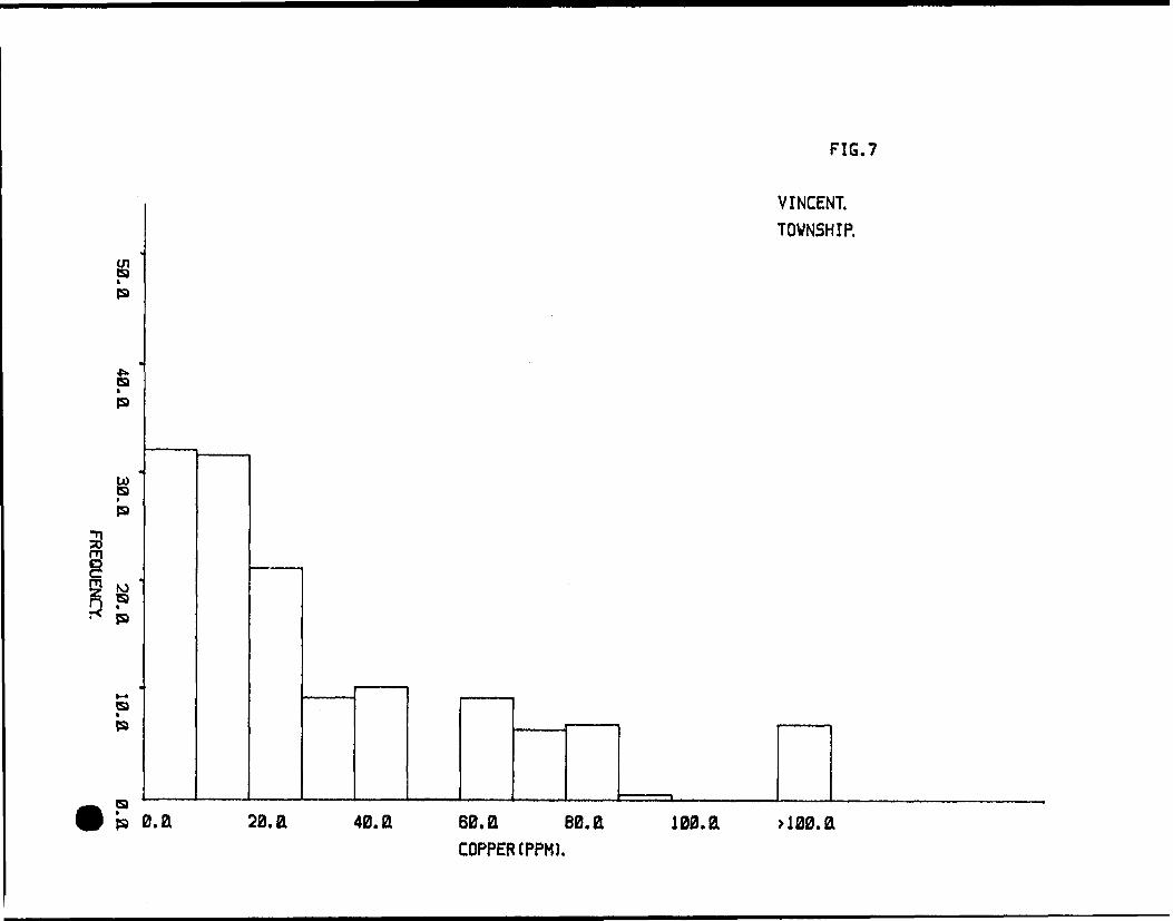
FIG.7
VINCENT. TOWNSHIP.
gb
O)s*(9
Pfa
(91
(9
eab 13. fl 20. a 40. a 60. a 80. a 100. a a00.a
COPPER (PPM).
———— U—
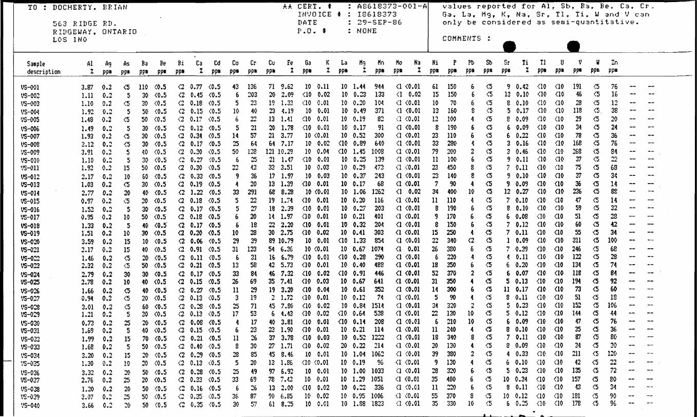
TO :
Saaple
DOCHERTY.
5G3 RIDGERIDGEWAY,LOS 1NO
Aldescription Z
VS-0011-5-002VS-003VS-004ys-oosVS-006VS-007VS-008VS-009VS-010ys-oiiVS-012VS-013VS-014VS-015VS-016vs-017VS-018VS-019VS-020VS-021VS-022VS-023VS-024VS-025VS-026ys-02?•v'S-028VS-029VS-030VS-031VS-032VS-033'v'S-034ys-035VS-036VS-037VS-03SVS-039VS-040
3.871.111.101.921.481.491.933.123.911.101.922.171.032.770.971.520.951.331.513.592.171.462.322.792.781.660.943.011.210.731.691.991.683.201.303.322.761.203.073.66
E R
ED
IAN
a
ONTARIO
AQppi
0.20.20.20.20.20.20.20.20.20.20.20.20.20.20.20.20.20.20.20.20.20.20.20.20.20.20.20.20.20.20.20.20.20.20.20.20.20.20.20.2
Asppi
(55
(55
tt5
tttt55
1510tt20tt
510
5101515tttt3010(5(5tt5
255
155
15102025202520
Ba Beppi ppi
110 (0.530 (0.530 (0.550 (0.550 (0.530 (0.530 (0.530 (0.540 (0.530 (0.550 (0.560 (0.530 (0.540 (0.520 (0.530 (0.550 (0.540 (0.530 (0.510 (0.540 (0.520 (0.550 (0.530 (0.540 (0.540 (0.520 (0.560 (0.530 (0.520 (0.540 (0.570 (0.550 (0.520 (0.520 (0.550 (0.520 (0.550 (0.550 (0.550 (0.5
Bi Cappi Z
(2 0.77(2 0.45(2 0.18(2 0.15(2 0.17(2 0.12(2 0.34(2 0.17(2 0.20(2 0.27(2 0.30(2 0.33(2 0.19(2 1.22(2 0.18(2 0.17(2 0.18(2 0.17(2 0.20(2 0.06(2 0.91(2 0.11(2 0.21(2 0.17(2 0.15(2 0.27(2 0.13(2 0.28(2 0.13(2 0.08(2 0.15(2 0.21(2 0.40(2 0.29(2 0.13(2 0.28(2 0.23(2 0.16(2 0.35(2 0.35
Cdppi
(0.5(0.5(0.5(0.5(0.5(0.5(0.5(0.5(0.5(0.5(0.5(0.5(0.5(0.5(0.5(0.5(0.5(0.5(0.5(0.5(0.5(0.5(0.5(0.5(0.5(0.5(0.5(0.5(0.5(0.5(0.5(0.5(0.5(0.5(0.5(0.5(0.5(0.5(0.5(0.5
Coppi
4365
1065
142550
622
94
335566
102931
6133326113
2517
46
118
285
2533
63630
Crppi
136203134022215764
12825423620
291222720182839
12331588469291971531723263085204969268757
AA CERT, t : A8G183 73-001-AINVOICE * : 18618373DATE : 29-SEP-8GP.O. * : NONE
Cu Fe Ga K La Mq Hnppi Z ppi Z ppi Z ppi
71 9.62 10 0.11 10 1.44 94420 2.09 (10 0.02 10 0.23 13319 1.33 (10 0.01 10 0.20 10423 4.19 10 0.01 10 0.49 37113 1.41 (10 0.01 10 0.19 8220 1.78 (10 0.01 10 0.17 9121 3.77 10 (0.01 10 0.52 30064 7.17 10 0.02 (10 0.89 640
121 10.29 10 0.04 (10 1.45 100821 1.47 (10 0.01 10 0.25 13933 3.51 10 0.03 10 0.29 47317 1.97 10 0.03 10 0.37 24313 1.39 (10 0.01 10 0.17 6868 8.28 10 (0.01 10 1.06 126219 1.74 (10 0.01 10 0.20 11618 2.39 (10 0.01 10 0.27 20314 1.97 (10 0.01 10 0.21 40122 2.20 (10 0.01 10 0.32 20430 2.75 (10 0.02 10 0.41 30389 10.79 10 0.01 (10 1.33 85454 6.36 10 (0.01 10 0.67 107416 6.79 (10 0.01 (10 0.28 29042 5.73 (10 0.01 10 0.40 48S46 7.32 (10 0.02 (10 0.91 44635 7.41 (10 0.03 10 0.67 64119 3.20 (10 0.04 10 0.61 3522 1.72 (10 0.01 10 0.12 74
45 7.80 (10 0.02 10 0.84 15146 4.43 (10 0.02 (10 0.64 538
40 3.81 (10 0.01 (10 0.14 20823 1.90 (10 0.01 10 0.21 11437 3.78 (10 0.03 10 0.52 122227 1.71 (10 0.02 20 0.22 21445 8.46 10 0.01 10 1.04 106213 1.86 (10 (0.01 10 0.19 9697 6.92 10 0.01 10 1.00 103378 7.42 10 0.01 10 1.29 105113 2.00 (10 0.02 10 0.22 33690 6.85 10 0.02 10 0.95 100661 8.25 10 0.01 10 1.S8 1823
Mo Nappi Z
(1 (0.01(1 0.02(1 (0.01(1 (0.01(1 (0.01(1 (0.01(1 (0.01(1 (0.01(1 (0.01(1 (0.01(1 (0.01(1 (0.01(1 (0.01(1 0.02(1 (0.01(1 (0.01(1 (0.01(1 (0.01(1 (0.01(1 (0.01(1 0.01(1 (0.01(1 (0.01(1 (0.01(1 (0.01(1 (0.01(1 (0.01(1 (0.01(1 (0.01(1 (0.01(1 (0.01(1 (0.01(1 (0.01(1 (0.01(1 (0.01(1 (0.01(1 (0.01(1 (0.01(1 (0.01(1 (0.01
values rGa,only
La ,be
eported forMg, K, Na,considered
AlSr ,as
, SbTl,
semiTi
a r, u
-quant
Be.a n d
i tat
Ca, Cr .V can
i ve .
COMMENTS :
Ni Pppi ppi
61 15015 15010 7013 16012 100
8 19023 11033 28079 20011 10023 45023 1407 90
34 40011 110
8 1909 1708 150
15 25022 34026 330
6 22018 35052 37031 35014 3005 90
34 32022 130
6 21011 24018 34020 13039 3809 130
28 32035 48011 22055 37035 330
PbPP"
6668466426884
1046664
(26462464Ttt
1010484246668
10
Sbppi
tttttttttttttttttttttttttttttttttttttttttttttttttttttttttt(5(5(5(5(5tttttttttttt
SrPP*
91385866339*7
99
12786771•7t
4665
11S556878465
108
106
liZ
0.420.100.100.170.090.090.220.160.460.110.110.100.090.270.100.100.080.120.110.090.390.110.200.070.130.170.110.230.120.090.100.110.090.330.100.230.340.110.120.25
11ppi
(10(10(10(10(10(10(10(10(10(10(10(10(10(10(10(10(10(10(10(10(10(10(10(10(10(10(10(10(10(10(10(10(10(10(10(10(10(10(10(10
Uppi
(10(10(10(10(10(10(10(10(10(10(10(10(10(10(10(10(10(10(10(10(10(10(10(10(10(10(10(10(10(10(10(10(10(10(10(10(10(10(10(10
VPP*
1914623
118293478
168268
37753736
2364759516055
3112461221341181947351
152144
47358734
21142
135157
43181178
UPPE
tttttttttttttttttttttttttttttttttttttttttttttttttttttttttttttttttttttttttttttttt
Ir,pps
76161238202436763422683414881432284234
10068287484926018
1064476368030
120M**
7280349096
_ ———
-.————————————————————— — :———————
———
— .———
—
TO : DOCHERTY.
5G3 RIDGERIDGEUAY,LOS 1NO
Staple Al description ~
VS-041VS-042
j VS-043VS-044VS-045VS-046VS-047'••3-048VS-049VS-050 VS-051VS-052VS-053VS-054US-055ys-056VS-057VS-058VS-059VS-060'.'S-061VS-062VS-063VS-064VS-065VS-066VS-067VS-068VS-069VS-070VS-071VS-072VS-073VS-074VS-075VS-076VS-077VS-078VS-079
,, VS-080
3.061.56 1.141.071.391.563.260.541.202.50 2.261.262.012.111.400.981.911.972.161.700.360.992.043.591.491.453.481.051.251.771.351.161.161.210.961.161.430.340.900.82
B R
R D
IAH AA
ONTARIO
Ag ppi
0.20.2 0.20.20.20.20.20.20.20.2 0.20.20.20.20.20.20.20.20.20.20.20.20.20.20.20.20.20.20.20.20.20.20.20.20.20.20.20.20.20.2
As PPi
1010 (5
510
515{51015 10{510151010203010
55
105
{555
10555
{5{5{5
55
105
{55
{5
B-3 Sepps ppa
80 {0.540 {0.5 40 {0.530 {0.520 {0.530 {0.580 {0.510 {0.520 {0.520 {0.5 50 {0.520 {0.540 {0.540 {0.520 {0.520 {0.560 {0.540 {0.560 {0.590 {0.530 {0.520 {0.550 {0.540 {0.530 {0.540 {0.570 {0.520 {0.520 {0.520 {0.530 {0.530 {0.530 {0.530 {0.510 {0.520 {0.530 {0.520 {0.520 {0.530 {0.5
Bi ppi
ri{2 {2{2{2{2{2{2{2{2 {2{2{2aa{2{2{2{2{2{2{2{2{2{2{2{2{2
T
{2{2{2{2{2{2{2{2{2{2{2
Ca2
0.200.20 0.310.200.130.210.730.190.260.49 0.120.120.290.540.210.120.240.220.420.210.140.150.140.070.190.140.810.200.240.510.150.190.190.190.150.480.550.120.120.15
Cd ppi
{0.5{0.5 {0.5{0.5{0.5{0.5{0.5{0.5{0.5{0.5 {0.5{0.5{0.5{0.5{0.5{0.5{0.5{0.5{0.5{0.5{0.5{0.5{0.5{0.5{0.5{0.5{0.5{0.5{0.5{0.5{0.5{0.5{0.5{0.5{0.5{0.5{0.5{0.5{0.5{0.5
Co pps
216 6469
281
1119 12
49
1111
5212013
947
113186
1667
15945668
10344
Crppa
4630 27212732
1031430543618425137205036423124233577393169232840382426282633421922Mti
Cu pps
6817 2513402337112262 63224241in4***
1430
306432411273988471161
661
157622
27112775{124
4
Fe•f fm
5.422.04 1.391.332.003.407.430.822.165.432.961.322.743.133.492.945.47
15.692.753.501.781.802.529.161.702.523.021.411.703.402.521.311.391.442.131.842.461.391.541.75
CERT. * INVOICE DATEP.O. t
Ga K ppa 2
{10 0.03{10 0.02ao 0.02•ao o.oiao o.oi
10 0.01ao o.o3{10 {0.01ao {o.oi
10 0.01ao o.oi{10 0.01{10 0.02
10 0.01{10 0.02{10 0.01{10 0.02{10 0.03{10 0.02{10 0.02ao o.oi{10 0.01{10 0.02
10 0.02{10 0.01{10 0.01
10 0.02{10 0.01{10 0.01{10 0.01ao o.oi{10 0.01{10 0.02ao 0.02ao o.oiao o.oiao o.o3{10 0.01ao o.oiao o.oi
La PPi
1010 1010101010101010 10101010101010101010101010
ao10105010101010101010101020101010
A36133 126133 29-3EPNONE
Mg Hn 2 ppi
0.97 14290.24 112 0.27 1910.19 840.29 1360.40 2590.94 26400.15 900.24 1230.59 1393 0.34 1730.16 870.42 2700.66 5000.42 3010.18 3150.47 22840.41 24390.42 4460.30 3610.25 1030.23 1820.30 5701.14 9280.43 1550.24 1470.45 3530.28 1470.26 1390.41 10660.34 3890.20 1320.23 1500.29 1570.25 1290.38 2620.39 3000.14 620.16 670.17 159
— ^ o m Aj -j* -36
Ho Na pps l
{1 {0.01a {o.oi a {o.oi{1 {0.01a {o.oia {o.oia {o.oia {o.oia {o.oia {o.oi a {o.oia {o.oi{1 {0.01{1 {0.01{1 {0.01a {o.oia {o.oi{1 {0.01{1 {0.01{1 {0.01{1 {0.01a {o.oia {o.oi{1 {0.01a {o.oi{1 {0.01{1 {0.01{1 {0.01a {o.oia {o.oi{1 {0.01a {o.oi{1 {0.01{1 {0.01a {o.oi{1 {0.01{1 {0.01{1 {0.01{1 {0.01a {o.oi
val Ga , onl
tjez, r e p o r La, Mg. '
y be cons
ted for K, Na, i d e r e d
AlSr.as
. st.Tl,
semi
r Ba, T i, U
-quant
Be, Ca, Cr .and V can
i t a t i v e .
COMMENTS : m mNi
ppi
3717 1412141244
41630 3111252217
7202328231012224524154411182415111116141819
711
7
Pppi
410320 110190170100370
5050
300 170
6016016012013034052019017011090
290360100150360
7070
170170210150
8011012024010080
120
Pbppa
36 iif
4OM
210
244 223644
1066244244242244282
{242424
Sb PPi
{5{5{5{5{5{5{5{5{5{5 {5{5{5{5{5{5{5{5{5{5{5{5{5{5{5,{5{5{5{5{5{5{5{5{5{5{5{5{5{5{5
^Sr T:
ppa l
7 0 .198 0.11 9 0.108 0.097 0.117 0.259 0.066 0.086 0.104 0.13 6 0.126 0.08
10 0.109 0.165 0.166 0.076 0.095 0.02
10 0.109 0.097 0.106 0.097 0.093 0.037 0.118 0.12
12 0.1011 0.118 0.109 0.098 0.118 0.09
10 0.1210 0.116 0.097 0.10
14 0.106 0.095 0.097 0.09
Tl ppi
{10ao{10{10{10ao{10aoaoao ao{10{10ao{10aoaoao{10ao{10ao{10{10{10ao{10{10{10{10{10ao{10{10ao{10{10aoaoao
Uppi
ao{10 {10{10{10ao{10{10{10{10 {10ao{10aoaoao{10{10aoao{10aoao{10{10ao{10ao{10{10{10{10{10ao{10ao{10ao{10ao
•^
yppi
10533 23244088
1211843
101 532543707545
101715139423447
13733464930315554253929453645312844
^y
ppi
{5{5{5{5{5{5{5{5{5{5 {5{5{5{5{5{5{5{5{5{5{5{5{5{5{5{5{5{5{5{5{5{5{5{5{5{5{5{5{5{5
Znops
63 - -16 - ~13 - -14 - ~20 ~ -32 ~ -70 - ~
3 - -14 - -46 ~ ~ 23 ~ ~i* M _36 - -88 - -32 - -30 ~ ~60 - -
160 — - '43 — —22 ™ ~18 - -26 - ~54 - -78 ~ -26 - -40 ~ -CQ - —— jo —72
no - --76 ~ ~3*J
ft ~~
lo "~~ ~~
32 - ~162 - -38 - -24 - -26 - -12 - ~10 - - '22 - -
LOS
Saaple description
VS-081VS-082VS-033V3-OS4VS-085VS-036VS-087VS-038V'S-089VS-090ys-09iVS-092ys-093VS-094VS-095VS-096VS-097VS-098ys-099ys-iooyS-101VS-102ys-iosVS-104ys-iosVS-106ys-io?VS-108ys-109VS-110ys-iiiVS-112VS-113VS-114VS-115vs-116vs-117VS-118V'S-119VS-120
IK'0
AlT
1.001.211.031.031.461.271.311.472.220.570.901.052.400.651.321.840.621.502.800.680.771.661.202.261.790.381.401.951.211.101.241.431.331.381.481.711.121.651.351.34
'-J 1 T J.
Ag ppi
0.20.20.20.20.20.2A ** Vi*
0.20.20.20.20.20.20.20.20.20.20.20.20.20.20.20.20.20.20.20.20.20.20.20.20.20.20.20.20.20.20.20.20.2
n JL\ o. *-
As pps
5(510(510
510
555
1010(5(55
105
(510
55
10101010
5555555
(55
1055
1510
S
t
B.3ppa
20302020403040202010202020102040204040103030302050203040302020202020304040502030
Se ppi
(0.5(0.5(0.5(0.5(0.5(0.5(0.5(0.5(0.5(0.5(0.5(0.5(0.5(0.5(0.5(0.5(0,5(0.5(0.5(0.5(0.5(0.5(0.5(0.5(0.5(0.5(0.5(0.5(0.5(0.5(0.5(0.5(0.5(0.5(0.5(0.5(0.5(0.5(0.5(0.5
Bi ppi
(2(2(2(2(2ti\ w(2(2/t\u
/l••bif
(2(2(2(2(2
"tM
(2(2(2(2(2(2(2(2(2
2(2(2(2(2(2(2(2(2(2(22
(2(2(2
C.3Vjt
0.360.110.140.200.140.220.140.150.170.030.410.100.130.100.100.150.350.120.360.150.110.120.110.320.140.230.120.120.160.110.110.100.120.110.150.160.140.200.140.13
Cd ppi
(0.5(0.5(0.5(0.5(0.5(0.5(0.5(0.5(0.5(0.5(0.5(0.5(0.5(0.5(0.5(0.5(0.5(0.5(0.5(0.5(0.5(0.5(0.5(0.5(0.5(0.5(0.5(0.5(0.5(0.5(0.5(0.5(0.5(0.5(0.5(0.5(0.5(0.5(0.5(0.5
Coppi
3456
11777
17173
1125
1148
315265
199555633846775
1076
Crppi
2923292762233732
10314372062163139152871242037344438262934312423272933433527462854
Cuppi
22(1
4IS87
141362
1to
349(1102685
8319(120143619112
(12
(11935101625(1
11031
FeIV
f*
1.511.722.021.393.421.472.462.814.751.311.561.96
12.040.761.663.011.331.686.941.011.602.842.636.492.181.211.502.411.541.862.251 ontt m *i*M
1.392.782.641.811.342.791.591.85
l 1 "J
Gappi
(10(10(10(10(10(10(10(10(10(10(10(10(10(10(10(10(10(10(10(10(10(10(10(10(10(10(10(10(10(10(10(10(10(10(10(10(10(10(10(10
1^^^^^^
K*ts.
0.01(0.010.010.010.020.020.020.010.010.010.020.010.010.010.020.030.010.010.030.020.010.020.020.010.020.030.020.030.030.020.010.010.020.010.010.030.020.020.020.02
^^^MMV
LaPps
10(1010101010101010
(102010
(10101010
(10101010
(101010
(1010101010101010101010101010101010
^^MilM
10.230.150.210.240.490.250.300.300.320.070.280.150.390.140.220.430.130.200.910.230.110.280.260.650.320.210.200.190.240.140.160.170.200.270.350.210.200.370.280.24
i^i^i^i^H
"rtn ppa
2115632
120573118118164290
53250
59526
7436
132112
811548
8474
12611596412810684819866697586
170166
8975
203113
71
••••^^^^^H
Ho Ha ppa 2
(1 (0.01(1 (0.01(1 (0.01(1 (0.01(1 (0.01(1 (0.01(1 (0.01(1 (0.01(1 (0.01(1 (0.01(1 (0.01(1 (0.01(1 (0.01(1 (0.01(1 (0.01(1 (0.01(1 (0.01(1 (0.01(1 (0.01(1 (0.01(1 (0.01(1 (0.01(1 (0.01(1 (0.01(1 (0.01(1 (0.01(1 (0.01(1 (0.01(1 (0.01(1 (0.01(1 (0.01(1 (0.01(1 (0.01(1 (0.01(1 (0.01(1 (0.01(1 (0.01(1 (0.01(1 (0.01(1 (0.01
COMMENTS :
Ni ppi
151011162217171334
317
515
413235
1539116
1413232013151516
96
161112131912201220
Certlf
P ppi
130150170160230110180100200140240130280
7013020012016029010090
22019045019012015029025015013010015025026026017033030
150
led
Pb ppi
42423244i44422266442444242244222*i
M
4224
(24
by .
3b ppi
(5(5(5(5(5(5(5(5(5(5(5(5(5(5(5(5(5(5(5(5(5(5(5(5(5(5(5(5(5(5(5(5(5(5(5(5(5(5(5(5
•vN^
Sr PP"
5667
11977
476455*?
6565566437973676767939
' 77
li
0.090.090.110.090.090.100.120.120.200.070.070.080.050.060.100.120.150.090.200.070.080.110.120.120.120.080.090.120.100.100.120.100.110.110.120.110.090.130.090.11
\v a
li ppi
(10(10(10(10(10(10(10(10(10(10(10(10(10(10(10(10(10(10(10(10(10(10(10(10(10(10(10(10(10(10(10(10(10(10(10(10(10(10(10(10
^
upps
(10(10(10(10(10(10(10(10(10(10(10(10(10(10(10(10(10(10(10(10(10(10(10(10(10(10(10(10(10(10(10(10(10(10(10(10(10(10(10(10
Sbz^
yppi"29^
30402974274555
100392744
1222335533327
12621445746
10741242744293445373653523226503534
.* " -
H ppi
1(5(5(5(5(5(5(5(5(5(5(5(5(5(5(5(5(5(5(5(5(5(5(5(5(5(5(5(5(5(5(5(5(5(5(5(5(5(5(5(5
————————— 1
Znppi
13 - -18 - -22 - -22 - -52 - ~16 - -IS ~ -20 - -52 - ~18 - -22 — —18 - ~70 -- ~10 - -14 - -30 - -28 - - 116 - -76 - -12 - -36 ~ -34 - -20 - ~54 -- -T) ~—**4*
12 ~ ™16 - -16 - -14 - -12 - -20 - -18 - -18 - -28 - -32 - ~16 -- ~16 - —40 -- -24 - -24 -- ~
V03rev 11,85
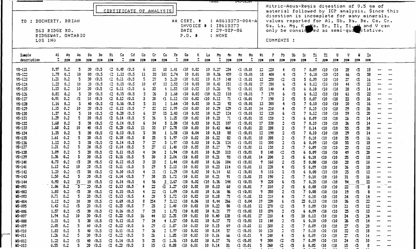
——————————————————————————— CERTIFICATE
TO : DOCHEETY. BRIAN
563 RIDGE RD. RIDGEUAY. ONTARIO LOS 1NO
Saiple AI Ag As Ba Be Bi Ca Cd description 1 ppa ppi ppi ppa ppi ~ ppi
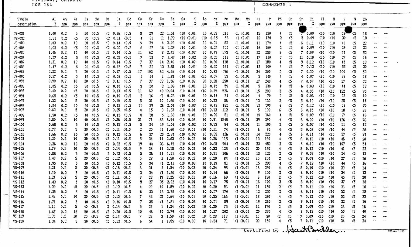
' OF ANALYSIS ——————————————————————————
AA CSRT. # : AS613373-004-A INVOICE * : 13613372 DATE : 29-SEP-SG P.O. t : NONE
Co Cr Cu Fe Ga K La Mg Hn Ho Nappa ppi ppa * ppa I ppa I ppi ppa Z
Nitr ic-Aqua-Regia digestion of 0.5 g m ofmaterial followed by ICP analysis. Since thisdigestion is incomplete for many minerals, values reported for Al, Sb, Ba, Be, Ca. Cr . Ga, La, Mg. K ^ a , Sr, Tl, Ti f R and V can only be consio^Fed as semi-qualitative.
COMMENTS :
Hi P Pb Sb Sr li 11 U V M Zn ppi ppa ppa ppa ppa 1 ppa ppa ppa ppa pea
ys-i2iVS-122 VS-123 VS-124 VS-125 VS-126 VS-127 VS-128 VS-129 VS-130 VS-131 VS-132 VS-133 VS-134 VS-135 VS-136 VS-137VS-138 VS-139 VS-140 VS-I41 VS-142 VS-143 VS-144 WS-001 US-002 MS-003ys-oo4US-005 MS-006 MS-007 US-008 MS-009 MS-010ys-oiiMS-012 MS-013
0.971.781.211.231.150.820.911.161.151.371.291.681.681.351.611.121.311.091.260.731.121.201.500.931.061.030.711.121.421.571.941.312.051.831.251.230.55
0.20.20.20.20.20.20.20.20.20.20.20.26.20.20.20.20.20.20.20.20.20.20.20.20.20.20.20.20.20.20.20.20.20.20.20.20.2
510510105
(55
10555
10555555(510(5515-5 —
(5510tf(5105555(55
30803020302010402010303040303030302030202030201020202030203030304040304020
^. 5(0.5(0.5a. 5(0.5(0.5(0.5(0.5(0.5(0.5(0.5(0.5(0.5(0.5(0.5(0.5(0.5(0.5(0.5(0.5(0.5(0.5(0.5(0.5(0.5(0.5(0.5(0.5(0.5(0.5(0.5(0.5(0.5(0.5(0.5(0.5(0.5
(2 0.40 (0.5(2 1.13 (0.5(2 0.11 (0.5(2 0.15 (0.5(2 0.11 (0.5(2 0.15 (0.5(2 0.12 (0.5(2 0.16 (0.5(2 0.13 (0.5(2 0.20 (0.5(2 0.14 (0.5(2 0.14 (0.5(2 0.20 (0.5(2 0.13 (0.5(2 0.1S (0.5(2 0.14 (0.5(2 0.14 (0.5(2 0.11 (0.5(2 0.16 (0.5(2 0.12 (0.5(2 0.11 (0.5(2 0.10 (0.5(2 0.14 (0.5(2 0.14 (0.5(2 0.13 (0.5(2 0.15 (0.5(2 0.13 (0.5(2 0.69 (0.5(2 0.25 (0.5(2 0.16 (0.5(2 0.22 (0.5(2 0.12 (0.5(2 0.12 (0.5(2 0.11 (0.5(2 0.12 (0.5(2 0.14 (0.5(2 0.23 (0.5
6115106o•j35f656
11587545354M
44448f7
16767
553
3133-irj
473326203132372634333035•VJiti
2724302329213056222220254252344242926262515
18101
51343
(11
121555
17153
(123Ow
5(1153
(1(157t
1124
(iH w
1(1(1
1.412.742.20n c,c,UB\*V
1.S31.501.121.641.992.431.352.30i toAmi W
1.531.971.971.401.942.041.442.131.291.722.671.271.09i r*A m t M
** T1 itm i *.
1.401.72*J TCM**A*
1.571.371.971.351.360.88
(1010
(10(10(10(10(10(10(10(10(10(10(10(10(10(10(10(10(10(10(10(10(10(10(10(10(10(10(10(10(10(10(10(10(10(10(10
0.020.010.020.030.020.020.020.030.030.020.020.030.030.040.020.030.030.010.030.030.020.020.020.020.030.030.020.060.020.020.020.020.020.020.030.020.01
1010101010
(10(1010101010101010101010101010101010(1010101010101010101010101010
0.270.560.190.410.260.220.120.230.290.270.230.210.420.180.220.260.170.200.210.160.230.140.210.360.130.160.180.440.220.210.400.170.150.140.160.170.14
234459148151911107192
129124711074648832124791139310411461911446036752663077
128736957667631
(1 (0.01(1 (0.01(1 (0.01(1 (0.01(1 (0.01(1 (0.01(1 (0.01(1 (0.01(1 (0.01(1 (0.01(1 (0.01(1 (0.01(1 (0.01(1 (0.01(1 (0.01(1 (0.01(1 (0.01(1 (0.01(1 (0.01(1 (0.01(1 (0.01(1 (0.01(1 (0.01(1 (0.01(1 (0.01(1 (0.01(1 (0.01(1 0.04(1 (0.01(1 (0.01(1 (0.01(1 (0.01(1 (0.01(1 (0.01(1 (0.01(1 (0.01(1 (0.01
121812*vrU*
157i
1131412151722121811118
14Q
11
315979
131912131*7iti
131110995
220400220230140170190300210120150330230190380300ISO140200160220110190220310350210230270370210140300120240300360
44
(26462446Ti ^tA
1if
0U
t
M
2(221tt
4n•A
62246
(224n•4
2^4(2(2
(5(5(5(5tt(5(5(5(5(5(5(5(5(5(5(5(5(5(5(5(5(5(5(5(5(5(5(5(5(5(5(5(5(5(5(5(5
7 0.097 0.105 0.096 0.126 0.106 0.125 0.077 0.107 0.107 0.126 0.097 0.107 0.147 0.107 0.106 0.097 0.096 0.096 0.105 0.085 0.096 0.087 0.107 0.206 0.08"7 0.087 0.1023 0.139 0.096 0.09
10 0.136 0.107 0.097 0.106 0.097 0.096 0.05
(10(10(10(10(10(10(10(10(10(10(10(10(10(10(10(10(10(10(10(10(10(10(10(10(10(10(10(10(10(10(10(10(10(10(10(10(10
(10(10(10(10(10(10(10(10(10(10(10(10(10(10(10(10(10(10(10(10(10(10(10(10(10(10(10(10(10(10(10(10(10(10(10(10(10
23663744336122303959263655293555234935233525319422~
1934362125342627O^ WM
272415
(5(5(5(5(5(5(5(5(5(5(5(5(5(5(5(5(5(5(5(5(5(5(5(5"~oT(5(5(5(5(5(5(5(5(5(5(5(5
IS581622142216163620141430141518122013101312162238
142212122414201814103
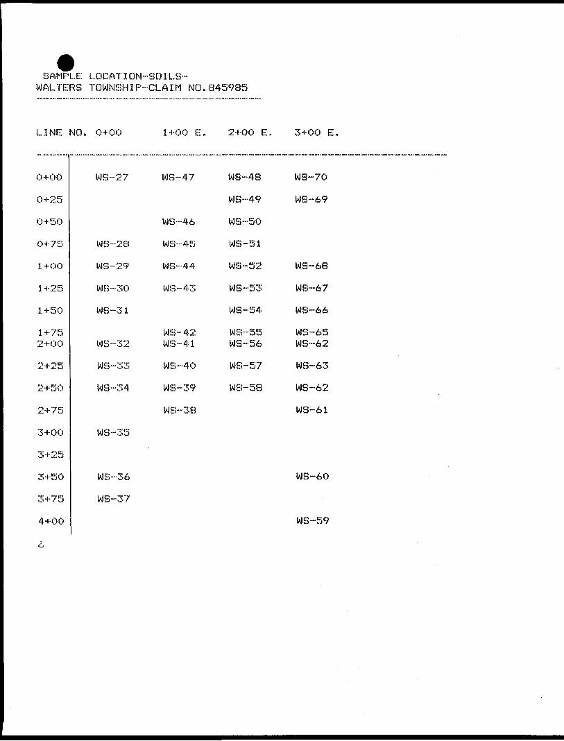
SAMPLE LOCATI DIM-SO ILS- WALTERS TOWNSHIP-CLAIM NO.845985
LINE NO. 0+00 1+00 E. 2+00 E. 3+00 E.
0+00
0+25
0+50
0+75
l +OO
1+25
1+50
1+75 2+00
2+25
2+50
2+75
3+00
3+25
3+50
3+75
4+00
WS--27
WS--28
WS-29
WS-30
WS--31
WS-32
WS-33
WS-34
WS-35
WS-36
WS-37
WS-47
WS--46
WS--45
WS-44
WS-43
WS-42 W S -41
WS-40
WS-39
WS-38
WS-48
WS--49
WS-50
WS-51
W8-S2
WS-53
WS-54
WS-S5 WS-56
WS-57
WS-58
W8-70
WS--69
WS-68
WS-67
WS-66
MS-65 WS-62
WS-63
WS-62
WS-61
WS-60
WB-59
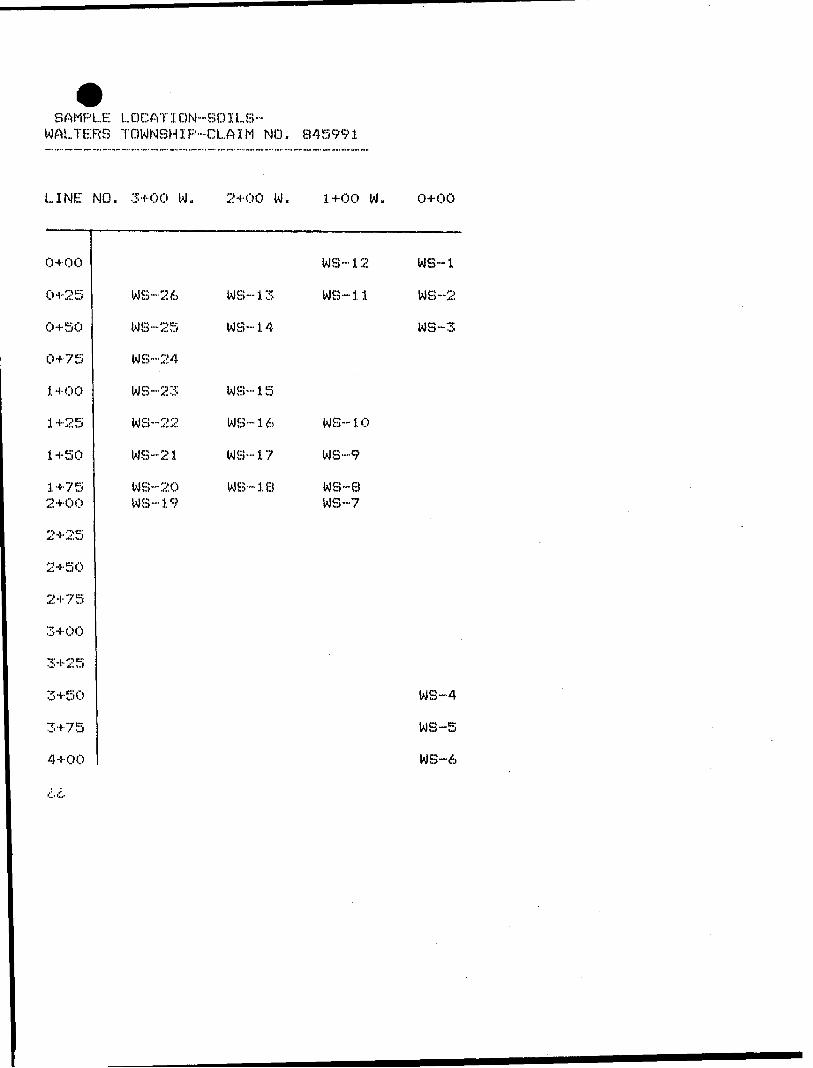
SAMPLE LOGATION-SOILS~ WALTERS TOWNSHIP-CLAIM NO. 845991
LINE
04-00
0+25
0+50
0+75
1+00
1 +2S
1 +50
1+752+00
2+25
2+50
2+75
3+00
3+25
3+50
3+75
4+00
MO. 3+00 W. 2+00 W. 1+00 W. 0+00
WS-12 WS~1
VIS-26 WS-13 WS--11 WS--2
WS-25 WS-14 WS-3
WS--24
WS-23 WS--15
WS-22 WS-16 WS--10
WS--21 WS-17 WS-9
WS-20 WG--18 WS--8WS-19 WS--7
WS-4
WS-5
WS-6
C C-
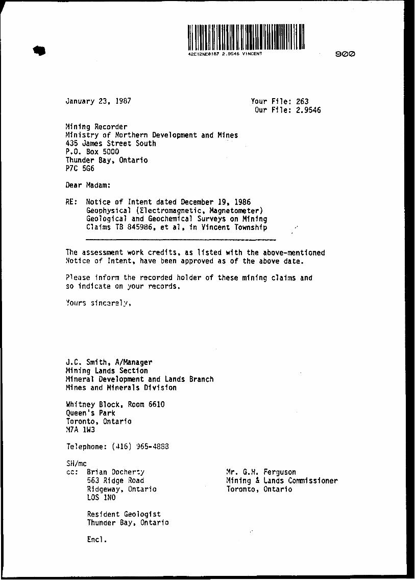
42E12NEei87 2.9546 VINCENT 900
January 23, 1987 Your File: 263Our File: 2.9546
Mining RecorderMinistry of Northern Development and Mines435 James Street SouthP.O. Box 5000Thunder Bay, OntarioP7C 5G6
Dear Madam:
RE: Notice of Intent dated December 19, 1986 Geophysical (Electromagnetic, Magnetometer) Geological and Geochemical Surveys on Mining Claims TB 845986. et al, 1n Vincent Township
The assessment work credits, as listed with the above-mentioned Notice of Intent, have been approved as of the above date.
Please Inform the recorded holder of these mining claims and so indicate on your records.
Yours sincarely,
J.C. Smith, A/ManagerMining Lands SectionMineral Development and Lands BranchMines and Minerals Division
Whitney Block, Room 6610 Queen's Park Toronto, Ontario M7A 1W3
Telephone: (416) 965-4888
SH/mccc: Brian Oocherty
563 Ridge RoadRidgeway, OntarioLOS 1NO
Resident Geologist Thunder Bay, Ontario
Encl.
Mr. G.H. FergusonMining i Lands CommissionerToronto, Ontario
y o ^
t, o K o
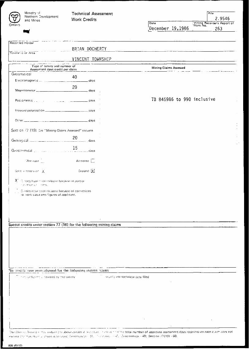
Ministry ofNorthern developmentand Mines
Ontario
Technical Assessment Work C redits
File
2.9546Date Mining Recorder'! Report o*
Work No.December 19,1986 , 263
Recorded Holder
BRIAN DOCHERTYTownsn;Q or Area
VINCENT TOWNSHIPType of survey and number of
Assessment clays credit per claimGeophysical
Electromagnet,c _-
Magnetometer ———
40
20
Radiometric __________,
Inauced polarization ______
Other _______________
.days
. days
. days
-days
.days
Section 77 (19) See "Mining Claims Assessed" column
Geological __.__..___________.___days
15Gi;oc:v;mical _,
Man days
. days
Airborne j_,
Ground \Xl
C:"'C!its nnvo ::een niduccd because of corrections :o .vork datos and fiyures of applicant.
Mining Claims Assessed
TB 845986 to 990 inclusive
Special credits under section 77 (16) for the following mining claims
Mo ornciits ,iave been uilowecl for the foilowinq mimno ninims
nsuif ; c:ent technical data filed
iMn'-",: •v i roKl''i '".u ri'diKV 'tis 1 jbovr criHiitr, M M"ci;',s.n\ ' mil,'i ".-.M t he total number of approved assessment days recorneo on each cl.iim iioes not eu t'''' r" -ixi m LI,T . ; o'.MM l .is M Hou s: G i 1 o pin suvii - /O, '^ -j o,H i c.;: - --0. o coe he rtit cal - 40; Section 77(19) - 60.
828 (85/12)
Ontario
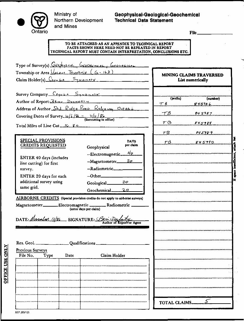
Ministry ofNorthern Developmentand Mines
Geophyslcal-Geological-Geochemical Technical Data Statement
File—
TO BE ATTACHED AS AN APPENDIX TO TECHNICAL REPORTFACTS SHOWN HERE NEED NOT BE REPEATED IN REPORT
TECHNICAL REPORT MUST CONTAIN INTERPRETATION, CONCLUSIONS ETC.
lW
Type of Survey(s). Township or Area. Claim Holder(s).!
lo
G. A
Survey Company
Author of
Address of Author . K
Covering Dates of Survey \ o\L
Total Miles of Line r.ut(linecutting to office)
g. o
SPECIAL PROVISIONS CREDITS REQUESTED
ENTER 40 days (includes line cutting) for first survey.ENTER 20 days for each additional survey using same grid.
Geophysical —Electromagnetic —— z
DAYS per claim
—Radiometric-Other ^—Geological.Geochemical. •2.0
AIRBORNE CREDITS (Special proviiion credits do not apply to airborne surveys)
Magnetometer Electromagnetic Radiometric(enter dayi per claim)
nfa SIGNATURE..Author of ReporWor Agent
Res. Geol.. .Qualifications.Previous Surveys
File No. Type Date Claim Holder
MINING CLAIMS TRAVERSED List numerically
-rg (number)
re.t~s ryxj? t* * * * •T*•••••••••••••••••••••••••••••r*r**********
TOTAL CLAIMS.
837 /85/12)
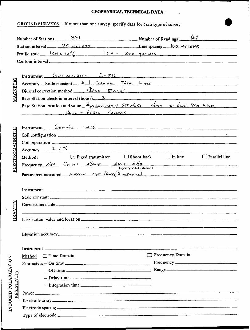
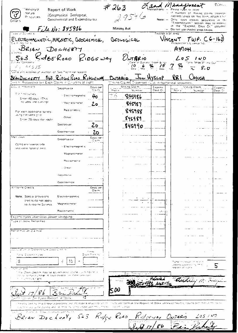
GEOPHYSICAL TECHNICAL DATA
GROUND SURVEYS — If more than one survey, specify data for each type of survey
Number of Stations Station interval ——Profile sralp l CM ^ fo Ol
25 x/l fa-rfcTR.5
.Number of Readings
.Line sparing 11? O
Contour interval.
C
Instrument. G f? o
Accuracy — Scale constant. Diurnal correction method.
A /M d/*-
6Asg
Base Station check-in interval (hnnrs) Base Station location and value A/ooflrts D
ECTROMAGNETIC Oijl configuration
CV*j] separation
Acnirary i X /*
Method: 0 Fixed transmitter Q Shoot back d In lineFrermenrv ^A Cvr L-trii //liO'^f g*/- P *"?;. .... ... ....
D Parallel line
Parameters measured.(specify V.L.F. station)
J,,
O
Instrument.Scale constant.Corrections made.
Base station value and location.
Elevation accuracy.
9M
O)
InstrumentMethod D Time Domain
— On time ———.- Off time ——.
Delay time.
Power.Electrode array — Electrode spacing . Type of electrode
Q Frequency Domain _ Frequency .^.—-—— — Range_______
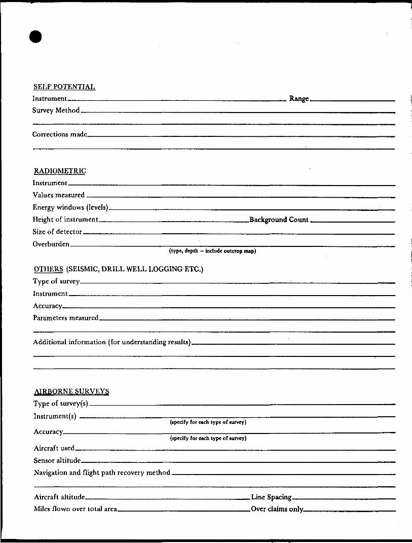
SELF POTENTIALInstrument_______________________________________ Range.Survey Method •—-—-———————^—-—-—————————-—.^^-—.———-^.......-—
Corrections made.
RADIOMETRICInstrument.Values measured.Energy windows (levels) ————-———..-—-——^—^——.—.——-.——.————.-.——.—-Height of instrument___________________________Background Count, Size of detector—————^——————.^—.^————-.—^^^^^..————.——..————Overburden —^—^—-——..^^^^^————.^——-....—-^^———————^—.——
(type, depth — include outcrop map)
OTHERS (SEISMIC, DRILL WELL LOGGING ETC.) Type of survey.—————.^^——^—.—-———————^— Instrument ————————————————————————— Accuracy——————————————————————————Parameters measured.
Additional information (for understanding results).
AIRBORNE SURVEYS Type of survey(s) ———— Instrument(s) —————
(specify for each type of lurvey) Accuracy^—————————————-
(specify for each type of survey) Aircraft used—^-^———————-..————-—-^——^^—.——.—
Sensor altitude.Navigation and flight path recovery method.
Aircraft altitude_______________________________Line Sparing Miles flown over total area________________________Over claims only.
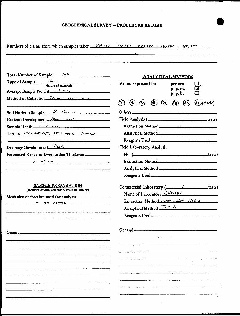
GEOCHEMICAL SURVEY - PROCEDURE RECORD
Numbers of claims from which samples taken.
Total Number of Samples.t~i
Type of Sample.(Nature of Material)
Average Sample Weight—J±L-5nl Method of Collection, •SV---^-^—q~t
S -Soil Horizon Sampled. Horizon Development, 7)oofi ~ Sample Depth. Terrain dues
*.~,
Drainage Development—Estimated Range of Overburden Thickness.
ANALYTICAL METHODSValues expressed in:
Others———————
per cent p. p. m. p. p. b.
Field Analysis (.Extraction Method. Analytical Method. Reagents Used——
Field Laboratory AnalysisNo. ————-^^—-.
SAMPLE PREPARATION(Includes drying, icreening, cruihing, athing)
Mesh size of fraction used for analysis____
Extraction Method. Analytical Method - Reagents Used __
Commercial Laboratory (. Name of Laboratory Extraction Method Analytical Method, Reagents Used __
9/D
©(circle)
.tests)
.tests)
.tests)
GeneraL General.
CO CO
toCL
(T UJ OD2OOo
WALTERS TWP G-I7I
614231 .145052
- - l- - - -,- J"T"; -. y -gr~~\ ^^933
1611504 614511 1614512
, 61 4 506 l 61 4509 ' -t- — - 1- ~
614495 1614496
BEARDMORE G-7
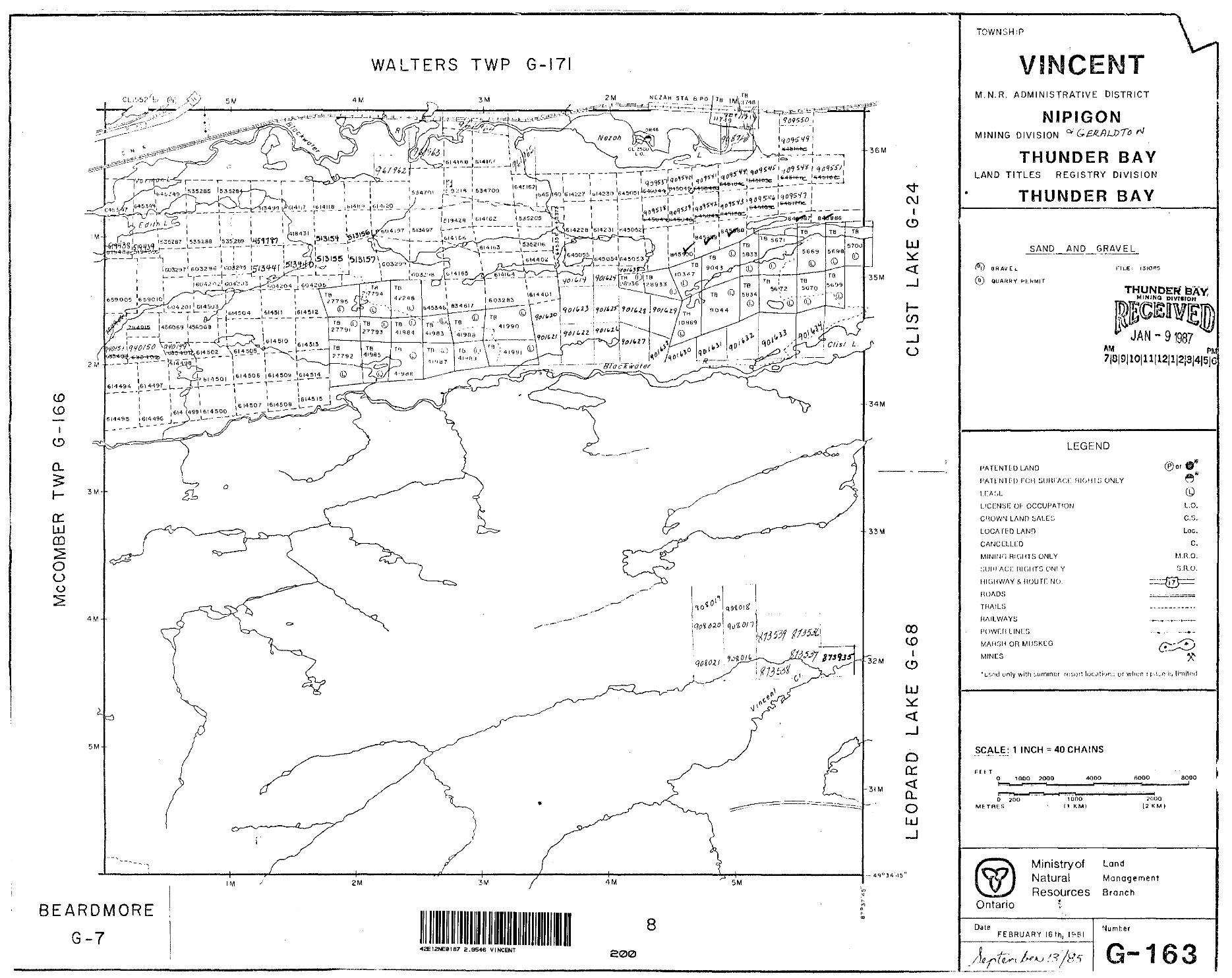
42E12NE8187 2.9546 VINCENT 200
TOWNSHIP
C Hf™ R, l ™W** r" l\! 8 KL*M H li B
M.N.R. ADMINISTRATIVE DISTRICT
MINING DIVISION ^ QeAAUtTo ri
THUNDER BAYLAND TITLES REGISTRY DIVISION
THUNDER BAY
SAND AND GRAVEL
\} G H AV E. L
(s) QUARRY PLhMIT
FILE i I3IO"5
THUNDER' BAYMIMINO D IVIVION
JAN -9 1987AM Pfcfl7|8|9|IO|11|12|1|2I3|4|5|C
LEGEND
PATLNTLD L.ANO
i-'ATtNii;o ron suHi'Aci: RK.HK; ONLYLKASL
LICCNSK Ol- OCCUPATION
CHOWN LAND bALEG
LOCATfDLAND
CANCELLED
MINING RIGHTS ONLY
;;unrAc;[: HIGHTG ONI Y HIGHWAY A nourr. NO.ROADS
THAILS
HAILWAYii
©l'
L,O.
C. S.
Loc.C,
M.n.o.5 H.O.
WAHfiH OR MU5KCG
MINUS
'uf.frd unly with L. u mm f: r rujjurt ij ur whyn : [-.IL-O i^ limited
SCALE: 1 INCH ^ 40 CHAINS
F f h T1000 ?000 4QOO 6000 aooo
—J
D 2DO METRES
1000M KM)
2 f J 00(2 K M
Ministryof LandNatural ManagementResources Branch
Ontario
DateFEBRUARY IGth, I9BI
Number

LO
-1
*- -i
K -19
x .5
B
LIE
\
X,l
-g.
-i- 1*
3
-t ,
-7
-n
-i*
\
L 2E
-i*
.-l
tic
H
it -H
-7
•~ i/
l
-S-
L 3E
~p,
-M-f
f?
-t,
\\
-5
-7
-7
Oui o r P H vSF'x-x) VtRTlc/L ^CALE l cm 10%
IER- NAA- 24kHz
WALTERS WfcST CLAIM 845985
VLF ProfilesCAYUGA SYNDICATE
SCALE
2.54cm. to 5o{nFIELD WORK PERFORMED, INTERPRETED AND PLOTTEI
2W L 1W
INPHASEf' - . ) N OUT of PHASE(x-x)
VERTtCAl SCACt lc TRANSMITTER NAA- 24 kHz
LO
N
WALTERS EAST CLAIM845991
VLF ProfilesCAYUGA SYNDICATE
SCALE: - .
2.54cm. to SOI FIEtO WORK PERFOR MED, INTERPRETED, AND PLOTTED Bf i B-Do
42E12NE0187 2.9546 VINCENT
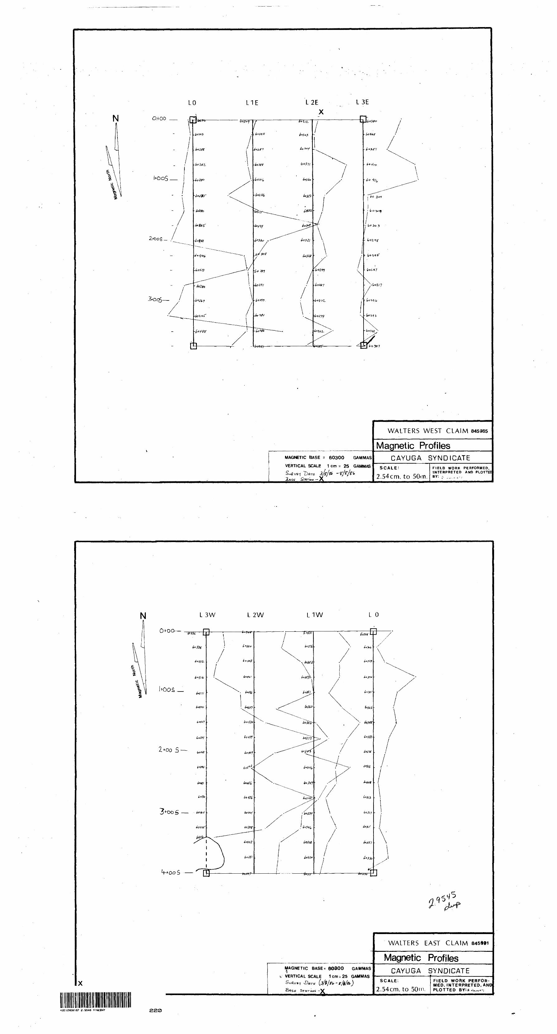
OH-OO
3C7
MAGNETIC BASE = 60300 GAMMAS
VERTICAL SCALE 1 cm - 25 GAMMAS
3/V/& -
WALTERS WEST CLAIM 845985
Magnetic ProfilesCAYUGA SYNDICATE
SCALE; 2.54cm. to 50m.
FIELD WORK PERFORMED, INTERPRETED AND PLOTTEIBY: P. ... ..,~,
L 3W
0 + 00—
S
3+-OOS —
L 2W L1W L O
MAGNETIC BASE* 60300 G AMMAS
t, VERTICAL SCALE,Dflrb-
1 cm ^ 25 GAMMAS
e Sr AT- lo vi -V
WALTERS EAST CLAIM
Magnetic ProfilesCAYUGA SYNDICATE
SCALE.
2.54cm. to 50m,FIELD WORK PERFOR MED, INTERPRETED, AND PLOTTED BY:a^^T,
42EI2NE0187 2.9546 VINCENT 220
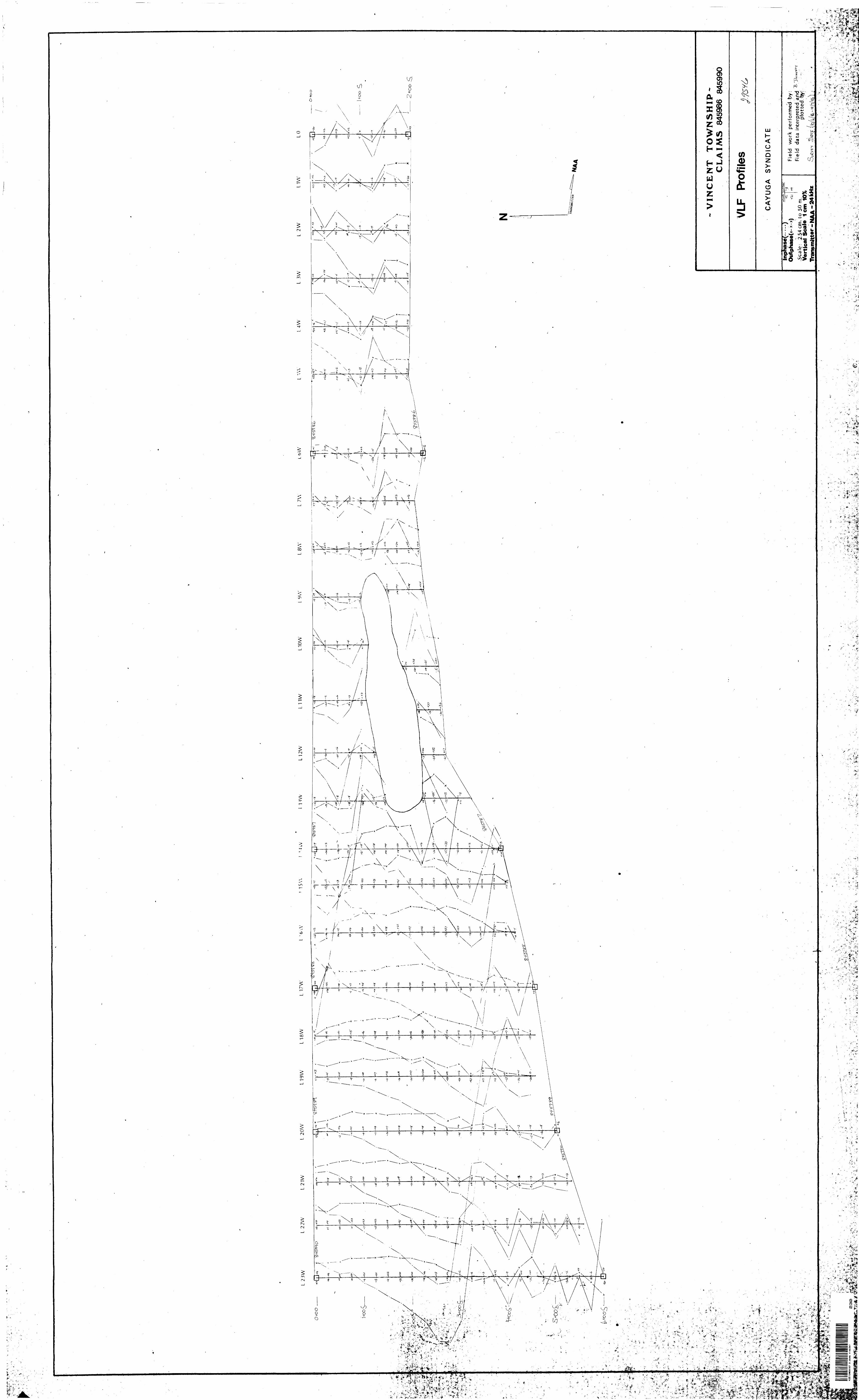
OO
O
l tO
O
*-flt-
J..
- '•ijat^
's .
. '
-z- M
t^^^^^V
-;
'
^J^V
IH -
^ ;
.^:;
' v:-*
ft^
^x^*
- -
•t.
"A
*
,JV
r'
*
. "
' f
'~ T
-S
'
'iT
.J
M'
J
to y
i
f^S
L 23
WL
22W
L 21
WL
20W
L19W
L18W
L 17
WL
115
W•5 W
L11W
now
9VV
L8W
L 7\
\LO
WL
S WL
4W
L 3W
L 2
WL1
WLO
O -
too
*7
2 +
00
';;
S+oo
l
, ^
, .'"
'''
-' -
^^"T
^?
11/sL
^'ts
1' t,^
'."-'.
-"C
" "-
?,\
-: f*
*^
Ai^
..
^^
'J**
'.
*,^:
V'T'V
./'•^
.•vV..
C.V.'-
i "
;--^.
,-
'
*- •*i'
t3f-'
1' i
-^,
. -s.
-j*
.
. *
:*. .*v
~
* -
'- ^-
w
-1 -
.'-.,
^L
L4
* t*
, fl^
f'V'-
. ,,
,/ f
\*s
* -
'-'
tl -,
-VIN
CE
NT
T
OW
NS
HIP
- C
LA
IMS
84
5986
845
990
VLF
Prof
iles
CA
YU
GA
S
YN
DIC
AT
E
•ft|n
phas
e(
Out
phas
e(x-
x x)
i-S
cale
: 2.
54 c
m. t
o 50
m.
Ver
tica
l S
cale
1
cmTr
ansm
itter
- N
AA
- 2
4 kH
z
Fie
ld
wor
k pe
rfor
med
by:
Fie
ld
data
int
erpr
eted
and
plot
ted
by:
. V
e --'
-' s.,.~
-f "m
t :
~ i"
: - ;:v
\" -,-
~
- --
'I* M
c-*
..r-".
•'f'
.~ *
..*
.'-
*" ^
7V
!*
-•w*^
;v
-' * -
- '-
fi
*,-*ff-f
.'-A
.'^^t-
^^v^
'--'^
; v
^ -r-
. i- -
^i ^
M-
^aij^
-. f
c,K
'i
"
•-. ' ^
-i^'^
Kii*
**.*
^.*
^ -^
/.
;. ,
'. '^
r-'-
.-^U
' ^
- '''
^
A .t
Ir
~*^
-
S
- ,L
A
"V1*
..^V
" ''
Jfe
'.'te
'Sk-
('A-*
.*-'

x
L 23
WL
22W
L 21
WL
20W
L19W
L18
WL
17
WL
16
WL1
5WL1
4WL1
3WL1
2WL1
1WL1
0WL9
WL8
WL
7WL6
WL5
WL4
WL
3WL
2WL1
WLO
O w
o
+0 O
S'-
O-t
oo
l+oo S
Z+
oo
S
-VIN
CE
NT
T
OW
NS
HIP
- C
LA
IMS
84
5986
- 84
5990
CA
YU
GA
S
YN
DIC
AT
E
.——
——
— -
. —
-. -
T
Mag
netic
Bas
e 60
300
Gam
mas
- X
Sca
le:
2.54
cm
. to
50
m.
1cm
-200
G
amm
as
Fie
ld
wor
k pe
rfor
med
by
: 5.
F
ield
da
ta i
nter
pret
ed a
nd
/*plo
tted
by:
DAT
E
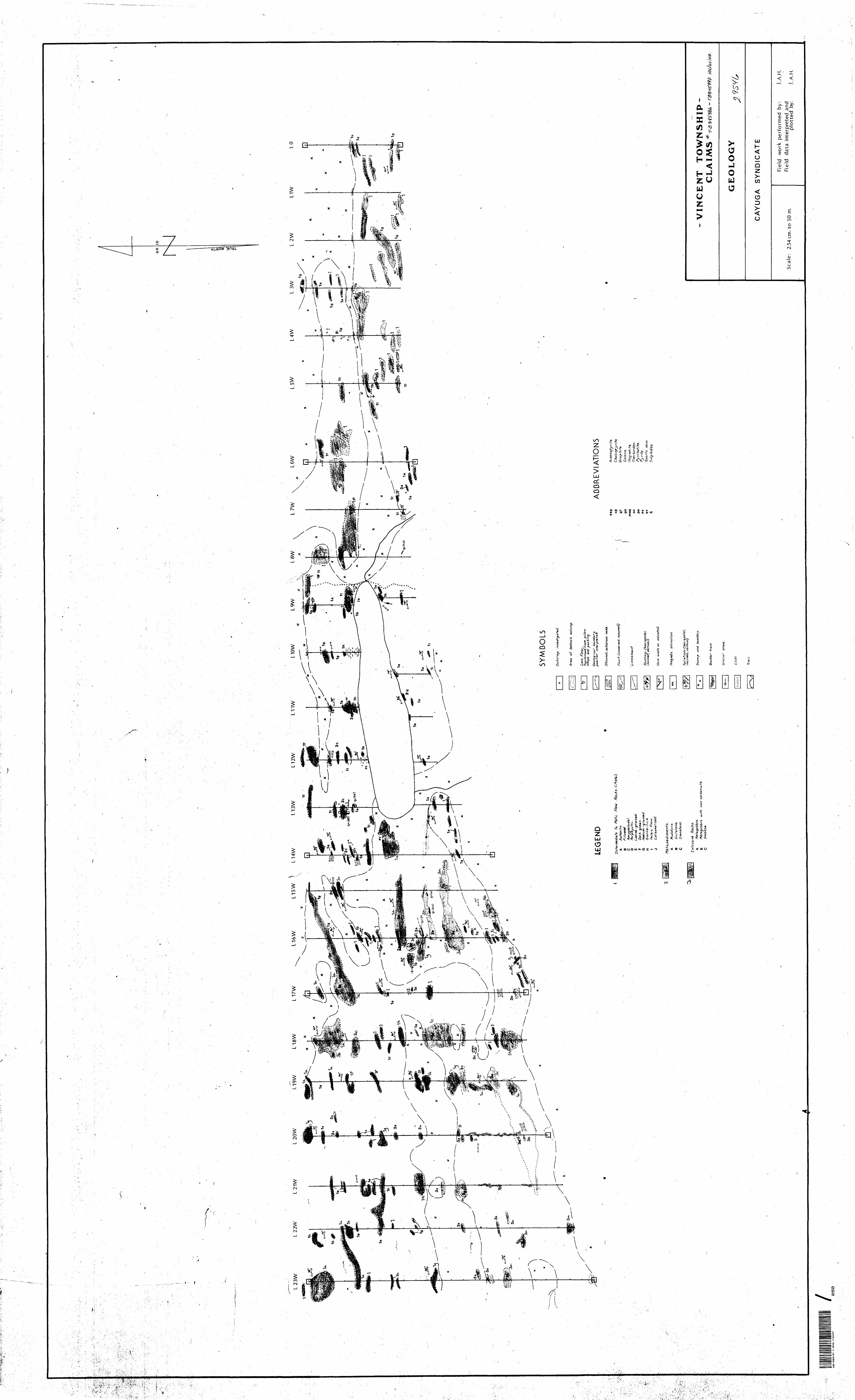
\
\
GR N
ID
- 1g
SY
MB
OLS
Ou
tcro
p
't
Are
a o
f be
droc
k ou
tcro
p.
LQVQ
/V
ow;
fisp
farr
ow)
Sn
oe
an
d
ICG
END
iate
, io
M
afic
. F/
Ow
R
oc.k
s.A B C D E F G
H l J
G&
olo
g icaf
bou
nd
ary
, pot i
t i o
n tn
+m
rppe
t* a
.
; sch
isto
se,
rack
s.
fau
lt;
(ob
serv
ed
,
AB
BR
EV
IATI
ON
S
Am
da/o
ida./
Dor
k
i (ho
rizo
n-to
ll* v
&r+t
co.!)
asp cp gf
gn
jnag
ov
po
PV
ritt
G ra
p h
ite.
GQ
le.n
o..
M Q g
net
1 1 Q.
O
verb
urde
n P
yrr
hotite
. fy
r/V
e ,
Vei
n. w
idM
03
A
Mud
ston
e..
B
SiL
T&to
ne.-
C
Iro
nsto
ne.
Intr
usiv
e
Roc
ks.
A fte
ta.g
ab
bro
,B
M
efaQ
Qbb
ro
with
iron
C
Dia
base
-
c. or
trac
t/o rt
.
i C h
oriz
on to
I, , v
ertic
al)
and
tra
in
Gla
cia
l s
rfo
e.
Cliff.
Trai
l.
VIN
CE
NT
T
OW
NS
HIP
-C
LA
I M
Sin
clusiv
e.
GE
OL
OG
Y
CA
YU
GA
S
YN
DIC
AT
E
Sca
le:
2.54
cm.
to 5
0 m
.
Fie
ld
wor
k p
erf
orm
ed
by
:F
ield
da
ta i
nter
pret
ed a
ndplo
tte
d
by:
J.A.
H.
J.A.
H.
42E12NEai87 2.9546 VINCENT
250
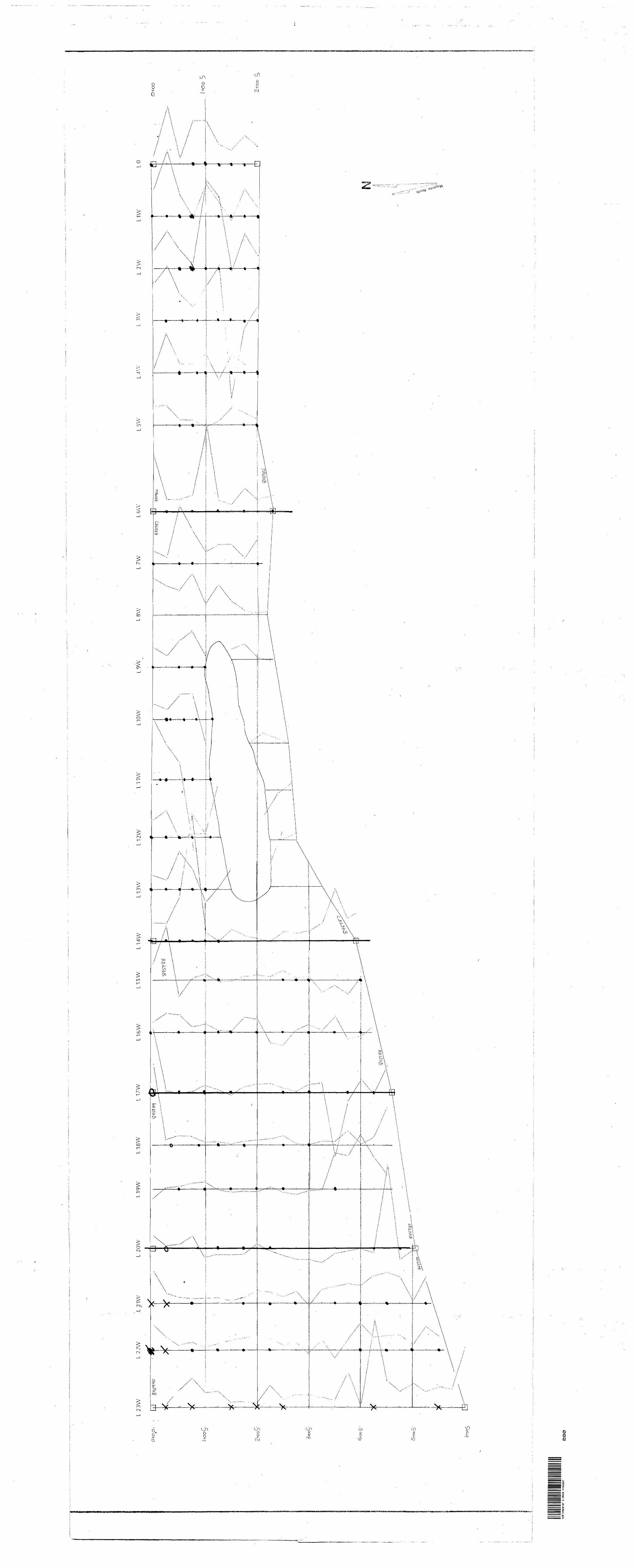
L 23
VL
IVY
LO
0+
0 O
*O
40
O
S
c^ *z 5
42E
12N
6B18
7 2.9
546
VIN
CE
NT
2S
0


