
Pike National Forest
Bear Creek Watershed Improvement
EA
Hydrology Resource Report
Prepared by: Dana Butler and Leah Lessard

The U.S. Department of Agriculture (USDA) prohibits discrimination in all its programs and
activities on the basis of race, color, national origin, age, disability, and where applicable, sex,
marital status, familial status, parental status, religion, sexual orientation, genetic information,
political beliefs, reprisal, or because all or part of an individual’s income is derived from any
public assistance program. (Not all prohibited bases apply to all programs.) Persons with
disabilities who require alternative means for communication of program information (Braille,
large print, audiotape, etc.) should contact USDA’s TARGET Center at (202) 720-2600 (voice and
TTY). To file a complaint of discrimination, write to USDA, Director, Office of Civil Rights,
1400 Independence Avenue, SW., Washington, DC 20250-9410, or call (800) 795-3272 (voice) or
(202) 720-6382 (TTY). USDA is an equal opportunity provider and employer.

PSICC Bear Creek Hydrology Resource Report
i
Table of Contents
Introduction ................................................................................................................................. 1 Overview of Issues Addressed ................................................................................................ 1
Affected Environment ................................................................................................................. 3 Existing Condition ................................................................................................................... 3 Desired Condition .................................................................................................................. 22
Environmental Consequences ................................................................................................... 22 Methodology ......................................................................................................................... 22 Alternative A – No Action .................................................................................................... 24 Alternative B – Proposed Action ........................................................................................... 25 Alternative C ......................................................................................................................... 27
Regulatory Framework ............................................................................................................. 28 Land Management Direction..................................................................................................... 28 Monitoring ................................................................................................................................ 30 Design Features and Mitigation Measures ................................................................................ 31 References…………………………………………………………………………………… 35
List of Tables
Table 1 - Watershed condition indicators ........................................................................................ 4 Table 2 - Watershed condition class and ownership ....................................................................... 5 Table 3 - Soil erosion hazard acres ................................................................................................ 10 Table 4 - Summary of hillslope percentages ................................................................................. 10 Table 5 - Acres of road and trail disturbance ................................................................................ 15 Table 6 - Percent length of road/trail and proximity to stream...................................................... 17 Table 7 - Number of road/trail crossings by type .......................................................................... 18 Table 8 - Road and trail slopes ...................................................................................................... 18 Table 9 - Miles of motorized trail routes located within the wiz of Bear Creek ........................... 22 Table 10 - Miles of non-motorized trail routes located within the wiz of Bear Creek .................. 23 Table 11 - Miles of all travel routes located within the wiz of Bear Creek ................................... 23 Table 12 - Summary of management actions on the stream channel ............................................ 23
List of Figures
Figure 1 - Stream drainage density .................................................................................................. 4 Figure 2 - USGS Gage Data 07105000 Bear Creek ........................................................................ 6 Figure 3 - USGS Gage Data 07105000 Bear Creek ........................................................................ 7 Figure 4 - Example of bare ground hydrologically connected to Bear Creek ................................. 8 Figure 5 - Example of bare ground/fill slope hydrologically connected to Bear Creek .................. 9 Figure 6 - Example of mining activity .......................................................................................... 10 Figure 7 - Example of highly erosive natural surface material/pikes peak granite ....................... 12 Figure 8 - Example of sediment produced after the September 2013 storm events ...................... 12 Figure 9 - Example of road contributions ...................................................................................... 13 Figure 10 - Example of a gully formed by poor road drainage ..................................................... 13 Figure 11 - Example of an incised trail ......................................................................................... 15 Figure 12 - Example of an incised trail ......................................................................................... 16 Figure 13 - Example of sediment contribution directly into Bear Creek ...................................... 19 Figure 14 - Example of lateral migration/road encroachment ....................................................... 20

PSICC Bear Creek Hydrology Resource Report
ii

PSICC Bear Creek Hydrology Resource Report
1
Introduction The greenback cutthroat trout (Oncorhynchus clarkii stomias), Colorado’s state fish, is native to
the east side of the Continental Divide in Colorado. Historically, it was thought to have occupied
the Arkansas and South Platte River watersheds; however, recent genetic analysis indicates it
occurred only in the South Platte River watershed (Metcalf et al. 2012). The greenback cutthroat
trout is currently listed as threatened under the Endangered Species Act (ESA). Extensive surveys
have failed to identify any extant populations of the greenback cutthroat trout in the South Platte
watershed. At present, the sole known remaining population of genetically pure greenback
cutthroat trout inhabits Bear Creek, a tributary of Fountain Creek, itself a tributary of the
Arkansas River (Metcalf et al. 2012).
Land ownership within the analysis area is divided between the USFS (8,152 acres), CSU (173
acres), City of Colorado Springs (805 acres), El Paso County (1,148 acres) and private
landowners (72 acres). At the beginning of this assessment it was agreed upon by all land owners
that this document would disclose and analyze for effects to all resources, on all land ownerships.
This document looks at the analysis area as a whole, regardless of land ownership. The USFS
only has the ability to make management decisions on NFS lands. Decisions and implementation
on lands managed by the City and El Paso County will require decisions by these agencies and
will be independent of any decisions made by the USFS. The USFS has been and continues to be
committed to working closely with the City and El Paso County to implement a variety of
mutually agreeable management actions that protect the Bear Creek watershed and the greenback
cutthroat trout while allowing compatible human use. The transportation system has routes that
continue outside of the Bear Creek Watershed, and opportunities for route expansion outside of
the watershed within the Cheyenne Creek Watershed. All of these actions are within the Bear
Creek Project Analysis area, but when talking about what proposed actions will result in
improvements to the greenback cutthroat trout habitat, the watershed specialist report utilizes the
Bear Creek watershed as the appropriate scale for assessment.
Overview of Issues Addressed
This report describes the effects of the existing watershed conditions and the proposed
management actions in the Bear Creek project area. Watershed resources include both soils and
hydrology.
The following factors that influence the risk of erosion and sediment delivery to Bear Creek are
documented: acres of watershed, acres of bare ground, mining, soils and geology, hillslope
gradient, drainage density, acres of road/trail disturbance, road/trail density, road/trail condition,
number of road/trail stream crossings, road/trail gradient, and unauthorized/nonsystem
disturbance.
The roads and trails in the watershed analysis area are constructed on erosive, native surfaced,
bare soils that are directly impacting water quality and habitat in Bear Creek. The issue is the
existence of roads and trails and not a single user group’s impact. Some sections of the
transportation system are far enough away from the creek and the damaging effects can be
mitigated. Other sections of the transportation system are so close to Bear Creek that the trails
may have to be relocated and the closed sections will have to be rehabilitated to reduce sediment
delivery to the greatest extent practical. The conceptual designs for road, trail and stream
restoration work on City and County managed lands are incorporated in the environmental

PSICC Bear Creek Hydrology Resource Report
2
analysis. As site specific implementation plans and monitoring plans are developed, the USFS
will review designs and work together with partners to incorporate actions across ownership
boundaries that will strengthen the efforts to meet the purpose and need.
The alternatives section of this report describes and evaluates the management actions and
mitigations proposed to reduce and limit the sediment pollution into Bear Creek.
Existing watershed condition classes, State and Federal Regulations, Forest Plan guidance, water
quality standards, research reports, consultant reports, GIS analysis, public scoping issues,
partnership concerns, and field reconnaissance serve as the basis for this report.
Site Specific Reports include: (Also See: References pg. 35)
Associated Design Professionals, Inc. (ADP). December 2014. High Drive Mitigation Report.
CH2M Hill. January 2013. High Drive Road Assessment Bear Creek Watershed
Prepared By: Kyle Hamilton, P.E. and Candice Hein, P.E. Map Book Prepared by U.S. Forest
Service.
Federal Emergency Management Act, U.S. Department of Homeland Security. November 2013.
Project Worksheet. Prepared By: Stanley W. Notestine, Project Specialist.
Fin-Up Habitat Consultants, Inc. December 2011. Aquatic Habitat Assessment Bear Creek
Fountain Creek Watershed.
Great Outdoors Consultants. December 2012. Trail Assessment Report.
Natureshape LLC. October 2013. Bear Creek Watershed Restoration Project.
Rocky Mountain Field Institute. June 2014. Bear Creek Watershed Rapid Trail Condition
Assessment. Prepared by Amber Shanklin, RMFI Program Director.
Rocky Mountain Field Institute. December 2013. Bear Creek Watershed Post Flooding Rapid
Trail Condition Assessment. Prepared by: Amber Shanklin, RMFI Program Director.
Rocky Mountain Field Institute. December 2012. Bear Creek Watershed Trails Assessment.
Prepared by Amber Shanklin, RMFI Program Director.
USDA Forest Service. August 2013. FINAL Bear Creek Watershed Assessment.
USDA Forest Service. December 2012. Hydrology and Soils Existing Conditions Report Bear
Creek Watershed Assessment. Prepared by: Dana A. Butler.
USDA Forest Service. July 2007. Trail Construction and Maintenance Notebook. Prepared by:
Woody Hesselbarth, Brian Vachowski, and Mary Ann Davies.
Winters, D.S., E.N.Bennett and J.P.Gallagher. – USDA Forest Service. 1994. Basinwide Stream
Habitat Inventory – Greenback Cutthroat Trout Streams of the Pike and San Isabel National
Forests in Colorado. Pike and San Isabel National Forests and the Cimarron and Comanche
National Grasslands.

PSICC Bear Creek Hydrology Resource Report
3
Winters, D.S. and J.P.Gallagher. - USDA-Forest Service. 1997. Basinwide Stream Habitat
Inventory - A Protocol for the Pike and San Isabel National Forests and the Cimarron and
Comanche National Grasslands.
Affected Environment
Existing Condition
The biggest concern in the Bear Creek watershed is sediment loading and the effect on the
threatened greenback cutthroat trout habitat. The existing condition in the project area is most
influenced by a frequently used, road and trail network. Indirect and cumulative impacts from
unauthorized mining, natural processes and wildfire also have an effect on erosion and
sedimentation into Bear Creek. A large storm event occurred in September 2013 bringing nearly
one foot of precipitation and stream flows in excess of 200 cfs. Emergency repairs to High Drive,
funded by FEMA, are ongoing and managed by the City of Colorado Springs. High Drive is the
only road in the project area and is owned and maintained by the City of Colorado Springs. See
the CH2M Hill High Drive Road Assessment for specific management recommendations as well
as the FEMA project worksheet for a detailed description of the existing condition. The ADP
Civil – High Drive Mitigation report and associated drainage plans identify site specific
refinements from the CH2M Hill conceptual plan (ADP, 2014). Watershed improvement
activities, including trail maintenance and sediment abatement, have also occurred across the
landscape. (See the Bear Creek Watershed Trails Assessment (RMFI, 2012) and the Bear Creek
Watershed Rapid Trail Condition Assessment (RMFI, 2014) for more detailed information on
trails maintenance and existing condition by sections of trail.)
Watershed Condition
Bear Creek has an overall stream drainage density of around 5.52 miles per square mile. In the
lower part of the Bear Creek Watershed the valley becomes more confined, the side slopes are
steeper and the 1st order drainage density increases (Figure 1). This leads to a more rapid
hydrograph response to storm events and a higher risk of sediment delivery from disturbance.

PSICC Bear Creek Hydrology Resource Report
4
Figure 1 - Stream drainage density (miles/sq. mile) for the Bear Creek watershed
In 2011, the Pike National Forest completed watershed condition class ratings utilizing the 2010
Forest Service Watershed Condition Classification Technical Guide. http://fsweb.wo.fs.fed.us/wfw/watershed/classification/watershed_classification_guide-oct-25-
2010.pdf
The following indicators were given values by an interdisciplinary team of Forest resource
specialists (Table 1). The indicator values were weighted to develop the watershed condition
class ratings.
Table 1 - Watershed condition indicators
AQUATIC PHYSICAL INDICATORS
1. Water Quality
This indicator addresses the expressed alteration of
physical, chemical, and biological components of water
quality.
2. Water Quantity
This indicator addresses changes to the natural flow
regime with respect to the magnitude, duration, or timing
of the natural stream flow hydrograph.
3. Aquatic Habitat
This indicator addresses aquatic habitat condition with
respect to habitat fragmentation, large woody debris, and
channel shape and function.
AQUATIC BIOLOGICAL INDICATORS
4. Aquatic Biota
This indicator addresses the distribution, structure, and
density of native and introduced aquatic fauna.
5. Riparian/Wetland Vegetation
This indicator addresses the function and condition of
riparian vegetation along streams, water bodies, and
wetlands.
TERRESTRIAL PHYSICAL INDICATORS
6. Roads and Trails
This indicator addresses changes to the hydrologic and
sediment regimes due to the density, location,
distribution, and maintenance of the road and trail

PSICC Bear Creek Hydrology Resource Report
5
network.
7. Soils
This indicator addresses alteration to the natural soil
condition, including productivity, erosion, and chemical
contamination.
TERRESTRIAL BIOLOGICAL INDICATORS
8. Fire Regime or Wildfire
This indicator addresses the potential for altered
hydrologic and sediment regimes due to departures from
historical ranges of variability in vegetation, fuel
composition, fire frequency, fire severity, and fire pattern.
9. Forest Cover
This indicator addresses the potential for altered
hydrologic and sediment regimes due to the loss of forest
cover on forest land.
10. Rangeland Vegetation
This indicator addresses impacts to soil and water relative
to the vegetative health of rangelands.
11. Terrestrial Invasive Species
This indicator addresses potential impacts to soil,
vegetation, and water resources due to terrestrial invasive
species (including vertebrates, invertebrates, and plants).
12. Forest Health
This indicator addresses forest mortality impacts to
hydrologic and soil function due to major invasive and
native forest pest insect and disease outbreaks and air
pollution.
Watershed condition classification is the process of describing watershed condition in terms of
discrete classes that reflect the level of watershed health or integrity. The Forest Service Manual
uses three classes to describe watershed condition:
Class 1 – watersheds exhibit high geomorphic, hydrologic, and biotic integrity relative to their
natural potential condition.
Class 2 – watersheds exhibit moderate geomorphic, hydrologic, and biotic integrity relative to
their natural potential condition.
Class 3 – watersheds exhibit low geomorphic, hydrologic, and biotic integrity relative to their
natural potential condition.
Within this context, the three watershed condition classes are directly related to the degree or
level of watershed functionality or integrity:
Class 1 – Functioning Properly
Class 2 – Functioning at Risk
Class 3 – Impaired Function
Table 2 - Bear Creek watershed condition class and ownership
HUC12 Code
HUC12
Name
Watershed
Condition
Class
Total
Acres
FS
Acres
Co Springs
Utilities
Acres
City
Acres
PVT
Acres
FS
Percent
101900030303 Bear Creek 2 3602 2331 840 406 25 65%

PSICC Bear Creek Hydrology Resource Report
6
Water Quantity
An automated stream gauge is maintained by the USGS in Bear Creek. The location of this
gauge is at Latitude N 38°49'21", Longitude W 104°53'17", in NE¼ sec.21, T.14 S., R.67 W., El
Paso County, Hydrologic Unit 11020003. The drainage area upstream of the gauge is 6.89 mi2.
Flow measurements taken during the Fin-Up survey, using a Marsh-McBirney Flow-Mate 2000
meter, indicate that typical low flow conditions are approximately 0.4 cubic foot second (cfs) in
the study reaches. Bank-full stage within the study reaches was estimated to be approximately 16
- 20 cfs (Gallagher, 2011). The regional curve for bankfull discharge as a function of drainage
area for this region indicates a bankfull flow of about 20 cfs. Although the Fin-Up report makes
note of a Colorado Springs Utilities (CSU) diversion, CSU has confirmed that no water has been
diverted since the early 1990s and that the hydrograph represents natural stream flows.
According to the USGS gage, several large flood events have been recorded over the last 15
years. In 1999, the peak discharge reached 185 cfs and in September, 2013 the peak discharge
was recorded at over 200 cfs.
Figure 2 - USGS Gage Data 07105000 Bear Creek

PSICC Bear Creek Hydrology Resource Report
7
Figure 3 - USGS Gage Data 07105000 Bear Creek
The next three sections summarize: Hillslope and Soil conditions; Roads and Trails; and Bear
Creek Stream Channel and Water Quality. The effects analysis will contrast these existing
condition summaries.
Hillslope and Soil Conditions
Research reports, consultant reports, field reconnaissance, NRCS soil surveys and GIS analysis
were utilized to determine the existing condition of hillslopes and soil resources in the Bear Creek
watershed analysis area. In general, the analysis area is characterized by rocky, shallow, coarse
textured decomposing Pikes Peak granite with thin organic layers. These soils are particularly
vulnerable to rill and gully erosion if protective ground cover is removed. Exposed surface area
(bare ground) and a lack of vegetation leads to accelerated drainage flows with increased stream
power. The increased energy in the accelerated drainage flows causes elevated erosion and
increased amounts of introduced sediment into Bear Creek. Erosion potential is higher on steep
slopes and adjacent to less permeable surfaces such as rock outcrops or roads and trails.
Generally rocky, coarse textured soils are not susceptible to deep compaction. However, surficial
compaction may occur where OHVs, bicycles and horses travel extensively. Eroded soil from
trails within the project area becomes detached, available sediment which is staged for transport
into Bear Creek, reducing water quality and modifying channel morphology and aquatic habitat.

PSICC Bear Creek Hydrology Resource Report
8
Figure 4 - Example of bare ground hydrologically connected to Bear Creek

PSICC Bear Creek Hydrology Resource Report
9
Figure 5 - Example of bare ground/fill slope hydrologically connected to Bear Creek
Through a GIS exercise, each soil within a map unit is given an individual soil erosion hazard
rating. The soil erosion hazard rating evaluates each soil component in a map unit for its
susceptibility to erosion. The rating is based on the inherent erodibility of the surface soil (K
factor) and the average slope of that soil. A rating of low means that the soil has a mixture of
sand, silt, and clay and has relatively high organic matter content, creating strong structure. These
soils generally are on gentle to moderate slopes and do not usually require costly erosion-control
measures. A rating of moderate means soils have moderate inherent erodibility and are generally
on moderate to steep slopes. A rating of high indicates soils with moderate to high inherent
erodibility. Generally, erosion increases with increased soil erosion hazard rating, lower amounts
of surface cover, steeper slopes, and rainfall intensity. Tables 3, 4 and 5 characterize the soil
erosion hazard, bare ground and slopes within the watershed analysis area. About 97% of the
Bear Creek watershed area soils are in a High soil erosion hazard rating.

PSICC Bear Creek Hydrology Resource Report
10
Table 3 - Soil erosion hazard acres in Bear Creek watershed analysis area
Low 49
Moderate 72
High 3480
Table 4 - Over 80% of the hillslopes in the Bear Creek watershed analysis area have slopes greater
than 30%
Hillslope Percent Slope Acres
0-10% 76
10-20% 269
20-30% 364
>30% 2895
Cumulative impacts within the project area include:
Authorized and unauthorized
mining activity (authorized mining
incorporates BMPs to prevent
offsite transport of sediment)
The Bear Creek Fire - 3.5 acres
July 4th, 2011 – (the burn area
gradually continues to re-vegetate
and is more sensitive than adjacent
unburned areas.)
Naturally occurring bare ground
across the landscape due to highly
erosive Pikes Peak Granitic Soil.
Storm damage from September
2013 event.
Elevated erosion from
transportation system, user created
road widening, user created
adjacent routes around wet spots,
unauthorized camping areas and
illegal hill climbs.
Figure 6 - Example of mining activity in the
Bear Creek watershed analysis area

PSICC Bear Creek Hydrology Resource Report
11
Roads and Trails
Field review and reporting by CH2M Hill, ADP Civil Engineering, Inc., FEMA, US Fish and
Wildlife, Colorado Parks and Wildlife, El Paso County, City of Colorado Springs, Colorado
Springs Utilities, Fin-Up Consultants, RMFI, USFS – San Dimas, USFS local staff, Natureshape
Consultants, and Great Outdoors Consultants provide a comprehensive description of the existing
conditions of roads and trails. (See referenced reports available with the Project Record for
details.) The proposed mitigations to reduce the road derived sediment from High Drive are
incorporated by reference from the CH2M Hill assessment and ADP Civil Engineering plans. The
CH2M Hill conceptual design describes local and regional sediment traps as well as identifies
areas for culvert and stormwater management improvements – see below. The ADP Civil plans
are surveyed design plans that incorporate CH2M Hills designs and have been reviewed by the
USFS.
CH2M Hill has evaluated road conditions and drainage system function on High Drive and their
report identified improvement opportunities. According to the High Drive assessment (CH2M
Hill 2013), “much of the (drainage) system is currently not functional due to accumulated
sediment.” Improvements will be focused on reducing sediment delivery to Bear Creek.
Drainage features on High Drive need to be cleaned and maintained to protect the culvert
investment and keep them properly functioning. The spacing between culverts increases the
quantity and energy of storm flows. Road grading breaks up the surface, levels the road,
improves drainage, but creates a fresh source of sediment. High drive also has mounded berms
from road grading maintenance. These berms prevent water from out-sloping uniformly and
force storm flows to concentrate. The storm flows pick up sediment from these berms and dump
large quantities of sediment into lead out ditches. In other areas, the concentrated storm water
flows have caused significant gully erosion. The city has indicated that High Drive will be closed
to public vehicular traffic. It is expected that without vehicles there will be less disturbance and
the proposed storm water improvements will be more effective.
In addition to the CH2M Hill recommendations, the City proposes other mitigations including
hand work in existing culvert outlet gullies. As work progresses from emergency FEMA repair
from the 2013 flooding and mitigations, to long term improvements to reduce sediment delivery
to Bear Creek, the USFS will work with the City to ensure compliance with Forest Plan standards
and guidelines, as well as State and Federal wetlands and floodplains laws. The City is
responsible for all contracting and permitting with the US Army Corps of Engineers for the road
work and in stream restoration work. The City is responsible for developing and funding a
monitoring plan that ensures that their road and stream work are meeting the purpose and need of
this project. Road work monitoring includes surveying gullies and sediment detention areas, as
well as storm patrol to monitor culvert and other storm water drainage conveyance effectiveness.
Adjustments may be made to ensure that road work is improving Greenback Cutthroat fish habitat
in Bear Creek.

PSICC Bear Creek Hydrology Resource Report
12
Figure 7 - Example of highly erosive natural surface material/pikes peak granite (High Drive) within
the Bear Creek watershed analysis area
Figure 8 - Example of available native sediment produced from a High Drive ephemeral drainage
with the Bear Creek watershed analysis area after the September 2013 storm events

PSICC Bear Creek Hydrology Resource Report
13
Figure 9 - Example of road contributions from High Drive within the Bear Creek watershed analysis
area
Figure 10 - Example of a gully formed by poor road drainage of High Drive within the Bear Creek
watershed analysis area

PSICC Bear Creek Hydrology Resource Report
14
The Rocky Mountain Field Institute prepared the Bear Creek Watershed Trails Assessment in
November 2012 and has completed two Rapid Trail Assessments of the Bear Creek Watershed,
one in 2013 and the other in 2014. The RMFI field crew has been involved in improving Bear
Creek habitat and erosion control work since 2009. Monitoring has determined that frequent
maintenance is necessary for sediment catchments and trail drainage improvements. RMFI
identified many locations where additional risers and water bars could assist with the prevention
of down cutting and the concentrating of storm flows and sediment. In general the report
identified that much of the trail system in the watershed is poorly located, have non-functioning
or poorly functioning trail drainage, and have not been adequately repaired or maintained over
time.

PSICC Bear Creek Hydrology Resource Report
15
The Bear Creek Watershed hydrology and soils analysis area is 3,602 acres in size and has
approximately 2.2 miles of system roads and 12.8 miles of system trails. This is a density of
about 2.13 miles/sq. mile. Accounting for differences in widths due to cut and fill slopes, this
translates into about 62 acres of bare ground (Table 5). Widths of road and cut and fill slope
disturbance were ground truthed and recorded. Field reconnaissance determined that many cut
and fill slopes are steep and lack the vegetation necessary to prevent rilling and gullying. RMFI
reported an additional 9.1 miles or 29.3 acres of unauthorized trails in the project area (RMFI,
2012). The total authorized and unauthorized road/trail density is about 3.75 miles/sq. mile. The
total barren ground from the GIS vegetation layer is an additional 113 acres. The total estimated
acres of bare ground are 204 acres or about 5.6% of the watershed.
Figure 11 - Example of an incised trail within the Bear Creek watershed analysis area

PSICC Bear Creek Hydrology Resource Report
16
Table 5 - Acres of road and trail disturbance within the Bear Creek watershed analysis area
Trail or Road Number Acres of Disturbance
380 (High Drive) - Road 34.08
666 (Bear Creek) 9.40
720.A (Forester Cutoff - North Spur) 0.98
701 (Foresters) 2.15
720 (Foresters Cutoff) 1.30
667 (Jones Park/Captain Jacks) 11.17
665 (Penrose) 2.02
668 (Pipeline) 0.66
Total 61.76
Bare Ground - GIS layer 113.00
Nonsystem/Unauthorized Trails 29.30
The water influence zone and stream crossings
are of particular concern when considering road
impacts because this is generally where roads
have direct connectivity with the stream channel. The water influence zone (WIZ) includes the
geomorphic floodplain (valley bottom), riparian ecosystem, and inner gorge. Its minimum
horizontal width (from top of each bank) is the greater of 100 feet or the mean height of mature
dominant late-seral vegetation. The WIZ protects interacting aquatic, riparian, and upland
functions by maintaining natural processes and resilience of soil, water, and vegetation systems
(Forest Service Handbook, 2509.25, the Region 2 Watershed Conservation Practices Handbook).
There is estimated to be a total of 402 WIZ acres within the Bear Creek project analysis area.
About 40% of the system road and trails are located within the WIZ indicating a higher risk of
sediment delivery.
Figure 12 - Example of an incised trail within the Bear Creek watershed analysis area
PSICC Bear Creek Hydrology Resource Report
17
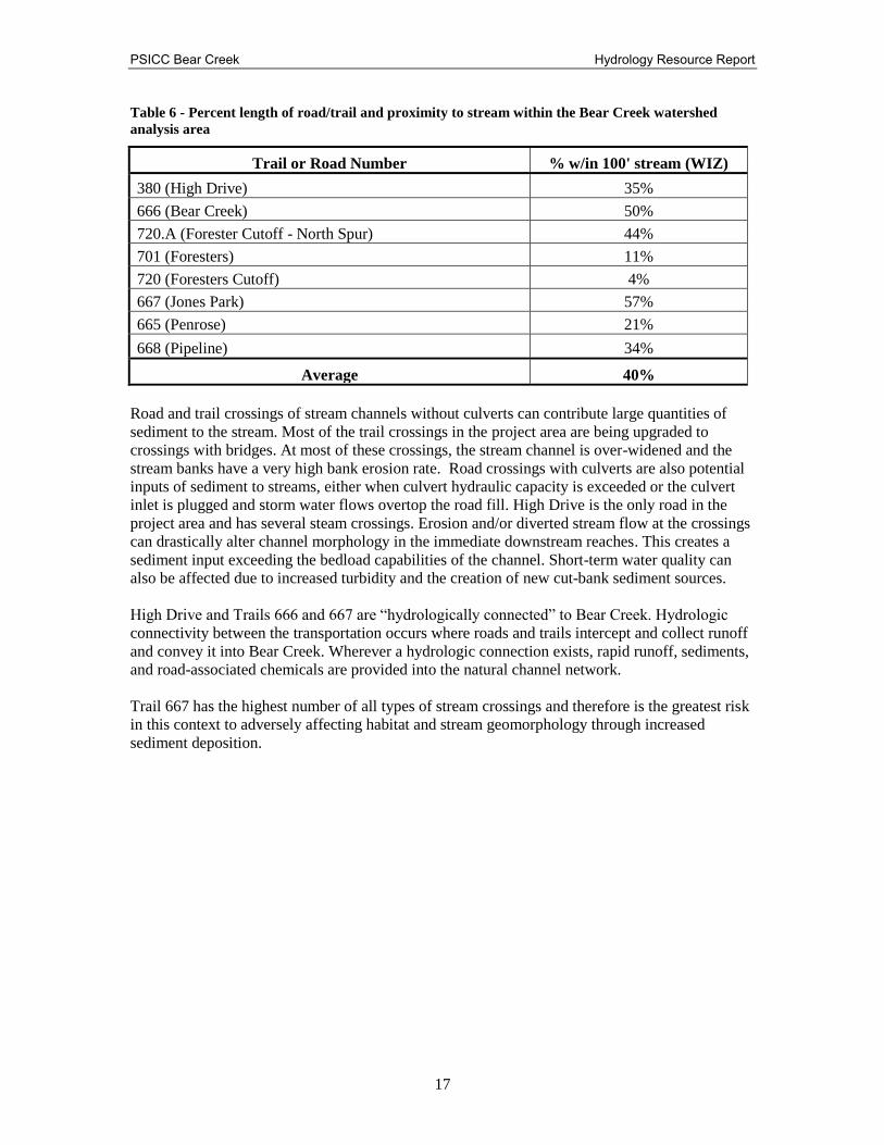
Table 6 - Percent length of road/trail and proximity to stream within the Bear Creek watershed
analysis area
Trail or Road Number % w/in 100' stream (WIZ)
380 (High Drive) 35%
666 (Bear Creek) 50%
720.A (Forester Cutoff - North Spur) 44%
701 (Foresters) 11%
720 (Foresters Cutoff) 4%
667 (Jones Park) 57%
665 (Penrose) 21%
668 (Pipeline) 34%
Average 40%
Road and trail crossings of stream channels without culverts can contribute large quantities of
sediment to the stream. Most of the trail crossings in the project area are being upgraded to
crossings with bridges. At most of these crossings, the stream channel is over-widened and the
stream banks have a very high bank erosion rate. Road crossings with culverts are also potential
inputs of sediment to streams, either when culvert hydraulic capacity is exceeded or the culvert
inlet is plugged and storm water flows overtop the road fill. High Drive is the only road in the
project area and has several steam crossings. Erosion and/or diverted stream flow at the crossings
can drastically alter channel morphology in the immediate downstream reaches. This creates a
sediment input exceeding the bedload capabilities of the channel. Short-term water quality can
also be affected due to increased turbidity and the creation of new cut-bank sediment sources.
High Drive and Trails 666 and 667 are “hydrologically connected” to Bear Creek. Hydrologic
connectivity between the transportation occurs where roads and trails intercept and collect runoff
and convey it into Bear Creek. Wherever a hydrologic connection exists, rapid runoff, sediments,
and road-associated chemicals are provided into the natural channel network.
Trail 667 has the highest number of all types of stream crossings and therefore is the greatest risk
in this context to adversely affecting habitat and stream geomorphology through increased
sediment deposition.
PSICC Bear Creek Hydrology Resource Report
18
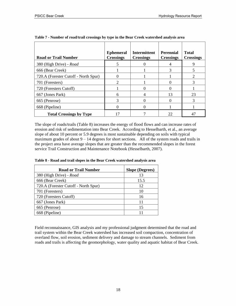
Table 7 - Number of road/trail crossings by type in the Bear Creek watershed analysis area
Road or Trail Number
Ephemeral
Crossings
Intermittent
Crossings
Perennial
Crossings
Total
Crossings
380 (High Drive) - Road 5 0 4 9
666 (Bear Creek) 1 1 3 5
720.A (Forester Cutoff - North Spur) 0 1 1 2
701 (Foresters) 2 1 0 3
720 (Foresters Cutoff) 1 0 0 1
667 (Jones Park) 6 4 13 23
665 (Penrose) 3 0 0 3
668 (Pipeline) 0 0 1 1
Total Crossings by Type 17 7 22 47
The slope of roads/trails (Table 8) increases the energy of flood flows and can increase rates of
erosion and risk of sedimentation into Bear Creek. According to Hesselbarth, et al., an average
slope of about 10 percent or 5.9 degrees is most sustainable depending on soils with typical
maximum grades of about 9 – 14 degrees for short sections. All of the system roads and trails in
the project area have average slopes that are greater than the recommended slopes in the forest
service Trail Construction and Maintenance Notebook (Hesselbarth, 2007).
Table 8 - Road and trail slopes in the Bear Creek watershed analysis area
Road or Trail Number Slope (Degrees)
380 (High Drive) - Road 13
666 (Bear Creek) 15.5
720.A (Forester Cutoff - North Spur) 12
701 (Foresters) 10
720 (Foresters Cutoff) 16
667 (Jones Park) 11
665 (Penrose) 15
668 (Pipeline) 11
Field reconnaissance, GIS analysis and my professional judgment determined that the road and
trail system within the Bear Creek watershed has increased soil compaction, concentration of
overland flow, soil erosion, sediment delivery and damage to stream channels. Sediment from
roads and trails is affecting the geomorphology, water quality and aquatic habitat of Bear Creek.

PSICC Bear Creek Hydrology Resource Report
19
Stream Channel and Water Quality
Numerous studies have demonstrated that there is a direct impact to the stream channel and water
quality of Bear Creek from road and trail derived sediment. At one time, Bear Creek was a
naturally stable, self-formed and self-maintained river system. The presence and increased use
of roads and trails in the Bear Creek watershed has led to a degradation in trail condition (USDA
Forest Service. August 2013. FINAL Bear Creek Watershed Assessment.) (RMFI, 2014). Bear
Creek has visual evidence of instability caused by direct increased sediment contribution from
roads and trails. This instability has been observed and documented with measurements such as
lateral migration, eroding banks, mid-channel bars and loss of residual pool depth. The
hydrologic connectivity of the trail system to Bear Creek has led to direct alterations of the stream
channel, created river instability and a degradation of aquatic habitat (USDA Forest Service.
August 2013. FINAL Bear Creek Watershed Assessment.) (Fin Up, 2013).
Figure 13 - Example of sediment contribution directly into Bear Creek

PSICC Bear Creek Hydrology Resource Report
20
Figure 14 - Example of lateral migration/road encroachment (High Drive) within the Bear creek
watershed
Stream Channel
The stream channel instability in Bear Creek is associated with excess sediment beyond the
carrying capacity of the river, thus aggradation has resulted.
The geomorphic role of rivers is to transport the flows and sediment of its watershed while
maintaining its dimension, pattern and profile without aggrading or degrading.
Dimension, pattern, and profile describe a river’s physical arrangement. Instability can cause an
increase in width/depth ratio (dimension); lateral migration and changes in sinuosity (pattern);
and changes in slope, pool/riffle spacing and presence of headcuts (profile).
Dimension
Stream channel enlargement is caused by the combined processes of incision, bank erosion and
direct modification by hydrologically connected roads and trails.
The results of enlargement are increased sediment supply from the bed and bank erosion,
increased deposition due to decreased shear stress and stream power, loss of habitat, increased
water temperatures, and a shift in the evolutionary state of morphological stream types.

PSICC Bear Creek Hydrology Resource Report
21
Pattern
Stream systems are dynamic and typically migrate within historic floodplains as they carry and
re-deposit bedload materials. Road and trail alignment increase flow energy by constricting the
channel migration (causing downcuts), isolating floodplains, and reducing riparian and aquatic
habitat.
Road encroachment on stream channels, especially where there is some form of bank revetment,
can divert stream flows to the opposite bank from their natural position, creating a cutbank that
destabilizes the hill slope and increases sediment input into the channel.
Profile
The stream profile can be looked at to determine aggradation (deposition) or degradation
(downcutting) of a channel. The profile is useful to describe pool depth and other aquatic habitat
features. Many aquatic habitat features have declined when compared with the 1994 Basinwide
Stream Habitat Inventory (BWSHI) study. Pool area, maximum pool depth, and average pool
depth have all reduced. Glide habitat increased because of sediment aggradation (Winters et al
1994, Gallagher 2011).
Details of changes of these features are described in Fin-Up’s Aquatic Habitat Assessment Bear
Creek Fountain Creek Watershed (2011).
Water Quality - Sedimentation
All waters within the Bear Creek watershed must meet Federal EPA and Colorado State water
quality standards. Bear Creek is designated by the Colorado Department of Public Health and
Environment to protect for the following beneficial uses: Aquatic Life (Coldwater), Recreation
1A, Water Supply, and Agriculture.
Sediment is the Federal EPA standard and Colorado Department of Public Health and
Environment (CDPHE) regulatory parameter of concern with regard to water quality in Bear
Creek. The CDPHE enforces Federal Clean Water Act Standards. The Colorado State sediment
standard states that “surface waters shall be free from substances attributable to human caused
point source or nonpoint source discharge in amounts, concentrations or combinations which: can
settle to form bottom deposits detrimental to the beneficial uses. Depositions are stream bottom
buildup of materials which include but are not limited to anaerobic sludges, mine slurry or
tailings, silt, or mud” and “are harmful to the beneficial uses” (CDPHE, 2001).
Sources of sediment in the Bear Creek watershed include roads, trails, mining activities,
nonsystem/unauthorized trail use, wildfires, channel processes and naturally occurring sediment
sources. Erosion and sedimentation occurs during precipitation and runoff events as well as
during base stream flow. Altered flow regimes, hillslope disturbance and channel disturbance
leads to accelerated bank erosion and accelerated stream bed erosion.
USFS managed lands must also follow the PSICC Forest Plan standards (USDA Forest Service,
Land and Resource Management Plan for the PSICC, 1984). According to the PSICC Plan, lands
administered by the PSICC must try to protect the aquatic resources so that there is no measurable
degradation of water quality. There is evidence that pool volume is decreasing and affecting the
beneficial use to the Greenback Cutthroat Trout (Gallagher, 2011).

PSICC Bear Creek Hydrology Resource Report
22
Trails compact soil, resulting in less infiltration, increased energy, and once the water reaches a
weak spot, the increased over land flows cause more erosion and also deposit a greater amount of
sediment in a point source pollution manner at these infrequent diversions, causing stream water
quality pollution and having an adverse effect on aquatic habitat. Stream channel adjustments due
to channel instability (dis-equilibrium) often result in accelerated sediment yields. Stream
channel instability caused by excess deposition of sediment severely impacts aquatic life
including the food chain, spawning and rearing habitat, in-stream cover, water temperature
extremes, and other structural and functional components.
Desired Condition
Erosion and sedimentation is a natural process, but acceleration of this natural process leads to a
water quality impairment, stream channel instability, land loss, habitat loss and other adverse
effects. Many land use activities can affect these components. Implementing mitigation measures
and making management changes that will balance sediment supply and improve channel stability
will improve beneficial water uses.
The desired condition for the Bear Creek watershed:
Improve water quality to meet CDPHE and Forest Plan water quality standards.
Manage the transportation system to reduce road/trail hydrologic connectivity and
minimize soil erosion and sedimentation and maximize riparian vegetation.
Restore Bear Creek to a stable stream dimension, pattern and profile that transports
sediment without aggrading or degrading.
Reduce sedimentation from disturbed tributaries.
Reduce contributing hillslope/rill/gully erosion from disturbed areas.
In similar soil types, the Pike National Forest has been effective at improving fish habitat in the
Trail Creek watershed. This area was severely affected by the Hayman Fire. Recent efforts to
relocate roads and trails and improve habitat have resulted in an increase in the number of fish in
Trail Creek (Trail Creek Watershed Assessment and Conceptual Restoration Plan, Rosgen 2011).
Environmental Consequences
Methodology
Transportation system analysis is the well-defined, repeatable way to measure and contrast the
changes and risk to Bear Creek by alternative. Active stream restoration measured in miles is
contrasted by alternative. Management actions are summarized by alternative in the following
tables.
Comparison of Alternatives

PSICC Bear Creek Hydrology Resource Report
23
Table 9 - Miles of motorized trail routes located within the wiz of Bear Creek (by alternative)
LAND JURISDICTION TRAIL - SINGLE TRACK
Alternative A Alternative B Alternative C
NATIONAL FOREST 0.5 0.1 0.1
EL PASO COUNTY 2.1 0 0
CITY PARKS 0 0 0
TOTAL 2.6 0.1 0.1
PERCENT REDUCTION 96%
Table 10 - Miles of non-motorized trail located within the wiz of Bear Creek (by alternative)
LAND
JURISDICTION
SYSTEM NON-SYSTEM COMBINED
Alt. A Alt. B Alt. C Alt. A Alt. B Alt. C Alt. A Alt. B Alt. C
NATIONAL
FOREST 0.7 0.2 0 1.7 0 0 2.4 0.2 0
EL PASO
COUNTY 0 0.2 0 0.8 0 0 0.6 0.2 0
CITY PARKS 0.5 0.5 0.2 1.4 0 0 1.9 0.5 0.2
TOTAL 1.2 0.9 0.2 3.9 0 0 4.9 0.9 0.2
PERCENT
REDUCTION 25% 83% 100% 82% 96%
Table 11- -Miles of all travel routes located within the wiz of Bear Creek (by alternative)
LAND JURISDICTION TRAVEL ROUTES
Alternative A Alternative B Alternative C
NATIONAL FOREST 2.9 0.3 0.1
EL PASO COUNTY 2.7 0.2 0
CITY PARKS 2.7 1.3 1
TOTAL 8.3 1.8 1.1
PERCENT REDUCTION 78% 87%
Table 12 - Summary of management actions on the Bear Creek stream channel that may affect the
greenback cutthroat trout (by alternative)
MANAGEMENT ACTION
NATIONAL
FOREST
COLORADO
SPRINGS
UTILITIES
CITY PARKS &
RECREATION
DEPT.
TOTAL
Alt. B Alt. C Alt. B Alt. C Alt. B Alt. C Alt. B Alt. C
In-stream Habitat
Improvement 0.4 0.4 0.3 0.3 0.8 0.8 1.5 1.5
Trail Decommissioning -
System 0.9 1.1 1.9 1.9 0 0.3 2.8 3.3
Trail Decommissioning -
Non-system 1.7 1.7 0.6 0.6 1.4 1.4 3.7 3.7
TOTAL MILES 3.0 3.2 2.8 2.8 2.2 2.5 8.0 8.5

PSICC Bear Creek Hydrology Resource Report
24
Alternative A – No Action
The No Action alternative does not implement any mitigations in the Bear Creek watershed.
Direct Effects:
Roads and Trails
There would be no improvements to the transportation system to mitigate road and trail derived
sediment. Stormwater flow, with elevated turbidity and energy, would continue to be directly
routed into Bear Creek. There would be no reduction in transportation system derived shear
stress.
Trails
0 acre reduction of motorized single track trail routes located within the WIZ of Bear
Creek
0 acre reduction of non-motorized trail routes located within the WIZ of Bear Creek
Stream Channel
0 miles of in-stream habitat improvement, resulting in zero water quality improvements.
High Drive
Emergency restoration actions managed by the City of Colorado Springs associated with
the 2013 storm event are currently being implemented.
0 acre reduction of miles of motorized routes located within the WIZ of Bear Creek
Indirect Effects:
Hillslope
Nonsystem/unauthorized routes will not be rehabilitated. Bare, eroding hillslopes, rills and other
anthropogenic (human caused) erosion that is further away from Bear Creek , but still within the
project area, will not be mitigated. Continued erosion may cause decline in the in the habitat and
number of greenback cutthroat trout.
Side tributaries that are affected by the trail system, often causing headcuts at intersections will
not be rehabilitated.
Non-system disturbed, dispersed campsites will not be rehabilitated.
Unauthorized mining activities will not be rehabilitated.
Roads and Trails
The trail system outside of the WIZ and farther away from Bear Creek, would continue to
degrade. This degradation could cause greater impacts to Bear Creek over time. Leaving trails in
their current entrenched condition will lead also to an increase in trail maintenance complexity
and decreased user experience.
With no mitigation and corrective action being taken on USFS, El Paso County and City managed
lands, the transportation system, hillslopes, stream channel, water quality and habitat will

PSICC Bear Creek Hydrology Resource Report
25
continue to degrade. The fire ban will not be implemented and there will continue to be elevated
risk from catastrophic wildfire. Catastrophic wildfires can lead to erosion and flooding. Effects
from the 2013 storm event on hillslopes and within the USFS decision space will not be
mitigated.
Alternative B – Proposed Action
The proposed action describing all ground disturbing activities, including actions affecting:
hillslopes, roads and trails, and stream channel restoration is described in detail in the Bear
Creek Watershed Improvement Environmental Assessment. In summary, the proposed action
will: stabilize eroding, bare hillslopes and ephemeral drainages; trails on USFS managed lands
would have sections relocated out of the WIZ; the drainage system of the transportation system
would be improved; trail crossings would be improved; overwidened stream channel reaches,
eroding banks, and incised channels would benefit from active restoration; and riparian areas
would receive re-establishment of riparian vegetation. The USFS is responsible for restoration
and monitoring on USFS lands. The responsibilities of each landowner are identified in detail in
the Bear Creek Watershed Improvement Environmental Assessment.
Relevant to this report - In General:
The City of Colorado Springs would implement the recommendations from the CH2M Hill report
on High Drive (CH2M Hill. January 2013) and the ADP, Inc. High Drive Mitigation Report
(ADP, Inc. 2014). The City is responsible for contract administration. The USFS will work with
the City to incorporate further mitigation refinements at time of implementation and to complete
implementation and effectiveness monitoring.
The City of Colorado Springs would implement the recommendations of the Colorado
Department of Parks and Wildlife / FinUp Habitat report for stream channel restoration
(Gallagher, J.P. Fin-Up Habitat Consultants, Inc. 2011). The Colorado Department of Parks and
Wildlife is responsible for the stream restoration design and the City of Colorado Springs is
responsible for the stream restoration contract administration on City lands.
El Paso County would implement the recommendations of the USFS for trail relocation and
watershed rehabilitation in the Jones Park parcel. El Paso County is responsible for contract
administration on County lands. The USFS will work with the County to incorporate further
mitigation refinements at time of implementation and to complete implementation and
effectiveness monitoring.
All of these proposed actions will lead to an increase in channel stability and improved water
quality in Bear Creek.
Direct Effects:
Hillslope
Mitigation for surface erosion provides for an increase in ground cover/surface
protection, and breaks-up continuous slope length across the bar hillslope and reduces the
erosive energy.
These proposed mitigation on bare soils will reduce erosion and sediment delivery into
Bear Creek.

PSICC Bear Creek Hydrology Resource Report
26
Trails
Trail length is converted to bare ground erosional area by assuming an 8 foot width for
the effective footprint of the trail and the cut/fill.
The rehabilitation of 2.42 acres of motorized single track trail routes located within the
WIZ of Bear Creek will reduce the area of bare ground available for erosion and
sedimentation into Bear Creek by 96%. (The WIZ is defined here as the water influence
zone of the perennial mainstem of Bear Creek)
The rehabilitation of 3.88 acres of non- motorized trail routes located within the WIZ of
Bear Creek will reduce the area of bare ground available for erosion and sedimentation
into Bear Creek by 82%. (The WIZ is defined here as the water influence zone of the
perennial mainstem of Bear Creek) For existing system/authorized trails that remain open, maintenance, reconstruction, or
re-alignment will be performed to minimize erosion and sediment production.
For existing trails that are closed, access will be physically blocked and the trail surface
decommissioned to minimize erosion and sediment production.
Bridges that span bankfull flows will be installed at stream crossings to avoid
constrictions and increased hydraulic energy during storm flows.
Sustainable sections of Buckhorn and Palmer non-system trails will be converted to
National Forest System Trails and maintained to minimize erosion and sediment
production.
All other non-system/unauthorized routes within the Bear Creek basin and those that lead
into the basin will be fully decommissioned to minimize erosion and sediment production
back to natural, pre-disturbance, conditions.
High Drive
Recommendations of the High Drive road assessment (CH2M Hill, January 2013) will be
implemented to manage stormwater flows and reduce road derived sediment.
Road improvements and erosion mitigations will result in less sedimentation into Bear
Creek and will reduce shear stress and reduce channel degradation.
Stream Channel
1.5 miles of in-stream habitat improvement will stabilize the stream channel and reduce
sediment contributions from the streambed and stream banks.
Ephemeral drainages and headcuts will be stabilized reducing bank and channel sediment
contributions into Bear Creek.
A riparian buffer and bankfull bench will be created to reduce hillslope and road/trail
derived sediment delivery into Bear Creek.
Existing pool habitats will be deepened, excess sediment will be removed, and pool
habitat will be reconstructed to maintain pool depth comparable to reference stream
conditions.
Eroding stream banks will be stabilized and lateral stream migration will be reduced with
nearby trees, rocks, sod mats and other native riparian vegetation.
The width to depth ratios will be reduced to align with reference stream conditions.
Floodplain access will be provided for flood flows.
Vegetated bankfull benches will be re-established for toe slope stabilization.

PSICC Bear Creek Hydrology Resource Report
27
Indirect Effects:
A combination of many different rehabilitation techniques will be implemented for these upland
hill slope restoration projects.
Water contact by users has the potential to spread aquatic diseases (for example, whirling disease)
and to serve as a route for introduction of pollutants. Re-routing trails out of the WIZ, reducing
the number of water crossings, and developing educational materials and signs will help minimize
water contact.
Non-system, disturbed, dispersed campsites, associated with hillslope erosion will be
rehabilitated.
Unauthorized mining activities, associated with hillslope erosion, will be rehabilitated.
Alternative C
In addition to the management actions proposed in Alternative B, Alternative C proposes
Limit public access in the Bear Creek basin on all NFS and El Paso County lands within
the Bear Creek basin to designated routes.
Continue the existing ban of off trail travel on City managed lands.
Decommission the entire length trail of Trail 666
Do not build New Mount Buckhorn trail or trail into Jones Park.
Direct Effects:
Trails
The reduction of 2.42 acres (96%) of motorized single track trail routes located within the
WIZ of bear creek will reduce the area of bare ground available for erosion and
sedimentation into Bear Creek.
The reduction of 4.56 acres (96%) of non-motorized trail routes located within the WIZ
of bear creek will reduce the area of bare ground available for erosion and sedimentation
into Bear Creek.
High Drive
0% percent reduction of miles of motorized routes located within the WIZ of Bear Creek
Stream Channel
1.5 miles of in-stream habitat improvement
If all of NFS Trail 666 is rehabilitated, the bare ground restored, and the channel is improved,
than the water quality and fish habitat will improve in Bear Creek. All risks to the Greenback
Cutthroat are reduced if there are fewer vectors for contamination.
PSICC Bear Creek Hydrology Resource Report
28
Indirect Effects:
There will be a lower risk of trespass and a lower risk of newly created nonsystem/unauthorized
trails id there is less access in the watershed. There will be less erosion in the Bear Creek
watershed.
Regulatory Framework
Land Management Direction
There are two identified agreements in place that guide management of use and activities in
portions of the analysis area. The first, an Act of Congress on February 27, 1913, designated
approximately 14,843 acres in the Pike National Forest to be “reserved from all forms of location
or entry and set aside as a municipal water supply reserve for the benefit of the City of Colorado
Springs…” This agreement covers a small portion of the western end of the watershed. The
second is an agreement, dated January 9, 1924, for the purposes of conserving and protecting the
water supply of the City of Colorado Springs. This agreement covers the remainder of NFS lands
in the watershed not covered by the 1913 act.
The Forest Plan, as amended, provides programmatic management direction for NFS lands on the
PSICC. Through its goals, standards and guidelines, and MA direction, the Forest Plan provides
the overall guidance for management of NFS land within the PSICC’s borders.
The Forest-wide standards and guidelines in the Forest Plan that apply to this project are
primarily those regarding cultural resources (page III-17), recreation (pages III-19 to III-24), fish
and wildlife (pages III-28 to III-32), water resources (pages III-50 to III-52), special uses (pages
III-68 to III-69), rights-of-way and lands (pages III-69 to III-71), soil resources (pages III-72 to
III-74), transportation (pages III-74 to III-80), and fire and fuels (pages III-81 to III-82) and are
hereby incorporated by reference.
The Forest Plan divides the PSICC into individual MAs and designates specific direction, goals,
standards, and guidelines to be used in the management of each area to meet its emphasis more
completely. Applicable direction for the five MAs in the analysis area is summarized below.
Semi-primitive Motorized Recreation (MA 2A): This MA covers 4,067 acres (50 percent) of
NFS lands in the analysis area. MA 2A emphasizes semi-primitive motorized recreation
opportunities, such as snowmobiling, four-wheel driving, and motorcycling, both on and off roads
and trails. Motorized travel may be restricted or seasonally prohibited to protect physical and
biological resources. General direction for dispersed recreation management is to prohibit
motorized vehicle use off roads and trails where needed to protect soils, vegetation, or special
wildlife habitat (page III-109). Standards and guidelines for MA 2A are found in the Forest Plan
on pages III-107 to III-115.
Rural and Roaded-Natural Recreation (MA 2B): This MA covers 277 acres (3 percent) of
NFS lands in the analysis area. MA 2B emphasizes rural and roaded-natural recreation
opportunities. Motorized and non-motorized recreation activities such as driving for pleasure,
viewing scenery, picnicking, fishing, snowmobiling and cross-country skiing are possible.
Motorized travel may be restricted or seasonally prohibited to protect physical and biological
resources. General direction for visual resources is to manage activities to maintain or improve
the quality of recreation opportunities. Management activities are not evident, remain visually
subordinate, or may dominate, but harmonize and blend with the natural setting. Standards and
guidelines for MA 2B are found in the Forest Plan on pages III-116 to III-124.

PSICC Bear Creek Hydrology Resource Report
29
Riparian Area Management (MA 9A): This MA covers 396 acres ( 5 percent) of NFS lands in
the analysis area. The management of all component ecosystems of riparian areas is emphasized.
These components include the aquatic ecosystem, the riparian ecosystem, and adjacent
ecosystems within 100 feet of perennial streams, lakes, and other water bodies. Each of these
components is managed together as an integrated riparian area. The 9A management areas were
not mapped at the time of the Forest Plan release. For this project 9A management area was
mapped as 100 feet from all 2,3 and 4th order streams. The goals of management are to provide
healthy self-perpetuating plant communities, meet water quality standards, provide habitats for
viable populations of wildlife and fish, and provide stable stream channels. General direction for
transportation system management is to locate roads and trails outside riparian areas unless
alternative routes have been reviewed and rejected as being more environmentally damaging (III-
214). Standards and guidelines for MA 9A are found in the Forest Plan on pages III-204 to III-
215.
Municipal Watershed (MA 4D): This MA covers 78 acres (1 percent) of NFS lands in the
analysis area. This management area emphasizes maintaining and improving aspen sites. Other
tree species, if present, are de-emphasized. Aspen is managed to produce wildlife habitat, wood
products, visual quality, and plant and animal diversity. A variety of age, size and shapes of
aspen are maintained. Recreation opportunities are semi primitive non- motorized and motorized
or roaded natural. Some temporary or seasonal road and area use restrictions are implemented to
prevent disturbance of wildlife or improve hunting and fishing quality. Standards and guidelines
for MA 4D are found in the Forest Plan on pages III-144 to III-148
Municipal Watershed (MA 10E): This MA covers 3,339 acres (41 percent) of NFS lands in the
analysis area. MA 10E emphasizes protecting or improving the quality and quantity of municipal
water supplies. Management practices vary from use restrictions to water resource improvement
practices, with the primary objective of meeting water quality standards established for the
individual watershed. A secondary objective is to manage the watersheds to improve the yield
and timing of water flows, consistent with water quality requirements. General direction for
dispersed recreation management is to allow motorized travel only on established roads and trails.
Close the watershed to all travel when the road or trail surfaces could be damaged to the degree
that water quality could be degraded (III-234). Standards and guidelines for MA 10E are found in
the Forest Plan on pages III-233 to III-241.
Other Relevant Mandatory Disclosures
Executive Orders of Floodplains and Wetlands
Forest management activities in any wetland, riparian area, and flood plain, will be designed to
prevent long and short-term adverse impacts, in accordance with Executive Orders 11988 and
11990.
Direction from Presidential Executive Order 11988, May 24, 1977 Flood plains Protection:
The "Floodplain Management" Executive Order issued by the President and which specifies the
responsibilities of federal agencies in floodplain management. E.O. 11988 directed federal
agencies to evaluate and reflect the potential effects of their actions on flood plains and to include
the evaluation and consideration of flood hazards in agency permitting and licensing procedures.
Direction from Presidential Executive Order Number 11990, May 24, 1977 Wetlands
Protection: “Minimize the destruction, loss or degradation of wetlands, and preserve and
enhance the natural beneficial values of wetlands ... in carrying out federal activities … including
land resource planning and regulating activities.”

PSICC Bear Creek Hydrology Resource Report
30
Colorado Department of Public Health and the Environment
The Colorado Department of Public Health and the Environment necessitates the following
guidelines:
Implementation Guidance for Determining Sediment Deposition Impacts to Aquatic Life in
Streams and Rivers
http://www.cdphe.state.co.us/op/wqcc/StatutesRegsPolicies/Policies/98-1-2010.pdf
Classifications and Numeric Standards for Arkansas River Basin, Regulation No. 32
http://water.epa.gov/scitech/swguidance/standards/upload/2006_06_26_standards_wqslibrary_co
_reg32-200606.pdf
List of Impaired Waters and Monitoring and Evaluation List, Colorado’s Section 303(d)
http://www.cdphe.state.co.us/regulations/wqccregs/100293wqlimitedsegtmdlsnew.pdf
Monitoring The Bear Creek watershed has been monitored to determine sources of sediment affecting aquatic
habitat and the effects on the habitat (RMFI, FinUP, USFS). Road and trail surveys, as well as
internal, partnership and public scoping, identified sediment sources. Proposed hillslope erosion
control, road and trail improvements and stream channel restoration will reduce sediment delivery
into Bear Creek. Proposed actions will have implementation monitoring as well as effectiveness
monitoring.
Implementation monitoring takes place during construction and will require applying relevant
USFS BMP monitoring protocol.
http://www.fs.fed.us/biology/resources/pubs/watershed/FS_National_Core_BMPs_April2012.pdf
Effectiveness monitoring:
Effectiveness monitoring will occur annually after construction until the restoration work and
construction work has been determined to be stable and effective by the hydrologist or soil
scientist. Effectiveness monitoring will also provide for follow up restoration work to meet the
purpose and need.
High Drive road will be monitored using a USFS approved survey and monitoring plan. Sediment
delivery is expected to be mitigated by implementing the CH2M Hill conceptual design and the
ADP Civil mitigation design plan. Structures as well as downstream effects from the new and
redesigned structures will be monitored for effectiveness.
Effectiveness monitoring will take place after instream construction as determined necessary by
the USFS fish biologist. Monitoring data will determine if we are achieving our desired
condition. A monitoring plan will be designed to determine if sedimentation has been reduced
and river stability has increased due to management/mitigation. The geomorphic response of
Bear Creek from the combination of management actions will be documented using standard
stream survey monitoring protocols.
Standard surveys are useful tools for determining long-term trends in stream habitat condition.
These metrics can be best monitored and presented utilizing standard geomorphology surveys and
V* monitoring. Stream surveys must be repeated periodically in order to develop a dataset large
enough to allow for statistical analysis of habitat composition change and trend. The

PSICC Bear Creek Hydrology Resource Report
31
geomorphology surveys will identify stream stability and function by documenting standard
stream measurements including: width/depth ratios, changes in cross-sectional area, pool to pool
spacing, sinuosity, pebble counts and longitudinal profiles.
V* monitoring will be utilized to evaluate effectiveness of upland road/trail stabilization and in
stream restoration at reducing sediment delivery and loss of pool habitat.
http://www.fs.fed.us/psw/topics/water/vstar/
V* pool sediment deposition monitoring plots (Hilton, 1993) have were established in several
pools throughout the study area in Fall 2014 to detect changes in pool deposition over time. The
V* plots should be sampled several times each year, particularly after significant precipitation
events in the summer months, in order to determine short term variations in pool depth and scour
that may not be detected by stream surveys.
The riparian and upland vegetation recovery will be documented and interpreted via permanent
photo points.
Design Features and Mitigation Measures
The following handbooks provide guidance in the development of Best Management Practices,
mitigation measures and design features:
FSH 2509.25 Watershed Conservations Handbook
USDA National Best Management Practices for Water Quality Management on National
Forest System Lands, April 2012
Colorado State Forest Service Forestry Best Management Practices to Protect Water
Quality in Colorado 2010.
Site Specific Design Criteria
• In-stream work would be timed to avoid greenback cutthroat trout spawning and high
flow periods.
• Limit soil disturbances in the Bear Creek Watershed to the minimum area consistent with
the purpose of specific management actions and rehabilitation operations.
• Stream access would be delineated using flagging by U.S. Forest Service natural resource
representative.
• Fuel storage areas would be identified by US Forest Service and bermed and lined to
contain spills.
• A revegetation plan would be developed for the Project Area with the objectives of
stabilizing cut and fill slopes, accelerating recovery of disturbed areas.
• Reclamation work would begin immediately after construction is completed.
• Where feasible use existing fill, rock or trees from within the Project Area as part of the
restoration work.

PSICC Bear Creek Hydrology Resource Report
32
Perform construction and monitoring in accordance with FSH 2509.25 – applicable Watershed
Conservation Practices Handbook standards:
http://www.fs.fed.us/cgi-bin/Directives/get_dirs/fsh?2509.25!r2
11.2 - Management Measure (2)
Manage land treatments to maintain enough organic ground cover in each activity area to
prevent harmful increased runoff.
Organic ground cover (plants, litter, and humus) is vital to maintain hydrologic
function. Reduced ground cover decreases infiltration of water and increases surface runoff and
peak flows. Continued or severe loss of ground cover often results in the formation of pedestals,
rills, and gullies that greatly concentrate runoff, increase peak flows, and damage streams.
1. Design Criteria.
b. Restore the organic ground cover of degraded activity areas within the next plan period, using
certified local native plants as practicable; avoid persistent or invasive exotic plants.
2. Monitoring. Compare average organic ground cover of treated activity areas with reference
areas, using ocular methods, rooted nested frequency method, cover-frequency method (USFS,
1996a), soil pedon data, pace transects, or other accepted monitoring methods.
3. Restoration. Apply watershed restoration along with land-use controls on degraded lands to
disperse runoff and restore organic ground cover with minimum long-term maintenance
needs. Reclamation treatments and changes in management may be required. Revegetate using
certified local native plants as practicable; avoid persistent or invasive exotic plants.
12.2 - Management Measure (4)
Design and construct all stream crossings and other instream structures to provide for
passage of flow and sediment, withstand expected flood flows, and allow free movement of
resident aquatic life.
Corps of Engineers and Forest Service design criteria are combined to ensure that all facilities
remain stable, not necessarily pass the entire flood flow. Structures must sustain long-term
channel integrity, pass design flows with expected debris or be armored to withstand the design
flood (not wash out) during their design life, and allow unimpeded movement of aquatic life.
Check crossings for problems and repair them if needed.
1. Design Criteria
d. Install stream crossings to sustain bankfull dimensions of width, depth, and slope and keep
streambeds and banks resilient. Favor bridges, bottomless arches or buried pipe-arches for those
streams with identifiable flood plains and elevated road prisms, instead of pipe culverts. Favor
armored fords for those streams where vehicle traffic is either seasonal or temporary, or the ford
design maintains the channel pattern, profile and dimension.
NOTE: Temporary bridges or vented fords (fords with pipes to pass low flows) are potential
options where appropriate depending upon traffic use. Temporary bridges should be installed and

PSICC Bear Creek Hydrology Resource Report
33
removed seasonally. Temporary fords should be removed when the need for the crossing no
longer exists. Pipe culverts pose the most risk of channel damage, migration blockage, and
sediment, while fords can impact incised channels (WRENSS II.57; Terrene Institute 1994; Bohn
1998).
2. Monitoring. Check stability and grade of crossings, capacity of channels, sediment deposits in
streambeds, and ability of aquatic biota to pass (40 CFR 230.23 and 230.31).
3. Restoration. Restore to provide bed and bank stability and movement of aquatic life.
12.3 - Management Measure (5)
Conduct actions so that stream pattern, geometry, and habitats maintain or improve long-
term stream health.
Stream health depends much on channel widths and depths, bank stability, and quality of cover
and substrate. In-channel work can directly impact stream channel morphology. Other actions,
such as snowmaking or water depletions, can indirectly affect channel morphology by changing
(either increasing or decreasing) flow.
1. Design Criteria.
a. Add or remove rocks, wood, or other material in streams or lakes only if such action maintains
or improves stream and lake health. Leave rocks and portions of wood that are embedded in beds
or banks to prevent channel scour and maintain natural habitat complexity.
NOTE: Structural complexity provided by rocks, wood, and other elements is vital to maintain
channel resilience and habitat features for aquatic biota. Excessive input or removal can damage
stream health (Dunne and Leopold 1978, page 709).
b. Do not relocate natural stream channels if avoidable. Return flow to natural channels where
practicable. Where reconstruction of stream channels is necessary, construct channels and
floodways with natural stream pattern and geometry, stable beds and banks and provide habitat
complexity.
NOTE: Dunne and Leopold (1978, page 709).
2. Monitoring. Monitor channel pattern, geometry, and stability; migration barriers; and aquatic
habitat and biota.
3. Restoration. Restore degraded streams to robust stream health with minimum long-term
maintenance needs, as part of whole watershed restoration programs that permanently cure causes
of damage. Install or remove rocks, wood, or other structures only as a last resort to restore
robust stream health. Plant certified local native plants, as practicable, to restore bank stability
and cover; avoid persistent or invasive exotic plants.
12.4 - Management Measure (6)
Maintain long-term ground cover, soil structure, water budgets, and flow patterns of
wetlands to sustain their ecological function.
Wetlands control runoff and water quality, recharge ground water, and provide abundant and
diverse biota. Natural patterns and processes must be protected. Executive Order 11990 directs

PSICC Bear Creek Hydrology Resource Report
34
that impacts to wetlands should be avoided, minimized or mitigated where practicable. The
Corps of Engineers protects wetlands under Section 404 regulations, which may permit wetland
impacts if mitigation measures are applied to replace wetland values in-kind.
1. Design Criteria.
a. Keep ground vehicles out of wetlands unless protected by at least 1 foot of packed snow or 2
inches of frozen soil. Do not disrupt water supply or drainage patterns into wetlands.
NOTE: Field studies show this measure protects soil structure and water regimes.
b. Keep roads and trails out of wetlands unless there is no other practicable alternative. If roads
or trails must enter wetlands, use bridges or raised prisms with diffuse drainage to sustain flow
patterns. Set crossing bottoms at natural levels of channel beds and wet meadow surfaces. Avoid
actions that may dewater or reduce water budgets in wetlands.
NOTE: Terrene Institute (1994).
c. Avoid long-term reduction in organic ground cover and organic soil layers in any wetland
(including peat in fens).
NOTE: Field studies show this measure protects vital ecological functions.
e. Avoid any loss of rare wetlands such as fens and springs.
NOTE: These wetlands cannot be replaced in-kind.
2. Monitoring. Monitor integrity of organic ground cover and organic soil layers, plant
community composition and structure, soil structure, water levels, and drainage patterns.
3. Restoration. Retrofit crossings to restore water levels and drainage (Terrene Institute
1994). Reclaim wetlands to restore physical and biological functions. Revegetate using certified
local native plants as practicable; avoid persistent or invasive exotic plants.
13.1 - STANDARD (9)
Limit roads and other disturbed sites to the minimum feasible number, width, and total length
consistent with the purpose of specific operations, local topography, and climate.
Keep the number of stream crossings and the extent of sediment sources to a feasible
minimum. Avoid sediment loads that damage stream health.
1. Design Criteria.
b. Avoid soil-disturbing actions during periods of heavy rain or wet soils. Apply travel
restrictions to protect soil and water.
NOTE: This measure reduces mobilized soil during runoff events (WRENSS II.56).
c. Install cross drains to disperse runoff into filter strips and minimize connected disturbed
areas. Make cuts, fills, and road surfaces strongly resistant to erosion between each stream

PSICC Bear Creek Hydrology Resource Report
35
crossing and at least the nearest cross drain. Revegetate using certified local native plants as
feasible; avoid persistent or invasive exotic plants.
NOTE: Cross drains near crossings, well-revegetated cuts and fills, and surfacing with large (1 to
3 inch), angular, clean gravel greatly reduce sediment from connected disturbed areas (Burroughs
and King 1989; Kochenderfer et al. 1984; Swift 1984).
d. Construct roads where feasible, with rolling grades instead of ditches and culverts.
NOTE: Kochenderfer et al. (1984); Swift (1984).
e. Retain stabilizing vegetation on unstable soils. Avoid new roads or heavy equipment use on
unstable or highly erodible soils.
NOTE: WRENSS (II.58, II.60).
f. Use existing roads unless other options will produce less long-term sediment. Reconstruct for
long-term soil and drainage stability.
NOTE: Reusing old roads usually produces less sediment, but it is often best to reclaim old roads
near streams and build farther upslope.
2. Monitoring. Monitor travelway conditions, sediment movement into streams, and sediment
effects on aquatic habitat and biota.
3. Restoration. Disconnect disturbed areas from streams. Stabilize slopes and surface
roads. Close and reclaim roads using certified local native plants as feasible; avoid persistent or
invasive exotic plants. Restore integrity of streams and their aquatic habitats.
13.3 - STANDARD (11)
Stabilize and maintain roads and other disturbed sites during and after construction to control
erosion.
Build erosion resistance into project design to reduce costly maintenance and restoration (Clean
Water Act Sections 402(p) and 404). Mitigate concurrently with construction. Disturbance of
more than 5 contiguous acres per project requires a State storm-water discharge permit.
1. Design Criteria.
a. Do not encroach fills or introduce soil into streams, swales, lakes, or wetlands.
NOTE: Corps of Engineers nationwide permits (33 CFR 330) limit fill in streams.
b. Revegetate cuts and fills upon final shaping to restore ground cover, using certified local
native plants as feasible; avoid persistent or invasive exotic plants. Provide sediment control until
erosion control is permanent.
NOTE: Burroughs and King (1989); WRENSS (II.63, V.29, V.35).
2. Monitoring. Monitor condition of cuts, fills, and ditches, effectiveness of filter strips, and
runoff and sediment dispersion below cross drains. Monitor sediment movement into streams and
sediment effects on aquatic habitat and biota.

PSICC Bear Creek Hydrology Resource Report
36
3. Restoration. Stabilize fills, ditches, and cross drains. Add cross drains. Repair and harden
surfaces subject to ruts. Restore integrity of streams and their aquatic habitats.
13.4 - STANDARD (12)
Reclaim roads and other disturbed sites when use ends, as needed, to prevent resource damage.
Restoring stable grades, stable drainage, and ground cover are critical to closing out disturbances
and protecting soil productivity and stream health.
1. Design Criteria.
a. Site-prepare, drain, revegetate, and close temporary and intermittent use roads and other
disturbed sites within one year after use ends. Provide stable drainage that disperses runoff into
filter strips and maintains stable fills. Do this work concurrently. Use certified local native plants
as feasible; avoid persistent or invasive exotic plants.
NOTE: WRENSS (II.57, II.58), USFS (1996b). One year allows revegetation in optimum
seasons.
b. Remove all temporary stream crossings (including all fill material in the active channel),
restore the channel geometry, and revegetate the channel banks using certified local native plants
as feasible; avoid persistent or invasive exotic plants.
NOTE: Pre-fabricated temporary bridges are easy to use with no damage.
2. Monitoring. Monitor connected disturbed areas and culverts removed.
3. Restoration. Reclaim remaining sediment sources. Provide stable drainage that disconnects as
much disturbed area as feasible. Revegetate using certified local native plants as feasible; avoid
persistent or invasive exotic plants.

PSICC Bear Creek Hydrology Resource Report
37
References
CH2M Hill. January 2013. High Drive Road Assessment Bear Creek Watershed
Prepared By: Kyle Hamilton, P.E. and Candice Hein, P.E. Map Book Prepared by U.S. Forest
Service.
Colorado Department of Public Health and the Environment. 2005. Implementation Guidance for
Determining Sediment Deposition Impacts to Aquatic Life in Streams and Rivers. Water Quality
Control Division, Denver, CO.
http://www.cdphe.state.co.us/op/wqcc/StatutesRegsPolicies/Policies/98-1-2010.pdf
Colorado Department of Public Health and the Environment. 2006. Classifications and Numeric
Standards for Arkansas River Basin, Regulation No. 32.
http://water.epa.gov/scitech/swguidance/standards/upload/2006_06_26_standards_wqslibrary_co
_reg32-200606.pdf
Colorado Department of Public Health and the Environment. 2010. Colorado’s Section 303(d)
List of Impaired Waters and Monitoring and Evaluation List. Water Quality Control Division,
Denver, CO.
http://www.cdphe.state.co.us/regulations/wqccregs/100293wqlimitedsegtmdlsnew.pdf
Federal Emergency Management Act, U.S. Department of Homeland Security. November 2013.
Project Worksheet. Prepared By: Stanley W. Notestine, Project Specialist.
Gallagher, J.P. Fin-Up Habitat Consultants, Inc. 2011. Aquatic Habitat Assessment Bear Creek
Fountain Creek Watershed Pike National Forest Colorado.
Great Outdoors Consultants. December 2012. Trail Assessment Report.
Hesselbarth, Woody, Brian Vachowski, and Mary Ann Davies. USDA Forest Service, 2007.
0723-2806-MTDC - Missoula Technology and Development Center. Trail Construction and
Maintenance Notebook. (Accessed 12/17/2012)
http://www.fs.fed.us/t-d/pubs/htmlpubs/htm07232806/toc.htm
Kolka R.K. and Smidt M.F. 2004. Effects of forest road amelioration techniques on soil bulk
density, surface runoff, sediment transport, soil moisture and seedling growth. Forest Ecology
and Management 202 (2004) 313–323.
Natureshape LLC. October 2013. Bear Creek Watershed Restoration Project.
Rocky Mountain Field Institute. June 2014. Bear Creek Watershed Rapid Trail Condition
Assessment. Prepared by Amber Shanklin, RMFI Program Director.

PSICC Bear Creek Hydrology Resource Report
38
Rocky Mountain Field Institute. December 2013. Bear Creek Watershed Post Flooding Rapid
Trail Condition Assessment. Prepared by: Amber Shanklin, RMFI Program Director.
Rocky Mountain Field Institute. December 2012. Bear Creek Watershed Trails Assessment.
Prepared by Amber Shanklin, RMFI Program Director
Rosgen, Dave. 2006. Watershed Assessment of River Stability and Sediment Supply
(WARSSS).
Rosgen, Dave. 2011. Trail Creek Watershed Assessment and Conceptual Restoration Plan.
Soil Survey Staff, Natural Resources Conservation Service, United States Department of
Agriculture. Web Soil Survey. Available online at http://websoilsurvey.nrcs.usda.gov/.
USDA Forest Service. August 2013. FINAL Bear Creek Watershed Assessment.
USDA Forest Service. December 2012. Hydrology and Soils Existing Conditions Report Bear
Creek Watershed Assessment. Prepared by: Dana A. Butler.
USDA Forest Service. July 2007. Trail Construction and Maintenance Notebook. Prepared by:
Woody Hesselbarth, Brian Vachowski, and Mary Ann Davies
USDA Forest Service. 1992. Forest Service Handbook - Soil Management 2509.18, Region 2
Supplement, August 15.
USDA Forest Service, 1994. Ecological Subregions of the United States. Ed: Bailey RG., Avers
P., King, T, and McNab H. USDA Forest Service. Available on the Internet at
www.fs.fed.us/land/pubs/ecoregions/ch43.html.
USDA Forest Service. 1984. Land and Resource Management Plan for the PSICC.
USDA Forest Service. 2006. FSH 2509.25 – Watershed Conservation Practices Handbook.
http://www.fs.fed.us/cgi-bin/Directives/get_dirs/fsh?2509.25
USDA Forest Service, 2010. Watershed Condition Classification Technical Guide.
http://fsweb.wo.fs.fed.us/wfw/watershed/classification/watershed_classification_guide-oct-25-
2010.pdf
Wildland Hydrology. 2012. Valley Type Classification Key.
Winters, D.S., E.N.Bennett and J.P.Gallagher. – USDA Forest Service. 1994. Basinwide Stream
Habitat Inventory – Greenback Cutthroat Trout Streams of the Pike and San Isabel National
Forests in Colorado. Pike and San Isabel National Forests and the Cimarron and Comanche
National Grasslands. 57pp.
Winters, D.S. and J.P.Gallagher. - USDA-Forest Service. 1997. Basinwide Stream Habitat
Inventory - A Protocol for the Pike and San Isabel National Forests and the Cimarron and
Comanche National Grasslands. 41pp.


