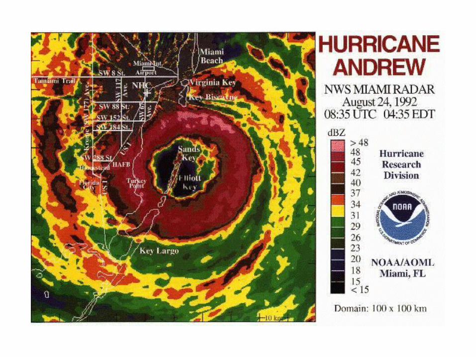
Meso- - Scale and
Meso- -Scale Convective Systems
β
α
Mesoscale Convective System
• Grouping of deep cumulonimbus clouds merged at the anvil forming a meso-scale or larger cluster.
• Defining the term “MCS” implies that there are one or more dynamics mechanisms maintaining and growing the system.
• What are some of these mechanisms?
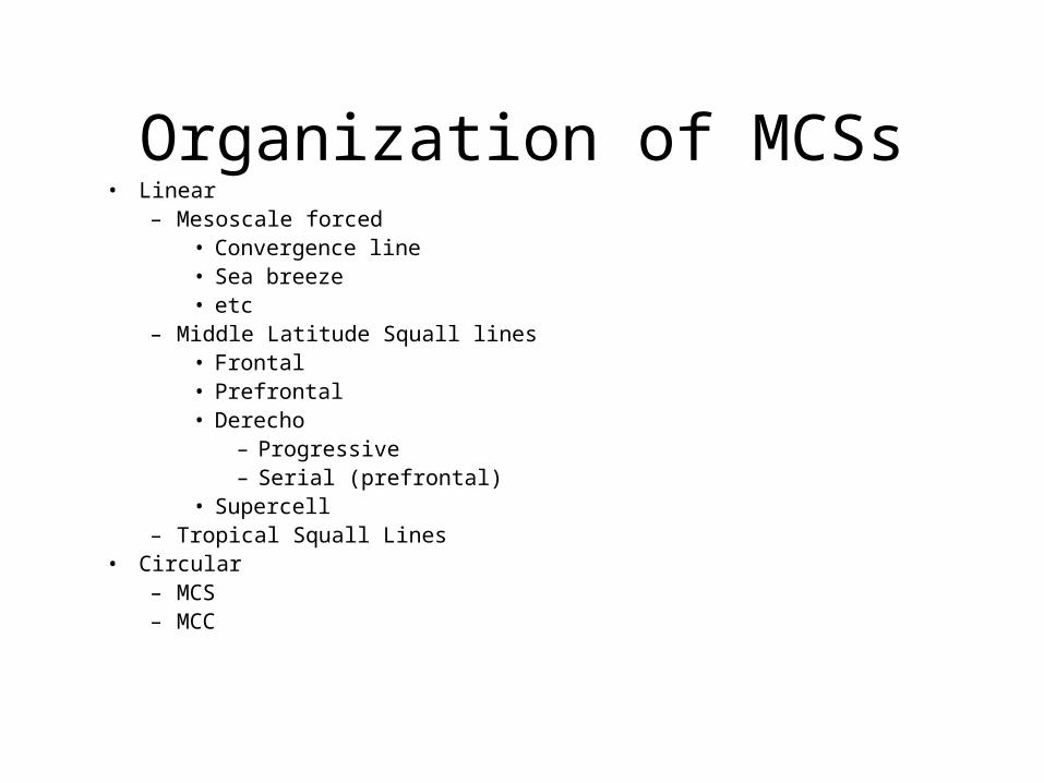
Organization of MCSs• Linear
– Mesoscale forced• Convergence line• Sea breeze• etc
– Middle Latitude Squall lines• Frontal• Prefrontal• Derecho
– Progressive– Serial (prefrontal)
• Supercell– Tropical Squall Lines
• Circular– MCS– MCC
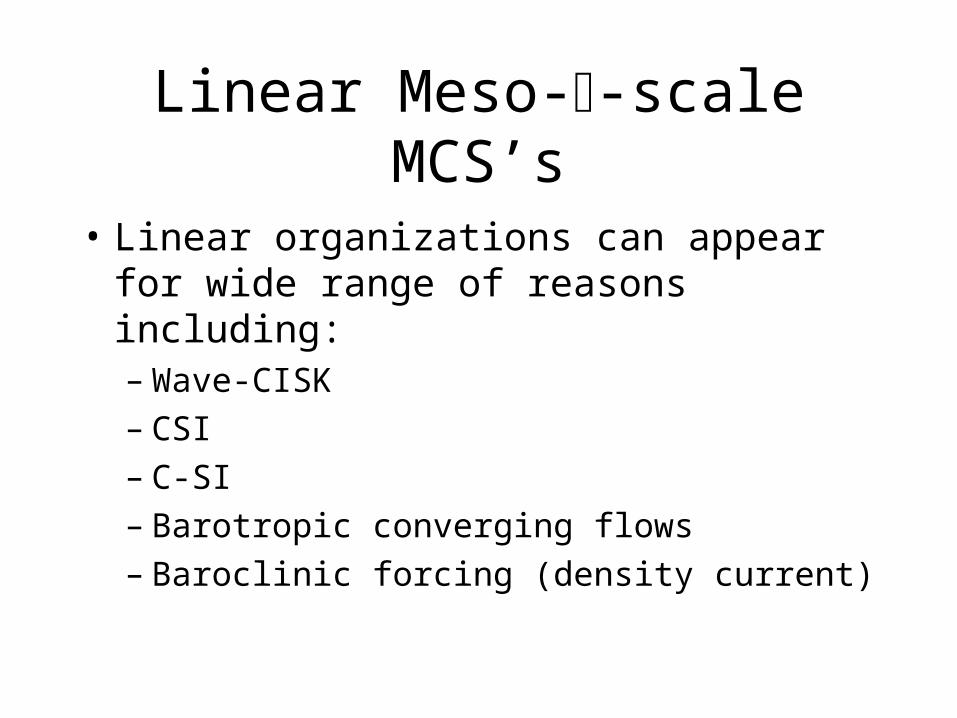
Linear Meso--scale MCS’s
• Linear organizations can appear for wide range of reasons including:– Wave-CISK– CSI– C-SI– Barotropic converging flows– Baroclinic forcing (density current)
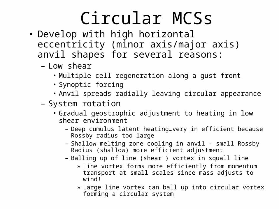
Circular MCSs• Develop with high horizontal eccentricity (minor
axis/major axis) anvil shapes for several reasons:– Low shear
• Multiple cell regeneration along a gust front• Synoptic forcing• Anvil spreads radially leaving circular appearance
– System rotation• Gradual geostrophic adjustment to heating in low shear
environment – Deep cumulus latent heating…very in efficient because Rossby
radius too large– Shallow melting zone cooling in anvil - small Rossby Radius
(shallow) more efficient adjustment– Balling up of line (shear ) vortex in squall line
» Line vortex forms more efficiently from momentum transport at small scales since mass adjusts to wind!
» Large line vortex can ball up into circular vortex forming a circular system
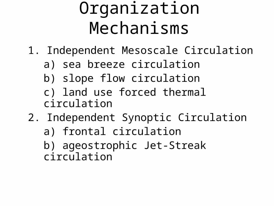
Organization Mechanisms
1. Independent Mesoscale Circulationa) sea breeze circulationb) slope flow circulationc) land use forced thermal circulation
2. Independent Synoptic Circulationa) frontal circulationb) ageostrophic Jet-Streak circulation
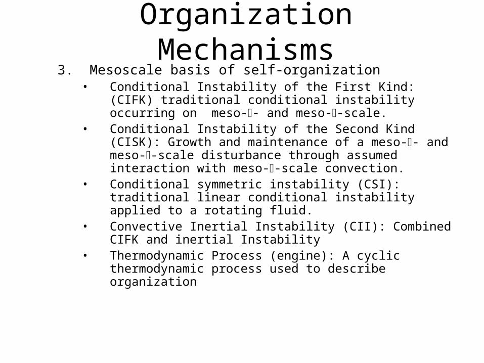
Organization Mechanisms3. Mesoscale basis of self-organization
• Conditional Instability of the First Kind: (CIFK) traditional conditional instability occurring on meso-- and meso--scale.
• Conditional Instability of the Second Kind (CISK): Growth and maintenance of a meso-- and meso--scale disturbance through assumed interaction with meso--scale convection.
• Conditional symmetric instability (CSI): traditional linear conditional instability applied to a rotating fluid.
• Convective Inertial Instability (CII): Combined CIFK and inertial Instability
• Thermodynamic Process (engine): A cyclic thermodynamic process used to describe organization
CISK
• Unstable growth of a wave on the scale of several cumulus (meso-β-scale and larger) in response to latent heating
• Originally applied to the growth of a hurricane depression by Charney and Elliasen
• Later applied to the growth of any wave using linear theory (wave-CISK)

Frictional CISK(Charney and Elliasen , 1962)
• Once believed to the basis of organization for a tropical cyclone• An “ensemble” of cumuli is supported by mesoscale ascent driven by
Ekman pumping of cyclone vortex.• cumulus feed back to vortex strength by heating on scale of vortex
(through a cumulus parameterization) In the linear formulation, this major assumption is a feedback that makes linear instability in the system appear that is used to account for the hurricane growth.
• Flaw: – the cumulus parameterization assumes the scale interaction that it
is trying to find.– Many hurricanes don’t have cumulus!
• 20 years later, they realized that explaining the growth of a hurricane this way was a circular argument.
Wave-CISK
• Upward mesoscale vertical motion driven by the propagation of linear wave (gravity wave, rotational wave, any wave) drives cumulus heating that amplifies the wave.
• Cumulus parameterization used to represent cumulus feed back on wave.
• Flaw: cumulus parameterization assumes the scale interaction it is trying to predict.
Density Current Organization• Mesoscale density current formed by combined effect of a
group of cumulus over time acts to organize lifting along the gust front (density current boundary).
• Density current moves relatively slowly and has a long lifetime when compared to time scale of individual cumulus. Hence the density current is the basis of the system organization.
• But:– Density currents are a nonlinear packet of shallow trapped internal
waves…a solitary wave.
– Not treated by linear theory
Air-Sea Interaction Instability
• Thermodynamic instability allowing tropical cyclone circulation to couple directly with water surface.
• New paradigm for explaining the dynamics of a weather system
• Break from traditional CISK description of tropical cyclone
Geostrophic Adjustment
• Recall winds adjust to mass for scales larger than LR and mass adjust to wind for scales smaller than LR.
• In mid-latitude squall line momentum transport by the rear inflow jet converging with the front updraft inflow produce a mid-level line vortex through momentum transport and the mass field adjusts to the vorticity, ie the pressure lowers along the line vortex.
• This regionally decreases LR .
• The melting layer heating function projects on to a small LR because the layer is shallow, further enhancing the line vortex.
• Hence the squall line grows a quasi-geostrophic component through scale interactions.
• Eventually the line vortex can ball up creating a circular vortex and a circular convective system of meso-alpha scale proportions.
Dynamic Flywheel
• The formation of a quasi-geostrophic component to an MCS is significant because:
– Quasi-geostrophic flows have long time scales compared to transient gravity wave components, with e-folding times of ½ pendulum day.
– The quasi-geostrophic component effectively stores the available energy of the storm’s convective latent heating in its mass balanced circulation.
– Essentially, the quasi-geostrophic system works in reverse to what synoptic-small scale flow interaction: The small scale vertical motion, driven by conditionally unstable latent heating, creates a geostrophic flow that would have created the vertical motion had the process run in the forward direction. Hence the tail wags the dog using energy coming from the tail.
• The mid level line vortex of the middle latitude squall line is such a component that provides a lasting organization of the system. In essence the quasi-geostrophic component of the system, built from cumulus and slant wise processes, stores the energy released in the latent heating into a long time scale balanced quasi-geostrophic circulation.. That is why that circulation can be called a dynamic flywheel.
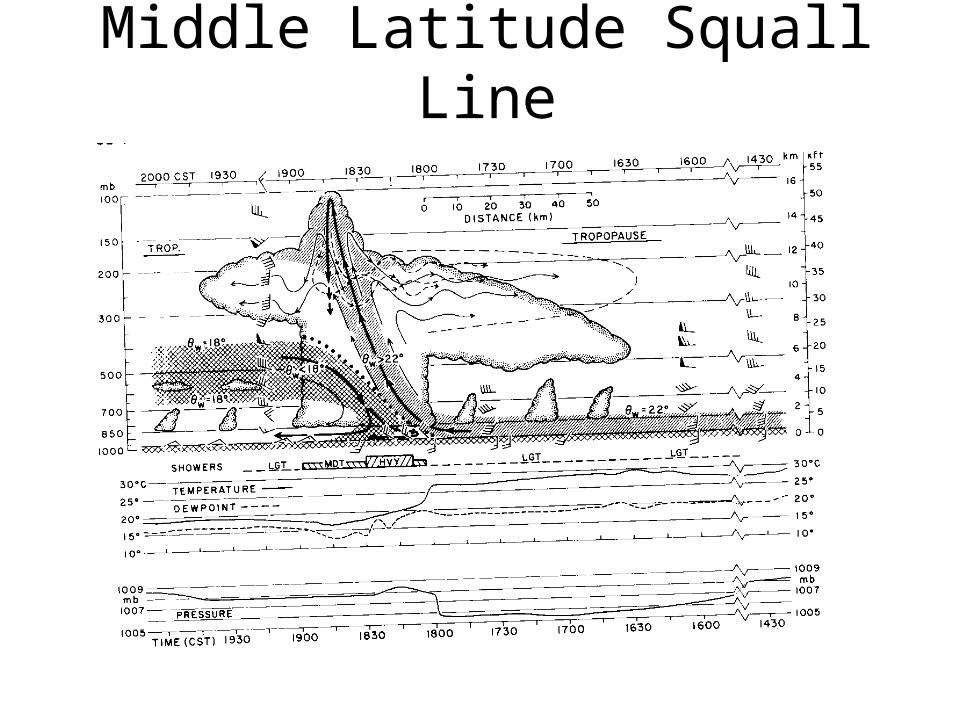
Middle Latitude Squall Line
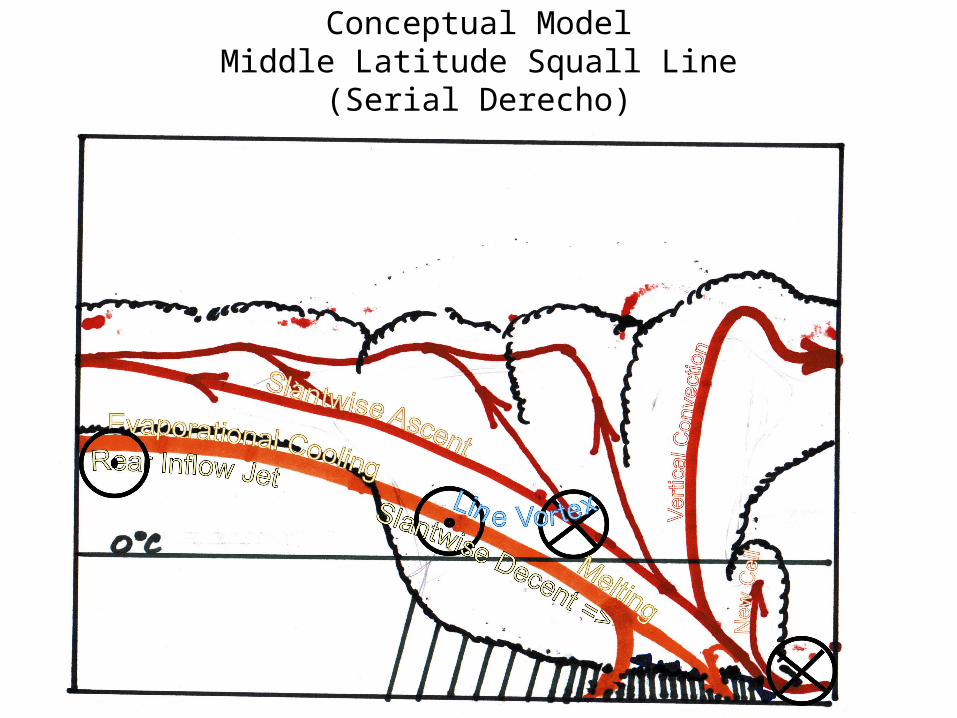
Conceptual ModelMiddle Latitude Squall Line
(Serial Derecho)
Prefrontal Middle Latitude Squall Line
• In its formative stage the line organizes along a preexisting convergence line and is three-dimensional in character, i.e. it is composed of a linear arrangement of individual convective cells.
• The mature line becomes essentially two-dimensional in construction and follows the equilibrium model of sheared convection presented earlier.
• It is the mature stage of squall line MCS that begins with a line of cumulus initiated along a preexisting boundary such as a cold front or local thermal circulationAfter several hours of down shear tilting short lived cumulus a deep density current is built that becomes the basis of maintenance of the steady state quasi-two-dimensional line structure
• Persistence of the quasi-steady structure can evolve to build a strong positive vortex sheet along a shear line at middle levels. Associated mass adjustment to the vorticity results in low pressure and mesoscale circulations that support the line.

Middle Latitude Squall Line(continued)
• Eventual shearing instability can lead to “balling up” of the vortex sheet into a circular warm core vortex aloft
• Mid-level vorticity maximum can drive mesoscale ascent in support of convection. Role of slantwise convection in trailing stratiform anvil.
• Slantwise mesoscale subsidence driven by melting and evaporation in anvil.
• Compensating upward slantwise motion are forced helped by new condensation and ice growth along upward motion.
• Vertical circulation may build jet streak feature at upper levels
Super Cell Squall Lines
• Another form of the middle latitude squall line is a super cell line
• Formed by a line of right moving super cells oriented so that left movers move back over density current and right movers move with squall line.
• Very dangerous squall line because of the increased potential for tornadoes
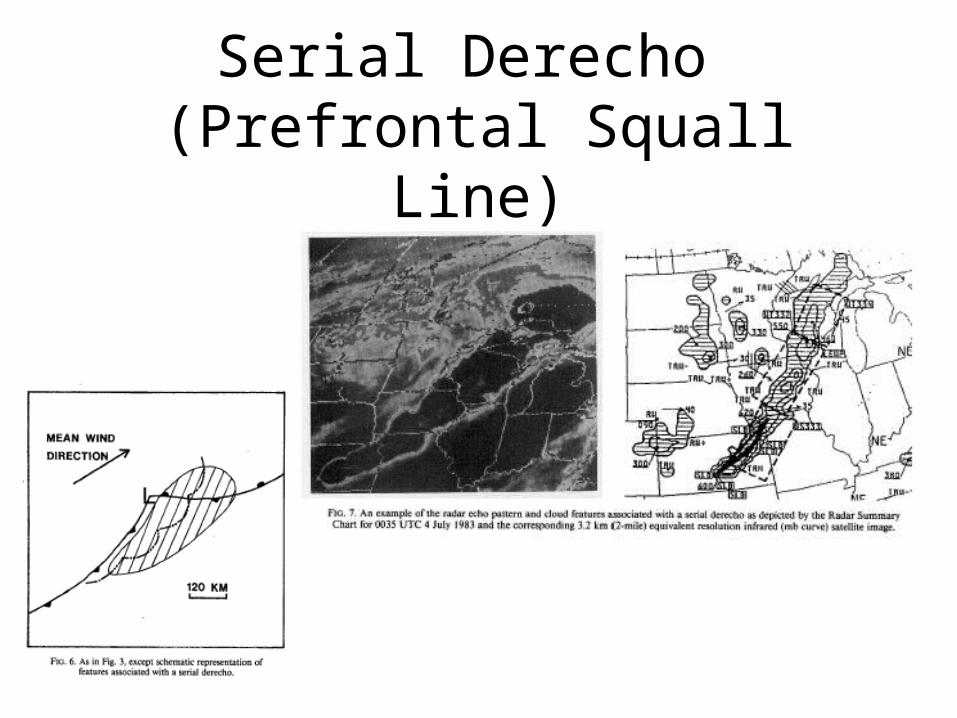
Serial Derecho (Prefrontal Squall Line)
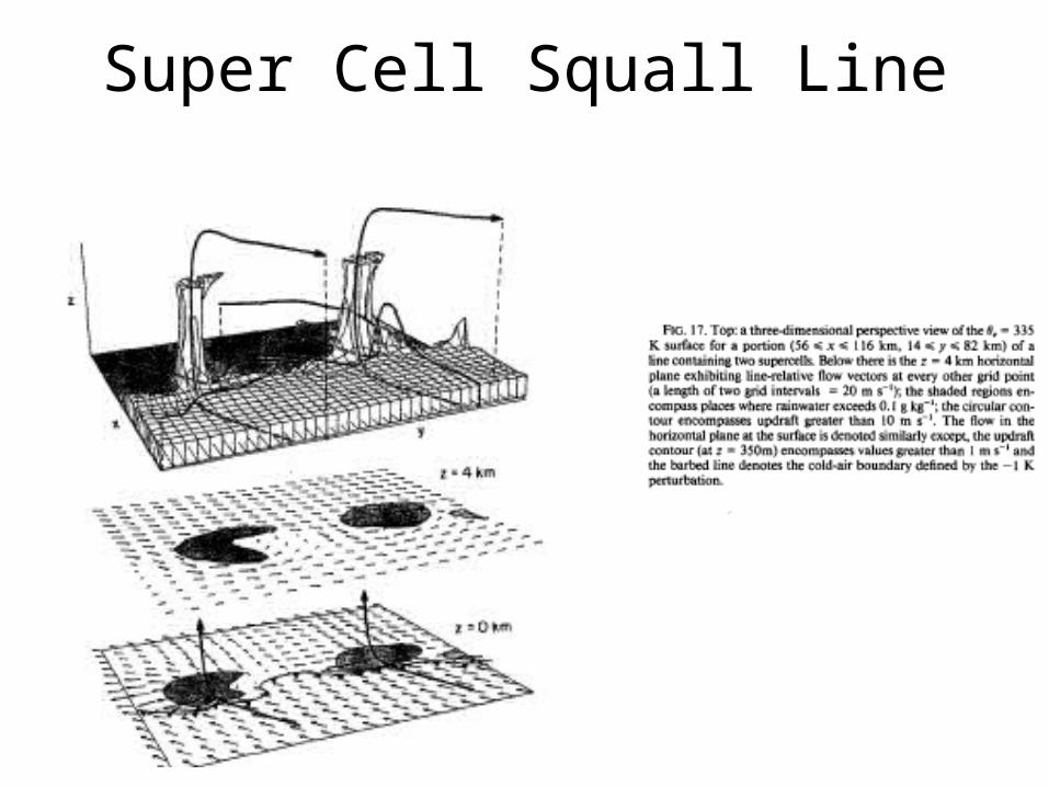
Super Cell Squall Line
Progressive Derecho(Bow Echo)
• This is similar to middle latitude squall line except for an increased role of the up-downdraft and the interaction with a stable layer
• Occurs pole ward of stationary front with extremely unstable capped air equator ward.
• Pole ward advection of unstable air over front feeds updraft of strong elevated deep convective line.

Progressive Derecho(continued)
• Dynamic lifting of vigorous convection entrains stable frontal air lifting it and cooling it until it is released in a strong up-downdraft.
• Up-downdraft crashes downward, assisted by evaporatively cooled air from middle levels (rear inflow jet or from front of storm) hitting surface and spreading as a strong wind storm.
• Spreading wind pushes up more post frontal air into convection.
Progressive Derecho(continued)
• By definition, the derecho is long lived (6 hours or more) and contains severe winds.
• Most common over upper mid-west United states just north of an east-west oriented stationary front.
• Associated with conditionally unstable air located equator ward of the front and capped by an elevated mixed layer usually advected from the Rockies.

Derecho Climatology
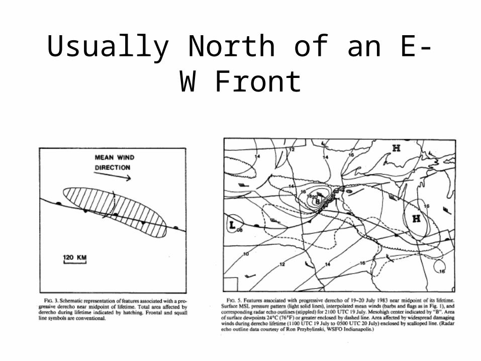
Usually North of an E-W Front
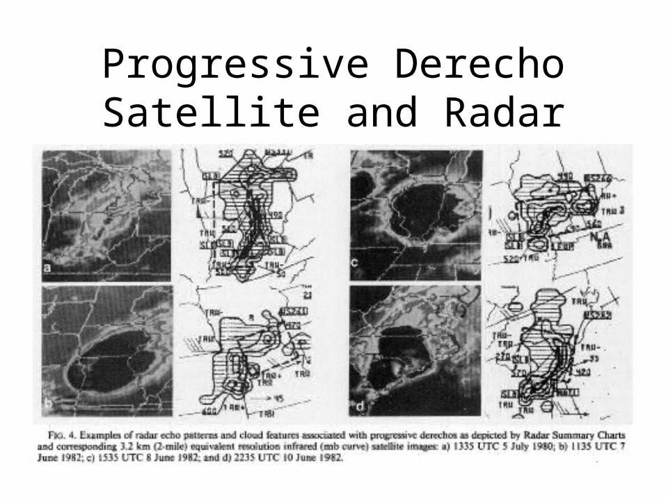
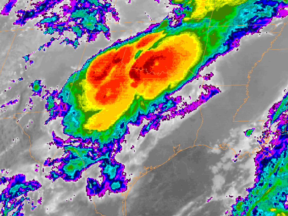
Progressive DerechoSatellite and Radar
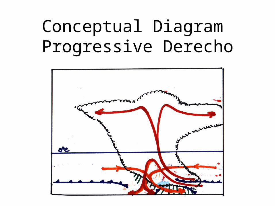
Conceptual Diagram Progressive Derecho
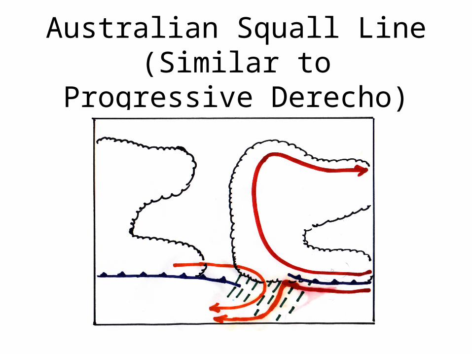
Australian Squall Line(Similar to Progressive Derecho)
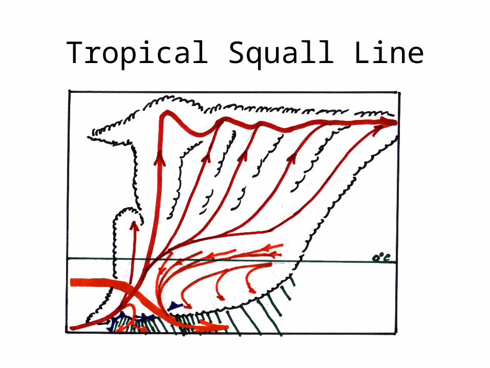
Tropical Squall Line
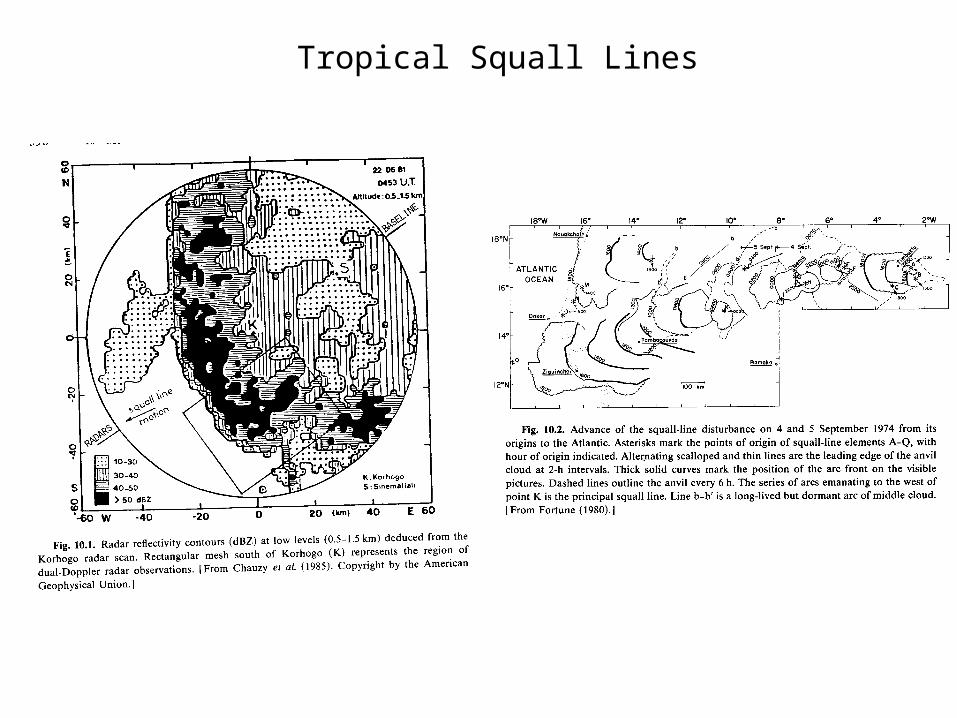
Tropical Squall Lines
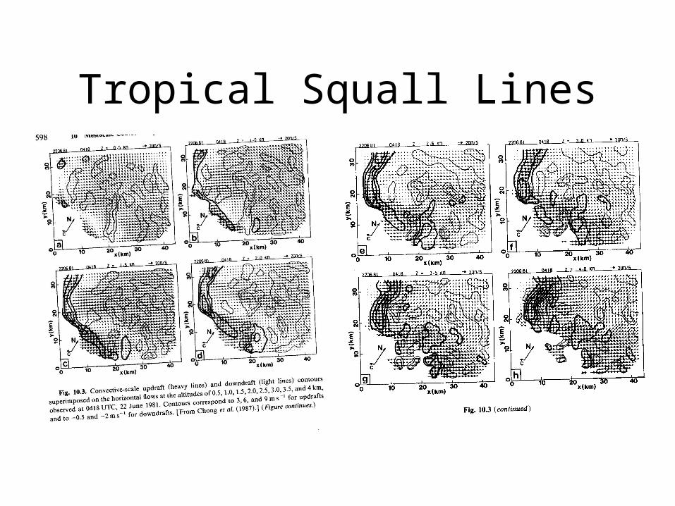
Tropical Squall Lines
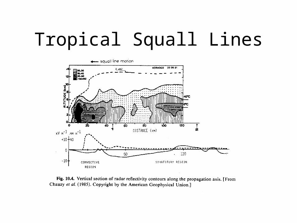
Tropical Squall Lines
Tropical Squall Line
• Updraft and downdraft approach from the front (western side) of the eastward propagating storm.
• Moves faster than the wind at any height, i.e. there is no steering level!
• Dynamical analysis suggest that the tropical squall line may have a dynamics basis that is true wave-CISK organized around a deep tropospheric internal gravity wave.
• Density current plays a major role. As with middle latitude squall line, convection slopes over density current.
Tropical Squall Line(continued)
• Theory requires that the density current move at the same speed as the convective wave to remain steady and coupled. The difference is that the deep convection moves as a gravity wave whereas in the middle latitude squall line the convection moves with the steering level of the mean westerly flow.
Tropical Squall Line(continued)
• As with middle latitude squall line about 50-60 % of the rain falls in the deep cumulonimbus towers at the leading edge of the line and 40-50 % falls from the stratiform region containing the remnants of old towers overlying the dnesity current.
• Strong role of gravity wave is consistent with a tropical atmosphere where Rossby radius is large.
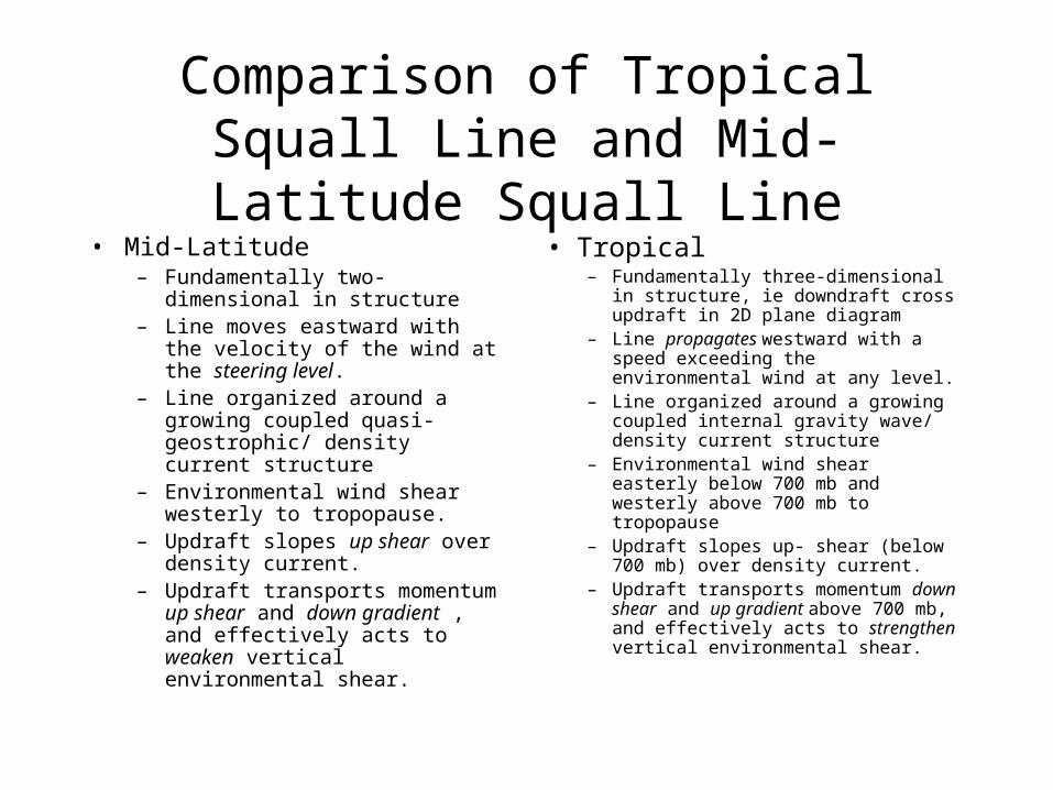
Comparison of Tropical Squall Line and Mid-Latitude Squall Line
• Mid-Latitude– Fundamentally two-dimensional in
structure– Line moves eastward with the
velocity of the wind at the steering level.
– Line organized around a growing coupled quasi-geostrophic/ density current structure
– Environmental wind shear westerly to tropopause.
– Updraft slopes up shear over density current.
– Updraft transports momentum up shear and down gradient , and effectively acts to weaken vertical environmental shear.
• Tropical– Fundamentally three-dimensional in
structure, ie downdraft cross updraft in 2D plane diagram
– Line propagates westward with a speed exceeding the environmental wind at any level.
– Line organized around a growing coupled internal gravity wave/ density current structure
– Environmental wind shear easterly below 700 mb and westerly above 700 mb to tropopause
– Updraft slopes up- shear (below 700 mb) over density current.
– Updraft transports momentum down shear and up gradient above 700 mb, and effectively acts to strengthen vertical environmental shear.
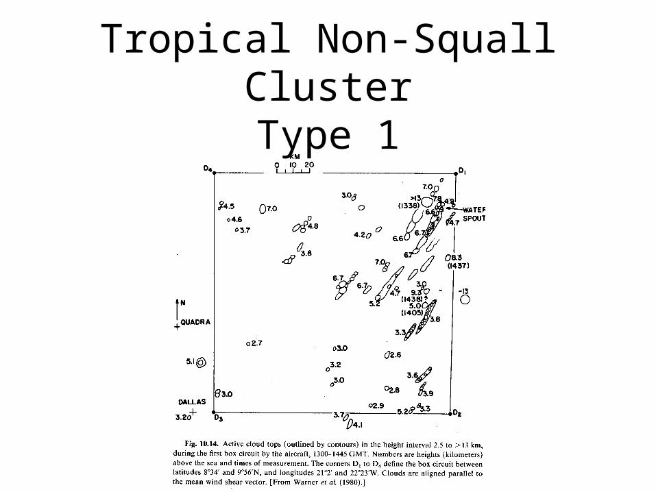
Tropical Non-Squall ClusterType 1
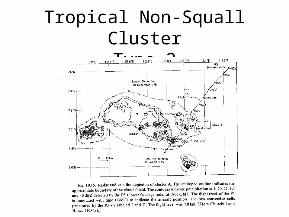
Tropical Non-Squall ClusterType 2
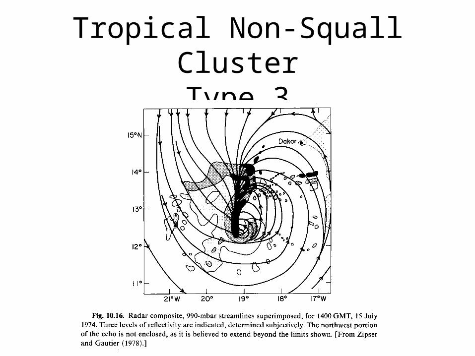
Tropical Non-Squall ClusterType 3
TCC Organization
• Long-Lived signature
• Mean vorticity
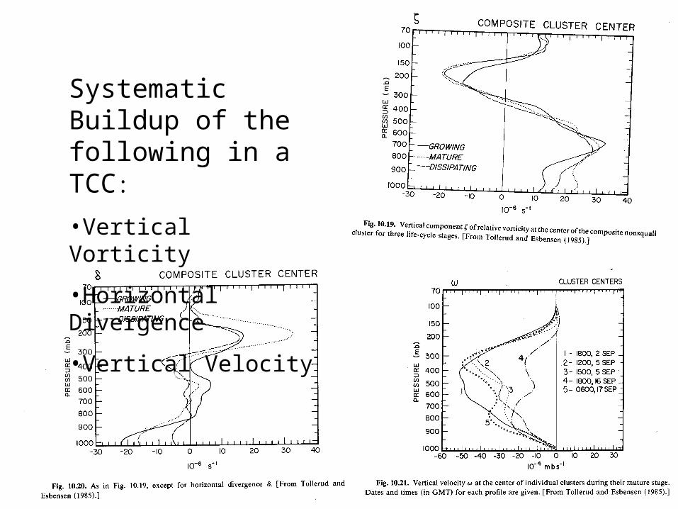
Systematic Buildup of the following in a TCC:
•Vertical Vorticity
•Horizontal Divergence
•Vertical Velocity
Meso--Scale Circular Convective Systems• Significant projection of heating onto balanced scales above the Rossby radius
of deformation.
• Growth of Vortex from cumulus latent heating
– Geostrophic adjustment
• Deep cumulus heating => Large Rossby Radius => slow and inefficient adjustment
• Shallow melting zone => more efficient adjustment => rotation => smaller Rossby Radius => more efficient adjustment to deep heating of cumulus updrafts
– Mass to wind => line vortex => balls up into circular vortex => shrink rossby radius => efficient geostrophic adjustment to latent heating
• Role of slantwise convection
– Latent heating, ie theta redistribution
• More efficient than cumulus heating because spread over a larger horizontal scale
• Driven by melting
– Momentum redistribution
• Form line vortex as with vertical cumulus
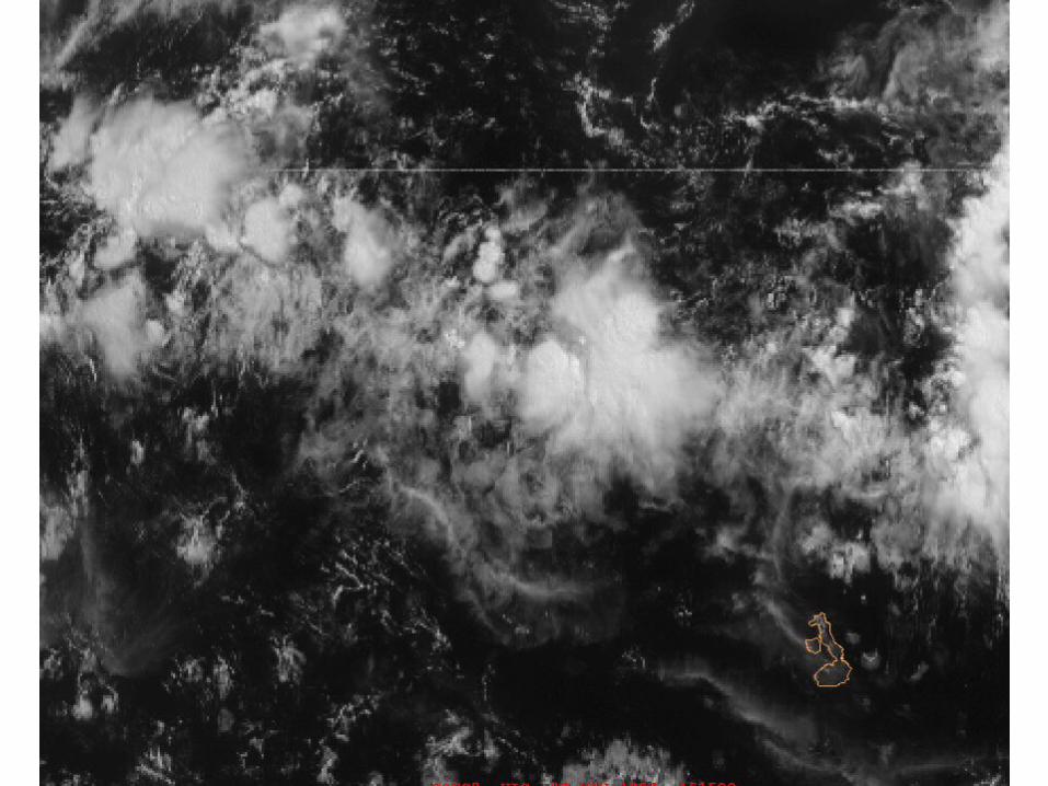
Tropical Non-Squall Clusters
• Grouping of tropical convection:– Along ITCZ– Associated with easterly wave (just ahead of
trough)– Associated with upper level trough (cold low)– Associated with land-water contrast
• Typical Size and Lifetime– 100,000 km2
– 1-2 days
Tropical Non-Squall Clusters(continued)
• Structure – Formative stage
• Isolated cells• Randomly clustered lines
– Intensifying Stage• Individual cells grow and merge• Density currents grow and merge
– Mature Stage• Stratiform area develops• System scale density current• New growth upwind
– Dissipating Stage• Large region of mostly stratiform precipitation
Tropical Non-Squall Clusters(continued)
• Movement– Direction of lower tropospheric flow– Slightly less than speed of easterly (Rossby)
wave (accounts for decay)
• Typical Size and Lifetime– 100,000 km2
– 1-2 days
Tropical Non-Squall Clusters(continued)
• Developing
• Typical Size and Lifetime– 100,000 km2
– 1-2 days
Non-Squall Clusters (continued)
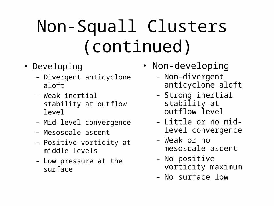
• Developing– Divergent anticyclone aloft
– Weak inertial stability at outflow level
– Mid-level convergence
– Mesoscale ascent
– Positive vorticity at middle levels
– Low pressure at the surface
• Non-developing– Non-divergent anticyclone
aloft– Strong inertial stability at
outflow level– Little or no mid-level
convergence– Weak or no mesoscale
ascent– No positive vorticity
maximum– No surface low
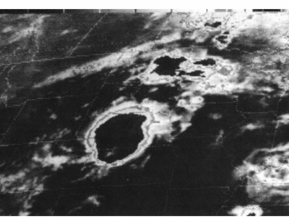
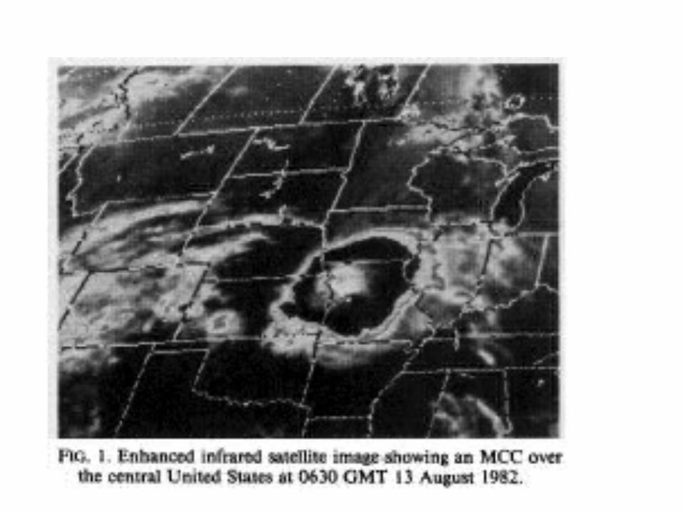
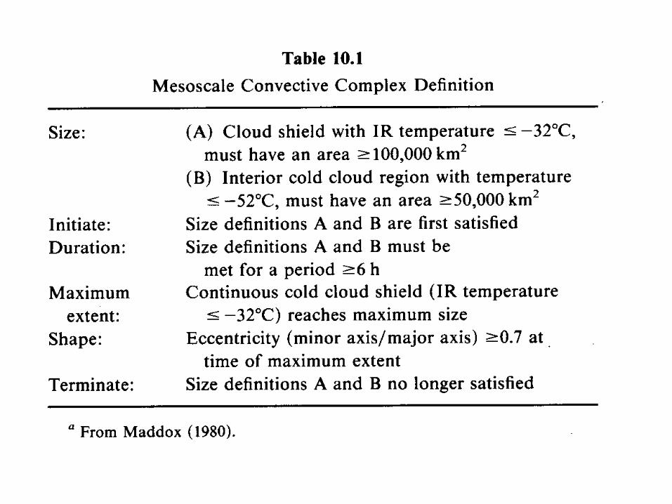
Mesoscale Convective Complex(MCC)
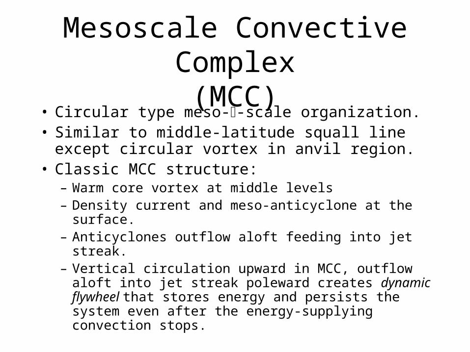
• Circular type meso--scale organization.• Similar to middle-latitude squall line except circular
vortex in anvil region.• Classic MCC structure:
– Warm core vortex at middle levels– Density current and meso-anticyclone at the surface.– Anticyclones outflow aloft feeding into jet streak.– Vertical circulation upward in MCC, outflow aloft into
jet streak poleward creates dynamic flywheel that stores energy and persists the system even after the energy-supplying convection stops.
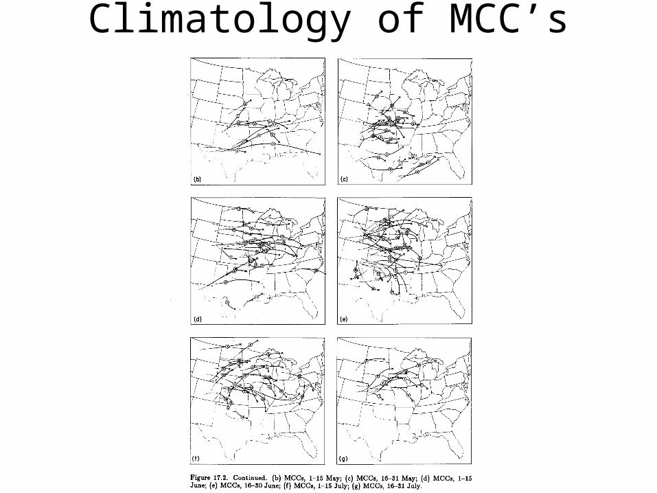
Climatology of MCC’s
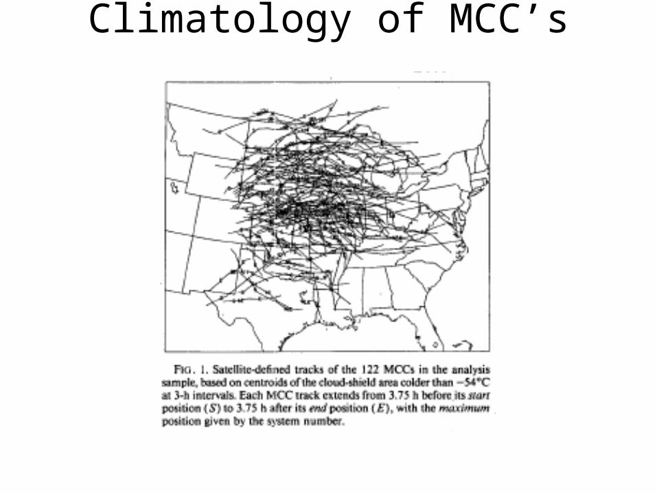
Climatology of MCC’s
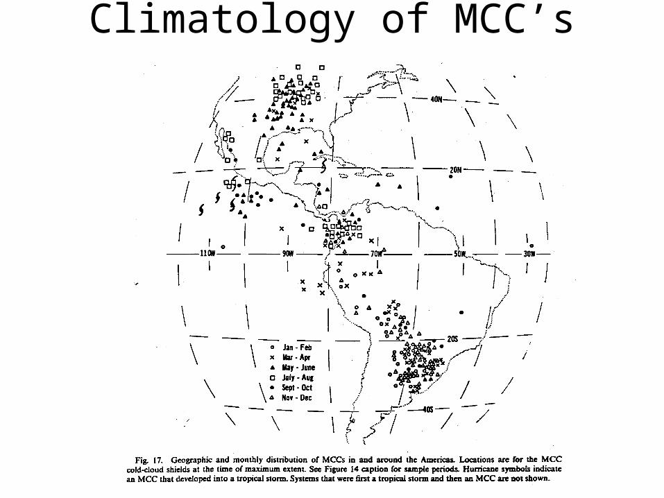
Climatology of MCC’s
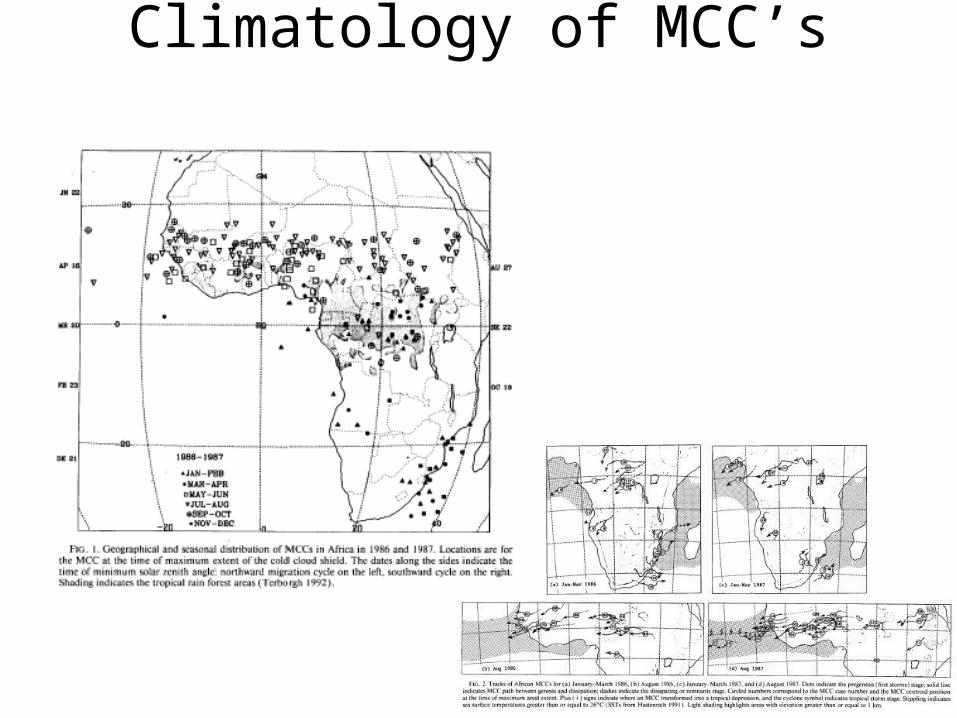
Climatology of MCC’s
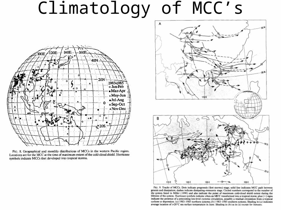
Climatology of MCC’s
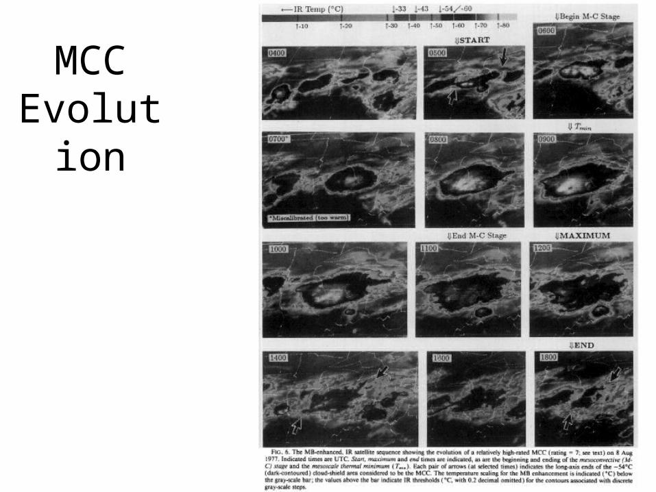
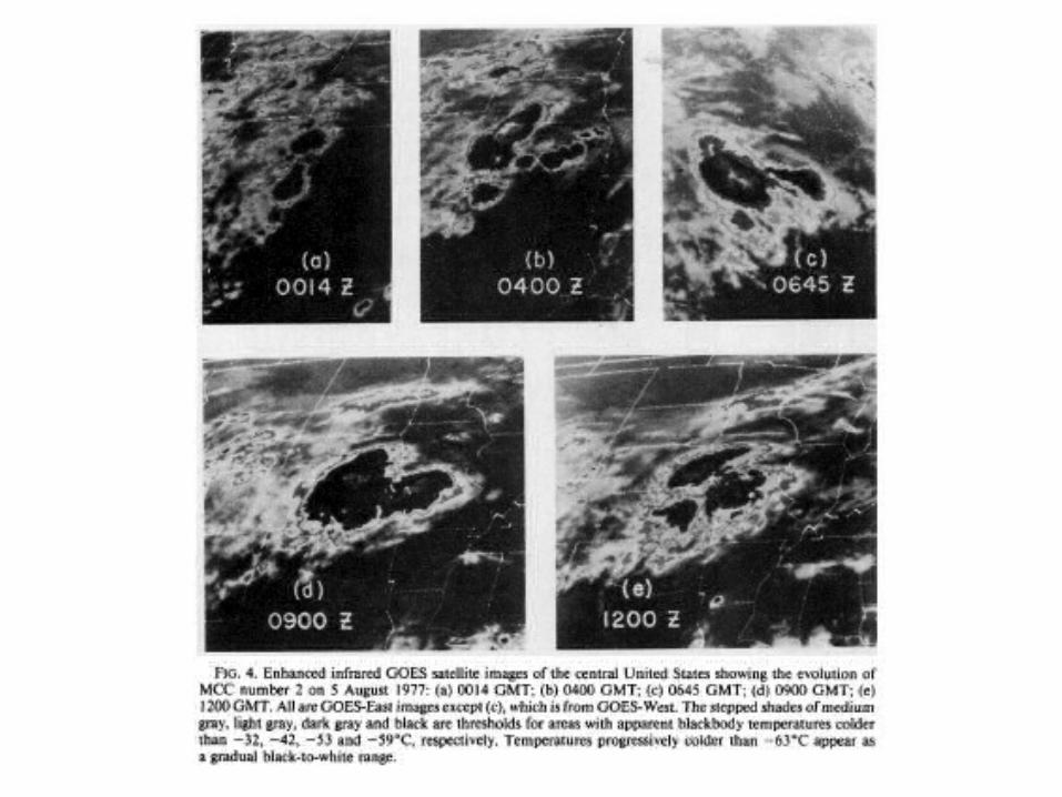
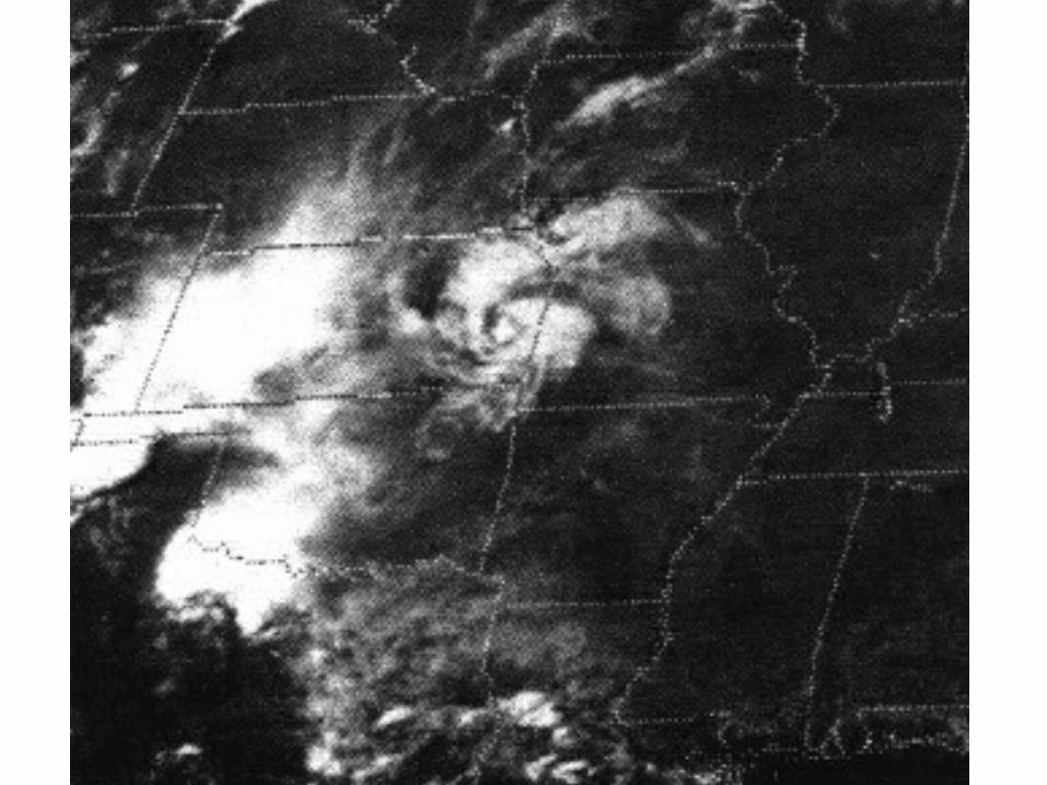
MCC Evolution
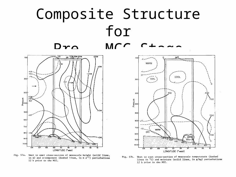
Composite Structure forPre - MCC Stage
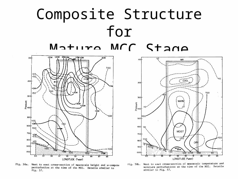
Composite Structure forMature MCC Stage
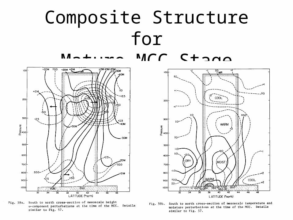
Composite Structure forMature MCC Stage
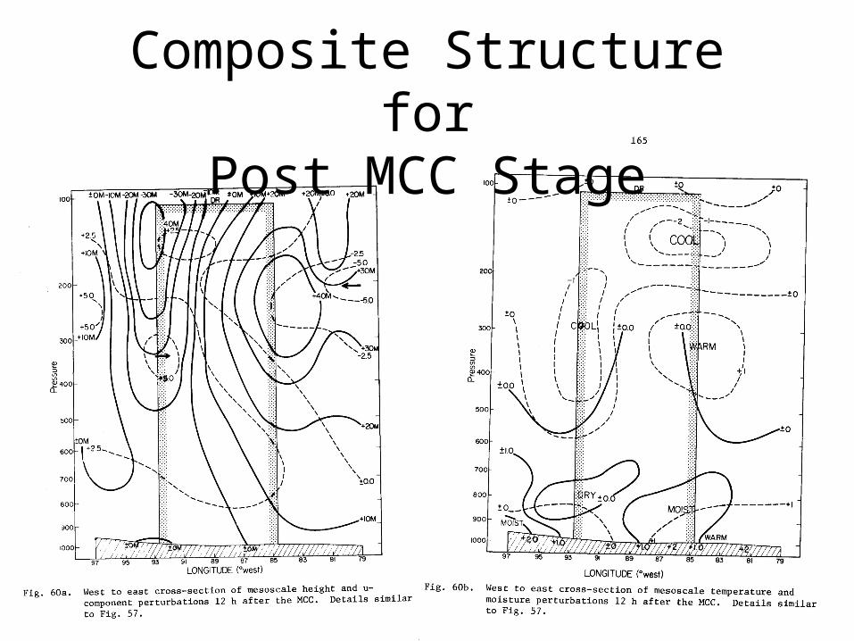
Composite Structure forPost MCC Stage
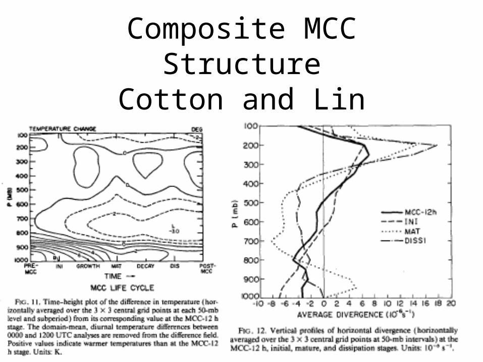
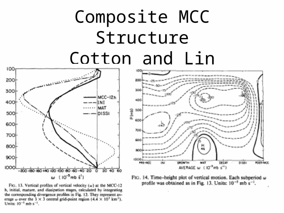
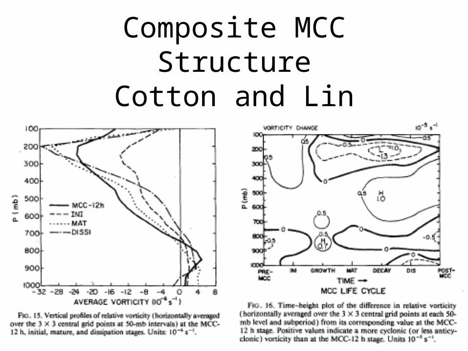
Composite MCC StructureCotton and Lin
Composite MCC StructureCotton and Lin
Composite MCC StructureCotton and Lin
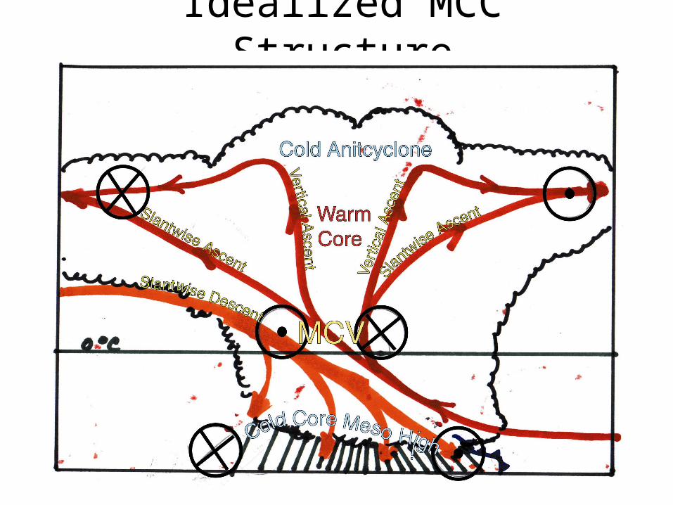
Idealized MCC Structure

Idealized Tropical Cyclone Structure
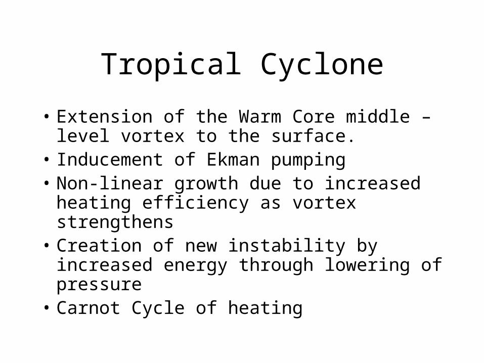
Tropical Cyclone
• Extension of the Warm Core middle –level vortex to the surface.
• Inducement of Ekman pumping• Non-linear growth due to increased heating
efficiency as vortex strengthens• Creation of new instability by increased
energy through lowering of pressure• Carnot Cycle of heating