Environment Protection Authority
Lower Murray Reclaimed Irrigation Area (LMRIA) Acid Drainage Project
Final summary report 2013
Lower Murray Reclaimed Irrigation Area (LMRIA) Acid Drainage Project: final summary report 2013
This is a joint project between the South Australia Government and the MurrayDarling Basin Authority.
Authors: Luke Mosley, David Palmer, Peter Mettam, Courtney Cummings and Emily Leyden
This report was prepared as a summary of a project undertaken with the guidance of the LMRIA Acid Drainage
Interagency Working Group comprising Andrew Beal (Chair, DEWNR), Richard Brown (DEWNR), David Cunliffe (DHA),
Michael Cutting (SAMDB NRM Board), Rob Daly (SA Water), Jarrod Eaton (DEWNR), Jacqueline Frizenschaf (SA
Water), Simon Gierke (PIRSA), Jessica Iacopetta (DEWNR), Thorsten Mosisch (SA Water), Rob Kingham (MDBA),
Tapas Biswas (MDBA), Vladimir Tsymbal (SA Water), and Michelle Wittholz (DHA).
For further information please contact:
Information Officer
Environment Protection Authority
GPO Box 2607
Adelaide SA 5001
Telephone: (08) 8204 2004
Facsimile: (08) 8124 4670
Free call (country): 1800 623 445
Website: <www.epa.sa.gov.au>
Email: <[email protected]>
ISBN 978-1-921495-30-4
July 2014
© Environment Protection Authority
This document may be reproduced in whole or part for the purpose of study or training, subject to the inclusion of an
acknowledgment of the source and to it not being used for commercial purposes or sale. Reproduction for purposes other
than those given above requires the prior written permission of the Environment Protection Authority.
Contents
Abbreviations ...................................................................................................................................................................... 1
Acknowledgments ............................................................................................................................................................... 2
Executive summary ............................................................................................................................................................. 3
1 Introduction ................................................................................................................................................................... 4
2 Key findings ................................................................................................................................................................ 10
3 Communications and contingency plan ................................................................................................................... 24
4 Management implications .......................................................................................................................................... 26
5 Conclusion .................................................................................................................................................................. 28
6 Recommendations ...................................................................................................................................................... 29
7 References................................................................................................................................................................... 30
List of figures
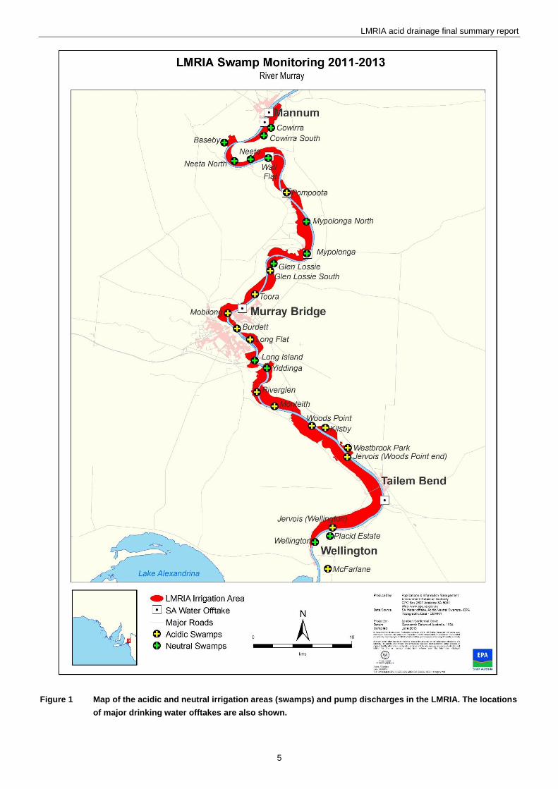
Figure 1 Map of the acidic and neutral irrigation areas (swamps) and pump discharges in the LMRIA ............................ 5
Figure 2 Lower Murray (Lock 1) river levels 1921 to 2012. ............................................................................................... 6
Figure 3 Conceptual model constructed in 2011 by the EPA as basis for this project ...................................................... 7
Figure 4 pH and acid base accounting data plotted against depth for each profile collected at Long Flat in 2011 and
2012 ................................................................................................................................................................... 11
Figure 5 pH in acid drainage plumes discharged from Jervois (Woods Point end) irrigation area in October 2011. ...... 12
Figure 6 pH in acid drainage plumes discharged from Jervois (Woods Pt end) irrigation area in October 2011 ............ 13
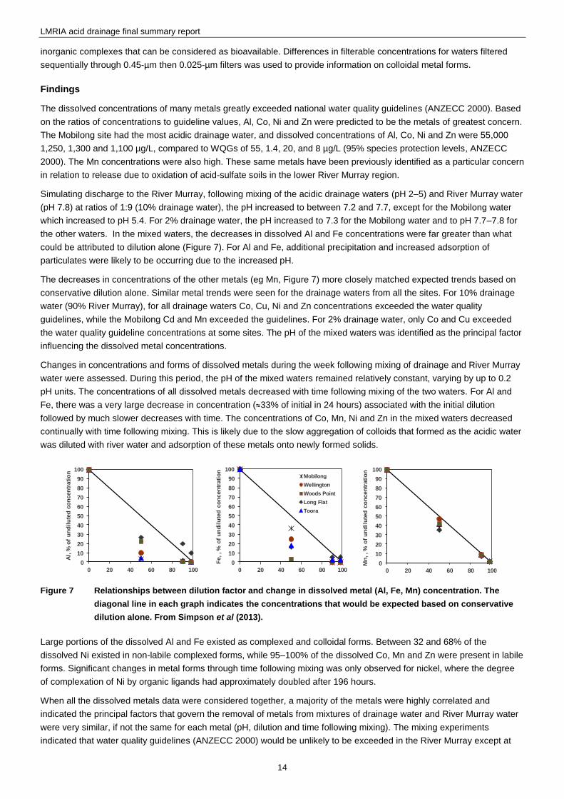
Figure 7 Relationships between dilution factor and change in dissolved metal (Al, Fe, Mn) concentration. ................... 14
Figure 8 Concentration-response curves showing the toxicity of acid drainage water to cladocerans, shrimp and fish
at two Jervois sites (Wellington and Woods Point) ............................................................................................ 16
Figure 9 Soluble manganese (Mn) at the Tailem Bend SA Water offtake from the 3D geochemical model ................... 18
Figure 10 Groundwater pH and acidity in piezometers in the B (0.75–1.25 m below ground level) and C (2.5–3 m
below ground level) horizon at Long Flat ........................................................................................................... 20
Figure 11 Lime slurry dosing at along the main drain at Jervois–Woods Point (left) and at the salt drain at
Jervois– Wellington End (right) .......................................................................................................................... 20
Figure 12 Modified mole plough attached to the rear of a tractor (left), excavation to show mole with injected lime
(centre) and milk of lime in container with pump set-up at the front of the tractor (right). ................................. 21
Figure 14 Management scenario showing how soil pyrite oxidation can be minimised by stabilisation of river levels
at 0.5 m AHD and use of two environmental irrigations .................................................................................... 23
Figure 15 The four-tiered alert system in the contingency plan ......................................................................................... 25
Figure 16 Groundwater level at Mobilong and Mypolonga from 2002 to 2012 .................................................................. 27

1
0BAbbreviations
ANZECC Australian and New Zealand Environment Conservation Council
ASS acid sulfate soils
DEWNR Department of Environment, Water, Natural Resources
DHA Department of Health and Ageing
EPA South Australian Environment Protection Authority
LMRIA Lower Murray Reclaimed Irrigation Area
MDBA Murray–Darling Basin Authority
PIRSA Primary Industries and Regions South Australia
SAMDB NRM South Australian MurrayDarling Basin Natural Resources Management Board
WQG water quality guidelines
2
1BAcknowledgments
This project was co-funded by the South Australian Government and the Murray–Darling Basin Authority (MDBA). The
excellent project support and guidance from Rob Kingham and Brian Lawrence at the MDBA is gratefully acknowledged.
The ongoing guidance and support of the LMRIA Interagency Working Group (individuals and agencies listed on inside
cover of report) is also gratefully acknowledged.
The cooperation and assistance of various irrigators and irrigation trusts across the LMRIA is greatly appreciated. In
particular we would like to thank Barry and Joanne Pfeiffer at Long Flat for the use of their farm as an acid drainage
management trial site and assistance with various aspects of the project.
We also thank SA Water for offering their land at Mobilong for a trial of a novel lime injection remediation technique. The
assistance of various SA Water staff is also much appreciated.
We thank Michael Fogg for his contribution to this project while at the EPA.
We would like to thank Drs Rob Fitzpatrick, Stuart Simpson, Anu Kumar, Merrin Adams, Paul Shand and Andrew Baker
from CSIRO for contributing to the scientific understanding of the issue.
We would also like to thank Dr Freeman Cook (Freeman Cook and Associates Pty Ltd) for assistance and advice on
groundwater hydrological processes and calculations for Long Flat.
Thank you to the Hon Dean Brown and the Lower Murray Sustainable Soils Reference Group for useful discussions and
support for the project. The advice of Martin Philcox and Monique White is particularly acknowledged.
Additional funding contributions from the Environment Protection Authority (EPA), SA Water and Primary Industries and
Resources South Australia (PIRSA) are gratefully acknowledged.
3
2BExecutive summary
Severe soil acidification occurred in the Lower Murray Reclaimed Irrigation Area (LMRIA) due to falling river and ground
water levels, exposing acid sulfate soils during the extreme ‘millennium’ drought from 2007–10. The EPA became aware
of this issue in February 2011 when unusual orange-brown water appeared in many LMRIA drainage channels. The
LMRIA drainage water is returned to the River Murray via large pumps, a practice necessary to control saline water
tables rise and risk to agricultural activities.
The broad objectives of the LMRIA acid drainage project were:
To understand the behaviour and impacts of acid drainage plumes being discharged to the Lower River Murray.
To protect aquatic ecosystems, water supplies and recreational users from exposure to contaminated water.
Soil surveys at three irrigation areas in 2011 revealed sulfuric (pH<4) soil layers present 1–3 m below ground level with
high levels of total available (readily soluble and transportable) acidity. Subsequent soil surveys in 2012 and 2013 have
found these acidic soil layers persisting over time and generating the acid drainage discharges.
From early 2011 to mid-2013, acid (pH 2–5) drainage discharges have occurred from 13 irrigation areas (14 drainage
pumps) to the River Murray. The drainage is generated from an estimated 3,500 ha of acidified land in the LMRIA. Low
pH, high acidity and high soluble metal levels have persisted in these drainage discharges for over 2.5 years.
Monitoring of the discharge zone in the River Murray shows that the acid drainage water is quickly neutralised (pH>6.5)
in the immediate mixing zone (pump outlet channel), with precipitation of solid metal phases occurring, before entering
the main river channel. However minor detectable changes in water quality occur in the river over 1.5 km downstream of
some drainage discharges. The pH is always within national water quality (ANZECC) guideline values (pH 6.5–9.0) in the
main river channel, and metal exceedences are rare and minor.
Laboratory experiments were consistent with the field observations and showed that removal of aluminium and iron was
rapid. As pH neutralised, the formation and aggregation of metal colloids was a key driver for removal of soluble metals.
Laboratory based experiments showed mixed ecotoxicity responses for different species and sites. Generally fish and
cladocerans were most sensitive to the acid drainage but acute toxicity of the drainage water is unlikely after more than a
1–10% dilution (achieved within 5–10 m of the mixing of drainage water in the river). No fish or other aquatic species kills
have been observed in the vicinity of the LMRIA discharges or lower reaches of the river which is consistent with these
findings. Some sites showed much less toxicity (Jervois–Woods Points end) relative to other sites (Jervois–Wellington
end) despite having similar pH, salinity and metal concentrations. Further work is required to understand the factors
causing toxicity and extend the laboratory experiments to field conditions.
A three-dimensional hydrodynamic and river water quality model was developed for the area between Mannum and
Wellington where the LMRIA acid drainage discharges occurred. The model gave acceptable performance against
measured water quality results for a five-month testing period. At lower flows (<5,000 ML/day) the model indicated there
was potential for soluble manganese to more regularly exceed SA Water treatment guidelines (non-health guideline) at
Tailem Bend. There are water treatment contingency plans to manage this if required. SA Water and SA Health have
established that to date there has been no risk to the public water supply and public health.
Various trials of remediation options were conducted. Drain treatment via lime slurry dosing produced neutral discharge
water with low metal concentrations. Irrigation and lime spreading resulted in slow improvements in groundwater quality.
The injection of lime via a mole plough appeared to speed the remediation process and may be a viable management
technique. It is recommended that monitoring of the soil, groundwater, drainage (at discharge points), and river water
quality continues with additional research and monitoring in relation to aquatic ecosystem risks.
LMRIA acid drainage final summary report
4
1 3BIntroduction
1.1 11BGeneral background
There is approximately 5,200 hectares of flood irrigated agriculture on the former floodplain of the River Murray in South
Australia, between the townships of Mannum and Wellington (Figure 1). This area comprises 27 individual irrigation areas
and is known collectively as the Lower Murray Reclaimed Irrigation Area (LMRIA). Historically, the predominant landuse
was dairy farming, with a smaller area used for beef cattle, fodder production and lifestyle farming. Most of this land was
drained and developed for agriculture between 1880 and 1940.
Agriculture in this area was historically inefficient in water use and the irrigation practices returned large volumes of
polluted water with high levels of salt, nutrients and pathogens to the River Murray (Mosley and Fleming 2009). As a
result of the risk to environmental values (drinking water, recreation, aquatic ecosystems) within the Lower Murray–
Darling Basin, the state government worked with irrigators on a $22-million Commonwealth funded project from 2003–06
to improve water and land management practices in the LMRIA.
Key outcomes from the rehabilitation project were the installation of efficient irrigation and runoff reuse systems to reduce
the pollutant loads returned to the river, and improved on-farm management practises (EPA 2009). In particular, the
project focused on infrastructure improvements such as new water delivery infrastructure (siphons/sluices, inlet
channels), water metering, laser grading of paddock surfaces, and construction of runoff reuse systems (>50 kL/ha
capacity) to recycle excess surface irrigation runoff water and pollutants (that were previously returned to the river) back
onto the farm.
Unfortunately, at the conclusion of the rehabilitation project, drought conditions and long-term low inflows into the
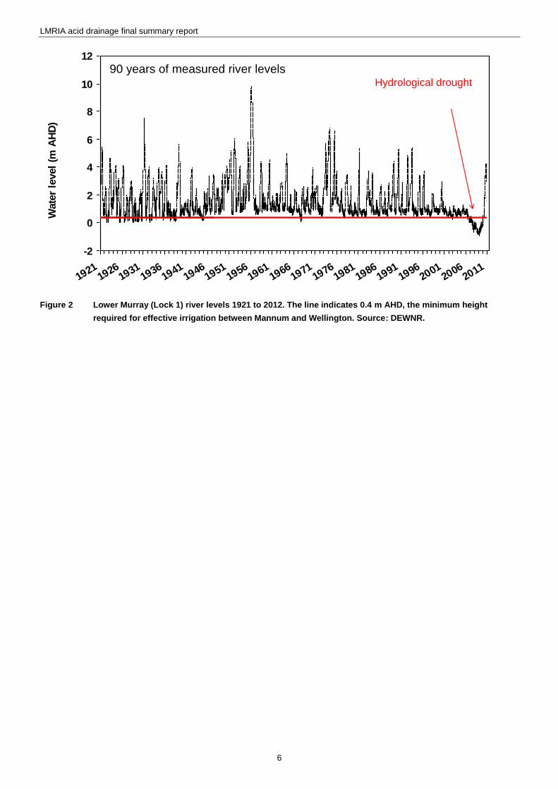
Murray–Darling system led to unprecedented low water levels below Lock 1. During April 2009 the water level in the
Lower Murray fell to below –1 m AHD, the lowest river level since records began over 90 years ago (Figure. 2). At Murray
Bridge the river level dropped below 0.4 m from 12 March 2007 to 9 September 2010. The low water levels and restricted
irrigation water allocations during the drought meant that most of the reclaimed areas were not able to be irrigated for
substantial periods of time, which led to a drop in the water table of up to 3 m from pre-drought levels. The heavy clay
soils subsequently salinised, dried and cracked, causing major damage to the rehabilitated irrigation bays and associated
infrastructure, as well as major socio-economic impacts due to loss of farm production.
Screening by the EPA in late February 2011 highlighted the presence of acid water in 14 LMRIA salt drains (Figure. 1).
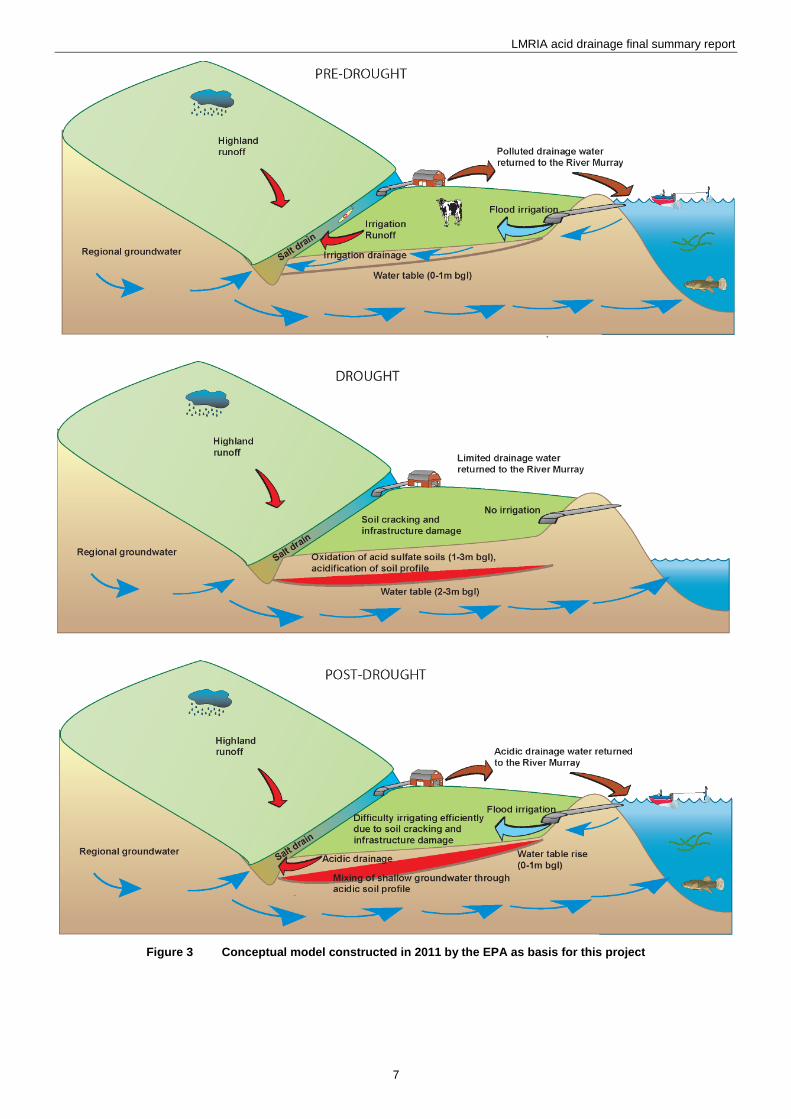
This was the first time that this issue was discovered. The EPA constructed a conceptual model (Figure. 3) in 2011 to
begin to understand the causes of the issue. This model proposed that the falling ground water levels and soil drying
under the LMRIA during the drought resulted in oxidation of deeper (1–3 m below ground level) subsoils containing
reduced inorganic sulfur minerals such as pyrite (FeS2).
These sulfidic soil materials are commonly termed acid sulfate soils as they can transform to sulfuric (pH<4) materials
upon oxidation when exposed to air. The sulfuric acid which was produced in the soil profile as a result of the oxidation
process was then mixed with the shallow groundwater as water levels recovered in the Lower Murray in 2010, resulting in
an acidic water table under 13 irrigation areas. As each irrigation area is flood irrigated or as rainfall events occur, acidic
water moves towards the drainage channels where it collects before being pumped back into the River Murray. Pumping
is necessary to maintain agricultural practices in this region as it keeps the saline, and now acidic, water tables below the
pasture root zone.
LMRIA acid drainage final summary report
5
Figure 1 Map of the acidic and neutral irrigation areas (swamps) and pump discharges in the LMRIA. The locations
of major drinking water offtakes are also shown.
LMRIA acid drainage final summary report
6
Figure 2 Lower Murray (Lock 1) river levels 1921 to 2012. The line indicates 0.4 m AHD, the minimum height
required for effective irrigation between Mannum and Wellington. Source: DEWNR.
-2
0
2
4
6
8
10
12
19211926
19311936
19411946
19511956
19611966
19711976
19811986
19911996
20012006
2011
Wate
r le
vel
(m A
HD
)
90 years of measured river levelsHydrological drought
-2
0
2
4
6
8
10
12
19211926
19311936
19411946
19511956
19611966
19711976
19811986
19911996
20012006
2011
Wate
r le
vel
(m A
HD
)
90 years of measured river levelsHydrological drought
LMRIA acid drainage final summary report
7
Figure 3 Conceptual model constructed in 2011 by the EPA as basis for this project
LMRIA acid drainage final summary report
8
1.2 12BRationale for project
In 2011, there was great uncertainty as to the risk that the acid drainage discharges posed to river water quality. However
these risks were considered serious given that a previous study has demonstrated the LMRIA drainage discharges can
change the water quality of the river downstream of Mannum for nutrients (Mosley and Fleming 2010). The LMRIA is in
the reach of the River Murray which contains several large drinking water off-takes, servicing the city of Adelaide
(population 1.23 million) and several regional areas. When pumping of LMRIA drains recommenced (from early 2011)
there had been several large spikes of manganese (Mn) observed at Tailem Bend drinking water offtake. These raised
some level of concern as the Mn concentration had exceeded the Australian Drinking Water Guidelines (NHMRC/
NRMMC 2011) for aesthetics and approached the limits of the health guidelines for a couple of spikes. Preliminary
modelling by SA Water also indicated that if SA entitlement flow (reduced river level) was present, Mn could consistently
exceed drinking water guidelines more consistently.
Risks to aquatic ecosystems in the River Murray arising from the high concentrations of acid and metals in the drainage
discharges were also unclear. In order to fully assess the risks and develop management options, there is a need to
better understand the ecotoxicity of the acid drainage, and metals in particular, upon mixing with river water.
The river is also very important for recreational use and tourism and it was important these activities were not impacted
by acid drainage discharges.
A business case for funding was submitted to the Murray–Darling Basin Authority (MDBA) in November 2011. The
rationale for proposing the MDBA and other Murray–Darling Basin jurisdictions contribute funding to this issue were:
low water levels between 2007–10, and subsequent large-scale acid drainage issue, is a direct consequence of
South Australia not receiving its entitlement flow and hence a whole-of-basin response is justified
A Ministerial Council decision in 31 August 1990 which agreed that the ‘the policy is to endeavour to ensure that
existing water quality is not allowed to deteriorate’
by early 2012 critical human water needs (CHWN) could be threatened in the Lower Murray for water quality reasons
and Basin States have agreed that CHWN are the highest priority water use (Water Act 2007 Section 86a Clause 1b)
by early 2012 the discharges could negatively impact on the Lower Lakes and there are whole-of-basin obligations to
protect this Ramsar-listed Murray–Darling Basin icon site.
The uncertainty described above, and conceptual model formulated in early 2011 (Figure. 3) were used as guidance to
formulate projects within the business case. The various projects would enable a detailed assessment of the acid
drainage issue, river water quality and ecosystem risks, and trialling of remediation options. On 5 December 2011, a
meeting of the Basin Officials Committee (comprising all Murray–Darling Basin jurisdictions) approved the business case
and agreed to fund 50% of a project provided the SA government contributed the remaining 50%.
1.3 13BObjectives of the project
The broad objectives of the LMRIA acid drainage project were to:
to understand the behaviour and impacts of acid drainage plumes being discharged to the Lower River Murray
to protect aquatic ecosystems, water supplies and recreational users from exposure to contaminated water.
1.4 14BProject outline
Details of the work undertaken and the findings from the research will be published in a series of technical reports. The
aims, methods and key findings from all these studies are summarised in this document.
30BSoil survey
Fitzpatrick RW, Shand P, Simpson S, Grocke S, Raven M, Baker AKM, Mosley LM and Self PG (in prep), Assessment of
re-flooded Acid Sulfate Soil environments at Long Flat, Jervois, Toora and Pompoota in the Lower Murray Reclaimed
Irrigation Area (LMRIA), CSIRO Land and Water Science Report.
LMRIA acid drainage final summary report
9
31BDrain and river water quality monitoring
Leyden E, Palmer D, Scott P, Zammit B and Mosley L 2012, Lower Murray River Irrigated Area Acidification Risk Project:
Preliminary monitoring report 2011–12, Environment Protection Authority,
http://www.epa.sa.gov.au/xstd_files/Water/Report/Preliminary%20Report_LMRIA_Final.pdf
Mettam P, Mosley L, Palmer D, Leyden E, Scott P, Cummings C and Zammit B 2013, Lower Murray Reclaimed Irrigation
Area (LMRIA) Acidification Project: Final monitoring report 2013, Environment Protection Authority, Adelaide,
www.epa.sa.gov.au/xstd_files/Water/Report/lmria_acid_finalreport.pdf
32BMetal behaviour and speciation during mixing of acid drainage with river water
Simpson SL, Vardenega C, Jarolimek, CV and Angel, BA 2013, Behaviour and potential impacts of acid drainage plumes
being discharged to the Lower Murray, Water for a Healthy Country Flagship Report. CSIRO, Australia,
www.epa.sa.gov.au/xstd_files/Water/Report/csiro_acid_behaviour.pdf
33BEcotoxicity
Adams MS, Simpson SL, Kumar A, Doan H, Gonzago D, Jarolimek CV and King J 2013, Ecotoxicological assessment of
acid drainage plumes from the LMRIA being discharged to the Lower Murray, Water for a Healthy Country Flagship
Report. CSIRO, Australia, www.epa.sa.gov.au/xstd_files/Water/Report/csiro_acid_ecotoxicity.pdf
34BScoping and trialling of remediation options
Palmer D, Leyden E, Fogg M, Mettam P, Fradley K and Mosley LM 2013, Lower Murray Reclaimed Irrigation Area
(LMRIA) acidification risk project: scoping and trialling of remediation options, Environment Protection Authority,
Adelaide, www.epa.sa.gov.au/xstd_files/Water/Report/lmria_acid_scoping.pdf
35BGeochemical modelling of river water quality
Mosley LM and Daly R 2013, Modelling of acid drainage discharges from the Lower Murray Reclaimed Irrigation Area
(LMRIA) to the Lower River Murray, Environment Protection Authority, Adelaide,
www.epa.sa.gov.au/xstd_files/Water/Report/lmria_acid_modelling.pdf
36BGeochemical modelling of acid sulfate soils
Mosley LM, Fitzpatrick R and Groenenberg BJ 2013, A biogeochemical model for assessing and managing acid sulfate
soils in the Lower Murray region of South Australia, Environment Protection Authority, Adelaide,
www.epa.sa.gov.au/xstd_files/Water/Report/lmria_acid_biogeochemical.pdf
LMRIA acid drainage final summary report
10
2 4BKey findings
2.1 15BSoil survey
Detailed soil survey work and the findings are provided in the report by Fitzpatrick et al (in prep).
37BAim
The aim of this investigation was to undertake a detailed assessment of acid sulfate soil materials in the LMRIA and
associated iron-rich precipitates in adjacent drains.
38BApproach
Representative study sites for soil sampling were selected at Long Flat, Jervois, and Toora irrigation areas. Sampling of
drain precipitates occurred at the soil sampling sites plus in the Pompoota and Burdett irrigation area drains. At each
study area, sampling sites were generally located along topo-sequences across irrigated paddocks and drains. Sampling
of the soil profiles was carried out to a depth of up to 3 m in June 2011 and April 2012. Sampling of iron gel/precipitates
along the drains occurred on various occasions in 2011. The mobilisation of contaminant and metalloids from the acidic
soils was also assessed by mixing a dried portion of soil with water and taking subsamples for a period of 1 ,7, 14 and 35
days.
39BFindings
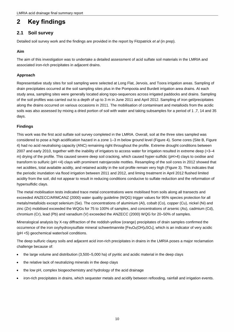
This work was the first acid sulfate soil survey completed in the LMRIA. Overall, soil at the three sites sampled was
considered to pose a high acidification hazard in a zone 1–3 m below ground level (Figure 4). Some cores (Site B, Figure
4) had no acid neutralising capacity (ANC) remaining right throughout the profile. Extreme drought conditions between
2007 and early 2010, together with the inability of irrigators to access water for irrigation resulted in extreme deep (>3–4
m) drying of the profile. This caused severe deep soil cracking, which caused hyper-sulfidic (pH>4) clays to oxidise and
transform to sulfuric (pH <4) clays with prominent natrojarosite mottles. Resampling of the soil cores in 2012 showed that
net acidities, total available acidity, and retained acidity in the soil profile remain very high (Figure 3). This indicates that
the periodic inundation via flood irrigation between 2011 and 2012, and liming treatment in April 2012 flushed limited
acidity from the soil, did not appear to result in reducing conditions conducive to sulfate reduction and the reformation of
hypersulfidic clays.
The metal mobilisation tests indicated trace metal concentrations were mobilised from soils along all transects and
exceeded ANZECC/ARMCANZ (2000) water quality guideline (WQG) trigger values for 95% species protection for all
metals/metalloids except selenium (Se). The concentrations of aluminium (Al), cobalt (Co), copper (Cu), nickel (Ni) and
zinc (Zn) mobilised exceeded the WQGs for 75 to 100% of samples, and concentrations of arsenic (As), cadmium (Cd),
chromium (Cr), lead (Pb) and vanadium (V) exceeded the ANZECC (2000) WQG for 20–50% of samples.
Mineralogical analysis by X-ray diffraction of the reddish-yellow (orange) precipitates of drain samples confirmed the
occurrence of the iron oxyhydroxysulfate mineral schwertmannite [Fe8O8(OH)6SO4], which is an indicator of very acidic
(pH <5) geochemical water/soil conditions.
The deep sulfuric clayey soils and adjacent acid iron-rich precipitates in drains in the LMRIA poses a major reclamation
challenge because of:
the large volume and distribution (3,500–5,000 ha) of pyritic and acidic material in the deep clays
the relative lack of neutralizing minerals in the deep clays
the low pH, complex biogeochemistry and hydrology of the acid drainage
iron-rich precipitates in drains, which sequester metals and acidify between reflooding, rainfall and irrigation events.
LMRIA acid drainage final summary report
11
Figure 4 pH and acid base accounting data plotted against depth for each profile collected at Long Flat in 2011 and
2012 (from Fitzpatrick et al 2013). TAA is total available acidity, Scr is chromium reducible sulphur
(measure of pyrite), RA is retained acidity (measure of minerals such as jarosite), ANC is acid neutralising
capacity (measure of carbonate), NA is the net acidity (measure of potential and severity of soil
acidification, net acidity >> 0 indicates high risk). pHw is pH in a 1:1 soil:water solution, pHINC is the pH
following an eight-week moist incubation in the laboratory, and pHox is pH following addition of hydrogen
peroxide (to accelerate oxidation).
2.2 16BAcid drainage
Detailed work undertaken and the findings are provided in the report by Leyden et al (2012) and Mettam et al (2013).
40BAims
The aims of this investigation were to provide an assessment of:
drainage water quality and volumes across the LMRIA
drainage plume water quality and behaviour following discharge to the River Murray
metal precipitates discharged with drainage water and their effect on benthic ecology.
41BApproach
Samples in the salt drains were taken weekly–fortnightly by grab sampling directly adjacent to the pump shed using a
clean plastic bucket and/or groundwater bailer. Plume sampling was conducted weekly to fortnightly onboard a 5.5-m
aluminium vessel. Surface water samples were collected by grab samples, and samples at top, middle and bottom of
water column were collected using a Van Dorn sampling unit. Temperature, pH, ORP, EC and dissolved oxygen were
measured at the time of sample collection using calibrated instruments (YSI Pro Plus multiparameter meters). All other
DS01-A: 06/11 (a)
Alkalinity or acidity
(moles H+/tonne)
-400 -200 0 200 400 600
De
pth
ra
ng
e (
cm
) 0 - 57
57 - 95
95 - 190
190 - 280
280 - 350
pH
0 2 4 6 8 10
DS01-B: 06/11 (a)
Alkalinity or acidity
(moles H+/tonne)
-200 0 200 400 600
0 - 76
76 - 190
190 - 250
250 - 290
290 - 340
pH
0 2 4 6 8 10
DS01-C: 06/11 (a)
Alkalinity or acidity
(moles H+/tonne)
-300 -150 0 150 300
0 - 65
65 - 140
140 - 200
200 - 255
255 - 340
pH
0 2 4 6 8 10
TAA
Scr
RA
ANC
NA
pHW
pHINC
pHOX
pH = 4
DS01-A: 04/12 (b)
Alkalinity or acidity
(moles H+/tonne)
-400 -200 0 200 400 600
De
pth
ra
ng
e (
cm
)
0 - 10
10 - 50
50 - 75
75 - 110
110 - 150
150 - 200
200 - 250
250 - 350
pH
0 2 4 6 8 10
DS01-B: 04/12 (b)
Alkalinity or acidity
(moles H+/tonne)
-200 0 200 400 600
0 - 10
10 - 50
50 - 90
90 - 195
195 - 245
245 - 300
pH
0 2 4 6 8 10
DS01-C: 04/12 (b)
Alkalinity or acidity
(moles H+/tonne)
-300 -150 0 150 300
0 - 10
10 - 50
50 - 110
110 - 160
160 - 215
215 - 270
270 - 330
pH
0 2 4 6 8 10
LMRIA acid drainage final summary report
12
analyses were undertaken by the Australian Water Quality Centre (AWQC) or ALS Melbourne, which are both National
Association of Testing Authorities (NATA) accredited laboratories.
42BFindings
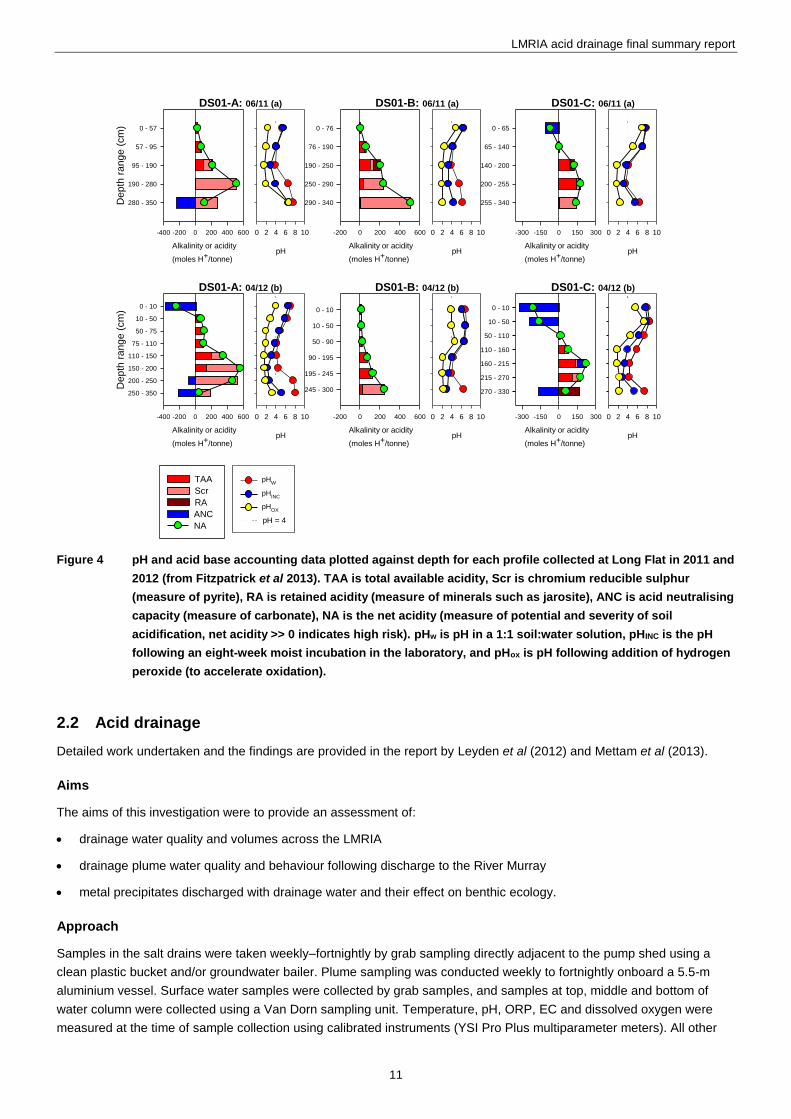
Results demonstrated that low pH and acidic conditions have persisted in the salt drains for over two years despite an
end to the drought and regular irrigation events (Figure 5). High dissolved metal levels that exceed water quality
protection guidelines also still persevere in many salt drains. A few sites have shown signs of improvement I (eg
Riverglen in Figure. 5) but in general the acidity problem is continuing throughout the LMRIA region with high severity.
Figure 5 pH in acid drainage plumes discharged from Jervois (Woods Point end) irrigation area in October 2011.
The ANZECC (2000) guideline of pH 6.5 is shown as the dash line on the pH plot.
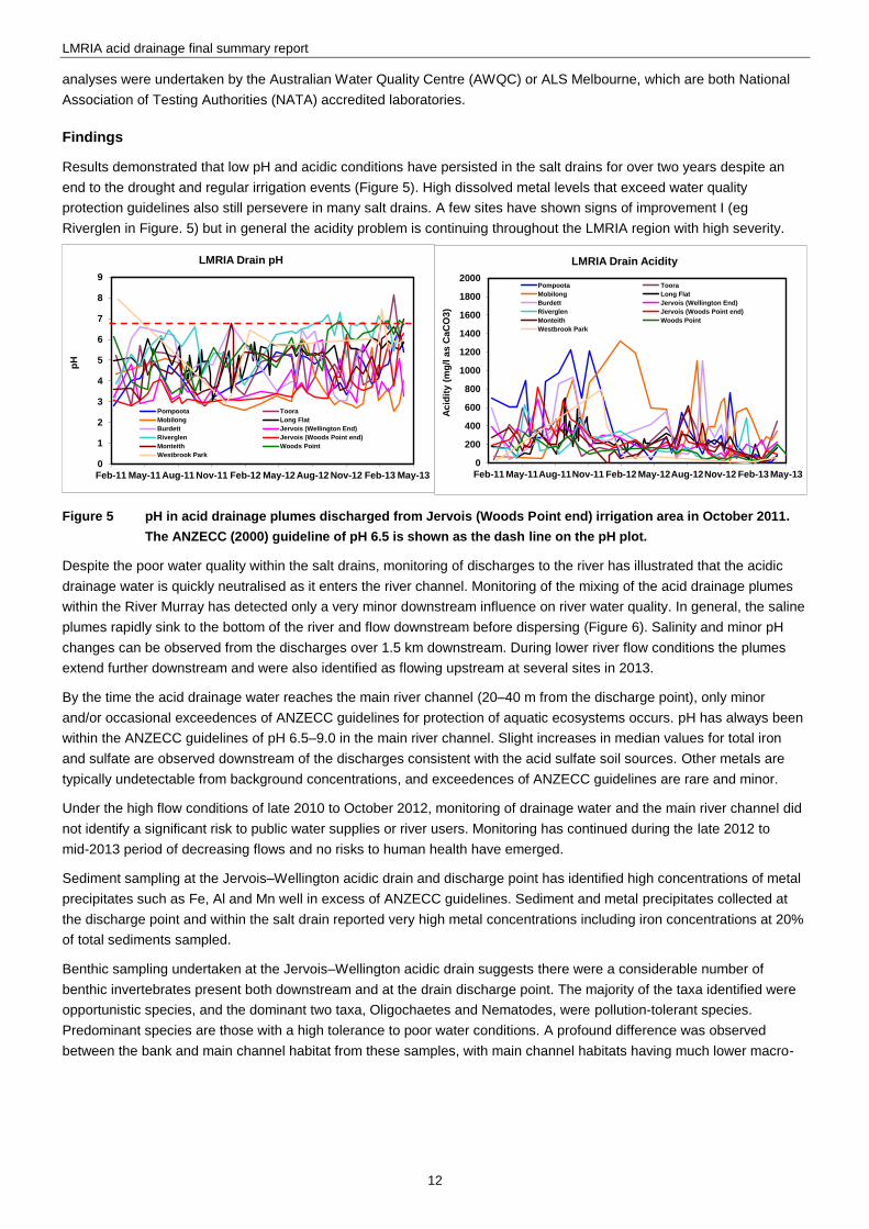
Despite the poor water quality within the salt drains, monitoring of discharges to the river has illustrated that the acidic
drainage water is quickly neutralised as it enters the river channel. Monitoring of the mixing of the acid drainage plumes
within the River Murray has detected only a very minor downstream influence on river water quality. In general, the saline
plumes rapidly sink to the bottom of the river and flow downstream before dispersing (Figure 6). Salinity and minor pH
changes can be observed from the discharges over 1.5 km downstream. During lower river flow conditions the plumes
extend further downstream and were also identified as flowing upstream at several sites in 2013.
By the time the acid drainage water reaches the main river channel (20–40 m from the discharge point), only minor
and/or occasional exceedences of ANZECC guidelines for protection of aquatic ecosystems occurs. pH has always been
within the ANZECC guidelines of pH 6.5–9.0 in the main river channel. Slight increases in median values for total iron
and sulfate are observed downstream of the discharges consistent with the acid sulfate soil sources. Other metals are
typically undetectable from background concentrations, and exceedences of ANZECC guidelines are rare and minor.
Under the high flow conditions of late 2010 to October 2012, monitoring of drainage water and the main river channel did
not identify a significant risk to public water supplies or river users. Monitoring has continued during the late 2012 to
mid-2013 period of decreasing flows and no risks to human health have emerged.
Sediment sampling at the Jervois–Wellington acidic drain and discharge point has identified high concentrations of metal
precipitates such as Fe, Al and Mn well in excess of ANZECC guidelines. Sediment and metal precipitates collected at
the discharge point and within the salt drain reported very high metal concentrations including iron concentrations at 20%
of total sediments sampled.
Benthic sampling undertaken at the Jervois–Wellington acidic drain suggests there were a considerable number of
benthic invertebrates present both downstream and at the drain discharge point. The majority of the taxa identified were
opportunistic species, and the dominant two taxa, Oligochaetes and Nematodes, were pollution-tolerant species.
Predominant species are those with a high tolerance to poor water conditions. A profound difference was observed
between the bank and main channel habitat from these samples, with main channel habitats having much lower macro-
0
1
2
3
4
5
6
7
8
9
Feb-11 May-11Aug-11 Nov-11 Feb-12 May-12Aug-12 Nov-12 Feb-13 May-13
pH
LMRIA Drain pH
Pompoota Toora
Mobilong Long Flat
Burdett Jervois (Wellington End)
Riverglen Jervois (Woods Point end)
Monteith Woods Point
Westbrook Park
0
200
400
600
800
1000
1200
1400
1600
1800
2000
Feb-11 May-11Aug-11Nov-11 Feb-12 May-12Aug-12Nov-12 Feb-13 May-13
Ac
idit
y (
mg
/l a
s C
aC
O3
)
LMRIA Drain Acidity
Pompoota Toora
Mobilong Long Flat
Burdett Jervois (Wellington End)
Riverglen Jervois (Woods Point end)
Monteith Woods Point
Westbrook Park
LMRIA acid drainage final summary report
13
invertebrate abundances, richness and evenness values. This is likely due to less food sources and habitat in the deeper
main channel sites. This sampling is preliminary and further sampling is required to confirm these preliminary findings.
It is also recommended that monitoring of salt drains and discharge events continue to enable assessment of how the
pH, acidity and metal concentrations are changing over time.
Figure 6 pH in acid drainage plumes discharged from Jervois (Woods Pt end) irrigation area in October 2011
2.3 17BMetal behaviour and speciation during mixing of acid drainage water with river water
Detailed work undertaken and the findings are provided in the report by the Simpson et al (2013)
43BAim
The aim of this investigation were to undertake a detailed assessment of acid sulfate soil materials in the LMRIA and
associated iron-rich precipitates in adjacent drains
44BApproach
Field sampling and laboratory based experiments were undertaken to provide information on the fate of acid and metals
following dilution of the drainage water with the River Murray water. The risk posed by the dissolved metals was
evaluated in relation to WQG for the protection of aquatic ecosystem health (ANZECC 2000). The major forms of metals
in the discharge mixing zone were evaluated, with particular consideration of metal complexes, colloids and precipitates,
and the kinetics that govern the formation for these phases.
Two techniques were used to provide information on the complexed and colloidal metal forms following mixing. Chelex-
labile metal measurements were used to provide information on the labile metal forms, which excludes metals strongly
complexed by naturally occurring organic ligands or colloidal forms. Labile forms include mostly free metal ions or weak
LMRIA acid drainage final summary report
14
inorganic complexes that can be considered as bioavailable. Differences in filterable concentrations for waters filtered
sequentially through 0.45-µm then 0.025-µm filters was used to provide information on colloidal metal forms.
45BFindings
18BThe dissolved concentrations of many metals greatly exceeded national water quality guidelines (ANZECC 2000). Based
on the ratios of concentrations to guideline values, Al, Co, Ni and Zn were predicted to be the metals of greatest concern.
The Mobilong site had the most acidic drainage water, and dissolved concentrations of Al, Co, Ni and Zn were 55,000
1,250, 1,300 and 1,100 µg/L, compared to WQGs of 55, 1.4, 20, and 8 µg/L (95% species protection levels, ANZECC
2000). The Mn concentrations were also high. These same metals have been previously identified as a particular concern
in relation to release due to oxidation of acid-sulfate soils in the lower River Murray region.
Simulating discharge to the River Murray, following mixing of the acidic drainage waters (pH 2–5) and River Murray water
(pH 7.8) at ratios of 1:9 (10% drainage water), the pH increased to between 7.2 and 7.7, except for the Mobilong water
which increased to pH 5.4. For 2% drainage water, the pH increased to 7.3 for the Mobilong water and to pH 7.7–7.8 for
the other waters. In the mixed waters, the decreases in dissolved Al and Fe concentrations were far greater than what
could be attributed to dilution alone (Figure 7). For Al and Fe, additional precipitation and increased adsorption of
particulates were likely to be occurring due to the increased pH.
The decreases in concentrations of the other metals (eg Mn, Figure 7) more closely matched expected trends based on
conservative dilution alone. Similar metal trends were seen for the drainage waters from all the sites. For 10% drainage
water (90% River Murray), for all drainage waters Co, Cu, Ni and Zn concentrations exceeded the water quality
guidelines, while the Mobilong Cd and Mn exceeded the guidelines. For 2% drainage water, only Co and Cu exceeded
the water quality guideline concentrations at some sites. The pH of the mixed waters was identified as the principal factor
influencing the dissolved metal concentrations.
Changes in concentrations and forms of dissolved metals during the week following mixing of drainage and River Murray
water were assessed. During this period, the pH of the mixed waters remained relatively constant, varying by up to 0.2
pH units. The concentrations of all dissolved metals decreased with time following mixing of the two waters. For Al and
Fe, there was a very large decrease in concentration (33% of initial in 24 hours) associated with the initial dilution
followed by much slower decreases with time. The concentrations of Co, Mn, Ni and Zn in the mixed waters decreased
continually with time following mixing. This is likely due to the slow aggregation of colloids that formed as the acidic water
was diluted with river water and adsorption of these metals onto newly formed solids.
Figure 7 Relationships between dilution factor and change in dissolved metal (Al, Fe, Mn) concentration. The
diagonal line in each graph indicates the concentrations that would be expected based on conservative
dilution alone. From Simpson et al (2013).
19BLarge portions of the dissolved Al and Fe existed as complexed and colloidal forms. Between 32 and 68% of the
dissolved Ni existed in non-labile complexed forms, while 95–100% of the dissolved Co, Mn and Zn were present in labile
forms. Significant changes in metal forms through time following mixing was only observed for nickel, where the degree
of complexation of Ni by organic ligands had approximately doubled after 196 hours.
When all the dissolved metals data were considered together, a majority of the metals were highly correlated and
indicated the principal factors that govern the removal of metals from mixtures of drainage water and River Murray water
were very similar, if not the same for each metal (pH, dilution and time following mixing). The mixing experiments
indicated that water quality guidelines (ANZECC 2000) would be unlikely to be exceeded in the River Murray except at
0
10
20
30
40
50
60
70
80
90
100
0 20 40 60 80 100
Mn
, , %
of
un
dil
ute
d c
on
cen
trati
on
0
10
20
30
40
50
60
70
80
90
100
0 20 40 60 80 100
Fe, , %
of
un
dil
ute
d c
on
cen
trati
on
Mobilong
Wellington
Woods Point
Long Flat
Toora
0
10
20
30
40
50
60
70
80
90
100
0 20 40 60 80 100
Al,
% o
f u
nd
ilu
ted
co
ncen
trati
on
LMRIA acid drainage final summary report
15
low dilutions (1–100 % acid drainage water). EPA field measurements were consistent with these findings and indicated
that dilution to >1% occurs in the localised mixing zone (20–40 m from discharge), before the acid drainage water
reaches the main river channel.
Low dissolved oxygen (DO) concentrations have occasionally been measured in the bottom water of River Murray.
Experiments were undertaken to assess the differences in dissolved metal concentrations when drainage and River
Murray waters were mixed under high DO (84 to 93% saturation) and low DO (16 to 22% saturation) conditions. The
concentrations of dissolved metals were generally greater in the high DO conditions, with exceptions being observed for
Al, Fe and Mn. The differences between the dissolved metal concentrations under high and low DO conditions were
generally within a factor of two. Assessments based on high DO conditions would provide a more conservative
assessment of the potential risks associated with most dissolved metals, other than Al, Fe and Mn, in the discharge
mixing zone. The higher DO conditions may have been increasing the rate of aggregation of colloidal Al, Fe and Mn,
thereby lowering the dissolved concentrations.
The bottom water of the LMRIA drains has considerable amounts of suspended materials, and was expected to contain
large amounts of metals that had precipitated from the waters over time. In bottom sediment collected from the drains,
the concentrations of total-recoverable and dilute acid-extractable As, Cd, Cu, Ni, Pb and Zn metals exceeded the
ANZECC/ARMCANZ (2000) sediment quality guideline low or high trigger values. For many metals, >50% of the total
recoverable metals were present in acid-extractable forms, indicating the metals were not so strongly bound and
potentially bioavailable.
The particulate metal forms in the drainage waters may represent a risk to the environment if discharged to the River
Murray. For several solids collected from drainage channels, the release of dissolved metals was assessed following
resuspension in River Murray water (1, 4 and 10 g/L). The acidity associated with the solids resulted in a lowering of the
water pH and increase in conductivity associated with release of ions.
In general, metals were released rapidly into the dissolved phase, after which, there was little change in the
concentrations over the four-hour duration. There was little difference in the magnitude of metal release that occurred
from the rewetting of pre-dried precipitates, indicating drying had little effect on the release of metals. The degree of Cd,
Co, Mn, Ni and Zn release was generally observed to increase in proportion to the concentration of solids. The release of
Al and Fe was greater than proportional, and this was attributed to the lower pH (greater acidity input) at higher solids
concentrations leaching Al and Fe from solids.
2.4 20BAquatic ecosystem toxicity
Detailed work undertaken and the findings are provided in the report by Adams et al (2013).
46BAims
The aims of this investigation were to:
assess the ecotoxicological risk of drainage waters following dilution and neutralisation with river water
assess risk posed to benthic organisms by the metal-rich precipitates that form as a result of these inputs and may
deposit on sediments within the river system.
47BApproach
A range of species and endpoints (eg acute lethality; chronic growth, reproduction) were considered for use in the aquatic
ecotoxicology assessment, including algae Chlorella vulgaris, duckweed Lemna minor, Cladoceran Ceriodaphnia, shrimp
Paratya australiensis, tadpoles of native frog Lymnodynastes or Littoria species, and juvenile native fish Murray Rainbow
Melanotaenia fluviatilis or Murray Cod Maccullochella peelii. From these, the most appropriate species were considered
to be the cladoceran, shrimp and native fish, based on discussions between CSIRO and EPA ecologists.
Based on the chemistry study of metal behaviour and potential impacts of acid drainage plumes (Simpson et al 2013),
three to five different drainage waters (including Mobilong and Jervois–Woods Point) were tested at different dilutions
(10%, 3%, 1%, 0.4% and 0.1%). This range is expected to capture both waters where toxic effects occur and those with
no effects occurring due to the drainage water inputs. With respect to the potential effects of the metal-rich precipitates on
LMRIA acid drainage final summary report
16
benthic organisms, the most appropriate test species were considered to be the midge Chironomus teperri in which the
test endpoints are sub-chronic (growth, emergence, survival and sex-ratios).
For each test the dissolved metal concentrations was analysed at the start, completion and during different stages of the
toxicity tests to monitor the changes in dissolved metal concentrations throughout each toxicity test. The usual water
quality measurements were also undertaken and included pH, temperature, conductivity and dissolved oxygen
concentrations.
48BFindings
For each of the acid drainage waters, the pH of the test treatments increased with decreasing dilutions of acid drainage
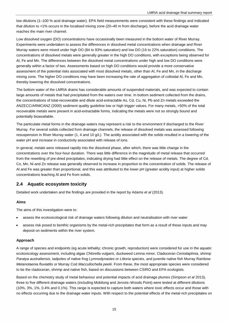
water while the conductivity decreased. The acid drainage water was toxic to aquatic organisms at most sites. Figure 8
shows the toxicity at two sites. The drainage water from the Jervois (Wellington end) site was toxic to fish at dilutions over
2% (1 part acid drainage water: 50 parts river water) and cladocerans at concentrations over 10%. The shrimp showed
higher survival rates relative to fish and cladocerans. In contrast the Jervois (Woods Point end) site was much less toxic.
The reasons for this are unclear at present as both sites had similar pH and metal concentrations.
Figure 8 Concentration-response curves showing the toxicity of acid drainage water to cladocerans, shrimp and
fish at two Jervois sites (Wellington and Woods Point). For all curves, the control response is equal to a
biological response of 100%.
As part of a CSIRO investigation, additional toxicity tests were carried out on the four acid drainage waters. Toxicity tests
included measuring inhibition in bacteria luminescence (Microtox, Vibrio fischeri), growth inhibition in the microalga
Chlorella vulgaris and growth inhibition in the macrophyte Lemna minor (duckweed). In light of the availability of
additional toxicity test results, estimated safe dilutions of acid drainage water were derived using the risk extrapolation
technique of Aldenburg and Slob (1993). This method uses No Observed Effect Concentration (NOEC) data from at least
five species from at least four different taxonomic groups and fits a log-normal or log-logistic distribution. In the ANZECC
(2000) water quality guidelines, EC10 (concentration of drainage to cause 10% effect/inhibition, or NOEC) data from
preferably eight species are fitted to a Burr Type III distribution and the concentration of toxicant/effluent that will protect a
defined proportion (eg 90%, 95%, 99%) of species in the receiving environment is derived.
The translation of the laboratory derived ecotoxicity results to the field setting requires further consideration and research.
Monitoring of the benthic species community composition in the Jervois (Wellington) discharge zone by the EPA (see
Mettam et al 2013), showed comparable macro-invertebrate abundance and species diversity to an upstream (control)
site. This is in alignment with CSIRO results that acute toxicity of the acid drainage water is unlikely after more than a
1–10% dilution. No fish or other species kills have been observed in the vicinity of the LMRIA discharges or lower
reaches of the river which is consistent with the CSIRO findings. The potential sublethal ecotoxicity effects inside and
outside the immediate mixing zone require further assessment. The use of field mesocosm (cages with test species in)
0
20
40
60
80
100
120
140
0.1 1 10 100
Bio
logi
cal
Re
spo
nse
(%
of
Co
ntr
ol)
Drainage Water (%)
Cladoceran immobilisation
Cladoceran reproduction
Shrimp survival
Fish survival
0
20
40
60
80
100
120
0.1 1 10 100
Bio
logi
cal
Re
spo
nse
(%
of
Co
ntr
ol)
Drainage Water (%)
Cladoceran immobilisation
Cladoceran reproduction
Shrimp survival
Fish survival
Jervois (Wellington)
Mobiling
Jervois (Woods Point)
LMRIA acid drainage final summary report
17
experiments is one option that could be used. Further field sampling from Wellington and other drains is also required to
better assess potential risks to ecosystems.
2.5 21BGeochemical modelling of river water quality
Detailed work undertaken and the findings are provided in the report by the Mosley and Daly (2013).
49BAims
The aims of this investigation were to:
construct a 3D hydrodynamic and geochemical model (ELCOM-CAEDYM platform) to simulate the impact of acid
drainage discharges from the LMRIA on the water quality of the River Murray
Assess the model performance in comparison to another geochemical code (PHREEQC) and observed water quality
data
Undertake simulations of lower flow conditions to assess risk to the aquatic ecosystem and beneficial uses of the
river, in particular drinking water supplies.
50BApproach
To assess the magnitude and nature of potential water quality risks, a 3-dimensional (3D) hydrodynamic and
geochemical model (ELCOM-CAEDYM) was constructed.
An ELCOM-CAEDYM model grid was constructed for the 84-km length of the River Murray between Mannum and
Wellington. The model grid was straightened to improve model efficiency and achieve suitable runtimes ( 25:1) for full
3D geochemical simulation. The key inputs for the model were the upstream flow and water quality, LMRIA drainage
pump flow and water quality, and meteorological data.
Initial testing of the ELCOM-CAEDYM model was undertaken against another geochemical code, PHREEQC.
51BFindings
The ELCOM-CAEDYM model generally validated well (<3% difference for key parameters such as pH and dissolved
inorganic carbon) against PHREEQC, particularly given the fundamental differences between the two codes.
Model performance checking using the full model domain between Mannum to Wellington was undertaken using a five-
month period from November 2011 to April 2012. The model gave satisfactory results against measured parameters at
the Tailem Bend water offtake and was able to represent widely varying concentrations (see Figure 9 for manganese).
The general behaviour of the measured plume was satisfactorily represented in the model. Similar to measured plume
behaviour shown in Figure 6, the plume sinks to the bottom of the river near the discharge zone and travels downstream
with observed effects still remaining after 1–2 km.
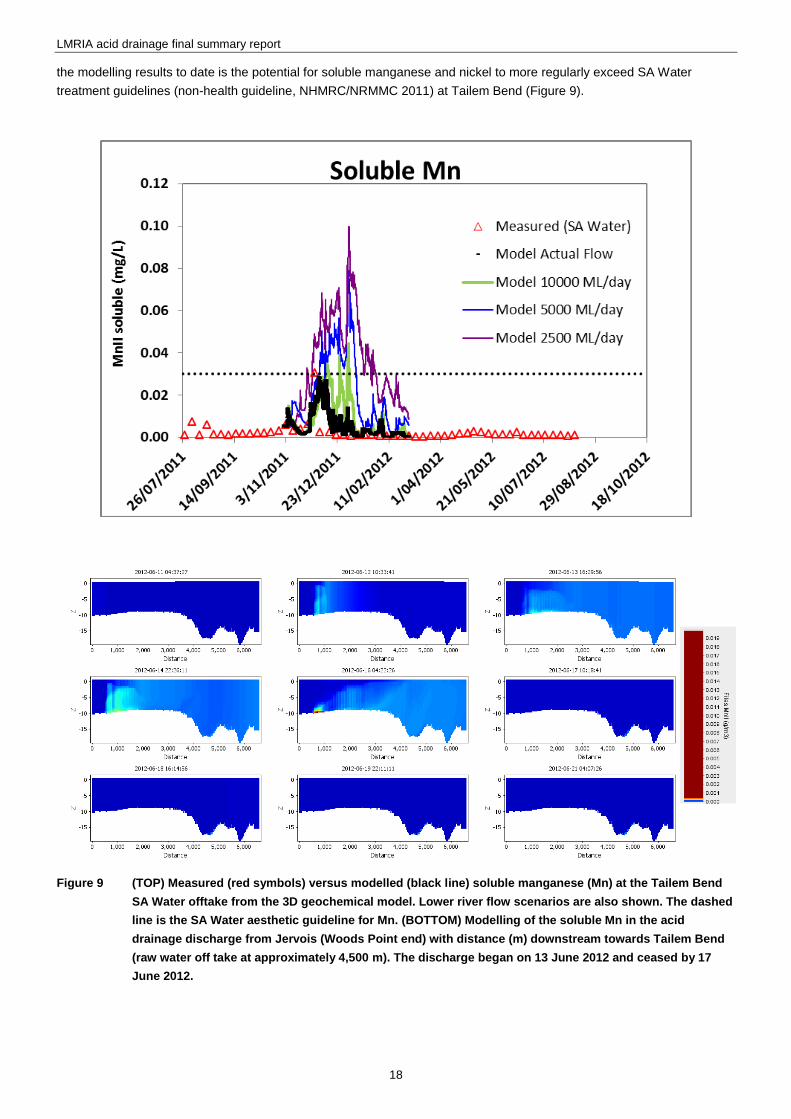
Lower flow conditions 1,000–10,000 ML/day were simulated in the model. Results indicated that water quality risks to the
main channel could increase if the flow over Lock 1 reduced below 5,000 ML/day. The main issue of concern identified in
LMRIA acid drainage final summary report
18
the modelling results to date is the potential for soluble manganese and nickel to more regularly exceed SA Water
treatment guidelines (non-health guideline, NHMRC/NRMMC 2011) at Tailem Bend (Figure 9).
Figure 9 (TOP) Measured (red symbols) versus modelled (black line) soluble manganese (Mn) at the Tailem Bend
SA Water offtake from the 3D geochemical model. Lower river flow scenarios are also shown. The dashed
line is the SA Water aesthetic guideline for Mn. (BOTTOM) Modelling of the soluble Mn in the acid
drainage discharge from Jervois (Woods Point end) with distance (m) downstream towards Tailem Bend
(raw water off take at approximately 4,500 m). The discharge began on 13 June 2012 and ceased by 17
June 2012.
LMRIA acid drainage final summary report
19
2.6 22BScoping and trialling of remediation options
Detailed work undertaken and the findings are provided in the report by the Palmer et al (2013)
52BAim
The aim of this investigation was to assess potential mitigation strategies and trial options to reduce the potential risks
that acidic drainage water poses to the water quality and environmental values of the Lower River Murray.
53BApproach
Following scoping of a range of potential options the following four remediation strategies were trialled:
controlled flood irrigation to flush acidity from the soil profile
surface limestone application followed by irrigation
lime dosing drain water prior to discharge to the river
subsurface injection of a hydrated lime and limestone slurry via a mole plough.
54BFindings
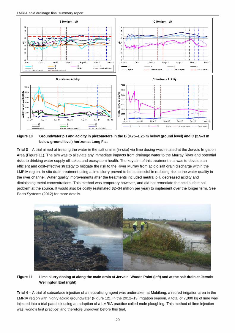
Trials 1 and 2 – A trial site to investigate whether flood irrigation and lime spreading could combat acidic groundwater
conditions, was established on an irrigation bay in the Long Flat Irrigation Area, one of 13 acidic areas in the LMRIA
region. A series of piezometers at depths ranging from 0.3 to 3 m below ground level were installed to assess and
monitor the groundwater during the trial. Three irrigation events were initially undertaken followed by surface application
of lime totalling 60 tonnes in conjunction with two additional irrigation events.
Irrigation, both with or without surface limestone application, does not provide an immediate improvement in soil and
groundwater acidity and metal levels. However, improvements in groundwater quality [increase in pH; reduction in
salinity, total acidity and metal levels; appearance of alkalinity; and trend toward reducing conditions (required for sulfate
and Fe reduction which can generate alkalinity)], and water quality in the associated drains have been observed over
time at the trial site (see pH and acidity trends on Figure 10). This suggests that sites under active irrigation in the LMtRIA
are heading towards more healthy soil and groundwater conditions.
LMRIA acid drainage final summary report
20
Figure 10 Groundwater pH and acidity in piezometers in the B (0.75–1.25 m below ground level) and C (2.5–3 m
below ground level) horizon at Long Flat
Trial 3 – A trial aimed at treating the water in the salt drains (in-situ) via lime dosing was initiated at the Jervois Irrigation
Area (Figure 11). The aim was to alleviate any immediate impacts from drainage water to the Murray River and potential
risks to drinking water supply off-takes and ecosystem health. The key aim of this treatment trial was to develop an
efficient and cost-effective strategy to mitigate the risk to the River Murray from acidic salt drain discharge within the
LMRIA region. In-situ drain treatment using a lime slurry proved to be successful in reducing risk to the water quality in
the river channel. Water quality improvements after the treatments included neutral pH, decreased acidity and
diminishing metal concentrations. This method was temporary however, and did not remediate the acid sulfate soil
problem at the source. It would also be costly (estimated $2–$4 million per year) to implement over the longer term. See
Earth Systems (2012) for more details.
Figure 11 Lime slurry dosing at along the main drain at Jervois–Woods Point (left) and at the salt drain at Jervois–
Wellington End (right)
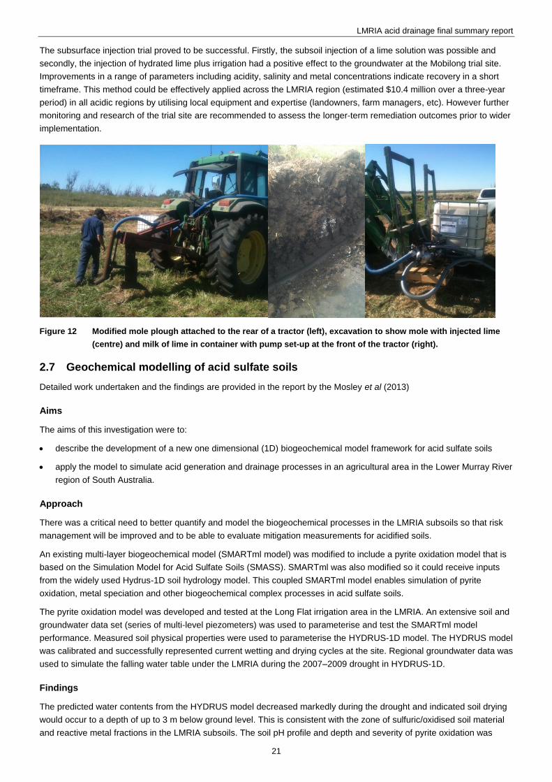
Trial 4 – A trial of subsurface injection of a neutralising agent was undertaken at Mobilong, a retired irrigation area in the
LMRIA region with highly acidic groundwater (Figure 12). In the 2012–13 irrigation season, a total of 7,000 kg of lime was
injected into a trial paddock using an adaption of a LMRIA practice called mole ploughing. This method of lime injection
was ‘world’s first practice’ and therefore unproven before this trial.
LMRIA acid drainage final summary report
21
The subsurface injection trial proved to be successful. Firstly, the subsoil injection of a lime solution was possible and
secondly, the injection of hydrated lime plus irrigation had a positive effect to the groundwater at the Mobilong trial site.
Improvements in a range of parameters including acidity, salinity and metal concentrations indicate recovery in a short
timeframe. This method could be effectively applied across the LMRIA region (estimated $10.4 million over a three-year
period) in all acidic regions by utilising local equipment and expertise (landowners, farm managers, etc). However further
monitoring and research of the trial site are recommended to assess the longer-term remediation outcomes prior to wider
implementation.
Figure 12 Modified mole plough attached to the rear of a tractor (left), excavation to show mole with injected lime
(centre) and milk of lime in container with pump set-up at the front of the tractor (right).
2.7 23BGeochemical modelling of acid sulfate soils
Detailed work undertaken and the findings are provided in the report by the Mosley et al (2013)
55BAims
The aims of this investigation were to:
describe the development of a new one dimensional (1D) biogeochemical model framework for acid sulfate soils
apply the model to simulate acid generation and drainage processes in an agricultural area in the Lower Murray River
region of South Australia.
56BApproach
There was a critical need to better quantify and model the biogeochemical processes in the LMRIA subsoils so that risk
management will be improved and to be able to evaluate mitigation measurements for acidified soils.
An existing multi-layer biogeochemical model (SMARTml model) was modified to include a pyrite oxidation model that is
based on the Simulation Model for Acid Sulfate Soils (SMASS). SMARTml was also modified so it could receive inputs
from the widely used Hydrus-1D soil hydrology model. This coupled SMARTml model enables simulation of pyrite
oxidation, metal speciation and other biogeochemical complex processes in acid sulfate soils.
The pyrite oxidation model was developed and tested at the Long Flat irrigation area in the LMRIA. An extensive soil and
groundwater data set (series of multi-level piezometers) was used to parameterise and test the SMARTml model
performance. Measured soil physical properties were used to parameterise the HYDRUS-1D model. The HYDRUS model
was calibrated and successfully represented current wetting and drying cycles at the site. Regional groundwater data was
used to simulate the falling water table under the LMRIA during the 2007–2009 drought in HYDRUS-1D.
57BFindings
The predicted water contents from the HYDRUS model decreased markedly during the drought and indicated soil drying
would occur to a depth of up to 3 m below ground level. This is consistent with the zone of sulfuric/oxidised soil material
and reactive metal fractions in the LMRIA subsoils. The soil pH profile and depth and severity of pyrite oxidation was
LMRIA acid drainage final summary report
22
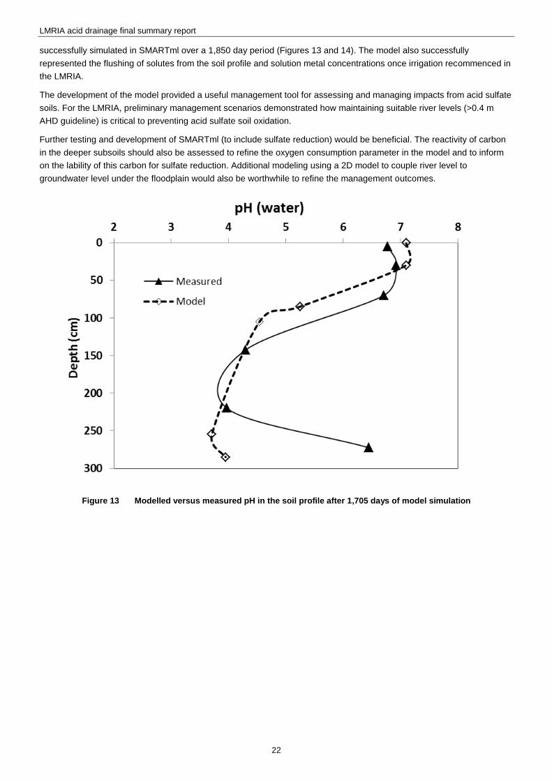
successfully simulated in SMARTml over a 1,850 day period (Figures 13 and 14). The model also successfully
represented the flushing of solutes from the soil profile and solution metal concentrations once irrigation recommenced in
the LMRIA.
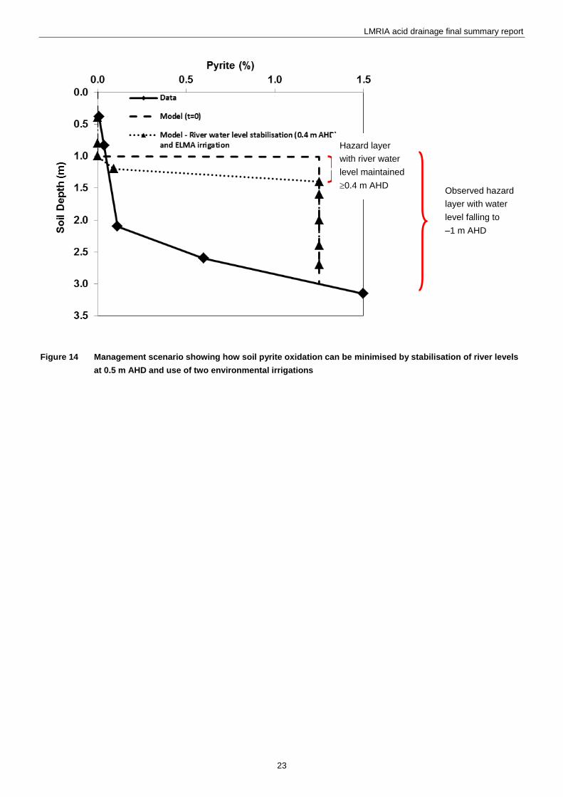
The development of the model provided a useful management tool for assessing and managing impacts from acid sulfate
soils. For the LMRIA, preliminary management scenarios demonstrated how maintaining suitable river levels (>0.4 m
AHD guideline) is critical to preventing acid sulfate soil oxidation.
Further testing and development of SMARTml (to include sulfate reduction) would be beneficial. The reactivity of carbon
in the deeper subsoils should also be assessed to refine the oxygen consumption parameter in the model and to inform
on the lability of this carbon for sulfate reduction. Additional modeling using a 2D model to couple river level to
groundwater level under the floodplain would also be worthwhile to refine the management outcomes.
Figure 13 Modelled versus measured pH in the soil profile after 1,705 days of model simulation
LMRIA acid drainage final summary report
23
5B
Figure 14 Management scenario showing how soil pyrite oxidation can be minimised by stabilisation of river levels
at 0.5 m AHD and use of two environmental irrigations
Hazard layer
with river water
level maintained
0.4 m AHD Observed hazard
layer with water
level falling to
–1 m AHD
LMRIA acid drainage final summary report
24
3 6BCommunications and contingency plan
3.1 24BCommunications
Various stakeholders were consulted during the project. Close consultation within the EPA Water Quality Branch and
LMRIA Acid Drainage Interagency Working Group comprising representatives (individuals listed inside front cover of
report) from the Department of Environmental, Water and Natural Resources (DEWNR), SA Water, the South Australian
Murray–Darling Basin Natural Resource Management Board (SAMDB NRM Board), Department of Health (DoH),
Primary Industries and Regions SA (PIRSA), and the Murray–Darling Basin Authority (MDBA).
Presentations and field visits with various local and national groups occurred to highlight and discuss the issue. These
included the State Natural Resources Committee, National Committee for Acid Sulfate Soils (NATCASS), and SAMDB
NRM board, and the Murray–Darling Basin Authority.
Regular meetings with LMRIA irrigators were also held, many through the Sustainable Soils Working Group, chaired by
the former South Australian Premier Dean Brown.
3.2 25BContingency plan
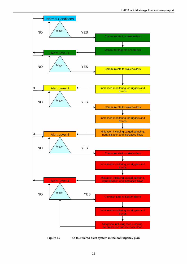
As a precautionary measure, a draft contingency plan was developed to ensure any risks to water quality in the River
Murray were identified as early as possible and managed appropriately. The document uses a four-tiered alert system
which is implemented following exceedences of trigger level (Figure 15). Each tier has a set of associated actions for
communication, monitoring and management in addition to actions for progressing to the next level, should trigger levels
be exceeded.
The use of this alert system is designed to assist in communicating risks to government agencies more efficiently. The
higher the alert level, the more monitoring, communication and mitigation actions should occur. Each alert level has a set
of actions associated with it and then additional actions, including progress to the next alert level, should trigger levels be
exceeded.
Exceedence of a particular trigger level does not result in the automatic increase in alert levels. The exceedence of
multiple triggers and clear indication that the LMRIA acid drainage discharges are responsible for these exceedences will
generally be required to raise the alert level. However, exceedence of any health-based guidelines that pose a high risk
to water supplies will automatically trigger alert level 4.
Any decision to proceed to a higher alert level is upon agreement of the LMRIA interagency working group.
The alert level has remained green for most of 2013–2013 (lowest risk level) with only minor and/or temporary
exceedences observed.
LMRIA acid drainage final summary report
25
Figure 15 The four-tiered alert system in the contingency plan
Alert Level 4
Trigger NO YES
Alert Level 3
Trigger NO YES
Alert Level 2
Trigger NO YES
Alert Level 1
Trigger NO YES
Normal Conditions
Trigger NO YES
Communicate to stakeholders
Monitor for triggers and trends
Increased monitoring for triggers and trends
Mitigation including staged pumping, neutralisation and increased flows
Communicate to stakeholders
Communicate to Stakeholders
Mitigation including stop pumping, neutralisation and increase flows
Communicate to stakeholders
Increased monitoring for triggers and trends
Communicate to stakeholders
Increased monitoring for triggers and trends
Increased monitoring for triggers and trends
Mitigation including staged pumping, neutralisation and increased flows
LMRIA acid drainage final summary report
26
4 7BManagement implications
4.1 26BIrrigators
Irrigation and farming activities have been able to continue relatively unhindered in the LMRIA to date due to the (a)
operation of effective drainage system, and (b) the LMRIA topsoil where pasture/crop roots present being
uncontaminated/non-acidic. It should be noted that any cessation of drainage would cause large agricultural and socio-
economic impacts as the saline, and now acidic, water tables would rise to the surface, and contaminate and backflood
pastures.
The following general recommendations were made to irrigators in 2011 and are still current:
Understand what is happening on your farm—undertake visual observations and test the pH levels in your drainage
water and soil.
Ensure salt drains, reuse drains and pumps are operating efficiently to keep the acidic groundwater table below the
root zone (>0.5 m below ground level) where practical.
Provided drainage is adequate, irrigation should be beneficial as this will provide acid-neutralising/alkalinity, push
acid out of the root zone, and re-establish saturated conditions in the soil.
Ensure that livestock are kept away from areas containing acid drainage water. If animals come into contact with acid
drainage water, rinse them off. If they fall ill, call for veterinary advice.
Where practical, keep acid drainage water away from metal and masonry infrastructure.
4.2 27BDrinking water supplies
To date the risks to raw water before treatment for drinking water supplies have been minor with no exceedences of
health guidelines (NHMRC/NRMMC 2011). Modelling suggests low risks may continue under lower flow conditions
however given the uncertainties it is considered prudent to continue close monitoring and evaluation of this. SA Water
has additional treatment options available that may be employed to manage any future manganese exceedences in
particular.
4.3 28BAquatic ecosystems
The results suggest lethal toxicity from the LMRIA acid drainage discharges is unlikely except perhaps in a very localised
area (5–10 m from discharge point). No fish or other species kills have been observed in the vicinity of the LMRIA
discharges, or lower reaches of the river, which is consistent with the CSIRO findings. Preliminary EPA monitoring has
found similar diversity and abundance of benthic macro-invertebrates in the Jervois (Wellington end) discharge zone
compared to upstream control sites (Mettam et al 2013). Sub-lethal toxicity could potentially occur from the acid drainage
discharges and further field experiments, and monitoring is required to assess this.
4.4 29BLearnings for future
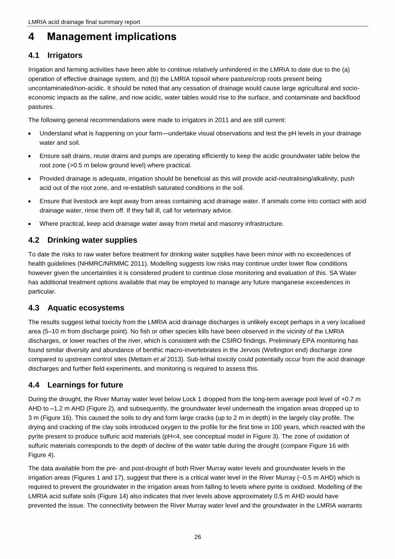
During the drought, the River Murray water level below Lock 1 dropped from the long-term average pool level of +0.7 m
AHD to –1.2 m AHD (Figure 2), and subsequently, the groundwater level underneath the irrigation areas dropped up to
3 m (Figure 16). This caused the soils to dry and form large cracks (up to 2 m in depth) in the largely clay profile. The
drying and cracking of the clay soils introduced oxygen to the profile for the first time in 100 years, which reacted with the
pyrite present to produce sulfuric acid materials (pH<4, see conceptual model in Figure 3). The zone of oxidation of
sulfuric materials corresponds to the depth of decline of the water table during the drought (compare Figure 16 with
Figure 4).
The data available from the pre- and post-drought of both River Murray water levels and groundwater levels in the
irrigation areas (Figures 1 and 17), suggest that there is a critical water level in the River Murray (~0.5 m AHD) which is
required to prevent the groundwater in the irrigation areas from falling to levels where pyrite is oxidised. Modelling of the
LMRIA acid sulfate soils (Figure 14) also indicates that river levels above approximately 0.5 m AHD would have
prevented the issue. The connectivity between the River Murray water level and the groundwater in the LMRIA warrants
LMRIA acid drainage final summary report
27
further research and modelling, to better understand the hydrological processes involved. Prevention is the preferred
approach for managing acid sulfate soils as the findings of the studies attest.
Figure 16 Groundwater level at Mobilong and Mypolonga from 2002 to 2012. This graph clearly illustrates that the
groundwater level in the irrigation areas begins to drop disproportionately once the water level in the
River Murray drops below 0.5 m AHD.
LMRIA acid drainage final summary report
28
5 8BConclusion
During the extreme drought (2007–10), severe soil acidification occurred in the LMRIA due to falling river and ground
water levels, and the deep drying out and cracking of clay soils. Sulfuric (pH<4) soil layers are present 1–3 m below
ground level and are persisting over time. An estimated 3,300 ha of land acidified and acid (pH 2–5) drainage discharges
occurred from 14 drainage pumps. Low pH and high acidity has persisted in these drainage discharges after over the 2.5
years of monitoring. High soluble metal levels are present in the undiluted drain water which exceed guidelines for
protection of aquatic ecosystems and drinking water supplies.
Monitoring of the discharge zone in the River Murray shows that the acid drainage water is quickly neutralised (pH>6.5)
with precipitation of solid metal phases occurring before entering the main river channel. However detectable impacts of
the acid drainage discharges occurs over 1.5 km downstream. Laboratory experiments were consistent with the field
findings and showed that removal of Al and Fe is rapid. The formation and aggregation of metal colloids as the pH is
neutralised is a key driver for removal of soluble metals.
Ecotoxicity experiments showed mixed toxicity for different species and sites. Generally fish and cladocerans were most
sensitive to the acid drainage but acute toxicity of the acid drainage water is unlikely after more than a 1–10% dilution
(achieved within 5–10 m of the mixing of drainage water in the river). No fish or other species kills have been observed in
the vicinity of the LMRIA discharges or lower reaches of the river which is consistent with the CSIRO findings. Some sites
showed much less toxicity (Jervois–Woods Point end) relative to other sites (Jervois–Wellington end) despite having
similar pH, salinity and metal concentrations. Further work is required to understand the factors causing toxicity and
extend the laboratory experiments to the field situation.
A 3D hydrodynamic and river water quality model was developed for the region between Mannum and Wellington where
the LMRIA acid drainage discharges occurred. The model gave acceptable performance against measured water quality
results for a five- month testing period. The potential for soluble manganese to exceed aesthetic guidelines for drinking
water is the main issue of concern arising from the modelling.
Various trials of remediation options were conducted. Drain treatment via lime slurry dosing produced neutral discharge
water with low metal concentrations. Management options such as irrigation and lime spreading resulted in slow
improvements in groundwater quality. The injection of lime via a mole plough appeared to speed the remediation process
and could be a viable supplementary management technique.
It is recommended that monitoring of the river water quality and acid drainage continue and that treatment commences to
minimise aquatic ecosystem risks. This is a critical support function to implement the contingency plan to protect drinking
water supplies, recreational users and ecosystem health.
LMRIA acid drainage final summary report
29
6 9BRecommendations
Further assessment of ecotoxicity should occur as a matter of urgency. This should involve more field assessments
of the aquatic ecology in the LMRIA drain discharge zones and in-situ ecotoxicity experiments.
Continue water quality monitoring of acid drainage water across the LMRIA to assess changes over time in the
drainage water returned to the river. This is important to assess if recovery is occurring and to inform on river risks.
Continue to monitor acid drainage plumes discharged to the River Murray as this is particularly important if low river
flows occur.
Continue ambient river water quality monitoring of parameters relevant to the acid sulfate issue at Mannum, Murray
Bridge and Tailem Bend.
Continuation of funding of loggers on drainage pumps to provide data on volumes and salinity of acid drainage
returned to the river. This is required for modelling purposes.
Continue monitoring program for shallow ground water at the Long Flat trial site.
Review long term monitoring of deeper groundwater at Mobilong and Mypolonga sites to ensure dataset is
maintained prior to and during any future droughts.
Undertake further mole plough injection trials to assess whether the results can be replicated at other irrigation areas.
Undertake an annual resampling of soil from the three previously surveyed sites to assess change in acid-base
characteristics over time and whether neutralisation is occurring.
Ongoing implementation of the contingency plan to protect water supplies and aquatic ecosystems.
Ongoing development and testing of the ELCOM-CAEDYM geochemical model to assess river water quality risks.
Testing of the model under low flows is critical.
The river level should be maintained no lower than 0.4–0.5 m AHD to prevent reoccurrence of this issue and potential
movement of the current acidic groundwater into the river.
Construct a 2D or 3D floodplain hydrology model (eg using Hyrdus 2D/3D) to better understand linkages between the
LMRIA floodplain hydrology with the river hydrology. Coupling of a geochemical/acid sulfate soil model to the
hydrology model would be beneficial.
LMRIA acid drainage final summary report
30
7 10BReferences
Adams MS, Simpson SL, Kumar A, Doan H, Gonzago D, Jarolimek CV and King J 2013, Ecotoxicological assessment of
acid drainage plumes from the LMRIA being discharged to the Lower Murray, Water for a Healthy Country Flagship
Report, CSIRO, Australia, viewed 29 July, 2014, www.epa.sa.gov.au/xstd_files/Water/Report/csiro_acid_ecotoxicity.pdf
Aldenburg T and Slob W 1993, ‘Confidence limits for hazardous concentrations based on logistically distributed NOEC
toxicity data‘, Ecotoxicological and Environmental Safety, 25:48–63.
ANZECC/ARMCANZ 2000, Australia and New Zealand Guidelines for Fresh and Marine Water Quality, Australian and
New Zealand Environment and Conservation Council, and Agriculture and Resource Management Council of Australia
and New Zealand, Canberra, ACT, Australia.
Fitzpatrick RW, Shand P, Simpson S, Grocke S, Raven M, Baker AKM, Mosley LM and Self PG in prep, Assessment of
re-flooded Acid Sulfate Soil environments at Long Flat, Jervois, Toora and Pompoota in the Lower Murray Reclaimed
Irrigation Area (LMRIA), CSIRO Land and Water Science Report.
Leyden E, Palmer D, Scott P, Zammit B and Mosley L 2012, Lower Murray River Irrigated Area Acidification Risk Project:
Preliminary monitoring report 2011–12, Environment Protection Authority, Adelaide, viewed 29 July 2014,
www.epa.sa.gov.au/xstd_files/Water/Report/Preliminary%20Report_LMRIA_Final.pdf
Mettam P, Mosley L, Palmer D, Leyden E, Scott P, Cummings C and Zammit B 2013, Lower Murray Reclaimed Irrigation
Area (LMRIA) acidification risk project: Final monitoring report 2013, Environment Protection Authority, Adelaide, viewed
29 July 2014, www.epa.sa.gov.au/xstd_files/Water/Report/lmria_acid_finalreport.pdf
Mosley L and Fleming N 2010, ‘Pollutant Loads returned to the Lower Murray River from flood-irrigated agriculture’,
Water Air and Soil Pollution, 211:475–487.
Mosley LM and Daly R 2013, Modelling of acid drainage discharges from the Lower Murray Reclaimed Irrigation Area
(LMRIA) to the Lower River Murray, Environment Protection Authority, Adelaide, viewed 29 July 2014,
www.epa.sa.gov.au/xstd_files/Water/Report/lmria_acid_modelling.pdf
Mosley LM, Fitzpatrick R and Groenenberg BJ (2013), A biogeochemical model for assessing and managing acid sulfate
soils in the Lower Murray region of South Australia, Environment Protection Authority, Adelaide, viewed 29 July 2014,
www.epa.sa.gov.au/xstd_files/Water/Report/lmria_acid_biogeochemical.pdf
NHMRC/NRMMC 2011, Australian Drinking Water Guidelines Paper 6 National Water Quality Management Strategy,
National Health and Medical Research Council and National Resource Management Ministerial Council, Commonwealth
of Australia, Canberra.
Palmer D, Leyden E, Fogg M, Mettam P, Fradley K and Mosley LM 2013, Lower Murray Reclaimed Irrigation Area
(LMRIA) acidification risk project: scoping and trialling of remediation options, Environment Protection Authority,
Adelaide, viewed 29 July 2014, www.epa.sa.gov.au/xstd_files/Water/Report/lmria_acid_scoping.pdf
Simpson SL, Vardenega C, Jarolimek CV and Angel BA 2013, Behaviour and potential impacts of acid drainage plumes
being discharged to the Lower Murray, Water for a Healthy Country Flagship Report, CSIRO, Australia, viewed 29 July
2014, www.epa.sa.gov.au/xstd_files/Water/Report/csiro_acid_behaviour.pdf


