This article was downloaded by: [Universitat Politècnica de València]On: 24 October 2014, At: 09:34Publisher: RoutledgeInforma Ltd Registered in England and Wales Registered Number: 1072954 Registered office: MortimerHouse, 37-41 Mortimer Street, London W1T 3JH, UK
Norsk Geografisk Tidsskrift - Norwegian Journal ofGeographyPublication details, including instructions for authors and subscription information:http://www.tandfonline.com/loi/sgeo20
Landscape as an arena for applied environmentalstudiesLouise Simonsson aa Department of Earth Sciences, University of Uppsala , Villavagen , SE-752 32 , SwedenE-mail:Published online: 28 Jan 2014.
To cite this article: Louise Simonsson (2003) Landscape as an arena for applied environmental studies, Norsk GeografiskTidsskrift - Norwegian Journal of Geography, 57:1, 40-48, DOI: 10.1080/00291950310000811
To link to this article: http://dx.doi.org/10.1080/00291950310000811
PLEASE SCROLL DOWN FOR ARTICLE
Taylor & Francis makes every effort to ensure the accuracy of all the information (the “Content”) containedin the publications on our platform. However, Taylor & Francis, our agents, and our licensors make norepresentations or warranties whatsoever as to the accuracy, completeness, or suitability for any purpose ofthe Content. Any opinions and views expressed in this publication are the opinions and views of the authors,and are not the views of or endorsed by Taylor & Francis. The accuracy of the Content should not be reliedupon and should be independently verified with primary sources of information. Taylor and Francis shallnot be liable for any losses, actions, claims, proceedings, demands, costs, expenses, damages, and otherliabilities whatsoever or howsoever caused arising directly or indirectly in connection with, in relation to orarising out of the use of the Content.
This article may be used for research, teaching, and private study purposes. Any substantial or systematicreproduction, redistribution, reselling, loan, sub-licensing, systematic supply, or distribution in anyform to anyone is expressly forbidden. Terms & Conditions of access and use can be found at http://www.tandfonline.com/page/terms-and-conditions
Norsk G
eograji.1k Tid
sskriji-N
orvoegian Journal of' Geography V
ol. 57,40--48. Oslo. ISSN
0029-1951
Landscape as an arena for applied environm
ental studies
I.OliiS
L S
IMO
NS
SO
N
Sim
on
"on
. L 2tK
U. L
andscape as an arena for applied environmental studies. N
orsk GeoK
rafisk Tidsskriji-N
orweK
ian Journal of
(;,·ographl· Vol. 57 . ..\t}-4X
. Oslo. IS
SN
1Xl29-1951.
The concept o
f lancbcapc is discussed in relation to environmental studies and landscape assessm
ents. It is argued that the separation of. fam
bcape nlto natural and ~:ufturaf has hampered m
terd"c1phnary syntheses and understandings of com
plex ecological relatiO
nships. The Im
portance of per>pect1vc and v
arym
gw
ays of v
~ewmg and thus assessing the landscape is em
phasized. It is argued that the lack of ~mde~standmg of landscape as a hohsll<.: term
, encompassing both m
aterial and intangible factors, has hindered ~u~tatnah~e ,oJutJO
O\. tn
~nvtronm~ntal ~anagcment. In res~arch carried out in Tanzania, m
aps and map-m
aking have been tested as a tool m
comm
un1cat1on and diSCUSSI<lll to reveal and V
ISualize intangible factors alongside quantitative information.
Keyw
ords: t'lll'ironmental m
anagement, interdisciplinary studies, landscape, m
appinp,, Tanzania
1-<mi.H' Simon.1.w
m.
Pm
Kranm
u· .fiJr Applied E
nvironmm
tal Impact A
ssessme/ll,
Departm
ent of E
arth Sciences U
niversity of
Upf'sala, VdhH•ii~en If>, S
E-7
52
3f> Upp.m
la. Swt~den. £-mail: louise.sim
onsson@;.:eo.uu.sl'
'
Introduction
Landscape is a w
ord that evokes feelings in most people, has
an air of m
ystique and contains a great deal of sym
bolism.
Yet it is a concept that is seldom
fully utilized. This m
ay be because it
is used by
so many and for so m
any different purposes,
How
ever, O
lwig
(1993) argues
against the
elimination o
f such polyvalent words and their replacem
ent by supposedly m
ore neutral, univalent concepts. Still, w
hen a landscape is assessed for practical environm
ental projects or
planning, it is
the visual, rational, quantifiable param
eters that receive the m
ost attention. Therefore, there is a need for
a com
mon
arena and
a practical,
useful concept
for environm
ental studies where m
any different disciplines and levels o
f expertise are involved, and where the term
inology and technical language differ w
idely. T
here is some resistance tow
ards words and concepts that
are com
plex and
complicate
the com
partmentalization
of
thought. Often people think in term
s of opposites, at least in
western society. N
ature and culture are examples o
f such a dichotom
y. When 'natural' is perceived as pure, an ideal, that
humankind and its techniques have desecrated, then virgin
land or w
ilderness arc term
s used w
here hum
ans are not recognized as a part o
f nature and the environment (S
oper 1995, A
dmns &
McS
hane 1996, Darier 1999). N
evertheless, changes in subsistence strategies, dem
ography or perception
have, through time, resulted in both intended and unintended
modification o
f the global environment (C
rumley 1994). A
n exam
ple from T
anzania is given by Schm
idt ( 1997), who has
shown
that cultural
perceptions have
affected landscape
managem
ent over
the last
2500 years
in the
Usam
bara M
ountains area. D
espite a widely accepted construction o
f a eo-evolving past, w
estern scicn<.:c has, since the Enlightenm
ent, largely c~l~<.:eptualized natural and social phenom
ena as being of a
dttferent order, as a priori separate. M
any scientists break dow
n their consideration of the environm
ent into 'natural' form
s and processes (involving plants, animals, soils, w
ater,
C\ Taylor &
Francis ~
T•y
lorf.fr•m
iiCro
llp
etc.) as if uninftuenced by people and society, and anthropic factors .<Sope.r 1995 ). It is assum
ed that 'natural' phenomena
can be mvesttgated as separate from
human society, except in
as m
uch as
people and
their social
world are
subject to 'nature' and act on 'it'. T
his has also brought about the idea o
f nature as an ideal, which has been central to conservation
policies that have comm
only deemed the exclusion o
f people as necessary for the preservation o
r reestablishment o
f nature (M
els 1999).
In the
same
way,
nature and
humans
are norm
ally treated as ~wo se~arate fields of study in develop
ment schem
es and m
E
nvironmental
Impact A
ssessments
(EIA
s). The approach often taken to the (physical) environ
ment is th.at it can be ~ltered to the desired state by sim
ple technologtcal
and engm
eering solutions.
While
the m
ost
~om~?n ~atrices and quantitative m
ethods used for impact
tdentlficatiOn,
e.g. the
Leopold
matrix
and the
Battelle
environmental
evaluation system
(G
iasson et
al. 1996,
Barrow
1997),
do consider
both 'natural
and hum
an interests',
the form
er cannot handle
interactions betw
een the different factors and the latter requires that all data can be expressed num
erically. . ~ow~ver,
in ~any Africa~
societies, for example, such
d1stmct1ons are ahen. C
ategones of thought are structured in
very different ways w
hich cross-cut a nature-culture divide (F
airhead & L
each 1999, 6). In this paper I w
ill argue that landscape could be a way
forward in this confusing dilem
ma o
f how to proceed in a
more holistic approach to practical environm
ental issues and that,
in the
representation o
f landscape, quantitative
and qualitative factors can be com
municated sim
ultaneously.
The concept o
f landscape
Landscapes are particular w
ays of expressing conceptions o
f the w
orld and they are also means o
f reference to physical entities: Oft~n
lands~a~e is
defined as 'scenery', m
eaning som
ethmg v1sual. T
h1s IS how
the concept is used comm
er-
DO
l 10.1080/00291950310000811
((' 2003 T
aylor & F
rancis
Dow
nloa
ded
by [
Uni
vers
itat P
olitè
cnic
a de
Val
ènci
a] a
t 09:
34 2
4 O
ctob
er 2
014
~ORSK G
EO
GR
AF
ISK
TID
SS
KR
IFT
57 120031
cially, for
example
by the
tourist industry,
but also
in guidelines for landscape assessm
ents, wh
ich often coincide
or overlap with visual im
pact assessment (e.g. C
ountryside C
omm
ission I YY I). A
cademics have discussed the concept
widely
and further
divided the
term
into subclasses
and categories, such as natural landscapes, cultural landscapes, political landscapes, m
ental landscapes, etc. How
ever, I will
argue that by breaking do
wn
into narrow com
partments one
of the few
concepts that actually describes a totality, where
all processes
-physical,
cultural, rational,
political and
mental -
are present,
we dim
inish o
ur chances o
f understanding
the com
plex reality
that w
e try
to explain
and m
anage. L
andscape thus enco
mp
asses both the conceptual and the physical.
This is o
f course not a new idea. M
einig ( 1979, 21
8-2
19
) listed the key feature o
f J. B. Jack
son
's idea of landscape as:
'landscape is
a unity
of
people and
env
iron
men
t w
hich opposes in its reality the false d
icho
tom
y o
f man and nature.'
Hi.igerstrand ( 1991) argues that in co
mp
arison
with hum
an ecology there is an
'old
er concept, wh
ich does not im
ply a division
between
natural an
d
human,
between
living and
manufactured.' T
his concept is landscape, understood as the m
ixture of everything that is present an
d spatially distributed
ov
er the surface of the earth, but it is absolutely not a static
concept. A
lthough the concept of en
viro
nm
ent has been defined b
y
the World B
ank (19
98
) as a unity of nature and culture, the
idea of 'lan
dscap
e' has a utility and flexibility that is easier to understand as an ev
eryd
ay reality than 'en
viro
nm
ent' (B
ruun 1998, B
ell 1999). Landscape is that part o
f the env
iron
men
t that is the h
um
an habitat, perceived an
d understood by us
through the medium
of o
ur perceptions. T
his aw
areness has m
any implications fo
r planners, designers and managers o
f landscape.
Landscape as form
an
d process
Cart S
auer ( 1925) defined 'lan
dscap
e' as an area made up o
f a distinct association o
f forms, both physical and cultural. H
e noted:
An inevitable difficulty w
ith a purely genetic morphology o
f relief form
s is that most o
f the actual relief features of the
earth are of very m
ixed origin. Behind the present form
s lie processal
associations, previous
or ancestral
forms,
and alm
ost inscrutable expressions of tim
e (Sauer 192.'i. ~~).
Later geographers (e.g. O
lsson 1994, W
idg
ren
1999) have recognized that geom
etric form d
oes not necessarily associ
ate with one given process. W
idg
ren (1
99
9) has su
mm
arized
the form
-pro
cess discussion: landscape is, on
the one hand, a form
which at a given m
om
ent and in a given context can b
e represented in a landscape painting o
r recorded and interpreted in satellite im
agery; on
the oth
er hand, landscapes can only be understood as continual processes, flow
s of energy
and matter, thoughts and actions. H
ence, landscape is form,
but it is also an o
ng
oin
g process, as
well as the result o
f previous processes.
Therefore
it can
no
t b
e treated exclusively as either process o
r form. H
ence landscape ceases to
Lu
nd
lcllf"' u
s llll llrt'llll ji1r llflf'linl t'lll"il"llllllll'llltlf ,./tu
/it·' 41
be a static concept that merely c
omprise~ everything prc~cnt
and recorded visually today.
Perspectil'e a
nd
percetJtion
Cosgrovc ( 1990, 199X
) ha~ di~cu~~cd in depth the importance
of ·perspective·
for the concept of lalllbcapc. w
here land
scape mainly is som
ething to be seen
-a picture. H
e write~:
The landscape idea represents a w
ay of ~eein)!
-a w
ay in
which som
e Europeans h
aw rcprc~entcd to thcm~elves and to
others the world ahout them
and their relati<Hlships
with it.
and through which they have com
mented on social relations.
Landscape is a w
ay of seeing that has it~ ow
n hi~tory. hut a history that can he understood only a~ part of a w
ider hi~tory o
f economy and society:
that has
it~ own a"umption~ and
conscqucm:es,
hut assum
ptions and
consequences who~e
origin' and im
plications extend
well
hcyond the
l"c and
perception of land: that has its ow
n techniques of expression, but
techniques which it
shares with other area~ o
f cultural practice (C
osgrovc 199X.
I).
Olw
ig ( 1996) has challenged the argument that landscape a~
a w
ay o
f seeing.
a sym
bolic construction,
has largely
replaced landscape
as a
direct hum
an ex
perien
ce and
expression o
f collective
social order
within
a specitic
geographical and environmental context.
He claim
s that it
is not
sufficient only to study
landscape as
a scenic text. B
ruun ( 199X
, 83 ).
in reference
to co
ntem
po
rary
human
ecology. has stated that 'land~cape
is often referred to
as som
ething exclusively visual:
it is
something
we sec
... H
owever. o
ur interaction
as hum
ans w
ith landscapes
is a
process that enco
mp
asses ou
r whole register o
f senses· (my
translation). Gu
nn
ar Olsso
n's ( 1999) 'six
th sense o
f cultu
re' is crucial to the discussion o
f perceptions and pcr~pcctivc on
landscapes:
In the
landscape. the corresponding
transformation~ arc
in conjunction of the live scn~es o
f the hody and the ~ixth ~en se o
f culture. in the relation between the flt'rsp
t•clii'IIIIC/IIIrtliis of
the optical
eye and
the fll'l".~fll'l"lil'll
artific
ialis
o
f social im
agination (Oisson
1999. J:Hi ).
A full understanding o
f ho
w people perceive and experience
landscapes thus assum
es that we d
o not rely totally on the
exclusively visual. What is registered in a landscape analysis
will
be the
result o
f a subjective
choice as
to w
hat is
considered as
significant in
the landscape.
depending on
factors such as ethnic aftiliation. econ
om
ic interest. social
class or ev
en academ
ic training (]on
es 1991. 232). Th
is can lead to great m
isinterpretations. Aasb~
( 1999) sh
ow
s how
perception
and cognitive
experience generally
differ betw
een ·o
utsid
ers' and
'insid
ers'. wh
ere the physical and visual factors arc emp
hasized
by the form
er and the social and pragmatic by the latter. 1t is
my
belief that
this illustration
is extremely
important
for people w
orking with any kind o
f landscape studies. develo
pm
ent
projects and
environmental
managem
ent issues.
Frequently
'exp
erts', d
evelo
pers
and policy-m
akers are
outsiders to
the area
wh
ere they
work.
som
etimes
even co
min
g from
another country. An o
utsid
er is a person wh
o
does not belong to the local com
mu
nity
or socio-econom
ic
Dow
nloa
ded
by [
Uni
vers
itat P
olitè
cnic
a de
Val
ènci
a] a
t 09:
34 2
4 O
ctob
er 2
014
l' I
\un
t'll, ,o,
)Ci"IIJl "'
il.IIL' iilc·
':IIIIL' nlu
c·:lllllll .111d ll:lllllll)C
1\lu1
1
I'I'Jl). ((
'1)
\\ l11k lilt· \1'11<11·,
\le'\\
Ill pc'IL'L'jlll\111 ''
ultt:ll :1111:111<.:r u
l
U'lli)C
tile· L'~ L
'' ill LlliiiJlll'L
' IIIL'Ili:JI (1ll'ilii'L''·
(uc
aJ (1L'lljlic-
ill
L'illlll.l'l il.I\L' .1 c'<
>lll('k'\ .lllliU
dc· d
e'll\c'd fro111
til.:ir illlllh:r
''"11 111 tile· lllt.dll~
ol th
e· l.llld,c·:q
lL'. l11:111 :lr).!ue·d I llJ
74
) tha
t
the·
c'.Jitil', '11il:1ce· ''
lil;:lil~ 1:11ic·d
. hu
t th
e· 11:1~'
in 1\h
lc'il
pe·llp
k pc' I CL' I 1 c· .111d <.: 1 :d u
:1te· th:11 'UI I :leT :11 c I :11 IIWr<.: 1 a
rinl.
I kn
c·e· the· 'C
ic'IIIIIIL' 1 lc'\1 I' a
l'" n
dtu
rc· h
ou
nd
an
d u
nh
Oil<:
Jlll"lh
k pcT
,pt:C
II\L' :IIIHlll)C
111:111~.
Sch
:1111:1 11
11'1."\i .Jr).!IIL''
th:il
l:lllli,c:lp
c'
c'\i-,t in
th
e 111ind
an
d tiL
II Jd
c'lllll~ I'
'h:q1n
l in thL' c'l1\ irllll111C
ill. t\cco
rdin
;: 10
Jlll' lilllldL
'I'lll'llc' i(H
HI).!h
l. 11
h:l\ h
e'Cill11c
illljlll"-ihic
Ill de
ll)
that 1111r u11 11 e
'\plan
:llltlll' :tn: cu
ltura
ll) cn
n,tl·u
cte
d: c
1c11 if
I he·) r<
.:ln 111 :111
lllticp
.:nd
.:nt
re:d
it). th
e)
.:na
hlc
~llll\\ led
;:.:
nl
!he·
1\\lrld
11111
a'
11 i,.
hu
t 111<.:n
:l~ :"
11.: r<.:pn:,t:lll
it to
ou
r,c·h
c·'· l-ro111 :1 tiH
ll'tlU).!h
l,!oin
),! J11
hi1
1H
llkrni't per,p<.:c
tilc.
l:111thc:q
11: .,,
cT<.:atcd
in
pc'I'C
cptill11. \a
nd
\ do
.:' no
t in
:1 real
'L'Ii'e L'\i't :1'
:1 111
atn
i:d <lhj.:c
t' !1
·:1irclo
ug
h 1
119'). I~~).
lllli\C\c
'l. th1'
rc':l'llllill)o! crc:llc
' '11111<.: 'c
riou
' prohlc111'
for
i(Hh
L' dc•ailll).! \1 lih 111:111a).!c'IIIL'Ill I"
Ut:'. JJ' \\c
ran Ill'\ er il'lll)
unde·r,tam
l :IIH
llhe
r la
nd
,ca
pc.
or
on!)
un
dcr,t:llld
11
:"
:1
·,uh)e'l't'.IH
l\\ e·:111 \\c' (U'Iil)
1:111lhcap<.: 111ana;:c111L'Ill 'tu
dic·,·!
(, '(: lilli'L·ape
' :111
1111(111\\lhic·
CllllC
<.:Jll J'or
ap
plie
d 'c
icllCC·>
t\lTtll'd
ll1).! to
.lon
e' 1
1 11'11) th
e ~C
) co
nce
pt
i' in
tcr,u
hjcc
lil it). T
h.: p
o1nt o
f d.:p
:1rtu
r.: i' th
at
r.::dit)
i' n
eith
er'' h
ull)
oh
(ce·ti\L' IH
lr 11 ho
ll) 'Uh(c'l'tilc
. l.and
,.:ap<.: can
he
dc
,crih
.:d
:1, 'ilu
:!led
tln
th
e· in
tclla
L·c h
ctlle
'cn
the
ph)'i.::d
an
d
the
l'O).!n
lll \ <.:.
Vi~ua
li;.ing
invi~ihi
lity
'I ilL' tklllllllo
lh :1nd 111tc·rp
r.:lalio
n o
l \llch
e'lllle·cp
t' a' n
:llure·.
ln1111:111. cu
liurr. ,.n
, irtlllll1t.:lll
:111d land-,c
ap
c c:111 h:11e l:1rt!e
i111pach
:111d
'lrel1_l:th
en
p1111er. T
he
pre
,en
t 'IU
d)
tl·ie'
to
llH>
\c' .111.1) ln1111
the '\\'e,t<.:rn (i:lte
' likn
de
r 1 119'J
). a g:11e
1h:11 '~l
llh illl' ,lll'i;IC
e', 'Ill \L
')' th
e i:1111i J'ro111 all e
go
-Ce'n
ln:d
\IL
'\\(lll1111. 111\
0~e'
:111 :lc
li\C
lie'\\e
'r (the
'llhjc
ct)
:1nd a
p:1
'"''' lan
d lo
h(e
'l't). :111d i'
ultiiii:Jte
l) :d
lliUI c
llntml. l.o
c:d
~1111\\ kd
).!c' i'
;:re':lli)
llL'e
'lkd
,ii1CL'
it Clllllrih
llic'' ill :1 11Hlre
ho
li,IIC
:111:!1) ''' o
l ''tu
aliolh
th
an
W
c,te
rn
'ec
tmitc
d
:lcad
elllic
di,c
ipliiiL
'' can a
chie
1c
. Co
nllic
l i' o
ften
cJu,e
at
h:111d :111d 111:1dc 1 i'ih
lc 11 he'll nature· i'
:1p
prll:1ched o
n!) l'ro111
:1 ll:IIU
r:d lt:,ou
rce· pe
r'(1L'Ciilt: <
lljllrt ar O
lnii'
1 11 1)6).
,\cct>
rdin
c: 111
C<
h;:ro
l e· 11 11
11X) 11 c
:1ccep1 !:!L'Il!:!r:1phic:il
re:dil)
hec:1
u'c
\l'e ca
n 'ec· il. T
u 'C
l' 'lllileth
ing
i' h
oth
to
"'"''I 1 c·
11 :111d Ill gra
'Jl 11 lllle'llc
ctu
all)
. Th
e 11 a)
pcllp
ic '-CC
I he
ir 11 mid
''
:1 1 ita
! L'iuc
l!l the
11 :I)
the
) lllld
cr,l:111d
tha
t
ll'orld
:11111 th
eir rcl:ltill11
,hip
' 11 ith i1.
Sl).!llilica
nl
lcch
ni,·:d
inn
tllatitlll'
l'or
re·p
r.:,cntin;:
1hi'
1 1'u:d tn
llh h
a1e he
l'll 111:1tk
. inclu
din
g 'in;:l.:-p
oin
l pe
r,pec
tilc'. In
rL'l'elll
tkca
de·,
:1en
:d p
ho
to!:!ra
ph
) :111d
':llellite
illl:l).!er)
il:J\e'
hccOIIlL'
1111J11lrl:illl lO
O(,
J'or (a
lll(,C:1(1L'
an
d
e'll\ II'Oilllle'llt:d
'tud
i.:'. R
en1llte 'e
ll,in;:
a111i Ill h
er
1 i'ua
l
rcplc
,ent:llltlll' u
l ·re:illt) · .1rc l'o
nn
' 111' d
eta
ch1ne
nt tha
t gi1
c
:11la1. hird
-,-ey.: p
cr,p
t:l'lilc. T
hi,
du
e'
no
t inc
lud
e illloilc
lllt:lll a
nd
d
llc'
no
t p
rm id
c the
l'ull
exp
erie
nce
o
r :ill th
e
'cll'e
' tha
t I' nce
dn
l for a l:llld
'L·:qlL' ap
pro
ach
. it i'. ho
l\t.:ler.
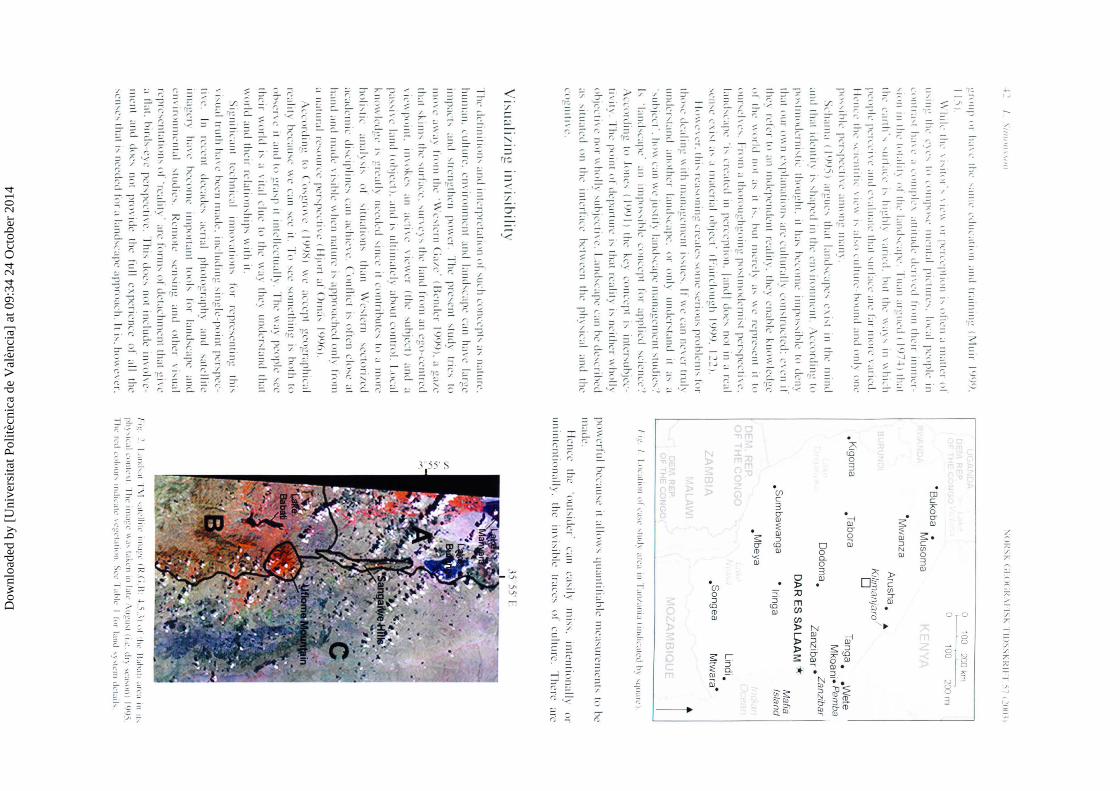
.K
1goma
0 100
200 km
0 100
:?OOm
·su
kob
a
• M
usom
a
•Mw
anza
.Tabora
Arusha
. •
K1/im
anjaro1
D
Tanga
We
te
Mko~ni: Pem
ba D
odoma
. Z
an
ziba
r • Za
nzib
ar
.sum
ba
wa
ng
a
.Mbeya
OA
R E
S S
AL
AA
M ~
• lringa
. son
g ea
Mafia
Islan
d
Lindi.
Mtw
ara·
11...:. I
I Dl..'.l[ltlll o
l l'~I'L' ... tud
~ a
fl'd Ill
ra
nt.llll.l (llllilcatcd
h~ 'lJ
li.IIL'l.
po11.:rl'u
l hc
c;ILhc it :d
im" q
ua
ntilia
hlc
mca
,urc
mcn
h to
he
ma
de.
I kn
ee th
e 't>
uh
idcr·
c:111
ca,il)
mi"
. in
ten
tion
al I)
or
un
int.:n
tion
;dly
. th
e i111 i,
ihlt.: trace~
of c
ultu
re. T
he
re
arc
35 55' 1·:
J.1~ ~
l.and,:ll T\1
':ttl'llttt' llll:t~L' (l<..(
i.H· ..J.).~)
11! th~.:
lbh
:tll :nt•a
111 lh
ph\'
IL';t\ L'llll[L
'\[ lh
c llll:l~l'
\\:!' l:t~l.'llllll:tlt'
\U~
ll'[ IL
L. dr~
'L',I'Illll
\9l)
).
I lie tl'll u
dPut-.
Jlldtt'a
ll.' \t'g
t'l.tllllll. <.;~~..·
l.thh:
I lt~r lan
d ,~,h.:
lll d~.·t.n\,
Dow
nloa
ded
by [
Uni
vers
itat P
olitè
cnic
a de
Val
ènci
a] a
t 09:
34 2
4 O
ctob
er 2
014
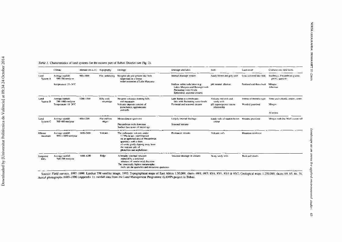
Table I. Characteristics of land systems for the eastern pan of Babati District (see Fig. 2).
Land System A
Land System 8
Land System C
Ufiome mountain
Sangaiwe Hill~
Climate
Average rainfall: 500-700 mm/year
Temperature: 22-24°C
Average rainfall: 700-1000 mm/year
Temperature: 18-20°C
Average rdinfaU: 500-600 mm/year
Average rainfall: 900-> 1000 mm/year
A vcrage rainfall: 500--7<Xl mm/year
Altitude (m a.s.l.) Topography
900-1000 Flat. undulating
t200-1500 Hilly with mountains
900-1200 Rat and low ridges
1800-2400 Volcano
1000-1200 Ridge
Geology
Neogene old and present lake beds (deposited in a former wider extension of Lake Manyara)
Neogene volcanics fonning hills and mountains
Volcanic deposits consisb of pyroclastics, agglomerates and tuffs
Mctasediment (gneisses)
Precambrian rock~ dominate Surface limestones of recent age
The carbonalite volcano. under 1.2 Ma in age. superimposed on an updomed area of Precambrian quartzites with a sheet of sovite genlly dipping away from the volcanic pile of phonolites and ncphelinites
Drainage and lake:;
Internal drainage system
Shallow saline soda lakes (e.g. Lake~ Manyara and Burunge) with fluctuating water levels Ephemeral. seasonal streams
Lake Babati is a freshwater lake with fluctuating water levels
Perennial and seru.onal streams
Largely internal drainage
Seawnal streams
Permanent streams
A broadly synclinal !'otructure Seasonal drainage in ~tream!'o replaced hy a anticlinal structure of !<oimilar axial direction
The structurally highe!oot metamo~phic rocks arc the quanzites and micaceou!'o quaruite~
Soils Land cover Characteristic land facets
Sandy brown and grey !<.oils Gras~-covered lake hcd~ In~clbcrg!'.: Precamhrian granite.
pH: neutral-alkaline
Volcani<.· red soils and sandy soils
pH: toposequencc catena relationship
Parkland and thorn bw.h
Forests of miomho type
Wooded grassland
Sandy !'>Oils of reddish-hrown Wooded gra~:-.land colour
Volcanic :..oib Mountain rainforest
Stony sandy soih Bu!'.h and shrubs
gnei~s. quartt.ite
Mbugas Alluvium
Vents and volcanic. <.Tatcr~. cone!'.
Mhuga!'.
Alluvium
Mhuga~ with fine hla":k cotton :-.oil
Source: Field surveys. 1997-1999: Landsat TM satellite image. 1995: Topographical maps of East Africa I :50.000. sheets 69/4. 69/3. 85/·t 8511. 85/3 & 85/2: Geological maps I :250.000. sheets 69. 85. 86. 70: Aerial photographs 1989-1990 (Appendix 1): rainfall data from the Land Management Programme (LAMP) project in Babati.
z 0 ;:<l [/)
;>:
Cl
8 ;:<l p .,., Cii ;>: -l 6 [/) [/)
;>: ;:<l
~ u. ..... ;::; x ~
~ §-:::;
"":::
"' ::: "' § ::: ...,
~ ~ .:;
~ 2._
~ "'· ~ ~ ~ ~ ~ " "'
""'" "'
Dow
nloa
ded
by [
Uni
vers
itat P
olitè
cnic
a de
Val
ènci
a] a
t 09:
34 2
4 O
ctob
er 2
014
..j..j / •. Si11u'""o"
nunH:ro
u' n
a1
np
k' i'rnm
i'rica
when.:
peor~c·~ pre~cn
cc
ha
' he~n r~nd
.:r ·d i111 i'ihl~ 'im
ply
b~cau'c th
eir ecolog
ical im
pact w
a~ no
t 'ul'li<.:icnt for th
eir c
ultu
n.: to take a m
aterial
form
that
wa~ rc~i,tant
thro
ugh time (
Adam~ &
McS
hane
19%
). Th
e d
nami
<.:~ of th
e frica
n landscape. w
ith g
reat variatin
n' o e
r both tim
e and 'pa
ce. on 'ca
lc, va
rying from
da
y~ to ~ca,on,
. ca
r' and ccnturi ''· arc no
t easily recorded
hy 'atcllitc im
ag
e,. S
ince vi~ua
l r~prc~cnt
ation~ ha
ve proven
to be
'uch
pm
crful
in,lru
mcn
h
and arc
often
u,cd
u~
argum~nh
in E
l ~.
it i' m
y be
lief
that
the best
1 ay to
pro id
l! a m
ore ba
lanced ba'i~
for dl!c
i~ion' and enviro
n
mental
1 olicil!~ i~
to m
ake
'om
e
invi,ib
lc in
form
atio
n
·vi,ib
le'. B
y pu
lling peop
li.:·, percepti
on~ on
10
maps
and thereby m
ixing qu
alita
tive 1 ith quan
titative in
form
ation. it m
ight he po,~ible to a'~c~~ them
in the sa
me m
anne
r a' and
with no
h;,~ va
lue than phy~
ical param
eter,. The fo
llow
ing ca
'e
'tudy
~ugge't'
a m
ethod
for
this vi,u
aliza
tion o
f in
tan
gib
le L!lcmen
t' in th
e land~capc.
Th
e landscap of Sangaiw
e village m B
abati D
istri t. T
anzania
The B
ahati D
i,tri<.:t area in
north-<.:cntral T
arw
mia
(Fig.
I) W
il' <.:ho' '11 a
' \IUd
y an.:a hl!Call'l! o
f it~ dynam
ic character in a region
1 h ·re hu
ma
n' have eo
-evo
l ed
with th
e phy,ica
l environm
ent
for a ver long period o
r rime
. Yet
it is ~till
con,id..:red h 111:1ny :h
recen
tly c p
loitcd wi
ldcrn
c~s. I have clw~e
n ln
• of w
ven
village~ ,tu
died (Simon~~on 200
0) to
present
~orne ke
y rc~
ulh
.
Tile dewclted fm
uf.l·cot}(' experience
Ap
pro
ach
ing
the lantbcape from
'pa
ce (F
ig. 2) might re
veal
pallcrn
' and
interaction~ to put
local ~tudie~ in a co
ntext.
lt allow
!-. the area to he <.:hara
cterird and
lividcd a<.:cordin
g to land
!-.Y'tem' (T
ahl• I).
wh
ich m
ight
pa!-.~
as a land
scape as~e,s
mcnt. F
orm
i~ a k 'Y in
to pa~t process·~ and deve
lop
me
nt\ initia
ted hy both natural and hum
an activity. How
ever. nor every
thin
g <.:an he e ·po
!-. ·d or ex
plain
ed by this im
age.
and altho
ugh it <.:over~ a larg
. po
rtion
or lan I it m
ight he lOO n
arro
w a too
l for h
oli~tic land~<.:ap
e 'tudie~. F
urtherm
ore. th
e im
age
rcpn
.:~ ·nt' a 'tru
th' that
i~ valid o
nly for one ~pecific
nwm
·nt in tim
l! (Striimqui
~t et al. 1999).
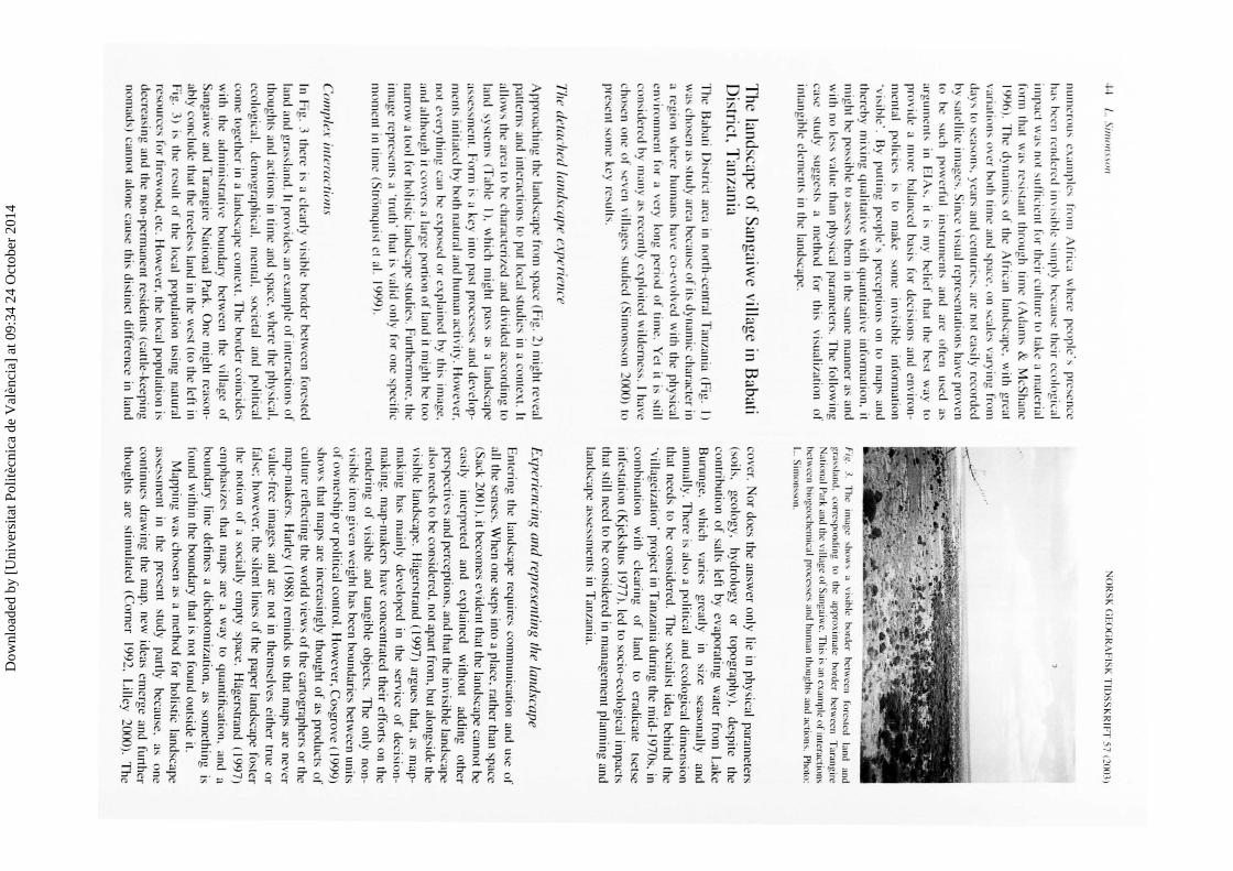
·111111 ''ex i 111 e roe 1 i oil.\'
In ~ig . .1 there
i~ a clearly visible border h•tw
ecn fo
restcd land and g
ra,~land
. it provide~ an ·x
amp
le of interac
tions o
r th
ough
" and ac
tion~ in tim
e and space. w
here the ph
ysica
l. eco
logical.
dem
ographical.
mental.
so<.:ietal and
politica
l ·o
m · toge
ther in
a land,<.:ape contex
t. Th
e border co
incid
es w
ith th
e admini~
trative boundary
betwee
n th
e village
of
Sang
aiw
c and Tara
ngirt:
ational P
urk. O
ne m
ight reaso
nab
ly conclude th
at the trec
lc~s land in the wes
t (to the le
ft in ~ig
. ~)
i, th~
re~ult o
r the loc
al pop
ula
tion usin
g natu
ral
rc~ource~ fo
r lircwo
od
, etc. How
ever. th
e local popu
lation is
dec
rea~ing and th
e non-perm
anent
reside
nts (cattle-ke
eping
nomad~) ca
nnot alo
ne cau~e this distin
ct diffe
ren
ce in
land
NO
RS
K G
EO
GR
AF
ISK
TID
SS
KR
IFr 57 r2003)
Fig.
3. Th~
imag~ ''"
"'''
a vi,ihlc
border
bclwccn
rurC,ICd
land and
gra"lan
d.
corrc,p<lll(lin
g 10
lhc approxim
alc ho
rdcr bc1w
ccn T
arangirc N
ational Park and I he village o
f Sa
ngaiw
c. This i' an exa
mple of' intcraclio
n'
hci\\Ccn biogcochcmica
l pro
cc"c
' and human lh
oug
hh
and au
ion
,, Pho1o:
I .. Sin
H""'o
n.
cover. N
or does th
e answe
r only lie in ph
ysica
l parameters
(soils.
geolo
gy
. hyd
rolo
gy
or
topograph
y). d
espite
the
con
tribu
tion
of sa
lts left by e apora
ting
water
from
L
ake
Burun
ge. w
hich
va
ries grea
tly in
size seuso
nally and
annually. T
here is also a po
litical and eco
logica
l dim
ension
that needs
to be consid
ered. T
he ~oc
ialist id
ea beh
ind th
e ·village
izatio
n· project in T
anzania du
ring th
e mid
-1970s, in co
mbina
tion w
ith cleu
ring
of
land to
eradica
te tsetse
infc~tation (K
jekshus 19
77
), led to socio-eco
logica
l imp
acts that still need to be co
nsidered in m
anage
ment p
lan
nin
g and land
scape a~sessments in T
anzania.
Experiencing and representing !he landscape
Enterin
g the land
scape req
uires co
mm
un
ication and use o
f all th
e senses. W
hen o
ne steps into a place. ra
ther than space
( ack 200 I). it becom
es evid
ent that th
e landscape cann
ot be
easily interp
reted and
explain
ed w
itho
ut addin
g o
ther
pe
r,pcc
tives and perce
ption~, und th
at the in
visible land
scape a
l~o needs to be consid
ered, no
t apart from
. but alo
ngside the
visible la nd
scape.
H~ige
rstrand ( 1997) argues th
at. as m
ap
makin
g has
main
ly developed
in th
e service
of decision
m
aking. m
ap-make
rs have co
ncentra
ted their e
fforts o
n the
re nderin
g o
f visible and
tang
ible o
bjects. T
he only
non
visible item
give
n we
ight has been bo
unduries betw
een u
nits
of o
wnership o
r politica
l con
trol. H
owever. C
osgrove ( 1999)
sho
ws th
at maps are in
creasin
gly th
oug
ht of as produ
cts or
culture refle
cting th
e wo
rld views o
r the cartog
raphers o
r the
map
-makers. H
arley ( 19R8) rem
ind
s us that m
aps are never
valu
e-free
images and
are no
t in them
selves either tru
e or
false: how
ever. the silem
lines o
r the pap
er landscape fos
ter th
e notion
or a soc
ially emp
ty space
. Hagers
trand ( 199
7)
empha~
izes th
at maps
are a way
10 q
ua
ntifica
tion. and
a bo
undary lin
e defin
es a clicho
tom
ization. as
som
ething
is ro
und w
ithin
the bo
undary th
at is not fo
und o
utside it.
Ma
pp
ing w
as chosen as a m
ethod for ho
listic landsca
pe as~e~s
ment in
the
present
stud
y partly
because.
as o
ne co
ntin
ues d
rawin
g the m
ap.
new
ideas em
erge and further
tho
ughts are stim
ulated
(Co
rner 1992,
Lilley
2000). T
he
Dow
nloa
ded
by [
Uni
vers
itat P
olitè
cnic
a de
Val
ènci
a] a
t 09:
34 2
4 O
ctob
er 2
014
NO
RS
K (;IJ
)(;R,\H
SK
TlllS
SK
RII·T
)7
(~IK1.1J
Good
N
i 0~ _
___::2.._,5:.__ _ _:.,5 0 km
pH 6
-7
A
pH 7
-8
A
pH 8
-9
• 45
0-9
00
kg matZ
e/acre
90
0-1
35
0 kg m
arze
/acre
1350-180
0 kg m
a•ze/acre
• 1
80
0-2
25
0 kg m
arze
/acre
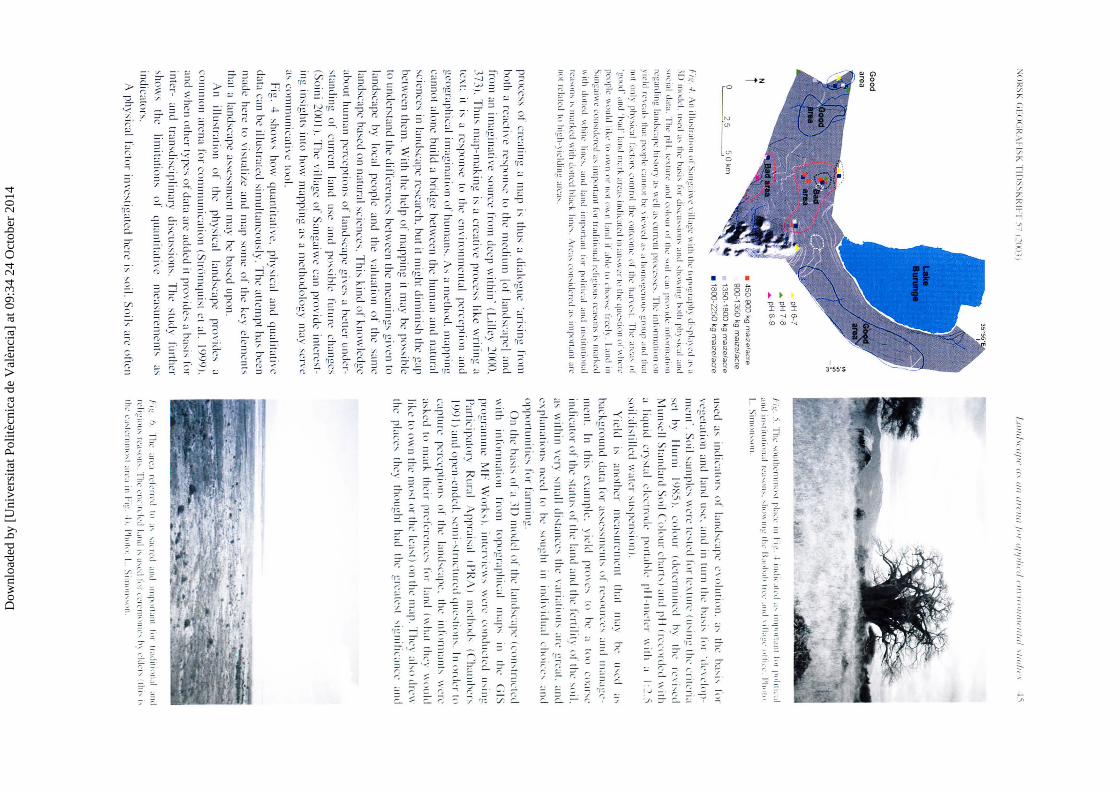
, .. it:. -1. An iiiL
hlratiu
ll or Sallf:ti\\~ \ illa
gc \\ ith thl...' ltlpog
r:tph~ di-.pl:t~L·d
;I', :I
'D
llhllk
l. ll"
l..'d a' thL
h:l'-.j..., ror di,cu
,,ioth and
,Jh
l\\ ing
both
pll: ,jcal and 'm
:ial tbta
. Thl' p
i I. IL
Xtun
.. · am.l
L'n
luu
r \lf
thL' 'llil \.:an p
nl\ id..:
ini"P
rlllatio
n
t\.:garding
lattd,
crp~..: hi,to
ry a-. \\1..'11 a~ l'llTTL'III p
nh
_'\..':-.'c'. The i11fo
rma
tion
ttll
) idd
1\!\!.:<il' that pco
pk
cu
ttlll\ he\ icw
l...'d a' a lllltllu~c
tltHI..., ~r1H1p
;uH
J that
1101 only ph
y-.ical Ltcto
r .... control lh~
Otlll'O
llK' or th
L' h:tn c-.\.
The an.::l' .. o
r ·gu
ud
' :r11d 'h:td' land m
:rrlx arl...'a' indicated
in :Ill'''' er to tile que:-.tion nl \\'hen.:
pl.'uplc \\otdd
li~c to uw
n or nul n
\\ 11 l:111d if ah
k· ID ciHHJ...,~ free!:
. Land in
San
gai\H.' L'O
il'lilkre
d a.., im
pu
rtant fo
r traditin
nal rc..:lig
iuu
..., rca .... on~ j..., lll;tr"n
l
\\ith
dutll:d
\\hilt.:
linL' ..... and
land im
po
na111
fpr p~1litical
and
ilh
litutio
n:d
re; I 'lOll..,
j, mar"ed
\\ ith dolled hi;IL'" lin
e ..... Arc
;h L·n
n .... id
ern
l a.., illlpn
rlant ;m
.· n
ot ll.'b
tcd to
hi~h
-) il'ldin~ :trL·a .....
[Jrocess of crea
ting a m
ap i, thu
s a dia
log
ue ·arisin
g fro
m
both a reactive respo
nsl:
to 1hc med
ium
lo
f l~mdscapel
and fro
m an im
agin
ative so
urce
from deep w
ithin
· (Lilley 2000.
]73
). Th
us m
ap
-ma
king is a crea
live p
rocess
like w
riling ~~
text:
it is a respon
se to lh
e en
vironnH
.:ntal percep
tion and
geog
raphica
l ima
gin
ation o
f hu
nw
n,_ A
s a me
tho
d. m
app
ing
cannot alone b
uild
a brid
ge b
etw
een the h
um
an
and
natural
'ciences in land
sca11e re,e
arc
h. b
ut itm
ighl d
imin
ish the gap
betwee
n them
. With
the h
elp o
r mapp
ing it m
ay be po
"ih
le
to understand the d
illerenc
e' betw
een the m
ean
ing
' give
n to
landscape
by
loca
l peo
ple and
the
valu
ation o
f the sam
e la
nd
,cap
e ba
sed o
n na
tura
l science
s_ Th
i' kind
of kn
ow
ledge abo
ut human pe
rcep
tions o
r landscape g
ive
, a bette
r under
'landing
of
cu
rrent
land use
and po
"ih
l..: fu1ure ch
anges (S
oin
i 2001 ). T
he v
illage o
f Sang~tiw
c ca
n pro
vide in
lcrest
ing in
sights in
to how
ma
pp
ing as a m
etho
do
log
y may se
rve ~"communica
tive lo
ol.
Fig.
4 sho
w' h
ow
qu
an
titative.
phys
ical
and q
ua
liwtive
data can b
e illustrated sim
ulta
neo
usly. The a
llem
pl ha
:-be
en m
ade he
re to visu
al izc ;Jnd m
ap
som
e of th
e key e
leme
nts thal a land
>cape asscssm
cn1 rn
ay be based upon.
An
illuslr<tlion
of
the
phys
ic;JI l<tnd
scape p
rov
ide:-
~~
comm
on <tn.:na for co
mm
un
icatio
n (Siriirn
qu
ist et al.
199
0).
and when o
ther 1ypes o
f data arc added it p
rov
ide
, a b<t'i' fo
r in
ter-and
lran
sdisc
iplin
ary
di>cussio
ns.
Th
e stu
dy
furth
er
'ho
ws
the
limita
tions
of
qu
an
titative
mC;JS
Urem
ents ~"
ind
icato
r>.
A ph
ysica
l facto
r invc,
tig~tted here is so
il. So
ils are ofte
n
IJIIIlilf·tlfl<' t/1
1111
tlrr'l/11
for tlf'f'/in
l ,.ll
,.//o
l/1/l<"tlltil '"
"'"
'' l.'i
J.ig. 5. T
he ,m
llhe
rnllln
...,t p
l;tL'L' in h
~. I tn
dit'.tiL'd
;,..., rtllp
Prt.rn
t 1111
pP
itlll';tl
and in
,titutillll:tll\.':t...,iH
l'-. ...,ht\\\111~
thl' lL
Hlh
ah
IIL'L'
.111d ull.t
~L· tlllt
l·l.· J
'htl\ll
1 .. Sim
on,,o
n.
u:-ed a' in
dica
tor'
of l~tnd-.,c;qx:
.:1 nlu
tion. :t'
thL· h
~t'i'
f"r vege
lalio
n and
land u~c. :111d in tu
rn the ha
'i' r,,r
·t~L·\clop
mcnl·. S
oil "
unplc~ w
ere IC
,Icd for ln
iLirC (u-.,in
g the criteria
se
t hy
llurn
i 10X
5). u1
lour
(dclcrm
ined
h)
lhe
rc,
i-.,cd M
un:-...:11 St~111dan
l So
il Co
lou
r chart') :tnd pi I (rcu
H·ded "
ith
:t liqu
id crys
1~tl e
lec1rod
c p
nrt:th
k· pii-111L"IL"r
\\ i1h :t
I :2.5 ~o
i I :di.'t i lied w~
tlcr ,u,pcn
:-ion ).
Yie
ld i'
~tiHJthc
r n1ca:-u
rcm
cnt lhat
Ill<~) h
e u.,c
d :"
backg
rou
nd
d<1ta fn
r ~"'e·'"
IICill' o
f n.:-.,ou
rcc:-
:111d tlla
n:tgL·
lllelll. In
thi>
cx~tmplc
. y
ield p
nl\'e
' 10
hL·
~~ to
o co
~tr'e
ind
icato
r or th
e 'talU>
of th
e land :tnd the fe
rtility of I he -.,oil.
a' w
ithin
\'cry ~ma
ll di,tan
cc' tilL'
v:tri:tliotl'
:m: g
r ·~tt. :tnd ex
plana
tion
' need
to
he ... ou
glll
in in
di1 idu
~tl c
ho
ice
' and
oppnrtunili
c~ for fa
nn
ing.
On lh
e ha:-i, o
r :1 .ID m
mk
l or lh
c l:tlllbc:tpe (cu
n-.,lructcd
w
ith infmlll<~
lion
from
w
po
gr:tphic:tl
111:1p:-in
1hc (;IS
pro
gr~t
mme
MF
Wo
rk,).
inlr.:rvicw
-.. w
ere co
nduc
tnl
u-.,ing
P<~rticipal
ory
Ru
r~tl A
pprai,;tl (P
R;\)
llleiiH
>d:-(C
'h:ttllhc
r' 1 9
91) an
d open-end
ed. 'c
mi-,lru
cture
d q
tle~lio
th. In o
rde
r 1o L";tJ1tU
r<.: p
crcepli()ll'
Of th
<.: l:tnd
-.,C~tpe. tilL•
illfOrlll:tll(-.,
\\'Cre
<1:-ked lo tn
ark I h
eir prefe
renc
e' fm
l:ttH
I (\\ h~tl
they
1\ln
tld like
10 ow
n th
e mo~t o
r the lc<~,t) tlll th
e ttt~tp. Th
e) :tl-.,o dn.:11
the
place:-
they
tho
ug
ht had
lhc
grc
:tte'l
-.,ign
ilic;tllCL"
ami
h~.
h. The arL';t
rck
rrl.'d
tn
;,..., ...,;tL't\.'d
;tnd
ttll[l~ll\:tnt IP
t tr;ILilltP
n.d
.n
Hl
rL:Ii~tnu..., rl':t'~Oll\. T
he
L'llL'trck
d land h
u
....... :d ltn
L'L'Il'llHllliL'"' h
~ l·ldc1..., P
ill"''' tilL·
l'a"'ll'n
lllllh\ a
rea
in
h),!. -l f. P
ho111. 1.. S
ttlluth
,lltl.
Dow
nloa
ded
by [
Uni
vers
itat P
olitè
cnic
a de
Val
ènci
a] a
t 09:
34 2
4 O
ctob
er 2
014
-lfJ / ..
Silllo
/1.\.\o
ll N
OR
SK
GE
OG
RA
FIS
K T
IDS
SK
RIFT' 57 (200
~)
PAS
T C
LIM
AT
ES
, TEC
TON
IC EVE
NT
S, GE
OM
OR
PH
OL
OG
ICA
L PR
OC
ESS
ES
:;; "' _, s: z 0 " ~ m
l"
s: z 0 c 6
/'-,
PO
PU
LA
TI
urr7:~* "' .m
GE
OLO
GY
X
X
X
POL
ICIE
S LA
WS
Interaction between ind
ividual
agent and social com
ext
PER
CE
PTIO
NS
& V
AL
UE
S INT
ER
PRE
TE
D IN
A SO
CIO
-HIST
OR
ICA
L CO
NT
EX
T
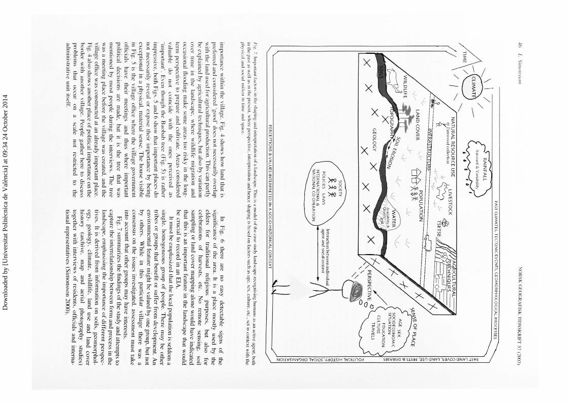
Fig
. 7. I m p
orta Ill f:.u
.:tor' in the 'ha pin
g and intc.!rprc
t~llinn of a land
scape. T
hi:-. i!-1 a m
od
el of th
e case :-.tucly land
scape recognisin
g hum
ans as an active age
nt. both
in the pa'l '"we
ll"' in the prc>crll. w
here pcr,pccrivc. inrcrprclalinn and hcru.:c shapin
g is ba>ed on factors such as :rgc. sex. cu
llurc. ere .. set in contex
t with the
phy"ic:tl and ... ncial m
ilieu in tim
e and ... pace:.
imp
on
ance with
in th
e village. F
ig. 4 show
s how
land that is p
rcfcrn.:d and co
nsid
ered 'goo
d' does no
t necessarily ove
rlap w
ith th
e land used for agric
ultu
ral produ
ction
. Th
is can p
artly
be expla
ined by ag
ricu
ltura
l techniques. but also by variatio
n ove
r tim
e in th
e landscape.
where
wild
life mig
ration
and occa~
iona
l n
oodin
g make som
e areas too risky in the lo
ng
term pe
rspective to p
repare and c
ultivate. A
reas consid
ered va
luab
le do
no
t co
inc
ide
with
the
ones
perceived
as 'im
po
rtant'. Eve
n tho
ugh th
e Baobab tree (F
ig. 5) is rath
er im
pressive. bo
th Figs. 5 and 6 show
that imp
ortant places do
not necessa
rily re
veal o
r expose th
eir imp
ortan
ce by bein
g exce
ptio
na
l in a phys
icaL materia
l sense. T
he ho
use visible
in Fig
. 5 is the v
illage office
where the villa
ge governm
ent
officia
ls have
their
mee
tings
and thu
s w
here im
po
rtant po
litical
decisions are
made.
but it
is th
e tree
that
wa
s m
entio
ned by m
ost people d
urin
g the interv
iews.
Th
e tree w
as a mee
ting pla
ce before the village w
as created
, and the
village o
ffice was co
nstructed at an already im
po
rtant place.
Fig. 4 also sh
ow
s anoth
er place of p
olitica
l imp
ortance o
n the
border w
ith another villa
ge. Peo
ple gath
er here to discuss
pro
blem
s th
at o
ccur
on
a sca
le no
t restricted
to th
e adm
inistrati ve u
nit itself.
In F
ig. 6
there
are no
easy d
etectable
signs
of
the
sign
ificance
of
the area.
lt is a place
mostly
used by
the
eld
ers fo
r trad
itional
religio
us purposes,
but also
for
celebrations
of
harvests,
etc. N
o
remote
sensin
g. so
il sa
mp
ling o
r land cover m
apping alone w
ou
ld have in
dica
ted th
at this is an imp
ortant feature in
the land
scape th
at wo
uld
be cru
cial to record in an E
IA.
·
lt mu
st be emphasized th
at the loca
l populatio
n is seld
om
a sin
gle. ho
moge
neous g
roup o
f people. T
here m
ay be oth
er trib
es or g
roup
s that be
nefit or su
ffer from
de
velopm
ent. An
en
vironm
ental featu
re mig
ht be valued by one g
rou
p, but n
ot
by o
thers.
Wh
ile in
this particu
lar
villag
e
there
wa
s a
con se
nsus on th
e issues investiga
ted. assessmen
t mu
st take in
to account that o
ther g
roup
s may h
ave intere
sts. Fig. 7 su
mm
arizes the fin
din
gs o
f the stud
y and attemp
ts to cap
ture th
e inte
rrela
tion
ship
between fo
rm and pro
cess in th
e land
scape, e
mph
asisin
g the im
po
rtance o
f differe
nt perspec
ti ves. lt is d
erived fro
m in
form
atio
n o
n soils, geo
mo
rph
ol
og
y, geo
log
y, clim
ate,
wild
life,
land use and
land cove
r histo
ry (a
rchive,
map
and aerial
pho
tog
raph
y stu
dies)
togeth
er with
interview
s of resid
ents. officia
ls and in
terna
tional rep
resentatives (S
imo
nsson 20
00).
Dow
nloa
ded
by [
Uni
vers
itat P
olitè
cnic
a de
Val
ènci
a] a
t 09:
34 2
4 O
ctob
er 2
014
NO
RSK
GE
OG
RA
FIS
K T
IDS
SK
RIF
f 57 (2003)
Conclusion
The landscape is an arena w
here biogeochemical processes
and human actions,
perceptions and political decisions in tim
e and space together shape the landscape. The present
study show
s how
landscapes
are valued
and assessed
differently, depending on cultural background along w
ith individual
characteristics. W
hile the
visual and
physical elem
ents are stressed by outsiders, insiders read the landscape through a social and historical filter.
Maps and m
ap-making can serve as a m
edium for creating
a dialogue and comm
unicating knowledge and ideas both
between local people, experts and scientists from
different disciplines and decision-m
akers. How
ever, mapping m
ust be approached w
ith caution, for, as Hiigerstrand (1997) rem
inds us, how
ever precise the map-m
aking techniques are, they can only
measure
association, eo-variation
or correlation be
tween variables, but cannot prove causation. Fry (200 I) points out that disciplinarity is a dem
arcation that has no reality in nature and w
hen it comes to m
aking decisions about the m
anagement of natural resources, single
subject approaches will not be enough. L
andscape provides practitioners
of m
any disciplines
-from
geography
and ecology to architecture and philosophy -
with a com
mon and
useful concept. How
ever, integrated research is not simply a
question o
f creating
an arena
within
which
disparate disciplinary
contributions can
be placed
alongside one
another. A
series of studies o
f climate, soils,
hydrology, and dem
ographic factors that are assembled and presented in
separate chapters, with a 'synthesis' listing the independent
conclusions, does not produce
a truly integrated
picture. D
efining landscape
in the
manner
proposed here
might
improve the quality o
f environmental projects and reduce
costly and painful conflicts. How
ever, applied projects have strict requirem
ents of cost-
and time-effectiveness. M
ethods are needed that have the ability to m
eet these requirements
but still convey the message o
f the complexity o
f interactions betw
een natural and human system
s.
Ackn
ow
ledg
emen
ts.-This study has been m
ade possible with the assistance
and co-operation of the villagers o
f Sangaiw
e and other people in Babati
District, T
anzania. The S
wedish S
ociety for Anthropology and G
eography, the
Royal
Academ
y o
f Sciences,
Margit A
lthins fond
and A
nna M
aria L
undins stipendiefond
have kindly
provided funding
for fieldw
ork and
archive studies. Thanks are due to L
ennart Strom
quist, Urban E
manuelsson
and Mats W
idgren for comm
ents on the manuscript.
Man
uscrip
t sub
mitted
21 M
ay 2002; accepted 10 D
ecemb
er 2002
References
Aasb!il.
S.
1999. H
istory and
ecology in
everyday landscape.
Norsk
Geografisk T
idsskrift 53, 145-152. A
dams, J. S. &
McS
hane, T. 0
. 1996. The Myth o
f Wild A
frica. Conservation
Without
Illusion. U
niversity o
f C
alifornia P
ress, B
erkeley and
Los
Angeles.
Barrow
, C
. J.
1997. E
nvironmental a
nd
Social Im
pact A
ssessment.
An
Introduction. A
mold, L
ondon. B
ell, S. 1999. Landscape. P
attern, Perception and P
rocess. E. &
F. N. S
pon, L
ondon. B
ender, B. 1999. S
ubverting the Western G
aze: mapping alternative w
orlds. U
cko, P. J. &
Layton, R
. (eds.) The Archaeology and A
nthropology of
Landscape. Shaping Y
our Landscape, 31-45. R
outledge, London.
Landscape as an arena .flJr applied enl'ironm
ental studies 4
7
Bruun,
H.
1998. L
andskapets begreppsliga landskap -
en hum
anekolog' reftexioner om
landskapsbcgreppets m
i\jligheter. N
ord<•nskW
id-S<m
!fim·
det.' Tidskrift 57, 77-95.
Cham
bers, R.
1991. Shortcut and participatory m
ethods for gaining social inform
ation for
projects. C
ernea, M
. M
. (cd.)
PuttiiiM
People
First.
Sociological V
ariables in
Rural
Developm
mt.
515-537. O
xford U
niversity P
ress, Oxford.
Corner, J.
1992. Representation and landscape: draw
ing and making in the
landscape medium
. Word and l
ma~e 8, 243-275.
Cosgrove, D
. E.
1990. Environm
ental thought and action. Prc-m
ndcrn and post-m
odern. Institute of B
ritish Geo~raphers, Transactions N
eu· Seric.1· 15, 344-358.
Cosgrove, D
. E. 1998. Social F
ormation and Sym
bolic Lmulsm
p<'. U
niversity o
f Wisconsin P
ress, Madison.
Cosgrove, D
. E. 1999. Introduction: m
apping meaning. C
osgrove, D. E
. (ed.) M
appings, 1-23. Reaction B
ooks Ltd., L
ondon. C
ountryside Com
mission 1991. E
nvironmental A
ssessment: T
ht' Trl'lltm
ent o
f Landscape a
nd
Countryside R
<'creation Issues. C
CP
326. Countryside
Com
mission, C
heltenham.
Crum
ley, C.
L. (ed.) 1994. H
istorical EcoiO!i.l':
Cultural K
nowledg<
' a11d
Changing L
andscapes. A
dvanced S
eminar S
eries. S
chool o
f Am
erican R
esearch Press. S
anta Fe, New
Mexico.
Darier, E. (ed.) 1999. D
iscourses of the E
nvironmellf. B
lack well P
ublishers,
Oxford.
Fairclough,
G.
1999. P
rotecting tim
e and
space: understanding
historic landscapes for conservation in E
ngland. Ucko, P. J. &
L
ayton, R. (eds.)
The Archaeolo~y and Anthropoh>~y of L
andscape. Shapin~
Your Lt.md
scape, 119-134. Routledge. L
ondon. F
airhead, J. & L
each, M. 1999. Misreadin~ the A
frican Lt.md.IT<tJ>e. Society and E
cology in a F
orest-Savanna M
osaic. A
frican S
tudies Series
90. C
ambridge U
niversity Press, C
ambridge.
Fry, G
. L. A
. 2001. Multifunctional lan
dscap
es-tow
ards transdisciplinary research. L
andscape and Urhan P
lanning 57, 159-168. G
lasson, J., Therivel, R
. &
Chadw
ick, A.
1996. Introduction to Environ
mental Im
pact Assessm
ent. Principles and P
rocedures, Proa.1·s, P
ractia
and P
rospects. University C
ollege London P
ress, London.
Hagerstrand, T
. 1991. Ekologi och landskap. T
idskriji j{ir Arkitekturjim
·knilt!i 4:2, 19-24.
Hagerstrand, T
. 1997. T
he map as an analytical instrum
ent. Edlund, L
. E.
(ed.) Kartan i kultuiforskningens tjiinst, 9
-22
. Kulturgriins norr 2, U
meii.
Harley, J. B
. 1988. Maps, know
ledge, and power. C
osgrove, D. E
. & D
aniels, S.
(eds.) The
Iconography o
f Landscape.
Es.m
y., on
the Sym
holic R
epresentation, Design and U
se of P
ast Environm
ents, 277-313. Cam
bridge U
niversity Press, C
ambridge.
Hjort af O
mas, A
. (ed.) 1996. A
pproachin11 Nature from
U>
cal Com
mrrniti<
'.>.
Security P
erceived and
Achieved.
EP
OS
, R
esearch P
rogramm
e on
Environm
ental Policy and S
ociety. Institute ofT
ema R
esearch. Linkiiping.
Hurni,
H.
1985. Soil
Conservation
Manual
ji>r
Ethiopia.
Ministry
of
Agriculture,
Natural
Resources
Conservation
and D
evelopment
Main
Departm
ent, and Com
munity F
orests and Soil C
onservation Developm
ent D
epartment, A
ddis Ababa.
Jones, M. 1991. T
he elusive reality of landscape. C
oncepts and approaches in landscape research. N
orsk Geografisk T
idsskriji 45, 229-244. K
jekshus, H.
1977. Ecology C
ontrol an
d E
conomic D
evelopmem
in E
mt
African
History.
The
Case
of T
anganyika /8
50
-/95
0.
Heinem
ann. L
ondon. L
illey, K. D
. 2000. Landscape m
apping and symbolic form
: drawing as a
creative medium
in cultural geography. Cook, I., C
rouch, D., N
aylor. S. &
Ryan, J. R
. (eds.) C
ultural Turm
JGeographil'al Turns:
Perspectil'es ""
Cultural G
eography, 370-386. Prentice H
all, New
York.
Meinig,
D.
W.
1979. R
eading the
landscape, an
appreciation o
f W.
G.
Hoskins and J. B
. Jackson.
Meinig, D
. W
. (ed.) The
Interpretation <Jl O
rdinary Landscapes, 195-244. O
xford University P
ress, New
York.
Mels, T
. 1999. Wild L
andscapes. The Cultural N
ature of Sw
edi.!h National
Parks. L
und University P
ress, Lund.
Muir, R
. 1999. Approaches to L
andscape. Macm
illan Press L
td. London.
Olsson, G
. 1994. Heretic cartography. E
cumene I :3, 215-234.
Olsson,
G.
1999. L
andscape -
border station
between
stonescape and
mindscape. C
usimano, G
. (ed.) La Construzione del P
easaggio Siciliano: G
eografi e Scrittori a Confronto, 135-146. A
nnali Della F
acoltii di lettere e F
ilosofia dell'Universiti\ di P
alermo, L
a Mem
oria 12. Universitii degli
Studi di P
alermo, F
acolti\ di Lettere e F
ilosofia. Palerm
o. O
lwig, K
. R. 1993. S
exual cosmology: nation and landscape at the conceptual
Dow
nloa
ded
by [
Uni
vers
itat P
olitè
cnic
a de
Val
ènci
a] a
t 09:
34 2
4 O
ctob
er 2
014
4X
L Sim
on1.1t111
intcNi<
:cs of nature am
i nolturc; or, what does lands<:ape
really m
ean? B
ender. B
. led.)
IAIII<ism
pc• P
olitin
1111</
I'NSflt'ctio•t•.\,
107-144. B
crg J>uhlishcr,, ( h ford.
Olw
ig. K. K
. 1996. Kcw
vering the 'uhst;ontive meaning o
f landsc·ape. Am
w/.1
t~{"thc As.\·o
ciation
f~/ Am
crinm
<if'n
grap
lrcr.\ X6:4. tl)0-653.
Sa<:k. K
. D
. 21K
JI. T
he geographic
prohlematic
empirical
issues. N
orsk C
icogrq/isk 1/d.ukri/i-Nonregillll lo
llmlll o(C
ieographr 55. 107-116. S
auer. C. 0
. 1925. The m
orphology of landscape. U
lli\'t'l'sit\' of C
'a/ij(moia
Puhfim
tirms ill G
c•ogmf>
hr 2:2. 19-51. S
chama. S.
1995. Lm
ul.lcaflt' a11cl Mcm
orr. HarpcrC
ollins. London.
Schm
idt. P. R. 1997./m
ll Tcch11o/ogy ill t:mt A
frica: Srmholism
. Scie11a 111111
Archat•o/ogy. Indiana U
niversity Press. Bloom
ington/lndianapolis. S
imonsson. L. 2!K
Kl. A
pplied landscape ussessment in a holistic perspective.
A case
study from
B
ahati D
istrict, north-central
Tanzania.
Licentiate
thesis, A
pplied Environm
ental Im
pact A
ssessment, U
ppsala University,
Uppsala.
Soini, K
. 20
) I. Exploring hum
an dimensions o
f multifunctional landscapes
through mapping and m
ap-making. u
md
smp
e a11d U
rha11 P
lmm
in}i 57, 225-239.
Soper, K
. 1995.
What is N
atun•? C
ulture, P
olitin· 1111d the Non-H
uman.
Blackw
ell Publishers, O
xford. S
triim4uist, L
.. Yanda, P .. M
semw
a. P .. Lindberg, C
. & S
imonsson-F
orsberg, L.
1999. T
he extended
baseline perspective
-utilising
landscape inform
ation to analyse and predict environmental change. A
Tanzanian
example. A
MB
/0 28:5. 436-443.
NO
RSK
GE
OG
RA
FISK T
IDS
SK
RIF
T 57 (21X
JJJ
Tuan,
Y.-F.
1974. T
opophilia: A
Study
of E
11vironmental
Perceptioll,
Allitu
dn
. mu
/ Va
lun
. Prenticc-H
all Inc .. New
Jersey. W
idgrcn, M.
1999. Is landscape history possible'' Ucko, P. J. &
L
ayton. R.
!eds.) The A
rclweo
log
r a11d Alllhropolo!iy o
f um
dsca
pe. Shaping
Yo11r u
md
scap
t'. 94-103. Routledge. L
ondon. W
orld Bank 199H
. Em
·ironmental A
s.vessment So11rcehook. V
ol. I. P
olicies. P
roced11re. a
nd
C
'ro.u-Sectora/ Issues.
World
Bank
Technical
Paper
Num
ber 139. World B
ank. Washington D
C.
Appendix I. O
ther sources
Directorate
of O
verseas S
urveys for
the U
nited R
epublic o
f Tanzania/
Directorate o
f Overseas S
urveys for the T
anganyika Governm
ent. 1965/
1964. Topographical m
aps, E
ast A
frica 1.50,000 Tanzania/T
anganyika. S
eries Y7 42.
Mineral
Resources
Division,
Tanzania.
1965/1966. G
eological m
aps 1:250,000.
Geological S
urvey Dodom
a, Tanzania. 1978. G
eological maps 1:250,000.
Ministry
of
Energy
and M
ineral, T
anzania. 1996.
Geological
maps
1:250,000. A
erial photos. 1989/1990. Obtained from
Photom
ap Ltd. K
enya. S
atellite image L
andsat TM
. 1995. (950826) Track/F
rame 168/063. R
,G,B
: T
M4. T
M5. T
M3. O
btained from S
SC
Satellitbild, K
iruna, Sw
eden.
Dow
nloa
ded
by [
Uni
vers
itat P
olitè
cnic
a de
Val
ènci
a] a
t 09:
34 2
4 O
ctob
er 2
014


