
804 N. 2nd Ave. E.Rock Rapids, IA 51246-1759
800-622-3070www.aop.com
GEOGRAPHYHISTORY &STUDENT BOOK
3rd Grade | Unit 8

HISTORY & GEOGRAPHY 308MOUNTAIN STATES
Introduction |3
1. Mountain Geography ...............................5States in the Mountain Region |6Geographical Features |8Weather |11Self Test 1 |14
2. Mountain Resources .............................. 16Natural Resources |18Human Resources |21Products and Industries |25Self Test 2 |28
3. Mountain Community ............................ 30Culture |31Cowboys |35Recreation |37Self Test 3 |40
LIFEPAC Test |Pull-out
| 1
Unit 8 | MOUNTAIN STATES

Author: Rachelle Wiersma, M.A.
Managing Editor: Alan Christopherson, M.S.
Editor: Laura Messner
Media Credits: Page 3: © Stockbyte, Thinkstock; 5: © Bkamprath, iStock, Thinkstock; 9: © johnnya123, iStock, Thinkstock; 10: © Comstock Images, Stockbyte, Thinkstock; © Ameng Wu, iStock, Thinkstock; 16: © somchaij, iStock, Thinkstock; 18: © Andrew Zarivny, iStock,Thinkstock; 19: © Dalgic, iStock,Thinkstock; 21: © TongRo Images, Thinkstock; 22: National Archives; 25: © Ingram Publishing, Thinkstock; © Ciaran Griffin, Stockbyte,Thinkstock; 30: © Comstock, Stockbyte,Thinkstock; 31: © Nick Harris/Virgil Pomfret Agency, Thinkstock; 32: © Jorge Barrios; 33: © William E Jennings; 34: © Andrew J. Russell, Yale University Libraries; 35: © John Alves, iStock, Thinkstock; 36: © dgphotography, iStock,Thinkstock; 37: © smontgom65, iStock,Thinkstock; © Bartus Hendrikse, iStock,Thinkstock; 38: © dell640, iStock,Thinkstock.
All maps are © Image Resources unless otherwise stated.
804 N. 2nd Ave. E. Rock Rapids, IA 51246-1759
© MMXI by Alpha Omega Publications, a division of Glynlyon, Inc. All rights reserved. LIFEPAC is a registered trademark of Alpha Omega Publications, a division of Glynlyon, Inc.
All trademarks and/or service marks referenced in this material are the property of their respective owners.
Alpha Omega Publications, a division of Glynlyon, Inc. makes no claim of ownership to any trademarks and/or
service marks other than their own and their affiliates, and makes no claim of affiliation to any companies whose
trademarks may be listed in this material, other than their own.
2 |
MOUNTAIN STATES | Unit 8

MAINE
NH
VT
MARI
CTNEW YORK
PENNSYLVANIA NJ
DEMD
VIRGINIA
WESTVIRGINIA
NORTH CAROLINA
SOUTHCAROLINA
GEORGIA
FLORIDA
ALABAMA
MISSISSIPPI
LOUISIANA
OHIO
INDIANAILLINOIS
MISSOURI
ARKANSASOKLAHOMA
TEXAS
KANSAS
IOWA
WISCONSIN
MINNESOTA
NEBRASKA
SOUTHDAKOTA
NORTHDAKOTA
MONTANA
COLORADO
NEW MEXICO
ARIZONA
UTAH
WYOMING
IDAHO
OREGON
NEVADA
CALIFORNIA
WASHINGTON
PacificOcean
GreatSalt Lake
Snake R
iver
Colorado River
Rio Grande River
Platte River
Missouri R
iver Mississippi River
Miss
issip
pi R
iverArkansas River
Red River
Alabama R.
Cossa
R.
Tennessee R
.
Lake Superior
Lake
Mic
higa
n
LakeHuron
Lake Erie
Lake Ontario
Ohio
Rive
r
AtlanticOcean
OTTAWA
WASHINGTON D.C.
CANADA
MEXICO
Gulf of Mexico
TENNESSEE
KENTUCKY
MICHIGAN
Augusta
Concord
Boston
Montpelier
Albany
Providence
Hartford
Trenton
Dover
Annapolis
Harrisburg
Richmond
Raleigh
Columbia
Atlanta
Tallahassee
Montgomery
Jackson
Nashville
Frankfort
Columbus
Charleston
IndianapolisSpringfield
LansingMadison
St. Paul
Des Moines
Jefferson City
Little Rock
Baton RougeAustin
Oklahoma City
Topeka
Lincoln
Pierre
Bismark
Helena
Cheyenne
Denver
Santa Fe
Phoenix
Salt Lake CityCarson City
Boise
Sacramento
Salem
Olympia
ALASKA HAWAII
Honolulu
Juneau
N
S
W ENW NE
SESW
MAP LEGENDNational CapitalState Capital
State BoundaryCountry BoundaryRiver
Lake
Mountain Range
0 200 400 Miles
0 200 400 KM
MOUNTAIN STATESMontana, Idaho, Wyoming, Nevada, Utah, Colorado, Arizona, and
New Mexico
The next region of the United States you will study is the Mountain
states. The Mountain states stretch from the Canadian border in the
north to the Mexican border in the south. The Rocky Mountains run
through these states and play an important role in their geography.
The mountains also created challenges for the early settlers. Today
the mountains provide abundant natural resources as well as
recreational opportunities for the people living in the region.
| 3
Unit 8 | MOUNTAIN STATES

ObjectivesRead these objectives. The objectives tell you what you will be able to do when you have successfully completed this LIFEPAC. Each section will list according to the numbers below what objectives will be met in that section. When you have finished this LIFEPAC, you should be able to:
1. Locate the Mountain states.2. Know the geography of the Mountain states.3. List natural resources found in the Mountain states.4. State the types of businesses and employers found in the Mountain
region.5. Know some settlers of the Mountain states. 6. Recognize the importance of cowboys in the Mountain states.7. Identify the pastimes of the people living in the Mountain states.
4 |
MOUNTAIN STATES | Unit 8

ObjectivesReview these objectives. When you have completed this section, you should be able to:
1. Locate the Mountain states.2. Know the geography of the Mountain states.
VocabularyStudy these new words. Learning the meanings of these words is a good study habit and will improve your understanding of this LIFEPAC.
adapt ( e-dăpt’). To change to fit a situation.evaporation (ĭ-văp’ e-rā’sh en). To change from a liquid form to a vapor.
Note: All vocabulary words in this LIFEPAC appear in boldface print the first time they are used. If you are unsure of the meaning when you are reading, study the definitions given.
Pronunciation Key: hat, āge, cãre, fär; let, ēqual, tėrm; it, īce; hot, ōpen, ôrder; oil; out; cup, pu·t, rüle; child; long; thin; /ŦH/ for then; /zh/ for measure; /u/ or / e/ represents /a/ in about, /e/ in taken, /i/ in pencil, /o/ in lemon, and /u/ in circus.
1. MOUNTAIN GEOGRAPHYYou will begin this LIFEPAC by studying the geography of the
Mountain states. You will learn the names of some of the Mountain
states’ land features. You will also learn the names of the Mountain
states’ major cities. The Mountain states’ location impacts the types
of food people grow, the places they live, and the activities they do.
Section 1 | 5
Unit 8 | MOUNTAIN STATES

Ask your teacher to say these vocabulary words with you.
Teacher check:
Initials _____________________ Date ____________________
States in the Mountain RegionBefore you study the Mountain states, look at the map below. The map will introduce you to the Mountain area.
10
5°W
11
0°W
11
5°W1
20
°W1
25
°W
30°W
35°W
40°W
45°W
50°W
TEXAS
MONTANA
COLORADO
NEW MEXICO
ARIZONA
UTAH
WYOMING
IDAHO
OREGON
NEVADA
CALIFORNIA
WASHINGTON
PacificOcean
GreatSalt Lake
Snake R
iver
Colorado River
Rio Grande River
Platte River
CANADA
MEXICO
Pierre
Helena
Cheyenne
Denver
Santa Fe
Phoenix
Salt Lake CityCarson City
Boise
Salem
Olympia
N
S
W ENW NE
SESW
MAP LEGENDNational CapitalState Capital
State BoundaryCountry BoundaryRiver
Lake
Mountain Range
0 200 400 Miles
0 200 400 KM
6 | Section 1
MOUNTAIN STATES | Unit 8
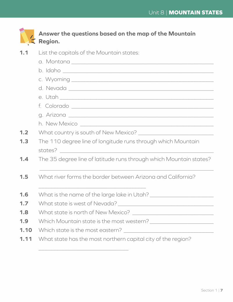
Answer the questions based on the map of the Mountain Region.
1.1 List the capitals of the Mountain states:
a. Montana _________________________________________________
b. Idaho ____________________________________________________
c. Wyoming _________________________________________________
d. Nevada __________________________________________________
e. Utah _____________________________________________________
f. Colorado _________________________________________________
g. Arizona __________________________________________________
h. New Mexico ______________________________________________
1.2 What country is south of New Mexico? __________________________
1.3 The 110 degree line of longitude runs through which Mountain
states? _____________________________________________________
1.4 The 35 degree line of latitude runs through which Mountain states?
____________________________________________________________
1.5 What river forms the border between Arizona and California?
_____________________________________
1.6 What is the name of the large lake in Utah? ______________________
1.7 What state is west of Nevada? _________________________________
1.8 What state is north of New Mexico? ____________________________
1.9 Which Mountain state is the most western? ______________________
1.10 Which state is the most eastern? _______________________________
1.11 What state has the most northern capital city of the region?
_______________________________
Section 1 | 7
Unit 8 | MOUNTAIN STATES

Geographical FeaturesThe geography of the Mountain states is much different than that of the Midwestern states. Where the Midwestern states were largely flat and good for planting crops, the Mountain states are rugged and better suited for cattle grazing. The highest peak in this region is Mt. Elbert in Colorado at 14,433 feet. The Rocky Mountains extend over 3,000 miles from Canada to the southern U.S. border. The Rocky Mountains also form the Continental Divide.
| Continental Divide
TEXAS
MONTANA
COLORADO
NEW MEXICO
ARIZONA
UTAH
WYOMING
IDAHO
OREGON
NEVADA
CALIFORNIA
WASHINGTON
PacificOcean
GreatSalt Lake
Snake R
iver
Colorado River
Rio Grande River
Platte River
CANADA
MEXICO
Missouri River
Pierre
Helena
Cheyenne
Denver
Santa Fe
Phoenix
Salt Lake CityCarson City
Boise
Salem
The Continental Divide
The Continental Divide
N
S
W ENW NE
SESW
MAP LEGENDNational CapitalState Capital
State BoundaryCountry BoundaryRiver
Lake
Mountain Range
0 200 400 Miles
0 200 400 KM
8 | Section 1
MOUNTAIN STATES | Unit 8

The Continental Divide is an imaginary line that follows the highest peaks of the Rocky Mountains from north to south. The Continental Divide separates the streams that flow into the Pacific Ocean from those flowing into the Atlantic Ocean or Gulf of Mexico. The Colorado River forms on the western side of the Continental Divide and flows into the Pacific Ocean. The Missouri River forms on the eastern side of the Continental Divide and flows into the Gulf of Mexico.
The Great Salt Lake is found in Utah. It is the largest salt water lake in the United States. Four rivers and numerous streams flow into the Great Salt Lake but none flow out of it. Because of this, evaporation is the only way in which water exits the lake. When water evaporates, it leaves behind salt and other minerals in the water. The lake is much saltier than the ocean. Only a few animals can survive in the salty water. However, large populations of ducks, pelicans, and swans live around the lake. Visitors come to the lake for the beautiful beaches. They also enjoy swimming in the lake because the
| The Great Salt Lake
Section 1 | 9
Unit 8 | MOUNTAIN STATES
salt makes it easy for people to float. One of the minerals taken from the lake is table salt.
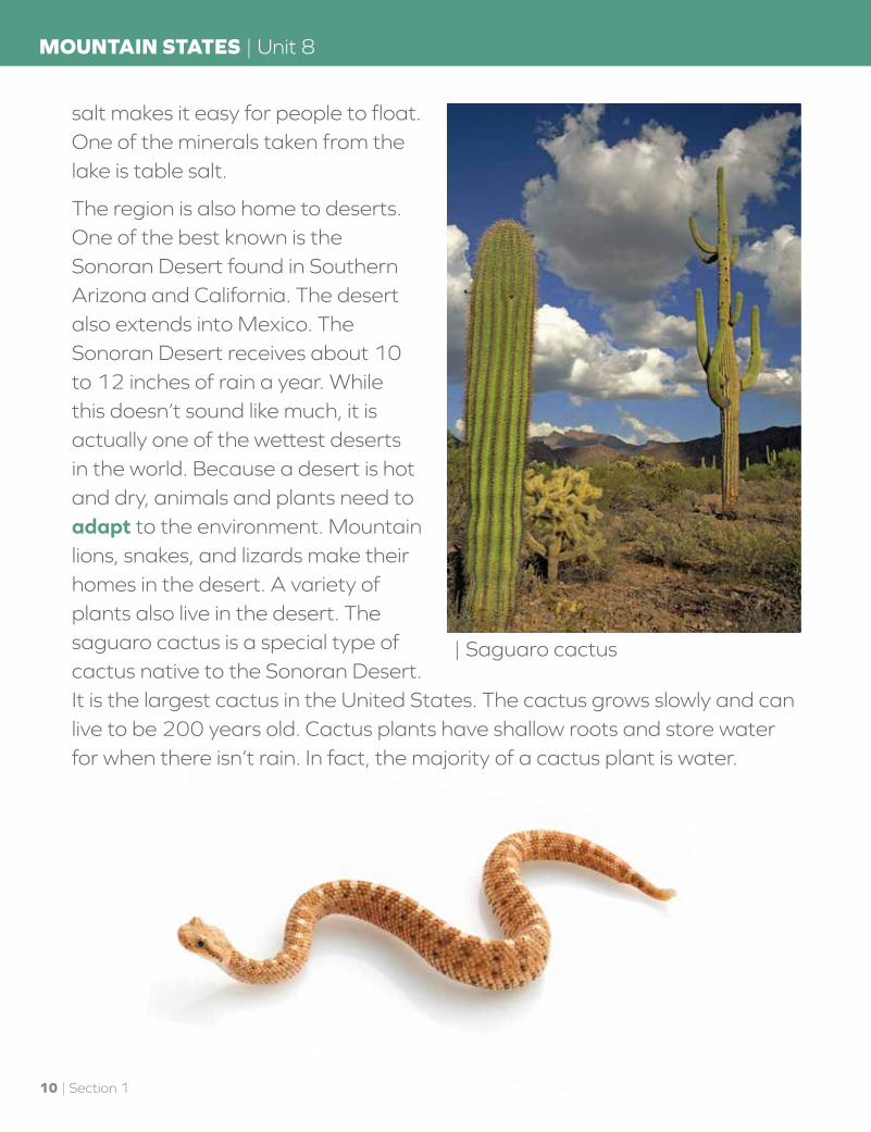
The region is also home to deserts. One of the best known is the Sonoran Desert found in Southern Arizona and California. The desert also extends into Mexico. The Sonoran Desert receives about 10 to 12 inches of rain a year. While this doesn’t sound like much, it is actually one of the wettest deserts in the world. Because a desert is hot and dry, animals and plants need to adapt to the environment. Mountain lions, snakes, and lizards make their homes in the desert. A variety of plants also live in the desert. The saguaro cactus is a special type of cactus native to the Sonoran Desert. It is the largest cactus in the United States. The cactus grows slowly and can live to be 200 years old. Cactus plants have shallow roots and store water for when there isn’t rain. In fact, the majority of a cactus plant is water.
| Saguaro cactus
10 | Section 1
MOUNTAIN STATES | Unit 8
Fill in the blank.
1.12 The Continental Divide separates rivers which flow into the Atlantic
Ocean or Gulf of Mexico from those flowing into the
________________________________ .
1.13 The saguaro is the largest ________________ in the United States.
1.14 The Great Salt Lake is located in the state of ___________________ .
1.15 The only way water leaves the Great Salt Lake is through
_______________________________ .
1.16 The large desert in southern Arizona and California is called the
____________________________ Desert.
WeatherThe weather varies greatly from the northern to the southern states in this region. The weather also varies from the high elevations of the mountains to the lower desert regions. One weather feature that all the states share is that they are dry. The Mountain states are at higher elevations and away from any large bodies of water. These are two of the reasons the states in this region are dry.
The Great Basin is a particularly dry area which covers most of Nevada and parts of the surrounding states. The Cascade Range, Rocky Mountains, and Sierra Nevada surround the area keeping moisture from falling in the region. The desert area within the Great Basin is so dry that the water from the rivers flowing in the area evaporates. The rivers end in the desert rather than flowing into a larger body of water.
Many people think of hot temperatures when they think of a desert. While deserts are hot during the days, they are not always hot at night. In the
Section 1 | 11
Unit 8 | MOUNTAIN STATES
summer, the daytime temperatures soar to 100 degrees F or higher. At night, the temperature in some areas might drop to 40 degrees F. Between October and April, the weather cools. During winter, daytime temperatures average between 60 and 70 degrees F. Nighttime temperatures might dip below freezing.
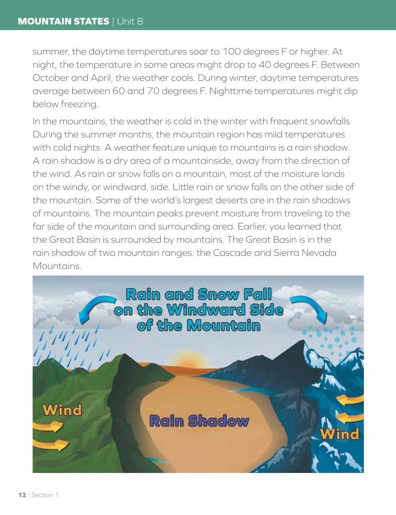
In the mountains, the weather is cold in the winter with frequent snowfalls. During the summer months, the mountain region has mild temperatures with cold nights. A weather feature unique to mountains is a rain shadow. A rain shadow is a dry area of a mountainside, away from the direction of the wind. As rain or snow falls on a mountain, most of the moisture lands on the windy, or windward, side. Little rain or snow falls on the other side of the mountain. Some of the world’s largest deserts are in the rain shadows of mountains. The mountain peaks prevent moisture from traveling to the far side of the mountain and surrounding area. Earlier, you learned that the Great Basin is surrounded by mountains. The Great Basin is in the rain shadow of two mountain ranges: the Cascade and Sierra Nevada Mountains.
12 | Section 1
MOUNTAIN STATES | Unit 8

Answer true or false.
1.17 _____________ Deserts are always hot, even at night.
1.18 _____________ A rain shadow is a dry area of the mountain, away from the direction of the wind.
1.19 _____________ Mountain temperatures are cold all year long.
1.20 _____________ The Great Basin is the name given to a huge lake in Nevada.
Teacher check:
Initials _____________________ Date ____________________
For this Self Test, study what you have read and done. The Self Test will check what you remember.
Section 1 | 13
Unit 8 | MOUNTAIN STATES

SELF TEST 1Each answer = 1 point
Choose the correct answer.
1.01 The Continental Divide separates rivers flowing from the Atlantic
Ocean and the Gulf of Mexico from those flowing into the
_______________________________ . a. Indian Ocean b. Great Salt Lake c. Pacific Ocean
1.02 The capital of Colorado is _______________________ . a. Denver b. Boise c. Cheyenne
1.03 The highest mountain peak in this region is called
____________________________ . a. Mt. Elbert b. Pike’s Peak c. Mt. St. Helens
1.04 The saguaro cactus can live to be __________ years old. a. 50 b. 100 c. 200
1.05 The Great Salt Lake has many rivers and streams flowing into it and
_____ streams flowing out. a. 0 b. 5 c. 10
1.06 Deserts tend to be hot during the day and ____________ at night. a. hot b. warm c. cool
Answer true or false.
1.07 _____________ The Great Basin is a large lake in the middle of Nevada.
1.08 _____________ The Mountain states are generally wet.
1.09 _____________ The word “adapt” means that something changes to its surroundings.
1.010 _____________ The state of Nevada is west of Colorado.
14 | Section 1
MOUNTAIN STATES | Unit 8

Fill in the blank.
1.011 A(n) ____________________ shadow forms on the side of the
mountain away from the wind.
1.012 _______________________ takes place when water disappears into
the air.
1.013 The state of New Mexico is directly east of _____________________ .
1.014 The Great Salt Lake is located in the state of ___________________ .
1.015 The saguaro cactus is mostly made up of ______________________ .
Teacher check: Initials ___________
Score _____________________ Date ___________
12
15
Section 1 | 15
Unit 8 | MOUNTAIN STATES

804 N. 2nd Ave. E.Rock Rapids, IA 51246-1759
800-622-3070www.aop.com
GEOGRAPHYHISTORY &STUDENT BOOK
ISBN 978-0-7403-2447-5
9 7 8 0 7 4 0 3 2 4 4 7 5
HIS0308 – Jan ‘16 Printing


