Handbook for the Master programme
Geodesy and Geoinformatics Faculty for Civil Engineering and Geodetic Science 2015
PREVIEW This handbook is available on our homepage: www.gug.uni-hannover.de Date: 31.03.2015
Impressum Publisher Faculty for Civil Engineering and Geodetic Science Leibniz Universität Hannover Dean of studies: Prof. Dr.-Ing. S. Schön Adress: Institut für Erdmessung Schneiderberg 50, 30167 Hannover Telefone: +49 511 762-3362 Fax: +49 511 762-4006 E-Mail: [email protected] Student coordinator: Dipl.-Ing. Tanja Grönefeld Adress: c/o Geodätisches Institut Nienburger Str. 1, 30167 Hannover Telefon: +49 511 762-4408 Fax: +49 511 762-2468 E-Mail: [email protected]
Handbook 2015 Geodesy and Geoinformatics 3
Content
1. MASTER PROGRAMME 5
1.1 Structure of the Master programme 5
2. MODULE DESCRIPTION OF THE MASTER DEGREE PROGRAMME 10
2.1 Compulsory modules in the Master programme 11
2.2 Lectures for the elective module Geodesy 19
2.3 Lectures for the elective module Geoinformatics 27
2.4 Lectures for the elective module „Studium Generale“ 35
2.5 Additional study achievements in master programme 36
3. ADRESSES AND CONTACT PERSONS 38
4 Handbook 2015 Geodesy and Geoinformatics
Register of modules and lectures BASIC SUBJECTS GEODESY
Kinematic Measurement Processes in Engineering Geodesy 11
Methods and Applications of Physical Geodesy 12
Positioning und Navigation II 13
BASIC SUBJECTS GEOINFORMATICS Photogrammetric Computer Vision 14
Internet GIS 15
Land Management and Real Estate Calculation II 16
PROJEKT SEMINAR Project seminar 17
MASTER THESIS Master thesis 18
ELECTIVE MODULE GEODESY Analysis of deformation measurements 20
Industrial surveying 21
Selected topics of geodetic data analysis 22
Geodetic astronomy 23
Satellite Orbit Calculation 24
Research project: Analysis of the gravity field satellite data 25
Gravimetry II 26
ELECTIVE MODULE GEOINFORMATICS Radar Remote Sensing 28
Image Analysis I 29
Image Analysis II 30
Selected Topics in Computer Vision 31
GIS III – Applications and new research directions 32
Laser scanning – modelling and interpretation 33
SLAM and path planning 34
ADDITIONAL STUDY ACHIEVEMENTS Presentation seminar 36
Geodetic excursion 37
Handbook 2015 Geodesy and Geoinformatics 5
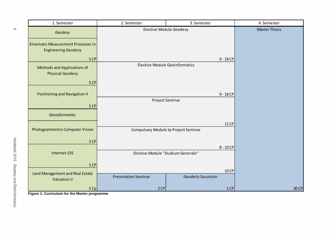
1. Master programme 1.1 Structure of the Master programme The master degree programme consists of a compulsory and an elective field such as the elective module „Studium Generale“ and the master thesis. The studies are based on compulsory modules with contents from six specialty fields of Geodesy and Geoinformatics. During the programme a project seminar is to be selected from topics offered by the institutes. A compulsory module is related to the project depending on the chosen topic. In the elective modules “Geodesy” and “Geoinformatics” students select single lectures in the sum of at least 27 credit points (CP). In each of both modules they have to select at least 9 CP. These options offer possibilities to specialise in a specific field as well as to keep a broad overview in all subjects. In order to gain interdisciplinary skills students will select lectures in the sum of 10 CP in the elective module “Studium Generale”. They can choose from the list in this handbook or select courses from the university’s complete lecture catalogue. The programme ends with a master thesis, which takes one semester and 30 CP. The thesis’ results are presented in a colloquium.
6 H
andbook 2015 G
eodesy and G
eoinform
atics
5 CP
5 CP
5 CP
5 CP
5 Cp
Land Management and Real Estate
Valuation II
12 CP
8 - 10 CP
Compulsary Module tp Project Seminar
30 CP
10 CP
Elective Module "Studium Generale"
2 CP 1 CP
Geodetic ExcursionPresenation Seminar
1. Semester 2. Semester 3. Semester 4. Semester
Geodesy
9 - 18 CP
Elective Module Geodesy Master Thesis
5 CP
Positioning and Navigation II
Geoinformatics
Project Seminar
9 - 18 CP
Elective Module Geoinformatics
Kinematic Measurement Processes in
Engineering Geodesy
Photogrammetric Computer Vision
Internet-GIS
Methods and Applications of
Physical Geodesy
Figure 1: Curriculum for the Master programme
Han
dbook 2015 Geodesy an
d Geoin
formatics
7
Module
Lecture Sem. L P S Type **Durat-
ion (min.)
presence prepara-tionexam prepara-
tionwork load CP
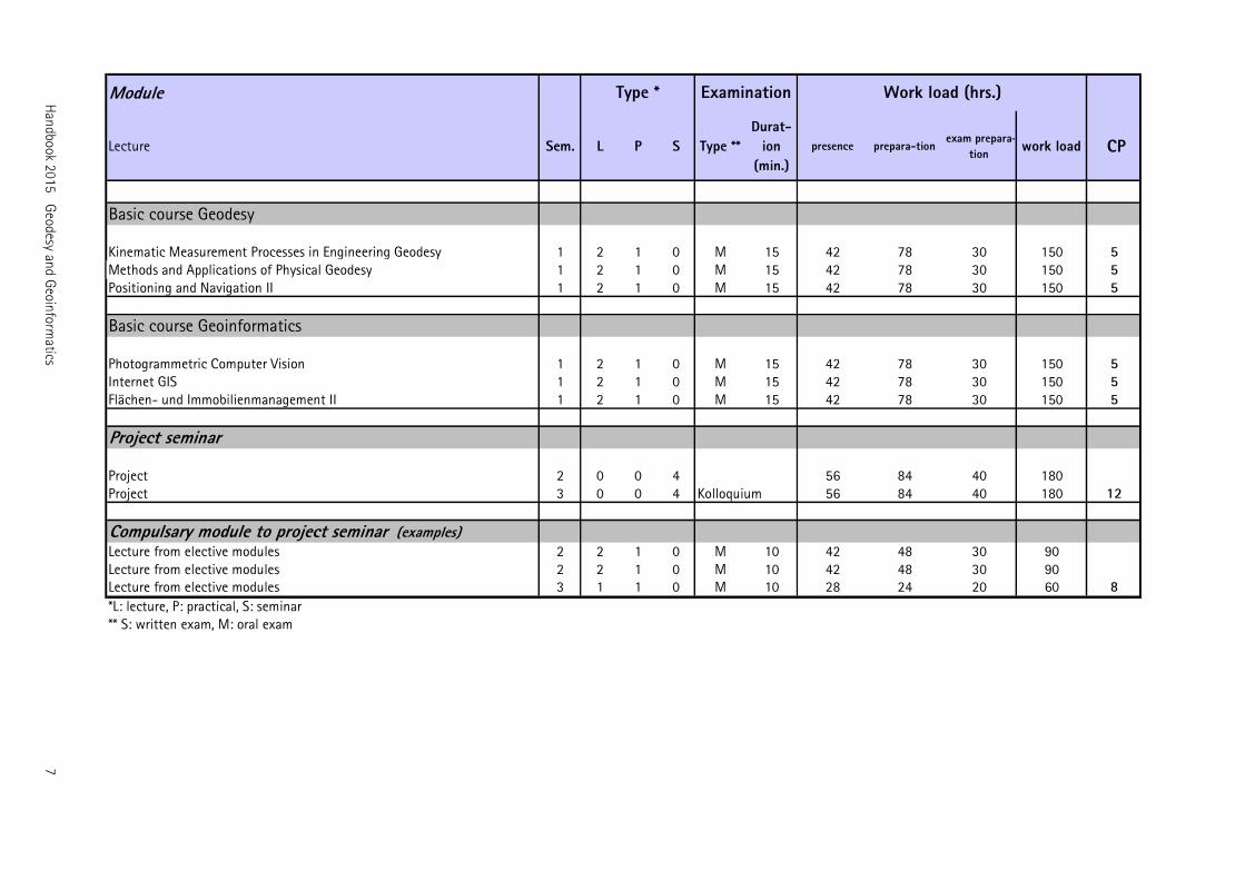
Basic course Geodesy
Kinematic Measurement Processes in Engineering Geodesy 1 2 1 0 M 15 42 78 30 150 5Methods and Applications of Physical Geodesy 1 2 1 0 M 15 42 78 30 150 5Positioning and Navigation II 1 2 1 0 M 15 42 78 30 150 5
Basic course Geoinformatics
Photogrammetric Computer Vision 1 2 1 0 M 15 42 78 30 150 5Internet GIS 1 2 1 0 M 15 42 78 30 150 5Flächen- und Immobilienmanagement II 1 2 1 0 M 15 42 78 30 150 5
Project seminar
Project 2 0 0 4 56 84 40 180Project 3 0 0 4 Kolloquium 56 84 40 180 12
Compulsary module to project seminar (examples)Lecture from elective modules 2 2 1 0 M 10 42 48 30 90Lecture from elective modules 2 2 1 0 M 10 42 48 30 90Lecture from elective modules 3 1 1 0 M 10 28 24 20 60 8
*L: lecture, P: practical, S: seminar** S: written exam, M: oral exam
Type * Examination Work load (hrs.)
8 H
andbook 2015 G
eodesy and G
eoinform
atics
Module
Lecture Sem. L P S Type **Durat-
ion (min.)
presence prepara-tionexam prepara-
tionwork load CP
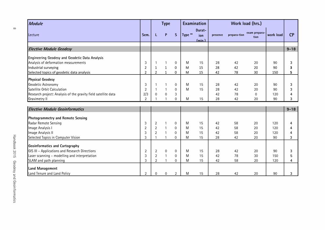
Elective Module Geodesy 9-18
Engineering Geodesy and Geodetic Data AnalysisAnalysis of deformation measurements 3 1 1 0 M 15 28 42 20 90 3
Industrial surveying 2 1 1 0 M 15 28 42 20 90 3
Selected topics of geodetic data analysis 2 2 1 0 M 15 42 78 30 150 5
Physical GeodesyGeodetic Astronomy 3 1 1 0 M 15 28 42 20 90 3Satellite Orbit Calculation 2 1 1 0 M 15 28 42 20 90 3Research project: Analysis of the gravity field satellite data 2/3 0 0 3 42 78 0 120 4Gravimetry II 2 1 1 0 M 15 28 42 20 90 3
Elective Module Geoinformatics 9-18
Photogrammetry and Remote SensingRadar Remote Sensing 3 2 1 0 M 15 42 58 20 120 4Image Analysis I 2 2 1 0 M 15 42 58 20 120 4Image Analysis II 3 2 1 0 M 15 42 58 20 120 4Selected Topics in Computer Vision 3 1 1 0 M 15 28 42 20 90 3
Geoinformatics and CartographyGIS III – Applications and Research Directions 2 2 0 0 M 15 28 42 20 90 3Laser scanning – modelling and interpretation 3 2 1 0 M 15 42 78 30 150 5SLAM and path planning 3 2 1 0 M 15 42 58 20 120 4
Land ManagementLand Tenure and Land Policy 2 0 0 2 M 15 28 42 20 90 3
Type Examination Work load (hrs.)
Han
dbook 2015 Geodesy an
d Geoin
formatics
9
Module
Lecture Sem. L P S Type **Durat-
ion (min.)
presence prepara-tionexam prepara-
tionwork load CP
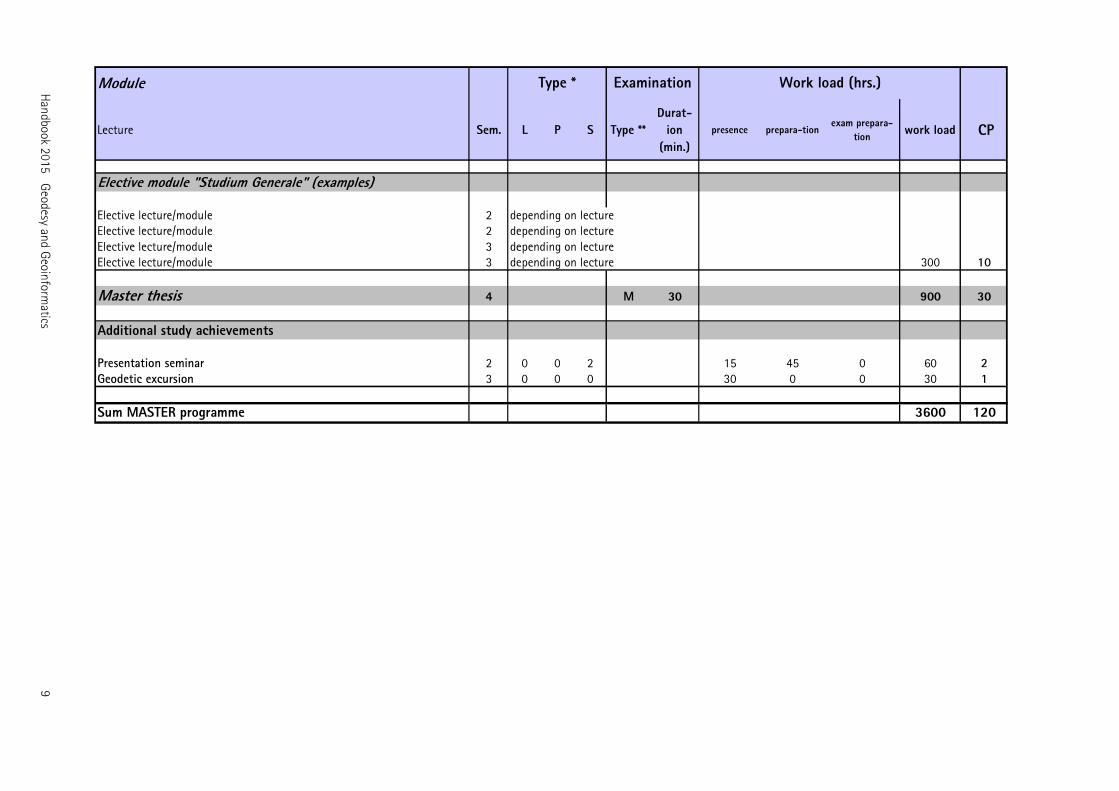
Elective module "Studium Generale" (examples)
Elective lecture/module 2 depending on lectureElective lecture/module 2 depending on lectureElective lecture/module 3 depending on lectureElective lecture/module 3 depending on lecture 300 10
Master thesis 4 M 30 900 30
Additional study achievements
Presentation seminar 2 0 0 2 15 45 0 60 2Geodetic excursion 3 0 0 0 30 0 0 30 1
Sum MASTER programme 3600 120
Type * Examination Work load (hrs.)
10 Handbook 2015 Geodesy and Geoinformatics
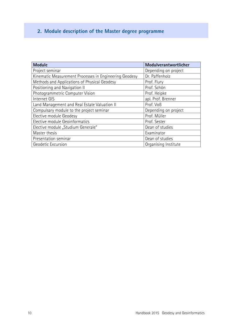
2. Module description of the Master degree programme
Module Modulverantwortlicher Project seminar Depending on project Kinematic Measurement Processes in Engineering Geodesy Dr. Paffenholz Methods and Applications of Physical Geodesy Prof. Flury Positioning and Navigation II Prof. Schön Photogrammetric Computer Vision Prof. Heipke Internet GIS apl. Prof. Brenner Land Management and Real Estate Valuation II Prof. Voß Compulsary module to the project seminar Depending on project Elective module Geodesy Prof. Müller Elective module Geoinformatics Prof. Sester Elective module „Studium Generale“ Dean of studies Master thesis Examinator Presentation seminar Dean of studies Geodetic Excursion Organising Institute
Handbook 2015 Geodesy and Geoinformatics 11
2.1 Compulsory modules in the Master programme
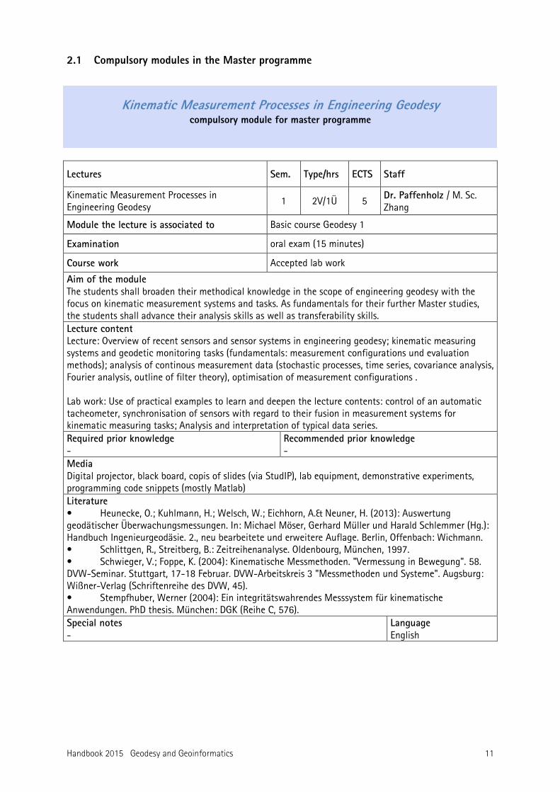
Kinematic Measurement Processes in Engineering Geodesy compulsory module for master programme
Lectures Sem. Type/hrs ECTS Staff
Kinematic Measurement Processes in Engineering Geodesy
1 2V/1Ü 5 Dr. Paffenholz / M. Sc. Zhang
Module the lecture is associated to Basic course Geodesy 1
Examination oral exam (15 minutes)
Course work Accepted lab work
Aim of the module The students shall broaden their methodical knowledge in the scope of engineering geodesy with the focus on kinematic measurement systems and tasks. As fundamentals for their further Master studies, the students shall advance their analysis skills as well as transferability skills. Lecture content Lecture: Overview of recent sensors and sensor systems in engineering geodesy; kinematic measuring systems and geodetic monitoring tasks (fundamentals: measurement configurations und evaluation methods); analysis of continous measurement data (stochastic processes, time series, covariance analysis, Fourier analysis, outline of filter theory), optimisation of measurement configurations . Lab work: Use of practical examples to learn and deepen the lecture contents: control of an automatic tacheometer, synchronisation of sensors with regard to their fusion in measurement systems for kinematic measuring tasks; Analysis and interpretation of typical data series. Required prior knowledge -
Recommended prior knowledge -
Media Digital projector, black board, copis of slides (via StudIP), lab equipment, demonstrative experiments, programming code snippets (mostly Matlab) Literature • Heunecke, O.; Kuhlmann, H.; Welsch, W.; Eichhorn, A.& Neuner, H. (2013): Auswertung geodätischer Überwachungsmessungen. In: Michael Möser, Gerhard Müller und Harald Schlemmer (Hg.): Handbuch Ingenieurgeodäsie. 2., neu bearbeitete und erweitere Auflage. Berlin, Offenbach: Wichmann. • Schlittgen, R., Streitberg, B.: Zeitreihenanalyse. Oldenbourg, München, 1997. • Schwieger, V.; Foppe, K. (2004): Kinematische Messmethoden. "Vermessung in Bewegung". 58. DVW-Seminar. Stuttgart, 17-18 Februar. DVW-Arbeitskreis 3 "Messmethoden und Systeme". Augsburg: Wißner-Verlag (Schriftenreihe des DVW, 45). • Stempfhuber, Werner (2004): Ein integritätswahrendes Messsystem für kinematische Anwendungen. PhD thesis. München: DGK (Reihe C, 576). Special notes -
Language English
12 Handbook 2015 Geodesy and Geoinformatics
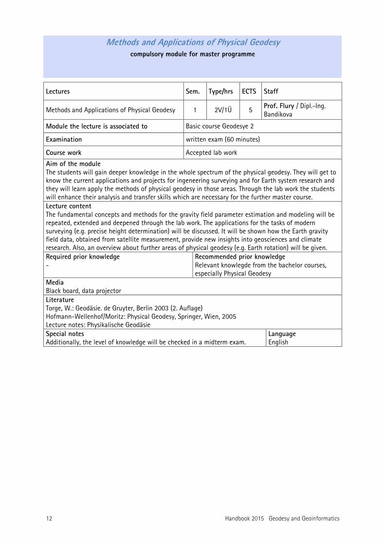
Methods and Applications of Physical Geodesy compulsory module for master programme
Lectures Sem. Type/hrs ECTS Staff
Methods and Applications of Physical Geodesy 1 2V/1Ü 5 Prof. Flury / Dipl.-Ing. Bandikova
Module the lecture is associated to Basic course Geodesye 2
Examination written exam (60 minutes)
Course work Accepted lab work
Aim of the module The students will gain deeper knowledge in the whole spectrum of the physical geodesy. They will get to know the current applications and projects for ingeneering surveying and for Earth system research and they will learn apply the methods of physical geodesy in those areas. Through the lab work the students will enhance their analysis and transfer skills which are necessary for the further master course. Lecture content The fundamental concepts and methods for the gravity field parameter estimation and modeling will be repeated, extended and deepened through the lab work. The applications for the tasks of modern surveying (e.g. precise height determination) will be discussed. It will be shown how the Earth gravity field data, obtained from satellite measurement, provide new insights into geosciences and climate research. Also, an overview about further areas of physical geodesy (e.g. Earth rotation) will be given. Required prior knowledge -
Recommended prior knowledge Relevant knowlegde from the bachelor courses, especially Physical Geodesy
Media Black board, data projector Literature Torge, W.: Geodäsie. de Gruyter, Berlin 2003 (2. Auflage) Hofmann-Wellenhof/Moritz: Physical Geodesy, Springer, Wien, 2005 Lecture notes: Physikalische Geodäsie Special notes Additionally, the level of knowledge will be checked in a midterm exam.
Language English
Handbook 2015 Geodesy and Geoinformatics 13
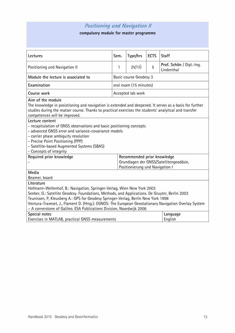
Positioning und Navigation II compulsory module for master programme
Lectures Sem. Type/hrs ECTS Staff
Positioning und Navigation II 1 2V/1Ü 5 Prof. Schön / Dipl.-Ing. Lindenthal
Module the lecture is associated to Basic course Geodesy 3
Examination oral exam (15 minutes)
Course work Accepted lab work
Aim of the module The knowledge in posistioning and navigation is extended and deepened. It serves as a basis for further studies during the matser course. Thanks to practical exercises the students' analyitcal and transfer competences will be improved. Lecture content - recapitulation of GNSS observations and basic positioning concepts - advanced GNSS error and variance-covariance models - carrier phase ambiguity resolution - Precise Point Positioning (PPP) - Satellite-based Augmented Systems (SBAS) - Concepts of integrity Required prior knowledge -
Recommended prior knowledge Grundlagen der GNSS/Satellitengeodäsie, Positionierung und Navigation I
Media Beamer, board Literature Hofmann-Wellenhof, B.: Navigation, Springer-Verlag, Wien New York 2003 Seeber, G.: Satellite Geodesy. Foundations, Methods, and Applications. De Gruyter, Berlin 2003 Teunissen, P, Kleusberg A.: GPS for Geodesy Springer-Verlag, Berlin New York 1998 Ventura-Traveset, J., Flament D. (Hrsg.): EGNOS: The European Geostationary Navigation Overlay System – A cornerstone of Galileo. ESA Publications Division, Noordwijk 2006 Special notes Exercises in MATLAB, practical GNSS measurements
Language English
14 Handbook 2015 Geodesy and Geoinformatics
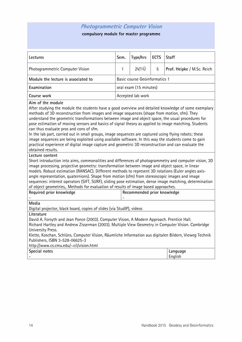
Photogrammetric Computer Vision compulsory module for master programme
Lectures Sem. Type/hrs ECTS Staff
Photogrammetric Computer Vision 1 2V/1Ü 5 Prof. Heipke / M.Sc. Reich
Module the lecture is associated to Basic course Geoinformatics 1
Examination oral exam (15 minutes)
Course work Accepted lab work
Aim of the module After studying the module the students have a good overview and detailed knowledge of some exemplary methods of 3D reconstruction from images and image sequences (shape from motion, sfm). They understand the geometric transformations between image and object space, the usual procedures for pose estimation of moving sensors and basics of signal theory as applied to image matching. Students can thus evaluate pros and cons of sfm. In the lab part, carried out in small groups, image sequences are captured using flying robots; these image sequences are being exploited using available software. In this way the students come to gain practical experience of digital image capture and geometric 3D reconstruction and can evaluate the obtained results. Lecture content Short introduction into aims, commonalities and differences of photogrammetry and computer vision, 3D image processing, projective geometry: transformation between image and object space, in linear models. Robust estimation (RANSAC). Different methods to represent 3D rotations (Euler angles axis-angle representation, quaternions). Shape from motion (sfm) from stereoscopic images and image sequences: interest operators (SIFT, SURF), sliding pose estimation, dense image matching, determination of object geometries,. Methods for evaluation of results of image based approaches. Required prior knowledge -
Recommended prior knowledge -
Media Digital projector, black board, copies of slides (via StudIP), videos Literature David A. Forsyth and Jean Ponce (2003). Computer Vision, A Modern Approach. Prentice Hall. Richard Hartley and Andrew Zisserman (2003). Multiple View Geometry in Computer Vision. Cambridge University Press. Klette, Koschan, Schlüns, Computer Vision, Räumliche Information aus digitalen Bildern, Vieweg Technik Publishers, ISBN 3-528-06625-3 http://www.cs.cmu.edu/~cil/vision.html Special notes -
Language English
Handbook 2015 Geodesy and Geoinformatics 15
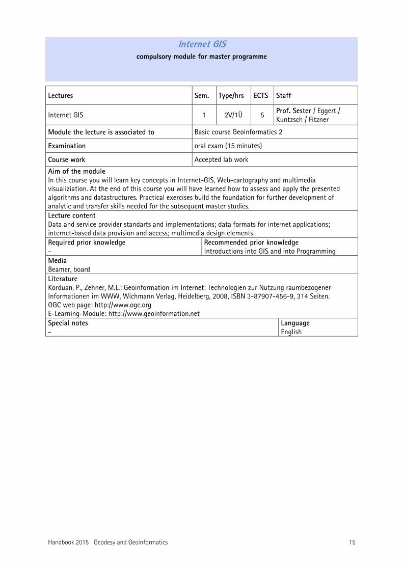
Internet GIS compulsory module for master programme
Lectures Sem. Type/hrs ECTS Staff
Internet GIS 1 2V/1Ü 5 Prof. Sester / Eggert / Kuntzsch / Fitzner
Module the lecture is associated to Basic course Geoinformatics 2
Examination oral exam (15 minutes)
Course work Accepted lab work
Aim of the module In this course you will learn key concepts in Internet-GIS, Web-cartography and multimedia visualiziation. At the end of this course you will have learned how to assess and apply the presented algorithms and datastructures. Practical exercises build the foundation for further development of analytic and transfer skills needed for the subsequent master studies. Lecture content Data and service provider standarts and implementations; data formats for internet applications; internet-based data provision and access; multimedia design elements. Required prior knowledge -
Recommended prior knowledge Introductions into GIS and into Programming
Media Beamer, board Literature Korduan, P., Zehner, M.L.: Geoinformation im Internet: Technologien zur Nutzung raumbezogener Informationen im WWW, Wichmann Verlag, Heidelberg, 2008, ISBN 3-87907-456-9, 314 Seiten. OGC web page: http://www.ogc.org E-Learning-Module: http://www.geoinformation.net Special notes -
Language English
16 Handbook 2015 Geodesy and Geoinformatics
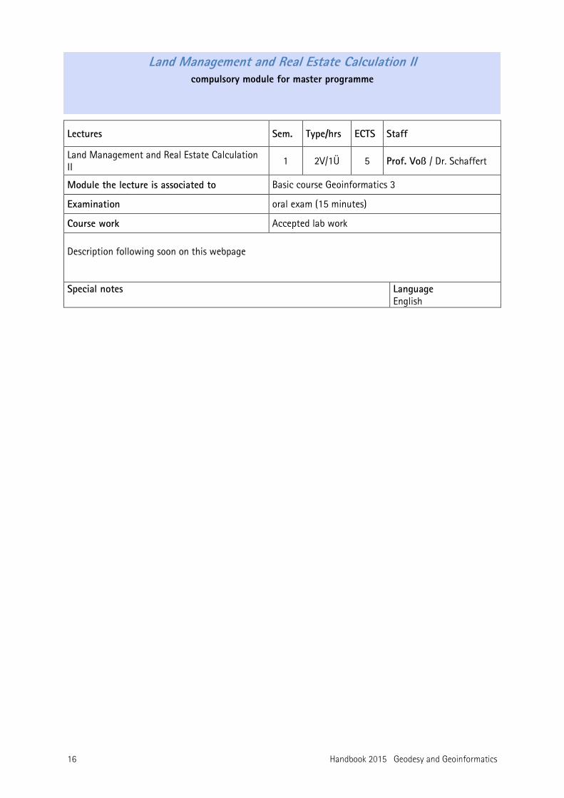
Land Management and Real Estate Calculation II compulsory module for master programme
Lectures Sem. Type/hrs ECTS Staff
Land Management and Real Estate Calculation II
1 2V/1Ü 5 Prof. Voß / Dr. Schaffert
Module the lecture is associated to Basic course Geoinformatics 3
Examination oral exam (15 minutes)
Course work Accepted lab work
Description following soon on this webpage Special notes Language
English
Handbook 2015 Geodesy and Geoinformatics 17
Project seminar compulsory module for master programme
Lectures Sem. Type/hrs ECTS Staff
Project seminar 2 3
4S 4S
12 different staff members
Module the lecture is associated to Project seminar
Examination final colloquium at the end of 3rd semester
Course work final report, project presentation
Aim of the module The project seminar supports scientific learning and thinking. Applications and the critical discussion of special knowledge are the most important topics. The goal of this module is for students to independently work in small groups on a given project. This includes the analysis of the problem, project planning, the organisation and field work, and the derivation as well as a critical evaluation of the obtained results. The results will be presented in a report and in an oral presentation. Lecture content The institutes of Geodesy and Geoinformatics offer different projects each year. The student work is done in the frame of a project seminar, which takes place during the 2nd and 3rd semester. It comprises practical work such as data acquisition, data analysis, and evaluation and presentation of results. Besides the practical work students and staff will discuss different relevant methods, partly by means of presentation. Students will participate in the project planning and organisation. The practical and independent work will strengthen the students specialised knowledge and develop their responsibility and independence. The project results are submitted in a written final report from the group. The conclusions are also presented in a common event with the other project groups at the end of the third semester. Each group has one hour for the presentation. The successful participation is to be proven in a final colloquium (with a grade). Contents of the compulsory lectures, which go along with the project, can be subject of questions in the colloquium. Required prior knowledge -
Recommended prior knowledge -
Media - Literature Will be given to each project individually. Special notes In a common event at the end of the first M.Sc. semester staff members present the different projects for the following year. The student choose a project. Each project is supervised by at least one staff member, who is available for additional information and support of the students. Compulsory lectures comprising at least 8 ECTS points are part of the project. The lectures to be taken are named by staff during the initial project presentation.
Language English
18 Handbook 2015 Geodesy and Geoinformatics
Master thesis compulsory module for master programme
Lectures Sem. Type/hrs ECTS Staff
4 900 h 30
Professors / academic staff
Module the lecture is associated to Master thesis
Examination Master thesis and colloquium (30 Minuten, no grade)
Course work -
Aim of the module In a master thesis students acquire skills to develop and apply scientific methods in order to independently solve a complex task. The assignment comes from the field of Geodesy and Geoinformatics or related areas, the goal has to be achieved in a certain time. How to obtain a topic In order to obtain a topic students have to apply at the examination office after consultation with the supervisor. According to the examination rules students have to acquire at least 30 ECTS before being allowed to start the master thesis. Thesis work can start at any time during the year. The application date, the start date and the topic are registered at the examination office. An application form is available at the examination office and at the examination board office. After six months two copies of the thesis are to be handed in at the examination office. The date of submission is registered officially. Required prior knowledge The contents of the master thesis are presented in an oral colloquium of approximately 30 min incl. questions, in which the student has to prove his/her ability to independently work on the topics of the thesis using scientific methods and to discuss the obtained results with peers and supervisors. The colloquium comprises the demonstration of the content of the master thesis and its results in an oral presentation including a discussion with the examiner and other scientific staff. The thesis must have been preliminarily graded with at least “sufficient” (4,0) for the student to be admitted to the colloquium. The colloquium should take place during the three weeks following submission of the master thesis. The master thesis is graded by two examiners. Each examiner derives a final grade consisting of the grade of the thesis (85%) and the grade of the colloquium (15%). Media Literature Special notes Language
English or German
Handbook 2015 Geodesy and Geoinformatics 19
2.2 Lectures for the elective module Geodesy The elective module „Geodesy“ can be studied by electing lectures from three different fields:
• Engineering Geodesy and geodetic data analysis
• Physical Geodesy and
• Positioning and Navigation (see above list and following lecture descriptions). Students choose lectures in an amount of 9-18 CP, so that the sum of both elective modules („Geodesy“ and „Geoinformatics“) is at least 27 CP.
20 Handbook 2015 Geodesy and Geoinformatics
Analysis of deformation measurements lecture for elective module Geodesy
Lectures Sem. Type/hrs ECTS Staff
Analysis of deformation measurements 3 1V/1Ü 3 Prof. Neumann / Dipl.-Ing. Hartmann
Module the lecture is associated to elective module Geodesy
Examination oral exam (15 min)
Course work Accepted lab work
Description following soon on this webpage Special notes Language
English
Handbook 2015 Geodesy and Geoinformatics 21
Industrial surveying lecture for elective module Geodesy
Lectures Sem. Type/hrs ECTS Staff
Industrial surveying 2 1V/1Ü 3 Prof. Neumann / Dipl.-Ing. Stenz
Module the lecture is associated to elective module Geodesy
Examination oral exam (15 min)
Course work Accepted lab work
Description following soon on this webpage Special notes Language
English

22 Handbook 2015 Geodesy and Geoinformatics
Selected topics of geodetic data analysis lecture for elective module Geodesy
Lectures Sem. Type/hrs ECTS Staff
Selected topics of geodetic data analysis 2 2V/1Ü 5 Prof. Neumann / Dr. Alkhatib
Module the lecture is associated to elective module Geodesy
Examination oral exam (15 min)
Course work Accepted lab work
Description following soon on this webpage Special notes Language
English
Handbook 2015 Geodesy and Geoinformatics 23
Geodetic astronomy lecture for elective module Geodesy
Lectures Sem. Type/hrs ECTS Staff
Geodetic astronomy 3 1V/1Ü 3 Prof. Flury/ Dipl.-Ing. Bandikova / Dipl.-Ing. Hofmann
Module the lecture is associated to elective module Geodesy
Examination oral exam (15 min)
Course work Accepted lab work
Aim of the module The students will learn the fundamentals and selected techniques of geodetic astronomy as well as their practical application. They will be taught how to organize and perform precision measurements and how to the critically evaluate the results. Lecture content Fundamentals of astronomy and geodetic astronomy; astrometric sensors; astrogeodetic gravity field and geoid determination; transpotable zenith camera; almucantar technique; astronomic leveling; time measurement and time transfer; fundamental astronomy; astrometric satellite missions; star catalogues; traditional geodetic-astronomic techniques for determination of latitude, longitude and azimuth. Required prior knowledge Methods and Applications of Physical Geodesy
Recommended prior knowledge Relevant knowledge from the bachelor courses
Media Beamer, board Literature Schödlbauer – Geodätische Astronomie, De Gruyter, 2000 Special notes Lab: practical measurements and computations
Language English
24 Handbook 2015 Geodesy and Geoinformatics
Satellite Orbit Calculation lecture for elective module Geodesy
Lectures Sem. Type/hrs ECTS Staff
Satellite Orbit Calculation 2 1V/1Ü 3 Dr. Mai
Module the lecture is associated to elective module Geodesy
Examination oral exam (15 min)
Course work Accepted lab work
Aim of the module The students should get familiar with basic methods of numerical as well as analytical satellite orbit calculation and recognize its importance for genuine geodetic tasks. Especially, this course focuses on the autonomous development and implementation of software routines and the respective visualization of given complex motion problems in different scenarios. The students will improve their skills regarding a critical assessment of computation results. Lecture content Computation and visualization of satellite orbits w.r.t. various reference systems (quasi-inertial, body-fixed, topocentric); computation of time-varying Keplerian elements (osculating elements); analytical treatment of gravitationally perturbed satellite trajectories; numerical integration of satellite orbits, which are gravitationally perturbed by Earth’s gravitational field, third body attraction, etc.; numerical treatment of non-gravitational forces like atmospheric drag, or solar radiation pressure; consideration of relativistic effects. Required prior knowledge -
Recommended prior knowledge relevant content of the bachelor‘s program, methods and applications of physical geodesy
Media blackboard, beamer, StudIP Literature Vallado, D.A.: Fundamentals of Astrodynamics and Applications, Space Technology Series, McGraw-Hill Schneider, M.: Himmelsmechanik Bd.e I-IV, B.I. Wissenschaftsverlag Special notes Homeworks require programming skills, e.g., using MATHEMATICA or MATLAB
Language English
Handbook 2015 Geodesy and Geoinformatics 25
Research project: Analysis of the gravity field satellite data lecture for elective module Geodesy
Lectures Sem. Type/hrs ECTS Staff
Research project: Analysis of the gravity field satellite data
2/3 3S 4 Prof. Flury
Module the lecture is associated to elective module Geodesy
Examination practical work: final report and presentation
Course work software module
Aim of the module The students learn techniques to analyze satellite data. They practice the development of efficient software tools and the interpretation and description of computation results. They experience how to work in science and obtain insight into the potential of Earth observation techniques. Lecture content Tasks from the following fields: Analysis of data from GRACE, GOCE, Swarm or other satellite missions to determine variations of gravity and mass redistribution in the Earth system Development and testing of software modules for satellite data analysis (accelerometer data, ranging, star cameras) Identification of signal and noise contributions Analysis of residual air drag and radiation pressure Analysis of mass variations (ice mass, hydrology, etc.) Required prior knowledge -
Recommended prior knowledge Coding skills (Matlab, other)
Media - Literature - Special notes For every participant, a project task is defined, such as a research question or a software module to be developed. The task will be solved individually by each participant, in collaboration with the research group of the lecturer. The required time is about 4 weeks. The schedule is agreed on with the participant. The schedule can include the time between semesters.
Language English
26 Handbook 2015 Geodesy and Geoinformatics
Gravimetry II lecture for elective module Geodesy
Lectures Sem. Type/hrs ECTS Staff
Gravimetry II 2 1V/1Ü 3 Dr. Timmen
Module the lecture is associated to elective module Geodesy
Examination oral exam (15 min)
Course work Accepted lab work
Aim of the module The prospective geodesist is to be able to deploy gravimetric methods as well as data evaluation and analysis methods in geodetic and interdisciplinary fields. He obtains the knowledge to apply gravimetry for special geoscientific issues. The students gather practical experiences and competence in exercises to deal with gravity networks and with gravity field interpretation. Lecture content Measuring techniques; airborne gravimetry; optimization of gravity networks; modelling of terrestrial mass movements; relationship between variations in gravity, height and geoid; inversion of gravity data; geophysical interpretation (introduction) Required prior knowledge Basics from bachelor courses: Physical Geodesy, Gravimetry, Adjustment Computation, Statistics; computer programming
Recommended prior knowledge -
Media Board, beamer Literature Torge, W. (1989): Gravimetry. De Gruyter. Torge, W. and Müller, J. (2012): Geodesy. 433 pages, De Gruyter. Long, L. T., and Kaufmann, R. D. (2013): Acquisition and Analysis of Terrestrial Gravity Data. 169 pages, Cambridge University Press. Titterton, D.H., Weston, J.L. (1997): Strapdown inertial navigation technology. Peter Peregrinus Ltd., UK. Special notes Minimum number of participants: 5
Language English
Handbook 2015 Geodesy and Geoinformatics 27
2.3 Lectures for the elective module Geoinformatics The elective module „Geodesy“ can be studied by electing lectures from three different fields:
• Photogrammetry and Remote Sensing
• Geoinformatics and Cartography and
• Land Management and Real Estate Valuation II
Students choose lectures in an amount of 9-18 CP, so that the sum of both elective modules („Geodesy“ and „Geoinformatics“) is at least 27 CP.
28 Handbook 2015 Geodesy and Geoinformatics
Radar Remote Sensing lecture for elective module Geoinformatic
Lectures Sem. Type/hrs ECTS Staff
Radar Remote Sensing 3 2V/1Ü 4 N.N. N.N.
Module the lecture is associated to elective module Geoinformatic
Examination oral exam (15 min)
Course work Accepted lab work
Aim of the module At the end of the lecture the students know the basics of imaging radar sensors, radar processing as well as further processing and applications in remote sensing. They have gained the possibility to investigate exemaplry research questions in radar remote sensing. Lecture content Basics of radar technology; imaging radar; radar with synthec aperture (SAR); Processing of radar signals to SAR images; SAR polarimetry; Generation of height models by SAR interferometry; Determination of surface deformations using differential interferometrie; Automatic processing of radar images; airborne and space borne SAR sesnor systems. Application of radar remote sensing in geodesy, agriculture, forestry, oceanography, environmental sciences etc. Current research trends: SAR tomography, bi-static SAR etc. Required prior knowledge -
Recommended prior knowledge -
Media Digital projector, black board, copis of slides (via StudIP), videos Literature Slide copies Special notes Language
English
Handbook 2015 Geodesy and Geoinformatics 29
Image Analysis I lecture for elective module Geoinformatic
Lectures Sem. Type/hrs ECTS Staff
Image Analysis I 2 2V/1Ü 4 apl. Prof. Rottensteiner
Module the lecture is associated to elective module Geoinformatic
Examination oral exam (15 min)
Course work Accepted lab work
Aim of the module The students will get to know a general strategy for knowledge-based image analysis, including all the required intermediate steps. In the lab course, the students will gain practical experience in addition to the theoretical knowledge taught in the lecture by developing their own image analysis modules. In addition, the lab will train the students’ problem solving skills. Lecture content The course starts with a brief overview about imaging sensors and image pre-processing techniques. After that, the concept of scale space is introduced. This is followed by a block of lectures dealing with different aspects of image segmentation, including specific methods for extracting points, edges and regions as well as a generic framework delivering all these features. This lecture block is completed by an overview about methods for post-processing the segmentation results and for feature grouping. After that, fundamental aspects of knowledge-based image analysis are discussed. We start with the definition of feature vectors from image data, which is followed by a discussion of the role of models in image analysis and formal options for knowledge representation. Finally, the generic structure of knowledge-based image analysis systems and the general strategies used for image analysis in such systems are discussed. The course finishes with a lecture block on methods for internal and external evaluation. Lab: Development of image analysis modules based on Matlab. Required prior knowledge -
Recommended prior knowledge Photogrammetric Computer Vision
Media Beamer, blackboard, StudIP, computer Literature Forsyth, D.A., Ponce, J., Computer Vision, A Modern Approach, Prentice Hall, 2003. Special notes Language
English
30 Handbook 2015 Geodesy and Geoinformatics
Image Analysis II lecture for elective module Geoinformatic
Lectures Sem. Type/hrs ECTS Staff
Image Analysis II 3 2V/1Ü 4 apl. Prof. Rottensteiner / M. Sc. Albert
Module the lecture is associated to elective module Geoinformatic
Examination oral exam (15 min)
Course work Accepted lab work
Aim of the module The students should get to know and understand modern statistical methods of pattern recognition, along with their theoretical foundations and current applications. By analyzing state-of-the art scientific papers in the lab, the students’ analytic and methodological skills should be strengthened. Lecture content The first part of this module covers supervised and unsupervised methods for classification. This block starts with a discussion of Bayesian classification, including aspects of generative modeling of probabilities and the estimation of the parameters of these models. After that, there is a transition to discriminative classifiers, introducing logistic regression, Support Vector Machines, Boosting, and Random Forests. Artificial neural networks and the theory of Dempster-Shafer are also presented in this context. This is followed by an introduction into unsupervised techniques for an analysis of clusters in feature space. Graphical models, in particular Bayes networks and statistical models of context as provided by Markov Random Fields and Conditional Random Fields are also discussed. The lecture finishes with a lecture block on active contours and their applications in image analysis. Lab course: Analysis of scientific papers. Required prior knowledge -
Recommended prior knowledge Image Analysis I
Media Beamer, blackboard, StudIP, computer Literature Bishop, C.M., Pattern Recognition and Machine Learning, Springer Verlag, 2006. Duda, R.O., Hart, P.E., Strok, D.G., Pattern Classification,2nd ed., John Wiley & Sons, 2001. Special notes Language
English
Handbook 2015 Geodesy and Geoinformatics 31
Selected Topics in Computer Vision lecture for elective module Geoinformatic
Lectures Sem. Type/hrs ECTS Staff
Selected Topics in Computer Vision 3 1V/1Ü 3 Dr. Bulatov
Module the lecture is associated to elective module Geoinformatic
Examination oral exam (15 min)
Course work Accepted lab work
Aim of the module At the end of the lecture the students have a good overview in selected topics of computer vision. The basics of geometric reconstruction (multi-view geometry) are in the focus and also form the base of the lab work, which is carried out in small groups. In addition, applications from objet recognition, and medical imaging are presented. Lecture content Fast algorithms for orientation of image pairs with the example of the 5 point algorithm: Motivation, theoretical basics (Gröbner bases, analysis of degenerate configurations). Additional applications (omni-directional cameras, geometric reasoning). Discrete non-local optimisation in CV: extraction of depth maps (as motivation), dynamic programming (focus), semi-global optimisation, graph-based methods, TGV-fusion, additional applications (classification). Context based modelling of urban areas: building detection and reconstruction. Implicit shape models and applications for person detection and recognition. Registration of deformable objects and applications in medical image processing. Required prior knowledge -
Recommended prior knowledge -
Media Digital projector, black board, copis of slides (via StudIP), videos Literature Richard Hartley and Andrew Zisserman (2003). Multiple View Geometry in Computer Vision. Cambridge University Press. Richard Szeliski (2010): Computer Vision, Springer, London, 82,20 €, szeliski.org/Book/, see also www.eecs.berkeley.edu/~trevor/CS280.html http://www.cs.cmu.edu/~cil/vision.html Advanced references for Gröbner bases: David Cox, John Little, Donal O’Shea (2007): Ideals, Varieties, and Algorithms; An Introduction to Computational Algebraic Geometry and Commutative Algebra. Springer Special notes -
Language English
32 Handbook 2015 Geodesy and Geoinformatics
GIS III – Applications and new research directions lecture for elective module Geoinformatic
Lectures Sem. Type/hrs ECTS Staff
- GIS III – Applications and new research directions
2 2V 3 Prof. Sester
Module the lecture is associated to elective module Geoinformatic
Examination oral exam (15 min)
Course work -
Aim of the module In the course current research topics in cartography and geoinformatics are presented. In this way, the students get acquainted with the state of the art in the domain. Lecture content The course presents current research topics, e.g. spatial query, multiple representation, trajectory analysis, Artificial Intelligence. The topics may vary and are adapted to current research topics of the institute. Required prior knowledge -
Recommended prior knowledge GIS II
Media Powerpoint slides Literature selected conference or journal papers Special notes -
Language English
Handbook 2015 Geodesy and Geoinformatics 33
Laser scanning – modelling and interpretation lecture for elective module Geoinformatic
Lectures Sem. Type/hrs ECTS Staff
Laser scanning – modelling and interpretation 3 2V/1Ü 5 apl. Prof. Brenner
Module the lecture is associated to elective module Geoinformatic
Examination oral exam (15 min)
Course work Accepted lab work
Aim of the module The students know selected techniques and algorithms for the low-, intermediate- and high-level processing of laser scanning data and their respective application areas. Lecture content Airborne, terrestrial and mobile mapping laser scanning: scan geometry and technical characteristics. Low-, intermediate- and high-level tasks. Representation of 3D rotations: matrix, angles, axis+angle, quaternions. Estimation of similarity transforms and the iterative closest point algorithm. Estimation and segmentation of lines and planes. Region growing, RANSAC and MSAC, Hough transform, scanline grouping. Scanning and segmentation in robotics applications. Decision trees and random forests for the classification of point clouds. Markov chains and Markov chain Monte Carlo methods and their use for high-level interpretation. In the exercises, selected algorithms will be programmed. Required prior knowledge Recommended prior knowledge
GIS I + II, Programming skills Media Literature Vosselman, Maas: Airborne and Terrestrial Laser Scanning, Whittles Publishing 2010. Special notes -
Language English
34 Handbook 2015 Geodesy and Geoinformatics
SLAM and path planning lecture for elective module Geoinformatic
Lectures Sem. Type/hrs ECTS Staff
SLAM and path planning 3 2V/1Ü 4 apl. Prof. Brenner
Module the lecture is associated to elective module Geoinformatic
Examination oral exam (15 min)
Course work Accepted lab work
Aim of the module The students know the problems of localization, mapping, and simultaneous localization and mapping (SLAM), as well as elementary methods for path planning. They have programmed selected methods and are thus able to understand the modules of available robotics packages. Lecture content Robot motion model. Laserscanning and landmark detection. Positioning using estimation of a similarity transform. Iterative closest point method. Bayes filter. Parametric filters and the Kalman filter. Variances and error ellipses. Extended (EKF) and multidimensional Kalman filter. Histogram- and particle filter. EKF SLAM. Rao-Blackwellized particle filter SLAM (FastSLAM). Path planning: Dijkstra and A* algorithms, potential functions, path planning in the kinematic state space. In the exercises, most of the algorithms will be programmed using Python. Required prior knowledge -
Recommended prior knowledge -
Media Literature S. Thrun, W. Burgard, D. Fox, Probabilistic Robotics, MIT Press, 2005. H. Choset u.a., Principles of Robot Motion, Theory, Algorithms, and Implementations, MIT Press, 2005. Special notes -
Language English
Handbook 2015 Geodesy and Geoinformatics 35
2.4 Lectures for the elective module „Studium Generale“ In the elective module „Studium Generale“ lectures and modules from the above list or from the list „Allgemeinbildende Fächer“ in the bachelor degree programme can be selected. Students can also select lectures and courses from the university’s whole programmes to acquire additional and interdisciplinary skills. In this elective module students have to get 10 CP. If students choose lectures, that are not listed above or in the bachelor handbook Geodesy and Geoinformatics, the chosen lectures or courses have to be admitted by the examination board. They can only select two language courses, which are not in their mother tongue. They can choose seminars from the ZfSk (soft skills centre) up to 5 CP. www.zfsk.uni-hannover.de.
Lectures for "Studium Generale"
Lehrveranstaltung/Modul WS SS Art der Prüfung LP
V / Ü V / Ü Einführung in das Recht für Ingenieure*) 2/0 90 s 3
Technikrecht I*) 2/0 2/0 120 s 4
Technikrecht II*) 2/0 2/0 120 s 4
Volkswirtschaftslehre*) 2/0 60 s 4
Einführung in die Geologie*) 2/0 90 s 3 Einführung in die Mechatronik**) 2/1 90 s 4 Robotik I**) 2/1 90 s 4
Grundlagen der Regelungstechnik**) 2/1 90 s 4
Rechnergestützte Szenenanalyse**) 2/1 30 m 4
Computer Vision**) 2/1 30 m 4
Grundlagen der Software-Technik**) 2/1 60 s 4
Softwareanforderungen und -entwurf**) 2/1 30 m 4
Softwarequalität**) 2/1 60 s 4
Künstliche Intelligenz I**) 2/1 90 s 4
Semantic Web**) 2/1 60 s 4
Grundlagen der Betriebswirtschaft und Unternehmensführung I und II
1/0 1/0 10 m 3
Führung als Qualifikation im Ingenieurberuf 1/0 30 s 2
Ringvorlesung „Transformation des Energiesystems“ 2/0 - 1
*) s. Wahlkatalog „Allgemeinbildende Fächer“ im Bachelor **) s. Modulkatalog Maschinenbau, Elektrotechnik bzw. Informatik
36 Handbook 2015 Geodesy and Geoinformatics
2.5 Additional study achievements in master programme
Presentation seminar additional study achievement for master programme
Lectures Sem. Type/hrs ECTS Staff
Presentation seminar 2 2 S 2 Professors and further staff members
Module the lecture is associated to Additional study achievement
Examination -
Course work see special notes
Aim of the module The presentation seminar serves the development of independent work in a specialised topic based on different professional articles and its oral presentation in a limited time in front of a professional audience. The students deepen their oral and written presentation skills and also moderate the presentation event. Lecture content The presentation seminar takes place in the second semester. Based on different references, which students research themselves, they discuss an current topic from Geodesy or Geoinformatics. The presentation time is 15 minutes and is followed by a discussion on the presented topic. Students show a deepend knowledge of the topic in this discussion. A written report (digital document) is to be submitted to the supervisor three weeks after the presentation. The list with topics and supervising staff members is handed out to the students at the end of the first semester. Initial literature is handed out on an individual basis. Required prior knowledge -
Recommended prior knowledge -
Media Literature Is beeing recommended by staff depending on the chosen topic. Special notes A regular participation, a successfull presentation and an approved written report are required to pass the course work. The presentation is not graded. For didactical reasons the presentation is beeing reviewed by the staff members at the end of each single presentation. The written report is checked by the supervising staff member. If the presentation is not accepted a new topic is given to the student. The new topic can be presented in the same or the following semester.
Language English
Handbook 2015 Geodesy and Geoinformatics 37
Geodetic excursion additional study achievement for master programme
Lectures Sem. Type/hrs ECTS Staff
Geodetic excursion 3 1 1 Professors, scientific assistants
Module the lecture is associated to Additional study achievement
Examination -
Course work see special notes
Aim of the module In the geodetic excursion students obtain an interesting overview of professional institutions. It serves to intensify the relation between studying and working as a professional. Besides the professional aspects the excursion also offers visits of cultural events and places of the region in which the excursion takes place. Lecture content The 5-10 day excursion usually takes place during the lecture break in September or October or in the week after Whitsunday. The destination is announced be the organising institute. 2016 IPI to be announced 2015 IPI Northern Germany 2014 IfE Netherlands 2013 IfE Southern Germany 2012 IKG Poland 2011 IKG Northern and Eastern Germany 2010 GIH Switzerland 2009 GIH West- and Southern Germany The geodetic excursion is organised by one of the four institutes. The detailed programme is assembled by all institutes together. Required prior knowledge -
Recommended prior knowledge -
Media Literature Special notes The participation in the geodetic excursion is a mandatory element of the master degree programme. Participation will be certified by a receipt from the organising institute. Students have to pay a fee, which can amount to up to 250€ for excursions abroad. Members of the “Förderergesellschaft” receive a substantial contribution to this fee.
Language
38 Handbook 2015 Geodesy and Geoinformatics
3. Adresses and contact persons 3.1 Services at Leibniz Universität Hannover 3.2 Institutes of Geodesy and Geoinformatics 3.3 Internal Services 3.4 Student council
Handbook 2015 Geodesy and Geoinformatics 39
7.1 Services at Leibniz Universität Hannover The ServiceCenter is placed in the main university building. Contact:
ServiceCenter Leibniz Universität Hannover Welfengarten 1 30167 Hannover Tel. +49 511.762 - 2020 (Servicehotline) Fax +49 511.762 - 19385 [email protected]
opening hours:
Monday to Thursday 10.00 to 17.00 o’clock Friday and before holidays 10.00 to 15.00 o’clock
Service-Hotline (05 11) 762 - 20 20, always open one hour before the ServiceCenter opens, which means at 9:00 o’clock. The ServiceCenter comprises the following services:
Registration office (I-Amt) and admissions http://www.uni-hannover.de/i-amt
Central study counselling (ZSB) http://www.uni-hannover.de/zsb
Examination office (APA) http://www.uni-hannover.de/pruefungsamt
International office (HI) http://www.uni-hannover.de/internationaloffice
Student Services Organisation Hanover http://www.studentenwerk-hannover.de
Psychological counselling (ptb) http://www.ptb.uni-hannover.de
40 Handbook 2015 Geodesy and Geoinformatics
7.2 Institutes of Geodesy and Geoinformatics
Geodätisches Institut Hannover (GIH)
Nienburger Str. 1 30167 Hannover Fon: +49 511 762-2462 Fax: +49 511 762-2468 http://www.gih.uni-hannover.de
Institut für Photogrammetrie und GeoInformation (IPI)
Nienburger Str.1 30167 Hannover Fon: +49 511 762-2482 Fax: +49 511 762-2483 http://www.ipi.uni-hannover.de
Institut für Erdmessung (IFE)
Schneiderberg 50 30167 Hannover Fon: +49 511 762-2795 Fax: +49 511 762-4006 http://www.ife.uni-hannover.de
Institut für Kartographie und Geoinformatik (IKG)
Appelstraße 9 30167 Hannover Fon: +49 511 762-3589 Fax: +49 511 762-2780 http://www.ikg.uni-hannover.de
Handbook 2015 Geodesy and Geoinformatics 41
7.3 Internal Services
Dean of studies
Prof. Dr.-Ing. Steffen Schön c/o Institut für Erdmessung Schneiderberg 50, 30167 Hannover Tel.: +49 511 762-3362 [email protected]
Coordinator of studies
Dipl.-Ing. Tanja Grönefeld c/o Geodätisches Institut Nienburgerstr. 1, 30167 Hannover Tel.: +49 511 762-4408 [email protected]
Examination board
Prof. Dr.-Ing. Winrich Voß c/o Geodätisches Institut Nienburgerstr. 1, 30167 Hannover Tel.: + 49 511 762-2981 [email protected]
Internship and examination board office
Christine Bödeker c/o Geodätisches Institut Nienburger Str. 1, 30167 Hannover Tel.: +49 511 762-2463 [email protected]

42 Handbook 2015 Geodesy and Geoinformatics
7.4 Students council
Fachschaft Geodäsie und Geoinformatik
Geodätisches Institut (Raum B205) Nienburger Str. 1, 30167 Hannover Tel.: +49 511 762-4410 [email protected] http://www.hannover-uni.de/


